implementing iso 19115 aleta vienneau and david danko esri
Post on 22-Dec-2015
220 views
TRANSCRIPT

Implementing ISO 19115Implementing ISO 19115
Aleta Vienneau and David DankoAleta Vienneau and David DankoESRIESRI

IntroductionIntroduction
• Implementing ISO 19115 - Metadata Implementing ISO 19115 - Metadata – Have built tools that let people create ISO Have built tools that let people create ISO
metadata using ArcCatalogmetadata using ArcCatalog• ArcCatalog is one of a suite of desktop ArcCatalog is one of a suite of desktop
products provided with ArcGISproducts provided with ArcGIS– ISO metadata can be published on the ISO metadata can be published on the
Internet using the Geography NetworkInternet using the Geography Network

Background: What is Background: What is ArcCatalog?ArcCatalog?
• A tool for exploring and managing A tool for exploring and managing geographic datageographic data– File-based data on disk in many formatsFile-based data on disk in many formats– Design and implement spatial databases in Design and implement spatial databases in
an enterprise RDBMSan enterprise RDBMS– Access vector, image, metadata services Access vector, image, metadata services
on an ArcIMS Internet serverson an ArcIMS Internet servers

Browse for dataBrowse for data

Preview geographyPreview geography

View an analyze tablesView an analyze tables

Change properties and attributesChange properties and attributes

Explore metadataExplore metadata

Design goals for metadata in Design goals for metadata in ArcCatalogArcCatalog
• Make it easy to create and use Make it easy to create and use metadatametadata– Create editors that are easy to useCreate editors that are easy to use– Create and update metadata automatically Create and update metadata automatically
with a dataset’s current propertieswith a dataset’s current properties

Design goals for metadata in Design goals for metadata in ArcCatalogArcCatalog
• Support FGDC and ISO metadata Support FGDC and ISO metadata content standards out-of-the-boxcontent standards out-of-the-box– Support other standards through Support other standards through
customizationcustomization
• Support metadata for everythingSupport metadata for everything– Geographic data, non-spatial files, folders, Geographic data, non-spatial files, folders,
databases, etc.databases, etc.

Design goals for metadata in Design goals for metadata in ArcCatalogArcCatalog
• Metadata is part of the dataMetadata is part of the data– Travels with the data when copied, moved, Travels with the data when copied, moved,
renamed, or exportedrenamed, or exported– Doesn’t get lostDoesn’t get lost
• Achieve our goals using open, flexible, Achieve our goals using open, flexible, industry standard technologyindustry standard technology– Metadata stored in XML formatMetadata stored in XML format

ISO metadata tools in ArcCatalog ISO metadata tools in ArcCatalog
• Editor for typing informationEditor for typing information• Stylesheets for viewingStylesheets for viewing• Synchronizer for updating Synchronizer for updating
automaticallyautomatically• Importers and exportersImporters and exporters• Translator from one standard to Translator from one standard to
anotheranother

ISO metadata editorISO metadata editor
• New wizard-based editor designed for New wizard-based editor designed for the average personthe average person
• Elements are introduced by plain Elements are introduced by plain languagelanguage
• Navigate with Next and Back buttons or Navigate with Next and Back buttons or go directly to a page using the TOCgo directly to a page using the TOC
• Handles core elements as defined by Handles core elements as defined by 1911519115

ISO metadata editorISO metadata editor

ISO metadata editorISO metadata editor
• Red asterisks indicate mandatory Red asterisks indicate mandatory elementselements– Which pages have mandatory elementsWhich pages have mandatory elements– Which elements on a page are mandatoryWhich elements on a page are mandatory– Disappear when information is providedDisappear when information is provided

ISO stylesheetsISO stylesheets
• Stylesheets map metadata elements in Stylesheets map metadata elements in XML to HTML for better viewingXML to HTML for better viewing– Similar to SQL queries—select data and Similar to SQL queries—select data and
define how to show itdefine how to show it
• Display the same metadata record in Display the same metadata record in many ways with different stylesheetsmany ways with different stylesheets

ISO stylesheetsISO stylesheets

ISO synchronizerISO synchronizer
• Automates much Automates much of the work for of the work for metadata metadata collection and collection and maintenancemaintenance
• Vector and raster Vector and raster information, information, spatial reference, spatial reference, etc.etc. ArcIMS ArcIMS
ServicesServices
ArcIMS ArcIMS ServicesServices FilesFiles
Automatically senses and records properties Automatically senses and records properties Automatically senses and records properties

DemoDemo

Author and publish metadataAuthor and publish metadata
• Scientist generates a dataset Scientist generates a dataset • Metadata is automatically generatedMetadata is automatically generated• Scientist augments metadata using Scientist augments metadata using
editoreditor• Publishes data as image map servicePublishes data as image map service• Publishes metadata to Geography Publishes metadata to Geography
NetworkNetwork
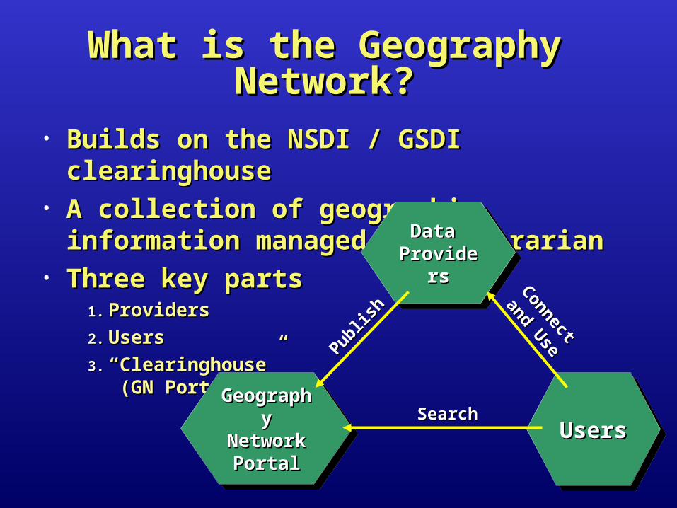
What is the Geography What is the Geography Network?Network?
• Builds on the NSDI / GSDI clearinghouseBuilds on the NSDI / GSDI clearinghouse• A collection of geographic information A collection of geographic information
managed by a librarianmanaged by a librarian• Three key partsThree key parts
1.1. ProvidersProviders
2.2. UsersUsers
3.3. ““Clearinghouse” Clearinghouse” (GN Portal) (GN Portal)
Data Data ProvidersProviders
Data Data ProvidersProviders
UsersUsersUsersUsersGeographGeography Network y Network
PortalPortal
GeographGeography Network y Network
PortalPortal
SearchSearch
Publish
Publish
Connect
Connect
and Use
and Use

What is the Geography Network?What is the Geography Network?
• When searching for data you find:When searching for data you find:– Ordering information, ftp download sites, Ordering information, ftp download sites,
WMS servicesWMS services• Geography Network emphasizes variety Geography Network emphasizes variety
of immediately available servicesof immediately available services– Live maps, data streaming, zip & ship Live maps, data streaming, zip & ship
datasets, GIS servicesdatasets, GIS services——positioning, and positioning, and solutionssolutions—flood risk mapping—flood risk mapping
– Support enterprise GIS, eGovernment, Support enterprise GIS, eGovernment, eCommerceeCommerce

Searching the Geography Searching the Geography NetworkNetwork
• Can use many search clientsCan use many search clients
Metadata Metadata CatalogCatalog
Geography NetworkGeography NetworkGeography NetworkGeography Network
ArcCatalogArcCatalog
HTML or JavaHTML or Java
Clearinghouse Clearinghouse Z39.50Z39.50

www.geographynetwork.comwww.geographynetwork.com

www.geographynetwork.comwww.geographynetwork.com

Search for data in ArcCatalogSearch for data in ArcCatalog

Search for data in ArcCatalogSearch for data in ArcCatalog

Issues in implementing ISO Issues in implementing ISO 1911519115
• To adequately describe data we need to To adequately describe data we need to use many ISO standards, e.g.use many ISO standards, e.g.– 19110: Feature cataloguing methodology19110: Feature cataloguing methodology– 19111: Spatial referencing by coordinates19111: Spatial referencing by coordinates
• No clear way to integrate information No clear way to integrate information defined by multiple parts of ISO 19xxx defined by multiple parts of ISO 19xxx standardsstandards– If there isn’t a standard XML DTD, the If there isn’t a standard XML DTD, the
information isn’t interoperableinformation isn’t interoperable
