implementation and publication of inspire download ... aba… · 23/11/2012 · implementation and...
TRANSCRIPT

1 INSPIRE Conference 2015
Implementation and publication of Inspire
Download Services, WFS 2.0, and Inspire
View Service, WMTS 1.0.0, in CNIG
Paloma Abad, Emilio López, Alejandra Sánchez,
Antonio. F Rodríguez, Carolina Soteres, Julián
Gonzalez, Cristina Ruiz
INSPIRE ‐ Geospatial World Forum 2015

2 INSPIRE Conference 2015
Presentation overview
WMS 1.1.0
WFS
WMTS
Tools
Experience
WMS 1.3.0
WFS 2.0
INSPIRE ‐ Geospatial World Forum 2015

3 INSPIRE Conference 2015
Not later than 9 November 2011, Member States shall provide the
Discovery and View Services in conformity with this Regulation.
Not later than 28 December 2012, Member States shall provide the
Download Services in conformity with this Regulation
Commission Regulation amending Regulation (EC) No 976/2009 as regards download services and transformation service
Commission Regulation (EC) No 976/2009 of 19 October 2009 implementing Directive 2007/2/EC of the European Parliament and of the Council as regards the Network Services
08.12.2010
19.10.2009
Access to the Network Services
Access to the Network Services
INSPIRE ‐ Geospatial World Forum 2015
4 INSPIRE Conference 2015
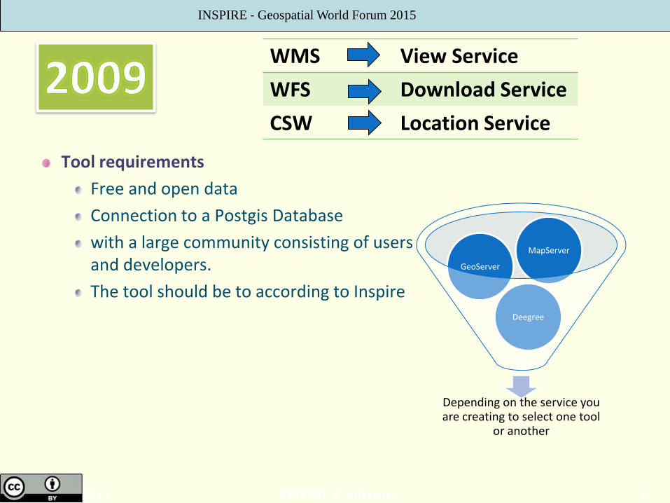
Tool requirements
Free and open data
Connection to a Postgis Database
with a large community consisting of users and developers.
The tool should be to according to Inspire
WMS View Service
WFS Download Service
CSW Location Service
Depending on the service you are creating to select one tool
or another
Deegree
GeoServer
MapServer
INSPIRE ‐ Geospatial World Forum 2015
5 INSPIRE Conference 2015
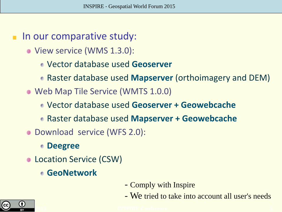
In our comparative study:
View service (WMS 1.3.0):
Vector database used Geoserver
Raster database used Mapserver (orthoimagery and DEM)
Web Map Tile Service (WMTS 1.0.0)
Vector database used Geoserver + Geowebcache
Raster database used Mapserver + Geowebcache
Download service (WFS 2.0):
Deegree
Location Service (CSW)
GeoNetwork
INSPIRE ‐ Geospatial World Forum 2015
- Comply with Inspire
- We tried to take into account all user's needs

6 INSPIRE Conference 2015
View Services according to Technical Guidance
Tools Vector database used Geoserver Raster database used Mapserver
Difficult Low
One service One o more data set base map with GN, HY, TN, AD layers
Weakest points WMS is a service too slow to deal in internet
Data specifications Basic Knowledge
INSPIRE ‐ Geospatial World Forum 2015

7 INSPIRE Conference 2015
View Services according to Technical Guidance
There are a number of hard issues
To link the database with inspire layers
The layer can be no Inspire: other countries or historical orthoimagery
TN.RailTransportNetwork.RailwayLink
AU.AdministrativeBoundary
GN.GeographicalNames
EL.Elevation
PS.ProtectedSite
INSPIRE ‐ Geospatial World Forum 2015
8 INSPIRE Conference 2015
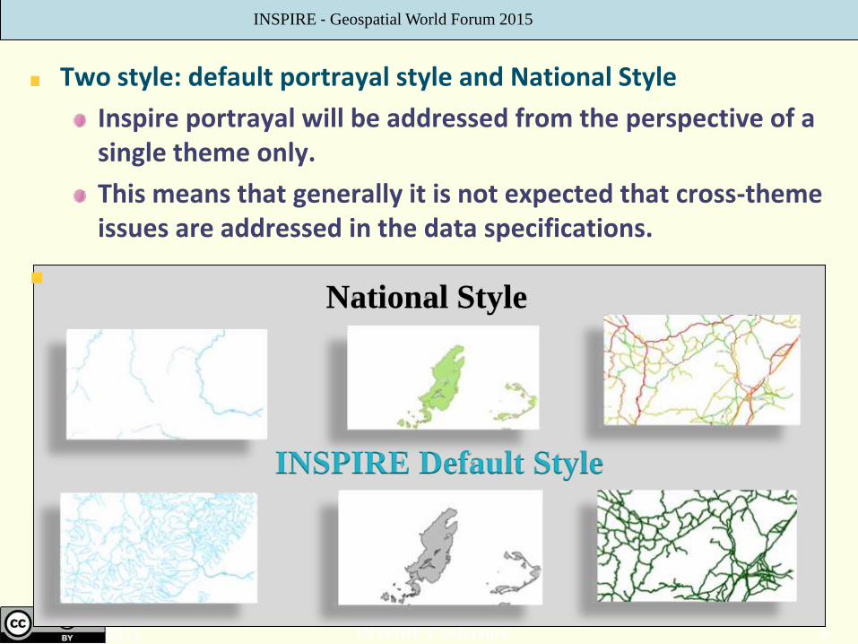
Two style: default portrayal style and National Style
Inspire portrayal will be addressed from the perspective of a single theme only.
This means that generally it is not expected that cross-theme issues are addressed in the data specifications.
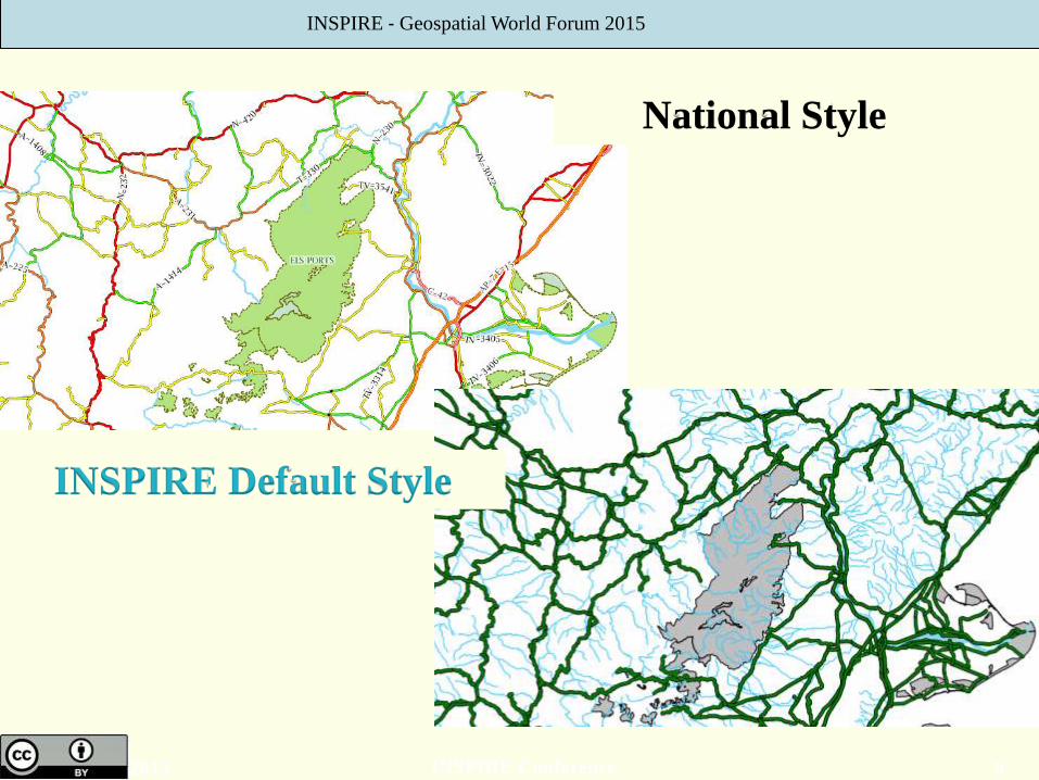
National Style
INSPIRE Default Style
INSPIRE ‐ Geospatial World Forum 2015
9 INSPIRE Conference 2015
National Style
INSPIRE Default Style
INSPIRE ‐ Geospatial World Forum 2015
10 INSPIRE Conference 2015
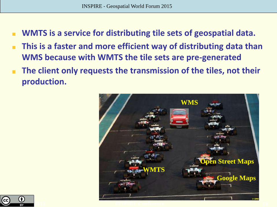
WMTS is a service for distributing tile sets of geospatial data.
This is a faster and more efficient way of distributing data than WMS because with WMTS the tile sets are pre-generated
The client only requests the transmission of the tiles, not their production.
Google Maps
Open Street Maps
WMTS
INSPIRE ‐ Geospatial World Forum 2015
WMS
11 INSPIRE Conference 2015
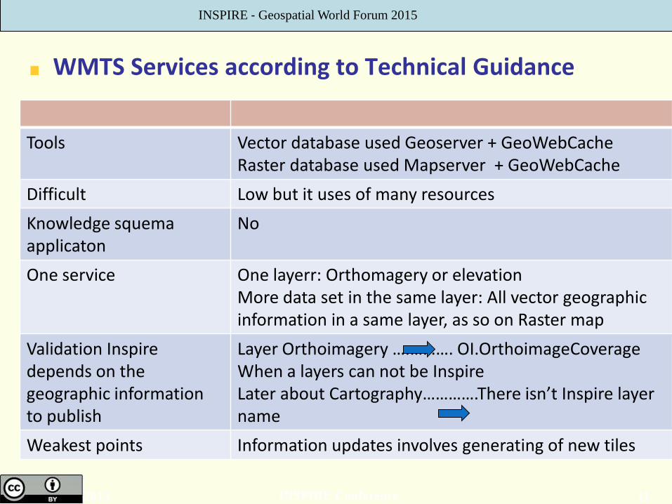
WMTS Services according to Technical Guidance
Tools Vector database used Geoserver + GeoWebCache Raster database used Mapserver + GeoWebCache
Difficult Low but it uses of many resources
Knowledge squema applicaton
No
One service One layerr: Orthomagery or elevation More data set in the same layer: All vector geographic information in a same layer, as so on Raster map
Validation Inspire depends on the geographic information to publish
Layer Orthoimagery ….………. OI.OrthoimageCoverage When a layers can not be Inspire Later about Cartography………….There isn’t Inspire layer name
Weakest points Information updates involves generating of new tiles
INSPIRE ‐ Geospatial World Forum 2015
12 INSPIRE Conference 2015
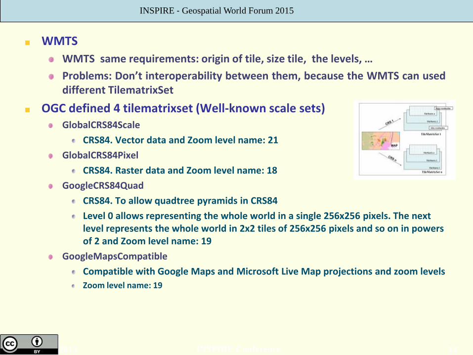
WMTS
WMTS same requirements: origin of tile, size tile, the levels, …
Problems: Don’t interoperability between them, because the WMTS can used different TilematrixSet
OGC defined 4 tilematrixset (Well-known scale sets) GlobalCRS84Scale
CRS84. Vector data and Zoom level name: 21
GlobalCRS84Pixel
CRS84. Raster data and Zoom level name: 18
GoogleCRS84Quad
CRS84. To allow quadtree pyramids in CRS84
Level 0 allows representing the whole world in a single 256x256 pixels. The next level represents the whole world in 2x2 tiles of 256x256 pixels and so on in powers of 2 and Zoom level name: 19
GoogleMapsCompatible
Compatible with Google Maps and Microsoft Live Map projections and zoom levels
Zoom level name: 19
INSPIRE ‐ Geospatial World Forum 2015
13 INSPIRE Conference 2015
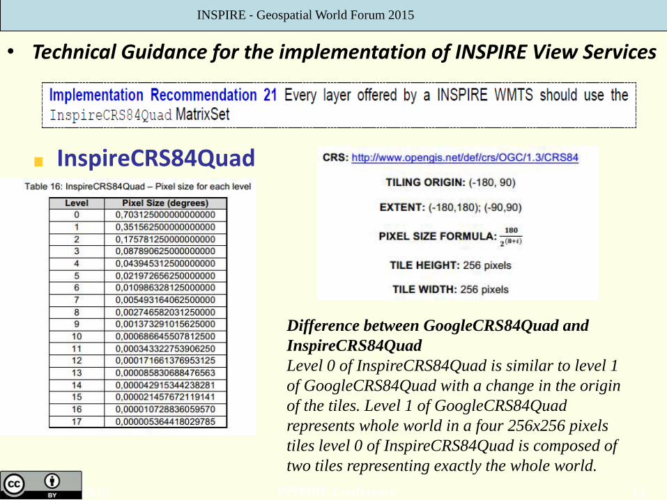
InspireCRS84Quad
• Technical Guidance for the implementation of INSPIRE View Services
INSPIRE ‐ Geospatial World Forum 2015
Difference between GoogleCRS84Quad and
InspireCRS84Quad
Level 0 of InspireCRS84Quad is similar to level 1
of GoogleCRS84Quad with a change in the origin
of the tiles. Level 1 of GoogleCRS84Quad
represents whole world in a four 256x256 pixels
tiles level 0 of InspireCRS84Quad is composed of
two tiles representing exactly the whole world.

14 INSPIRE Conference 2015
GetCapabilities WMTS <TileMatrixSetLink>
<TileMatrixSet>InspireCRS84Quad</TileMatrixSet>
<TileMatrixSet>EPSG:4326</TileMatrixSet>
<TileMatrixSet>EPSG:4258</TileMatrixSet>
<TileMatrixSet>EPSG:25830</TileMatrixSet>
<TileMatrixSet>EPSG:25828</TileMatrixSet>
<TileMatrixSet>GoogleMapsCompatible</TileMatrixSet>
</TileMatrixSetLink>
<TileMatrixSet>
<ows:Identifier>InspireCRS84Quad</ows:Identifier>
<ows:SupportedCRS>http://www.opengis.net/def/crs/OGC/1.3/CRS84</ows:SupportedCRS>
<TileMatrix>
<ows:Identifier>0</ows:Identifier><
ScaleDenominator>2.79541132014358E8</ScaleDenominator>
<TopLeftCorner>-180.0 90.0</TopLeftCorner>
<TileWidth>256</TileWidth>
<TileHeight>256</TileHeight>
<MatrixWidth>2</MatrixWidth>
<MatrixHeight>1</MatrixHeight>
</TileMatrix
WMTS shall be based on common criteria
Same format Jpeg: less storage space is needed
Png: recommedation of Inspire, transparent, Teselas cacheadas por el usuario
-Resolution of tile
-Origin of tite
-Size of tile
-Identifier of tilematrix
INSPIRE ‐ Geospatial World Forum 2015

15 INSPIRE Conference 2015
WMTS precacheo
Update the tile: level / time
InspireCRSQuad84 Approximate time required to
publish a tiling service Scale
Level 0 to 9 …
Level 10 …
Level 11 …
Level 12 …
Level 13 …
Level 14 2 hours
Level 15 8 hours
Level 16 32 hours
Level 17 128 hours = 5 days 1:2000 (pixel size = 0.6 m)
Level 18 512 hours = 21 days 1:1000 (pixel size =0,30 m )
Orthoimagery WMTS <TileMatrixSet>InspireCRS84Quad</TileMatrixSet> 21 days
<TileMatrixSet>EPSG:4326</TileMatrixSet> User tiling the image
<TileMatrixSet>EPSG:4258</TileMatrixSet>
<TileMatrixSet>EPSG:25830</TileMatrixSet> 21 days
<TileMatrixSet>EPSG:25828</TileMatrixSet>
<TileMatrixSet>GoogleMapsCompatible</TileMatrixSet> 21 days
INSPIRE ‐ Geospatial World Forum 2015

16 INSPIRE Conference 2015
Download Services according to Technical Guidance download services enabling copies of complete spatial data sets, or of parts of such sets, to be downloaded.
Tools Deegree: automatically generates the structure of tables Extract-Transform-Load. ETL
Difficult High
Knowledge squema applicaton
Yes. Necessary condition
One service One Data Set WFS Transport Network WFS Geographic Names WFS Hydrographic ---
Weakest points Don’t use massive like WMS
INSPIRE ‐ Geospatial World Forum 2015

17 INSPIRE Conference 2015
Join and split tables, select specific columns in a table, encode or decode values, join or separate columns of a table, create new fields, etc.
Deegree automatically generates the structure of tables in the database
from a specific application schema. Advantage of file mapping between the database and application schema is generated automatically
Disadvantage: a large number of tables are created in the database, especially if the scheme is complex.
ETL (Extract Transform Load). FME o GeoKettle.
INSPIRE ‐ Geospatial World Forum 2015
18 INSPIRE Conference 2015
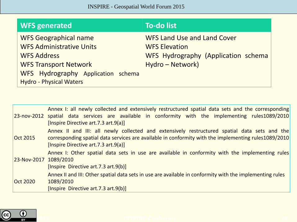
WFS generated To-do list
WFS Geographical name WFS Administrative Units WFS Address WFS Transport Network WFS Hydrography Application schema Hydro - Physical Waters
WFS Land Use and Land Cover WFS Elevation WFS Hydrography (Application schema Hydro – Network)
INSPIRE ‐ Geospatial World Forum 2015
23-nov-2012 Annex I: all newly collected and extensively restructured spatial data sets and the corresponding spatial data services are available in conformity with the implementing rules1089/2010 [Inspire Directive art.7.3 art.9(a)]
Oct 2015 Annex II and III: all newly collected and extensively restructured spatial data sets and the corresponding spatial data services are available in conformity with the implementing rules1089/2010 [Inspire Directive art.7.3 art.9(a)]
23-Nov-2017 Annex I: Other spatial data sets in use are available in conformity with the implementing rules 1089/2010 [Inspire Directive art.7.3 art.9(b)]
Oct 2020 Annex II and III: Other spatial data sets in use are available in conformity with the implementing rules 1089/2010 [Inspire Directive art.7.3 art.9(b)]

19 INSPIRE Conference 2015
Today National Geographic Institute has
17 WMS in IGN
13 services according to Technical Guidance for the implementation of INSPIRE View Services
4 services not according to Directive because is not Inspire geographic information or is a specific service
13 WFS
5 services according to Technical Guidance for the implementation of INSPIRE Download Services
8 services not according to technical guidance. Many of these need to be transformed, others eliminated
6 WMTS
According to implementing rules except the names of layers and the information displayed
All spatial data services are free and available in a
http://www.idee.es/web/guest/directorio-de-servicios or IDEE Catalogue
http://www.idee.es/csw-inspire-idee/srv/spa/main.home
INSPIRE ‐ Geospatial World Forum 2015

Thank you for your attention
20 INSPIRE Conference 2015
Paloma abad
National Geographic Institute
INSPIRE ‐ Geospatial World Forum 2015