impacts of the lightsquared network on federal science
TRANSCRIPT

U.S. GOVERNMENT PRINTING OFFICE
WASHINGTON :
For sale by the Superintendent of Documents, U.S. Government Printing OfficeInternet: bookstore.gpo.gov Phone: toll free (866) 512–1800; DC area (202) 512–1800
Fax: (202) 512–2104 Mail: Stop IDCC, Washington, DC 20402–0001
68–227PDF 2011
IMPACTS OF THE LIGHTSQUARED NETWORK ON FEDERAL SCIENCE ACTIVITIES
HEARING BEFORE THE
COMMITTEE ON SCIENCE, SPACE, AND
TECHNOLOGY
HOUSE OF REPRESENTATIVES
ONE HUNDRED TWELFTH CONGRESS
FIRST SESSION
THURSDAY, SEPTEMBER 8, 2011
Serial No. 112–33
Printed for the use of the Committee on Science, Space, and Technology
(
Available via the World Wide Web: http://science.house.gov
(II)
COMMITTEE ON SCIENCE, SPACE, AND TECHNOLOGY
HON. RALPH M. HALL, Texas, Chair F. JAMES SENSENBRENNER, JR.,
Wisconsin LAMAR S. SMITH, Texas DANA ROHRABACHER, California ROSCOE G. BARTLETT, Maryland FRANK D. LUCAS, Oklahoma JUDY BIGGERT, Illinois W. TODD AKIN, Missouri RANDY NEUGEBAUER, Texas MICHAEL T. MCCAUL, Texas PAUL C. BROUN, Georgia SANDY ADAMS, Florida BENJAMIN QUAYLE, Arizona CHARLES J. ‘‘CHUCK’’ FLEISCHMANN,
Tennessee E. SCOTT RIGELL, Virginia STEVEN M. PALAZZO, Mississippi MO BROOKS, Alabama ANDY HARRIS, Maryland RANDY HULTGREN, Illinois CHIP CRAVAACK, Minnesota LARRY BUCSHON, Indiana DAN BENISHEK, Michigan VACANCY
EDDIE BERNICE JOHNSON, Texas JERRY F. COSTELLO, Illinois LYNN C. WOOLSEY, California ZOE LOFGREN, California BRAD MILLER, North Carolina DANIEL LIPINSKI, Illinois GABRIELLE GIFFORDS, Arizona DONNA F. EDWARDS, Maryland MARCIA L. FUDGE, Ohio BEN R. LUJAN, New Mexico PAUL D. TONKO, New York JERRY MCNERNEY, California JOHN P. SARBANES, Maryland TERRI A. SEWELL, Alabama FREDERICA S. WILSON, Florida HANSEN CLARKE, Michigan VACANCY

(III)
C O N T E N T S Thursday, September 8, 2011
Page Witness List ............................................................................................................. 2 Hearing Charter ...................................................................................................... 3
Opening Statements
Statement by Representative Ralph M. Hall, Chairman, Committee on Science, Space, and Technology, U.S. House of Representatives ..................... 12
Written Statement ............................................................................................ 13 Statement by Representative Eddie Bernice Johnson, Ranking Minority Mem-
ber, Committee on Science, Space, and Technology, U.S. House of Rep-resentatives ........................................................................................................... 14
Written Statement ............................................................................................ 15
Witnesses:
Mr. Anthony Russo, Director, the National Coordination Office for Space- Based Positioning, Navigation, and Timing
Oral Statement ................................................................................................. 17 Written Statement ............................................................................................ 19
Ms. Mary Glackin, Deputy Under Secretary, National Oceanic and Atmos-pheric Administration
Oral Statement ................................................................................................. 29 Written Statement ............................................................................................ 30
Mr. Victor Sparrow, Director, Spectrum Policy, Space Communications and Navigation, Space Operations Mission Directorate, National Aeronautics and Space Administration
Oral Statement ................................................................................................. 34 Written Statement ............................................................................................ 36
Hon. Peter H. Appel, Administrator, Research and Innovative Technology Administration, Department of Transportation
Oral Statement ................................................................................................. 39 Written Statement ............................................................................................ 40
Dr. David Applegate, Associate Director, Natural Hazards, U.S. Geological Survey
Oral Statement ................................................................................................. 43 Written Statement ............................................................................................ 44
Mr. Jeffrey J. Carlisle, Executive Vice President, Regulatory Affairs and Public Policy, LightSquared
Oral Statement ................................................................................................. 46 Written Statement ............................................................................................ 48
Dr. Scott Pace, Director, Space Policy Institute, George Washington Univer-sity
Oral Statement ................................................................................................. 75 Written Statement ............................................................................................ 77
Discussion ................................................................................................................. 88

PageIV
Appendix 1: Answers to Post-Hearing Questions
Mr. Anthony Russo, Director, the National Coordination Office for Space- Based Positioning, Navigation, and Timing ....................................................... 106
Ms. Mary Glackin, Deputy Under Secretary, National Oceanic and Atmos-pheric Administration .......................................................................................... 115
Mr. Victor Sparrow, Director, Spectrum Policy, Space Communications and Navigation, Space Operations Mission Directorate, National Aeronautics and Space Administration ................................................................................... 132
Hon. Peter H. Appel, Administrator, Research and Innovative Technology Administration, Department of Transportation ................................................ 141
Dr. David Applegate, Associate Director, Natural Hazards, U.S. Geological Survey ................................................................................................................... 147
Mr. Jeffrey J. Carlisle, Executive Vice President, Regulatory Affairs and Public Policy, LightSquared ................................................................................ 151
Dr. Scott Pace, Director, Space Policy Institute, George Washington Univer-sity ......................................................................................................................... 164
Appendix 2: Additional Material for the Record
Prepared Statement of Mr. Randy Neugebauer, U.S. House Committee on Science, Space, and Technology .......................................................................... 172
Letter from Members of Congress to Hon. Julius Genachowski, Chairman, Federal Communications Commission, Washington, DC ................................. 173
Response to Hon. Randy Neugebauer from Hon. Julius Genachowski, Chair-man, Federal Communications Commission, Washington, DC ........................ 178
Written Statement of the Coalition to Save Our GPS, Presented to the House Committee on Science, Space, and Technology .................................................. 179
Letter to Hon. Ralph M. Hall, Chairman, U.S. House Committee on Science, Space, and Technology from Mr. Malcolm D. Jackson, Assistant Adminis-trator and Chief Information Officer, U.S. Environmental Protection Agen-cy ........................................................................................................................... 196
Letter to Hon. Ralph M. Hall, Chairman, U.S. House Committee on Science, Space, and Technology from Mr. Michael W. Locatis III, Chief Information Officer, U.S. Department of Energy ................................................................... 197
Letter to Hon. Ralph M. Hall, Chairman, U.S. House Committee on Science, Space, and Technology from Mr. Subra Suresh, Director, National Science Foundation ............................................................................................................ 198
Letter to Mr. Larry Strickling, Assistant Secretary of Commerce, U.S. Depart-ment of Commerce from NASA ........................................................................... 199
Federal Aviation Administration: LightSquared Impact to Aviation: FAA Per-spective: PowerPoint Presentation to U.S. House Committee on Science, Space, and Technology ......................................................................................... 204
Letter to Mr. Karl B. Nebbia, Associate Administrator, National Tele-communications and Information Administration from Mr. Joel Szabat, Deputy Assistant Secretary for Transportation Policy, U.S. Department of Transportation ................................................................................................. 219
Memorandum for Mr. Karl Nebbia, Associate Administrator, National Tele-communications and Information Administration from Deanna Archuleta, Senior Advisor to the Secretary, Department of the Interior ........................... 252

(1)
IMPACTS OF THE LIGHTSQUARED NETWORK ON FEDERAL SCIENCE ACTIVITIES
THURSDAY, SEPTEMBER 8, 2011
HOUSE OF REPRESENTATIVES, COMMITTEE ON SCIENCE, SPACE, AND TECHNOLOGY,
Washington, DC.
The Committee met, pursuant to call, at 2:19 p.m., in Room 2318 of the Rayburn House Office Building, Hon. Ralph Hall [Chairman of the Committee] presiding.

2

3
1 FCC DA 11–133, January 26, 2011. 2 FCC 03–15, February 10, 2003.
HEARING CHARTER
COMMITTEE ON SCIENCE, SPACE, AND TECHNOLOGY U.S. HOUSE OF REPRESENTATIVES
Impacts of the LightSquared Network on Federal Science Activities
WEDNESDAY, SEPTEMBER 8, 2011 2:00 P.M.—4:00 P.M.
2318 RAYBURN HOUSE OFFICE BUILDING
Hearing Purpose The purpose of this hearing is to examine the concerns and issues associated with
interference on the Global Positioning System (GPS) signal from the proposed LightSquared LLC terrestrial broadband network related to federal scientific activi-ties.
The committee will review the results of recent testing on the impact of the LightSquared network on the GPS signal. Potential interference could disable the GPS signal used for critical U.S. Government services and science missions such as the Next Generation Air Transportation System, Earth and space science missions, communications and navigation, space mission operations, weather predication and climate observation, search and rescue, disaster response and public safety, naviga-tion, geodesy, and marine research platforms and services. In addition, the Com-mittee will examine measures and costs necessary to implement and prioritize miti-gation strategies at federal departments and agencies. Background
LightSquared is a Mobile Satellite Service (MSS) telecommunication company owned by Harbinger Capital Partners Funds that was formed in 2010 with plans to provide a wholesale, nationwide 4G wireless broadband network through their ex-isting mobile satellite communications services and a ground-based wireless commu-nications network that uses the same L-band radio spectrum as their satellites. LightSquared’s predecessor companies include SkyTerra Communications, Inc. (SkyTerra), Mobile Satellite Ventures (MSV), Motient Services Inc. and American Mobile Satellite Company (AMSC). 1
LightSquared operates its satellite service using two geostationary satellites that cover North America and is also authorized to operate a ‘‘next-generation’’ satellite called SkyTerra–1, launched on November 14, 2010.
The new LightSquared terrestrial network will be located in the same frequency band as their satellite service, which is adjacent to existing GPS spectrum, and transmitted through approximately 40,000 base stations located primarily in major city markets. A number of GPS stakeholders have raised concerns with the Federal Communications Commission (FCC) that the proposed LightSquared business plan will interfere with existing GPS-based services.
In 2003, the FCC adopted initial rules allowing commercial satellite service pro-viders to operate a ground network integrated with their satellite service. These in-tegrated ground networks are referred to as an Ancillary Terrestrial Component (ATC) of a Mobile Satellite Service (MSS) and were intended to ‘‘fill in’’ gaps and boost the penetration of the original satellite signal within dense urban environ-ments. The integrated ATC network would simply augment the satellite signal.
The initial ATC ruling permitted MSS providers to enhance their satellite service but was not intended to become an independent terrestrial network. The FCC stated in the 2003 ruling:
The purpose of our grant of ATC authority is to provide satellite licensees flexibility in providing satellite services that will benefit consumers, not to allow licensees to profit by selling access to their spectrum for a terrestrial-only service. 2
In 2004, the FCC granted LightSquared (then known as MSV) conditional ap-proval to build its integrated ATC ground-based wireless network using its satellite

4
3 FCC DA 04–3553, November 8, 2004. 4 ‘‘Notice to Noteholders—Name Change,’’ SkyTerra Press Release, December 8, 2008. 5 FCC DA 10–535, March 26, 2010. 6 FCC DA 11–133, January 26, 2010. 7 Ibid. 8 Hearing titled ‘‘GPS Reliability: A Review of Aviation Industry Performance, Safety Issues,
and Avoiding Potential New and Costly Government Burdens,’’ Committee on Transportation and Infrastructure, U.S. House of Representatives, June 23, 2011.
9 FCC Proceeding filing 11–109, June 30, 2011. 10 Final Report of the Technical Working Grouup, June 30, 2011.
spectrum near the GPS signal. 3 At that time, the GPS industry concluded that in-terference with GPS signal would be manageable as the ATC would simply augment the satellite signal.
MSV changed its name to SkyTerra in 2008. 4 In 2010, Harbinger Capital Part-ners Funds became the principal owner of SkyTerra, 5 and subsequently renamed the company LightSquared. The newly formed company also developed a new busi-ness plan to provide a wholesale, nationwide 4G wireless broadband network through their existing mobile satellite communications services and an integrated ground-based wireless communications network that uses the same L-band radio spectrum as their satellites.
On January 26, 2011, the FCC granted LightSquared a conditional waiver of its ATC authority ‘‘integrated service rule’’ meaning its customers could offer terrestrial only services. 6 LightSquared maintains that its network will continue to offer both satellite and terrestrial services bundled together but that its wholesale customers could sell smartphones and similar devices that are only capable of transmitting and receiving with the terrestrial base stations. 7 The approval also required LightSquared to form a Technical Working Group (TWG) and issue a GPS inter-ference assessment report, due to the FCC on June 15, 2011.
In March 2011, LightSquared formed the TWG with industry representatives and government officials to conduct testing and report the results of impacts on the GPS signal. Comments and responses on the TWG report were due on August 15th. Re-cent congressional testimony on the report’s findings indicate significant inter-ference between the LightSquared signal and the GPS signal. 8
Independent of the FCC-ordered study, the U.S. Government’s National Space- Based Positioning, Navigation, and Timing Systems Engineering Forum (NPEF) conducted its own testing of the potential interference to military and civilian GPS users from LightSquared’s terrestrial network. The NPEF completed its report on June 1, 2011, and concluded that harmful interference to the GPS signal would re-sult from the LightSquared network. The NPEF report recommended that the FCC withhold authorization for LightSquared to commence commercial operations and stated:
The U.S. Government should conduct more thorough studies on the operational, economic and safety impacts of operating the LightSquared Network.
In light of the test results from the TWG and the NPEF reports, LightSquared has proposed a new plan to initiate commercial operations utilizing the lower 10 MHz of its L-band spectrum that the company believes will minimize interference with the GPS signal. 9 While LightSquared maintains its new proposal will signifi-cantly reduce interference to a large percentage of the GPS user community, its im-pact on aviation, space-based, and high precision users, such as the FAA NextGen, NASA Earth Science missions, GPS meteorology, seismology, and NOAA weather satellites and marine surveyors remains uncertain. While these users represent a small percentage of the overall GPS community, their services are critical to U.S. government operations and science missions.
The latest LightSquared proposal would first utilize the lower 10 MHz of its L- band spectrum allocation that is the farthest away from the GPS signal at reduced power. Over time, provided interference concerns with the GPS signal could be suffi-ciently mitigated, LightSquared would then start operations across its entire upper and lower spectrum allocation. Although not specifically tested, the TWG report con-tains numerous recommendations (see Appendix 1) to conduct additional testing on the impact on the GPS signal if the FCC were to authorize LightSquared’s latest commercial operations proposal. 10
On July 6, 2011, the National Telecommunications and Information Administra-tion (NTIA) sent a letter to the FCC stating that, based on the government testing and analysis, earlier concerns about GPS interference remain unresolved and addi-tional testing is necessary. NTIA recommended that the FCC continue to withhold authorization for LightSquared to commence commercial operations, stating:

5
11 NTIA Letter to FCC, July 6, 2011. 12 Letter from Chairman Genachowski, FCC, to Senator Grassley, May 31, 2011. 13 FCC filing, Recommendation of LightSquared LLC, June 30, 2011. 14 http://www.saveourgps.org/ pdf/TWGlFinallReportl2lPagel Summary.pdf.
15 FCC filing, Recommendation of LightSquared LLC, June 30, 2011.
NTIA supports the [National Executive Committee for Space-Based Positioning, Navigation, and Timing] EXCOM’s recommendation that additional tests be per-formed and recommends that the FCC continue to withhold authorization for LightSquared to commence commercial operations until all the available test data can be analyzed and all valid concerns have been resolved. 11
On May 11, 2011, the National Executive Committee for Space-Based Positioning, Navigation, and Timing requested Departments and agencies assess the impacts of LightSquared’s concept for operations. The PNT-NCO asked Departments and agen-cies to answer the following questions:
• Summarize and quantify current and future benefits provided by use of GPS- based application and any cost-benefit analyses.
• Summarize and quantify total sunk costs in GPS-based infrastructure (prior years to date) and planned investments going forward.
• To the extent possible, qualify, quantify, and describe risks to your agency’s GPS-based mission capability, including ‘‘lost benefits’’ if GPS performance were degraded (or lost) due to LightSquared’s signals including the costs to modify (or replace) GPS receiver infrastructure and the time frame required to replace that infrastructure.
As stated previously, comments on the TWG report were due on July 29, 2011, and responses to comments were due on August 15, 2011. At this point, the FCC can rule on whether to approve LightSquared’s proposal at any time. While it is pos-sible that the FCC could approve LightSquared’s proposal, the Commission has stat-ed that it ‘‘will not permit LightSquared to begin commercial service without first resolving the Commission’s concerns about potential widespread harmful inter-ference to GPS devices. The FCC International Bureau’s Order of January 26, 2011 (Order), outlines our interference concerns and unambiguously conditions LightSquared’s commercial operation on first resolving those challenges to our satis-faction. Under no circumstances would I put at risk our nation’s national defense or public safety.’’ 12
Issues Mitigation
While LightSquared announced that their new proposal (which offers to delay the use of the upper band of their spectrum) mitigates interference with 99 percent of GPS receivers, the GPS industry has challenged these claims.13,14 There would still be interference, however, with high precision ers—the primary users of GPS that the Committee is concerned with. Recent statements by LightSquared indicate that the remaining interference can be minimized by the use of filters. Questions remain as to whether this is actually possible, whether such a plan would require additional testing, how much this would cost, who would bear the costs of developing these fil-ters, and who would be responsible for retrofitting impacted receivers.
Spectrum Use
LightSquared’s new proposal also states that they will, ‘‘delay incorporating into its terrestrial network the upper 10 MHz of its frequencies in which transmissions may jeopardize legacy GPS usage,’’ but will ‘‘work with the FCC, NTIA, and other government agencies to explore all options for using a full complement of terrestrial frequencies.’’ 15 Assuming LightSquared’s proposal is allowed by the FCC, it is un-certain whether the FCC will prevent LightSquared from operating in the upper 10 MHz, or if this prohibition will be self-imposed. Issues also exist relative to how to determine an acceptable level of interference, who makes this determination, and when this determination can be made.
Spectrum Encroachment
High precision GPS receivers utilize a technique that receives augmentation sig-nals over a wide swath of Global Navigation Satellite System (GNSS) spectrum in

6
16 FCC Filing SAT-MOD-20101118–00239, Feb. 25, 2011. 17 Letter to the Office of Spectrum Management, NTIA, from Mobile Satellite Ventures L.P.
and the U.S. GPS Industry Council, July 25, 2002.
order to achieve sub-centimeter accuracy. 16 These receivers also ‘‘look’’ across the spectrum allocated to LightSquared. While regulations exist to restrict broadcasts to certain portions of the spectrum, no regulations exist related to receivers. There-fore, LightSquared argues that interference ‘‘is not caused by emissions from LightSquared’s base stations into the GPS band, but from the failure of these legacy GPS receivers to reject transmissions from LightSquared’s licensed frequencies, which are adjacent to the spectrum allocated for use by GPS.’’ Conversely, the GPS industry argues that the LightSquared spectrum was originally planned to be for a Mobile Satellite Service (MSS), which, by design, can coexist with the GPS signal since it is of a similar strength. Furthermore, the GPS industry claims that the out- of-band spectrum that high precision GPS receivers use in LightSquared’s spectrum can coexist without interference as long as the signal strength used by LightSquared in its spectrum remains predominately satellite based as originally planned. Although FCC waivers have allowed satellite providers to operate ancillary terrestrial components (ATC) to augment satellite signals, agreements were made to prevent interference with not only other bands, but also interference with a pro-vider’s own satellite signal. 17 With LightSquared’s proposal to operate a predomi-nately terrestrial network, bundled with a satellite service, adjacent to a low-level GPS signal, these interference issues have now become problematic.
Witnesses
• Mr. Anthony Russo, Director, National Coordination Office for Positioning, Navigation and Timing
• Ms. Mary Glackin, Deputy Under Secretary, National Oceanic and Atmospheric Administration
• Mr. Victor Sparrow, Director, Spectrum Policy, Space Communications and Navigation, Space Operations Mission Directorate, National Aeronautics and Space Administration
• The Honorable Peter Appel, Administrator, Research and Innovation Tech-nology Administration, Department of Transportation
• Dr. David Applegate, Associate Director, Natural Hazards, U.S. Geological Sur-vey
• Mr. Jeffrey J. Carlisle, Executive Vice President, Regulatory Affairs and Public Policy, LightSquared
• Dr. Scott Pace, Director, Space Policy Institute, George Washington University

7
APPENDIX 1
GPS Technical Working Group (TWG) Final Report—6/30/2011 (Excerpts) 2.7.5 Space-based Receivers • In NASA‘s view, the interference to space-based GPS receivers used for [radio
occultation (RO)] RO would be severely disruptive to NASA‘s science missions based on the test and analysis conducted in the TWG. Space-based GPS receiv-ers used for navigation and precise orbit determination would receive a lesser amount of interference, though interference would occur.
• NASA is of the view that, although the TWG members worked diligently and in good faith throughout the period prescribed by the FCC, it was impossible to adequately evaluate and thoroughly investigate potential interference mitiga-tion options for space-based and high precision science receivers.
3.1 Aviation Sub-Team • Compatibility of aviation GPS operations with a single lower 10 MHz channel
could not be determined definitively without additional study. 3.4 High Precision, Timing, and Networks Sub-Team • 1.1 GPS Community Positions • (5) In the lower 10 MHz channel configuration, 31 of 33 High Precision and
Network GPS receivers tested experienced harmful interference within the range of power levels that would be seen inside the network. High precision receivers fielded today would experience harmful interference at up to 5 km from a single LightSquared base station.
• With respect to possible mitigations: • (4) We believe more study is required on the feasibility of building future
wideband High Precision, Network, and Timing receivers and augmentation systems that would be compatible with LightSquared terrestrial signals and which would provide the same performance as today‘s receivers and systems. We do not foresee any possibility that LightSquared signals near the GPS band could ever be compatible with wideband receivers.
• (6) The viability of proposed future concepts to accommodate high precision GPS and MSS augmentations in the presence of interference from LightSquared terrestrial operations only in the lower 10MHz band has not been tested or validated as part of this study.

8
APPENDIX 2—LEGISLATION
HR 2596. Commerce, Justice, Science Appropriations Act
• Committee Report 112–169: Spectrum interference issues.—The Committee is aware that NTIA and the Federal Communications Commission (FCC) are in the midst of a regulatory process with respect to the Global Positioning System and that a technical working group is reviewing potential interference issues. NTIA is directed to report to the Committee following completion of the tech-nical working group activities, but no later than August 1, 2011, regarding the discoveries of this technical working group and the scientific steps necessary to address any potential interference concerns.
HR 2434. Financial Service Appropriations Act
• Section 633: None of the funds made available in this Act may be used by the Federal Communications Commission to remove the conditions imposed on com-mercial terrestrial operations in the Order and Authorization adopted by the Commission on January 26, 2011 (DA 11–133), or otherwise permit such oper-ations, until the Commission has resolved concerns of potential widespread harmful interference by such commercial terrestrial operations to commercially available Global Positioning System devices.
• Committee Report 112–136: The Committee is aware of concerns related to pos-sible interference to Global Positioning System (GPS) devices due to terrestrial broadband service. The Committee remains engaged on this issue and awaits the final report by the Technical Working Group.
HR 1540. National Defense Authorization Act, 2012
• Committee Report 112–78: The committee is aware that the Federal Commu-nications Commission (FCC) issued a conditional order to a commercial commu-nications company on January 26, 2011, authorizing it to provide broadband voice and data communications services that potentially interfere with GPS. The committee recognizes that the Armed Forces are highly dependent on GPS capabilities and services. The committee believes that any space-based or ter-restrial-based commercial communications service that has the potential to interfere with GPS should not receive final authorization to provide service within the United States by the FCC unless and until the potential interference with GPS is resolved. Such commercial services are planned to be transmitted from 40,000 land-based towers across the United States. The committee under-stands, based on information received from the Air Force, that the signal strength of such service is estimated to be one billion times more powerful than the GPS signal. Though the commercial service would broadcast on a frequency adjacent to GPS, it may still overwhelm GPS receivers, potentially causing a denial of service for millions of users in the United States relying on GPS navi-gation and timing services. Such users included the military, emergency re-sponders, maritime and aeronautical emergency communication systems, bank-ing transactions, air traffic and ground transportation systems, and myriad commercial applications. The committee understands that the Deputy Secretary of Defense sent a letter to the Chairman of the Federal Communications Com-mission on January 12, 2011, highlighting the ‘‘strong potential for interference to . . . critical national security systems,’’ and ‘‘strongly recommend[ing] deferral of final action on [the FCC order and authorization] until the proper inter-ference analysis and mitigation studies can be conducted.’’
HR 2112. Agriculture, Rural Development, Food and Drug Administration, and Re-lated Agencies Appropriations Act, 2012
• Committee Report 112–101: GPS Interference.—The Committee recognizes that the use of the Global Positioning System (GPS) is critical to USDA’s mission, including natural resource monitoring, forest firefighting, law enforcement, and research. In addition, precision agriculture would not be possible without GPS. It is estimated that U.S. farmers and ranchers have invested more than $3 bil-lion in GPS technologies.
• The Committee is aware of a decision by the Federal Communications Commis-sion that may disrupt the use of GPS, causing significant problems for USDA and our Nation’s farmers and ranchers. The Committee directs USDA to ensure the FCC is aware of these concerns and to work with other Federal agencies,

9
such as the Department of Defense and the Department of Transportation, to address them.
10
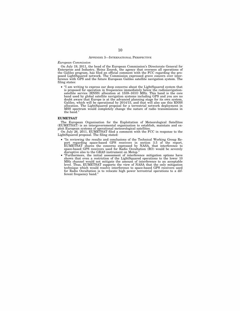
APPENDIX 3—INTERNATIONAL PERSPECTIVE
European Commission On July 19, 2011, the head of the European Commission’s Directorate General for
Enterprise and Industry, Heinz Zourek, the agency that oversees all operations of the Galileo program, has filed an official comment with the FCC regarding the pro-posed LightSquared network. The Commission expressed grave concern over inter-ference with GPS and the future European Galileo satellite navigation system. The filing states:
• ‘‘I am writing to express our deep concerns about the LightSquared system that is proposed for operation in frequencies immediately below the radionavigation- satellite service (RNSS) allocation at 1559–161O MHz. This band is the core band used by global satellite navigation systems including GPS and you are no doubt aware that Europe is at the advanced planning stage for its own system, Galileo, which will be operational by 2014/15, and that will also use this RNSS allocation. The LightSquared proposal for a terrestrial network deployment in MSS spectrum would completely change the nature of radio transmissions in the band.’’
EUMETSAT The European Organisation for the Exploitation of Meteorological Satellites
(EUMETSAT) is an intergovernmental organization to establish, maintain and ex-ploit European systems of operational meteorological satellites.
On July 26, 2011, EUMETSAT filed a comment with the FCC in response to the LightSquared proposal. The filing stated:
• ‘‘In reviewing the results and conclusions of the Technical Working Group Re-port regarding space-based GPS receivers in section 3.5 of the report, EUMETSAT shares the concerns expressed by NASA, that interference to space-based GPS receivers used for Radio Occultation (RO) would be severely disruptive also to the GRAS instrument on Metop.’’
• ‘‘Furthermore, the initial assessment of interference mitigation options have shown that even a restriction of the LightSquared operations to the lower 10 MHz channel would not mitigate the amount of interference to an acceptable level. Thus, EUMETSAT supports the view of NASA that the only mitigation technique which would resolve interference to space-based GPS receivers used for Radio Occultation is to relocate high power terrestrial operations to a dif-ferent frequency band.’’

11
APPENDIX 4—ILLUSTRATION OF CONCERNS WITH LIGHTSQUARED

12
Chairman HALL. I’d like to welcome you to today’s hearing enti-tled ‘‘Impacts of the LightSquared Network on Federal Science Ac-tivities,’’ and in front of you are the packets containing the written testimony, biography, and truth in testimony disclosures for today’s witnesses. We have two, four, six, seven.
I recognize myself for five minutes for an opening statement. The United States is the clear leader in precision, navigation,
and timing because of its consistent investment in the global posi-tioning system. This investment has been protected and reaffirmed by successive Administrations’ support, which has led to the—one of the greatest technological achievements I guess this Nation has ever created. It is one that both government and industry can be proud of, and it is the gold standard for billions of people around the world.
While it is nearly impossible to quantify the exact impact GPS has on society, it has certainly had an enormous impact on eco-nomic productivity, furthered scientific understanding, and mod-ernized our national defense. Some recent reports estimate GPS en-ables over three trillion in direct and indirect economic activity and has created over three million jobs, a fact that should not be over-looked with the President preparing to speak before Congress in a few short hours on the state of our economy.
In addition to the economic significance, the Global Positioning System is also an important aspect of many federal operations and scientific activities. Aerial and satellite imagery, weather fore-casting, climate observation, search and rescue, air traffic manage-ment, rail transportation, traffic management, vessel navigation, emergency response and mapping, time distribution, seismic moni-toring, land surveys, resource management, agriculture, engineer-ing, and scientific observations all depend on GPS. Any potential disruption to GPS and the science activities that it supports is of utmost concern to this committee.
LightSquared has proposed a network to support the President’s challenge to identify 500 megahertz of new spectrum for broadband service. While the President’s goal is certainly commendable, it should not be accomplished by destroying existing systems and ap-plications. As the President’s own National Space Policy states, the United States must, ‘‘maintain its leadership in the service, provi-sion, and use of global navigation satellite systems,’’ and ‘‘invest in domestic capabilities and support international activities to detect, mitigate, and increase resiliency to harmful interference for GPS.’’
The purpose of this hearing is to examine the potential impact of the LightSquared Network on federal science activities. In doing so we hope to ensure that all the affected agencies are aware of the potential issues, have communicated those concerns effectively, are identifying potential mitigation strategies, and are calculating the costs associated with those mitigation strategies. In preparing for this hearing we have seen varying degrees of preparation by agen-cies. Some have done the expected due diligence, and some clearly have not.
Although the FCC has stated that it will not allow LightSquared to begin commercial service without first resolving the interference issue, nothing actually prevents the FCC from moving forward at this point. Since the testing that was conducted this spring and

13
summer, LightSquared has put forth a modified plan. Unfortu-nately, no testing has been done on this modified plan. I agree with the agencies before us today that additional testing should be re-quired before the FCC allows LightSquared to begin commercial service.
Ensuring that GPS is protected is a vital national interest. Its economic impact is clear, and its utility to science is unquestion-able, but what is also important is the real impact on lives. Last month the FAA announced that LightSquared’s previous proposal would result in billions of dollars of investment loss, a decade of delays to ongoing projects, a cost impact of roughly 72 billion, and almost 800 additional fatalities, and that is just one Administra-tion. Compromising the GPS would also benefit foreign systems and threaten U.S. leadership. As we have recently seen dependence on Russia for access to International Space Station has already compromised U.S. interests. Reliance on Russia’s GLONASS Sys-tem, China’s COMPASS System, of Europe’s GALILEO System for the precision, navigation, and timing would be just as costly.
We have to find a way to open up more spectrum for broadband but not at the expense of GPS. This is, however, a two-way street. GPS users and agencies also have to be mindful that developing applications outside of their spectrum is dangerous and ripe for conflict, even though previously there were no problems.
[The prepared statement of Mr. Hall follows:]
PREPARED STATEMENT OF CHAIRMAN RALPH M. HALL
Good afternoon. Welcome to today’s hearing titled ‘‘Impacts of the LightSquared Network on Federal Science Activities.’’ The United States is the clear leader in pre-cision, navigation, and timing because of its consistent investment in the Global Po-sitioning System. This investment has been protected and reaffirmed by successive Administrations’ support, which has led to one of the greatest technological achieve-ments this nation has ever created. It is one that both government and industry can be proud of and is the gold standard for billions of people around the world. While it is nearly impossible to quantify the exact impact GPS has had on society, it has certainly had an enormous impact on economic productivity, furthered scientific un-derstanding, and modernized our national defense. Some recent reports estimate GPS enables over $3 trillion in direct and indirect economic activity and has created over three million jobs—a fact that should not be overlooked with the President pre-paring to speak before Congress in a few short hours on the state of our economy.
In addition to its economic significance, the Global Positioning System is also an important aspect of many federal operations and scientific activities. Aerial and sat-ellite imagery, weather forecasting, climate observation, search and rescue, air traf-fic management, rail transportation, traffic management, vessel navigation, emer-gency response and mapping, time distribution, seismic monitoring, land surveys, resource management, agriculture, engineering and scientific observations all de-pend upon GPS. Any potential disruption to GPS, and the science activities that it supports, is of utmost concern to this Committee.
LightSquared has proposed a network to support the President’s challenge to identify 500 megahertz of new spectrum for broadband service. While the Presi-dent’s goal is certainly commendable, it should not be accomplished by destroying existing systems and applications. As the President’s own National Space Policy states, the United States must ‘‘maintain its leadership in the service, provision, and use of global navigation satellite systems (GNSS),’’ and ‘‘[i]nvest in domestic ca-pabilities and support international activities to detect, mitigate, and increase resil-iency to harmful interference to GPS.’’
The purpose of this hearing is to examine the potential impact of the LightSquared network on federal science activities. In doing so, we hope to ensure that all of the affected agencies are aware of the potential issues, have commu-nicated those concerns effectively, are identifying potential mitigation strategies, and are calculating the costs associated with those mitigation strategies. In pre-
14
paring for this hearing, we have seen varying degrees of preparation by agencies. Some have done the expected due diligence and some clearly have not.
Although the FCC has stated that it will not allow LightSquared to begin com-mercial service without first resolving the interference issue, nothing actually pre-vents the FCC from moving forward at this point. Since the testing that was con-ducted this spring and summer, LightSquared has put forth a modified plan. Unfor-tunately, no testing has been done on this modified plan. I agree with the agencies before us today that additional testing should be required before the FCC allows LightSquared to begin commercial service.
Ensuring that GPS is protected is a vital national interest. Its economic impact is clear, and its utility to science is unquestionable, but what is also important is the real impact on lives. Last month the FAA announced that LightSquared’s pre-vious proposal would result in billions of dollars of investment lost, a decade of delays to ongoing projects, a cost impact of roughly $72 billion, and almost 800 addi-tional fatalities—and that is just one Administration. Compromises to GPS would also benefit foreign systems and threaten U.S. leadership. As we have recently seen, dependence on Russia for access to the International Space Station has already com-promised U.S. interests. Reliance on Russia’s GLONASS system, China’s COMPASS system, or Europe’s GALILEO system for precision, navigation, and timing would be just as costly.
We have to find a way to open up more spectrum for broadband, but not at the expense of GPS. This is, however, a two-way street. GPS users and agencies also have to be mindful that developing applications outside of their spectrum is dan-gerous and ripe for conflict, even though previously there were no problems.
With that, I yield to the Ranking Member from Texas, Ms. Johnson.
Chairman HALL. I now recognize Ms. Johnson for her opening statement.
Ms. JOHNSON. Thank you very much, Mr. Chairman. Good after-noon, and I would like to join you in welcoming our witnesses for today’s hearing.
There is no question that the Global Positioning System has transformed our economy and our society in many ways. It has been an amazing accomplishment, and some here may be surprised to learn that this very successful program is a government initia-tive. The Global Positioning System was established by the Depart-ment of Defense to support their national security mission needs.
But civilian agencies also rely on GPS to provide greater services for the American public. There is no doubt that GPS plays an es-sential role in public safety. This hearing will allow Members to better appreciate how agencies use GPS as well as what would be lost without a GPS. GPS satellite signals have also spawned an en-tire area of innovation in private industry with new hardware and applications that allow the average citizen unprecedented tools for location and navigation. All of this has been a free benefit to the Nation’s economy that is a product of sound management of the radio spectrum and direct government investment.
The LightSquared proposal to build a nationwide broadband net-work into frequencies that sit next to GPS has provoked enormous controversy. I believe that if there is no way for LightSquared to move forward without damaging GPS, then the FCC should not ap-prove the company’s proposal.
However, I do not believe that FCC would make a decision that compromises GPS services. The question the commission has to set-tle and the question that this hearing will not allow us to make much headway on is whether GPS can thrive side by side with a ground-based broadband network.
I sincerely hope that they can coexist. Some of those supporting the GPS industry claim such coexistence is impossible. This sug-

15
gests the physics of cell towers sending out powerful transmissions will overwhelm the sensitive GPS receivers.
However, others are feeling this is not a physics problem but an engineering challenge. With filters for GPS units and with reason-able beam shaping at cell towers, smart engineering can solve these problems. I do not know whether we are dealing with a phys-ics problem or an engineering challenge, but I am not convinced that any of the witnesses can today provide an answer to that question with absolute certainty.
The agencies before us are testifying based on testing of GPS equipment under the original LightSquared proposal, in which the company would first build cell towers that broadcast in the portion of the spectrum immediately adjacent to that of GPS. That testing was not based on the new proposal from the company to use the portion of the spectrum that is most remote from GPS-assigned fre-quencies.
I fully believe that the FCC will make its decision based on tech-nical assessments and not the political pressure that may come from private parties or even from committees of Congress or the Executive. I hope to learn as much as I can today about what addi-tional testing may be needed to inform the FCC’s processes.
The core question for policymakers is this. Can we use the L- band, or some portion of it, of the radio spectrum for an earth- based broadband network without damaging GPS? I hope the an-swer is yes, and everyone here should hope the answer is yes, be-cause we need more broadband just as we need GPS.
LightSquared is saying that they intend to invest $14 billion over the next eight years to build out the network, employing 14,000 people in the process. In building more information technology in-frastructure, consumers would have more choice in their tele-communications and data services with lower costs and expanding access.
We should also see accelerating innovation of data-intensive cel-lular applications that take advantage of the greater capacities of this new network, creating more jobs, more profits, and more growth in high-tech industries. And we are desperately in need of jobs, profits, and growth right now.
And while I am skeptical that today we will get definitive an-swers to the most important policy questions, I look forward to lis-tening to the testimony, and I thank all of our witnesses for their participation.
Thank you, and I yield back, Mr. Chairman. [The prepared statement of Ms. Johnson follows:]
PREPARED STATEMENT OF RANKING MEMBER EDDIE BERNICE JOHNSON
The Global Positioning Satellite system has been a complete success. It is, for those who don’t know, a government program. The GPS system was established by the Department of Defense to help assist their security mission needs, but civilian agencies also use the GPS system to provide greater services to the American pub-lic. There is no doubt that GPS plays an essential role in public safety.
But that is not all that has come from this public investment. GPS satellite sig-nals have spawned an entire area of innovation in private industry with new hard-ware and applications that allow the average citizen unprecedented tools for location and navigation. All ofthis has been a free benefit to the economy from this govern-ment investment and sound management of the radio spectrum.

16
The LightSquared proposal to build a nationwide broadband network in the fre-quencies that sit next to GPS has provoked enormous controversy. On the one hand, GPS is too important to lose and so if there is no way for LightSquared to move forward without damaging GPS. On the other hand, the promise of enhanced infra-structure and the jobs that this might create is worthy of further study. This hear-ing will allow Members to better appreciate how OUI agencies use GPS as well as what would be lost should GPS suddenly go away. However, I do not believe that the FCC would make a decision that compromises GPS services. The question they have to settle, and the question that this hearing will not allow us to make much headway on, is whether GPS can thrive side-by≥side with a ground-based broadband network.
Some of those lobbying for the GPS industry claim such coexistence is impossible. They suggest the physics of cell towers sending out powerful transmissions would overwhelm sensitive GPS receivers. However, others argue that this is not a physics problem, but an engineering challenge. With filters for GPS units and with reason-able beam shaping at cell towers, smart engineering could solve these problems. It is unclear whether we are dealing with a physics problem or an engineering chal-lenge, and I do not believe any of the witnesses before us today can provide an an-swer to that question with absolute certainty.
The agencies before us today are testitying based on testing of GPS equipment under the original LightSquared proposal in which the company would first build cell towers designed to use the portion of the spectrum immediately adjacent to that of GPS. Their testing is not based on the new proposal from the company to use their spectrum that is most remote from GPS’s assigned frequencies. The FCC will have to make its decisions based on technical assessments and not the political pres-sure that may come from private parties or even from Committees of Congress. Today, I want to learn about what additional testing may be needed to inform the FCC’s processes.
The core question for policy-makers is this: can we use the L-band, or some por-tion of it, of the radio spectrum for terrestrial broadband applications without dam-aging GPS? I hope that the answer is yes, and everyone here should hope the an-swer is yes, because we need more broadband just as we need GPS. LightSquarcd is proposing to invest $14 billion over the next eight years to build out their network and projects it will employ 14,000 people in the process. In building more informa-tion technology infrastructure, we would see consumers have more choice in their telecommunications and data services, lowering their costs and expanding access. We should also see accelerating innovation of data-intensive cellular applications that take advantage ofthe greater capacities of this new network—creating more jobs, more profits, more growth. And we desperately need jobs, profits and growth right now.
While I am skeptical that we will get definitive answers to the most important policy questions here today, I am happy to listen to the testimony from all of our panel members.
Chairman HALL. Thank you, Ms. Johnson. If there are Members who wish to submit additional opening statements, your state-ments will be added to the record at this point.
At this time I would like to introduce our witnesses and to thank our witnesses because I know they are valuable, their time is valu-able. It took time to prepare for this. It took time for you to arrive here, it will take time for you to give your testimony, take time for you to go home. And your time is valuable, and we are going to try to be as helpful with you. As long as you give us the answers we are looking for, we won’t even use up all of our time.
Mr. Anthony Russo is the Director of National Coordination Of-fice for Positioning, Navigation, and Timing, Mrs. Mary Glackin is the Deputy Under Secretary at the National Oceanic and Atmos-pheric Administration, Mr. Victor Sparrow is the Director of Spec-trum Policy at the National Aeronautics and Space Administration. The Honorable Peter Appel is the Administrator of the Research and Innovation Technology Administration at the Department of Transportation, Dr. David Applegate is the Associate Director for National—Natural Hazards at the U.S. Geological Survey, Mr. Jef-

17
frey J. Carlisle is the Executive Vice President for Regulatory Af-fairs and Public Policy at LightSquared LLC, and Dr. Scott Pace is the Director of the Space Policy Institute at George Washington University. And I want to welcome all of you.
As our witnesses probably know, spoken testimony is limited to five minutes, after which the Members of the Committee will have five minutes each to ask questions. We hope you can stay as close to that five minutes as you can because—and don’t let these empty seats here indicate a lack of interest in what you are saying be-cause we are just back from a month when we were all gone and nobody was getting heard up here, and we came back, and every-body has a lot to do, and they have other committees, but all this testimony is being taken down and will be of record for everybody, not just the Members of this Committee but for everybody to read.
So Mr. Russo, you may proceed if you would like, sir.
STATEMENT OF MR. ANTHONY RUSSO, DIRECTOR, THE NATIONAL COORDINATION OFFICE FOR SPACE-BASED POSITIONING, NAVIGATION, AND TIMING
Mr. RUSSO. Chairman Hall, Ranking Member Johnson, and Members of the Committee, I am deeply honored to be here for you today.
Like the Internet, GPS is an essential element of the global in-formation infrastructure. The free, open, and dependable nature of GPS has led to the development of thousands of applications affect-ing every aspect of modern life, and innovation has not stopped. New applications are being developed daily.
GPS saves lives by preventing transportation accidents, aiding search and rescue efforts, assisting law enforcement, and speeding delivery of emergency services and disaster relief. It is vital to weather forecasting, earthquake monitoring, and environmental protection.
GPS’s role as part of our civil infrastructure traces its roots to a tragic incident in 1983. A Korean airliner took off from Alaska and ended up straying way off course in Soviet airspace. The air-liner was shot down, and all 269 passengers were killed, including a sitting Member of Congress. As part of the response, President Reagan announced we would make GPS signals available to the world, and that marked the beginning of a multi-use policy ap-proach to GPS that each successive Administration has strength-ened.
An Executive Committee consisting of the Department Deputy Secretaries was established in 2004, to advise and coordinate on GPS-related issues to include spectrum protection and interference. To execute the staff functions of the Executive Committee, a Na-tional Coordination Office or NCO was also established. The NCO is staffed with representatives from every department or agency with major equities in GPS. I am speaking to you today in my ca-pacity as director of that office.
Earlier this year, the FCC approved a conditional waiver for LightSquared’s high-powered network, and with the permission of the Executive Committee, a tasked interagency group of technical experts called the National Space-Based Position Navigation and Timing Systems Engineering Forum or NPEF for short, to evaluate

18
the LightSquared proposal, assess impacts, and look at the mitiga-tion of any harmful effects.
And although they were not required to do so, LightSquared ac-tively supported these efforts. They provided their actual hardware including a custom filter for their transmitter, technical specifica-tions, they answered numerous questions, and they even sent per-sonnel to government test sites to review the test set-up. So I would like to take the opportunity to publicly thank LightSquared for their cooperation, which greatly improved the fidelity of the re-sults.
The NPEF testing was done under numerous limitations, espe-cially an extremely compressed time frame, but despite these limi-tations the NPEF reached a definitive answer. LightSquared’s pro-posed system would create harmful interference throughout all three phases of its planned deployment. Although not every indi-vidual receiver failed to perform, there were unacceptable levels of harmful interference in every class of receiver tested and at signifi-cant distances.
I had asked the NPEF to investigate not only things that we might reasonably ask LightSquared to do, but also to look at changes the GPS community could do that would mitigate harmful interference and still allow LightSquared to execute their business plan. The NPEF spent many hours considering the full range of op-tions but could not identify any feasible option that would both mitigate harmful interference for all or even most GPS users and still allow LightSquared to meet their system requirements.
Now, to meet one of the conditions of their conditional waiver, LightSquared created a Technical Working Group or TWG with sig-nificant industry, government representation to conduct inter-ference testing. LightSquared chose to break their testing into seven separate subgroups based on GPS application type. All seven subgroups reported significant harmful interference with respect to all three phases of LightSquared’s planned deployment. However, there was no consensus on feasible mitigation options.
On June 29, LightSquared submitted their TWG report acknowl-edging the harmful interference, and simultaneously they sub-mitted a report outlining a potential solution. LightSquared’s new recommendation paper suggests three distinct changes, and this was a series in constructive proposal, and the FCC is currently evaluating this recommendation, but the NPEF testing did not in-clude the configuration LightSquared is now proposing. And it wasn’t in the TWG test plans either.
Now, in the final days of their testing TWG did manage to collect some of the data relevant to this configuration, but the report itself is inconclusive as to whether data still shows harmful interference to many GPS receivers. The limited data collected is highly dis-puted among the members of TWG. Therefore, the federal agencies are recommending further testing once the FCC defines the final LightSquared end-state configuration.
What we do know is enough data was collected that—by all par-ties in terms of whether or not high-precision receivers would be impacted. LightSquared’s report indicates 31 of 33 receivers tested in this subgroup still failed, even in the lower configuration, and this class of receivers involves many of those used in advanced sci-
19
entific research applications. Most federal science systems were not directly tested by either the NPEF or the TWG, so we do not know for sure if they would be impacted. But the tests did indicate in-creased susceptibility interference for the higher end, more sophis-ticated systems, many of which are used in research and science applications.
In summary, the extensive testing done by LightSquared, the government, and the GPS industry conclusively demonstrate harm-ful interference from LightSquared’s intended deployment, and they should not be allowed to commence commercial operations until the identified problems are resolved. Further study is needed on alternative concepts that were not comprehensively tested, in-cluding the most recent LightSquared proposal. The National Co-ordination Office will assist as directed by the Executive Com-mittee in any follow-on efforts.
I thank you for this opportunity to speak on this very significant issue impacting federal science activities and over a billion world-wide users. I look forward to your questions.
[The prepared statement of Mr. Russo follows:
PREPARED STATEMENT OF MR. ANTHONY RUSSO, DIRECTOR, THE NATIONAL COORDINATION OFFICE FOR SPACE-BASED POSITIONING, NAVIGATION, AND TIMING
Chairman Hall, Ranking Member Johnson, and Members of the Committee, I am deeply honored for this opportunity to appear before you today. Like the Internet, Global Positioning System (GPS) is an essential element of the global information infrastructure. The free, open, and dependable nature of GPS has led to the develop-ment of thousands of applications affecting every aspect of modern life and new ap-plications are developed daily. GPS technology is now in everything from cell phones and wristwatches to bulldozers and shipping containers. When you swipe your card at an Automatic Teller Machine (ATM) or your credit card at a gas pump, you are using GPS. GPS boosts productivity across a wide swath of the economy, to include farming, construction, mining, surveying, package delivery, and logistical supply chain management. Major communications networks, banking systems, financial markets, and power grids depend heavily on GPS for precise time synchronization. Some wireless services cannot operate without it.
GPS saves lives by preventing transportation accidents, aiding search and rescue efforts, assisting law enforcement and speeding the delivery of emergency services and disaster relief. GPS is vital to the Next Generation Air Transportation System (NextGen) that will enhance flight safety while increasing airspace capacity. GPS also advances scientific aims such as weather forecasting, earthquake monitoring, and environmental protection.
The Role of the Space-Based Positioning, Navigation and Timing Executive Committee
On September 1, 1983, a Korean civilian airliner took off from Alaska and ended up straying way off course into Soviet airspace. The airliner was shot down as it attempted to leave the airspace and all 269 passengers were killed. As part of the response to that tragedy, President Reagan announced the United States would make its GPS signals available to the world to avoid any navigation errors of that type. That announcement marked the beginning of a multi-use policy approach to GPS and each successive administration has strengthened that concept. In 2004, President Bush issued a National Space-Based Positioning, Navigation, and Timing (PNT) Policy establishing a Deputy Secretary-level Executive Committee to advise and coordinate on policies, programs, requirements, schedules, architectures and budgets to sustain and modernize GPS, systems that augment or enhance GPS, and any backup systems. The Policy includes an explicit instruction to continue to oper-ate and modernize GPS to meet growing scientific and commercial demands. Last year, President Obama signed out his comprehensive National Space Policy which left the existing PNT policy in place, but added emphasis and additional guidance

20
in four key areas related to GPS. One of these new emphasis areas dealt specifically with the issue of harmful interference. We are also responsible in this policy to iden-tify impacts to government space systems prior to any reallocation of spectrum for commercial, federal, or shared use.
To execute the staff functions of the Executive Committee, and to assist them in ensuring implementation of the President’s policy objectives, a National Coordina-tion Office (NCO) was established. The NCO is staffed with representatives from every department or agency with major equities in GPS. I am speaking to you today in my capacity as the Director of that office.
The National Space-Based Positioning, Navigation, and Timing Systems Engineering Forum (NPEF)
The NPEF is an interagency working group that supports the Executive Com-mittee on major technical issues that cross agency boundaries. Their reports help form the basis for recommendations made to the Executive Committee. The NPEF is co-chaired by the Air Force’s Chief Engineer from the GPS Program Office and the FAA’s Ground Segment Lead for Global Navigation Satellite Systems and Space-Based Augmentation Systems. They are assisted by technical representatives and other staff from across the interagency.
On the January 26 this year, the Federal Communications Commission (FCC) ap-proved a Conditional Waiver for LightSquared’s high-power broadband network the Executive Committee had warned might cause significant interference to govern-mentwide GPS applications. With the permission of the Executive Committee’s Steering Group, the NPEF was tasked to evaluate the LightSquared proposal, as-sess impacts, and look at potential mitigation of any harmful effects. I’ve included the NPEF Task Statement as part of this testimony.
Their test methodology involved modeling, simulation, analysis, bench testing, ra-diated testing inside an anechoic chamber, and what we call ‘‘live sky’’ testing where they set up a tower outdoors and broadcast a signal as close as they could to what they expected the actual configuration to be. Each of these methods has advantages and limitations and using multiple methods enhances confidence in the results. LightSquared actively supported these efforts. They provided their actual hardware including a custom filter on their transmitters, technical specifications and an-swered numerous questions from NPEF engineers, and sent personnel to govern-ment test sites to review and comment on the test set-up. I would like to take this opportunity to publicly thank LightSquared for their cooperation. It greatly en-hanced the fidelity of the results.
I do want to identify some limitations of our testing effort. The most significant is that there was only one LightSquared transmit antenna. Since interference ef-fects can be additive, this is a serious limitation in a planned environment where the LightSquared base stations are densely enough packed that a given user will likely see effects from multiple towers simultaneously. This also greatly complicates some of the potential mitigation options. A second limiting factor was there were no LightSquared handsets available to test. The handsets operate at a different fre-quency than their base stations and are much less powerful. However, the NPEF anticipates they will be much more numerous and since they are mobile they could be anywhere, and may even be frequently co-located with GPS receivers. Several technical experts on the team consider this to be a very significant problem, but they were not able to explicitly address this issue. A third limiting factor is the in-ability to fully represent the diversity of the GPS user community. There are more GPS applications than we can count, and at the NCO we learn of new applications at the rate of about three per week. Each application is different. Some require ex-treme position accuracy; others do not use position at all, but need very precise tim-ing. Some applications require less precision, but need extremely high integrity— in other words they need high confidence the signal they receive is accurate. Still others do not even read the signal’s message content; they only care about the phase relationship between the military and civil GPS signals. It was therefore difficult to construct tests that covered all of our diverse users in the time we had to work with. And a final limiting factor was the extremely compressed time frame.
But despite these limitations, the NPEF completed the job they were asked to do. They were able to look at a wide range of representative receivers against all three phases of LightSquared’s proposed deployment plan. In all, 24 different organiza-tions participated in testing more than 75 different receivers in over 50 separate test events. The answer is definitive: LightSquared’s proposed system would create harmful interference throughout all three phases of its planned deployment. I have attached an Executive Summary of the publicly releasable results to this testimony. The tests showed no evidence of out-of-band emissions. In other words, the NPEF

21
was able to confirm LightSquared’s claim they correctly filter their transmission so it is not leaking into the GPS band. However, the tests also confirm the presence of other serious and harmful interference effects. Although not every individual re-ceiver failed to perform, there were unacceptable levels of harmful interference in every class of receiver tested and at significant distances.
In the NPEF task statement, the engineering team was asked to consider possible mitigations to any problems they discovered. They were asked to investigate not only things that we might reasonably ask LightSquared to do, but also to look at changes the GPS community could do that would mitigate harmful interference and still allow LightSquared to execute their business plan. The NPEF spent many hours considering the full range of options such as: reducing power on LightSquared’s transmission, increasing GPS’s transmitted power, building better GPS filters, or asking for exclusion zones around certain sensitive installations that use GPS. Unfortunately the NPEF could not identify any feasible option that would mitigate harmful interference for all or even most GPS users, and still allow LightSquared to meet their system requirements. The only suggested option that might work would be moving LightSquared to a different part of the spectrum, and that involves a host of other issues outside the PNT community. I’ve included an Executive Summary of the results of the NPEF testing, including a discussion of the potential mitigation options, as part of this testimony.
LightSquared’s Technical Working Group (TWG)
When the FCC granted the Conditional Waiver, one of the conditions was for the company to fund testing efforts to resolve the interference concerns the Executive Committee and GPS Industry had raised. The FCC Order further directed the cre-ation of a LightSquared-led working group and highly encouraged participation from the U.S. Government and representation from across the diverse GPS industry. Al-together the TWG contained 39 full-time members and 61 part-time technical advi-sors, split between GPS Industry, LightSquared, and the Government. Like the NPEF, the TWG used an assortment of different techniques culminating in two weeks of ‘‘Live-Sky’’ testing in Las Vegas. There was healthy crossflow of expertise and data sharing between the NPEF and TWG.
LightSquared chose to break the effort into seven separate subgroups based on GPS application type. The results were completely consistent with what the NPEF found. All seven subgroups reported significant harmful interference with respect to all three phases of LightSquared’s planned deployment. There was no consensus on feasible mitigation options although most of the subgroups did advocate for moving LightSquared’s service to a different frequency band.
LightSquared’s New Plan
On June 29, 2011 LightSquared submitted their TWG report acknowledging the harmful interference their proposed system would create. Simultaneously they sub-mitted a report outlining a proposed potential solution. This solution was completely separate from the TWG and not evaluated by them. LightSquared’s new ‘‘Rec-ommendation Paper’’ suggests three distinct changes. (1) A re-phasing of their plan where the first of their two transmissions is the one lower in their frequency band and therefore further from GPS; (2) a reduction in authorized power to the level they told us they originally planned to operate at; and (3) a ‘‘standstill’’ on transmit-ting their second channel (closer to the GPS band) for some undefined period of time.
The FCC is currently evaluating this recommendation as well as considering all the comments received in the public comment period. The Government testing did not consider the configuration LightSquared is now proposing, although NPEF test-ing was done at the power level they indicate. The TWG did not plan to test this configuration either, but in the final days of their testing did collect some data. The TWG report is inconclusive as to whether this lower channel transmission does or does not cause harmful interference to most GPS receivers. The limited data col-lected is highly disputed and all seven of LightSquared’s subgroups recommended further study of this planned change to the phasing. The federal departments and agencies are recommending retesting once the FCC defines the final configuration.
High-Precision Receivers
However all parties concur the class considered ‘‘High-Precision’’ would still be im-pacted even under the first phase of LightSquared’s new proposal. LightSquared’s TWG report indicates 31 of 33 receivers tested in this subgroup failed in an environ-ment where LightSquared was not transmitting in the upper half of their band.

22
This class of receivers involves many of those used in advanced scientific and re-search applications. For example, the receivers used in EarthScope’s Plate Boundary Observatory can measure movements due to tidal forces less than a one millimeter. Receivers like these would fit into the ‘‘High-Precision’’ category and will eventually be in every county in the country. This National Science Foundation project is crit-ical to our understanding of the interior of the Earth and supports research on earthquakes, tsunamis and global climate change.
Another example of a service which may be affected would be the National Insti-tute of Standards and Technology (NIST) Time and Frequency Measurement and Analysis Service (TMAS) and (FMAS). LightSquared implementation, even under their new configuration, may impact NIST’s ability to provide high-precision calibra-tion services to national laboratories and private sector customers nationwide. Even non-GPS related research may depend on accurate time and frequency calibration received from NIST.
High-Precision GPS is also used by the Environmental Protection Agency for nu-merous research applications and is an integral part of their Field EnvironmentaL Decision Support system, or FIELDS. This impacts areas such as hazard waste site clean-up, response to oil spills, emergency preparedness, revitalization and develop-ment. Another NSF-funded environmental research project involves spatial varia-bility in plant nitrogen and forage quality related to grassland fires. This directly affects grazing habits of herbivores.
A final example would be potential impacts to efficient power distribution. The fu-ture ‘‘Smart Grid’’ incorporates geographically diverse Phasor Measurement Units (PMUs) to ensure alternating current is phase synchronized across the network. There are numerous economic and environmental benefits to this including reduced overall energy consumption, increased efficiency in demand response/load manage-ment programs, better utilization of equipment, reduction in carbon emissions, and the ability to more easily substitute renewable forms of energy. With the aid of pre-cise GPS timing, the Department of Energy will be able to decrease the likelihood and the severity of major blackouts.
None of these systems I’ve mentioned above were directly tested by either the NPEF or the TWG, so we do not know if they would be impacted. But both sets of tests did indicate increased susceptibility to interference for those higher-end, more sophisticated systems. Both the NPEF and the TWG subgroups recommended further testing, especially on the 10 MHz low configuration and on any proposed measures to mitigate harmful effects.
Summary
The extensive and comprehensive testing done by LightSquared, the NPEF, and the GPS Industry conclusively demonstrates harmful interference from LightSquared’s intended deployment of their high-power terrestrial broadband sys-tem and should not be allowed to commence commercial operations until the identi-fied problems are resolved.
The Administration believes that we must protect existing GPS users from dis-ruption of the services they depend on today and ensure that innovative new GPS applications can be developed in the future. At the same time, recognizing the President’s instruction to identify 500 MHz of new spectrum for innovative new mobile broadband services, we will continue our efforts at more efficient use of spectrum. Therefore, in the short run, we will participate in the further testing required to establish whether there are any mitigation strategies that can enable LSQ operation in the lower 10MHz of the band. We also encourage commercial entities with interests to work with Lightsquared toward a possible resolution, though any proposed mitigation must be subjected to full testing. The challenge of meeting the President’s goal also depends on long-term actions by Federal agencies in the area of research and development, procurement prac-tices that encourage spectrally efficient applications, and new policy develop-ment.
Further study is needed on alternative concepts, including the most recent LightSquared proposal. The National Coordination Office will assist as directed by the Space-Based PNT Executive Committee in any follow-on efforts. I thank you for this opportunity to speak on an issue with a very significant impact to federal science activities and to over a billion world-wide users. I look forward to your ques-tions.

23

24

25

26

27

28

29
Chairman HALL. Thank you very much. Dr. Applegate, you may proceed. I am sorry. I am told Ms. Glackin is next in line.
STATEMENT OF MS. MARY GLACKIN, DEPUTY UNDER SECRETARY, NATIONAL OCEANIC AND
ATMOSPHERIC ADMINISTRATION
Ms. GLACKIN. Thank you. Mr. Chairman, Ranking Member John-son, and Members of the Committee, thank you for the opportunity to speak today about the importance of GPS to NOAA and the operational impacts we could face as a result of GPS interference from the LightSquared network.
GPS technology is a key enabler for nearly all of NOAA’s mission activities, and for this reason we are very interested and involved in the activities surrounding LightSquared and GPS. NOAA con-tributed equipment and experts to the two major testing efforts just described. My testimony will address the potential effects of the original and the modified LightSquared Spectrum Plans based on our analysis of the data.
Based on our work to date, GPS interference under LightSquared’s original plan would cause serious degradation for a wide range of NOAA systems, resulting in the loss of critical serv-ices and potentially loss of life and property. These include sat-ellite, airborne, sea-based, and terrestrial systems used for weather warnings, forecasting, climate observation, search and rescue, among others.
First and foremost, our entire fleet of meteorological satellites would be put at risk. Without GPS, the ground systems that con-trol the NOAA spacecraft would fail to keep proper time, causing widespread errors, leading to inaccurate warnings of tornadoes, hurricanes, and other severe weather events and eventually our ability to command and control the satellites would be com-promised.
Likewise, without precise GPS times, NOAA’s search and rescue satellite ground stations would produce less accurate and less time-ly distress alerts, leading to longer response time, greater risk to human life, and increased costs.
We are concerned that LightSquared’s original broadcast would interfere with onboard GPS for newer satellites, including our NPP satellite in low-earth orbit and even GOES–R in GS geostationary orbit.
My written testimony also highlights other critical NOAA sys-tems put at risk at the LightSquared’s original proposal, including 23,000 environmental sensor platforms that depend on GPS for ac-curate geo-referencing, time stamping, and communication of data that enable timely storm and flood warnings, use in weather bal-loons and hurricane dropsondes that measure wind speeds.
LightSquared’s proposed solution involves voluntary power limits and postponement of one of its two planned channels, the upper 10 megahertz next to GPS. Unfortunately, LightSquared’s own report to the FCC demonstrates that the new spectrum plan involves— would still raise issues for high-precision GPS receivers featuring a wideband design.

30
We have identified at least five major NOAA functions that re-quire wideband GPS equipment. These include the COSMIC Sys-tem of satellites to improve global and weather climate models, monitoring sea level trends to protect natural and human commu-nities, the ground-based GPS meteorology project to improve short- term forecasts, the issuance of the U.S. Total Electron Count prod-uct to inform the public of space weather conditions and space storms, and maintaining the National Spatial Reference System to ensure the compatibility among U.S. maps and surveys.
Three of these five activities depend on NOAA’s nationwide net-work of Continuously Operating Reference Stations, or CORS, which collect and share precise data about GPS satellite orbits. CORS provides a consistent positioning technology, accurate to an inch, used by millions to anchor nautical charts, build roads and railways, and respond to disasters.
CORS alone includes 1,800 wideband receivers owned by NOAA and 190 partner stakeholder organizations, and without a suitable mitigation for the lower channel LightSquared interference, major portions of CORS could cease functioning, forcing NOAA to revert to less accurate and much more costly methods to define the Na-tional Spatial Reference System.
LightSquared has stated its belief that filtering can mitigate in-terference for wideband GPS users. We are concerned that a filter capable of blocking out the powerful LightSquared signal at a lower channel may also block the GPS signal, rendering our equipment useless. This is something that must be tested and, in any event, would not be feasible to apply to satellites that are already in space.
Mr. Chairman, we must protect existing GPS users from disrup-tion of services on which they depend. At the same time we recog-nize the need to use spectrum more efficiently to improve broadband access. We recommend further testing of LightSquared’s proposal to assess GPS interference in the lower 10 megahertz and to establish whether there is any feasible mitigation strategies.
We appreciate LightSquared’s offer to not transmit in the upper 10 megahertz and strongly support efforts to identify alternative means of achieving the purpose of the signal that was planned there.
Thank you for your attention, and I look forward to any ques-tions.
[The prepared statement of Ms. Glackin follows:]
PREPARED STATEMENT OF MS. MARY M. GLACKIN, DEPUTY UNDER SECRETARY FOR OPERATIONS,
NATIONAL OCEANIC AND ATMOSPHERIC ADMINISTRATION
Mr. Chairman, Ranking Member Johnson, and Members of the Committee, thank you for the opportunity to speak today on the importance of the Global Positioning System (GPS) to the National Oceanic and Atmospheric Administration (NOAA) and the operational impacts we could face as a result of GPS interference from the pro-posed LightSquared communications network.
My name is Mary Glackin, and I am the Deputy Under Secretary for Operations at NOAA.
From daily weather forecasts, severe storm warnings, and climate monitoring to fisheries management, coastal restoration, and supporting marine commerce, NOAA’s products and services support economic vitality and affect more than one- third of America’s gross domestic product. GPS technology is a key enabler for all

31
of these activities, integrated into our operational systems and functions across all of the line offices at NOAA.
For this reason, NOAA has been very interested and involved in the recent activi-ties surrounding LightSquared Subsidiary LLC and its conditional authorization to broadcast in the 1525–1559 MHz band next to the GPS signal. NOAA contributed GPS equipment and experts to both of the major interference testing efforts that took place this spring—namely, the Technical Working Group led by LightSquared, and the government’s National Space-Based Positioning, Navigation, and Timing Systems Engineering Forum.
Those testing efforts focused primarily on the original LightSquared broadcasting plan involving two channels, referred to as the upper 10 MHz and lower 10 MHz channels. But both groups also performed initial testing of LightSquared’s modified spectrum plan involving only the lower 10 MHz channel. My testimony today will address potential effects of both the original and modified LightSquared spectrum plans, based on our analysis of the empirical test data collected to date.
Potential NOAA Impacts of LightSquared’s Original Spectrum Plan
In response to tasking from the National Space-Based Positioning, Navigation, and Timing Executive Committee, we recently conducted an extensive review of GPS usage across NOAA, including the National Weather Service, the National Ocean Service, the Office of Oceanic and Atmospheric Research, the National Ma-rine Fisheries Service, and the National Environmental Satellite, Data, and Infor-mation Service.
Our review concluded that interference to GPS under LightSquared’s original spectrum plan would cause serious performance degradation or a total loss of mis-sion for a wide range of our operational systems, resulting in the loss of critical services and potential loss of life and property. These include major satellite, air-borne, sea-based, and terrestrial systems used for weather forecasting, climate ob-servation, search and rescue, vessel navigation, nautical charting, emergency re-sponse, and geodesy.
Our entire fleet of meteorological satellites would be put at risk. All of the ground stations that control the current GOES (Geostationary Operational Environmental Satellite) and POES (Polar-orbiting Operational Environmental Satellite) spacecraft depend on GPS for accurate system timing. Without GPS, these ground systems would eventually fail to keep proper time, causing widespread errors that degrade the quality of satellite-based weather and climate measurements. The result would be less accurate warnings of tornadoes, hurricanes, and other severe weather di-rectly affecting U.S. public safety, property, and businesses. Eventually, if the tim-ing errors reach the order of a few microseconds, spacecraft could become unstable and we could completely lose the ability to command and control them.
Likewise, NOAA’s satellite-based search and rescue system, SARSAT, uses mul-tiple GPS receivers at its ground stations to determine and maintain precise time. Since 1982, SARSAT has contributed to over 28,000 worldwide rescues—including last year’s rescue of Abby Sunderland, the 16-year-old who capsized in the Indian Ocean while sailing around the world. SARSAT ground stations use GPS time main-tain the clocks on the satellite instruments that relay distress alerts. Without pre-cise GPS time, the accuracy and timeliness of distress alert position calculations are significantly impacted. This leads to larger search areas, increased rescue personnel and fuel costs, longer response times, and ultimately, greater risk to rescuers and persons in distress.
Our future satellites, including the NPOESS Preparatory Project (NPP) and GOES–R, will use on-board GPS receivers for timing and orbit determination. The testing to date has shown that LightSquared’s original broadcast could cause inter-ference to GPS equipment in low Earth orbit, where NPP will fly. Our own engi-neering analysis suggests that it could even affect GOES–R at geostationary orbit, since GPS reception is already weak at that long distance. NPP and GOES–R are essential to continuing our weather and climate observations; without reliable GPS, their data will become almost useless.
Aside from our satellites, NOAA has deployed over 23,000 environmental sensor platforms across the planet that depend critically on GPS for accurate georeferencing and time stamping of data. All of the sensor data must be tightly bound to the same geospatial and time scales, or it cannot be combined and ingested into our weather and climate models. The sensor platforms also require GPS time to synchronize their radio transmitters, so they can share limited radio spectrum as they relay data via the GOES and POES Data Collection Systems. Prolonged, continuous GPS interference at sensor platforms would cause their radios to start transmitting at the wrong times, and eventually cease operation. This would cause
32
data corruption and gaps, degrading our modeling, forecasting, and disaster warning capabilities. Redesigning the radio system and redeploying it to over 23,000 remote locations would require new technology whose cost cannot be estimated at this time.
Similarly, NOAA’s network of NEXRAD weather radars and sea surface radar al-timeters require GPS-based time synchronization to enable the sharing of radio fre-quencies among dozens of radars. The NEXRAD system is critical to issuing timely severe storm and flood warnings, and local weather forecasts. The oceanographic radar systems measure conditions at the ocean surface and ocean currents to im-prove weather and climate models, as well as models used to inform search and res-cue operations at sea. NOAA used these radars to predict the growth of the Deep-water Horizon oil spill last year. Loss of GPS timing would require either greater use of spectrum, which is very unlikely, or loss of current NOAA capabilities.
NOAA’s radiosondes and dropsondes—instruments we attach to weather balloons and drop from aircraft into hurricanes—are entirely dependent on GPS for accurate position and velocity measurements. These measurements provide wind speed data used for aviation forecasts and as input to global numerical weather prediction mod-els. Widespread interference to GPS would force us to re-engineer these critical sys-tems using alternative methods. These methods would be less accurate and take many years to develop and implement. Meanwhile, we would be left with major data gaps for numerical weather prediction models, support to air traffic, and hurricane forecasts.
NOAA’s fleet of 19 ships employs a variety of GPS and differential GPS receivers for navigation and scientific use. These vessels support oceanographic, atmospheric, fisheries and coral reef research, nautical charting, environmental monitoring, and ocean exploration. In addition, NOAA has numerous fleets of smaller vessels used for research, education, damage assessment, law enforcement, environmental obser-vation, and buoy maintenance. If GPS service becomes unavailable or unreliable along U.S. coasts and waterways, NOAA vessels will be unable to perform many op-erations and missions.
I have described just a few of the myriad NOAA systems that depend on GPS and that would be impacted by GPS interference under LightSquared’s original spec-trum plan.
Potential NOAA Impacts from LightSquared’s Modified Spectrum Plan
LightSquared’s proposed solution to the problem involves voluntary power limits and the postponement of one of its two planned broadcast channels—the upper 10 MHz bordering the GPS signal.
Unfortunately, the existing data from the interference testing groups, including LightSquared’s own report to the FCC, demonstrates that the new spectrum plan, involving the lower 10 MHz channel, still raises issues for high-precision GPS re-ceivers that feature a wideband design. As I mentioned, NOAA participated in this testing. Specifically, we provided five different wideband receivers that are rep-resentative of the equipment in use at NOAA for high-precision positioning. During the tests, four out of the five models failed when subjected to only the lower 10 MHz LightSquared channel. Since many critical NOAA operations require high-precision, wideband GPS equipment, we support further testing of LightSquared’s proposal and continued investigations into mitigation options for wideband applications.
We have identified at least five major NOAA systems or functions that require wideband GPS equipment. These include:
• (1) the six-satellite COSMIC system that observes the Earth’s atmosphere to improve global weather and climate models;
• (2) the monitoring of sea level trends to protect natural and human commu-nities;
• (3) the Ground-Based GPS Meteorology (GPS–Met) project, which measures at-mospheric moisture to improve short-term weather forecasts;
• (4) the issuance of the U.S. Total Electron Content (US-TEC) product to inform surveyors and other customers about space weather conditions affecting GPS accuracy; and
• (5) the maintenance of the National Spatial Reference System to ensure compat-ibility among U.S. maps, surveys, and other geospatial products.
Three of these five activities depend on NOAA’s management of a nationwide net-work of Continuously Operating Reference Stations, or CORS, which collect and share precise data about GPS satellite orbits. CORS provides a consistent posi-tioning technology, accurate to an inch, that is used by millions of people throughout the United States, from surveyors to farmers to the FAA. This network is critical

33
1 Leveson, Irving. 2009. Socio-Economic Benefits Study: Scoping the Value of CORS and GRAV-D. NOAA’s National Geodetic Survey, Washington, D.C.
to anchoring nautical charts, building roads and railways, surveying airports, and responding to natural disasters and other emergencies, such as Hurricane Katrina and the Deepwater Horizon oil spill. For example, it allows FEMA flood maps to be seamlessly overlaid with levee surveys from the Army Corps of Engineers.
Unlike consumer GPS devices used for basic positioning, high-precision GPS equipment costs thousands of dollars per unit, and the economic value it provides to society is similarly high. In the case of CORS alone, there are over 1,800 ref-erence stations, many of which have multiple GPS receivers. This multimillion dol-lar investment has been made not only by NOAA, but over 190 stakeholder organi-zations, including states, local communities, universities and other federal agencies. They all have a shared interest in maintaining a common standard for geospatial positioning in the United States, so the construction and maintenance of roads, bridges, railways, inland waterways, and other projects that cross jurisdictional boundaries all use the same coordinate system.
If testing confirms that high-precision GPS receivers are significantly degraded by LightSquared’s lower channel, and a suitable mitigation is not developed, major por-tions of the CORS network could cease functioning. Depending on the geographic distribution of the remaining sites, the entire network could fail to serve its in-tended purpose, forcing NOAA to use less accurate, more labor-intensive, and more costly methods such as line-of-sight triangulation to define the National Spatial Ref-erence System.
For example, the cost to update the International Great Lakes Datum—a water level reference system of enormous economic importance to the United States and Canada for maritime navigation and shipping—could increase from under $30 mil-lion using GPS to $160 million using older methods. In addition, the widespread so-cioeconomic benefits of CORS use, estimated at $758 million annually, could be lost due to interference at CORS sites. 1
Similarly, we must find a way to preserve the high-precision GPS receivers used to measure sea level rise, which are subject to the same interference risk as the CORS equipment. Monitoring of ecological observations within an accurate and con-sistent geospatial framework requires high-precision GPS. Losing the availability or reliability of this technology would have a profound effect on our ability to monitor the impacts of sea level changes and inundation from storms and coastal flooding on coastal communities and ecosystems. This would undermine the ability of com-munities to identify their risk to sea level change and episodic storm events.
Finally, we have concerns about the COSMIC satellite system that uses the ‘‘GPS radio occultation’’ technique to probe the Earth’s atmosphere. We use COSMIC data operationally to significantly increase the accuracy of hurricane forecasts and other weather models. COSMIC flies in low Earth orbit and would have been impacted by LightSquared’s original broadcast plan. The next round of testing needs to assess whether wideband receivers in low Earth orbit, including those on COSMIC, are af-fected by LightSquared’s new plan involving only the lower channel with proposed maximum power levels. If they are affected, the mitigation options will be limited, as the COSMIC satellites are already in space and cannot be modified.For the wide-band GPS receivers that are on the ground, LightSquared has stated its belief that new radio signal filtering techniques and/or exclusion zones can mitigate the inter-ference concern for GPS users. Our engineers are concerned that a filter capable of blocking out the powerful LightSquared signal at the lower channel may also pre-vent the receiver from detecting the GPS signal, rendering it useless. This is some-thing that must be investigated thoroughly in the next round of testing, so that NOAA does not lose important operational capabilities. If a filter-based solution is identified, it must preserve the receiver’s high-precision functionality and it must not impose an unreasonable cost burden on NOAA and its partners. Establishing exclusion zones to keep LightSquared base stations away from major GPS users such as CORS sites may be more feasible, although this creates its own set of prob-lems.
Conclusion
Mr. Chairman, the Administration believes that we must protect existing GPS users from disruption of the services they depend on today and ensure that innova-tive new GPS applications can be developed in the future. At the same time, recog-nizing the President’s instruction to identify 500 MHz of new spectrum for innova-tive new mobile broadband services, we will continue our efforts at more efficient use of spectrum. Therefore, in the short run, we recommend further testing in order
34
2 Letter from Lawrence E. Strickling, Assistant Secretary for Communications and Informa-tion, U.S. Department of Commerce, to Julius Genachowski, Chairman, Federal Communica-tions Commission, (January 12, 2011). See also, Letter from Lawrence E. Strickling, Assistant Secretary for Communications and Information, U.S. Department of Commerce, to Julius Genachowski, Chairman, Federal Communications Commission, (July 6, 2011).
to assess the GPS interference concerns in the lower 10 MHz of the band and to establish whether there are any feasible mitigation strategies. We also encourage commercial entities with interests to work with LightSquared toward a possible res-olution, though any proposed mitigation must be subjected to full testing. The Ad-ministration appreciates LightSquared’s offer to not transmit in the upper 10 MHz of its band, right next to GPS, and strongly supports efforts to identify alternative means of achieving the intended purpose of the signal that was planned there. The challenge of meeting the President’s goal also depends on long-term actions by fed-eral agencies in the area of research and development, procurement practices that encourage spectrally efficient applications, and new policy development.
NOAA has communicated our concerns to the National Telecommunications and Information Administration (NTIA), the agency that is responsible for managing federal agencies’ use of spectrum, and with which the FCC has stated it will consult in determining whether the interference concerns raised by this matter have been resolved.
NTIA, on behalf of impacted federal agencies, has previously informed the FCC, on two occasions, that the LightSquared proposal ‘‘raises significant interference concerns’’ with respect to GPS and GNSS receivers and has urged the FCC to en-sure these concerns are resolved before permitting LightSquared to become oper-ational. 2
This concludes my prepared statement. I thank you for your attention and look forward to your questions.
Chairman HALL. And thank you for staying within the five min-utes.
Mr. Sparrow, you may proceed, sir.
STATEMENT OF MR. VICTOR SPARROW, DIRECTOR, SPECTRUM POLICY,
SPACE COMMUNICATIONS AND NAVIGATION, SPACE OPERATIONS MISSION DIRECTORATE,
NATIONAL AERONAUTICS AND SPACE ADMINISTRATION
Mr. SPARROW. Okay. Good morning Chairman Hall, Ranking Member Johnson, and distinguished Members of the Committee. Thank you for inviting NASA to testify on the potential impacts of the proposed LightSquared Network on NASA’s scientific and ex-ploration activities. My name is Victor Sparrow, and as you have mentioned, I am the Director of Spectrum Policy and Planning for NASA.
My testimony today will focus on some of NASA’s GPS-dependent applications and their vulnerability to interference from the pro-posed network. I have gone into more detail in my written testi-mony and would be pleased to provide more information on any of these applications if needed.
NASA relies on GPS technology and capabilities to monitor and improve our scientific understanding of the Earth, including cli-mate studies and solid earth hazards, such as earthquakes and vol-canic activity. This knowledge of our dynamic environment en-hances resource management and protection, as well as environ-mental impact mitigation efforts.
NASA also uses GPS data for ground-truth calibration, often sup-ported by field measurements. Precise knowledge of their location is critical to enable accurate calibration of instruments aboard many of NASA’s orbiting earth science spacecraft.

35
NASA also collects data used in Unmanned Aerial Vehicles and crewed aircraft. For example, NASA recently flew sophisticated radar to study the oil disaster in the Gulf of Mexico and the impact of the Mississippi River floods on levees and farmlands. These UAVs and other aircraft conducting airborne science flights rely heavily on GPS data for accurate navigation and critical science measurements.
Spacecraft also use GPS for highly precise navigation. This may involve obtaining signals from very low angles, including those from just over the horizon. Based on testing and analysis, NASA is concerned that powerful signals from a ground-based terrestrial network may cause disruption of these signals, degrading the preci-sion of the spacecraft’s orientation.
The worldwide search and rescue community uses the proposed band for downlink messages. There is a new system, the Distress Alerting Satellite System, developed by NASA’s Goddard Space Flight Center, which is intended to integrate future GPS satellites to replace the existing search and rescue system that will be de-commissioned in 2016.
As far as testing is concerned, NASA has participated in several efforts to analyze the potential impacts from the proposed network. NASA was part of the industry-led TWG and led the work of the Space-Based subgroup. NASA also participated in the High Preci-sion Receiver sub-group.
NASA is also a member of the federal agency National Space- Based Positioning, Navigation, and Timing or PNT Systems Engi-neering Forum or NPEF, conducting tests and analysis work to in-terference to GPS receivers.
Finally, NASA was involved in the test and analysis efforts con-ducted by RTCA, an advisory board to the FAA.
Results of the TWG and NPEF test and analysis efforts indicate that significant and harmful interference would occur to terrestrial and space-based GPS receivers from the proposed network. NASA’s test results firmly support the conclusion at this point that deploy-ment of the LightSquared network would jeopardize NASA’s low- earth orbit and terrestrial-based science missions that are depend-ent and reliable on GPS reception. Similarly, analysis conducted on aviation-based scenarios in the RTCA efforts demonstrated that the deployment and operation of the propose network would not be compatible with aviation GPS operations. The significant disrup-tion of GPS-based aviation systems would adversely impact NASA’s aviation research missions.
The Technical Working Group considered several mitigation op-tions, none which of yet have been demonstrated to be effective in mitigating potential interference to GPS.
In conclusion, Mr. Chairman, NASA has participated in federal agency and industry-led test and analysis efforts related to the de-ployment of the LightSquared Network and its potential impact to GPS. At this time it is clear to NASA that the FCC-imposed condi-tion requiring resolution of GPS interference issues prior to com-mencing commercial operations has not been satisfied, including LightSquared’s modified plan of June 30. Impacts to NASA’s GPS- dependent systems from interference created by the network would be substantial. It is important to reiterate that NASA fully sup-

36
ports the Nation’s efforts to increase broadband wireless access, but such efforts should be compatible with our critical GPS assets. The critical science and engineering applications that GPS makes pos-sible, benefiting Americans in many ways, should not be jeopard-ized.
I would like to thank the Committee for its continued support of NASA and its programs, and I look forward to answering your questions you may have. Thank you.
[The prepared statement of Mr. Sparrow follows:]
PREPARED STATEMENT OF MR. VICTOR D. SPARROW, DIRECTOR, SPECTRUM POLICY AND PLANNING DIVISION,
HUMAN EXPLORATION AND OPERATIONS MISSION DIRECTORATE, NATIONAL AERONAUTICS AND SPACE ADMINISTRATION
Good morning Chairman Hall, Ranking Member Johnson, and Members of the Committee. Thank you for inviting the National Aeronautics and Space Administra-tion (NASA) to testify today on this very important issue concerning the potential impacts of the proposed LightSquared network on NASA’s activities. My name is Victor Sparrow, and I am Director of the Spectrum Policy and Planning Division at NASA.
NASA recognizes the importance of maximizing the utility of the radio spectrum, and fully supports the President’s Wireless Innovation Initiative and the Executive Memo setting a goal of 500 MHz for mobile broadband to achieve this end. This ef-fort is needed to enable the continued growth of, and innovation in, wireless broadband capabilities and services. It is important to ensure, though, that projects being undertaken to pursue this initiative are compatible with the many Global-Po-sitioning-System-dependent (GPS-dependent) systems that are also critical to the Nation. The capabilities, benefits, and innovation of the GPS utility should not be degraded or disrupted in the pursuit of increased wireless broadband access.
My testimony today will focus on some of NASA’s GPS-dependent applications, and their significant vulnerability to interference from the network proposed by LightSquared and under consideration by the Federal Communications Commission (FCC). Impacted systems would include ground-based, airborne, and space-based re-ceivers used to support activities such as: Earth Science research, weather fore-casting, disaster monitoring, ground-truth calibration of instruments on orbit, preci-sion navigation for aircraft and spacecraft, and search and rescue efforts. Research into the development of future aeronautical applications might be affected, as well. The Administration believes that we must protect existing GPS users from disrup-tion of the services they depend on today and ensure that innovative new GPS ap-plications can be developed in the future. At the same time, recognizing the Presi-dent’s instruction to identify 500 MHz of new spectrum for innovative new mobile broadband services, we will continue our efforts at more efficient use of spectrum. Therefore, in the short run, we recommend further testing in order to assess the GPS interference concerns in the lower 10 MHz of the band and to establish wheth-er there are any feasible mitigation strategies. We also encourage commercial enti-ties with interests to work with LightSquared toward a possible resolution, though any proposed mitigation must be subjected to full testing. The Administration ap-preciates LightSquared’s offer to not transmit in the upper 10 MHz of its band, right next to GPS, and strongly supports efforts to identify alternative means of achieving the intended purpose of the signal that was planned there. The challenge of meeting the President’s goal also depends on long-term actions by Federal agen-cies in the area of research and development, procurement practices that encourage spectrally-efficient applications, and new policy development.
NASA Science-Related Uses of GPS Technology
In addition to depending upon GPS to provide robust navigation services, NASA relies on GPS technology and capabilities to monitor and improve our understanding of Earth science, including climate change and solid Earth hazards, such as earth-quakes and volcanic activity. This knowledge of our dynamic environment enhances resource management and protection, and environmental impact mitigation efforts. Some examples of the use of GPS-dependent space-based applications to improve our knowledge of the Earth include: determining the atmosphere’s water content; improving the accuracy of weather forecasts; and enabling (as part of a multi-instru-

37
1 COSPAS-SARSAT is the international satellite search-and-rescue network. COSPAS is an acronym for the Russian words 11Cosmicheskaya Sistyema Poiska Avariynich Sudov’’ (‘‘Space System for the Search of Vessels in Distress’’), and SARSAT for ‘‘Search And Rescue Satellite Aided Tracking.’’
ment suite) ocean topography measurements to determine currents and long-term changes in sea height. Ground-based GPS networks are also playing an increasingly prominent role in monitoring ground movement in order to identify potential condi-tions that may precede earthquakes and volcanic activity.
NASA also uses GPS data for ground-truth calibration measurements, often sup-ported by field measurements. Precise knowledge of the location of these measure-ments is critical to enabling accurate calibration of instruments aboard orbiting spacecraft. This important procedure is completely dependent on the availability of the in situ GPS location data. Without ground-truth measurements, the resulting observations from spacecraft instruments, and interpretations of the data they col-lect, would be suspect. This application of the GPS system impacts many Earth Science missions.
In addition to data collected from satellites or in situ measurements on the ground, data are also collected using Unmanned Aerial Vehicles (UAVs) and crewed aircraft. For example, NASA’s highly successful UAV Synthetic Aperture Radar project recently flew a sophisticated radar to study the Gulf of Mexico oil disaster and the impact of the Mississippi River floods on levees and farmland. These UAVs and other aircraft use GPS for navigation. Airborne science flights carrying lidars or altimeters rely on GPS data for all the science measurements they obtained.
Spacecraft also use GPS for highly precise navigation, using as many GPS sat-ellites’ signals as their receivers are able to acquire at one time. This may involve obtaining signals from very low angles, including those from just over the receiving spacecraft’s ‘‘horizon.’’ Based on testing and analysis of receivers used for a similar low look angle scenario (‘‘radio occultation’’ measurements), NASA is concerned that powerful signals from a ground-based terrestrial network may cause disruption of those signals, degrading the precision of the spacecraft’s orientation.
NASA uses GPS for weather sensing applications with a technique known as GPS radio occultation. This relies on the bending of GPS radio signals by the atmosphere as they travel from the GPS satellites in medium Earth orbit to a spacecraft in low Earth orbit (LEO). Specifically, this technique is used to estimate the temperature and water vapor content of the atmosphere by evaluating the minute changes in the GPS signal. These measurements define a vertical profile within the atmosphere. This technique, developed by NASA, is now being used operationally by the National Oceanic and Atmospheric Administration (NOAA) to improve its long-range weather forecasts.
NASA Support for GPS-Based Search and Rescue (SAR) Efforts
The worldwide Search and Rescue (SAR) community uses the 1544 MHz band for downlink messages. The effects of the LightSquared network on the global SAR ca-pability have not yet been determined. It is critical to test the compatibility of these systems before a final regulatory decision is made which might affect future federal and international infrastructure plans. NASA is supporting the integration of a next-generation SAR capability onto the GPS satellites. The new system, the Dis-tress Alerting Satellite System (DASS), is intended to succeed the existing COSPAS- SARSAT 1 system as it is decommissioned around 2016. DASS is expected to signifi-cantly enhance current SAR operations by providing near-instantaneous detection and location of emergency beacons (NASA’s Goddard Space Flight Center currently hosts a prototype ground station for such applications).
NASA Aeronautical Research and GPS
NASA’s aeronautics research supports the development of the FAA’s NextGen air traffic system. NASA’s work in this area may or may not be impacted, depending on the resolution of the GPS signals interference issue. If the spectrum is not pro-tected for aviation uses, certain GPS-enabled capabilities would not be possible. These include advanced Flight Management Systems which would allow for preci-sion positioning and navigation (e.g., area navigation and required navigation per-formance). Substantial operational efficiencies would be lost (such as improvements enabled by Automatic Dependent Surveillance-Broadcast, or ADS–B technologies), and the benefits of NASA’s aeronautics research into NextGen applications that as-sume GPS-enabled precision would not be realized.

38
Test and Analysis of LightSquared’s Impacts
NASA has participated in several efforts to analyze the potential impacts of the LightSquared proposal. The Agency was part of the industry-led Technical Working Group (TWG), which analyzed and tested GPS receiver performance in the presence of interfering signals representing LightSquared terrestrial broadcasts. Specifically, NASA led the work of the Space-Based Receiver (SBR) subgroup of the TWG, and participated in the work of the High Precision Receiver (HPR) subgroup.
NASA is also a member of the National Space-based Positioning, Navigation, and Timing (PNT) Systems Engineering Forum (NPEF), a federal agency group that per-formed test and analysis work related to interference to GPS receivers.
Finally, NASA was involved in the test and analysis effort conducted by the RTCA (formerly the Radio Technical Commission for Aeronautics), an advisory body to the Federal Aviation Administration. The FAA chartered an RTCA committee to inves-tigate the impact to aviation and NextGen of the LightSquared implementation plan. This team concluded that all three phases of the currently proposed LightSquared deployment plan are incompatible with aviation GPS operations. RTCA concluded that use of the upper 10 MHz band segment should not be allowed from an aviation perspective and that use of the Lower 10 MHz channel as a pos-sible mitigation technique would require additional study.
Results of the TWG and NPEF test and analysis efforts indicate significant and harmful interference to terrestrial and space-based GPS receivers from the LightSquared network, were it to be deployed as originally intended. NASA’s test results support the conclusion at this point that if the LightSquared network were to be deployed as originally intended, NASA’s LEO and terrestrial-based science missions that are dependent on reliable GPS reception would be jeopardized. Simi-larly, analysis conducted on aviation-based scenarios in the RTCA effort showed sig-nificant disruption of GPS-based aviation systems, thereby impacting NASA avia-tion research missions.
Mitigation Options
Mitigation options for preventing the disruption of GPS by the deployment and operation of the LightSquared network, including a proposal to only use the lower 10 Megahertz (MHz) channel of the planned two-channel deployment, were identi-fied in the TWG and NPEF Reports. However, none of these options have yet been demonstrated to be effective in mitigating potential interference to GPS. Although limited testing was conducted by the TWG on the susceptibility of some GPS devices to the use of only the lower 10 MHz LightSquared channel, limitations— such as filters that have yet to be designed or are theoretical or speculative in nature—pre-vented adequate testing of this mitigation approach. NASA believes it would be pre-mature to allow the use of only the lower 10 MHz channel as a solution, until test-ing has been completed and it is established that there is no negative impact on GPS users.
Conclusion
Mr. Chairman, NASA has participated in the federal agency and industry-led test and analysis efforts related to deployment of the LightSquared network and its po-tential impacts to GPS. At the conclusion of these efforts, it is clear to NASA that the FCC-imposed condition requiring resolution of GPS interference issues prior to commencing commercial operations has not been satisfied, including by LightSquared’s modified plan of June 30, 2011. Impacts to NASA’s GPS-dependent systems from interference created by the network would be substantial, impacting airborne and spaceborne science, as well as certain space operations. It is important to reiterate that NASA fully supports the Nation’s efforts to increase wireless ac-cess, but those efforts should be implemented in such a way that our critical GPS assets, and the many worthwhile, innovative science and engineering applications they make possible, are not jeopardized.
I would like to thank this Committee for its continuing support of NASA and its programs. I would be pleased to respond to any questions you may have at this time.
Chairman HALL. Thank you, Mr. Sparrow. The Chair now recognizes Mr. Appel.

39
STATEMENT OF HON. PETER H. APPEL, ADMINISTRATOR, RESEARCH AND
INNOVATIVE TECHNOLOGY ADMINISTRATION, DEPARTMENT OF TRANSPORTATION
Mr. APPEL. Chairman Hall, Ranking Member Johnson, and dis-tinguished Members of the Committee, thank you for the oppor-tunity to appear before you today.
The Global Positioning System is vital to multimodal transpor-tation safety and efficiency now and in the future. The Next Gen-eration Air Transportation System or NextGen will use GPS to shorten routes, save time and fuel, reduce traffic delays, increase capacity, and permit controllers to monitor and manage aircraft with greater safety margins. Positive Train Control will increas-ingly depend on GPS to prevent train collisions and derailments and accidents caused by railroad switches left in an incorrect posi-tion.
The Intelligent Transportation System Program for surface transportation relies on GPS for vehicle collision-warning and crash-avoidance systems.
To provide the accuracy necessary for precision navigation, GPS receivers are designed with a wide front end so precision receivers also pick up signals from the adjacent Mobile Satellite Service band, the MSS band.
Until the recent FCC action on LightSquared, this did not create a potential conflict. The GPS and MSS bands were both designed to be ‘‘quiet,’’ limited to weak satellite signals. GPS receivers easily filtered out the MSS signals.
The Department of Transportation assessed the impact of test re-sults from LightSquared’s original operating plan and concluded that the planned use of GPS for NextGen, Positive Train Control, and Intelligent Transportation System research and applications would not be feasible under this scenario.
Based on the test results of using both the upper and lower por-tion of the LightSquared band, aviation use of GPS would be sig-nificantly compromised due to the aggregate effect of 40,000 LightSquared transmitters. This would impact GPS receivers on-board over 60,000 aircraft, resulting in substantial retrofit costs and delay. Safety benefits of using GPS for approach and landing in all weather conditions and addressing controlled flight into ter-rain and runway incursions would not be fully realized.
As a mitigation technique, there would be heavy reliance on aging legacy ground-based systems which do not meet the perform-ance requirements for NextGen. The aviation industry also could have a demand for a non-U.S. satellite navigation system, such as Russia’s GLONASS system, which operates farther away in fre-quency from LightSquared than does GPS.
For Positive Train Control, GPS is the least costly method for transmitting location information. If GPS were deemed unreliable, most railroads would have to switch to transponder-based tech-nology identifying alternative approaches, would significantly delay PCT implementation and increase costs.
The Intelligent Transportation Systems Program and their in-dustry partners have invested many years and millions of dollars in safety-based research that leverages GPS to make significant

40
improvements in surface transportation crash avoidance. A deg-radation or loss of GPS will affect the operation of connected vehi-cle safety applications that will assist drivers in preventing crash-es.
Recently, LightSquared proposed to initially broadcast only on the lower 10 megahertz portion of the band in an attempt to avoid many of the interference issues. It is important to realize that any future use of the upper portion of the band would introduce all of the impacts uncovered by the test results previously discussed. Any future examinations of LightSquared should be made under the paradigm that only the lower 10 megahertz portion of the band will be utilized.
While this scenario may lessen the impacts on aviation and other modes of transportation, it is important that the new scenario be thoroughly analyzed and tested. High-precision GPS receivers used for airfield and flight procedure surveys, flight test tracking, space weather monitoring, and timing applications might be impacted.
The DOT would like to work towards a win-win, if one exists, that allows for increased broadband access without disrupting ex-isting and planned GPS-based services. The DOT is also respon-sible for representing the Space-Based Positioning, Navigation, and Timing or PNT interested partner civilian federal agencies, as well as our own. Applications which may require access to both GPS and MSS signals such as precision agriculture and many scientific and surveying systems may be most difficult to resolve.
We are concerned that if terrestrial broadband transmissions are allowed anywhere in the MSS band, they may disrupt existing high-precision GPS uses. The Department of Transportation has communicated its concerns to the National Telecommunications and Information Administration, NTIA, which has expressed con-cerns to the FCC and has urged that they be resolved before per-mitting LightSquared to operate.
Going forward, the Transportation Deputy Secretary, John Porcari, has committed the Department to working with NTIA and the other federal agencies to ensure that we will have a plan in place such that the GPS systems in development now will not be compromised by interference in the years to come.
Thank you very much, and I look forward to answering your questions.
[The prepared statement of Mr. Appel follows:]
PREPARED STATEMENT OF HON. PETER H. APPEL, ADMINISTRATOR, RESEARCH AND
INNOVATIVE TECHNOLOGY ADMINISTRATION, U.S. DEPARTMENT OF TRANSPORTATION
Chairman Hall, Ranking Member Johnson, and Members of the Committee: Thank you for the opportunity to appear before you today to discuss such an im-
portant topic. The Global Positioning System (GPS) is one of the greatest success stories of gov-
ernment and private sector innovation. Today, the use of GPS is ubiquitous. No one knows exactly how many commercial uses are built around GPS. Worldwide sales of GPS navigation devices exceed $20 billion, annually, and an estimated $3 trillion worth of commerce relies on GPS for tracking, timing and navigation.
The United States clearly is the leader in space-based positioning, navigation, and timing (PNT) and we must continue to maintain and improve GPS, its augmenta-tions, and backup capabilities.

41
GPS is vital to multimodal applications of transportation safety and efficiency. The Next Generation Air Transportation System (NextGen) will transform Amer-ica’s air traffic control system from an aging ground-based system of today to a sat-ellite-based system of the future. NextGen GPS technology will be used to shorten routes, save time and fuel, reduce traffic delays, increase capacity, and permit con-trollers to monitor and manage aircraft with greater safety margins. Positive Train Control (PTC) will increasingly depend on GPS to prevent train-to-train collisions, train derailments, and accidents caused by railroad switches left in an incorrect po-sition.
The Intelligent Transportation System (ITS) program will rely on GPS as a key technology for vehicle collision-warning and crash-avoidance systems. GPS-based lo-cation is also a crucial element of the Next Generation-911 public safety response systems currently in development.
Per U.S. National Space-based PNT policy, the Department of Transportation also is responsible for representing the space-based PNT interests of partner civilian fed-eral agencies, as well as our own. These applications include millions of GPS receiv-ers used for precision agriculture and scientific and surveying systems such as those that NASA, NOAA, Department of the Interior, and others rely on.
To provide the accuracy necessary for precision navigation, GPS receivers have been designed with a ‘‘wide front end’’ that pick up signals greater than the band authorized for GPS. In order to pick up this wide range of signals, precision receiv-ers also pick up signals from the adjacent band, reserved for Mobile Satellite Service (MSS).
Until recently, this did not create a conflict. The GPS and MSS bands were both designed to be ‘‘quiet,’’ limited to weak satellite signals, a tiny fraction of a watt when they reached the Earth. GPS receivers easily filtered out the MSS signals.
In January 2011, the Federal Communications Commission (FCC) approved the application of LightSquared to broadcast broadband signals in the MSS band, con-tingent on LightSquared resolving potential interference to GPS. The LightSquared- led Technical Working Group (TWG) performed measurements and submitted its re-sults and findings to the FCC on June 30th.
Technical staff from the Federal Aviation Administration (FAA) participated in the TWG testing. In addition, the FAA commissioned RTCA, Inc. to study the im-pact of LightSquared’s proposed operations on aviation. The Department of Trans-portation also participated in a joint federal study—the National Space-Based PNT Engineering Forum (NPEF)—to assess the impact on a broad range of common gov-ernment and commercial GPS receivers.
The tests, based on the original operating plan that LightSquared had submitted to the FCC, focused on ‘‘overload interference’’—interference with the GPS receivers that ‘‘listened in’’ to the adjacent MSS band. The powerful broadband signal over-whelmed filters and effectively blocked GPS signals in almost all of the devices test-ed.
The Department of Transportation assessed the impact of these test results from LightSquared’s original operating plan and concluded that the planned use of GPS for NextGen, Positive Train Control, and Intelligent Transportation System research and applications would not be feasible under this scenario.
Based on the test results of using both the upper and lower portion of the LightSquared band— the original LightSquared operating plan—aviation use of GPS would be significantly compromised due to the aggregate effect of 40,000 high- power LightSquared transmitters. This would impact GPS receivers onboard over 60,000 aircraft, resulting in substantial retrofit costs. Benefits of providing more di-rect routes and improving capacity, as well as safety benefits of using GPS for ap-proach and landing in all weather conditions, and addressing controlled flight into terrain and runway incursions, would not be fully realized.
As a mitigation technique, there would be heavy reliance on aging legacy ground- based systems which do not meet the performance requirements for NextGen. The aviation industry also could have a demand for a non-U.S. satellite navigation sys-tem, such as Russia’s GLONASS system, which operates farther away in frequency from LightSquared than does GPS.
The FAA has initiated an Alternative Positioning, Navigation, and Timing (APNT) research program to identify technologies that meet the requirements of NextGen in the event that GPS is disrupted.
Other transportation applications that rely on GPS also would be affected. For Positive Train Control, use of GPS is the least costly method for transmitting loca-tion information. If GPS were deemed to be unreliable, most railroads would have to switch to the transponder-based technology such as that used for the Advanced Civil Speed Enforcement System (ACSES) currently in place on the Northeast Cor-ridor.
42
1 Letter from Lawrence E. Strickling, Assistant Secretary for Communications and Informa-tion, U.S. Department of Commerce, to Julius Genachowski, Chairman, Federal Communica-tions Commission, (January 12, 2011). See also, Letter from Lawrence E. Strickling, Assistant Secretary for Communications and Information, U.S. Department of Commerce, to Julius Genachowski, Chairman, Federal Communications Commission, (July 6, 2011).
A need to identify alternate and complementary sources for positioning, naviga-tion, and timing would result in significant increases in PTC implementation time and costs.
The Intelligent Transportation Systems Joint Program Office and their industry partners have invested many years and millions of dollars in safety-based research that leverages GPS to make significant improvements in surface transportation crash avoidance. A degradation or loss of GPS will affect the operation of Vehicle- to-Vehicle and Vehicle-to-Infrastructure applications that provide the location and speed of other vehicles assisting drivers in preventing crashes, thereby reducing the substantial number of fatalities and injuries that occur each year.
On June 30th, LightSquared submitted a Recommendation Paper to the FCC pro-posing to initially broadcast only on the lower 10 MHz portion of the band in an attempt to avoid many of the interference issues. LightSquared plans to ‘‘standstill’’ on use of the upper portion of the band. It is important to realize that any future use of the upper portion of the band would introduce all of the impacts uncovered by the test results previously discussed. As a result, any future examinations of LightSquared should be made under the paradigm that only the lower 10 MHz por-tion of the band would ever be utilized for the proposed high-power terrestrial trans-mitters.
While this scenario may lessen the impacts on aviation and other modes of trans-portation, it is important that the new scenario—at which LightSquared only oper-ates at the lower 10 MHz portion of its spectrum—be thoroughly analyzed and test-ed to determine any impact to GPS performance.
The FAA is concerned that high-precision GPS receivers used for airfield and flight procedure surveys, flight test tracking, space weather monitoring, and timing applications might be impacted. Also, applications which require access to both GPS and MSS signals such as precision agriculture may be the most difficult to resolve.
The Department of Transportation would like to work towards a ‘‘win-win’’—if one exists— that allows for increased broadband access, without disrupting existing and planned GPS-based services, such as NextGen.
However, we are concerned that if terrestrial broadband transmissions are al-lowed anywhere in the MSS-band, they will disrupt existing GPS uses including precision agriculture and many scientific and surveying systems such as those that NASA, NOAA, Department of the Interior, and others rely on.
The Department of Transportation has communicated its concerns to the National Telecommunications and Information Administration (NTIA), the agency that is re-sponsible for managing federal agencies’ use of spectrum, and with which the FCC has stated it will consult in determining whether the interference concerns raised by this matter have been resolved. NTIA has advised the FCC that the LightSquared proposal ‘‘raises significant interference concerns’’ and has urged the FCC to ensure these concerns are resolved before permitting LightSquared to be-come operational. 1
The Department of Transportation will look for solutions to the challenges of our partner agencies, as well as our own, in interagency discussions. Going forward, Deputy Secretary John Porcari has committed the Department to work with NTIA and the other federal agencies to ensure that we have a plan in place such that the GPS systems in development now will not be compromised by interference in the years to come.
The Administration believes that we must protect existing GPS users from disrup-tion of the services they depend on today and ensure that innovative new GPS ap-plications can be developed in the future. At the same time, recognizing the Presi-dent’s instruction to identify 500 MHz of new spectrum for innovative new mobile broadband services, we will continue our efforts at more efficient use of spectrum.
Therefore, in the short run, we will participate in any further testing or analysis required to establish whether there are any mitigation strategies that can enable LightSquared operation in the lower 10 MHz of the band. We also encourage com-mercial entities with interests to work with Lightsquared toward a possible resolu-tion, though any proposed mitigation must be subjected to full testing. The chal-lenge of meeting the President’s goal also depends on long-term actions by federal agencies in the area of research and development, procurement practices that en-courage spectrally efficient applications, and new policy development.
Thank you and I look forward to answering your questions.
43
Chairman HALL. I thank you very much, and our next—who is next up? Dr. Applegate for five minutes. Thank you, sir.
Mr. APPLEGATE. Thank you.
STATEMENT OF DR. DAVID APPLEGATE, ASSOCIATE DIRECTOR, NATURAL HAZARDS,
U.S. GEOLOGICAL SURVEY, U.S. DEPARTMENT OF THE INTERIOR
Dr. APPLEGATE. Well, Chairman Hall, Ranking Member Johnson, and Members of the Committee, I want to thank you for the invita-tion to testify at this hearing. I am the Associate Director for Nat-ural Hazards at the U.S. Geological Survey, and we are the science agency for the Department of the Interior.
The Department has significant concerns about the proposed LightSquared system, which could have negative impacts on the re-ception of Global Positioning System signals. The USGS and our colleagues across Interior make extensive use of GPS technology. Testing performed this year on LightSquared’s original deployment plan has failed to demonstrate the satisfactory effectiveness of miti-gation techniques. Proposed alternatives, meanwhile, require fur-ther testing to be fairly judged. The Department feels that the pro-posal should not be approved at this time.
The USGS and our sister bureaus at Interior face a wide range of potential impacts from GPS interference. Many Interior bureaus have law enforcement and public safety missions, for example, In-terior Department police officers and fire crews use GPS for navi-gation in both remote back country and urban settings.
At the USGS GPS is an essential tool for many of our mission responsibilities, including streamgaging, mapping and surveying, and in my area of responsibility, natural hazards monitoring and research.
Streamgages and water quality monitors operated by the USGS and our partners provide data used to manage water resources, to forecast floods and droughts, and for many other purposes. GPS signals are used to calibrate these streamgages. In addition, mod-ern streamgages have radios that use the GPS timing signal to make near real-time transmission of data possible. There are about 9,000 of these radios in use, and without them the quality of data from the streamgages would be diminished. Losing those capabili-ties would reduce the accuracy of National Weather Service flood forecasts and would likely diminish the ability of the Army Corps of Engineers to minimize flood damage.
With respect to our mapping mission, nearly all of the mapping data collected today involves the use of GPS. All modern airborne or satellite-based systems are dependent on GPS for navigation, po-sition, and geolocation of the data. LiDAR technology can deter-mine elevation to within centimeters but requires equally precise GPS positioning data to validate it.
Nowhere is our stake in this issue more significant than in our natural hazards mission. Under the Stafford Act, the USGS issues warnings and forecasts for earthquakes, volcanoes, and landslides, and we support other agencies, especially NOAA, for a host of other threats. All of these responsibilities depend on reliable, redundant monitoring infrastructures.

44
For rapid reporting of earthquakes and their impacts, the USGS relies on our Advanced National Seismic System here in the U.S. and the Global Seismographic Network worldwide, which we main-tain in cooperation with the National Science Foundation and the IRIS Consortium. The 2,500 seismic sensors in these networks use GPS for precise timing, and a small change in the timing signal, even just a few stations, can degrade the accuracy of our response products.
Our ability to monitor deformation of the earth’s crust requires the most precise, accurate, and reliable GPS signals. With our uni-versity cooperators, along with the National Science Foundation and the UNAVCO Consortium, we maintain and use over 1,000 permanent continuously operated GPS stations to monitor ground deformations along faults like the San Andreas. Dense networks of these high-data rate, high-precision GPS stations are particularly important for earthquake monitoring in at-risk urban areas in Southern California, the San Francisco Bay Area, and the Pacific Northwest.
Our network of volcano observatories relies on real-time data from 220 continuously reporting GPS stations in order to forecast and detect eruptions for volcanically active areas across the West-ern U.S. These GPS instruments provide unique information, which are not often available from other monitoring methods and almost never with the near real time availability provided by GPS. Losing our GPS monitoring capabilities would result in a severely decreased ability to provide early as possible warning of volcanic unrest. This would be a significant public safety concern for com-munities near volcanoes, such as those in the Pacific Northwest and Alaska. It is also a concern for air traffic to the hazard of vol-canic ash.
GPS has become so pervasive that it risks being taken for grant-ed. Many of these applications are critical, even fundamental, to the missions of the USGS and the Department of the Interior. The Department is committed to the development of solutions that en-sure no loss of critical national security capabilities, including GPS. We look forward to working with our federal partners as well as Congress to address long-term solutions regarding a balance be-tween federal spectrum requirements and the expanding demand for mobile broadband services.
Thank you again for your attention to this important matter, and I would be happy to answer your questions.
[The prepared statement of Dr. Applegate follows:]
PREPARED STATEMENT OF DR. DAVID APPLEGATE, ASSOCIATE DIRECTOR FOR NATURAL HAZARDS,
U.S. GEOLOGICAL SURVEY, U.S. DEPARTMENT OF THE INTERIOR
Chairman Hall, Congresswoman Johnson, thank you for inviting me to this hear-ing. My name is Dave Applegate. I am the Associate Director for Natural Hazards at the U.S. Geological Survey (USGS). The USGS is the science agency for the De-partment of the Interior (DOI).
As you already know, the Department has significant concerns about the proposal for a satellite communications system being developed by the firm LightSquared. The proposed system could have negative impacts on the reception of Global Posi-tioning System signals, or GPS. The USGS and our colleagues across DOI make ex-tensive use of GPS technology—some of our work is entirely dependent upon it. Testing performed this year on LightSquared’s original deployment plan has failed

45
to demonstrate the satisfactory effectiveness of mitigation techniques. Proposed al-ternatives, meanwhile, require further testing to be fairly judged. The Department of the Interior feels that the proposal should not be approved at this time and has expressed this position to the National Telecommunications and Information Admin-istration, which represents the spectrum interests of the Federal agencies before the Federal Communications Commission.
I am, of course, most familiar with the uses of high-precision GPS technology in the fields related to my charge of natural hazards research and monitoring. How-ever, DOI, the USGS, and our sister bureaus have identified a wide range of im-pacts of potential GPS interference to capabilities used for mapping, navigation, and timing. Many Interior bureaus have law enforcement and public safety missions, in-cluding a significant role in wildfire response nationwide. Law enforcement officers and fire crews use GPS for navigation in both remote backcountry and urban areas. Any degradation of GPS signal could make it more difficult for personnel to navi-gate. They would have to revert to navigating by ‘‘pencil-and-map.’’ Miscommunication and delays also would be a life-safety risk for personnel and the public. It is even possible that investigations by Department law-enforcement agents could be called into doubt due to the greater inaccuracy of manual geolocation tech-niques.
For our part at the USGS, GPS technology is an essential tool for many of our mission responsibilities. Some examples include streamgaging, mapping and sur-veying, and in my area of expertise, geologic hazards.
Streamgages and water quality monitors operated by the USGS and its partners provide data used to manage water resources, forecast floods and droughts, inform the design and operation of dams, levees, water—and wastewater treatment plants, and irrigation systems, and the regulation and monitoring of water pollution and its impacts. GPS signals in mobile applications are used to accurately position flow- measuring equipment and obtain data needed to calibrate streamgages. In addition, modern streamgages have radios that use the GPS timing signal to make near real- time transmission of data possible. There are about 9,000 of these radios in use and without them the quality of data from the streamgages would be diminished. The impact of losing the capabilities of these radios is varied and significant. For exam-ple, it would reduce the accuracy of National Weather Service flood forecasts and would likely diminish the ability of flood-fighting agencies such as the Corps of En-gineers to minimize flood damage. The confidence and timeliness of water-manage-ment decisions made by states, the Bureau of Reclamation, and the Army Corps of Engineers could also be impacted. Since 2009, the USGS has invested $11.5 million in GPS-based satellite radios and 91 acoustic doppler current profilers. Without the GPS-driven streamgage satellite radios, the increase in costs will approach $6.6 mil-lion per year based on the expense of periodically resetting physical clocks at each streamgage.
As with our work to better understand water resources, the USGS relies on strong partnerships to fulfill our mapping missions. The science and craft of mapping have come a long way since this USGS mission began in the late 19th Century. Today, nearly all of the data collected involves the use of GPS. All modern airborne or sat-ellite-based systems are dependent on GPS for navigation, positioning and geolocation of the data. Ortho-rectified imagery needs GPS to reliably determine the location of each image. LiDAR technology, meanwhile, can determine elevation to within centimeters, but requires equally precise GPS positioning data to validate it. High-precision LiDAR data are also useful in my field because the technology can reveal hidden faults, map out ancient landslides, and determine the shape of volca-noes in unprecedented detail. Since 2008, USGS has made between $18 million and $20 million in lidar acquisition purchases per year. The 2010 total was over $40 mil-lion, including a substantial investment of Recovery Act funds.
Nowhere is our stake in this issue more significant than in our mission respon-sibilities for natural hazards. Under the Stafford Act, the USGS issues warnings and forecasts for a variety of geologic hazards, and we support other agencies for a host of other threats. All of these responsibilities depend on reliable, redundant monitoring infrastructures, like networks of seismometers or streamgages.
For rapid reporting of earthquakes and their impacts, the USGS relies on our Ad-vanced National Seismic System (ANSS) here in the U.S. and the Global Seis-mographic Network (GSN) worldwide, in cooperation with the National Science Foundation and IRIS Consortium of universities. The 2,500 seismic sensors in these networks use GPS for precise timing, and a small change in the timing signal at even just a few seismic stations can degrade the accuracy of earthquake’s location, and hence all downstream response products.
Our ability to monitor deformation of the Earth’s crust requires the most precise, accurate, and reliable GPS signals. We and our university cooperators, along with

46
the National Science Foundation and UNAVCO consortium, maintain and use over 1,000 permanent continuously operating GPS stations to track plate motions and monitor ground deformation due to earthquakes along faults like the San Andreas and hundreds of others nationwide. Dense networks of high data rate, high-preci-sion GPS stations are particularly important for earthquake monitoring for at-risk urban areas in southern California, the San Francisco Bay Area, and the Pacific Northwest. The estimated capital cost of the USGS investment in these geodetic networks is $26 million, including $6 million in Recovery Act funds used to upgrade existing networks. For the NSF Earthscope project alone, GPS network capital costs are about $100 million and current operation and maintenance costs are $11 million yearly. UNAVCO expert analysis shows that this NSF investment would be put in jeopardy if the LightSquared Network is given approval to proceed.
Our network of volcano observatories relies on real-time data from 220 continu-ously reporting GPS stations in order to forecast and detect eruptions for volcanically active areas around the western United States. These GPS instruments provide unique information on the location of magma and the size of an impending eruption, which seismic or other types of data do not. The impact of interference of GPS signals on the monitoring of U.S. volcanoes would be substantial. The three- dimensional deformation data gathered from continuously recording GPS stations are often not available from any other monitoring method, and almost never with the near-real-time availability provided by the GPS networks. We now rely on our GPS monitoring capabilities, and losing these would result in a severely decreased ability to perform our duties in providing earliest possible warning of volcanic un-rest. This would be a significant public safety concern for communities near volca-noes, such as those in the Pacific Northwest and Alaska. It is also a concern for air traffic in the northern Pacific Ocean due to the hazard of volcanic ash, a hazard that was recently demonstrated by the eruption of Icelandic volcanoes. Similar tech-nology is used to monitor 16 potential landslide sites. The USGS capital investment in GPS receivers currently used for volcano monitoring is $3.5 million of which $1.5 million came from Recovery Act funds.
Recent testing has demonstrated that reception of the L1 signal, the civilian-use band of frequencies, by high-precision receivers used by DOI is significantly de-graded when exposed to the proposed LightSquared signals tested thus far (recently proposed alternatives will require further testing to be sufficiently understood and fairly judged). Given the wide use of such receivers and the uncertainty of technical fixes, it is impossible to predict exactly how much it would cost to replace these re-ceivers. The Department estimates that it has invested about $100 million in the technology and it could cost as much as $500 million to replace it. Also, there could be a cost in lost situational awareness and ongoing scientific research.
GPS is vitally important in acquiring virtually every type of spatially referenced data in use today. It has become so pervasive that it is taken for granted. Many of these applications are critical-even fundamental-to the missions of the USGS and the Department of the Interior. A short-term requirement for replacement or modi-fication would be chaotic and expensive; a gradual upgrade would require adequate funding, careful planning, and several years.
The Department fully supports the national economic and security goals of the President’s 500 MHz initiative and is committed to the implementation of more ef-fective and efficient use of the finite radio frequency spectrum and the development of solutions that ensure no loss of critical National Security capabilities, to include GPS. The Department will continue to work with its Administration partners and NTIA, as well as with Congress, to address long-term solutions regarding a balance between federal spectrum requirements and the expanding demand for mobile broadband services.Thank you again for inviting me today and for your attention to this important matter. I would be happy to answer any questions you may have.
Chairman HALL. I thank you, sir, and Mr. Carlisle, you may pro-ceed, sir.
STATEMENT OF MR. JEFFREY J. CARLISLE,
EXECUTIVE VICE PRESIDENT, REGULATORY AFFAIRS
AND PUBLIC POLICY, LIGHTSQUARED
Mr. CARLISLE. Chairman Hall, Ranking Member Johnson, Mem-bers of the Committee, thank you very much for giving me the op-portunity to speak with you today about this issue.

47
We are going to make a major investment in U.S. infrastructure, and let me be extremely clear about this. We are not going to im-plement that investment in a way that will degrade or destroy GPS. Nor do we believe that the FCC would ever allow us to do so. This is not a zero sum game. Americans do not have to choose between a robust GPS and a competitive broadband wireless net-work. They can have both, because this is an issue of responsible receiver design and coordination of the network. It is a technical issue that can be solved just as it is solved every time anybody de-ploys a wireless network in the United States.
As was mentioned earlier, we are investing $14 billion over the next eight years in deploying this network. This investment also in-cludes support of our satellite, which was launched last November, which in and of itself was a $1 billion investment in American technology leadership. Part of that investment was $250 million in space technology that have never been invented yet, and as a result we have the largest commercial dish ever launched into space any-where.
Now, why did we make this investment, and why are we commit-ting to invest more? Because the certainty of the FCC regulatory regime allowing us to deployment a ground-based network and this was not developed within the last few months as it is sometimes portrayed. This was actually the result of a four-year process that the FCC conducted from 2001, to 2005, and I have detailed this process in my testimony, but I will just emphasize a few points here.
This process resulted—there was the—there were the original rules, there was out authorization under the rules in—the original rules were written in 2003, we were authorized in 2004, and the rules were reconsidered in 2005. That reconsideration is relevant for a very specific point. In that reconsideration in 2005, the FCC did two things. It removed any limit on the number of base stations or cell towers we could deploy in our network. It also established a power level of 1.6 kilowatts for those base stations. That is what we tested, that is what we are using, and that is what we have committed to use going forward.
Also as part of this process it included the GPS manufacturers, and it included review at every one of these steps; 2003, 2004, 2005, by NTIA’s interdepartmental committee that review—inter-agency committee that reviews all decisions by the FCC that have a potential impact on federal spectrum. The agencies here today can have—can and have made their concerns known through that committee on any number of spectrum issues, including this one.
So why was that last issue relevant? Well, during the process from 2001 to 2005, the GPS industry said that the only issue that we were supposed to be worried about was our signal going into GPS, that it was powerful, it was going to taper off into GPS and overwhelm the GPS signal. We reached an agreement in 2002 to prevent that. Our signal is filtered so it doesn’t taper off into GPS.
The issue of receiver sensitivity where the receivers or receiver overload where the receivers look into our band, so it doesn’t mat-ter what kind of filtering we put in, they can still be overloaded by our transmitters, that was never raised during this four-year pe-riod. It was first raised by the GPS Industry Council in September

48
of last year after we had already committed $4 billion of invest-ment to this project on the basis of the rules that had been written six years previously.
So where are we today? We are moving forward with the pro-posal that has been discussed. We are moving to the other end of the GPS spectrum at a cost of $100 million to the company. We are reducing our power by 90 percent, not 50 percent. Ninety percent to the levels established in 2005, and this week we also discussed limiting the power that will reach the ground so that we will not interfere with the vast majority of devices. We will also fund re-search into resilient precision devices and coordinate the deploy-ment of our network to avoid interference with them.
We are committed to solving this issue, because if we get it wrong, Americans won’t have access to another competitive broadband network. They will basically have two, and that is a pretty big stake right now, particularly for jobs, education, and sci-entific progress in the United States.
Thank you very much for you time, and I look forward to answer-ing your questions.
[The prepared statement of Mr. Carlisle follows:]
PREPARED STATEMENT OF MR. JEFFREY J. CARLISLE, EXECUTIVE VICE PRESIDENT,
REGULATORY AFFAIRS AND PUBLIC POLICY, LIGHTSQUARED
My testimony today will explain the network that LightSquared is building, ex-tensive interference testing, and steps that LightSquared plans to take to mitigate interference. LightSquared is investing billions of dollars in American infrastruc-ture, in order to bring competitive wireless broadband service across the country. We will do so in a way that protects the GPS-related work of the agencies under this Committee’s jurisdiction. Indeed, LightSquared is in very much the same posi-tion as the agencies testifying before you today. We find long-planned and long-au-thorized operations threatened because the manufacturers of GPS devices have been building and selling receivers that ignored rules the FCC established in 2003 and 2005 with their knowledge, and without their opposition. Nevertheless, LightSquared is committed to working with the Committee and the agencies to do our part in addressing a problem we did not create, and we have already made sub-stantial and real proposals. The interference issue is a question of technology choice, and can be addressed through proper design.
I. Lightsquared Is Building Critical Infrastructure for the 21st Century
LightSquared is investing $14 billion over the next eight years to build a nation-wide wireless broadband network. This investment will support over 15,000 jobs a year for each of the five years that it will take to construct this network. When com-pleted, our ground network will provide over 260 million people with wireless broadband service at expected speeds of 5 to 10 megabits per second. The ground network will provide the scale needed to make our new high-power satellite system viable over the long term, which will provide disaster-resistant service to a new gen-eration of user devices that are the same size, weight, and cost as today’s terrestrial mobile devices. LightSquared’s network promises to increase competition in the marketplace, give consumers new choices, broaden access to broadband, increase public safety and emergency response, and, ultimately, lower prices.
This network is the culmination of years of hard work and billions of dollars of investment. LightSquared has been authorized to use spectrum for mobile satellite services (MSS) since 1989, and launch its first satellite in 1996. For the last 15 years, it has provided voice and data services over its satellites to federal, state and local governments, transportation and maritime industries, and others who need re-liable communications when a ground network is unavailable.
In 2003, the FCC first issued rules authorizing the use of satellite spectrum for ground networks. The FCC issued an authorization to LightSquared’s predecessor in 2004, and finalized the spectrum rules in 2005 on reconsideration. Since then

49
LightSquared has worked hard to bring its network to market. It coordinated spec-trum and developed technology to support an integrated satellite and ground net-work.
Now we are ready to move forward, and this investment is coming at a particu-larly crucial time. The U.S. ranks 15th in the world when it comes to broadband, according to a recent Cisco survey. Congestion in urban markets is leading to an unacceptable level of dropped calls and ‘‘no service’’ displays. At the same time, many consumers in rural America don’t even have a wireless broadband option: 28 percent of people who live in rural America still have no access to broadband. This puts rural communities at a disadvantage when it comes to attracting new busi-nesses, creating jobs and gaining access to education.
Wireless infrastructure in the U.S. is manifestly unready to meet the challenges of the 21st century. The U.S. is seeing the beginning of almost vertical growth in data usage. Data usage in the will jump from under 2 million terabytes per year to almost 14 million terabytes in 2015. Spectrum is needed to carry that data, and spectrum is severely limited.
The FCC has already identified a need for at least 500 MHz of additional spec-trum to be freed for broadband use over the next 10 years. We are bringing 40 MHz of spectrum to be used for broadband services—a significant down payment on the FCC’s 10-year goal. No other company has such a significant slice of airwaves that is ready to deliver network capacity to our spectrum-starved nation, and no other company could conceivably offer this broad coverage in the same time frame.
It is important to understand that LightSquared will do this in a way that is com-pletely different from other wireless companies in two ways.
First, LightSquared will be the only wireless broadband network with an inte-grated satellite. Our first satellite was launched in November 2010, with the largest dish ever placed on a commercial spacecraft—seven stories tall. This represented a $1 billion investment in U.S. space technology. Our satellite allows a smartphone, tablet, data stick, or other device to link to the satellite when the ground network is not available, either because the device is out of range, or when ground networks have been destroyed by natural disasters. LightSquared already has a history of providing satellite communications in the places they are needed most: in Mis-sissippi after Hurricane Katrina; in Kentucky after widespread and destructive ice storms; in Joplin, Missouri after its tornado; and in Maryland, Delaware, and Vir-ginia after Hurricane Irene. The size and cost of satellite-enabled devices, assuming we can take advantage of the scale offered by the ground network, will be the same as that of regular cellular devices. This is why the deployment of the ground net-work is so critical. A sustainable, reliable satellite function promises substantial long-term benefit to government, public safety, and individual consumers.
Second, LightSquared will be the first wholesale-only network. We will sell capac-ity to wireless companies, retailers and other companies that want to provide broadband services, and they can then provide the integrated network to their con-sumers. Thus, when we build our network, we’re not just enabling LightSquared as a competitor, we’re enabling dozens of competitors in the marketplace.
In sum, then, what LightSquared is doing is making a massive private investment in critical U.S. infrastructure, making better and more efficient use of spectrum, and enabling wireless competition, all to the benefit of American consumers, public safety, and the nation as a whole.
II. GPS Interference Has Been Studied Comprehensively
Part of LightSquared’s spectrum is directly adjacent to the spectrum used by GPS. This is not a new development. When LightSquared’s predecessor first proposed using satellite spectrum for a ground network over 10 years ago, the GPS commu-nity, represented by the US GPS Industry Council (USGIC), asked us to voluntarily limit our energy that could bleed over into the GPS band. If we did nothing, com-paratively powerful base stations used in cell sites would drown out faint GPS sig-nals. We agreed to limits on emissions out of our band into GPS that were 1,000 times stricter than what the FCC required, and designed our network around this agreement. Moreover, the power levels we are using today in our base stations are the same as what the FCC authorized in 2005, and we have committed to stay at those levels. I have attached a chronology, with citations to the public record, as At-tachment 1 to my testimony.
The current concerns about interference do not stem from a concern about emis-sions into the GOPS band. Instead, in September 2010, the USGIC raised a new and different issue arising out of the fact that certain GPS receivers are designed to not only capture GPS signals, but also capture signals from our band and could be desensitized, or overloaded. Accordingly, no matter how strictly we limited our

50
out of band emissions, we could still cause overload of some GPS receivers. I have provided illustrations showing this effect as Attachment 2 to my testimony.
Much of the advocacy by the GPS manufacturers over the last nine months has tried to portray this issue as having arisen only this year because LightSquared somehow changed the ‘‘nature’’ of its network. This narrative has been stated and restated with a purpose: to distract lawmakers from the fact that GPS manufactur-ers failed to raise this issue at the FCC when it was developing its rules and could have addressed this issue in the design of their receivers years ago. In 2005, they knew that the FCC rules allowed LightSquared to deploy tens of thousands of base stations in our band, all broadcasting at a power of 1.5 kw. Thus, if LightSquared’s predecessor had had the resources to build its network at that time, it could have built exactly the same network as is planned today. Indeed, in 2003, the USGIC stated to the FCC that the effect of their rules was to allow us to use tens of thou-sands of base stations. (See Attachment 1 for citation.)
The GPS community’s convenient story that we caused the problem because we asked for a modification to the types of end user devices that could be brought to our network is easily demonstrated to be false. End user devices have nothing to do with the overload effect the GPS community identified—it is entirely a function of the number and power of our base stations, which as I stated above was estab-lished in 2005. Moreover, as I stated above, the GPS community raised this issue in September 2010, two months before we asked for any modification for end user devices. Finally, the USGIC did acknowledge, eight years ago, that we would oper-ate tens of thousands of base stations in our band. The possible scale and scope of our use of the network was well known by, or at least obvious to, any of the large companies that manufacture GPS receivers, all with presences in Washington, and yet they did nothing. This, despite the fact that the Department of Defense’s stand-ards for use of the GPS constellation specify that manufacturers should use a re-ceiver that filters out signals from adjacent bands if they expect to have full per-formance.
Notably, the original rules in 2003, our authorization in 2004, and the reconsider-ation of those rules in 2005 were all subject to full review by the NTIA’s Inter-department Radio Advisory Committee process, which includes input from all im-pacted federal agencies. Thus, when the FCC issued decisions allowing us to deploy tens of thousands of base stations, all transmitting at the powers we will use today, federal agencies had extensive and repeated opportunities for comment and input. Of course, as users of GPS devices, it is extremely difficult, if not impossible, for federal agencies to study this issue fully without the support and involvement of the GPS receiver manufacturers. The manufacturers’ failure to identify the overload issue until a year ago may well explain why Federal Government users did not raise this issue earlier.
In the end, the GPS manufacturers either failed to understand the vulnerability of their own receivers or took the calculated risk that LightSquared would not be able to complete its network. Either way, they did nothing to prepare their receivers or their users for the changed spectrum environment.
Despite the history of this issue, the fact remains that many receivers were placed into the stream of commerce that were not going to be compatible with the uses es-tablished by the FCC in 2003 and 2005. If LightSquared was going to be able to move forward with its network within any reasonable period of time, the responsible thing to do would be to test to determine the scope of the issue and possible mitiga-tion. This is exactly what the FCC did when, in January of this year, it ordered us to work with the GPS community and federal agencies on joint testing.
What followed is perhaps the most extensive study of interference ever conducted. The Technical Working Group (TWG), co-chaired by LightSquared and the USGIC, comprised 37 individuals with strong technical expertise representing a full range of GPS receiver categories, installed user groups, and other interested parties. The TWG included representatives of all the major GPS manufacturers, the four major wireless companies, two public safety organizations, the Department of Defense, FAA, NASA, Boeing, Rockwell, and Lockheed Martin. The TWG also relied on advi-sors representing a full range of stakeholders including manufacturers, user groups and individual experts in the GPS field. Over a three-and-a-half month period, the TWG tested over 130 devices across seven GPS receiver categories—aviation, cel-lular, general location and navigation, high-precision, networks, space-based receiv-ers, and timing receivers. The Final TWG Report was filed June 30.
Separately, the Department of Defense, RTCA (the aviation safety standards orga-nization) and the Jet Propulsion Laboratory conducted their own analysis and tests of dozens of GPS receivers. LightSquared provided equipment and engineering ex-pertise for each of these tests. Several reports or summaries have already been made public including reports from RTCA and the NPEF Report of government re-

51
ceivers derived from the DoD tests. Accordingly, over the past nine months, there has been more than adequate opportunity in numerous venues to fully test receiver vulnerability.
III. Lightsquared and GPS Can Coexist
Key to understanding mitigation options is understanding that the vast majority of GPS receivers look only at LightSquared’s spectrum that is immediately adjacent to GPS. LightSquared’s original plan, before USGIC advised of the overload issue in September 2010, was to use this spectrum first, and then bring additional spec-trum online later, when it needed further spectrum to serve capacity needs. This additional spectrum is on the other end of LightSquared’s band, as far away as pos-sible from the border with GPS. Indeed, the frequencies LightSquared planned to use far away from GPS are a full 23 MHz removed from the bottom of the GPS fre-quency.
Unsurprisingly, then, testing shows that LightSquared’s planned deployment would cause interference with a broad range of different types of GPS receivers, be-cause the planned deployment would have started close to GPS. They also show, however, that use of the spectrum far away from GPS does not cause interference for the vast majority of GPS receivers. Among the recommendations of the NPEF report was a recommendation to conduct further testing of the 10 MHz furthest away from GPS, as the testing conducted by the Federal Government agencies on receivers so far has shown minimal or no interference. Similarly, the RTCA report stated that the 5 MHz furthest away from GPS does not cause a problem for avia-tion receivers under worst- case analyses, and that further analysis is needed to confirm that the next 5 MHz is similarly clear. Notably, the RTCA also noted that aviation receivers tested performed significantly better than the minimum perform-ance standards. LightSquared is optimistic that this further analysis will not change the report’s conclusion.
LightSquared has developed its position in response to the actual testing data, and has made the following proposal to resolve GPS interference issues:
• First, LightSquared will operate at lower power than permitted by its existing FCC authorization, staying at the power level authorized in 2005.
• Second, LightSquared will agree to a standstill in the terrestrial use of its upper 10 MHz of its frequencies immediately adjacent to the GPS band.
• Third, LightSquared will commence terrestrial commercial operations only on those portions of its spectrum that pose no risk to the vast majority of GPS users and will coordinate and share the cost of underwriting a workable solu-tion for the relatively small number of legacy precision measurement devices that may be at risk.
• Fourth, just this week, LightSquared has made a proposal to the FCC to limit the power reaching the ground to levels that would, based on actual testing data, definitely eliminate interference issues for the vast majority of receivers. More detail on this proposal was provided to the FCC earlier this week, and is attached as Attachment 3 hereto.
Initially, it should be noted that, though they are employed for a variety of impor-tant uses, legacy precision GPS receivers represent a small fraction of the overall installed base of GPS receivers. As compared to the 400 to 500 million cellular, per-sonal navigation and aviation receivers that will be covered by our move to spec-trum far away from GPS, precision receivers amount to approximately 500,000, used primarily in agriculture, surveying and construction. Precision receivers are also used in some of the scientific work undertaken by the agencies before the Com-mittee. Some, but not all, precision receivers may still be impacted by operations on the other side of our band from GPS if they are specifically designed to look all the way across the band. These receivers use satellite signals from our band to aug-ment the precision of their receivers. Notably, however, testing showed that not all precision receivers are so impacted. Ten out of 38 tested receivers were resilient to our operations in the spectrum farthest from GPS. The interference issue, then, is not a physics issue. It is a technology design issue and can be addressed through proper design.
Contrary to the claims of some of the GPS manufacturers, there are technical and operational solutions that will allow us to deploy our network while retaining the benefits provided by using these devices. LightSquared can coordinate its rollout so agricultural receivers and many other receivers in remote locations will not be near LightSquared base stations for several years. LightSquared will underwrite the de-velopment of filtering technology for new receivers that can then be used consist-

52
ently with the placement of our network. LightSquared will also work with Inmarsat to find a place in our band where precision manufacturers can be placed over the long term, isolated from terrestrial operations and where they can have a much higher certainty for their ongoing operations than they do today.
IV. Conclusion
LightSquared has never dismissed or made light of the sincere concerns expressed by the GPS community over the interference issues raised by the design of GPS re-ceivers. Nor has LightSquared ever said that, because it is a receiver issue, it is the job of the manufacturers to solve alone. LightSquared has an obligation to be a good neighbor, however or whenever this issue arose. By taking the steps I’ve out-lined in my testimony, LightSquared will address this issue for over 99% of the re-ceivers currently used. These steps are not inexpensive to us, and they are not easy, but they can and must be done. We are stepping up to this commitment so that Americans can get the benefit of our significant investment in critical infrastruc-ture, and continue to have all the benefits of a robust GPS system.
LIGHTSQUARED AND GPS—THE FACTS
For the last decade, LightSquared has planned to deploy a terrestrial network, and worked with the GPS community to make sure its network would not interfere with GPS.
Lightsquared’s Service Has Been Expected for Almost 10 Years
• In 2001, LightSquared proposed using satellite spectrum for a fully-capable ground network. In 2002, after discussions with the GPS industry representa-tives, LightSquared agreed (http://fjallfoss.fcc.gov/ecfs/document/ view?id=6513283601) to curtail any portion of its signal that crossed into GPS frequencies. This agreement imposed restrictions that were 1,000 times stricter than what the FCC rules eventually required. http://edocket.access.gpo.gov/ cfr¥2010/octqtr/pdf/47cfr25.253.pdf.
• In 2003, the FCC adopted initial rules allowing LightSquared’s ground network to operate near GPS. http://hraunfoss.fcc.gov/edocs¥public/attachmatch/FCC- 03-15A1.pdf. These rules were adopted after a full review by DoD, FAA and all other interested government agencies. As the FCC said recently, ‘‘extensive ter-restrial operations have been anticipated in [LightSquared’s spectrum band] for at least 8 years.’’ FCC MSS Flexibility Order, § 27 (Apr. 6, 2011). http:// hraunfoss.fcc.gov/edocs¥public/attachmatch/FCC-11-57A1.pdf.
The GPS Industry Understood the Scope of Lightsquared’s Network
• When the rules were first written in 2003, the FCC had an explicit limit in the technical characteristics as to the number of base stations LightSquared could build—1,750 per 200 KHz channel, which, when applied to the company’s net-work, would equal a little over 10,000 base stations. ATC Report and Order, FCC 03–15, at §§ 144–47 (February 10, 2003). http://hraunfoss.fcc.gov/ edocs¥public/attachmatch/FCC-03-15A1.pdf.
• In 2003, the U.S. GPS Industry Council (‘‘USGIC’’) stated that the restrictions of the 2002 agreement were necessary to protect GPS against ‘‘[t]he increased user density from potentially millions of MSS mobile terminals operating in ATC mode . . . [and] potentially tens of thousands of ATC wireless base stations.’’ Reply Comments of USGIC, IB Docket No. 01–185, at 2 (Sept. 4, 2003) (empha-sis added). http://fjallfoss.fcc.gov/ecfs/document/view?id=6515082621.
• In 2004, the USGIC supported the LightSquared application for authority to op-erate a ground network under the 2003 rules, stating that the 2002 agreement was ‘‘intended to protect GPS receivers and at the same time allow [LightSquared] to maximize the utility of its ATC [ground network] service to its users.’’ Letter from USGIC to FCC (Mar. 24, 2004). http://licensing.fcc.gov/ myibfs/download.do?attachment¥key=366878.
• In 2005, the FCC removed all limits on the number of base stations LightSquared could build and increased their permissible power to 1.6 kw, the level at which LightSquared now plans to operate. ATC Order on Reconsider-ation, FCC 05–30, at §§ 48–50, 53 (February 25, 2005). http:// hraunfoss.fcc.gov/edocs¥public/attachmatch/FCC-05-30A1.pdf Again, this deci-sion was reviewed by all interested government agencies and was not chal-lenged by USGIC.
53
• Beginning in 2006 and continuing to 2010, LightSquared disclosed its intent to build a wireless network using tens of thousands of base stations in its annual filings with the SEC http://www.sec.gov/Archives/edgar/data/756502/ 000119312506067030/d10k.htm and http://www.sec.gov/Archives/edgar/data/ 756502/000119312510041110/d10k.htm.
The GPS Industry Knew About Lightsquared’s Planned Power Levels and Did Not Object
• In 2009, LightSquared asked the FCC to increase the power levels of its base stations by approximately 10 times to 15 kw, to match the power levels at which other wireless networks are permitted to operate. http://licens-ing.fcc.gov/myibfs/download.do?attachment¥key=-164606.
• USGIC did not object to even those higher power levels. It objected only to the possibility of interference into the GPS band from low-power indoor femtocells, an objection it withdrew (http://licensing.fcc.gov/myibfs/ download.do?attachment¥key=738501) in August 2009 after reaching agreement with LightSquared. http://licensing.fcc.gov/myibfs/ download.do?attachment¥key=731265.
• In March 2010, the FCC approved LightSquared’s increased power levels. http://hraunfoss.fcc.gov/edocs¥public/attachmatch/DA-10-534A1.pdf. As with all previous FCC proceedings, the order was issued after a public proceeding and was fully coordinated with all interested Federal Government agencies. Neither GPSIC, nor any other party, filed for reconsideration or review of this order.
• Also in March 2010, the FCC required LightSquared to build a ground network reaching 260 million people by the end of 2015. http://hraunfoss.fcc.gov/ edocs¥public/attachmatch/DA-10-535A1.pdf. Neither GPSIC, nor any other party, filed for reconsideration or review of this requirement.
Lightsquared Is Doing Everything It Can to Work With GPS to Address Issues Raised Only a Few Months Ago
• In September 2010, USGIC raised for the first time (http://fjallfoss.fcc.gov/ ecfs/document/view?id=7020912452)—in a general mobile satellite proceeding— the possibility that some GPS receivers may be subject to interference because they can be overpowered by signals transmitted by LightSquared inside the spectrum the FCC licensed to LightSquared.
• In November 2010, LightSquared applied (http://licensing.fcc.gov/myibfs/ download.do?attachment¥key=852869) to allow devices onto its ground network that do not also communicate with its satellite. This application did not change the power, number, deployment or any other technical characteristic of LightSquared’s base stations. USGIC raised the same objection it raised in Sep-tember.http://licensing.fcc.gov/myibfs/download.do?attachment¥key=854795.
• Although the interference issue was irrelevant to this application, LightSquared, in January 2011, proposed a rigorous program of testing to deter-mine the extent of the susceptibility of GPS receivers to LightSquared’s trans-missions, which the FCC made a condition of granting LightSquared’s applica-tion on Jan. 26, 2011. http://hraunfoss.fcc.gov/edocs¥public/attachmatch/DA- 11-133A1.pdf.
• The FCC validated the GPS testing process in April 2011 by unanimous Com-mission vote, noting USGIC’s September 2010 comments and the cooperative testing program, and stating that ‘‘responsibility for protecting services rests not only on new entrants but also on incumbent users themselves, who must use receivers that reasonably discriminate against reception of signals outside their allocated spectrum.’’ FCC MSS Flexibility Order, § 27 (Apr. 6, 2011). http://hraunfoss.fcc.gov/edocs¥public/attachmatch/FCC-11-57A1.pdf.

54

55
56

57
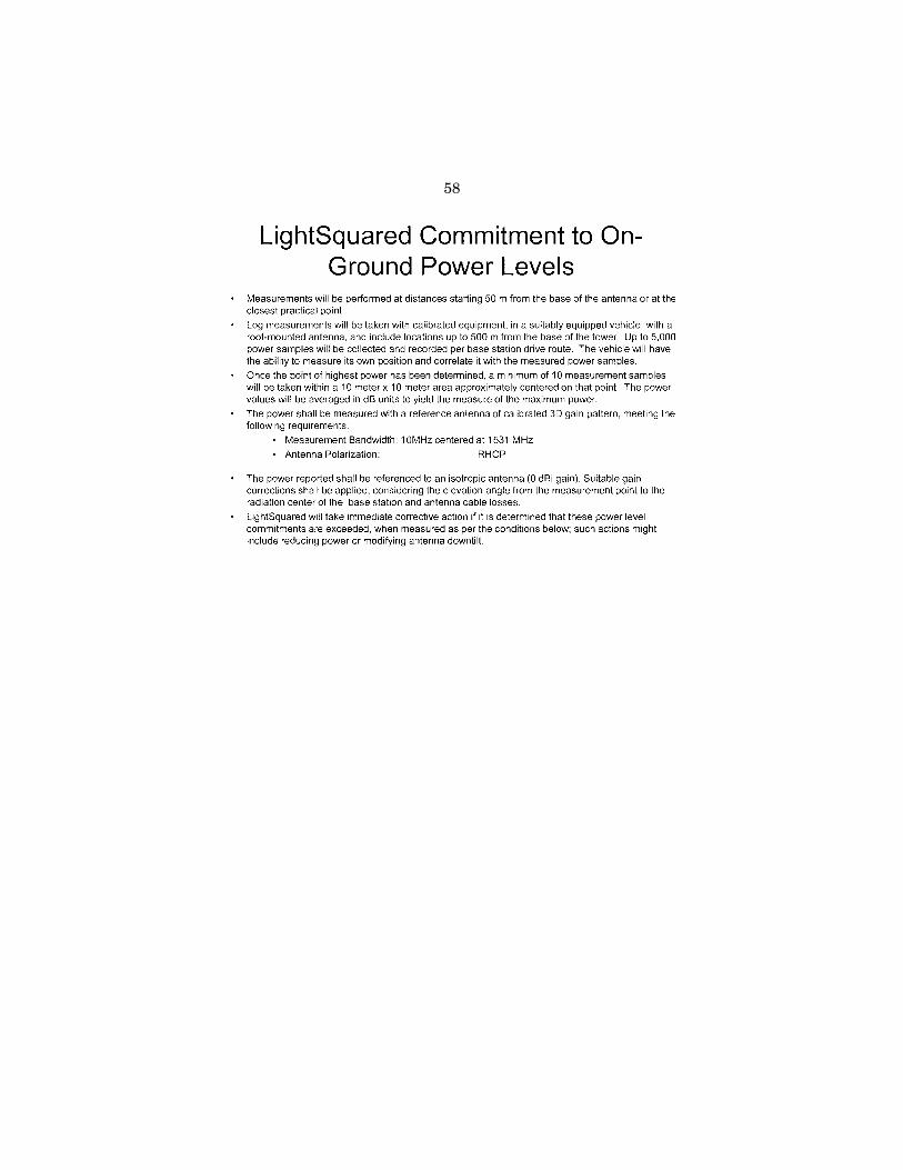
58
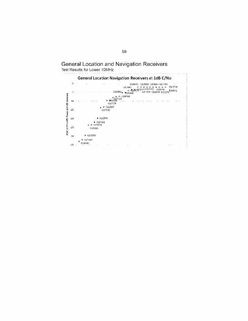
59

60

61

62
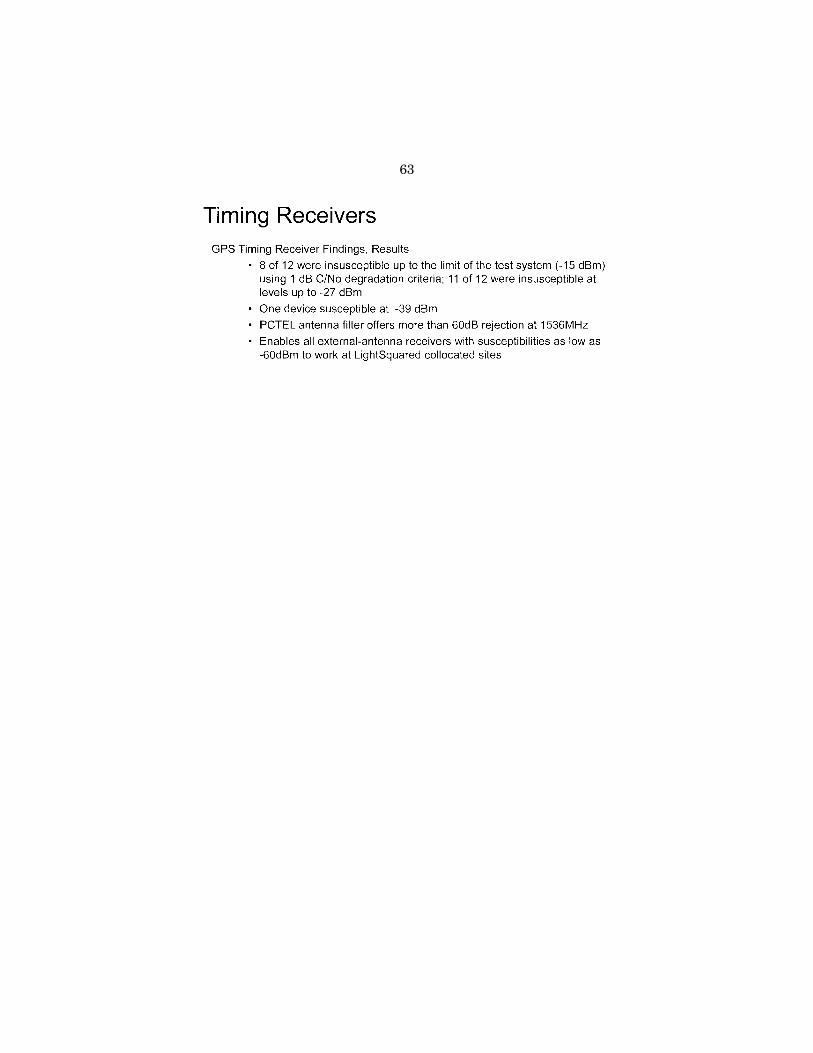
63

64

65

66
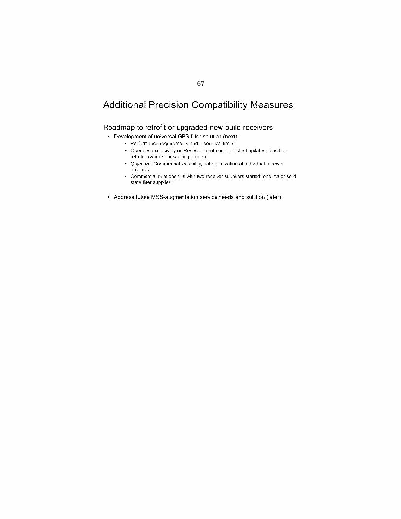
67

68

69

70

71

72

73

74

75
Chairman HALL. Thank you, sir, and at this time we recognize Dr. Pace.
STATEMENT OF DR. SCOTT PACE, DIRECTOR, SPACE POLICY INSTITUTE,
GEORGE WASHINGTON UNIVERSITY Dr. PACE. Thank you, Mr. Chairman. Wonderful opportunity
today, and I appreciate the Committee’s interest in this. Other witnesses have ably described the importance of GPS sig-
nals to their agencies and scientific users, and as is fairly clear, sci-entific users tend to be the most demanding, seeking the most pre-cision and accuracy possible. The highest precision GPS receivers are designed to receive not only the full range of radio-navigation satellite signals, including GPS, but also the mobile satellite serv-ice signals in the adjacent bands that you have heard about that carry wide area differential correction from commercial providers, and in many cases the reception of those signals is part of a con-tractual requirement.
It is important to understand that GPS is not a communication service. It is a navigation service. It requires precision-timed meas-urements, not just the reception of ones and zeros, and that preci-sion time is what results in precision position. The evolution of these high-precision capabilities has been made possible because of carefully considered past spectrum management decisions to use this particular spectrum neighborhood for satellite services, not ter-restrial ones.
In addition to the federal science agencies you have heard from, the university-scientific community is also concerned with this issue. In January of this year the CEO of the University Space Re-search Association, comprising 105 Ph.D. granting universities, wrote that USRA member universities are engaged in research in all aspects of GPS use and testing. All of these have the potential to be adversely affected by the LightSquared proposal unless rig-orous measures are implemented to mitigate interference of the re-ception of GPS signals.
The Technical Working Group final report, showed GPS inter-ference. The TWG rightly used multiple approaches to characterize the interference. There were paper calculations, along with testing in controlled environments such as anechoic chambers, and finally, realistic operational scenarios were defined for specific categories of users as well as live sky field tests were conducted on government- controlled ranges.
Virtually all tests, the precision receivers, those used by sci-entists and deployed in networks around the world, were harmfully impacted. The GPS community concluded that 31 of 33 high-preci-sion receivers tested were significantly affected. We can talk about the other two.
There is no viable or verifiable technological solution that has been identified to date that would allow a ground-based broadband communication network to operate in close proximity to GPS sig-nals. This is why the band has for decades been intentionally allo-cated for space services. Even if some new as yet unforeseen tech-nology did appear, the industrial, commercial, and public sector users of GPS equipment routinely take up to 15 years to complete

76
a normal replacement cycle; software cycles can be fast, but hard-ware takes longer.
GPS is arguably the most efficient use of spectrum the world has ever seen. Almost a billion people are currently benefiting from to-day’s signal, and this use represents a massive installed base and source of advantage for the United States of which international scientific cooperation is but one part.
If LightSquared were deployed in a way that caused harmful in-terference with GPS, a major beneficiary as you have heard, would likely be the Russian GLONASS System as its operating fre-quencies are farther away from LightSquared base-station fre-quencies. I should add that GALILEO and COMPASS probably would be equally harmed because they share frequencies similar to GPS.
Now, there are competing national policy objectives that need to be reconciled. On June 28 the Administration released two major policy statements. The first was aimed at expanding spectrum for wireless broadband use; a memorandum from the President called for collaboration between the FCC and the National Telecommuni-cations and Information Administration to make available a total of 500 megahertz of federal and non-federal spectrum over the next 10 years.
However, the memorandum cautioned that agencies were to quote, ‘‘take into account the need to ensure no loss of critical, ex-isting, and planned federal, state, local, and tribal government ca-pabilities.’’
On the very same day the White House also released a National Space Policy that specifically referred to GPS as a form of space- based position, navigation, and timing, and in this policy the Presi-dent said, ‘‘The United States must maintain its leadership in the service, provision, and use of global navigation satellite systems.’’ More specifically, this required, ‘‘the protection of radio navigation spectrum from disruption and interference.’’
In my judgment the safest and most fact-based course of action on the data we have to date is to conclude that the terms of the LightSquared conditional waiver have not been met and to with-draw the LightSquared license to deploy a terrestrial network in the 1525 to 1559 megahertz band. It is the only approach fully con-sistent with the terms of both the National Space Policy and the broadband memorandum, and I would argue the FCC’s own regula-tions.
The last 20 years have seen continuous innovation in the ability to use GPS for measurements of the Earth, the atmosphere, and the biosphere via precise positioning, navigation, and timing. If the LightSquared terrestrial network is allowed to operate as proposed, it would create new, additional, and as of yet unforeseen costs for federal science agencies as well as state and local governments who rely on high-precision GPS-derived data. It would mark a perma-nent decline in the capabilities that GPS has afforded scientific ap-plication in the United States. Such operations would be contrary to the technical facts established by independent testing. They would improperly place burdens on the victim service, in this case GPS. They would undermine the international credibility of the United States as built for GPS and would be contrary to the Na-

77
tional Space Policy and the terms of the President’s own broadband initiative.
Thank you for your attention, and I would be happy to answer any questions you might have.
[The prepared statement of Dr. Pace follows:]
PREPARED STATEMENT OF DR. SCOTT PACE, DIRECTOR, SPACE POLICY INSTITUTE, GEORGE WASHINGTON UNIVERSITY
Thank you, Mr. Chairman, and thanks to this Committee, for providing an oppor-tunity to discuss this important topic. The subject of today’s hearing is a complex one that involves not just federal science activities, but national security, public safety, foreign policy, and the health of economic sectors from agriculture to infor-mation technology.
Specifically, the Committee has asked that witnesses address the impact of the proposed LightSquared mobile terrestrial commercial communications network on federal science agencies and to discuss the recent report of the FCC-mandated tech-nical working group that was tasked to examine radiofrequency interference with GPS as well as possible mitigation strategies. The technical evidence gathered to date clearly shows that the LightSquared network poses an unacceptable inter-ference threat to all GPS users and especially high-precision scientific users of GPS.
I have been involved with GPS issues for over 20 years, beginning with work at the U.S. Department of Commerce around the time of the first Gulf War. While at the RAND Corporation, I supported the Office of Science and Technology Policy dur-ing the creation of the first Presidential Decision Directive on GPS in 1996. I have also been involved in domestic and international conflicts over radio frequency spec-trum used by GPS for almost as long, including negotiations at the International Telecommunications Union and proceedings before the Federal Communications Commission. I am currently the Director of the Space Policy Institute at George Washington University and am speaking today purely in a personal capacity and my comments do not necessarily represent the views of any agency, organization or company.
The LightSquared Network Represents a Major Change in Spectrum Use
The most commonly used GPS signal, L1, is located in the spectrum band 1559– 1610 MHz. This band is specifically ‘‘zoned’’ internationally for radionavigation sat-ellite services (RNSS) like GPS, the Russian GLONASS system, and the European Galileo system. On either side of the band are bands for mobile satellite services (MSS) at 1525–1559 MHz, below GPS, and at 1610–1660.5 MHz, above GPS. The key point is that the entire ‘‘neighborhood’’ is oriented to satellite services and such services require ‘‘quiet’’ spectrum as the powers of signals transmitted from space are many orders of magnitude weaker than those transmitted by typical terrestrial stations. There are major power differences between satellite services as well. The power of a MSS signal is much greater than that of signal coming from a GPS sat-ellite. Thus MSS and GPS signals operate in adjacent bands where their functions are compatible with each other but they do not operate in the same band since MSS signals would easily drown out the GPS signal.Figure 1 shows how proposed uses of the 1525–1559 MHz band next to GPS have evolved over the past 10 years. (At-tachment 1 provides a more detailed history of regulatory highlights.)

78
MSS services, such as those offered by Inmarsat, have historically operated purely through satellites. This enables service over very wide regions or even the entire globe. However, there will be coverage gaps for areas either outside the satellite service area, or more commonly, when dense urban environments block the weak satellite signals. This led to interest in creating an ancillary terrestrial component (ATC) to the MSS service in which ground-based towers would ‘‘fill in’’ the coverage gaps and thus enable better service to a wider range of customers. The GPS commu-nity was concerned the deployment of terrestrial base stations would create inter-ference to the adjacent RNSS band. The U.S. GPS Industry Council negotiated with the proposed MSS ATC operator, then known as MSV, and reached a technical agreement on ‘‘out-of-band’’ emission limits to restrict any harmful spillover into the RNSS band. This agreement was also predicated on the requirement that the ATC would remain tied to satellites and that the need to avoid self-interference between the satellites and terrestrial components of the same company meant the MSS band would remain relatively quiet. This helped ensure compatibility with GPS users next door.
The U.S.-licensed operator of MSS ATC in the L-band went through several own-ership changes, including the most recent transfer of license to what became LightSquared in March 2010. The essential operational situation remained un-changed until November 2010 when LightSquared requested relaxation of the ‘‘gat-ing requirement’’ which tied the ground-based ATC system to the satellite service. This would allow the terrestrial network to carry broadband services and the sat-ellites would now be effectively ‘‘ancillary’’ to the ground network as they are not capable of providing broadband level service. In effect, satellite spectrum would be ‘‘rezoned’’ to allow deployment of high-powered, terrestrial base stations in urban areas and across the country. This is the situation that the GPS community sought to avoid a decade ago. Unfortunately, the FCC granted a conditional waiver to LightSquared on January 26, 2011. The waiver was conditioned on the creation of an industry-led technical working group to examine the potential for interference to GPS and possible means of mitigation.
Scientific and High-Precision GPS Users Depend on Large Bandwidths
Other witnesses have ably described the importance of GPS signals to their agen-cies and scientific users. These users tend to be very demanding, seeking the most precision and accuracy possible. This in turn requires taking in the most informa-tion possible not only from GPS signals but other Global Navigation Satellite Sys-tems (GNSS) such as Galileo and using accuracy augmentation signals that are car-ried on MSS systems. Figure 2 shows the 2 MHz wide (pink) GPS signal used by common smart phones. The wider blue region shows the full RNSS band used by

79
more capable receivers, including those designed to receive signals from foreign GNSS systems as well as GPS. The green bars show the proposed upper (close to GPS) and lower (farther from GPS) channels for LightSquared’s 4G long-term evo-lution (LTE) service.
Figure 3 shows the bandwidth of the highest precision GPS receivers. They are designed to receive not only the full range of RNSS signals, including GPS, but also MSS signals in the adjacent band that carry wide-area differential GPS corrections from commercial providers such as Starfire. Developed by John Deere and precision farming groups, a Starfire-capable receiver can produce centimeter-level position measurements. Powerful transmissions from LightSquared base stations would un-avoidably jam the reception of weaker MSS signals used by the high precision GPS receivers. Thus when talking about receiver bandwidths, it is not enough to receive just the GPS signal itself, but all the services used for precision positioning, naviga-tion, and timing. The evolution of high precision capabilities has been possible be-cause of carefully considered past spectrum management decisions to use this par-ticular neighborhood for satellite services, not terrestrial ones.
In addition to the federal science agencies, the university scientific community is concerned with the LightSquared network. I serve on the board of the Universities Space Research Association, a non-profit organization of 105 Ph.D.-granting univer-sities conducting space and aeronautics-related research. In January of this year, prior to the FCC granting the requested waiver of the satellite requirement, the CEO of USRA wrote:
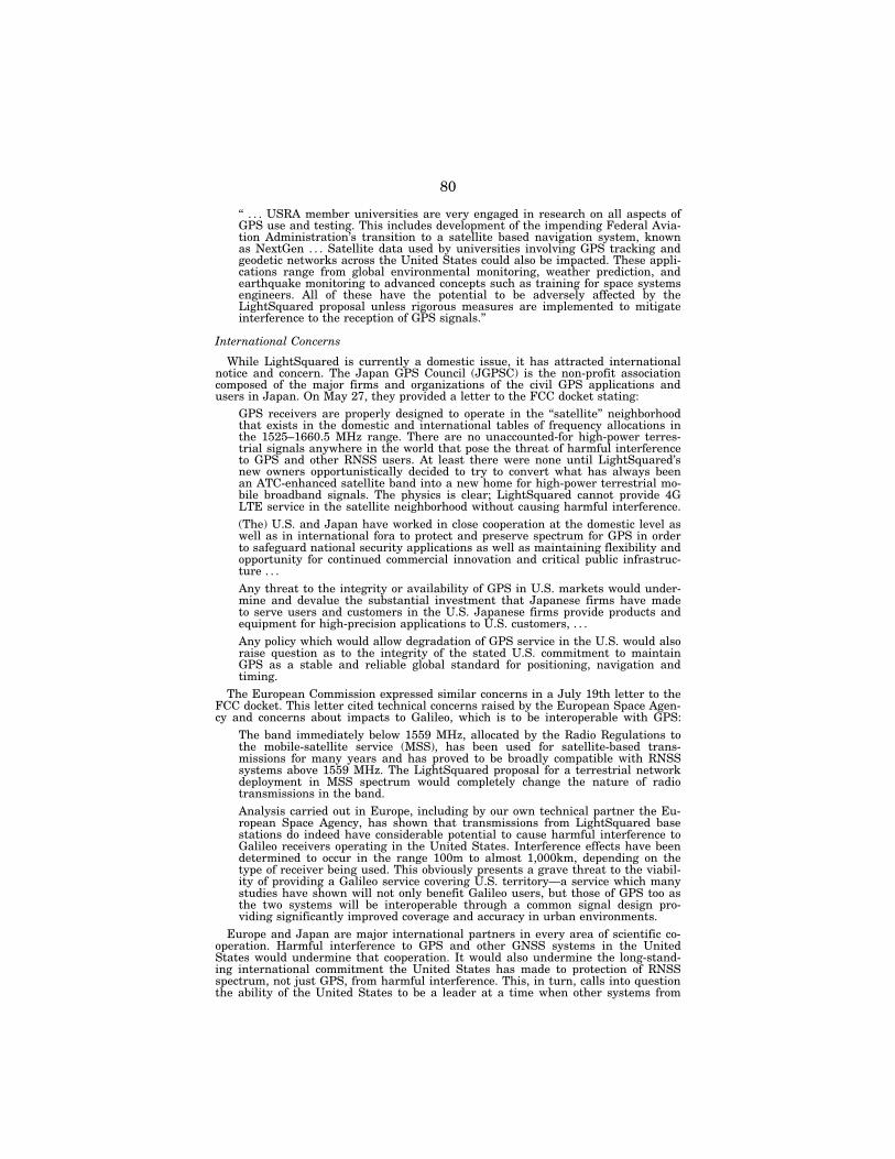
80
‘‘ . . . USRA member universities are very engaged in research on all aspects of GPS use and testing. This includes development of the impending Federal Avia-tion Administration’s transition to a satellite based navigation system, known as NextGen . . . Satellite data used by universities involving GPS tracking and geodetic networks across the United States could also be impacted. These appli-cations range from global environmental monitoring, weather prediction, and earthquake monitoring to advanced concepts such as training for space systems engineers. All of these have the potential to be adversely affected by the LightSquared proposal unless rigorous measures are implemented to mitigate interference to the reception of GPS signals.’’
International Concerns
While LightSquared is currently a domestic issue, it has attracted international notice and concern. The Japan GPS Council (JGPSC) is the non-profit association composed of the major firms and organizations of the civil GPS applications and users in Japan. On May 27, they provided a letter to the FCC docket stating:
GPS receivers are properly designed to operate in the ‘‘satellite’’ neighborhood that exists in the domestic and international tables of frequency allocations in the 1525–1660.5 MHz range. There are no unaccounted-for high-power terres-trial signals anywhere in the world that pose the threat of harmful interference to GPS and other RNSS users. At least there were none until LightSquared’s new owners opportunistically decided to try to convert what has always been an ATC-enhanced satellite band into a new home for high-power terrestrial mo-bile broadband signals. The physics is clear; LightSquared cannot provide 4G LTE service in the satellite neighborhood without causing harmful interference. (The) U.S. and Japan have worked in close cooperation at the domestic level as well as in international fora to protect and preserve spectrum for GPS in order to safeguard national security applications as well as maintaining flexibility and opportunity for continued commercial innovation and critical public infrastruc-ture . . . Any threat to the integrity or availability of GPS in U.S. markets would under-mine and devalue the substantial investment that Japanese firms have made to serve users and customers in the U.S. Japanese firms provide products and equipment for high-precision applications to U.S. customers, . . . Any policy which would allow degradation of GPS service in the U.S. would also raise question as to the integrity of the stated U.S. commitment to maintain GPS as a stable and reliable global standard for positioning, navigation and timing.
The European Commission expressed similar concerns in a July 19th letter to the FCC docket. This letter cited technical concerns raised by the European Space Agen-cy and concerns about impacts to Galileo, which is to be interoperable with GPS:
The band immediately below 1559 MHz, allocated by the Radio Regulations to the mobile-satellite service (MSS), has been used for satellite-based trans-missions for many years and has proved to be broadly compatible with RNSS systems above 1559 MHz. The LightSquared proposal for a terrestrial network deployment in MSS spectrum would completely change the nature of radio transmissions in the band. Analysis carried out in Europe, including by our own technical partner the Eu-ropean Space Agency, has shown that transmissions from LightSquared base stations do indeed have considerable potential to cause harmful interference to Galileo receivers operating in the United States. Interference effects have been determined to occur in the range 100m to almost 1,000km, depending on the type of receiver being used. This obviously presents a grave threat to the viabil-ity of providing a Galileo service covering U.S. territory—a service which many studies have shown will not only benefit Galileo users, but those of GPS too as the two systems will be interoperable through a common signal design pro-viding significantly improved coverage and accuracy in urban environments.
Europe and Japan are major international partners in every area of scientific co-operation. Harmful interference to GPS and other GNSS systems in the United States would undermine that cooperation. It would also undermine the long-stand-ing international commitment the United States has made to protection of RNSS spectrum, not just GPS, from harmful interference. This, in turn, calls into question the ability of the United States to be a leader at a time when other systems from
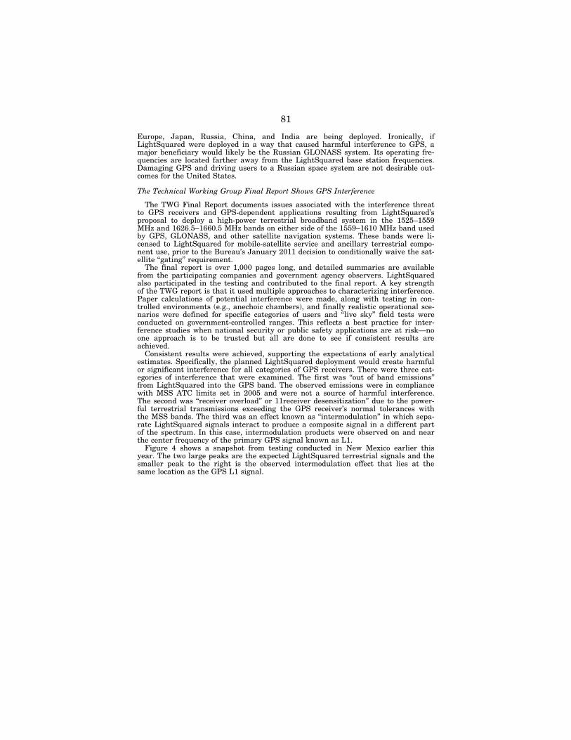
81
Europe, Japan, Russia, China, and India are being deployed. Ironically, if LightSquared were deployed in a way that caused harmful interference to GPS, a major beneficiary would likely be the Russian GLONASS system. Its operating fre-quencies are located farther away from the LightSquared base station frequencies. Damaging GPS and driving users to a Russian space system are not desirable out-comes for the United States.
The Technical Working Group Final Report Shows GPS Interference
The TWG Final Report documents issues associated with the interference threat to GPS receivers and GPS-dependent applications resulting from LightSquared’s proposal to deploy a high-power terrestrial broadband system in the 1525–1559 MHz and 1626.5–1660.5 MHz bands on either side of the 1559–1610 MHz band used by GPS, GLONASS, and other satellite navigation systems. These bands were li-censed to LightSquared for mobile-satellite service and ancillary terrestrial compo-nent use, prior to the Bureau’s January 2011 decision to conditionally waive the sat-ellite ‘‘gating’’ requirement.
The final report is over 1,000 pages long, and detailed summaries are available from the participating companies and government agency observers. LightSquared also participated in the testing and contributed to the final report. A key strength of the TWG report is that it used multiple approaches to characterizing interference. Paper calculations of potential interference were made, along with testing in con-trolled environments (e.g., anechoic chambers), and finally realistic operational sce-narios were defined for specific categories of users and ‘‘live sky’’ field tests were conducted on government-controlled ranges. This reflects a best practice for inter-ference studies when national security or public safety applications are at risk—no one approach is to be trusted but all are done to see if consistent results are achieved.
Consistent results were achieved, supporting the expectations of early analytical estimates. Specifically, the planned LightSquared deployment would create harmful or significant interference for all categories of GPS receivers. There were three cat-egories of interference that were examined. The first was ‘‘out of band emissions’’ from LightSquared into the GPS band. The observed emissions were in compliance with MSS ATC limits set in 2005 and were not a source of harmful interference. The second was ‘‘receiver overload’’ or 11receiver desensitization’’ due to the power-ful terrestrial transmissions exceeding the GPS receiver’s normal tolerances with the MSS bands. The third was an effect known as ‘‘intermodulation’’ in which sepa-rate LightSquared signals interact to produce a composite signal in a different part of the spectrum. In this case, intermodulation products were observed on and near the center frequency of the primary GPS signal known as L1.
Figure 4 shows a snapshot from testing conducted in New Mexico earlier this year. The two large peaks are the expected LightSquared terrestrial signals and the smaller peak to the right is the observed intermodulation effect that lies at the same location as the GPS L1 signal.
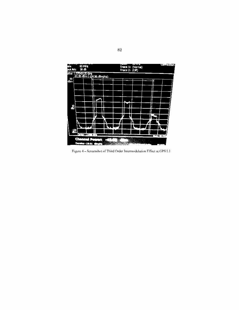
82

83
The operational impact of interference effects for scientific applications can be in-ferred from impacts to high precision receivers, networks of high precision receivers, and space applications. Virtually all tested precision receivers, those used by sci-entists and deployed in networks around the world, were harmfully impacted. In the TWG report, the GPS community concluded that 31 of 33 high precision receivers tested were significantly affected in the testing. This is an unavoidable and natural consequence of taking in as much of the GPS signal as possible using a wideband receiver. It is a natural consequence of accessing multiple radionavigation satellite systems that share the same RNSS band as GPS. Giving up access to the best GPS signals available or access to other RNSS satellite systems is not a solution for sci-entific users.
In addition to direct effects on the receipt of GPS signals, the LightSquared sig-nals create co-channel interference to MSS signals in the 1525–1559 MHz band where they operate. This blocks the receipt of those signals by GPS receivers that use them to create ‘‘differential corrections’’ to augment the accuracy of the basic GPS receiver. The FCC has licensed commercial firms such as Starfire and OmniSTAR to provide augmentation services that scientific, agricultural, and other users rely on today across the country.
Due to the large distances involved, GPS receivers used for navigation on space-craft may not suffer harmful interference from the LightSquared network. However, GPS receivers looking at the Earth would be affected. Such receivers are used to understand the ionosphere and atmosphere by looking at the behavior of the GPS signal as it passes through them. This enables great improvements to weather fore-casts, tracking hurricanes and typhoons, and establishing precise climate bench-marks to allow actual measurements of climate change.
In addition to scientific research, State and local governments use high precision GPS for mapping, surveying and infrastructure maintenance. High precision data is used in Geographic Information Systems (GIS) for asset management, emergency preparedness, disaster response and E911 mapping, public sector water, wastewater and electric utilities, public works, environmental management, dam and structure monitoring, environmental health, insurance rating districts, flood zones, tax ap-praisals, the provision of geodetic control networks, and a host of other functions.
The Government’s NPEF Report Is Consistent With TWG Report Results
The National PNT Engineering Forum (NPEF) report contains the results of test-ing by federal agencies, including the science agencies, and had technical results consistent with those of the TWG effort. As with the TWG, multiple approaches were taken to ensure theoretical and experimental results agreed with each other. A summary of the TWG report is available from the National Coordination Office and in other testimony. I would like to therefore highlight the two recommendations made by the NPEF:
• RECOMMENDATION 1: LightSquared should not commence commercial services per its planned deployment for terrestrial operations in the 1525–1559 MHz Mobile-Satellite Service (MSS) Band due to harmful interference to GPS oper-ations.
• RECOMMENDATION 2: The U.S. Government should conduct more thorough stud-ies on the operational, economic and safety impacts of operating the LightSquared Network, to include additional ATC signal configurations not cur-rently in LightSquared planned spectrum phases, effects on timing receivers, as well as transmissions from LightSquared handsets. As part of these studies the compatibility of ATC architectures in the MSS L-Band with GPS applications should be reassessed.
The two recommendations underscore the infeasibility of operating the LightSquared network as proposed without harmful interference to GPS. The rec-ommendations also note areas where testing was incomplete, raising deeper ques-tions about the feasibility of operating even previously approved MSS ATC networks in the band, never mind a broadband terrestrial network. The MSS ATC networks approved earlier had never been deployed and realistic equipment was not available to verify the regulatory limits truly prevented harm to GPS. Given the discovery of intermodulation products, a reexamination of the feasibility of ‘‘traditional’’ ATC would be prudent.
LightSquared’s Proposed Solution Is Not Sufficient
LightSquared has proposed to change the order in which they would deploy the same frequencies in the band adjacent to GPS. There are two channels of spectrum

84
1 47 C.F.R. § 25.255. 2 The White House, ‘‘Unleashing the Wireless Broadband Revolution,’’ Office of the Press Sec-
retary, June 28, 2010. 3 op cit.
in the band adjacent to GPS, which they originally planned to deploy in a certain order. They now propose to suspend, for what is implied to be a short time, use of the upper 10 MHz channel and begin with the lower 10 MHz channel. This would potentially result in impacting high precision scientific users first and other users, such as aviation, later.
The company has also proposed reducing the power of the terrestrial base stations by 50% from allowable levels. Unfortunately, that does not help, as cell site trans-mitter providers do not even supply equipment at the very high 15.8-kilowatt level the FCC proposes to allow. All testing was done with equipment that was available, that is, at roughly 10% of the maximum allowable level.
Even if it was considered acceptable to sacrifice high precision GPS users, the ‘‘lower 10 MHz’’ approach could be solution only if it was a complete solution. Unfor-tunately, it is not. LightSquared has been consistently clear that a commercially viable network would require more spectrum, preferably close to where they would already be operating.
Deployment in the lower block alone has not been concluded to be compatible with GPS and would likely require around 15 years prior to commencement for new tech-nology to be developed and existing user equipment to be replaced. However, with-out a permanent restriction on use of additional spectrum for terrestrial operations in other parts of the band, this approach merely shifts the burden of mitigation to the existing GPS users.
Section 25.255 of the FCC’s rules makes the obligation of resolving harmful inter-ference to other services that is caused by MSS ATC operations the sole responsi-bility of the ATC operator. 1 Nominally, at least, even under the LightSquared order, LightSquared is still an ATC operator subject to Section 25.255. It cannot require authorized users of another service to take measures—especially measures deemed infeasible or inappropriate by a substantial majority of the TWG—to mitigate the harmful interference. This obligation is LightSquared’s alone.
There is no viable or verifiable technological solution that has been identified to date that would allow a ground-based broadband communications network to oper-ate in close proximity to GPS signals. This is in part why the band has, for decades, been internationally allocated for space services. Even if some new, as yet unfore-seen, technology did appear, the industrial, commercial and public sector users of GPS equipment routinely take up to 15 years to complete a normal replacement cycle. Equipment installed on aircraft, vessels, agricultural, construction and mining machinery, commercial vehicles or high-cost professional instruments used today are not thrown away after a few years of use—their lifetimes are measured in decades.
There is one possible solution available today that I am aware of. LightSquared could operate the satellite part of its network, serving rural and public safety users outside of cellular coverage areas, in the L-band adjacent to GPS while developing its new high-powered terrestrial portion of its network in a different band, where it would be compatible with adjacent uses. Possible locations include the S-Band (above 2 GHz) or the 700 MHz bands already allocated to terrestrial 4G wireless services. The MSS satellite part of the LightSquared network is compatible with neighboring GPS uses and thus can coexist with all GPS services, applications and existing user equipment. The terrestrial component of the LightSquared network has not yet been built; therefore it is at least technically feasible to move to a dif-ferent band from the outset, thus avoiding large scale disruption to GPS users across the United States.
Competing National Policy Objectives Need To Be Reconciled
On June 28, 2010, the Administration released two major policy statements. The first was aimed at expanding spectrum for wireless broadband use. 2 The Memo-randum from the President called for collaboration between the FCC and the Na-tional Telecommunications and Information Administration to ‘‘make available a total of 500 MHz of Federal and nonfederal spectrum over the next 10 years, suit-able for both mobile and fixed wireless broadband use.’’ However, the Memorandum cautioned that agencies were to ‘‘take into account the need to ensure no loss of crit-ical existing and planned Federal, State, local, and tribal government capabilities . . . .’’ 3
On the same day, the White House also released a new National Space Policy that specifically referred to GPS as a form of space-based positioning, navigation, and

85
4 The White House, ‘‘National Space Policy,’’ Office of the Press Secretary, June 28, 2010.
timing. 4 In the policy, the President said, ‘‘The United States must maintain its leadership in the service, provision, and use of global navigation satellite systems.’’ More specifically, this required the ‘‘Protection of radionavigation spectrum from disruption and interference.’’
Considering the objectives of both policies, there seem to be four options for con-sideration by the FCC, Administration and Congress:
• 1. Accept the most recent LightSquared proposal to begin deployment in the lower 10 MHz of the 1525–1559 MHz band. Additional testing to define mitiga-tion measures should be required as a condition of approval.
• 2. Rescind the LightSquared waiver and bar commercial operations even in the lower 10 MHz pending completion of further testing and demonstration of spe-cific mitigation measures by LightSquared to preclude harmful interference to GPS.
• 3. Assist LightSquared in finding alternative spectrum for its terrestrial net-work outside the L-band. The FCC would have to explore legal and regulatory challenges in aiding such as move that may or may not be economically feasible for the company.
• 4. Conclude that the terms of the LightSquared conditional waiver have not been met and withdraw LightSquared license to deploy a terrestrial network in the 1525–1559 MHz band.
In my judgment, the safest and most fact-based course of action is number 4. It is the only approach fully consistent with the terms of both the National Space Pol-icy and the Broadband Memorandum as well as the FCC’s own regulations.
Conclusion
It is sometimes argued that accommodations by legacy systems need to be made to enable new uses of spectrum and that doing so enables more efficient use of a scarce, natural resource. When it comes to spectrum efficiency, GPS is arguably the most efficient use of spectrum the world has ever seen; almost a billion people are currently benefitting from the 20 MHz GPS signal that is available today. In fact the entire global population could use GPS without any additional spectrum being used. This use represents a massive installed base and source of advantage for the United States, of which international scientific cooperation is but one part. Most im-portantly, it represents a high degree of trust and confidence in the United States and its stewardship of GPS.
If allowed to operate in either its original or modified form, the LightSquared ter-restrial network would create unacceptable harmful interference to GPS users and high precision scientific users in particular. Such operations would be contrary to the technical facts established by independent testing; they would improperly place burdens on the victim service, in this case GPS, undermine the international credi-bility the United States has built for GPS, and would be contrary the National Space Policy and the terms of the President’s own broadband initiative.
The last 20 years have seen continuous improvement in the ability to use GPS for measurements of the Earth, the atmosphere, and the biosphere via precise posi-tioning, navigation, and timing. If the LightSquared terrestrial network is allowed to operate as proposed, it will mark a permanent decline in the beneficial capabili-ties GPS has afforded scientific users in the United States. It would create new, ad-ditional, and unforeseen, costs for federal science agencies as well as State and local governments who rely on high precision GPS-derived data.
Thank you for your attention. I would be happy to answer any questions you might have.
ATTACHMENT 1—HISTORICAL NOTES ON MSS ATC AT L-BAND
August 17, 2001: Notice of Proposed Rulemaking (NPRM) on MSS ATC Re-leased
• Based on applications of ICO and Motient MSS systems • Included consideration of out-of-band emission limits to protect GPS July 25, 2002, Agreement Between MSV and U.S. GPS Industry Council • Parties reach agreement on a—100 dBW/MHz limit for MSS ATC base stations
in order to protect GPS/RNSS in the 1559–1610 MHz band.

86
• Predicated on the assumption that ATC use remained tied to satellites and that the service would be relatively low-density fill-in.
February 10, 2003: First Report and Order and NPRM on MSS ATC Re-leased
• FCC makes clear that MSS ATC is to augment satellite service: Para. 1: ‘‘We do not intend, nor will we permit, the terrestrial component to be-come a stand-alone service.’’ Footnote 5: ‘‘While it is impossible to anticipate or imagine every possible way in which it might be possible to ‘game’ our rules by providing ATC without also simultaneously providing MSS and while we do not expect our licensees to make such attempts, we do not intend to allow such ‘gaming.’ For example, even if an MSS licensee were to enter an agreement to lease some or all of the access to its authorized MSS spectrum to a terrestrial licensee such spectrum could only be used if its usage met the requirements to ensure it remained ancillary to MSS and were used in conjunction with MSS operations, i.e., that it met all of our gating requirements. The purpose of our grant of ATC authority is to pro-vide satellite licensees flexibility in providing satellite services that will benefit consumers, not to allow licensees to profit by selling access to their spectrum for a terrestrial-only service.’’
• Adopts ‘‘Gating Criteria’’ (FCC Part 25.149(b)(4)) to limit terrestrial deployment to that which is ancillary to the satellite component of the network. Effectively prohibits ATC-only or stand-alone terrestrial services.
• Declined to adopt limits on emissions into the RNSS band (1559–1610 MHz) more stringent than GMPCS rules (–70 dBW/MHz) for BS and METs and men-tioned possible rulemaking on GPS protection in a future proceeding.
• Number of base stations limited to 1725. • EIRP limited to 14.1 dBW (AE6 25 watts) towards the horizon and maximum
EIRP of 23.9 dBW (AE6245 watts) per sector (derived from limit on per-carrier EIRP of 19.1 dBW and the number of carriers per sector limited to three).
November 8, 2004: MSV Order and Authorization Released • MSV commits to meeting a—100 dBW/MHz limit in 1559–1610 MHz RNSS
band, which FCC imposes as a condition of the authorization (noting these lim-its are more stringent than FCC rules require).
• Limit of 1725 base stations increased to 2415. • Gating criteria in 25.149(b)(4) retained.retaining the prohibition against stand-
alone terrestrial services. • Overhead gain suppression relaxed to permit base-station antenna gain of up
to 27 dB below the maximum directional gain in vertical angles from 30.5 to 55.5 and up to 30 dB below the maximum directional gain in vertical angles from 55.5 to 145.5, as requested.’’
• Aggregate EIRP increased (subject to some restrictions) to 26.9 dBW toward the physical horizon and 31.9 dBW in other directions.
February 25, 2005: Memorandum Opinion and Order (MO&O) Released • Limit on number of base stations eliminated in favor of delta T/T limit of 6%
to protect Inmarsat MSS in the L-band. • Aggregate EIRP increased by rule (beyond just waiver granted to MSV) to 31.9
dBW (AE61550 watts) generally and 26.9 dBW (AE6490 watts) per base station sector toward the horizon, representing an 8 dB increase over the previous power limits that apply when three carriers are used within an antenna sector.
• Gating criteria in 25.149(b)(4) retained.retaining the prohibition against stand- alone terrestrial services.
• No L-band MSS ATC network or equipment deployed. Note: Order includes extensive testing and analysis of Inmarsat terminals and in-
terference from MSV ATC network. December 21, 2007: Inmarsat-MSV Spectrum Sharing Agreement • According to Satellite Today (January 2008): The agreement was defined in two
phases. Phase one, from December 2007 to September 2011, gives the compa-nies an 18- to 30-month period to transition to the modified band plan, includ-ing ‘‘modification of certain of Inmarsat’s network and end user devices and a

87
shift in frequencies between the MSV parties and Inmarsat,’’ according to the U.S. Securities and Exchange Commission report. MSV will be allocated 28 MHz of L-band spectrum and will pay Inmarsat $250 million in cash and $87.5 million in equity for additional spectrum. During phase two, from January 2010 to January 2013, Inmarsat will be able to modify the amount of spectrum it uses over North America and make that bandwidth available to MSV for rental use. MSV will pay $115 million for this additional spectrum.
• No L-band MSS ATC network or equipment yet deployed.
March 26, 2010: FCC Issues Order on Harbinger Acquisition of SkyTerra • Relevant Milestones:
March 27, 2009: Harbinger begins acquisition of SkyTerra with filing to FCC for transfer and control of SkyTerra to Harbinger Capital Partners, Ltd. November 24, 2009: FCC issues Protective Order allowing submissions by Har-binger and SkyTerra to be handled as proprietary and confidential material upon request. February 26, 2010: Harbinger submits information on its business model, in-cluding the planned build-out of an extensive terrestrial network, and requests it be treated as proprietary and confidential information as allowed by the Pro-tective Order. The new business model (including the proposed building of an extensive terrestrial network) is not coordinated with the IRAC and Federal agencies. March 26, 2010: FCC issues a Memorandum Opinion and Order and Declara-tory Ruling finalizing the acquisition of SkyTerra (to be renamed LightSquared) by Harbinger. March 26, 2010: Harbinger files a letter with the FCC on the same day the Har-binger Order is released, making available information on its business plans (including the building of an extensive terrestrial network) that was filed under a request for confidential treatment on February 26, 2010. April 1, 2010: Verizon files Petition for Partial Reconsideration of the Harbinger Order, alleging various process fouls and irregularities in the proceeding (be-lieved to be still pending) April 2, 2010: AT&T files Petition for Reconsideration of the Harbinger Order, alleging various process fouls and irregularities in the proceeding (believed to be still pending). April 15, 2010: Harbinger withdraws its request that the February 26, 2010, in-formation on its business plans be treated as confidential material.
March 26, 2010: FCC Releases Order and Authorization to modify SkyTerra ATC license
• Aggregate EIRP increased to 42 dBW (AE615.85 kilowatts) per sector. • No change to gating requirement and tying of ATC to satellites.
• Power density limits relaxed near airports and waterways subject to Inmarsat making its terminals less susceptible to receiver overload interference (see para-graphs 35, 36).
• Increased protection for GPS from femtocells added to SkyTerra authorization: PSD of emissions in the 1559–1605 MHz band limited to –114.7 dBW/MHz and that PC data cards transmitting to such femtocells should limit the PSD of emissions in the 1559–1605 MHz band to –111.7 dBW/MHz.
• No L-band MSS ATC network or equipment yet deployed.
November 2010: FCC Initiates LightSquared Waiver Proceeding • November 18, 2010: LightSquared Files Report to FCC on its MSS ATC Plans
and notes that if the plans are not in conformance with the ‘‘gating criteria’’ in FCC’s rules, request that the requirement be waived.
• November 19, 2010: FCC initiates proceeding on LSQ waiver request by placing the application on Public Notice and inviting public comment. By a separate Order on November 26, FCC extended comment deadline to December 2, 2010, with reply comments due December 9, 2010.
• No L-band MSS ATC network or equipment yet deployed.
January 26, 2011: FCC Grants LightSquared Waiver of Gating Criteria

88
• Federal agencies object to granting the gating waiver prior to completion of technical studies establishing whether GPS would be protected. The Depart-ment of Defense separately expresses its opposition to the FCC Chairman.
• While noting agency objections and the creation of a ‘‘new interference environ-ment’’ NTIA does not formally block the FCC waiver proposal.
• On January 26, 2011, FCC granted a waiver to LightSquared of FCC rule 25.149(b)(4), permitting stand-alone terrestrial use for the first time.
• Establishes Technical Working Group (TWG) to examine potential interference to GPS.
• Report from the TWG due to FCC on June 15, 2011. The FCC later granted a two-week extension to June 30, 2011 at the request of LightSquared.
• No L-band MSS ATC network or equipment deployed. First base station equip-ment provided for testing in April 2011.
June 30, 2011: FCC places TWG Report on docket for Public Comment • Period for comments closes July 30, 2011. Period for reply comments closes Au-
gust 15, 2011.
Chairman HALL. All right. Thank you, and thank you for your testimony. I would remind the Members of this Committee that the rules require and allow questioning for five minutes.
And the Chair at this point will open the round of questions. I relegate myself to five minutes. Hope each of you can stay within that deal.
And I will start out by asking Mr. Appel, are you familiar, Mr. Appel, with the LightSquared impact to aviation that is based on LightSquared? Yes. I think written by and prepared by J.C. Johns. Is he the director?
Mr. APPEL. He is one of the FAA officials overseeing a lot of this effort. Yes.
Chairman HALL. All right, and for the first five, one, two, three, four—Mr. Russo, Ms. Glackin, Mr. Sparrow, Mr. Appel, you are all the representatives of the people, are you not? All appointed, not elected, appointed, and serving, and I believe, Mr. Appel, you were just confirmed by the Senate, were you not? Recently.
Mr. APPEL. 2009, actually. Chairman HALL. Well, good luck to you. Mr. APPEL. Thank you. Chairman HALL. And I guess I will ask all of you, Mr. Appel, are
you familiar with the FAA’s analysis of the impact on LightSquared’s network, and that is what this study is.
Mr. APPEL. Yeah. There have been a number of internal analyses of the FAA, and I am generally familiar with them. Yes.
Chairman HALL. And is this assessment based on studies of LightSquared, LightSquared’s Technical Working Group, their radio technical commission for aeronautics, and other national PNT engineering form reports?
Mr. APPEL. My understanding is that the work that the FAA did was in conjunction with the Technical Working Group and those other groups. Yes.
Chairman HALL. And I think in my opening statement I men-tioned some of the real problems. Did that—let us talk about the impact of LightSquared’s network. Did that assessment indicate an increase in potential aviation fatalities?
Mr. APPEL. My understanding was that there was an internal FAA analysis looking at the initial LightSquared proposals that did some early estimates based on the original scenario. I think that
89
a lot of that work has been superceded by looking at the current scenario.
Chairman HALL. And I think the estimate was around 800 re-duced fatalities over 10 years, and to be more—to be exact, that is something I think we should be, there is a 64 air carrier and one was mentioned by the one that had a Congressman aboard. I think I remember the day that Congressman left here to go on an inter-national meeting. It was a lot of secrecy about it. I have even been told that some people thought the airplane was shot down because he was on it, which is a bad loss of life there, and they were sup-posedly over into the wrong airways when they got shot down.
But that was the 64. That is part of the air carrier and then the general aviation part, there is 730 reduced fatalities over 10 years according to this potential averted fatalities report and for a total 794, not 800, but 794, and also in the report they indicated the cost of money. That based on input from RTCA as well as National Space-Based Position, Navigation, and Timing Systems Engineer-ing Forum, proposed LightSquared development would result in an estimated aviation community cost. Community cost of at least $72 billion stemming from two billion loss of existing GPS efficiency benefits, five billion loss of existing GPS safety benefits, 59 billion due to delayed NextGen benefits, and six billion in aircraft retrofit costs.
Additionally, LightSquared deployment resulted in an additional 30 million tons of CO2, and FAA would be forced to re-plan 17 bil-lion in NextGen investments with associated additional develop-ment costs. Those are within the findings of the FAA, Federal Aviation Administrator’s research and report.
Are you satisfied with that, the accuracy of it, and have you ex-amined it on your own?
Mr. APPEL. My—I have looked at it. My colleague, the head of the FAA, the Administrator, Randy Babbitt, when asked about this issue, has made clear that he is not going to let anything happen that is going to jeopardize safety of aviation. We have gotten pro-gressively better and better every year in our aviation safety in this country, and the FAA takes every measure possible to ensure that no matter what the potential threat to safety, we address it before it happens.
Chairman HALL. All right. I just have a little bit more time left. I think you have answered my question, and I would ask Ms. Glackin, and you are the only one I will ask this because I don’t have the time and because you are associated with the weather, and we are all aware of some weather around here, this Nation at this time, more than ever before. I don’t ever remember this many earthquakes or forest fires.
If NOAA received full funding for its satellite programs but the LightSquared proposal was approved, how would the Nation’s weather forecasting capabilities be affected?
Ms. GLACKIN. NOAA has—— Chairman HALL. If you can give me a good quick answer. Ms. GLACKIN. Yeah. I was going to say even with that full fund-
ing NOAA has concerns about the impacts of LightSquared because depending on how it is implemented it touches so many parts of

90
our warning mission, from our radars on the ground to the sat-ellites that are operating in space.
So I couldn’t give you any confidence today that we would be able to successfully deliver on that mission. It would be impacted to some degree, and we would need to do much more testing to under-stand that.
Chairman HALL. And in closing, Mr. Russo, Mr. Sparrow, Mr. Appel, Dr. Applegate, would your answers have been similar to her answer as it affects the division you represent for the people of the United States?
Mr. RUSSO. Yes, sir. Chairman HALL. Each of you have a yes or no on that? Mr. SPARROW. Yes, sir. Mr. APPEL. Yes, sir. Dr. APPLEGATE. Yes. Chairman HALL. All right. I have used up all my time. At this time I recognize Ms. Johnson, the Ranking Member, for
five minutes or whatever time you have to use. Ms. Johnson. Ms. JOHNSON. Thank you very much. Chairman HALL. I went over about almost a minute. Ms. JOHNSON. A little over a minute. Chairman HALL. You can go for six minutes if you want to. Ms. JOHNSON. I understand that minimal testing was done by
the Technical Working Group to examine whether LightSquared’s proposed plan to re-phase its bandwidth use and reduce power will mitigate the network’s impact on most GPS applications. Agency statements today are consistent in their call for additional testing.
What do agencies need to know about the new LightSquared pro-posal to assess its impact on their programs? How long this process take, and I would like to hear from all witnesses, but let’s start with Mr. Russo and Mr. Carlisle.
Mr. RUSSO. Yes. The first part of the question in terms of what we would need to know, the first thing we need to know is what the final end-state configuration is. In LightSquared’s recommenda-tion paper of 29–June they had three recommendations. One was to broadcast initially in the lower 10 megahertz of their band, two was the reduction in power to basically the same power level that we were testing at, and the third one is the one that is problematic for us, which is that at some point in the future they would be broadcasting in the upper half, and that point is undefined. They called it a standstill period, and we don’t know at what point that would occur. That is the key missing piece to being able to con-struct a new test to say whether we will or will not have substan-tial interference.
And in terms of how long it would take, that will depend some-what on that answer.
Mr. CARLISLE. To be clear, it is not true that there was no testing at the lower 10 by the Technical Working Group. In fact, every sub-group tested the lower 10, and it wasn’t either in the final days. Some of the subgroups had from the very beginning of their work a plan to test the lower 10 against their devices.
So in effect, there has been testing of 130 devices across seven different categories on the lower 10, and some of those categories are fine. Precision is not as we have heard here today. We take a
91
measurement of 10 out of the 38 precision devices that were ulti-mately tested actually will operate fine in the presence of the power levels that will reach the ground in our network.
But very quickly I would say if there is a specific plan for addi-tional federal testing, we have yet to hear it from any agency at this point. The only claim we have seen in terms of additional test-ing needed is from the Department of Defense to test certain classi-fied receivers that were not tested on the lower 10 as part of the Department of Defense’s testing.
But we are completely open to speaking with the government agencies about facilitating further discussion on this and also about whether the upper 10 that Mr. Russo just mentioned is ever going to be—it can be used down the road.
Ms. JOHNSON. Do you want to comment on that? Ms. GLACKIN. I would just comment quickly, point out that Mr.
Russo’s original testimony really highlighted some of the shortfalls in the testing that was done, and in particular that only one trans-mit antenna was part of the testing configuration, and we know that there is—there can be interference effects, you know, are addi-tive there and also the fact that the time period was so compressed. There is a lot of complexity to work through.
Ms. JOHNSON. Thank you. Mr. Russo, in your opinion is it tech-nically feasible to design a filter that simultaneously allows GPS users to listen to signals in LightSquared’s allocated band, and block LightSquared’s signals?
Mr. RUSSO. I am sorry, ma’am. I don’t know the answer to that. We are dealing with a very large power difference. At half a mile the LightSquared signal is five billion times more powerful than the GPS signal by the time it gets down from space. That is a big number to be able to reconcile.
Dr. Parkinson from Stanford University expressed it this way, that the GPS signal is like a teaspoon of water. The LightSquared signal is Niagara Falls. That is about a five billion difference. I am a very optimistic person. I think that given time, given the right technical people talking to each other there may be a way to do this, but I certainly don’t know that, and I certainly would want to see that tested before I would be able to say that would work.
Ms. JOHNSON. Can you estimate its cost? Mr. RUSSO. No. I am sorry. I can’t. Ms. JOHNSON. Mr. Carlisle, would you like to comment on that? Mr. CARLISLE. Yes, I would. Actually, its effect which is the com-
parison of our base station power against the power level of GPS signals was known in 2005. So my question generally would be why did the GPS manufacturers not test that and determine there was an effect? Why was the overload effect never mentioned during the four years of testing, and why wasn’t that made a condition of our—any sort of condition about our investing and deploying the network? It was only brought up in the last year.
Now, we have done everything we can in order to address this issue, and we have made sincere, real commitments in order to ad-dress it, but at the end of the day this is a six-year-old issue on which nothing was done in order to address receiver overload.
Ms. JOHNSON. One last quick question. Dr. Pace, would you com-ment on that?

92
Dr. PACE. Well, I would first of all say I agree that trying to overcome a billion dollar, I mean, excuse me, a billion times power difference is technically very difficult, and because of that technical uncertainty it is difficult to say how much money would be re-quired.
With regard to how long this issue was known, I think one addi-tional fact is that the FCC time and time again from the original discussions in 2002, up until January of 2010, were very adamant that they would forbid any sort of stand-alone terrestrial wireless service. In fact, they made a number of points in the proceedings about how they would not allow evasions of the satellite require-ment, what was called the gating requirement, the need to link to a satellite.
This linkage is very important because it meant that the ground- based systems, the ancillary treshold component, could not inter-fere with the satellite, and therefore, the mobile satellite service band would remain a quiet band. So I would say that the GPS in-dustry for the period that Mr. Carlisle mentions was relying on the assurances of the FCC that the band would remain a satellite band, and the issue of numbers of ground stations and powers and so forth is truly an ancillary issue to the core question of would this band remain a satellite band. If it is a satellite band, then you have no problem. If it is not a satellite band, you have a problem that you see here today.
Ms. JOHNSON. Thank you. My time has expired. Chairman HALL. Thank you. The gentleman from Wisconsin, the
Vice Chairman of this Committee, Mr. Sensenbrenner, is recog-nized for five minutes.
Mr. SENSENBRENNER. Thank you very much. Mr. Carlisle, all of your contracters on this panel don’t seen to
have a high regard for your position, and I have got a few ques-tions. Maybe I can blow a little bit of the fog away.
Say you don’t get permission from the FCC to use the high-end band, meaning the upper 10, for LightSquared. Would you still in-vest the $14 billion in this project?
Mr. CARLISLE. We would invest the maximum amount of money necessary in order to build out on the spectrum we had. So if we can’t use the—if we can build out on the lower 10, we will invest as much as we need to get a robust network.
Mr. SENSENBRENNER. How much would that be? Mr. CARLISLE. I can’t tell you that sitting here right now. I would
need a network engineer and a business model to go through that, but right now the plan is 14 billion.
Mr. SENSENBRENNER. Now, what would happen if there was a re-duction in power? You know, we have heard about the teaspoon of water versus Niagara Falls. Would you still be able to make a go of it if you got a tablespoon of water?
Mr. CARLISLE. Well, that is—in order to provide a wireless broadband network, you need cell towers or base stations that are operating consistent with the power levels that you need for that in order to make it economically viable. Otherwise you just have so many cell towers it becomes economically infeasible to provide service.

93
So at the power levels we have committed to right now, that is a network that is the size of between 30,000 and 40,000 base sta-tions.
Mr. SENSENBRENNER. Okay. Now, you made a deal with Sprint, and they have got a lot of cell towers around the country.
Mr. CARLISLE. Uh-huh. Mr. SENSENBRENNER. Because you would have access to those,
would you still spend the 14 billion? Mr. CARLISLE. Our plan is yes. We are spending nine billion with
Sprint alone in order to deploy the network, and the 14 billion is the total of capital and operating expenses over eight years.
Mr. SENSENBRENNER. Now, how much of that is Sprint’s money, and how much of that is LightSquared’s money?
Mr. CARLISLE. Nine, the $9 billion is what we are spending to get the network deployed.
Mr. SENSENBRENNER. Is this LightSquared’s money? Mr. CARLISLE. I believe so. Yeah. I am not sure what the—we are
spending—we are giving—spent $9 billion to—— Mr. SENSENBRENNER. You know, I noticed the name of what is
now LightSquared has been changed as a result of reorganization several times in the last decade, which is——
Mr. CARLISLE. Right. Mr. SENSENBRENNER[continuing]. Not particularly comforting to
me, you know, unless something end up midstream on this. The other line of questioning I would like to have in the time that I have remaining is what kind of testing has there been on precision GPSs, which are the most expensive ones and, you know, the ones that I would say that we need particularly in a transportation sec-tor to make passengers safe.
We have heard that retrofitting as a result of potential inter-ference would cost billions of dollars, largely in an airline industry that really isn’t all the financially healthy. What kind of testing have you done on this stuff?
Mr. CARLISLE. Well, if you are talking about—the Technical Working Group tested both aviation receivers, which are used in aircraft, and also the standards that are applicable to the WAS net-work that is going to be used for Next Generation, and separately- tested precision receivers, which are largely used in agriculture, construction, survey, and for scientific research as we have heard today.
Those precision receivers were tested fully on the bottom 10. In terms of the level of the scale that we are talking about here, if we are talking about cellular phones, personal navigation devices, aviation receivers, and timing receivers, it is about 400 million de-vices around the country. If we are talking about precision as it was tested at the Technical Working Group, it is less than a mil-lion, probably about—between 500,000 and 750,000 receivers.
Mr. SENSENBRENNER. Okay. Mr. CARLISLE. So in terms of the investment needed to replace
those receivers, this is not, you are not talking about replacing 400 million receivers. You are talking about replacing a much smaller number.
Mr. SENSENBRENNER. One of the complaints I have heard is that LightSquared has been changing the parameters of what it pro-

94
poses to do before the testing is completed. The Committee has in-formation that you have a newer proposal. Has that been filed with the FCC yet?
Mr. CARLISLE. We have a proposal in addition to our last pro-posal. It was filed at the FCC on Wednesday, and it is attached to my testimony.
Mr. SENSENBRENNER. Okay. Now, are you going to stick by that proposal until the testing is done, or if something bad comes out, is there going to be another proposal that would be filed, in which case the testing would have to go to square one?
Mr. CARLISLE. Well, let me respond to that in this way. We are sort of—we are acting in a situation where the GPS manufacturers have—and the federal agencies have most of the information about what GPS devices they use and how they operate. So our original proposal was in the absence of having that information. As the in-formation started to become available, started to become obvious that there was going to be a problem on the upper 10, we came up with a proposal that would mitigate the issue by moving to the lower 10 at a cost of $100 million to the company.
That is what you do when you see engineering problems. Mr. SENSENBRENNER. I don’t think that answers my question of
whether we are going to have to go back to square one again with a new proposal if the testing shows that there is another problem that comes up.
Mr. CARLISLE. Well, the proposal we have discussed this week is in addition to our other proposal, so it is incremental on top of it. If there are additional issues discussed, that come to light with re-gard to federal receivers or other receivers, we will take that into account and see what we can do to fix it. But at this point you do raise a very good issue in that we have made all the proposals to solve this issue, and we are spending all the money to do it. The GPS manufacturers have not.
Mr. SENSENBRENNER. Well, GPS was there first, and a lot of peo-ple use GPS, and, you know, I don’t want to have to face my con-stituents at a town meeting if their GPS ends up not being what it is supposed to be and what it has been as a result of spectrum interference.
You know, Mr. Carlisle, I wish I could have gotten more direct answers to questions that were pretty direct, but maybe you can supply them with written testimony later on.
Mr. CARLISLE. I would be happy to if there is anything I didn’t answer. Sorry about that.
Chairman HALL. All right. The gentleman’s time has expired. The Chair recognizes the gentleman from California, Mr.
McNerney, recognized for five minutes. Mr. MCNERNEY. Thank you, Mr. Chairman. I just want to say to
Mr. Carlisle, you knew this was going to be a tough afternoon, so I appreciate your coming out here and testifying.
The frustrating thing is that every one of us would like to see you move forward because of the economic boom that broadband brings, but we are all very concerned about the impact on a very well-established and growing set of industries and businesses.
One of the things I heard you say was that the problem in your opinion can be solved by responsible receiver design, and by that

95
I take it you mean GPS receivers. And so that implies a significant investment by the GPS people, and I am not even sure that that technology exists. A lot of folks here don’t seem to think that it does, but I agree with Mr. Russo. I think that there are technical solutions in the future that if enough investment is made will be-come available.
So I am not going to be writing off anything at this point, but I would like to have a little bit more comfort that the technical so-lutions on the receiver side actually work.
Now, you have charted out a plot on page seven of your Power Point that shows a 40 db reduction in signal transmission. How many orders of magnitude is 40 db, Dr. Pace? Do you have an idea? Because we are talking about a nine order of magnitude difference in signals. Is 40 db equal to nine orders of magnitude?
Dr. PACE. I would have to go back and get my computer. Mr. MCNERNEY. Yes. Does—— Dr. PACE. I may look at Tony to save me, but it is on the order
of multiple orders of magnitude. I mean, 1 db is a major change, 10 I think is an order of magnitude. So I would guess about four orders of magnitude unless someone wants to correct me.
Mr. MCNERNEY. Well, and Ms. Glackin is also concerned about the attenuated part also causing distortion of the GPS signal. We have a seven nanosecond delay. Is seven nanoseconds acceptable in precision GPS?
Dr. PACE. I would have to say no, because, again, this is some-thing that is very interesting in the different applications, and Mr. Carlisle is quite correct to point out the differences in the different categories of receivers. A seven nanosecond delay created by a filter may not be an issue for say a smart phone, but a seven nanosecond delay can be on the order of several meters of error that can be in-troduced, which is a big deal if you are a precision farmer working at two to 10 centimeters.
So it depends on what is the baseline level of performance you are going to be looking for. A filter that may work for certain cat-egories of users may not be applicable to others, and as Mr. Car-lisle mentioned, the precision users are probably the most stressing of the folks you have to deal with.
Mr. MCNERNEY. Well, I mean, it seems to me that there are tech-nical solutions in the future, and I want to go there, but what is happening is that you are sort of saying and Mr. Carlisle, you are saying that the rules have changed along the way from what was originally required, but the problem is that if you are talking about public safety, that is a losing argument. We need to get to a point where the public safety people are comfortable, or this isn’t going to go forward. I mean, that is the bottom line, so I see a great deal of cooperation on your part and earnest effort to get there, but I am not convinced that we are there yet, and anything you can do to convince me or the Members of this panel would be useful.
Mr. CARLISLE. If I could respond on two things. First of all, on public safety the primary use of GPS by public safety is two ways. On timing receivers and in simulcast networks, the public safety entity is used and in vehicles and for mission-specific use of per-sonal navigation devices.

96
Under our current set of proposals no public safety devices will have—no personal navigation devices will have a problem with the deployment of our network as long as we are operating on the lower 10 megahertz. On the timing devices that should also be the case, but if some of these timing devices happen to be in close prox-imity to one of our transmitters, there are replacement antennas available that are completely filtered against our signal that are available on the market today for $100 each. So this is an issue that can be handled.
In terms of precision receivers, this is directly out of the report. It is slide 12 in the Power Point attachment to my testimony. This line is the power level that we will be broadcasting at that will reach the ground. These dots are all precision receivers that were tested. Now, most of those fall below the line and would show harmful interference. These ten above the line would operate fine in the presence of our signal.
This is a design choice. It is not an immutable physics problem. We know it because we can see the performance of the receivers.
Mr. MCNERNEY. Okay. Well, one of the issues that has been brought up is a lack of testing in the lower 10 band, so I just don’t think we are quite there yet, and I want to see what you are pro-posing to go forward because it just—we need jobs, and this is going to create them, but in my opinion we are not quite there yet, and I would like to see that happen.
So with that I will yield back. Chairman HALL. I thank the gentleman. Next the gentleman from Maryland, Dr. Bartlett, is recognized
for five minutes. Mr. BARTLETT. Thank you very much. It seems to me that the actions of the FCC seven years ago might
have anticipated that we would be here today talking about this problem because as I understand it, the FCC granted LightSquared, then known as MSV, conditional approval to build its integrated ATC ground-based wireless network using its sat-ellite spectrum near the GPS signal. Wouldn’t it have been ex-pected that the enormous disparity between the GPS satellite sig-nal and these ground signals would have produced some bleed that we would have this problem?
I am a little concerned as to why that spectrum so close to GPS was granted. I am also confused by the FCC’s rulings here. In 2003, when they adopted the initial rules allowing commercial sat-ellite service providers who operate a ground-based integrated with their satellite service, they made this statement. The purpose of our grant of ATC authority is to provide satellite licensees flexi-bility in providing satellite services that will benefit consumers, not to allow licensees to profit by selling access to their spectrum for terrestrial-only service.
And then I note that on January 26 of this year the FCC granted LightSquared a conditional waiver of its ATC authority integrated service rule meaning its customers could offer terrestrial-only serv-ices.
Now, did our staff make an error in this briefing paper, or is this a direct contradiction?
Mr. CARLISLE. Are you asking me or——

97
Mr. BARTLETT. Whoever can answer. Because it appears to me a direct contradiction. My concern is that I think that we, the gov-ernment, are somewhat complacent in this problem that I wonder why we were ever—gave a spectrum so close to the GPS signal that when you have a billion time disparity, wasn’t it anticipated that there was going to be a bleed over? Who would have thought there wouldn’t have been a bleed over that would compromise the GPS? For at least the low-end technical receivers.
Mr. CARLISLE. Well, Congressman, the FCC process is only as good as the input it gets, and at the time from 2001 to 2005, the only issue that was discussed was the possibility of our signal bleeding over into GPS.
Mr. BARTLETT. Well, was it a given that being a billion times, if you went to a ground based and pumped it up, wasn’t it just antici-pated that a billion times more powerful signal was going to bleed over?
Mr. CARLISLE. And that is why we entered into an agreement in 2002, with the GPS Industry Council to filter our transmission so it would not bleed over. The issue that was not——
Mr. BARTLETT. It is bleeding over because many of the devices you tested were compromised by it, and now you are using only the lower end of it, which still bleeds over is my understanding.
Mr. CARLISLE. Well, as Dr. Pace’s testimony points out, the test-ing actually showed that if you look at what our signal is doing, it is not tapering off into GPS and causing a problem. We have fil-tered it. The problem is caused by receivers that are looking not only at the GPS signal but also looking at our signals.
So even if we have a filter so we don’t bleed over into GPS, they are still seeing our signal. It is a receiver-side issue that was never raised between 2001 and 2005.
Mr. BARTLETT. But if the frequencies were further apart, this wouldn’t be a problem. Right?
Mr. CARLISLE. Not—no, it would not be a problem and—— Mr. BARTLETT. Okay. Mr. CARLISLE[continuing]. That is why we have offered to move
to the lower part of our spectrum. Mr. BARTLETT. Was there no signal more distinct from GPS that
could have been given to LightSquared? I am confused as to why they ended up with a spectrum so close to the GPS.
Mr. CARLISLE. Well, we had been licensed to use that spectrum since 1989, when the FCC added the possibility of having a ground network. The only issue related to GPS interference that was raised was the issue that we accounted for in our filtering. This re-ceiver overload issue was not raised to the FCC until September of 2010. Entities that had the information, the performance of their receivers and how much spectrum they actually look at, the GPS manufacturers did not raise it until then.
Mr. BARTLETT. But even with the filtering and even with only using the lower half of the band, don’t we still have a very signifi-cant number of GPS receivers that are compromised?
Mr. CARLISLE. The testing shows that that would be precision re-ceivers primarily, which amount to perhaps 750,000 in the country compared to 400 million other types of——
Mr. BARTLETT. They both are big numbers.
98
Mr. CARLISLE. But not—in terms of precision receivers, not an impractical number to handle over time.
Mr. BARTLETT. Thank you, Mr. Chairman. Chairman HALL. I yield you another minute. Dr. Pace has been
holding his hand up there for about five minutes, I think wants to help answer this question.
Dr. PACE. Thank you. The thing I would have to add is that when the discussions took place between the GPS Industry Council and the predecessor organization, MSV, I was at NASA at the time, and so I knew that these two groups were going off to have these conversations with each other and the out-of-band, the emission limits, bleed-over issue was certainly one of the issues that was dis-cussed in great detail before the groups came back to the FCC and came back to the government agencies to talk about what their so-lution was.
I think an integral part of that solution was the fact that this was still supposed to be an ancillary terrestrial component, an add- on extension, a fill-in service to a satellite service. So the satellite gating requirement and the preservation of the band as a satellite band was crucial. It was not a matter of looking at one solution in isolation, that is the out-of-band emissions into the GPS band. It was a total look at what that band was like, what the neighborhood was like, and it rested on the assurances of the Commission that they intended and wanted to preserve that band for mobile satellite services.
So I recall the very deep technical discussion, there was a total package that was looked at, there are a number of technical char-acteristics that were preserved. If one was to go and change those characteristics and say convert this satellite band to a mobile serv-ice, a terrestrial band, the normal process one would go through is a notice of proposed rulemaking. This is what happened up at other bands, what is called the S band up around two gigahertz. You have probably heard of Charlie Ergen and DISH Network and some of these other guys have proposals there.
So the FCC engaged in proper notice and proposed rulemaking when they made other major changes. In this particular case they granted a waiver without really in my view sufficient technical data in place to support that waiver, then testing occurred after the fact to see if it could be made to work. They made a major change in the allocation of the band from satellite to a terrestrial service without the notice of proposed rulemaking that they en-gaged in in other areas.
So I think your phrase that the government is a little compliant in this is actually quite true, that there were indications and en-couragements made for a very worthy cause of more broadband but where sufficient homework was not done, and that has led to the situation we are facing today.
Chairman HALL. Thank you very much. Next—do you yield back now, professor? Mr. BARTLETT. One final comment, Mr. Chairman. I wonder is
there not a technology that could migrate this system for the ground-based component that would make it not competitive or threatening to GPS?

99
Do we have receivers that are designed to receive both the ter-restrial signal and the space signal, or are they two kinds of— strength is enormously different; I would judge that you got two different——
Mr. CARLISLE. There are, well, for our band, yes, we are going to—the concept that this is going to be a terrestrial-only network is wrong. We will continue to have an integrated network. We in-vested in a satellite. We will continue to use it. We will have dual- mode devices that will enable these devices to talk to the satellite and loop through it.
Mr. BARTLETT. But they are dual mode—— Mr. CARLISLE. Yes. Mr. BARTLETT. [continuing]. Because they have a part of it which
receives the terrestrial signal and another part which receives the space.
Mr. CARLISLE. Absolutely. Mr. BARTLETT. We aren’t concerned about the satellite I under-
stand. It is only the terrestrial part of it that is a concern. Why cannot we simply migrate that signal so that it is not competitive?
Mr. CARLISLE. To the ground—— Mr. BARTLETT. Yes. Mr. CARLISLE. Network somewhere else. Mr. BARTLETT. Completely move the band width. Mr. CARLISLE. Well, that has been proposed by some of the GPS
manufacturers. We have invested $4 billion in the spectrum so far and but what those proposals amount to is go somewhere else and spend another $4 billion to develop your technology in another band. So that is one problem.
The other problem is that where is it? Every piece of spectrum that is suitable for a ground network is already taken by someone else.
Chairman HALL. I would be upset if I hadn’t caused that last question, but I always get more of out Dr. Bartlett’s questions than I do out of the answers. Thank you. You are a good Member.
And we have another good Member that has been very patient. The gentlelady from Maryland, Ms. Edwards, my friend, is recog-nized for five minutes.
Ms. EDWARDS. Thank you, Mr. Chairman, and thank you also to the Ranking Member and to our witnesses today.
You know, I am just coming at this from your basic consumer. I think none of us can, you know, question the fact that GPS is so pervasive in our lives that obviously we don’t even know it any-more because it is everywhere and everything, and that is a good thing, and I think it is one of those examples where the govern-ment has made a significant investment, and it is good government work, and you know, at a time when we seem to be, you know, cut-ting back and challenging every single aspect of government, I think the American public can be thankful for the investment that the Federal Government and taxpayers made in the development of GPS.
I think the confusion here is that we have competing national policy directives. On the one hand we have the, all of the good work of our scientific and technological agencies that are dependent on GPS for important and critical services, and on the other hand we
100
have a policy directive from the Administration, which I think is, you know, right in terms of expanding the ability of broadband to be accessed in multiple communities, and that was my signal that I am going to keep going until my time is up.
And so—and I share that, I share the value of doing that. I mean, in urban and suburban areas, even like ones represented in my Congressional district, that are plenty of people who for a vari-ety of reasons because of the level of competition and the lack of access, there are plenty of communities underserved, both subur-ban and urban, who need greater access and need that at competi-tive rates that people can afford. In rural areas, obviously, that challenge exists, too, and so it is a great goal to have to expand broadband access.
And so what I would like to know is given the level of investment that the Federal Government has put in and the competing policy directives, why it is that our agencies don’t have some responsi-bility and the Federal Government doesn’t have some responsibility to figure out a solution that allows LightSquared to move forward at the same time that we protect our vital GPS services. And it does seem to me that our federal agencies can’t just sort of sit and wait and say, well, LightSquared, you figure that out without some responsibility of our own agencies.
I mean, NextGen, for example, is just in development. Why is it that we are not investing in the technology that is going to allow for the existence of these two services, even if it means that at least part of the band width isn’t used in order to guard GPS but then allows LightSquared to develop the part of the band with— that can be used.
And so my question for the agencies is what investment are you all making to try to meet the dual directives, policy directives of the Administration that I outlined previously?
Any one of you can take that question. Mr. RUSSO. I will start off, see if I can get part of this. We recog-
nize the dual directives. The one piece I want to point out is that the President’s broadband directive also contains the caveat that it not be done at the expense of critical federal, state, and local capa-bilities. So he recognized that when they gave the initiative out, that, you know, do this but do this without stepping on other things.
In terms of investment, we do need to make ourselves more effi-cient, and as Dr. Pace said, GPS is really the most efficient spec-trum use we have ever seen, where we have a billion users in 20 megahertz. But we concur that we need to work towards making it even more efficient in the future. Our demands for spectrum are going to continue to grow, especially in terms of our broadband needs.
So we do have a responsibility to try to work with all of our part-ners to make that more efficient, and the FCC is the lead for that.
In terms of this specific issue, we have taken out of hide all of the technical experts that we have available to try to work this problem. We don’t have—this NPEF I talked about is not a stand-ing organization. When I sent the tasker out, people had to be pulled from their regular jobs in order to come together to do this testing.

101
So the departments and agencies don’t want to do this perpet-ually. They want to be able to do this on a focused answer. We can’t do this 365 days a year. You haven’t authorized us the money to be able to keep these people as a standing test for anything that somebody might come up with.
So that is part of the answer. We are willing to work on future testing and future alternatives to try to make this work. We are seeking a win-win solution, and that is guidance we will receive from the White House, and we are all working towards that. Could we do more? Maybe. We are also resource constrained.
Ms. EDWARDS. Could I hear for a moment from the Department of Transportation because, you know, NextGen is just in develop-ment. You are not finished, you are not done, you are not, you know, where you need to be yet. Why is it that you can’t work on some technological solution that allows the compatible existence of these two technologies?
Mr. APPEL. Certainly. The Department of Transportation believes that we would want nothing more than to have expanded broadband capabilities. Expanded broadband capabilities has tre-mendous benefits for transportation in improving efficiency, in im-proving environmental sustainability, and just getting better routings, not just from the navigation GPS but from better broadband applications across the spectrum.
So in the case of this win-win that Mr. Russo is talking about, yes, we are—the FAA has put people, we are working very closely with the Technical Working Group, not just to find problems, but to find solutions, to find that win-win.
In the case of NextGen in particular, yeah, we want to make NextGen work as well as it can based on what we have with which to work. A lot of the receivers, for example, on which NextGen will be based are already either there or in development. There are fu-ture aspects of NextGen, there will be several billion dollars in ad-ditional investment from each of the public and private sector, and that can be affected by the state of the world today, but there is also a lot that is already in place that we have to work from.
So we just—so bottom line we would want to as best as we can help find the win-win solution. We would also have to accept that there are certain give-ins that we have to deal with.
Ms. EDWARDS. Thank you, Mr. Chairman. I failed in staying in my five minutes.
Chairman HALL. You did pretty good. I thank the gentlelady, and I thank the gentleman for his answers.
The gentleman from California, Mr. Rohrabacher, is recognized for five minutes.
Mr. ROHRABACHER. Thank you, Mr. Chairman, and I have been trying to take in the information. I was actually—when I left, I was watching you from my office, which is what we often do.
Let me ask, first of all, let me suggest that—is it Carlisle? Is that how you pronounce your name? You are doing a terrific job for your company. Let me just note that you have got all of these guys against you, and there you are, and you are holding your own, and I often find myself in that position, so I certainly appreciate it.
Chairman HALL. The gentleman’s time is almost over.

102
Mr. ROHRABACHER. Let me—so I am trying to glean exactly how we get to the core of the issues here, but because I admire the job you are doing doesn’t mean I agree with the positions that you have taken.
The—we are talking about a company now, LightSquared, that received a waiver originally from what other companies would have been expected to, and how much did LightSquared pay for the right to own this band?
Mr. CARLISLE. We received the spectrum in 1989, when spectrum was still allocated on a competitive process. Auctions didn’t start until the late 1990s.
Mr. ROHRABACHER. So how much did you pay? Mr. CARLISLE. We paid nothing at the time. Mr. ROHRABACHER. You paid nothing at the time for that right,
and you had a waiver for other restrictions, and so while I would have to admit that my sympathies might be a little bit greater if I would have learned that your company had actually paid a great deal of money out of their pocket for the right to this to begin with, so we are recognizing that this was a publicly-owned asset that was transferred ownership to your company for nothing.
Mr. CARLISLE. Sir, can I respond to that? Mr. ROHRABACHER. Yes. Please. Mr. CARLISLE. Okay. Originally when we received the allocation,
it was before auctions were in place. That is how spectrum was al-located, and in fact, that is how the original cellular networks were built by the companies that own them.
Mr. ROHRABACHER. Yes. Mr. CARLISLE. Cingular, all the rest of them, they got spectrum
for nothing as well—— Mr. ROHRABACHER. Yeah. Mr. CARLISLE [continuing]. Before auctions were instituted. We
subsequently invested several billion dollars to put up satellites to use it——
Mr. ROHRABACHER. Right. Mr. CARLISLE [continuing]. And provide public safety services
and significant public benefit to the United States. When our com-pany was acquired for $3 billion last year, that was an investment in the spectrum, and further investment——
Mr. ROHRABACHER. When you were granted this and the waiver was specifically—had something to do with whether or not—as long as you were not interfering with others’ use of the band near your band width, was that correct? I mean, that was part of the agree-ment that you had when you received this right to this band width. You did not receive——
Mr. CARLISLE. Are you talking about the waiver in January? Mr. ROHRABACHER. The waiver and the original grant. You
were—wasn’t there pre-condition that this would not be interfering with other activities in nearby band widths?
Mr. CARLISLE. Well, anybody who receives spectrum has the obli-gation not to interfere with adjacent bands.
Mr. ROHRABACHER. Right. Mr. CARLISLE. We are operating within the limits—— Mr. ROHRABACHER. Okay. Mr. CARLISLE [continuing].On our network.

103
Mr. ROHRABACHER. And wasn’t it pretty well understood as then the satellite that if you did choose to go the satellite route in the development of your right to use this band, that it might, indeed, complicate things to the point that you were interfering or there was a potential interference, because now you are using satellite rather than ground-based systems.
Mr. CARLISLE. Well, there was no issue with the development of our satellite network, which we have operated for 15 years. That is—that does not cause interference with GPS. The potential inter-ference comes from the ground-based network.
Mr. ROHRABACHER. Okay. I am trying to—that is what I am try-ing to learn here. We are not—none of us are engineers. So right now what we have heard from these witnesses is that there is po-tential interference at least in a very small, maybe 98 percent has been corrected, but there is a small area where there might be some kind of interference, and you have, of course, confirmed that.
Now, you don’t—your company’s position isn’t that you should move forward even though there is this potential interference. You seem to be saying if the people who are being interfered with will buy certain types of technology, that interference can be overcome or might, it might be overcome.
Mr. CARLISLE. Well, and we have committed to fund the research of the—take the cost of that off the GPS manufacturers and fund it ourselves. So we have actually put earnest money up in order to solve this problem.
Mr. ROHRABACHER. And but that is in terms of the scientific re-search. Have—are we satisfied that the science exists, not that we will pay for it until it comes out, that the science exists to take care of the problem, meaning that last entity or part of the band that will possibly interfere with GPS? Is the consensus that technology exists, or is this a—something that is—you are suggesting that it might exist if we made this investment in research and develop-ment?
Mr. CARLISLE. We know it exists today because these receivers, these precision receivers are just fine. It is a technology design choice.
Mr. ROHRABACHER. I have one last question, Mr. Chairman. Are you in agreement with that, that you were—he said we are satis-fied that the technology does exist by this test?
Mr. RUSSO. Sir, there is not a consensus on that. Some of the re-ceivers passed, but they may have a different application. Not all precision receivers do the same thing. The GPS community is so di-verse and the way this TWG report is presented, it is—there is an anonymous receivers. In order to get everybody’s cooperation, the manufacturers that submitted devices didn’t want their device to be named. So I don’t know whether the ones that are above the line, what specific function they do. So it may be that they don’t need to be as precise as other ones, and therefore, can have more filtering.
So the answer from inside the government is that our technical experts are split as to whether it is even feasible that we could put a filter in that was both strong enough to knock out the LightSquared signal and still allow us to do our mission. That is the hard part is the second part of that, not the first part.

104
Mr. ROHRABACHER. Thank you very much, Mr. Chairman, for the extra time.
Chairman HALL. Thank you. The Chair recognizes Mr. Neugebauer, who is one of the members who asked for this hear-ing, and recognize him for five minutes or whatever time he has to use.
Mr. NEUGEBAUER. Well, thank you, Mr. Chairman. I think this has been a good hearing, and one of the problems of being one of the last people in the question queue is I think a lot of the ques-tions and statements that I wanted to make have been asked, but I do appreciate you holding this hearing. I think it is an important issue. Certainly, you know, the broadband issue is for—spreading that around to the rest of the country is important, but it is also important that we protect our GPS as well.
And so I ask unanimous consent, Mr. Chairman, that a letter that we wrote the FCC Chairman, which you so kindly joined in on June the 7th, as well as the response I received, that they be made a part of this record.
Chairman HALL. Without objection. [The information can be found in Appendix 2.] Mr. NEUGEBAUER. I also ask unanimous consent that the testi-
mony of the Save our GPS Coalition be made a part of the record for today’s hearing as well. They were not able to provide a witness for today but ask that their testimony be included in the record.
Chairman HALL. Is there objection? The Chair hears none. [The information can be found in Appendix 2.] Mr. NEUGEBAUER. And I thank the Chairman and I thank the
Chairman for having this hearing. Chairman HALL. And you yield back. I would say this. The mem-
bers of the Committee may have additional questions. We may have to ask you to respond to those in writing, if we might, and the record will remain open for two weeks for additional comments from members.
I ask for unanimous consent to enter a number of documents into the record that were previously shared with the minority, including the list of over 400 individuals who submitted comments to the Committee. And I have heard a lot of testimony about funds. I have heard very little testimony about the 800 fatalities. We maybe need another hearing for that sometime in the near future.
But hearing no objection, it is so ordered. [The information can be found in Appendix 2.] Chairman HALL. The Chairman calls this hearing adjourned. [Whereupon, at 4:04 p.m., the Committee was adjourned.]

(105)
Appendix
ANSWERS TO POST-HEARING QUESTIONS
106
ANSWERS TO POST-HEARING QUESTIONS
Responses by Mr. Anthony Russo, Director, The National Coordination Office for Space-Based Positioning, Navigation, and Timing
Questions submitted by Chairman Ralph Hall
Q1. How common are the wideband and high precision GPS receivers that are at risk of interference from LightSquared’s modified business plan that starts com-mercial operations with just the ‘‘lower’’ portion of its spectrum?
A1. In response to an August 9th request by Mr Strickling (NTIA Administrator), federal agencies identified a current inventory of over one million wideband and high precision GPS receivers. This inventory does not include State, local, tribal, or commercial high precision receivers. While the number of non-federal receivers is unknown, it would be in the hundreds of thousands. According to a September 29th market study conducted by ABI Research, the high precision market is expected to double between now and 2016. Areas that are expected to experience strong growth include agriculture, construction, aviation, GIS mapping, and military high precisionb applications.
There is no universally accepted definition of what constitutes a ‘‘wideband’’ or ‘‘high precision’’ receiver, so the number of affected receivers might vary based on different interpretations. Q1a. How much do they cost? A1a. High precision receivers vary greatly in terms of their mission requirements and applications. Therefore, there is also a wide variation in cost. On the lower end of the high precision market, receivers cost between $4,000 and $20,000. On the higher end, receivers can be as high as $40,000 to $50,000, occasionally even higher. Q1b. What is the normal upgrade or re-equipage cycle for these GPS receivers at fed-
eral departments and agencies? A1b. The federal agencies were not able to provide an estimate of their normal up-grade time, but federal users do typically keep their equipment much longer than their commercial counterparts. Certain high precision applications, for example aviation infrastructure, would require longer—as much as 10–15 years. Fifteen years was also the upper end identified by GPS Industry in the FCC-directed Tech-nical Working Group final report. It should be noted that LightSquared disputed this estimate and believes it could be accomplished in significantly less time. Q2. LightSquared has agreed to a ‘‘standstill’’ on the use ofthe ‘‘upper’’ portion of
their spectrum, the portion closest to the GPS signal. LightSquared has stated they would like to work with the GPS community to develop mitigation strate-gies in order to initiate commercial operations of the upper spectrum within two to three years.
Q2a. Are federal agencies prepared to upgrade or re-equip all their GPS equipment in that time frame?
A2a. No federal agency has indicated they are prepared to upgrade or re-equip in this time frame. Q2b. What would be the cost to implement this strategy at federal departments and
agencies? A2b. No feasible mitigation has been proposed for tbe ‘‘upper’’ portion of the spec-trum. Even the LightSquared-compatible receiver recently announced by JAVAD GNSS does not mitigate upper channel induced interference. No credible estimate of implementation cost can be provided until the set of effective mitigation solutions is identified and fully tested. Certainly re-equipage of GPS equipment across the Federal Government would cost tens of billions of dollars if it is necessary. Q2c. Is two to three years a reasonable time frame to expect federal agencies to up-
grade or re-equip? A2c. No, there is no way federal agencies would be able to accomplish such wide-spread equipment changes in this time frame. We have one previous data point on how long is ‘‘reasonable’’ when faced with the issue of upgrading or re-equipping. In 2008, a Memorandum of Understanding (MOU) between the Departments of De-fense and Transportation was set to expire, which had allowed the used of ‘‘semi- codeless’’ techniques. These techniques took advantage of the encrypted military sig-nal to augment the accuracy of civil applications. Because this decision impacted

107
several hundred thousand civilian high precision receivers, the Federal Government spent considerable time analyzing the impacts and engaging industry to quantify the installed base affected, estimate its economic value, and determine an accept-able time frame for deferring the planned GPS military signal modications to allow an extension of semi-codeless accesss for civilian GPS access. It took longer to con-duct interagency coordination of the task statement than the entire amount of time devoted to LightSquared testing.
Office of the Secretary of Defense (OSD) authorized deferral of changes to the military GPS signal until December 31, 2020, so that civilian users of semi-codeless GPS augmentations techniques could have more time to upgrade or change to alter-natives. OSD established and announced this revised policy via Federal Register no-tification. That is more than 12 years after an effective migitation was identified. Q3. LightSquared’s modified business plan starts commercial operations with just
the ‘‘lower’’ portion of its spectrum and will be limited to urban areas. Does this satisfy your concerns about short-term interference issues to wideband and high precision GPS receivers? If not, why not?
A3. No, the modifications to LightSquared’s plans have not satisfied the concerns about interference to GPS receivers. During the first round of GPS interference test-ing, the limited tests performed using only the lower LightSquared channel dem-onstrated significant interference to wideband, high precision GPS receivers. Accord-ing to the FCC-directed Technical Working Group Report’s Executive Summary, 31 of 33 high precision receivers experience harmful interference even with trans-missions restricted to the ‘‘lower’’ portion of the LightSquared spectrum allocation. In addition, many of these receivers—supporting a diverse set of important applica-tions—are used in urban environments and will be affected by the first day of LightSquared operations.
On behalf of multiple federal agencies, we recommended to NTIA additional test-ing be performed to better understand the interference effects of the lower channel on high precision receivers, and to determine whether receiver mitigation techniques proposed by LightSquared are effective. Both NTIA and FCC have concurred with this recommendation, and we expect NTIA to request this testing as soon as LightSquared can provide the propsed receiver mitigation hardware. Q4. Given that LightSquared has clearly shown that it intends to ultimately utilize
both the upper and the lower portion of its spectrum, even with its new business proposal to start with just the lower portion, how is the new proposal really any different to your agency than their original proposal?
A4. Their new proposal is significant and constructive. It reduces the impact to most GPS receivers in the near term and provides several years to find mitigations (if they exist) for the second phase of their implementation. However, LightSquared’s filings and their congressional testimony to several committees indi-cate they still intend to operate in both the lower and upper portion of their identi-fied spectrum. Therefore, the end-state remains unchanged and the extensive test-ing by LightSquared, GPS industry, and the government all indicate unresolved in-terference problems that cannot be addressed in the expected time frame. Contrary to media accounts, neither LightSquared nor the FCC have taken upper channel op-erations ‘‘off the table.’’ Q5. I understand there are now other companies exploring a similar terrestrial
broadband business plan but in an entirely different part of the spectrum that would not interfere with the GPS signal. If we can accommodate the President’s goals for the Broadband Initiative using spectrum that doesn’t interfere with GPS, why should we risk the taxpayer investment in GPS?
A5. We strongly support protecting the taxpayer investment in GPS including the modernization of GPS to ensure innovative new applications in the future. At the same time, we continue to support the President’s goals to identify 500 MHz of spec-trum to make available for innvative mobile broadband services. We welcome all new entrants to the broadband marketplace provided they demonstrate they can provide new broadband services without jeopardizing existing and planned space- based Positioning, Navigation, and Timing (PNT) capabilities. Q6. Will the filters proposed by JAVAD GNSS and LightSquared mitigate the inter-
ference problem to wideband and high precision GPS receivers? If not, why not? A6. Maybe. JAVAD GNSS claims its filters mitigate the interference problem for the first phase (‘‘lower 10 MHz’’) of LightSquared’s planned deployment. Although currently this applies to only the small number of precision receivers built by JAVAD GNSS, the company also claims it can adapt their proprietary solution to

108
devices built by other manufacturers. Other manufacturers are also working inde-pendently on designing solutions for their own systems. It should be noted this solu-tion does not mitigate upper channel overload interference or the intermodulation products that will occur when LightSquared implements their upper channel, which is still in their plans as filed with the FCC. This JAVAD GNSS solution, by itself, also does not mitigate the co-channel interference to GPS augmentation systems like StarFire and OmniStar that receive signals from satellite service providers, such as LightSquared and Inmarsat, in the Mobile Satellite Service (MSS) band. However, if JAVAD GNSS is able to demonstrate they have successfully done as they have claimed, it represents a very significant step to resolving the problems for many users.
Q6a. If so, what testing has been done to demonstrate their effectiveness? If filters are developed and tested, how long would it take to retrofit existing units? How much would this cost?
A6a. We are not aware of any independent testing done to demonstrate the effec-tiveness of this solution. Extensive, independent tests must be conducted once hard-ware is made available. The testing must not only ensure the filtering out of the LightSquared transmission, but also verify required performance characteristics can still be met with the modified devices. At this time, it is unclear how long it would take to retrofit existing units, and LightSquared has stated it may not be possible to retrofit some types of units. We do not know how much retrofitting would cost for those units where it is feasible to do so.
Q7. Are there currently any mitigation strategies that make sense for wideband or high precision GPS receivers?
A7. The three key strategies for mitigation LightSquared interference to GPS are: (1) frequency separation, (2) physical separation, and (3) reduction in the LightSquared transmitted power. LightSquared has already offered to move (tempo-rarily) from the GPS boundary as far as possible within the band allocated to MSS. They have also proposed a subtantial reduction in their authorized tramsmit power. LightSquared has expressed some flexibility in working with the federal agencies on the location of their towers to protect certain fixed installations (for example, mili-tary training facilities) that must use wideband GPS receivers. Physical separation is a major factor since the resulting interference power reduces with the square of the separation distance.
In addition to mitigation measures that LightSquared can do on the transmit side, there are also potential strategies for mitigation on the receiver side. The most log-ical mitigation strategy for the lower portion of the MSS spectrum is to reduce the bandwidth and steepen the ‘‘cutoff’’ slope of the radio frequency (RF) filters used by GPS receivers; however, this will likely result in some accuracy and performance degradation to the receivers. Precision GPS receivers traditionally have used very wideband filters to capture as much GPS signal energy as possible in order to achieve the best possible accuracy. Another reason for the wideband filters is to allow reception of differential correction signals from communications satellites in the MSS band, which improve navigation accuracy. Precision agriculture and some military applications depend on these correction signals. Relocation of these correc-tion signals to the top of the MSS band and not transmitting terrestrial signals in the upper part of the MSS band are both necessary in order to contemplate a way to mitigate terrestrial signals in the lower part of the band. Whether mitigation fil-ters can be successful without impairing present or future accuracy has not been confirmed.
There is no known mitigation strategy for mitigation of the interference resulting from use of the upper portion of the MSS band.
Q8. Mr. Carlisle states in his testimony that ‘‘the GPS manufacturers failed to raise issue at the FCC when it was developing its rules and could have addressed this issue in the design of their receivers years ago.’’
Q8a. Does identifying who is to blame for the current interference issues minimize the interference to U.S. government receivers today?
A8a. No.
Q8b. Does the fact that GPS companies did not mention these issues in the past min-imize interference to U.S. government rceeivers today?
A8b. No.

109
Q8c. To your knowledge, did the U.S. Government raise concerns (at any time) about potential interference to high precision receivers that ‘‘look’’ into spectrum li-censed to LightSquared?
A8c. GPS interference concerns with respect to Ancillary Terrestrial Component (ATC) operation in the MSS band were raised immediately by the federal agencies through the NTIA when LightSquared’s predecessor first submitted their applica-tion in 2001. At the time, the primary interference concern was out-of-band-emis-sions (OOBE). LightSquared successfully developed a custom filter for their base stations that mitigates OOBE interference. The concerns about ‘‘overload’’ or desen-sitization interference effects that severely affect wideband GPS receivers—many used for high precision applications—were not raised within the Federal Govern-ment until relatively recently. The government raised a concern about this par-ticular type of interference effect in December 2010. Prior to that time, GPS had some protection from overload interference effects because of the satellite ‘‘gating’’ requirements for dual mode (terrestrial/satellite) handsets the FCC included in the original 2003 Order and in all subsequent Orders between 2003 and 2010.
Based on federal agency comments, NTIA wrote a letter to FCC (January 12, 2011) which raised significant interference concerns and conveyed the agencies’ de-sire to have a waiver decision deferred pending testing. On that date the Deputy Secretary of Defense also wrote to the FCC Defense Commissioner citing national security concerns and also strongly recommending deferral. To address these con-cerns, the FCC made the January 26, 2011, ATC waiver approval—which waived the gating requirements for the first time—conditional on resolving the overload in-terference to GPS. Q9. I understand that you have proposed additional testing of the LightSquared pro-
posal over the next six months. What type of GPS receivers would be tested? Are there specific areas that are of more concern than the others?
A9. The Government’s evaluation conducted by the National Space-Based Posi-tioning, Navigation, and Timing Systems Engineering Forum (NPEF) from February to May of this year had some significant limitations. I described these limitations in detail in my testimony to this Committee. The NPEF final report recommends an additional evaluation period of at least six months to enable completion of a thor-ough assessment of LightSquared’s network. Some of the specific reasons identified for this additional testing: (1) Testing of LightSquared’s new signal configuration (‘‘10 MHz Low’’) which had not been identified at the time of the NPEF testing; (2) Effects of multiple ATC towers instead of one tower (interference effects aggregate); (3) Testing of timing receivers which the NPEF could not evaluate due to schedule constraints; (4) Systems-level testing vice just looking at GPS receivers; (5) Testing of propsed mitigation strategies; and (6) Testing of LightSquared handsets which were not available to the government during the NPEF testing. This additional test period has not been directed or authorized at this time.
Separate from the additional testing recommended above, the NTIA requested (on September 9, 2011) that the NPEF revalidate two of the seven areas tested by the FCC-directed Technical Working Group. These areas focus on cellular devices and General Location/Navigation systems such as personal navigation devices used by consumers in their cars. This effort is underway and we expect to complete testing of these two areas by November 30, 2011. Q10. What is the National Coordination Office’s official recommendation to the FCC
for granting a final license to LightSquared? Please explain your concerns. A10. The National Coordination Office (NCO) is an administrative office serving the National Space-Based Positioning, Navigation, and Timing Executive Com-mittee. It is not a decision-making or policy-making body. Therefore all NCO rec-ommendations are provided through the Executive Committeee and not directly to FCC. Ultimately, NTIA filed the measurement recommendations on behalf of the Administration.
The Executive Committee’s recommendations are: • LightSquared should not commence commercial services per its planned deploy-
ment for terrestrial operations in the 1525—1559 MHz Mobile-Satellite Service (MSS) Band due to harmful interference to GPS operations.
• The U.S. Government should conduct more thorough studies on the operation, economic, and safety impacts of operating the LightSquared Network, to include compatibility of ATC architectures in the MSS L Band with GPS-dependent ap-plications, signal configurations not currently in LightSquared planned spec-trum phases, effects on timing receivers, and transmissions from LightSquared handsets.

110
The Executive Committee (EXCOM) remains concerned the interference issues are still not resolved, despite several constructive mitigation proposals from LightSquared. The EXCOM would like to see thorough testing of all proposed miti-gation strategies. In addition, the EXCOM has expressed concern about the need for a defined ‘‘end-state.’’ LightSquared’s authorization, their recommendations filed with the FCC, and their testimony to three Congressional Committees all refer to using both the lower and upper channels. The upper channel transmission has beeen discribed as being put in ‘‘standstill,’’ but that term lacks clarity and makes it difficult to fully estimate the ultimate cost and timeline for interference mitiga-tion. Q11. How much would additional testing on high precision receivers cost? A11. There has not been any cost estimate done on how much additional testing of high precision receivers would cost. We have taken an initial inventory of how many high precision devices are in use by federal agencies, but no testing has been initiated to date. Q11a. Do agencies already have funding available to conduct this testing? A11a. No agency has funding to conduct this testing. Multiple agencies have raised the lack of funding as a concern if we are asked to complete this testing in a timely fashion. Q11b. Has LightSquared offered to fund additional testing on their new proposal? A11b. Yes, LightSquared has offered, in general terms, to partially fund this test-ing and has offered in-kind services such as use of their contracted test facilities and LightSquared hardware. It is not clear if federal agencies can accept the fund-ing LightSquared is offering. The NCO continues to address this issue through dis-cussion with government legal counsel, but has not yet identified a mechanism where we can accept this offer. Q12. Have you been involved in any efforts to quantify the potential costs to the Fed-
eral Government of mitigating interference from the LightSquared proposal? A12. Yes. At the request of the National Executive Committtee for Space-Based Po-sitioning, Navigation, and Timing (EXCOM), I tasked each member agency to quan-tify costs of mitigating GPS interference and to provide their estimate to NTIA. The relevant text from my June 8th task letter is:
• ‘‘To the extent possible, qualify, quantify, and describe risks to your agency’s GPS-based mission capability, including ‘lost benefits’ if GPS performance were degraded (or lost) due to LightSquared’s signals including the costs to modify (or replace) GPS receiver infrastructure and the time frame required to replace that infrastructure.’’
Q12a. Do you currently have any ‘‘order of magnitude’’ estimates of the total poten-tial costs?
A12a. Some of the agencies that provided estimates to NTIA also provided the NCO a courtesy copy. Not all agencies were able to provide the requested estimates because of the uncertainties of the final end-state signal configuration and of the effectiveness of mitigation techniques. Some were able to answer only in general terms, while others did make an ‘‘order of magnitude’’ estimate. NTIA has asked me not to provide copies of these estimates to Congress because they are still consid-ered pre-decisional and part of the deliberative process of the Executive Branch. Q13. State and local governments are also heavy users of GPS equipment. Is any ef-
fort being made to estimate the potential costs to state and local governments of mitigating interference from the LightSquared proposal?
A13. I am not aware of any effort to provide an overall estimate of the impact to State and local governments. The FCC has regulatory responsibility over non-fed-eral users. State and local governments are very significant users of GPS and espe-cially high precision GPS. There are over 100 high precision networks, supporting tens of thousands of receivers, in use by 37 different States and more are being built. Some of the areas supported are: heavy construction, municipal surveying, high precision agriculture, roadwork, machine control, disaster response, emergency first responders, asset management, intelligent transportation, structural integrity monitoring, wastewater treatment service, water distribution systems, and many others.
NITA represents federal agency interests in this matter. However, in their re-sponse to NTIA, several federal agencies (i.e., Department of Transportation) also
111
have represented the concerns of non-federal entities they regulate. I am unaware of the manner and extent to which NTIA will factor in these concerns in its rec-ommendation to the FCC. The FCC is responsible for issues concerning State and local government use of spectrum, but I am not aware of any attempt to estimate the cost impacts of interference mitigation on those entities. State and local govern-ments were allowed to file comments to the FCC Public Notice, and many did. How-ever, these include only anecdotal estimates for narrow application. A few examples:
• The North Carolina Department of Agriculture cited: ‘‘Basic land navigation, forest fire response, suppression, and reporting affecting some 1,400 commu-nities at risk, fire suppression aviation assets such as firespotting aircraft and water-dropping helicopters and airplanes, and forest measurement services for 300,000 private forestland owners. In addition, damaging America’s GPS would nullify over $1,000,000 of taxpayer investment in GPS-based tools for the NC Forest Service alone.’’
• The Wisconsin Department of Transportation has invested approximately $20M in a Height Modernization Program that relies on high precision GPS reference stations. They have over 900 registered users of the GPS Continuously Oper-ating Reference Station (CORS), a system our preliminary results indicate would be impacted by operation at ‘‘10 MHz Low.’’
• Houston County, a small rural county in Minnesota, told the FCC it invested $90,000 in high precision GPS equipment and would have to revert to more labor-intensive methods requiring additional personnel and longer delivery times.
• The City of Bellevue in Washington State says survey projects that can be done with high precision GPS receivers in less than a year would require 10 years to complete with other methods. They estimate high precision GPS has saved them ‘‘many millions of dollars.’’
Questions Submitted by Ranking Member Eddie Bernice Johnson
Q1. There seems to be a difference of opinion among LightSquared proponents and detractors on when federal agencies initially voiced concerns about the LightSquared network. In your view, when was the issue of potential inter-ference first surfaced by federal agencies, what triggered agencies’ concerns, and what was your office’s involvement? Were these concerns relayed to the FCC? What was the FCC’s response?
A1. Federal agencies immediately raised concerns about potential interference to GPS when LightSquared’s predecessor company applied for a license in 2001 for an Ancillary Terrestrial Component (ATC) to its Mobile Satellite Service (MSS). These concerns primarily dealt with Out-of-Band-Emissions (OOBE), or transmissions from LightSquared’s signals that would bleed into GPS’s band. Through collabora-tion between federal agencies, LightSquared’s predecessor, the GPS industry, and NTIA, the FCC addressed the concerns in its rulemaking. Since then, LightSquared invested considerable money to have custom filters designed for their transmitters to meet OOBE restrictions. Government testing confirms that LightSquared base station transmissions meet the OOBE requirements established in the original rule-making. We have not yet conducted testing on potential OOBE created by LightSquared handsets, since no handsets have been available for testing.
A second type of interference effect is called ‘‘Intermodulation’’ and occurs when transmissions from the two high power LightSquared channels interact with the front end of a GPS receiver to create a third signal (also called an ‘‘Intermodulation Product’’) inside the receiver. NTIA raised this as a concern to FCC in 2002. At the time, there were no LightSquared base stations or hardware available to conduct testing. Recent government testing of actual hardware in 2011 found that inter-modulation effects did occur with dual-channel LightSquared transmissions and the intermodulations product is unfortunately created in the center of the GPS receive frequency band. LightSquared has acknowledged this effect and points out that it will not occur if they only broadcast one channel in the lower half of their spectrum. The issue is unresolved for the eventual dual-channel transmissions.
A third type of interference called ‘‘overload’’ or ‘‘desensitization’’ interference in-volves the inability of current filters on GPS receivers to screen out the high power signals from nearby terrestrial base stations. Some GPS reveivers also intentionally use filters wide enough to receive signals from across the MSS band. One reason for this is to receive correction signals from MSS providers (like LightSquared) that improve the accuracy of GPS signals. LightSquared’s proposed transmissions are properly within their own band, but are billions of times more powerful than the

112
weak satellite signals that are currently operating in the Mobile Satellite Service band. To the best of my knowledge, federal agencies did not raise overload inter-ference to GPS as an issue until December 2010, in part because of assumptions GPS was protected by satellite ‘‘gating’’ requirements which forced terrestrial handsets to also be capable of working with the MSS satellite.
Neither my office, nor the Executive Committee it serves, existed in 2001–2002, when the federal agencies first raised concerns about MSS/ATC interference. How-ever, we have been involved in the current issue concerning overload interference. The issue of overload interference was brought to my attention on December 21, 2010, in the context of LightSquared’s application for a waiver to the integrated service rules which would have resulted in a de facto repurposing of the spectrum for terrestrial broadband instead of MSS. This represented a significant change to the interference environment in terms of the number and density of the ATC base stations we would expect to see. I immediately brought the issue to the attention of the Executive Steering Group (Assistant Secretary-level) and on December 27, I wrote to NTIA to request that any action on LightSquared’s request for waiver be deferred until testing could be performed. On January 3, 2011, I provided a point paper to all the members of the Executive Committee (Deputy Secretary-level) and requested the Deputy Secretary of Defense engage the FCC Chairman to seek a delay to the waiver decision until specific interference effects and mitigation actions could be identified.
Based on the engagement of the Co-Chairs of the Executive Committee (Mr. Lynn and Mr. Porcari) with NTIA and FCC, as well as senior level engagement from all of the departments that are GPS stakeholders, the FCC agreed to grant the waiver only on a conditional basis. One of the conditions stated that LightSquared is not to commence commercial operations until the overload GPS interference concerns are resolved. On September 13, the FCC issued a Public Notice [DA 11–1537] stat-ing additional targeted testing is needed to ensure any potential commercial terres-trial service offered by LightSquared will not cause harmful interference to GPS op-erations. Q2. A terrestrial network was envisioned by LightSquared’s predecessors as a fill-
in to their mobile satellite services. They have had permission to build an exten-sive terrestrial network for eight years. Can you explain why federal agencies waited until just recently to point out that such ground-based towers could drown out GPS signals?
A2. This question contains an incorrect premise. Eight years ago, LightSquared’s predecessor received permission to build an ancillary terrestrial network, not an ex-tensive network. There are a number of serious constraints that went along with this permsision, and ancillary was defined by FCC (in part) as being ‘‘for the pur-pose of augmenting signals in areas where the principal service signal, the satellite signal, is attenuated.’’ The examples given were urban areas where the buildings might block a satellite signal and inside buildings.
Eight years ago, the FCC Order authorizing ancillary terrestrial service also con-tained strict technical limits on the transmit power, the bandwidth, the total num-ber of terrestrial base stations, and other parameters. Many of these limits were changed over the years in reconsideration actions, modfications, amendments, and waivers. There is absolutely nothing wrong with this; requirements, market condi-tions, and technology all evolve over time so the rules need to evolve also. However it is not accurate to equate the system LightSquared proposes today with what was envisioned when the predecessor received permission in 2003.
Two important restrictions on ATC use did not change between 2003 and 2011: (1) The terrestrial service needed to remain ancillary to the satellite service, and (2) terrestrial and space services must remain integrated. The purpose for the latter requirement was acknowledged by LightSquared’s predecessor in its application in 2001. ‘‘Because MSV’s <Mobile Satellite Venture> own satellite system will be the most affected by signals generated by ancillary terrestrial operations, it will have every incentive to monitor and minimize these signal levels in order to ensure that the quality of its satelllite service is not compromised.’’ In other words, the inte-grated service rules requiring terrestrial handsets to be able to communicate with the satellite ensure intererence protection fo GPS because of the self-interference issue.
This integrated service rule is not a minor administrative technicality. Two months before LightSquared applied for its waiver to this rule, GlobalStar had its license suspended for failing to meet the appropriate criteria. The criteria FCC es-tablished are ‘‘ . . . intended to ensure compliance with the ancillary requirement.’’ While many of the technical criteria in the various FCC Orders are difficult for non-
113
spectrum experts to comprehend, the FCC’s made its intent in these Orders crystal clear. Examples from the 2003 Order:
• ‘‘The purpose of our grant of ATC authority is to provide satellite licensees flexi-bility in providing satellite services that will benefit consumers, not to allow li-censees to profit by selling access to their spectrum for a terrestrial-only serv-ice.’’
And
• ‘‘We reiterate our intention not to allow ATC to become a stand-alone system . . . We will not permit MSS/ATC operator to offer ATC-only subscriptions . . . .’’
So while it is legitimate to question why federal agencies did not act more force-fully to the easing of some of the technical restrictions that occurred incrementally throughout 2003–2011, the principal change to the nature of the terrestrial service was not anticiated until LightSquared’s November 2010 request that essentially changes the entire purpose of the spectrum. FCC’s conditional waiver of the inte-grated service rules allows changes that had asserted would ‘‘never’’ be permitted and now permits—for the first time in this band—a primary and stand-alone terres-trial service. However, the FCC also clearly made this change conditional on resolv-ing the GPS interference conerns and that work is in progress.
Q3. NOAA’s prepared statement says that its engineers are concerned that a filter capable of blocking out the powerful LightSquared signal at the lower channel may also prevent the receiver from detecting the GPS signal, rendering it use-less.
Q3a. In your opinion, is it technically feasible to design a filter that simultaneously allows GPS users to listen to signals in LightSquared’s allocated bandwidth and block LightSquared’s signals?
A3a. In my opinion, yes, it is possible to block LightSquared signals in the lower channel while allowing GPS receivers to receive signals in the upper part of LightSquared’s band. LightSquared has recently announced partnership with a GPS manufactureer and with a filter company and has provided information to NTIA and FCC supporting the feasibility of this. The federal agencies have not yet been pro-vided this information or conducted testing of these concepts.
However, the key issue is not simply blocking out LightSquared signals, but being able to still perform the intended mission of the receiver after adding this filtering. Filters add cost and weight to a receiver and cause performance problems such as: signal attenuation, increased thermal noise floor, phase and group delay variations with temperature and between frequencies, and loss of narrow correlator processing benefits. Because of the diversity of high precision GPS applications, thorough test-ing of modified receivers integrated with proposed changes to antennas and the new filter must be conducted before we can evaluate whether LightSquared’s proposal mitigates the interference issues.
Q3b. Can you estimate its cost?
A3b No, we currently do not have sufficiant information.
Q3c. What are the challenges associated with certifying such filters for aviation use?
A3c. The Federal Aviation Adminstration (FAA) could provide a more complete an-swer, but I do know the airworthiness process requires a very detailed assessment of all hardware and software functions to ensure no unintended effects that would create a safety issue. This process typically takes five years to certify new devices once there is a new agreed-upon technical standard. Retrofitting aviation systems with newly certified devices can take another 10 years or more.
Q4. What can Congress do to protect the future value of spectrum and ensure user receivers do not bleed into spectrum not assigned to them?
A4. The Executive Committee has not sought any congressional action and remains committed to working these concerns through the regulatory process with NTIA and FCC.
Q4a. What are the challenges associated with establishing receiver standards to pre-clude devices from picking up unintended spectrum?
A4a. The primary challenges are the size and diversity of the installed user base and the lengthy transition time it would take to implement significant changes.

114
Q5. Your testimony highlights testing that was conducted by federal agencies inde-pendent of the work mandated by the FCC. Can you quantify the level of re-sources and staff time expended in doing such testing?
A5. The original testing conducted by the National Space-Based Positioning, Navi-gation, and Timing Engineering Forum (NPEF) was initiated February 9, 2011, and concluded in a final report signed June 2, 2011. The effort involved support from all members of the agencies that make up the Executive Committee. The total cost to government agencies of this first round of testing was approximately $1.2M. This does not include the considerable efforts that have been done in support of LightSquared analysis outside of this particular test phase, such as the 10 govern-ment personnel who were detailed to support the Technical Working Group, the peo-ple who supported the FAA/RTCA analysis, or the staff personnel who have been trying to keep senior agency leaders, White House officials, and congressional staff informed about the complex issues raised in this testing. Q5a. Were there any lessons learned that federal agencies might apply if called on
to conduct more interference testing? A5a. Yes. This testing has made us much more aware the government does not have a standing infrastructure to conduct this type of technical assessment in the very short time frames requested. The testing we did was successful, but ad hoc and with significant limitations. More time is needed in upfront planning to include the identification of personnel, test facilities, and other resources. Because no funding or personnel lines exist for this type of work, everything used to support this testing had to be reallocated from other tasks and negatively impacted the intended use of those resources. Limitations on resources limited the test, especially in terms of the numbers and types of devices that could be tested.
More time is needed regarding the identification of test articles because GPS is essential to so many different applications. And more time is needed for the coordi-nation and staffing of results and analyses at the end of testing because of the large number of government agencies that are stakeholders.

115
Responses by Ms. Mary Glackin, Deputy Under Secretary, National Oceanic and Atmospheric Administration
Questions submitted by Chairman Ralph Hall
Q1. How common are the wideband and high precision GPS receivers that are at risk of interference from LightSquared’s modified business plan that starts com-mercial operations with just the ‘‘lower’’ portion of its spectrum?
Q1a. How much do they cost? Q1b. What is the normal upgrade or re-equipage cycle for these GPS receivers at
your agency? A1, 1a, 1b. Wideband, high-precision GPS receivers are commonly used throughout the construction, mining, surveying, and agricultural industries. They are also used in shipping port operations, offshore oil rig positioning, pipeline and cable infra-structure mapping, and other critical business operations. Within the government, such GPS equipment is widely used for geodesy. surveying, earthquake monitoring, weather forecasting, spacecraft control, space-based Earth observations, sea level measurement, and many other applications.
Wideband GPS receivers are high-end products that are much more expensive than consumer-grade GPS gear. A typical wideband receiver costs thousands of dol-lars per unit. Some cost tens of thousands of dollars. Many are used in broad net-works consisting of hundreds or thousands of high-precision receivers, such as NOAA’s nationwide network of over 1,800 Continuously Operating Reference Sta-tions (CORS). The receivers that make up CORS are owned and operated by over 200 government, academic, and private organizations. NOAA presently owns 85 re-ceivers. The cost for replacing these receivers would be approximately $22,000 to $27,000 per site.
Users in the government and in the commercial sector expect their capital invest-ments in high-precision GPS equipment to last for many years—typically, a decade or longer. As a point of reference, in 2008, when the U.S. Government announced its intent to phase out certain types of wide band, high precision GPS equipment known as ‘‘semi-codeless’’ receivers, it gave users until December 31, 2020—12 years—to re-equip. This extended time period was chosen to allow users to replace their costly GPS equipment as part of their normal recapitalization and upgrade cycle. Q2. LightSquared has agreed to a ‘‘standstill’’ on the use of the ‘‘upper’’ portion of
their spectrum, the portion closest to the GPS signal. LightSquared has stated they would like to work with the GPS community to develop mitigation strate-gies in order to initiate commercial operations of the upper spectrum within two to three years.
Q2a. Is NOAA prepared to upgrade or re-equip all their GPS equipment in that time frame?
Q2b. What would be the cost to implement this strategy within your agency? Q2c. Is two to three years a reasonable time frame to expect federal agencies to up-
grade or re-equip? A2–2c. NOAA is not prepared to support a replacement or upgrade of all our GPS equipment in order to mitigate LightSquared use of the upper spectrum within two to three years. At this time, we do not have a complete estimate of the cost of all NOAA GPS receivers. We do not believe it is reasonable to expect federal agencies to upgrade or re-equip any GPS equipment before suitable mitigations have been identified, fully verified, costed, and made available. Q3. LightSquared’s modified business plan starts commercial operations with just
the ‘‘lower’’ portion of its spectrum and will be limited to urban areas. Does this satisfy your concerns about short-term interference issues to wideband and high precision GPS receivers? If not, why not?
A3. No, the modifications to LightSquared’s plans have not satisfied NOAA’s con-cerns about interference to wideband, high precision GPS receivers. During the first round of GPS interference testing, the limited tests performed using only the lower LightSquared channel demonstrated significant interference to wideband, high pre-cision GPS receivers. NOAA supports recent calls for additional testing to better un-derstand the interference effects of the [ower channel on high precision receivers, and to find out whether receiver mitigation techniques proposed by LightSquared are effective.

116
Q4. Given that LightSquared has clearly shown that it intends to ultimately utilize both the upper and the lower portion of its spectrum, even with its new business proposal to start with just the lower portion, how is the new proposal really any different to your agency than their original proposal?
A4. In terms of the impacts to NOAA operations, and the potential costs to re- equip, we still have the same concerns we had under LightSquared’s original oper-ating plan. Q5. I understand there are now other companies exploring a similar terrestrial
broadband business plan but in an entirely different part of the spectrum that would not interfere with the GPS signal If we can accommodate the President’s goals for the Broadband Initiative using spectrum that doesn’t interfere with GPS, why should we risk the taxpayer investment in GPS?
A5. The President has set a goal of repurposing 500 MHz. The Administration con-tinues to explore whether LightSquared can implement its proposed system while protecting GPS. Q6. Does NOAA feel that adequate testing has been done on all of the issues associ-
ated with LightSquared interference on the agency’s missions? Should there be more testing on high precision units?
A6. NOAA concurs with the National Space-Based Positioning, Navigation, and Timing Executive Committee (PNT EXCOM) that adequate testing has now been completed and no additional testing is warranted at this time. Q7. Will the filters proposed by JAVAD GNSS and LightSquared mitigate the inter-
ference problem to wideband and high precision GPS receivers? If not, why not? If so, what testing has been done to demonstrate their effectiveness? Who should pay for this testing?
A7. Javad GNSS announced new receivers in September, but we have not had a chance to test them or review any test results associated with them. In order to mitigate the interference to wideband and high precision GPS receivers, the equip-ment must not only block out the jamming effects of the LightSquared signal, but also demonstrate high precision performance similar to today’s equipment. In addi-tion to new receivers, Javad and other companies have also announced filters that may be retrofitted onto existing high precision equipment. We have not had an op-portunity to test these filters. Again, it is not enough to block out the jamming ef-fects using filters; existing receivers must be able to continue delivering high preci-sion measurements, or they will fail to perform their intended function. Q8. Are there currently any mitigation strategies that make sense for wideband or
high precision GPS receivers? A8. The National Space-Based PNT Systems Engineering Forum explored a wide range of potential mitigation strategies but could not identify any feasible solution other than to move LightSquared’s terrestrial transmissions to another part of the radio spectrum, far away from GPS bands. At this time, there are no known mitiga-tion strategies for LightSquared’s use ofthe upper 10 MHz band. We believe the power levels proposed by LightSquared for the lower 10 MHz signal may be impos-sible to overcome unless filter solutions are demonstrated that can mitigate the in-terference without impacting receiver performance. Q9. How much would it cost your agency to mitigate the interference issues from the
LightSquared signal on your missions? Q9a. Does your agency currently have funds set aside for this purpose? A9, 9a. At this time, we do not have a complete estimate of the cost of all NOAA GPS receivers that would need to be replaced or upgraded to mitigate LightSquared’s proposed signals. NOAA’s current budget does not include any fund-ing for GPS interference mitigation. Q10. Since August 15, the FCC has had the ability to rule on the LightSquared pro-
posal, and to my knowledge, NTIA has yet to submit comments to the FCC on behalf of affected agencies.
Q10a. Has NTIA provided your comments to the FCC? Q10b. Will NOAA submit its comments directly to the FCC if NTIA fails to do so?
If so, when? Q10c. Would you agree that your agency’s assessment should be made public so that
everyone can understand the extent to which LightSquared interference to

117
GPS will impact the ability of your agency to perform its duties, and the costs that may be incurred due to this interference?
A10c . NOAA has followed, and will continue to follow, the established process by which federal agencies provide comments to the FCC through NTIA, the Adminis-tration’s lead agency for spectrum policy matters, rather than each agency submit-ting comments directly to the FCC. The impact statements contain core deliberative communications from Executive Branch agencies that provide critical advice to NTIA in its role as spectrum manager on behalf of the Federal Government. Agency inputs as part of this deliberative process have not been released to the public. Q11. I understand from my staff that were briefed by NOAA officials that there are
significant issues with interference from the LightSquared signal on the GPS signal utilized in major NOAA systems used for weather forecasting, climate observation, search and rescue, vessel navigation, emergency response mapping, geodesy, time distribution, and census operations. Do you have an estimate on what the costs to NOAA may be to mitigate interference from the LightSquared signal?
A11. We have some rough estimates on costs to mitigate LightSquared interference to a few specific NOAA systems, but we do not have an estimate for the total cost to mitigate all systems across NOAA. If LightSquared is allowed to proceed with operations involving signals in both the upper and lower 10 MHz, we are concerned that this would negatively impact currently operational capabilities essential to our mission. Q12. Given that LightSquared has modified its original business plan to start com-
mercial operations with just the ‘‘lower’’ portion of its spectrum, the spectrum furthest away from the GPS signal, do you feel that there has been adequate testing on the impacts to NOAA’s systems if their latest proposal is approved?
A12. Adequate testing has not been completed at this time. NTIA and FCC re-cently called for additional testing to better understand the interference effects caused by LightSquared’s lower channel only. Part of this testing, focusing on cel-lular and general/personal navigation receivers, has just been completed, but the data have not been analyzed. NOAA actively participated in the latest testing and will also engage in the future testing involving wideband receivers. Please note that the latest testing, like the original testing, occurred on an extremely compressed schedule that prevented us from testing all the equipment that could potentially be affected by the LightSquared proposals. Q13. I understand it is LightSquared’s stated intent to eventually utilize its entire
authorized spectrum, including the upper portion near the GPS signal, as it builds out its network. How much time would be required to upgrade existing equipment, and how much would that cost?
Q13a. Does NOAA currently have funding available for these upgrades? Q13b. What would NOAA cut in order to fund these upgrades? A13–13b. At this time, we do not have a complete estimate of the cost of all NOAA GPS receivers that would need to be replaced or upgraded to mitigate LightSquarcd’s proposed signals. NOAA’s current budget does not include any fund-ing for GPS interference mitigation. NOAA cannot plan to upgrade or re-equip any GPS equipment before suitable mitigations have been identified, fully verified, costed, and made available. Q14. The limited testing conducted by the TWG showed significant interference from
the LightSquared signal on high precision GPS equipment even with the newly proposed LightSquared strategy to limit initial commercials operations to the ‘‘lower’’ spectrum using less power. LightSquared maintains that filters can be developed to minimize their interference with the GPS signals.
Q14a. Can you tell the Committee how NOAA plans to use filters to mitigate the in-terference issues?
Q14b. What are the costs associated with developing these filters? Q14c. Since NOAA weather satellites are already in orbit and future satellites are
already designed or built, how would those assets be affected? A14–14c. We have no current plans to use filters to mitigate interference to our high precision equipment, as the FCC has not approved LightSquared network oper-ations, and the proposed filters do not exist yet. We do not know what the filters would cost, but they will likely cost more than the $300–$800 price that Javad

118
GNSS cited to retrofit Javad’s own products. It is important to note that this cost only includes the hardware; it does not account for the significant labor costs in-volved in retrofitting, re-certifying, and retraining, nor does it include the oper-ational impacts of taking systems offline for upgrades. NOAA has hundreds of de-vices that may need upgrading. In the case ofthe six COSMIC satellites in space and the NPP satellite launched October 28, our latest analysis suggests that LightSquared’s lower channel will not affect the receivers used on the COSMIC sat-ellites. However, we remain concerned about potential interference to COSMIC if LightSquared eventually operates using its upper channel since we have no way of modifying the GPS receivers they carry on board. Q15. Approximately two months ago I asked all agencies within this Committee’s ju-
risdiction to provide the Committee with the comments they submitted to NTIA regarding the LightSquared proposal. I have not yet received responses from NOAA, NIST, and DHS. Will NOAA agree to provide those comments to the Committee so that we, and the American people, can better understand the im-pact that the LightSquared proposal would have on NOAA operations?
A15. NOAA has followed, and will continue to follow, the established process by which federal agencies provide comments to the FCC through NTIA, the Adminis-tration’s lead agency for spectrum policy matters, rather than each agency submit-ting comments directly to the FCC. The impact statements contain core deliberative communications from Executive Branch agencies that provide critical advice to NTIA in its role as spectrum manager on behalf of the Federal Government. Agency inputs as part of this deliberative process have not been released to the public. Q16. If LightSquared’s modified spectrum plan on June 30, 2011 (which only in-
volves the lower 10 MHz) were to be implemented, what capabilities in service would the agency lose?
A16. NOAA has several major capabilities at risk under the lower channel pro-posal. We need to do more testing to confirm the scope ofthe potential impacts. The capabilities include:
• (1) GPS-based surveying of airport runways and shorelines; • (2) monitoring sea level trends (rise and fall), to protect natural and human
communities; • (3) the Ground-Based GPS Meteorology project, which measures atmospheric
moisture to improve short-term forecasts; • (4) issuance of the U.S. Total Electron Content product, to inform the public of
space weather conditions affecting GPS accuracy; and • (5) maintaining the National Spatial Reference System, to ensure compatibility
among U.S. maps and surveys.
Q17. Please list the systems and functions that would be impacted by GPS inter-ference.
Q17a. How would weather forecasting bc impacted? A17, 17a. GPS interference—under both the original and modified LightSquared plans—threatens to disable or degrade our environmental satellites and sensors, causing data corruption and gaps that reduce the accuracy of our weather forecasts and warnings. We are particularly concerned that our Ground-based GPS Meteor-ology (GPS-Met) system, which depends on wideband GPS receivers, could be sig-nificantly impacted by LightSquared’s use of the lower channel. Loss of the data from GPS-based weather instruments would not stop us from predicting hurricanes and other severe weather, but our forecasts would be less accurate. For example, we would have to issue storm warnings to broader swaths of the Nation, causing needless public concern and the expense of needless evacuations, which can cost up to $1 million per mile of coastline. The hurricane warnings would become less accu-rate as landfall is approached due to LightSquared interference with GPS in the coastal areas. Q17b. How would climate observation be impacted? A17b. The same sensors we use for weather forecasting feed data into our longer- term climate models. The term ‘‘climate’’ refers to weather conditions any time in the future beyond two weeks. GPS interference would lead to degraded climate mod-eling accuracy. Q17c. How wouId search and rescue be impacted?
119
A17c. NOAA’s Search and Rescue Satellite-Aided Tracking (SARSAT) system re-lays distress signals via satellite from emergency beacons to the ground stations and mission control center, which sends alerts and beacon locations to search and rescue authorities. It is a major component of the International COSPAS-SARSAT system, a critical life and safety service with national and international requirements. SARSAT ground stations (Local User Terminals, or LUTs) utilize multiple GPS re-ceivers to determine and maintain precise time. LUTs calibrate the oscillators that keep time for the SARSAT instruments on GOES and POES satellites. GPS is also integrated into some distress beacons to determine the user’s location and include it in the distress alert. The ability of such beacons to independently and more accu-rately determine and report their locations greatly improves response times and the chances of a successful rescue. The current MSS/ATC rules require that all base sta-tions within 27 kilometer or within the radio horizon of a SARSAT LUT earth sta-tion be coordinated. This requirement applies to base stations operating throughout the 1525–1559 MHz band which would cover both the upper and lower 10 MHz sig-nal proposals from LightSquared. Given the coordination requirements in the cur-rent rules for SARSAT LUTs, GPS receivers used at LUTs should not be impacted by the LightSquared original or current spectrum proposal. NOAA is planning to conduct tests with LightSquared to verify the 27-kilometer coordination distance provides sufficient protection. GPS interference on land or along coasts would pre-vent GPS-enabled emergency beacons from reporting accurate distress locations. We hope to perform additional testing of GPS-enabled search and rescue beacons in the future. Q17d. How would vessel navigation be impacted? A17d. NOAA operates a fleet of 19 vessels in the Pacific and Atlantic Oceans for oceanographic, atmospheric, fisheries and coral reef research, nautical charting, en-vironmental monitoring and ocean exploration. The fleet employs a variety of GPS and differential GPS receivers for navigation and scientific use. Position Heading and Attitude Sensors are used to determine the vessel’s position, heading and atti-tude (heave, pitch and roll) with input from GPS receivers. If GPS service became unavailable and unreliable, NOAA vessels would be unable to perform many of their operations and missions. Overcoming these impacts would require extensive equip-ment purchases and installations on NOAA vessels (assuming a replacement system and equipment are available), the costs of which are not within our current oper-ational and capital budget.
The existing MSS/ATC rules require that the emissions from a base station oper-ating in the 1525–1541.5 MHz and 1547.5–1559 MHz bands at the water edge of a navigable waterway is limited to a total power flux density (PFD). Given the base station PFD requirements in the current rules, GPS receivers on board vessels should not be impacted by the original or current spectrum proposal made by LightSquared. NOAA hopes to test some marine navigation equipment in a future round of interference testing to verify this is the case. Q17e. How would emergency response mapping be impacted? A17e. Following major disasters, NOAA flies aircraft over the affected areas to col-lect aerial imagery. Such imagery facilitates disaster relief efforts in areas affected by natural disasters, such as hurricanes, earthquakes, floods, etc., as well as man-made disasters such as oil spills. NOAA also deploys vessels after severe storm events to scan the seafloor for potential hazardous obstructions that may impede safe passage of the Marine Transportation System. GPS is used to georeference the aerial imagery and provides a spatial context to its suite of ocean mapping sensors, making it possible to identify areas devoid of landmarks and accurately map under-water hazards. Without accurate GPS, the locations of these features might not be known, and NOAA anticipates there would be resulting impacts on marine com-merce, as well as reductions in the U.S. government savings enabled by NOAA emergency response. Potential loss of savings enabled by NOAA emergency response imagery is estimated at $1.42 million per 10,000 affected homes, while a marine transportation shut-down in just Hampton Roads alone could impede an estimated $5 million worth of cargo every hour. We have not identified any possible mitigation for the loss of GPS in this function; NOAA would lose this capability. Q17f. How would geodesy be impacted? A17f. NOAA’s National Geodetic Survey uses a nationwide network of Continu-ously Operating Reference Stations (CORS) to define the National Spatial Reference System (NSRS). CORS is a network of high precision GPS receivers at over 1,800 fixed reference stations across the United States that continuously observe the GPS satellite orbits and relay the data to a central archive. The NSRS and CORS data

120
are distributed to users via the Online Positioning User Service (OPUS), which proc-esses and corrects collected GPS measurements with high precision. NSRS also pro-vides the basis for real time positioning networks (RTNs) operated by states in sup-port of agriculture, maritime operations, surveying, floodplain mapping, etc.
Based on initial testing, we believe the wideband, high precision GPS receivers in the CORS network are at risk of interference even if LightSquared only uses its lower 10 MHz channel. Without reliable GPS, the entire CORS network could be-come unusable, and we would be forced to use less accurate, more labor-intensive, and more costly methods to define the NSRS. For example, the cost to update the International Great Lakes Datum would increase from less than $30 million using GPS to $160 million using traditional line-of-sight survey methods. The Nation could lose an estimated $758 million in annual socioeconomic benefits from CORS. State investments in real time positioning networks (RTN) that depend on CORS for NSRS access would be lost, as would the significant economic activities RTNs support. OPUS would not function as designed, affecting approximately 20,000 users/month, resulting in a $12 million/month loss of economic benefits. It is unclear at this time whether filtering is possible without losing the functionality of high pre-cision GPS receivers. If filtering is possible, upgrading every CORS site would be time and labor intensive, and likely cost millions of dollars, a cost that would be borne largely by the States, universities, and other CORS stakeholders. There would also be significant outreach and training costs, and increased operating costs. Q17g. How would time distribution be impacted? A17g. We use GPS time to synchronize nearly all of our environmental sensors to the same time scale. This ensures that millions of data inputs are kept in proper chronological order as they are ingested into models and analyzed. GPS time syn-chronization is also critical to the transmission of data from more than 23,000 land, sea, and mobile-based observational platforms via the GOES and POES Data Collec-tion Systems (DCS). Examples of platforms include the National Water Level Obser-vation Network, National Estuarine Research Reserves System-wide Monitoring Program weather and water quality stations, Coastal Marine Automated Network, and weather and hurricane observing buoys. Each platform transmits at predefined wavelengths and times. GPS receivers discipline the platform transmitters to main-tain their frequency and time assignments. GPS receivers at the GOES and POES ground stations keep the satellites in time synchronization with the DCS platforms.
Prolonged, continuous GPS interference at DCS platforms would lead to clock drift. Data could be transmitted at the wrong times, resulting in lost, missing, or corrupt data affecting weather forecast models and climate records. After a certain amount of time without access to GPS, the DCS platform radios are programmed to cease transmission and shut down, resulting in data gaps. Interference to the GPS receiver on the GOES-R satellite could prevent it from properly relaying any data from DCS platforms. To mitigate widespread GPS interference, the entire DCS would have be re-engineered so fewer platforms transmit data on the same fre-quencies per hour. The result would be a drastic (roughly one order of magnitude) reduction in data collection capability. The cost to apply the fix to all of the deployed platforms could be prohibitively expensive, leading to losses of capability. Q17h. Would the entire fleet of NOAA satellites be put at risk?
A17h. Yes. There is a real possibility that GPS interference from LightSquared’s network could adversely affect our satellite ground stations’ ability to command and control our current satellites. Our future satellites could also be affected if LightSquared transmissions interfere with their onboard GPS equipment. Q18. Does NOAA have any way to mitigate the loss of GPS service?
A18. We would need to implement mitigations on a system-by-system basis, as there is no single solution that addresses all types of GPS uses across NOAA. We have identified potential mitigations to some of our systems, but almost none of these have been demonstrated, costed, or tested. Some NOAA functions could be ac-complished by reverting to older technologies and methods, but we would lose oper-ational capabilities and cost efficiencies associated with GPS. For certain systems, such as satellites already in space, we have no way to mitigate potential GPS inter-ference. Q19. How much would it cost to replace all of NOAA’s GPS receivers?
A19. At this time, we do not have a complete estimate of the cost of all NOAA GPS receivers that would need to be replaced or upgraded to mitigate LightSquared’s proposed signals. NOAA cannot plan to upgrade or re-equip any GPS equipment be-

121
fore suitable mitigations have been identified, fully verified, costed, and made avail-able. Q20. How much would it cost to retrofit all of NOAA’s GPS receivers, if a filter could
be developed?
A20. At this time, we do not have a complete estimate of the cost of all NOAA GPS receivers that would need to be replaced or upgraded to mitigate LightSquared’s proposed signals. NOAA cannot plan to upgrade or re-equip any GPS equipment be-fore suitable mitigations have been identified, fully verified, costed, and made avail-able. Q21. What programs would NOAA cut in order to pay for these upgrades?
A21. If and when we get to the point when we need to pay for upgrades, we will analyze all of our mission priorities to determine what lost GPS-based capabilities we need to preserve and what future improvements or other activities we may need to defer in order to do so. Given that the cost of mitigation is unknown at this time, it would be impossible to perform such analysis. Q22. Does NOAA have any way to modify, replace, or retrofit GPS receivers in space,
or being prepared for launch?
A22. No, we do not. If LightSquared transmissions affect those satellites, we will have no way to mitigate the interference. Those satellites could lose capability to maintain accurate orbits and orient themselves correctly, leading to degraded weather forecasts and climate data collection. Q23. If LightSquared was allowed to use both the upper and lower 10 MHz of its
spectrum (as it has states it eventually intends to do), how would NOAA oper-ations be impacted?
A23. It is expected that interference to GPS from both the upper and lower LightSquared channels would cause serious performance degradation or a total loss of mission for a wide range of NOAA’s operational systems, resulting in the loss of critical services and potential loss of life and property. These systems include major satellite, airborne, sea-based, and terrestrial systems used for weather forecasting, climate observation, search and rescue, vessel navigation, nautical charting, emer-gency response, and geodesy. Since virtually all of NOAA’s operational systems and functions are integrated with GPS technology, the impacts would be felt across all of our Line Offices. The American public, which relies on NOAA for weather fore-casting, research, and life-saving capabilities, could experience severe degradation or total loss of some products and services. Q24. Please describe how the following systems would be impacted by the
LightSquared network (as planned on June 30, 2011). Please include an as-sessment of the costs associated with each individual system/program.
A24. The LightSquared operating plan of June 30, 2011, still includes eventual use of the problematic upper 10 MHz channel next to GPS. The information below is based on our concerns about the upper channel. We have not yet had a chance to test whether all of the systems and functions below would be adversely affected by use of the lower 10 MHz channel only.
GOES/POES/NPP/JPSS
The Geostationary Operational Environmental Satellite (GOES) system provides continuous monitoring of the Western Hemisphere to support warnings of tornadoes, hurricanes, and other severe weather directly affecting U.S. public safety, protection of property, and economic health and development. The current Polar-orbiting Oper-ational Environmental Satellite (POES) system, the National Polar-orbiting Oper-ational Environmental Satellite System Preparatory Project (NPP), and the future Joint Polar-orbiting Satellite System (JPSS) collect global data to support weather forecasting, climate change research, monitor volcanic eruptions, detect forest fires, and support search and rescue. Today’s GOES and POES satellite operation centers use GPS on the ground to maintain the accuracy of local frequency standards used for system timing applications in their respective mission systems. The ground sta-tions routinely upload time corrections to the satellites to keep them synchronized with the GPS time scale used at the ground stations and across NOAA. The GOES and POES ground stations also use GPS time to generate and upload highly accu-rate spacecraft ephemeris (orbit information) essential for attitude control and navi-gation.
122
Any loss of GPS lock at the operational centers takes a minimum of 20 minutes to re-establish. Prolonged, continuous GPS interference at the ground stations would cause timing systems to drift out of specification, causing widespread errors that could not be effectively managed, even with constant, manual application of time corrections. This would cause attitude control and timing inaccuracies on the sat-ellites, degrading the quality of weather and climate measurements and leading to less accurate warnings of severe weather. Eventually, if the timing systems get into errors on the order of a few microseconds, spacecraft could become unstable and ground stations could completely lose the ability to command and control them. If NOAA ground stations cannot be protected from interference through LightSquared exclusion zones or physical relocation, the satellite operation centers would likely need to procure and maintain new cesium clocks for time reference at high initial and annual cost.
NOAA’s next-generation satellites, including GOES-R, NPP, and JPSS, will use on-board GPS receivers to provide autonomous orbit determination and a time ref-erence accurate to 250 nanoseconds. Loss of GPS on board these satellites would cause them to rely on less accurate star trackers for pointing, degrading data qual-ity and forecasts. The next-generation satellites cannot be upgraded as long as a mitigating filter has not been developed, proven, space-qualified, and made avail-able. This is especially true for those satellites that are now being readied for launch. We would have to develop ground-based ephemeris products and time cor-rections for the next-generation satellites, adding cost and labor requirements to the programs.
GOES and POES Data Collection Systems (DCS)
The GOES and POES Data Collection Systems (DCS) enable the collection of es-sential data from over 23,000 land, sea, and mobile-based observational platforms, which use the GOES and POES satellites as data relays. Examples of platforms in-clude the National Water Level Observation Network, National Estuarine Research Reserves System-wide Monitoring Program weather and water quality stations, Coastal Marine Automated Network, and weather and hurricane observing buoys. Each platform transmits at predefined wavelengths and times. GPS receivers dis-cipline the platform transmitters to maintain their frequency and time assignments. GPS receivers at the GOES and POES ground stations keep the satellites in time synchronization with the DCS platforms.
Prolonged, continuous GPS interference at DCS platforms would lead to clock drift. Data could be transmitted at the wrong times, resulting in lost, missing, or corrupt data affecting weather forecast models and climate records. After a certain amount of time without access to GPS, the DCS platform radios are programmed to cease transmission and shut down, resulting in data gaps. Interference to the GPS receiver on the GOES-R satellite could prevent it from properly relaying any data from DCS platforms. To mitigate widespread GPS interference, the entire DCS would have be re-engineered so fewer platforms transmit data on the same fre-quencies per hour. The result would be a drastic (roughly one order of magnitude) reduction in data collection capability. Applying the fix to all of the deployed plat-forms would incur costs in terms of hardware, labor, and travel to many remotely located platforms.
COSMIC and COSMIC–2
The Constellation Observing System for Meteorology, Ionosphere and Climate (COSMIC) is designed to fill in global gaps in atmospheric data where weather bal-loon observations are scarce. COSMIC involves six satellites in low Earth orbit that use the GPS radio occultation (GPSRO) technique to perform atmospheric soundings of pressure, temperature, water vapor, and electron density. The technique involves the observation of the GPS satellite signals from other satellites in space. The sig-nals refract (bend) as they pass through the limb of the Earth’s atmosphere. Meas-uring the amount of GPS signal refraction through different ‘‘slices’’ of the atmos-phere allows researchers to derive the physical properties of those slices. COSMIC data significantly improves the modeling of hurricanes and other storm patterns. COSMIC also collects global data on electron density to improve space weather fore-casts.
GPS interference from the LightSquared network could prevent the collection of GPSRO data over the United States. At this time, our analysis suggests that receiv-ers on the COSMIC satellite will not be affected if LightSquared uses its lower channel only. However, we remain concerned about potential interference to COS-MIC, which is already suffering from degraded operations as it operates beyond its

123
design life, if LightSquared eventually operates using its upper channel. If inter-ference occurs under any scenario, there would be no possible mitigation; this entire capability would be lost.
SARSAT
NOAA’s Search and Rescue Satellite-Aided Tracking (SARSAT) system relays dis-tress signals via satellite from emergency beacons to the ground stations and mis-sion control center, which sends alerts and beacon locations to search and rescue authorities. It is a major component of the International COSPAS-SARSAT system, a critical life and safety service with national and international requirements. SARSAT ground stations (Local User Terminals, or LUTs) utilize multiple GPS re-ceivers to determine and maintain precise time. LUTs calibrate the oscillators that keep time for the SARSAT instruments on GOES and POES satellites. GPS is also integrated into some distress beacons to determine the user’s location and include it in the distress alert. The ability of such beacons to independently and more accu-rately determine and report their locations greatly improves response times and the chances of a successful rescue.
GPS interference on land or along coasts would prevent GPS-enabled emergency beacons from reporting accurate distress locations. We hope to perform additional testing of GPS-enabled search and rescue beacons in the future.
The current MSS/ATC rules require that all base stations within 27 kilometer or within the radio horizon of a SARSAT LUT earth station be coordinated. This re-quirement applies to base stations operating throughout the 1525–1559 MHz band which would cover both the upper and lower 10 MHz signal proposals from LightSquared. Given the coordination requirements in the current rules for SARSAT LUTs, GPS receivers used at LUTs should not be impacted by the original or current spectrum proposal made by LightSquared. NOAA is planning to conduct tests with LightSquared to verify the 27-kilometer coordination distance provides sufficient protection.
NOAA Emergency Response Imagery
Following major disasters, NOAA flies aircraft over the affected areas to collect aerial imagery. Such imagery facilitates disaster relief efforts in areas affected by natural disasters, such as hurricanes, earthquakes, floods, etc., as well as manmade disasters such as oil spills. NOAA also deploys vessels after severe storm events to scan the seafloor for potential hazardous obstructions that may impede safe passage of the Marine Transportation System. GPS is used to georeference the aerial im-agery and provides a spatial context to its suite of ocean mapping sensors, making it possible to identify areas devoid of landmarks and accurately map underwater hazards. Without accurate GPS, the locations of these features might not be known, and NOAA anticipates there would be resulting impacts on marine commerce, as well as reductions in the U.S. Government savings enabled by NOAA emergency re-sponse. Potential loss of savings enabled by NOAA emergency response imagery is estimated at $1.42 million per 10,000 affected homes, while a marine transportation shut-down in just Hampton Roads alone could impede an estimated $5 million worth of cargo every hour. We have not identified any possible mitigation for the loss of GPS in this function; NOAA would lose this capability.
Global Maritime Distress and Safety System (GMDSS)
GMDSS is used to facilitate worldwide rescue of distressed vessels and aircraft. It disseminates navigational warnings, meteorological warnings and forecasts, and other urgent safety-related information to all ships on the world’s oceans, regardless of location or atmospheric conditions. The National Weather Service participates in the GMDSS by preparing meteorological forecasts and warnings for broadcast via systems that use GPS to program the receiver properly for receipt of the appropriate data.
The existing MSS/ATC rules require that the emissions from a base station oper-ating in the 1525–15415 MHz and 1547.5–1559 MHz bands at the water edge of a navigable waterway is limited to a total power flux density (PFD). The PFD limits in the current rules were developed in coordination with the Coast Guard specifi-cally to protect GMDSS operations in navigable waterways. Given the base station PPD requirements in the current rules, GMDSS receivers on board vessels should not be impacted by the original or current spectrum proposals made by LightSquared. NOAA hopes to test some marine navigation equipment in a future round ofinterference testing to verify this is the case.

124
Next-Generation Radar (NEXRAD)
NEXRAD is a network of 159 high resolution weather surveillance radars that transmit data that can be processed to show patterns of precipitation and its move-ment. Each radar contains a GPS unit for time stamping of data, troubleshooting, and auditing purposes. NEXRAD communications require extremely accurate timing and rely on GPS for Universal Time Coordinated (UTC) stamps.
If the radar loses GPS time, it will rely on local equipment. Over a prolonged pe-riod, the equipment will begin to drift, causing radar pointing errors and system alarms. Forecasters and air traffic controllers could generate erroneous reports. This problem is somewhat mitigated by software that ensures internal timing sources match, even if they are wrong. If GPS service is not available, the Radar Operations Center will need to engineer a separate time server and make a significant number of changes, mostly in software, to rehome radar sub-components to the new time source.
Continuously Operating Reference System (CORS)
CORS is a network of high precision GPS receivers at over 1,800 fixed reference stations across the United States that continuously observes the GPS satellite orbits and relays the data to a central archive. CORS provides the means for defining the National Spatial Reference System (NSRS), the common standard for all U.S. geospatial activities such as mapping and surveying. The NSRS and CORS data are distributed to users via the Online Positioning User Service (OPUS), which proc-esses and corrects collectcd GPS measurements with high precision. NSRS also pro-vides the basis for real time positioning networks (RTNs) operated by states in sup-port of agriculture, maritime operations, surveying, floodplain mapping, etc.
Based on initial testing, we believe thc wideband, high precision GPS receivers in the CORS network are at risk of interference even if LightSquared only uses its lower 10 MHz channel. Without reliable GPS, the entire CORS network could be-come unusable, and we would be forced to use less accurate, more labor-intensive, and more costly methods to define the NSRS. For example, the cost to update the International Great Lakes Datum would increase from less than $30 million using GPS to $160 million using traditional line-of-sight survey methods. The Nation could lose an estimated $758 million in annual socioeconomic benefits from CORS. State investments in real time positioning networks (RTN) that depend on CORS for NSRS access would be lost, as would the significant economic activities RTNs support. OPUS would not function as designed, affecting approximately 20,000 users/month, resulting in a $12 million/month loss of economic benefits. It is unclear at this time whether filtering is possible without losing the functionality of high pre-cision GPS receivers. If filtering is possible, upgrading every CORS site would be time and labor intensive and likely cost millions of dollars, a cost that would be borne largely by the states, universities, and other CORS stakeholders. There would also be significant outreach and training costs, and increased operating costs.
Aeronautical Survey Program
NOAA provides airport geodetic control, runway, navigational aid, obstruction, and other aeronautical data that is critical to the operation of the National Airspace System. This data is used to develop runway approach procedures and obstruction charts. We use high precision GPS equipment to perform the field surveys.
Based on initial testing, we believe the wideband, high precision GPS receivers we use for aeronautical surveying are at risk if LightSquared uses its lower channel only. If our aeronautical surveying equipment were to cease functioning, we would have to conduct the surveys using traditional methods that are less accurate, result-ing in decreased safety at the airports we survey in the future. Using traditional surveying methods would also significantly increase the time and cost, and reduce the number of surveys that could be performed each year. A single survey mark cost $14,649 in 1984 using traditional methods vs. $822 in 2004 with GPS, and the team costs dropped from $439,455 to $24,647.
The existing MSS/ATC rules require that the emissions from a base station oper-ating in the 1525–1559 MHz band at the edge of all airport runways and aircraft stand areas, including takeoff and land paths, is limited to a total power flux den-sity (PPD). The planned future round of interference testing involving high precision GPS equipment should provide data on whether the existing PFD limits provide adequate protection for ground surveying equipment at airports.

125
Coast Mapping Program
NOAA provides the critical baseline data for demarcating the Nation’s marine ter-ritorial limits, including its Exclusive Economic Zone, and for the geographic ref-erence needed to maintain coastal resources and many other uses. We use GPS to georeference shoreline information during data collection.
GPS interference would prevent the georeferencing. We have not identified any possible mitigation for the loss of GPS; NOAA would lose capability.
National Data Buoy Center Observation System
NOAA’s National Data Buoy Center operates a network of weather and hurricane observing buoys, coastal stations, the Tropical Atmosphere Ocean climate moni-toring buoys, and tsunami detection stations that provide hourly observations on wind, atmospheric, and sea surface conditions. The system depends on continuous GPS capability for positioning, data acquisition system timing, and transmission of data.
GPS interference in coastal areas would cause weather and hurricane observing buoys and Coastal Marine Automated Network (C-MAN) stations to cease transmit-ting all weather data via GOES satellite (see GOES and POES Data Collection Sys-tems). The positions of affected buoys would be unknown. Affected buoys that break free of their moorings would not be tracked, causing a navigation hazard and loss of the buoy. To mitigate the loss of GPS, we could outfit the weather and hurricane buoys and the C-MAN stations with IRIDIUM data transmission capability at an estimated cost of $2 million (one-time cost) plus an annual maintenance cost of $1 million. If expedited deployment of new equipment were required to restore service, the additional cost is estimated to be $25 million for additional labor and ship time. The estimated cost to replace buoys that go adrift and become lost at sea due to the inability to track buoy position, cover additional logistics costs for transportation to and from ports, and provide larger vessels for the additional buoy spares would be $14 million per year. This is a recurring cost and includes equipment purchases and preparation of 35 spare buoys per year.
Radiosonde Upper-Air Observing System
NOAA flies instruments called radiosondes on weather balloons to measure pro-files of pressure, temperature, and relative humidity from the Earth’s surface to the mid-stratosphere. The data is used by weather forecasters in numerical prediction models and by the aviation industry for use in air traffic. Each instrument includes a GPS receiver to provide accurate position and velocity data as it is carried aloft. The velocity data is used to compute the winds aloft and the positioning data is used to determine the instrument’s height. One site uses GPS height data to derive the air-pressure measurement, and there are actions under way to implement the same technology in all radiosondes.
Prolonged, continuous GPS interference would render our radiosondes incapable of reporting any wind data, directly impacting the National Weather Service’s nu-merical weather prediction models, aviation weather products, independent ref-erence for calibration of satellite remote sensing systems, and international commit-ments to exchange global atmospheric wind and thermodynamic information. Alter-nate methods would cost approximately $1 million for research and development and up to $20 million to implement. They would require at least five years to de-velop and as long as 15 years to implement, yet produce less data accuracy and quality. One alternative method is to triangulate radiosonde course and speed for computation of wind data. A second method is to modify the system to operate as a radio-theodolite and use radio-direction finding to compute wind data.
GPS Dropsondes
NOAA’s ‘‘hurricane hunter’’ aircraft release instruments called dropsondes into the eye of hurricanes to obtain data, enabling forecasters to track and predict hurri-cane movements. This results in warnings that save human lives and property. These data are also used by the hurricane research community. Each dropsonde contains a GPS receiver, along with pressure, temperature, and humidity sensors to capture atmospheric profiles and thermodynamic data.
Interference with the GPS signals would affect hurricane reconnaissance and sur-veillance missions, especially along the immediate coast of the United States, and would hamper any ability to accurately predict the strength, location, and direction of a hurricane or cyclone and to implement disaster management plans. If the LightSquared system interferes with the signals from dropsondes, this would re-

126
quire dropsonde redesign efforts exceeding $200,000, including redesign, prototypes, and testing.
Hydrological and Geospatial Data
NOAA’s National Weather Service relies upon geospatial hydrologic data received from numerous internal and external sources, with over 14,000 data collection plat-forms. These data support weather forecasts and storm alerts of significant rainfall/ snowfall. The data collection platforms use GPS to correct normal clock drift.
Disruption of the GPS signal would result in transmission of data at incorrect times, which may result in lost, missing, or corrupt data, affecting the National Weather Service’s ability to provide hydrologic forecast services. To mitigate wide-spread GPS interference, the entire data collection system would have be re-engi-neered so fewer platforms transmit data on the same frequencies per hour. The re-sult would be a drastic (roughly one order of magnitude) reduction in data collection capability. Applying the fix to all of the deployed platforms would incur costs in terms of hardware, labor, and travel to many remotely located platforms.
Digital Gamma Radiation Detection Systems
NOAA flies digital gamma radiation detection systems on aircraft to measure soil moisture and snow water. These systems are often the sole source of in situ data available during floods driven by spring snowmelt, such as those experienced re-cently in the Upper Midwest. The data streams provided by these systems contain GPS-derived location information, necessary for assimilating gamma-based measure-ments into river forecasting decision support systems.
Imprecise gamma flight line location would decrease the accuracy, precision, and confidence of flood forecast models dependent on these data. The gamma survey sys-tem’s GPS data stream could be replaced with the aircraft’s GPS location data stream at a cost of about $10,000. But if the avionics were also degraded by LightSquared transmissions, no mitigation would be possible, and this current NOAA capability would be lost.
Observation Station Location Data
Accurate and precise measurements of observation station locations are essential to the assimilation and validation of ground-based observations of hydrometeorological variables. Station locations are routinely measured using com-mercial GPS receivers.
In the absence of GPS, the National Weather Service would use USGS topo-graphic maps to determine the locations of observation stations. This imprecise data will have an unacceptable effect on model-generated forecasts of water levels and flooding by decreasing model confidence levels. We have not identified any possible mitigation for the loss of GPS; NOAA would lose capability.
Tsunami Warning Centers
The National Weather Service operates tsunami warning centers in Alaska and Hawaii as part of an international cooperative effort among 26 member states to save lives and protect property. Both centers are highly dependent on reliable GPS to conduct their mission. Both use seismic and sea-level data, nearly all of which are timed using GPS clocks, to detect and analyze earthquakes for their tsunami potential and to detect and measure tsunami waves to forecast their impact. Fur-ther, all of the computers within the two centers that are used to do the analysis and create and issue the products are timed using GPS clocks.
In the presence of GPS interference, the clocks would begin drifting such that within a fairly short time—probably less than a day—timings would be affected, de-grading the tsunami warning centers’ performance. Also, many of the coastal sea level stations have a small (as small as five seconds) time window in which to send their data to the satellite. If the local clock drifts out of the window, then the trans-mission can overlap with the transmission from another gauge, destroying both sets of data. To mitigate widespread GPS interference, the entire data collection system would have be re-engineered so fewer platforms transmit data on the same fre-quencies per hour. The result would be a drastic (roughly one order of magnitude) reduction in data collection capability. Applying the fix to all of the deployed plat-forms would incur costs in terms of hardware, labor, and travel to many remotely located platforms.

127
Pacific Island GPS Sensors
These sensors provide continuous total accumulated moisture within the atmos-phere for a better depiction of the atmosphere as conditions change. They also sup-port atmospheric modeling. The sensors provide geologic information on island vertical and horizontal displacement. These data also provide information about the duration and strength of seismic activities. GPS provides time and position data as well as detection of water vapor based on the atmospheric effects on the GPS sig-nals.
GPS interference would result in a loss of sensor data. We have not identified any possible mitigation for the loss of GPS; NOAA would lose capability. These sensors provide valuable information in the Pacific that cannot otherwise be obtained with-out great cost to the Nation.
Alaska Fisheries Science Center (AFSC)
The Alaska Fisheries Science Center (AFSC) generates scientific information and analysis necessary for the conservation, management, and utilization of the Alaska region’s living marine resources, and GPS is linked to every geo-referenced piece of data collected for this purpose. It is used for accurate data mapping, precise sam-pling, and geographic information system analysis to understand distributions of fish, protected species, habitat biota, oil, and marine chemistry. For instance, it is used to follow marine mammals through tracking collars and geo-referenced photog-raphy. Without GPS, mammal positions would have to be calculated with Service Argos, with a significant loss of precision. Additionally observer data, fisheries sur-vey data, acoustic mapping and hydrographic mapping all rely on the accuracy and dependability of GPS. The above-mentioned benefits of GPS are not specific to AFSC. Over the last decade almost every fisheries science program and commercial fishing operation has come to rely on GPS to provide economical, accurate, high- quality positioning information.
Emergency beacon (G-EPIRB) signals use GPS positions and are critical to per-sonnel safety, particularly for those operating in remote and harsh environments such as the Alaska region. AFSC issues hundreds of personal locator beacons to staff and contracted fishery observers. It also distributes several dozen GPS units used by field researchers and small vessel operators when operating in remote areas. NOAA vessels and small boats rely entirely on GPS for positioning and navi-gation of field operations, even in waters considered near shore. In emergency situa-tions, GPS degradation could prevent fast responses and position certainty. As a re-sult, personnel would be exposed to more safety risks than their jobs currently pose.
Without GPS, economical and accurate positioning and geospatial referencing will be much more expensive, time consuming, and inaccurate. At a minimum, service interruptions would compromise our ability to enforce fishing regulations (vessel monitoring system accuracy), monitor habitat changes, and collect accurate geospatial research and commercial catch data. At worst, it could invalidate data needed to support decision-making actions required by the Magnuson-Stevens Fish-ery Conservation and Management Act, the Endangered Species Act, the Marine Mammal Protection Act, and a host of other legislation.
National Estuarine Research Reserve System (NERRS)
The NERRS System-wide Monitoring Program provides high-resolution data on water quality and weather at 28 coastal reserves across the Nation. Sentinel site networks are now being established to track the impacts of coastal uplift and sea level rise on coastal ecosystems. Monitoring of ecological observations within an ac-curate and consistent geospatial framework requires high precision GPS. It is used to connect tidal and geodetic datums, establish spatial relationships between trends observed within a network of surface elevation tables, and monitor the rate of local vertical land movement, as well as the height of the marsh surface and ground water relative to local sea level. In many locations, elevation changes below one cen-timeter can have profound effects on the structure and function of coastal eco-systems; therefore high-precision GPS capability is critical.
Based on initial testing, we believe the wideband, high precision GPS equipment used to measure sea level trends is at risk even under the LightSquared lower chan-nel only. If high precision GPS service became unavailable or unreliable, it would have profound effects on the ability to monitor impacts of sea level changes and in-undation from storms and coastal flooding on coastal communities and ecosystems. This would undermine the ability of communities to identify their risk to sea level change and episodic storm events. The loss of GPS service would require extensive

128
reliance on field-based leveling, which is exponentially more expensive in terms of time and labor costs.
Coastal Services Center
The Center works with state and local coastal programs to determine data needs and deliver the data, tools and training needed to turn these data into useful infor-mation relative to socioeconomics, orthoimagery, marine boundaries, land cover, hy-drography, elevation, etc. GPS receivers are used in marking boundaries and map-ping shorelines, monitoring erosion, assisting with dock permitting and other man-agement plans, tracking endangered animals, and rapidly assimilating post-storm damage assessments. LIDAR elevation mapping and aerial photography use high precision GPS. Validation of the mapped data also requires high precision GPS.
If GPS services were not available, elevation products needed to meet require-ments for flood mapping and sea level rise mapping may not be possible. It was only with the advent of high precision GPS that wide-area coverage at the required accu-racies became feasible. Aerial photography could still be done, but at additional costs for crews to put down target panels and survey them in. That surveying would also have to be done with older, more expensive, technology. Costs might be any-where from 50–100 percent greater.
Center for Operational Oceanograpbic Products and Services (CO-OPS)
CO-OPS provides the national infrastructure, science, and technical expertise to monitor, assess, and distribute oceanographic data for coastal waters, including his-torical and real-time observations and predictions of tide, current, water level, and other coastal oceanographic data. GPS time synchronization is necessary for the time stamping of data shared and ingested to produce products (six-minute data, high and low data, hourly heights, and datums).
If the GPS signals are degraded or not reliable, all CO-OPS operations would be affected. Loss of GPS time stamps would prevent data processing and reduce sup-port to the Physical Oceanographic Real-Time System, hydrographic surveys photo-grammetry, National Water Level Observation Network, VDatum, COASTAL part-ners, OCS, other federal agencies, and the general public. We have not identified any possible mitigation for the loss of GPS; NOAA would lose capability.
Bench Mark Elevation Data
This data is necessary to vertically reference water level observations to establish tidal datums. Without a vertical datum reference, water level data have minimal value and cannot be used to update tidal datums, derive nautical chart depths from bathymetric survey data, or establish privately owned land, state-owned land, terri-torial sea, exclusive economic zone, and high seas boundaries. CO-OPS collects GPS observations on bench marks and submits the data to the OPUS database.
Lost or degraded GPS signals would affect the collection of ellipsoid elevations, geodetic elevations and hence would affect the compilation of the VDatum Complete List for the VDatum Program, which in turn would affect the development and up-date of the VDatum models. We have not identified any possible mitigation for the loss of GPS; NOAA would lose capability.
National Current Observations Program (NCOP)
NCOP supports tidal current predictions for various coastal regions and location as well as recovery of expensive subsurface measurement systems. It relies on GPS position data to mark locations of moored current measurement instrumentation.
Loss of GPS would result in inaccurate or missing position data and potential loss of instrumentation. We have not identified any possible mitigation for the loss of GPS; NOAA would lose capability.
Sea Surface Radar Altimeters
These instruments measure sea state and ocean currents to improve weather and climate models, as well as models used to inform NOAA and Coast Guard search- and-rescue efforts and other operations at sea. GPS time synchronization enables time-based sharing of radio frequencies among dozens of radars. This capability will soon become a requirement by international and domestic regulations for all high frequency radars, as it allows for nearly simultaneous use of the same transmit fre-quency.

129
Loss of GPS time synchronization would prevent the radar network from properly sharing the radio frequencies, degrading data collection capabilities and reducing the accuracy of meteorological models. The systems would not comply with the im-pending regulations. The systems would be required to operate on a non-inter-ference basis. Radars would need much more spectrum to continue operating at cur-rent levels. Increased spectrum requirement will result in lost capability due to lack of available frequencies. Capability would be lost in support of Coast Guard search and rescue activities and NOAA/Coast Guard oil spill response. We have not identi-fied any possible mitigation for the loss of GPS; NOAA would lose capability.
Ship Mounted Current Profiler Systems
NOAA vessels measure sea currents by combining GPS motion data (ship’s speed over ground, course over ground, and heading) with acoustic profiler data to obtain current measurements referenced to earth-fixed coordinates. In coastal areas where the impact would be greatest, interference to GPS on our vessels would lead to inac-curate or missing position and motion data. We have not identified any possible mitigation for the loss of GPS; NOAA would lose capability.
NOAA
Vessel Navigation Systems
NOAA operates a fleet of 19 vessels in the Pacific and Atlantic Oceans for oceano-graphic, atmospheric, fisheries and coral reef research, nautical charting, environ-mental monitoring and ocean exploration. The fleet employs a variety of GPS and differential GPS receivers for navigation and scientific use. Position Heading and Attitude Sensors are used to determine the vessel’s position, heading and attitude (heave, pitch and roll) with input from GPS receivers.
The existing MSS/ATC rules require that the emissions from a base station oper-ating in the 1525–J541.5 MHz and 1547.5–1559 MHz bands at the water edge of a navigable waterway is limited to a total power flux density (PFD). Given the base station PFD requirements in the current rules GPS receivers on board vessels should not be impacted by the original or current spectrum proposal made by LightSquared. NOAA hopes to test some marine navigation equipment in a future round of interference testing to verify if this is the case.
Electronic Chart Display (ECDIS) and Information System/Electronic Navigational Charts (ENC)
ECDIS and ENCs replace paper nautical charts aboard maritime vessels. The International Maritime Organization (IMO) mandated carriage of ECDlS and ENCs aboard commercial vessels starting in July 2012. An ECDIS displays the informa-tion from an ENC and integrates current position information from GPS and other navigational sensors. Interference to GPS on vessels would lead to incorrect oper-ation of IMO-mandated ECDIS and ENCs for navigation. We have not identified any possible mitigation for the loss of GPS; NOAA would lose capability.
Autonomous Underwater Vehicles (AUV)
NOAA uses AUVs in robotic studies of lakes, the ocean, and the ocean floor. A variety of sensors measures the concentration of various elements or compounds, the absorption or reflection of light, and map features of the ocean. AUVs navigate using an underwater acoustic positioning system. Surface references, such as a sup-port ship, use baseline positioning to calculate where the AUV is relative to the known (GPS) position of the surface craft. When operating completely autono-mously, the AUV will surface and take its own GPS fix.
Interference with GPS positioning data along U.S. coasts would render informa-tion mapped by the UAV inaccurate or speculative. We have not identified any pos-sible mitigation for the loss of GPS; NOAA would lose capability.
Ocean Mapping Sensor Network
NOAA uses this network to acquire hydrographic data to update the Nation’s nau-tical charts and navigation products. NOAA is responsible for surveying 3.2 million miles of the U.S. Exclusive Economic Zone. GPS provides precise positioning for ac-quiring hydrographic survey data. NOAA’s Office of Coast Survey relies heavily on this data to accurately position its sensors.

130
Our analysis ofthe LightSquared testing data suggests that our survey boats could be affected from as far as 1.2 miles from shore. We have not identified any possible mitigation for the loss of GPS; NOAA would lose capability.
Ground-Based GPS Meteorology Project (GPS-Met)
GPS-Met provides atmospheric profiles across the United States in support of im-proved weather forecasting, climate monitoring, and satellite sensor calibration and validation. GPS-Met utilizes high precision GPS receivers co-located with surface meteorological sensors to calculate the total precipitable water vapor directly above the site, vastly improving short-term weather forecasting.
Based on initial tests, we believe the wideband, high-precision GPS equipment used by GPS-Met is at risk even if LightSquared uses its lower channel only. GPS interference would prevent GPS-Met data and products from being assimilated into operational weather models used by forecasters for nowcasting. Model and fore-caster prediction skill, especially during severe weather, would fall. Atmospheric river observatories and warning systems would be rendered largely useless. Inde-pendent monitoring of weather balloon and aircraft moisture observation quality would stop, allowing increased inclusion of errors in models, time series, climate records, and satellite data products. As GPS-Met is based entirely on wideband GPS observations, we stand to lose this entire capability.
Scanning Doppler Lidar Systems
These systems measure atmospheric wind velocity in a large cone and produce three-dimensional portraits of atmospheric activity. The Lidar systems are operated on moving platforms, including research vessels and aircraft. Differential GPS is used to measure the platform orientation and motion, control the pointing of the scanning device, and remove the impact of the platform’s motion from the measure-ments.
GPS interference is already a problem for the sensitive differential GPS naviga-tion systems around ports. Increased interference to vessels near coastal urban areas or to aircraft over land would worsen the situation. There is currently no backup navigation system for making stabilized Doppler Lidar wind measurements. We have not identified any possible mitigation for the loss of GPS; NOAA would lose capability.
Wind Profiling Radars
NOAA operates a network of 35 wind profiling radars around the United States. They detect wind speed and direction at various elevations to support forecasting and timely reporting for flight planning. GPS is used to synchronize the time stamps across the national network and provide location information for collected data.
Without GPS time stamps and georeference information, data cannot be properly ingested into weather models, degrading the accuracy of forecasts. To mitigate GPS interference, NOAA could purchase and maintain atomic time standards for each of the 35 radar sites at great expense. However, even absent GPS interference, the wind profilers arc expected to experience interruptions in the future once the Euro-pean Galileo satellites, which operate on the same frequency as the profilers, are launched.
Space Weather Prediction Center
SWPC provides space weather information and warnings to a variety of customers including airlines, power distribution systems, oil rigs and survey vessels, marine construction surveyors, satellite operators, and GPS users. It also produces iono-spheric models that can be applied as corrections to improve GPS positioning accu-racy. SWPC uses networks of high precision GPS reference stations to observe GPS signal delays that reveal the electron content of the upper atmosphere.
Based on initial testing, we believe the wideband, high precision GPS equipment used by SWPC is at risk even if LightSquared uses its lower channel only. GPS in-terference would degrade the accuracy and usefulness of SWPC products such as the U.S. Total Electron Content (US-TEC) product, which informs surveyors, construc-tion operations, and other customers about space weather conditions affecting GPS accuracy. We have not identified any possible mitigation for the loss of GPS; NOAA would lose capability.

131
Frequency Measurement and Analysis Service; Time Measurement and Analysis Service/Phasor Measurement Units/Inter-American Metrology System
NOAA is not involved with these particular systems and functions.

132
Responses by Mr. Victor Sparrow, Director, Spectrum Policy, Space Communications and Navigation, Space Operations Mission Directorate, National Aeronautics and Space Administration
Questions submitted by Chairman Ralph Hall
Q1. How common are the wideband and high precision GPS receivers that are at risk of interference from LightSquared’s modified business plan that starts com-mercial operations with just the ‘‘lower’’ portion of its spectrum?
Q1a. How much do they cost? Q1b. What is the normal upgrade or re-equipage cycle for these GPS receivers at
your agency? A1, 1a, 1b. Radio occultation techniques used by Global Positioning System (GPS) receivers (also known as GPS occultation science) are believed to be the most sus-ceptible to severe interference from the LightSquared network and were studied both in the Federal Communications Commission (FCC)-mandated technical Work-ing group (TWG) and the National Space-based Positioning, Navigation, and Timing (PNT) Systems Engineering Forum (NPEF). Both space-based and ground-based radio occultation science programs would be affected:
• Space Missions Affected: NASA estimates 20-plus satellites will be launched for radio occultation measurements over the next 10 years. The normal upgrade cycle for flight receivers is 10 years, and the effective mission length of these satellites has been about eight years.
• Ground-based Tracking Networks Affected: For impacts to NASA ground-based GPS occultation science on the Global Differential GPS (GDGPS) network, the cost is approximately $50 thousand per station, for a total of at least 100 NASA sites, which results in a conservative estimate of $5 million. An additional 500- plus sites for International Global Navigation Satellite Systems (GNSS) Service (IGS) totals $25 million, with an additional $50 million for the National Science Foundation (NSF) Plate Boundary Observatory.
• Uninhabited Aerial Vehicle Synthetic Aperture Radar (UAVSAR): NASA oper-ates aircraft-based radar which uses both augmented GPS to provide accurate real-time navigation and centimeter-level post processed positioning to achieve the precision required for interferometric synthetic aperture radar.
There are, however, additional impacts to other programs and missions, including: • Geodetic Science: It is difficult to estimate the costs associated with disturbing
the GPS-based measurements used to maintain and update the reference frame, but these could be significant because such errors will in turn affect high preci-sion applications that use GPS for climate and environmental monitoring.
• Tracking of Launch Vehicles: NASA uses GPS for tracking launch vehicles at Wallops Flight Facility (WFF) and as the primary tracking source for the Au-tonomous Flight Safety System (AFSS) being developed by WFF and Kennedy Space Center (KSC). NASA also uses commercial rockets to launch science mis-sions from the Eastern and Western Air Force Ranges that increasingly rely on GPS. Not knowing where a vehicle is during a launch because of GPS inter-ference could result in a rocket and its payload being destroyed unnecessarily.
Since the interference degradation from LightSquared emissions is highly depend-ent on the specific design of the GPS receiver front-end, the effect on other space receivers is unknown at this time. Q2. LightSquared has agreed to a ‘‘standstill’’ on the use of the ‘‘upper’’ portion of
their spectrum, the portion closest to the GPS signal. LightSquared has stated they would like to work with the GPS community to develop mitigation strate-gies in order to initiate commercial operations of the upper spectrum within two to three years.
Q2a. Is NASA prepared to upgrade or re-equip all their GPS equipment in that time frame?
Q2b. Can you tell the members of the Committee what the cost would be to imple-ment this strategy within your agency?
Q2c. Is two to three years a reasonable time frame to expect federal agencies to up-grade or re-equip?

133
A2–2c. The proposed filters are not yet available to NASA, and preliminary discus-sions with filter manufacturers (e.g., Delta Microwave, which was referred to NASA by LightSquared) indicate that filtering for high precision GPS receivers would re-sult in significant degradation in receiver performance and accuracy. If interference mitigation techniques are identified, testing would be necessary to determine the impact on receiver performance.
A more realistic time frame to upgrade and/or re-equip missions under develop-ment has been demonstrated by the U.S. Department of Defense (DoD), which pro-vided a decade of transition time for worldwide GPS codeless/semi-codeless users to migrate to the new L2C signal by 2020 to enable unfettered GPS Precise Positioning System (GPS PPS) Flex Power on the modernized GPS constellation.
It will take 10 or more years for most of the GPS receivers that are operating in space today (or close to launch now) to reach the end of their operational life. It is not feasible to retro-fit satellites that are already on orbit, so harmful inter-ference would directly compromise these missions. Q3. LightSquared’s modified business plan starts commercial operations with just
the ‘‘lower’’ portion of its spectrum and will be limited to urban areas. Does this satisfy your concerns about short-term interference issues to wideband and high precision GPS receivers? If not, why not?
A3. NASA testing shows that the use of just the lower 10 MegaHertz (MHz) band still results in significant interference to NASA’s next generation space-based GPS receiver and terrestrial high precision science receivers. Further, NASA expects that the addition of filters to reduce the interference from the lower 10 MHz LightSquared signal would cause significant performance degradation. If inter-ference mitigation techniques are identified, testing would be necessary to deter-mine the impact on receiver performance. Q4. Given that LightSquared has clearly shown that it intends to ultimately utilize
both the upper and the lower portion of its spectrum, even with its new business proposal to start with just the lower portion, how is the new proposal really any different to your agency than their original proposal?
A4. For GPS high precision receivers, there would be very little difference; NASA’s testing shows that the use of just the lower 10 MHz band still results in significant interference to the Agency’s missions, particularly Uninhabited Aerial Vehicle-Syn-thetic Aperture Radar (UAVSAR), geodetic science, and launch operations. Future GPS flight receivers will need to be equipped to deal with all LightSquared signals that may be broadcast during the mission lifetime. Q5. I understand there are now other companies exploring a similar terrestrial
broadband business plan but in an entirely different part of the spectrum that would not interfere with the GPS signal. If we can accommodate the President’s goals for the Broadband Initiative using spectrum that doesn’t interfere with GPS, why should we risk the taxpayer investment in GPS?
A5. NASA fully supports the Administration’s goal of identifying additional spec-trum for broadband use, and will continue to cooperatively investigate and assess mitigation strategies, while seeking not to compromise the performance of NASA’s GPS-dependent systems or missions. Q6. Does NASA feel that adequate testing has been done on all of the issues associ-
ated with LightSquared interference on their agency’s missions? Should there be more testing on high precision units?
A6. Since the interference degradation from the LightSquared emission is highly dependent on the specific design of the GPS receiver front-end, the effect on other space receivers is unknown at this time.
Additional analyses are also needed for ‘‘non-high-precision’’ receivers used by NASA and other space operators, in applications such as: (1) International Space Station (ISS) operations, including human and/or automated space vehicles per-forming rendezvous with the Station; and (2) launch vehicles and/or space vehicles performing re-entry and landing where a vehicle could be operating much closer to an interfering source.
The issue of interference with GPS receivers from LightSquared handset emis-sions has not been completely tested. In NASA’s view, extensive testing of handset emissions is a necessity before any LightSquared field use. Q7. Will the filters proposed by JAVAD GNSS and LightSquared mitigate the inter-
ference problem to wideband and high precision GPS receivers? If not, why not? If so, what testing has been done to demonstrate their effectiveness?

134
A7. These filters have not been made available to NASA for assessment. Prelimi-nary discussions with experienced filter manufacturers (e.g., Delta Microwave) indi-cate that filtering for high precision GPS receivers would result in significant deg-radation in receiver performance and accuracy.
The JAVAD website states, ‘‘We have also invented a unique solution for timing applications in which we dynamically compensate for group delay variations with the accuracy of better than 100 picoseconds. We are developing techniques to reduce this to better than 10 picoseconds.’’ NASA has not had the opportunity to test the accuracy of these statements but, even if accurate, 10 picoseconds is 30 times higher than nominal system noise error at C/No = 52 dB-Hz, which amounts to inde-pendent 1-second errors of 0.3 ps at the GPS L1 frequency (100 picoseconds is 300 times higher), and would still fail to meet the requirements of NASA missions such as GRACE (which requires 0.060 nanosecond precision to enable gravity field meas-urements).
In addition, these filters would only remove the signals in the lower portion of the spectrum allocated to LightSquared; if the company eventually utilizes the upper portion, as well, the filters would not mitigate signal interference.
Q8. Are there currently any mitigation strategies that make sense for wideband or high precision GPS receivers?
A8. NASA is not aware of any mitigation strategies at the proposed LightSquared frequencies that would not impose significant performance penalties on the high precision receivers. If interference mitigation techniques are identified, testing would be necessary to determine the impact on receiver performance. Q9. How much would it cost your agency to mitigate the interference issues from the
LightSquared signal on your missions?
Q9a. Does your agency currently have funds set aside for this purpose?
A9, 9a. NASA is not aware of any mitigation strategies that would not impose sig-nificant performance penalties on its high precision receivers. No funds have been authorized or set aside for mitigation of interference impacts due to LightSquared emissions in the upper 10 MHz portion of the spectrum. Additionally, many receiv-ers are already serving operational missions on-orbit, so there is no way to retrieve the satellite to retrofit the impacted receivers if the upper 10 MHz is used by LightSquared. We are also concerned about the impact to the next generation of GPS receivers used for future missions that could be impacted by LightSquared emissions in both the upper and lower 10 MHz areas. Q10. Since August 15, the FCC has had the ability to rule on the LightSquared pro-
posal, and to my knowledge, NTIA has yet to submit comments to the FCC on behalf of affected agencies.
Q10a. Has NTIA provided your comments to the FCC?
Q10b. Will NASA submit its comments directly to the FCC if NTIA fails to do so? If so, when?
Q10c. Would you agree that your agency’s assessment should be made public so that everyone can understand the extent to which LightSquared interference to GPS will impact the ability of your agency to perform its duties, and the costs that may be incurred due to this interference?
A10–10b. To NASA’s knowledge, NTIA has not provided formal comments, on be-half of the Administration, to the FCC on the LightSquared proceedings. However, NTIA did provide the NPEF Report to the FCC on July 6, 2011. NASA has no plans to submit comments directly to the FCC, but reserves the option to do so. NASA provided its assessment in testimony to the House Committee on Science, Space and Technology on September 8, 2011. Q11. The NASA letter to the NTIA states that NASA extensively uses high precision
GPS receivers for scientific applications and ‘‘we have seen no evidence that these receivers can be filtered without significantly reducing receiver accuracy and performance.’’
Q11a. Is additional testing necessary to determine the impacts on these high preci-sion GPS receivers?
Q11b. Should LightSquared be required to satisfy all members of the GPS commu-nity, including those high precision users that are not represented by industry, before they’re allowed to commence commercial operations?

135
A11–11b. The interference degradation from the LightSquared emission is highly dependent on the specific design of the GPS receiver front-end, so the effect on other high precision space receivers is unknown at this time.
Additional testing could help to quantify the degree of impact to high precision GPS receivers, but it is clear that significant impacts will be introduced with cur-rent LightSquared plans unless interference mitigation techniques are identified that do not impact performance. In NASA’s view, commercial operations should not be allowed to commence if significant interference would occur to existing NASA op-erations and scientific research that benefits the Nation as a whole. NASA cannot speak for all members of the GPS community. Q12. One possible solution proposed by NASA is to ‘‘find alternative spectrum, in-
cluding spectrum holdings LightSquared already has, in which to conduct LightSquared’s planned terrestrial operations.’’ Can you expand on this solu-tion for the Committee? What other spectrum could be utilized by LightSquared for its operations? Would that spectrum be far removed from the GPS signal and not cause significant interference issues?
A12. NASA fully supports the Administration’s goal of identifying additional spec-trum for broadband use, and will continue to cooperatively investigate and assess mitigation strategies, while not compromising the performance of NASA’s GPS-de-pendent systems or missions.
LightSquared press releases refer to its control of 59 MHz of spectrum, some of which is presumably available for terrestrial use. Some of the spectrum is around 1.4 GigaHertz (GHz) and some is around 1.6 GHz, both removed from the 1.5 GHz region where GPS operates. While testing and analysis would be necessary for verification, the use of spectrum away from GPS helps reduce interference consider-ably. Q13. Since it is well established that LightSquared intends to operate on the upper
10 megahertz of the L-Band after some interim period, and since it is also well established that such use of the upper 10 megahertz channel will have cata-strophic negative results for GPS reception, is the use of the Low-10 option a viable option?
A13. Testing by NASA Jet Propulsion Laboratory (JPL) engineers indicates the use of just the lower 10 MHz band still results in significant interference to NASA’s next generation space-based GPS receiver and terrestrial high precision science re-ceivers. These are similar to receivers used by other nations to process GPS and other similar PNT systems such as Galileo. Moreover, with respect to the inter-ference impact to NASA space receivers from LightSquared emissions in the lower 10 MHz band, it should be noted that only two space receivers were tested during the TWG process. Since the interference degradation from the LightSquared emis-sion is highly dependent on the specific design of the GPS receiver front-end, the affect on other space receivers, including those used onboard the ISS and NASA launch vehicles, is unknown at this time. NASA has identified this to NTIA as an area for further study.
The implementation of a system that causes GPS ‘‘dead spots’’ would have a sig-nificant impact on NASA’s scientific research. There are many examples where this interference would be detrimental, some of which are described below.
• Ground-truth measurements. In order to calibrate on-orbit instruments, sci-entists often use ground-truth measurements. Precise knowledge of the location of these measurements is critical to enabling accurate calibration of the on-orbit instrument. For example, for a new spacecraft instrument taking a measure-ment of algae blooms in lakes or air samples, measurements are taken over a precisely identified time and location, as defined by the spacecraft GPS location data. The ground measurement is also precisely known (in time and location) based on GPS data. If the measurements on the spacecraft match the measure-ments on the ground, scientists know the on-board instrument is working prop-erly. This important calibration procedure is completely dependent on the avail-ability of the in situ GPS location data. Without this ground truth of the instru-ment data, the resulting observations and data interpretations will be suspect.
• Ground-based infrastructure. The National Research Council recently published a report on the national imperatives for a precision positioning infrastructure. NASA is a lead agency in the operation and maintenance of this infrastructure, and interference with GPS operations would compromise the utility of this in-frastructure. There are numerous applications of ground-based science that are dependent on the precise location information available from GPS. One critical type of science is research on natural hazards such as earthquakes, landslides,

136
and volcanic eruptions. In this research area, the smallest movement of the Earth’s surface is tracked to better understand the possibility of catastrophic events. These measurements must be extremely precise if scientists are to have insight into the pressures building up within fault zones or volcanoes that ulti-mately result in a release of the pressure in the form of an earthquake or vol-canic eruption. Natural hazards research has become increasingly dependent on GPS data, the loss or impairment of which could be devastating and jeopardize thousands of lives.
• Ionospheric measurements. The sun routinely sends out radiation that, on Earth, is trapped by the ionosphere. When a particularly strong solar flare erupts, it has the potential to send enough radiation to disrupt (and even dis-able) the country’s electric power grid and to disrupt communications and radar tracking. By using very precise GPS measurements, scientists can watch for changes in the ionosphere to mitigate the effect of these changes or to prepare for impending events. This information is useful to a broad group of users in-cluding electric companies (which can take action to protect their systems), radar and radio operators, and scientists who seek to better understand and re-spond to this phenomenon. Without these GPS measurements, notification of potential disruptions would be delayed, resulting in damage to the power grid or interference to radar and radio transmissions.
• Uninhabited Aerial Vehicle (UAV) and Aircraft operations. Not all science data are collected from satellites or in situ measurements; some are collected using UAVs and other aircraft. For example, NASA’s highly successful UAV Synthetic Aperture Radar (SAR) project recently flew a sophisticated radar to study the Gulf of Mexico oil disaster and the impact of the Mississippi floods on levees and farmland. These UAVs and other aircraft use GPS for navigation, and would not be usable for this type of science without it (or without a costly change to perform navigation using another method). In the case of interferometric SAR, no other navigation is capable of determining the relative position between repeat UAV passes with sub-centimeter accuracy to allow suc-cessful data collection.
• Precision spacecraft navigation. Spacecraft use GPS for precise navigation. While the LightSquared transmission towers would not interfere with the use of GPS signals that are directly overhead of the spacecraft, there would be in-terference with ultra-precise navigation that requires the input of multiple GPS signals simultaneously. In this instance, the scientific satellite would be looking at a very low angle to obtain the signals from GPS satellites that are farther away. The high power emissions from the LightSquared transmission towers would interfere with these low look-angle signals, thereby reducing the accuracy of the navigation information and leading to a degradation of the science data. Many spacecraft also use a reference system of ground networks that would be dramatically impacted by this GPS interference. The U.S. hosts a significant number of ground observatories that function as reference sites for the precision navigation of satellites and aircraft, and interference to the GPS signal would degrade the science data.
• Weather sensing. GPS radio occultation uses the bending of GPS signals by the atmosphere as they travel from the GPS satellites to an orbiting spacecraft. This NASA-developed technique is now used operationally by NOAA to improve their long-range weather forecasts. The interference to the GPS signal would render this technique, which looks all the way down to the Earth’s surface, use-less over the continental U.S., thus impacting the accuracy of NOAA’s weather forecasts. Radio occultation is also used to help set an absolute benchmark to answer the question of global climate change. Geographical biases due to, for example, degraded results near the continental United States, would be a se-vere challenge to this important benchmark.
In addition, although the plans of LightSquared are for towers within the conti-nental United States, approval for this U.S. Company could have global implica-tions. There is great concern that companies outside the U.S. will pick up this tech-nology, causing scientific impacts across the globe and eroding the capabilities of all Global Navigation Satellite Systems, not just the U.S. GPS. In short, use of just the lower 10 MHz for high-precision GPS receivers does not appear technically accept-able to NASA.
In summary, due to the very physics of GPS-based PNT, there is no apparent op-tion that would allow the high-precision GPS receivers to operate in the presence of the LightSquared lower 10 MHz signal unless interference mitigation techniques are developed that do not impact performance.

137
Q14. Now that the United States is dependent on Russia for access to the Inter-national Space Station and the failure of the Soyuz Launch Vehicle leaves the U.S. grounded, how would NASA operations be impacted if the U.S. was de-pendent upon Russia’s GLONASS system, or any other precision, navigation, and timing system?
A14. The impact to NASA is minimal since the cause of the Soyuz failure has been determined and Soyuz flights have resumed. The Progress 45 mission was success-fully launched on a Soyuz vehicle on October 30, 2011.
The proposed LightSquared network, however, does have the potential to cause significant impact to NASA and other U.S. rocket launches. NASA uses GPS for tracking launch vehicles at Wallops Flight Facility (WFF) and as the primary track-ing source for the Autonomous Flight Safety System being developed by WFF and Kennedy Space Center (KSC). NASA also uses commercial rockets to launch science missions from the Eastern and Western Air Force Ranges that increasingly rely on GPS. Not knowing where a vehicle is during a launch because of GPS interference could result in a rocket and its payload being destroyed unnecessarily. The costs of a failed mission depend on the vehicle and payload, but could be in excess of $1 bil-lion.
In terms of using the Russian GLONASS system for navigation, as suggested in the question, the Russian GLONASS system uses a very different signal structure that requires its own receivers. It is not fully interoperable with GPS receivers, al-though there are receivers that process both GPS and GLONASS signals. Also, GLONASS has had serious reliability problems in the past. Therefore, GLONASS is not a substitute for GPS today, and other international systems are not yet oper-ational.
Questions Submitted by Ranking Member Eddie Bernice Johnson
Q1. I understand that NASA uses high precision receivers on its satellites. Limited tests have shown that such high precision receivers may be more prone to inter-ference from the proposed LightSquared network than say, the GPS receiver in cell phones.
Q1a. What NASA applications require high precision receivers?
A1a. NASA scientists use GPS science receivers, in combination with other meas-urement techniques such as laser ranging and radar altimeters, to monitor our envi-ronment. This includes, for example, monitoring the changes in Earth’s surface, sea level height, and atmospheric measurements, and providing precise knowledge of Earth’s shape and rotation (Figure 1). Global Positioning System (GPS) technology has become an essential tool for monitoring and improving our understanding of Earth systems, including climate change and solid earth hazards, such as earth-quakes and volcanic activity. This knowledge of our environment and its changes is also used for resource management, protection, and environmental impact mitiga-tion.
Some examples of the use of GPS to improve our knowledge of the Earth are: de-termining the atmosphere’s water content; improving the accuracy of weather fore-casts; sensing changes in the small-scale distribution of ground water; accurately measuring the mass changes in glaciers and polar ice caps; setting an accurate present-day benchmark for the global averaged atmospheric temperature; gener-ating ‘‘now-casts’’ of space weather; and enabling ocean topography measurements to determine currents and long-term changes in sea height. Ground-based GPS net-works are also playing an increasingly prominent role in monitoring ground move-ment to identify potential conditions that may precede earthquakes and volcanic ac-tivity. In addition, some insurance companies use GPS-based maps of accumulated tectonic strain to predict risk. The same data are used by other Government agen-cies beyond NASA. GPS technology assists NASA scientists in understanding the physical characteristics of the Earth and its atmosphere, and changes over time. The Earth system, like the human body, comprises diverse components that interact in complex ways. Scientists work to understand the Earth’s ionosphere, atmosphere, oceans, interior, and biosphere as a single connected system. The planet is changing on all spatial and temporal scales.

138
Specific satellite-based NASA GPS-based science applications include, but are not limited to: radio occultation, gravity field modeling, altimetry, surface reflectometry, precise time transfer, global topography, and aeronomy.
• Radio Occultation: GPS facilitates weather forecasts and also provides an unbi-ased benchmark for analyzing climate change. Early use of radio occultation (RO) data from the COSMIC–1 constellation has been incorporated into weather models and has demonstrated an 8-hour improvement in weather forecast skill at day four and 15-hour improvement at day seven. This means without RO data, scientists could predict with a certain confidence 48 hours in the future. After adding RO data, they can now predict with the same confidence out to 56 hours. Radio occultation data provide a very well calibrated measure of the global average atmospheric absolute temperature and, thus, measurements can be compared from one mission to another with very low systematic errors. This will provide a key benchmark for climate change studies.
• Gravity Field: GPS enables measurement of the Earth’s gravity field with high resolution in time and space. For example, the GRACE mission can measure a one-centimeter change in ground water level over the state of Ohio with one- month temporal resolution. Some applications include hydrology, measurement of variations in mass captured in ice caps and glaciers due to global tempera-ture changes, and determination of ocean currents at depths which have soci-etal applications to fisheries and transportation.
• Altimetry: GPS facilitates precise orbit determination in altimetry (measuring sea level height and/or ice sheet thickness). Ocean altimetry data from missions such as TOPEX/Poseidon, Jason, the Ocean Surface Topography Mission (OSTM), and Jason–3 use GPS to translate radar altimeter measurements to place the ocean surface in an Earth fixed reference frame, which supports appli-cations such as fisheries, transportation, weather, and sea level rise. Data from missions such as the Ice, Cloud, and land Elevation Satellite (ICESat), and ICESat Follow-On enable the determination of ice sheet thickness and esti-mation of the ‘‘global ice budget’’ to observe the effects of climate change.
• Surface Reflectometry: The use of GPS signal surface reflections is currently being developed to provide synoptic altimetry and scatterometry observables. This is an important tool for applications such as, for example, measuring sea level height in real time.
• Time Transfer: GPS facilitates precise time transfer between satellites as need-ed for coordinated observations from separate satellite platforms. For example, the GRACE constellation used GPS time transfer with 0.060 nanosecond preci-sion to enable gravity field measurements.

139
• Global Topography: GPS supports orbit determination for global topographic mapping. For example, GPS provided 60-centimeter navigation of the Space Shuttle during the Shuttle Radar Topography Mission (SRTM), which used Interferometric Synthetic Aperture Radar (InSAR) to obtain the first global topographic map.
• Aeronomy: The inference of atmospheric state (aeronomy) from observed drag using precise GPS-determined orbits is used to improve models of the upper at-mosphere. These models enable space missions to better estimate the effect of atmospheric drag and orbit decay of spacecraft in Low Earth Orbit (LEO).
The science data obtained using GPS enable the continually improved precise navigation provided by GPS to all other GPS users. In turn, these scientific data have enabled GPS to continue improving. Thus, the data from Earth science mis-sions support the continued improvement of GPS capabilities while, at the same time, GPS provides data for scientific research.
The potential disruption of GPS reception due to interference from the LightSquared terrestrial wireless network could affect a number of terrestrial and space-based NASA science missions. Affected terrestrial missions include primarily Earth science applications such as geodesy (e.g., earthquake monitoring and meas-urement of changes on the Earth’s surface) and environmental monitoring relying on GPS measurements at the ground sites of the Global Differential GPS System (GDGPS) and International Global Navigation Satellite Systems Service (IGS). Space-based science missions potentially affected would include receivers used for GPS occultation measurements for atmospheric and ionospheric monitoring and characterization. Q1b. Are these high precision receivers only space-based?
A1b. No, as described in the response to the previous question. Q1c. Are there any alternatives to GPS for conducting such science missions?
A1c. GPS is a valuable tool that supports a broad range of NASA science applica-tions. The proposed mitigation techniques do not address the concerns of GPS-based science applications. There are no practical alternatives to GPS since they’d have to be specific to each of the areas described in the response to question 1a and, thus, prohibitively expensive. Should GPS not be available to support high precision science, it is likely that most of these science applications would quite simply not be performed. Q1d. What current missions would be impacted, and what science is NASA at risk
of losing? What upcoming missions would be affected?
A1d. There are substantial risks to ongoing and planned NASA missions and science. In addition to impacts to space missions, and ground-based networks, there are also impacts when supporting operations such as rocket launches. Direct Impact to NASA Science
• Space Missions Affected: NASA estimates 20-plus satellites will be launched for radio occultation measurements over the next 10 years. The normal upgrade cycle for flight receivers is 10 years, and the effective mission length of these satellites has been about eight years.
• Ground-based Tracking Networks Affected: For impacts to NASA ground-based GPS occultation science on the Global Differential GPS (GDGPS) network, the cost is approximately $50 thousand per station, for a total of at least 100 NASA sites, which results in a conservative estimate of $5 million. An additional 500- plus sites for International Global Navigation Satellite Systems Service (IGS) totals $25 million with an additional $50 million for the National Science Foun-dation (NSF) Plate Boundary Observatory.
A conservative overall estimate of the cost to NASA space and ground-based science missions directly at risk from LightSquared is $2.1-plus billion.
Impact to Rocket Launches
NASA uses GPS for tracking launch vehicles at Wallops Flight Facility (WFF) and as the primary tracking source for the Autonomous Flight Safety System (AFSS) being developed by WFF and Kennedy Space Center (KSC). NASA also uses com-mercial rockets to launch science missions from the Eastern and Western Air Force Ranges that increasingly rely on GPS. Not knowing where a vehicle is during a
140
launch because of GPS interference could result in a rocket and its payload being destroyed unnecessarily.
Additional Impacts
• NASA Geodesy: It is difficult to estimate the costs associated with disturbing the GPS-based measurements used to maintain and update the reference frame, but these could be significant because these errors would in turn affect high precision uses such as climate and environmental monitoring.
In summary, over the coming decade, scientists will be analyzing the data from orbiting spacecraft to characterize, understand, and predict variability and trends in Earth’s system for both research and applications. Over a third of the U.S. econ-omy is influenced by climate, weather, space weather, and natural hazards, and other applications of Earth Science. Thus, costs to society and the nation of losing NASA’s existing GPS-dependent capabilities would go well beyond the estimated $2.1-plus billion in direct costs. Q2. NASA said in the Technical Working Group report that ‘‘it was impossible to
adequately evaluate and thoroughly investigate potential interference mitigation options for space-based and high precision receivers.’’ LightSquared said in the same section of the report that it believes that a new type of receiver currently in development could be modified to achieve complete mitigation with minimal impact on NASA science missions.
Q2a. What receivers did NASA and the Technical Working Group test? Q2b. What is required to evaluate a mitigation technology? Q2c. What is your view of LightSquared’s assessment that a receiver currently in de-
velopment could be modified to provide complete mitigation? A2–2c. Only two space receivers (IGOR and TriG) were tested during the TWG process. Since the interference degradation from the LightSquared emission is high-ly dependent on the specific design of the GPS receiver front-end, the effect on other space receivers, including those used onboard the ISS and NASA launch vehicles, is unknown at this time.
The proposed filters have not yet been made available to NASA from LightSquared or the filter manufacturers and, therefore, would need to be evaluated before a complete mitigation can be implemented. However, preliminary discussions with filter manufacturers (e.g., Delta Microwave, which was referred to NASA by LightSquared) indicate filtering for high precision GPS receivers would result in sig-nificant degradation in receiver performance and accuracy.
A mitigation technology must be evaluated analytically (e.g., via simulations), tested under controlled conditions (e.g., in anechoic chambers), and be operationally practical in real-world scenarios.
Lacking an actual filter or other mitigation technology to test, it is not possible to prove claims that mitigation is possible or to measure the degree of performance degradation likely to be experienced by the GPS receiver. Complete mitigation is a desirable goal, but as yet there is no evidence to prove that this is possible, and much to suggest that it is not. If interference mitigation techniques are identified, testing would be necessary to determine the impact on receiver performance.

141
Responses by Hon. Peter H. Appel, Administrator, Research and Innovative Technology Administration, Department of Transportation
Questions submitted by Chairman Ralph Hall
Q1. How common are the wideband and high precision GPS receivers that are at risk of interference from LightSquared’s modified business plan that starts com-mercial operations with just the ‘‘lower’’ portion of its spectrum?
Q1a. How much do they cost? Q1b. What is the normal upgrade or re-equipage cycle for these GPS receivers at
your agency? A1–1b. Many Global Positioning System (GPS) receivers use wide portions of the GPS frequency band to provide extremely precise measurements used for applica-tions such as safety-of-life transportation applications, precision agriculture, earth-quake and infrastructure monitoring, severe weather forecasting, and surveying.
The wider bandwidth allows for better signal tracking, which improves the accu-racy over low-cost GPS units that often are designed to function using a narrow bandwidth. These wideband GPS receivers include 90 percent of those used for avia-tion today in the U.S. (more than 60,000 aircraft), another 5,600–8,000 receivers on international operators’ aircraft from 105 nations coming into the U.S., and all of those receivers planned to be used in the future to support the Next Generation Air Transportation System (NextGen) navigation and surveillance. Wideband and high- precision receivers are also used in Unmanned Aircraft Systems and National Air-space System infrastructure.
Many of the high-precision applications for transportation involve surveying, ma-chine control for construction, airborne and ground flight inspection, and reference receivers for differential networks. The cost for these receivers is generally a few thousand dollars. The Federal Aviation Administration (FAA) Wide Area Augmenta-tion System (WAAS) Program uses this class of receiver in all its ground reference station sites. The WAAS receivers generally cost on the order of $40,000 per unit. Beyond federal use, State and local governments and their contractors employ tens of thousands of high precision and timing receivers on a daily basis for road con-struction, asset management, and infrastructure monitoring.
Timing receivers are used nationwide for traffic signal and operations coordina-tion in road and rail, in ground stations for Automatic Dependent Surveillance- Broadcast and the Automatic Identification System, and serve a number of applica-tions at Air Route Traffic Control Centers.
The retrofit of existing aircraft occurs at points of opportunity as industry cycles its respective aircraft through maintenance cycles. The normal upgrade cycle ranges from 10 to 20 years. For other transportation applications, it is usually on the order of seven to 10 years. For positive train control (PTC) systems, however, the antici-pated upgrade cycle will be much closer to the 15- to 20-year range. Q2. LightSquared has agreed to a ‘‘standstill’’ on the use of the ‘‘upper’’ portion of
their spectrum, the portion closest to the GPS signal. LightSquared has stated they would like to work with the GPS community to develop mitigation strate-gies in order to initiate commercial operations of the upper spectrum within two to three years.
Q2a. Is DOT prepared to upgrade or re-equip all their GPS equipment in that time frame?
Q2b. What would be the cost to implement this strategy within your agency? Q2c. Is two to three years a reasonable time frame to expect federal agencies to up-
grade or re-equip? A2–2c. No mitigation measures have been identified for LightSquared’s use of the upper 10 megahertz (MHz) portion of the band. If mitigation measures are identi-fied, it would then take a minimum of 10 years to re-equip systems, based on an assumption of three years to complete standards and product development, followed by seven years to complete the retrofit. Based on these considerations, DOT cannot upgrade or re-equip GPS equipment in a two- or three-year period.
The cost for DOT and its stakeholders to implement this strategy is likely over $10 billion, based on historical standards and equipment development and certifi-cation costs, in addition to the costs to industry of an upgrade/re-equip investment cycle. FAA estimates $6 billion in unplanned aviation retrofit costs alone.

142
In addition, the lack of mitigation measures would preclude many freight rail-roads’ and commuter railroads’ deployment of PTC by December 31, 2015, which is mandated by section 104 of the Rail Safety Improvement Act of 2008 (RSIA) (49 U.S.C. 20157). With the exception of the Northeast Corridor, the railroad industry is progressing with the implementation of GPS-based PTC systems. The same miti-gation-time considerations would be applicable the current GPS-based PTC systems. Shifting to non-GPS-based PTC systems, in an attempt to meet the RSIA’s deadline, would result in nonrecoverable expenditures for GPS-based PTC systems on the order of $3 billion to $4 billion or more as a yet-to-be-determined cost for alternative non-GPS-based PTC technology. As the GPS-based technology is cheaper than non- GPS-based technology, the current, roughly 20-to-1 adverse cost-benefit ratio would become significantly worse. Q3. LightSquared’s modified business plan starts commercial operations with just
the ‘‘lower’’ portion of its spectrum and will be limited to urban areas. Does this satisfy your concerns about short-term interference issues to wideband and high precision GPS receivers? If not, why not?
A3. Initially limiting LightSquared service to urban areas does not satisfy DOT’s concerns, as aviation and other transportation safety and timing applications are widespread in urban areas. Per the U.S. National Space-Based PNT [Position, Navi-gation, and Timing] Policy, DOT is responsible for representing the space-based PNT interests of partner civilian Federal agencies, as well as our own.
The impact of LightSquared’s initially operating on the lower 10 MHz will not be fully understood until additional testing is conducted. However, limited testing on the lower 10 MHz has demonstrated it is incompatible with many existing GPS high precision and timing receivers that operate both in urban and rural environments.
Additional testing of the lower 10 MHz is required to assess the impact to general navigation and cellular devices that are prevalent within urban areas.
Additionally, no testing has been performed on the effects of the LightSquared user handsets on GPS receivers. The frequency band proposed by Light Squared for these devices is 1620.5–1660.5 MHz. No testing has been performed on the handsets due to non-availability of hardware. Q4. Given that LightSquared has clearly shown that it intends to ultimately utilize
both the upper and the lower portion of its spectrum, even with its new business proposal to start with just the lower portion, how is the new proposal really any different to your agency than their original proposal?
A4. The new proposal is substantively no different than LightSquared’s original proposal, other than it delays implementation of the upper 10 MHz channel, which testing has demonstrated to have significant impact on virtually all GPS applica-tions.
As noted previously, the impact of LightSquared initially operating on the lower 10 MHz will not be fully understood until additional testing is conducted; however, limited testing on the lower 10 MHz has demonstrated it is incompatible with many existing GPS high precision and timing receivers. Q5. I understand there are now other companies exploring a similar terrestrial
broadband business plan but in an entirely different part of the spectrum that would not interfere with the GPS signal. If we can accommodate the President’s goals for the Broadband Initiative using spectrum that doesn’t interfere with GPS, why should we risk the taxpayer investment in GPS?
A5. DOT recognizes that there are other satellite-based terrestrial broadband busi-ness plans being proposed. DOT supports the President’s National Broadband Plan and welcomes approaches to providing increased wireless broadband services that do not impact existing critical infrastructure systems, such as GPS. Q6. Does DOT feel that adequate testing has been done on all of the issues associated
with LightSquared interference on the agency’s missions? Should there be more testing on high precision units?
A6. Testing and analysis to date have clearly demonstrated that LightSquared op-erations on the upper 10 MHz are incompatible with virtually all GPS applications. Limited testing on the lower 10 MHz has demonstrated that the proposed LightSquared signal emissions are incompatible with many existing GPS high-preci-sion and timing receivers.
Additional testing of the lower 10 MHz is required to assess any impact to general navigation and cellular devices, as well as for high precision and timing receivers once the LightSquared-proposed filters and antennas for these devices are available.

143
Q7. Will the filters proposed by JAVAD GNSS and LightSquared mitigate the inter-ference problem to wideband and high precision GPS receivers? If not, why not? If so, what testing has been done to demonstrate their effectiveness? Who should pay for this testing?
A7. The proposed filter offered by LightSquared and a GPS receiver manufacturer, JAVAD, is designed to address LightSquared emissions only in the lower 10 MHz. It does not resolve the interference problem with LightSquared’s potential use of both the lower and upper 10 MHz channels. There is no known filter solution that could mitigate the degradation caused by an upper 10 MHz channel LightSquared signal emission.
To our knowledge, no tests have been performed regarding the filter’s ability to reject the LightSquared signal while still maintaining GPS receiver capability. LightSquared has stated that the filter for the high-precision and timing devices will be available for Federal Government testing in November 2011 and March 2012, respectively.
LightSquared has offered to pay for testing, but it is not clear that the Federal Government can legally accept this offer. DOT has no position on who should pay for this testing. DOT continues to pursue ways to participate in the testing within existing resources, as DOT could not have anticipated this unexpected expense and made the appropriate budgetary request. Q8. Are there currently any mitigation strategies that make sense for wideband or
high precision GPS receivers? A8. There are currently no known mitigation strategies that make sense for wide-band or high precision GPS receivers. Mitigation measures have not been identified for LightSquared’s use of the upper 10 MHz portion of the band. LightSquared and JAVAD have proposed a filter designed to address LightSquared emissions only in the lower 10 MHz. To our knowledge, no tests have been performed regarding the filter’s ability to reject the LightSquared signal while still maintaining GPS receiver capability. Q9. How much would it cost your agency to mitigate the interference issues from the
LightSquared signal on your missions? Q9a. Does your agency currently have funds set aside for this purpose? A9–9a. There are currently no known mitigation strategies that make sense for wideband or high precision GPS receivers. Mitigation measures have not been iden-tified for LightSquared’s use of the upper 10 MHz portion of the band. If mitigation measures are identified, it would take a minimum of 10 years to re-equip systems, as previously stated.
As previously stated, the cost for DOT and its stakeholders to implement this strategy is likely over $10 billion. FAA estimates $6 billion in unplanned aviation retrofit costs alone.
DOT does not have any funds identified to mitigate interference issues from the LightSquared signal for our mission, and it is not clear that the issues could be mitigated at any cost. Q10. Since August 15, the FCC has had the ability to rule on the LightSquared pro-
posal, and to my knowledge, NTIA has yet to submit comments to the FCC on behalf of affected agencies.
Q10a. Has NTIA provided your comments to the FCC? Q10b. Will DOT submit its comments directly to the FCC if NTIA fails to do so? If
so, when? Q10c. Would you agree that your agency’s assessment should be made public so that
everyone can understand the extent to which LightSquared interference to GPS will impact the ability of your agency to perform its duties, and the costs that may be incurred due to this interference?
A10–10c. To our knowledge, the National Telecommunications and Information Ad-ministration (NTIA) has not formally provided DOT’s July 21, 2011, comments on LightSquared’s proposal to the Federal Communications Commission (FCC). DOT does not plan to submit its comments directly to the FCC. DOT supports NTIA’s role as the principal Executive Branch adviser on telecommunications policies.
DOT looks forward to participating in the upcoming test of the lower 10 MHz on general navigation and cellular devices and then testing precision and timing receiv-ers early next year. We anticipate that NTIA will provide the outcome of those tests to the FCC.

144
Q11. The DOT letter to the NTIA provides many details on the impact on the Next Generation Air Transportation System (NextGen) from the latest LightSquared proposal. Estimates range from 10 years to design and certify modified equip-ment in the civil aviation fleet, delayed deployment of NextGen by 10 years, and additional costs of billions of dollars.
Q11a. How is DOT planning to pay for these delays and the necessary mitigation implementation?
A11–11a. Current technology does not provide a mitigation capability for certified aircraft avionics without severe performance degradation. If a compatible GPS equipment mitigation were identified and determined acceptable, the FAA estimates that the cost impact to modify all aircraft would be $6 billion. The necessary avi-onics modification costs would normally be an airlines and aircraft operators’ ex-pense. Additionally, approximately $17 billion in NextGen investments would need to be replanned including civil aviation industry estimated investments of $9 billion and $8 billion in FAA infrastructure investments. The FAA would require additional obligation authority to address cost growth as a result of replanning and procure-ment, integration, and logistics support for U.S. National Airspace System (NAS) GPS timing and high-precision infrastructure equipment. Q12. Your testimony mentions a possible mitigation technique where NextGen would
rely on the navigation signals of the Russian GLONASS System instead of GPS. To what extent will the NextGen program rely on the Russian GLONASS system if the FAA is forced to proceed with this mitigation strategy?
A12. The FAA would not find it acceptable to base the U.S. National Airspace Sys-tem, as a key element of U.S. critical infrastructure, solely on the use of a foreign global navigation satellite system (GNSS). FAA NextGen infrastructure is currently based upon the use of GPS and the Wide Area Augmentation System (WAAS). The 2010 National Space Policy states ‘‘Foreign positioning, navigation, and timing (PNT) services may be used to augment and strengthen the resiliency of GPS.’’
When the Russian Federation achieves full GLONASS operational status and pro-vides GLONASS performance standard commitments to the international commu-nity that are consistent with International Civil Aviation Organization (ICAO) standards and recommended practices, the FAA and GPS manufacturers could as-sess the cost effectiveness of developing GPS/GLONASS equipment that might pro-vide acceptable function in the presence of LightSquared’s proposed upper 10 MHz channel emissions. However, GLONASS-capable receivers, which operate on fre-quencies further away from the proposed LightSquared base station frequencies, would also need to be assessed for potential interference from LightSquared user handsets that transmit at GLONASS frequencies.
It should be noted that the FAA has worked with other elements of the U.S. gov-ernment to encourage interoperability of other governments’ GNSS with GPS. Most foreign GNSS providers plan to transmit an interoperable wideband L1 signal that is compatible with the modernized GPS L1C signal. These new wideband GNSS sig-nals are expected to have greater susceptibility to the effects of LightSquared inter-ference. Q13. DOT estimates that aircraft retrofit costs will be $6 billion and take six to 10
years to fully deploy. What are the costs associated with the loss of productivity or environmental impacts from the delays to the NextGen system?
A13. The FAA estimated that if LightSquared were to use the upper 10 MHz chan-nel starting in 2014, the loss of productivity and environmental impacts over a 10- year retrofit/replanning period would result in an estimated impact to aviation com-munity of at least $2 billion in baselined GPS aviation efficiency benefits. In addi-tion, it would severely impact the NextGen program, with a loss of $59 billion in estimated benefits and an associated 31 million tons of additional carbon dioxide emissions savings. Q14. What is the impact on safety if the GPS signal is unavailable or degraded be-
cause of interference from the LightSquared network signal? A14. DOT provided the results of an operational, economic, and public safety im-pact assessment of the original LightSquared Concept of Operations (upper and lower 10 MHz channels) in a letter to NTIA on July 21, 2011, which is posted on the Committee’s website. DOT supports the statement made by FCC Chairman Genachowski during an August 9, 2011, press conference on LightSquared, ‘‘We’re not going to do anything that creates problems for GPS safety and service as we explore technical solutions that will both protect GPS and allow a new service to launch.’’

145
Q15. DOT has stated that use of the LightSquared ‘‘upper’’ portion of its spectrum, the portion closest to the GPS signal, is unacceptable at any power level. How-ever, LightSquared’s newly proposed plan still relies on the utilization of the upper spectrum in the 2013–14 time frame. How long would it take the Depart-ment to implement mitigation measures and re-equip its systems to be compat-ible with this time frame?
A15. As previously stated, no mitigation measures have been identified for LightSquared’s use of the upper 10 MHz portion of the band, and if mitigation measures are identified, re-equipping systems would take at least 10 years. Q16. Your testimony states that approximately 60,000 civil aircraft would need to be
retro-fitted with new GPS equipment to mitigate the impacts of the interference from the LightSquared signal. How much would it cost the FAA and the air-lines to retro-fit those aircraft?
A16. A mitigating technology has not been developed and may not be feasible. The FAA estimate was based on an assumed replacement of existing GPS avionics equipment. The FAA estimated that aircraft equipment retrofits would cost the air-lines and aircraft operators $6 billion to retrofit, if LightSquared deployed using both the upper and lower 10 MHz channels. Q17. LightSquared has stated that their new approach will solve ‘‘99.5 percent’’ of
the interference problems for GPS. Do you agree with that assumption? Can you explain how LightSquared has quantified this claim?
A17. DOT does not agree with that assumption based upon an understanding of current technology. No one knows exactly how many GPS receivers are in use today. Moreover, none of the testing groups—the Technical Working Group, RTCA, Inc. or the National Space-Based PNT Engineering Forum—performed comprehensive test-ing of just the lower 10 MHz option. More testing is needed to determine which users would be affected.
DOT has no insight into how LightSquared quantified this estimate.
Questions submitted by Acting Ranking Member Mr. Costello
Q1. Your prepared statement indicates that FAA has initiated an Alternative Posi-tioning, Navigation, and Timing research program to identify technologies that meet the requirements of NextGen in the event that GPS is disrupted. What is the nature of the research program, when was it initiated, and what has been accomplished so far?
A1. The Alternate Positioning Navigation and Timing (APNT) research program is tasked to assess various architectures to provide position, navigation, and timing (PNT) services, as a backup to GPS for the U.S. National Airspace System (NAS) in the 2025 time frame. This program was initiated in 2009, with a goal of identi-fying a more cost-effective backup for temporary GPS disruptions (e.g., testing or interference). The APNT program is not intended to replicate the full performance and economic efficiencies provided by GPS and the Wide Area Augmentation System (WAAS). APNT studies and public meetings are being conducted to scope the re-quirements for, and technical trade-offs of, a cost-effective GPS backup for the NAS. Q2. How is the safety of General Aviation impacted by the potential loss of GPS ca-
pability? Has FAA documented any decrease in fatalities in General Aviation as a direct result of the use of GPS?
A2. The safety benefits associated with General Aviation (GA) use of GPS have been significant. The earliest hard evidence of the benefits from such equipment came from the CAPSTONE program in Alaska and its demonstration of GPS navi-gation, moving maps and Automatic Dependent Surveillance-Broadcast (ADS-B). Based on a before-and-after comparison of accidents in Alaska from FY 2002 through FY 2005 (before the surge in glass cockpits as standard equipment in the GA fleet improved visibility), a detailed study by FAA and Mitre found that CAP-STONE alone would reduce fatal accidents in Alaska by one-third.
Nationally, in the past five years fatal Controlled Flight Into Terrain (CFIT) acci-dents in GA and Part 135 (commuter and on-demand) operations have decreased 44 percent from the preceding five years, while fatal approach-and-landing accidents and all fatal accidents at night have decreased by 30 percent. GPS and glass cock-pits together are a primary explanation for these improvements, and these rapid im-provements will likely continue for several more years as GPS-based equipment con-tinues to penetrate the GA market. The actual decrease in fatalities from CFIT, ap-proach-and-landing, and nighttime accidents has averaged 76.6 per year over the
146
past five years versus the preceding five years. Part of this decrease can be attrib-uted to the fact that GA and on-demand Part 135 hours flown are down an average of about 6.2% annually in the past five years versus the preceding five years, so one would expect at least some decline in various types of accidents. However, if one were to adjust the annual average to account for this reduction in volume, there re-mains an annual average observed reduction of about 73 fatalities per year that FAA believes is attributable directly to GPS.
With the loss of GPS, those benefits already achieved would be immediately re-versed, and the opportunity for even more long-term benefits would be lost. Unlike air carriers, GA losses would not be offset by air traffic control and Instrument Landing Systems (ILS) because the GA fleet would either not be equipped with ILS or may not be under air traffic control. Q3. Assuming filters can be developed, what is involved in certifying new electronics
incorporating such filters and retrofitting the aircraft fleet? What is the basis for FAA’s projected time frame of 10 years to perform retrofits?
A3. It is technically questionable if filters can be developed that would mitigate the negative effects of GPS on aviation users and still provide the required perform-ance, and comply with the size and environment constraints required to install them on aircraft. Assuming such a technical breakthrough is possible, it typically takes several years to develop a revised technical standard that is agreed to by the indus-try. The development of an approved product takes several more years, as a specific design is updated to ensure reliable performance under the stressing conditions of an aircraft and to ensure there are no failure conditions that adversely affect safety.
Once the equipment is available, it can take years to retrofit all aircraft. The ret-rofit of existing aircraft occurs at points of opportunity as industry cycles its respec-tive aircraft through maintenance cycles, in order to reduce the costs of the retrofit. The current level of GPS equipage has been achieved after 17 years of equipment availability, and has been motivated by the benefits that GPS delivers. There are a number of factors which can reduce this time, including mandates or cost-sharing or reimbursement (e.g., if LightSquared or another entity paid for the retrofit). An estimate of ten years assumes an effective mandate and is based on an assumption of three years to complete standards and product development, followed by seven years to complete the retrofit. Q4. In describing the impact of the proposed LightSquared network on its operations
to NTIA, FAA stated that LightSquared’s proposal ‘‘could adversely affect U.S. international leadership in aviation.’’ Could you expand on this statement by identifying areas in which U.S. leadership would be affected?
A4. GPS is used globally for aviation, and has spurred development of similar sys-tems by the European Union, Russia, Japan, India, and China. Due to the market dominance and excellent record of service of GPS, the U.S. has maintained an inter-national leadership position, to protect GPS reception from interference, to promote signal compatibility, and to promote acceptance of GPS for aviation in countries that do not have their own infrastructure. Recognizing that the protection of GPS from interference has been a significant component of the U.S. position, a decision to ap-prove any system that causes widespread interference would jeopardize our credi-bility and damage our leadership position in aviation use of GPS.

147
Responses by Dr. David Applegate, Associate Director, Natural Hazards, U.S. Geological Survey
Questions Submitted by Chairman Ralph Hall
Q1. How common are the wideband and high precision GPS receivers that are at risk of interference from LightSquared’s modified business plan that starts com-mercial operations with just the ‘‘lower’’ portion of its spectrum?
Q1a. How much do they cost? Q1b. What is the normal upgrade or re-equipage cycle for these GPS receivers at
your agency? A1–1b. Wideband high precision GPS receivers are fairly commonplace. The De-partment of the Interior owns over 6,000. They are used for a variety of applications from surveying and mapping to earthquake and volcano monitoring. The testing conducted to date shows that high precision GPS receivers are susceptible to inter-ference from the lower portion of the spectrum proposed for use by Lightsquared. These receivers come in a variety of makes and models and their prices vary from about $5,000 to as much as $30,000. The typical upgrade cycle for this type of equip-ment ranges from eight to 15 years.
For example, the U.S. Geological Survey’s (USGS) Earthquake Hazards Program is in the process of upgrading high precision GPS receivers that monitor crustal de-formation in earthquake-prone southern California. Of the 102 high precision receiv-ers operated by the USGS in that region, 38 are 15 years old, 35 are less than 10 years old but are now obsolete and no longer manufactured, and 29 are the new modern receivers. The USGS is in the process of upgrading all 38 of the oldest re-ceivers, and most of the 35 older receivers. Q2. LightSquared has agreed to a ‘‘standstill’’ on the use of the ‘‘upper’’ portion of
their spectrum, the portion closest to the GPS signal. LightSquared has stated they would like to work with the GPS community to develop mitigation strate-gies in order to initiate commercial operations of the upper spectrum within two to three years.
Q2a. Is USGS prepared to upgrade or re-equip all their GPS equipment in that time frame?
Q2b. What would be the cost to implement this strategy within your agency? Q2c. Is two to three years a reasonable time frame to expect federal agencies to up-
grade or re-equip? A2–2c. There are no known mitigation strategies that have been shown to be effec-tive, particularly for the upper portion of the LightSquared spectrum. So it seems very unlikely that effective mitigation can be accomplished for the upper portion of the spectrum in two to three years. It would be equally difficult for the USGS to re-equip all of our GPS equipment even if mitigation for the upper portion were re-alized. For instance, the USGS has replaced 38 receivers in one year as part of the modernization effort by the USGS Earthquake Hazards Program. The USGS up-grades were delayed because of technical problems that are now resolved but which added months to the modernization process, which is expected to be completed later this year. This small number of receivers took over a year to be replaced, and the process is still not complete.
It is difficult to estimate the cost of replacing GPS equipment in a two–three year time frame. However, based upon the 2010 DOI GPS Survey, the USGS estimates $20–40 million has been invested for current USGS GPS hardware and software. If we include labor and training cost, the USGS believes a GPS replacement strat-egy would double the estimated cost resulting in expenditures between $40–80 mil-lion. It does not seem reasonable for federal agencies to re-equip in this short time frame even if we had the resources to do so. Q3. LightSquared’s modified business plan starts commercial operations with just
the ‘‘lower’’ portion of its spectrum and will be limited to urban areas. Does this satisfy your concerns about short-term interference issues to wideband and high precision GPS receivers? If not, why not?
A3. No, LightSquared has acknowledged, and the testing showed, operations in the lower portion of their spectrum cause harmful interference to high precision GPS receivers. No known techniques have yet been shown to mitigate this harmful inter-ference. The USGS has a range of applications in urban areas using high precision GPS receivers. For example, the USGS and its partners operate a network of high

148
precision GPS receivers for monitoring earthquakes in urban areas of Alaska, Cali-fornia, Nevada, Utah and Washington states. In addition, of the 9,000 nationwide USGS watergages, many are located in or near urban areas and may also be im-pacted because they use GPS timing receivers for data transmissions.
Q4. Given that LightSquared has clearly shown that it intends to ultimately utilize both the upper and the lower portion of its spectrum, even with its new business proposal to start with just the lower portion, how is the new proposal really any different to your agency than their original proposal?
A4. LightSquared‘s new plan is different in that it starts with the lower portion of the spectrum. Testing on this lower portion of the spectrum has been limited so further testing on this lower portion of the spectrum is needed to better understand whether LightSquared’s signal causes harmful interference for GPS.
The higher portion of the spectrum is clearly problematic for the foreseeable fu-ture. The use of LightSquared’s transmissions in the higher portion of their pro-posed spectrum is already known to cause harmful interference to GPS.
Q5. I understand there are now other companies exploring a similar terrestrial broadband business plan but in an entirely different part of the spectrum that would not interfere with the GPS signal. If we can accommodate the President’s goals for the Broadband Initiative using spectrum that doesn’t interfere with GPS, why should we risk the taxpayer investment in GPS?
A5. GPS is a critical technology for the USGS. If different spectrum can be found located further from the GPS band for broadband signals, such a move would solve the harmful interference concerns.
Q6. Does USGS feel that adequate testing has been done on all of the issues associ-ated with LightSquared interference on their agency’s missions? Should there be more testing on high precision units?
A6. The USGS believes that additional testing of the lower portion of LightSquared’s spectrum is needed. This new approach by LightSquared was not tested nor was it part of LightSquared’s original plan. High precision receivers were particularly impacted in the limited testing that has been done on LightSquared’s lower portion of the spectrum. The USGS believes that additional testing of high precision receivers is needed particularly to evaluate whether mitigation techniques to eliminate harmful interference are feasible without impacting performance.
Q7. Will the filters proposed by JAVAD GNSS and LightSquared mitigate the inter-ference problem to wideband and high precision GPS receivers? If not, why not? If so, what testing has been done to demonstrate their effectiveness? Who should pay for this testing?
A7. USGS has examined the filtering techniques that are proposed by JAVAD GNSS. USGS believes this is a serious effort that holds some promise of mitigating the harmful interference effects of the lower portion of LightSquared’s spectrum. It should be noted, however, that this filtering technique does not mitigate the higher portion of LightSquared’s spectrum, nor was it designed to. As of Oct 7, 2011, no equipment or filters have been manufactured by JAVAD GNSS. Once this equip-ment is available, it will need thorough testing and evaluation to see if it does effec-tively mitigate the harmful interference without impacting the performance of high precision receivers.
Plans for testing are under consideration, and the USGS believes that govern-ment-led testing is appropriate to obtain unbiased results and analysis. The cost of the testing, however, would not be insignificant and is not included the FY 2012 Budget.
Q8. Are there currently any mitigation strategies that make sense for wideband or high precision GPS receivers?
A8. No known mitigation techniques have been shown to work for harmful inter-ference from LightSquared’s signals. High precision receivers that employ a wide bandwidth are particularly susceptible to this harmful interference. Alternative spectrum has been recommended by the Space-Based Positioning, Navigation, and Timing Advisory Board.
Q9. How much would it cost your agency to mitigate the interference issues from the LightSquared signal on your missions?
Q9a. Does your agency currently have funds set aside for this purpose?

149
A9–9a. No known mitigation techniques have been shown to work for harmful in-terference from LightSquared’s signals. It is not clear what the cost of mitigation would be. The USGS estimates the replacement cost of current GPS equipment to be about $40–80 million. The USGS does not have funds set aside to mitigate harm-ful interference from LightSquared’s signals, nor are those costs included in the FY 2012 Budget. Q10. Since August 15, the FCC has had the ability to rule on the LightSquared pro-
posal, and to my knowledge, NTIA has yet to submit comments to the FCC on behalf of affected agencies.
Q10a. Has NTIA provided your comments to the FCC?
Q10b. Will USGS submit its comments directly to the FCC if NTIA fails to do so? If so, when?
Q10c. Would you agree that your agency’s assessment should be made public so that everyone can understand the extent to which LightSquared interference to GPS will impact the ability of your agency to perform its duties, and the costs that may be incurred due to this interference?
A10–10c. The USGS is unaware of what specific actions NTIA has taken with the information that has been provided by the Department of the Interior. The USGS will continue to work within the Department to convey additional comments as ap-propriate. These comments contain core deliberative communications from Executive Branch agencies that provide critical advice to NTIA in its role as spectrum man-ager on behalf of the Federal Government. Agency comments have not yet been re-leased to the public in keeping with this deliberative process. Q11. The Department of Interior letter to the NTIA states that impacts to natural
disaster response, law enforcement, and seismic and volcanic monitoring will be caused by the LightSquared network. The Department estimates the costs to mitigate the problems associated with those areas range from $250M to $500M.
Q11a. Do these costs stay the same if LightSquared is allowed to begin commercial operations utilizing the ‘‘lower’’ portion of its spectrum?
Q11b. Does this level of additional funding currently exist in the Department’s budg-et? In other words, would the Department need additional funding to carry out its mitigation strategy or are there sufficient funds available?
Q11c. What sort of hard choices would need to be made to offset that spending? Are there modernization plans or capabilities that would be put on hold to deal with the interference issues?
A11–11c. The Department of the Interior estimated the replacement costs of the existing GPS infrastructure within the Department. The Department, including the USGS, does not know what the cost to mitigate LightSquared’s signals will be be-cause it has not yet been shown they can be mitigated. Without additional testing, including demonstration of mitigation techniques, it will be difficult to know what mitigation actions will be effective, the impact on performance, and what their cost might be.
Whatever the cost, the USGS has not planned for any funding to pay for receiver- based mitigations.
Any decision about how to implement a receiver-based mitigation strategy over a short period of time would pose a significant challenge. It is likely our services that rely on GPS would be impacted. As we learn more about mitigation techniques and implementation decisions, the USGS will be able to refine its approach to mitiga-tion.
At present, the USGS is continuing to implement GPS equipment modernization. For example, the USGS is planning on installing 60 modern high precision GPS re-ceivers in the next year to enhance its earthquake monitoring capabilities. Q12. The Department of Interior letter to the NTIA states that the Department has
approximately $100M to $200M invested in GPS technology. Of particular note, the letter states that The Department spent almost $2M last year on state-of- the-art GPS equipment for its Earthquake and Volcano Hazards Programs. If LightSquared is allowed to begin commercial operations, would that new ex-pensive equipment essentially become obsolete?
A12. No, the equipment would still be state-of-the-art, but it would be susceptible to interference from LightSquared’s signals. The equipment would work fine in areas far enough away from LightSquared base station transmissions. For example,
150
the equipment could be used for post-disaster missions in foreign countries, where Lightsquared is not operating. Q13. This summer the country battled forest fires in Texas, flooding in the north-
east, and recently experienced a rare earthquake here in the Washington area. How would our understanding of these events be impacted by the LightSquared network?
A13. Our understanding of the potential impact of the LightSquared network is based on an understanding of our current activities and those of other bureaus in the Department of the Interior. The LightSquared signals would make it more dif-ficult to fight fires, and to collect earthquake, flood, and volcano data, because of the harmful interference to GPS. In short, it would set back USGS mission activi-ties, and our understanding of these events would be more limited, compromising situational awareness for emergency response.
151
Responses by Mr. Jeffrey J. Carlisle, Executive Vice President, Regulatory Affairs and Public Policy, LightSquared
Questions Submitted by Chairman Ralph Hall
Q1. Given that LightSquared has clearly shown that it intends to ultimately utilize both the upper and the lower portion of its spectrum, even with its new business proposal to start with just the lower portion, how is the new proposal really any different than the original proposal?
A1. Our new proposal is entirely different from our old business plan and is a sig-nificant concession to the use of our spectrum by GPS manufacturers. Importantly, it eliminates the need for replacing hundreds of millions of GPS devices used by con-sumers and the aviation industry.
We respectfully disagree with the premise of the question. Eventually, LightSquared will need to add additional capacity to its network, assuming retailers using the network bring enough subscribers to require such capacity. We do not ex-pect to need such capacity for five to six years at least. When needed, this additional capacity could be added by bringing the upper portion of our spectrum online. How-ever, it could also be met by (1) adding more towers in the lower part of our spec-trum, (2) using the upper portion in ways that are substantially different from the old plan (lower power, etc.), and (3) using alternative spectrum. Moreover, it must be borne in mind that our customers are retailers who can reasonably be expected to have alternatives in the marketplace by the time we would need to add more ca-pacity.
Accordingly, our intent is exactly what we proposed to the FCC: to move forward with deployment on the lower portion of the spectrum, while setting aside the upper portion in order to allow a further discussion of how safe deployment of that spec-trum could be achieved within a commercially reasonable time frame. The above al-ternatives must be explored in an objective way, but there is no need for that proc-ess to delay the deployment of an urgently needed network on the lower portion of spectrum.
Implementing this proposal will cost the company $100 million. This is a signifi-cant cost to LightSquared, particularly in light of the fact that the interference prob-lem at issue is caused by GPS receivers looking into the spectrum licensed to LightSquared. This proposal, however, allows us to move forward with a network deployment while removing the need for anyone to replace cellular, personal naviga-tion, timing or aviation devices. Q2. I understand there are now other companies exploring a similar terrestrial
broadband business plan but in an entirely different part of the spectrum that would not interfere with the GPS signal. If we can accommodate the President’s goals for the Broadband Initiative using spectrum that doesn’t interfere with GPS, why should we risk the taxpayer investment in GPS?
A2. LightSquared’s proposals eliminate the need to replace all but a small portion of precision GPS devices. As discussed in further detail below, GPS manufacturers are already stepping forward with solutions for the remaining number of precision devices—estimated to number about 750,000 devices total but those requiring re-placement or retrofit are likely to be far fewer. Thus, it is not accurate to say that development of our spectrum puts the taxpayer investment in GPS at risk in any way. Taxpayers will continue to have access to a robust GPS system and also have the substantial benefits of a competitive nationwide wireless broadband network.
With respect to alternatives, while all alternatives should be pursued, the U.S. cannot afford to turn its back on a privately funded network that will bring signifi-cant amounts of spectrum to market and invest $14 billion in the U.S. economy. Even though there are initiatives underway to make more spectrum available, it will be some number of years before any of this spectrum will actually be made available to consumers. The National Broadband Plan identified 300 MHz of spec-trum that should be made available for mobile broadband within five years, and 500 MHz within 10 years. LightSquared’s spectrum is included in that 300 MHz, along with all other spectrum that could reasonably made available. Yet more than a year and a half after release of the Plan, only the LightSquared spectrum is on the verge of deployment. None of the other spectrum identified has any clear timetable for de-ployment.
• The 700 MHz ‘‘D Block’’ has not been auctioned as planned and may be needed for the national public safety broadband network.

152
• Little progress has been made in preparing the ‘‘AWS’’ spectrum for auction, in part because of the difficulty of reallocating government spectrum, which re-quired relocating government users.
• The companies that held the MSS S-band spectrum in 2009 have been through bankruptcy and the buyers of that spectrum are awaiting approval from the FCC.
• Although the WCS spectrum has been licensed, none of the owners have an-nounced any plans to deploy it.
• The FCC does not have authority to reclaim and auction television broadcast spectrum, as the National Broadband Plan proposed. Even if Congress grants authority, it appears that perhaps 60 to 84 MHz of broadcast spectrum could be made available at most, rather than the 120 MHz originally planned. Auc-tion of that spectrum is many years away.
Moreover, deployment of much of this spectrum will be delayed by the inevitable presence of existing users and nearby operators who deploy inefficient receivers (like GPS manufacturers). In the meantime, Americans will continue to live and work at a significant disadvantage to other countries—the U.S. is currently 15th in the world in terms of broadband adoption. Additional spectrum and competitive net-works are desperately needed to address this situation, and LightSquared could start providing service next year.
Finally, it is important to understand that this is not the first technology GPS has threatened and it will not be the last. GPS receivers are, in some cases, so poor-ly designed that they can be sensitive to transmissions many tens of megahertz to either side of the frequencies actually authorized for GPS. The only spectrum suit-able for mobile wireless broadband network is at frequencies of 3 GHz or less, and GPS sits square in the middle of that range at 1.6 GHz. The threat to taxpayers thus comes from the insistence of a few GPS manufacturers on selling inefficient receivers that have the effect of blocking needed services in other bands. Our net-work is threatened by this inefficiency, and proposed future spectrum is close enough to GPS to conceivably raise interference issues. Given that the interference problem can be solved, it should be, as otherwise GPS manufacturers will continue to delay or even stop beneficial technologies from reaching the public. Q3. Will the filters proposed by JAVAD GNSS and LightSquared mitigate the inter-
ference problem to wideband and high precision GPS receivers? If so, what test-ing has been done to demonstrate their effectiveness? Who should pay for this testing?
A3. The new Javad device eliminates potential overload interference to wideband and high precision GPS devices, and shows that all manufacturers can quickly and inexpensively deploy such solutions. The Javad solution was accomplished simply by upgrading the components and signal processing in an existing product. Prior to this, many in the GPS industry had claimed that it was impossible to design a high precision GPS receiver that could operate in this environment. Javad is expected to have units ready for testing as early as November 14, 2011. These can be tested by the government by the terms prescribed by NTIA in its letter of September 9 to PNT ExCom. Alternatively, LightSquared has also engaged an independent lab-oratory for testing if necessary. To be clear, LightSquared is happy to pay for any testing necessary to validate this or any other solutions. Q4. In your testimony you state that LightSquared’s ‘‘ground network will provide
over 260 million people with wireless broadband service.’’ Can you meet that goal by only utilizing the lower portion of your spectrum, as you recently pro-posed?
Q4a. Have no other companies proposed developing spectrum for 4G Broadband? A4–4a. Yes. We can meet the FCC coverage requirement of reaching 260 million people by the end of 2015 utilizing the lower portion of our spectrum. As discussed in response to question 1, above, adding the upper portion is one way of addressing the eventual need for capacity assuming subscribers (and data usage) increases, but not the only way.
As of this date, the only companies that have proposed deploying nationwide 4G networks are AT&T, Verizon Wireless, Clearwire, and Sprint (building out both their own and our spectrum). There are no other nationwide networks currently pro-posed. Moreover, as mentioned in response to question 2, there are no alternatives for spectrum that could be deployed for the next several years. The United States, then, cannot afford a ‘‘not in my back yard’’ approach to spectrum. There are no ‘‘clear’’ portions of spectrum proposed to be brought online in the foreseeable fu-

153
ture—there will always be transition costs given that spectrum is extremely crowd-ed and will remain so. Accordingly, it is crucial that the U.S. resolve all spectrum issues—such as the current one—in ways that (1) promote coexistence and (2) pre-vent inefficient users of spectrum from blocking infrastructure investment.
Q5. The media has reported that LightSquared believes its move to the lower part of the Mobile Satellite Service band resolves GPS interference problems for 99.5% of receivers. Can you explain to us how you arrived at that 99.5% num-ber? Is your analysis of that data consistent with industry standards for ana-lyzing interference?
A5. These numbers were derived based on the testing that was conducted by the members of the GPS community and LightSquared as part of the Technical Working Group. LightSquared estimates that there are over 400 million GPS units currently in use in the United States. Of these, approximately 300 million reside within cel-lular phones, 100 million reside in general location/navigation (GLN) devices, 500 thousand in high precision devices and another 500 thousand used in timing and aviation devices.
Representative samples of all classes of devices were tested by the TWG and LightSquared’s assessment of the efficacy of its mitigation plan is based entirely on the results attained in the TWG testing, and for aviation devices on the results of an analysis of existing minimum performance standards and testing of some avia-tion devices.
Cellular
Every cellular device tested by the TWG showed no degradation of operation ac-cording to established industry and regulatory standards. Thus, LightSquared was able to conclude that none of the 300 million cell phones in use would be impacted by its operation on the lower 10 MHz channel.
General Location/Navigation (GLN)
The results of the testing of the GLN devices also showed that they would be un-affected by LightSquared’s operation on the Lower 10 MHz channel. There was ini-tially disagreement between GPS manufacturers and LightSquared on the appro-priate interference threshold and on propagation models to predict LightSquared’s on-the-ground signal strength. The LightSquared commitment to initially limit its measured power to a power level of –30 dBm eliminates any basis for disagreement. Even though TWG testing showed that there were two outlier devices that did expe-rience a slight rise in the noise floor at this signal strength, there was no indication whatsoever that this would impact the normal performance of the devices tested. Thus the TWG results confirm that none of the 100 million GLN devices would be impacted by LightSquared’s proposed operating parameters.
Timing
Timing devices showed similar results, with all but one tested showing no impact from LightSquared’s proposed operation even using the GPS industry’s very con-servative interference criteria. The confidentiality requirements imposed by the TWG prevent LightSquared from disclosing specific information about the one outlier device, but LightSquared believes this device to be in very limited use and has already identified mitigation options which it can address directly with the manufacturer and users of the device in question.
Aviation
The limited number of aviation devices tested by the TWG showed complete resil-ience to LightSquared’s lower 10 MHz operation. However the FAA and aviation in-dustry have previously indicated that the preferred approach for determining poten-tial impact to aviation uses of GPS is through an analysis of LightSquared’s oper-ating parameters in the context of existing minimum performance standards for GPS devices used in Aviation. The TWG report concluded that additional study was needed to determine whether LightSquared’s proposed operations were compatible with existing aviation standards. That work is ongoing and LightSquared is opti-mistic that it will be able to reach a mutually acceptable conclusion with the FAA on the analytical parameters and ultimate determination.
154
High Precision
The sole area that the TWG report identified that was not automatically solved by LightSquared’s proposed mitigation plan is for high precision GPS units. A sig-nificant percentage of these devices showed in tests that they could operate with no perceptible interference from LightSquared’s operation on its Lower 10 MHz. There are an estimated 500,000 high precision GPS devices in use, with some estimates as high as 1 million devices. Even using the upper bound of 1 million high precision GPS devices and assuming all the devices would be adversely affected, LightSquared’s mitigation proposal would resolve interference for 400 million de-vices, which yields a measure of 99.75%.
Q6. We have seen in the public comments filed at the FCC a discussion about pos-sible interference from, not only the LightSquared grid network, but also the LightSquared handsets. It is my understanding that no handsets were available to be tested. When will LightSquared make their handsets available so they can be tested? Do you think it is a major oversight that no handsets are available? There could potentially be hundreds of thousands or millions of LightSquared handsets in circulation—should this issue be tested now before they are on the market?
A6. The unavailability of LightSquared handsets in no way limited the TWG in its testing protocol. First, it should be noted that the test procedures for most of the sub-teams simulated LightSquared’s base station signal, even though actual base stations were available to the TWG. This is normal practice as the design of the anechoic chamber test environment often makes it impractical to utilize production equipment. Additionally, using signal generators tuned to the exact parameters of the expected transmission produce more reliable test results by allowing the setting of very precise parameters and varying such parameters according to the test meth-odology. This type of flexibility is often not afforded when production devices are used. It is for this reason that most sub-teams chose to simulate base station sig-nals.
The sub-team that tested high precision devices in fact used a simulated signal in order to test the potential impact of user devices operating in proximity to high precision receivers. This sub-team, which included representatives from Trimble and John Deere, among others, did not raise any issues with the simulation of user de-vice transmissions, nor would one expect them to do so as this is consistent with quality testing practices. Other sub-teams could have employed a similar test setup, but chose not to perform tests including LightSquared simulated user devices.
The recent letter from NTIA to PNT ExCom does call for testing to include con-figurations simulating a LightSquared user device. LightSquared is confident that, as was done in the TWG, this signal can be accurately generated in the laboratory environment.
Q7. LightSquared has argued that the GPS industry has been developing defective equipment because it produced receivers that ‘‘look’’ into LightSquared’s spec-trum. When did you become aware that high-precision GPS receivers used part of LightSquared’s spectrum? Has LightSquared ever been compensated for the use of this spectrum? If so, how much? If so, when did it first receive compensa-tion? Did any of LightSquared’s predecessor company’s ever receive compensa-tion for the use of their spectrum? If so, when, and how much?
A7. High precision GPS devices, which as we note above represent a small fraction of the total GPS devices in use, are generally designed to receive two signals: (1) the signal from GPS satellites and (2) an ‘‘augmentation’’ signal. The devices listen to the GPS signal across the widest possible bandwidth in order to increase their accuracy and use the augmentation signal to provide additional information to boost accuracy even further. The augmentation signal can come from a number of sources, such as a satellite signal in a number of different spectrum bands, including the L-band (LightSquared’s spectrum) or a terrestrial network.
Many high precision receivers were designed by GPS manufacturers without the filtering needed to prevent their listening to the far ends of the GPS signal all the way into the LightSquared spectrum. LightSquared did not learn of this design deci-sion until late 2010 when GPS manufacturers first raised it with LightSquared. LightSquared and its corporate predecessors have never received compensation for this use of its spectrum—such as a royalty paid by the GPS manufacturers—by GPS devices. With respect to high-precision GPS devices that receive an augmentation signal from an L-band satellite, LightSquared was aware of such receivers from the

155
1 We have also been aware that Inmarsat provides a similar augmentation signal to GPS manufacturers.
2 Since 1997, LightSquared (and its predecessors) have sold satellite capacity to a company called, Omnistar, which resold that capacity to supply augmentation services to GPS manufac-turers, including Trimble Navigation Limited. Omnistar was purchased by Trimble in March 2011. We understand that the GPS manufacturers charge a significant mark up on their sub-scriptions to end users for augmentation signals. For instance, we understand that a typical an-nual subscription can range from $800 to several thousands of dollars a year.
3 As one GPS manufacturer conceded to the FCC, ‘‘[a]ll GPS receivers use filters that overlap in the MSS band.’’ http://www.saveourgps.org/pdf/fcc/Deere¥Co¥Ex¥Parte.pdf
4 That same GPS manufacturer noted that ‘‘[out of band emissions] is not a problem in the GPS band if LightSquared filters their signals as they have committed.’’ http:// www.saveourgps.org/pdf/fcc/Deere¥Co¥Ex¥Parte.pdf
time that it first began providing this service to resellers that offer this service. 1 LightSquared’s predecessors began offering this service in 1997, and the annual rev-enue has been approximately $500,000. 2
In this respect, it is important to note that LightSquared has received nothing from any of the high precision manufacturers that use other L-band augmentation services, and it has received nothing from manufacturers of GPS devices that look into the upper portion of our spectrum and do not rely on our satellite signal for augmentation. Effectively, these manufacturers use LightSquared’s licensed spec-trum for free, and are trying to establish a continuing right to do so.
LightSquared has never dictated or been aware of the design choices made by manufacturers of high precision GPS devices, including those that use an L-band augmentation signal. Despite ample notice, the GPS manufacturers have had more than sufficient time to make appropriate design decisions to ensure that their de-vices were compatible with LightSquared’s planned network. LightSquared con-tinues to believe that such devices can be designed to be compatible with its terres-trial network.
The results of the Technical Working Group confirm that the GPS ‘‘interference’’ issue is caused by the design choices made by GPS device manufacturers. 3 The TWG confirmed that this incompatibility is not caused by LightSquared’s emissions ‘‘bleeding’’ into the GPS spectrum—it is solely a matter of GPS receiver design. In 2002 and 2003, LightSquared and the GPS industry reached agreement to limit strictly such emissions—known as ‘‘out of band emissions’’—to ensure that LightSquared’s network did not interfere with GPS devices. 4 The GPS industry raised other concerns along the way, including as late as 2009, all of which LightSquared resolved. The GPS industry never raised any concerns about ‘‘over-load’’ at any of those times.
Apparently, GPS manufacturers designed high precision GPS devices to use a sin-gle, open front-end (which consists of antennas, amplifiers, and filters) to receive both GPS and augmentation signals. The GPS manufacturers could have designed their high precision GPS devices to separate the GPS signal from the satellite aug-mentation to avoid the overload issue. As one commentator has noted, ‘‘the common analog front end amplifies the [LightSquared] allocation when it should be filtered, a very bad design indeed and one that blatantly violates design guidelines issued by the DoD’s 2008 Global Positioning System Standard Positioning Service Perform-ance Standard.’’ http://www.itif.org/publications/itif-comments-lightsquaredgps- testing.
As we discuss in response to Representative Neugebauer’s first question, the GPS industry has been on notice as a result of the FCC proceedings and decisions since 2003 that LightSquared intended to build an integrated terrestrial and satellite net-work. In addition, OmniSTAR’s customers, including presumably Trimble, should have known since 2008 that their operations would have to change to accommodate changes in the service that LightSquared was providing to Omnistar. For example, in February 2008, OmniSTAR was told by LightSquared that after 2011, ‘‘OmniSTAR must have converted its network to MSV’s next-generation service . . . moved to another operator, or shut down its network.’’
In short, the GPS manufacturers made deliberate design decisions that created the potential for overload by LightSquared’s network terrestrial network. Since 2003, the GPS manufacturers were on notice that they needed to review their de-sign decisions to ensure that they were compatible with LightSquared’s network. In addition, with respect to those GPS manufacturers that purchased an augmentation signal from LightSquared, they received further notice since 2008 about LightSquared’s transition to an integrated terrestrial and satellite network. Q8. Agencies that use high precision GPS have indicated that the use of the upper
band of LightSquared’s spectrum will never be able to be used without inter-

156
fering with high precision GPS. Will LightSquared commit to never using that upper band of spectrum that is closest to the GPS signal?
A8. Please see our answers to questions 1 and 4. We take the concerns expressed by federal agencies seriously. They must be taken into account as we engage in the discussion of whether the upper portion of our spectrum could be safely deployed in a commercially reasonable time frame.
Please note, however, that regardless of use of the upper portion of the spectrum for a ground network, the upper portion of this spectrum can continue to be used for satellite services, which have been provided for 15 years without any inter-ference with GPS receivers. Q9. When will you submit filters for high-precision GPS for testing? Who will con-
duct this testing? How long will it take? Will federal agencies be able to conduct their own independent testing, similar to the TWG and the NPEF, prior to LightSquared operations?
A9. On its own initiative, LightSquared has recently completed a request for infor-mation (RFI) process that requested filter suppliers to deliver filters meeting the specifications defined by the GPS industry. In less than 30 days from issuing the RFI, LightSquared began receiving shipments of filters and testing on these filters can begin immediately. LightSquared intends to conduct its own testing of these fil-ters using respected, independent laboratories. These filters are also available for testing according to the terms outlined by NTIA in its September 9, 2011, letter to the PNT ExCom.
Questions Submitted by Ranking Member Eddie Bernice Johnson
Q1. What can Congress do to protect the future value of spectrum and ensure user receivers do not bleed into spectrum not assigned to them? What are the chal-lenges associated with establishing receiver standards to preclude devices from picking up unintended spectrum?
A1. Spectrum will become much more intensively used in the next few years as more and more Americans use smartphones—which use 24 to 25 times the data as cellphones—and businesses begin to take advantage of the capabilities of new wire-less infrastructure. But there is no spectrum available that does not already have existing users. Accordingly, new networks and existing users will have to find ways of coexisting, as otherwise the U.S. will never be able to bring sufficient spectrum to meet increasing demand. The losers in that scenario will not be the companies arguing over spectrum—it will inevitably be the American consumer, who will pay more for worse service.
Coexistence should be a question of technology and economics: how do you fix it and who pays? These are questions that can normally be solved by agreement of new networks and existing users, and we strongly believe that should continue to be the model.
The current issue, however, shows what happens when a powerful entrenched in-dustry decides that it would rather take the chance that it cannot be stopped from deploying inefficient technology. We believe that this issue can be solved, and are more confident in this belief with each passing week as more manufacturers an-nounce solutions. However, to the extent some continue to try to hold out, there are three things Congress should do:
• Instead of taking sides, Congress should encourage parties to work these issues out as success means benefits to all Americans from new uses of spectrum while retaining and strengthening old uses.
• The current regulatory regime—Part 15—makes clear that devices that look outside their authorized bands are not entitled to interference protection. In-deed, I have attached hereto an excerpt from a Garmin GPS receiver manual that provides standard language to this effect. Accordingly, the FCC today has the tools in its hands to allow networks to move forward, simply by allowing them to do so and thus making clear that device manufacturers have to inno-vate and adapt. Congress should encourage FCC to stand by this rule and its own longstanding precedent.
• Finally, in order to avoid future situations where the current tools may prove insufficient, Congress should explicitly authorize the FCC to apply receiver standards that would protect authorized adjacent band operations. Many coun-tries apply receiver standards today, and if limited to these specific issues, the

157
effect of such requirements would be to maximize efficient use of spectrum while minimizing regulatory burden.
Q2. LightSquared claims that its service has been beneficial to federal, state, and local governments and first responders in times of national emergencies as it provides an interoperable network for first responders to utilize when cell phone service is not an option. Can you elaborate on the services provided by LightSquared to our first responders? Does this service require use of your mo-bile satellite assets? In what way is the terrestrial network used?
A2. LightSquared and its predecessor companies have a long history of providing satellite-based communication services to federal, tribal, state, and local govern-ments on a continuing basis and during times of emergencies. The company cur-rently has hundreds of federal, tribal, and state and local government accounts rep-resenting thousands of end users and offers a broad variety of satellite services in-cluding telephony voice, two-way radio, push-to-track and mobile data. LightSquared also offers Satellite Mutual Aid Radio Talkgroups (‘‘SMART’’) nation-wide and regionally that enable critical and interoperable communications among homeland security officials, law enforcement, emergency responders, and public safety officials from various departments and agencies across the United States. LightSquared’s satellite-based communication services have facilitated critical emer-gency communications among nationwide and local first responders during disasters such as Hurricane Katrina, Hurricane Ike, Hurricane Irene, the Kentucky ice storms in 2009, the California wild fires and the earthquake in Haiti—for U.S.- based first responders operating in Haiti following that disaster.
While LightSquared’s current network is satellite based, such a network involves some terrestrial equipment such as earth stations to receive and transmit signals. When a satellite-initiated telephone call is connected to an Earth-based, traditional cellular or wireline telephone, the call also transits another carrier’s terrestrial net-work.
Q3. Former lawmakers, now lobbyists for LightSquared, recently wrote an Op-Ed claiming that tests indicate LightSquared’s new wireless service would not cause any interference for 99.95 percent of all GPS users.
Q3a. What is the basis for the 99.95 percentage figure?
Q3b. Are there tests and analysis to support this claim?
Q3c. Were these tests conducted using federal agency equipment and observed by fed-eral agency personnel?
A3–3c. Please see our answer to Chairman Hall’s question number 5, above, for the basis for our 99.5% figure, which in the worst case is actually 99.75%.
To our knowledge, LightSquared has never claimed that our proposal would pro-tect 99.95% of all receivers. If you have an example of such a claim, however, we would be happy to review it and provide a response.
The Technical Working Group (TWG) tests included the participation of represent-atives from the Department of Defense, the Federal Aviation Administration and NASA. These participants had full access to all of the deliberations of the TWG, test methodologies, and testing data. Testing was performed on commercial receivers, some of which are used by federal agencies. Information regarding the types of fa-cilities and resources utilized is as follows:
• Testing for the Cellular and General Location/Navigation categories were per-formed by engineers at independent laboratories, with all costs paid for by LightSquared.
• Testing for the High Precision, Networks and Timing categories occurred at the US Navy’s NAVAIR facility, for which LightSquared paid the facility’s standard commercial rate; testing of these devices was performed by employees of the manufacturers of the devices tested.
• Testing for the Space-Based device category was conducted at the Jet Propul-sion Laboratory by NASA and JPL employees.
• Testing of aviation devices was performed at Zeta Associates, Inc. (ZAI) by ZAI employees, under the terms of a then-existing contract with the FAA.
• Additionally, the U.S. Air Force, Space Command conducted testing of certain classified and unclassified special purpose receivers, though this testing was not part of the work undertaken by the TWG.

158
Q4. How long would LightSquared operate its network using only the lower portion of the spectrum allocated to it by the FCC? If FCC granted you permission to build out a broadband system in your lower 10 MHz portion of the spectrum band, would you expect to need to go back to the FCC for approval to expand your build out into your upper 10 MHz portion of the band—those that sit next to GPS?
A4. As stated in response to Chairman Hall’s question number 1, above, we expect to be able to operate our network on the lower portion of the spectrum for at least five to six years. Under our current proposals, we would want to have a further dis-cussion of how safe deployment of the upper portion of the spectrum could be achieved within a commercially reasonable time frame. In any event, however, we would not be able to deploy that spectrum unless we were specifically authorized by the FCC, which would consult with NTIA, the Department of Defense, and other government agencies before taking any action.
Questions Submitted by Rep. Randy Neugebauer
Q1. LightSquared continuously makes claims that the GPS community knew this was coming, but I would venture to say it is the other way around. The FCC has always firmly opposed a ground-based network in this spectrum band (and the FCC’s allowance of an ancillary terrestrial network does not indicate will-ingness to allow a plan like LightSquared’s), and LightSquared’s attempts are clearly against the grain. Since years and years of explicit FCC precedent has reserved the spectrum band in question for only ancillary terrestrial use because of the obvious impacts on GPS technology, why did LightSquared invest so much money in this plan to severely expand a ground-based system in the first place? Why did your company not look for other spectrum that would not impact GPS systems at all?
A1. LightSquared’s plan—to build an integrated satellite and terrestrial broadband network in its spectrum—is fully consistent with FCC precedents and has been fully authorized by the FCC since 2003. The FCC, under both the current and prior Ad-ministrations, has confirmed this view. As recently, as April 6, 2011, the FCC noted that ‘‘[i]n the case of GPS, we note that extensive terrestrial operations have been anticipated in the L-band for at least 8 years (emphasis added).’’ http:// fjallfoss.fcc.gov/edocs¥public/attachmatch/FCC-11-57A1.pdf.
In addition, in October 2008, the FCC further stated that: [T]he integration of an ATC into MSS systems would have several benefits, in-
cluding the filling of gaps in MSS coverage, increasing MSS network capacity, and the development of new and innovative service offerings that satellite-only MSS sys-tems cannot offer, including, e.g., ubiquitous digital telecommunications and broadband services and other services that take advantage of the unique coverage and capacity characteristics of ATC-enabled MSS (emphasis added).
http://licensing.fcc.gov/myibfs/download.do?attachment¥key=678085 LightSquared (and its corporate predecessors) worked for almost a decade with
the GPS industry to ensure that its plans for a terrestrial broadband network could co-exist with GPS devices. The kind of interference that GPS manufacturers now complain of—overload interference—should have been just as much of a concern then as it is now, but the GPS manufacturers failed to raise the overload issue until late 2010. The only exception is Deere, which raised the issue briefly in 2001 and then without explanation failed to raise it again until late 2010. Under the cir-cumstances, LightSquared had every reason to believe that GPS manufacturers were designing their devices so that their only concern was LightSquared emissions into the GPS band (the ‘‘out-of-band emission’’ or ‘‘OOBE’’ issue), and not overload.
• In 2002, LightSquared and the GPS industry submitted a voluntary agreement under which LightSquared would limit its emissions to avoid interference with GPS devices. When it submitted that agreement, the GPS industry stated that ‘‘[LightSquared’s] proposed terrestrial augmentations are also well known.’’ http://fjallfoss.fcc.gov/ecfs/document/view?id=6513283601
• In 2003, the GPS industry trade association requested that the FCC approve this voluntary agreement because these limits ‘‘to protect GPS represent a ‘win- win’ for [LightSquared], for the Commission’s reliance on OOBE to limit inter-ference, and for GPS safety of life and public safety use.’’ http:// fjallfoss.fcc.gov/ecfs/document/view?id=6515082621
• In July 2009, the GPS industry raised concerns about possible interference with GPS devices, but, as the FCC itself recently noted, ‘‘[o]ne month later . . . the

159
[GPS industry association] filed a joint letter with LightSquared agreeing that the GPS interference issues had been resolved (emphasis in original).’’ http:// fjallfoss.fcc.gov/ecfs/document/view?id=7021686751
Not only has the GPS industry fully participated in all regulatory proceedings, known about potential interference issues, and worked with LightSquared to resolve those issues—it actually applauded LightSquared’s efforts and urged the FCC to ap-prove its application to build an integrated satellite and terrestrial broadband net-work. In a March 24, 2004, letter from the GPS trade association to the FCC, which is worth quoting in full, they stated:
The U.S. GPS Industry Council (‘‘the Council’’) . . . urges the Commission to grant the above-referenced applications of [LightSquared] and to do so as soon as possible. [T]he Council and [LightSquared] worked diligently to develop out-of-band emission (‘‘OOBE’’) limits from MSV ancillary terrestrial component (‘‘ATC’’) base stations and terminals into the GPS band, which are intended to protect GPS receivers and at the same time allow [LightSquared] to maximize the utility of its ATC service to its users.
[LightSquared] proposes to operate at OOBE levels that are even more stringent than those set out in its agreement with the Council. We believe that [LightSquared] is to be commended for its proposal to use its spectrum in a responsible manner that ensures the continued utility of GPS receivers operating in the vicinity of [LightSquared] ATC stations. The major issues raised in its application have been before the Commission and fully briefed since at least mid 2003 and, in many cases, for far longer. Thus, the Commission’s granting [LightSquared’s] applications expedi-tiously would validate [LightSquared’s] adherence to best commercial practices and advance the public and national interests in promoting the responsible use of spec-trum (emphasis added). http://licensing.fcc.gov/myibfs/ download.do?attachment¥key=366878
We note that some in the GPS industry have recently attempted to deny this ex-tensive regulatory record and their own words in asserting that ‘‘FCC rules also did not allow the terrestrial-only broadband services LightSquared now wants to pro-vide.’’ http://www.amerisurv.com/ index.php?option=comlcontent&task=view&id=9208&Itemid=2. This is simply revi-sionist history for the following reasons:
• The GPS industry told the FCC in 2003 that it knew of the extent of LightSquared’s plans. In a filing to the FCC in 2003, the GPS industry noted that LightSquared’s network would have ‘‘increased user density from poten-tially millions of MSS mobile terminals operating in ATC mode in the 1626.5- 1660.5 MHz bands will transmit back to potentially tens of thousands of ATC wireless base stations in the 1525-1559 MHz bands . . . (emphasis added).’’ http://fjallfoss.fcc.gov/ecfs/document/view?id=6515082621.
• The GPS industry warned its own investors as early as 2001 about pos-sible interference issues. For example, in 2001, Trimble Navigation Limited, in its Form 10–K stated that: ‘‘[E]missions from mobile satellite service and other equipment operating in adjacent frequency bands or inband may materi-ally and adversely affect the utility and reliability of our products, which could result in a material adverse effect on our operating result.’’ http:// files.shareholder.com/downloads/TRMB/1422870148x0x34031/919048BF-0668- 4353-97B5-7EFDF7718E64/2001¥10K.pdf.
• The undisputed regulatory record shows that, as early as 2003, LightSquared was intending to build, and the FCC had approved, an extensive integrated satellite and terrestrial broadband network. This chart summarizes the regulatory history of the number of base stations and the power levels that those base stations that LightSquared was authorized to oper-ate:

160
6 These FCC’s conclusions completely rebut Dr. Scott Pace’s written testimony at the Commit-tee’s hearing that LightSquared was only authorized to build a ‘‘fill in’’ terrestrial network for gaps in satellite coverage. http://science.house.gov/sites/republicans.science.house.gov/files/doc-uments/hearings/0908011¥Pace.pdf. Dr. Pace also grossly errs in his recitation of the regu-latory history, stating that LightSquared was limited to the construction of only 1725 base sta-tions in 2003 and 2145 base stations in 2004. This is plainly and demonstratively wrong, as explained in the footnote above.
• Contrary to the suggestions of the GPS industry, the FCC’s rules do not require that satellite service be the ‘‘predominant’’ or ‘‘primary’’ use of LightSquared’s licensed L-band spectrum. Indeed, such a requirement—as well as other restrictions, such as limiting base stations to areas without sat-ellite coverage and requiring user devices to first look to the satellite before con-necting to the terrestrial network—was explicitly rejected by the FCC in 2003 and 2005 as spectrally inefficient, unnecessarily costly, and operationally ineffi-cient. 6
• The GPS industry’s argument—that the January 2011 conditional waiv-er of the integrated services rule represented a fundamental change in LightSquared’s network—is wrong. As the chart above illustrates, it has been well-known for nearly eight years that LightSquared had the authority to build an integrated satellite and terrestrial network consisting of over 10,000 base stations at power levels that are as high as or exceed LightSquared’s cur-rent plans. As the FCC itself noted recently, ‘‘[t]he [conditional waiver of the FCC integrated services rule] was not the trigger to permit LightSquared access to the spectrum in the band adjacent to GPS. LightSquared’s predecessors have had access to this L-Band satellite spectrum since 1995 and have been author-ized to provide terrestrial service since 2004. (emphasis added).’’ http:// fjallfoss.fcc.gov/ecfs/document/view?id=7021686751
• The GPS industry has never offered that LightSquared could begin to operate under its pre-January 2011 authorizations. If the January 2011 conditional waiver represented a fundamental change in LightSquared’s net-work, as the GPS industry argues, they should be comfortable in allowing LightSquared to deploy its network under its earlier authorizations. They have never offered that compromise because they know that the technical character-istics approved by the FCC from 2003 to 2005 and blessed by the GPS industry are the same as the network that LightSquared intends to deploy today.
In summary, LightSquared chose to invest $14 billion in private capital to build an integrated satellite and terrestrial network in its own spectrum because:

161
• Over the course of eight years, it had the undisputed legal and regulatory au-thorization to build its integrated satellite and terrestrial network. Those FCC authorizations occurred in 2003, 2004, 2005, and 2010.
• Over that same period, it worked extensively with the GPS industry to resolve any interference issues. The GPS industry itself has characterized that coopera-tion as a ‘‘win-win,’’ ‘‘intended to protect GPS receivers and at the same time allow [LightSquared] to maximize the utility of its ATC services to its users,’’″ and in ‘‘the public and national interests in promoting the responsible use of spectrum.’’
• LightSquared does not need to find new spectrum farther away from GPS re-ceivers because it has the legal right to build and operate an integrated satellite and terrestrial network in its own spectrum. While LightSquared is fully com-mitted to finding technical solutions to co-exist with the GPS industry, as a legal matter, it has no obligation to move from its spectrum to accommodate GPS devices that were intentionally designed to look into LightSquared’s spec-trum.
Q2. LightSquared has claimed that your new plan resolves interference problems for 99.5 percent of GPS receivers. I have not seen this claim substantiated. Could you please provide evidence for this claim? Also, have you estimated the eco-nomic impacts of the supposedly small percentage of receivers that will be af-fected by your current plan? It seems to me, from the testimonies of the experts at the hearing and from various studies, that the most economically valuable and critically important GPS users will be the ones still affected by LightSquared’s use of the lower half of the spectrum.
A2. With regard to the first part of the question, substantiation of the 99.5% fig-ure, please see our answers to Chairman Hall’s question number 5 and Ranking Member Johnson’s question number 3, above.
With regard to the second part of the question regarding economic impact on pre-cision receivers, LightSquared’s position is that there should be no economic impact on any users, as manufacturers should be responsible for providing their users de-vices that can operate consistent with rules the FCC issued years ago, which as dis-cussed above in response top Chairman Hall’s question number 3, has been shown to be completely feasible with a minimal investment of time and resources. As ex-plained in response to your question 1, above, the public record clearly shows that LightSquared’s planned use of its network was anticipated for years. GPS manufac-turers, however, have repeatedly tried to focus debate on how LightSquared will im-pact GPS users in order to distract policymakers and the public from the real ques-tion of their own responsibility for replacing or retrofitting devices.
It is important to note in this respect that while use of precision devices is impor-tant, the hundreds of millions of devices LightSquared’s proposals address con-tribute significantly to the economy. Hundreds of millions of smartphones and per-sonal navigation devices—used by consumers but also used by business, government and public safety—will not need to be replaced. Devices used in aviation—the eco-nomic importance of which is clear—will not need to be replaced. And timing de-vices—used in wireless and other critical networks that contribute tens of billions of dollars of value every year to the U.S. economy—will not need to be replaced. This is the result of an investment by LightSquared of over $100 million to solve the problem for these devices, thus absolving the GPS manufacturers if responsi-bility to do so.
What is left is something less than the estimated 500,000–1,000,000 precision de-vices used largely in agriculture, surveying and construction. There will be no im-pact from our deployment for a significant number of these devices for three rea-sons:
• Testing has demonstrated that, even using the most restrictive definitions of harmful interference proposed by the GPS manufacturers, 10 out of 38 precision devices—26%—did not suffer harmful interference.
• Assuming LightSquared is operating in the spectrum farthest from GPS, harm-ful interference for the remaining devices would be limited to a relatively close distance from our base station, meaning that many precision receivers used in remote areas and for agriculture will never be close enough to our network to suffer any effect.
• Our network will be deployed over five years, meaning that some portion of de-vices would have been traded out for new devices in the ordinary course of busi-ness.

162
7 LightSquared News Release, October 13, 2011, LightSquared Shows Filtering Technology: ‘‘In addition to receivers developed by Javad GNSS, several other high-tech companies have also created LightSquared compatible components that can be integrated into receivers. For example, PCTEL has developed LightSquared compatible chip sets, and Partron America has created a filtering component that only costs $6.’’ http://www.lightsquared.com/press-room/press-re-leases/lightsquared-shows-filtering-technology/
After accounting for these factors, what is left is a portion of the total number of devices, which could be as few as 100,000–200,000, but under any set of reason-able assumptions will not be as many as 1 million.
For these devices, we have recently demonstrated, together with our partners, Javad and Partron America, that filters for precision receivers could be developed within days and would cost as little as $6. 7 This proves three concepts: that the interference issue can be solved; that it can be solved quickly; and that it can be solved inexpensively.
In this respect it is important to compare this with a recent recall of GPS devices by Garmin. Issued in August, 2010, Garmin recalled 1.2 million devices because of battery issues. This is one manufacturer. The present situation involves only a por-tion of this number, spread out over a GPS industry that is manifestly capable of bearing the cost. Not only do GPS manufacturers enjoy the use of government spec-trum for free, but they are well funded, with John Deere alone carrying over $3 bil-lion in cash, Garmin over $1.5 billion, and Trimble over $250 million.
Given the limited scope of the remaining receivers—the receivers not already pro-tected by the investment LightSquared is making—there is simply no reasonable ar-gument as to why this cannot be solved. LightSquared will invest $14 billion of pri-vate funds in the American economy, support 15,000 jobs a year for each year of our build out, and create an unprecedented integrated network that will allow doz-ens of retail competitors to offer broadband across the U.S. The economic cost of solving this last portion of devices should not stand in the way of bringing this in-vestment at a time when jobs, infrastructure, and innovation are sorely needed in the U.S. economy.
If we fail to solve it because certain GPS manufacturers are allowed to continue to avoid responsibility for addressing the issue, the economic consequences to the country will be extremely damaging. Companies and investors will have serious doubts about the ability of the U.S. government to bring more spectrum to market. They will also doubt the government’s willingness to enforce longstanding license rights in spectrum. The combined effect will push the value of spectrum down, and therefore reduce significantly the receipts the Federal Government can expect from the auction of licensed spectrum. Investors will direct investment to countries where spectrum rights are enforced, and where operators can expect to be able to deploy networks as authorized. The United States has long drawn private investment in wireless telecommunications because it has stood by these principles, and must con-tinue to do so.
163

164
Responses by Dr. Scott Pace, Director, Space Policy Institute, George Washington University
Questions Submitted by Chairman Ralph Hall
Q1. How common are the wideband and high precision GPS receivers that are at risk of interference from LightSquared’s modified business plan that starts com-mercial operations with just the ‘‘lower’’ portion of its spectrum?
Q1a. How much do they cost? Q1b. What is the normal upgrade or re-equipage cycle for these GPS receivers at fed-
eral departments and agencies? A1–1b. Wideband and high precision GPS receivers are not as common as mobile phones, but they are standard equipment in multiple sectors of the global economy, from machine control, survey, mapping, and construction, to precision agriculture and timing/network synchronization. More than 100,000 receivers for high precision applications are sold in North America each year.
Prices for high precision receivers can range from $1,000 to in excess of $100,000 but currently average between $9,000 and $13,000 (NDP Consulting 2011). Typical re-equipage times can average around 15 years. Software upgrades occur on faster cycles but proposed mitigations to the effects of LightSquared emissions have typi-cally been to change external antennas or modify the receiver front ends. These are not software fixes. Federal agencies may hold on to equipment for longer periods of time and, as with commercial users, employing older receivers as base stations while using more current equipment in mobile applications. Q2. LightSquared has agreed to a ‘‘standstill’’ on the use of the ‘‘upper’’ portion of
their spectrum, the portion closest to the GPS signal. LightSquared has stated they would like to work with the GPS community to develop mitigation strate-gies in order to initiate commercial operations of the upper spectrum within two to three years.
Q2a. Is two to three years a reasonable time frame to expect federal agencies to up-grade or re-equip? What would be the costs?
A2–2a. Two to three years is not a reasonable time frame. When major changes were made to GPS in the past, such as turning Selective Availability to zero or transitioning semi-codeless users to a second coded civil signal, transition times of a decade or more were used. The potential interference from LightSquared is more disruptive and technically difficult to mitigate.
It is not yet clear that use of the lower band by LightSquared is technically pos-sible without unacceptable harm to GPS high precision and other users (e.g., spe-cialized receivers used in spaceflight). The upper band is even more problematic and the consensus in the GPS community seems to be that use of the upper band should be ‘‘off the table.’’
Despite press releases, no proposed filters have been made available for inde-pendent testing. Even if they function as claimed, filters alone are not sufficient to make a regulatory decision. Actual high precision equipment with the proposed fil-ter fully integrated must be tested to assess degradation in receiver performance and accuracy. Equipment that is proven able to function in the face of lower band interference may or may not be able to provide the same level of performance if LightSquared uses both the upper and lower bands.
It is virtually impossible to provide a cost estimate on upgrading or re-equipping the GPS receivers used by federal agencies as key pieces of information are missing: (1) is it possible to suppress the effects of LightSquared emissions without signifi-cant harm to GPS receiver performance? (2) What are the operational characteris-tics of the ‘‘new’’ receivers? (e.g., thermal stability, weight, form and fit factors, de-gree of hardware and software modifications, etc.), and (3) If there is a solution that works at the lower band, does it also work at the upper band or would another round of changes be required?
Even assuming technical feasibility, there are applications where upgrades and/ or re-equipage are not possible. Examples could include satellite constellations per-forming radio-occultation science where the receiver lifetimes can be up to 15 years and the only ‘mitigation’ possible is to launch new satellites at a cost of hundreds of millions of dollars each. Q3. Given that LightSquared has clearly shown that it intends to ultimately utilize
both the upper and the lower portion of its spectrum, even with its new business
165
1 47 C.F.R. §25.255.
proposal to start with just the lower portion, how is the new proposal really any different to federal agencies than the original proposal?
A3. In my opinion, it is merely a change in sequencing and timing of LightSquared’s proposed deployment plan and does not represent a fundamental technical change.
Since the upper band is still allowed by the current FCC regulations, the GPS community must assume its use in their assessments of LightSquared interference. If and when the FCC officially and publicly rules that the upper band will not be used for terrestrial transmissions, the GPS community can modify its assessments to focus only on the lower band.
The same is true for the maximum authorized power of LightSquared’s terrestrial signals. Current FCC regulations allow maximum power ten times greater than LightSquared’s current planned power. Unless the FCC regulations are updated to document a new, lower maximum authorized power for LightSquared terrestrial transmissions; the assessment of interference to GPS must be based on the higher authorized power. Q4. I understand there are now other companies exploring a similar terrestrial
broadband business plan but in an entirely different part of the spectrum that would not interfere with the GPS signal. If we can accommodate the President’s goals for the Broadband Initiative using spectrum that doesn’t interfere with GPS, why should we risk the taxpayer investment in GPS?
A4. The taxpayer investment in GPS need not and should not be put at risk. The MSS satellite part of the LightSquared network is compatible with neighboring GPS uses and thus can coexist with all GPS services, applications and existing user equipment if it is used solely for space-service links. The terrestrial component of the LightSquared network has not yet been built therefore it is at least technically feasible to move to a different band from the outset, thus avoiding large scale dis-ruption to GPS users across the United States. Possible locations include the S- Band (above 2 GHz) or the 700 MHz bands already allocated to terrestrial 4G wire-less services.
In addition, handsets are an important part of the LightSquared terrestrial net-work; they are the user terminals that subscribers will use for high-speed broadband applications. These user terminals have, for the most part, been over-looked in the immediate debate over LightSquared’s terrestrial base station trans-mitters. Each of these user terminals is also a radio transmitter, operating in the frequency band 1626.5–1660.5 MHz, just above the GPS L1 frequencies. LightSquared claims it will have 260 million subscribers by 2015. Each of these sub-scribers will carry in their hand a potential source of GPS interference. GPS users in automobiles, aircraft, or on a city sidewalk could find themselves in close prox-imity (1 meter or less) to one or more of these LightSquared user terminals. Prelimi-nary testing by the high precision sub-team of the FCC Technical Working Group (TWG), published in the 30 June 2011 TWG Final Report, confirmed that LightSquared handsets do have the potential to interfere with GPS, and so the final assessment of LightSquared’s total interference to GPS must include a careful ex-amination of the effects of emissions from handsets as well as base stations. Q5. Will the filters proposed by JAVAD GNSS and LightSquared mitigate the inter-
ference problem to wideband and high precision GPS receivers? What testing has been done to demonstrate their effectiveness? Who should pay for this test-ing?
A5. It is unknown whether the proposed filters will mitigate interference due to LightSquared’s terrestrial operations. Some performance charts have been provided to the FCC in an ex parte presentation claiming improved protection but no filters or prototype high precision receivers are yet available for independent testing.
Section 25.255 of the FCC’s rules makes the obligation of resolving harmful inter-ference to other services that is caused by MSS ATC operations the sole responsi-bility of the ATC operator. 1 These regulations, which went into effect on 5 June 2003, clearly state ‘‘If harmful interference is caused to other services by ancillary MSS ATC operations, either from ATC base stations or mobile terminals, the MSS ATC operator must resolve any such interference.’’ LightSquared is still nominally an ATC operator subject to Section 25.255 and thus I would argue that LightSquared should pay for testing of equipment that it claims will mitigate inter-ference it proposes to create. If that equipment proves to be effective at mitigating LightSquared interference to GPS, then Section 25.255 would also suggest that
166
2 See http://www.dailyfinance.com/2011/10/15/lightsquared-our-lte-network-will-be-better- than-a/
LightSquared is responsible for the cost of manufacturing, delivery, installation, re-calibration, recertification, and subsequent maintenance of that mitigation hardware for the life of any affected GPS application. This would apply to GPS use by federal agencies, state, local, and tribal governments and the private sector. Q6. Are there currently any mitigation strategies that make sense for wideband or
high precision GPS receivers? A6. The only assured mitigation strategy I am aware of would be one in which the band 1525–1559 MHz remains a satellite services band and terrestrial mobile serv-ices are moved to a frequency band distant from GPS signals as I describe in my response to Question #4 above. It should be noted, however, that even if LightSquared were to vacate the 1525–1559 MHz band completely with their terres-trial transmissions, that LightSquared handset transmissions in the 1626.5–1660.5 MHz band could still prove to be a major source of interference to GPS. Q7. Mr. Carlisle states in his testimony that ‘‘many consumers in rural America
don’t even have a wireless broadband option: 28 percent of people who live in rural America still have no access to broadband.’’
Q7a. Will LightSquared’s new proposal roll out a ground network in rural areas? Q7b. Will its satellite service be able to reach rural areas? Q7c. What is the definition of broadband service? Q7d. Will LightSquared’s satellite component be able to meet that broadband defini-
tion? Q7e. So, in summary: Will LightSquared be able to provide broadband to rural
areas under its current proposal? A7–7e. LightSquared’s proposed rollout plan is still considered proprietary to the best of my knowledge. That said, business considerations would likely create an em-phasis on serving high-density urban areas first and thus terrestrial tower deploy-ments should be expected in key cities before service is extended to rural areas. The satellite service is certainly capable of reaching rural areas, however the satellite service does not and will not provide broadband performance.
The FCC defines broadband as 1 Mbps up and 4 Mbps down (see http:// www.fcc.gov/DailylReleases/Daily¥Business/2010/db0720/FCC-10-129A1.pdf) and the maximum data rates possible from the LightSquared SkyTerra I satellite are 300–400 Kbps (see http://www.pcworld.com/businesscenter/article/210570/ lightsquareds¥mobile¥hopes¥to¥rise¥with¥satellite.html). Thus the satellite cov-erage looks to be voice, text messages, and similar low data rate services but not 4G LTE broadband. Given the economic pressure to build out terrestrial capacity in urban areas first and limitations of the satellites, it is unlikely that rural areas will benefit from LightSquared broadband capacity any time soon.
LightSquared Chief Marketing Officer Frank Boulben confirmed this point in a press statement this past week. To quote: ‘‘But Boulben cautioned that LightSquared’s satellite service will provide only voice and text coverage and will not provide the kind of high-speed data services for users who live near its terres-trial LTE network.’’ 2 Q8. Mr. Carlisle states in his testimony that ‘‘no other company could conceivably
offer this broad coverage in the same time frame.’’ Q8a. Are there any other options, or is LightSquared the ‘‘only game in town’’? A8–8a. Broadband can be delivered in many ways (e.g., DSL, cable modem, fiber optics, wireless, satellite, etc.) Certainly, LightSquared has (or had) expectations of being able to offer broad coverage in short period of time, but this required a variety of regulatory, technical, and financial assumptions. I cannot comment on their busi-ness viability, but given expressions of interest by other companies in using dif-ferent MSS spectrum for terrestrial 4G LTE broadband (e.g., DISH Network has ap-plied to use its spectrum for terrestrial broadband services), alternatives exist to the LightSquared proposal. Q9. Mr. Carlisle states in his testimony that the GPS manufacturers failed to raise
issues at the FCC when it was developing its rules and could have addressed this issue in the design of their receivers years ago. But in fact, some high preci-sion GPS receivers actually use the LightSquared signal.

167
3 In the original FCC Order dated February 10, 2003, Paragraph 1: ‘‘We do not intend, nor will we permit, the terrestrial component to become a stand-alone service.’’ The gating criteria that maintained this prohibition was never waived until January of this year.
Q9a. Did users know about this issue years ago? Q9b. Is it disingenuous for LightSquared to blame GPS manufacturers? A9–9b. The GPS community did not know years ago, and could not have predicted, that the FCC would effectively seek to reallocate spectrum from space services such as the MSS to terrestrial mobile services without a notice of proposed rule-making and in contradiction to prior statements that it would maintain the satellite gating requirement that prohibited stand-alone terrestrial services as LightSquared has proposed. Speculation that the Commission would do so would have rightly been dis-missed as unfounded speculation by the FCC. In numerous formal rulemakings, FCC indicated they would not allow stand-alone terrestrial services and GPS users and manufacturers relied on those assurances. 3
In addition, some high precision receivers use MSS signals in the adjacent spec-trum as part of contractually agreed on services from Inmarsat and the Skyterra satellite now owned by LightSquared. It would seem unusual to expect GPS manu-factures to design equipment providing poorer performance in the expectation that existing satellite services would be eliminated by a future regulatory action that the Commissions denied it would ever take. Q10. What impact would LightSquared’s network have on high precision GPS re-
ceivers? Q10a. First, how important are high precision receivers today? Q10b. Is the trend for higher precision receivers across the board in all industries? Q10c. How are these receivers affected by LightSquared’s most recent proposal? Q10d. Does LightSquared have a viable solution for the high precision receivers? Q10e. What do you see as a solution for these types of receivers? A10–10e. High precision GPS receivers are crucial to multiple areas or the economy and scientific work. The accuracy and precision of high end GPS receivers are relied upon in surveying, mapping, construction, machine control, and agriculture to the extent that readily available substitutes do not exist.
The LightSquared proposal and associated interference does not represent a single type of threat. Different applications have different requirements for precision with scientific users perhaps being the most demanding. While it is possible to expect mobile phones to be unaffected by LightSquared operations that are restricted to the lower band, it is not possible to imagine the same for wideband and high precision receivers. LightSquared interference would most severely impact scientific work supported by federal agencies and economically impact those areas of the economy reliant on high precision positioning and timing.There is only one GPS and one set of GPS signals that are used in such critical applications. There are multiple means for providing broadband communications. The highest levels of GPS precision posi-tioning and timing should not, and need not, be sacrificed for a capability that can be supplied in other ways. In my opinion, the solution for high precision receivers is to maintain the 1525–1559 MHz band as a dedicated space services band as it has been for many decades.
Questions Submitted by Ranking Member Eddie Bernice Johnson
Q1. NOAA’s prepared statement says that its engineers are concerned that a filter capable of blocking out the powerful LightSquared signal at the lower channel may also prevent the receiver from detecting the GPS signal, rendering it use-less.
Q1a. In your opinion, is it technically feasible to design a filter that simultaneously allows GPS users to listen to signals in LightSquared’s allocated bandwidth and block LightSquared’s signals?
Q1b. Can you estimate its cost? Q1c. What are the challenges associated with certifying such filters for aviation use? A1–1c. I don’t believe you can have a commercial filter that can discriminate be-tween wanted and unwanted emissions that are effectively identical. Blocking a sig-
168
nal in a certain frequency band means blocking all signals unless one is using so-phisticated anti-jam/anti-spoofing techniques that would be impractical for non-mili-tary users. I could not estimate the cost of such devices.
Hypothetically assuming a new filter existed, aviation certification would require incorporating the filter into an existing aviation receiver or creating a new receiver for certification. It is the aviation receiver whose performance has to meet Minimum Operational Performance Specifications (MOPS), not just the filter itself. Certifying a new type of receiver can take years.
Q2. What can Congress do to protect the future value of spectrum and ensure user receivers do not bleed into spectrum not assigned to them? What are the chal-lenges associated with establishing receiver standards to preclude devices from picking up unintended spectrum?
A2. It would be more accurate to say that transmitters pose a risk of their emis-sions bleeding over into spectrum not assigned to them. The type of interference caused by LightSquared to GPS arises from both the practical design of GPS filters and the power of the LightSquared terrestrial signal. It is not accurate to charac-terize the interference as solely a GPS receiver problem. This is true both tech-nically, and in terms of the FCC regulations 47 CFR 25.255, which states that the MSS ATC operator must resolve any interference. The fact is that all GPS receivers incorporate filters that are carefully designed and calibrated for the environment in which they are expected to operate.
Receivers incorporate filters to protect against unwanted emissions and in the case of GPS receivers operating next to the MSS spectrum, most have filters to pre-vent interference from the more powerful MSS signals coming from the satellite. In some cases, the GPS receivers are even designed to received MSS signals through the same antenna and front-end as used for the GPS signals. Unfortunately, no fil-ters have not yet been demonstrated that can protect GPS receivers from the many billions of times stronger terrestrial LightSquared signal.
The ability of real-world hardware filters to reject interference is not infinite. Any filter can eventually be overcome by a sufficiently strong interference source. Inci-dentally, this is why it is critically important for the FCC to formally limit the au-thorized maximum power of LightSquared ATC transmissions to the lower levels at which LightSquared has promised to operate. If FCC regulations allow LightSquared to raise their base station power by a factor of 10 in the future, any filter mitigation developed and deployed today—even if it is technically feasible— could be once again overwhelmed and rendered ineffective if LightSquared increases its terrestrial power in the future.
Industry already develops and uses standards to serve their customers and mar-kets. There are normal market forces that drive receiver performance. The govern-ment should not seek to define separate standards except for compelling purposes of national security (e.g., military applications) or public safety (e.g. as with aviation receivers). The government should certainly not try to establish standards that would limit the performance of receivers used in scientific research—whether in space or on the Earth.
On the subject of standards, it is important to clarify claims that ‘‘GPS commer-cial device manufacturers have ignored government design standards.’’ The stand-ard to which LightSquared refers was published by the Department of Defense in 2008 and is known as the Standard Positioning Service Performance Standard (SPS PS). As its name implies, the SPS PS is a performance standard, not a design stand-ard. The SPS PS defines the level of accuracy and other performance a representa-tive GPS receiver can expect from the GPS system of satellites and ground control elements, but it is not in any way a GPS receiver design standard. Section 2.0 of the SPS PS clearly states: ‘‘The representative receiver characteristics are used to provide a framework for defining the SPS performance standards. They are not in-tended to impose any minimum requirements on receiver manufacturers or integra-tors, although they are necessary attributes to achieve the SPS performance de-scribed in this document.’’ Therefore, claims that the SPS PS serves as a ‘‘govern-ment design standard’’ are incorrect.
The most effective oversight action the Congress could take is to ensure that the FCC follows the Administrative Procedures Act and that changes in the allocation of spectrum are done through normal notices of proposed rulemaking based on tech-nical facts openly presented. Q3. Your statement provides several ways to move forward, including an option to
help LightSquared find alternative spectrum for its terrestrial network outside the L-band. Is there any precedent for FCC doing such a thing?
169
A3. The FCC has provided ‘‘bidding credits’’ in spectrum auctions to certain cat-egories of applicants, such as small businesses or those serving tribal lands. The Commission could seek authorization from the Congress to provide assistance to LightSquared or other similarly situated MSS ATC operators to secure non-L-band spectrum already allocated for terrestrial mobile services if it was determined that such assistance was warranted. As a practical matter, the Commission would likely be reluctant to undertake the difficult work necessary to make this happen, but it is an option if the policy case for broadband was sufficiently compelling. Q4. The European Union and the United Nations’ aviation body ICAO have voiced
concern about the potential disruption to aviation use of GPS caused by the pro-posed LightSquared network. What agreements do we have in place that we risk violating were such disruptions occur?
A4. Article 11 of the 2004 Agreement between the U.S. and European Union on the use of GPS and Galileo states:
The Parties shall work together to promote adequate frequency allocations for sat-ellite-based navigation and timing signals, to ensure radio frequency compatibility in spectrum use between each other’s signals, to make all practicable efforts to pro-tect each other’s signals from interference by the radio frequency emissions of other systems, and to promote harmonized use of spectrum on a global basis, notably at the ITU. The Parties shall cooperate with respect to identifying sources of inter-ference and taking appropriate follow-on actions.In 2007, the FAA submitted a let-ter to ICAO that reaffirmed ‘‘the United States Government’s commitment to pro-vide the Global Positioning System (GPS) Standard Positioning Service (SPS) for aviation throughout the world. Further, the United States commits to provide the Wide-Area Augmentation System (WAAS) service within its prescribed service vol-ume.’’ The letter goes on to say ‘‘The U.S. Government plans to take all necessary measures for the foreseeable future to maintain the integrity, reliability and avail-ability of the GPS SPS and WAAS service and expects to provide at least six years’ notice prior to any termination of such operations or elimination of such services.’’
While not a formal agreement, the 1998 Joint Statement between the United States and Japan recognized GPS cooperation between the two countries along with the commitment that the two countries would ‘‘help develop effective approaches to-ward providing adequate radio frequency allocations for GPS and other radio-navigation systems.’’


(171)
Appendix 2
ADDITIONAL MATERIAL FOR THE RECORD

172
ADDITIONAL MATERIAL FOR THE RECORD
PREPARED STATEMENT OF MR. RANDY NEUGEBAUER U.S. HOUSE COMMITTEE ON SCIENCE, SPACE, AND TECHNOLOGY
Mr. Chairman, thank you for holding this full Committee hearing to review the effects of the proposed LightSquared broadband network on federal science activi-ties. Multiple studies have indicated that LightSquared’s proposal will cause wide-spread degradation of virtually every Global Positioning System (GPS) application in the United States, and I have significant concerns about its effects in particular on federal science activities. I also am concerned that the network will severely damage GPS usage for agricultural production in the U.S., which is a major concern for my constituents in the 19th District of Texas.
LightSquared intends to build 40,000 high-powered ground transmission units, creating a signal one billion times stronger than GPS signals. This could lead to major interference issues since the spectrum to be used is immediately adjacent to GPS spectrum.
The President’s national broadband initiative is admirable, but as with any major proposal it is imperative that we consider the consequences. The Administration has seemed amicable to LightSquared because it advertises massive expansion of broadband technology to millions of Americans if it is allowed to build out its terres-trial network. However, I am worried that the negative impacts of the technology will far outweigh the benefits. The scientific problems with the substantial terres-trial usage of this spectrum—for which FCC precedent has only allowed ancillary terrestrial usage in the past—have been well documented. As a result LightSquared has recently published a modified proposal to use only the lower half of the spec-trum initially. Preliminary studies indicate that even this proposal would have se-vere effects on federal science activities. There is certainly not sufficient evidence to support this alternative proposal without further study.
I look forward to the verbal testimony of the panel before the Committee today. Based on current evidence, LightSquared’s proposal could severely inhibit federal science activities. I believe that the experts testifying here today will provide valu-able insight into the problems this plan could cause.
Thank you.

173
LETTER FROM MEMBERS OF CONGRESS TO HON. JULIUS GENACHOWSKI, CHAIRMAN, FEDERAL COMMUNICATIONS COMMISSION, WASHINGTON, DC

174
175

176
177

178
RESPONSE TO HON. RANDY NEUGEBAUER FROM HON. JULIUS GENACHOWSKI,
CHAIRMAN, FEDERAL COMMUNICATIONS COMMISSION, WASHINGTON, DC

179
WRITTEN STATEMENT OF THE COALITION TO SAVE OUR GPS PRESENTED TO THE HOUSE COMMITTEE ON SCIENCE, SPACE, AND TECHNOLOGY

180

181

182

183

184

185
186

187

188

189

190

191

192

193

194

195

196
LETTER TO HON. RALPH M. HALL, CHAIRMAN, U.S. HOUSE COMMITTEE ON SCIENCE, SPACE, AND TECHNOLOGY,
FROM MR. MALCOLM D. JACKSON, ASSISTANT ADMINISTRATOR AND CHIEF INFORMATION OFFICER, U.S. ENVIRONMENTAL PROTECTION AGENCY

197
LETTER TO HON. RALPH M. HALL, CHAIRMAN, U.S. HOUSE COMMITTEE ON SCIENCE, SPACE, AND TECHNOLOGY,
FROM MR. MICHAEL W. LOCATIS III, CHIEF INFORMATION OFFICER, U.S. DEPARTMENT OF ENERGY

198
LETTER TO HON. RALPH M. HALL, CHAIRMAN, U.S. HOUSE COMMITTEE ON SCIENCE, SPACE, AND TECHNOLOGY,
FROM MR. SUBRA SURESH, DIRECTOR, NATIONAL SCIENCE FOUNDATION

199
LETTER TO MR. LARRY STRICKLING, ASSISTANT SECRETARY OF COMMERCE,
U.S. DEPARTMENT OF COMMERCE, FROM NASA

200

201

202

203

204
FEDERAL AVIATION ADMINISTRATION: LIGHTSQUARED IMPACT TO AVIATION: FAA PERSPECTIVE:
POWERPOINT PRESENTATION TO U.S. HOUSE COMMITTEE ON SCIENCE, SPACE, AND TECHNOLOGY

205

206
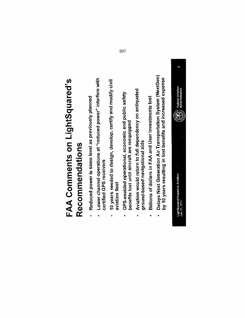
207

208

209
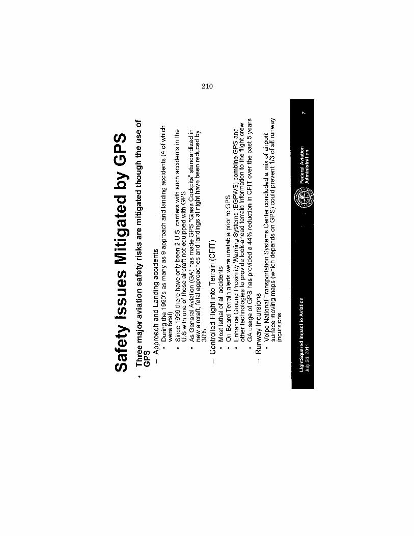
210

211

212

213

214

215

216

217

218

219
LETTER TO MR. KARL B. NEBBIA, ASSOCIATE ADMINISTRATOR, NATIONAL TELECOMMUNICATIONS AND INFORMATION ADMINISTRATION,
FROM MR. JOEL SZABAT, DEPUTY ASSISTANT SECRETARY FOR TRANSPORTATION POLICY, U.S. DEPARTMENT OF TRANSPORTATION
220

221
222

223
224

225

226

227

228

229
230
231

232
233

234

235

236
237

238

239

240

241

242

243

244

245
246

247
248

249
250

251

252
MEMORANDUM FOR MR. KARL NEBBIA, ASSOCIATE ADMINISTRATOR, NATIONAL TELECOMMUNICATIONS AND INFORMATION ADMINISTRATION,
FROM DEANNA ARCHULETA, SENIOR ADVISOR TO THE SECRETARY, DEPARTMENT OF THE INTERIOR
253

254

255

256
257

258
259
Æ