impact of human mobility on the emergence of dengue ... · impact of human mobility on the...
TRANSCRIPT

Impact of human mobility on the emergence of dengueepidemics in PakistanAmyWesolowskia,b, Taimur Qureshic, Maciej F. Bonid,e, Pål Roe Sundsøyc, Michael A. Johanssonb,f, Syed Basit Rasheedg,Kenth Engø-Monsenc, and Caroline O. Buckeea,b,1
aDepartment of Epidemiology, Harvard T. H. Chan School of Public Health, Boston, MA 02115; bCenter for Communicable Disease Dynamics, Harvard T. H.Chan School of Public Health, Boston, MA 02115; cTelenor Research, Telenor Group, N-1360 Fornebu, Norway; dOxford University Clinical Research Unit,Wellcome Trust Major Overseas Programme, Ho Chi Minh City, Vietnam; eCentre for Tropical Medicine, Nuffield Department of Clinical Medicine, Universityof Oxford, Oxford OX3 7FZ, United Kingdom; fDivision of Vector-Borne Diseases, Centers for Disease Control, San Juan, Puerto Rico 00920; and gDepartmentof Zoology, University of Peshawar, Peshawar 25120, Pakistan
Edited by Burton H. Singer, University of Florida, Gainesville, FL, and approved August 6, 2015 (received for review April 2, 2015)
The recent emergence of dengue viruses into new susceptiblehuman populations throughout Asia and the Middle East, driven inpart by human travel on both local and global scales, represents asignificant global health risk, particularly in areas with changingclimatic suitability for the mosquito vector. In Pakistan, denguehas been endemic for decades in the southern port city of Karachi,but large epidemics in the northeast have emerged only since2011. Pakistan is therefore representative of many countries onthe verge of countrywide endemic dengue transmission, whereprevention, surveillance, and preparedness are key priorities inpreviously dengue-free regions. We analyze spatially explicitdengue case data from a large outbreak in Pakistan in 2013 andcompare the dynamics of the epidemic to an epidemiologicalmodel of dengue virus transmission based on climate and mobilitydata from ∼40 million mobile phone subscribers. We find thatmobile phone-based mobility estimates predict the geographicspread and timing of epidemics in both recently epidemic andemerging locations. We combine transmission suitability mapswith estimates of seasonal dengue virus importation to generatefine-scale dynamic risk maps with direct application to denguecontainment and epidemic preparedness.
dengue | human mobility | Pakistan | mobile phones | epidemiology
Dengue is the most rapidly spreading mosquito-borne diseaseworldwide (1, 2). Half the global population now lives in at-
risk regions for dengue virus transmission, due to the wide dis-tribution of the mosquito vector, Aedes aegypti, which thrives inperi-urban areas and transmits the virus between humans (3).Dengue virus can cause acute febrile illness and carries the riskof severe disease, hospitalization, and shock syndrome, especiallyin clinical settings with little experience treating dengue patients.There is currently no specific therapeutic protocol for, or vaccineagainst, infection (1). Current control measures focus on vectorcontrol, although these measures are often logistically difficultand have shown varying efficacy in controlling epidemics (4). Inthe absence of effective prevention and treatment, public healthsystem preparedness remains the single most important tool forminimizing morbidity and mortality as dengue epidemics spreadbeyond endemic areas (5, 6).The introduction of dengue into new populations is mediated
by travel of infected individuals to areas that can support trans-mission, because mosquito vectors move only short distancesduring their lifespans (3, 7–12). International travel to endemiccountries has resulted in imported cases and outbreaks in Europeand the Americas (2, 8, 10, 13). Local variation in transmission,within a single city for example, is also driven by mobility patternsof individuals on short timescales (7). Forecasting methods areneeded to spatially target interventions and epidemic prepared-ness measures that reflect both the changing temporal risks ofimportation and environmental suitability that go beyond solelyclimate-based methods (14).
Dengue has long been endemic in most Southeast Asian coun-tries (1), but has more recently emerged in parts of the Middle Eastand South Asia, including Pakistan (15, 16). In Pakistan, thetransmission of dengue viruses was largely confined to the southerncity of Karachi until 2011 when a large dengue epidemic with over20,000 cases occurred in the northeastern city of Lahore (16),causing significant morbidity and mortality. In 2013, a secondlarge epidemic occurred in northeastern Pakistan in Punjab andKhyber-Pakhtunkhwa (KP) provinces, establishing the region asan emerging focus of seasonal dengue epidemics. It has beenhypothesized that the recent geographic expansion of A. aegyptimosquito vectors, changing environmental suitability, and humanimportation of dengue from endemic regions all contributed tothe emergence of dengue in northern areas (17). Pakistan istherefore representative of many countries that are on the vergeof countrywide endemic dengue transmission and are strugglingto contain its emergence into previously dengue-free regions.Measuring changing risks of importation events that spark
epidemics has been extremely challenging on the refined tem-poral and spatial scales necessary to inform local policies (18).Being able to predict when to prepare surveillance systems andhealth facilities for dengue outbreaks could dramatically reducethe morbidity and mortality associated with epidemics and wouldallow policy makers to pinpoint regions that are particularlyvulnerable to imported cases, for vector control. Mobile phonedata offer direct measures of human aggregation and movement
Significance
Dengue virus has rapidly spread into new human populationsdue to human travel and changing suitability for the mosquitovector, causing severe febrile illness and significant mortality.Accurate predictive models identifying changing vulnerabilityto dengue outbreaks are necessary for epidemic preparednessand containment of the virus. Here we show that an epide-miological model of dengue transmission in travelers, based onmobility data from ∼40 million mobile phone subscribers andclimatic information, predicts the geographic spread and tim-ing of epidemics throughout the country. We generate fine-scale dynamic risk maps with direct application to denguecontainment and epidemic preparedness.
Author contributions: A.W. and C.O.B. designed research; A.W., T.Q., M.F.B., K.E.-M., andC.O.B. performed research; A.W., M.F.B., M.A.J., S.B.R., and K.E.-M. contributed new re-agents/analytic tools; A.W., T.Q., P.R.S., S.B.R., and K.E.-M. analyzed data; and A.W., T.Q.,M.F.B., P.R.S., M.A.J., S.B.R., K.E.-M., and C.O.B. wrote the paper.
Conflict of interest statement: M.F.B. has worked as a paid consultant to Visterra, Inc. inCambridge, MA.
This article is a PNAS Direct Submission.
Freely available online through the PNAS open access option.1To whom correspondence should be addressed. Email: [email protected].
This article contains supporting information online at www.pnas.org/lookup/suppl/doi:10.1073/pnas.1504964112/-/DCSupplemental.
www.pnas.org/cgi/doi/10.1073/pnas.1504964112 PNAS Early Edition | 1 of 6
ECOLO
GY

and represent a unique source of information on the humandeterminants of the geographic expansion of emerging epidemicdiseases like dengue. Here, we conduct a retrospective epide-miological analysis of large dengue outbreaks in Pakistan in2013, to examine the predictive ability of an epidemiologicalmodel that integrates human mobility from the largest mobilephone dataset analyzed to date with climate information. Weshow that within-country human mobility predicts emerging ep-idemics in Pakistan, and epidemiological models incorporatingthis type of data can predict the spatial extent and timing ofoutbreaks, providing a new approach to forecasting.
ResultsHuman Mobility in Pakistan Does Not Conform to Standard ModelPredictions. To measure human travel patterns underlying thespread of dengue virus across Pakistan in 2013, we estimated themobility of 39,785,786 mobile phone subscribers between geo-located mobile phone towers in Pakistan between June 1 andDecember 31 of 2013 (representing ∼22% of the population;Materials and Methods). Daily locations and movements wereaggregated to measure travel between 356 small, politically de-fined areas called tehsils (Fig. 1A and Materials and Methods).We compared our data to gravity models of mobility, developedfrom transportation theory and commonly used to parameterizeinfectious disease frameworks, to assess whether observed mo-bility measured using mobile phone data significantly improvesupon this standard approach. We have focused on intracountrymobility patterns (Discussion).The sampled population was extremely mobile. We estimated
that between 2.4 million and 4.8 million subscribers traveledbetween tehsils each day (95% quantile interval: 3.1–4.6 million;details inMaterials and Methods). Most travel followed a NW–SEcorridor along the major highways (Fig. 1B). Large volumes oftravel occurred to and from Karachi, a major population andeconomic hub of Pakistan, with ∼710,000 subscribers traveling toor from the city each day on average (95% quantile interval:570,000–813,000; Fig. S1). In contrast to expectations of stan-dard mobility models, there was almost no decay in travel withincreasing distance (correlation coefficient: −0.064, P < 0.001),although the most frequent destinations for travel were often in anearby tehsil (Fig. 1C). This pattern reflects the topography,road infrastructure, and population distribution in Pakistan, withthe largest cities outside Karachi being located in the northernpart of Punjab province that includes the Rawalpindi/Islamabadmetropolitan area, Lahore, and Faisalabad. Although there was
a decrease in overall movement during Ramadan, we did notobserve a systematic difference in the amount or direction of travelpatterns in the weeks before and after the holiday (Fig. S1).
Epidemiological Modeling of Dengue Epidemics in 2013. There were15,535 reported dengue cases in 82 tehsils over 7 mo in Pakistanin 2013 (Fig. 2A and Materials and Methods). Peak timing of theepidemic varied by location, and the majority of cases occurredin and around Karachi, in the northern district of Swat, and inthe cities of Lahore and Rawalpindi (Fig. 2A and Table S1).About half of the dengue cases reported occurred in the Mingoraarea of Swat (KP province), marking the first major outbreak inthe region [n = 7,950, compared with a previous maximum of 300cases reported in KP in 2011 (16)].We first fitted an ento-epidemiological model to the reported
dengue cases in Southern Pakistan, where transmission occursyear round, and to case data in Lahore and Swat in northernPakistan, where transmission is seasonal due to climatic variation.Southern Pakistan has year-round climatic suitability for denguevectors and is therefore the most likely source of exported cases toother parts of the country, where greater seasonal temperatureextremes limit suitability (16) (SI Text). Although importation frominternational regions is technically a possibility, given the fairly re-strictive political borders we assume here that importation will benegligible compared with the within-country importation rate. Wefitted an ento-epidemiological model of dengue dynamics in Kar-achi (Fig. 2B), with vector dynamics being determined by temper-ature (19). We fitted the mosquito-biting rate (a= 0.66) andreporting rate (SI Text), yielding parameter values that are consis-tent with endemic dengue virus transmission (Materials and Methodsand SI Text).In northern Pakistan, we used our epidemiological framework
to estimate the timing of the introduction of the first case thatsparked the epidemics in each area, to compare these estimateswith our mechanistic model of imported infections using mobilephone data. We performed a sensitivity analysis to estimate anexpected range of dates for the introduction of dengue to Lahoreand Mingora, where most cases were concentrated (Materialsand Methods and Fig. 3 A and B). Interestingly, Lahore hadsuffered its first major outbreak 2 y before this epidemic, and weexpect that immunity may have played a significant role in de-termining transmission dynamics (16). Mingora, on the otherhand, represents an effectively naive population. In the absenceof serotype information, we took the simplest approach and as-sumed each population was immunologically naive; however, we
−10
−5
0
5
10
−10 −5 0 5 10Difference from Origin Latititude
Diff
eren
ce fr
om O
rigin
Lon
gitu
de
50
10
30
count
A C
Population density (per sq. km)
6000
0
Mobile phone tower in tehsil
Karachi
Lahore
Mingora
Karachi
Lahore
Mingora
B
Fig. 1. Human mobility dynamics in Pakistan. (A) Population density (red, high density; yellow, low density) and mobile phone tower coverage from themobile phone operator in Pakistan (colored in gray) per tehsil. (B) The top routes of travel between pairs of tehsils in Pakistan. A line is drawn if at least 20,000trips occurred between the origin and destination between June and December 2013. The top routes occur between Karachi and cities in northern Punjabprovince, particularly Lahore tehsil. (C) Relative direction and volume of travel. For each trip, we calculated the distance traveled from the origin and thedestination. The origin location was centered at 0,0 and the longitude distance and latitude distance to the destination are shown. Although many tripsoccurred over short distances, a substantial amount of travel occurred between the southeastern and northern parts of the country, reflecting the geographyand population distribution of Pakistan.
2 of 6 | www.pnas.org/cgi/doi/10.1073/pnas.1504964112 Wesolowski et al.

hypothesize that the delay between the first cases and the peak ofthe epidemic in Lahore may have been caused by immunity fromthe 2011 outbreak. We estimated that the first case was in-troduced to Lahore during the second week of May (betweendays 124 and 130; SI Text and Fig. 3A) a few days earlier than thefirst reported case (day 133). In Mingora, on the other hand, weestimated that the first introductions likely occurred in August(between days 202 and 231) (Fig. 3B), a few weeks before thefirst reported case in the city.
Models of Dengue Virus Importation Based on Mobile Phone DataAccurately Predict the Spatial Extent and Timing of Epidemics. Wenext modeled the number of infected individuals traveling fromthe endemic areas in southern Pakistan to all other tehsils, usingdifferent approaches to characterize mobility: direct observationsfrom the mobile phone data and various modified gravity modelsof travel (Materials and Methods) (10, 19). To compare theperformance of the mobile phone data against the next best al-ternative, we used a parameter-free gravity model (referred to asthe diffusion model) that is equivalent to a population-weightedspatial diffusion model (Materials and Methods) based on thetravel time distance between the origin and the destination. Inaddition to these models, we fitted a gravity model to the mobilephone data, to determine whether simple adjustments wouldsignificantly improve our predictions (SI Text and Fig. S2).We compared the timing of predicted importation events from
endemic areas in southern Pakistan, based on our mobilitymodel, to the estimated first dengue case inferred from casereport data from Lahore and Mingora (SI Text). The timing ofthe first dengue case estimated from the epidemiological dataoverlapped well with the predicted introductions from southernPakistan to Lahore from the importation model (Fig. 3A), withthe first introductions occurring approximately 1 mo earlier. InMingora, the predicted timing of imported infections using ourmodel occurred 2 wk before the first reported case, consistentwith the serial interval for dengue and the estimates of the first
case from epidemiological data (Fig. 3B). Crucially, the diffusionmodel does not predict any introductions from endemic areas insouthern Pakistan to Mingora. Thus, travel patterns measuredusing mobile phone data predict introduction events consis-tent with outbreaks in both emerging (Lahore) and previouslydengue-free (Mingora) regions. Our ability to measure these im-portations in more remote places like Mingora was somewhatsensitive to the Karachi model fit, in particular the reportingrate, although the mobile phone data are always able to predictearlier, more frequent, and more accurate introductions than thediffusion model (SI Text). The modeled interaction betweenseasonal variations in vectorial capacity and the dynamics ofimportation events provide accurate predictions about the lo-cation and timing of epidemics in different epidemiological set-tings and regions of the country.We combined our estimates of imported cases with an index of
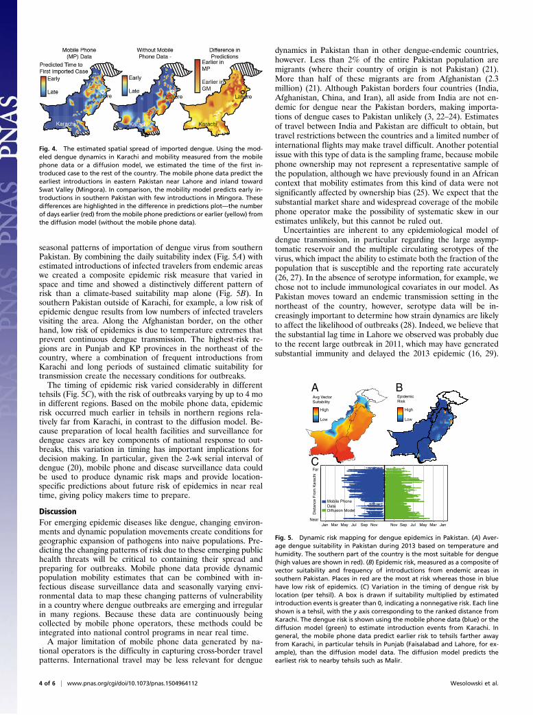
climatic suitability for dengue vectors (19) across Pakistan to pre-dict the potential for spread of the virus in areas with introducedcases and assessed how well the spatiotemporal dynamics of theepidemic were captured. In general, the spatial extent and epi-demic timing of cases were predicted more accurately using mobilephone data (Fig. 4) compared with the diffusion models, whichboth predicted early spread along the major highway connectingKarachi to other highly populated areas.
A New Approach to Dynamic Risk Mapping for Epidemic Preparedness.We next constructed risk maps to identify areas of the country thatwere vulnerable to epidemics due to a combination of seasonallyvarying climatic suitability based on temperature and relativehumidity (vectorial capacity index) for dengue transmission and
050
010
0015
00A
Week
0 10 20 30 40 50
010
000
2000
030
000
Week Number
Mod
el F
it -
Cas
es
15
20
25
30
35Cases adjusted for reporting
Model TempRamadan
Tem
perature (C)
BMay August December
Rep
orte
d C
ases
Fig. 2. Dengue epidemiology in Pakistan in 2013. (A) The location of den-gue cases throughout Pakistan and the number of cases per week by tehsil.Tehsils that reported at least 15 cases are shown on the map with corre-sponding color shown in the time series. The majority of cases were reportedin Karachi (gray), Lahore (blue), and Mingora (orange). The dengue seasonin the entire country lasted 35 wk, with the first reported case in Karachiduring week 18 (end of April). (B) The reported cases (red), temperature(blue), and model fit (black) for Karachi are shown. Using the case andtemperature data, the human and vector population dynamics were mod-eled (Materials and Methods).
Lahore
0
100
200
300
0
0.004
0.01
4
2
0
6
3
0
Cas
es
Vectoral S
uitability
Mobile Phone Data
Diffusion
Pre
dict
edIn
trod
uctio
ns
0 10 20 30 40 50Week Number May September December
Dengue CasesVector Suitability
Estimated Intro fromDengue Case DataA
Mingora
0
200
400
600
800
1000
3
1.5
0
0
0.004
0.01
Cas
es
Vectoral S
uitability
Mobile Phone Data
Diffusion
Pre
dict
edIn
trod
uctio
ns
B
0 10 20 30 40 50Week Number May September December
Dengue CasesVector Suitability
Estimated Intro fromDengue Case Data
Fig. 3. Mobility estimates derived from mobile phone data predict thetiming of introduced cases around the country that spark epidemics. (A andB) The estimated introduced cases from Karachi to (A) Lahore (total denguecases: 1,538) and (B) Mingora (total dengue cases: 4,029). The estimatedintroductions (assuming 30% of individuals travel, a 2% reporting rate, anda probability of 0.01) from the mobile phone data (boxplot in blue), thediffusion model (boxplot in green), actual case data (red), and estimateddengue suitability (gray) are shown. Dengue suitability was defined basedon temperature and relative humidity, using a measure that is linearlyproportional to vectoral capacity (Materials and Methods). Values near zeroare unsuitable for dengue transmission. For Lahore and Mingora, the esti-mated introduction from the case data alone is shown (red cross-hatchedbox). In all instances, the mobile phone data were able to predict the timingof the first introduced case in each tehsil. An arrow indicates the week of thefirst reported case in each tehsil.
Wesolowski et al. PNAS Early Edition | 3 of 6
ECOLO
GY
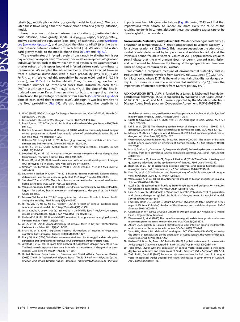
seasonal patterns of importation of dengue virus from southernPakistan. By combining the daily suitability index (Fig. 5A) withestimated introductions of infected travelers from endemic areaswe created a composite epidemic risk measure that varied inspace and time and showed a distinctively different pattern ofrisk than a climate-based suitability map alone (Fig. 5B). Insouthern Pakistan outside of Karachi, for example, a low risk ofepidemic dengue results from low numbers of infected travelersvisiting the area. Along the Afghanistan border, on the otherhand, low risk of epidemics is due to temperature extremes thatprevent continuous dengue transmission. The highest-risk re-gions are in Punjab and KP provinces in the northeast of thecountry, where a combination of frequent introductions fromKarachi and long periods of sustained climatic suitability fortransmission create the necessary conditions for outbreaks.The timing of epidemic risk varied considerably in different
tehsils (Fig. 5C), with the risk of outbreaks varying by up to 4 moin different regions. Based on the mobile phone data, epidemicrisk occurred much earlier in tehsils in northern regions rela-tively far from Karachi, in contrast to the diffusion model. Be-cause preparation of local health facilities and surveillance fordengue cases are key components of national response to out-breaks, this variation in timing has important implications fordecision making. In particular, given the 2-wk serial interval ofdengue (20), mobile phone and disease surveillance data couldbe used to produce dynamic risk maps and provide location-specific predictions about future risk of epidemics in near realtime, giving policy makers time to prepare.
DiscussionFor emerging epidemic diseases like dengue, changing environ-ments and dynamic population movements create conditions forgeographic expansion of pathogens into naive populations. Pre-dicting the changing patterns of risk due to these emerging publichealth threats will be critical to containing their spread andpreparing for outbreaks. Mobile phone data provide dynamicpopulation mobility estimates that can be combined with in-fectious disease surveillance data and seasonally varying envi-ronmental data to map these changing patterns of vulnerabilityin a country where dengue outbreaks are emerging and irregularin many regions. Because these data are continuously beingcollected by mobile phone operators, these methods could beintegrated into national control programs in near real time.A major limitation of mobile phone data generated by na-
tional operators is the difficulty in capturing cross-border travelpatterns. International travel may be less relevant for dengue
dynamics in Pakistan than in other dengue-endemic countries,however. Less than 2% of the entire Pakistan population aremigrants (where their country of origin is not Pakistan) (21).More than half of these migrants are from Afghanistan (2.3million) (21). Although Pakistan borders four countries (India,Afghanistan, China, and Iran), all aside from India are not en-demic for dengue near the Pakistan borders, making importa-tions of dengue cases to Pakistan unlikely (3, 22–24). Estimatesof travel between India and Pakistan are difficult to obtain, buttravel restrictions between the countries and a limited number ofinternational flights may make travel difficult. Another potentialissue with this type of data is the sampling frame, because mobilephone ownership may not represent a representative sample ofthe population, although we have previously found in an Africancontext that mobility estimates from this kind of data were notsignificantly affected by ownership bias (25). We expect that thesubstantial market share and widespread coverage of the mobilephone operator make the possibility of systematic skew in ourestimates unlikely, but this cannot be ruled out.Uncertainties are inherent to any epidemiological model of
dengue transmission, in particular regarding the large asymp-tomatic reservoir and the multiple circulating serotypes of thevirus, which impact the ability to estimate both the fraction of thepopulation that is susceptible and the reporting rate accurately(26, 27). In the absence of serotype information, for example, wechose not to include immunological covariates in our model. AsPakistan moves toward an endemic transmission setting in thenortheast of the country, however, serotype data will be in-creasingly important to determine how strain dynamics are likelyto affect the likelihood of outbreaks (28). Indeed, we believe thatthe substantial lag time in Lahore we observed was probably dueto the recent large outbreak in 2011, which may have generatedsubstantial immunity and delayed the 2013 epidemic (16, 29).
Fig. 4. The estimated spatial spread of imported dengue. Using the mod-eled dengue dynamics in Karachi and mobility measured from the mobilephone data or a diffusion model, we estimated the time of the first in-troduced case to the rest of the country. The mobile phone data predict theearliest introductions in eastern Pakistan near Lahore and inland towardSwat Valley (Mingora). In comparison, the mobility model predicts early in-troductions in southern Pakistan with few introductions in Mingora. Thesedifferences are highlighted in the difference in predictions plot—the numberof days earlier (red) from the mobile phone predictions or earlier (yellow) fromthe diffusion model (without the mobile phone data).
A BAvg Vector Suitability
High
Low
Epidemic Risk
C
High
Low
Dis
tanc
e F
rom
Kar
achi
Jan Mar May Jul Sep Nov Nov Sep Jul May Mar JanNear
Far
Mobile Phone DataDiffusion Model
Fig. 5. Dynamic risk mapping for dengue epidemics in Pakistan. (A) Aver-age dengue suitability in Pakistan during 2013 based on temperature andhumidity. The southern part of the country is the most suitable for dengue(high values are shown in red). (B) Epidemic risk, measured as a composite ofvector suitability and frequency of introductions from endemic areas insouthern Pakistan. Places in red are the most at risk whereas those in bluehave low risk of epidemics. (C) Variation in the timing of dengue risk bylocation (per tehsil). A box is drawn if suitability multiplied by estimatedintroduction events is greater than 0, indicating a nonnegative risk. Each lineshown is a tehsil, with the y axis corresponding to the ranked distance fromKarachi. The dengue risk is shown using the mobile phone data (blue) or thediffusion model (green) to estimate introduction events from Karachi. Ingeneral, the mobile phone data predict earlier risk to tehsils farther awayfrom Karachi, in particular tehsils in Punjab (Faisalabad and Lahore, for ex-ample), than the diffusion model data. The diffusion model predicts theearliest risk to nearby tehsils such as Malir.
4 of 6 | www.pnas.org/cgi/doi/10.1073/pnas.1504964112 Wesolowski et al.

These uncertainties will continue to make forecasting challeng-ing, although serotype data could improve model accuracy.Given these difficulties, forecasting dengue epidemics will al-
ways need to encompass substantial stochastic variation, despite itsimportance for targeting limited public health resources. Cur-rently, vector control programs in Pakistan begin during themonsoon season uniformly across the country. We believe that thelarge estimated lead times this approach offers could aid controlmanagers, providing an early warning system. This approachprovides policy-relevant, real-time information about where andwhen to expect dengue epidemics and therefore how to effec-tively target interventions, surveillance, and clinical response.
Materials and MethodsPopulation Data. Pakistan’s large population (182 million) is broadly dividedinto one capital territory, Federally Administered Tribal Area (FATA), Gilgit-Baltistan, Azad Jammu and Kashmir, and four provinces, which are furthersubdivided into 388 tehsils (equivalent to administrative unit 3 from 2008;Fig. 1A). Karachi is the most populated city in the country and located alongthe southern coast. The majority of the population in southern Pakistan livesalong the Indus river, whereas in the northern half the population lives in anarc between Faisalabad and Peshawar that includes the major populationcenters of Lahore, Islamabad, and Rawalpindi. We used population dataobtained from worldpop.org.uk.
Dengue Data. Data for Punjab province were collected by the ProvincialHealth Department, whereas the District Health Office collected case data forSwat District (Table S1) daily. All public and private hospitals, health clinics,and laboratories reported any case of a patient presenting with denguesymptoms. The data listed each patient who presented to a hospital or clinic,regardless of whether the patient was admitted in the province or district,seeking treatment for high fever, body aches, petechiae, and low plateletcounts (with a cutoff value for thrombocytopenia of <50,000/mm3). Thesecases were then confirmed by using IgM or NS 1-Ag enzyme-linked immu-nosorbent assay (ELISA). The data reported from Karachi were based onofficial public releases from the Sindh Health department. All case data weredeidentified and aggregated to the tehsil level.
Mobile Phone Data.We analyzed all voice-based, originated, call data records(CDRs) from 39,785,786 subscriber SIMs (security information management)over a 7-mo period, from June 1 to December 31, 2013. The mobile operatorhas the largest coverage of tehsil headquarters (352 in the dataset of 388total tehsils) across Pakistan, particularly in rural areas (two-thirds of thenetwork). To comply with national laws and regulations of Pakistan and theprivacy policy of the Telenor group, the following measures were imple-mented to preserve the privacy rights of Telenor Pakistan’s customers:(i) The CDR/mobility data were processed on a backup and recovery servermade available by Telenor Pakistan. Only Telenor employees have access tothe detailed CDR/mobility data. (ii) Given the server arrangements, no de-tailed CDR/mobility data were taken out of Pakistan or left the premises ofTelenor Pakistan. (iii) The processing of the detailed CDR/mobility dataresulted in aggregations of the data on a tower-level granularity that wasaccessed only by Telenor employees. Further spatial aggregations to thelevel of the tehsil were made available to the remaining coauthors.
On average, 28 million subscriber SIMs were recorded as active on a givenday, and of these 15.2 million subscribers generated outgoing, voice-eventCDRs that encoded location information. At the time of data acquisition, themobile phone operator had approximately a 25% market share (22% of thepopulation) and was the second largest provider of mobile telecommuni-cation services in Pakistan. Multi-SIM activity is common in Pakistan, but webelieve that this should not create a systematic bias in mobility estimatesbecause the geographic coverage of the operator is so extensive.
Quantifying Travel Using the Mobile Phone Data. Every caller was assigned tohis or her most frequently used base station/mobile phone tower on a givenday, as in previous studies (30). For a given location, defined through thelocation of a base station, the flux of that location is defined through thenumber of active callers assigned to the base station and was then aggre-gated to the tehsil level. On an average day, ∼12% of the total populationof Pakistan made a call. We measured daily travel between mobile phonetowers relative to subscriber location on the previous day. Trips were ag-gregated to each tehsil based on the location of the origin and destinationtower. We normalized trip counts by the origin tehsils’ number of active
subscribers on each day (SI Text and Fig. S1). Aggregated forms of thesemobility patterns can be made available upon request.
On a country-wide scale there were two significant decreases in therecorded CDR activity, one occurring during Ramadan (July 9 to August 7,2013), reflecting less subscriber activity (Fig. S1). The decrease in the use ofmobile communication services during Ramadan has been confirmed by themobile operator as an expected effect, and this effect is seen every year. Theother decrease in activity was after October 25, due to a major system up-grade to the core mobile system infrastructure, which impacted all of thecustomers of the mobile operator. In the collected dataset, this led to a dropin the number of location-generating subscribers recorded per day of ∼3.38million. We adjusted the time series under the assumption that the systemupgrade was a 1-d event only, based on expert opinion from the operator,and that the population in the customer base did not change its overallbehavior. The flux values were adjusted after this date, assuming that theaverage would remain the same as in the beginning of the dataset (Fig. S1).To analyze the relationship between mobility and dengue dynamics, weapproximated travel patterns between January 1 and June 1. We simulatedtravel, assuming that the mean number of normalized trips (normalized byflux) remained the same, and added noise [Normð0, σÞ, where σ is the vari-ance in the number of trips between all pairs of tehsils] (SI Text and Fig. S1).
Climate Data. A. aegypti entomological and dengue viral factors are highlyinfluenced by temperature (19). Daily mean temperature and total pre-cipitation were recorded at 39 weather stations across Pakistan, obtainedfrom the National Oceanic and Atmospheric Administration National Cli-mate Data Center (Fig. S3). Temperatures peak in the middle of the year,June, July, and August; are lowest in January and December; and are vari-able across the country (daily averages between 9 °C and 27 °C) (for exam-ple, Fig. S3). We converted temperature to dew-point temperature based onthe Numerical Terradynamic Simulation Group proposed model at the Uni-versity of Montana (31). Dew-point values and temperature were thenconverted to relative humidity.
Ento-Epidemiological Framework. To model dengue dynamics, we used anordinary differential equation model based on a model by Lourenco andRecker to describe a dengue outbreak in Madeira, Portugal (10). This modelcaptures the dynamics of dengue between human and mosquito hostswhere the mosquito dynamics are dependent on temperature and relativehumidity (SI Text and Fig. S3). Here we assume that individuals can be in-fected only once and we do not consider multiple serotypes. We assignedtemperature-dependent epidemiological variables as in Lourenco and Recker(SI Text and Fig. S3) (10).
The relationship between relative humidity and dengue suitability hasbeen explored in a number of environments (3, 32). We have added anadditional variable to the temperature-dependent epidemiological variable,the mortality factor that is based on relative humidity (33). In contrast to ref.10, we analyzed the reporting rate ρ along with the biting rate a (SI Text).We varied the reporting rate between 2% and 10% (a 2% reporting rate isshown) because low rates of dengue reporting have previously been foundin South Asia (34). We did not fit the carrying capacity (K) explicitly andperformed a sensitivity analysis, changing values of K. Although variousvalues of K changed both a and ρ, it did not change the overall shape of theepidemic (Fig. S4 and SI Text). Using the temperature data for Karachi andthe population (13.4 million), we estimated that a= 0.66, ρ= 0.02 (assumingK = 5e6; see SI Text for the sensitivity analysis).
Importation of Infected Travelers from Endemic Areas in Southern Pakistan. Toestimate the number and role of importation of cases from endemic areas insouthern Pakistan (Karachi) to all other tehsils, we first modeled the denguedynamics in Karachi, using the ento-epidemiological framework describedabove. We are focused only on the role of travel within Pakistan as opposedto cross-border migration (Discussion). Dengue is endemic in Karachi (16),due to year-round climatic suitability and availability of vectors, and thus weassumed the date of the first introduced was day 1 (t0 = 1).
We then estimated the flow of infected travelers from Karachi. We firstestimated the number of infected travelers per day who have left Karachi(Tt =mtβt). Based on the mobile phone data, ∼30% (in the figures 30% isshown: min, 25.6%; median, 30%; max, 34%) of subscribers have traveledoutside of Karachi per day (βt) (Fig. S5). We varied this percentage between10% and 30% to account for uncertainty in this estimate and a possibleoverestimate of travel because this value was based only on mobile phonesubscribers (25). The daily number of infected individuals in Karachi is basedon the modeled epidemic (mt). We determined the destinations of infectedtravelers based on the daily percentage of travelers from Karachi to all other
Wesolowski et al. PNAS Early Edition | 5 of 6
ECOLO
GY
tehsils (xt,j, mobile phone data; gt,j, gravity model to location j). We calcu-lated these flows using either the mobile phone data or a gravity (diffusion)model.
Here, the amount of travel between two locations, i, j estimated via abasic diffusion, naive gravity, model is Ndiffusion,i,j = ðpopi × popjÞ=distði, jÞand we estimated the population (popi , popjÞ of each tehsil, using Worldpop.org (www.worldpop.org), and calculated the distance (distði, jÞ) as the traveltime distance between centroids of each tehsil (35). We also fitted a stan-dard gravity model to the mobile phone data (SI Text and Fig. S2).
The raw estimates of infected travelers from Karachi to all other tehsils perday represent an upper limit. To account for variation in epidemiological andindividual factors, such as the within-host viral dynamics, we assumed that asmaller subset of this upper bound of infected visitors could contribute totransmission. We sampled the actual number of effective infected travelersfrom a binomial distribution with a fixed probability [PrðTi × xt,j jγÞ andPrðTi × gt,j jγÞ]. We varied this probability between 0.001 and 0.9 (0.01 isshown); see SI Text for further details. Thus, for each day, we had anestimated number of introduced cases from Karachi to each tehsil[PrðTi × xt,j jγÞ× mt =Yx,t, PrðTi × gt,j jγÞ× mt =Yg,t]. The date of the first in-troduced case from Karachi was sensitive to both the reporting rate forKarachi and the percentage of travelers from Karachi (SI Text) (see Fig. S6 forplots of each tehsil that reported cases), although it was less sensitive tothe fixed probability (Fig. S7). We also investigated the possibility of
importations from Mingora into Lahore (Fig. S8) during 2013 and find thatimportations from Karachi to Lahore are more likely the cause of theresulting epidemic in Lahore, although these two possible causes cannot bedisentangled in the case data.
Environmental Suitability and Epidemic Risk. We defined dengue suitability asa function of temperature ZxðTÞ that is proportional to vectoral capacity (V)for a given location x (19) (SI Text). This measure depends on the adult vectormortality rate (determined by temperature and relative humidity) and theinfectious period for adult vectors. Values of ZxðTÞ approximately equal tozero indicate that the environment does not permit onward transmissionand can be used to determine the timing of the geographic and temporallimits of dengue transmission in Pakistan.
We created a composite measure of environmental suitability and in-troduction of infected travelers from Karachi, riskepidemicðxÞ=
PNt=1ZxðTtÞYx,t
for a location x, where ZxðTtÞ is the environmental suitability for dengue onday t. This measure sums the environmental suitability (ZxðTÞ) times theimportation of infected travelers from Karachi per day (Yx,t).
ACKNOWLEDGMENTS. A.W. is funded by a James S. McDonnell Foundationpostdoctoral fellowship. M.F.B. is supported by Wellcome Trust Grant 098511/Z/12/Z. C.O.B., A.W., and M.A.J. were supported by the Models of InfectiousDisease Agent Study program (Cooperative Agreement 1U54GM088558).
1. WHO (2012) Global Strategy for Dengue Prevention and Control (World Health Or-ganization, Geneva).
2. Guzman MG, Harris E (2015) Dengue. Lancet 385(9966):453–465.3. Bhatt S, et al. (2013) The global distribution and burden of dengue. Nature 496(7446):
504–507.4. Heintze C, Velasco Garrido M, Kroeger A (2007) What do community-based dengue
control programmes achieve? A systematic review of published evaluations. Trans RSoc Trop Med Hyg 101(4):317–325.
5. Halloran ME, Longini IM, Jr (2014) Emerging, evolving, and established infectiousdiseases and interventions. Science 345(6202):1292–1294.
6. Jones KE, et al. (2008) Global trends in emerging infectious diseases. Nature451(7181):990–993.
7. Stoddard ST, et al. (2013) House-to-house human movement drives dengue virustransmission. Proc Natl Acad Sci USA 110(3):994–999.
8. Nunes MR, et al. (2014) Air travel is associated with intracontinental spread of denguevirus serotypes 1-3 in Brazil. PLoS Negl Trop Dis 8(4):e2769.
9. Simmons CP, Farrar JJ, Nguyen V, Wills B (2012) Dengue. N Engl J Med 366(15):1423–1432.
10. Lourenço J, Recker M (2014) The 2012 Madeira dengue outbreak: Epidemiologicaldeterminants and future epidemic potential. PLoS Negl Trop Dis 8(8):e3083.
11. Stoddard ST, et al. (2009) The role of human movement in the transmission of vector-borne pathogens. PLoS Negl Trop Dis 3(7):e481.
12. Vazquez-Prokopec GMSS, et al. (2009) Usefulness of commercially available GPS data-loggers for tracking human movement and exposure to dengue virus. Int J HealthGeogr 8(68):68.
13. Morens DM, Fauci AS (2013) Emerging infectious diseases: Threats to human healthand global stability. PLoS Pathog 9(7):e1003467.
14. Hii YL, Zhu H, Ng N, Ng LC, Rocklov J (2012) Forecast of dengue incidence usingtemperature and rainfall. PLoS Negl Trop Dis 6(11):e1908.
15. Amarasinghe A, Letson GW (2012) Dengue in the Middle East: A neglected, emergingdisease of importance. Trans R Soc Trop Med Hyg 106(1):1–2.
16. Rasheed SB, Butlin RK, Boots M (2013) A review of dengue as an emerging disease inPakistan. Public Health 127(1):11–17.
17. Ali A, et al. (2013) Seroepidemiology of dengue fever in Khyber Pakhtunkhawa,Pakistan. Int J Infect Dis 17(7):e518–523.
18. Bharti N, et al. (2011) Explaining seasonal fluctuations of measles in Niger usingnighttime lights imagery. Science 334(6061):1424–1427.
19. Brady OJ, et al. (2014) Global temperature constraints on Aedes aegypti and Ae. albopictuspersistence and competence for dengue virus transmission. Parasit Vectors 7:338.
20. Aldstadt J, et al. (2012) Space-time analysis of hospitalised dengue patients in ruralThailand reveals important temporal intervals in the pattern of dengue virus trans-mission. Trop Med Int Health 17(9):1076–1085.
21. United Nations, Department of Economic and Social Affairs, Population Division(2013) Trends in International Migrant Stock: The 2013 Revision—Migrants by Des-tination and Origin (United Nations database, POP/DB/MIG/Stock/Rev.2013/Origin).
Available at www.un.org/en/development/desa/population/publications/pdf/migration/migrant-stock-origin-2013.pdf. Accessed June 1, 2015.
22. Gupta N, Srivastava S, Jain A, Chaturvedi UC (2012) Dengue in India. Indian J Med Res136(3):373–390.
23. Lai S, et al. (2015) The changing epidemiology of dengue in China, 1990-2014: Adescriptive analysis of 25 years of nationwide surveillance data. BMC Med 13:100.
24. Mardani M, Abbasi F, Aghahasani M, Ghavam B (2013) First Iranian imported case ofdengue. Int J Prev Med 4(9):1075–1077.
25. Wesolowski A, Eagle N, Noor AM, Snow RW, Buckee CO (2013) The impact of biases inmobile phone ownership on estimates of human mobility. J R Soc Interface 10(81):20120986.
26. Imai N, Dorigatti I, Cauchemez S, Ferguson NM (2015) Estimating dengue transmissionintensity from sero-prevalence surveys in multiple countries. PLoS Negl Trop Dis 9(4):e0003719.
27. Wikramaratna PS, Simmons CP, Gupta S, Recker M (2010) The effects of tertiary andquaternary infections on the epidemiology of dengue. PLoS One 5(8):e12347.
28. Reich NS, et al. (2013) Interactions between serotypes and dengue highlight epide-miological impact of cross-immunity. J R Soc Interface 10(86):20130414.
29. Koo CN, et al. (2013) Evolution and heterogeneity of multiple serotypes of denguevirus in Pakistan, 2006-2011. Virol J 10(1):275.
30. Wesolowski A, et al. (2012) Quantifying the impact of human mobility on malaria.Science 338(6104):267–270.
31. Eccel E (2012) Estimating air humidity from temperature and precipitation measuresfor modelling applications. Meteorol Appl 19(1):118–128.
32. Hales S, deWet N, Maindonald J, Woodward A (2002) Potential effect of populationand climate changes on global distribution of dengue fever: An empirical model.Lancet 360(9336):830–834.
33. Focks DA, Haile DG, Daniels E, Mount GA (1993) Dynamic life table model for Aedesaegypti (Diptera: Culicidae): Analysis of the literature and model development. J MedEntomol 30(6):1003–1017.
34. Organization WH (2010) Situation Update of Dengue in the SEA Region 2010 (WorldHealth Organization, Geneva).
35. Wesolowski A, et al. (2013) The use of census migration data to approximate humanmovement patterns across temporal scales. PLoS One 8(1):e52971.
36. Akram DSIA, Igarashi A, Takasu T (1998) Dengue virus infection among children withundifferentiated fever in Karachi. Indian J Pediatr 65(5):735–740.
37. Yang HM, Macoris ML, Galvani KC, Andrighetti MT, Wanderley DM (2009) Assessingthe effects of temperature on the population of Aedes aegypti, the vector of dengue.Epidemiol Infect 137(8):1188–1202.
38. Rasheed SB, Boots M, Frantz AC, Butlin RK (2013) Population structure of the mosquitoAedes aegypti (Stegomyia aegypti) in Pakistan. Med Vet Entomol 27(4):430–440.
39. Tariq RMZS (2000) Why the population of dengue vector mosquitoes is increasingday-by-day in Karachi and other areas of Sindh, Pakistan? Pak J Entomol 15(1):7–10.
40. Tariq RMAI, Qadri SS (2010) Population dynamics and mechanical control of denguevector mosquitoes Aedes aegypti and Aedes unilineatus in seven towns of Karachi.Pak J Entomol 25(1):21–26.
6 of 6 | www.pnas.org/cgi/doi/10.1073/pnas.1504964112 Wesolowski et al.