ijet an implementation of a system remote tracking and...
TRANSCRIPT

International Journal of Engineering and Technology Volume 7 No.9, September, 2017
ISSN: 2049-3444 © 2017 – IJET Publications UK. All rights reserved. 527
An Implementation of a System Remote Tracking and Control Using Global
Positioning System and Global System of Mobile Communication
1Jonathan A. Enokela, 2Sampson O. Umoru 1Department of Electrical and Electronics Engineering,
Federal University of Agriculture, PMB 2373, Makurdi, Benue State, Nigeria 2Engineering Works and Services Department, Ajaokuta Steel Company Limited, P. M. B. 1000, Ajaokuta, Kogi State, Nigeria
ABSTRACT
The theft of vehicles of all types has become common place and a source of concern to the society. The need to prevent such theft or
to recover the vehicles after they have been stolen is of paramount importance. The project presented in this paper develops an efficient
system of tracking a vehicle, or any object, using the Global Positioning System (GPS) and the Global System of Mobile
Communication (GSM). The implementation of this long distance object tracker also uses a microcontroller, in the Arduino
development platform that is appropriately programmed to communicate with the GPS and GSM modules. The GSM Modem receives
an SMS message from the user of the system to track the location of the stolen vehicle. This message is also processed by the
microcontroller which receives position coordinates in the form of longitude and latitude from the GPS and sends them to the GSM
modem for transmission to the user’s cellular phone. The coordinates are also displayed for viewing on a Liquid Crystal Display
(LCD). The user can initiate the action of immobilizing the vehicle from his cellular phone. Through the incorporation of the Google
maps Application Programming Interface (API), the position of the vehicle can be viewed on the map. A prototype of the system was
built and tested and it achieves the twin objectives of tracking and control of objects from remote locations excellently. The system
has applications in other areas such as vehicle fleet management and security monitoring of objects.
Keywords: GPS, GSM, Object Tracker, SMS, Google Maps API
1. INTRODUCTION
Over the past decade, real time tracking and management of
vehicles using various kinds of technology has become a field
of mounting interest. It has now developed into a powerful and
marketable package due to continued lowering of cost and the
incorporation of various facilities such as anti-theft modules
and client identification (Ahmad et al., 2006). A good number
of tracking systems have so far been developed with a wide
range of tracking facilities. However, the operational cost of
most of these systems is high and this prevents them from
widespread use.
A cost effective GPS-GPRS based object tracking system
which uses the GPRS for its operation was reported by
Khondker et al. (2009). A complete embedded system
implementation of GPS-GSM based tracking System using
SMS was reported by Abed and Ravi (2012). Baburao et al.
(2008) discussed GSM and GPS based vehicle location and
tracking System, which makes use of existing GSM networks
and GPS technology. Hsiao and Chang (2006) developed an
analytical model to analyse the optimal location update
strategy with the objective of minimum total cost. Montaser et
al. (2012) implemented an object tracking system but used
separate GPS and GSM modules; moreover their work did not
provide any alternate telephone number to report theft of
vehicles.
This project focuses on reducing the total cost of object
tracking and theft prevention and thus makes use of a single
SIM908 GPS/GSM Module (Shanghai SIMCom, 2011) that
contains a GSM modem and GPS together and therefore has
all that is required to develop GSM and GPS based systems.
The incorporation of the in-vehicle tracking unit of this project,
working together with a server, makes it possible to monitor
the location of a vehicle. This, in turn, discourages dangerous
and inefficient driving practices of drivers, in the case of fleet
management, which leads to increased vehicle security and
driver safety. The vehicle tracking system plays a vital role if
it is used in any company or organization for any kind of
delivery purposes. Since the driver is aware of the fact that the
car is constantly being monitored, he would be careful while
driving and he would take the shortest possible route to reach
his destination right on time. This system also ensures the
recovery of stolen vehicles. If the vehicle does not get to the
designated location or is being used by an unauthorized person,
the location can be tracked and the vehicle immobilized so that
the relevant law enforcement agents can be notified for the
vehicle to be recovered.
2. MATERIALS AND METHODS
2.1 System Architecture
The block diagram of the vehicle or long distance tracking
system using GPS/GSM is shown in figure 1. The system
shown in figure 1 is embedded in the vehicle being tracked.
The microcontroller, which in this case is part of the Arduino
platform (Margolis, 2012), receives the longitude and latitude
coordinates of the location of the vehicle from the GPS
module. These coordinates are displayed on the LCD. Upon
demand from the user’s cellular phone that may be located in
a remote location far from the in-vehicle unit, the
microcontroller sends an SMS message to the user through the

International Journal of Engineering and Technology (IJET) – Volume 7 No. 9, September, 2017
ISSN: 2049-3444 © 2017 – IJET Publications UK. All rights reserved. 528
GSM Modem to indicate the working status of the whole
system. However, in the case where the vehicle is stolen or
being operated by an unauthorized person, the user can send an
SMS message instructing the microcontroller to switch off the
ignition which thereby shuts down the vehicle’s engine. The
system will then send a message back to the owner confirming
that the requested action has been performed. The location of
the vehicle can be viewed on an Internet-connected computer
using the Google map API (Google Maps, 2015). Although
shown as separate blocks, the GPS and GSM modules used in
this design are contained in a single integrated module known
as the SIM 908 GPS/GSM module.
Figure 1. Block Diagram of Tracking System Using GPS and GSM Modules
There may then be the need to inform the relevant security
agents of the position of the stolen vehicle. When the vehicle
is recovered, it can only be started from the owner’s cellular
phone with another SMS to the in-vehicle unit. A
corresponding SMS message would be sent by the
microcontroller to the user’s phone to tell him that the action
has been performed. In all these cases, the SMS text messages
received include GPS coordinates in the form of longitude and
latitude. The overall system efficiency depends on the quality
of service of the used mobile communication network (Haider
et al, 2009).
2.2 Hardware Design
The schematic diagram of the system is shown in figure 2. It
comprises the SIM908 GPS/GSM module, the Arduino Uno
Rev3 microcontroller module, the LCD and the tracked object
control unit. The SIM908 GPS/GSM module selected for this
design is compatible with 850/900/1800/1900 MHz
frequencies of the cellular network hence its capability to work
on most GSM networks around the world. It has a 20-channel
high sensitivity GPS receiver and a built-in SIM card holder,
making the system compact and power efficient. It also
supports the complete standard AT command set plus custom
AT command set for GPS. The SIM908 GPS/GSM module is
the ideal platform for mobile application in areas such as
telematics, fleet management, tracking, security and vehicle
navigation (Telit Wireless Solutions, 2015). The Arduino Uno
Rev3 microcontroller was selected because it can efficiently
handle the requirements of this design and it is relatively
cheaper compared to other microcontrollers.
LCD
Tracked Object Control Unit
Microcontroller
GPS Module
GSM Modem
Antenna
Antenna

International Journal of Engineering and Technology (IJET) – Volume 7 No. 9, September, 2017
ISSN: 2049-3444 © 2017 – IJET Publications UK. All rights reserved. 529
Figure 2. Schematic Diagram of the Design
2.3 Program Flowcharts
The flowchart for the design is shown in figure 3. After the
initialization of the GPS and GSM modules, the system checks,
in a subroutine, if the user has placed a request for coordinates
of the tracked object from the satellites. If the coordinates are
available, the GPS module sends them to the user’s phone.
Another subroutine of the program is used to display the
coordinates on the LCD. The third subroutine uses the PHP
code and the Google map API to initialize and display the exact
location of the tracked object. The programs for the first two
subroutines were written in Arduino language which is actually
a subset of the C/C++ programming language (Purdum, 2012).

International Journal of Engineering and Technology (IJET) – Volume 7 No. 9, September, 2017
ISSN: 2049-3444 © 2017 – IJET Publications UK. All rights reserved. 530
Figure 3: Flowchart of the System Design
3. RESULTS
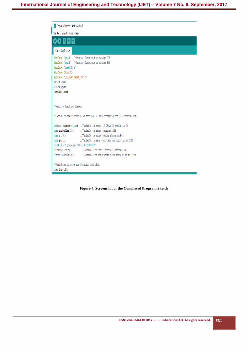
Screenshots of the completed program sketch and the PHP
code are shown in figures 4 and 5. Figure 6 shows the various
component modules assembled on an aluminium casing. The
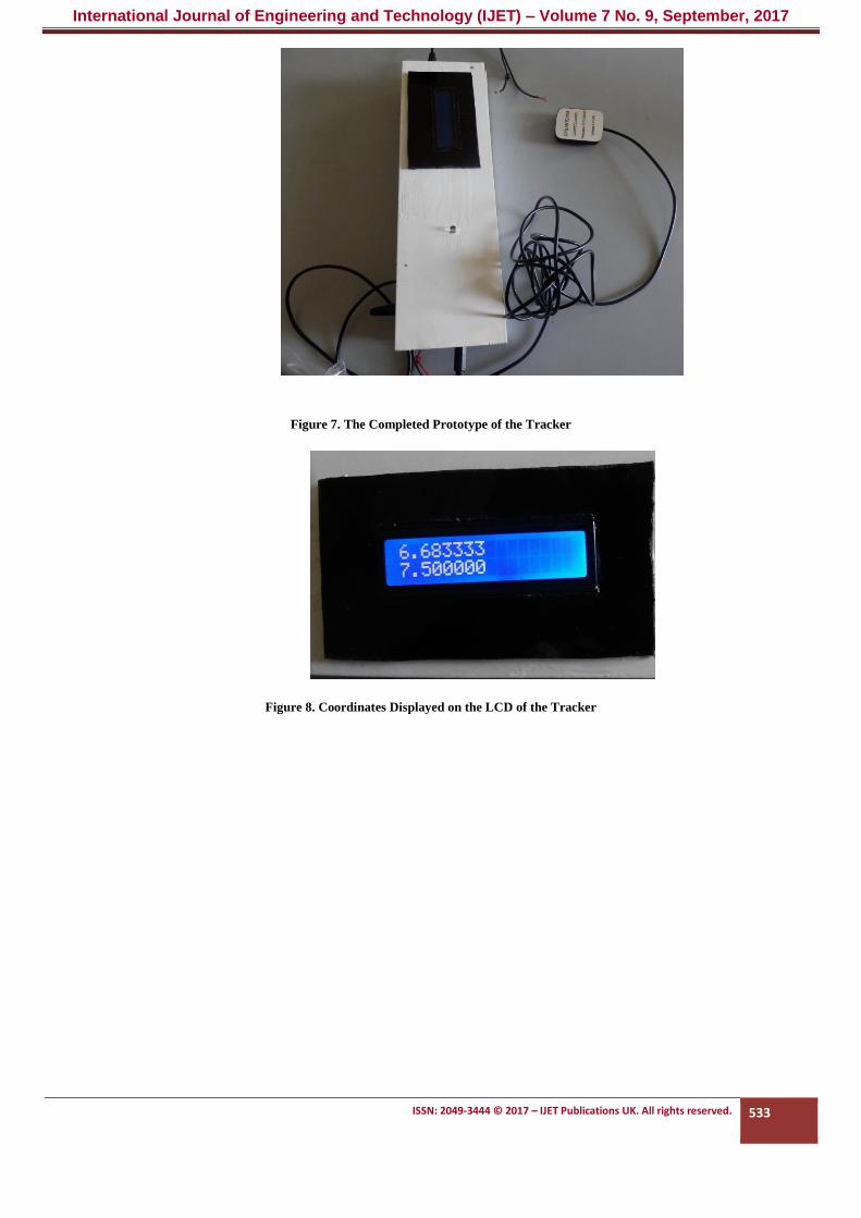
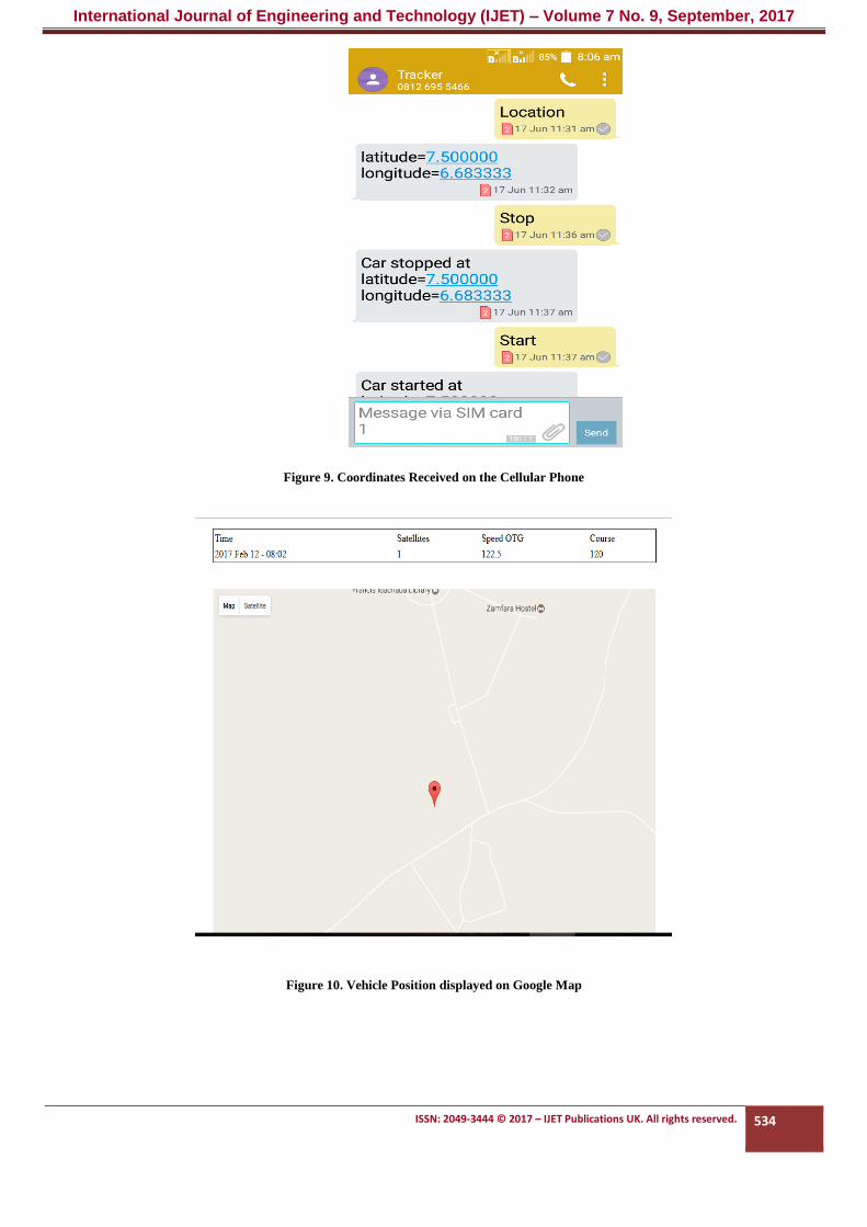
completed prototype is shown in figure 7, while figures 8, 9
and 10 show the received coordinates on the LCD, cellular
phone message and the vehicle position on the Google map
respectively. After the construction of the prototype the system
was tested to verify its ability to track and control a vehicle and
it was found to work efficiently.
Yes
No
Stop
Start
Coordinates
available?
User Requests
Coordinates from GPS
Send GPS coordinates to
user’s phone and display
on LCD
Initialize website for
vehicle position display
Initialize GPS, GSM
International Journal of Engineering and Technology (IJET) – Volume 7 No. 9, September, 2017
ISSN: 2049-3444 © 2017 – IJET Publications UK. All rights reserved. 531
Figure 4. Screenshot of the Completed Program Sketch

International Journal of Engineering and Technology (IJET) – Volume 7 No. 9, September, 2017
ISSN: 2049-3444 © 2017 – IJET Publications UK. All rights reserved. 532
Figure 5. Screenshot of the PHP Code
Figure 6. The Various Modules of the Tracker Installed in the Casing
International Journal of Engineering and Technology (IJET) – Volume 7 No. 9, September, 2017
ISSN: 2049-3444 © 2017 – IJET Publications UK. All rights reserved. 533
Figure 7. The Completed Prototype of the Tracker
Figure 8. Coordinates Displayed on the LCD of the Tracker
International Journal of Engineering and Technology (IJET) – Volume 7 No. 9, September, 2017
ISSN: 2049-3444 © 2017 – IJET Publications UK. All rights reserved. 534
Figure 9. Coordinates Received on the Cellular Phone
Figure 10. Vehicle Position displayed on Google Map

International Journal of Engineering and Technology (IJET) – Volume 7 No. 9, September, 2017
ISSN: 2049-3444 © 2017 – IJET Publications UK. All rights reserved. 535
4. DISCUSSION
The system was constructed and tested, and it responded
efficiently, giving a satisfactory accuracy of the vehicle
position, taking into account some limitations such as weather
conditions, multipath errors, obstructions such as tall trees and
buildings, and the internet and mobile network provider
effectiveness and availability. It was observed that the system
would not work inside of a room as the GPS receiver needs a
clear line-of sight to be able to acquire the coordinates from the
GPS satellites. The accuracy of a tracking device in locating
the object being tracked depends on the quality of the GPS
receiver used as well as physical conditions earlier highlighted.
The system presented in this report was found to have an
accuracy of ten meters. While testing the system, it was
observed that there were delays between receiving and sending
text messages between the system and the cellular phone of the
user after every request. The SIM cards of all the major mobile
network providers in the country were used in the tests and they
provided satisfactory results although the delay times varied
from one network provider to the other.
5. CONCLUSION
A vehicle tracking system using the GPS and GSM modules
has been successfully designed and implemented. The system
can be used to track any object from a long distance as long as
the tracked object is within the coverage of a GSM network.
The system can be used not only for thwarting theft of vehicles
but also can be modified for applications in fleet management
and security monitoring of goods.
REFERENCES
Ahmad, M., Iqbal, J., Qurat-Ul-ain, Ghazel, (2006). Real-Time
Fleet Monitoring and Security using GSM Network, 6th
WSEAS International Conference on Simulation, Modelling
and Optimization, Lisbon, September, 2006, pp.1-6.
Khondker, H.S., Rahman, M., Haque, A.L., AbdulRahman,
T.R., Rasheed, M.M., (2009). Cost Effective GPS-Based
Object Tracking System, International Multiconference of
Engineers and Computer Scientists (IMECS), Hong Kong,
March 18-20, 2009, pp. 1-16.
Abed khan M.E., Ravi Mishra, (2012). GPS – GSM Based
Tracking System, International Journal of Engineering Trends
and Technology, Vol. 3, pp. 161-164.
Baburao, K., Raju, V.K., Rao, S.S., Pradu, A.V., Rao, T.A.,
Narayana, Y.V., (2008). GSM and GPS Based Vehicle
Location and Tracking System, International Journal of
Engineering Research and Applications, Vol. 1, Issue 3, pp.
616-625.
Hsiao, W.C.M. and S.K.J. Chang, (2006). The Optimal
Location Update Strategy of
Cellular Network Based Traffic Information System,
Intelligent Transportation
Systems Conference, Gujarat, India, September 17-20, 2006.
Montaser, R.N., Al-Khedher, M.A., Al-Khedher, S.A., (2012).
Intelligent Anti-Theft and Tracking System for Automobiles,
International Journal of Machine Learning and Computing,
Vol. 2, Issue 1, pp. 88-92.
Shanghai SIMCom Wireless Solutions Ltd.,
SIM908_Hardware Design Vl.06.pdf,
http://www.electrodragon.com/w/File:SIM908_Hardware_De
sign_V1.06.pdf, Accessed 1st October, 2015.
Margolis, M., (2012). Arduino Cookbook, Second Edition,
Published by O’Reily Media, Inc., 1005 Gravenstein
Highbury, North Sebastopol, CA 95472, USA, pp. 1-724.
Google Maps APIs – Google Developers.
https://developers.google.com/maps, Accessed 15th June,
2015.
Haider, B., Zafrullah, M., Islam, M.K., (2009). Radio
Frequency Optimization and QoS Evaluation in Operational
GSM Network, World Congress on Engineering and Computer
Science (WCECS), San Francisco, October 20-22, 2009, pp.
600-688.
Telit Wireless Solutions, GM862-GPS Hardware User Guide,
https://www.manualslib.com/download/264023/Telit-
Wireless-Solutions-Gm862-Gps.html, Accessed 20th
September, 2015.
Purdum, J., (2012). Beginning C for Arduino: Learn C
Programming for Arduino, Ed. Michelle L., Apress Media,
California, USA.