igtf 2017 -...
TRANSCRIPT

IGTF 2017ASPRS Annual Meeting 2017Uniting Imagery, GIS, Mapping, and SurveyingMarch 12–16, 2017Baltimore, Marylandconferences .asprs .org/Baltimore-2017

Get more out of your imagery with ASD FieldSpec®
Ground-truthing is an essential step for interpreting unknown materials in multispectral and hyperspectral imagery. ASD Inc., a PANalytical company, is the global leader in portable remote sensing and hyperspectral measurement solutions, providing unparalleled ground truthing results.
ASD FieldSpec spectroradiometers generate high-quality field spectra at the required illumination and viewing geometry for accurate correlation to satellite and aircraft sensor data, and are compatible with popular image analysis software packages such as ENVI, ERDAS Imagine, and MultiSpec, allowing you to create detailed spectral libraries tailored to your application.
For more information, please visit:
asdi.com
Satellite Data Ground-truthing Better Spectral Data
ASPRS Certification ProgramASPRS certification is official recognition by one’s colleagues and peers that an individual has demonstrated professional integrity and competence in his or her field.
Apply for certification as a• Photogrammetrist• Mapping Scientist – Remote Sensing• Mapping Scientist – GIS/LIS• Photogrammetric Technologist• GIS/LIS Technologist• Remote Sensing Technologist• Certified Mapping Scientist – Lidar• Certified Lidar technologist
asprs.org/Certification-Program/

1
Welcome to Baltimore!

2
TABLE OF CONTENTS
Welcome to Baltimore / 1Conference-at-a-Glance / 3ASPRS Committee Meetings / 3Workshops / 4Classified Session / 7UAS Hands-On Workshop / 13Technical Program Tuesday, March 14 / 14 Wednesday, March 15 / 20 Thursday, March 16 / 25Exhibitors / 28 Media Partner Descriptions / 31 Frequenty Asked Questions / 32Around Baltimore / 342017 Conference Committee / 34ASPRS Staff / 34Hotel Map / Inside back cover
SPONSORS
Morning Beverage Break
Lanyards
Conference Bags and Keynote Speaker
Note pads & pens
Morning Beverage Break
MEDIA PARTNERS

CONFERENCE AT A GLANCE
3
Saturday, March 114pm–7pm Registration Open, Dover B
Sunday, March 128am–5:45pm Workshops
Monday, March 13
8am–5pmClassified Session Offsite, 6:45am pickup, see pg. 7
8am–5:30pm Workshops
5:30pm–7pm Welcoming Reception
Tuesday, March 147:30am–8:30am Light Breakfast with Exhibitors
8am–9:30am
Plenary Session 1 & AM Awards Ceremony Sponsored by Esri
9am–7pm Exhibit Hall Open
10am–6:30pm Workshops
10am–11:30am Technical Sessions
11:30am–1pm Lunch with Exhibitors
12pm–6pm Exhibit Hall Vendor Session
1pm–2:30pmPlenary Session 2 & PM Awards Ceremony
2:30pm–3pm Refreshments
3pm–4:30pm Technical Sessions
3pm–4:30pm Poster Session
5pm–7pm Exhibitor Reception
Wednesday, March 157:30am–5pm STEM Day Outreach
8am–9:30amPlenary Session 3 & AM Awards Ceremony
9am–5pm Exhibit Hall Open
9:30am–10am Light Breakfast with Exhibitors
10am–11:30am Technical Sessions & Poster Session
11:30am–1pm Lunch with Exhibitors
1:30pm–5:45pm Workshops
1pm–1:30pm Plenary Session 4
1:30pm–2:30pm Technical Sessions
2:30pm–3pmRefreshments & Networking with Exhibitors
3pm–4:30pm Technical & SAC Poster Sessions
4pm–5:30pm Student/Employer Meet & Greet
5:30pm–7:30pm Awards Reception
Thursday, March 168am–9:30am Plenary Session 5
9:30am–10am Refreshments
10am–11:30am Technical Sessions
11:30am–1pm Lunch with Friends
1pm–2:30pm Technical Sessions
1pm–6pm Hands-On UAS Workshop
3pm–4:30pm Technical Sessions
COMMITTEE & DIVISION MEETINGSSunday, March 12
10am–12pmAwards Committee, Grand Ballroom 1
12pm–12:30pm UAS Division, Grand Ballroom 3
12:30pm–1pmPrimary Data Acquisition Division, Grand Ballroom 3
12:30pm–1:30pmEvaluation for Certification, Grand Ballroom 2
1pm–2pmPDAD/UASD Precision Mapping by UAS, Grand Ballroom 3
2pm–3pmStandards Committee, Grand Ballroom 9-10
2pm–3pm LIDAR Division, Grand Ballroom 4
3pm–7pmASPRS Board of Directors, Grand Ball-room 2
3:30pm–4:30pmGeographic Information Systems Divi-sion, Grand Ballroom 3
4pm–5pmPhotogrammetric Applications Division, Grand Ballroom 4
4pm–5pmRemote Sensing Applications Division, Grand Ballroom 9-10
Monday, March 13
11am–2pmASPRS Foundation Board Meeting, Chassuer
1:30pm–3:30pmPublications and Communications Com-mittee, Grand Ballroom 1
3pm–4pmProfessional Practices Division, Grand Ballroom Salon 4
4:30pm–5:30pmCorporate Member Council, Grand Ballroom 1
Tuesday, March 14
3pm–4:30pmJournal Publication Committee, Grand Ballroom 8
4:30pm–5:30pmDefense & Intelligence Committee, Grand Ballroom 9
Wednesday, March 15
11:30am–12:30pmGovernance Transition / Installation of Officers, Harbor C-E
5pm–5:30pmEducation and Professional Development Committee, Harbor A

WORKSHOPS4
Sunday, March 128AM–12:15PM, GRAND BALLROOM 7-8 Precision Mapping by UAS: Theory and Applications Mohamed Mostafa, Navmatica CorporationBecky Morton, GeoWingMapping
The ASPRS Primary Data Acquisition Division (PDAD) and Unmanned Autonomous Systems Division (UASD) have been jointly and proactively focused on addressing the nation’s needs for establishing proper guidelines, procedures, best practices and possibly standards for the UAS Mapping industry. This workshop is sponsored the “Precision Mapping by UAS” Committee jointly estab-lished by the PDAD and UASD.
This workshop will focus on presenting the under-lying concepts and applications of Precision Mapping by UAS including sensors, platforms, workflows, data acquisition/processing best practices, sensor calibration, and integrated multi-sensor system calibration & data fusion. Additionally, Accuracy assessment of UAS-gener-ated mapping products will be addressed using practical examples from real world UAS projects. This workshop is intended for the ASPRS mapping professionals from either technical or business background. The topics will be covered in this workshop can be summarized as:1. UAS Sensor Payload
• Imaging Sensors (Camera, LiDAR, etc.)• Positioning Sensors (GNSS, Inertial, etc.)
2. UAS Platforms• Drone UAV• Fixed wing UAV
3. UAS Data Processing and Map Production Techniques• Aerotriangulation, Direct Georeferencing, and
Integrated Sensor Orientation,• Structure from motion• Calibration & Quality Control• Best Practices Real World UAS examples
8AM-10AM, GRAND BALLROOM 3 Photogrammetry on the Cloud: Challenges and Opportunities Benjamin John Vander Jagt, PixElement
Historically, advancements in photogrammetry and remote sensing have relied heavily on software solutions which reside on desktop computing platforms. These solutions require significant investments in software licenses, workstation costs, and personnel. The major paradigm shift with cloud computing is that you no lon-ger need to make large upfront investments in hardware. Nor do you need to spend valuable time and resources managing that hardware. Instead, you can provision ex-actly the right type and size of computing resources you need to power your newest bright idea. You can access as many resources as you need, almost instantly, and only pay for what you use.
The workshop will be composed of two sections. The first will consist of a traditional lecture component. Regis-trants will be exposed to current practices in cloud com-puting, specifically as they pertain to geospatial technol-ogy (with a focus on photogrammetry). Registrants will learn the benefits of cloud computing, including speed, scalability, shareability, and usability. Real world appli-cations involving photogrammetry, remote sensing, and Lidar point cloud processing will be discussed in detail.
The second section will involve;hands-on; photogram-metric project with real data, data processing, and data storage. Registrants will be given a 2D imagery dataset, from which they will derive different data products in-cluding point clouds, orthorectified imagery, and digital elevation models (DEM). Registrants will learn how to process imagery data using web-based tools, visualize and share with colleagues, and create an end to end workflow without ever needing a software license.1. Workshop duration - 2 hours2. Level: All (Introductory, Intermediate, and Advanced)3. Maximum number of attendees - 304. Internet connection need: Yes5. Attendance Laptop need: No6. Additional Keywords (optional)

WORKSHOPS5
Sunday, March 128AM-12:15PM, GRAND BALLROOM 2 Preparing for the ASPRS Certification Exam Robert Burtch, Ferris State UniversityThe purpose of this workshop is to prepare individuals who are planning to sit for the ASPRS Certification ex-ams. The workshop will begin by explaining the purpose and form of the exam. It will then begin to identify key topical areas which an applicant should be aware of prior to taking the exam. Topics will begin with a review of the basic concepts and sample questions to show how these topics will be tested for on the exam. Finally, the workshop will try to identify resources in which exam takers should be aware of and study from in their prepa-ration for the examination.
Outline1. Purpose of the exam
• Role of the exam in the certification process• Format of the exam• Topical areas covered on each of the Five different
exams2. Photogrammetry
• Overview of photogrammetric principles• Mapping concepts and products• Example exam questions• Resources for further study
3. Remote Sensing• Important principles• Utilization of remote sensing for geospatial
purposes• Review questions• Resources for further study
4. Geographic Information Systems• Important principles• Cartographic/Mapping concepts• Review questions• Resources for further study
5. Lidar• Working principles• Utilization of lidar in geospatial science• Typical questions one can expect• Resources for further study
6. Unmanned Autonomous/Aircraft Systems• Basic UAS Configurations/Functionality• Overview of regulatory factors• Review questions• Resources for further study
7. Other topical areas of importance in preparation for the exam
8AM-12:15PM, GRAND BALLROOM 9-10Geospatial Big Data Platform: Performing Imagery Analysis at Scale Daniel Getman, DigitalGlobe, Inc.Interested in performing image processing and exploita-tion at state/national/global scales?
Are you currently performing feature extraction, LULC, machine learning, and other processes to derive knowledge from imagery?
Would you like to? In this session we will provide a thorough introduc-
tion to, and hands on experience with, DigitalGlobe’s Geospatial Big Data Platform (GBDX).
The GBDX Platform provides a cost effective way to perform analysis on imagery without having to own it or download it. The platform is cloud based and designed to bring the analysis to the data in order to cost effec-tively support automated information extraction and to perform analysis on datasets that range from a single image chip to those with national or global coverage and all at a fraction of the cost and time compared to industry standard.
GBDX brings an ecosystem comprised of user-defined algorithms, algorithms developed by DigitalGlobe re-searchers and scientists, and algorithms developed by some of the best companies in the industry.
The session will start with semi-automated interface driven examples that do not require prior knowledge in software development and move into a more hands on session where we will walk users through the process of creating a custom analysis using open source tools, com-bining that with other algorithms in the GBDX ecosys-tem, and creating an information product from imagery using the platform.
This four hour workshop will be delivered at an inter-mediate level. Each attendee will have the opportunity to walk through actual analysis using the platform, so inter-net connectivity will be required and each attendee will need to bring their own laptop to participate. Attendance will be capped at 100 attendees.

WORKSHOPS6
Sunday, March 121:30PM-5:45PM, GRAND BALLROOM 7-8Methods for the Quality Assurance of LiDAR Point Clouds and Breaklines for Floodplain Modeling Al Karlin, Southwest Florida Water Management DistrictNicole Hewitt, Mapping and GIS, Southwest Florida Water Management District
The goals of this workshop are to provide the partici-pants with a background on methods used by the SWF-WMD for the quality assurance of LiDAR point clouds and supplemental breaklines. Specifically, the workshop reviews the NSSDA (National Standards for Spatial Data Accuracy) and the ASPRS (American Society of Photo-grammetry and Remote Sensing) methodology as it is applied by the SWFWMD. During the past 10 years the SWFWMD contracted for LiDAR terrain data in support of its FEMA floodplain mapping program and is inter-nally responsible for the quality control/quality assur-ance of those data. Over this period, the SWFWMD has implemented several specialized routines and developed several automated and semi-automated procedures for LiDAR QC. This workshop will systematically describe these step for the participants. The workshop is divided into four components: 1. SWFWMD District Standards and a comparison with
USGS Specifications2. Ground Truthing and Ground Check Points3. Detailed LiDAR Point Cloud QC4. Hydro-Enforced, Hydro-Flattened, and Hydro-correct-
ed DTM ConstructionThe workshop is intended for participants involved in LiDAR QC. While there is some introductory material, the focus of the workshop is on QC with the assumption that the participants have some experience with LiDAR and the software packages (Esri-ArcGIS, LP360, & Global-Mapper) that are commonly used in the GIS industry.
1:30PM-5:45PM, GRAND BALLROOM 1Drone2Map for ArcGIS Kurt Schwoppe, Esri - DC Tysons Office
This workshop will consist of hands exercises on and presentation on the of the use of Drone2Map for Arc-GIS to generate Mosaic, Point Clouds, 3D Meshes, and Oblique Imagery from Drone Imagery. USES of Drone-2Map for ArcGIS outputs will be covered for further work with ArcGIS Earth, ArcGIS Pro and ArcGIS Online.
Users at the end of this presentation will learn how to construct, share, and use several 3D products derived from remote sensing data for decision makers http://dld.bz/eWP9M
Attendees are required to bring their own computer but can download evaluation copies of the software be-ing used for the workshop http://dld.bz/Drone2Map
• Workshop Length- 3 hours• Skill Level: Intermediate• Questions Please contact Steve Snow
http://dld.bz/eZGrj on LinkedIn• Computer Hardware Requirements:
- CPU speed: 2 GHz dual-core CPU minimum (at least Core2 Duo compatible Intel/AMD)
- Memory/RAM: 16 GB- Disk space: 2 GB or more- Video/Graphics adapter: Nvidia—GeForce 600 and
later / Quadro 600 and later AMD—Radeon HD 7000 and later Intel—HD 4400 and later On Linux—Intel cards need the Mesa package (version 11.0 or later) On Linux and Windows—use the latest available drivers (OpenGL 4.1 or later)
• Supported operating system: - Windows 10 Pro and Enterprise (64 bit [EM64T])- Windows 8.1 Pro and Enterprise (64 bit [EM64T])- Windows 8 Pro and Enterprise (64 bit [EM64T])
1. Workshop Duration 4 hours2. Level Intermediate3. Maximum number of attendees 604. nternet connection needed for room5. Laptop required for training Yes6. Keywords: Drone, Survey, Imagery, Image Process-
ing, Business Development, Training, Hands on Instruction, GIS Technology, Remote Sensing, Terrain, Mapping, 2D, 3D, Structure for Motion, Point Cloud, ArcGIS, ArcGIS Online, ArcGIS Pro, ArcGIS Earth, Cloud Technology
WORKSHOPS7
Monday, March 138AM-5PM, OFFSITE (Northrop Grumman Mission Systems, 1550 West Nursery Road, Linthicum Heights, MD 21090)
Classified Session: Advancements in GEOINT Data AnalyticsNote: Requires security clearence and registration must be completed prior to arriving at the conference.
Zbest Bus Service will pick up from the Marriott Waterfront at 6:45am at the front side of the hotel for Northrop Grumman Mission Systems. Zbest Bus Service will leave Northrop Grumman Mission Systems at 5:30pm.
8AM-12:15PM, GRAND BALLROOM 8Imagery Triangulation and Sensor Calibration for Manned and Unmanned Aerial Systems – PART I Qassim Abdullah, Woolpert, Inc.Riadh Munjy, California State University, Fresno
The workshop provides participants with all the neces-sary knowledge about how to successfully design, plan and execute an aerial mission project to support GPS-based aerial triangulation. Operational requirements and good practice guidelines of operating an airborne GPS is detailed together with guidelines on flight planning strategy and ground control distribution. Mathematical background of the process of simultaneous bundle block adjustment will be detailed and recommended parame-ters setting will be explained. Workflows for both frame-based cameras and push broom cameras will be detailed and discussed. PART I will be followed by PART II of this workshop which focuses on the special requirements needed for project executed with UAS/UAV. Practical lessons on triangulating and calibrating imagery flown with UAS together with practical examples and results will be discussed in details.Outlines:
1. Fundamentals of an airborne GPS integrated system• Operational principles and requirements of a GPS
system2. Functional system design and requirements for an
airborne GPS Integrated photogrammetric system• Geometric integration of airborne sensors• Electronic integration of airborne sensors• System calibration
3. Flight design and control criteria for successful air-borne GPS-controlled missions for framing cameras (analogue or digital)• Flight configuration• Ground control configuration
4. Incorporating airborne GPS data in the mathematical model for bundle adjustment of AT blocks• Incorporating airborne GPS data
5. Fundamental of the push broom digital photography, the ADS40 case• Image formation with ADS40 push broom digital
aerial camera
• Image characteristics at various processing levels6. Flight design and control criteria for successful air-
borne GPS-controlled missions for push broom digital camera (ADS40)• Flight configuration• Ground control configuration
7. Flight design and special considerations for UAS-based aerial triangulation• Increased over lap• Less accurate GPS• Lack of camera calibration• Ground control configuration
8. Processing flow for bundle adjustment of imagery from frame and push broom cameras• Input data requirements• Systematic error corrections• Data analysis
9. Practical results and the status of airborne GPS con-trolled aerial-triangulation in production today.
8AM-12:15PM, GRAND BALLROOM 2Drone2Map for ArcGIS Hands on Workshop Steve Snow, EsriMark Romero, Esri
This is a repeat of the identical workshop presented Sunday at 1:30pm.
8AM-12:15PM, GRAND BALLROOM 9Geospatial Big Data Platform: Performing Imagery Analysis at Scale Daniel Getman, DigitalGlobe, Inc.
This is a repeat of the identical workshop presented Sunday at 8am.
8AM-12:15PM, GRAND BALLROOM 3Preparing for the ASPRS Certification Exam: Second Offering Robert Burtch, Ferris State University
This is a repeat of the identical workshop presented Sunday at 8am.
8AM-12:15PM, DOVER A-C Hyperspectral and Extended Multispectral Remote Sensing: Phenomenology, Sensor Systems, and Data Processing William Farrand, Space Science Institute
Overview: Hyperspectral datasets provide full spectral resolution over the wavelength range of interest so that diagnostic absorption features of Earth surface materials can be uniquely identified. “Extended multispectral” sys-tems such as ASTER and WorldView-3 provide multiple spectral bands in the visible and near infrared and short-wave infrared allowing for the detection of many mate-rials with absorption features that are sampled by those bands. This workshop provides an introduction to the

WORKSHOPS8
Monday, March 13phenomenology of hyperspectral remote sensing putting an emphasis on the physics of the radiometry and spec-trometry involved. The causes of absorption features in Earth surface materials (minerals, soils, vegetation, and manmade materials) will be discussed as will the role of the atmosphere in modulating the observed signal. Hyperspectral and extended multispectral data collection systems will be discussed. Finally, an introduction to data processing methods based on the mapping of spec-tral features and the utilization of spectral shape will be provided. These include spectral feature fitting, spectral matching approaches and spectral mixture analysis.Topics to be addressed:
• Definitions of hyperspectral and extended multispectral remote sensing
• The phenomenology of reflectance and emission spectrometry
• Hyperspectral and extended multispectral sensor system architectures
• Hyperspectral and extended multispectral processing techniques and approaches
• Examples of application areas.
Who Should Participate: This workshop is intended for users of multi- or hyperspectral remote sensing data. This includes analysts who may have used multispectral data or some other form of remote sensing data and are now interested in using hyperspectral or extended multi-spectral data in their work. This workshop is also ap-propriate for managers who must make decisions about what kind of remote sensing data to purchase for their projects and/or what kind of multi- or hyperspectral im-age processing software that they should purchase. This workshop will provide an introduction to the power of hyperspectral and extended multispectral data in remote sensing projects.
8AM-12:15PM, GRAND BALLROOM 1 Precision Mapping By UAS: Theory and Applications Mohamed Mostafa, Navmatica CorporationBecky Morton, GeoWingMapping
This is a repeat of the identical workshop presented Sunday at 8am.
1PM-5:15PM, DOVER A-CMethods for the Quality Assurance of LiDAR Point Clouds and Breaklines for Floodplain Modeling Al Karlin, Southwest Florida Water Management DistrictNicole Hewitt, Southwest Florida Water Management District
This is a repeat of the identical workshop presented Sunday at 1:30pm.
1:15PM-5:30PM, GRAND BALLROOM 8 Imagery Triangulation and Sensor Calibration for Manned and Unmanned Aerial Systems – PART II Qassim Abdullah, Woolpert, Inc.Riadh Munjy, California State University, Fresno
The workshop provides participants with all the nec-essary knowledge about how to successfully design, plan and execute an aerial mission project to support GPS-based aerial triangulation using unmanned aerial system (UAS). Operational requirements and good prac-tice guidelines of operating an airborne GPS is detailed together with guidelines on flight planning strategy and ground control distribution. To gain workable knowledge of the mathematical background of the process of the simultaneous bundle block adjustment and details of the recommended parameters setting, participants of this this workshop are advised to register for PART 1, Imag-ery Triangulation and Sensor Calibration for Manned and Unmanned Aerial Systems – PART I, of this topic which will be offered in this conference prior to PART II. PART II focuses on the special requirements needed for project executed with UAS/UAV. Practical lessons on triangu-lating and calibrating imagery flown with UAS together with practical examples and products generation will be discussed in details.Outlines:1. Overview of Fundamentals of an airborne GPS inte-
grated system• Operational principles and requirements of a GPS
system on board of a UAS.2. Overview of Functional system design and require-
ments for an airborne GPS Integrated photogrammet-ric system
3. Data Characteristics for UAS Projects• Increased over lap• Less accurate GPS• Lack of accurate IMU• Lack of camera calibration
4. Flight design and special considerations for UAS-based aerial triangulation• Flight configuration for block and corridor types
projects.• Ground control configuration for block and corridor
types projects5. Processing flow for bundle adjustment of imagery
from UAS• Input data requirements• Systematic error corrections• Data analysis
6. Concept of Camera Self Calibration7. Practical results and projects examples.

WORKSHOPS9
Monday, March 131:15PM-5:30PM, GRAND BALLROOM 2 Object-based Image Analysis Of Natural Land Cover Amr Abd-Elrahman, Univeristy of FloridaTao Liu, Univeristy of Florida
Object-based image analysis (OBIA) is widely used in ur-ban/urban-rural feature extraction using rule-based mod-els. For natural scenes (e.g. wetlands), aggregating the spec-tral information of the objects and facilitating textural and contextual information can have many advantages. The main objective of this professional development workshop proposal is to demonstrate the use of OBIA in classifying high-resolution (sub-decimeter) unmanned aerial system imagery using machine learning algorithms. An example of classifying wetland areas for natural resource management and invasive plant detection will be illustrated. RGB, NIR, and DSM are used in the segmentation and classification process. The use of machine learning classification algo-rithms will be demonstrated and assessed. The workshop will utilize the eCognition Developer software as well as other spatial analysis and programming software. The in-tegration of the eCognition software and other open source image analysis and statistical analysis software will be explored. The audience is asked to bring in Windows OS laptops (Intel Dual or Quad Core Processor) with enough storage (50-200 GB disk space) and memory (1-4 GB RAM) to install the eCognition software. Other light-weight soft-ware packages may also need to be installed.
• Keywords: OBIA – classification – machine learning• Duration: 4 Hours• Skill Level: Beginner-Intermediate• Computer Requirement: Yes• Projector/audio/power outlets: Yes• Internet: Yes• Capacity: 20 participants
1:15PM-5:30PM, GRAND BALLROOM 9Esri Remote Sensing APPathon Steve Snow, EsriMark Romero, EsriKurt Schwoppe, EsriSarah Schwoppe
Hidden in every complicated computer solution is a sim-ple App just waiting for a creative mind to bring it to life. That is the challenge of Esri’s Remote Sensing APPathon; making image processing simple and intuitive. We are going to provide all ingredients needed for non-develop-ers to design, build and implement remote sensing apps using AppStudio for ArcGIS http://dld.bz/eZJEd. All we need is your ingenuity, creativeness and willingness to learn a few simple tools, and the rest is up to you. While nobody expects a miracle, we guarantee that by the end of the session you will have created a working remote sensing App that actually does something useful. And that is just the beginning. 1. Workshop duration 4 Hours2. Level: Intermediate3. Maximum number of attendees 1004. Internet connection need: Yes5. Attendance Laptop need: Yes6. Additional Keywords Emerging Applications,
Requirements: Users will need to bring their own com-puter for Hands on Imagery Application Training.

WORKSHOPS10
Monday, March 131:15PM-5:30PM, GRAND BALLROOM 3 Field Data Collection Techniques for the Development of Remote Sensing Ground Truth, Including “the Most Accurate, Least Expensive, and Most Easily Applied” Method Kenneth Stumpf, Geographic Resource SolutionsSage Romberg, Geographic Resource Solutions
This workshop is an introductory workshop designed to take the participant through a review of data collection method-ologies, definitions, and pro and cons of different method-ologies designed to assist the participant in designing and/or selecting the most appropriate reference data collection processes to suit their particular information needs, whether related to field training or accuracy assessment sites. Meth-odologies presented will include ocular estimates, fixed area sampling, transect sampling, point sampling, and combina-tions of these approaches. The concepts of cover, closure, and frequency will be discussed. Techniques used to devel-op estimates of canopy cover, foliar cover, and canopy clo-sure; trees per acre; quadratic mean diameter; average crown diameter; canopy structure; and species composition will be included. The estimation of categorical estimates will also be addressed, as well a discussion of potential bias and cost. The Line-point Transect methodology will be of primary focus, as this field data collection methodology was recently recommended by a UN Food and Agriculture Organization Research Study as the most accurate, least expensive, and most easily applied” field data collection method of the four methods they tested ( see Adikari, Y. and MacDicken, K.,Testing Field Methods for Assessing the Forest Protective Function for Soil and Water; Forest Resource Assessment Working Paper 185/e United Nations FAO 2015: 1-36).
Examples from recent projects will be used to illustrate field data collection principles and the nature of information that can be developed from an integrated sample design to accurately assess the multitude of different features that may be sampled at any given site that includes trees, shrubs, her-baceous plants, nonvascular plants, ground surface condi-tion, woody debris, snags, trace elements and other features.
Audience: Those in need of or who want to learn how to develop and use accurate, easy-to-use, and inexpensive field data descriptions including: Remote sensing project manag-ers and analysts; natural resource managers and scientists; and others involved in inventory, monitoring, or mapping projects interested in development of accurate land cover data that can be used to assess and describe ecosystem char-acteristics for either training or accuracy assessment.
IGTF 2017 Welcoming Reception5:30PM-7PM
REGISTRATION/GRAND BALLROOM AREA
Join us and your fellow attendees for refreshments and networking!
WORKSHOPS11
Tuesday, March 1410AM-12PM, ESSEX ABHyperspectral Imaging Standards Workshop David Allen, NISTTerry Slonecker, USGS
Hyperspectral imaging as a field is in the process of maturing from a specialized tool to a routine technolo-gy applied to many facets of society. Standards provide common reference points that foster an understanding between different entities. This workshop is intended to survey the range of standards currently available and to identify gaps where new standards are needed. The range of standards open for discussion encompasses all aspects related to hyperspectral imaging and may include perfor-mance specifications, calibration standards, data formats, terminology, and best practices. This workshop will pro-vide an open forum for metrology laboratories, instrument vendors, data product analysts, data product vendors and end-users. The outcome of this workshop will provide guidance for future activities including an expanded workshop to address areas determined to be significant bottlenecks restricting the full potential of this technology.
Goals:• Provide a forum for the hyperspectral imaging
community to discuss current and future standards• Identifying international standards organizations
that can contribute to the development and maintenance of new standards
• Address the need for standards to address regulatory requirements
• Discuss the possibility of a uniform set of performance metrics
• Discuss the need for traceability to national standards
10AM-12PM, KENT ABPhotogrammetry on the Cloud; Challenges and Opportunities Benjamin John Vander Jagt, PixElementMatt McCann, PixElement
This is a repeat of the identical workshop presented Sunday at 8am.
2:15PM-6:30PM, LAUREL ABGeneric Sensor Model for Optical Line Scanners and Framers Henry Theiss, IAIReuben Settergren, BAE Systems
For roughly ten years, NGA has been involved with the Community Sensor Model (CSM) Application Programming Interface (API) and in providing guidance for its future; and now its paradigm is shifting from the concept of many specific sensor models (e.g. one for GeoEye1, one for World-View1, etc.) to a few generic sensor models by class/family. The generic model concept is made possible by establishing standards for upstream data providers to supply metadata with their image products. NGA has designed a set of six “Common Sensor” (CS) Tagged Record Extensions (TREs) or Data Extension Segments (DESs) that will soon become part of the National Imagery Transmission Format (NITF) stan-dard and facilitate generalization of all EO/IR sensor models whether they are line scanners or framers, and whether they are panchromatic, MSI, or HSI. Framers can collect a still frame, or a sequence of frames captured in either a step-stare or spotlight mode to support wide area collection or motion imagery collection, respectively. An “A” version of the CS TREs had been designed approximately ten years ago, but it is inadequate in several areas that will be accom-modated by the “B” version; e.g. the “A” version only ap-plies to line scanners and does not contain any mechanism to store error covariance (uncertainty) information. So, the “B” version will address that deficiency, as well as support exploitation of emerging commercial imaging systems like Skybox which can collect motion imagery.
The goal of this workshop is to improve the partici-pants’ understanding of the properties of sensor models, the concept of generic models for line scanners and frame sequences, and the content of the metadata required to support rigorous downstream exploitation of the associ-ated image products to include optimal estimation and reliable uncertainty reporting for all computed quantities.
The workshop will consist of two parts. Part 1 in-cludes a briefing to provide an elementary, non-mathe-matical overview of general principles of geographic co-ordinate systems and major classes of sensor models for a variety of imaging sensors. Part 2 includes a briefing to explain the photogrammetry and error modeling aspects of these new generic sensor models and associated meta-data structure. At the ends of each part, the instructors will provide the participants an informal atmosphere to ask questions and promote discussion on related topics; e.g. about coordinate systems and sensor model classes at the conclusion of Part 1, and the practical aspects of how a data provider populates the proper metadata with their image products and how an exploitation tool user performs typical geopositioning scenarios including ab-solute geolocation, relative mensuration, and multi-mo-dality registration at the conclusion of Part 2. Approved for public release under case number 16-212.

WORKSHOPS12
Tuesday, March 142:45PM-4:45PM, DOVER A-CTechniques to Evaluate Terrestrial Laser Scanners Prem Rachakonda, NISTBala Muralikrishnan, NIST
The Dimensional Metrology Group (DMG) at the National Institute of Standards and Technology (NIST) is involved in the development of documentary standards for a va-riety of 3D metrology instruments such as laser trackers, terrestrial laser scanners (TLSs) etc. As a US National Metrology Institute, NIST is involved in the development of test procedures to evaluate dimensional metrology instruments in an unbiased and objective manner.
The ASTM E57 sub-committee on 3D imaging systems was formed in 2006 to standardize the evaluation of instruments such as TLSs. This committee meets every 2 weeks via a teleconference to discuss the technical work related to the point-to-point evaluation of 3D imaging systems. In May 2016, a run-off meeting was held at NIST where five manufacturers brought their instruments and tested them per the procedures in the draft standard.
NIST is a major contributing member of this committee and possesses unique expertise for this task due to our
prior experience with laser trackers that could be applied for evaluating TLSs. Challenges in evaluating TLSs in-clude the commercial availability of high quality targets that can be measured by TLSs as well as the reference instrument (a laser tracker). The target’s material and surface finish properties such as stiffness, reflectivity, op-tical penetration and geometric form affect their usage for such a performance evaluation. Other challenges include mounting methods, data collection and data processing algorithms used to deduce the performance criteria.
This workshop will present an overview of NIST’s work and its contributions to the development of documentary standards for evaluating TLSs. The construction of these instruments will be discussed which will reveal the physics and the engineering behind their performance issues. We will discuss the techniques, experimental & theoretical work performed at NIST to evaluate terrestrial laser scanners.
Wednesday, March 141:30PM-5:45PM, GRAND BALLROOM 7-8Lidar Geometric Accuracy Assessment Qassim Abdullah, Woolpert, Inc.Lewis Graham, GeoCue GroupJamie Young, Merrick & CompanyHans Heidemann, USGSAmar Nayegandhi, Dewberry Consultants LLCAparajithan Sampath, Stinger Ghaffarian Technologies, Inc. (SGT)
Lidar has become the de-facto technology for 3D data col-lection. With increasing applications, including mission critical ones such as infrastructure, precision forestry, flood risk management, aviation safety, etc., it is import-ant that users understand the quality of their lidar data. In this workshop, we will present a comprehensive view of the sources, assessment, and reporting of the geomet-ric quality and accuracy of lidar data.
We will begin by introducing the attendees to the most significant elements of the core lidar error budget and their manifestation in the lidar data. Additional errors due to sampling, interpolation, trajectory etc. will be discussed. The session will then address current lidar ac-curacy assessment techniques being used in the industry. This will first cover the means of assessing and reporting the absolute accuracy of lidar data in accordance with the new “ASPRS Positional Accuracy Standards for Dig-ital Geospatial Data”, followed by a review of accuracy
requirements of the US Geological Survey National Geo-spatial Program’s Lidar Base Specifications, along with suggested methods and expectations.
Finally, the attendees will be introduced to future methods of assessment and reporting relative accuracy and geometric quality of lidar data. The attendees will be given a background of the development of these methods and introduced to the theoretical aspects of the measure-ment technique. This will be followed by a demonstra-tion using the USGS developed software that implements these techniques. The software will be distributed to the attendees prior to the workshop.
Throughout the workshop, attendees will be present-ed with worked examples of various parameters that are expected to be reported for 3D Elevation Program’s lidar acquisitions. Where feasible, sample data will be provid-ed to participants for their future reference.

WORKSHOPS13
Thursday, March 151PM-6PM, HARBOR CUAS Hands-On Mapping Workshop Becky Morton, ASPRS
This 4-hour workshop will provide a classroom setting with knowledgeable instructors leading attendees through the steps of aerotriangulation, point cloud processing, or-thophoto production, topographic and planimetric map-ping, and more! Those attending should possess funda-mental understanding of remote sensing data processing.
Temporary software licensing information and sam-ple data will be made available in advance to registered participants. In that way, each attendee comes to the workshop prepared with the tools and data needed to start immediately with data processing on their own
computer. Each participant must bring her or his own prepared laptop. Use of the internet will not be required.
The objective will be to provide basic training in sev-eral different UAS mapping tools. Participants will leave the session with an understanding of the steps to convert raw UAS imagery into high-end map products such as 3D models, contours, 3D planimetric map features, and orthophotography. This high demand workshop will fill quickly and registration is limited to the first 150, there-fore register early. Stay tuned for more information on the specific software tools that will be covered.
Task Description Software Instructor Duration
Introduction• Background• Mission Statement• Introduction of instructors
Becky Morton 15 min
Mission Planning
• Mission Planning• Ground Control• RTK vs PPK vs DG
Mohamed Mostafa 15 min
Image Georeferencing
• Aerotriangulation• Accuracy Reporting
Icaros Asaf Even-Paz 30 min
• GNSS-assisted AT• GNSS/IMU-assisted AT
POSPac Joe Hutton 30 min
Map Production
• Digital Elevation Model Extraction Simactive Abdaal Mazhar Shafi 40 min
• Orthophoto Generation Pix4D Antoine Martin 40 min
• Point Cloud Extraction• Feature Collection
Topolyst Lewis Graham 40 min
Quality Control• Orthophoto Accuracy Assessment Navmatica Mohamed Mostafa 15 min
• Elevation Data Accuracy Assess-ment
Topolyst Lewis Graham 15 min
Open Forum• Open Discussion• Q&A• Feedback• Feedback forms
Becky Morton 60 min
Sponsors

14
TECHNICAL PROGRAM TUESDAY, MARCH 14
7:30AM–8:30AM GRAND BALLROOM EXHIBIT HALLLight Breakfast
8AM–9AM, HARBOR C-EPlenary SessionSponsored by Esri
Keynote Address: Trends in GIS and How They are Helping Utilities
Jack DangermondEsri
A landscape architect by training, Jack Dangermond founded Environmental Systems Research Institute (Esri) in 1969 with a vision that computer mapping and analysis could help us design a better future. Under Dangermond’s
leadership, that vision has continued to guide Esri in creating cutting-edge GIS and GeoDesign technologies used in every industry to make a difference worldwide.
Dangermond fostered the growth of Esri from a small research group to an organization recognized as the world leader in GIS software development. Esri employs 2,700 people in the U.S.; many who shared his passion for GIS in the early days are still with the company and remain dedicated to helping our users be successful.
9am – 9:30amAwards CeremonyAwards will be presented immediately following the Plenary Session
10AM-11:30AM, HARBOR A Geo-League, Annual Student Competition
The 7th Annual ASPRS SAC GeoLeague Challenge Jason Blankenship, Florida Atlantic UniversityCaren Remillard, University of GeorgiaAmanda Aragón, New Mexico Highlands University
10AM-11:30AM, GRAND BALLROOM 2 High-resolution Land Cover: Presentations and Discussion
High-Resolution Land Cover Mapping: Building Production-Based Systems Jarlath O’Neil-Dunne, University of Vermont
From Research to Operations: Developing a High-Resolution Mapping Approach for the Central United States Dacia Meneguzzo, Greg Liknes, and Todd Kellerman, USDA Forest Service - NAC
Leveraging Precision Conservation for the Chesapeake Bay Watershed Jeffrey Allenby, Chesapeake Conservancy
Generation of High Resolution Land Cover from WorldView Multispectral Imagery Steven Stutts, Benjamin Raskob, and Eric Wenger, Applied Research Associates
The last mile: how to move from an automated dataset to one people want Andrew Brenner and Nathaniel Morton, Quantum Spatial
10AM-11:30AM, GRAND BALLROOM 9Object-based Image Analysis
A Comparison of Unsupervised Segmentation Parameter Optimization Approaches Using Moderate and High Resolution Imagery Heather Grybas, Lindsay Ledoux, and Russell Congalton, University of New Hampshire
Detecting Road and Building using a fully convolutional network in aerial images Mohammad Rezaee and Yun Zhang, University of New Brunswick
Road and Building detection using a patch-based deep network for aerial images Mohammad Rezaee and Yun Zhang, University of New Brunswick
Transferability of GEOBIA rulesets for detecting penguin guano in very high spatial resolution satellite images Chandi Witharana, University of Connecticut
Agricultural land use classification integrating high resolution remote sensing imagery and multi-temporal Landsat data Qian Lei, Daniel Civco, and Thomas Meyer, University of Connecticut
10AM-11:30AM,GRAND BALLROOM 3 Primary Data User Needs and Surveys
U.S. Government Earth Observation Requirements Gregory Stensaas, USGS EROS Data CenterGregory Snyder, USGSZhuoting Wu, USGSJohn Cullen, USGSTimothy Stryker, NSTC, White House Office of Science and Technology PolicyMartin Yapur, NOAA
The 2016 National Earth Observation Assessment Gregory Snyder, U.S. Geological SurveyTimothy Stryker, Office of Science and Technology Policy
Moderate resolution land imaging user requirements Zhuoting Wu, USGSCarolyn Vadnais, IAIGrant Mah, USGSGreg Snyder, USGS
Primary Data User Needs and SurveysGregory Stensaas
Asymptotically Small Geopositioning Error from Large Sets of Imagery Reuben Settergren, and Seth Merickel, BAE Systems

15
TECHNICAL PROGRAMTUESDAY, MARCH 14
10AM-11:30AM, LAUREL ABPoint and 3D Model Extraction and Analysis
Smart Surveying: Assessing the Accuracy of 3D Models created using Smartphones Michel Morgan, SAIT
Contribution of Normalized Digital Surface Models used in Automatic Building Extraction Deborah Dennison, Penn State University
Deriving Pedestrian Positions from Uncalibrated Videos Zoltan Koppanyi, The Ohio State UniversityCharles Toth, The Ohio State UniversityTamas Soltesz, Budapest University of Technology and Economics
10AM-11:30AM, GRAND BALLROOM 1 Mapping, Monitoring and Education
Integration of Mapping Technologies for Cultural History Documentation at Stratford Hall, Virginia Thomas Jordan, Center for Geospatial ResearchCari Goetcheus, University of GeorgiaMarguerite Madden, Center for Geospatial Research
Integrating UAS into transportation asset management workflows Colin Brooks, Richard Dobson, David Banach, Sam Aden, and Ben Hart, Michigan Technological University - MTRI
Unmanned Aerial Systems: UAS use in geospatial applications and educational programs Vincent DiNoto, Jefferson Community CollegeAnn Johnson, GeoTech Center
Mapping, Monitoring and EducationAlan Mikuni
10AM-11:30AM, LAUREL CD3D Surfaces from Imagery
Automated 3D recovery from very high resolution multi-view images Rongjun Qin, The Ohio State University
Designing a payload for the purpose of sensing microtopography signatures of landmines and UXO’s onboard Unmanned Aerial System, UAS. Andrew Knight, and Sergio Bernardes, University of Georgia
Accuracy Analysis Of DEMs Generated From Uas Imagery And Large Format Digital Cameras Ricardo Passini, BAE Systems GP&SDavid Day, Keystone Aerial Surveys, IncWesley Weaver, Keystone Aerial Surveys, Inc.Karsten Jacobsen, Leibniz Hannover University
Towards Automated High-Throughput 3D Surface Generation for High Resolution Satellite Imagery David Page, Dave Kelbe, Lawrence MacIntyre, Chris Craig, Jeff Nichols, Andrew Hardin, and Devin White, Oak Ridge National Laboratory
10AM-11:30AM, GRAND BALLROOM 7 Precision Mapping by UAS – Panel Discussion Gregory Stensaas, USGS EROS Data CenterMohamed Mostafa, Navmatica
10AM-11:30AM, GRAND BALLROOM 8Urban Analysis: Solar Thermal and Density
Spatial Object Oriented Approach for Modeling Roof Solar Potential in Cagayan de Oro City Using LiDAR Technology Jigg Pelayo, Ricardo Villar, and Gretchen Lestones, Central Mindanao University
Exploring variability of the annual temperature cycle over the conterminous United States, CONUS with MODIS imagery from 2003-2016 Peng Fu, Indiana State University
Spatiotemporal analysis of Land Surface Temperature and Urban Heat Island Evaluation of Four Metropolitan Areas of Texas, USA Chunhong Zhao, Texas State University
A Novel Algorithm for Solar Potential Estimation in Complex Urban Scenes Partha Acharjee, UT ArlingtonVenkat Devarajan, University of Texas at Arlington
Assessing 25 Years of Urban Density Changes in the U.S. Mary Latiolais, MDA Information Systems, LLC
10AM-11:30AM, HARBOR B ISPRS Technical Panel Session
International Society for Photogrammetry and Remote Sensing, ISPRS Special Session Charles Toth, The Ohio State University
10AM-11:30AM, DOVER A-CTechnical Divisions and Committees - Overview
Be a Part of Our Smarter Tomorrow John McCombs, The Baldwin Group at NOAA Office for Coastal Management Within ASPRS there are seven Technical Divisions and 18 Standing and Ad hoc committees. While many members may be aware these exist, the participation level within these groups has seen more limited participation. Much of the work of the society takes place within these groups and they provide an excellent opportunity to become more professionally involved in determining the future and direction of the Society. This session will introduce members to some of these Technical Divisions, Working Groups, and Committees, highlighting our newest avenues of work, including the UAS Division and Humanitarian and Emergency Response Working Group, among others. Come learn what the Society has to offer and find out how you can help support the Society.

16
TECHNICAL PROGRAM TUESDAY, MARCH 14
10AM-11:30AM, GRAND BALLROOM 4National (ASPRS) and International (ISPRS) Perspectives of Geospatial Education, Training and Professional Development with Focus on SDI and Decision SupportThis Special Session of the aSpRS Education and Professional Development Committee and the ISPRS Commission IV Working Group IV/6, Spatial Data Infrastructure: Internet of Things and Spatial Decision Support, consists of an invited panel of national and international experts on geospatial education, training and professional development with a focus on developing skills for spatial data infrastructure (SDI). Topics will address opportunities for students, young professionals, veterans and those interested in retraining that are available from federal agencies, universities and non-profit organizations. Speakers will each spend 10 to 15 min-utes describing opportunities for education, training and profes-sional development related to SDI, Internet of Things and Spatial Decision Support Systems (SDSS). Highlights include descriptions of the NASA DEVELOP Program, NASA CubeSat Program, the USGS 3DP, National Map and Center of Excellence for Geospatial Information Science, STEM opportunities and challenges of Histor-ically Black Universities and Colleges and the support of the global GEOINT workforce by the U.S. Geospatial Intelligence Foundation. The session will close with a question and answer period allowing session participants to interact with the invited speakers.
Opportunities for Education, Training and Professional Development: How ASPRS and ISPRS can Change your LifeMarguerite Madden, University of Georgia
USGS Federal and Academic Geospatial Research for 3DEP and The National MapE. Lynn Usery, U.S. Geological Survey
Workforce Training and Professional Development by Bridging NASA Earth Observations and Decision Makers: NASA DEVELOP ProgramKenton Ross, Caren Remillard and Kathleen Moore, NASA
STEM Opportunities for Undergraduates Building Nannosatellites: the NASA CubeSat ProgramDavid Cotten, Caleb Adams, Deepak Mishra, Marguerite Madden and Sergio Bernardes, University of Georgia
Historically Black Universities and Colleges (HBCUs) Reach Out for Opportunities in STEM Education, Training and Professional DevelopmentRakesh Malhotra, State University of North Carolina Fayetteville
Exploring Professional Pathways into and within the Global GEOINT WorkforceDarryl Murdock, U.S. Geospatial Intelligence Foundation (USGIF)
Developing Spatial Modeling Learning Materials to Support Research Skills in Undergraduate Students(Invited) Suzana Dragicevic, Simon Fraser University
11:30AM-1PM, Grand Ballroom Exhibit HallLunch with Exhibitors
12PM-6PM, GRAND BALLROOM EXHIBIT HALLVendor Presentations12pm-1pm Blue Marble, Trimble, GeoCue
1:15pm-2:15pm nFrames, Lizardtech, University of Maryland
2:30pm-3:30pm Bayspec, Keystone, Pix4D
3:45pm - 4:45pm ESRI, ASD, Inc., GeoWing Mapping
5pm-6pm Terra Remote Sensing, DAT-EM, Google
1PM–2PM, HARBOR C-EPlenary Session
Kass GreenKass Green & Associates
Kass Green, President of Kass Green and Associ-ates, consults on geospa-tial strategy, technology and policy issues to private, educational, and public organizations. Green also provides pro bono advice and con-sulting to public agen-cies and non-profit organizations. Green retired as President of Space Imaging Solu-
tions, a division of Space Imaging LLC where she super-vised over 200 employees involved in tasks including operation of a digital airborne system, acquisition of airborne and satellite imagery from numerous platforms and sensors, creation of land cover and land use coverages from remotely sensed data using both manual and automated techniques, and the development of desktop and web based geospatial analysis software. Prior to joining Space Imaging, Green was President of Pacific Meridian Resources, a geospatial services company she co-founded in 1988 and grew to 7 offices throughout the United States.
An ASPRS member since 1988, Green has served the Society on the ASPRS Board of Directors as Society Pres-ident, as cofounder of the GIS Division, Program Chair for the 2000 Pecora Conference, Registration Chair for the GIS 1987 conference, and has presented workshops at almost every ASPRS conference for the last decade. She has received numerous awards from the Society.
Green received her BS degree in Forestry from the University of California at Berkeley, her MS degree in Resource Policy and Management from the University of Michigan, and advanced to PhD candidacy at the University of California at Berkeley.
2PM–2:30PMAwards CeremonyAwards will be presented immediately following the Plenary Session

17
TECHNICAL PROGRAMTUESDAY, MARCH 14
2:30PM–3PM, Grand Ballroom Exhibit HallRefreshments
3PM-4:30PM, GRAND BALLROOM 2 Mapping for Human and Environmental Safety
Detecting impoundment ponds associated with hydraulic fracturing in Pennsylvania Rutherford Platt, Gettysburg CollegeDavid Manthos, Yolandita Franklin, and John Amos, SkyTruth
Hyperspectral image comparison of monocots and dicots to exposure of varying RDX, HMX, and TNT concentrations Paul Manley, II, Missouri University of Science and TechnologyAbduwasit Ghulam, St. Louis UniversityZhaozheng Yin, Missouri University of Science and TechnologyMikhail Berezin, Washington UniversityJoel Burken, Missouri University of Science and Technology
Identification of Principal Predictors of Mine Subsidence Susceptibility using Advanced Time-Series INSAR Techniques Mark Grzovic and Abuduwasiti Ghulam, Saint Louis University
3PM-4:30PM, GRAND BALLROOM 4 Designed, Scheduled and Flying: New sensors coming online
Image Products from a new German Hyperspectral Mission EnMAP Gintautas Palubinskas, German Aerospace Center DLR
The DESIS Hyperspectral Instrument – A New Space-Based Tool for Agriculture and Water Monitoring Ray Perkins, Teledyne Brown EngineeringRupert Mueller, DLREmiliano Carmona, DLR
Building a small satellite research program as a platform for STEM education at the University of Georgia David Cotten, Deepak Mishra, Marguerite Madden, Sergio Bernardes, Caleb Adams, Khoa Ngo, Nicholas Neel, Nirav Ilango, Megan Le Corre, Graham Grable, and Adam King, University of Georgia
Multi-orbit Geospatial Offset of Formosat-2 Imagery in Southern Arizona, United States Shin-Yi Hsu, State Univ NY-BinghamtonMing Chih Hung, Northwest Missouri State University
News from UltraCam Sensors - an Update Michael Gruber, Vexcel Imaging GmbH
3PM-4:30PM, HARBOR B ASPRS Accuracy Panel Moderator: Ajit Sampath
The ASPRS has provided guidance on the quality of geospatial data for many years. It has recently establish new standards on accuracy classes and process including the ASPRS Positional Accuracy Standards for Digital Geospatial Data, 2014 and the In situ Digital Aerial Camera Calibration and is working towards guidelines for assessment of quality of data. This panel’s objec-tive is to discuss these guidelines and lead discussions on the way forward. Some of these discussions will include:• Enhancements and processes are needed for assuring quality
of aerial and UAS data,• Ground control and target needs,• Validation of accuracy requirements,• Validation and verification of system capability and accuracy,• Do the current ASPRS Positional Standards address these
needs?• What additional enhancements are needed?• How do we address the ever changing technological im-
provements, and ensure that the standards are sensor agnos-tic and data driven?
ASPRS Accuracy GuidelinesQassim Abdullah, Woolpert
Process for assuring data accuracyPDAD Calibration Committee
Sensor Calibration and Quality Control RequirementsGreg Stensaas
Ground Control and Quality Target needsBlaine Horner, CompassData, Inc.
Way Forward Discussion
ASPRS Accuracy Panel, PDAD Session Gregory Stensaas, USGS EROS Data CenterQassim Abdullah, WoolpertAparajithan Sampath, Stinger Ghaffarian Technologies, Inc.Blaine Homer, CompassData, Inc.Dean Merchant, Topophoto, Inc.Mohamed Mostafa, Navmatica
3PM-4:30PM, ESSEX ABPanel Discussion on New Trends of Remote Sensing Systems: Sentinel-2 Raad Saleh, EROS, USGS

18
TECHNICAL PROGRAM TUESDAY, MARCH 14
3PM-4:30PM, GRAND BALLROOM 3 Big Data Situational Awareness
Extracting Object-Oriented Severe Storm Features from High-Resolution Rapid Refresh Meteorologic Data James Zollweg, The College at Brockport
Big Data Analytics for Situational Awareness and Decision Making During Emergency Management Bandana Kar, University of Southern Mississippi
Revolutionizing Rapid Disaster Management and Humanitarian Response platforms Ghermay Araya, and Eric Davis, New Light Technolgies, Inc.
Making Map Data More Relevant and Useful during Decision Making Rafael de Ameller, GeoCollaborate / StormCenter
Framework for processing citizen science data for applications to NASA earth science missions William Teng, ADNET Systems, Inc, at NASA GES DISC
3PM-4:30PM, GRAND BALLROOM 9 Emerging 3D Mobile Panel Todd Johanesen, National Geospatial-Intelligence Agency
3PM-4:30PM, HARBOR A Lidar Applications
A prototype automated toolbox for a large scale water body detection algorithm using linear airborne Lidar Venkat Devarajan, University of Texas at ArlingtonPartha Acharjee, UT ArlingtonCollin McCormick, NRCS
Automatic land/water delineation from multispectral airborne LiDAR data Ahmed Shaker, Ryerson UniversityWai Yeung Yan, Ryerson UniversityPaul LaRocque, Teledyne Optech Incorporated
Airborne Lidar Bathymetry Survey of the lower Colorado River Basin Kutalmis Saylam, John Hupp, Aarron Averett, Rebecca Brown, and John Andrews, The University of Texas at Austin
LiDAR, GEOBIA, and Archaeology: Remote sensing of southern New Englands lost archaeological landscape Chandi Witharana, University of Connecticut
3PM-4:30PM, KENT ABLIDAR Data Quality Session Panel
Evaluation of Geometric Quality of Lidar Data for 3DEP Aparajithan Sampath, SGT, Contractor to USGSGreg StensaasKarl Heidemann, USGS
Numerical Modeling of TPU, Total Propagated Uncertainty in Lidar Point Clouds Minsu Kim, Stinger Ghaffarian Technologies
3PM-4:30PM, GRAND BALLROOM 1 Agricultural and Environmental Applications of UAS
Unmanned Aerial Systems for High Temporal and Spatial Resolution Agricultural GIS Data Collection Charles Malveaux, LSU/Environmental Robotics Institute
Image-based Water Stress Detection: A Deep Learning Framework and Evaluation Shimin Tang, 355004473605Zhiqiang Chen, University of Missouri Kansas City
The Use Of Unmanned Aircraft Systems, UAS, Multispectral Sensors and GIS Can Greatly Enhance Environmental Monitoring and Mitigation Environmental Monitoring and Mitigation Paul Granado and Luis Robles, Aerial Zeus
High precision assessment at the Aletsch Glacier by remote sensing Briton Voorhees, senseFly
3PM-4:30PM, LAUREL CDIGTF Grab Bag Image Processing Tools
Placing and Orienting a Network of Cameras Using Irradiance/Exposure-Added Camera Model and BIM Nima Ajam Gard, and Alper Yimaz, Photogrammetric Computer Vision Laboratory - Ohio State University
A method for colorizing historical panchromatic aerial photographs Zachary Bortolot, James Madison University
Landowner Insights on Vegetation Encroachment based on Aerial Imagery Raechel Bianchetti, Michigan State University
Large-Scale Urban Mapping for Autonomous Vehicles Yunming Shao, Charles Toth, and Dorota Grejner-Brzezinska, The Ohio State University
Accurate and Reliable Line Segment Matching Improvements in Oblique Image Processing Mjn Chen, Southwest Jiaotong University
3PM-4:30PM, HARBOR C-E Cartography and GIS, CaGIS Session
Hierarchical Decomposition of 3D Object Segments Derived From Linear Lidar Data by an Autonomous Virtual Surveyor Ahsan Habib, University of Texas at ArlingtonCollin McCormick, NRCSVenkat Devarajan, University of Texas at Arlington
Assessing changes in type of artisanal and small-scale diamond mining, ASM activity across the Carnot region of the Central African Republic Jessica DeWitt and Peter Chirico, U.S. Geological Survey
Redefining Geospatial Accuracy Standards: Inclusion of Continuously Evolving Sensors, Platforms, and IoT Bishwa Acharya and John Rutan, Earth Mapping International
The International Cartographic Conference in Washington, D.C. E. Lynn Usery, U.S. Geological Survey

19
TECHNICAL PROGRAMTUESDAY, MARCH 14
3PM-4:30PMGrand Ballroom Exhibit Hall Poster Presentation Session: Monitoring and Modeling Change through Earth Observation
Histogram intersection kernel with spatial pyramid matching for plant diseases classification Meng Yi, Civil, Alper Yilmaz, and Ashish Gupta, Civil, Environmental and Geodetic Engineering, The Ohio State University
Mapping Historic Structures Using UAV Technology Jason Blankenship, Paulo Fernandes, and Hongbo Su, Florida Atlantic University
Assessing Urban Tree Canopy Across Miami-Dade County: A Regional Approach Adam Benjamin, University of FloridaHartwig Hochmair, University of FloridaDaniel Gann, Florida International UniversityZhaohui Fu, Florida International University
Using Unmanned Aerial Systems, UAS to Map Macrophyte Assemblages in a Large, Subtropical Reservoir: A Novel Approach to Aquatic Ecosystems Monitoring Philip Ashford, University of Georgia
UAS-Derived Pest Management Solution to Sorghum Crop Production Tiisetso Masiane and Michael Starek, Texas A&M University - Corpus Christi, TX
Comparison of image enhancement algorithms for improving the visual quality of post-disaster satellite images B. Malvika, Coimbatore Institute of TechnologyRamesh Sivanpillai, University of WyomingB. Bhuvaneshwari, Coimbatore Institute of Technology
Use of hyperspectral images for detecting clandestine graves in Mexico Jose Silvan, Nirani Corona, Jose Madrigal, and Aristides Saavedra, Centrogeo
Geographical Variations of Livestock Production in Northern China Xin Hong, Kent State UniversityChengbing Deng, Binghamton UniversityYanpeng Zhang, Henan University
Image-Based 3D Reconstruction of the Russian Thistle: Lessons Learned Jose Zuniga, Eugene Canlas, Omar Mora, and Erin Questad, Cal Poly Pomona
Landslide Detection Using GIS And Remote Sensing Data: A Case Study In The Carlyon Beach Peninsula, Washington Melissa Guardado, Pasadena City College Ariana Villafuerte, Pasadena City College Tin Lieu, California State Polytechnic University, Pomona Omar Mora, California State Polytechnic University, Pomona
Identification of Accident Blackspots in 18 Michigan Freeways using GIS Abdulla Ali, Phd StudentNishantha Bandara, Assistant ProfessorSusan Henson, Adjunct Professor
Evaluation of Spatio-temporal Dynamics of Land Surface Temperature Change, LSTC and Land Use Land Cover Change, LULCC: A Case Study Surabuddin Mondal, Georg August University of Gottingen
5PM–7PM, Grand Ballroom Exhibit HallExhibitors’ Reception

20
TECHNICAL PROGRAM WEDNESDAY, MARCH 15
7:30AM–8:30AMLight BreakfastGrand Ballroom Exhibit Hall
HARBOR A ALL DAY EVENT- the “Baltimore STEM Day Outreach” Activity spans the day from 7:30am to 5pm
8AM-9AM, HARBOR C-EPlenary Session
Patrick MeieriRevolution
Patrick Meier is an internationally recognized expert on Humanitarian Technology. His new book Digital Humanitarians has been praised by Harvard, MIT, Stanford, Oxford, UN, Red Cross, World Bank, USAID and others. Over the past 14 years, Patrick has worked in the Sudan, Somalia, Kenya, Uganda, Liberia, India, Philippines, Kyrgyzstan, Nepal, Timor-Leste, Turkey, Morocco, Western Sahara, Haiti, Vanuatu and Peru on a wide range of humanitarian projects with multiple organizations including the United Nations, Red Cross and World Bank. Patrick is the Executive Director of WeRobotics, Founder of the Humanitarian UAV Network (UAViators) and co-Founder of the Crisis Mappers Network. WeRobotics accelerates the transfer of appropriate robotics technologies to partners in disaster-prone countries. Patrick also serves as a consultant for Planet Labs and Facebook. His work has been featured in the New York Times, Washington Post, Wall Street Journal, CNN, BBC News, UK Guardian, The Economist, Forbes & Times Magazines, New Yorker, NPR, Wired, Mashable, TechCrunch, Fast Company, Nature, New Scientist, Scientific American and elsewhere. His influential and widely-read blog iRevolutions has received close to 2 million hits. He tweets at @patrickmeier.
Presentation: Humanitarian Crisis Mapping with Aerial and Space Robotics
This talk draws on real-world examples to illustrate how autonomous robotics like drones and satellites are being used in a wide range of humanitarian crisis mapping efforts. Robotics presents a fundamental shift from manually controlled technologies—a world we’re all very familiar with—to a world powered by increas-ingly intelligent and autonomous systems—an entirely different kind of world. Why does this fundamental shift matter to those working in humanitarian aid?
9AM-9:30AM, HARBOR C-EAwards Ceremony
For at least two reasons: the collection of humanitari-an information and the transportation of humanitarian cargo. The rise of increasingly autonomous systems will impact both data collection and cargo delivery by making these processes faster, safer and more cost-effective. This talk will give real world examples from humanitarian projects in Nepal, Vanuatu, Peru, Tanzania and beyond. In closing, the talk highlight exactly how members of ASPRS can support future humanitarian crisis mapping efforts.
10AM-11:30AM, GRAND BALLROOM 2NASA DEVELOP National Program - Session Co-sponsored by the SAC and ECP
Identifying Key Urban Areas to Reduce Stormwater Runoff and Maximize Conservation Efforts in Metropolitan Atlanta Amanda Aragon, Christopher Cameron , Ike Astuti, Doori Oh, Alys Hannum, Natalia Shim, and Kamalakanta Sahoo, NASA DEVELOP National Program
Decoding the Spectral Signature of Harmful Algal Blooms in the Chesapeake Bay Sara Lubkin, Northern Virginia Community CollegeKenton Ross, NASAKimberly Reece, Virginia Institute of Marine Science
Northern Great Plains Water: Discovering Archaeological Sites by Utilizing NASA Earth Observations to Detect Changes in Snowpack Coverage in Intermountain National Parks Xin Hong, Anne Gale, Cody Vineyard, and Michael Brooke, NASA DEVELOP Program
Southeast Idaho Water Resources: SWIM Cody O’Dale, Idaho State University
Student Activities Committee, SAC - Technical Session Megan Miller S.A.C., Purdue University

21
TECHNICAL PROGRAMWEDNESDAY, MARCH 15
10AM-11:30AM, GRAND BALLROOM 1 Remote sensing image quality and enhancement…
Improving image exploitation performance through the use of atmospheric compensation Milan Karspeck, DigitalGlobe
A Comparison of Atmospheric Correction Methods Using Three Separate Platforms to Optimize Imagery Analysis Products Mihir Datta-Chaudhuri and Francois Smith, MDA Information Systems LLC
Improving Spectral Quality Assessment of The Pan-Sharpened Images using IHS-based SAM and SCM Fatemeh Fathollahi, and Yun Zhang, University of New Brunswick
Improving the Colour Distortion of the Hyperspectral Pan-Sharpening by Incorporating More Spectral Bands Fatemeh Fathollahi, Yun Zhang, Shabnam Jabari, and Mohammad Rezaee, University of New Brunswick
Deep learning for automated atmospheric cloud detection Byung Park, Ramakrishnan Kannan, David Hughes, Jeanette Weaver, Kristin Safi, Sophie Voisin, and Devin White, Oak Ridge National Lab
10AM-11:30AM, GRAND BALLROOM 4 LIDAR Data Extraction
Multi-Scale Voxel Segmentation for Terrestrial Lidar Data within Marshes Chuyen Nguyen, Micheal Starek, and Phillippie Tissot, Texas A&M University
Towards Effective Application of Lidar Data for Automated Buildings Extraction in Complex Urban Environment Shakeel Hosein, Raid Al-Tahir, and Dexter Davis, University of the West Indies
Refining A Best of Class Pixel-Based Ground Filter by Virtual Surveyor based GEOBIA Ahsan Habib, University of Texas at ArlingtonCollin McCormick, NRCSVenkat Devarajan, University of Texas at Arlington
Automatic detection of utility poles from scanning mobile LiDAR data Tom Meyer and Jason Parent, University of Connecticut
10AM-11:30AM, GRAND BALLROOM 9-10 Precision Mapping by UAS; Geometric Accuracy Assessment
Precision Mapping by UAS – Geometric Accuracy Assessment Gregory Stensaas, USGS EROS Data CenterMohamed Mostafa, Navmatica
Ground Control Configuration Analysis for Small Area UAV Imagery Based Mapping David Day and Wesley Weaver, Keystone Aerial Surveys, Inc.
Comparing and Characterizing Three-Dimensional Point Clouds Derived by Structure from Motion Photogrammetry Michael Schwind and Michael Starek, Texas A&M University-Corpus Christi
10AM-11:30AM, Grand Ballroom Exhibit HallPoster Presentation Session: Sensors, Systems, and Techniques to Improve Remote Sensing Use
A Look at Emerging Lidar Technologies Lori Phillips, US Geological Survey
Lidar-derived Hydrography as a Source for Updates to the National Hydrography Dataset Cynthia Miller-Corbett, USGS
Bridging the Divide: How a Breakline Data Dictionary Can Integrate Ele-Hydro Datasets Christy-Ann Archuleta, USGS
Human detection using VLP-16 LiDAR and Face Recognition Yushin Ahn and Krishna Poduru, Michigan Technological University
Spatial Object-oriented Template Matching Algorithm using Normalized Cross Correlation Criterion for Tracking Aerial Image Scene Jigg Pelayo, Ricardo Villar, and Gretchen Lestones, Central Mindanao University
A Novel Dodging Method for Colored Terrestrial LiDAR Point Clouds Quan Li, Xiaojun Cheng, and Wang Guo, Tongji University
Unmanned Aerial Solutions and Imagery Bill Timmins, GIS ServicesJeff Young, LizardTech
The importance of Aerial and Drone Imagery for Aviation Steve Snow and Kurt Schwoppe, Esri
Development of algorithms for automated, single-tree parameter estimation from lidar and photogrammetric point cloud data H. Lassiter, Ruoyu Wang, and Benjamin Wilkinson, University of Florida
Image Matching through Spectral Correspondence Pany Zafiropoulos, GeoImageSoft
Feature-Driven Recontruction of Image Blocks Pany Zafiropoulos, GeoImageSoft
LiDAR derived digital terrain model: A comparative assessment of Stream with NAMRIA and SRTM data Jerald Ruta, Jojemar Bantugan, Nycel Barbadillo, Ricardo Villar, and Jigg Pelayo, Central Mindanao University - Phil-Lidar 2
Irrigation Network Extraction of Alubijid, Misamis Oriental Nycel Barbadillo, Ricardo Villar, Jigg Pelayo, Jojemar Bantugan, and Jerald Ruta, Phil-LiDAR2

22
TECHNICAL PROGRAM WEDNESDAY, MARCH 15
10AM-11:30AM, HARBOR B Big Data Sources and Methods
Maximizing Workflow Efficiency: An Open Tool for Extracting and Exploring Multiple Remote Sensing Data Products Cole Krehbiel, Innovate! Inc.; Tom Maiersperger, USGS; Aaron Friesz, Innovate! Inc.; Lindsey Harriman, SGT, Inc.; Rob Quenzer, SGT, Inc.; Kevin Impecoven, SGT, Inc.; and Chris Doescher, USGS
The Hybrid Pluggable Processing Pipeline, HyP3: Transitioning Synthetic Aperture Radar Processing to the Cloud Raymond Hogenson, Atticus Geiger, Jake Herrmann, Kirk Hogenson, Brian Beuchler, and Scott Arko, University of Alaska Fairbanks
SpyMeSat Mobile App for On Demand Satellite Imagery Ella Herz, Orbit Logic
Remote Sensing of Global Croplands for Food Security Prasad Thenkabail et al., U.S. Geological Survey
Unsupervised Sea Ice Tracking and Velocity Estimation using Open-Source Libraries and Computer Vision Algorithms Scott Arko, University of Alaska Fairbanks
10AM-11:30AM, GRAND BALLROOM 7-8 Shaping the Future of Smart Cities and Autonomous Vehicles:: The Role of the Geospatial Industry Dr. Qassim Abdullah, Woolpert, Inc.
PanelistsQassim Abdullah, WoolpertCarl K. Andersen, FHWARobert N. Dingess, Mercer Strategic AllianceRick Day, Woolpert
The smart city concept is attracting many large cities man-agers around the world. Here in the United States, the City of Columbus won the U.S. Department of Transportation (USDOT) $40 million Smart City Challenge in June, 2016 after competing against 77 cities nationwide to implement a holistic vision for how technology can help all residents to move more easily and to access opportunity. In addition, the autonomous vehicle is expected to be on the road by the year 2022. The two subjects, smart cities and autonomous vehi-cles will require a well-designed and managed roads and cit-ies infrastructure. Such infrastructure management needs to be based on accurate and a dynamic approach where roads assets and cities infrastructure are continuously updated with accurate information. The geospatial mapping means whether with its aerial or ground sensors and 3D-modeling tools are the only viable approach to provide such massive assets and infrastructure updates. The panel will include officials from different US agencies and industry experts to discuss the role that the geospatial industry plays in helping the smart cities and autonomous vehicle move forward.
10:45AM-12PM, HARBOR A STEM Day AmericaView Panel: Challenges and Solutions in STEM EducationThomas Mueller, California University of Pennsylvania Russell Congalton, University of New Hampshire J.B. Sharma, University of North Georgia Pia van Benthem, U of California, Davis Megan Miller and Ayman Habib, Purdue University
11:30AM–1PM, Grand Ballroom Exhibit HallLunch with Exhibitors
1PM-1:30PM, HARBOR C-EPlenary SessionRole of ASPRS in STEM Education
Stan HoveyASPRS EmeritusMember
• Currently retired with past service on the ASPRS Education & Professional Development Committee for over 20 years.
• Certified Mapping Scientist/Remote Sensing #129 from ASPRS
• BS—General Forestry from new York State College of Environmental Science & Forestry—1955
• MS—Photogrammetry from Syracuse University—1956
• Professional career in research management for GIS, remotes sensing, automated cartography and photogrammetry; as well as mapping science applications to transportation and emergency management.
• Past ASPRS Region President for the Central New York and Potomac Regions
This talk reviews how the ASPRS can directly con-tribute to Geospatial Technology being a vital com-ponent of STEM Education in K-12 environments. The presentation, a) reviews the past attempts to have ASPRS pro-actively support K-12 technology teachers and students, b) summarizes current exam-ples of teaching geospatial technology within K-12 and c) offers specific suggestions for ASPRS to sup-port and benefit from establishing a K-12 Geospatial Technology Initiative.
The future ASPRS K-12 Geospatial Technology Initiative includes the following aspects: 1) K-12 level ASPRS membership for teachers and students, 2) an ASPRS emeritus member led “Emeritus Initia-tive”, 3) an ASPRS sustaining member involvement in partnership with local chapters, and 4) an ASPRS “Mentorship Movement” at local middle and high schools across the U.S.
Future benefits from ASPRS having a pro-active role in STEM Education of Geospatial Technologies to K-12 environments, the ASPRS and sustaining members will be summarized.

23
TECHNICAL PROGRAMWEDNESDAY, MARCH 15
1:30PM-2:30PM, GRAND BALLROOM 2Lidar Acquisition Issues
Lidar System Calibration Stability Analysis Megan Miller and Ayman Habib, Purdue University
A One-Step Calibration Procedure for a Comprehensive Set of Lidar System Calibration Techniques Megan Miller and Ayman Habib, Purdue University
Characterization and categorization of elevation datasets Sagar Deshpande, Ferris State UniversitySanchit Agarwal, Sanborn Map Company
DEM Generation from Airborne Waveform Data over Dense Forest Areas Qinghua Li, Serkan Ural, and Jie Shan, Purdue University
1:30PM-2:30PM, GRAND BALLROOM 4 Forest Applications
Evaluating the Use of Unmanned Aerial Systems, UAS for Collecting Thematic Accuracy Assessment Reference Data in New England Forest Communities Benjamin Fraser and Russell Congalton, University of New Hampshire
NDVI Point Cloud Obtained from Applying Multispectral Images to Photogrammetry Antoine Martin, Pix4D US, Inc.
Forest Loss and Land Cover Change Assessment in the Luce District of Michigan’s Upper Peninsula Michael Bomber, Michigan State University
2:30PM–3PM, Grand Ballroom Exhibit HallRefreshments & Networking with Exhibitors
3PM-4:30PM, GRAND BALLROOM 9-10 New Satellites – Capabilities and Quality
New Satellites – Capabilities and Quality - PDAD Sponsored Panel on the future satellite capabilities and quality of newly launched systems Gregory Stensaas, USGS EROS Data CenterJon Christopherson, SGT, Inc.
3PM-4:30PM, GRAND BALLROOM 4LIDAR Data Processing
Boresight Calibration of Low Point Density LIDAR sensors Using Volume Minimization Technique Sudhagar Nagarajan, Florida Atlantic University
Classification of Terrestrial LiDAR Data Using Intensity and Color Wang Guo, Xiaojun Cheng, and Quan Li, Tongji University
Hybrid Approach to Corridor Mapping: Mobile Mapping Lidar, MMS and Image-based Points Cloud Qassim Abdullah, Woolpert, Inc.
Experiences with Merging Photogrammetrically Created and LiDAR Produced Point Clouds Yuan Yang, Charles Toth, and Zoltan Koppanyi, The Ohio State University
3PM-4PM, Grand Ballroom Exhibit Hall SAC Poster Session: Characterizing Change & Forecasting the Future
Animal behavioral estimation based on the movement track data extracted from GPS sensors Farid Cheraghi, Mahmoudreza Delavar, Farshad Amiraslani, and Kazem Alavipanah, University of Tehran
Hyperspectral and lidar derived vegetation species and biomass loss from wildfire: lessons from the 2015 Soda Fire Andrew Poley, Nancy Glenn, Jennifer Forbey, Dylan Mikesell, and Jennifer Pierce, Boise State University
Gradual Change in Texas Natural Ecosystem Using MODIS EVI Zahra Ghaffari, Saber Brasher, Mogahid Hussein, and Jeniffer Jensen, Texas State University
Evaluating the impacts of the Land Use Land Cover Change in the Coastal Watersheds of Mississippi using Remote Sensing Technology Jarett Bell, University of MississippiAzad Hossain, University of Tennesse at ChattanoogaGreg Easson, University of Mississippi
Using Geospatial Analysis to Assess Seasonal Variations in Moose Microhabitats in Relation to Winter Tick Life Cycles and Timber Harvesting Practices in New Hampshire and Maine Christine Healy and Russ Congalton, University of New Hampshire
Mapping Land Cover Change in a Coastal area of Binh Thuan, Vietnam based on Object-Oriented Methodology Hoa Tran and James Campbell, Virginia Tech
Statistical Estimation of the Saint John River Surface Water Quality Using Landsat8 Multi-spectral Data Essam Sharaf El Din and Yun Zhang, University of New Brunswick
Neural Network Modeling of the Saint John River Sediments and Dissolved Oxygen Content from Landsat OLI Imagery Essam Sharaf El Din and Yun Zhang, University of New Brunswick
Sagebrush nitrogen mapping: optimization methods for high resolution airborne remote sensingM. Maloney, H. Dashti, N. Ilangakoon, Y. Qi, J. Mitchell, and N. Glenn.
3PM-4:30PM, GRAND BALLROOM 2 Geiger-mode/Single Photon Lidar
Geiger-mode LIDAR – The Dawn of Digital Mapping Peter Kostoulas, Mark Itzler, and Mark Entwistle, Princeton Lightwave
A method to hydro flatten Single Photon LiDAR Sagar Deshpande, Ferris State UniversityAlper Yilmaz, The Ohio State University
Photon Counting Lidar: sensor and data characteristics Aparajithan Sampath, SGT, Contractor to USGSMinsu Kimand Rajagopalan Rengarajan
Exploring the Costs and Capabilities of Geiger and Conventional LiDAR and Photogrammetry in Mapping Utility Infrastructure and Roadside Vegetation Jason Parent and Chandi Witharana, University of Connecticut

24
TECHNICAL PROGRAM WEDNESDAY, MARCH 15
3PM-4:30PM, HARBOR B Water Session 1
Exploring the Potential of Remote Sensing Techniques for Quantitative Estimation of Mercury Concentration in Inland Surface Water Bodies A.K.M. Hossain, University of Tennessee at ChattanoogaXiaobo Chao, James Cizdziel, Yafei Jia, and Mustafa Altinakar, University of Mississippi
Quantifying impacts of riparian vegetation and seasonal weather patterns on stream water quality in the Genesee River, NY. Ge Pu and Lindi Quackenbush, SUNY-ESF
A framework to interactively visualize septic tank related environmental information in coastal Georgia Mingshu Wang, Department of Geography, University of GeorgiaDoug Atkinson, Marine Extension and Georgia Sea Grant, University of GeorgiaJessica Alcorn, Carl Vinson Institute of Government, University of GeorgiaSergio Bernardes, Department of Geography, University of GeorgiaMark Risse, Marine Extension and Georgia Sea Grant, University of GeorgiaMarguerite Madden, Department of Geography, University of Georgia
An investigation on the quality of Karun River and the contribution of land uses on the degradation of water quality in recent years Mohamad Sakizadeh, Shahid Rajaee Teacher Training UniversityFatemeh Sharafabadi, Jundishapour University of Medical Sciences
4PM–5:30PM, Harbor C-EStudent Employer Meet & Greet
5:30pm-7:30pm, HARBOR C-EAwards Reception Entertainment Featuring the Photogrammetric Ramblers
l to r: Tommy Jordan, Chris McGlone, and Jesse Winch

25
TECHNICAL PROGRAMTHURSDAY, MARCH 16
8AM-9AM, HARBOR C Plenary SessionAdvances in Remote Sensing within the GEOINT Revolution
Keith MasbackUSGIF, CEO
Mr. Masback is the Chief Execu-tive Officer of the United States Geospatial Intelligence Founda-tion (USGIF). He leads the Foun-dation in its mission to promote the geospatial intelligence trade-craft and develop a stronger GEOINT Community among government, industry, academia, professional organizations and
individuals whose mission focus is the development and application of geospatial intelligence to address national security objectives.
Prior to joining USGIF, Mr. Masback spent over 20 years as an officer in the U.S. Army and in the gov-ernment civilian service, culminating as a member of the Defense Intelligence Senior Executive Service at the National Geospatial-Intelligence Agency (NGA). He held a variety of positions at NGA primarily fo-cused on strategic planning and programming. Most recently, he served as the Director, Source Operations Group where he was responsible for tasking the Na-tion’s space-based imagery collection assets. Prior to his service at NGA, he was a senior executive civil-ian on the Army Staff, responsible for planning the future of Army Intelligence and serving as the Army’s first Director of Intelligence, Surveillance, and Recon-naissance Integration.
Mr. Masback began his professional career in the U.S. Army, serving as an Infantry officer in the Berlin Brigade and as a Military Intelligence officer at XVIII Airborne Corps, and on the Army Staff (G-2 & G-3).
He holds a Bachelor of Arts in Political Sci-ence from Gettysburg College. He completed the Post-Graduate Intelligence Program at the National Intelligence University. He has also completed exec-utive education at the Kellogg School, Northwestern University and the Elliott School, George Washing-ton University.
He has served as a member of the Intelligence Task Force of the Defense Science Board, and cur-rently serves as a member of the Department of Commerce, National Oceanic and Atmospheric Administration’s Advisory Committee on Commer-cial Remote Sensing (ACCRES) and the Department of Interior’s National Geospatial Advisory Com-mittee (NGAC). He is a Councilor of the American Geographical Society, and a member of the Board of Advisors of the Global Special Operations Forces Foundation. He is also a United States Soccer Feder-ation certified referee.
9AM-9:30AM, HARBOR C NGA PresentationManaging GEOINT Using Photogrammetric and Geodetic Science
Damian KopchaNGA Office of Geomatics
Damian Kopcha is the Plans and Programs Officer for the NGA Office of Geomatics. In this role, he is responsible for ensuring office operations adhere to agency policies. Damian also serves as the Office of Geomatics training lead and academic outreach expert to strengthen the photo-grammetric and geodetic science tradecraft. Damian has supported
NGA geomatics for over 25 years. In previous roles he has worked with the Global Positioning System (GPS) program and Inertial Navigation Systems (INS) to achieve improved navigation and position-ing capabilities. In addition, he has held program and project management positions in the Office of Geomatics and with NGA’s research and develop-ment office. Damian has BS degrees in mathematics and physics from The Pennsylvania State University and an MS degree in civil engineering (geodesy) from Purdue University.
Managing GEOINT Using Photogrammetric and Geodetic ScienceThe explosion of Geospatial-Intelligence (GEOINT) information collected from the ever increasing advancements in satellite, airborne and ground-based collection technologies challenge the ability to manage GEOINT services and capabilities. The Office of Geomatics is the NGA office charged with producing global geodetic models for the DoD and IC; including regional models using soils and ele-vation data and global models, such as the World Magnetic Model, the Earth Gravitational Model, and the Department of Defense World Reference Frame. The office is leading efforts to crowd source and broker GEOINT content and services with initiatives focused on GEOINT standards, content brokering services, and cloud-based computing. This presen-tation will provide an overview of several initiatives within NGA’s Office of Geomatics to respond to specific technological challenges, including efforts focused on improving Geomatics’ photogrammetric and geodetic tradecraft. An office level vision and roadmap will be provided.
9:30AM–10AM, Harbor C-EMorning Refreshments

26
TECHNICAL PROGRAM THURSDAY, MARCH 16
10AM-11:30AM, GRAND BALLROOM 1Mapping, monitoring, and measuring landscapes
Individual tree-based species classification for uneven-aged, mixed-deciduous forests using multi-seasonal WorldView-3 images Jian Yang, University of TorontoYuhong He, University of Toronto Mississauga
A shift towards high-resolution land cover for the NOAA Coastal Change Analysis Program John McCombs, The Baldwin Group at NOAA Office for Coastal ManagementNate Herold, NOAA Office for Coastal ManagmentChris Robison, The Baldwin Group at NOAA Office for Coastal Management
Issues with Large Area Thematic Accuracy Assessments: A Tale of Three Continents Kamini Yadav and Russell Congalton, University of New Hampshire
Maximizing Geospatial Baseline Data for Optimizing Landsat Imageries: Assessing Climate Change Impacts Bishwa Acharya, Earth Mapping International, Inc.Buddhi Gyawali, and Tilak Shrestha, Kentucky State University
Detecting Coastal Salt Marsh Change in Grand Bay National Estuarine Research and Reserve from 1940 – 2014 Using Texture Methods on Panchromatic Imagery Heather Nicholson and Gregory Carter, University of Southern Missisippi
10AM-11:30AM, GRAND BALLROOM 2 Wetland mapping and coastal bathymetry
Optimization of Multi-date Strategies for Calculating Bathymetry Using Landsat Imagery Francois Smith and Marisa Hess, MDA Information Systems LLC
A Novel Contextual Speckle Reduction Method of PolSAR Images: Evaluation of Speckle Reduction Effects on Sea Ice Segmentation Masoud Mahdianpari, Bahram Salehi, and Fariba Mohammadimanesh, C-CORE
Monitoring of Wetland Water Levels in Newfoundland and Labrador Using Interferometric Synthetic Aperture Radar (InSAR) Technique Fariba Mohammadimanesh, Memorial University of NewfoundlandBahram Salehi, C-COREBrian Brisco, Canada Centre for Mapping and Earth ObservationMasoud Mahdianpari, C-CORE
An Investigation into the Capability of Various Synthetic Aperture RADAR (SAR) Sensors for Wetland Classification in Newfoundland and Labrador Sahel Mahdavi, Memorial University of NewfoundlandBahram Salehi, Meisam Amani, Jean Granger, Brian Brisco, and Weimin Huang
10AM-11:30AM, GRAND BALLROOM 3Past, Present, and Future of aerial camera systems, use, and calibration
Camera Geometric Calibration - Current Status Dean Merchant, Topo Photo Inc.
Past, Present, and Future of aerial camera systems, use, and calibration (PDAD Special Panel session) Gregory Stensaas, USGS EROS Data CenterDean Merchant, Topophoto, Inc.Richard Breitlow, AgfaThomas Brennan, KodakMichael Gruber, Vexcel ImagingQassim Abdullah, Woolpert
10AM-11:30AM, GRAND BALLROOM 9-10Image Registration Approaches
Rectification of Opportunistic Low-altitude Airborne Imagery for Disasters (ROLAID) Paul Pope, Los Alamos National LaboratoryMarschall Furman, North Carolina State University
Big Data Image Registration in the Cloud Robert Ledner, Ozy Sjahputera, Nathan Swanson, Chad Bleiler, Steven Hartung, Kevin Harrison, and James Balasalle, DigitalGlobe, Inc.
A Fully-Automated, Sensor Agnostic, Globally-Applicable, and High Performance Geolocation Improvement Workflow for Problematic Imaging Systems Devin White, Christopher Davis, Sophie Voisin, Andrew Hardin, and Jeremy Archuleta, Oak Ridge National Laboratory
Assessing UAS Data with Variable Ground Control Points and Variable Check Points Blaine Horner, CompassData, Inc.
10AM-11:30AM, GRAND BALLROOM 7-8 Standards Committee Technical Session
Harmonizing Geospatial Metadata Standards Ryan Bowe, Woolpert
New 3rd edition of “Digital Elevation Model Technologies and Applications: The DEM Users Manual” David Maune, Dewberry
11:30AM–1PM, 4th Floor FoyerLunch with Friends

27
TECHNICAL PROGRAMTHURSDAY, MARCH 16
1PM-2:30PM, GRAND BALLROOM 2Topo-Bathymetric Lidar
Integrating Tidal Effects in high spatial resolution salt marsh mapping with Topo-Bathymetric LiDAR Anthony Campbell and Yeqiao Wang, University of Rhode Island
Airborne Topo-bathymetric LiDAR Acquisition and Processing in Shallow Streams, Rivers, and Estuaries Nick Kules, Quantum Spatial
Recent Topobathymetric Lidar Surveys in various coastal, riverine, and lacustrine environments Amar Nayegandhi, Dewberry
Spectral analysis of wetlands in Newfoundland using Sentinel 2A and Landsat 8 imagery Meisam Amani, Memorial University of NewfoundlandBahram Salehi, Memorial University of NewfoundlandSahel Mahdavi, Memorial University of NewfoundlandJean Granger, Memorial University of NewfoundlandBrian Brisco, Canada Center for Mapping and Earth Observation
1PM-2:30PM, GRAND BALLROOM 9-10 Precision Mapping by UAS: Enabling Technologies
Precision Mapping by UAS: Enabling Technologies Gregory Stensaas, USGS EROS Data CenterMohamed Mostafa, Navmatica
Advanced Geospatial Technologies for Education and Outreach: 3D Immersion and Geovisualization System (3DIG) Sergio Bernardes, Marguerite Madden, David Cotten, and Thomas Jordan, University of Georgia
Precision Mapping by UAS: Enabling TechnologiesGregory Lee Stensaas, USGS EROS Data CenterMohamed MR Mostafa, Navmatica
Advanced Geospatial Technologies for Education and Outreach: 3D Immersion and Geovisualization System (3DIG)Sergio Bernardes, Marguerite Madden, David Cotten, and Thomas Jordan, Geography, University of Georgia
3PM-4:30PM, GRAND BALLROOM 2Water Session 2
Relationships between plant stem and foliar water contents estimated by spectral indices and canopy heights in the Lower Chesapeake Bay Long-Term Agroecological Research site E. Hunt, USDA-ARSJennifer Friedman, USDA-ARSMichael Cosh, USDA-ARSJames Carr, Carr AstronauticsNorman Lo, Carr AstronauticsLi Li, Naval Research Laboratory
Predicting groundwater fluctuations in major global river basins: Case study of California and Mekong River Basins Jessica Fayne, University of South CarolinaVenkataraman Lakshmi, University of South Carolina
Shoreline Change Detection And Forecast Using Remote Sensing And GIS Technique, Case study; Coast of Trincomalee in Sri Lanka Pinthuja Kulasingam, Sabaragamuwa University of Sri Lanka
SMAP Soil Moisture Data Downscaling Assessment Using Ordinary Kriging Method Zhengwei Yang, USDAYijun Wei, George Mason University - Fairfax, VARuixin Yang, George Mason University
3PM-4:30PM, GRAND BALLROOM 1Habitat Analysis
Ecological Fragmentation and Connectivity in the New River Valley Observed Using Geospatial Analysis Iris Fynn, Virginia Tech
A Methodological Approach to Forest Fire Risk Analysis Using Remote Sensing Karelle Sieunarine, University of the West IndiesRaid Al-Tahir, University of the West IndiesAdam Jehu, Trinidad and Tobago Meteorological Service
USFS Riparian Inventory Framework. Sinan Abood, US Forest Service
Satellite time series analysis of changes in vegetation phenology in the Great Smoky Mountains National Park, Eastern United States Sergio Bernardes and Marguerite Madden, University of Georgia
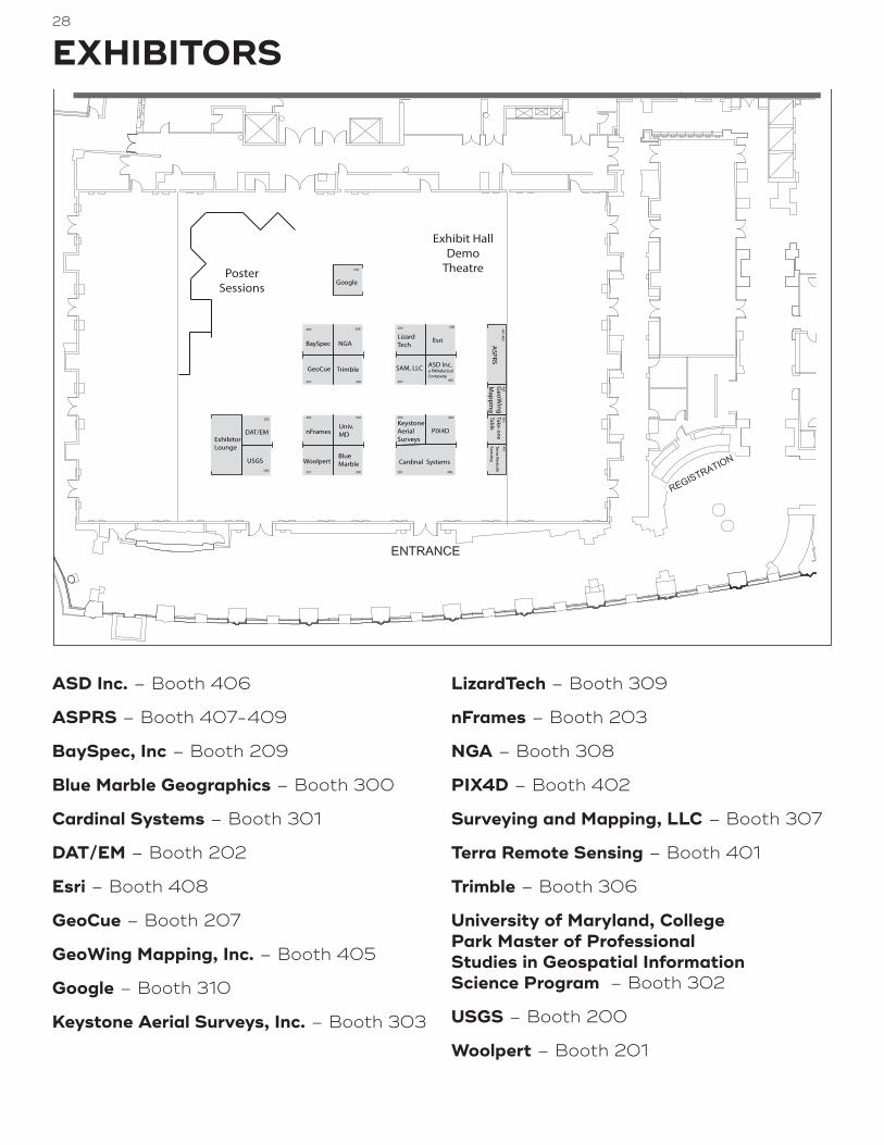
28
EXHIBITORS
ASD Inc. – Booth 406
ASPRS – Booth 407-409
BaySpec, Inc – Booth 209
Blue Marble Geographics – Booth 300
Cardinal Systems – Booth 301
DAT/EM – Booth 202
Esri – Booth 408
GeoCue – Booth 207
GeoWing Mapping, Inc. – Booth 405
Google – Booth 310
Keystone Aerial Surveys, Inc. – Booth 303
LizardTech – Booth 309
nFrames – Booth 203
NGA – Booth 308
PIX4D – Booth 402
Surveying and Mapping, LLC – Booth 307
Terra Remote Sensing – Booth 401
Trimble – Booth 306
University of Maryland, College Park Master of Professional Studies in Geospatial Information Science Program – Booth 302
USGS – Booth 200
Woolpert – Booth 201
Cardinal SystemsBlueMarble
TrimbleGeoCue
GeoW
ingM
apping
Woolpert
Univ.MD
SAM, LLC
nFramesKeystoneAerialSurveys
203 302
201 300
303
301 400
307207 306405
LizardTech
309
Terra Remote
Sensing
401
ASD Inc.a PANalytical Company
406
PIX4D
402
USGS200
DAT/EM
202
BaySpec
209
Exhibit HallDemo
Theatre
NGA
308
ExhibitorLounge
ASPRS
407-409Take-oneTable
403
Esri
408
PosterSessions
310

29
EXHIBITORSASD Inc. Booth 406www.asdi.comASD Inc., a PANalytical company, is the global leader in remote sensing and hyperspectral measurement solutions, providing unparalleled ground truthing results. Our rugged, portable FieldSpec® 4 line of spectroradiometers provides the freedom to rapidly collect high-quality spectra in the field. Trusted by top research experts at thousands of universities and research institutions, ASD’s full-range spectrometers are used in more than 70 countries. For more information, please visit www.asdi.com.
ASPRS Booth 407-409www.asprs.orgJoin us for an online demonstration of the Manual of Remote Sensing, 4th edition. The Manual is designed as an e-manual, a living document that facilitates easy updates, color graphics, live links to videos, animations, and other online sites. Come experience the unique capabilities of this e-manual as you explore its content and features.
Information on ASPRS membership, certification and the ASPRS Awards and Scholarship Program will be available.
BaySpec, Inc Booth 209www.bayspec.comBaySpec, Inc., founded in 1999 with 100% manufacturing in the USA (San Jose, California), is a vertically integrated spectral sensing company. The company designs, manufactures and markets advanced spectral instruments, including UV-VIS-NIR-SWIR spectrometers, benchtop and portable NIR/SWIR and Raman analyzers, confocal Raman microscopes, hyperspectral imagers, mass spectrometers, and OEM spectral engines and components, for the R&D, biomedical, pharmaceuticals, chemical, food, semiconductor, health monitoring, human & animal medical devices, and the optical telecommunications industries.
Blue Marble Geographics Booth 300www.bluemarblegeo.comTrusted by thousands of GIS professionals around the world, Blue Marble Geographics is a leading developer of software products and services for geospatial data conversion and GIS. Pioneering work in geomatics and spatial data conversion quickly established this Maine-based company as a key player in the GIS software field. Today’s GIS professionals are turning to Blue Marble for Global Mapper, a low-cost, easy-to-use yet powerful GIS software tool. Blue Marble is known for coordinate conversion and file format expertise and is the developer of the Geographic Calculator, GeoCalc SDK, Global Mapper, LiDAR Module for Global Mapper and Global Mapper SDK.
Cardinal Systems Booth 301www.cardinalsystems.netCardinal Systems continues development of the Vr Mapping Software suite. Data collection and editing in 2D and true 3D stereo environments from imagery/LiDAR/point clouds & surface data highlight packages such as VrOne®, VrTwo and VrThree. VrAutoTie and VrBundle extend the capabilities of the VrAT program and VrUAS. Vr software has the ability to work with difficult geometries including UAS, oblique, high oblique, close range and coincident camera positions. A stand-alone camera calibration program is available to supplement the integration of UAS and other single lens cameras into the workflow. VrThree integrates LiDAR, point cloud and/or DSM data into the Vr Mapping Software packages VrOne® and VrTwo. Four viewing environments available in VrThree enable vector data to be collected and edited using the extensive VrOne®/VrTwo mapping tools.
VrOrtho has been reinvented, is very easy to use and clients report that production is 30% faster. Projects transition seamlessly into VrOrtho. Orthophoto production is threaded and mosaic seam lines and balance are automatic. Mosaics are created directly from images. Mosaic boundaries are user drawn and can be rotated (north doesn’t have to be up). This is very efficient for corridor mapping. GeoTIF and world files work perfectly in ESRI software.
DAT/EM Booth 202http://www.datem.comDAT/EM Systems International® develops software for the photogrammetric, engineering and GIS industries that enables the extraction of 3D vector features from stereo imagery and point clouds. Celebrating its 30th anniversary, DAT/EM has kept pace with emerging technologies by creating modern tools that meet the requirements of both new and traditional photogrammetrists, engineers and GIS professionals.
DAT/EM’s suite of software solutions includes Summit Evolution™ photogrammetric workstation, LandScape™ point cloud viewing and editing toolkit, and complementary components Capture™, MapEditor™, Ortho+Mosaic™, Airfield3D™, Contour Creator™. Also availabe is Summit UAS™ which provides a set of tools to easily analyze or compare UAS data by viewing, editing and defining features. In either stereo or non-stereo packages, Summit UAS supplies new ways to interact with and analyze UAS data.
DAT/EM Systems International is committed to continued development, execution and export of digital mapping applications. If you have any questions or would like to learn more about our photogrammetric suite, please contact us.
Esri Booth 408www.esri.comEsri’s GIS enables your organization to Modernize and leverage the power of imagery and Lidar to make decisions based on the best information and analysis using the ArcGIS technology platform. ArcGIS provides a secure, accessible, and authoritative enterprise information system that can manage, produce, and share your products with stakeholders and customers.

30
EXHIBITORSGeoCue Booth 207www.geocue.comGeoCue Group was founded by engineers with extensive experience in developing hardware and software solutions for primary remote-sensed data acquisition and processing. GeoCue Group is the largest supplier of kinematic LIDAR processing and workflow management tools in North America. We are the developer of LP360, the world’s most widely used tools for exploiting point cloud data in an ArcGIS® or native Windows environment. Our AirGon subsidiary is focused on using small Unmanned Aerial Systems for high accuracy mapping of sites such as open pit mines. Leveraging our expertise in production risk reduction and point cloud processing tools, we are bringing services and products to market that provide higher efficiencies and lower costs to both geomatics professionals and end-users.
GeoWing Mapping, Inc. Booth 405www.geowingmapping.comGeoWing Mapping, Inc. is a team of mapping professionals focused on high-end mapping solutions through the application of technologies that range from traditional airborne digital sensors to newer innovation unmanned aircraft systems (UAS). We have over 50 years of combined experience in geospatial science, photogrammetry, and GIS. Our company is headquartered in Oakland CA and we are certified WOSB/DBE/SBE.
Google Booth 310earthengine.google.comGoogle Earth Engine combines a multi-petabyte catalog of satellite imagery and geospatial datasets with planetary-scale analysis capabilities and makes it available for scientists, researchers, and developers to detect changes, map trends, and quantify differences on the Earth’s surface.
Keystone Aerial Surveys, Inc. Booth 303www.kasurveys.comKeystone Aerial Surveys, Inc. specializes in providing quality airborne surveys. Keystone has flown millions of survey miles throughout the United States. With four locations: Philadelphia, PA (headquarters), Tyler, TX, Tucson, AZ and Los Angeles, CA, the Flight Department has considerable experience collecting airborne imagery at high and low altitudes from many sensor types: digital, film and LiDAR (including its new Galaxy).
Keystone operates a large fleet of aircraft (currently 21), metric film camera systems, a suite of large format digital sensors (currently 8) and multiple Optech LiDAR systems. Keystone now has 8 UAS for use in mapping, engineering and inspection.
LizardTech Booth 309www.lizardtech.comSince 1992, LizardTech has delivered state-of-the-art software products for managing and distributing massive, high-resolution geospatial data such as aerial and satellite imagery and LiDAR data. LizardTech pioneered the MrSID technology, a powerful wavelet-based image encoder, viewer, and file format. LizardTech has offices in Seattle, Denver, London and Tokyo. For more information about LizardTech, visit http://www.lizardtech.com.
nFrames Booth 203www.nframes.comGermany based technology company nFrames, develops cutting edge and industry leading 3D surface reconstruction software, designed for professional mapping production. Optimized for precision, speed and simplicity the core product, SURE Software is built to scale for large datasets. SURE Aerial and SURE Professional deliver derivation of precise point clouds, DSMs, True Orthophotos and textured meshes from small, medium and large frame images for applications such as countrywide mapping or monitoring projects using manned aircraft.
NGA Booth 308www.nga.milThe National Geospatial-Intelligence Agency (NGA) delivers world-class geospatial intelligence that provides a decisive advantage to policymakers, warfighters, intelligence professionals and first responders. Anyone who sails a U.S. ship, flies a U.S. aircraft, makes national policy decisions, fights wars, locates targets, responds to natural disasters, or even navigates with a cellphone relies on NGA. NGA enables all of these critical actions and shapes decisions that impact our world through the indispensable discipline of geospatial intelligence (GEOINT).
PIX4D Booth 402www.pix4d.comPix4D is the main provider and industry standard for professional drone photogrammetry software. Pix4D is a dynamic and rapidly expanding company with headquarters in Lausanne and local offices in San Francisco and Shanghai. Pix4D is the only solution providing desktop, cloud, and mobile solution for drone mapping.
Surveying and Mapping, LLC Booth 307www.sam.bizSurveying And Mapping, LLC (SAM) is a full service firm providing complete geospatial data solutions. Our integrated approach delivers: Professional Land Surveying, Construction Staking, Mobile Laser Scanning, Hi-Rail Surveying, HDS Laser Scanning, Photogrammetry and LiDAR, Hydrographic Surveying, Geographic Information Systems (GIS), Subsurface Utility Engineering (SUE), Utility Coordination and Construction Inspection.
Terra Remote Sensing Booth 401terraremote.comTerra is a company specializing in the acquisition, analyses, and production of geospatial data. Terra provides services to a diverse set of clients who demand timely, high-quality and cost-effective geospatial solutions. The organization has grown to over 75 employees with offices in Canada, USA, Chile and Colombia. Terra offers a comprehensive range of remote sensing and mapping services including:• LiDAR acquisition and processing• Digital Orthophotography• Thermal Scanning• Hyperspectral Imaging• Hydrographic and Marine Geophysical Surveys

31
EXHIBITORS
Agogeo Spatialwww.apogeospatial.comFormerly Imaging Notes magazine, Apogeo Spatial communicates the power of geospatial tools and technologies in managing the world’s scarce resources and environment, so that the global population has security—of water, food and energy. With a focus on long-term sustainability of the planet and people, Apogeo Spatial provides visual intelligence elevating global awareness for business, government and academic professionals.
Geoconnexionwww.geoconnexion.comGeoConnexion International and GeoConnexion UK bring you the latest news and stories plus reports from geotechnology industries in UK, Europe, the Middle East, Africa, North America and Asia.
Coverage of topics such as 3D Visualisation, Remote Sensing, LiDAR, Cloud, Mobile Mapping, Navigation with emphases on healthcare, public safety, retail, the environment, utilities, sur-veying, LBS, transport/ logistics, telecommunications and more.
LIDAR Magazine, American Surveyor, and Spatial Media LIDAR Magazine (www.lidarmag.com) promotes the adoption of LIDAR and imaging technology. Editor Roland Mangold leads an expert contributor network, bringing insights to readers via print and online publications.
The American Surveyor (www.amerisurv.com) is made by sur-veyors for surveyors. Editor Marc Cheves leads a stellar contribu-tor group sharing insights on business, technology and more.
Spatial Media, (Frederick, MD USA) founded 2003, is an advanced internet media provider, operating websites, eNewsletters and interactive magazines. www.spatialmedia.us
Point of Beginning (POB)Point of Beginning (POB) helps land surveyors and geomatics professionals in the surveying business succeed through our coverage of new technologies and opportunities. We offer practical solutions to surveying and mapping problems, while keeping you up to date on business strategies, the law and education. In recent years, POB has expanded with a digital edition, eNewsletters, webinars, podcasts and through our online community forum, RPLS.com
xyHtwww.xyht.comxyHt is North America’s leading geospatial resource. If your business focuses on precision measurement, positioning or imaging, then you will enjoy the credible content that xyHt brings to you each month. 31,000 geospatial professionals subscribe…you should too! Go to: www.xyht.com/subscribe and keep your business on the cutting edge.
Trimble Booth 306www.trimble.comAbout Trimble’s Geospatial Division: Trimble’s Geospatial Division provides solutions that facilitate high-quality, productive workflows and information exchange, driving value for a global and diverse customer base of surveyors, engineering and GIS service companies, governments, utilities and transportation authorities. Trimble’s innovative technologies include integrated sensors, field applications, real-time communications and office software for processing, modeling and data analytics. Using Trimble solutions, organizations can capture the most accurate spatial data and transform it into intelligence to deliver increased productivity and improved decision-making. Whether enabling more efficient use of natural resources or enhancing the performance and lifecycle of civil infrastructure, timely and reliable geospatial information is at the core of Trimble’s solutions to transform the way work is done.
University of Maryland, College Park Master of Professional Studies in Geospatial Information Science Program Booth 302www.geog.umd.edu/gisThe Master of Professional Studies in Geospatial Information Sciences Program is dedicated to providing the most up-to-date education on geospatial technology, theory and applications. The courses cover spatial analysis, statistics, programming, databases, modeling, remote sensing, Internet GIS, Mobile GIS, and Open Source GIS. Both MPS degree (31 Credits) and Graduate Certificate (12 Credits) in GIS are offered.
USGS Booth 200eros.usgs.govThe Earth Resources Observation and Science (EROS) Center is a field center for the U.S. Geological Survey (USGS). Fundamental to the EROS mission - “contributing to the understanding of a changing Earth” - is the collection and archiving of data about Earth’s land surfaces, providing a visual and digital record of global features and environmental change, and ensuring the accessibility of these records to anyone, anywhere, and at no cost to users.
Woolpert Booth 201www.woolpert.comWoolpert is the premier geospatial firm in the U.S. with an unmatched reputation for performance, quality, and service. We offer an integrated suite of geospatial services including photogrammetry, remote sensing, mobile mapping, digital and oblique aerial imagery, aerial and ground-based LiDAR, UAS, surveying, payload integration and testing, and GIS consulting/application development.
MEDIA PARTNERS

32
FREQUENTY ASKED QUESTIONSHow do I register for the conference?Please register on-line (see below) or at the Registraton Desk located on the 3rd floor the Foyer. Payment in U.S. Dollars will be accepted by Visa, MasterCard, Discover, American Express, checks made payable to ASPRS 2017 IGTF Annual Conference, and signed government pur-chase orders or training orders. Registrations received without payment will not be processed.
Online: http://conferences.asprs.org/Baltimore-2017/
As a student, presenting either a Technical Paper or Poster, what registration fee do I pay?All students attending the conference, whether they are presenting a paper or poster or not, are eligible for the appropriate student registration fee.
I am a part-time student at an accredited institution. Do I qualify for student registration fee?Anyone who is currently enrolled as a full or part-time student at an accredited college or university may register at the student registration rates if they have not previously held an ASPRS membership in another category, e.g., some-one who previously held full membership then returned to college cannot now register as a student. As a non-member student, you register online or use the paper form. ALL students are required to fax a copy of their student identifi-cation to qualify for the student registration fee.
May I bring a Guest to the conference? Yes, we welcome adult guests. This is a professional conference and children under age 13 are not permitted to attend any sessions or visit the Exhibit Hall. A sepa-rate registration fee has been set for all guests. (Please see Registration Form on page 21 of this program). This fee includes the admission to the Exhibit Hall and the Exhib-itors’ Reception. Admission to the general and technical sessions is not included with this registration. If guests wish to attend any of these sessions, they must register at the appropriate rate.
How do I get into the Exhibit Hall if I am not registered for the conference?You may visit the Conference Registration Desk in the Marriott Baltimore Waterfront Hotel to purchase an exhibit hall only registration. Everyone entering the Exhibit Hall must have a name badge, including children 13 years of age and older. Children under 13 years of age are not permitted in the Exhibit Hall at any time due to insurance and safety regulations.
Are Workshops included with the registration fees?Full conference registration comes with one workshop. Availability is based on space. We do not reserve spaces without full payment in advance and there is no waiting list. Workshop registrations are open during the entire conference. On-site registration will be available for con-firmed workshops with available space. Register early as many workshops will sell out.
As a Technical Paper or Poster Presenter, whose presentation has been accepted, when do I submit my work to be included in the proceedings?You will need to register for the conference and submit your complete paper or poster (not an abstract) as direct-ed in the e-mail instructions you received previously no later than February 20, 2017.
Does ASPRS provide laptops during Technical Sessions?No, ASPRS does not provide laptops or desktop comput-ers for Presenters during Technical Sessions. All Present-ers must provide their own laptop computer.
What does ASPRS provide in each Technical Session room?Each technical session room will be equipped with an LCD projector and screen. A microphone will be pro-vided when necessary. ASPRS does NOT provide laser pointers or laptop computers for the technical sessions.
Do Presenters have a Preparation Room?Yes. A room will be available on a first come basis from 7:00 am to 5:00 pm, March 12th - 16h. This room will be equipped with an LCD projector and screen. All present-ers must bring their own laptops for their presentations. The location of this room will be announced in the Final Program that will be included with the on-site registra-tion materials. We encourage all presenters to review their materials prior to their presentation.
What are Technical Paper Presenters expected to do when they arrive?All Technical Paper Presenters should check in at the Conference Registration Desk to pick-up their registration packets and initial the Master Final Program next to their name including either a hotel room number or cell phone number. A Master Final Program will be posted at the Conference Registration Desk so the session moderators can check if each presenter has arrived and can contact them if necessary.
May I volunteer to assist with the Conference activities?Yes, if you are a student at an accredited college or uni-versity, you are welcome to apply for service as a confer-ence volunteer. Please see full details at the Conference web page under the Presenter & Volunteer tab.
Is Disability Assistance Available?If you have special needs, please contact ASPRS Head-quarters at 301-493-0290 ext. 109. A written statement will be required outlining your particular needs. Please submit all requests for assistance by March 6, 2017, so that appropriate arrangements can be made.
Why do I need a badge? Your badge is verification of your paid registration and must be visible for admission to all sessions and the Exhibit Hall.

33
FREQUENTY ASKED QUESTIONSWhat if I forget or lose my badge?A charge of $5 will be made for replacement of lost badges.
Why do I need tickets for certain events?Your tickets are proof of payment for certain events and must be presented at the collection point. Lost tickets will not be replaced.
Will it be possible to post resumes and job openings?Yes, posting boards will be provided for resumes and job openings. Please bring multiple copies of all postings to allow interested parties to take one and check the board frequently for new materials and/or messages.
How do I get a copy of the Conference Proceedings?All registrants, except for those registered as Spouse/Guest, will receive access to the online proceedings area of the conference website. Access for additional people can be ordered with the Conference Registration Form or purchased on-site for $20.
What are the Conference Registration Desk HoursSaturday, March 11, 4:00pm–7:00pm, Dover BSunday, March 12, 7:30pm–6:00pm, FoyerMonday, March 13, 7:30am–5:00pm, FoyerTuesday, March 14, 6:30am–5:00pm, FoyerWednesday, March 15, 7:00am–5:45pm, Foyer Thursday, March 16, 7:00am–12:00 noon, Foyer
Conference Registration materials are available only during the above hours.
What are the Exhibit Hall Hours?• Tuesday, March 14, 9am–7pm
• Wednesday, March 15, 9am–5pm
Light Breakfast Tuesday, March14 7:30am–8:30am, Exhibit HallWednesday, March 15, 7:30am–8:30am, Exhibit Hall
Exhibitors ReceptionTuesday, 5:30pm–7pm
Lunch served in the Exhibit HallTuesday, 11:30am–1:00pm
Wednesday, 11:30am–1:00pm
Welcome Reception in the Exhibit Hall Foyer Monday, 5:30pm–7:30pm
Please note: Children under the age of 13 are not allowed in the Exhibit Hall
Lyft is pleased to provide transportation to and from the ASPRS Annual Conference by offering attendees $15 IN FREE RIDES! Pursuant to Lyft’s terms, new accounts will receive $5 off their first 3 rides and these credits can be used in any of the cities where Lyft operates before/during/after the ASPRS Annual Conference. To participate in this special promotion, please share the following information, link, and image below with attendees:
Lyft is offering $15 IN FREE RIDES to attendees of the ASPRS Annual Conference! Click on the link below to download the free Lyft app and enter the credit code “15BONUS” in the payment section before requesting a Lyft to claim $15 IN FREE RIDES! *Valid for new accounts, $5 off 3 rides
www.lyft.com/i/15BONUS

34
Baltimore Marriott Waterfront700 Aliceanna Street, Baltimore, Maryland 21202
marriott.com/hotels/travel/bwiwf-baltimore-marriott-waterfront/
Visit Baltimorebaltimore.org
Charm City Circulatorcharmcitycirculator.com
Maryland Transit Administration mta.maryland.gov
AROUND BALTIMORE

35
2017 CONFERENCE COMMITTEEKaren Schuckman • Conference Chair
Priscilla Weeks • Conference Coordinator
Bruce Quirk • Technical Divisions Program
John McComb • Technical Divisons Program
Amr H. Abd-Elrahman • Workshop Coordinator
Thomas Mueller • Baltimore STEM
Bandana Kar • Baltimore STEM
Bobbi Lenczowski • Posters
Rae Kelley • Posters
Rakesh Malhotra • Student Volunteer Coordinator
Caren Michelle Remillard • Student Activity
Megan Miller • Student Activity
James Gentry • Mira Tech Support
Jerry Lenczowski • Mira Project Manager
Matthew Austin • Program Layout
ASPRS STAFFJesse Winch • Acting Executive Director
Priscilla Weeks •Membership Manager/ Conference Coordinator
Rae Kelley • Assistant Director Publications
Matthew Austin • Program Layout

36
Commercial UAV ExpoOctober 24–26, 2017Las Vegas, NevadaASPRS UAS Division will be presenting a Symposium at this year’s Commercial UAV Expo! Drop by the see the latest industry developments!
Pecora 20November 12–16, 2017Sioux Falls, South Dakota
ASPRS/ILMF 2018 Feb 2018Denver, Colorado
UPCOMING
CONFERENCES

B A LT I M O R E M A R R I O T T WAT E R F R O N T3 R D F L O O R | G R A N D B A L L R O O M L E V E L
Sessions/WorkshopsExhibits
RegistrationAdministrative
B A LT I M O R E M A R R I O T T WAT E R F R O N T4 T H F L O O R | H A R B O R S I D E L E V E L
Sessions/WorkshopsPlenary

Topics covered:
✔ 3D Visualisation/Modelling
✔ Addressing Technology
✔ Aerial Imagery/Photography
✔ Asset Management
✔ Bathymetry
✔ Big Data
✔ Business Geographics/Analytics
✔ Cadastral Mapping
✔ Cartography
✔ Climate Change
✔ Computing in the Cloud
✔ Crime Mapping/ Modelling
✔ Data Capture/Collection
✔ DEM- Digital Elevation Model
✔ DGPS - Diff erential GPS
✔ Digital City Models
✔ Digital Mapping
✔ Digital Rights Management
✔ Disaster Management/ Monitoring
✔ DSM - Digital Surface Model
✔ DTM - Digital Terrain Model
✔ Dynamic Mapping
✔ Earth Observation
✔ Emergency Services
✔ ENC - Electronic Navigation Chart
✔ Environmental Monitoring
✔ Galileo
✔ Geo-ICT
✔ Geodesy
✔ Georeferencing
✔ Geosciences
✔ Geospatial Image Processing
✔ GIS
✔ GIS in Agriculture & Forestry
✔ GLONASS
✔ GMES
✔ GNSS
✔ GPS
✔ GSDI
✔ Hardware
✔ Hydrography
✔ Hyperspectral Imaging
✔ Image Analysis
✔ INSPIRE
✔ Integration
✔ Interoperability & Open Standards
✔ Land Information Systems
✔ Laser Scanning
✔ LBS
✔ LiDAR
✔ Mapping Software
✔ Marine Tracking & Navigation
✔ Mobile GIS/Mapping
✔ Municipal GIS
✔ Navigation
✔ Network Topology
✔ NSDI
✔ Open GIS
✔ Photogrammetric
✔ Photogrammetry
✔ Point Clouds
✔ Property Information Systems
✔ Radio Navigation
✔ Remote Sensing
✔ Risk Management
✔ RTK (Real Time Kinematic) Surveying
✔ Satellite Imagery/Navigation
✔ Scanning Technology
✔ SDI - Spatial Data Infrastructures
✔ Smart Grids
✔ Software
✔ Surveying Instrumentation
✔ Surveying Technology Sensor
✔ Telematics
✔ Topographic Mapping
✔ Total Station
✔ Tracking & Route Planning
✔ Transport
✔ Utilities GIS
✔ Vehicle Tracking & Navigation
✔ VRS - Virtual Reference Station
✔ Web Mapping
Sectors covered:
✔ Aerospace
✔ Agriculture
✔ Archaeology & Heritage
✔ Architecture
✔ Biosecurity
✔ Business Security/Service
✔ Central/Local/Regional Government
✔ Construction
✔ Consulting Services
✔ Cyber Security
✔ Defence
✔ Education
✔ Emergency Services
✔ Energy Utility
✔ Engineering
✔ Environmental Management
✔ Environmental Monitoring
✔ Financial Services
✔ Fisheries
✔ Forestry Management
✔ Geosciences
✔ Healthcare
✔ Infrastructure Protection
✔ Insurance
✔ Manufacturing
✔ Marine
✔ Military
✔ Mining
✔ Natural Resource Management
✔ Oil & Gas
✔ Property
✔ Public Safety/Works
✔ Retail
✔ Shipping
✔ Software Development
✔ Technical Services
✔ Telecommunications
✔ Tourism/Travel
✔ Training
✔ Transport
✔ Utilities (Energy & Water)
The Online Pack: Unbeatable ValueUnlimited access to Online News, Comment, Features Sections and Archive plus Monthly eNewsletter packed with the Latest News and what’s on in the Geospatial Industry
Join today for only £1 a month
Sign up at geoconnexion.com/membership
Jointoday!
Subscribe and stay ahead of the game!The content that you can trust
Just £1 a month
9084 - GeoConnexion - New House Advert 2014 - A4 v2 Final AW.indd 1 16/09/2014 14:57