ieee access 1 mobile augmented reality survey: from where ...panhui/papers/final-article.pdf ·...
TRANSCRIPT

IEEE ACCESS 1
Mobile Augmented Reality Survey:From Where We Are to Where We Go
Dimitris Chatzopoulos, Carlos Bermejo, Zhanpeng Huang, and Pan Hui
Abstract—The boom in the capabilities and features of mobiledevices like smartphones, tablets and wearables combined withthe ubiquitous and affordable Internet access and the advances inthe areas of cooperative networking, computer vision and mobilecloud computing transformed Mobile Augmented Reality (MAR)from science fiction to a reality. Although mobile devices are moreconstrained computational-wise from traditional computers, theyhave a multitude of sensors that can be used to the developmentof more sophisticated MAR applications and can be assisted fromremote servers for the execution of their intensive parts. In thiswork, after introducing the reader to the basics of MAR, wepresent a categorisation of the application fields together withsome representative examples. Next, we introduce the reader tothe user interface and experience (UI/UX) in MAR applicationsand continue with the core system components of the MARsystems. After that we discuss advances in tracking and registra-tion, since their functionality is crucial to any MAR applicationand the network connectivity of the devices that run MARapplications together with its importance to the performanceof the application. We continue with the importance of datamanagement in MAR systems and the systems performance andsustainability and before we conclude this survey, we presentexisting challenging problems.
Index Terms—Mobile Augmented Reality, Mobile Computing,Human Computer Interaction
I. INTRODUCTION
During the last decade, Mobile Augmented Reality (MAR)attracted interest from both industry and academia. MARsupplements the real world of a mobile user with computer-generated virtual contents. The intensity of the virtual contentsand their affect on the view of the mobile user determinethe reality or the virtuality, in the case of intense graphicsthat change the original view, of the mobile user. Figure1 depicts the categorisation between the different versionsof reality and virtuality. Real Reality is the environment ofthe user without the use of any device while Virtual Realityis the reality that users experience, which is unrelated withtheir environment and is completely generated by a computer.Mobile technology improvements in built-in cameras, sensors,computational resources and mobile cloud computing havemade AR possible on mobile devices.
The advances on human computer interaction interfaces,mobile computing, mobile cloud computing, scenery under-standing, computer vision, network caching and device to de-vice communications have enabled new user experiences thatenhance the way we acquire, interact and display information
Dimitris Chatzopoulos, Carlos Bermejo and Pan Hui are with the Depart-ment of Computer Science and Engineering, Hong Kong University of Scienceand Technology, Hong Kong.
Corresponding author: Dimitris Chatzopoulos, email: [email protected]
Fig. 1. Order of reality concepts ranging from Reality (left) to Virtuality(right) as presented in [7].
within the world that surrounds us. We are now able to blendinformation from our senses and mobile devices in myriadways that were not possible before.
Cloud infrastructure and service providers continue to de-ploy innovative services to breed new MAR applications. TheMAR-based mobile apps and mobile advertising market ismore than $732 million [1]. By considering all the definitionsfrom various researchers in the past [2], [3], [4], [5], [6], wecan conclude that MAR:
1) combines real and virtual objects in a real environment,2) is interactive in real time,3) registers and aligns real and virtual objects with each
other, and4) runs and/or displays the augmented view on a mobile
device.
Any system with all above characteristics can be regarded asa MAR system. A successful MAR system should enable usersto focus on application rather than its implementation [8].During the last years, many case specific MAR applicationshave been developed with the most of them in the areas oftourism and culture and education while there is currentlyhuge interest in MAR games. Pokemon GO1, for example, isa well-known MAR application that offers location-based ARmobile game experience. Pokemon GO shares many featureswith a previous similar MAR application, named Ingress2 andalthough it gain huge popularity the first days after its release,by generating almost 2 million US dollars revenue per day, itis now loosing its popularity3. Some more examples are thework of M. Billinghurst et al, who examined the impact of anaugmented reality system on students’ motivation for a visualart course [9] and the work of P. Geiger et al, who discussedlocation-based MAR applications [10].
1http://www.pokemongo.com2https://www.ingress.com3http://expandedramblings.com/index.php/pokemon-go-statistics/
IEEE ACCESS 2
Since the applicability of MAR is very broad, we dedicatea big part of this survey on the presentation and discussion ofthese cases. Due to their mobile nature, most MAR applica-tions tend to run on mobile/wearable devices, such as smartglasses, smartphones, tablets, or even in some cases laptops. Amobile application can be categorised as a MAR applicationif it has the following characteristics:
Input: It considers the various sensors of the device (cam-era, gyroscope, microphone, GPS), as well as anycompanion device [11].
Processing: It determines the type of information that isgoing to render in the screen of the mobile device.In order to do that it may require access stored locallyin the device or in a remote database.
Output: It projects its output to the screen of the mobiledevice together with the current view of the user (i.e.It augments the reality of the user).
AR glasses are the best option for ubiquitous mobile ARas the projected information is directly superimposed to thephysical world, although their computing power is limited and,due to that, most applications remain quite basic. Smartphonesare also a good option, due to their higher computing powerand portability, but require the user to “point and hold” forbeing able to benefit from AR applications. Tablets, PC andlaptops start to get cumbersome and limit their use to specificoperations.
Due to specific mobile platform requirements, MAR suffersfrom additional problems such as computational power andenergy limitations. It is usually required to be self-contained soas to work in unknown environments. A typical MAR systemcomprises mobile computing platforms, software frameworks,detection and tracking support, display, wireless communica-tion, and data management. There are also cases where themobile users are interacting with the application using externalcontrollers [12]. P. Jain et al in their work in the OverLayproject discuss the requirements of an MAR system to befunctional [13].
The most widely adapted devices for AR are also theleast powerful due to their high portability. Depending on thegenerality of an application, (1) the storage and (2) renderingcapabilities of the device as well as (3) its connectivity to theInternet, parts of it may be executed in a cloud surrogate [14].Vision-based applications are almost impossible to run onwearables, and very difficult on smartphones since they requirecapable GPUs [15], [16]. Some operations only run flawlesslyon a desktop computer, or even on some dedicated server.Computation offloading solutions can therefore be used forthe execution of heavy computations to a distant but morepowerful device. The capabilities of the surrogate devices andaccessibility vary on their type and the considered networkarchitecture. The one extreme it can be a smartphone thatworks as a companion device to a smart glass device, while theother extreme it can be a virtual machine with almost infiniteprocessing, memory and storage resources. In between thereare FoG and D2D solutions.
Another important parameter is the memory and the storagerequirements of the mobile applications. MAR browsers, forexample, are projecting virtual objects in the view of the
Cloud Server
Eye Tracking device
Smart device
Sensors
Eye Tracking
Virtual Objects
GPS
Gyroscope
Compass
Accelerometer
AR Display
Virtual Objects
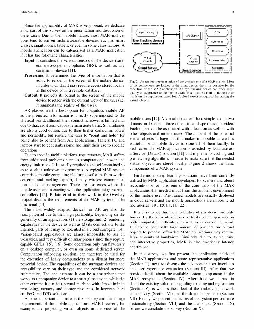
Fig. 2. An abstract representation of the components of a MAR system. Mostof the components are located in the smart device, that is responsible for theexecution of the MAR application. An eye tracking device can offer betterquality of experience to the mobile users since it allows them to not use theirhands on the application execution. A cloud server is required for storing thevirtual objects.
mobile users [17]. A virtual object can be a simple text, a twodimensional shape, a three dimensional shape or even a video.Each object can be associated with a location as well as withother objects and mobile users. The amount of the potentialvirtual objects is huge and this makes impossible as well aswasteful for a mobile device to store all of them locally. Insuch cases the MAR application is assisted by Database-as-a-Service (DBaaS) solution [18] and implements caching andpre-fetching algorithms in order to make sure that the neededvirtual objects are stored locally. Figure 2 shows the basiccomponents of a MAR system.
Furthermore, deep learning solutions have been currentlyutilised by MAR application developers for scenery and objectrecognition since it is one of the core parts of the MARapplications that needed input from the ambient environmentof the mobile user. Pre-trained models are usually deployedin cloud servers and the mobile applications are imposing adhoc queries [19], [20], [21], [22].
It is easy to see that the capabilities of any device are onlylimited by the network access due to its core importance inboth computation offloading as well as in content retrieval.Due to the potentially large amount of physical and virtualobjects to process, offloaded MAR applications may requirelarge amounts of bandwidth. Similarly, due to its real timeand interactive properties, MAR is also drastically latencyconstrained.
In this survey, we first present the application fields ofthe MAR applications and some representative applications(Section II), next we discuss the advances in user interfacesand user experience evaluation (Section III). After that, weprovide details about the available system components in theMAR ecosystems (Section IV). After these we discuss indetail the existing solutions regarding tracking and registration(Section V) as well as the effect of the underlying networkconnectivity (Section VI) and the data management (SectionVII). Finally, we present the factors of the system performancesustainability (Section VIII) and the challenges (Section IX)before we conclude the survey (Section X).
IEEE ACCESS 3
II. APPLICATION FIELDS
The huge spread of mobile devices and the appearance ofwearable devices and smart glasses together with advanceson computer vision have given wide applicability to MARapplications. In this section we present some representativeapplications on the following general categories: Tourismand Navigation (Section II-A), Entertainment and Advertise-ment (Section II-B), Training and Education (Section II-C),Geometry Modeling and Scene Construction (Section II-D),Assembly and Maintenance (Section II-E) and InformationAssistant Management (Section II-F). Last, in Section II-H wepresent some representative MAR applications that are listedin Table I.
A. Tourism and Navigation
Researchers at Columbia University built a MAR prototypefor campus exploration [23], [24]. It overlaid virtual informa-tion on items in visitor’s vicinity when they walked aroundcampus. Dahne et al. [25] developed Archeoguide to pro-vide tourists with interactive personalized information abouthistorical sites of Olympia. Tourists could view computer-generated ancient structure at its original site. Fockler etal. [26] presented an enhanced museum guidance systemPhoneGuide to introduce exhibitions. The system displayedadditional information on mobile phones when visitors tar-geted their mobile phones at exhibits. They implemented aperception neuronal network algorithm to recognize exhibitson mobile phone.
Elmqvist et al. [27] proposed a three-dimensional virtualnavigation application to support both path finding and high-lighting of local features. A hand gesture interface was devel-oped to facilitate interaction with virtual world. Schmalstieget al. [28] constructed a MAR-based city navigation system.The system supported path finding and real object selection.When users selected a item in real world, virtual informationwas overlaid on view of real items.
Tokusho and Feiner [29] developed a “AR street view”system which provided an intuitive way to obtain surroundinggeographic information for navigation. When users walkedon a street, street name, virtual paths and current locationwere overlaid on real world to give users a quick overview ofenvironment around them. Radha and Diptiman [30] proposedto integrate mobile travel planner with social networks usingMAR technologies to see feedback and share experiences. In[31], the authors review the existing projects on Linked Datain MAR applications for tourism. They address issues withdata quality and trust, as in tourist applications the visitorsrely on to visit the surroundings environment.
Furthermore, large scale integration for spatial data needsto be taken in future work. i-Street is an Android MARapplication to read street plates from a video flow. Theapplication will overlay information such as walking distancesfrom POIs and targets tourist visiting a new city. [32] presenta MAR building recognition application, KnossosAR. Thesystem provides object occlusion, and raycasting techniques tooffer a better understanding for users about their surroundings.The application uses hidden markers in POIs to overlay the
content, and audio as an alternative feedback for the ARexperience. The goal of this dissertation [33] is to explorenew ways to interact with cultural and historical sites throughMAR applications. They develop an application that relies ina physical map to overlay AR content. The authors addresspossibly issues in case of applications that use network con-nectivity to provide content.
Geiger et al. [10] focuses on the implementation of aefficient MAR application. AR applications usually needbased-location systems, inertia sensors and require heavycomputational tasks in order to render the AR content inreal-time. The authors provides also some insights in orderto design and implement the core framework of an MARapplication (Augmented Reality Engine Application, AREA).Mobile device resources and energy consumption are takeninto account in AREA to design the application, and as partof their future work they want to address indoor localizationto provide location-based services for MAR applications.
In [13], the authors develop a MAR application (Overlay)to serve as historical tour guide. They use multiple objectdetection and inner motion sensor to provide better indoorlocation accuracy and therefore, a better AR experience. Theyhave an extensive analysis about latency and how sensor op-timizations (time, full, rotation) affects the accuracy. Nartz etal. [34] propose the car as the device to show AR content andoffer a novel alternative to navigation systems. The frameworkdisplays AR content such as path, gas station information onthe user’s mobile device (i.e., smartphone, PDA, tablet). Theauthors present a prototype of their system implemented onthe car’s windscreen.
They also point out some of the issues of wearable ARdevices due to their size, and the need of MAR devicesthat merge seamlessly with the user’s environment. JoGuide[35] is a MAR application to help tourist to recognize ar-eas, locate POIs, and overlay the corresponding informationusing an Android smartphone. The authors use gelocation-based approach gathering information from users’ GPS andweb services such as foursquare4. In [36], authors proposea MAR application for individual location recommendation.They use object detection and GPS data to identify the imageand locate, then the application renders the correspondinginformation on the user’s display. The experiment results showan improvement on accuracy when the application uses bothlocation and image recognition instead of only GPS location,60% versus 40%. Vert et al. [37] present a model and animplemented prototype that integrates open and governmentdata in a MAR tourism application. Tourist are willing tobe provided with context-sensitive and dynamic information.One suitable solution is integrating linked open sources toovercome the current static-content MAR applications (i.e.,applications that overlays Wikipedia information). This paperproposes the guidelines to implement such linked data MARsystem. The authors highlight some issues during the proto-type implementation regarding POIs names and position varybetween sources, and the significant amount of manual effortto translate the data. This paper [38] presents a reusable MAR
4https://foursquare.com/
IEEE ACCESS 4
framework to address the repetitive and crucial task of outdoorvisualization. The authors claim that the existing software doesnot provide a fast development environment for testing andresearch. Therefore, they propose a framework that will bepluggable using Object Oriented Design (OOD) techniquesand modular design.
B. Entertainment and Advertisement
Renevier and Nigay [2] developed a collaborative gamebased on Studierstube. The game supports two users to playvirtual 3D chess on a real table. Piekarski and Thomas [39]proposed an outdoor single-player MAR games ARQuake.It enabled players to kill virtual 3D monsters with physi-cal props. Cheok et al. [40] developed an MAR game formultiplayers in outdoor environment. They embed Bluetoothinto objects to associate them with virtual objects. Systemcould recognize and interact with virtual counterparts whenplayers interacted with real objects. Players kill virtual enemiesby physical touch other players in real world. Henrysson etal. [41] built a face-to-face collaborative 3D tennis game onSymbian mobile phones. Mobile phone was used as tangibleracket to hit virtual ball. Hakkarainen and Woodward [42]created a similar table tennis MAR game. They proposeda color-based feature tracking approach to improve runtimeperformance. The game was feasible and scalable in variousconditions as it required no pre-defined markers. Morrisonet al. [43] developed a MAR map MapLens to superimposevirtual content on paper map when users targeted mobilephones at paper map. The system was used to help playerscomplete their game. There are also many MAR applicationsexploited to augment advertisements.
The website [44] list several MAR-based apps for adver-tisement. Absolut displayed augmented animation to showconsumers how vodka was made as users point their mobilephones at a bottle of vodka. Starbucks enable customersto augment their coffee cups with virtual animation scenes.Juniper research [Juniper09] estimated that MAR-based mo-bile apps and mobile advertising market would reach $732million in 2014. The authors in [45] develops a game inspiredby the platform puzzle game Lemmings for MAR systems.They use the Vuforia SDK to develop the AR game (virtualobject, tracking), and Microsoft Kinect5 to scan the 3D realenvironment. The participants’ results in the authors’ designedexperiment show immersion game features. The authors in[46] develop a MAR application for visitors to experiencethe historical center of a Greek city. The evaluation of theirapplication show that MAR applications create an immersiveexperience, also the game interaction should be simple enoughnot to affect the performance and engagement of users. In[47], the authors design a markerless MAR application foradvertisement. The application uses Vuforia SDK to scan thereal object and overlay to effectively convey the informationof advertisement.
Olsson et al. [48] realize a user case study of MAR servicesin shopping centers. The authors conduct 16 semi-structuredinterview with 28 participants in shopping centers. From
5https://developer.microsoft.com/en-us/windows/kinect
the experiment results, authors claim that MAR applicationshave great potential to provide context-sensitivity, emotions,engagement. Furthermore, the results show also some guide-lines for building the next UX for MAR applications suchas audio-visual feedback, readability, and accuracy of ARcontent. Authors in [49] discuss how and why the use ofMAR applications can impact the retail market. They conducta large-scale survey across United States smartphone users.The experiment findings show that MAR applications can addmore value to the shopping experience, such as more detailedinformation, users’ product ratings. However, designers needto be careful with the privacy settings as it is one of the mostmentioned concern of the participants. For example, giving toomuch personal information to an application.
C. Training and Education
The Naval Research Lab (NRL) developed a MAR-basedmilitary training system [50] to train soldiers for militaryoperations in different environments. The battlefield was aug-mented with virtual 3D goals and hazards which could bedeployed beforehand or dynastically at run time. Traskbackand Haller [51] used MAR technology to augment oil refinerytraining. Traditional training was conducted in classrooms oron-site when the plant was shut down for safety consideration.The system enabled on-site device-running training so thattrainees could look into run-time workflow. Klopfer et al. [52]proposed a collaborative MAR education system for museum.Players use Pocket PCs and walkie-talkies to interview virtualcharacters and operate virtual instruments. To finish the task,children were encouraged to engage in exhibits more deeplyand broadly. Schmalstieg and Wagner [53] built a MARgame engine based on Studierstube ES. In order to finishthe task, players had to search around with cues displayed onhandheld device when players pointed their handheld deviceat exhibits. Freitas and Campos [54] developed an educationsystem SMART for low-grade students. Virtual 3D modelssuch as cars and airplanes were overlaid on real time video todemonstrate concepts of transportation and animations.
In [55] authors study users’ engagement during a collabora-tive AR game. Bower et al. [56] discuss the pedagogical poten-tial that AR can bring to mainstream society and educationalsystem. The paper presents a learn by design case studied inSchool of Arts, which resulted in higher creativity and criticalanalysis. The authors suggest that it is important for educatorsto keep updating their knowledge about AR technologiesin order to prepare themselves and their classes for futuredevelopments. They also mentioned the use of smartphonesand tablets to provide the AR scenarios in the learning process.In [57], the authors realized an extensive relative literatureabout AR and informal and informal education environments.The paper also provides several study insights whose prove theevidence of positive outcome regarding student learning. [58]is an up-to-date survey on AR in education, which includesfactors such as uses, advantages, features, and effectiveness ofthe AR approach.
The number of AR studies has incremented significantlysince 2013, the majority of these studies report that the

IEEE ACCESS 5
inclusion of AR in education environments can lead to betterlearning performance and student engagement. Furthermore,the authors suggest as future work, additional interactivestrategies to enhanced first-hand experiences, and lengtheningthe time span of the research AR studies. [59] explain theadvantages and disadvantages of the different approaches tomark real objects for AR environments, and the forthcomingopportunities for museums and libraries. [60], authors proposea mobile peer-assesment AR framework, in which the studentscan present their own work and evaluate others. Furthermore,the system also provide location-based adaptive content andhow their work can be applied in real scenarios. As previouspapers, the framework leans on better understanding, andcritical thinking skills.
In [61], authors review several studies on augmented paper(i.e., documents, notebooks with fiducial markers, user inputdigitalization) in education scenarios. Using the notion ofclass orchestration as a conceptual tool to describe the po-tential integration of augmented paper in class environments.Furthermore, the analysis point out design difficulties foraugmented paper and the advantages of MAR. [62] prove real-world information based in AR can be used for education.However, the old AR system have several weakness regardingthe projection such as luminance and contrast changes inreal world. The authors address these issues and proposea system that can improve immersion and interaction user-AR objects. [63] authors study AR is embedded in outdoorsettings for learning processes, they also attempt to classifythe key aspects of this interaction. As the authors mentioned,the AR for mobile experiences is still in its infancy. Theyalso have another opinion against previous mentioned studieshere, that it is still not straightforward to see how useful is forcreating learning experiences. However, they agree that MARcan provide a better immersive experience and engagement.
Chiang et al. [64] propose a AR mobile learning systembased on GPS location to position virtual objects in the realworld in Natural Science projects. The experimental resultsfound that the AR mobile system improved students’ learningcapabilities. Although, there are some constraints in the pro-posed system as the GPS accuracy of object positioning. [65]summarize existing related work about MAR in educationalenvironments. The authors address the need to explore howAR can improve not only the learning process but othereducational and pedagogic issues in the classroom.
Authors in [66] found evidence that MAR influence studentsto consider affective, and ethical aspects for problem solvingand decision making. [67] analyze published study findingsand trends from 2003 to 2013 about MAR in educational set-tings. Besides the already mentioned advantages, the authorsenumerate some issues with the MAR systems such as veryfew systems that take into account accessibility, difficultiesto maintain the superposed information, and that most ofthe studies have used mixed evaluation methods and relativemedium samples sizes (30 to 200 participants). Wu et al.[68] discuss how different categories of AR approaches canaffect the learning process. For example, in particular ARenvironments the users may be overloaded by the amount ofprovided information and different devices to use. They also
support the idea of greater samples for experiment studiesand the benefits of AR in the classroom. They propose acategorization of AR approaches from instructional approaches(i.e., roles, locations, tasks). Wide the subjects with MARtechniques has to be addressed in future works, how to inte-grate theses new techniques into the regular school curricula.[69] describe the potential of MAR for training psycho-motorskills and visualize concepts to improve the understanding ofcomplex causality. MAR systems can improve the studentsenhancement inside and outside the classroom [70]. The useof books and notebooks with MAR systems can lead to abetter learning process, although the lack of content creationtools is one of current problems for educators to implementMAR in educational environments. Construct3D [71] is athree dimensional geometric tool based on Studierstube [72].They use a stereoscopic head-mounted device to provide a 3Daugmented reality to interact with 3D geometric constructionsin space. Authors in [73] develop a MAR system to improveart museum visitors learning effectiveness during their visit.The system locates and overlays information over currentpictures, providing functions such as zooming in the virtualpicture. The authors want to integrate art appreciation withMAR techniques.
However, the developed system can be used in other kind ofexhibitions such as theme parks, other museums or educationcenters to improve visitors engagement and interaction. In[74], authors compare student learning performance in ARversus non-AR applications, they also list the advantages anddisadvantages of AR in the learning process. MAR applica-tions improve learners performance due to information can bespatio- and temporally aligned with physical objects, enhancedmemory (due to immersion of AR experiences), attention isdirected to relevant content, interaction and collaboration, andstudents motivation. However, AR applications can also havenegative effects such as attention decrement to errors (i.e., 3Dbuilding in AR environment against paper-based), usabilitydifficulties in some AR examples and ineffective classroomintegration between students and students-teachers.
D. Geometry Modeling and Scene Construction
Baillot et al. [75] developed a MAR-based authoring tools tocreate geometry models. Modelers extracted key points fromreal objects and then constructed geometric primitives frompoints to create 3D models. Created models were registeredand aligned with real objects for checking and verification.Piekarski and Thomas [76] built a similar system for out-door object creation. It used pinch gloves and hand trackingtechnologies to manipulate models. The system was speciallysuitable for geometrical model creation of giant objects (e.g.building) as users could stand a distance away. Ledermann etal. [77] developed a high-level authoring tool APRIL to designMAR presentation. They integrated it into a furniture designapplication. Users could design and construct virtual modelwith real furniture as reference in the same view. Henryssonet al. [78] employed MAR to construct 3D scene on mobilephone in a novel way. Motions of mobile phone were trackedand interpreted to translation and rotation manipulation of

IEEE ACCESS 6
virtual objects. Bergig et al. [79] developed a 3D sketchingsystem to create virtual scenes for augmented mechanicalexperiments. Users use their hands to design experiment scenesuperimposed on a real drawing. Hagbi et al. [80] extended itto support virtual scene construction for augmented games.
E. Assembly and Maintenance
Klinker et al. [81] developed a MAR application for nuclearplant maintenance. The system created an information modelbased on legacy paper documents so that users could easilyobtain related information that was overlaid on real devices.The system was able to highlight fault devices and suppliedinstructions to repair them. Billinghurst et al. [82] createda mobile phone system to offer users step-by-step guidancefor assembly. A virtual view of next step was overlaid oncurrent view to help users decided which component to addand where to place it in the next step. Henderson and Feiner[83] developed a MAR-based assembly system. Auxiliaryinformation such as virtual arrows, labels and aligning dashlines were overlaid on current view to facilitate maintenance. Astudy case showed that users completed task significant fasterand more accurate than looking up guidebooks. An empiricalstudy [84] showed that MAR helped to reduced assemblyerror by 82%. In addition, it decreased mental effort for users.However, how to balance user attention between real world andvirtual content to avoid distraction due to over-reliance is stillan open problem. Webel et al. [85] present the need of efficienttraining systems for maintenance and assembly and how MARcan improve the trainer skills with appropriate methods. Theauthors develop and evaluate their training platform, wherethey highlight the need of vibrotactile feedback in this par-ticular scenario in order to improve user interaction with theAR content. The experiment results suggest the improvementin participants skills. However, the maintenance and assemblytraining need to give special attention of capturing and in-terpretation of underlying skills. Moreover, the data capturedfrom the system can be used to show how experts wouldresolve a particular training case. Furthermore, MAR opensthe possibility of remote interaction expert-trainee in the field.
F. Information Assistant Management
Goose et al. [86] developed a MAR-based industrial servicesystem to check equipment status. The system used taggedvisual markers to obtain identification information, which wassent to management software for equipment state information.Data such as pressure and temperature were sent back andoverlaid for display on the PDA. White et al. [87] developeda head-worn based MAR system to facilitate managementof specimens for botanists in the field. The system searcheda species database and listed related species samples side-by-side with physical specimens for comparison and identi-fication. Users slid virtual voucher list with head horizon-tal rotation and zoom the virtual voucher by head noddingmovements. Deffeyes [88] implemented an Asset AssistantAugmented Reality system to help data center administratorsfind and manage assets. QR code was used to recognize asset.
Fig. 3. Visualization of a numerical flow field with real buildings makesthe influence of the building on wind movement easily understood. (source:http://emcl.iwr.uni-heidelberg.de/research sv.html)
Asset information was retrieved from a MAMEO server andoverlaid on current view of asset.
MAR also finds its markets in other fields. MAR hasbeen used to enhance visualization and plan operations byplacing augmented graphic scans over surgeons’ vision field[89]. Rosenthal et al. [90] used the ”x-ray vision” featureto look through the body and made sure the needle wasinserted at the right place. MAR was also used to managepersonal information [91]. Another large part of applicationsis AR browsers on mobile phones [92], [93]. AR browser issimilar to MAR navigation application, but more emphasizeson location-based service (LBS). Grubert et al. [94] conducteda detailed survey about AR browsers on mobile phones.
G. Big Data Driven MAR
In [95], authors list some data driven examples for realapplication scenarios and provide a categorisation. The fourproposed categories are: (1) Retail, (2) Tourism, (3) HealthCare and (4) Public Services. MAR applications in Retailboost the shopping experience with more product information,the ability to change based on users emotions, and person-alized content. For the case of Tourism, MAR applicationsuse geo-spatial data to assists users on their browsing inunfamiliar environments while Health case, MAR applicationsaid doctors in operations and nurses in care-giving. Last,MAR applications in Public Services help citizens in theireveryday routine. In all these for cases, these applications arefunctional only because they have access to big data sources.In Figure 3 we present an example were big data is used inthe visualisation of the wind movement. It is easy to see thatthis detailed representation requires huge amount of data sinceit can not be described through modeling.
H. Representative MAR Systems
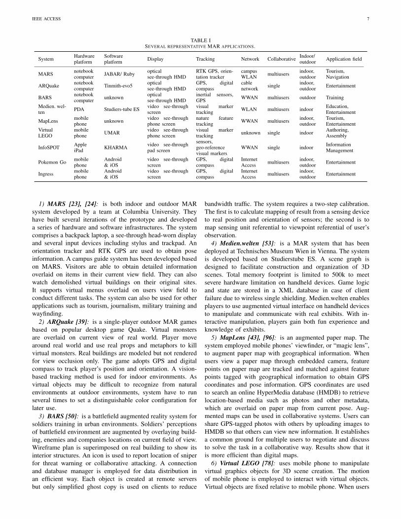
Although there are many MAR systems, as discuss earlierin this section, we use this subsection to discuss a represen-tative sample of them in more detail. Table I contains theircharacteristics in a collective way.
IEEE ACCESS 7
TABLE ISEVERAL REPRESENTATIVE MAR APPLICATIONS.
System Hardwareplatform
Softwareplatform Display Tracking Network Collaborative Indoor/
outdoor Application field
MARS notebookcomputer JABAR/ Ruby optical
see-through HMDRTK GPS, orien-tation tracker
campusWLAN multiusers indoor,
outdoorTourism,Navigation
ARQuake notebookcomputer Tinmith-evo5 optical
see-through HMDGPS, digitalcompass
cablenetwork single indoor,
outdoor Entertainment
BARS notebookcomputer unknown optical
see-through HMDinertial sensors,GPS WWAN multiusers outdoor Training
Medien. wel-ten PDA Studiers-tube ES video see-through
screenvisual markertracking WLAN multiusers indoor Education,
Entertainment
MapLens mobilephone unknown video see-through
phone screennature featuretracking WWAN multiusers indoor,
outdoorTourism,Entertainment
VirtualLEGO
mobilephone UMAR video see-through
phone screenvisual markertracking unknown single indoor Authoring,
Assembly
InfoSPOT AppleiPad KHARMA video see-through
pad screen
sensors,geo-referencevisual markers
WWAN single indoor InformationManagement
Pokemon Go mobilephone
Android& iOS
video see-throughscreen
GPS, digitalcompass
InternetAccess multiusers indoor,
outdoor Entertainment
Ingress mobilephone
Android& iOS
video see-throughscreen
GPS, digitalcompass
InternetAccess multiusers indoor,
outdoor Entertainment
1) MARS [23], [24]: is both indoor and outdoor MARsystem developed by a team at Columbia University. Theyhave built several iterations of the prototype and developeda series of hardware and software infrastructures. The systemcomprises a backpack laptop, a see-through head-worn displayand several input devices including stylus and trackpad. Anorientation tracker and RTK GPS are used to obtain poseinformation. A campus guide system has been developed basedon MARS. Visitors are able to obtain detailed informationoverlaid on items in their current view field. They can alsowatch demolished virtual buildings on their original sites.It supports virtual menus overlaid on users view field toconduct different tasks. The system can also be used for otherapplications such as tourism, journalism, military training andwayfinding.
2) ARQuake [39]: is a single-player outdoor MAR gamesbased on popular desktop game Quake. Virtual monstersare overlaid on current view of real world. Player movearound real world and use real props and metaphors to killvirtual monsters. Real buildings are modeled but not renderedfor view occlusion only. The game adopts GPS and digitalcompass to track player’s position and orientation. A vision-based tracking method is used for indoor environments. Asvirtual objects may be difficult to recognize from naturalenvironments at outdoor environments, system have to runseveral times to set a distinguishable color configuration forlater use.
3) BARS [50]: is a battlefield augmented reality system forsoldiers training in urban environments. Soldiers’ perceptionsof battlefield environment are augmented by overlaying build-ing, enemies and companies locations on current field of view.Wireframe plan is superimposed on real building to show itsinterior structures. An icon is used to report location of sniperfor threat warning or collaborative attacking. A connectionand database manager is employed for data distribution inan efficient way. Each object is created at remote serversbut only simplified ghost copy is used on clients to reduce
bandwidth traffic. The system requires a two-step calibration.The first is to calculate mapping of result from a sensing deviceto real position and orientation of sensors; the second is tomap sensing unit referential to viewpoint referential of user’sobservation.
4) Medien.welten [53]: is a MAR system that has beendeployed at Technisches Museum Wien in Vienna. The systemis developed based on Studierstube ES. A scene graph isdesigned to facilitate construction and organization of 3Dscenes. Total memory footprint is limited to 500k to meetsevere hardware limitation on handheld devices. Game logicand state are stored in a XML database in case of clientfailure due to wireless single shielding. Medien.welten enablesplayers to use augmented virtual interface on handheld devicesto manipulate and communicate with real exhibits. With in-teractive manipulation, players gain both fun experience andknowledge of exhibits.
5) MapLens [43], [96]: is an augmented paper map. Thesystem employed mobile phones’ viewfinder, or “magic lens”,to augment paper map with geographical information. Whenusers view a paper map through embedded camera, featurepoints on paper map are tracked and matched against featurepoints tagged with geographical information to obtain GPScoordinates and pose information. GPS coordinates are usedto search an online HyperMedia database (HMDB) to retrievelocation-based media such as photos and other metadata,which are overlaid on paper map from current pose. Aug-mented maps can be used in collaborative systems. Users canshare GPS-tagged photos with others by uploading images toHMDB so that others can view new information. It establishesa common ground for multiple users to negotiate and discussto solve the task in a collaborative way. Results show that itis more efficient than digital maps.
6) Virtual LEGO [78]: uses mobile phone to manipulatevirtual graphics objects for 3D scene creation. The motionof mobile phone is employed to interact with virtual objects.Virtual objects are fixed relative to mobile phone. When users

IEEE ACCESS 8
move their mobile phone, objects are also moved accordingto relative movement of mobile phones to the real world.In translation mode, the selected object is translated by thesame distance as mobile phone. Translation of mobile phoneis projected onto a virtual Arcball and converted as rotationdirection and angle to rotate virtual object. The objects areorganized in a hierarchical structure so that transformation ofa parent object can be propagated to its sub-objects. A multiplevisual markers tracking method is employed to guaranteeaccuracy and robustness of mobile phone tracking. Resultsshow that the manipulation is more efficient than buttoninterface such as keypad and joypad, albeit with relative lowaccuracy.
7) InfoSPOT [97]: is a MAR system to help facilitymanagers (FMs) access building information. It augmentsFMs’ situation awareness by overlaying device information onview of real environment. It enables FMs to fast solve prob-lems and make critical decisions in their inspection activities.The Building Information Modeling (BIM) model is parsedinto geometry and data parts, which are linked with uniqueidentifiers. Geo-reference points are surveyed beforehand toobtain accurate initial registration and indoor localization. Thegeometry part is used to render panoramas of specific localesto reduce sensor drift and latency. When FMs click virtual iconof physical object on IPad screen, its identifier is extractedto search data model to fetch information such as productmanufacture, installation date and life of product.
8) Pokemon Go & Ingress: are two MAR games bothdeveloped by Niantic, Inc. In both of them the mobile usersaugment their view though the screen of the mobile device,are multiuser games, require Internet access and use GPS forpositioning. In both games, a cloud server is used to locatevirtual objects in the form of Pokemons or events and the userscompete with each other to arrive first in these locations. Also,the users are able to set up battles with each other and earnothers’ winnings.
Table I lists system components and enabling technolo-gies of aforementioned MAR applications. Early applicationsemployed backpack notebook computer for computing tasks.External HMDs were required to provide optical see-throughdisplay. As mobile devices become powerful and popular,numerous applications use mobile devices as computing plat-forms. Embedded camera and self-contained screen are usedfor video see-through display. Single tracking methods havealso been replaced with hybrid methods to obtain high accurateresults in both indoor and outdoor environments. Recently ap-plications outsource computations on server and cloud to gainacceleration and reduce client mobile device requirements.With rapid advances from all aspects, MAR will be widelyused in more application fields.
III. UI/UX
User Interface and experience is a key factor in usersengagement for MAR. The difference between good and badimplementation can make great changes in users’ opinionabout the AR content and interactivity. Although users centerdesign still holds the core in designing User Interfaces (UI),
it is not enough for applications to provide usability. UsereXperience (UX) involves users’ behaviour, emotions towardsa specific artifac, and needs to be consider in any currentapplication design for MAR.
Wang et al. [98] propose a framework to provide an ex-periment sandbox where different stakeholder can discuss thedesign of future AR applications. The paper [99] containsdesign approaches for advertisement industry for improvingUX. The results from an experimental study will provide futureguidelines to follow in following UI designs: the interfaceshould be fun and usable, the UI should be quick and respon-sive, design to enhanced utility, the 3D design of AR contentplays an important role on users perception. In [100], authorspropose a multi-layered conceptual UX framework for MARapplications. They present the important products aspects thatneed to be addressed while designing for MAR.
The goal of this framework is to be the guideline fordesign and evaluation of future MAR applications such aspresentation, content, functionality, users time experience dur-ing actions, specific context (i.e., physical), and experiencebeing invoked. Ubiquitous interface interaction (Ubii) is anovel interface system that aims to merge the physical andthe virtual world with hand gesture interactions. Ubii is ainnovative smart-glass system that provides free-hand userexperience to interact with physical objects. For example, theuser can send a document to a printer with a simple pinch handgesture from the PC (where the document is) to the printerusing smart-glasses to visualize the action. The Master Thesis[101] aims to provide a better presentation of informationfor indoor navigation systems using MAR technologies. Theexperiment result suggest that providing information on a mapis not sufficient for indoor navigation, for example showingAR content in similar manner than modern GPS may improvethe user experience. This paper [102] presents novel key ideasto develop a framework for context and user-based context,to improve user experience immersion. Context immersioncan be define as user awareness of real context throughinteractions with the AR content. The paper aims to get abetter understanding of UX in MAR applications, and it is con-structed based in three context dimension: time and location-based tracking (i.e., GPS); object-based context immersion(i.e., object recognition); user-based context immersion (i.e.,multiple users communication, interaction).
These three dimensions and the insights from this paper’sempirical results need to be considered when designing MARapplications. In [103], the authors present two experiments toexplore new interaction metaphors for MAR applications. Theexperiments evaluate canonical operations such as translation,rotation, and scaling with real and virtual objects. One ofthe major problem we face with AR content is the lack offeedback when touching and moving the virtual objects.,toovercome this issue the framework provides a clear descriptionand visualization of a particular interaction (i.e., overlay infor-mation, color fingertips). Other interesting outcome from theexperiment is the preference for one finger gesture to rotate thevirtual objects instead of using two fingers as we would do inthe real world scenario. Therefore, designer need to focus notonly in translate real world interactions into the virtual world,

IEEE ACCESS 9
TABLE IIMAR APPLICATION DESIGN GUIDELINE
Guideline Description
Use the context forproviding content Geolocation, object detection to provide corresponding information
Deliver relevant-to-the-task content
Clear and consistent UI; personalized, and dynamic changing content. Besides, the addition of the social aspect (i.e.,Facebook, Twitter, collaborative environments) improves the user experience and enhancement with the MAR application
Provide useful interactionswith the AR content Provide information related to the product or object that empower the user interaction and experience
Inform about contentprivacy
Inform the user how the information collected about the users’ device will be used. Besides, provides privacy awarenessfor the AR content
Provide feedback aboutthe infrastructuresbehaviour
Provide different configurations of an application regarding quality, resource requirements. Update the interaction accordingto users’ interactions
Support procedural andsemantic memory
Focus the UI design in usability in order to make easier for non-experienced users to interact with the AR applications.Furthermore, some of the AR content interactions do not need to be an extrapolation of real world gestures (i.e., someusers prefer other approaches to interact with AR objects and content)
but to analyse each interaction to find the best user experience.Most of the MAR applications simulate real interactions in theaugmented world without considering the manifold contextualfactors of their use [104] . In this workshop the authors suggestsome guidelines to follow such as designing with reality andbeyond to provide usable and interactive experiences with theAR content, adaptative AR situate the content with relation tousers position and change dynamically according to it, rapidprototyping tools to improve applications development.
MAR application design face several challenges [105] thatinclude: Discoverability, how to find the MAR services; In-terpretability, value that provides MAR services; Usability,UI/UX features and MAR application-user interaction. Theauthors enumerate the design approaches to achieve a goodMAR experience. Developers of MAR applications need toevaluate the usability and effectiveness of their proposedapplication. There are extensive work on how to translate realinteractions into the augmented world. However, the designerneed also to consider other interactions besides the real worldones in order to provide a better UX. Furthermore, the authorsdevelop a prototype based on the insights of other researchpapers (Friend Radar) and evaluate the MAR applicationaccording to concept and feature validation, usability testingand UX evaluation. To summarize, the authors try to respondto the question: how can we develop MAR applicationsthat are usable and realistic? AR and MAR experiences cansometimes look messy because of the multi-layer nature (i.e.,UI and information) of the applications [106]. Within thisAR/MAR paradigm, designer have the chance to redefine therelationship between information and the physical world. Dueto the pervasive nature of mobile devices many of the MARapplications provide a social layer content (i.e., Facebook,Twitter), so the users can interact with other users of theplatform. Several studies suggest that the society is shiftingthe culture’s aesthetics due to MAR/AR applications. We needto focus on how we can have better designs and improvedinformation using this new paradigm, MAR/AR. The authorsin this paper propose a MAR Trail Guide as an example,where the users navigate from map to displayed AR content.Authors in [107] propose the development of AR content forMAR applications in HTML5 to provide a clean separationbetween content and application logic. They follow a similar
approach to Wikitude ([93]), so the HTML5 application canbe cross-platform compatible. However, the content structureof ARchitect (Wikitude) does not rely on HTML. The ARcontent is contained in HTML. For example, a physical entityis associated with an URI, which returns metadata in HTMLformat, image and feature extracted from the image. CSS isused in this system to provide augmented HTML elementsonto the physical world. To demonstrate the feasibility of au-thor’s proposal, they develop an AR Web Browser to evaluatethe performance. In this paper [108], the authors conduct afield study with 35 participants, where they test two differentUI approaches for MAR.
The first UI design is a standalone MAR application wherethe AR content is displayed over the physical world; and thesecond approach uses 3D models (Virtual) to represent thereal world. The combination of AR content and real physicalelements is more appealing to the participants as it provides amore realistic experience. However, the 3D model has someadvantages in situations where there are unimportant objectsin user’s view. This paper [109] analyse the findings of auser case study of last UI MAR applications. The experimentconsists in a cross sectional survey to evaluate the currentaugmented reality market services. Most of the participantshave found the experience with current MAR applicationslively and playful, the UI is consistent and clear. However,the connection between the application and the product isnot relevant, which means that MAR applications need toempower the users and not just user AR content as a trendyvisualization tool to inform users about a product. This paper[110] present a concept framework for UX of MAR appli-cations. This framework guide the developers to design andevaluate the MAR components to achieve a good UX. TheAR content should be interactive, relevant in order to providegood information to the user. The application should giveappropriate feedback to user’s actions and personalization ofthe content. User friendly menus should also be considered bydevelopers. Finally, intuitive, simple and interactive designableelements (UI). Besides, the MAR application should alsoevoke emotional (i.e., love, fear, desire), aesthetic (i.e., beautyof use) experience, and lastly experience of meaning (i.e.,luxury, attachment).

IEEE ACCESS 10
Fig. 4. User Interfaces in Avatar (top) and Minority Report (bottom).
In [111], the authors propose a large-area interactive mixedreality system, where users can experience the same sharedevents simultaneously. The system does not need to havepre-defined markers, and it provides shared AR content formultiple users providing a unique collaborative experience.The experiment results show that the mixed reality experiencein a group enhanced the interactivity. Kourouthanassis et al.[112] present a set of interactions design principles for MARapplications. The design principles are centered in ensuringthe UX in MAR ecosystems and are the following: (1) Usethe context for providing content (i.e., location). (2) Deliverrelevant-to-the-task content (i.e., filtering and personalizationof AR content). (3) Inform about content privacy. (4) Pro-vide feedback about the infrastructure behaviour (i.e., providedifferent configurations of an application regarding quality,resource requirements). (5) Support procedural and semanticmemory (i.e., making it easy for the user to learn how to usethe system). The paper [113] presents the challenges for ARwearable devices to show adequate information, feedback, andproposes a framework that adapts MAR applications to an in-dividuals environmental and cognitive state in real time. MARapplications need to be responsive and able to provide the rightfeedback/interaction according to environmental conditions,and users cognitive states (which changes with sleep, nutrition,stress, and even time of day). In this paper [95], the authorsdescribe some future concepts for AR and MAR applications.(1) Data Visualization with AR and MAR we can providea landscape of data where the users can interact with. AR
ecosystem opens a new approach to understand complex datastructures and better for users to manage. (2) User interaction;AR can be a very usable canvas to visualize big data sets as wecan see from movies such Avatar or Minority Report. Figure4 shows the UIs of these two movies.
IV. SYSTEM COMPONENTS
Despite the number of projects and research have been done,many of the existing AR systems rely in platforms that areheavy and not practical for the mobile environment [119].Krevelen et al. [120] also mention the lack of portabilityin some AR systems, due to computing and energy powerconstrains. Furthermore, there are technical challenges in thecomputer vision field such as depth perception, that has beenimproved in last products implementations (i.e., Smart-glass,Microsoft Kinect). Besides the hardware, the UI must also fol-lows some guidelines to provide a good user experience. Lastbut not least, the social acceptance of this new paradigm mightbe more challenging than expected, we have a good examplewith Google-Glass. We use this Section to present existingmobile platforms in Section IV-A, the software frameworks inSection IV-B and the displays in Section IV-C.
A. Mobile Computing Platforms
The high mobility of MAR requires it to provide serviceswithout constraining users’ whereabouts to a limited space,which needs mobile platforms to be small and light. Recentyears, we have seen significant progress in miniaturization andperformance improvement of mobile computing platforms.
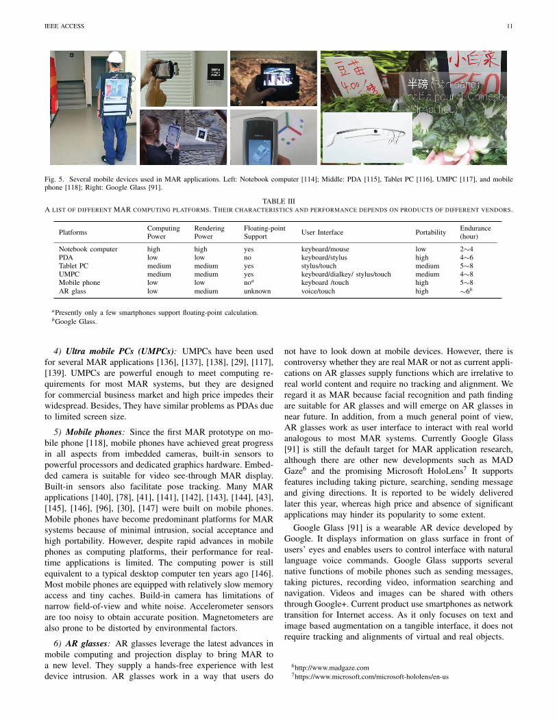
1) Notebook computers: Notebook computers were usuallyused in early MAR prototypes [121], [40], [122] as back-pack computing platforms. Comparing to consumable desktopcomputers, notebook computers are more flexible to takealongside. However, size and weight is still the hurdle forwide acceptance by most users. Since notebook computers areconfigured as backpack setup, additional display devices suchas head mounted displays (HMDs) are required for display.Notebook screen is only used for profiling and debugging.
2) Personal Digital Assistants (PDAs): PDAs were analternative to notebook computers before emergence of otheradvanced handheld PCs. Several MAR applications [123],[86], [124], [125], [126], [127], [128] configured PDAs asmobile computing platforms, while others [129], [130], [115]outsourced the CPU-intensive computations on remote serversto shrink PDAs as thin clients for interaction and displayonly. PDAs have problem of poor computational capabilityand absence of floating-point support. Small screen also limitsthe view angle and display resolution.
3) Tablet personal computers (Tablet PCs): Tablet PC is apersonal mobile computer product running Windows operatingsystems. Large screen size and multi-touch technology facil-itate content display and interactive operations. Many MARsystems [131], [132], [133], [53], [134], [135] were built onTablet PCs. In addition to expensive cost, Tablet PCs are alsotoo heavyweight for long-time single-handed hold.[124]
IEEE ACCESS 11
Fig. 5. Several mobile devices used in MAR applications. Left: Notebook computer [114]; Middle: PDA [115], Tablet PC [116], UMPC [117], and mobilephone [118]; Right: Google Glass [91].
TABLE IIIA LIST OF DIFFERENT MAR COMPUTING PLATFORMS. THEIR CHARACTERISTICS AND PERFORMANCE DEPENDS ON PRODUCTS OF DIFFERENT VENDORS.
Platforms ComputingPower
RenderingPower
Floating-pointSupport User Interface Portability Endurance
(hour)
Notebook computer high high yes keyboard/mouse low 2∼4PDA low low no keyboard/stylus high 4∼6Tablet PC medium medium yes stylus/touch medium 5∼8UMPC medium medium yes keyboard/dialkey/ stylus/touch medium 4∼8Mobile phone low low noa keyboard /touch high 5∼8AR glass low medium unknown voice/touch high ∼6b
aPresently only a few smartphones support floating-point calculation.bGoogle Glass.
4) Ultra mobile PCs (UMPCs): UMPCs have been usedfor several MAR applications [136], [137], [138], [29], [117],[139]. UMPCs are powerful enough to meet computing re-quirements for most MAR systems, but they are designedfor commercial business market and high price impedes theirwidespread. Besides, They have similar problems as PDAs dueto limited screen size.
5) Mobile phones: Since the first MAR prototype on mo-bile phone [118], mobile phones have achieved great progressin all aspects from imbedded cameras, built-in sensors topowerful processors and dedicated graphics hardware. Embed-ded camera is suitable for video see-through MAR display.Built-in sensors also facilitate pose tracking. Many MARapplications [140], [78], [41], [141], [142], [143], [144], [43],[145], [146], [96], [30], [147] were built on mobile phones.Mobile phones have become predominant platforms for MARsystems because of minimal intrusion, social acceptance andhigh portability. However, despite rapid advances in mobilephones as computing platforms, their performance for real-time applications is limited. The computing power is stillequivalent to a typical desktop computer ten years ago [146].Most mobile phones are equipped with relatively slow memoryaccess and tiny caches. Build-in camera has limitations ofnarrow field-of-view and white noise. Accelerometer sensorsare too noisy to obtain accurate position. Magnetometers arealso prone to be distorted by environmental factors.
6) AR glasses: AR glasses leverage the latest advances inmobile computing and projection display to bring MAR toa new level. They supply a hands-free experience with lestdevice intrusion. AR glasses work in a way that users do
not have to look down at mobile devices. However, there iscontroversy whether they are real MAR or not as current appli-cations on AR glasses supply functions which are irrelative toreal world content and require no tracking and alignment. Weregard it as MAR because facial recognition and path findingare suitable for AR glasses and will emerge on AR glasses innear future. In addition, from a much general point of view,AR glasses work as user interface to interact with real worldanalogous to most MAR systems. Currently Google Glass[91] is still the default target for MAR application research,although there are other new developments such as MADGaze6 and the promising Microsoft HoloLens7 It supportsfeatures including taking picture, searching, sending messageand giving directions. It is reported to be widely deliveredlater this year, whereas high price and absence of significantapplications may hinder its popularity to some extent.
Google Glass [91] is a wearable AR device developed byGoogle. It displays information on glass surface in front ofusers’ eyes and enables users to control interface with naturallanguage voice commands. Google Glass supports severalnative functions of mobile phones such as sending messages,taking pictures, recording video, information searching andnavigation. Videos and images can be shared with othersthrough Google+. Current product use smartphones as networktransition for Internet access. As it only focuses on text andimage based augmentation on a tangible interface, it does notrequire tracking and alignments of virtual and real objects.
6http://www.madgaze.com7https://www.microsoft.com/microsoft-hololens/en-us

IEEE ACCESS 12
Figure 5 shows some typical mobile devices used in MARapplications. Since most computing platforms are not designedfor MAR use, specific tradeoffs between size, weight, com-puting capability and cost are made for different users andmarkets. Table III compares mobile platforms in terms offeatures that may concern.
B. Software Frameworks
It is complicated and time-consuming to build a MARsystem from scratch. Many software frameworks have beendeveloped to help developers focus on high-level applicationsother than low-level implementations. In this section we dis-cuss a representative subset of the existing frameworks andwe present them collectively in Table IV.
1) Studierstube ES: Studierstube [72] was developed bythe Institute of Computer Graphics in Vienna University ofTechnology. Reitmayr and Schmalstieg migrated it to mo-bile platforms as a sub-branch Studierstube ES [148], [149].Studierstube ES was rewritten from scratch to leverage newlygraphics APIs for better rendering capability. The system sup-port various display devices and input interfaces. It use Open-Tracker [150] to abstract tracking devices and their relations. Anetwork module Muddleware [151] was developed to offer fastclient-server communication services. A high-level descriptionlanguage Augmented Presentation and Interaction Language(APRL) [77] was also provided to author MAR presentationindependent of specific applications and hardware platforms.Many MAR applications and prototypes [124], [127], [53],[143], [147] were developed with Studierstube ES. Withabout two-decade persistent development and maintenance, itbecame one of most successful MAR frameworks. CurrentlyStudierstube ES is only available for Windows phones andAndroid platforms.
2) Wikitude [93]: is a LBS-based AR browser to augmentinformation on mobile phones. It is referred as “AR browser”due to its characteristic of augmentation with web-basedinformation. Wikitude overlays text and image information oncurrent view when users point their mobile phones to geo-located sites. Wikitude combines GPS and digital compasssensors to track pose tracking. Contents are organized in KMLand ARML formats to support geographic annotation andvisualization. Users can also register custom web services toget specific information.
3) Nexus: Nexus [152] was developed by University ofStuttgart as a basis for mobile location-aware applications.It supported spatial modeling, network communication andvirtual information representation. The architecture was struc-tured in three layers [153], which were used for client de-vices abstraction, information uniform presentation and basicfunction wrapper. A hierarchical class schema was dedicatedto prepresent different data objects. It supported both localand distributed data management to offer uniform access toreal and virtual objects. An adaptive module was developedto ensure the scalability in different application scenarios.Nexus prevailed over other platforms in terms of stability andportability.
4) UMAR: UMAR [140] was a conceptual software frame-work based on client-server architecture. It was delicatelydesigned to perform as much as possible on the client sideto reduce data traffic and over-dependence on network in-frastructure. UMAR imported ARToolkit [154] onto mobilephones for visual tracking. A camera calibration module wasalso integrated to boost accuracy. UMAR was only available tothe Symbian platform. Besides, it did not support collaborativeMAR applications.
5) Tinmith-evo5: Tinmith-evo5 [155], [156] was an object-oriented software framework developed by Wearable Com-puter Lab at the University of South Australia. Data flow wasdivided into serial layers with sensor data as input and displaydevice as output. All objects in the system were allocated in anobject repository to support distributed, persistent storage andrun-time configuration. Render system was based on OpenGLand designed to support hardware acceleration. Several MARapplications and games [157], [39], [76] were developed withTinmith-evo5.
6) DWARF: DWARF [158], [159], [160] was a reconfig-urable distributed framework. A task flow engine was designedto manage a sequence of operations that cooperated to finishuser tasks. The Common Object Request Broker Architecture(CORBA) was used to construct a peer-to-peer communicationinfrastructure and manage nodes servers. It was also employedto create wrappers for third-party components. A visual moni-toring and debugging tool was developed for fast prototyping.DWARF has been used to create several MAR applicationsincluding Pathfinder [158], FIXIT for machine maintenanceand SHEEP for collaborative game [160].
7) KHARMA: KHARMA [161] was developed by GVU ofGeorgia Institute of Technology. It was an open architecturebased on KML, a type of XML for geo-referenced multimediadescription, to leverage ready-to-use protocols and contentdelivery pipelines for geospatial and relative referencing. Theframework contained three major components: channel serverto deliver multiple individual channels for virtual content,tracking server to provide location-related information andinfrastructure server to deliver information about real world.Irizarry et al. [97] developed InfoSPOT system based onKHARMA to access building information. KHARMA sup-ported hybrid multiple sources tracking to increase accuracy,but it was only suitable for geospatial MAR applications.
8) ALVAR: ALVAR [123] was a client-server based soft-ware platform developed by VTT Technical Research Centerof Finland. Virtual contents rendering and pose calculationcould be outsourced to server to leverage powerful computingand rendering capabilities. Images were then sent back toclient and overlaid onto captured images on client for display.It offered high-level tools and methods for AR/MAR develop-ments such as cameral calibration, Kalman filters and markershiding. ALVAR supported both marker and markerless basedtracking as well as multiple markers for pose detection. It wasdesigned to be flexible and independent of any graphical andother third-part libraries except for OpenCV, so it could beeasily integrated into any other applications. ALVAR was usedto construct various MAR applications such as maintenance[164], plant lifetime management [165] and retail [166].
IEEE ACCESS 13
TABLE IVCOMPARISONS OF DIFFERENT MAR SOFTWARE FRAMEWORKS
Software ProgrammingLanguage Rendering Language Auxiliary Tools Tracking & Positioning Device Support
StudierstubeES C++ OpenGL/ES Authoring tools (APRIL) ARToolkitPlus [162] Windows phone / Android
Wikitude HTML& Javascript Unity 3D Cross-platform
deploymentWindows phone / Android/ iOS
Nexus unknown unknown AR language (AWML) external sensor system Portable computers /handheld devices
UMAR Web scripts OpenGL ESa no ARToolkit [154] Symbian mobile devicesTinmith-evo5 C++ OpenGL no OpenTracker [150] Portable computer
DWARF C++ / Java VRML/ OpenGL Profiling/debugging tools self-contained Portable computers / PDA
KHARMA KML&Web scripts OpenGL ES Authoring tools (KML) GeoSpots [161] handheld devices
ALVAR C++ third-party graphical libs camera calibration, basicfilters ARToolkit [154] Portable computers /
handheld devicesCloudRidAR C++ third-party graphical libs no OpenCV AndroidARTiFICe C# & C++ Unity 3D multiuser support Kinect Android & iOS
AndAR Java OpenGL no ARToolkit [154] AndroidDroidAR Java OpenGL no self-contained Android
GRATF C] Direct3D Prototyping /debuggingtools glyph recognition [163] unknown
aIt is uncovered in current version, but it is reported to be OpenGL ES in next version.
9) CloudRidAR: CloudRidAR is a cloud-based architecturefor MAR [167] in order to help developers in the heavy taskof designing an AR system. In cases of low requirementsfor rendering the AR content, CloudRidAR provides a localrendering engine,; for large-scale scenarios there is a cloudrendering subsystem. The user interaction is parametrized inthe local device and upload to the cloud.
10) ARTiFICe: ARTiFICe [168] is a powerful softwareframework to develop collaborative and distributed MARapplications. The application allows collaboration betweenmultiple users, either by focusing their mobile device to thesame physical area, or showing on the device the same ARcontent on different physical scenarios. ARTiFICe can beimplemented seamlessly in several platforms such as mobile,desktop and immersive systems, which provides 6DOF-inputdevices.
11) Open source frameworks: Besides efforts from aca-demic laboratories, there are several open source frameworksfrom developer communities. AndAR [169] is an open projectto enable MAR on Android platforms. The project is stillat its early age and it is only tested on very few mobilephones. DroidAR [170] is similar to AndAR but supports bothlocation-based MAR and marker-based MAR applications.GRATF [171] is glyph recognition and tracing framework.It provides functions of localization, recognition and poseestimation of optical glyphs in static images and video files.Most open source frameworks are still under development.
Table IV gives a comparison of several software frame-works. An ideal software framework should be highly reusableand independent of hardware components and applications. Itshould be used for various scenarios without reprogrammingand modifications. Current frameworks are far from satisfac-tory for the requirements. It is difficult to abstract all hardware
components with a uniform presentation, not to mention thathardware is developing.
C. Display1) Optical See-through Display: In optical see-through
display, virtual contents are projected onto interface to opti-cally mix with real scene. It requires the interface to be semi-transparent and semi-reflexive so that both real and virtualscenes can be seen. A head tracker is used to obtain users’positions and orientations for content alignment. Optical see-through display was used in early MAR applications [172], [2].It enables users to watch real world with their natural senseof vision without scene distortion. The major problem is thatit blocks the amount of light rays from real world and reduceslight. Besides, it is difficult to distinguish virtual contents fromreal world when background environment is too bright.
2) Video See-through Display: Video see-through displayhas two work modalities. One is to use HMD devices toreplace user eyes with head-mounted video cameras to capturereal world scene. Captured video is blended with computer-generated content and then sent to HMD screen for display. Ahead tracker is used to get users position and orientation. Thismode is similar to optical see-through display and has beenused in early MAR applications [173], [40], [118]. The othermode works with camera and screen in handheld devices. Ituses the embedded cameras to capture live video and blendthe video with virtual information before displaying it onthe screen. This mode is predominant in applications withhandheld devices. The former mode obtains better immer-sion experience at the cost of less mobility and portability.Compared to optical see-through display, mixed contents areless affected by surrounding conditions in video see-throughdisplay, but it has problems of latency and limited videoresolution.

IEEE ACCESS 14
Fig. 6. Several display ways in MAR. Optical see-through display (Left): SonyGlasstron LDI-D100B and MicroOptical Clip-on; Video see-through display(Middle): two camera mounted HMD of UNC, mobile phone [88] and PDA[53]; Surface project display (Right): mobile camera projector [174] and laserprojector [175].
3) Surface Projection Display: Projection display is notsuitable for MAR systems due to its consumable volume andhigh power requirements. With recent progress of projectorsin miniaturization and low power consumption, projectiondisplay finds its new way in MAR applications. Surfaceprojection displays virtual contents on real object surfacerather than display mixed contents on a specific interface. Anyobject surface, such as wall, paper and even human palm,can be used as interface for display. It is able to generateimpressive visual results if real surface and virtual contentsare delicately arranged. Pico-projectors have already been usedin several MAR applications [174], [176]. Laser projector,a variation of traditional projector, has been exploited forspatial AR (SAR) applications [175]. It has many advantagesincluding self-calibration, high brightness and infinite focallength. Since virtual information is projected to any arbitrarysurface, surface projection display requires additional imagedistortion to match real and virtual projectors for contentalignment [177].
Figure 6 illustrates several display devices for MAR. Jan-nick et al. [178] gave a detailed comparison of HMD-basedoptical and video see-through displays in terms of field ofview, latency, resolution limitation and social acceptance.Optical see-through display is not often used in recent MARapplications due to sophisticated requirement of projectors anddisplay devices, whereas Google Glass [91] proves that it isalso suitable for wearable and MAR systems with micro laserprojector.
V. TRACKING AND REGISTRATION
Tracking and registration is the process to evaluate currentpose information so as to align virtual content with physicalobjects in real world. There are two types of tracking and regis-tration: sensor-based and vision-based. Sensor-based methodsemploy inertial and electromagnetic fields, ultrasonic and radiowave measure and calculate pose information; vision-basedmethods estimate gesture information from point correspon-
dent relationships of markers and features from capturedimages or videos.
A. Sensor-based Methods
According to work modalities, sensor-based methods can bedivided into inertial, magnetic, electromagnetic and ultrasoniccategories. For simplification, we also categorize inferred-based tracking as a type of electromagnetic method in thispaper.
1) Inertial-based: Many inertial sensors output accelera-tion, which is integrated twice over time to obtain positionand angle. Inertial-based method is able to work under mostconditions without range limitation or shielding problem.Many MAR applications [23], [179], [180], [181], [87] useinertial sensors to get user pose information. It has problem ofrapid propagation of drift due to double integration and jittersfrom external interference. Several methods have been pro-posed to improve accuracy. For example, jitter was suppressedwith complementary Kalman filter [182]. In [183], drift errorwas minimized by taking relative measurements rather thanabsolute measurements.The method required a periodic re-calibration and prior knowledge of initial state to get absolutepose in a global reference frame.
2) Magnetic-based: Magnetic tracking uses earth magneticfield to get orientation. It combines with other position track-ing methods to obtain six degree of freedom (6DOF). ManyMAR applications [2], [184], [185], [186] use it to track ori-entation. Magnetic-based method has problem of interferenceby ambient electromagnetic fields. It is apt to be distorted insurroundings full of metal shields such as steel and concreteskeletons. Chung et al. [187] employed a server that containedmagnetic fingerprint map to improve accuracy at indoor area.Sun et al. [188] aggregated ceiling pictures as orientationreferences to correct original outputs. The method achieved3.5 times accurate improvement. As it required ceiling patternsfor tracking, the method was only suitable for indoor use.
3) Electromagnetic-based: Electromagnetic methods trackposition based on time of arrival (TOA), received signalstrength indicator (RSSI) or phase difference of electromag-netic signals. There are several electromagnetic-based track-ing methods in MAR field. GPS method is widely used innumerous outdoor MAR applications, but it has problem ofsingle shielding in urban canyons and indoor environments.Besides, plain GPS is too coarse to use for accurate tracking.Some works used differential GPS [25], [173] and real-timekinematic (RTK) GPS [23] to improve accuracy but theyrequire locations of base stations. Sen et al. [189] leveraged thedifference of Wi-Fi signal attenuation blocked by human bodyto estimate position. It required communication parametersand wireless maps beforehand. Wi-Fi tracking has problemof poor accuracy and tedious offline training to constructwireless map [8].Ultra Wideband (UWB) is able to obtaincentimeter-level accurate results. It has been used in manysystems [121], [190], [191], [192]. The method has drawbacksof high initial implementation cost and low performance.Radio Frequency Identification (RFID) depends on responsebetween RFID readers and RFID tags for tracking [193],
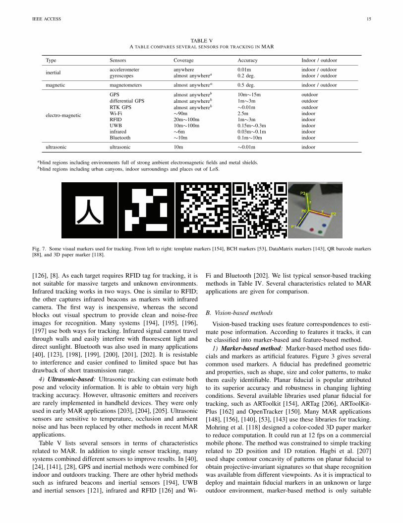
IEEE ACCESS 15
TABLE VA TABLE COMPARES SEVERAL SENSORS FOR TRACKING IN MAR
Type Sensors Coverage Accuracy Indoor / outdoor
inertial accelerometer anywhere 0.01m indoor / outdoorgyroscopes almost anywherea 0.2 deg. indoor / outdoor
magnetic magnetometers almost anywherea 0.5 deg. indoor / outdoor
electro-magnetic
GPS almost anywhereb 10m∼15m outdoordifferential GPS almost anywhereb 1m∼3m outdoorRTK GPS almost anywhereb ∼0.01m outdoorWi-Fi ∼90m 2.5m indoorRFID 20m∼100m 1m∼3m indoorUWB 10m∼100m 0.15m∼0.3m indoorinfrared ∼6m 0.03m∼0.1m indoorBluetooth ∼10m 0.1m∼10m indoor
ultrasonic ultrasonic 10m ∼0.01m indoor
ablind regions including environments full of strong ambient electromagnetic fields and metal shields.bblind regions including urban canyons, indoor surroundings and places out of LoS.
Fig. 7. Some visual markers used for tracking. From left to right: template markers [154], BCH markers [53], DataMatrix markers [143], QR barcode markers[88], and 3D paper marker [118].
[126], [8]. As each target requires RFID tag for tracking, it isnot suitable for massive targets and unknown environments.Infrared tracking works in two ways. One is similar to RFID;the other captures infrared beacons as markers with infraredcamera. The first way is inexpensive, whereas the secondblocks out visual spectrum to provide clean and noise-freeimages for recognition. Many systems [194], [195], [196],[197] use both ways for tracking. Infrared signal cannot travelthrough walls and easily interfere with fluorescent light anddirect sunlight. Bluetooth was also used in many applications[40], [123], [198], [199], [200], [201], [202]. It is resistableto interference and easier confined to limited space but hasdrawback of short transmission range.
4) Ultrasonic-based: Ultrasonic tracking can estimate bothpose and velocity information. It is able to obtain very hightracking accuracy. However, ultrasonic emitters and receiversare rarely implemented in handheld devices. They were onlyused in early MAR applications [203], [204], [205]. Ultrasonicsensors are sensitive to temperature, occlusion and ambientnoise and has been replaced by other methods in recent MARapplications.
Table V lists several sensors in terms of characteristicsrelated to MAR. In addition to single sensor tracking, manysystems combined different sensors to improve results. In [40],[24], [141], [28], GPS and inertial methods were combined forindoor and outdoors tracking. There are other hybrid methodssuch as infrared beacons and inertial sensors [194], UWBand inertial sensors [121], infrared and RFID [126] and Wi-
Fi and Bluetooth [202]. We list typical sensor-based trackingmethods in Table IV. Several characteristics related to MARapplications are given for comparison.
B. Vision-based methods
Vision-based tracking uses feature correspondences to esti-mate pose information. According to features it tracks, it canbe classified into marker-based and feature-based method.
1) Marker-based method: Marker-based method uses fidu-cials and markers as artificial features. Figure 3 gives severalcommon used markers. A fiducial has predefined geometricand properties, such as shape, size and color patterns, to makethem easily identifiable. Planar fiducial is popular attributedto its superior accuracy and robustness in changing lightingconditions. Several available libraries used planar fiducial fortracking, such as ARToolkit [154], ARTag [206], ARToolKit-Plus [162] and OpenTracker [150]. Many MAR applications[148], [156], [140], [53], [143] use these libraries for tracking.Mohring et al. [118] designed a color-coded 3D paper markerto reduce computation. It could run at 12 fps on a commercialmobile phone. The method was constrained to simple trackingrelated to 2D position and 1D rotation. Hagbi et al. [207]used shape contour concavity of patterns on planar fiducial toobtain projective-invariant signatures so that shape recognitionwas available from different viewpoints. As it is impractical todeploy and maintain fiducial markers in an unknown or largeoutdoor environment, marker-based method is only suitable

IEEE ACCESS 16
for indoor applications. Besides, it suffers from problems ofobtrusive, monotonous and view occlusion.
2) Nature feature method: Nature feature method trackspoint and region features in image sequences to calculatecorrespondent relationships to estimate pose information. Themethod requires no prior information of environment. Theframe-by-frame tracking helps to remove mismatches anddrift errors that most sensor-based methods suffer. However,it suffers from deficiencies of image distortion, illuminationvariation and self-occlusion [208]. Besides, additional regis-tration of image sequence with real world is required to getfinally results. The major problem of nature feature methodis expensive in terms of computational overhead, which isespecially severe for MAR applications with requirement ofreal time performance on mobile devices. Many researchesfocused on performance improvement from different aspects,such as GPU acceleration, computation outsourcing and algo-rithm improvement. We focus on algorithm improvement inthis section with other two aspects in the next section.
Many robust local descriptors including SIFT [209] andSURF [210] are introduced for nature feature tracking in MARfield. Skrypnyk and Lowe [211] presented a traditional SIFT-based implementation. SIFT features were extracted offlinefrom reference images and then used to compute camerapose from live video. Fritz et al. [212] deployed an imagerydatabase on a remote server and conducted SIFT featurematching on the server to reduce computing and memoryoverhead on client mobile phones. Chen et al. [145] alsoimplemented the SURF tracking on remote server. The livevideo captured by embedded camera was streamed to serverfor tracking. The result was then retrieved back to clientside for display. Rosten et al. [213] propose a high-speedcorner detection (FAST) using machine learning techniques toimprove speed detection. However, FAST is not very robustto the presence of noise. PCA-SIFT [214] is a PrincipalComponents Analysis (PCA) SIFT variant that provides morerobust to image deformations, and compact descriptors thanbaseline SIFT; this leads to significant improvements in match-ing accuracy and speed.
Calonder et al. [215] propose to use binary strings as anefficient feature point descriptor. This descriptor similaritycan be evaluated using an efficient computing algorithm suchas Hamming distance, and provides higher recognition ratescompared to SURF. However, it is rotation and scale invariantand it is addressed in authors’ future work. Wagner et al.[216] replaced conventional Difference of Gaussians (DoGs)with FAST corner detector, 4*4 sub-regions with 3*3 sub-regions and k-d tree with multiple Spill Trees to reduceSIFT computation. The reduced SIFT was self-contained andtracked 6DOF at 20Hz frame rate on mobile phones. Takacset al. [217] identified new contents in image sequences andconducted feature extraction and database access only whennew contents appeared. They further proposed a optimizationscheme [144] to decrease feature matching by rejecting ir-relevant candidates according to location information. Onlydata from nearby location cells were considered. They furtherdeveloped a feature clustering and pruning strategy to elimi-nate redundant information. It reduced both computation and
bandwidth requirements.An entropy-based compression scheme was used to en-
code SURF descriptors 7 times faster. Their method run35% faster with only half memory consumption. Chen etal. [218] used integral image for Haar transformation toimprove SURF computational efficiency. A Gaussian filterlookup table and an efficient arctan approximation were usedto reduce floating-point computation. The method achievedperformance improvement of 30% speedup. Ta et al. [219]proposed a space-space image pyramid structure to reducesearch space of interest points. It obtained real-time objectrecognition and tracking with SURF algorithm. In order tospeed up database querying, images were organized based onspatial relationships and only related subsets were selected formatching. The method obtained 5 times speedup comparedto original SURF and it took less than 0.1s on Nokia N95mobile phones. Wagner et al. [220] proposed a multiple targettracking and detection method on mobile phones. It separatedtarget detection and tracking so that target tracking run at fullframe rate and created a mask to guide detector to look fornew target. To further reduce calculations, they assumed thatlocal area around positive matched key points were visible incamera images and uncovered regions were ignored during keypoint detection. The method was able to track 6 planar targetssimultaneously at a rate of 23 fps on an Asus P565 Windowsmobile phone. Wagner et al. [221] propose three approachesfor 6DOF natural language feature tracking for MAR in real-time systems. The authors perform a performance analysisusing different feature extraction approaches such as SIFT(PhonySIFT) and Ferns-based (PhonyFern, and PathTrackerthat instead of tracking-by-detection it takes advantage of thecamera and scene position difference between two succesivesframes to predict the feature positions.
ORB [222] solves the rotation invariant issues of BRIEFand it is resistant to noise offering better performance thanSIFT and BRIEF. BRISK [223] provides a novel method forkey point detection, description and matching with lower com-putational cost in comparison with SIFT, SURF, and BRIEF.It can be used in task with hard real-time constrains keepingthe overall performance with previous mentioned methods. Liet al. [224] quantized a small number of random projectionsof SIFT features and sent them to the server, which returnedmeta-data corresponding to the queried image by using anearest neighbor search in the random projection space. Themethod achieved retrieval accuracy up to 95% with only 2.5kBdata transmission. Park et al. [225] optimized original featuretracking process from various aspects. Since stable features didnot lose tracking until they were out of view, there was no needto extract them from each frame. Feature point number wasalso limited to 20 to reduce computation. A feature predictionexcluded feature points that would disappear and added newfeatures that may appear after a period of time. It achievedruntime performance of 35ms per frame, about 7 times fasterthan original method.
ALIEN is a feature extraction and tracking method based onlocal features invariant under occlusion [226]. This algorithmcan be very useful in MAR applications to provide a realisticexperience in situations of object occlusion, and offer better

IEEE ACCESS 17
performance, in most of the situations, than its competitors[227], [228], [229], [230], [231], [232], and [233]. In [234],the authors use two LED as fiducial markers for tracking ona hand-held device, together with the inertial sensors of thedevice, it can provide 6DoF pose estimation. This proposedmethod can improve the visualization of virtual objects in theMAR systems, and improve the AR experience; as it providestracking of the mobile device (i.e., 6DoF position). DeCAF isa deep convolutional network open source implementation forgeneric tasks [235]. DeCAF (precursor of Caffe) outperformsthe baseline SURF implementation in all of authors’ experi-ments, and opens new feature extraction possibilities for deepneural networks in the future.
Convolutional Neural Networks (CNN) are very powerfulfor feature extraction as recent results indicate, [236]. In thispaper, authors use an existing model for object classification(OverFeat) to perform feature extraction tasks. The experimentresults show that although OverFeat was originally designedto perform object classification, it is a strong competitor forother visualization task such as feature extraction against othermethods: SIFT, Bag of Words (BoW), Histogram of Gradients(HOG). Caffe is a BSD-licensed C++ library with Python andMatlab bindings [20]. Caffe provides a deep neural networkframework for vision, speech and multimedia large-scale orresearch projects. It provides a big step forward in objectclassification and feature extraction performance. Besides,there are current some ports to use Caffe models in the mobileenvironment such as Caffe Android library [237], and CNNlibrary [238]. Dollar et al. [19] introduce a novel efficientschema for computing feature pyramids (fast feature pyramid).Finely pyramids sampling of features of an image can improvethe feature detection methods at higher computation costs. Theproposed algorithm can improve significantly the speed andperformance of current object and feature detection methods,decreasing the computational cost of current pyramidal meth-ods substantially. This paper [21] propose a Fast Region-basedCNN for object detection. Object detection is slow in CNNand R-CNN approaches because features are extracted in realtime from each region proposal and the training is an expensivetask in time and space.
Fast R-CNN uses Caffe framework and implements severalinnovative methods to improve training/testing speed andaccuracy. YOLO9000 [22] is a state of the art real-timeobject detection system. The system can detect over 9000categories outperforming previous R-CNN, Faster R-CNNmethods. YOLO9000 framework closes the big gap that existsbetween object detection and classification providing objectdetection and classification system in real-time. The authorsuse WordTree to merge data from different sources and trainsimultaneously.
C. Hybrid Tracking Methods
Each individual method has its advantages and limitations.A better solution is to overcome inherent limitations of indi-vidual method by combining different methods together. Forinstance, inertial sensors are fast and robust under drastic rapidmotion. We can couple it with vision-based tracking to provide
accurate priors under fast movements. Behringer et al. [239]proposed a hybrid tracking algorithm to estimate the optimal3D motion vector from displacements of 2D image features.The hybrid method employed GPS and digital compass toobtain an approximate initial position and orientation. Avision tracking then calculated camera pose by predicting newfeatures in perspective projection of environmental models. Itobtained a visual tracking precision of 0.5o and was able toworked under a maximal rotation motion of 40o/s.
Jiang et al. [240] used gyroscope to predict orientationand image line positions. The drift was compensated by aline-based vision tracking method. A heuristic control systemwas integrated to guarantee system robustness by reducingre-projection error to less than 5 pixels after a long-timeoperation. Hu and Uchimura [241] developed a parameterizedmodel-matching (PMM) algorithm to fuse data from GPS,3D inertial gyroscope and vision tracking. Inertial sensor wasused to evaluate initial motion and stabilize pose output.The method obtained convincing precise and robust results.Reitmayr and Drummond [125] combined vision tracking withgyroscope to get accurate results in real time. Vision trackerwas used for localization and gyroscope for fast motion. AKalman filter was used to fuse both measurements. Honkamaaet al. [242] used GPS position information to download GoogleEarth KML models, which were aligned to real world usingcamera pose estimation from feature tracking. The methodstrongly depended on the access to models on Google server.
Paucher and Turk [146] combined GPS, accelerator andmagnetometer to estimate camera pose information. Imagesout of current view were discarded to reduce database search.A SURF algorithm was then used to match candidate imagesand live video to refine pose information. Langlotz et al.[147] used inertial and magnetic sensors to obtain absoluteorientation, and GPS for current user position. A panorama-based visual tracking was then fused with sensor data by usinga Kalman filter to improve accuracy and robustness.
Sensor-based method works in an open loop way. Trackingerror can not be evaluated and used for further correction.Besides, it suffers from deficiencies of shielding, noise andinterference. Vision-based method employs tracking result asfeedback to correct error dynamically. It is analogous toclosed loop system. However, tracking accuracy is sensitiveto view occlusion, clutter and large variation in environmentconditions. Besides, single feature-based method is prone toresult inconsistence[97]. Hybrid tracking requires fusion [241],[125], [182], [147] of results from different sources. Whichmethod to use depends on accuracy and granularity requiredfor a specific application scenario. For instance, we can acceptsome tracking error if we annotate the rough outlines of abuilding, whereas more accurate result is required to pinpointa particular window in the building.
VI. NETWORK CONNECTIVITY
We investigate wireless networks for pose tracking in pre-vious section, but they are also widely used for communi-cation and data transmission in MAR. As fast progresses inwireless network technologies and infrastructure investments,

IEEE ACCESS 18
TABLE VIA TABLE COMPARING DIFFERENT TYPES OF WIRELESS NETWORKS FOR MAR APPLICATIONS
Type Technology Coverage Bandwidth(bps) Latency(ms) Power(mw)
WWAN
GSM ∼35km 60K high 1000∼2000CDMA 12km∼50km 384K high 200∼100GPRS ∼10km 56K∼114K high ∼1000UMTS 1km∼2km 2M medium ∼250LTE 5km∼100 kma 5∼50M low ∼ 500
WLAN Wi-Fi ∼90m 11M∼54M low ∼100MIMO ∼100m 300M medium unknown
WPANUWB 10m∼100m 20M∼1G low 20∼1000Bluetooth ∼10m 1M∼3M medium 1∼2.5ZigBee ∼75m 20K∼250K low 1∼100
aDepending on the frequency band and the topography the coverage radius changes. Low frequency bands are used in rural areas and have higher bandwidthbut smaller coverage (5 km) while the so called macrocells have coverage radius of around 100 km and only acceptable perfomance.
TABLE VIINETWORKING NEEDS AND LIMITATIONS IN MAR APPLICATIONS
Visual Input Single HD Streaming Uncompressed Video/Model
Latency 10 msa 1 ∼ 10 msJitter <1 ms <1 ms
Throughput 6 MBps 1 GBps
aAll the values of this table are based on the report of the secondNSF Workshop on achieving ultra-low latencies in wireless networks. url:http://inlab.lab.asu.edu/nsf/
numerous systems were built on client-server architectureby leveraging wireless networks for communication. Mobiledevices have various network interfaces and can be connectedwith a remote server either via a cellular network or usingWiFi. Wearable devices usually do not have network interfacedthat can be connected directly to the Web but they havebluetooth and can be connected to a companion device.
We can try to estimate the maximum amount of data toprocess per second for a video feed, i.e. to the maximumexpected bandwidth required for the heaviest AR applications.Several studies suggest that the human eye transmits around6 to 10 Mb/s to the brain by taking into account that accuratedata is available only for the central region of the retina(a circle whose diameter is 2 degrees in the visual field).However, most MAR hardware do not provide proper eyetracking system that would permit to isolate this area onvideo frames. Therefore, full frames have to be processed.If we consider that a smartphone’s camera’s field of view isbetween 60 to 70 degrees, a rough estimate of the amountof data to transmit is around 9 to 12 Gb/s. Of course, thisestimate represents the upper limit of raw data that couldbe generated per second. Even though this amount can bedrastically reduced (compression, selection of specific areasetc.), we can expect some applications to generate severalhundreds of megabits per second, or even gigabits per second.Table VII present the networking needs and limitations ofMAR applications.
Regarding the latency requirements, although to the bestof our knowledge there is no empirical academic study onthe impact of delays for Augmented Reality, several studies
measure latency for various offloading scenarios in MARsystems [243], [13], [244]. As a first reference, we can con-sider the recommended end-to-end one way delays for otherreal-time applications. Those values revolve around 100ms,depending on the application, going as low as 75ms foronline gaming, while reaching 250ms for telemetry [245].However, due to several problems such as the alignment ofthe virtual layer on the physical world, we can expect thata seamless experience would be characterized by way lowerlatencies. Michael Abrash, Chief Scientist at Occulus VR, evenargues that augmented reality (AR) and virtual reality (VR)games should rely on latencies under 20ms, with a ?holygrail” around 7ms in order to preserve the integrity of thevirtual environment and prevent phenomenons such as motionsickness [246].
There exist several specifically designed platforms permitto perform offloading for AR operations. Most of them tryto combine on-device operation with offloaded procedures.As those frameworks are often dealing with 3/4G networks,which are characterized by a high cost of use as well as abruptchanges in bandwidth and latencies, they try to circumscribenetwork usage to the most computation intensive operations.For instance, CloudRidAR [14] performs feature extractionfrom the video flow. Those features are then transmitted to theserver instead of full pictures. More recently, Glimpse [247]even improves network efficiency by performing local trackingof objects, which allows to send only a select amount of framesto the server.
There are three major wireless networks used in MARapplications:
1) Wireless Wide Area Network (WWAN): WWAN issuitable for applications with large-scale mobility. There aremassive WWAN implementations based on different technolo-gies including 2G GSM and CDMA, 2.5G GPRS, 3G UMTSand 4G LTE. Higher generation network usually has muchwider bandwidth and shorter latency than lower generationnetwork. Many MAR applications [140], [28], [144], [29],[248]used WWAN for data transition and communications.One problem of WWAN is high cost of initial infrastructuresinvestment. Besides, networks supplied by different providersare incompatible and users usually have to manually switch
IEEE ACCESS 19
different networks. However, WWAN is still the most popular,sometimes the only, solution for MAR communication as it isthe only available technology for wide public environments atpresent.
2) Wireless Local Area Network (WLAN): WLAN worksin a much smaller scope but with higher bandwidth and lowerlatency. Wi-Fi and MIMO are two typical WLANs. WLANhas become popular and is suitable for indoor applications.Many MAR applications [173], [24], [124], [145] were builton WLAN based architecture. However, limited coverage mayconstrain it be used in wide public environments.
3) Wireless Personal Area Network (WPAN): WPAN isdesigned to interconnect devices, such as mobile phones,PDAs and computers, centered around individual workspace.There are many WPAN implementations including Bluetooth,ZigBee and UWB. Bluetooth and ZigBee are usually usedfor position tracking and data transmission [78], [41], [53],[174], whereas UWB is major for tracking. WPAN has manyadvantages including small volume, low power consumptionand high bandwidth, but it is not suitable for application withwide whereabouts.
Table VI gives comparison of several wireless networksused in MAR applications. All technologies have their draw-backs. We can leverage advantages of different networks toimprove performance if multiple wireless networks overlap.However, it requires manually switching between differentnetworks. [249] proposed a wireless overlay network conceptto choice the most appropriate available networks for use. Itwas totally transparent for applications and users to switchbetween different networks.
VII. DATA MANAGEMENT
Any practical MAR application requires efficient data man-agement to acquire, organize and store large quantities of data.It is nature to design dedicated data management for specifiedapplications, but it can not be reused and scaled for otherapplications. We require more flexible strategies to presentand manage data source so as to make it available for differentapplications.
A. Data AcquisitionMAR requires a dataset model of user environment which
includs geometrical models and semantic description. Manyapplications create such model manually, whereas scaling itto a wide region is impractical. Data conversion from legacygeographic databases, such as GIS, is a convenient approach.Reitmayr and schmalstieg [173] extracted geographic informa-tion from a network of routes for pedestrians. Schmalstieg etal. [28] extracted footprints information of buildings from 2DGIS database. Some works constructed environmental modelfrom architectural plans. Hollerer [24] created building struc-tures from 2D map outlines of Columbia campus. As legacydatabase normally does not contain all necessary information,the method requires knowledge from other fields to completemodeling.
Field Survey with telemetry tools is also widely used toobtain environmental geometry data. Joseph et al. [250] devel-oped a semi-automatic survey system by using fiducial markers
to guide a robot for measurement, based on which Schmalstieg[28] employed Leica Total Station TPS700 theodolite to scanindoor structure of buildings. The cloud point results wereloaded into a view editor for manual construction of floors,walls and other elements. They further used a robot for sur-veying automatically. Output cloud points could be convertedinto DFX format using software packages, which was friendlyto 3D applications. Results from measurement are prone toinaccuracy and noise. Besides, discrete cloud points requireinterpolation to rebuild cartographic presentation.
Many MAR browsers [92], [93] concerned location-basedservices augmented with web information. They used geo-location information, images and QR markers to search cor-related contents through Internet. Results were retrieved andoverlaid on current view on mobile phones. Recent productsincluding Google Earth and Semapedia offer geo-referencedgeometry data through community efforts, which are easyto access through Internet. Hossmann et al. [251] developedapplication to gather environmental data through users reportof their current activities. The environmental data coverageexplodes as users increase.
B. Data Modeling
MAR Applications potentially do not access the sameabstraction or presentation of dataset even with the sameresource. Besides, it is difficult to guarantee presentationconsistency if any change cannot be traced back to the orig-inal resource. High-level data model is required to decoupleunderlying resource from upper logic changes. A data modelis a conceptual model to hide data details so as to facilitateunderstanding, representation and manipulation in a uniformmanner.
Researchers at Vienna University of Technology proposeda 3-tier [173], [28] data model. The first tier was a database.The second tier linked database and application by translatingraw data from database to specified data structure. The thirdtier was a container where all applications resided. The secondtier decoupled data from presentation so that applications didnot have to understand data details. Basic abstract types suchas ObjectType and SpatialObjectType were predefined thatapplication types could derive from. The XML object treewas interpreted in a geometrical way so that data storage andpresentation were linked and consistent. As data were modeledwith nodes, it may increase search computation for renderingengine when several information was not required.
Nicklas and Mitschang [153] also proposed a 3-layer modelincluding client device layer, federation layer and server layer.The server layer stored resource for entire system. It couldbe geographical data, users’ locations or virtual objects. Atop-level object Nexus Object was designed, from which allobjects such as sensors, spatial objects and event objects couldinherite. The federation layer provided transparent data accessto upper layer using a register mechanism. It decomposedquery from client layer and then dispatched them to registersfor information access. The federation layer guaranteed con-sistent presentation even if data servers supplied inconsistentdata. The model separated underlying data operations from
IEEE ACCESS 20
client layer, but it increased access delay due to delegationmechanism. Multiple copies of object on different serverscaused data inconsistence.
Other than traditional 3-layer structure, Tonnis [159] pro-posed a 4-layer data model. The bottom layer is a dy-namic peer-to-peer system to provide basic connectivity andcommunication services. The second layer supplied generalMAR functions such as tracking, sensor management andenvironmental presentation. The third layer contained high-level functional modules composed of sub-layer componentsto offer application related functions for top layer that di-rectly interacted with users and third-part systems. Virtualobject were represented by object identifier virtualObjectIDand their types, which were bound to a table data struc-ture object properties containing linking information. A datastructure object relations was proposed to describe objectrelationships. A special template was also used to storerepresentative information. The flat and separate data modelwas more flexible and efficient for different application andrendering requirements.
C. Data StorageSince no global data repository exists, researchers have
to build private data infrastructure for their MAR appli-cations. Hollerer et al. [23], [24] constructed a relationalcentral database to access meta-data based on client-serverarchitecture. A data replication infrastructure was appliedto distribute data to various clients. Piekarski et al. [155],[156] implemented hierarchical database storage which storedand retrieved objects using hierarchical path names similarto a file system. It used virtual directories to create andstore objects without understanding creation details. Reitmayrand Schmalstieg [114], [173] used a file system to organizeapplication data in their early implementation. As file system isefficient for unstructured dataset whereas MAR data is usuallywell structured, Schmalstieg et al. [53], [28], [143] adopted aXML database with a XML-based query strategy, which wasproven more flexible and efficient. Wagner [151] developed amiddleware named Muddleware to facilitate database access.It had a server-side state machine to respond to any databasechanges. An independent thread was dispatched to controldatabase server. Nicklas and Mitschang [153] advocated amulti-server infrastructure to decouple different data processesbut it had problem of data inconsistence as data copieswere deployed on multiple servers. Conventional databasetechnologies were also widely used to store and access variousresources in many MAR applications. In terms of massive datastorage technologies, from user’s point of view, the importantissue is how to get to the most relevant information with theleast effort and how to minimize information overload.
VIII. SYSTEM PERFORMANCE AND SUSTAINABILITY
Most MAR applications suffers from poor computing ca-pability and limited energy supply. To develop applicationsfor practical use we should consider issues of runtime per-formance and energy efficiency. From the developers’ pointof view, we should make design and development decisionsbased on careful task analysis.
A. Runtime Performance
Recent years we have witnessed great efforts to improveruntime performance for mobile applications. A speedup fromhardware, software and rendering improvements, ranging froma few times to hundreds of times, has been achieved duringthe past decade.
1) Multicore CPU parallelism: There are many off-the-shelf multicore CPU processors available for mobile devices,such as dual-core Apple A6 CPU and quad-core ARM Cortex-A9 CPU. [Softpedia09] reported that about 88% mobilephones would be equipped with multicore CPU by 2013. Mul-ticore CPU consumes less energy than single core CPU withsimilar throughput because each core works at much lowerclock frequency and voltage. Most MAR applications arecomposed of several basic tasks including camera access, posetracking, network communication and rendering. Wagner andSchmalstieg [Wagner09b] parallelized basic tasks for speedup.Since camera access was I/O bound rather than CPU bound,they run camera reading in a separate thread. Herling and Broll[Herling10] leveraged multicore CPUs to accelerate SURF onmobile phones by treating each detected feature independentlyand assigning different features to different threads. Takacs etal. [Takacs11] separated detection and tracking into differentthreads for parallelization. The system run at 7∼10 fps on a600MHz single-core CPU. Multithread technology is not pop-ular for MAR applications as computing context is much morestringent than desktop computers. CPU and other acceleratorsare integrated into single processor system-on-chip (SoC) toshare system bus. It requires intelligent scheme to schedulethreads to share data and avoid access conflict.
2) GPU Computing: Most mobile devices are nowequipped with mobile graphics processing unit (GPU). Thereare many mobile GPUs including Qualcomm SnapDragon SoCwith Adreno 225 GPU, TI OMAP5 SoC with PowerVR SGX544 and Nvidia Tegra 3 SoC with ULP GeForce. MobileGPU is developing toward programmable rendering pipeline.In order to facilitate mobile GPU programming, KhronosGroup proposed a low-level graphics programming interfacenamed OpenGL ES [252]. It supports per vertex and per pixeloperations by using vertex and pixel (or fragment) shaders,which are C-like program code snippets that run on GPUs. Theprogrammability and inherent high parallel architecture awakeresearch interests in general computing acceleration beyondgraphics rendering, namely general-purpose computing onGPU (GPGPU). However, it is complicated to program shadersas we have to map algorithms and data structure to graphicsoperations and data types. To alleviate the problem, KhronosGroup released high-level APIs named OpenCL [253]. Theyalso released the embedded profile of OpenCL for mobiledevices.
Profile results [123], [118], [82] have shown that tracking isa major performance bottleneck for most MAR applications.Many works accelerated feature tracking and recognition withGPU on mobile devices. Wutte [254] implemented SURF onhybrid CPU and GPU with OpenGL ES 2.0. Since compres-sion and search processes run on CPU, it required frequentdata transmissions between CPU and GPU. Kayombya [255]

IEEE ACCESS 21
leveraged mobile GPU to accelerate SIFT feature extractionwith OpenGL ES 2.0. They broke down the process intopixel-rate sub-process and keypoint-rate sub-process and thenprojected them as kernels for stream processing on GPU. Ittook about 0.9s to 100% match keypoint positions with animage of size 200*200. Singhal et al. [256], [257] developedseveral image processing tools including Harris corner detectorand SURF for handheld GPUs with OpenGL ES 2.0. They pre-computed neighboring texture coordinates in the vertex shaderto avoid dependent texture reading for filtering in fragmentshader. Other optimizations such as lower precision and texturecompression were used to gain further improvements. TheirGPU-based SURF implementation cost about 0.94s for imageof size 800*480, about 1.81x speedup comparing to CPUimplementation. Hofmann [258] also implemented SURF onmobile GPU with OpenGL ES 2.0. The method used mipmapsto obtain scale-aware, sub-pixel-accurate Haar wavelet sam-pling. It took about 0.4s to extract 1020 SURF-36 descriptorsfrom image of size 512*384 on mobile phones. Leskela et al.[259] conducted several image processing tests on mobile GPUwith OpenCL. The results were inspiring. However, in order tosave energy consumption, mobile GPU is designed with lowmemory bandwidth and a few stream processors (SPs) andinstruction set is also reduced.
The authors of [260] propose a parallel processing schemeusing CPU an GPU for the MAR applications. The schemeprocesses feature extraction techniques in the CPU as itwill perform better and faster; and the feature description inthe GPU. The proposed present and innovative scheme thatoutperforms CPU only and sequential CPU-GPU schemes inAR scenarios.
3) Cache Efficiency: Many mobile devices have tiny on-chip caches around CPU and GPU to reduce latency ofexternal memory access. For instance, Nvidia Tegra seriesmobile GPUs have a vertex cache for vertex fetching and apixel and a texture caches for pixel shader. The caches areconnected to a L2 cache via system bus. Memory is designedto be small to reduce energy consumption on mobile devices.Cache miss is therefore more expensive than desktop com-puters. Wagner and Schmalstieg [261] transmitted vertex datain interleaving way to improve cache efficiency. They furtheremployed vertex buffer objects (VBOs) for static meshes.Many systems leverage multithreading technologies to hidememory latency. PowerVR SGX5xx GPU [262] scheduledoperations from a pool of fragments when a fragment waitedfor texture requests. The method was effective but not energy-efficient. Besides, mobile CPU and GPU only had a few threadwraps due to power constraint, which might not hide cachemisses efficiently.
Arnau et al. [263] decoupled pixel and texture access fromfragment operations. The architecture fetched data earlier thanit would be used so as to hide cache latency when it wasused. It achieved 93% performance of a highly threaded im-plementation on desktop computer. Hofmann [258] employedmipmap technology for Haar sampling. The method obtaineda beneficial side effect of significant cache efficiency as itreduced texture fetch operations from 64 to 1. Cache optimiza-tion is usually an ad hoc solution for specified problem. For
instance, in [264], as problem dimension increased, data hadto be stored in off-chip memory as on-chip GPU cache wasnot large enough. Their method was only capable for smalldimensional problem. Performance improvement depends onboth available hardware and problem to solve. A side benefit ofcache saving is to reduce bus accesses and alleviate bandwidthtraffic.
4) Memory Bandwidth Saving: Most mobile devices adoptshare storage architecture to reduce energy consumption andcost. CPU, GPU and other processors use common systembus to share memory, which makes bandwidth scarce and busy.Besides, bandwidth is designed to be small for low energy cost.[265] reported that annual processor computational capabilitygrew by 71% whereas bandwidth only by 25%, so bandwidthis more prone to be bottleneck than computation power. Datecompression is usually used to alleviate the problem. Color,depth and stencil buffer data were compressed to reducetransmission on system bus [266], [267].
Texture is also compressed before it is stored in constantmemory. As slight degradation of image quality is acceptabledue to filter and mipmap operations during texture mapping,lossy compressions can be used to further reduce data. Mollerand Strom [268], [269] proposed a hardware rasterizationarchitecture to compress texture on mobile devices. It reducedmemory bandwidth by 53%. Singhal et al. [257] stored texturewith low precise pixel format such as RGB565, RGBA5551and RGBA444 to reduce data occupation. Wagner and Schmal-stieg [162] used native pixel format YUV12 for imagescaptured by built-in cameras to reduce image storage.
5) Rendering Improvement: 3D graphics rendering is oneof the most computational intensive tasks on mobile device.Duguet and Drettakis [270] proposed a point-based method toreduce model presentation for cheap 3D rendering on mobiledevice. They represented model mesh as hierarchical pointsand rendered parts of them according to computational powerof mobile devices. Setlur et al. [271] observed limitation ofhuman perception for unimportant objects on small displayscreen. They augmented important objects and eliminatedunimportant stuff to reduce rendering. It is an approximate ren-dering as some information is discarded in final result. Anotherapproximate rendering method is programmable culling unit(PCU) proposed by Hasselgren and Moller [272]. It excludedpixel shader whose contribution to entire block of pixels issmaller than zero. The method obtained 2 times performanceimprovement with about 14% to 28% bandwidth saving.
It could degrade to lossy rendering if contribution factorwas set to be greater than zero. Traditional immediate moderendering (IMR) mode updates entire buffer through pipelineimmediately. Mobile on-chip memory and cache are too smalland rendering data has to be stored in off-chip memory.Fuchs et al. [273] proposed a tile-based rendering (TBR) todivide data into subsets. It performed rasterization per tileother than entire frame buffer. As tiny data was requiredfor each tile rendering, data for a tile can be stored in on-chip memory to improve cache and bandwidth efficiency.Imagination Technologies Company delivered several TBR-based PowerVR series GPUs [262] for mobile devices. Astriangles were required to sort for each tile, additional compu-

IEEE ACCESS 22
tation would increase computational cost and bandwidth usage.Performance gain depends on scene geometry structure. Itobtains greater performance improvement if overdraw is high,while it may be less efficient than IMR if scene is full of longand thin triangles.
6) Computation Outsourcing: As rapid advances in highbandwidth, low latency and wide deployment of wirelessnetwork, it is feasible to outsource computational intensiveand even entire workloads to remote server and cloud.
Local-rendering remote-computing (LRRC):Computational tasks are outsourced to remote server for
acceleration and results are retrieved back to client for render-ing and further processes. Chang and Ger [274] proposed animage-based rendering (IBR) method to display complex mod-els on mobile devices. They used a computational intensiveray-tracing algorithm to get depth image of geometry model onthe server. The depth image contained rendering data such asview matrix, color and depth buffers, which were sent back toclient mobile devices for rendering with a wrapping equation[275]. It could run about 6 fps on a 206MHz StrongArmmobile processor. Fritz et al. [212] conducted object detectionand recognition with a modified SIFT algorithm on serverto search database for object information descriptor, whichwas sent back to client for annotation. It run 8 times fasterwith 98% accuracy than original implementation. Chen etal. [145] streamed live videos on mobile phone to remoteserver, on which a SURF-based recognition engine was usedto obtain features. It took only 1.0 second recognition latencyto detect 150 SURF features from each 320*240 frame. Gu etal. [276] conducted marker detection on server and processedgraphics rendering on mobile client. Captured live video wascompressed with YUV420 format to reduce data transmission.
Remote-rendering remote-computing (R3C):computational and rendering tasks are both outsourced to
remote servers and client mobile devices are used as displayand user interface. Pasman and Woodward [123] importedthe ARToolkit onto remote server for marker tracking. Virtualoverlays were blended with captured images on server side,which were encoded and sent back to client for display. Ittook about 0.8s to visualize a 3D model with 60,000 polygonson a PDA ten years ago. Lamberti et al. [277] visualized3D scene on remote clusters by using Chromium system tosplit computational task. Results were reassembled and sentback to client PDA as still images stream. It could displaycomplex models realistically at interactive frame rate. They[278] further transmit video stream to server. The server couldtailor results according to screen resolution and bandwidth toguarantee realtime performance.
With fast development of wireless network and cloud com-puting technologies, a few works imported computational andrendering tasks into cloud to gain performance improvement.Luo [279] proposed conception of Cloud-Mobile Convergencefor Virtual Reality (CMCVR) to improve VR/AR system basedon cloud-based infrastructure. He implemented a complicatedvision-based gesture interface based on original system. Run-time performance was almost not impacted with help of cloudcomputing. Lu et al. [280] outsourced whole task on cloud.
User input was projected to cloud and rendered screen wascompressed and sent back to mobile devices for display.
In R3C, as only rendered images are required for display onclient mobile devices, transmitted data amount is irrelevant tocomplexity of virtual scene. In addition, it is free of applicationmigration and compatible problems because all tasks arecompleted on server and cloud. Both LRRC and R3C sufferfrom several common problems. The performance is limitedby network characteristics including shielding, bandwidth andlatency. Data compression alleviates bandwidth traffic to acertain extent at the price of additional computations. In[281], [282], several principles in terms of bandwidth andcomputational workload were proposed to guide usage of com-putation offloading. Comparing to local computation, remotecomputation also has privacy security problem.
Approximate Computing:The first ingredient of approximate computing is a system
that can trade off accuracy for efficiency. In [283] [284], [285],authors describe the reasons behind approximate computingand explore the current approximation techniques in hardwareand software. This trade off can bring real-time speeds in verycomplex computational task such as image processing andsensing (i.e., GPS location, motion sensors). Moreau et al.[286] propose a hardware approximate computing approachin form of a flexible FPGA-based neural network for approxi-mate programs. Their hardware approach demonstrates higherspeeds and better energy savings for current applications thatuse neural networks as accelerators. In [287], it describes aframework to facilitate application resilient characterization(ARC) to bring approximate computing closer to mainstreamadoption so future adopters of this technique can analyze andcharacterize the resilience of their applications. Authors of[288], propose a framework for energy-constrained executionwith controlled and graceful quality loss. A simple program-ming model allows developers to structure the computationin different tasks, and to express the relative importance ofthese tasks for the quality of the end result. Furthermore,authors of [289] describe ACCEPT, a compiler frameworkfor approximation that balances automation with programmingguidance. Authors demonstrate that ACCEPT can improveend-to-end performance with very low quality degradation.Although, approximate computing is still in early steps, MARapplications that can tolerate imprecision (i.e., image recog-nition, motion sensing, location) can be far more efficient, interms of energy saving and speed, when we let them operateimprecisely.
B. Energy Efficiency
Survey [290] has revealed that battery life is one of the moststudied problem for handheld users. It is especially empha-sized for MAR application due to their power-hungry nature.Energy consumption can be addressed at various levels fromhardware platform, sensor, network and tracking algorithmsto user interaction. Rodriguez and Crowcroft [291] gave adetailed survey on energy management for mobile devices.Most methods mentioned are also suitable for MAR appli-cations. In this section we investigate several power saving
IEEE ACCESS 23
technologies not mentioned in the survey, but may be usefulfor MAR applications. Semiconductor principle proves thatpower consumption is exponential to frequency and voltage.Single core CPU improves computational performance with anexponential jump in power consumption, whereas multicoreCPU improves performance at the cost of linear increment inpower consumption attributed to the fact that each core run atlow frequency and voltage when workload is allocated to mul-tiple cores. Nvidia [292] showed a 40% power improvementby using multicore low-frequency CPU. High parallelism atlow clock frequency is much more energy efficient than lowparallelism at high clock frequency. MAR applications canalso benefits energy saving from leveraging multicore CPUfor performance acceleration .
Energy consumption is also proportional to memory access.It is an efficient way to reduce energy consumption by limitingmemory access and bandwidth traffic. Arnau et al. [263]decoupled memory access from fragment calculation to obtain34% energy saving. Bandwidth saving technologies, such asPCU [272], TBR [262] and data compression [266], [267],also reduce energy consumption as long as energy reductionis greater than energy exhausted by additional operations.Sohn et al. [293] designed a low-power 3D mobile graphicsprocessor by dynamic configuration of memory accordingto bandwidth requirements. It reduced power consumptionby partly activation of local memory to meet 3D renderingoperations. We can save energy by putting task and hardwarecomponents that do not work to sleep . Clock gating [266]is widely used in the design of mobile devices for energysaving from circuit level. Mochocki et al. [294] employeddynamic voltage and frequency scaling (DVFS) technologyto optimize mobile 3D rendering pipeline based on previousanalytical results. The method was able to reduce powerconsumption by 40%. For client-server based applications, thenetwork interfaces are idle in most time to wait for data. Itwas scheduled to work asynchronously to interleave with othertasks so as to save energy consumption [261].
Computation offloading also conditionally improves energyefficiency. Kumar et al. [295] proposed a model to evaluateenergy consumption by using computation offloading methods.It indicated that energy improvement depend on computation,wireless bandwidth and data amount to transmit throughnetwork. System also benefits from energy efficiency if alarge amount of computation is offloaded with limited data totransmit. Kosta et al. [296] proposed a ThinkAir frameworkto help developers migrate mobile applications to the cloud.The framework provided method-level computation offloading.It used multiple virtual machine (VM) images to parallelizemethod execution. Furthermore apart from the assistance to beprovided by remote cloud servers [296], [297], [298], [299]it can also be provided by nearby cloudlets [300], [301],[302], [303], or even by nearby mobile devices [304], [305],[306]. In all these cases, if it is properly done the computationoffloading improves the performance of the application whilespends less power. Since MAR is typical computationallyintensive and current network bandwidth is relative high, mostMAR applications obtain energy benefit from computationoffloading.
C. Performance vs. Energy Efficiency
As mobile processors are usually designed with emphasison lower power consumption rather than performance [264],energy efficiency is even more important than performance onmobile devices. In certain conditions, performance promotionalso improves energy efficiency, whereas in other cases itincreases energy consumption. If we improve performancewith operation reduction such as decreasing data amountand memory access [266], [267], [262], it will also decreasepower consumption; if we improve performance by usingmore powerful hardware [307], [258], it will increase energyconsumption. In most cases “increasing” method obtain higherperformance gain than “decreasing” way with the cost ofhigher energy consumption. A more practical solution is tocombine them by fully using available computing resourcewith the consideration of energy saving.
IX. CHALLENGING PROBLEMS
The continuously increasing needs of the MAR applicationusers increase the competition between application developersto build more attractive, fancier and more innovative appli-cations. The technological advancements can not follow thispace and this forces mobile developers to adapt solutions suchas computation outsourcing, as we presented in the previoussection. However, there exist various other obstacles, such asthe battery capabilities of smart devices and communicationdelay between them and the cloud servers, that the applicationdevelopers need to wait for the proper technology to beavailable and affordable. We discuss such limitations and wecomment on the uniqueness and the innovativeness of theMAR applications in Section IX-A. Apart from the technicalchallenges in MAR, there exist various concerns regarding thesecurity and the privacy of such applications. Section IX-Bcontains more details about these and Section IX-C discussthe social acceptance of MAR devices from people.
A. Technological limitations
MAR developments are mostly based on various technolo-gies as mentioned above. Many problems such as network QoSdeficiency and display limitations remain unsolved in theirown fields. Some problems are induced by the combinationof multiple technologies. Below we discuss the open issues invarious technological sections.
1) Energy Efficiency: The batteries of mobile devices aredesigned to be sustainable for common functions such aspicture capturing and Internet access, which are supposedto be used at intervals. MAR applications require long-timecooperation of cameras capturing, GPS receiving and Internetconnection. These tasks, by being energy hungry even whenthey are working alone, when working together drain thebattery very quickly. So, in order for MAR applicationsto be able to be deployed in common mobile devices, animprovement in the common batteries is needed. ApproximateComputing can deal with energy hungry MAR applications byreducing the accuracy of heavy computations but this process,if not properly conducted, can compromise the performanceof the application and the quality of UX.

IEEE ACCESS 24
2) Low-level MAR Libraries: Although there is a fastprogress in the areas of computation offloading, cooperativecomputing and more generally on network assisted technolo-gies, many MAR systems are designed to be self-containedto make it free from environmental support. Self-support isemphasized to map completely unknown surroundings andimprove user experience. However, this decision introducescomplexity and limitations. For instance, many systems em-ploy visual feature method to get rid of deployed visualmarkers, but deficiencies of heavy computational overhead andpoor robustness make the system even less applicable for mostapplications. Following this monolithic apporach, most MARapplication developers reimplement the basic functionalitiesthat are required by their applications. Besides, what usefulannotations can be expected if we know nothing about theenvironment? It is still unclear about the necessity to makeit universal for completely unprepared surroundings. With thedevelopment of pervasive computing and Internet of Things(IoT), computing and identification are woven into the fabricof daily life and indistinguishable from environments. Suchsystems should be deeply integrated with environment otherthan isolated from it. Another reason to emphasize self-support is outdoor usage. A study case showed that GPS usagecoverage was much lower than expected [308]. As GPS wasshielded in indoor environments, it indicated that users mayspent most of their time indoors, so there may be not sogreat urgency to make system completely self-contained. So, inorder for MAR applications to be able to be more deployableand assist application developers to produce functional MARapplications, we argue that system level support for the basicfunctionalities, like object tracking, positioning, computationoffloading and others, is needed.
3) Killer MAR applications: Most existing MAR applica-tions are only prototypes for experiment and demonstrationpurposes. MAR has great potential to change our ways tointeract with real world, but it still lacks killer applicationsto show its capabilities, which may make it less attractivefor most users. Breakthrough applications are more likely toprovide a way for drivers to see through buildings to avoidcars coming from cross streets or help backhoe operator towatch out fiber-optic cables buried underground in the field.We have witness similar experience for Virtual Reality (VR)development during past decades, so we should create feasibleapplications to avoid risk of the same damage to MAR as seenwhen VR was turned from hype to oblivion. Smart glasses isa milestone device to raise public interest but it is still stuckwith absence of killer applications.
4) Networking: Another crucial problem is the networkrequirements due to the computation offloading and the remoteaccess to cloud databases for virtual objects. The requirementfor high user quality of experience, that depends on theframe rate of the MAR application, implies that the remotelyexecuted parts of the application have be processed in a remoteserver with which the mobile user has low communicationdelay. Unfortunately, this implies the deployment of edgecomputing clusters, which have a high monetary cost. Thesoon-to-be-available 5G together with recent research workshave provision regarding the experience improvement of the
so-called killer applications for MAR [309], [310], [311].Furthermore, many high accurate tracking approaches areavailable in computer vision fields but they can not be directlyused on mobile devices due to limited computing capability.We have discussed technology related challenges in previoussections. Several papers [4], [24], [8] also made detailedinvestigation of it.
5) Data Management: Apart from the networking issues,there exist a huge space for improvement in virtual objectmanagement. Most MAR applications have pre-stored all thevirtual objects that can potentially visualise in the screen butthis tactic, apart from increasing the needs of the application,imposes serious constraints in the potential functionalities ofit. We argue that a MAR killer application should get thevirtual objects from cloud databases using efficient cachingand prefetching techniques. In this way, sky is the limit inthe number and categories of them. Also, publicly availablevirtual object cloud databases can be shared by multipleapplications and allow application developers to focus onlyon the functionalities of the applications and not on the objectcollection and their registration and association with othercharacteristics like location.
6) UI/UX: The design of user friendly UI, and empoweringUX for MAR applications are important aspects that develop-ers and researchers need to address in their MAR approaches.Most of the previous work mention the necessity of someguidelines to achieve a clear interface that enhance users tointeract with the AR content. Furthermore, future work hasto focus in collaborative environments where users can shareand interact with other users. Researchers need to find betterways to personalize the current AR content to enhance theUX. The interaction with AR objects does not always needto be an analogy of real-world interactions (i.e., hand rotationto rotate objects), as some participants suggested other fastermethods to interact with them (i.e., move finger up and downto rotate the AR object). The interaction user-AR content hasto be fluent and give accurate feedback in order to maintaingood user experience. Furthermore, MAR applications needto provide a useful experience with relevant information, thatimprove the flow experience.
MAR also has several intrinsic problems from technologyaspect, which are very much underexplored but worth greatconsideration. We address these challenges in the followingsections.
B. Security and Privacy
Privacy and security are especially important for MARdue to various potential invasion sources including personalidentification, location tracking and private data storage. ManyMAR applications depend on personal location information toprovide services. For instance, in client-server applications,user’s position is transmitted to third-party server for trackingand analysis, which may be collected over time to trace useractivity. It is more serious for collaborative MAR applicationsas users have to share information with others, which notonly provides opportunity for others to snoop around privateinformation but also raise concern of how to trust quality

IEEE ACCESS 25
and authenticity of user-generated information supplied byothers. ReadMe [17], for example, is an innovative real-time recommendation system for MAR ecosystems. The roleof ReadMe is to provide the adequate object to render onthe user’s screen based on the user’s context. The systemsanalyse the user’s characteristics and the dynamic featuresof the mobile environment in order to decide which objectsneed to be rendered. However, the authors or ReadMe donot consider the users’ concerns about the required data thatmake the system functional and the recommendations suitable.To guarantee privacy safety, we require both trust models fordata generation and certification mechanisms for data access.But the generated data from such systems are usually notstored locally and this fact raises privacy concerns to theusers. Google Glass is a popular example to show users’concern about privacy. Although it is not widely delivered,it has already raised privacy concern that users can identifystrangers by using facial recognition or surreptitiously recordand broadcast private conversations.
Acquisti et al. [312] discussed privacy problem of facialrecognition for AR applications. Their experiment impliedthat users could obtain inferable sensitive information by facematching against facial images from online sources such as so-cial network sites (SNS). They proposed several privacy guide-lines including openness, use limitation, purpose specificationand collection limitation to protect privacy use. There is a bigconcern about privacy in Big Data and AR ecosystems [95].The privacy concern is a serious issue nowadays, althoughindividual data is fragmented or even hashed there are alreadystudies that suggest that is possible to correlate individualpatterns from Big Data sources of information. AR and MARapplications should follow some guidelines (i.e., forceful lawsand regulation) to avoid privacy leakage or malicious purposes.In the context of Visual Privacy, Shu et al [313] implementedCardea, a context aware visual privacy protection frameworkfrom pervasive cameras. Cardea allows mobile users to avoidhaving their photo taken by non familiar people while allowshand gestures that give flexibility to the users. Furthermore,the same authors implemented an updated version of Cardeathat allows both hand gestures and visual tags [314].
C. Social acceptance
Many factors such as device intrusion, privacy and safetyconsiderations may affect social acceptance of MAR. To re-duce system intrusion, we should both miniaturize computingand display devices and supply a nature interactive interface.Early applications equipped with backpack laptop computerand HMDs introduce serious device intrusion. Progress inminiaturization and performance of mobile devices alleviatethe problem to certain extent, but they do not work in anature way. Users have to raise their hands to point cameras atreal objects during system operation, which may cause phys-ical fatigue for users. The privacy problem is also seriouslyconcerned. A “Stop the Cyborgs” movement has attemptedto convince people to ban Google Glass in their premises.Many companies also post anti-Google Glass signs in theiroffices. As MAR distracts users’ attention from real world, it
also induce safety problems when users are operating motorvehicles or walking in the streets. All these issues worktogether to hurdle the social acceptance of MAR technology.
X. CONCLUSION
In this paper, we provide a complete and detailed surveyof the advances in mobile augmented reality in terms ofapplication fields, user interfaces and experience metrics,system components, object tracking and registration, networkconnectivity and data management, system performance andsustainability and we conclude with challenging problems.Although there are still several problems from technical andapplication aspects, it is estimated one of the most promisingmobile applications. MAR has become an important mannerto interact with real world and will change our daily life.
The booming development in cloud computing and wirelessnetworks, mobile cloud computing becomes a new trend tocombine the high flexibility of mobile devices and the high-performance capabilities of cloud computing. It will play akey role in MAR applications since it can undertake heavycomputational tasks to save energy and extend battery lifetime.Furthermore, cloud services for MAR applications can operateas caches and decrease the computational cost for both MARdevices and cloud providers. As MAR applications run on aremote server, we can also overcome limitations of mobileoperating systems with help of mobile browsers. It is possibleto combines multiple mobile devices for cooperative mobilecomputing which will be suitable for collaborative MAR appli-cations such as multi-player games, collaborative design andvirtual meeting. Although there are still several problems suchas bandwidth limitation, service availability, heterogeneityand security, mobile cloud computing and cooperative mobilecomputing seem promising new technologies to promote MARdevelopment to a higher level. Present MAR applicationsare mostly limited to mobile phones. We believe that thesemobile devices are transient choices for MAR as they arenot originally designed for MAR purpose. They happen tobe suitable but not perfect for it. Only dedicated devicessuch as Google Glass, Microsoft Hololens and Madgaze canfully explore potential capability of MAR but in their currentstate they luck of resources. As the development of mobilecomputing and wearable computers such as AR glass andwristwatch devices is keeping pace, we look forward to itsrenaissance.
XI. ACKNOWLEDGEMENTS
This research has been supported, in part, by GeneralResearch Fund 26211515 from the Research Grants Council ofHong Kong, Innovation and Technology Fund ITS/369/14FPfrom the Hong Kong Innovation and Technology Commission.
REFERENCES
[1] J. Research, “Augmented reality on the mobile to generate732 million dollars by 2014,” 2009. [Online]. Available:https://juniperresearch.com/viewpressrelease.php?pr=166
[2] P. Renevier and L. Nigay, “Mobile collaborative augmented reality: theaugmented stroll,” in Proceedings of EHCI, 2001, pp. 299–316.

IEEE ACCESS 26
[3] T. Kock, “The future directions of mobile augmented reality applica-tions,” PIXEL, 2010.
[4] R. T. Azuma, Y. Baillot, and R. Behringer, “Recent advances inaugmented reality,” IEEE Computer Graphics & Applications, pp. 34–47, 2001.
[5] R. T. Azuma, “A survey of augmented reality,” Presence: Teleoper.Virtual Environ., vol. 6, no. 4, pp. 355–385, Aug. 1997. [Online].Available: http://dx.doi.org/10.1162/pres.1997.6.4.355
[6] H. A. Karimi and A. Hammad, Telegeoinformatics : location-basedcomputing and services. Boca Raton, FL: CRC Press, 2004.
[7] M. A. Schnabel, X. Wang, H. Seichter, and T. Kvan, “From virtualityto reality and back,” Proceedings of the International Association ofSocieties of Design Research, vol. 1, p. 15, 2007.
[8] G. Papagiannakis, G. Singh, and N. M. Thalmann, “A survey of mobileand wireless technologies for augmented reality systems,” ComputerAnimation and Virtual Worlds, vol. 19, no. 3, pp. 3–22, 2008.
[9] M. Billinghurst, A. Clark, and G. Lee, “A survey of augmentedreality,” Foundations and Trends HumanComputer Interaction,vol. 8, no. 2-3, pp. 73–272, 2015. [Online]. Available:http://dx.doi.org/10.1561/1100000049
[10] P. Geiger, M. Schickler, R. Pryss, J. Schobel, and M. Reichert,“Location-based mobile augmented reality applications: Challenges,examples, lessons learned,” 2014.
[11] B. Shi, J. Yang, Z. Huang, and P. Hui, “Offloading guidelines foraugmented reality applications on wearable devices,” in Proceedingsof the 23rd ACM International Conference on Multimedia, ser. MM’15. New York, NY, USA: ACM, 2015, pp. 1271–1274. [Online].Available: http://doi.acm.org/10.1145/2733373.2806402
[12] T. Schurg, “Development and evaluation of interaction concepts formobile augmented and virtual reality applications considering externalcontrollers,” 2015.
[13] P. Jain, J. Manweiler, and R. Roy Choudhury, “Overlay: Practicalmobile augmented reality,” in Proceedings of the 13th Annual Inter-national Conference on Mobile Systems, Applications, and Services.ACM, 2015, pp. 331–344.
[14] Z. Huang, W. Li, P. Hui, and C. Peylo, “Cloudridar: A cloud-basedarchitecture for mobile augmented reality,” in Proceedings of the 2014Workshop on Mobile Augmented Reality and Robotic Technology-basedSystems, ser. MARS ’14. New York, NY, USA: ACM, 2014, pp. 29–34. [Online]. Available: http://doi.acm.org/10.1145/2609829.2609832
[15] K. Pulli, A. Baksheev, K. Kornyakov, and V. Eruhimov, “Real-timecomputer vision with opencv,” Communications of the ACM, vol. 55,no. 6, pp. 61–69, 2012.
[16] B.-K. Seo, J. Park, H. Park, and J.-I. Park, “Real-time visual trackingof less textured three-dimensional objects on mobile platforms,”Optical Engineering, vol. 51, no. 12, p. 127202, 2013. [Online].Available: http://dx.doi.org/10.1117/1.OE.51.12.127202
[17] D. Chatzopoulos and P. Hui, “Readme: A real-time recommendationsystem for mobile augmented reality ecosystems,” in Proceedingsof the 2016 ACM on Multimedia Conference, ser. MM ’16. NewYork, NY, USA: ACM, 2016, pp. 312–316. [Online]. Available:http://doi.acm.org/10.1145/2964284.2967233
[18] C. Curino, E. P. Jones, R. A. Popa, N. Malviya, E. Wu, S. Madden,H. Balakrishnan, and N. Zeldovich, “Relational cloud: A database-as-a-service for the cloud,” 2011.
[19] P. Dollar, R. Appel, S. Belongie, and P. Perona, “Fast feature pyramidsfor object detection,” IEEE Transactions on Pattern Analysis andMachine Intelligence, vol. 36, no. 8, pp. 1532–1545, 2014.
[20] Y. Jia, E. Shelhamer, J. Donahue, S. Karayev, J. Long, R. Girshick,S. Guadarrama, and T. Darrell, “Caffe: Convolutional architecture forfast feature embedding,” in Proceedings of the 22nd ACM internationalconference on Multimedia. ACM, 2014, pp. 675–678.
[21] R. Girshick, “Fast r-cnn,” in Proceedings of the IEEE InternationalConference on Computer Vision, 2015, pp. 1440–1448.
[22] J. Redmon and A. Farhadi, “YOLO9000: better, faster,stronger,” CoRR, vol. abs/1612.08242, 2016. [Online]. Available:http://arxiv.org/abs/1612.08242
[23] T. Hollerer, S. Feiner, and D. Hallaway, “User interface managementtechniques for collaborative mobile augmented reality,” Computers &Graphics, vol. 25, no. 5, pp. 799–810, 2001.
[24] T. Hollerer, “User interfaces for mobile augmented reality systems,”Ph.D. dissertation, Columbia University, 2004.
[25] P. Dahne and J. N. Karigiannis, “Archeoguide: System architecture of amobile outdoor augmented reality system,” in Proceedings of ISMAR,2002, pp. 263–264.
[26] P. Fockler, T. Zeidler, and B. Brombach, “Phoneguide: Museum guid-ance supported by on-device object recognition on mobile phones,” inProceedings of Mobile and Ubiquitous Multimedia, 2005, pp. 3–10.
[27] N. Elmqvist, D. Axblom, and J. Claesson, “3dvn: A mixed realityplatform for mobile navigation assistance,” in Proceedings of CHI,2006.
[28] D. Schmalstieg, G. Schall, and D. Wagner, “Managing complex aug-mented reality models,” IEEE Computer Graphics and Applications,vol. 27, no. 4, pp. 48–57, 2007.
[29] Y. Tokusho and S. Feiner, “Prototyping an outdoor mobile augmentedreality street view application,” in Proceedings of ISMAR, 2009, pp.3–5.
[30] M. Radha and D. Dasgupta, “Mobile tourism planning,” IBM AcademyTechNotes, vol. 3, no. 5, 2012.
[31] S. Vert and R. Vasiu, “Relevant aspects for the integration of linked datain mobile augmented reality applications for tourism,” in InternationalConference on Information and Software Technologies. Springer,2014, pp. 334–345.
[32] V. Kasapakis, D. Gavalas, and P. Galatis, “Augmented reality in culturalheritage: Field of view awareness in an archaeological site mobileguide,” Journal of Ambient Intelligence and Smart Environments, vol. 8,no. 5, pp. 501–514, 2016.
[33] A. A. M. Pires, “Combining paper maps and smartphones in theexploration of cultural heritage,” Ph.D. dissertation, Universidade Novade Lisboa, 2016.
[34] W. Narzt, G. Pomberger, A. Ferscha, D. Kolb, R. Muller, J. Wieghardt,H. Hortner, and C. Lindinger, “Augmented reality navigation systems,”Universal Access in the Information Society, vol. 4, no. 3, pp. 177–187,2006.
[35] F. Wedyan, R. Freihat, I. Aloqily, and S. Wedyan, “Joguide: A mobileaugmented reality application for locating and describing surroundingsites.”
[36] Z. Shi, H. Wang, W. Wei, X. Zheng, M. Zhao, and J. Zhao, “Anovel individual location recommendation system based on mobileaugmented reality,” in Identification, Information, and Knowledge inthe Internet of Things (IIKI), 2015 International Conference on. IEEE,2015, pp. 215–218.
[37] S. Vert and R. Vasiu, “Integrating linked open data in mobile augmentedreality applications-a case study,” TEM Journal, vol. 4, no. 1, pp. 35–43, 2015.
[38] A. H. Behzadan, B. W. Timm, and V. R. Kamat, “General-purpose mod-ular hardware and software framework for mobile outdoor augmentedreality applications in engineering,” Advanced Engineering Informatics,vol. 22, no. 1, pp. 90–105, 2008.
[39] W. Piekarski and B. H. Thomas, “Arquake: The outdoor augmentedreality gaming system,” Communications of the ACM, vol. 45, no. 1,pp. 36–38, 2002.
[40] A. D. Cheok, S. W. Fong, and K. H. Goh, “Human pacman: Amobile entertainment system with ubiquitous computing and tangibleinteraction over a wide outdoor area,” in Proceedings of Mobile HCI,2003, pp. 209–224.
[41] A. Henrysson, M. Billinghurst, and M. Ollila, “Face to face collabora-tive ar on mobile phones,” in Proceedings of ISMAR, 2005, pp. 80–89.
[42] M. Hakkarainen and C. Woodward, “Symball - camera driven tabletennis for mobile phones,” in Proceedings of ACE, 2005, pp. 391–392.
[43] A. Morrison, A. Oulasvirta, and P. Peltonen, “Like bees around thehive: A comparative study of a mobile augmented reality map,” inProceedings of CHI, 2009, pp. 1889–1898.
[44] B. Insider, “Amazing augmented reality ads,” 2012. [Online]. Avail-able: http://www.businessinsider.com/11-amazing-augmented-reality-ads-2012-1
[45] A. Panayiotou, “Rgb slemmings: An augmented reality game in yourroom,” Master’s thesis, 2016.
[46] D. Chalvatzaras, N. Yiannoutsou, C. Sintoris, and N. Avouris, “Doyou remember that building? exploring old zakynthos through anaugmented reality mobile game,” in 2014 International Conferenceon Interactive Mobile Communication Technologies and Learning(IMCL2014), Nov 2014, pp. 222–225.
[47] Y.-g. Kim and W.-j. Kim, “Implementation of augmented reality systemfor smartphone advertisements,” international journal of multimediaand ubiquitous engineering, vol. 9, no. 2, pp. 385–392, 2014.
[48] T. Olsson, E. Lagerstam, T. Karkkainen, and K. Vaananen-Vainio-Mattila, “Expected user experience of mobile augmented realityservices: a user study in the context of shopping centres,” Personaland Ubiquitous Computing, vol. 17, no. 2, pp. 287–304, 2013.[Online]. Available: http://dx.doi.org/10.1007/s00779-011-0494-x

IEEE ACCESS 27
[49] S. G. Dacko, “Enabling smart retail settings via mobile augmentedreality shopping apps,” Technological Forecasting and Social Change,2016.
[50] S. Julier, Y. Baillot, M. Lanzagorta, and D. Brown, “Bars: Battlefieldaugmented reality system,” in NATO Information Systems TechnologyPanel Symposium on New Information Processing Techniques forMilitary Systems, 2000.
[51] M. Traskback and H. M., “Mixed reality training application for anoil refinery: User requirements,” in Proceedings of VRCAI, 2004, pp.324–327.
[52] E. Klopfer, J. Perry, and K. Squire, “Mystery at the museum: Acollaborative game for museum education,” in Proceedings of CSCL,2005, pp. 316–320.
[53] D. Schmalstieg and D. Wagner, “Experiences with handheld augmentedreality,” in Proceedings of Mixed and Augmented Reality, 6th IEEE andACM International Symposium, 2007, pp. 3–18.
[54] R. Freitas and P. Campos, “Smart: a system of augmented realityfor teaching 2nd grade students,” in Proceedings of British ComputerSociety Conference on Human-Computer Interaction, 2008, pp. 27–30.
[55] ngela Di Serio, M. B. Ibez, and C. D. Kloos, “Impact of an augmentedreality system on students’ motivation for a visual art course,” Com-puters & Education, vol. 68, pp. 586 – 596, 2013. [Online]. Available:http://www.sciencedirect.com/science/article/pii/S0360131512000590
[56] M. Bower, C. Howe, N. McCredie, A. Robinson, and D. Grover, “Aug-mented reality in education–cases, places and potentials,” EducationalMedia International, vol. 51, no. 1, pp. 1–15, 2014.
[57] G. Koutromanos, A. Sofos, and L. Avraamidou, “The use ofaugmented reality games in education: a review of the literature,”Educational Media International, vol. 52, no. 4, pp. 253–271, 2015.[Online]. Available: http://dx.doi.org/10.1080/09523987.2015.1125988
[58] P. Chen, X. Liu, W. Cheng, and R. Huang, “A review of usingaugmented reality in education from 2011 to 2016,” in Innovationsin Smart Learning. Springer, 2017, pp. 13–18.
[59] H. E. Pence, “Smartphones, smart objects, and augmented reality,” TheReference Librarian, vol. 52, no. 1-2, pp. 136–145, 2010. [Online].Available: http://dx.doi.org/10.1080/02763877.2011.528281
[60] C.-H. Lan, S. Chao, K.-H. Chao et al., “Mobile augmented realityin supporting peer assessment: An implementation in a fundamentaldesign course.” International Association for Development of theInformation Society, 2013.
[61] L. P. Prieto, Y. Wen, D. Caballero, and P. Dillenbourg, “Reviewof augmented paper systems in education: An orchestrationperspective,” Journal of Educational Technology & Society,vol. 17, no. 4, pp. 169–185, 2014. [Online]. Available:http://www.jstor.org/stable/jeductechsoci.17.4.169
[62] Y. Shuo, M. Kim, E.-J. Choi, and S. Kim, “A design of augmentedreality system based on real-world illumination environment for edu-tainment,” Indian Journal of Science and Technology, vol. 8, no. 25,2015.
[63] E. FitzGerald, R. Ferguson, A. Adams, M. Gaved, Y. Mor, andR. Thomas, “Augmented reality and mobile learning: the state of theart,” International Journal of Mobile and Blended Learning, vol. 5,no. 4, pp. 43–58, 2013.
[64] T. H. Chiang, S. J. Yang, and G.-J. Hwang, “An augmented reality-based mobile learning system to improve students’ learning achieve-ments and motivations in natural science inquiry activities.” Educa-tional Technology & Society, vol. 17, no. 4, pp. 352–365, 2014.
[65] M. Dunleavy and C. Dede, “Augmented reality teaching and learning,”in Handbook of research on educational communications and technol-ogy. Springer, 2014, pp. 735–745.
[66] H.-Y. Chang, H.-K. Wu, and Y.-S. Hsu, “Integrating a mobile aug-mented reality activity to contextualize student learning of a sociosci-entific issue,” British Journal of Educational Technology, vol. 44, no. 3,pp. E95–E99, 2013.
[67] J. Bacca, S. Baldiris, R. Fabregat, S. Graf et al., “Augmented realitytrends in education: a systematic review of research and applications,”Journal of Educational Technology & Society, vol. 17, no. 4, p. 133,2014.
[68] H.-K. Wu, S. W.-Y. Lee, H.-Y. Chang, and J.-C. Liang, “Currentstatus, opportunities and challenges of augmented reality in education,”Computers & Education, vol. 62, pp. 41–49, 2013.
[69] C. Kamphuis, E. Barsom, M. Schijven, and N. Christoph, “Augmentedreality in medical education?” Perspectives on medical education,vol. 3, no. 4, pp. 300–311, 2014.
[70] M. Billinghurst and A. Duenser, “Augmented reality in the classroom,”Computer, vol. 45, no. 7, pp. 56–63, 2012.
[71] H. Kaufmann, “Construct3d: an augmented reality application formathematics and geometry education,” in Proceedings of the tenth ACMinternational conference on Multimedia. ACM, 2002, pp. 656–657.
[72] Z. Szalavari, D. Schmalstieg, and A. Fuhrmann, “Studierstubea: anenvironment for collaboration in augmented reality,” in Proceedings ofVirtual Reality, 1998, pp. 37–48.
[73] K.-E. Chang, C.-T. Chang, H.-T. Hou, Y.-T. Sung, H.-L. Chao, andC.-M. Lee, “Development and behavioral pattern analysis of a mobileguide system with augmented reality for painting appreciation instruc-tion in an art museum,” Computers & Education, vol. 71, pp. 185–197,2014.
[74] I. Radu, “Augmented reality in education: a meta-review and cross-media analysis,” Personal and Ubiquitous Computing, vol. 18, no. 6,pp. 1533–1543, 2014.
[75] Y. Baillot, D. Brown, and S. Julier, “Authoring of physical modelsusing mobile computers,” in Proceedings of ISWC, 2001, pp. 39–46.
[76] W. Piekarski and B. H. Thomas, “Interactive augmented reality tech-niques for construction at a distance of 3d geometry,” in Proceedings ofImmersive Projection Technology/Eurographics Virtual Environments,2003.
[77] F. Ledermann and D. Schmalstieg, “April: A high-level frameworkfor creating augmented reality presentations,” in Proceedings of IEEEVirtual Reality, 2005, pp. 187–194.
[78] A. Henrysson, M. Ollila, and M. Billinghurst, “Mobile phone based arscene assembly,” in Proceedings of MUM, 2005, pp. 95–102.
[79] O. Bergig, N. Hagbi, and J. E. Sana, “In-place 3d sketching forauthoring and augmenting mechanical systems,” in Proceedings ofISMAR, 2009, pp. 87–94.
[80] N. Hagbi, R. Grasset, and O. Bergig, “In-place sketching for contentauthoring in augmented reality games,” in Proceedings of VR, 2010,pp. 91–94.
[81] G. Klinker, O. Creighton, and A. H. Dutoit, “Augmented maintenanceof power plants: a prototyping case study of a mobile ar system,” inProceedings of ISMAR, 2001, pp. 214–233.
[82] M. Billinghurst, M. Hakkarainen, and C. Wodward, “Augmented as-sembly using a mobile phone,” in Proceedings of the 7th InternationalConference on Mobile and Ubiquitous Multimedia, 2008, pp. 84–87.
[83] S. J. Henderson and S. K. Feiner, “Augmented reality in the psychomo-tor phase of a procedural task,” in Proceedings of ISMAR, 2011, pp.191–200.
[84] A. Tang, C. Owen, and F. Biocca, “Comparative effectiveness ofaugmented reality in object assembly,” in Proceedings of CHI, 2003,pp. 73–80.
[85] S. Webel, U. Bockholt, T. Engelke, N. Gavish, M. Olbrich, andC. Preusche, “An augmented reality training platform for assemblyand maintenance skills,” Robotics and Autonomous Systems, vol. 61,no. 4, pp. 398–403, 2013.
[86] S. Goose, S. Guven, and X. Zhang, “Paris: fusing vision-based locationtracking with standards-based 3d visualization and speech interactionon a pda,” in Proceedings of IEEE DMS, 2004, pp. 75–80.
[87] S. White, S. Feiner, and J. Kopylec, “Virtual vouchers: Prototyping amobile augmented reality user interface for botanical species identifi-cation,” in Proceedings of 3D User Interface, 2006, pp. 119–126.
[88] S. Deffeyes, “Mobile augmented reality in the data center,” JournalIBM Journal of Research and Development, vol. 55, no. 5, pp. 487–491, 2011.
[89] F. K. Wacker, S. Vogt, and A. Khamene, “An augmented reality systemfor mr image guided needle biopsy: Initial results in a swine model,”Radiology, vol. 238, no. 2, pp. 497–504, 2006.
[90] M. Rosenthal, A. State, and J. Lee, “Augmented reality guidance forneedle biopsies: An initial randomized, controlled trial in phantoms,”Medical Image Analysis, vol. 6, no. 3, pp. 313–320, 2002.
[91] G. Glass, 2013. [Online]. Available: http://www.google.com/glass/start/[92] Layer, 2013. [Online]. Available: http://www.layar.com/[93] Wikitude, 2013. [Online]. Available: www.wikitude.org[94] J. Grubert, T. Langlotz, and R. Grasset, “Augmented reality browser
survey,” Tech. Rep., 2011.[95] Z. Huang, P. Hui, and C. Peylo, “When augmented reality meets big
data,” arXiv preprint arXiv:1407.7223, 2014.[96] A. Morrison, A. Mulloni, and S. Lemmela, “Collaborative use of
mobile augmented reality with paper maps,” Computers & Graphics,vol. 35, no. 4, pp. 798–799, 2011.
[97] J. Irizarry, M. Gheisari, and G. Williams, “Infospot: A mobile aug-mented reality method for accessing building information through asituation awareness approach,” J. Autom. Constr., vol. 33, pp. 11–23,2012.
IEEE ACCESS 28
[98] M. J. Lee, Y. Wang, and H. B.-L. Duh, “Ar ux design: Applying aeiou tohandheld augmented reality browser,” in Mixed and Augmented Reality(ISMAR-AMH), 2012 IEEE International Symposium on. IEEE, 2012,pp. 99–100.
[99] S. Irshad and D. R. A. Rambli, “Design implications for quality userexperience in mobile augmented reality applications,” in AdvancedComputer and Communication Engineering Technology. Springer,2016, pp. 1283–1294.
[100] S. Irshad and D. R. Awang Rambli, “Multi-layered mobile augmentedreality framework for positive user experience,” in Proceedings of theThe 2th International Conference in HCI and UX on Indonesia 2016.ACM, 2016, pp. 21–26.
[101] S. Mang, “Towards improving instruction presentation for indoornavigation,” 2013.
[102] M. J. Kim, “A framework for context immersion in mobile augmentedreality,” Automation in construction, vol. 33, pp. 79–85, 2013.
[103] W. Hurst and C. Van Wezel, “Gesture-based interaction via finger track-ing for mobile augmented reality,” Multimedia Tools and Applications,vol. 62, no. 1, pp. 233–258, 2013.
[104] H. Seichter, J. Grubert, and T. Langlotz, “Designing mobile augmentedreality,” in Proceedings of the 15th international conference on Human-computer interaction with mobile devices and services. ACM, 2013,pp. 616–621.
[105] M. De Sa and E. F. Churchill, “Mobile augmented reality: A designperspective,” in Human Factors in Augmented Reality Environments.Springer, 2013, pp. 139–164.
[106] J. D. Bolter, M. Engberg, and B. MacIntyre, “Media studies, mobileaugmented reality, and interaction design,” interactions, vol. 20, no. 1,pp. 36–45, 2013.
[107] S. Ahn, H. Ko, and B. Yoo, “Webizing mobile augmentedreality content,” New Review of Hypermedia and Multimedia,vol. 20, no. 1, pp. 79–100, 2014. [Online]. Available:http://dx.doi.org/10.1080/13614568.2013.857727
[108] L. Venta-Olkkonen, M. Posti, O. Koskenranta, and J. Hakkila, “In-vestigating the balance between virtuality and reality in mobile mixedreality ui design: user perception of an augmented city,” in Proceedingsof the 8th Nordic Conference on Human-Computer Interaction: Fun,Fast, Foundational. ACM, 2014, pp. 137–146.
[109] S. Irshad and D. R. A. Rambli, “User experience evaluation of mobilear services,” in Proceedings of the 12th International Conference onAdvances in Mobile Computing and Multimedia. ACM, 2014, pp.119–126.
[110] ——, “Preliminary user experience framework for designing mobileaugmented reality technologies,” in Interactive Digital Media (ICIDM),2015 4th International Conference on. IEEE, 2015, pp. 1–4.
[111] N. M. Khan, X. Nan, N. Dong, Y. He, M. Kyan, J. James, L. Guan,and C. Davis, “Towards a shared large-area mixed reality system,” inMultimedia & Expo Workshops (ICMEW), 2016 IEEE InternationalConference on. IEEE, 2016, pp. 1–6.
[112] P. E. Kourouthanassis, C. Boletsis, and G. Lekakos, “Demystifying thedesign of mobile augmented reality applications,” Multimedia Toolsand Applications, vol. 74, no. 3, pp. 1045–1066, 2015.
[113] J. T. Doswell and A. Skinner, “Augmenting human cognition withadaptive augmented reality,” in International Conference on AugmentedCognition. Springer, 2014, pp. 104–113.
[114] G. Reitmayr and D. Schmalstieg, “Location based applications formobile augmented reality,” in Proceedings of AUIC, 2003, pp. 65–73.
[115] D. Wagner and D. Schmalstieg, “Artoolkit on the pocketpc platform,”in Proceedings of IEEE International Augmented Reality Toolkit Work-shop, 2003, pp. 14–15.
[116] G. Klein and T. Drummond, “Sensor fusion and occlusion refinementfor tablet-based ar,” in Proceedings of ISMAR, 2004, pp. 38–47.
[117] M. Zollner, J. Keil, and H. Wust, “An augmented reality presentationsystem for remote cultural heritage sites,” in Proceedings of VirtualReality, Archaeology and Cultural Heritage, 2009, pp. 112–126.
[118] M. Mohring, C. Lessig, and O. Bimber, “Video see-through ar onconsumer cell phones,” in Proceedings of ISMAR, 2004, pp. 252–253.
[119] S. Vert and R. Vasiu, “Integrating linked data in mobile augmentedreality applications,” in International Conference on Information andSoftware Technologies. Springer, 2014, pp. 324–333.
[120] D. Van Krevelen and R. Poelman, “Augmented reality: Technologies,applications, and limitations,” 2007.
[121] M. Kalkusch, T. Lidy, and M. Knapp, “Structured visual markers forindoor pathfinding,” in Proceedings of the First IEEE InternationalWorkshop on ARToolKit, 2002.
[122] W. Piekarski, R. Smith, and B. H. Thomas, “Designing backpacksfor high fidelity mobile outdoor augmented reality,” in Proceedingsof ISMAR, 2004, pp. 280–281.
[123] W. Pasman and C. Woodward, “Implementation of an augmentedreality system on a pda,” in Proceedings of ISMAR, 2003, pp. 276–277.
[124] T. Pintaric, D. Wagner, and F. Ledermann, “Towards massively multi-user augmented reality on handheld devices,” in Proceedings of Per-vasive Computing, 2005, pp. 208–219.
[125] G. Reitmayr and T. Drummond, “Going out: Robust model-basedtracking for outdoor augmented reality,” in Proceedings of ISMAR,2006, pp. 119–122.
[126] J. Mantyjarvi, F. Paterno, and Z. Salvador, “Scan and tilt : Towardsnatural interaction for mobile museum guides,” in Proceedings ofMobileHCI, 2006.
[127] I. Barakonyi and D. Schmalstieg, “Ubiquitous animated agents foraugmented reality,” in Proceedings of ISMAR, 2006, pp. 145–154.
[128] I. Herbst, A. Braun, and R. McCall, “Timewarp: Interactive time travelwith a mobile mixed reality game,” in Proceedings of MobileHCI, 2008,pp. 235–244.
[129] J. Gausemeier, J. Fruend, and C. Matysczok, “Development of aprocess model for efficient content creation for mobile augmentedreality applications,” in Proceedings of CAD, 2002.
[130] J. Gausemeier, J. Frund, and C. Matysczok, “Development of a realtime image based object recognition method for mobile ar-devices,” inProceedings of SIGGRAPH AFRIGRAPH, 2003, pp. 133–139.
[131] P. Renevier, L. Nigay, and J. Bouchet, “Generic interaction techniquesfor mobile collaborative mixed systems,” in Proceedings of CADUI,2004, pp. 307–320.
[132] P. Ferdinand, S. Muller, T. Ritschel, and B. Urban, “The eduventure -a new approach of digital game based learning combining virtual andmobile augmented reality game episodes,” in Proceedings of WorkshopGame based Learning of DeLFI and GMW, 2005.
[133] S. Guven, S. Feiner, and O. Oda, “Mobile augmented reality interactiontechniques for authoring situated media on-site,” in Proceedings ofISMAR, 2006, pp. 235–236.
[134] J. Quarles, S. Lampotang, and I. Fischler, “A mixed reality approachfor merging abstract and concrete knowledge,” in Proceedings of VR,2008, pp. 27–34.
[135] S. Han, S. Yang, and J. Kim, “Eyeguardian: A framework of eyetracking and blink detection for mobile device users,” in Proceedingsof HotMobile, 2012, pp. 27–34.
[136] J. Newman, G. Schall, I. Barakonyi, and A. Schurzinger, “Wide-areatracking tools for augmented reality,” in Proceedings of Advances inPervasive Computing, 2006, pp. 143–146.
[137] ITACITUS, “Intelligent tourism and cultural information throughubiquitous services,” 2008. [Online]. Available: http://www.itacitus.org
[138] S. Kang, J. Lee, and H. Jang, “Seemon: Scalable and energy-efficientcontext monitoring framework for sensor-rich mobile environments,”in Proceedings of MobiSys, 2008, pp. 267–280.
[139] E. Kruijff, E. Mendez, and E. Veas, “On-site monitoring of envi-ronmental processes using mobile augmented reality (hydrosys),” inInfrastructures and Platforms Workshop, 2010.
[140] A. Henrysson and M. Ollila, “Umar: Ubiquitous mobile augmentedreality,” in Proceedings of 3rd international conference on Mobile andubiquitous multimedia, 2004, pp. 41–45.
[141] K. Greene, “Hyperlinking reality via phones,” MIT Technology Review,2006.
[142] M. Rohs, “Marker-based embodied interaction for handheld augmentedreality games,” Journal of Virtual Reality and Broadcasting, vol. 5,no. 4, pp. 618–639, 2007.
[143] D. Schmalstieg and D. Wagner, “Mobile phones as a platform foraugmented reality,” in Proceedings of IEEE VR Workshop on SoftwareEngineering and Architectures for Realtime Interactive Systems, 2008,pp. 43–44.
[144] G. Takacs, V. Chandrasekhar, and N. Gelfand, “Outdoors augmentedreality on mobile phone using loxel-based visual feature organization,”in Proceedings of MIR, 2008, pp. 427–434.
[145] D. M. Chen, S. S. Tsai, and R. Vedantham, “Streaming mobileaugmented reality on mobile phones,” in Proceedings of ISMAR, 2009,pp. 181–182.
[146] R. Paucher and M. Turk, “Location-based augmented reality on mobilephones,” in Proceedings of CVPR, 2010.
[147] T. Langlotz, S. Mooslechner, and S. Zollmann, “Sketching up theworld: in situ authoring for mobile augmented reality,” in Proceedingsof Pers. Ubiquit. Comput, 2012, pp. 623–630.
IEEE ACCESS 29
[148] G. Reitmayr and D. Schmalstieg, “Mobile collaborative augmentedreality,” in Proceedings of ISAR, 2001, pp. 114–123.
[149] ——, “An open software architecture for virtual reality interaction,”in Proceedings of the ACM symposium on Virtual reality software andtechnology, 2001, pp. 47–54.
[150] ——, “Opentracker - an open software architecture for reconfigurabletracking based on xml,” in Proceedings of IEEE Virtual Reality, 2001,pp. 285–286.
[151] D. Wagner and D. Schmalstieg, “Muddleware for prototyping mixedreality multiuser games,” in Proceedings of IEEE Virtual Reality, 2007,pp. 235–238.
[152] F. Hohl, U. Kubach, and A. Leonhardi, “Nexus - an open globalinfrastructure for spatial aware applications,” in Proceedings of MobileComputing and Networking, 1999.
[153] D. Nicklas and B. Mitschang, “A model-based, open architecture formobile, spatially aware applications,” in Proceedings of the 7th Inter-national Symposium on Advances in Spatial and Temporal Databases,2001, pp. 392–401.
[154] H. Kato and M. Billinghurst, “Marker tracking and hmd calibration fora video-based augmented reality conferencing system,” in Proceedingsof IWAR, 1999, p. 85.
[155] W. Piekarski and B. H. Thomas, “Tinmith-evo5: a software architecturefor supporting research into outdoor augmented reality environments,”Tech. Rep., 2001.
[156] W. Piekarski and H. T. Bruce, “An object-oriented software architecturefor 3d mixed reality applications,” in Proceedings of ISMAR, 2003, pp.247–256.
[157] W. Piekarski and B. H. Thomas, “Tinmith-metro: New outdoor tech-niques for creating city models with an augmented reality wearablecomputer,” in Proceedings of Wearable Computers, 2001, pp. 31–38.
[158] M. Bauer, B. Bruegge, G. Klinker, and G. MacWilliams, “Design ofa component-based augmented reality framework,” in Proceedings ofAugmented Reality, 2001, pp. 45–54.
[159] M. Tonnis, “Data management for augmented reality applications,”Master’s thesis, Technische Universitat Munchen, 2003.
[160] B. Bruegge and G. Klinker, “Dwarf-distributed wearableaugmented reality framework,” 2005. [Online]. Available:http://ar.in.tum.de/Chair/DwarfWhitePaper
[161] A. Hill, B. MacIntyre, and M. Gandy, “Kharma: an open kml/htmlarchitecture for mobile augmented reality applications,” in Proceedingsof ISMAR, 2010, pp. 233–234.
[162] D. Wagner and D. Schmalstieg, “Artoolkitplus for pose tracking onmobile devices,” in Proceedings of CVWW, 2007, pp. 233–234.
[163] A. Kirillov, “Glyph’s recognition,” 2010. [Online]. Available:http://www.aforgenet.com/articles/glyph recognition/
[164] P. Savioja, P. Jarvinen, T. Karhela, P. Siltanen, and C. Woodward,“Developing a mobile, service-based augmented reality tool for modernmaintenance work,” in Proceedings of Virtual Reality, HCII, 2007, pp.285–288.
[165] P. Siltanen, T. Karhela, C. Woodward, and S. P., “Augmented realityfor plant lifecycle management,” in Proceedings of Concurrent Enter-prising, 2007, pp. 285–288.
[166] P. Valkkynen, A. Boyer, T. Urhemaa, and R. Nieminen, “Mobile aug-mented reality for retail environments,” in Mobile HCI 2011 Workshopon Mobile Interaction in Retail Environments, 2011.
[167] Z. Huang, W. Li, P. Hui, and C. Peylo, “Cloudridar: A cloud-basedarchitecture for mobile augmented reality,” in Proceedings of the 2014workshop on Mobile augmented reality and robotic technology-basedsystems. ACM, 2014, pp. 29–34.
[168] A. Mossel, C. Schonauer, G. Gerstweiler, and H. Kaufmann, “Artifice-augmented reality framework for distributed collaboration,” Interna-tional Journal of Virtual Reality, 2013.
[169] andAR, 2010. [Online]. Available: https://code.google.com/p/andar/[170] DroidAR, 2011. [Online]. Available: https://code.google.com/p/droidar/[171] GRATF, 2013. [Online]. Available:
http://www.aforgenet.com/projects/gratf/[172] S. Feiner, B. MacIntyre, and T. Hollerer, “Wearing it out: First steps
toward mobile augmented reality systems,” in Proceedings of MixedReality: Merging Real and Virtual Worlds, 1999, pp. 363–377.
[173] G. Reitmayr and D. Schmalstieg, “Data management strategies for mo-bile augmented reality,” in Proceedings of the International Workshopon Software Technology for Augmented Reality Systems, 2003, pp. 47–52.
[174] J. Schoning, M. Rohs, and S. Kratz, “Map torchlight: A mobileaugmented reality camera projector unit,” in Proceedings of CHI, 2009,pp. 3841–2845.
[175] J. Zhou, I. Lee, and B. H. Thomas, Recent Trends of Mobile Collabora-tive Augmented Reality Systems, 1st ed. London: Springer New YorkDordrecht Heidelberg, 2011, ch. Facilitating Collaboration with LaserProjector-Based Spatial Augmented Reality in Industrial Applications,pp. 161–173.
[176] P. Mistry, P. Maes, and L. Chang, “Wuw - wear ur world - a wearablegestural interface,” in Proceedings of Human factors in ComputingSystems, 2009, pp. 4111–4116.
[177] project3d, “How to project on 3d geometry,” 2011. [Online]. Available:http://vvvv.org/documentation/how-to-project-on-3d-geometry
[178] R. Jannick, R. Holloway, and H. Fuchs, “A comparison of optical andvideo see-through head-mounted displays,” in Proceedings of SPIE,2004, pp. 293–307.
[179] P. Lang, A. Kusej, and A. Pinz, “Inertial tracking for mobile augmentedreality,” in Proceedings of Instrumentation and Measurement, 2002, pp.1583–1587.
[180] C. Randell, C. Djiallis, and H. Muller, “Personal position measurementusing dead reckoning,” in Proceedings of Wearable Computers, 2003,pp. 166–173.
[181] D. Hallaway, T. Hollerer, and S. Feiner, “Bridging the gaps: Hybridtracking for adaptive mobile augmented reality,” Applied ArtificialIntelligence Journal, Special Issue on AI in Mobile Systems, vol. 18,no. 6, pp. 477–500, 2004.
[182] S. Diverdi and T. Hollerer, “Groundcam: A tracking modality formobile mixed reality,” in Proceedings of VR, 2007, pp. 75–82.
[183] J. P. Rolland, Y. Baillot, and A. Goon, “A survey of tracking technologyfor virtual environments,” in Proceedings of Wearable Computers andAugumented Reality, 2001.
[184] J. Wither and T. Hollerer, “Depth cues for outdoor augmented reality,”in Proceedings of Wearable Computers, 2005, pp. 92–99.
[185] T. Hollerer, J. Wither, and S. Diverdi, “Anywhere augmentation:Towards mobile augmented reality in unprepared environments,” inProceedings of Location Based Services and TeleCartography, 2007,pp. 393–416.
[186] P. Belimpasakis, P. Selonen, and Y. You, “Bringing user-generatedcontent from internet services to mobile augmented reality clients,” inProceedings of Cloud-Mobile Convergence for Virtual Reality, 2010,pp. 14–17.
[187] J. Chung, M. Donahoe, and C. Schmandt, “Indoor location sensingusing geo-magnetism,” in Proceedings of MobiSys, 2011, pp. 141–154.
[188] Z. Sun, A. Purohit, and S. Pan, “Polaris: Getting accurate indoororientations for mobile devices using ubiquitous visual patterns onceilings,” in Proceedings of Twelfth Workshop on Mobile ComputingSystems & Applications, 2012.
[189] S. Sen, R. R. Choudhury, and S. Nelakuditi, “Indoor wayfinding:developing a functional interface for individuals with cognitive im-pairments,” in Proceedings of the 8th international ACM SIGACCESSconference on Computers and accessibility, 2006, pp. 95–102.
[190] W. C. Chung and D. S. Ha, “An accurate ultra wideband (uwb) rangingfor precision asset location,” in Proceedings of Ultra Wideband Systemsand Technologies, 2003, pp. 389–393.
[191] S. Gezici, Z. Tian, G. B. Giannakis, H. Kobaysshi, A. F. Molisch, andH. V. Poor, “Localization via ultra-wideband radios: a look at posi-tioning aspects for future sensor networks,” IEEE Signal ProcessingMagazine, vol. 22, no. 4, pp. 70–84, 2005.
[192] J. Gonzalez, J. L. Blanco, and C. Galindo, “Combination of uwband gps for indoor-outdoor vehicle localization,” in Proceedings ofIntelligent Signal Processing, 2007, pp. 1–7.
[193] L. M. Ni, L. Yunhao, and C. L. Yiu, “Landmarc: Indoor locationsensing using active rfid,” in Proceedings of Pervasive Computing andCommunications, 2003, pp. 407–415.
[194] S. Goose, H. Wanning, and G. Schneider, “Mobile reality: A pda-basedmultimodal framework synchronizing a hybrid tracking solution with3d graphics and location-sensitive speech interaction,” in Proceedingsof Ubiquitous Computing, 2002, pp. 33–47.
[195] D. Hallaway, T. Hollerer, and S. Feiner, “Coarse, inexpensive, infraredtracking for wearable computing,” in Proceedings of Wearable Com-puters, 2003, pp. 69–78.
[196] D. C. McFarlane and S. M. Wilder, “Interactive dirt: Increasingmobile work performance with a wearable projector-camera system,”in Proceedings of UbiComp, 2009, pp. 205–214.
[197] Y. Ishiguro, A. Mujibiya, and T. Miyaki, “Aided eyes: eye activitysensing for daily life,” in Proceedings of Augmented Human, 2010, pp.1–7.
[198] L. Alto, N. Gothlin, and J. Korhonen, “Bluetooth and wap push basedlocation-aware advertising system,” in Proceedings of MobiSys, 2004,pp. 49–58.

IEEE ACCESS 30
[199] M. Rauhala, A. Gunnarsson, and A. Henrysson, “A novel interface tosensor networks using handheld augmented reality,” in Proceedings ofMobileHCI, 2006, pp. 145–148.
[200] M. S. Bargh and R. D. Groote, “Indoor localization based on responserate of bluetooth inquiries,” in Proceedings of Mobile entity localizationand tracking in GPS-less environments, 2008, pp. 49–54.
[201] J. Paek, J. Kim, and R. Govindan, “Energy-efficient rate-adaptive gps-based positioning for smartphones,” in Proceedings of MobiSys, 2010,pp. 299–314.
[202] R. Wang, F. Zhao, and H. Y. Luo, “Fusion of wi-fi and bluetooth forindoor localization,” in Proceedings of LMBS, 2011, pp. 63–66.
[203] N. B. Priyantha, A. Chakraborty, and H. Balakrishnan, “The cricketlocation-support system,” in Proceedings of Mobile computing andnetworking, 2000, pp. 32–43.
[204] E. Foxlin and M. Harrington, “Weartrack: A self-referenced head andhand tracker for wearable computers and portable vr,” in Proceedingsof ISWC, 2000, pp. 155–162.
[205] J. Newman, D. Ingram, and A. Hopper, “Augmented reality in a widearea sentient environment,” in Proceedings of ISMAR, 2001, pp. 77–86.
[206] M. Fiala, “Artag, a fiducial marker system using digital techniques,”in Proceedings of Computer Vision and Pattern Recognition, 2005, pp.590–596.
[207] N. Hagbi, O. Bergig, and J. E. Sana, “Shape recognition and poseestimation for mobile augmented reality,” in Proceedings of ISMAR,2009, pp. 65–71.
[208] U. Neumann and S. Y. You, “Natural feature tracking for augmentedreality,” IEEE Transactions on Multimedia, vol. 1, no. 1, pp. 53–64,1999.
[209] D. G. Lowe, “Distinctive image features from scale-invariant key-points,” International Journal of Computer Vision, vol. 60, no. 2, pp.91–110, 2004.
[210] H. Bay, T. Tuytelaars, and V. G. L., “Surf: Speeded up robust features,”Lecture Notes in Computer Science, vol. 391, p. 404, 2006.
[211] I. Skrypnyk and D. G. Lowe, “Scene modelling, recognition andtracking with invariant image features,” in Proceedings of ISMAR,2004, pp. 110–119.
[212] G. Fritz, C. Seifert, and L. Paletta, “A mobile vision system for urbandetection with informative local descriptors,” in Proceedings of ICVS,2006, p. 30.
[213] E. Rosten and T. Drummond, “Machine learning for high-speed cornerdetection,” in European conference on computer vision. Springer,2006, pp. 430–443.
[214] Y. Ke and R. Sukthankar, “Pca-sift: A more distinctive representationfor local image descriptors,” in Computer Vision and Pattern Recog-nition, 2004. CVPR 2004. Proceedings of the 2004 IEEE ComputerSociety Conference on, vol. 2. IEEE, 2004, pp. II–II.
[215] M. Calonder, V. Lepetit, C. Strecha, and P. Fua, “Brief: Binary robustindependent elementary features,” in European conference on computervision. Springer, 2010, pp. 778–792.
[216] D. Wagner, G. Reitmayr, and A. Mulloni, “Pose tracking from naturalfeatures on mobile phones,” in Proceedings of ISMAR, 2008, pp. 125–134.
[217] G. Takacs, V. Chandrasekhar, and B. Girod, “Feature tracking formobile augmented reality using video coder motion vectors,” in Pro-ceedings of ISMAR, 2007, pp. 141–144.
[218] W. C. Chen, Y. Xiong, and J. Gao, “Efficient extraction of robust imagefeatures on mobile devices,” in Proceedings of ISMAR, 2007, pp. 287–288.
[219] D. N. Ta, W. C. Chen, and N. Gelfand, “Surftrac: Efficient trackingand continuous object recognition using local feature descriptors,” inProceedings of ICVS, 2009.
[220] D. Wagner, D. Schmalstieg, and H. Bischof, “Multiple target detec-tion and tracking with guaranteed framerates on mobile phones,” inProceedings of ISMAR, 2009, pp. 57–64.
[221] D. Wagner, G. Reitmayr, A. Mulloni, T. Drummond, and D. Schmal-stieg, “Real-time detection and tracking for augmented reality onmobile phones,” IEEE Transactions on Visualization and ComputerGraphics, vol. 16, no. 3, pp. 355–368, May 2010.
[222] E. Rublee, V. Rabaud, K. Konolige, and G. Bradski, “Orb: An efficientalternative to sift or surf,” in Computer Vision (ICCV), 2011 IEEEInternational Conference on. IEEE, 2011, pp. 2564–2571.
[223] S. Leutenegger, M. Chli, and R. Y. Siegwart, “Brisk: Binary robustinvariant scalable keypoints,” in Computer Vision (ICCV), 2011 IEEEInternational Conference on. IEEE, 2011, pp. 2548–2555.
[224] M. Li, S. Rane, and P. Boufounos, “Quantized embeddings of scale-invariant image features for mobile augmented reality,” in Proceedingsof MMSP, 2012, pp. 1–6.
[225] J. S. Park, B. J. Bae, and R. Jain, “Fast natural feature trackingfor mobile augmented reality applications,” 2012. [Online]. Available:http://onlinepresent.org/proceedings/vol3 2012/84.pdf
[226] F. Pernici and A. Del Bimbo, “Object tracking by oversamplinglocal features,” IEEE transactions on pattern analysis and machineintelligence, vol. 36, no. 12, pp. 2538–2551, 2014.
[227] Q. Yu, T. B. Dinh, and G. Medioni, “Online tracking and reacquisitionusing co-trained generative and discriminative trackers,” in Europeanconference on computer vision. Springer, 2008, pp. 678–691.
[228] S. He, Q. Yang, R. W. Lau, J. Wang, and M.-H. Yang, “Visualtracking via locality sensitive histograms,” in Proceedings of the IEEEConference on Computer Vision and Pattern Recognition, 2013, pp.2427–2434.
[229] J. Santner, C. Leistner, A. Saffari, T. Pock, and H. Bischof, “Prost:Parallel robust online simple tracking,” in Computer Vision and PatternRecognition (CVPR), 2010 IEEE Conference on. IEEE, 2010, pp.723–730.
[230] T. B. Dinh, N. Vo, and G. Medioni, “Context tracker: Exploringsupporters and distracters in unconstrained environments,” in ComputerVision and Pattern Recognition (CVPR), 2011 IEEE Conference on.IEEE, 2011, pp. 1177–1184.
[231] Z. Kalal, J. Matas, and K. Mikolajczyk, “Pn learning: Bootstrappingbinary classifiers by structural constraints,” in Computer Vision andPattern Recognition (CVPR), 2010 IEEE Conference on. IEEE, 2010,pp. 49–56.
[232] Y. Wu, H. Ling, J. Yu, F. Li, X. Mei, and E. Cheng, “Blurred targettracking by blur-driven tracker,” in Computer Vision (ICCV), 2011IEEE International Conference on. IEEE, 2011, pp. 1100–1107.
[233] T. Zhang, B. Ghanem, S. Liu, and N. Ahuja, “Robust visual trackingvia structured multi-task sparse learning,” International journal ofcomputer vision, vol. 101, no. 2, pp. 367–383, 2013.
[234] J. Li, M. Slembrouck, F. Deboeverie, A. M. Bernardos, J. A. Besada,P. Veelaert, H. Aghajan, W. Philips, and J. R. Casar, “A hybrid posetracking approach for handheld augmented reality,” in Proceedingsof the 9th International Conference on Distributed Smart Cameras.ACM, 2015, pp. 7–12.
[235] J. Donahue, Y. Jia, O. Vinyals, J. Hoffman, N. Zhang, E. Tzeng, andT. Darrell, “Decaf: A deep convolutional activation feature for genericvisual recognition.” in Icml, vol. 32, 2014, pp. 647–655.
[236] A. Sharif Razavian, H. Azizpour, J. Sullivan, and S. Carlsson, “Cnnfeatures off-the-shelf: an astounding baseline for recognition,” in Pro-ceedings of the IEEE Conference on Computer Vision and PatternRecognition Workshops, 2014, pp. 806–813.
[237] sh1r0. Caffe-android-lib. Accessed 01-03-2017. [Online]. Available:https://github.com/sh1r0/caffe-android-lib
[238] M. Hashemi. Cnndroid. Accessed 01-03-2017. [Online]. Available:https://github.com/ENCP/CNNdroid
[239] R. Behringer, J. Park, and V. Sundareswaran, “Model-based visualtracking for outdoor augmented reality applications,” in Proceedingsof ISMAR, 2002, pp. 277–278.
[240] B. L. Jiang, U. Neumann, and S. Y. You, “A robust tracking systemfor outdoor augmented reality,” in Proceedings of VR, 2004, pp. 3–10.
[241] Z. Hu and K. Uchimura, “Fusion of vision, gps and 3d gyro data insolving camera registration problem for direct visual navigation,” Int.Journal of ITS Research, vol. 4, no. 1, pp. 3–12, 2006.
[242] P. Honkamaa, S. Siltanen, and J. Jappinen, “Interactive outdoor mobileaugmentation using markerless tracking and gps,” in Proceedings ofVR, 2007.
[243] J. Dolezal, Z. Becvar, and T. Zeman, “Performance evaluation ofcomputation offloading from mobile device to the edge of mobilenetwork,” in 2016 IEEE Conference on Standards for Communicationsand Networking (CSCN), Oct 2016, pp. 1–7.
[244] K. Ha, Z. Chen, W. Hu, W. Richter, P. Pillai, and M. Satyanarayanan,“Towards wearable cognitive assistance,” in Proceedings of the 12thAnnual International Conference on Mobile Systems, Applications, andServices, ser. MobiSys ’14. New York, NY, USA: ACM, 2014, pp. 68–81. [Online]. Available: http://doi.acm.org/10.1145/2594368.2594383
[245] T. Blajic, D. Nogulic, and M. Druzijanic, “Latency improvements in3g long term evolution,” in Proceedings of the International Conven-tion on Information and Communication Technology, Electronics andMicroelectronics, 2006.
[246] M. Abrash. Latency ? the sine qua non ofar and vr. Accessed 23-02-2017. [Online]. Avail-able: http://blogs.valvesoftware.com/abrash/latency-the-sine-qua-non-of-ar-and-vr/
[247] T. Y.-H. Chen, L. Ravindranath, S. Deng, P. Bahl, and H. Balakrishnan,“Glimpse: Continuous, real-time object recognition on mobile
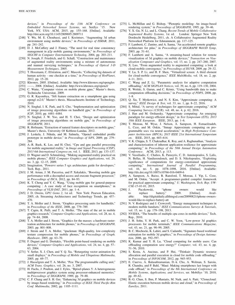
IEEE ACCESS 31
devices,” in Proceedings of the 13th ACM Conference onEmbedded Networked Sensor Systems, ser. SenSys ’15. NewYork, NY, USA: ACM, 2015, pp. 155–168. [Online]. Available:http://doi.acm.org/10.1145/2809695.2809711
[248] Y. Wu, M. E. Choubassi, and I. Kozintsev, “Augmenting 3d urbanenvironment using mobile devices,” in Proceedings of ISMAR, 2011,pp. 241–242.
[249] D. J. McCaffery and J. Finney, “The need for real time consistencymanagement in p2p mobile gaming environments,” in Proceedings ofSIGCHI in Computer Entertainment Technolog, 2004, pp. 203–211.
[250] N. Joseph, F. Friedrich, and G. Schall, “Construction and maintenanceof augmented reality environments using a mixture of autonomousand manual surveying techniques,” in Proceedings of Optical 3-DMeasurement Techniques, 2005.
[251] T. Hossmann, C. Efstratiou, and C. Mascolo, “Collecting big datasets ofhuman activity - one checkin at a time,” in Proceedings of HotPlanet,2012, pp. 15–20.
[252] Khronos, 2005. [Online]. Available: http://www.khronos.org/opengles[253] ——, 2008. [Online]. Available: http://www.khronos.org/opencl/[254] C. Wutte, “Computer vision on mobile phone gpus,” Master’s thesis,
Technische Universitat, 2009.[255] G. R. Kayombya, “Sift feature extraction on a smartphone gpu using
opengl es2.0,” Master’s thesis, Massachusetts Institute of Technology,2010.
[256] N. Singhal, I. K. Park, and S. Cho, “Implementation and optimizationof image processing algorithms on handheld gpu,” in Proceedings ofICIP, 2010, pp. 4481–4484.
[257] N. Singhal, J. W. Yoo, and H. Y. Choi, “Design and optimizationof image processing algorithms on mobile gpu,” in Proceedings ofSIGGRAPH, 2011.
[258] R. Hofmann, “Extraction of natural feature descriptors on mobile gpus,”Master’s thesis, University Of Koblenz-Landau, 2012.
[259] J. Leskela, J. Nikula, and M. Salmela, “Opencl embedded profileprototype in mobile device,” in Proceedings of SiPS, 2009, pp. 279–284.
[260] A.-R. Baek, K. Lee, and H. Choi, “Cpu and gpu parallel processingfor mobile augmented reality,” in Image and Signal Processing (CISP),2013 6th International Congress on, vol. 1. IEEE, 2013, pp. 133–137.
[261] D. Wagner and D. Schmalstieg, “Making augmented reality practical onmobile phones,” IEEE Computer Graphics and Applications, vol. 29,no. 3, pp. 12–15, 2009.
[262] Imagination, “Powervr series 5 sgx architecture guide for developers,”Tech. Rep., 2011.
[263] J. M. Arnau, J. M. Parcerisa, and P. Xekalakis, “Boosting mobile gpuperformance with a decoupled access and execute fragment processor,”in Proceedings of ISCA, 2012, pp. 84–93.
[264] K. T. Cheng and Y. C. Wang, “Using mobile gpu for general-purposecomputing : A case study of face recognition on smartphones,” inProceedings of VLSI-DAT, 2011, pp. 1–4.
[265] J. D. Owens, GPU Gems 2, 1st ed. New York: Pearson Education,2005, ch. Streaming Architectures and Technology Trends, pp. 457–470.
[266] T. A. Moller and J. Strom, “Graphics processing units for handhelds,”in Proceedings of the IEEE, 2008, pp. 779–789.
[267] T. Capin, K. Pulli, and T. A. Moller, “The state of the art in mobilegraphics research,” Computer Graphics and Applications, vol. 28, no. 4,pp. 74–84, 2008.
[268] T. A. Moller and J. Strom, “Graphics for the masses: a hardware raster-ization architecture for mobile phones,” in Proceedings of SIGGRAPH,2003, pp. 801–808.
[269] J. Strom and T. A. Moller, “ipackman: High-quality, low-complexitytexture compression for mobile phones,” in Proceedings of Graph.Hardware, 2005, pp. 63–70.
[270] F. Duguet and G. Drettakis, “Flexible point-based rendering on mobiledevices,” Computer Graphics and Applications, vol. 24, no. 4, pp. 57–63, 2004.
[271] V. Setlur, X. J. Chen, and Y. Q. Xu, “Retargeting vector animation forsmall displays,” in Proceedings of Mobile and Ubiquitous Multimedia,2005, pp. 69–77.
[272] J. Hasselgren and T. A. Moller, “Pcu: The programmable culling unit,”ACM Trans. Graphics, vol. 26, no. 3, 2007.
[273] H. Fuchs, J. Poulton, and J. Eyles, “Bpixel-planes 5: A heterogeneousmultiprocessor graphics system using processor-enhanced memories,”in Proceedings of SIGGRAPH, 1989, pp. 79–88.
[274] C. F. Chang and S. H. Ger, “Enhancing 3d graphics on mobile devicesby image-based rendering,” in Proceedings of IEEE Third Pacific-RimConf. Multimedia, 2002, pp. 1105–1111.
[275] L. McMillan and G. Bishop, “Plenoptic modeling: An image-basedrendering system,” in Proceedings of SIGGRAPH, 1995, pp. 39–46.
[276] Y. X. Gu, N. Li, and L. Chang, Recent Trends of Mobile CollaborativeAugmented Reality Systems, 1st ed. London: Springer New YorkDordrecht Heidelberg, 2011, ch. A Collaborative Augmented RealityNetworked Platform for Edutainment, pp. 117–125.
[277] F. Lamberti, C. Zunino, and A. Sanna, “An accelerated remote graphicsarchitecture for pdas,” in Proceedings of SIGGRAPH Web3D Symp,2003, pp. 51–61.
[278] F. Lamberti and A. Sanna, “A streaming-based solution for remotevisualization of 3d graphics on mobile devices,” Transaction on Visu-alization Compouter and Graphics, vol. 13, no. 2, pp. 247–260, 2007.
[279] X. Luo, “From augmented reality to augmented computing: a look atcloud-mobile convergence,” in Proceedings of ISUVR, 2009, pp. 29–32.
[280] Y. Lu, S. P. Li, and H. F. Shen, “Virtualized screen: A third elementfor cloud-mobile convergence,” IEEE MultiMedia, vol. 18, no. 2, pp.4–11, 2011.
[281] C. Wang and Z. Li, “Parametric analysis for adaptive computationoffloading,” ACM SIGPLAN Notices, vol. 39, no. 6, pp. 119–130, 2004.
[282] R. Wolski, S. Gurun, and C. Krintz, “Using bandwidth data to makecomputation offloading decisions,” in Proceedings of PDPS, 2008, pp.1–8.
[283] Q. Xu, T. Mytkowicz, and N. S. Kim, “Approximate computing: Asurvey,” IEEE Design & Test, vol. 33, no. 1, pp. 8–22, 2016.
[284] S. Mittal, “A survey of techniques for approximate computing,” ACMComputing Surveys (CSUR), vol. 48, no. 4, p. 62, 2016.
[285] J. Han and M. Orshansky, “Approximate computing: An emergingparadigm for energy-efficient design,” in Test Symposium (ETS), 201318th IEEE European. IEEE, 2013, pp. 1–6.
[286] T. Moreau, M. Wyse, J. Nelson, A. Sampson, H. Esmaeilzadeh,L. Ceze, and M. Oskin, “Snnap: Approximate computing on pro-grammable socs via neural acceleration,” in High Performance Com-puter Architecture (HPCA), 2015 IEEE 21st International Symposiumon. IEEE, 2015, pp. 603–614.
[287] V. K. Chippa, S. T. Chakradhar, K. Roy, and A. Raghunathan, “Analysisand characterization of inherent application resilience for approximatecomputing,” in Proceedings of the 50th Annual Design AutomationConference. ACM, 2013, p. 113.
[288] V. Vassiliadis, C. Chalios, K. Parasyris, C. D. Antonopoulos, S. Lalis,N. Bellas, H. Vandierendonck, and D. S. Nikolopoulos, “Exploitingsignificance of computations for energy-constrained approximatecomputing,” International Journal of Parallel Programming,vol. 44, no. 5, pp. 1078–1098, 2016. [Online]. Available:http://dx.doi.org/10.1007/s10766-016-0409-6
[289] A. Sampson, A. Baixo, B. Ransford, T. Moreau, J. Yip, L. Ceze,and M. Oskin, “Accept: A programmer-guided compiler frameworkfor practical approximate computing,” U. Washington, Tech. Rep. UW-CSE-15-01-01, 2015.
[290] J. Paczkowski, “iphone owners would liketo replace battery,” 2009. [Online]. Avail-able: http://digitaldaily.allthingsd.com/20090821/iphone-owners-would-like-to-replace-battery-att
[291] N. V. Rodriguez and J. Crowcroft, “Energy management techniques inmodern mobile handsets,” IEEE Communications Surveys & Tutorials,vol. 15, no. 1, pp. 179–198, 2013.
[292] NVIDIA, “The benefits of multiple cpu cores in mobile devices,” Tech.Rep., 2010.
[293] J. H. Sohn, Y. H. Park, and C. W. Yoon, “Low-power 3d graphicsprocessors for mobile terminals,” IEEE Communications Magazine,vol. 43, no. 21, pp. 90–99, 2005.
[294] B. C. Mochocki, K. Lahiri, and S. Cadambi, “Signature-based workloadestimation for mobile 3d graphics,” in Proceedings of Design Automa-tion, 2006, pp. 592–597.
[295] K. Kumar and Y. H. Lu, “Cloud computing for mobile users: Canoffloading computation save energy?” Computer, vol. 43, no. 4, pp.51–56, 2010.
[296] S. Kosta, A. Aucinas, and P. Hui, “Thinkair: Dynamic resourceallocation and parallel execution in cloud for mobile code offloading,”in Proceedings of INFOCOM, 2012, pp. 945–953.
[297] E. Cuervo, A. Balasubramanian, D.-k. Cho, A. Wolman, S. Saroiu,R. Chandra, and P. Bahl, “Maui: Making smartphones last longer withcode offload,” in Proceedings of the 8th International Conference onMobile Systems, Applications, and Services, ser. MobiSys ’10, 2010,pp. 49–62.
[298] B.-G. Chun, S. Ihm, P. Maniatis, M. Naik, and A. Patti, “Clonecloud:Elastic execution between mobile device and cloud,” in Proceedings ofEuroSys, 2011.

IEEE ACCESS 32
[299] M. S. Gordon, D. A. Jamshidi, S. Mahlke, Z. M. Mao, and X. Chen,“Comet: Code offload by migrating execution transparently,” in Pro-ceedings of the 10th USENIX OSDI, ser. OSDI’12, 2012, pp. 93–106.
[300] Y. Zhang, D. Niyato, and P. Wang, “Offloading in mobile cloudletsystems with intermittent connectivity,” IEEE Transactions on MobileComputing, vol. 14, no. 12, pp. 2516–2529, Dec 2015.
[301] Y. Li and W. Wang, “Can mobile cloudlets support mobile applica-tions?” in INFOCOM, 2014 Proceedings IEEE. IEEE, 2014, pp.1060–1068.
[302] D. Fesehaye, Y. Gao, K. Nahrstedt, and G. Wang, “Impact of cloudletson interactive mobile cloud applications,” in Enterprise DistributedObject Computing Conference (EDOC), 2012 IEEE 16th International.IEEE, 2012, pp. 123–132.
[303] P. A. Rego, P. B. Costa, E. F. Coutinho, L. S. Rocha, F. A. Trinta,and J. N. de Souza, “Performing computation offloading on multipleplatforms,” Computer Communications, pp. –, 2016.
[304] E. E. Marinelli, “Hyrax: cloud computing on mobile devices usingmapreduce,” Carnegie Mellon University, Tech. Rep., 2009.
[305] C. Shi, V. Lakafosis, M. H. Ammar, and E. W. Zegura, “Serendipity:Enabling remote computing among intermittently connected mobiledevices,” in Proceedings of MobiHoc ’12, 2012, pp. 145–154.
[306] D. Chatzopoulos, M. Ahmadi, S. Kosta, and P. Hui, “Openrp: areputation middleware for opportunistic crowd computing,” IEEE Com-munications Magazine, vol. 54, no. 7, pp. 115–121, July 2016.
[307] J. Herling and W. Broll, “An adaptive training-free feature tracker formobile phones,” in Proceedings of VRST, 2010, pp. 35–42.
[308] A. LaMarca, Y. Chawathe, and S. Consolvo, “Place lab: device po-sitioning using radio beacons in the wild pervasive computing,” inProceedings of Pervasive Computing, 2005, pp. 301–306.
[309] N. Alliance, “5g white paper,” Next generation mobile networks, whitepaper, 2015.
[310] R. Ford, M. Zhang, M. Mezzavilla, S. Dutta, S. Rangan, andM. Zorzi, “Achieving ultra-low latency in 5g millimeter wave cellularnetworks,” CoRR, vol. abs/1602.06925, 2016. [Online]. Available:http://arxiv.org/abs/1602.06925
[311] M. Agiwal, A. Roy, and N. Saxena, “Next generation 5g wirelessnetworks: A comprehensive survey,” IEEE Communications SurveysTutorials, vol. 18, no. 3, pp. 1617–1655, thirdquarter 2016.
[312] A. Acquisti, R. Gross, and F. Stutzman, “Faces of facebook : Privacyin the age of augmented reality,” Tech. Rep., 2012.
[313] J. Shu, R. Zheng, and P. Hui, “Cardea: Context-aware visual privacyprotection from pervasive cameras,” CoRR, vol. abs/1610.00889, 2016.[Online]. Available: http://arxiv.org/abs/1610.00889
[314] ——, “Demo: Interactive visual privacy control with gestures,” inProceedings of the 14th Annual International Conference on MobileSystems, Applications, and Services Companion, ser. MobiSys ’16Companion. New York, NY, USA: ACM, 2016, pp. 120–120.[Online]. Available: http://doi.acm.org/10.1145/2938559.2938571
Dimitris Chatzopoulos received his Diploma andhis Msc in Computer Engineering and Commu-nications from the Department of Electrical andComputer Engineering of University of Thessaly,Volos, Greece. He is currently a PhD student at theDepartment of Computer Science and Engineeringof the Hong Kong University of Science and Tech-nology and a member of Symlab. His main researchinterests are in the areas of mobile augmented reality,mobile computing, device–to–device ecosystems andcryptocurrencies.
Carlos Bermejo received his MSc. degree inTelecommunication Engineering in 2012 fromOviedo university, Spain. He is currently a PhDstudent at Hong Kong University of Science andTechnology working at the Symlab research group.His main research interest are Internet-of-Things,mobile augmented reality, network security, human-computer-interaction, social networks, and device-to-device communication.
Zhanpeng Huang received his bachelor and doctor-ate degrees both from Beihang University. After hisgraduation he became a postdoc at HKUST-DT Sys-tem and Media Laboratory(SyMLab) in Hong KongUniversity of Science and Technology. His researchinterest include mobile augmented reality, computer-human interaction, virtual reality, and physically-based simulation.
Pan Hui received his Ph.D degree from ComputerLaboratory, University of Cambridge, and earnedhis MPhil and BEng both from the Department ofElectrical and Electronic Engineering, University ofHong Kong. He is currently a faculty member of theDepartment of Computer Science and Engineeringat the Hong Kong University of Science and Tech-nology where he directs the HKUST-DT Systemand Media Lab. He also serves as a DistinguishedScientist of Telekom Innovation Laboratories (T-labs) Germany and an adjunct Professor of social
computing and networking at Aalto University Finland. Before returning toHong Kong, he spent several years in T-labs and Intel Research Cambridge.He has published more than 150 research papers and has some granted andpending European patents. He has founded and chaired several IEEE/ACMconferences/workshops, and has been serving on the organising and technicalprogram committee of numerous international conferences and workshopsincluding ACM SIGCOMM, IEEE Infocom, ICNP, SECON, MASS, Globe-com, WCNC, ITC, ICWSM and WWW. He is an associate editor forIEEE Transactions on Mobile Computing and IEEE Transactions on CloudComputing, and an ACM Distinguished Scientist.