identifying and addressing management issues for ... · identifying and addressing management...
TRANSCRIPT

Identifying And Addressing Management Issues For Australian State Sponsored CORS Networks
Martin John Hale
Thesis submitted for the Degree of Master of Geomatic Engineering
September 2007
Department of Geomatics
Faculty of Engineering
The University of Melbourne

i
ABSTRACT
Continuously Operating Reference Station (CORS) networks are increasingly being
deployed around the world. They offer Global Navigation Satellite Systems (GNSS)
users utility and productivity in positioning and navigation, and are relied upon by
businesses, governments, communities and individuals. CORS networks are often
established and managed by state governments to create a homogeneous spatial standard
to underpin Spatial Data Infrastructure (SDI), reduce infrastructure duplication and
make reliable positioning and navigation broadly accessible. CORS networks also
allow governments to reduce investment in, and reliance on, dense networks of geodetic
and survey control ground marks.
Establishing consistent CORS network management arrangements is important if
nations such as Australia with large land area, relatively small population and limited
communication infrastructure in rural and regional areas, are to maximise the benefits of
high accuracy GNSS positioning. Four independent and uncoordinated state sponsored
Real Time Kinematic (RTK) GNSS CORS networks, and one state government assisted
private RTK CORS network, currently operate in Australia. Each network covers a
limited area and delivers high accuracy positioning services, such as Network RTK
(NRTK), primarily to densely populated regions. Consequently, nationally important
applications in sparsely populated regions of Australia do not generally have access to
NRTK services.
Optimising the utility and productivity of CORS networks depends as much on CORS
network management arrangements and how well they meet institutional, legal,
operational and commercial requirements, as it does on developing the technical
capability of GNSS/CORS technology. Unified CORS network service provision over
multiple jurisdictions, demands that CORS network management supports maximum
compatibility, interoperability, compliance and marketability. Unification will also
improve prospects of achieving a satisfactory return on investments in CORS networks
while also helping to maintain and expand the infrastructure.
The research reported on in this thesis set out to determine the fundamental
requirements of CORS networks management and to test that arrangements adopted to

ii
respond to the institutional, legal, operational and commercial requirements of one
Australian state jurisdiction, can be applied nationally, to achieve management
consistency.
Research was undertaken to investigate GNSS generally, CORS network management
arrangements globally and the State of Victoria’s CORS network GPSnet specifically.
Two questionnaires, one directed to GPSnet users and a second made available in
Australia and internationally, collected data about user and stakeholder needs and
expectations of RTK CORS networks. Responses to institutional, legal, commercial
and operational requirements of CORS networks were specifically targeted and the
collated data subjected to gap analysis which showed that user and stakeholder needs
and expectations were largely being met by the outcomes of GPSnet management
arrangements.
The conclusion drawn from the research was that GPSnet management arrangements
can be used as a template for Australian jurisdictions to effectively deploy and
consistently manage CORS networks across Australia. An implication drawn from the
research is that GPSnet management arrangements can also be used to underpin a
CORS Network Management Model (CNMM). A CNMM based on public-private
partnerships to deploy and manage unified and sustainable infrastructure and deliver
services is presented to stimulate future research.

iii
DECLARATION
I, Martin John Hale, declare that:
1. the thesis comprises only my original work towards the Degree of Master of
Geomatics except where indicated in section 1.1 Preamble;
2. due acknowledgement has been made in the text to all other material used; and
3. the thesis is approximately 30 000 words in length, exclusive of tables, maps,
bibliographies and appendices.
…………………………………………. Martin John Hale

iv
ACKNOWLEDGEMENTS
I would like to acknowledge:
• that the work presented in this thesis has been supported by the Cooperative
Research Centre for Spatial Information, whose activities are funded by the
Australian Commonwealth’s Cooperative Research Centres Program; and
• the Department of Sustainability and Environment (DSE) through its Spatial
Information Infrastructure (SII) business for allowing me to conduct the
program of research and allow access to and publish information about GPSnet
management.
I would like to thank the members of the CRCSI Project 1.2 (Quality Control Issues for
Real-Time Positioning) research team and in particular:
• Dr Phil Collier, Project Leader for his guidance and advice during the conduct of
the research program;
• Dr Allison Kealy for her expert support and encouragement throughout the
research program; and
• Simon Fuller for his assistance in developing an online questionnaire and
stimulating discussions concerning GNSS and CORS networks.
Thanks also to:
• Peter Ramm (Manager Vicmap) and James Millner (GPSnet Development) who
provided support, valuable comment and feedback during the course of research
and preparation of supporting papers;
• the GPSnet staff members, Peter Oates (GPSnet Operations), Hayden Asmussen
(GPSnet Applications), Jacqueline Denham (GPSnet Stakeholder Relations) and
Warwick Wilson (GPSnet Analyst) for their support during the research
program; and
• Cathy Crooks for proof reading this thesis which was much appreciated.
A special thank you to my son Jack who was supportive and helpful throughout the
research program.
v
TABLE OF CONTENTS
ABSTRACT ................................................................................................................................................ I
DECLARATION ..................................................................................................................................... III
ACKNOWLEDGEMENTS .................................................................................................................... IV
TABLE OF CONTENTS ..........................................................................................................................V
LIST OF FIGURES AND TABLES ................................................................................................... VIII
LIST OF FIGURES AND TABLES ................................................................................................... VIII
LIST OF ACRONYMS.............................................................................................................................X
1. INTRODUCTION ............................................................................................................................1
1.1. PREAMBLE .................................................................................................................................1
1.2. BACKGROUND............................................................................................................................1
1.3. PROBLEM STATEMENT ...............................................................................................................5
1.4. AIM ............................................................................................................................................6
1.5. RESEARCH HYPOTHESIS .............................................................................................................7
1.6. RESEARCH OBJECTIVES..............................................................................................................7
1.7. METHODOLOGY .......................................................................................................................10
1.8. RESEARCH SCOPE ....................................................................................................................11
1.9. SIGNIFICANCE OF RESEARCH ...................................................................................................13
1.10. THESIS OUTLINE ......................................................................................................................14
1.11. FURTHER RESEARCH ................................................................................................................15
1.12. CONCLUDING REMARKS...........................................................................................................15
2. GLOBAL NAVIGATION SATELLITE SYSTEMS...................................................................16
2.1. INTRODUCTION ........................................................................................................................16
2.2. CONTEMPORARY AND PLANNED SATELLITE POSITIONING .......................................................16
2.3. GNSS PRIMARY SYSTEMS .......................................................................................................19
2.4. GLOBAL SBAS.........................................................................................................................28
2.5. CONTINENTAL SBAS ...............................................................................................................29
2.6. REGIONAL SATNAV .................................................................................................................29
2.7. CONTINENTAL GBAS ..............................................................................................................30
2.8. REGIONAL GBAS.....................................................................................................................30
2.9. LOCAL GBAS ..........................................................................................................................31
2.10. IMPACT OF GNSS DEVELOPMENTS ..........................................................................................31
2.11. COMMUNICATION DEVELOPMENTS AND THE IMPACT ON CORS NETWORKS...........................32
2.12. INHIBITORS TO CORS NETWORK DEVELOPMENT AND UPTAKE...............................................33
2.13. CONCLUDING REMARKS ...........................................................................................................35

vi
3. CORS NETWORKS.......................................................................................................................36
3.1. INTRODUCTION ........................................................................................................................36
3.2. CORS NETWORK USER ADVANTAGES AND BARRIERS AND ROLE OF GOVERNMENT IN THEIR
ESTABLISHMENT ......................................................................................................................37
3.3. CORS NETWORK DEVELOPMENT ............................................................................................41
3.4. CONCLUDING REMARKS ...........................................................................................................54
4. CORS NETWORK MANAGEMENT AND USERS...................................................................55
4.1. INTRODUCTION ........................................................................................................................55
4.2. THE CORS NETWORK MANAGEMENT ENVIRONMENT.............................................................57
4.3. CORS NETWORK MANAGEMENT PRINCIPLES AND OBJECTIVES ..............................................62
4.4. CORS NETWORK MANAGEMENT REQUIREMENTS AND USER SECTORS...................................67
4.5. CORS NETWORK MANAGEMENT REQUIREMENTS - INSTITUTIONAL........................................68
4.6. CORS NETWORK MANAGEMENT REQUIREMENTS - LEGAL .....................................................70
4.7. CORS NETWORK MANAGEMENT REQUIREMENTS - COMMERCIAL ..........................................70
4.8. CORS NETWORK MANAGEMENT REQUIREMENTS - OPERATIONAL STANDARDS AND
PRINCIPLES ..............................................................................................................................72
4.9. CONCLUDING REMARKS...........................................................................................................72
5. AUSTRALIAN STATE SPONSORED CORS NETWORK MANAGEMENT
REQUIREMENTS .........................................................................................................................73
5.1. INTRODUCTION ........................................................................................................................73
5.2. AUSTRALIAN CORS NETWORK MANAGEMENT AND USER ISSUES ..........................................74
5.3. GPSNET CORS NETWORK MANAGEMENT ARRANGEMENTS ...................................................76
5.4. CONCLUDING REMARKS...........................................................................................................94
6. EVALUATION OF CORS NETWORK MANAGEMENT ARRANGEMENTS.....................95
6.1. INTRODUCTION ........................................................................................................................95
6.2. QUESTIONNAIRE RATIONALE....................................................................................................95
6.3. QUESTIONNAIRE METHODOLOGY ............................................................................................96
6.4. CONCLUDING REMARKS.........................................................................................................100
7. GPSNET - A CASE STUDY FOR CORS NETWORK MANAGEMENT..............................101
7.1. INTRODUCTION ......................................................................................................................101
7.2. QUESTIONNAIRE RESULTS .....................................................................................................101
7.3. CONCLUSION..........................................................................................................................112
8. TOWARDS UNIFIED AND SUSTAINABLE AUSTRALIAN STATE SPONSORED CORS
NETWORKS ...............................................................................................................................113
8.1. INTRODUCTION ......................................................................................................................113
8.2. QUESTIONNAIRE RESULTS EVALUATION AND DISCUSSION ....................................................113
8.3. A MODEL FOR AUSTRALIAN STATE RTK CORS NETWORK MANAGEMENT .........................117
8.4. CONCLUDING REMARKS.........................................................................................................121

vii
9. CONCLUSION .............................................................................................................................122
9.1. RESEARCH SUMMARY ............................................................................................................122
9.2. RESEARCH OBSERVATIONS AND CONCLUSIONS .....................................................................123
9.3. CORS NETWORK MANAGEMENT MODEL FOR AUSTRALIA....................................................126
9.4. FUTURE RESEARCH ................................................................................................................126
10. REFERENCES.........................................................................................................................128
APPENDIX A — GPSNET CORS QUESTIONNAIRE.....................................................................139
APPENDIX B — GENERIC CORS QUESTIONNAIRE ..................................................................157
APPENDIX C — GPSNET CORS NETWORK MANAGEMENT VALIDATION THROUGH
USER FEEDBACK .................................................................................................166

viii
LIST OF FIGURES AND TABLES
FIGURES
Figure 1.1 GPSnet CORS network deployment with NRTK service area shaded in
dark red noting that GPSnet Adelaide CORs is not shown ............................ 4
Figure 1.2 Research Objectives and Strategies ............................................................ 10
Figure 3.1 Proposed National Geospatial Reference System CORS network ............. 52
Figure 7.1 GPSnet Institutional Arrangements........................................................... 102
Figure 7.2 GPSnet Operational Principles and Practice 1 to 8................................... 103
Figure 7.3 GPSnet Operational Principles and Practice 9 to 16................................. 103
Figure 7.4 GPSnet Operational Principles and Practice 17 to 25............................... 104
Figure 7.5 GPSnet legal arrangements ....................................................................... 104
Figure 7.6 GPSnet Commercial Arrangements .......................................................... 105
Figure 7.7 Question 2.1.3 CORS network contribution to the ASDI? ....................... 106
Figure 7.8 Question 2.2.3 Importance of CORS antenna coordinate relative to
ARGN, state or other network? ................................................................ 108
Figure 7.9 Question 2.2.4 Importance of data quality monitoring and user alerting? 108
Figure 7.10 Question 2.2.5 Importance of CORS network GNSS reception and
processing capability now?....................................................................... 109
Figure 7.11 Question 2.2.6 Importance of CORS network GNSS reception and
processing capability in the next four years ?.......................................... 109
Figure 7.12 Question 2.3.1 Importance of privacy of user location within a CORS
network? .................................................................................................. 110
Figure 7.13 Question 2.3.2 Importance of legal traceability of position? ................... 111
Figure 7.14 Question 2.4.1 CORS data distribution – how is it best distributed?...... 112
Figure 8.1 GNSS CORS Network Management Model........................................... 120

ix
TABLES
Table 2.1 GPS Positioning Accuracy ............................................................................ 23
Table 4.1 High precision GNSS applications, sectors and sub sectors ......................... 63
Table 4.2 CNMM arrangements, sectors and sub sectors ............................................. 67
Table 5.1 GPSnet CORS site hosts and contributors .................................................... 79
Table 5.2 Differences between SMES and GPSnet Regulation 13 NMA coordinates
as at May 27 2007.......................................................................................... 89
Table 6.1 Questionnaire score format for GPSnet Registered User Questionnaire ....... 98

x
LIST OF ACRONYMS
AFN Australian Fiducial Network
AGJU Australian GNSS Joint Undertaking
AGCC Australian GNSS Coordination Committee
ASIBA Australian Spatial Industry Business Association
AMSA Australian Maritime Safety Authority
ANZLIC Australia and New Zealand Land Information Council
ARGN Australian Regional GPS Network
ASABE American Society of Agricultural and Biological Engineers
ASDI Australian Spatial Data Infrastructure
BBS Bulletin Board Service
CA Course Acquisition
CBS Community Base Station
CDGPS Canada-Wide DGPS Correction Service
CDMA Code Division Multiple Access
CNMM CORS network Management Model
CORS Continuously Operating Reference Station
CRCSI Cooperative Research Centre for Spatial Information
CS Control Segment
CSC Central Server Cluster
CTF Controlled Traffic Farming
DC Digital City
DCITA Commonwealth Department of Communications, Information
Technology and the Arts
DGPS Differential Global Positioning System
DoD US Department of Defence
DSE Department of Sustainability and Environment
DSP Data Service Provider
EGNOS European Geostationary Navigation Overlay Service
ESA European Space Agency
EU European Union
FDMA Frequency Division Multiple Access
FIG International Federation of Surveyors

xi
FOC Full Operational Capability
GA Geoscience Australia
GAGAN GPS-Aided Geo Augmented Navigation
GBAS Ground Based Augmentation Systems
GDA Geocentric Datum of Australia
GEONET GPS Earth Observation Network System
GIOVE Galileo In-Orbit Validation Element
GLONASS Global'naya Navigatsionnaya Sputnikovaya Sistema (also GLObal
NAvigation Satellite System)
GNSS Global Navigation Satellite Systems
GPRS General Packet Radio Service
GPS Global Positioning System
GRAS Ground-based Regional Augmentation System
GSI Geographical Survey Institute
GSM Global Mobile Services
ICSM GTSC Intergovernmental Committee on Surveying and Mapping Geodesy
Technical Sub Committee
ICSM Intergovernmental Committee on Surveying and Mapping
IGS International GNSS Service
IRNSS Indian Regional Navigation Satellite System
ITRF International Terrestrial Reference Frame
ITU International Telecommunications Union
JPL Jet Propulsion Laboratory
LAAS Local Area Augmentation System
LGA Local Government Authority
MAC Master Auxiliary Concept
MEO Medium Earth Orbit
MSAS Multi-Function Satellite (MTSAT) Satellite Augmentation System
MTSATs Multi-Functional Transport Satellites
MSK Minimum Shift Keying
OS Ordnance Survey (of Great Britain and Ireland)
NAVSTAR Navigation System with Timing And Ranging
NCRIS National Collaborative Research Infrastructure Strategy
NDGPS Network Differential Global Positioning System

xii
NGS National Geodetic Service
NMA National Measurement Act
NRCan Natural Resources Canada
NRTK Network Real Time Kinematic
NTRIP Network Transport of RTCM over Internet Protocol
P Precision
PNT Positioning Navigation and Timing
PPP Precise Point Positioning
PPS Precise Positioning Service
PRN Pseudo Random Noise
PRS Public Regulated Service
PSMA Public Sector Management Agency
QZSS Quasi Zenith Satellite System
RINEX Receiver Independent Exchange Format
RF Russian Federation
RMIT Royal Melbourne Institute of Technology
ROI Return On Investment
RS Reference Station
RTCM Radio Technical Commission for Maritime Services
RTK Real Time Kinematic
RT-QC Real Time-Quality Control
SBAS Space Based Augmentation Systems
SDI Spatial Data Infrastructure
SII Spatial Information Infrastructure
SLR Satellite laser ranging
SMES Survey Marks Enquiry Service
SMS Short Message Service
SPP Single Point Positioning
SPS Standard Positioning Service
SP Standard Precision
UHF Ultra High Frequency
UTC Universal Time Coordinated
VAR Value Added Re-seller
VBS Virtual Base Station

xiii
VGRG Victorian GNSS Reference Group
VHF Very High Frequency
VLBI Very Long Baseline Interferometry
VPN Virtual Private Network
VRS Virtual Reference Station
VSAT Very Small Aperture Terminal
VSIS Victorian Spatial Information Strategy
WAAS Wide Area Augmentation System
WGS84 World Geodetic System 1984

1
1. INTRODUCTION
1.1. Preamble
This thesis is original material that unites three phases of research:
Phase 1 Identify issues relating to CORS network management;
Phase 2 Assess Victoria’s cooperative CORS network GPSnet; and
Phase 3 Develop a GNSS CORS Network Management Model (CNMM).
The details and outcomes of each phase of research have been reported in Hale et al.
(2005), Hale et al. (2006), and Hale et al. (forthcoming)1.
1.2. Background
Global Navigation Satellite Systems (GNSS) technologies have revolutionised
positioning, navigation and timing (PNT). Until the advent of the Global Positioning
System (GPS), navigation and positioning were specialised tasks restricted to all but a
limited number of professionals and experts. GPS has made general navigation and
positioning to a few metres of absolute accuracy a task no more difficult than pushing
a button. By combining space based global satellite systems with ground based
Continuously Operating Reference Station (CORS) networks, GNSS users with
minimal training can now position and navigate to an unprecedented level of
accuracy.
Initially CORS networks supported post processed positioning but over time evolved
to support high accuracy real time positioning and navigation. Real time kinematic
(RTK) capable CORS networks can now deliver satellite correction services over
regional areas and support GNSS users who require three-dimensional positioning and
navigation to a few centimetres of accuracy (Gordini 2007; Roberts 2007).
Governments, businesses, communities and individuals, are increasingly attracted to
establishing or using RTK CORS networks due to the significant utility, productivity
and cost savings that can be achieved. The significance of RTK CORS networks has
grown to the point where it is now contended that, RTK CORS networks are ‘…an
1 A copy of this paper is located at Appendix C

2
important part of the infrastructure for spatial sciences’ (Rizos et al. 2005). RTK
CORS networks, if properly managed, may well also become a fundamental part of
society’s general infrastructure, delivering accurate positions reliably, conveniently,
ubiquitously and affordably, in the same way that telecommunication, electricity, and
water are delivered.
CORS networks can support a diverse range of spatially related activities including
machine guidance, managing and monitoring the built and natural environments,
aiding emergency services, supporting intelligent transport and even contributing to
weather prediction. RTK dependant applications can be expected to increase as
human enterprise discovers new ways of taking advantage of such technology.
Internationally, governments have historically managed spatial control by
coordinating ground marked geodetic networks to unify local survey and mapping
activities. Traditional geodetic networks are also normally managed as hierarchical
sub networks and as an inherent part of an overall national network. By comparison,
CORS networks, which also provide spatial control, are currently being established
and managed by Australian state and territory governments to function independently
and not necessarily as an intrinsic part of a national CORS framework.
Jurisdictional CORS networks can underpin Spatial Data Infrastructure (SDI), realise
spatial datums, rationalise CORS network deployment, reduce reliance on dense
networks of ground survey marks and broaden access to high accuracy navigation and
positioning beyond traditional spatial professionals to lay GNSS users.
A significant challenge for governments is to optimise CORS network management to
benefit nationally significant industries and activities. The adoption of consistent
management arrangements can facilitate unification2 of CORS network systems and
enable generation and delivery of high accuracy services such as Network RTK
(NRTK). A key requirement of consistent CORS network management is datum
harmonisation3 across participating jurisdictions. Once unified and harmonised,
2 Unification refers to inter-jurisdictional sharing of CORS network data and systems. 3 Harmonisation refers to jurisdiction CORS networks adopting the same datum realisation in order to generate spatially homogeneous positioning and navigation services.

3
discrete jurisdiction CORS networks can be combined to deliver NRTK services
supporting homogeneous positioning and navigation over regional areas, regardless of
administrative boundaries.
Government sponsored CORS networks operate across states, countries, and regions.
Different methods of CORS network management are adopted and often depend on
factors such as a jurisdiction’s geography, tectonic stability, population distribution,
applications, availability and suitability of signal distribution technology and amount
of capital available to invest in network infrastructure. The specific challenges to
establishing RTK CORS infrastructure in Australia are its large land area, relatively
small population and limited availability of communication services—particularly in
regional and rural areas.
At the national level, the Australian Federal Government, in collaboration with state
and territory jurisdictions, is establishing approximately 100 GNSS CORS sites from
2007 to 2011. Managed by the AuScope Limited organisation (www.AuScope
.org.au), the GNSS CORS project targets earth monitoring objectives. The AuScope
GNSS CORS network will be deployed in transects with inter CORS site separations
of approximately 200 km. Some stations are proposed to be sited at selected coastal
tide gauges. The AuScope GNSS CORS network will provide the basis for national
datum harmonisation and lay the technical foundation for Australian CORS network
unification and delivery of seamless NRTK services across jurisdiction boundaries.
Overcoming the challenges of Australia’s vast expanse, sparse population, and limited
communications capabilities, will depend on the successful integration of AuScope
GNSS CORS and other CORS networks. The first Australian state sponsored CORS
network to provide statewide GNSS correction services to users in Australia is
Victoria’s GPSnet.

4
1.2.1. The State of Victoria’s Cooperative CORS network GPSnet
GPSnet is a cooperative CORS network facilitated and coordinated by the Victorian
Department of Sustainability and Environment (DSE) through its Spatial Information
Infrastructure business (SII). Commencing network operations in 1996, GPSnet has
expanded from three initial GPS base stations to become a provider of a NRTK
service over Melbourne and environs and a statewide network differential GPS
(NDGPS) service. Figure 1.1 shows the configuration of GPSnet CORS sites as at
June 2007.
Figure 1.1 GPSnet CORS network deployment with NRTK service area shaded in dark red
noting that GPSnet Adelaide CORs is not shown (Source: DSE 2007)
GPSnet provides CORS network services to a wide range of users and applications,
over varying topography with elevations up to 1986 m, and relatively high population
density compared to other Australian states and territories. GPSnet’s main features
include:
• a cooperative infrastructure development model;
• multi constellation GNSS CORS stations;
• integration with the national GPS network—the Australian Regional GPS
Network (ARGN);
• legally traceable CORS antenna coordinates;

5
• independent stability monitoring system
• contemporary CORS network connectivity, processing and distribution
technologies.
GPSnet management responses to institutional, legal, operational and commercial
requirements have developed since network commencement, however no formal
analysis of user satisfaction with those responses has been performed to date. Since
January 2006, an NRTK service has been made commercially available to GPSnet
users in Melbourne and surrounding areas. The initial sites to support the processing
of NRTK correction solutions were located at Melbourne (RMIT University),
Bacchus Marsh and Geelong.
As at June 2007, GPSnet services a registered user base of approximately 400 GNSS
users. These users have experience in accessing GPSnet systems and data for post
processing, fixed base radio RTK solutions from single reference stations (RSs), real
time Network Differential GPS (NDGPS) and the NRTK service.
1.3. Problem Statement
The provision of homogeneous CORS network services across Australia is confronted
by significant challenges such as:
• the nation’s political arrangement of federated state and territory governments;
• a relatively large area and small population—one of the highest ratios of land
area per head of population in the world (UN 2005)4; and
• high levels of dissatisfaction in rural and remote areas of Australia concerning
access to reliable and affordable telecommunication services (DCITA 2000).
The key problem that hinders the resolution of these issues is that Australian states5
currently adopt jurisdiction specific and often inconsistent responses to the
institutional, legal, commercial and operational requirements of CORS network
management.
4 Approximately 2.6 persons/km2 placing Australia 224th in a world ranking of 245 countries. 5 Henceforth, in the Australian government context, the word ‘state’ should be interpreted to also encompass territory.

6
Inconsistent Australian state sponsored management impedes the unification of CORS
networks. This in turn prevents the realisation of the benefits that ubiquitous and
homogeneous positioning can bring to nationally significant industries and activities.
Consistent management arrangements that satisfy the needs of GNSS/CORS users and
stakeholders, applied across all Australian jurisdictions, will help support the
unification and longer-term sustainability of CORS networks in Australia.
The validation of management arrangements for institutional, legal, operational and
commercial requirements of RTK CORS networks in Australia may also provide
guidance for other jurisdictions around the world and assist with their progress
towards network unification and sustainability.
1.4. Aim
The aim of the research is to identify management responses that can be adopted to
consistently meet the institutional, legal, commercial and operational requirements of
state and territory sponsored CORS networks in Australia that also satisfy
GNSS/CORS network user and stakeholder needs.
To date, considerable research has focussed on the technical development of CORS
networks and related GNSS technologies. Less attention has been given to the
management arrangements required to optimise RTK CORS network use. Schrock
(2006a) identifies a range of high precision sectors and applications including land
surveying, port operations, precision farming, and research programs such as
geological deformation monitoring6. Diverse sectors and applications lead to the need
for a range of different CORS network management responses to be established and
meticulously maintained to ensure specific user needs are met.
As governments increasingly deploy CORS networks to serve multimodal users, the
imperative also mounts for the adoption of comprehensive and consistent approaches
to management to optimise service efficiency, effectiveness and infrastructure
investment, not just within nations but arguably across nations. The implementation
6 Refer to Table 4.1 in Section 4.3 CORS Network Management Model Principles and Objectives for more details.

7
of large scale, unified, government sponsored CORS networks in Germany (SAPOS),
Europe (EUPOS), and Great Britain (OS Net) and investigations into a cooperative
RTK CORS network in the US (On Grid) are examples of different international
approaches to CORS network management. Preliminary efforts have also been made
to explore a range of business models to take advantage of services provided by RTK
CORS networks and obtain a reasonable return on investment (ROI) (Rizos &
Cranenbroeck 2006).
1.5. Research hypothesis
The underlying contention of this thesis is that consistent management of RTK CORS
networks that adopt an appropriate business model increases the potential of position
and navigation services becoming a ubiquitous and sustainable utility within and
across states and nations.
The research hypothesis poses the question—can the management arrangements
adopted to respond to the institutional, legal, operational and commercial
requirements of one Australian state jurisdiction CORS network be applied nationally
to achieve overall management consistency?
If the management arrangements for one Australian state jurisdiction are found to be
appropriate then they could be considered a template for consistent CORS network
management by state and federal governments Australia wide. These same
management arrangements could also be used to underpin the development of a
generic CORS Network Management Model (CNMM) supporting unified and
sustainable network development across Australia.
1.6. Research Objectives
The objectives of this research are to:
1. determine the fundamental requirements of CORS network management;
2. use questionnaires to obtain the views of GPSnet registered users and any
other person or organisation interested in the management of CORS networks
generally from Australia and internationally;
8
3. formulate management arrangements to consistently address institutional,
legal, operational and commercial requirements of CORS networks across
Australian jurisdictions; and
4. propose a CNMM based on these consistent management arrangements.
The above objectives will serve as intermediate steps towards achieving unified and
sustainable state sponsored CORS networks across Australia. This will be a
significant achievement, as the services provided from unified CORS networks can
then support important nationwide applications and activities. Hale et al. (2006)
suggest that such applications and activities include controlled traffic farming (CTF)
across all Australian cropping districts, modernising Australia’s cadastre compliant
with the FIG (International Federation of Surveyors) Cadastre 2014 model, enabling
‘discoverable’ underground utilities, supporting emergency services and underpinning
digital city (DC) development.
Nationally, the focus on CORS networks is increasing with the Intergovernmental
Committee on Surveying and Mapping (ICSM), Geodesy Technical Subcommittee
(GTSC) (www.icsm.gov.au/icsm/geodesy), considering Australian CORS network
unification and datum harmonisation. CORS network investment, across the majority
of Australian States and Territories, is also steadily increasing. State and territory
CORS network investment is either specific to the needs of the jurisdiction or in
support of the establishment of the AuScope GNSS network.
The Cooperative Research Centre for Spatial Information (CRCSI)
(www.crcsi.com.au) is also initiating Project 1.4, Integrating Electricity,
Telecommunications and Government Infrastructure to Deliver Precise Positioning
Services In Regional Areas, that will investigate ‘…user needs, market size and
pricing sensitivities; common operating standards; legal structure of the service
provider; transfer pricing within the supply chain; and liability and intellectual
property rights.’ (CRCSI 2007). Identifying and addressing CORS network
management issues complements these activities.
9
It can be reasonably expected that unification of CORS networks in Australia will
take a number of years to realise, while jurisdiction and national framework networks
are installed. If a consistent national approach to CORS network management can be
agreed early in network establishment, unification should be made much simpler and
network sustainability more achievable.
However, if a unified CORS network in Australia is not achieved, individual
jurisdiction networks are likely to continue to be developed but with reduced overall
management consistency leading to:
• GNSS CORS network infrastructure duplication, particularly near jurisdiction
borders;
• reduced likelihood of across border CORS network data sharing;
• reduced likelihood of sharing CORS network processing facilities for
redundancy;
• reduced ability to attract third party service distributors to distribute
amalgamated CORS data over large regional areas to support nationally
significant applications; and
• reduced jurisdiction CORS network sustainability.
When compared to discrete CORS networks, unified and sustainable CORS networks
in Australia will support:
• an increased revenue base for CORS network distributors;
• an optimum royalty base for CORS network operators;
• improved research capability to increase CORS network applications; and
• the maximisation of CORS network users and applications.
Figure 1.2 depicts the research objectives and related strategies arranged as a work
flow diagram.

10
Figure 1.2 Research Objectives and Strategies
1.7. Methodology
The research methodology was designed to:
1. Gather background information, based on literature review and documentation
of current GPSnet management arrangements about:
o GNSS development and future directions;
o CORS network development in Australia and internationally;
o CORS network management issues and requirements of users and
stakeholders; and
o GPSnet specific management arrangements.
Unified and Sustainable State Sponsored
CORS networks
Propose A CORS Network Management Model (CNMM) Option Based On Consistent Management Arrangements
Establish Consistent Management Arrangements To Address Institutional, Legal, Commercial, & Operational Requirements
Of RTK CORS Networks
Strategy - Questionnaire Feedback Gap Analysis
GPSnet User Questionnaire
International CORS Stakeholder Questionnaire
Top Level
Objective
Strategy – Test If GPSnet Management Arrangements Satisfy Fundamental CORS Network Requirements
Research Objective 4
Strategy - Investigate CORS Network Management Options
Determine Fundamental CORS Network Management Requirements
Research Objective 3
Research Objective 2
Research Objective 1

11
2. Evaluate via gap analysis, user satisfaction and expectations of CORS network
management via questionnaires directed to:
o Victoria’s registered GPSnet users; and
o Australian and international CORS network users and stakeholders.
3. Use the results of the user and stakeholder views to develop and propose a
broad model for Australian state RTK CORS network management.
Two questionnaires were designed, distributed, or made available online, seeking
perspectives on management responses to institutional, legal, operational and
commercial requirements of CORS networks. One questionnaire was sent directly to
GPSnet registered users and a second made available to any person interested in
CORS network management and operation.
Experience of CORS network management and NRTK services has accumulated in
many parts of the world, particularly in Europe including the United Kingdom,
Ireland, Germany and Nordic Countries, North America, and countries in Asia
particularly located in Southeast and Eastern Asia. The views of Australian and
international CORS network stakeholders were compared with the GPSnet user views.
1.8. Research Scope
The research scope was limited to CORS network management arrangements
supporting applications that relate to positioning and navigation only and did not
attempt to investigate management issues for GNSS CORS based timing used in
financial transactions, utilities and telecommunications.
The thesis is also restricted to research into the management of conventional CORS
networks and does not investigate the management of related infrastructure such as
pseudolite7 networks. This decision was made as management is expected to differ
significantly between the two positioning technologies. It is also likely that RTK
CORS networks will continue to be the primary focus of infrastructure installation
over time for ubiquitous positioning whereas networks of pseudolites will tend to be
installed in specific, high use locations (Rizos 2005), and where satellite positioning is
7 A ground based radio transmitter that mimics the signals of a GNSS satellite.

12
unlikely to ever be fully effective, such as inside high rise city buildings.
A potential alternative technique to RTK CORS networks, is Precise Point Positioning
(PPP). PPP ‘…is a method that performs precise position determination using a
single GPS receiver’ (Gao 2006). The adjective “precise” is used to distinguish PPP
from conventional, autonomous GNSS position determination, computed using code
or code smoothed transmissions from GNSS satellites.
PPP does not rely on dedicated CORS network infrastructure in the user’s local or
regional area of operations and instead uses precise ephemeris and clock correction
products made available by organisations such as the International GNSS Service
(IGS), Natural Resources Canada (NRCan), Jet Propulsion Laboratory (JPL) in
addition to some commercial sources. Using precise ephemeris and clock corrections,
PPP can compute post-processed positions to centimetre-level accuracy, however Gao
(2006) lists several unresolved challenges as:
• initialisation times from current minimums of twenty minutes or more8;
• corrupted integer ambiguity terms of the undifferenced carrier phase
observations;
• delays in accessing precise orbit and clock products; and
• fees levied by commercial companies to access precise orbit and clock
products.
As a result of these limitations PPP is currently unable to directly compete with
CORS network services. Accordingly this research concentrates on CORS
infrastructure and services management as the only currently viable means of
commercially delivering high accuracy position solutions to GNSS users. Chapter 3
describes CORS and its specific advantages over PPP in more detail.
8 PPP tests in Australia also confirm long initialization times, ‘…typically ranging between 30 minutes
to 2 hours’ (Choy et al. 2007).

13
1.9. Significance of Research
The research has significance at Australian state and national level, and also
internationally. The global trend to underpin data models and presentation of online
data using spatial coordinates, such as Google Maps (Google Maps Australia Beta
2007), can be expected to become intrinsic requirements for modern, information
based societies. As a result, supporting infrastructures such as CORS networks will
need to be technically well founded, professionally managed and operated and able to
service the needs of a broad user base actively integrating other spatially related data.
At the state level, a number of Australian jurisdictions are establishing CORS
networks. Access to a template of management arrangements will encourage and
support consistent establishment, operation and overall management of independent
CORS networks and systems. The adoption of consistent and agreed CORS network
management arrangements will also support national unification of CORS networks.
Nationally, the ICSM GTSC is active in attempting to establish datum harmonisation
across all Australian CORS networks through the AuScope GNSS CORS network.
Consistent and nationally agreed management of antenna coordination is critical to
CORS network unification and will be supported by the datum harmonisation process.
Due to the importance of CORS antenna coordination as a part of overall CORS
network management, responses concerning this issue have been specifically sought
in both questionnaires circulated as part of this research.
The CRCSI is also coordinating a collaborative project to investigate combining
Omnistar CORS and its High Performance (HP) service based on proprietary
processing techniques, with Australian jurisdiction CORS networks to generate
NRTK over areas of sparse CORS network coverage. A necessary precondition for
private-public partnership data sharing such as this will be adherence to agreed
management arrangements to ensure reliable delivery of CORS network data to a
specific standard of quality for centralised processing prior to delivery of NRTK
services to end users. The CORS network management arrangements made available
through this research will provide a number of the key elements required to be
negotiated in any future private-public partnership.

14
At the international level the CORS network management arrangements arising from
this research may also provide, in part or in full, a template for the management of
CORS networks elsewhere around the world.
1.10. Thesis Outline
The thesis introduces the reader to the general topic area by providing a background
to GNSS, GNSS augmentation systems and anticipated GNSS developments such as
satellite modernisation (chapter 2). A review of CORS networks in Australia and
around the world (chapter 3) explains how positioning and navigation can be
improved using differential positioning techniques.
The development path from individual GPS base stations to permanent CORS
networks is also reviewed in chapter 3, providing the reader with an understanding of
why CORS networks are increasingly regarded and used as a fundamental spatial
resource. Chapter 4 discusses the general environment in which CORS networks need
to be managed, while chapter 5 sets out the specific responses adopted for Victoria’s
GPSnet CORS network management.
A validation process for GPSnet management responses together with an assessment
of international expectations of CORS networks is described in chapter 6 and the
results presented in chapter 7. The results of chapter 7 are then analysed and used to
propose a CNMM in chapter 8. Chapter 9 provides the reader with a conclusion to the
research, summarising significant observations, findings and conclusions and areas for
future research.

15
1.11. Further Research
Further research is recommended to evaluate and develop the utility of the CNMM
proposed by this thesis. Although fundamental CORS network management
responses have been established by this research, further investigation is needed to
assess the viability of the overall CNMM. The adoption of a CNMM that has national
application will also depend on multi-jurisdictional agreement. Research is
recommended to evaluate an organisational arrangement that supports equitable
Australian State and Territory representation to achieve consensus on issues such as
unified CORS network policy and operational matters. It is also recommended that
different business models that are facilitated by the CNMM should also be evaluated
to ensure optimum arrangements are established to increase prospects for long term
CORS network sustainability. Investigation of appropriate organisations to bulk
licence and wholesale CORS network data to end users is also recommended to
ensure that the most efficient and effective CORS network data distribution chains are
established.
1.12. Concluding Remarks
This thesis is an introduction to the arrangements used in the management of CORS
networks from the perspective of a spatial sciences professional and project manager
of an Australian state sponsored CORS network (GPSnet). CORS networks are a
relatively new infrastructure for the spatial sciences, and as such networks develop
and unify over larger areas, their importance within states and nations will increase.
This thesis contributes to the consistent management, unification, and sustainability of
CORS networks into the future. The thesis also supports the need for acceptance of
strict datum harmonisation across all RTK CORS networks.

16
2. GLOBAL NAVIGATION SATELLITE SYSTEMS
2.1. Introduction
GNSS describes satellite and radio technology delivering worldwide PNT services.
Autonomous GNSS receivers trilaterate simultaneous ranges calculated using coded
signals to four or more satellites, in order to fix a user’s location, unambiguously, in
three dimensions, on or above the earth’s surface. This chapter describes current and
future GNSS and augmentations.
2.2. Contemporary and Planned Satellite Positioning
Contemporary examples of primary GNSS satellite constellation systems are the US
Global Positioning System (GPS) and the Russian Federation’s (RF) GLONASS
(Global'naya Navigatsionnaya Sputnikovaya Sistema or GLObal NAvigation Satellite
System). The European Union (EU) plans to deploy Galileo as a third primary GNSS
and have it operational by around 2012 (Galileo’s New PPP – Public – Public
Partnerhsip? 2007). China also proposes Compass as a fourth GNSS, scheduled for
‘…completion of the system by 2010, according to a May 28, 2004, commitment letter
to the ITU, from Zhu Sanbao, deputy director of the Radio Regulatory Department of
the PRC’s Ministry of Information Industry.’ (Compass: and China’s GNSS makes
four 2006, p.14).
Primary GNSS consist of three main components; a space segment in the form of a
constellation of earth orbiting satellites providing global coverage; a control segment
involving monitoring stations tracking orbiting satellites and relaying system
information; and the user segment incorporating receivers and antennas, operated on
land, sea and in the air (PNT 2007) . By augmenting the primary GNSS with RSs at
known locations, range errors that affect GNSS signals can be significantly reduced
(Rizos 2002). Errors include those caused by ionospheric and tropospheric refraction,
satellite clock, and satellite orbit. The transmission of GNSS augmentation
corrections, and in some cases the transmission of integrity signals, can be performed
using Space Based Augmentation Systems (SBAS) or Ground Based Augmentation
Systems (GBAS) (Rizos et al. 2005).

17
Rizos et al (2005) describe the main approaches to GNSS range correction as:
• Single Point Positioning (SPP): the fundamental GNSS position
determination technique using a single GNSS receiver and standard GNSS
signals.
• Differential GNSS (DGNSS): applies differential corrections to basic user
GNSS receiver measurements, using a second receiver as a RS making
simultaneous measurements at a point with known position coordinates.
Accuracies can be an order of magnitude better than SPP depending on the
receiver and technique used.
• GNSS Surveying: originally conceived, developed and utilised by the
surveying and geodetic community, but now widely used in a range of high
accuracy applications. This technique is based on differential processing as in
DGPS but achieving centimetre accuracy. Centimetre positioning accuracy is
accomplished by measuring the phase of one or more GNSS carrier wave
signals.
GNSS can be classified in different ways depending on the national perspective that it
is viewed from (Swider 2005). Rizos et al. (2005) describe a hierarchy of CORS
networks and service providers from the international to the Australian jurisdiction
level. Lorimer (2006) also describes GNSS from the relatively neutral Australian
perspective as a hierarchy of seven levels of infrastructure and systems:
1. Primary GNSS: the operational US GPS and RF GLONASS systems, and the
planned EU Galileo and China’s Compass systems;
2. Global SBAS (Space Based Augmentation System): including the commercial
Starfire, Omnistar and Veripos systems and the planned EU Galileo which is
being designed to provide integrity signals from space;
3. Continental SBAS: US WAAS (Wide Area Augmentation System) over
North America, EGNOS (European Geostationary Navigation Overlay
Service) over Europe and the planned Indian GAGAN (GPS-Aided Geo
Augmented Navigation) and the Japanese MSAS (Multi-Functional Satellite
Augmentation System) systems;
4. Regional SatNav: Japan’s QZSS (Quasi Zenith Satellite System), China’s
Beidou and CDGPS (Canada-Wide DGPS Correction Service);

18
5. Continental GBAS (Ground Based Augmentation System): GRAS (A
Ground-based Regional Augmentation System) typically located on coastlines
and waterways;
6. Regional GBAS: CORS (Continuously Operating Reference Station)
networks and Community Base Stations (CBS) arranged in arrays; and
7. Local GBAS: Single Base Stations generating differential GPS (DGPS) and
RTK corrections over short range.
First generation GNSS, or GNSS-1, comprise GPS and GLONASS and any
augmentation systems adopted to improve performance. Augmentation is considered
by US Space-Based PNT Policy to be:
…space and/or ground-based systems that provide users of space-based
positioning, navigation, and timing signals with additional information that
enables users to obtain enhanced performance when compared to the un-
augmented space-based signals alone. These improvements include better
accuracy, availability, integrity, and reliability, with independent integrity
monitoring and alerting capabilities for critical applications. (National Space-
Based PNT Executive Committee 2004).
Regional satellite systems such as QZSS and augmentations such as WAAS and Local
Area Augmentation System (LAAS), EGNOS and GAGAN are all designed to
complement GNSS-1.
Talbot (2006) predicts that approximately eighty five GNSS satellites should be
available to civil and commercial users by 2015. One estimate of the worldwide
GNSS-1 market alone is 1800 million users in 2010 and 3600 million users in 2020
(ESA 2006).
For some users and applications, conventional, autonomous GNSS, positioning and
navigation does not deliver sufficient accuracy, definitive position quality, legal
traceability of position and local datum compliance. As a result, reliance on Regional
GBAS infrastructure established in state and national jurisdictions, such as RTK
CORS networks, is increasing. This thesis focuses on Regional GBAS in the form of

19
CORS networks, using the signals propagated by the primary GNSS. The remainder
of this chapter details GNSS primary, augmentation, and regional systems providing
the context for the development of consistent responses to the management of RTK
CORS networks now and into the future.
2.3. GNSS Primary Systems
2.3.1. GPS
GPS is the first, and only, fully operational, satellite-based global radio-navigation
system. Known originally as the NAVSTAR (NAVigation System with Timing And
Ranging) Global Positioning System, it provides users with access to continuous PNT
services at no direct user cost. GPS was developed by the US Department of Defence
(DoD) for military support and coordination, however a significant uptake by civil
and commercial users has occurred in recent decades.
GPS uses a constellation of twenty four satellites operating in mid-earth9, elliptical
(near-circular) orbit. Spare satellites in orbit and on the ground are held in reserve in
case of satellite failure. Master and other control stations are located around the world
to monitor and control the GPS satellites. First generation GPS satellites commenced
in space operation from February 22 1978, however it was not until April 27 1995 that
Full Operational Capability (FOC) was declared.
After almost three decades of continuous GPS research, development, and experience
worldwide, GPS has revolutionised PNT in most nations and regions of the world. A
strong and consistent national US PNT policy has contributed to market confidence
and growth. The latest US PNT policy states in part that:
…the United States Government shall: Provide on a continuous, worldwide
basis civil space-based, positioning, navigation, and timing services free of
direct user fees for civil, commercial, and scientific uses, and for homeland
security through the Global Positioning System and its augmentations, and
provide open, free access to information necessary to develop and build
9 GPS satellites orbit at 20,200 km above the earth surface.

20
equipment to use these services; (National Space-Based PNT Executive
Committee 2004).
As noted in the previous section, nations other than the US and the Russian Federation
have or are considering building their own global positioning and or augmentation
systems—many with interoperable and or compatible features with the primary GNSS
systems. It is important to note that from the US perspective:
• interoperable refers to the ability of civil US and foreign space-based
positioning, navigation, and timing services to be used together, to provide
better capabilities at the user level than would be achieved by relying solely on
one service or signal; and
• compatible refers to the ability of US and foreign space-based PNT services to
be used separately or together without interfering with each individual service
or signal, and without adversely affecting navigation warfare (National Space-
Based PNT Executive Committee 2004).
GPS provides an open Standard Positioning Service (SPS) to civil users and a
restricted Precise Positioning Service (PPS) to US Government military and other
approved users. Civilian GPS uptake mainly occurred after FOC declaration,
spawning a burgeoning GNSS market over the following decade. The civilian GPS
receiver market was further stimulated by removal of Selective Availability (SA) on
May 1 2000 which denied full service accuracy to civil users after July 4 1991.
SA was implemented by deliberate alteration of GPS orbit data, and the ‘dithering’ of
the GPS satellite clock frequency in the navigation message (The White House 2000).
Differential positioning allowed GPS users to eliminate SA effects on position
accuracy. The US removed SA when it developed the capability to prevent hostile
use of GPS while maintaining a military advantage in designated regions without
disrupting or degrading civilian uses outside those regions (US Coast Guard
Navigation Center 2006).
Civil users outnumber military users of GPS by a ratio of 100:1 and the compound
annual growth rate of the GPS market alone is approximately 22 percent (Navstar
Global Positioning System Joint Program Office 2005). The US Department of
21
Commerce conducted a market study in September 1998 which predicted worldwide
sales of GPS to reach $US 4B by the end of 1998 with sales continuing to grow by
just over $US 1B per year through 2000 to $US 6.2B (Navstar Global Positioning
System Joint Program Office 2005).
During the development of GPS10, a series, or ‘Blocks’ of satellites were designed and
launched into space with increasingly advanced timing, positioning and ‘space
weather’ resistant capabilities. Navstar Global Positioning System (2004) states that
the main satellite Blocks launched, or planned for launch include:
• Block I, first generation, concept validation satellites first launched February
22 1978 and the last decommissioned in 1995;
• Block II, second generation, designated the start of the operational GPS with
the first satellite launched February 14 1989 and designed to provide fourteen
days of positioning service without contact with the Control Segment (CS).
The Block II satellites were followed by Block:
- IIA providing sixty days of positioning service without contact with
the CS;
- IIR (Replenishment version) providing at least sixty days of navigation
data while operating in a ‘IIA mode’ and a minimum of sixty days of
positioning service without contact with the CS when operating in
autonomous navigation (‘Autonav’) mode; and
- IIR-M or ‘Modernized’ configuration of Block IIR satellites radiating
additional L2C signals.
Block IIF satellites are third generation GPS satellites with additional benefits
of an extended design life of twelve years, faster processors with more
memory, an additional third carrier frequency (L5) and able to provide at least
sixty days of positioning service without contact with the CS. The first Block
IIF satellite is scheduled for launch in 2008.
10 Up to date GPS satellite status available from ftp://tycho.usno.navy.mil/pub/gps/gpstd.txt.

22
• Block III satellites are currently under development and will include advanced
signal anti-jam capabilities, improved system security, accuracy and reliability
compared to previous satellite Blocks.
The Block III satellites are a part of the GPS III11 program which seeks to:
‘…preserve and build on the successes of the Navstar Global Positioning
System (GPS) by creating a new architecture…for the assured delivery of
enhanced position, velocity, and timing (PVT) signals, and related services to
meet the needs of the next generation of GPS users. The GPS III program
includes an integrated space segment (SS) and control segment (CS) system that
incorporates the Nuclear Detonation Detection System (NUDET) and defines
the Signal-in-Space (SIS) to User Equipment (UE) interface.’ (US Coast Guard
Navigation Center 2001).
GPS signal characteristics are based on the original satellite transmission design on
two L-band frequencies, L1 (1575.42 MHz) and L2 (1227.6 MHz). Three pseudo-
random noise (PRN) codes are used for satellite-to-user receiver ranging, namely:
Coarse Acquisition (C/A) code available on L1, Precision (P) code on L1 and L2, and
the Y code used in place of the P-code whenever the so called Anti-Spoofing (A-S)
GPS mode of operation is activated to counter intentional ‘spoofing’ using counterfeit
signals. All GPS satellites transmit on both the L1 and L2 frequencies with individual
code assignments and use Code Division Multiple Access (CDMA) techniques to
allow signal discrimination between GPS satellites transmitting at the same L1 and L2
frequencies.
GPS satellites also transmit a navigation message with orbital elements, clock
behaviour, system time and status messages as well as an almanac which gives the
approximate data for all active satellites in the constellation. The almanac allows
GPS user receivers to search and process signals for all GPS satellites in the
constellation once one has been acquired. The navigation message also contains data
to allow GPS time to be related to Universal Time Coordinated (UTC) (Navstar
Global Positioning System 2004).
11 Also known as GPS Modernisation.

23
As an initial step in GPS III an open access code is being added to the L2 carrier
known as L2C, to allow more efficient reception and processing of RTK positions.
The first satellites with L2C capability were launched in September 2005. The
addition of an open access L5 carrier signal is the next step in GPS Modernisation
providing increased power over L1 and L2, and improving overall GPS satellite
tracking (Trimble 2006).
The US DoD (2001) claims autonomous SPS GPS position accuracy, derived without
further processing and without SA, will meet the specifications set out in Table 2.1.
Accuracy Standard Conditions and Constraints
Global Average Positioning Domain Accuracy:
≤ 13 meters 95% All-in-View Horizontal Error
≤ 22 meters 95% All-in-View Vertical Error
Defined for position solution meeting representative user conditions.
Standard based on a measurement interval of 24 hours averaged over all points.
Worst Site Positioning Domain Accuracy: ≤ 36 meters 95% All-in-View Horizontal Error
≤ 77 meters 95% All-in-View Vertical Error
Defined for position solution meeting the representative user conditions.
Standard based on a measurement interval of 24 hours.
Table 2.1 GPS Positioning Accuracy (adapted from DoD 2001)
The ongoing GPS satellite Block development and deployment, satellite vehicle
upgrades and signals/architecture improvement described in this section provide
evidence of a global utility that is being continuously improved to give increased
capability for civil and commercial users, further building the GPS/GNSS/CORS
market. However Gibbons (2006) provides a timely caution that GPS is not
necessarily a failsafe technology when he quotes the Air Force Space Command
projection that ‘…puts the worse case probability of the GPS constellation falling
below its Fully Operational Capability (FOC) of 24 space vehicles sometime between
2007 and 2012 as 20-40%.’ The potential susceptibility of the GPS service leads to
the desirability of interoperable GNSS and CORS networks with multi-GNSS
constellation tracking and network solution processing.

24
A CNMM therefore needs to allow for multi constellation support as well as taking
advantage of GPS satellite signal improvements.
2.3.2. GLONASS
Originally conceived and developed by the former USSR, the RF Government now
owns and operates GLONASS through its Ministry of Defence for similar reasons to
why the US developed GPS. The GLONASS program was initiated on October 12
1982 with the launch of two test satellites and one operational satellite. Poor
economic conditions in the RF has kept GLONASS from achieving FOC. GLONASS
and GPS share many basic design similarities including number of satellites, circular
orbit planes and altitude.
Gibbons (2007) points out that GLONASS adopts the Frequency Division Multiple
Access (FDMA) signal structure which is used to transmit a single code on different
frequencies allocated to antipodal sets of satellites. On the other hand GPS and
Galileo satellites use a CDMA signal structure to broadcast a specific code on a
common frequency. Although CDMA systems can be integrated with FDMA
systems, the resulting additional receiver costs may affect mass market production.
This situation may be resolved as the RF is considering adding a CDMA signal to
new GLONASS satellites by the end of 2007 (Gibbons 2007).
Talbot (2006) states that in the initial GLONASS modernisation phase it can be
expected that M class satellites will become the contemporary design with an open L2
frequency available for civil use and a seven-year design life compared to the current
three year lifespan. The latest GLONASS-K satellites are also being tested with an
expected ten to twelve year design life and incorporating a third (L3) civil signal to be
broadcast when launched from around 2008 onwards. However the benefits are
currently limited to relatively few commercial receivers that can take advantage of the
GLONASS signal (Gibbons 2006a).
It is also planned by the RF that a GLONASS constellation with FOC will be
available by 2010. This expectation was bolstered with the successful launch of three

25
GLONASS-M satellites on December 25 2006. The launch delivered seventeen
active GLONASS satellites in orbit. GLONASS at FOC is designed to have twenty
four spacecraft. Russia’s unique and poorly documented (from a Western
perspective) PZ90 datum is used to compute the position of GLONASS satellites with
respect to the earth. PZ90 was scheduled to be altered to accord with the International
Terrestrial Reference Frame (ITRF) on September 20, 2007 although confirmation has
yet to be published.
Like GPS, GLONASS provides an open access civilian service12 for worldwide use,
free of direct user charges, as well as an encrypted military service. In the 1990s, the
limited GLONASS constellation made the system unattractive to most users and
GNSS manufacturers. However some demanding users, particularly those operating
steep wall mines, used early versions of dual constellation GPS/GLONASS receivers
in the mid to late 1990’s to successfully increase the total number of satellites in view.
The RF is currently rebuilding and modernizing GLONASS and the US is cooperating
with the RF for GPS-GLONASS interoperability, both for enhanced PNT and
combined search and rescue capabilities.
A number of commercial satellite positioning receivers can track and process
GLONASS and GPS signals. Marradi et al. (2006) describe how projects, such as
GARDA (GAlileo user Receiver preliminary Development Activities), are focussed
on developing Galileo capable receivers which are also capable of processing GPS but
not GLONASS signals. The GARDA project highlights how CORS network
managers must stay informed about GNSS developments and conduct planning for
CORS network satellite tracking capability that anticipates the prevailing user
receiver technology well in advance of demand, to ensure relevance of the services
offered.
12 Standard Precision (SP) signal on L1.

26
2.3.3. Galileo
Galileo is being developed under civilian rather than military control, in contrast to
GPS, to become Europe’s own global navigation satellite system. Although being
designed for interoperability with both GPS and GLONASS Galileo will provide PNT
services for Europeans from a GNSS controlled by Europeans.
The fully operational Galileo constellation will consist of a proposed thirty satellites
(27 operational and 3 in orbit as spares) in Medium Earth Orbits (MEO). Galileo
satellite inclination from the equatorial plane and elevation will be higher than GPS,
in order to achieve improved satellite reception in ‘urban canyons’.
GIOVE-A (Galileo In-Orbit Validation Element), the first experimental Galileo
satellite was launched on December 26 2005. A second experimental satellite,
GIOVE-B, is scheduled for launch in 2007. The objectives of both these experimental
satellites is to secure the Galileo signal frequencies with the ITU (International
Telecommunications Union).
The ESA (2005) propose five Galileo services:
• Open Service: Positioning, velocity and timing free of direct charge and
aimed at general public users requiring only moderate accuracy;
• Commercial Service: Similar to that of the Open Service but adds additional
benefits and service guarantees;
• Vital or Safety of Life Service: Focussed on the maritime and aviation
markets and includes an integrity message to advise users of the reliability of
satellite signals and provide a legal guarantee of service, particularly where
human life is at risk;
• Search and Rescue Service: A user distress signal will be sent to a control
centre and a return message is relayed back to the user confirming receipt of
the message; and
• Public Regulated Service (PRS): Available only to authorised government
agencies and other approved users and incorporates systems to limit signal
interference and jamming.

27
From a CORS network management perspective it is important to recognise that the
design of the Galileo system will accept data from regional service providers allowing
for integrity signal customisation under partnership agreements with countries other
than the EU. The Australian GNSS Joint Undertaking (AGJU) has been initiated as
the mechanism for Galileo-related activities to tackle these and other issues (Enderle
et al. 2006).
Galileo satellites are to be built with a design life of twelve years and the full
constellation is planned to be available by around 2011 as a result of a deployment
regime of up to six satellites per launch13. Galileo navigation signals are planned to
be generated in the frequency ranges 1164–1215 MHz (E5a and E5b), 1260–1300
MHz (E6) and 1559–1591 MHz (E2–L1–E1), ESA (2005). The exact signal structure
is not yet decided however Galileo satellites will broadcast signals compatible with
the L1 and L5 GPS signals (Rizos et al. 2005).
With plans for an expanded navigation message structure and hydrogen maser atomic
clocks for the fundamental frequency source, Galileo will attempt to take advantage of
the latest technologies resulting in improved position and navigation accuracies and
improved carrier phase ambiguity resolution. On-board differential correction will
also allow Galileo to deliver improved differential GNSS accuracy directly through
the Commercial Service (Rizos et al. 2005).
2.3.4. Compass
China plans to construct and operate a fourth primary GNSS known as Compass14.
Compass will be based on thirty five MEO and five Geostationary Earth Orbit
satellites. Two levels of service will be broadcast by Compass; an open service and a
second PNT service for authorised users similar to the Galileo PRS and the GPS P
code service. Autonomous positioning accuracy of 10 m is planned.
Between 2000 and May 2003 China launched three of the planned five
geosynchronous Compass satellites. During 2007, China plans to launch two
13 Compared to three for GLONASS and one for GPS, per launch. 14 Compass is also associated with the name Beidou which translates in English as North Dipper and relates to the association of the North Pole-Star and the compass first discovered by the Chinese.

28
additional satellites. China intends Compass to be interoperable with other primary
GNSS (Gibbons 2006b). By 2008, Compass is planned to cover China and parts of
neighbouring countries and then be developed into a global system (Compass Points
Way to Positioning System 2006).
2.4. Global SBAS
Fugro’s Omnistar (www.omnistar.com) system is a wide-area DGPS service, using
satellite broadcast techniques to send corrections to users. Data from widely spaced
RSs are used in a proprietary, multi-site solution to achieve position correction over
most land areas worldwide. In Australia, the Omnistar VBS (Virtual Base Station—
providing accuracy to within one metre), XP (sub half-metre accuracy), and HP (high
precision—decimetre level accuracy) services are computed relative to ITRF00.
Other global SBAS services include Navcom’s Starfire
(www.navcomtech.com/products/starfirenetwork.cfm) and Subsea 7’s VERIPOS
(www.veripos.com) systems.
Due mainly to wide RS spacing, GBAS are normally not designed to support NRTK
±2 cm horizontal accuracy. However tests are currently being conducted through the
CRCSI, combining Omnistar HP and Australian jurisdiction CORS network data from
widely spaced (more than 70 km) RSs with proprietary algorithms in an attempt to
achieve this objective. If the tests prove successful, the technology could be used to
combine sparse CORS networks across large geographical areas in Australia.
Nationally significant applications would benefit from the application of this hybrid
approach to NRTK over wide areas.
A nationally consistent approach to the management of jurisdiction CORS networks
could be expected to underpin any future partnerships between private GBAS
providers and state sponsored CORS network managers.

29
2.5. Continental SBAS
Continental scale SBAS have developed primarily to support aviation in designated
air spaces by providing increased positioning certainty rather than high position
accuracy. SBAS examples include the operational US WAAS and EU EGNOS
(EGNOS 2006) systems; India’s planned GAGAN (GPS Daily 2006) proof of concept
system; and Japan’s MSAS (JMA 2007). WAAS has been designed to provide
uniform 7m accuracy (95 percent) regardless of the location of the receiver within the
WAAS service area (Johns 2001). The Japanese MSAS will use geostationary
satellites known as Multi-Functional Transport Satellites (MTSATs) to broadcast
information to users and will be interoperable with WAAS and EGNOS and designed
to improve positioning accuracy to approximately 5 m.
2.6. Regional SatNav
Regional SatNav (Satellite Navigation) refers to systems such as Japan’s proposed
QZSS. QZSS is being designed as a three satellite system by the Japanese
government with the intention of broadcasting signals compatible with, and
augmenting, GPS/GNSS to increase the number of satellites available at high
elevation angles over Japan. QZSS will appear like WAAS does to users Talbot
(2006). Tsujino (2005) details the QZSS rationale, technology involved, and how
QZSS will support improved positioning and satellite availability, particularly in
urban canyons and mountainous regions of Japan. A demonstration QZSS satellite is
planned to be launched in 2008.
QZSS is expected to effectively increase the number of GNSS satellites available to
suitably equipped users in the Asia-Pacific region. Sydney for example has been
shown to be a location that will have a maximum elevation angle of fifty four degrees
for the three QZSS satellites, compared to seventy eight degrees in Tokyo (Yoshitomi,
2006).
The three initial geostationary Chinese Beidou satellites, also fall into the regional
SatNav category. The Government of India, through its Ministry of Science and
Technology, Department of Science and Technology, has also announced plans for an

30
Indian Regional Navigation Satellite System (IRNSS) which will be operated to
service the Indian Region (Sibal 2005).
2.7. Continental GBAS
Ground Based Augmentation Systems providing continental scale coverage by
making use of ground stations to transmit correction and integrity information directly
to users using terrestrial radio message broadcasting techniques. Continental scale
GBAS include the Australian GRAS (Crosby et al. 2000) and the US Coastguard
DGPS service. Typical users include navigators in the maritime and aviation sectors.
2.8. Regional GBAS
Regional GBAS have proliferated around the world for a range of purposes using
dedicated infrastructure including:
• Arrays of GPS base stations for safe maritime navigation in coastal and inland
waterways ;
• Independent CBSs (Community Base Station) for single or multipurpose uses
such as mapping, precision farming, and asset management, often
incorporating correction signal re-transmitters to extend the range of fixed
base station radios; and
• CORS networks (refer to Chapter 3 for details).
Australia’s Maritime Safety Authority’s (AMSA) (www.amsa.gov.au) array of DGPS
radio beacons is typical of many such infrastructures serving national coastal
navigation around the world. The service is primarily intended for commercial
shipping by improving navigation accuracy and safety through the use of RSs to
monitor integrity of position correction signals. Stations test for out of specification
GPS signals and notify users within a few seconds of a satellite becoming ‘unhealthy’.
AMSA DGPS radio beacons have two independent GPS receivers, a DGPS station
controller and an integrity monitor, a Minimum Shift Keying (MSK) digital
modulator, and a Medium Frequency transmitter (operating in the 285 - 325 kHz
band) complying with the Radio Technical Commission for Maritime Services
(RTCM) standards. AMSA claims 2–4 m horizontal accuracy using standard
maritime DGPS receivers (AMSA 2006).

31
CBSs are typically installed as relatively low cost GPS/GNSS augmentation
infrastructure, often to support mapping (few metres of accuracy) activities. Post
mission processing is often the primary means of correction to avoid the cost and
complication of dedicated real time transmissions. CBS DGPS coverage can range
up to a few hundred kilometres for general mapping operations or over tens of
kilometres for more precise, decimetre level, GIS mapping operations. A small array
of strategically located sites, combined with fixed and mobile radio transmitters, can
provide continuous coverage for activities including forestry mapping and support of
food production such as tracking sugar cane production in Australia. Crossley and
Dines (2004) provide an example and details of the latter application.
2.9. Local GBAS
Local GBAS typically involve single base RTK restricted to inter-receiver distances
up to 10 km (Rizos 2002). Local GBAS are used on long term project sites such as
mines and precision farming enterprises or temporary project sites such as road
construction, subdivision developments or engineering and civil construction works.
Short range Very High Frequency (VHF) or Ultra High Frequency (UHF) and longer
range High Frequency (HF) fixed and repeating radio systems complement local
GBAS to broadcast corrections to one or more roving GPS/GNSS receivers.
Surveyors often use GNSS receivers as temporary base and rover combinations over
short distances (up to 20 km) for a range of survey applications.
2.10. Impact of GNSS Developments
Increasing numbers of GNSS systems, enhanced satellite availability, proliferating
augmentation systems, and developments in communications technology will
continue to contribute significant benefits for all GNSS users. Talbot (2006)
summarises the main user benefits of GPS modernisation and GNSS development in
general as:
• more frequencies result in faster and more reliable ambiguity resolution;
• better ionospheric bias estimation can be performed over longer baselines;
• more satellites can deliver improved precision and availability for users;

32
• improved signal structure gives better multipath suppression and positioning
precision; and
• higher power signals lead to better tracking, particularly under vegetation
canopies.
GNSS users are taking advantage of CORS services for a growing range of
applications. Ongoing installation of GNSS augmentation infrastructure in general
and CORS in particular, supporting high accuracy positioning and navigation
solutions, can be expected to continue to increase, reaching more users and being
applied to more applications due to productivity gains and input savings.
2.11. Communication Developments and the Impact on CORS Networks
Developments in fixed and mobile internet communication technologies has created
options for GNSS users to choose between owner operated, dedicated transmission
systems (such as short range radio) and commercial services provided through mobile
telephony, geosynchronous satellites and other wide area telecommunications options.
Options to access the Internet using land based broadband transmissions over
computer networks, dedicated cables, telephones, optic fibres, electric power lines and
via satellite15, also provide flexibility for CORS network operators. CORS data can
be reliably and quickly transmitted from remote CORS sites to be centrally processed
and then made available to users via the same or a different communications channel.
It can be expected that all of these technologies will continue to improve in terms of
increased throughput and reduced access costs.
Regardless of the data communication medium, a critical success factor for CORS
operation, is achieving interoperability between systems using standardised
transmission correction protocols to receive CORS data for processing in end user
GNSS receivers. Yan (2004) details common protocols to support compatibility and
interoperability in the exchange of GNSS correction data within CORS networks and
15 Such as Very Small Aperture Terminal (VSAT) two-way broadband, internet capable satellite technology.

33
to CORS users including international, open standards such as those defined by the
RTCM.
The RTCM version 3 transmission protocol for instance is designed for adoption by
GNSS equipment manufacturers and supports NRTK based on the Master Auxiliary
Concept (MAC) and can be broadcast via radio or internet (Euler 2006). Debate
exists about the relative merit of the MAC approach to CORS network processing
compared to proprietary solutions such as the Virtual Reference Station (VRS)
approach (Trimble 2005a). However GNSS industry adoption of RTCM 3 as an open,
contemporary and internationally recognised protocol for CORS networks should:
• further stimulate CORS usage as a result of improved GNSS receiver
interoperability between services generated by different proprietary
networking solutions;
• encourage CORS network unification as a result of the ability to share data
between CORS networks as well as providing seamless service coverage
across collaborating jurisdictions; and
• create an obligatory standard for use in nationally significant projects and
activities that can benefit from unified CORS NRTK services.
2.12. Inhibitors to CORS Network Development and Uptake
There are however potential inhibitors to CORS network development and uptake.
Precise orbit monitoring products such ultra rapid orbits, made freely available by the
IGS and other similar organisations, are critical to real time high accuracy CORS
services such as NRTK now and PPP near real time services in the future.
Without highly reliable access to the IGS Ultra Rapid Orbit Product, CORS networks
generating dependant services such as NRTK are at risk of discontinuation. An
example of the importance of Ultra Rapid Orbits is the lack of such information for
GLONASS satellites. This restricts GPS/GLONASS capable CORS networks from
offering high accuracy positioning and navigation services that can fully exploit
NRTK solutions based on dual constellation signal tracking.

34
The IGS itself is also vulnerable as its operation is only made possible by member
organisations contributing their own funds depending on particular organisational
objectives. Typically IGS organisations are public sector or research organisations.
To ensure continuity of reliable services, IGS member agencies need to continually
justify ongoing funding requests for budgets that are not necessarily guaranteed (IGS
2006). This critical dependence may well lead to more commercial provision of these
types of products.
A lack of GNSS compatibility may also inhibit CORS market development. Rizos et
al. (2005) point out that specialised GNSS applications will require:
• multiple frequencies to improve positioning and navigation performance;
• maximum satellites continuously delivering improved capability globally;
• uniform compatibility across all GNSS sub-systems and signals broadcast; and
• that the introduction of new signals needs to be synchronised across
constellations.
Rizos et al. (2005) also suggest a likely future scenario is that the wide range of GNSS
development possibilities will ‘…cause uncertainty for high accuracy users as
different receiver configurations ‘jockey’ for market dominance.’ This uncertainty
may also extend to CORS network operators needing to respond to user demand to
upgrade receivers, antennas and processing software to accommodate changes in
GNSS constellation availability and specification. Already CORS networks such as
Victoria’s GPSnet, are responding to user demand by adopting a policy of installing
GPS/GLONASS capable CORS receivers and antennas at new sites and those
requiring a receiver update. However the current dual constellation GPSnet CORS
deployment and upgrade policy can at best be considered reactive rather than a
planned rollout in advance of demand.
There will also be restrictions and limits to each new GNSS capability as it becomes
available. Talbot (2006) for instance notes that GPS L5 requires two simultaneous
satellites to make use of the benefits of the proposed signal and that L5 availability
across the entire GPS constellation will only achieved by 2015. Merely increasing the
number of in orbit satellites will not be directly proportional to improvement of
position measurement precision. As a result CORS network managers need to

35
carefully plan to adequately cater for reasonable user need rather than attempt to cover
all capabilities.
2.13. Concluding remarks
The growth and development of GNSS, augmentation and communication systems
has been detailed in this chapter. CORS networks have also been identified as having
a pivotal role in supporting user uptake of high accuracy positioning and navigation
services. As a result reliance on CORS networks can be expected to increase.
However some caution is needed. If the current development path being taken by
some GNSS receiver developers to focus only on GPS/Galileo constellation signal
processing is an indication of a general development trend, then CORS network
operators and managers need to carefully consider major investments in CORS
receiver upgrades to support future multi-constellation capability that involve
GLONASS. For instance it may be wise for CORS network managers to support
GPS/GLONASS in targeted areas of a network rather than an entire network and
avoid wasted capital investment if the next planned major CORS receiver upgrade
strategy is to support GPS/Galileo only, and exclude GLONASS.
As a result of ongoing constellation development, a CNMM also needs to ensure that
it can account for this type of opportunity well in advance of user demand, especially
where jurisdictions plan to unify CORS networks and wholesale consolidated raw
satellite data streams to commercial suppliers for subsequent retailing to consumers.
Major GNSS system improvements and changes require that a high degree of
coordination is needed concerning decision making on CORS network infrastructure
by participating jurisdictions. A key consideration for an effective CNMM therefore
includes the formation of an organisation and process that is capable of making and
carrying out such decisions.

36
3. CORS NETWORKS
3.1. Introduction
Cranenbroeck (2005) asserts that satellite positioning technology, combined with RS
infrastructures, has ‘…introduced a disruptive change’ allowing both surveyors and
geodesists to use the same technology to perform high precision positioning.
Although satellite-positioning technology is impacting on traditional spatial
professions, a revolution is occurring in industries beyond spatial professions.
For instance, RTK technology has transformed machine guidance from a manual to an
automated operation. Traditional cropping and other farming practices are being
replaced by precision techniques based on high accuracy guidance of tractors
performing ‘controlled traffic’ operations as reported in Straight Steering A Step
Closer After Trial in The Courier, Ballarat 5 September 2007, p. 29. Resource
exploitation on land is being made safer and more productive by converting from
expensive and labour intensive coal bucket dredges operating on steep walled, open
cut mines, to less capital intensive bulldozers using GNSS RTK guidance to
excavating ore on gentle slopes (Ramm et al 2000). Road construction is also being
achieved more efficiently with precision guided graders (Landmark 2006).
A large number of Australian RTK users, such as land surveyors and precision
farmers, still depend on single base-rover pairs due to the lack of RTK CORS service
coverage and desire for control over the entire positioning process and equipment
used. For some, the capital cost of acquiring RTK equipment alone inhibits the
adoption of GNSS/CORS technology. However it can be anticipated that as CORS
networks expand and densify and the cost of GNSS receivers reduce, widespread use
of third party provided RTK CORS services will occur.
This chapter discusses advantages of and barriers to the use of RTK CORS networks,
the role of government in establishing RTK CORS networks, RTK development
history, and RTK CORS network trends internationally and in Australia.

37
3.2. CORS Network User Advantages and Barriers and Role of Government in their Establishment
RTK CORS networks are being installed, expanded and densified, across a growing
number of local areas, states, nations and regions of the world. Two main reasons
underpin this phenomenon. One relates to the benefits that CORS networks can
deliver to GNSS users and the other relates to the benefits that accrue to network
sponsors in the delivery of contemporary spatial policy objectives while avoiding the
costs of maintaining traditional geodetic ground mark networks.
The typical benefits that CORS networks provide GNSS users are:
• improved accuracy—compared to autonomous positioning, by eliminating or
significantly reducing errors that affect SPP. Corrections from CORS
networks are more homogenous in nature compared to single base station
solutions;
• improved reliability—by eliminating outliers and by accessing alerts and
advice concerning CORS correction quality and availability, GNSS
constellation changes, space weather affects, and up to date technical
GNSS/CORS user information;
• improved certainty—by ensuring that the position outcome is relative to a
defined and widely used geodetic datum and, where applicable, linked to an
official standard of measurement of position;
• improved compatibility—by ensuring conformance with other spatial data
infrastructure products and services as a result of datum certainty;
• improved productivity—only one rover needed. Rover equipment initialised
in seconds rather than minutes or hours compared to PPP. Eliminates
constantly setting up, securing, operating, coordinating dedicated GNSS base
stations. Greater service area coverage is provided by CORS networks
compared to single base stations. Dependency on ground survey marks
reduced. CORS networks allows a fixed GNSS base station to become a
roving receiver;
• improved availability—CORS networks are by design continuous in operation
and provide service across the entire area of CORS network coverage. Access
to RTK reception is generally better due to mobile phone network coverage
and reception compared to dedicated radio base station equipment which is

38
subject to interference, particularly on project sites with multiple radios. No
need to continually find and establish an appropriate RS antenna location with
suitably referenced coordinates; and
• improved capital and operational investment—eliminates capital investment in
a dedicated GNSS base station. Eliminates base and repeater radio licensing
costs. Eliminates employee costs to guard base station equipment against
theft, damage or mischievous actions.
CORS networks are often sponsored, facilitated, established or managed by industry
sectors, governments, community groups and academic institutions; sometimes
working in partnerships or alone, to deliver position and navigation services. Typical
areas of application include:
• specific short, medium or long term projects such as road construction, mine
operations and structure monitoring;
• facilitation of strategic spatial infrastructure policy and other objectives of
government;
• commercial applications such as, location based services, precision
agriculture, asset management; and
• scientific research such as, tectonic plate deformation and movement,
earthquake prediction, volcano monitoring, numerical weather analysis and
prediction.
The requirement of governments to be directly involved in sponsoring the
establishment and operation of CORS networks relates to the largely hidden, but
pivotal role spatial infrastructure plays in society. Traditional geodetic infrastructure
includes ground marks, sighting beacons and tide gauges connected by high accuracy
survey measurements. These geodetic measurements are observed, adjusted and often
refined, over time using different generations of geodetic survey equipment and
processing techniques. Trigonometric networks and their high accuracy three
dimensional coordinates have served as the foundation of geodesy and enabled land
mapping to be performed since the 1500’s onwards (Alder 2004, pp. 23).
39
Trigonometric and associated level networks are used to define fundamental
horizontal and vertical datums respectively for jurisdictions and nations around the
world. Land surveyors have always been the primary users of such networks.
Governments have led the deployment and management of geodetic infrastructure to
support coordinated mapping and land surveys. Geodetic networks have consequently
spread across many developed and developing nations of the world. This approach
has led to an orderly and efficient approach to land and civil developments as well as
supporting national security objectives including mapping for defence and emergency
response.
The advent of space research, exploration, and as a consequence, satellite positioning
technology, has benefited and indeed revolutionised the science of geodesy, providing
‘…an ultra precise positioning technique that is used for a range of applications,
including the definition of the fundamental geodetic framework and the measurement
of tectonic motion.’ (Rizos 2002). In combination with satellite laser ranging (SLR),
Very Long Baseline Interferometry (VLBI), gravity measurement satellites, GNSS
and CORS, have provided the world with a significantly improved understanding of
the nature of the earth and its dimensions.
CORS networks have also provided governments with a flexible and economic form
of generating and providing access to spatial control, positioning and navigation
compared to terrestrial alternatives. Traditional ground mark geodetic networks can
however be expected to continue to be required by governments for some time, albeit
with reduced financial and human support, in order to meet well established
administrative and legal requirements.
It is technically feasible and often economically advantageous for CORS networks to
be expanded to cover large land areas. Scaling up typically means adding additional
CORS sites in new areas requiring positioning and navigation services, together with
increasing the network data processing capacity. CORS networks can be scaled up to
support small project areas, to localities, major cites, states, nations, sub continental
regions or even entire continents. Scaling up can also mean combining adjacent
jurisdiction CORS networks. A key to ensuring CORS networks can be easily scaled

40
up across federated nations such as Australia is to employ consistent CORS network
management arrangements that support unification and data sharing.
In order to better understand the barriers to the uptake of CORS services, it is
important to recognise the real as well as perceived deficiencies that CORS networks
have compared to the alternatives. Real and perceived deficiencies exist when
comparing CORS networks with traditional geodetic networks and positioning
technologies and with dedicated user operated GNSS base stations.
Perceived deficiencies can depend on the profession or user group and can inhibit
widespread adoption of CORS networks due to the:
• provision of fundamental global positioning and navigation services being
under the control of a foreign country;
• delegation of the provision of critical GNSS correction solutions and quality
control to third party CORS network operators;
• requirement for users to receive primary position corrections in terms of the
relevant state and national datum rather than a custom project datum;
• incomplete NRTK coverage or limitations in the capacity to transmit and
receive CORS corrections to user’s area of operation;
• reduced GNSS/CORS utility in urban canyons and other environments with
significant GNSS satellite obstructions;
• perception that obstruction of traditional optical survey instruments is easier to
overcome than obstruction of GNSS/CORS positioning solutions; and
• occasional inadequate GPS satellite coverage to generate RTK solutions16.
The following section describes the development path of CORS networks and how
many of these real and perceived deficiencies are now dealt with by contemporary
CORS networks.
16 A minimum of five satellites are required for RTK and occasionally the maximum number of GPS satellites in view can drop to four for constellation configuration or obstruction reasons, rendering accurate real time positioning and navigation impossible.

41
3.3. CORS Network Development
3.3.1. CORS Network Proliferation
Schrock (2006a) has determined that there are 200 real time capable RTK networks
worldwide. Rizos (2007) estimates that RTK CORS networks will increase in number
at the rate of ten percent per annum. Understanding the technical and managerial
development history of CORS network establishment and operation can provide the
foundation for determining how such a burgeoning infrastructure might be better
deployed and managed in the future.
3.3.2. CORS Network Technology
CORS networks are the result of contributions from many different industries
including the surveying and Information Telecommunications and Computing
industies. Rizos & Han (2003) details how GPS surveying in particular has provided
some of the fundamentals of CORS networking technology including differential
correction processes and network adjustment techniques. The precursor of CORS
networks were GPS receivers and antennas used in pairs by surveyors, and others, to
simultaneously measure raw GPS satellite data. Then, using differential post
processing techniques, systematic errors are eliminated to form baselines between
base and roving receivers.
By using networks of baseline measurements and applying least squares adjustment
techniques, survey control could be established over large areas, sometimes with base
lines lengths measuring hundreds of kilometres. For high accuracy requirements such
as geodetic surveys this technique is still popular, particularly where CORS networks
do not exist.
However as Schrock (2006b) points out, static post processing depends on long
observation periods to significantly reduce inherent errors by the ‘…sheer number of
observations’ and as a result is time consuming to plan and observe and requires
specialised training to accomplish. Consequently post processing techniques were
further developed to compute and then transmit satellite correction data, common to
the base and roving receivers, in near real time using short (UHF) and medium (VHF)
range radios located at temporary or fixed GPS base stations to roving receivers.

42
Radio repeater technology also allowed the propagation of correction signals beyond
the maximum base radio range or to propagate correction signals into areas not able to
be serviced directly by the base radio.
The range of single base RTK is dependant mainly on the effect of atmospheric
influences on GNSS satellite signals. Accuracy degradation typically occurs with
increasing range between the base and rover receiver until integer cycle ambiguity
resolution is lost and the position correction solution reverts to the non-fixed integer
(or float) solution.
Users are often guided by GNSS equipment manufacturers and one prominent
manufacturer claims single base kinematic surveying position accuracies for
contemporary GNSS survey grade equipment degrade at the rate of ±(10 mm + 1
ppm) Root Mean Square (RMS) error horizontally and ±(20 mm + 1 ppm) RMS error
vertically (Trimble 2007a). Another prominent GNSS equipment manufacturer
estimates that for ‘…single reference (base station) method, as the distance of the
rover starts to exceed 30 kilometres, it becomes more difficult to rapidly resolve the
carrier phase ambiguities. This is caused by the distance-dependent errors
associated with the GPS measurement, such as ionospheric and tropospheric
refraction and satellite orbit errors.’ (Leica Geosystems 2006).
In some cases, arrays of permanent and semi permanent GPS base stations were
established to monitor movement of natural (earthquakes, landslips, volcanos) and
artificial features (dams, bridges and other structures) or contribute to the day to day
operations of major projects such as open cut mines, civil construction projects and
coastal maritime navigation. Many of these networks remain operational today.
From about the mid 1990’s, government sponsored, permanent GPS base stations
began to be deployed at both state and national levels to augment traditional geodetic
networks. These individual base stations recorded raw satellite data onto computer
hard drives and were directly accessed by GPS users for post processing via electronic
bulletin board service (BBS) technology or sent via magnetic disk media (floppy
disks) by land mail to the user. Medium range VHF radio transmitters were also
sometimes located at these base stations to support RTK positioning.

43
During this stage of development, geodetic survey grade GPS field receivers were
supplied with internal memories as standard for data storage, combined with GPS
antennas fitted with ground planes or choke rings to mitigate signal multipath and
adapted for use as permanent base stations. GPS receivers and associated computer
equipment proved to be relatively unreliable when operated over extended periods,
with stoppages occurring typically at weekly or monthly intervals (Hale 2006). At
this stage of systems development, a truly robust and continuous GPS base station
service could not be guaranteed—no matter of how well the system was managed.
Advances in computer technology led to so called multi-threaded, multi-tasking
operating systems, such as IBM OS II Warp, which provided more reliable and
continuous DOS operations, and commercial GPS base station management systems
become available that took advantage of this capability. GPS receiver technology also
began to increase onboard computing ability and satellite tracking capability and,
when combined with more powerful personal computers, become known as
Continuously Operating Reference Stations (CORS).
The addition of ‘continuous’ to the description was apt as improvements in computing
and satellite signal processing technology allowed operators to rely on GPS receiver,
antenna and computer operation for months and often years at a time with minimal
disruption to signal reception and processing. With the rise of the internet, BBS
software was also replaced by user-friendly, web server technology, allowing more
efficient access to post processing data by users.
By linking arrays of individual CORS sites into a true network using computer
networks and the Internet and streaming raw satellite data in near real time to
centralised processing facilities, contemporary CORS networks were created. The
principle means of distributing post processing and real time data to users also became
the Internet and more particularly the mobile Internet, using portable mobile
telephones for real time solutions. Mobile telephony has developed through various
generations17 improving data quality and throughput.
17 CDMA, Global Mobile Services (GSM) and GPRS (General Packet Radio Service).
44
One example of contemporary mobile telephony offered in Australia is Telstra’s
‘Next G’ (3GSM 850MHz) service which provides a mixture of voice and data
network capabilities running over the internet protocol using packet technology and
providing the first 3G wireless broadband national coverage service in Australia
(Telstra 2007). Next G has been found to provide a good level of service to receive
NRTK corrections even in remote rural areas of Victoria18 (Gordini 2007).
Tickner (2007) also gives an overview of the future rollout of wireless broadband in
Australia as a part of the Australian Federal Government’s plan to build a fast
broadband internet capability which includes a WiMAX network for regional
Australia with a deployment of 1361 broadband wireless sites. However potential
problems are anticipated by some with WiMAX. For example it is suggested that
WiMAX transmission
‘…speed falls off rapidly as distance increases between base station and
receiver and as the number of users on the cell increases. It is also extremely
vulnerable to electromagnetic noise. …Bandwidth fluctuations can occur when
roaming between transmitters. Congestion on the network can slow download
speeds. Geographical features can block signals.’ (Tickner 2007).
Access to the mobile internet is important as the latest GNSS equipment, used
particularly for high accuracy survey operations, integrates mobile telephony
providing an all in one, compact device that is portable and convenient. Denial of
mobile telephony service results in less convenient techniques such as post processing
positions to be used.
During this same time period, CORS network operators were also able to take
advantage of the improving communications provided by computer networking of
multiple GPS receivers and thereby access individual CORS sites remotely, to
monitor and control individual receivers on an as-needs basis. Commercial CORS
networking software such as Leica Spidernet (Leica 2005) and Trimble Infrastructure
18 Parts of the Wimmera–Mallee region provided high levels of access to the GPSnet NRTK service via the Telstra Next G during field surveys performed for cadastral mapping accuracy tests.

45
Software (Trimble GPS Infrastructure 2006) were also developed to process
GLONASS signals, together with GPS signals, to determine position corrections.
A significant advantage of networked CORS corrections, whether real time or post
processed, is the ability to combine raw satellite data from multiple RSs
simultaneously. Then, by using modelling and adjustment techniques, spatial
accuracy degradation can be significantly reduced even with increasing range between
CORS sites and a GNSS roving receiver. CORS networked positions can now
routinely be determined in real time to ±2 cm horizontal accuracy where inter-CORS
separations are kept to approximately 70 km (Gordini 2007).
The following sections provide an overview of CORS networks worldwide.
3.3.3. International CORS Network Development and Management
The general trend in developed and developing nations is to establish RTK CORS
networks at a regional, national, state or local level using the resources of the private
sector, public sector, or a combination of both. Given the proliferation of CORS
networks around the world, this section provides only some important examples
relevant to this program of research.
EUPOS (www.eupos.org/) is a planned to become a continental scale cooperative
DGPS CORS network for Europe. Management of EUPOS is shared by national
participating organisations of the International EUPOS Steering Committee (ISC) and
operated through National Service Centres (NSC) in each participating country. The
International EUPOS Steering Committee determines the organisational arrangements
and determines technical specifications such as uniform CORS infrastructures and the
adoption of international operational standards. It is anticipated that EUPOS will
network 870 multi-functional DGNSS RSs located in fourteen countries in central and
Eastern Europe and service multimodal applications on land, sea and air.
EUPOS instigators recognised that RSs already existing in Western Europe were
frequently not compatible as a result of infrastructure developments that ignored
inter-jurisdictional requirements and the benefits that would accrue through

46
cooperation. EUPOS is seen by its promoters as a means of managing CORS
infrastructure to take account of inter-jurisdictional requirements and maximise
benefits for all participants (EUPOS 2007). It should be noted that the EUREF
(www.euref-iag.net/) CORS network of high accuracy GPS/GLONASS receivers also
operates in Europe to support scientific research and is used to define, realise and
maintain the European Reference Frame as the principle geodetic infrastructure for
the region underpinning EUPOS (EUREF 2006).
The German SAPOS (www.sapos.de/) national network of 250 CORS, generating a
range of GPS correction services, is an example of unified, state and federal
government sponsored CORS network spanning member jurisdictions and the Federal
Republic of Germany. SAPOS is technically consistent, adopts an agreed mode of
management, and offers advanced positioning services such as NRTK19. SAPOS is
an example of how federated states can unify CORS networks and manage them in
such a way as to achieve nationally consistent position and navigation outcomes.
The status and coverage of SAPOS is such that it is the ‘required’ method of
conducting official cadastral surveys in all German jurisdictions. SAPOS network
integration extends beyond Germany’s national borders to incorporate other national
RSs and CORS networks including the Automatic GPS Network for Switzerland
(AGNES), six Netherlands GPS RSs and four RSs in Austria (SAPOS 2004).
Other examples of broad scale, multi-jurisdictional CORS infrastructure are the US
National CORS Network (www.ngs.noaa.gov/CORS/cors-data.html) and the
Cooperative CORS networks (www.ngs.noaa.gov/CORS/Coop/), coordinated by the
National Geodetic Survey (NGS 2007; Snay 2000). Both networks support
positioning to an accuracy of a few centimetres relative to the US National Spatial
Reference System. The networks are established in accordance with published
criteria for multimodal application through the cooperative efforts of a diverse range
of government, academic, commercial and private organisations. The National CORS
network contains the majority of sites and is directly managed by NGS as the nation’s
fundamental CORS network.
19 Referred to as the SAPOS High Precision Real Time Positioning Service.

47
By comparison the US Cooperative CORS is a supplementary, ‘second tier’ network,
of independently operated CORS which augment the National CORS with
management oversight in key areas such as antenna coordination by the NGS.
Cooperative CORS organisations are responsible for making data available to the
public. NGS CORS data is used for post processing solutions by spatial and other
scientists. All NGS CORS networks are coordinated spatially by NGS to strict
technical standards, ensuring national consistency. The National and Cooperative
CORS networks combined, totals approximately 700 to 800 receivers (Schrock
2006a).
At a local level, many examples exist of collaborative and innovative approaches to
establishing and developing RTK CORS networks. The New York State Department
of Transport for instance is establishing its own RTK CORS network using the Spider
RTK network processing solution supplied by GNSS supplier Leica to support users.
Specifications on recent work contracted by the New York State Department of
Transport required the contractor to buy the state a base station and roving GNSS
equipment. This approach allows the state to have the ability to oversight the spatial
control framework and to expand the RTK CORS network in collaboration with
contractors who in turn benefit from the entire network (Leica Geosystems AG 2007).
Schrock (2006a) outlines the recent move in the US to conglomerate and leverage the
effectiveness of an estimated 3500 CORS with the ‘On Grid’ concept. On Grid, is
described by Schrock (2006b) as a grass roots initiative of current and potential RTK
CORS network administrators and stakeholders. On Grid is aimed at progressing
from the NGS CORS network concept of supporting post processing and limited area
coverage to implementing a high accuracy real-time CORS network over significant
areas of the US.
On Grid is based on adopting a cooperative approach and combining regional
resources on a national basis. Advocates of On Grid include The American Congress
on Surveying and Mapping and the National Society of Professional Surveyors which
have identified the need for ‘…guidelines, standards, business model templates, and
other planning tools’ to achieve On Grid goals (Schrock 2006a). Schrock (2006a)

48
also points out that ‘The challenges to a developing RTN [Real Time Network] are
often not financial, but more in the areas of policy, education, outreach, and
expertise.’ and that ‘…a program proposal cannot overlook essential private-public
partnership opportunities’.
Schrock (2006a) identifies On Grid program requirements which are generalised
below to include:
• documentation of RTK CORS communications, standards and security
requirements;
• standard cooperative agreements which include private/public partnerships;
• activating federal agency interests in local jurisdictions to bring about
approval from other organisations to participate;
• the development of business models and cost benefit analyses;
• ongoing funding of framework national CORS providing key services;
• identification of public projects that would benefit from RTK CORS network
development;
• encouraging systematic provision in project budgets for RTK CORS network
implementation and operation; and
• engagement with mobile data providers to integrate GNSS correction data
protocols.
The Ordnance Survey (OS) of Great Britain RTK CORS network is an example of a
public-private partnership model of management and data distribution respectively.
In December 2005 Leica Geosystems commenced delivery of its commercial GPS
correction network service, SmartNet, across Great Britain, in partnership with the OS
(Leica Geosystems 2006). Ninety six, mainly OS RTK capable CORS stations,
contribute data to its OS Net (OS 2007). A second commercial satellite correction
NRTK service based on proprietary network solutions is also provided by Trimble,
called VRS Now. The OS Net is also used, in house, by the OS for spatial data
collection.
In rapidly developing countries such as China, RTK CORS networks have been
established over new cities or old cities subject to modernisation. Detailed digital

49
representation of city infrastructure (Digital City or DC) are determined using CORS
networks (Keenan et al. 2005). Chinese DCs depend on CORS networks being used
to support integration and compatibility of services, structures, and administrative
planning. Ten multi-purpose RTK CORS networks using Trimble VRS technology
have already been established in the Chinese cities of Shanghai, Wuhan, DongGuan,
Tianjin, Shenzhen, Sichuan (Chengdu), Suzhou, Qingdao, Beijing and Guangdong
(Trimble 2007b).
On the other hand, in the case of nations with relatively small geographical areas and
relatively high populations or need, a single institution, a national government or
private sector organisation such as a professional body or surveying firm, will take on
the challenge as it is easier to achieve coverage and anticipate service uptake and
financial return. For example, some national governments have chosen to develop
CORS networks to achieve significant or total national coverage using a dedicated
program of funding and deployment channelled through a single agency to establish
and manage the network infrastructure and then distribute data services. Examples
include the CORS networks of:
• Great Britain - OS Net - www.ordnancesurvey.co.uk/oswebsite/gps/index.html
• Ireland’s OSi GPRS Network RTK GPS - www.osi.ie/gps/index.asp;
• New Zealand’s PositioNZ - www.linz.govt.nz/apps/positionz/index.php;
• Malaysia’s MyRTKnet -www.geodesi.jupem.gov.my/MyRTKnet/index.htm;
• Singapore’s SiReNT - www.sirent.inlis.gov.sg/;
• Sweden’s SWEPOS - http://swepos.lmv.lm.se/english/index.htm; and
• Switzerland’s AGNES - www.swisstopo.ch/en/services/swipos/.
In a number of cases, such as OS Net, the government’s role is restricted to managing
the infrastructure and the private sector delivers services to users.
France provides an example of another approach to nationwide coverage, with the
national survey profession funding the deployment of the TERIA network of CORS
to support RTK for surveying and other applications such as precision farming. The
French Union of Licensed (or private) Surveyors is deploying TERIA, to be
compatible with the French national mapping agency (IGN) network, and covering all
of France. More than 600 surveyors, representing about one third of all French

50
surveyors, are participating (Gaudet & Landry 2005). The TERIA approach to
funding and management appears to be the exception rather than the rule for RTK
CORS network establishment.
The examples provided in this section may well indicate that different approaches to
CORS network management and data distribution are associated with attributes such
as the ratio of geographical area to population, availability of communications
infrastructure, political approach to governing a nation, and general wealth of the
country. Where greater geographical areas need to be covered, a cooperative
approach generally becomes desirable, if not a necessity, due to the significant
resources required to create and operate the infrastructure. The next section explores
CORS network development in Australia specifically.
3.3.4. Australian CORS Network Development
The Commonwealth of Australia is governed as a federation of six states and two
territories. Each Australian state and territory has a significant degree of autonomy in
infrastructure development, including RTK CORS networks. To date, RTK CORS
network development in Australia has largely been the result of the independent and
uncoordinated efforts of its various state and territory jurisdictions. Lack of
coordination and implementation over wide areas makes the challenge of RTK CORS
network deployment a significant national challenge.
The combination of Australian state and territory autonomy and relatively small
GNSS market dispersed over a large geographical extent when compared to other
developed nations, demands that collaboration must occur between state and federal
jurisdictions and the private sector to ensure the utility of state sponsored RTK CORS
networks is optimised.
Australian public and private sector organisations have begun establishing a variety of
CORS networks, offering varying levels of service to users in a number of states and
territories or nationwide and often designed to provide specific coverage of land, sea
and air based applications. Private sector commercial providers typically aim CORS
network services at niche markets, and employ a range of proprietary correction

51
solutions, data distribution techniques, data standards, and receiver technologies in
order to meet specific users needs and achieve profitable returns.
The different network solutions, positioning techniques, communications technologies
and spatial standards adopted lead to a variety of position correction quality outcomes.
On the other hand, Australian Government sponsored CORS are typically associated
with state and national geodetic network augmentation and generally adhere strictly to
geodetic standards and positioning outcomes.
The national CORS infrastructure known as the Australian Regional GPS Network
(ARGN), operated by the Australian Federal Government through Geoscience
Australia (GA), consists of fifteen permanent geodetic quality GNSS receivers and
provides the fundamental framework for spatial data in Australia. The ARGN
includes the Australian Fiducial Network (AFN) which underpins the Geocentric
Datum of Australia (GDA).
An Australian Commonwealth Government initiative has commenced to establish an
earth science monitoring infrastructure, which includes a 100 station GNSS CORS
network, through the AuScope National Collaborative Research Infrastructure
Strategy (NCRIS) from 2007 to 2012 (NCRIS 2006). The AuScope programme will
‘…develop an enhanced national geospatial reference system’ and ‘…support work
in precision agriculture, mining and large-scale engineering as well as providing
detailed observations about the geological movement of Australia’ (NCRIS nd). Fifty
eight new CORS will be funded by the Commonwealth and forty four funded by
Australian jurisdictions. Indicative NCRIS GNSS CORS site locations are shown in
Figure 3.1.

52
Figure 3.1 Proposed National Geospatial Reference System CORS network (Source: NCRIS 2006)
It should be noted that eight NCRIS GNSS CORS sites are planned for the state of
Victoria although they are not shown in Figure 3.1 The investment will support an
upgrade to the existing Geocentric Datum of Australia 1994 (GDA94) to support the
unification of CORS networks and services and ensure harmonised real time
positioning across Australia.
The Australian Government also operates an array of widely spaced CORS sites,
around Australia’s coastline to improve the safety and efficiency of marine navigation
through AMSA. AMSA CORS sites are not specified to geodetic standard and
provide navigation standard signals incorporating signal integrity information
specifically for maritime users. The AMSA service propagates single station DGPS
corrections using medium frequency band radio beacon technology. AMSA RS
antenna positions are also specified relative to the World Geodetic System 1984
(WGS84), chosen to ensure compatibly with Australian Hydrographic Office charts,
navigation publications and other digital nautical chart products.

53
A number of Australian State and Territory Governments have established state
sponsored CORS networks or have been assisting the private sector to establish RTK
CORS networks. Examples in both categories include:
• GPSnet—Victorian DSE - http://www.land. vic.gov.au/GPSnet;
• SydNET—New South Wales Department of Lands -
http://sydnet.lands.nsw.gov. au/sydnet/login.jsp;
• SunPOZ—Queensland Department of Resources and Water
- www.nrw.qld.gov. au/;
• NT CORS—Northern Territory Department of Planning & Infrastructure
www.ipe.nt.gov.au/; and
• GPSnetwork Perth—Western Australia private sector operated network with
assistance from the Department of Land Information)
www.gpsnetworkperth.com.au/.
Private sector CORS networks and services provided in Australia include Navcom’s
Starfire GBAS service, Fugro’s Omnistar wide-area DGPS service, and New Zealand
based GPS Control (www.gpscontrol.com/php/index.php), providing single and dual
frequency GPS post processing solutions from independent base stations located in
Australia, and elsewhere.
Specialist agricultural applications companies also provide custom short range, single
base-rover solutions, targeting the needs of individuals or groups of precision farmers.
The gps-Ag company (www.gps-ag.com.au/) is an example of an organisation
specialising in agricultural applications involving precision guidance that has
established fifty GPS base stations on an ad hoc basis in Victoria Stock & Land (9
February 2006, p. 41). Commenting on the investment efficiency in relation to GPS
base station equipment for precision agriculture in Australia, Chapman and Neale
(2007) note that ‘…Australian growers have purchased enough RTK base stations to
provide a networked solution to an area 3.5 times the area of Australia. …The future
should be in fully networked RTK solutions.’

54
3.4. Concluding remarks
CORS networks are bringing disruptive change to a number of sectors and activities
across the globe and increasingly in Australia. To ensure that the benefits of this
disruption are capitalised upon, consistent and thorough CORS network management
is required. By not acting in concert, Australia’s states and territories reduce their
collective ability to achieve infrastructure sustainability by engaging with the private
sector to distribute services derived from unified RTK CORS networks over wide
areas of the nation. With RTK CORS networks being a key component of a
jurisdictional geodetic framework, these factors, when considered together work
against realising the Australian SDI (ASDI) vision that includes ensuring the nation’s
RTK CORS network spatial services are available and accessible to all users. The
following chapter discusses the components and beneficiaries of CORS network
management.

55
4. CORS NETWORK MANAGEMENT AND USERS
4.1. Introduction
Australian state sponsored CORS network management involves satisfying a range of
organisational requirements to ensure that GNSS user, state government and national
spatial needs and objectives are met. A key reason for developing a CNMM based on
consistent management practices is to promote effective establishment and operation
RTK CORS technology. By jurisdictions adopting a thorough and consistent
approach to the management of CORS infrastructure and services, user needs such as
improved access to services and consistent position and navigation can be enhanced.
Maximising the economic, social and environmental benefits from investment in
spatially referenced information is a key driver of the ASDI (2007).
The ASDI is defined in part as:
…a national initiative to provide better access for all Australians to essential
spatial data. It aims to ensure that users of spatial data will be able to acquire
consistent datasets to meet their requirements, even though the data is collected
and maintained by different authorities. The implementation of the ASDI
requires a solid infrastructure based on policy and administrative arrangements,
people and technology, and a means by which spatial data is made accessible to
the community. This infrastructure can be compared to services infrastructures,
such as road, rail and electricity networks. The concept of the ASDI is not to
establish a central database, but to set up a distributed network of databases,
managed by individual government and industry custodians (Geoscience
Australia 2006).
The link between spatial data and satellite positioning within the ASIS is established
in the following, albeit limited, definition ‘…Navigation - road, marine & air: Spatial
information such as road maps, air charts or nautical charts is combined with
technology such as Global Positioning Systems (a satellite system) to improve
navigational accuracy.’ (Geoscience Australia 2006).

56
Standardised, consistent, unified and integrated CORS network services across
jurisdictions will also promote wider acceptance and maximise the benefits that can
be delivered by high precision GNSS technology. Ashkenazi (2005) postulates,
GNSS are entering a phase of development ‘…ready for use in many financial, legal,
societal and safety critical applications’. However for many of these applications
CORS network generated NRTK services delivered using well managed CORS
network services is essential.
A suitable CNMM will also assist in making CORS services so attractive to users that
even resistant user sectors will be attracted by the overwhelming benefits. Initially
services are taken up by specific users, such as early technology adopters, until
eventually a tipping point is reached where access to CORS service is ubiquitous and
user uptake is dramatic. The CNMM is aimed at initiating acceleration to the tipping
point.
An example of a market sector that has been slow to adopt GNSS in some parts of the
world, including Australia, is the land (cadastral) surveyors, typically those operating
small companies. Reasons for slow uptake include relatively high GNSS equipment
costs compared to traditional survey equipment, need for specialised training, lack of
standard operating procedures, perceived lack of accuracy over short base lines and
legal status of position measurement. Boundary surveyors have been singled out as
being slow adopters of GPS since ‘…few points are gathered during cadastral work,
compared to topographical and construction surveying.’ (Trimble 2007c). However
as Roberts et al. (2007) point out, ‘Just as EDM [Electronic Distance Measurement
Equipment] was viewed with suspicion in the late 1970s and early 1980s, so too
CORS based RTK GPS and now integrated surveying [with CORS networks such as
SydNET] is being focussed under a similar microscope’.
A CNMM founded on strict standards combined with widespread CORS network
availability will encourage uptake of position and navigation services offered to users.
Widespread CORS network availability will also provide access to savings through
reduced equipment costs and increased productivity that surveyors and other slow
adopters of GNSS technology need in order to induce change in their spatial
measurement practice.

57
This chapter sets out the objectives and requirements of comprehensive RTK CORS
network management through the adoption of appropriate operational, legal,
institutional, and commercial arrangements and reviews global CORS network
management trends.
4.2. The CORS Network Management Environment
As discussed in the previous chapter, each advance made in CORS and
communications technology has subsequently led to an increase in CORS network
functionality, user benefits and increased productivity. However each increase in
positioning capability and utility has generally also come at the cost of increased
levels of technology sophistication and system complexity, reliance on third parties to
provide quality services and significant managerial and professional responsibilities
for both CORS network system operators and GNSS users.
From an operational perspective, specialist CORS network operators are required to
perform a range of roles that encompass understanding and operating complex
technologies and systems and ensuring they deliver services appropriate to the needs
of users as well as meeting established quality standards. These technologies include
multiple satellite positioning systems, computer networks and communication
networks, in addition to understanding advanced spatial concepts including survey
and geodetic principles and practice.
CORS networks involve a rapidly evolving range of satellite positioning hardware,
software, and theory. Meticulous logistical planning and execution is required to
ensure user needs are met. RTK CORS networks can involve considerable capital
expense and become extensive enterprises often incorporating tens and sometimes
hundreds of CORS sites, varying generations of CORS equipment and software,
networking facilities, communication and control networks and protocols.
From an institutional perspective, RTK CORS networks, particularly when sponsored
by state governments, need to be considered as existing within a wider spatial data
infrastructure. This type of environment typically requires a range of appropriate

58
organisational arrangements and response mechanisms to be put in place and
maintained for the longer term to ensure service standards are maintained and
improved whenever necessary. This includes:
• maintaining an appropriate sponsor agency profile and location within government
that is responsible for implementing broad spatial policy;
• ensuring that RTK CORS infrastructure is properly funded and supported with
adequate staff;
• ensuring that representation on peak national spatial organisations and their
working groups is maintained;
• preparing and publishing product descriptions; and
• providing leadership and direction of user group consultative bodies.
Rajabifard et al. (2007), in their investigation of SDI facilitating a spatially enabled
society, confirm that the overall need is for partnerships. The same authors further
suggest that partnerships are the crucial factor for success, and the common goal of
sharing data can be facilitated between government and private sector organisations
via ‘…joint ventures, consortiums etc. that enable various players to create services
and infrastructure that they could not create on their own.’ This logic can also apply
to the creation of seamless CORS network services over multiple jurisdictions, as data
needs to be shared in jurisdiction border areas for efficient coverage and avoidance of
infrastructure duplication and user confusion.
Rajabifard et al. (2007) also point out that interoperable architecture and authoritative
custodians managing data and access services ‘…allow SDI initiatives to grow in an
open environment that gives government and agencies the ability to operate in an
integrated manner and creates an opportunity for a whole of government initiative to
develop form [sic from] the often-fragmented developments at different levels.’
As the use of RTK CORS spreads to more uses and users, legalities become an
increasingly important consideration for both CORS network operators and users.
This is particularly so as services such as NRTK become a commonly available utility
adopted en masse by lay GNSS users. Both CORS network operators and
professional GNSS users have a role to play in ensuring that CORS corrected

59
positions, if legally challenged, can survive the scrutiny of a court. Specific actions
can for instance be taken by CORS network operators to ensure that the infrastructure
is incorporated into jurisdictional measurement standards. RTK CORS network
operators, site hosts and users also play a significant role in ensuring that positions
have legal integrity by adopting a range of appropriate equipment operation standards
and practices.
Bahlla (2007) identifies that by distributing spatial data via online web based systems
‘…issues of inappropriate use, lack of user knowledge or misrepresentation of data
become important to address. The concepts of internet law, licensing and liability
become equally prevalent as part of the environmental context to be considered.’ The
Internet, particularly when accessed by mobile users via contemporary telephony
systems, provides a relatively simple means for professionals and lay users to
determine positions and perform navigation tasks, however as Bhalla (2007) also
points out:
…the complexity of the applications and the technicalities, such as projections,
datums, and topology, of spatial data are invisible to the general user. The
advent and growth of the Internet has progressed to an era where spatial data
usage within the Internet is omnipresent but not discernable to the public eye
any longer in technical terms.
Bhalla’s (2007) investigations imply that State authorities responsible for CORS
networks:
• owe a standard duty of care to users of satellite correction data, including key
technical requirements such as the datum origin and coordinates; and
• can be constrained by financial and other resource limitations and may be able to
rely on evidence of compliance with general procedures and applicable standards
to demonstrate proper duty of care.
Accordingly data quality, service specifications and terms of licensed data use such as
those contained in product descriptions, custodial guidelines, and data supply license
agreements, can be expected to form a key legal requirement underpinning state

60
sponsored CORS network operations. Bhalla (2007) cautions against an over reliance
on disclaimers to deflect legal challenges and discusses the use of a “Customer
Friendly Disclaimer” as a more effective way of explaining limitations of liability, by
describing specifications relevant to CORS network operation such as accuracy,
completeness of the data, and fitness for use of the data. Bhalla (2007) also suggests
that potentially liable public authorities consider:
• the commons approach to data distribution;
• licensing, disclaimers and limitation of liability notices;
• metadata standards, data lineage and currency; and
• certification (professional standards).
Bhalla (2007) also recommends that the above procedures should be implemented as
an integrated package and combined with policy, legal and operational or technical
reforms and then continually assessed and improved to account for change.
Legalities of CORS network management include the maintenance of privacy. Iqbal
and Lim (in press) suggest that investigations into location privacy is at an early stage
and that research conducted thus far has only been ‘…speculative about an
individual’s privacy perspective’ and ‘it is important to quantify user expectations and
attitude to location privacy.’ This finding supports the need to quantify GNSS/CORS
user perspectives concerning location privacy and how it may influence the
development of a CNMM. Investigations by Iqbal and Lim (in press) into user
perspectives of privacy in telematics involving the use of GPS to determine location
can be used to conclude that CORS network operators should ensure privacy
protection is ‘built into’ network procedures.
Significant investments are also made by state agencies to establish, operate and
maintain CORS infrastructure and require that appropriate commercial arrangements
are put in place to achieve a reasonable return on investment (ROI) and ensure that
infrastructure is maintained on a sustainable basis.

61
Early indications are that AuScope GNSS CORS may also be subject to demands by
federal government to achieve a reasonable degree of ROI where commonwealth
funds have been used to build CORS infrastructure. Although AuScope partners have
yet to negotiate this issue in detail, ROI could be achieved through the wholesaling of
real time correction signals to help fund ongoing network operations. This approach
may negatively impact on returns to jurisdiction CORS network operators that have
their own established markets.
The commercial environment is further complicated by the objectives of organisations
such as the Australian Spatial Information Business Association (ASIBA) that calls on
‘…all governments to ensure that Fundamental Data Land and Geographical
Information held and maintained by their departments and agencies be made
available to all citizens without any constraint of use, other than recognition of its
source, and at the least possible cost of copy and supply’ (ASIBA 2003).
The CORS network management environment can thus be described in summary as:
• technologically complex demanding skilled network operators and managers
knowledgeable across multiple information and communication disciplines;
• suited to state provider organisations that have a broad spatial responsibility;
• requiring private and government partnerships to enable outcomes such as SDIs;
• increasingly demanding legal certainty of CORS and corrected user positions;
• reliant on thorough CORS network product and custodial documentation;
• requiring contemporary approaches to the provision of consumer advice and
protection of rights;
• requiring user privacy protection as an intrinsic part of service provision; and
• commercially complex.

62
4.3. CORS Network Management Principles and Objectives
A number of CORS network management principles and objectives are proposed here
to support the servicing of a wide variety of users and their needs and in order to
attract, build and retain a user base that will allow maximum advantage to be taken of
infrastructure and services. These principles and objectives, developed and expanded
from Hale et al. (2005) are defined as having:
1. an appropriate standard of service that is fit for the intended purpose, meeting
industry standards, including three-dimensional accuracy, precision and
reliability;
2. an adequate service availability (coverage and continuity);
3. suitable access appropriate to the needs of specific user groups;
4. appropriate compatibility of spatial standards, communication protocols and
network processing combining rover and CORS systems solutions;
5. fair pricing of state sponsored CORS network services based on neutral
competitive pricing policies and principles established at state and national
levels;
6. CORS network infrastructure sustainability with infrastructure and system
upgrades maintaining contemporary equipment standards and ability to take
advantage of advances in satellite constellation modernisation and
development;
7. the ability to protect user privacy by ensuring that CORS network operator
knowledge of a user’s position is not abused; and
8. the ability support a legal defence of CORS network corrected positions in
accordance with user needs and forming an authoritative link in the chain of
jurisdictional measurement standards.
Core attributes of a broad CNMM incorporating such principles and objectives need
to be future focussed, able to cater for multimodal user needs, be commercially
sustainable, and support the unification of CORS networks within a harmonised
geospatial reference system. It can argued that to be relevant, a CNMM would need
to be applicable for a number of decades. Satellite-positioning and associated
technologies can be expected to have developed sufficiently to enable PPP, using
multiple, modernised GNSS’s at full operational capacity, to become a viable

63
positioning technique for some positioning and navigation applications by around
2015. However it is probable that high accuracy and real-time users will still rely on
CORS networks for many years to come. CORS networks may well become an
infrastructure used primarily for specialist applications that require specific attributes
or outcomes such as legal traceability of position, position integrity information or
non standard datum references.
The CNMM also needs to support the strategic directions and requirements of key
user sectors. Schrock (2006a) lists uses for high precision GNSS. Although not
exhaustive, the list provides a means of identifying major industry sectors likely to
take advantage of or be dependant on high precision GNSS services and are also most
likely to contribute to a ROI for the maintenance of CORS infrastructure. Table 4.1
presents the list of high precision GNSS uses compiled by Schrock (2006a),
categorised and reorganised into key sectors and sub sectors.
Table 4.1 High precision GNSS applications, sectors and sub sectors (adapted from Schrock 2006a)
Sector Sub Sector High Precision GNSS Applications
Construction
Automation of grading
Heavy construction and structural assembly
Machine-guidance and grade control
Precision Farming Machine control
Machine Guidance
Automation Robotics
Research Atmospheric data
Archaeology and restoration
Advanced timing and research.
Geological deformation
Landslide studies and monitoring
Ionospheric and tropospheric modelling
Monument preservation
Tectonic plate movement

64
Sector Sub Sector High Precision GNSS Applications
Emergency Services Disaster preparedness
Emergency response incident mapping
Forensics and scene investigation
Post-event analysis
Recovery and reconstruction
Social Order
Compliance Construction inspection and compliance inspection
Surveying Construction staking
Construction surveying
Control monumentation
Design-grade topographic surveying
Grade checking
Land surveying
Project control
Mapping
Aerial mapping control
Asset inventory
Environmental mapping
Geographic information system resource mapping
Utility location and clearances
Engineering and Civil Works
Engineering studies
Physical plant management
Preliminary engineering
Structural integrity monitoring of dams, bridges, building and plants [sic]
Spatial Applications
Remote Sensing Geophysical studies
Transportation Intelligent transportation and route delineation
Maritime portage and hazard clearances
Precise navigation
Rail and port operations
Snowplow guidance
65
It is reasonable to deduce that, of the sectors presented in Table 4.1, machine
guidance, spatial applications and transport, are likely to play the most significant role
in contributing to ROI for CORS infrastructures. These same sectors contribute
significantly to the economies of most countries and are conducted on an ongoing and
generally continuous basis. The only significant qualification to the previous
statement would concern precision farming, which generally requires navigation
services on a seasonal basis. However the extent of agricultural activity in most
Australian jurisdictions is such that even on a seasonal basis it is likely to make a vital
contribution to sustaining CORS networks.
By identifying machine guidance, spatial applications and transport as the key sectors
to provide support for a reasonable ROI for RTK CORS then broad objectives for a
successful CNMM can be deduced.
For example the FIG’s vision for the Cadastre 2014 sets out the expectations of the
international profession of surveyors and predicts that the measurement of co-
ordinates will be easier with satellite positioning systems (together with other remote
sensing methods and technologies) compared to traditional survey measurement tools,
eventually leading to the building of data models of the real world (Kaufmann &
Steudler 1998). These data models can be expected to be based on three dimensional
models of the cadastre and incorporate information about the natural and build
environment. This strategic direction of the international surveying profession
indicates that an objective of RTK CORS management should be to ensure services
are fit for the purpose of building data models of the real world.
Hope et al. (2007) delve further into the process of building data models of the real
world by contending that in jurisdictions such as Victoria, technologies such as GNSS
can be used to efficiently acquire significant quantities of data about the cadastre with
high positional accuracy that ‘…should be used to upgrade the quality of existing
[cadastral] datasets’. Thus the principles and objectives of RTK CORS network
management for this sector need to be focussed on technical specifications such as
synchronisation with state and national geospatial reference systems, legal traceability

66
of position, position quality, and multi constellation support for positioning in urban
canyons and vegetated areas.
The transition of the Australian agriculture sector to precision applications and the use
of high accuracy RTK positioning is evidenced by the directions announced at the 3rd
National (Australian) Conference on Controlled Traffic Farming (CTF) held in 1995
where the conference attendees resolved ‘…that networks of 2cm GPS base stations
be established in all cropping districts’ (D Yule 2005, pers. comm., 4 August 2005).
Accurate and repeatable positioning of agricultural machinery is required by the
Australian CTF sector, to reduce inputs, maximise outputs and support sustainable
agriculture policy objectives (Denham et al. 2006).
Although the use of the term ‘GPS base station networks’ in the agricultural
community has meant, until recently, arrays of independent GPS base stations, the
accuracy requirement of ±2 cm for this application is clear20. CTF applications
require that RTK CORS networks with RS spacing of approximately 70kms be
deployed across cropping districts. The benefits of making an NRTK service
available in Victoria in such areas are substantial, with the total gross benefit
estimated at approximately $418 million over 20 years, equivalent to an annualised
benefit of $36 million (Allen 2007). A key objective for CORS network management
that applies to the agricultural industry is that NRTK service coverage needs to match
cropping districts across the nation.
In contrast to the majority of land survey applications that depend on static position
determinations, CTF practices in precision agriculture are primarily reliant on
dynamic position correction services. The majority of cropping areas are ideal for
receiving GNSS satellite signals due to the lack of overhead vegetation and thus the
agricultural sector can not be expected to be as easily attracted to multi constellation
capable GNSS rover equipment mounted on farm machinery as other sectors.
However given this qualification the key objectives of CORS network management
should be to ensure the maintenance of appropriate levels of correction signal latency,
20 Until presentations on CORS networks was made at the Australian Controlled Traffic Farming Conference held in Ballarat in 2006 the majority of the agricultural community were largely unaware of the potential of RTK CORS networks and how they could play a role in precision farming.

67
high levels of service reliability and accessibility, to support dynamic machine
guidance, to satisfy the precision agriculture sector.
It should be noted that the forthcoming American Society of Agricultural and
Biological Engineers (ASABE) Dynamic Testing of Global Positioning Devices used
in Agriculture21 (Standard Sought on Accuracy of Ag GPS 2007) provides a means of
ensuring CORS network correction services are benchmarked to standards that will
help ensure the objectives for the precision agriculture sector are met.
4.4. CORS Network Management Requirements and User Sectors
The previous section identified the machine guidance, spatial applications and
transport sectors as having potential for significant contribution to ROI for CORS
networks. Table 4.2 builds on this information to determine which aspects of CORS
network management are most likely to apply to each sector and sub sector.
Table 4.2 CNMM arrangements, sectors and sub sectors
CORS Network Users CORS Network Management Model
Arrangements
Sector Sub Sector Institutional Operational Legal Commercial
Construction - � - �
Precision Farming � � - �
Machine Guidance
Automation - � - -
Surveying � � � �
Mapping - � � �
Engineering and Civil Works
- � - �
Spatial Applications
Remote Sensing - � - �
Transportation � � � �
21 Project X587, Assessment and Reporting of GPS Receiver Dynamic Accuracy.

68
Table 4.2 confirms that all four of the proposed management requirements are
required to be incorporated into a CNMM in order that the target sectors can take
maximum advantage of CORS network services. The following sections set out the
basic scope of each of these management requirements.
4.5. CORS Network Management Requirements - Institutional
Appropriate institutional arrangements relating to CORS networks are needed so that
positioning and navigation can play a vital role in contributing to the successful
operation of the ASDI. The ASDI (2007) vision proposes that with appropriate
institutional arrangements, data sharing is promoted by ensuring that the appropriate
people, policies and technologies are engaged to allow data to flow with minimal
restriction to all levels of government, the private sector, non-profit organisations and
academia.
When applied to CORS network management, the ASDI vision implies that such
infrastructure would need to be integrated into the hierarchy of the national geospatial
reference system with appropriate agreements in place to promote efficient flow of
data through arrangements to share, on-sell and value-add to CORS network data.
Australian State and Territory Government officials from spatial agencies are
currently represented on organisations governing these types of arrangements such as
the ICSM22 GTSC and AuScope GNSS Sub Committee, which are considering the
process of CORS network unification, arrangements for data sharing and datum
harmonisation across networks. The first of such meetings was held in Sydney on the
February 15-16 2007.
22 The Intergovermental Committee on Surveying and Mapping (ICSM), through its Geodesy
Technical Sub Committee (GTSC), provides a forum for cooperation between agencies representing
the Australian Commonwealth, States, Territories and New Zealand. The objective of the ICSM GTSC
is the effective implementation of national geodesy policies developed by the ICSM, by coordinating
geodetic activities between government agencies. The ICSM GTSC includes satellite positioning
infrastructure in its range of geodetic responsibilities.

69
Creating effective partnerships between government agencies, the private sector,
academic institutions and the community to establish and run CORS networks,
requires that the following be focussed on;
• governance, incorporating formal data custodianship arrangements to ensure data
is managed to appropriate and publicly accessible standards and creating
mechanisms within governance arrangements to encourage individual user
feedback and induce continuous system improvement;
• formal, standardised approaches to CORS site hosting to ensure efficient and long
term network establishment and densification;
• GNSS user sector and other stakeholder requirements using appropriate
consultation mechanisms such as regular GNSS/CORS reference group meetings;
• user access to data is maximised by arranging appropriate partnerships with
providers of ubiquitous communication technologies (such as geosynchronous
satellite and mobile telephony companies);
• interoperability between CORS networks and users is assured by formalising
agreements concerning CORS data formats and data sharing between
jurisdictions;
• spatial integration through multi-jurisdiction agreement to strictly and rigorously
adopt the national geospatial reference system;
• appropriate location of CORS network management within state government
jurisdiction structures by ensuring agencies are involved in overall management of
spatial policy implementation;
• adequacy of human resources to staff CORS networks and ensure appropriate
ratios of staff to installed CORS infrastructure are maintained, appropriate
knowledge and or experience is available, access to regular training, and backup
staff is on hand; and
• financial sustainability achieved through jurisdictions agreeing to consolidate
supply of CORS network data, post unification, and establish royalty and revenue
sharing arrangements where appropriate.

70
4.6. CORS Network Management Requirements - Legal
The legal implications and responsibilities for CORS network management relate to
both technical and organisational requirements and include:
• ensuring that compliance is maintained with respect to all relevant legislative
requirements at national and state level, including privacy (Commonwealth’s
Privacy Act 1988) and traceability of measurements of position (National
Measurement Act 1960);
• ensuring CORS networks conform with the national geodetic network and support
datum realisation at jurisdiction level;
• ensuring CORS networks achieve and maintain a status of state reference standard
of measurement;
• ensuring CORS legal traceability of measurement of position of CORS antennas is
achieved and maintained;
• maintaining a CORS network data archive for a minimum period to accord with
applicable Australian jurisdiction laws concerning limitation of action;
• standardised legal agreements to support CORS hosting; and
• standard terms and conditions of provision of CORS network data to users.
4.7. CORS Network Management Requirements - Commercial
It is important for CORS network sustainability to reach the maximum number of
GNSS users. Appropriate commercial arrangements within a CNMM can achieve this
goal using partnerships and combining the complementary strengths of the Australian
public and private sectors to operate CORS infrastructure and deliver services and add
value respectively. The combination of a large geographic extent with a relatively
small population in Australia increase the need for cooperation at all levels—as
recognised in ANZLIC’s (Australia and New Zealand Land Information Council)
vision for the ASDI which emphasises that ‘Implementation needs to be value-driven
and cooperative’ (ANZLIC 2006).
Financial success founded on value-generation is an important factor in ensuring
ongoing network infrastructure operation and development as a permanent part of the
ASDI. With adequate financial returns and value adding, ongoing capital inputs are
more likely to occur and lead to use and relevance of a unified CORS infrastructure.
Ongoing infrastructure renewal is important in a field as dynamic as GNSS

71
augmentation, particularly with modernisation and addition of new satellite
constellations occurring regularly, as detailed in chapter 2.
Although some CORS networks are founded on strictly private sector and free market
based business models, others networks are primarily established by governments to
extract value for specific national endeavours such as earthquake monitoring. One
example of this is Japan’s GPS Earth Observation Network System (GEONET)
established by the Geographical Survey Institute (GSI) using public funds and
consisting of approximately 1200 CORS, the largest CORS network in the world, to
monitor and study earthquakes and volcanic activity on a daily basis (GSI 1995).
Although designed for research, GEONET real time data streams are also made
available through professional associations for commercial purposes.
The formation of any CORS network business model needs to also recognise that
systems such as GPS are provided to all users, free of charge by the US government,
and funded by US tax payers. For the foreseeable future, there is little prospect of a
truly free market GNSS/CORS network solution anywhere in the world and as a result
there should be no fundamental or philosophical economic disagreement about the
public and private sectors working cooperatively to extract the maximum benefit for
Australian GNSS/CORS users and the national good.
Key considerations for a cooperative commercial arrangement between the public and
private sectors are:
• data pricing policy, particularly concerning national competitive pricing
requirements and local jurisdiction policies;
• data access and distribution policy incorporating Value Added Re-sellers (VARs)
and Data Service Providers(DSPs); and
• agreements between jurisdictions to share and on-sell data.

72
4.8. CORS Network Management Requirements - Operational Standards and Principles
CORS network operational standards and principles are critical factors to ensure that
user needs can be reliably met on an ongoing basis. Operational standards and
principles for CORS networks need to particularly focus on:
• site selection processes;
• minimum hardware, software and systems specifications;
• secure and reliable data communication links between CORS nodes and CSC;
• robust network operation (minimum configuration standards, control centre
arrangements including duplication, staffing, data transfer standards, action in the
event of loss of node/s);
• adequate infrastructure maintenance, renewal, and upgrade, including equipment
age mapping and regular site inspections;
• systems testing and commissioning processes;
• systems monitoring regimes and alerts to operators;
• GNSS antenna mounting specifications and monumentation;
• adjacent jurisdiction network integration arrangements;
• antenna coordinates, computation, monitoring, adjustment, transformation; and
• how to conduct site changes (commissioning and decommissioning nodes).
4.9. Concluding Remarks
The trend to develop national and international SDIs is based on the desire to
maximise the potential of spatial data. Improving access to CORS networks that
support the provision of consistent position and navigation services can make a
valuable contribution to this objective. Appropriate CORS network management
arrangements can aid both spatial data capture and position and navigation in an
integrated environment for countries such as Australia. Just as spatial data in digital
map form, such as Google Maps, has made the transition to common use; consistent,
reliable and accurate position and navigation generated by CORS networks can and
should do the same. As CORS network services transition to the status of a utility,
user expectations can be expected to rise, forcing greater focus on management
arrangements. Chapter 5 proposes a CNMM that embodies institutional, operational,
legal and commercial management arrangements appropriate for adoption in
Australia.

73
5. AUSTRALIAN STATE SPONSORED CORS NETWORK MANAGEMENT REQUIREMENTS
5.1. Introduction
Many Australian jurisdictions are in the early stages of CORS network development.
The range of current and potential applications of CORS network technology
continues to grow with applications such as precision agriculture, machine guidance,
DCs, coordinated cadastres, making underground utilities easily discoverable, and use
in emergency services. The development and adoption of a CNMM is both timely
and needful.
Clear statements have been made by leading representatives of the public and private
sectors of the GNSS/CORS industry in Australia to concentrate their efforts on
infrastructure and service delivery respectively, and on the benefits of working
together to maximise use of Australia’s CORS networks23. This public recognition of
the need to take advantage of each sector’s strengths provides a foundation on which
to propose and develop a suitable CNMM for Australia. If the opportunity to adopt a
uniform approach to state sponsored CORS network management across Australia is
missed, the advantages of unifying state sponsored CORS networks and engaging
mass commercial signal distribution by the private sector are unlikely to occur.
The importance of acting promptly and achieving a consensus on consistent
management arrangements across jurisdictions is highlighted by the AuScope GNSS
CORS deployment. The AuScope GNSS CORS network can be expected to stimulate
additional CORS network growth and infill by each Australian State and Territory.
Private sector CORS network infill is also likely. However the mere presence of an
AuScope GNSS CORS network will not of itself be sufficient to ensure that the
advantages of scaling up CORS infrastructure and supporting mass commercial signal
distribution are realised.
23 Meeting of state sponsored and private sector CORS network operators held at Sydney on 15-16, February 2007.

74
The application of consistent institutional, legal, operational and commercial
arrangements within the framework of a suitable CNMM should increase public-
private partnership confidence and security, primarily through conformance to agreed
standards and business practices. When combined with increased availability of
CORS infrastructure, the prospect of triggering mass commercial uptake of
GNSS/CORS assisted positioning and guidance will be greatly enhanced.
This chapter sets out the challenges and opportunities facing CORS network managers
and users and describes the arrangements that have been put in place by the State of
Victoria for GPSnet, to manage institutional, legal, operational, and commercial
requirements.
5.2. Australian CORS Network Management and User Issues
In Australia, there are a range of providers, business models and approaches to the
management, operation and provision of CORS network services. Some differential
GNSS users operate their own RS equipment to generate corrections for internal
business use or other private activities. Other differential GNSS users depend on
services provided by third party suppliers (chapter 3 details CORS networks in
Australia). A range of third party suppliers generate corrections in Australia on a
commercial basis, others broadcast on a subscription basis to maritime users which is
also received on land freely by other users, while others establish community base
stations to cater to specific user groups.
Hale et al. (2005) point out that often users choose, or allow themselves to remain
relatively uninformed about the nature of correction signals they receive and the
resulting positioning outcomes due to:
• pressure of time and task prioritisation;
• perceptions of a prohibitive DGNSS ‘learning curve’;
• limited or lack of appropriate training opportunities; and
• simplistic marketing and promotion of ‘plug and play’ GNSS and CORS services.

75
CORS network users who are uninformed about the nature of the correction signals
they receive can often end up with poor quality positions. Poor quality positions can
lay dormant until downstream impacts are realised—often by another spatial data
user. This type of outcome can impact negatively on the building of high quality
SDIs.
Limited or non disclosure, of CORS network specifications can lead to inappropriate
or invalid position and navigation outcomes. Critical information that can be easily
overlooked by GNSS/CORS users includes the datum of corrected positions.
Uninformed users can have problems they experience exacerbated by their attraction
to and promotion by some GNSS equipment suppliers of ‘free’ DGPS beacon
correction services designed for subscribers in the maritime industry but able to be
made use of on land. Some GNSS manufacturers and retailers promote ‘plug and
play’ DGNSS to simplify their offering of products and services to potential users to
increase sales without necessarily providing adequate technical advice and training.
This can result in the need for users to repeat work later to a higher accuracy or
relative to a more appropriate datum.
These same factors can also lead differential GNSS users becoming confused,
frustrated, and disillusioned about the quality of position and navigation outcomes
they achieve and the impact on their application and business. Poor quality position
and navigation results can lead to duplication of effort, increased expense, and inhibit
greater use of CORS network services.
Chapman and Neale (2007) provide examples of user confusion, disappointment and
disillusionment and poor equipment supply and configuration in the field of precision
agriculture. They include:
• failure to adequately identify current and future requirements for guidance to be a
path to disillusionment with guidance technology;
• growers expectations of system capacity may be unrealistic given their budget or
current guidance equipment;
• most advertising and sales material quote accuracies that reflect most favourably
on the guidance product and refer to accuracy performance figures derived under

76
controlled conditions and cite ‘…several 2cm systems that have not performed to
that level repeatably’;
• quick and ‘nasty’ base station setups by companies/farmers; and
• untrained guidance operators adjusting important settings in the machine or base
station.
Ultimately these problems can impede the building of the ASDI and work against the
objective of improving access to consistent position and navigation data.
A fragmented approach to RTK CORS network development in Australia has led to a
degree of over capitalisation in infrastructure installation resulting in duplicated, non-
homogenous infrastructure and incompatible services. RTK CORS infrastructure
duplication has, for instance, occurred through precision agriculture solutions
companies providing dedicated GPS base-rover equipment to meet the needs of
individuals or small groups of precision farmers. In this case, fifty GPS base stations
have been established on an ad hoc basis in Victoria to support precision farming over
limited areas of operation using single base correction signals propagated by radio (in
Stock & Land, 9 February 2006, p. 41). However it has been estimated that a
maximum of seventy five strategically placed and networked CORS would be
sufficient to provide the entire state of Victoria with a dependable NRTK service
(Hale et al. 2007).
Providing access to appropriately managed, fully specified, and officially sanctioned
CORS networks, would improve the prospects for users to achieve the spatial
outcomes they require, while also ensuring the objectives of the ASDI are met.
5.3. GPSnet CORS Network Management Arrangements
Since 1995, GPSnet management arrangements have been developed by the State of
Victoria to meet the various and changing needs of GNSS users. SII, a business unit
within the DSE is responsible for managing GPSnet. Sections 5.3.1 to 5.3.40 outline
the fundamental GPSnet management arrangements adopted by SII to meet its
institutional, legal, operational, and commercial requirements.

77
5.3.1. Institutional – CORS antenna coordination
Since 1995 the local geodetic ground control network was adopted as the basis for the
determination of GPSnet antenna coordinates. However, since 2006 GPSnet antenna
coordinates have been regularly re-computed relative to the ARGN to:
• provide a basis for CORS network datum harmonisation and unification between
Victoria and adjoining states;
• achieve a low distortion realisation of GDA94; and
• form the basis of GPSnet as a reference standard for the measurement of position.
SII achieved GPSnet antenna coordination in terms of the ARGN by applying to GA
for certification24 of GPSnet sites, and supplying GA with GPSnet CORS data for
each site for subsequent processing (refer to section 5.3.28 Operational-GPSnet
antenna coordination for technical details). Certification of GPSnet CORS then
establishes legal traceability of the base of antennas with respect to the AFN.
5.3.2. Institutional - State government sponsorship of GPSnet through an agency leading spatial policy
SII is responsible for the Victorian Government program for:
• maintaining core spatial datasets and associated infrastructure, such as GPSnet;
• publishing and distributing Vicmap products and services, including GPSnet;
• developing spatial applications for discovery and delivery of spatial information;
• setting and reviewing spatial policy; and
• providing mapping services.
Overall coordination of GPSnet management is the responsibility of the Manager
Vicmap, a senior management position within SII. SII uses the Victorian Spatial
Information Strategy (VSIS) 2004-2007 (VSIS 2005) to inform stakeholders of
organisational arrangements including governance, policies, principles, and strategies
to build the state’s SDI and support the use of spatial information. The concept of
product custodianship (section 5.3.4) is used to implement the organisational
arrangements.
24 Certification is made by GA as an authorised verifying authority in relation to verification of a reference standard of measurement in accordance with Regulation 13 of the National Measurement Regulations 1999 in accordance with the National Measurement Act 1960.

78
5.3.3. Institutional - Cooperative network hosting
Cooperative partnerships and participation at all levels of Australian government,
academic institutions, private industry and the community is the foundation for all
GPSnet network development. Organisations external to DSE are invited to host
GPSnet CORS using long-term, formal agreements to manage relationships and
responsibilities. Other cooperative arrangements include agreements to contribute
and participate to mutual benefit, including access to GPSnet services without charge.
For example, Barwon Water, a water utility company and GPSnet foundation host,
contributes CORS equipment and physically hosts GPSnet CORS at the City of
Geelong (head office building), and in the townships of Cressy (water tower) and
Apollo Bay (water treatment plant). Barwon Water also hosts the GPSnet Central
Server Cluster (CSC) in its information technology centre located in Geelong.
Current GPSnet site hosts and participants are set out in Table 5.1.

79
Table 5.1 GPSnet CORS site hosts and contributors
GPSnet CORS Site Site Host Site Contributor
Adelaide Ultimate Positioning Ultimate Positioning South Australia
Irymple Lower Murray Water Surveyor General Victoria
Beulah Hopetoun-Beulah Landcare group Hopetoun-Beulah Landcare group DSE SII
Walpeup Victorian Dryland Institute DSE SII
Horsham Victorian Dryland Institute DSE SII
Albury Albury City council Ultimate Positioning Victoria
Apollo Bay Barwon Water Barwon Water
Ararat DSE South West Region DSE SII
Bacchus Marsh DSE South West Region DSE SII
Bairnsdale DSE eastern region Region DSE SII
Ballarat DSE South West Region DSE SII
Benalla DSE north east Region DSE SII
Cann River DSE eastern Region DSE SII
Colac Colac Otway Shire Council Colac Otway Shire Council
Cressy Barwon Water Barwon Water Colac Otway Shire Council
Ellinbank DSE East Region DSE SII
Epsom DSE Central Region DSE SII
Geelong Barwon Water Barwon Water
Hamilton Glenelg Hopkins Catchment management group
Glenelg Hopkins Catchment management group
Kyneton DSE Central Region DSE SII
Melbourne Observatory
Royal Botanical Gardens Geoscience Australia
Mornington DSE Central Region DSE SII
Mt Buller Alpine resort management Board DSE SII
Parkville University of Melbourne CR Kennedy
Robinvale Lower Murray Water Lower Murray Water
St Arnaud St Arnaud Shire Council DSE SII
Swan Hill DSE North West Region DSE SII
Tatura25 DSE Northern Region VicForests
Whittlesea Whittlesea City Council DSE SII
Woori Yallock DSE East Region DSE SII
Yallourn TRUenergy TRUenergy
Yanakie (proposed site)
DSE Eastern Region Surveyor General Victoria
25 Scheduled for installation during 2007

80
5.3.4. Institutional – CORS network data custodianship
GPSnet data custodianship is managed in accordance with the guidelines published in
the VSIS 2004 - 2007 (2005). Custodianship responsibilities are allocated by SII to a
senior GPSnet staff member26. Custodianship responsibilities include managing data
quality, publishing metadata, establishing pricing of services, licensing arrangements,
and access to GPSnet services. GPSnet data quality is maintained in accordance with
specifications detailed in the Vicmap Position–GPSnet Product Description27. A key
responsibility of the GPSnet data custodian is to determine data quality standards
through consultation with users to ensure that GPSnet CORS data is fit for purpose.
5.3.5. Institutional – GPSnet stakeholder consultation
GPSnet managers consult with GPSnet stakeholders and GNSS users at open biannual
meetings of the Victorian GNSS Reference Group (VGRG), hosted by SII. VGRG
meetings are held in both Melbourne and regional and rural areas of Victoria,
focussing on the needs of different stakeholders and providing a feedback mechanism
for attendees. Information sessions involving topics such as GNSS/CORS height
improvement, data quality, GNSS modernisation and GPSnet densification
requirements are held as required. Regular internal SII meetings of Victorian spatial
framework and business data custodians are also convened on a bimonthly basis
providing an additional mechanism to channel stakeholder feedback and stimulate
continuous data quality and service improvement.
5.3.6. Institutional – allocation of human resources
GPSnet has six full time staff members, with extensive experience or tertiary training
in spatial or related sciences28. The roles of the GPSnet staff members are:
• project manager;
• development manager;
• operations manager;
• applications manager;
• stakeholder relationship manager; and
• systems analyst.
26 GPSnet Project Manager 27 Available online at www.land.vic.gov.au/GPSnet. Refer to Introduction to GPSnet 28 Four current GPSnet staff members hold bachelor degrees (spatial sciences).

81
The operations and applications managers share the duties of day-to-day management
of the network of thirty-one29 GPSnet CORS across the state. Tasks include
managing central CORS network computing facilities, responding to system alerts,
archiving network data, processing coordinate information, obtaining and maintaining
legal traceability of CORS antennas, responding to user queries, maintaining existing
CORS sites and arranging the installation and configuration of new sites.
The majority of CORS site and central systems management is by remote digital
control and monitoring. The cooperative nature of the GPSnet network and the
typical adoption of inhabited office buildings to house CORS equipment, allows
GPSnet managers to engage with site hosts to assist with local CORS equipment
inspection and operation. Hosts typically have a vested interest in ensuring their
CORS sites, and other CORS local to their own operations, are continuously
operational to support their own organisation’s use of GNSS.
Experience over a decade has demonstrated that GPSnet CORS hosts provide an
efficient and effective onsite problem identification, and more often than not, problem
solving option for GPSnet managers. GPSnet staff contact host staff at GPSnet CORS
and CSC sites to undertake minor support tasks such as checking GNSS receiver
indicator lights, inspecting equipment connections, and manually restarting computers
or ancillary equipment under the supervision and direction of the GPSnet Operations
Manager.
This second and largely unseen cooperative GPSnet labour force provides an
important layer of human support that contributes significantly to ongoing GPSnet
system performance and efficient and low or no cost outage rectification compared to
alternative commercial maintenance solutions.
Initially one network operations manager was needed to support the day-to-day
running of approximately ten GPSnet sites operating contemporary CORS receivers
without external computers attached. Two full time GPSnet operators are now needed
29 As at April 2007.

82
to manage thirty-one CORS sites. It has been estimated by the GPSnet Operations
Manager (pers. com. 26 April 2007) that once the number of GPSnet CORS sites
increases to fifty at least three full time staff would be needed to manage network
operations to ensure continuity of service across the GPSnet CORS network.
5.3.7. Institutional – Funding Arrangements
Installation and operation of the cooperative GPSnet CORS network, including CORS
equipment, network connectivity, data transport costs and physical site hosting, is
shared between SII and GPSnet hosts, partners and contributors. Some GPSnet
CORS sites are fully funded by SII where no other organisation has a vested local
interest in supporting position and navigation services or a suitable organisation is not
available or willing to participate in the network. GPSnet Cann River located in state
forest in East Gippsland is one such example where DSE fully own and host the
CORS site equipment. Acquisition and funding the operation of the CSC computing
facility hardware and software, and maintaining direct control over systems
performance and data quality, is the sole responsibility of SII.
5.3.8. Institutional – Jurisdiction Coverage
GPSnet correction services (refer to Figure 1.1) provide:
• NDGPS real time coverage over Victoria and up to a nominal 200 km from the
outer ring of GPSnet CORS sites;
• RTK coverage up to a nominal range of 20 km from individual real time data
streaming sites; and
• NRTK over Melbourne and environs generated by GPSnet CORS separated by no
more than 70kms and up to a nominal 15 km beyond the outer limit of CORS.
GPSnet data for post processing30 is also kept on line for up to 80 days and is
thereafter only available by request and accessed by GPSnet staff from a permanent
archive of raw satellite data stored in RINEX format at 5 second epoch. SII is also
working with adjoining jurisdictions31 to install collaborative CORS sites that
contribute towards Victoria wide positioning and navigation services. GPSnet CORS
sites at Adelaide (South Australia) and Albury (New South Wales) are current
30 Five second epoch unless a prior request is made for one second epoch 31 South Australia, Tasmania and New South Wales.

83
examples of installations in adjoining states. Over time, interstate GPSnet CORS are
expected to migrate to computing facilities in each home state and CORS data
generated near jurisdiction boundaries would then be shared between jurisdictions
under formal agreements, ideally arising out of a national unification process.
5.3.9. Operational - Data Formats
GPSnet real time data is provided to users primarily in the international data exchange
format RTCM 3, and industry standard formats such as Trimble CMR+ and VRS.
RTCM 3 is the preferred format to stream data from GPSnet CORS nodes to the CSC
and also to users due to its universal adoption by manufacturers and support for
network RTK correction capabilities. GPSnet data for post processing is also made
available in the international RINEX 2 format.
5.3.10. Operational - Data Quality Monitoring
GPSnet undergoes continuous data quality monitoring, the results of which are made
available to users online (www.land.vic.gov.au/GPSnet32) using:
• GQC software to assess the quality of raw GPS data in RINEX format and report
on cycle slips, multipath and data completeness (Brown 2003); and
• Trimble Infrastructure software (2006) to report on the predicted geometric error
after ionospheric errors have been modelled and removed, and network stability
which is continuously monitored with network operator alerts generated when
deviations from the initial network three-dimensional coordinate exceeds 50 mm.
5.3.11. Operational - GPSnet real time access via mobile internet
User access to real time GPSnet data is primarily via the mobile Internet using the
GSM, GPRS and CDMA technologies to stream NTRK and NDGPS corrections.
32 Refer to Station Quality

84
5.3.12. Operational - GPSnet Real Time GPSnet Data Access via Fixed Radio Base Stations at CORS Sites
An alternative method of accessing GPSnet single base RTK corrections is via fixed
base station radios located at selected GPSnet sites (Swan Hill, Irymple, Yallourn,
Shepparton, Albury, Melbourne RMIT, Melbourne University, Walpeup, and Mt
Hotham). Some base station radio solutions are dedicated to a specific organisation,
requiring prior negotiation with the host before use (i.e. Yallourn, Melbourne
University, Walpeup, Mt Hotham and Shepparton) while others are available for
public access (Swan Hill and Irymple). The long term objective is transition away
from fixed base radio solutions to full reliance on mobile telephony to transmit and
receive real time networked corrections.
5.3.13. Operational - GPSnet post processing data via the WWW
Hourly data for post processing corrected positions can be downloaded from all
GPSnet sites across the state from a GPSnet dedicated File Transfer Protocol (FTP)
web server (www.land.vic.gov.au/GPSnet) for up to thirty five days after initial
capture. Data from real time streaming GPSnet sites is also made available from the
GPSnet CSC (www.GPSnet.com.au) up to eighty days after initial data capture.
Access to continuous data for post processing can be user selected for exact file
length, start and stop time, and decimated according to user requirement.
5.3.14. Operational - access to GPSnet data for post processing from the GPSnet data archive
Raw satellite data archives are maintained for all GPSnet CORS sites. Data is stored
on DVD (five-second epoch) for all active GPSnet sites with duplicate data kept at
both control centres at Melbourne and Ballarat.
5.3.15. Operational - GPSnet product description
GPSnet hardware, software, and systems specifications are documented in the Vicmap
Position - GPSnet Product Description (www.land.vic.gov.au/spatial). Details include
supported GNNS constellations, supported datums, system architecture, and GPSnet
personnel contact details.

85
5.3.16. Operational - GPSnet connectivity architecture
Data communication links between GPSnet CORS nodes and CSC is primarily via
state government high-speed, wide area computer network links over a secure Virtual
Private Network (VPN). Some GPSnet sites33 are connected via ADSL ‘business
grade’ broadband connection with priority queuing to ensure CORS data is received
in a timely fashion at the CSC. All GPSnet CORS sites that stream data via ground
based links to the CSC do so with a typical latency of 0.250 seconds. GPSnet CORS
sites sending data via alternative transmission technologies such as VSAT, do so at,
typically, under one second latency. Excessive latency can impact on position quality,
particularly for dynamic applications34.
5.3.17. Operational - co-located GPSnet control centres
GPSnet CORS nodes and CSC facilities are normally managed remotely from
duplicated control centres at state government offices located at Ballarat and
Melbourne. GPSnet CSC and network operations centres, are security controlled with
personalised magnetic card access ensuring that unauthorised entry to areas
containing GPSnet primary systems and sensitive records, including user
authentication codes, is controlled. Emergency access to remotely control and access
key GPSnet systems by authorised GPSnet staff is possible using secured access from
any Internet connection.
5.3.18. Operational - GPSnet data quality thresholds, alert and response
GPSnet CORS sites and CSC operations are monitored continuously with automated
alerts provided by email to GPSnet staff if predetermined quality assurance thresholds
are exceeded. Thresholds include, less than 95% data completeness, multipath (L1
code) exceeding 2.0 m, cycle slips exceeding thirty per hour at each CORS site, and
CORS antenna coordinates exceeding 50 mm from the fixed initial three-dimensional
network position. GPSnet staff respond to network alerts from 9am to 5pm from
Monday to Friday (excluding public holidays).
33 GPSnet Albury, Hamilton and Adelaide are examples 34 In an email to the GPSnet Applications Manager on June 27 2007 Mr J. Serink, Product Applications Engineer, Infrastructure Systems, Trimble Navigation Singapore PTE Ltd. stated ‘The longer you accept epochs, the more delayed the data is in getting to the rovers. By default it’s 2 seconds. Best practice to keep it below 1 second.’

86
5.3.19. Operational - GPSnet CORS outage alert and response
In the event of an individual GPSnet CORS node outage due to loss of power,
communications data transfer failure, or CORS receiver failure, an automated alert is
sent to GPSnet operators (see previous section). Response by GPSnet staff is
normally made during working hours by remote CORS or systems access and
remediation, typically through hardware and software resets, or by direct onsite
manual assistance by local host staff (typically authorised IT personal). In the event
of the need to replace failed equipment, backup GPSnet hardware35 is available and
also accessible through CORS equipment maintenance agreements prearranged with a
GNSS equipment suppliers36.
5.3.20. Operational - GPSnet server cluster hosting
The GPSnet CSC is professionally hosted by foundation GPSnet host Barwon Water,
in a secure and dedicated IT centre. Options to migrate the GPSnet CSC to a
permanent location at DSE’s IT facility at the Australian Stock Exchange in
Melbourne are currently being formulated. This would provide Melbourne GPSnet
staff physical systems access within a few minutes of a GPSnet CSC alert, further
improving emergency response arrangements. A redundant CSC operating through an
independent IT provider and secondary ISP arrangement is also planned to increase
system reliability to 99.98% uptime.
5.3.21. Operational - GPSnet CORS equipment and systems maintenance, repair and replacement
GPSnet CORS node hardware ownership varies according to each host arrangement.
CORS equipment may be owned outright by the host, partly shared with DSE or
owned outright by DSE. Hardware maintenance, renewal, and upgrade is therefore
subject to specific host agreements and annual DSE budget allocations. Funding of
ongoing GPSnet CSC connectivity and renewal, staffing and software maintenance is
managed as a core part of the annual SII budget.
35 Typically spare receivers, antennas and VPN client hardware are kept on hand by SII. 36 GNSS equipment supplier response is typically within one to three days of equipment failure.

87
5.3.22. Operational - GPSnet CORS site commissioning
New GPSnet CORS site and system testing is performed to ensure appropriate data
quality prior to commissioning. Testing includes clear satellite visibility to within
five degrees of the horizon and checks to ensure multipath, cycle slips and data
completeness are within threshold—refer to section 5.3.18. Prior to installation and
commissioning of all new GPSnet sites, TEQC (UNAVCO 2007) software is used to
process a minimum of forty-eight hours of CORS data to ensure data quality is within
the stated data quality thresholds.
5.3.23. Operational - GPSnet systems monitoring and reporting
Continuous monitoring of real time GPSnet CORS data streams is performed by BKG
(Germany federal agency for cartography and geodesy organisation) using NTRIP
(Network Transport of RTCM over Internet Protocol) (Lenz 2004). BKG monitors
hardware and software performance with outage reports made available to GPSnet
operators. Nix Worx, a software utility used by DSE IT management, is used to
assess computer network connectivity and provide outage reports to GPSnet staff.
5.3.24. Operational - Annual GPSnet CORS Site Inspections
GPSnet CORS sites are typically subject to an annual onsite inspection that
incorporates checks of all hardware, potential and actual antenna obstruction, cabling
and maintenance of host relationships.
5.3.25. Operational - GPSnet receiver and antenna installation
GPSnet antennas and antenna mounts are typically located on the top level37 of one or
two storey buildings of sound structure (typically concrete or brick walls) with a clear
view to the sky. Rooms containing the building’s information technology equipment
are typically used to house the GNSS receiver and communications equipment. This
normally provides multiple benefits including access to power, connectivity for data
transmission, a high level of security, and close proximity to host organisation staff
who can perform low-level, hardware and software intervention in the event of
systems failure.
37 Preferably CORS antennas are centrally located to minimise external building wall movement due to diurnal heating and contraction.

88
5.3.26. Operational - GPSnet interstate coverage
A deployment strategy of installing GPSnet sites on a cooperative basis into adjoining
jurisdictions provides for future integration with other CORS networks as they evolve.
This approach also provides a degree of network coverage for the interstate
jurisdiction using CSC facilities in Victoria, in addition to contributing to coverage up
to the Victorian land and sea borders.
5.3.27. Operational - GPSnet NTRIP data transmission protocol
NTRIP is the communications industry data transport format standard used in GPSnet
real time services to transfer satellite corrections via the mobile Internet to users.
NTRIP functionality is typically available in contemporary GNSS equipment.
5.3.28. Operational - GPSnet antenna coordination
Final GPSnet CORS antennas coordinate computation is relative to the ARGN and
performed by GA. Coordinates are expressed as GDA94 latitude and longitudes and
heights above the GRS80 ellipsoid. One week of continuous GPSnet RINEX data is
provided to GA for processing, using Bernese version 5 software38 to compute new
station coordinates (ed. Hugentobler et al. 2006). These computations produce daily
solutions, constrained to continental wide ARGN sites (G Luton, pers. comm. 9
February 2007).
Ross (2007) details how the incorporation of static dual frequency GPS observations
from a 50km ground mark network during 2005-6 to strengthened the Victorian
Survey Control Network. By incorporating solutions based on the ARGN39 and
including several national levelling network junction points into the national GDA
adjustment block, spatial differences between the ground mark network and GPSnet
coordinates have decreased. Ideally, to support national CORS network unification,
future ground mark network adjustments should hold CORS stations fixed rather than
just constrained.
38 Bernese version 5 software rigorously accounts for the effects of the ionosphere, troposphere, earth tides and applies relative antenna modelling. 39 Using AusPos online GPS processing service (www.ga.gov.au/geodesy/sgc/wwwgps/).

89
Table 5.2 depicts the current differences between the Survey Marks Enquiry Service40
(SMES) coordinates and GPSnet Regulation 13 certificate coordinates computed
relative to the ARGN as at May 27 2007.
Table 5.2 Differences between SMES and GPSnet Regulation 13 NMA coordinates as at May 27 2007.
Azimuth (SMES to
GPSnet Reg 13)
GPSnet CORS Site
Spheroidal
Distance
(m) Degrees Minutes
Albury 0.025 20° 15′
Bairnsdale 0.050 181° 42′
Ballarat 0.025 346° 24′
Benalla 0.063 338° 14′
Cann River 0.012 144° 12′
Colac 0.008 12° 56′
Epsom 0.024 323° 3′
Geelong 0.008 173° 4′
Hamilton 0.017 302° 38′
Horsham 0.050 354° 55′
Irymple 0.034 322° 36′
Melbourne RMIT 0.035 37° 29′
Melbourne Observatory 0.023 352° 40′
Mt Buller 0.026 30° 2′
Shepparton 0.030 303° 57′
Swan Hill 0.028 23° 57′
Walpeup 0.066 78° 11′
Yallourn 0.126* 166° 56′
* The reason for this larger difference is currently being investigated by DSE and the host of
the GPSnet Yallourn CORS.
40 www.land.vic.gov.au/SMES

90
5.3.29. Operational - GPSnet service availability
The target uptime for GPSnet services, using one CSC is 99.8 percent. This target is
routinely met as a consequence of the CSC having duplicated servers within the one
cluster. When a second CSC facility becomes available, the target uptime is to
become 99.98 percent during business hours, Monday to Fridays, excluding public
holidays (Vicmap 2007). The improvement from 99.8 to 99.98 percent uptime
(primarily achieved by incorporating a second internet service provider) is being
pursued by GPSnet managers as a result of the need to address the reliability being
sought by demanding users such as machine operators in the precision agriculture
sector. The higher CSC uptime target is also considered to be important when GPSnet
forms relationships with private sector data service provider partners who will seek
this level of performance.
5.3.30. Operational - GPSnet coordinate monitoring
GPSnet antenna coordinates are monitored for stability in real time, at the millimetre
level, using the Coordinate Monitor Module of the Trimble Infrastructure software.
When GPSnet antenna three-dimensional coordinate movement exceeds 50 mm, an
alert is automatically generated for GPSnet operations staff action and remote and, if
necessary, onsite investigations are conducted. If the antenna is physically unstable
for any reason, the site is taken off line and the instability rectified. If rectification is
not possible the site is decommissioned and equipment moved to a new location in the
general vicinity which is not subject to movement.
In the future an independent, authoritative, and definitive, real time-quality control
(RT-QC) application, currently under development by the CRCSI, is planned to be
implemented at the GPSnet CORS control centres to monitor raw data quality
including the impact of antenna movement (Fuller forthcoming).

91
5.3.31. Operational - GPSnet Technical User Advice and Alerts
Specific GPSnet system outage and data unavailability or quality concern reports are
provided to registered users by GPSnet operations staff via email, SMS (Short
Message Service) and voice phone contact. Non-specific and less time critical user
advice is provided, via the Geodesy Web pages (www.land.vic.gov.au/Geodesy) in
the News and Events section, in the form of a quarterly GPS/GNSS Technical Support
Newsletter. The same newsletter is also emailed directly to registered GPSnet users.
GPSnet registered users, and any other interested person, can also view general CORS
data quality reports online, generated by Trimble Infrastructure software
(www.GPSnet.com.au) and GQC (Brown 2003) at www.land.vic.gov.au/GPSnet41.
5.3.32. Legal - GPSnet antenna position traceability
The base of GPSnet antennas are certified by GA as a Verifying Authority of position
coordinates42. Certification also provides legal traceability to the AFN as the value
standard for position in Australia. Certification is dependant on maintaining antenna
stability and applies for five years. If the antenna is changed, antenna mount
modified, recertification is required.
5.3.33. Legal - GPSnet privacy requirements
SII, through its GPSnet operators and managers, are required to comply with state
privacy regulations concerning customer registration records containing user account
authentication and contact information. Only authorised GPSnet staff are permitted to
access customer records, to manage user accounts, and relay information such as
quality reports.
Privacy extends to GPSnet operator knowledge, in real time, of a GPSnet user
location. When an individual logs onto real time GPSnet services, an approximate
location is returned by the user’s GNSS equipment to the GPSnet CSC and presented
in the form of a location on a digital map relative to the GPSnet CORS sites at initial
logon. The position on the GPSnet operator screen is not updated until the user
reinitialises. Only authorised GPSnet staff can access this type of real time user
position information. 41 Refer to Station Quality section. 42 In accordance with Regulation 13 of the National Measurement Regulations Act 1999.

92
5.3.34. Legal - Datum realisation via GPSnet
GPSnet CORS sites are currently coordinated and published in two ways:
• Computed relative to the Victorian Survey Control Network and registered as
second order survey marks in SMES, which is accessible online from
www.land.vic.gov.au/SMES; and
• computed relative to the ARGN and published at www.land.vic.gov.au/GPSnet.
The GDA94 datum in Victoria is officially realised as a result of direct coordinate
computation relative to the ARGN (Ramm & Hale 2004). The differences between
the two coordinate sets presents a confusing situation for users. DSE needs to resolve
this situation as soon as possible and publish one definitive coordinate set based on
computations relative to the ARGN.
5.3.35. Legal - GPSnet data archiving
All GPSnet data is archived onto long life media, such as DVD, and retained in
perpetuity by SII, for use by GPSnet stakeholders and registered users. Duplicate sets
of the GPSnet data archive are maintained at the Ballarat and Melbourne control
centres.
5.3.36. Legal - GPSnet host agreements
SII and GPSnet hosts, contributors and partners enter into agreements to manage
hosting requirements (DSE n.d.). Agreements are normally for long-term periods,
typically five years for the initial term with five-year subsequent periods. The
standard GPSnet host agreement details the allocation of responsibilities concerning
management and security of the site, the vesting of intellectual property, asset
allocation, equipment decommissioning, and treatment of liability, indemnity and
insurance.

93
5.3.37. GPSnet User Licences
Liability is managed by the use of a data licence being agreed to by all GPSnet users
at the time of registration. The licence is for the use, but not purchase, of data and
incorporates conditions that the data will be fit for purpose but should not be used for
illegal purposes. Registration is completed together with data licencing via the
Vicmap Position – GPSnet Application Form Version 18 (DSE 2006a).
5.3.38. Commercial - GPSnet data pricing
The GPSnet data pricing policy conforms to national competitive pricing
requirements and to the Victorian Government spatial data pricing policy of cost
recovery. Access to GPSnet network real time and online post processing data is
made available to registered GPSnet users for an annual fee of $220043. Multiple
‘seat licences’ within one organisation are typically subject to bulk discount,
negotiated directly with the organisation by SII/DSE. The standard hourly rate for
data for post processing is $11 (including GST). The rate is capped at $55 (including
GST) for access to data in one continuous period of 24 hours. Details of current
pricing arrangement are documented in the Vicmap Position Pricing Sheet (DSE
2006b).
5.3.39. Commercial - Current GPSnet data access and distribution policy
GPSnet data is distributed to registered users primarily and directly through SII
GPSnet systems. Single base station data is also provided to users via a DSP and to
real time GPSnet users via fixed radio base station technology at GPSnet Albury and
GPSnet RMIT through Ultimate Positioning (Victoria).
5.3.40. Commercial - future GPSnet data access and distribution policy
The future GPSnet policy for high volume commercial distribution of real time
GPSnet data will be via non-exclusive agreements with DSPs and VARs. Pricing is
set by DSPs and VARs according to market forces. SII plans to continue to supply
GPSnet data to hosts, contributors and partners in addition to key state government
stakeholders, such as police and emergency services at negotiated rates.
43 Inclusive of Goods and Services Tax (GST).

94
5.4. Concluding Remarks
The Victorian GPSnet CORS network has been facilitated and coordinated by the
Government of Victoria to realise a range of spatial policy objectives. In order to
ensure these objectives are achieved with maximum benefit to users and stakeholders,
GPSnet management addresses specific institutional, legal, operational, and
commercial requirements. A distinguishing feature of GPSnet is the cooperative
approach to infrastructure establishment and operation. However it is the
comprehensive approach to institutional, legal, operational and commercial
requirements that provides a potential template for general adoption in Australia and
elsewhere. The suitability of the GPSnet approach to CORS network management is
tested in the next chapter.

95
6. EVALUATION OF CORS NETWORK MANAGEMENT ARRANGEMENTS
6.1. Introduction
Chapter 5 established the context and challenges for CORS network management in
Australia and also set out the specific management arrangements put in place for
Victoria’s cooperative CORS network, GPSnet. This chapter describes the method
used to assess user satisfaction and expectations of GPSnet management specifically,
and CORS network management in general. Interested readers should consult Hale et
al. (forthcoming) for further details of the method summarised in this chapter.
6.2. Questionnaire rationale
This research project has posed the following question: Can the arrangements adopted
to respond to the institutional, legal, operational and commercial requirements of one
Australian state CORS network, be applied nationally, to achieve consistency of
management? The gathering of questionnaire information and subsequent results
analysis, allows this question to be considered in depth. A questionnaire process was
used to investigate GPSnet user perspectives of GPSnet management responses and
whether or not they are representative of broader expectations and experience of
Australian and international CORS network users and stakeholders.
Questionnaires were designed to encourage full and frank disclosure, with all
questions being optional. Respondent anonymity was supported and questionnaires
incorporated a mixture of specific scored or multi choice questions. Textual
responses were encouraged to specific questions. The questionnaires also supported
identification of each respondent’s:
• contact details for follow-up if required;
• industry sector;
• country or Australian state or territory of origin;
• business application of CORS network data; and
• current and future expectations of CORS networks.
These details supported response bias detection towards specific sectors or
jurisdictions.

96
GPSnet is a useful CORS network to investigate as it:
• has the largest number of CORS sites compared to any other Australian state or
territory sponsored CORS network;
• supports NRTK and RTK over major capital cities (Melbourne and Adelaide
respectively);
• supports RTK at the majority of CORS sites located in Victoria’s regional towns
and cities;
• supports state-wide NDGPS;
• supports post processing;
• is a reference standard for measurement of position;
• is the realisation of the state datum; and
• has established commercial VAR and DSP arrangements with the private sector.
6.3. Questionnaire Methodology
Two questionnaires were developed to investigate the views of CORS network users
and stakeholders (Hale et al. forthcoming). One questionnaire was specifically
designed to investigate GPSnet management responses, from a user’s perspective and
referred to hereafter as the GPSnet Registered User questionnaire. The second
questionnaire was designed to ascertain general views of CORS network management
from Australian and international respondents and referred to hereafter as the Generic
CORS User questionnaire.
Both questionnaires surveyed the same four fundamental areas of CORS network
management, namely institutional, legal, operational and commercial requirements.
Both questionnaires likewise supported quantitative (i.e. scored and multi-choice
questions) and qualitative (i.e. open format written responses) empirical research, with
the latter designed to gather a broad range of perspectives, views and ideas.
Numerical scoring was deliberately used to increase objectivity for the analysis of the
GPSnet Registered User questionnaire.

97
Consideration was given to the fact that many GPSnet registered users would be
aware that one of the researchers and the author of this thesis was also the GPSnet
Project manager which could lead to biased or less than frank responses. As a result,
the Generic CORS User questionnaire provided an independent means of detecting
any variations from the results of the GPSnet User questionnaire in addition to
separately identifying any major gaps in CORS network management not revealed by
the GPSnet Registered User questionnaire
The use of multiple communication mediums to conduct the survey (i.e. email, mail
and web-based survey) allowed the effect of bias in the results that may have been
present in any one medium to be reduced.
Both questionnaires asked respondents to provide contact details to allow for
clarification of any ambiguous or unclear responses and provide a means of directly
communicating the compiled results of the questionnaire via return email.
Questionnaire results were also communicated to respondents via Hale et al.
(forthcoming) and more generally via a Victorian State Government newsletter (DSE
2006c).
6.3.1. The GPSnet CORS registered user questionnaire
The GPSnet CORS Registered User questionnaire (Appendix A) contained forty two
questions and was emailed directly to registered GPSnet users holding annual
licences. The questionnaire covered:
Part 1 Institutional Arrangements (eight questions);
Part 2 Operational Standards and Principles (twenty five questions);
Part 3 Legal Requirements (six questions); and
Part 4 Commercial Arrangements (three questions).
In addition to the questions, the questionnaire included:
• a background to GNSS and CORS;
• a brief overview of GPSnet;
• the purpose of the research;
• an invitation to participate

98
• an overview of scoring, analysis and results publishing;
• advice about questionnaire privacy, confidentiality and ethics considerations44 and
in particular that participants would not be identified in published research;
• advice that the sample size would be small, and
• how to score, complete and return the questionnaire.
Table 6.1 shows the score range adopted for the GPSnet CORS Registered User
Questionnaire. An average score of below five, for each individual question, was
used to identify a potential gap or deficiency in GPSnet management.
Table 6.1 Questionnaire score format for GPSnet Registered User Questionnaire
Twenty-three responses were received containing scored and written feedback from
the following sectors:
• utilities;
• surveying;
• mapping;
• research;
• local government;
• state government;
• GIS;
• forestry;
• academia (geodesy); and
• natural resource management.
44 Authorised by the University Of Melbourne Human Research Ethics Committee.
Acceptable Not
Applicable
Not
Acceptable OK Exceeds Basic Requirement
0 1 2 3 4 5 6 7 8 9 10

99
6.3.2. The Generic CORS Questionnaire
The Generic CORS questionnaire (Appendix B), contained multiple-choice questions,
provided a brief introduction to the questionnaire, its relationship to the research, and
an assurance that any information provided would be presented in a compiled format
or some other manner such that the respondent maintained anonymity. The
questionnaire was made available at www.geom.unimelb.edu.au/simonf/corsq and
covered:
Part 1 Institutional Arrangements (five questions);
Part 2 Operational Standards and Principles (eight questions);
Part 3 Legal Requirements (two questions); and
Part 4 Commercial Arrangements (one question).
The questionnaire, comprising sixteen questions in total, was made available to any
interested respondent. The web site was made known to a range of GNSS users,
organisations and online science interest groups with notifications sent to:
• CANSPACE ([email protected]);
• GNSS supplier companies in Victoria and Australia (Ultimate Positioning Victoria
representing Trimble, C. R. Kennedy Victoria representing Leica, GPSat Victoria
representing Novatel and Sagem New South Wales representing Ashtech);
• precision farming organisation; and
• spatial sciences organisations (Institution of Surveyors Australia and Spatial
Sciences Institute).
A hardcopy version of the questionnaire was also made available to delegates of
conferences held in Australia in 2006 including:
• the Spatial Sciences Conference, Melbourne;
• Spatial Sciences Regional Seminar, Hobart;
• International GNSS Symposium, Cairns; and
• the Controlled Traffic Farming Conference; Ballarat.

100
Twenty-four responses to the questionnaire were received with responses identifying
the following sectors:
• Federal/Central government (2);
• Surveying (11);
• Education/Research (5);
• GNSS Manufacturer/Supplier (2);
• Machine Control Guidance-Aircraft Landing (1);
• Mapping (1); and
• Agriculture (1).
The surveying industry provided the most responses to the questionnaire. This result
was not unexpected as GPSnet had been promoted heavily to this particular sector.
Surveying is also an industry that has demanding expectations of GNSS corrections
and is considered likely to expose any major deficiencies in GPSnet management
compared to less spatially aware sectors. Thus the imbalance between sector
responses was not considered to be a problem in the context of the objectives of this
research.
Analysis of respondent email domain names and contact details indicated that at least
six respondents were of international origin including, India, Germany, United
Kingdom, Canada, Belgium; and Slovenia.
6.4. Concluding Remarks
The RTK CORS management questionnaire process was designed to support the
compilation of candid perspectives on CORS network management from a range of
GPSnet users and other GNSS/CORS users and stakeholders. The process did not set
out to or expect to attract a large number of respondents to establish statistical
significance. Instead, the questionnaire process sought to obtain a broad range of
responses and help reveal significant GPSnet management deficiencies from a GPSnet
user and CORS network stakeholder perspective. Chapter 7 sets outs out the key
results of the questionnaires.
101
7. GPSNET - A CASE STUDY FOR CORS NETWORK MANAGEMENT
7.1. Introduction
Chapter 6 described the method used to assess CORS network user perceptions such
as satisfaction and expectations of CORS network management, and in particular that
of Victoria’s GPSnet. The questionnaire rationale, design, and distribution process
were also described. The basis for the collection of CORS user information was
established. Also detailed was how the resulting data could support a gap analysis
identifying possible deficiencies in GPSnet management responses and allowing
comparison between GPSnet users and Australian and international counterparts and
stakeholders. This chapter summarises the significant results of the questionnaire
process first reported by Hale et al. (forthcoming).
7.2. Questionnaire Results
7.2.1. GPSnet CORS registered user questionnaire
The questionnaire scores and significant feedback from the GPSnet registered user
questionnaire are presented in this section for GPSnet institutional, operational
principles and practice, legal, and commercial arrangements.
Institutional Requirements
Respondents scored GPSnet institutional arrangements on average in the acceptable
(>5) range. Respondents:
• acknowledged the practical difficulties of achieving NRKT coverage in remote
regions;
• suggested that open technical standards be adopted;
• recommended a universal method of accessing CORS network services;
• suggested a consistent organisational approach to CORS deployment and
operation be adopted across the nation; and
• recommended potential users and stakeholders be consulted in regional areas and
not just in cities.

102
Figure 7.1 depicts the averaged responses to the GPSnet institutional arrangements
questions.
Figure 7.1 GPSnet Institutional Arrangements
Operational Requirements
Respondents scored GPSnet institutional arrangements on average in the acceptable
(>5) range. Respondents:
• expected satellite correction data to be provided ‘error free’ and noted that quality
monitoring and reporting of CORS performance are deemed to be ‘basic’ services;
• noted that effective GPSnet NRTK service area coverage was restricted in some
locations due to the lack of mobile internet coverage;
• anticipated ‘24/7’ GPSnet management and response services in the future;
• recommended that well managed cooperative CORS host relationships need to be
maintained to secure a stable network infrastructure;
• requested that correction services be relative to the latest ITRF realisation, in
addition to GDA94 and the AHD;
• requested a consistent approach be adopted to CORS antenna coordination across
all networks to avoid incompatibilities;
• recommended that ‘uptime’ should be 99.9% for high value, airborne missions;
• identified the need for the governing body of the surveying industry accept legal
traceability of GNSS/CORS user positions;
• recommended assurance and auditing of CORS determined position quality;
GPSnet Institutional Arrangements
0 1 2 3 4 5 6 7 8 9 10
1.1 Part of State and National GPS Netw orks
1.2 GPSnet Management Responsibility Resides With State Govt
1.3 Cooperative Netw ork Arrangements
1.4 Data Custodianship
1.5 Stakeholder Consultation
1.6 A llocation Of Human Resources
1.7 Funding Arrangements
1.8 Jurisdiction Coverage
Average Respondent Score Out of 10

103
• expected clear definition, assignment and agreement of responsibly for CORS host
site and data distribution service outages, where DSPs become a link in the CORS
data supply chain; and
• expressed the need for additional funding from state government to increase the
pace of CORS network infrastructure establishment and decrease the emphasis on
the cooperative approach.
Figures 7.2, 7.3, 7.4 depict the averaged responses to the GPSnet operational
principles and practice arrangements questions.
Figure 7.2 GPSnet Operational Principles and Practice 1 to 8
Figure 7.3 GPSnet Operational Principles and Practice 9 to 16
GPSnet Operational Principles and Practice (1 to 8)
0 1 2 3 4 5 6 7 8 9 10
2.1 GPSnet Data Formats
2.2 GPSnet Data Quality Monitoring
2.3 GPSnet NRTK GPSnet Data
Access via Mobile Internet
2.4 NDGPS GPSnet Data Access via
Mobile Internet
2.5 GPSnet Real Time GPSnet Data
Access via Fixed Radio Base Stations
2.6 GPSnet Accuracy
2.7 Access to GPSnet Data for Post
Processing via the WWW
2.8 Access to GPSnet Data for Post
Processing f rom GPSnet Data A rchive
Average Respondent Score Out of 10
GPSnet Operational Principles and Practice (9 to 16)
0 1 2 3 4 5 6 7 8 9 10
2.9 GPSnet Product Description
2.10 GPSnet Real Time CORS Data Streaming Via Hybrid Computer Netw ork /
Internet Methodology over V irtual Private Netw ork
2.11 Co-located GPSnet Control Centres
2.12 GPSnet Remote Management and Response
2.13 GPSnet CORS Outage Response
2.14 GPSnet Server Cluster Hosting Arrangements
2.15 GPSnet CORS Equipment & Systems Maintenance, Repair & Replacement
2.16 GPSnet CORS Site Commissioning
Average Respondent Score Out of 10

104
GPSnet Operational Principles and Practice (17 to 25)
0 1 2 3 4 5 6 7 8 9 10
2.17 GPSnet Quality Monitoring and Reporting
2.18 Annual GPSnet CORS Site Inspections
2.19 GPSnet Antenna Installation
2.20 GPSnet Coverage
2.21 GPSnet NTRIP Data Transmission Format
2.22 GPSnet Antenna Coordination
2.23 GPSnet Service Availability
2.24 GPSnet Coordinate Monitoring
2.25 GPSnet Alerts and Technical User Advice
Average Respondent Score Out of 10
Figure 7.4 GPSnet Operational Principles and Practice 17 to 25
Legal Requirements
Respondents scored GPSnet institutional arrangements on average in the acceptable
(>5) range. Respondents:
• suggested formal host agreements at non DSE office GPSnet CORS sites45;
• formal licensing of GPSnet user access to CORS data incorporating defined
quality of service provisions and guaranteed archive data recovery times;
• requested that GPSnet antenna coordinates be clearly defined and
communicated unambiguously to users; and
• suggested that by engaging third parties in the GPSnet data supply chain, legal
responsibility for data quality could become unclear.
Figure 7.5 depicts the averaged responses to the GPSnet legal arrangements questions.
Figure 7.5 GPSnet legal arrangements
45 Formal host agreements are currently in place for non DSE GPSnet CORS sites.
GPSnet Legal Arrangements
0 1 2 3 4 5 6 7 8 9 10
3.1 GPSnet antenna position traceability
3.2 GPSnet privacy requirements
3.3 Datum realisation via GPSnet
3.4 GPSnet data archiving
3.5 GPSnet Host Agreements
3.6 GPSnet User Licences
Average Respondent Score Out Of 10
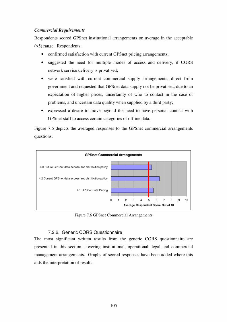
105
Commercial Requirements
Respondents scored GPSnet institutional arrangements on average in the acceptable
(>5) range. Respondents:
• confirmed satisfaction with current GPSnet pricing arrangements;
• suggested the need for multiple modes of access and delivery, if CORS
network service delivery is privatised;
• were satisfied with current commercial supply arrangements, direct from
government and requested that GPSnet data supply not be privatised, due to an
expectation of higher prices, uncertainty of who to contact in the case of
problems, and uncertain data quality when supplied by a third party;
• expressed a desire to move beyond the need to have personal contact with
GPSnet staff to access certain categories of offline data.
Figure 7.6 depicts the averaged responses to the GPSnet commercial arrangements
questions.
Figure 7.6 GPSnet Commercial Arrangements
7.2.2. Generic CORS Questionnaire
The most significant written results from the generic CORS questionnaire are
presented in this section, covering institutional, operational, legal and commercial
management arrangements. Graphs of scored responses have been added where this
aids the interpretation of results.
GPSnet Commercial Arrangements
0 1 2 3 4 5 6 7 8 9 10
4.1 GPSnet Data Pricing
4.2 Current GPSnet data access and distribution policy
4.3 Future GPSnet data access and distribution policy
Average Respondent Score Out of 10

106
Institutional Requirements
In relation to institutional requirements, the Generic CORS Questionnaire revealed
that:
• a majority of respondents anticipated significant or considerable benefits as a
result of CORS network unification, particularly for activities such as
precision farming, construction, transport and emergency services (Question
2.1.1);
• respondent support was evenly divided between state or federal government
management of state sponsored CORS networks, with an overriding appeal for
inter-government collaboration, whether it be at the operational level or for
standards setting (Question 2.1.2);
• respondents considered that CORS networks made a significant or
considerable contribution to the ASDI (Figure 7.7 Question 2.1.3);
0
2
4
6
8
10
12
14
16
Joined up
netw orks not
signif icant
Joined up
netw orks
some benefit
Joined up
netw orks
considerable
benefit
Joined up
netw orks
signif icant
benef it
Resp
on
ses
Figure 7.7 Question 2.1.3 CORS network contribution to the ASDI?
• respondent support was almost evenly divided between state and federal
custodianship for CORS network data, with federal government providing an

107
overseeing role, ensuring standards are maintained between states, and states
retaining the right to own CORS data (Question 2.1.4);
• a mixed respondent reaction to the question of responsibility for stakeholder
consultation saw support nearly evenly divided between the ICSM, state
reference groups and the (former) Australian GNSS Coordination Committee
(AGCC), with an over riding recognition of the need for CORS network
coordination in a management sense (Question 2.1.5).
Operational requirements
In relation to operational requirements, the Generic CORS Questionnaire revealed:
• almost all respondents attributed a high degree of importance to the adoption
of standard, internationally accepted correction formats, generated from
unified CORS networks and benefiting activities such as precision agriculture
(Question 2.2.1);
• horizontal CORS network correction accuracy at better than ±2 cm, either
completely or somewhat satisfied the accuracy needs of most respondents.
However, for users with a science focus, ±2 cm horizontal accuracy was
sometimes inadequate and post processing was seen as a viable alternative.
Respondents also highlighted the need for improved vertical accuracy
comparable to that achievable horizontally (Question 2.2.2);
• respondents overwhelmingly supported referencing state sponsored CORS
antenna coordinates to the ARGN (Question 2.2.3 Figure 7.8);

108
0
5
10
15
20
25
ARGN State Geodetic Other
Figure 7.8 Question 2.2.3 Importance of CORS antenna
coordinate relative to ARGN, state or other network?
• the majority of respondents indicated either high or considerable importance
of CORS network data quality alerts, however at least one user cautioned that
‘Too many warning automated emails or SMS alerts can work against the
network.’ (Question 2.2.4 Figure 7.9);
0
2
4
6
8
10
12
14
16
Not Somew hat Considerable High
Resp
on
ses
Figure 7.9 Question 2.2.4 Importance of data quality monitoring and user alerting?
• half the respondents considered that GNSS CORS network reception and
processing capability was of current importance, while nearly a third
considered it as only somewhat important (Question 2.2.5 Figure 7.10);

109
0
2
4
6
8
10
12
14
Not Somew hat Considerable High
Resp
on
ses
Figure 7.10 Question 2.2.5 Importance of CORS network GNSS reception and processing capability now?
• half the respondents considered CORS network GNSS reception and
processing capability in the next four years of high importance while almost a
third considered it of considerable importance (Question 2.2.6 Figure 7.11);
0
2
4
6
8
10
12
14
Not Somew hat Considerable High
Resp
on
ses
Figure 7.11 Question 2.2.6 Importance of CORS network GNSS
reception and processing capability in the next four years ?
• Half of the respondents indicated that NRTK was of high importance, and
approximately a third of considerable importance. NRTK service cost was
identified as an inhibitor to uptake if a user established reference station was

110
able to provide the same service at less cost compared to that provided through
a CORS network (Question 2.2.7); and
• A third of respondents indicated that CORS data for post processing was of
high importance, and approximately half of considerable importance, as a
result of the ability to support legal traceability, science and research
applications, in addition to backing up real time applications when outages
occurred (Question 2.2.8).
Legal requirements
• Most respondents did not consider privacy of location, (as a result of initial
user positions being sent to CORS networks and available to operators), as a
matter of major concern, with approximately forty percent of respondents
considering it as only somewhat important and a similar portion as not
important. While respondents accepted that such information could be
misused, they also indicated that restricting access to such data could mitigate
concerns (Question 2.3.1 Figure 7.12).
0
1
2
3
4
5
6
7
8
9
10
Not Somew hat Considerable High
Resp
on
ses
Figure 7.12 Question 2.3.1 Importance of privacy of user location within a CORS network?
• Approximately three quarters of respondents considered legal traceability of
position of high or considerable importance, with feedback indicating that
courts may need to determine if a user or the CORS network was at fault in the

111
generation of an inappropriate GNSS CORS corrected position (Question 2.3.2
Figure 7.13).
0
2
4
6
8
10
12
Not Somew hat Considerable High
Resp
on
ses
Figure 7.13 Question 2.3.2 Importance of legal traceability of position?
Commercial requirements
• Respondents indicated that distribution of CORS network data was in order of
preference, via a combination of government and the private sector
organisations (forty five percent), government only (thirty percent) and private
sector organisations only (approximately twenty percent) and that if there was
a division of responsibility then government should be responsible for the
infrastructure and the private sector packaging services and finding customers
(Question 2.4.1 Figure 7.14).

112
0
2
4
6
8
10
12
Govt Private Combination Other
Resp
on
ses
Figure 7.14 Question 2.4.1 CORS data distribution – how is it best distributed?
7.3. Conclusion
The dual questionnaire process resulted in twenty-three GPSnet registered users and
twenty-four generic CORS network user and stakeholder responses being returned for
analysis. Scored, multiple choice and written comments provided data for objective
and subjective analysis. Chapter 8 provides an objective and subjective analysis of
the results of the research. The validated CORS network management responses are
then used as the basis for the development of a CNMM.

113
8. TOWARDS UNIFIED AND SUSTAINABLE AUSTRALIAN STATE SPONSORED CORS NETWORKS
8.1. Introduction
Chapter 7 summarised the results of a dual questionnaire process of user and
stakeholder perspectives of CORS network management arrangements focussing on
institutional, legal, operational, and commercial requirements. One questionnaire
investigated in detail, the views and expectations of GPSnet users of CORS network
management, and a second investigated the views of CORS network users and
stakeholders in general from Australia and around the world. This chapter presents a
discussion and analysis of the questionnaire responses and uses the analysis to
propose a CNMM to support unified and sustainable CORS networks across
Australia.
8.2. Questionnaire Results Evaluation and Discussion
The results of the two questionnaires presented in chapter 7 were derived from a
sample of forty-seven responses from specific user perspectives. Based on the
number of responses and subsequent gap analysis, it was considered that major
shortcomings in the current GPSnet management arrangements would become
evident. Future surveys with larger sample sizes and diverse perspectives however
would assist in confirming the research findings.
The averaged scores from the GPSnet Registered User Questionnaire all rated in the
acceptable range across all questions. The general conclusion that can be inferred
from these results is that no major gaps exist in the GPSnet management arrangements
from a registered GPSnet user perspective. The results of the Generic CORS
questionnaire verified and reinforced the findings of the GPSnet Registered User
Questionnaire. The conclusion that can be drawn from the combined questionnaire
results is that no major gaps exist in GPSnet management responses to institutional,
legal, operational and commercial requirements from the perspective of GNSS users
and stakeholders in general.

114
The conclusion supports the hypothesis that arrangements adopted to respond to the
institutional, legal, operational and commercial requirements of one Australian state
jurisdiction CORS network, in this case GPSnet, can potentially be applied nationally,
to achieve consistency of management. The conclusion requires cautious application
however as users and stakeholders do not necessarily perceive or recognise all the
potential problems and implications that exist now and into the future concerning the
management of CORS networks. The combined questionnaires also represent
feedback aligned more with CORS network users than stakeholders. This suggests
additional evidence should be gathered to support the hypothesis particularly in
relation to institutional and commercial management arrangements which have a
greater focus for CORS network stakeholders.
The finding is significant as it provides evidence of the potential for general
application of GPSnet management arrangements in Australia and elsewhere.
The findings are also based on limited user experience of some aspects of GPSnet
management. High accuracy NRTK services for instance have only been available to
GPSnet users since January 2006. Extensive GPSnet user experience has yet to
accumulate which may alter future user perspectives. For example, over time,
particularly for professional GNSS/CORS users, experience may change perspectives.
Otherwise hidden legal implications of poor or inappropriate CORS network data
quality may only become apparent years after user positions have been accepted as
correct46.
The fact that privacy concerns were not considered of great importance to the majority
of GNSS/GPSnet users may be due to a lack of awareness or apathy about how CORS
network technology can be used ‘…for evil…’ as one respondent put it. Sector
analysis revealed that respondents to the questionnaires were primarily professional or
paraprofessional GNSS users, or have academic interests in CORS networks.
Professional or paraprofessional GNSS users do not necessarily represent the
expectations of lay GNSS/CORS users. Questionnaire respondents indicated minimal
concern that GPSnet operators may know their location in real time. By contrast, lay
46 For instance, a cadastral survey incorporating GNSS/CORS measurements may be challenged for correctness many years after the measurement of position is made.

115
users may be concerned about the potential adverse impact of location tracking and
social networking analysis as suggested by Iqbal and Lim (2007).
Respondents indicated that GPSnet CORS services are facilitated, coordinated, and
delivered reliably on a commercially acceptable basis. This finding does not conform
with the generalisation asserted by Rizos and Cranenbroek (2006) that:
The ‘geodetic legacy’ of permanent GNSS networks means that many of the
network operators have surveying and geodesy backgrounds, and few of them
have the IT specialists, and even the resources, to maintain a reliable service.
Furthermore, government agencies, the dominant GPS network receiver
operators, are notoriously bad at running commercial ventures.
A possible explanation for the difference between prevailing theory and the views
provided by GPSnet users is the location of GPSnet management within the SII
business of DSE. While GPSnet is managed by staff with surveying and geodetic
backgrounds, it is also the case that SII is responsible for developing and managing
Victoria's fundamental spatial information in addition to DSE’s corporate spatial
information resources. SII’s area of responsibility covers a broad range of potential
spatial data users and stakeholders, exposing GPSnet services to a large potential user
base. The opportunity to cross promote and integrate complementary spatial products
with GPSnet services, combined with a SII culture of customer focus, may well have
led to a satisfied user base. The results indicate that rather than all government
agencies being bad at running commercial ventures it is perhaps more the focus of
government agency concerned that needs to be considered as the deciding factor.
The suggestion by Rizos and Cranenbroek (2006), ‘…for the government agency to
license their data to a private service provider, who is then responsible for the
marketing of data generated using the basic GPS network infrastructure.’ was not
strongly endorsed by the respondents to the questionnaire. However partnership
between Australian State (and Federal) governments had respondent support. It is
probable that Australian governments, combining with the marketing and distribution
capabilities of the private sector may well provide the only viable way of marshalling

116
sufficient resources and capabilities to deliver NRTK CORS network services across
large areas of the nation, despite user reservations about such an approach.
Support for provision of CORS network services by government may also change as
service dependency increases and user expectations become more demanding. For
instance precision farmers have yet to take full advantage of CORS network services.
Precision farmers conduct auto-guidance night spraying to avoid spray drift and also
work continuously during specific cropping seasons which increases expectations of
service delivery beyond daylight hours into the night and also during holidays.
Government employees are typically not employed on weekends or during night-time
and holidays to ensure service continuity for this type of application, exposing users
to potential outages. By contrast, private sector organisations ensure that customer
service demands are met, regardless of the day of the week or hour of the day, when
the profit motive is sufficient47.
The questionnaires also revealed a desire for technical standardisation of CORS and a
consistent approach to CORS deployment and operation across the nation. CORS
standardisation would enable users to easily access and confidently use position and
guidance services regardless of location. The development of open technical
standards such as RTCM 3 and NTRIP, spatial referencing to the ARGN/GDA94,
legal traceability and their adoption in GPSnet, was endorsed by questionnaire
respondents, giving a clear guide to CNMM development.
Multi jurisdictional support for open technical standards is likely due to the increasing
adoption of these standards by GNSS equipment manufacturers. It is less likely that a
universal form of access to CORS services can occur while jurisdictions adopt
different proprietary network RTK processing systems across Australia and distribute
data individually. If raw RTK CORS data is pooled by jurisdictions for subsequent
distribution, universal access becomes possible. Once again, caution is needed in
CNMM development if data pooling is adopted as the problem of assigning legal
responsibility for data quality is more complex.
47 Utility companies for instance typically offer 24 hour emergency services in Australia.

117
Feedback about GPSnet user consultation through VGRG meetings indicated that user
and stakeholder consultations should include regional and rural locations in addition
to captial cities. This approach would benefit country based GPSnet hosts, and
registered and prospective users that would not normally travel to such meetings.
Groups such as precision agriculture, silviculture, mining and other primary industries
that could benefit from CORS networks are not typically located adjacent to cities and
would benefit from such a strategy.
During the research, on the April 23 2007, the first such regional VGRG meeting was
held in Ballarat and approximately twenty five people (apart from organisers and
presenters) attended, many of whom travelled over 100 km from Melbourne.
Disappointingly, few attendees were attracted from the local area even though NRTK
services are available in the region. The results of this initiative are at best
inconclusive. Future consultation in regional areas is needed before a final decision
can be made about the success of the strategy.
Section 8.3 uses the conclusions drawn from the results and previous discussion to
propose an example of how GPSnet management arrangements could be exploited
nationally.
8.3. A Model For Australian State RTK CORS Network Management
The analysis and discussion in section 8.2 found that, as long as some particular
concerns and considerations are allowed for, GPSnet management responses can be
considered for national adoption to meet the requirements of CORS network
management generally. The consistent adoption of appropriate CORS network
management arrangements is considered a necessary precursor to the development of
an overall approach to managing unified CORS networks across Australia. This
section sets out how GPSnet management arrangements can be integrated into an
overall CNMM first developed by Hale et al. (2006).
Fundamentally a CNMM is recommended to be based on partnerships. Partnerships
underpin contemporary ASDI development and can take advantage of the
coordination and standards setting capabilities of the public sector. These capabilities

118
can then be combined with the technical innovation, marketing and distribution
capabilities of the private sector. This arrangement can optimise position and
navigation outcomes for Australian CORS network users that would not otherwise be
created by each sector independently.
Both federal and state governments would be involved in CORS network
development and operation, with federal government coordinating a framework that
could be ‘in-filled’ at state and territory level48. Individual state and territory
sponsored CORS networks would have the flexibility to include arrangements
particular to a jurisdiction, such as protection to mitigate strikes in lightning prone
areas, or multiple receivers for a single CORS site in remote locations. However
agreements between jurisdictions would ensure consistency concerning core
institutional, operational, commercial and legal management requirements as
described in section 5.3.
Arrangements for commercial supply of ubiquitous CORS network services nationally
was identified as needing to migrate beyond state jurisdictions. Successful
commercial supply arrangements need to generate an adequate ROI to sustain both
CORS network infrastructure and provision of services. GPSnet respondents
validated commercial supply of RTK and other CORS network data direct from state
government. Despite this finding, ubiquitous positioning and navigation services,
supplied commercially to users on a national basis can be reasonably expected to
demand arrangements well beyond the capacity of any one state government.
Organisations such as ASIBA can also be expected to advocate for the engagement of
private sector players in the supply chain.
Private sector CORS data service providers (DSPs) would take part in the CORS
network data supply chain. They could take advantage of unified CORS network data
and provide services efficiently using technologies such as geosynchronous satellites
to reach the widest possible user base. Private sector companies with specialised
marketing, promotional capabilities, and access to market intelligence could also be
expected to have a greater capability to service a wider user base than individual
48 The AuScope NCRIS network of GNSS CORS provides the basis of such a framework.

119
government agencies. Publicly available jurisdiction CORS network product
descriptions would assist users to be informed about services offered.
Private-public partnerships would help maximise profits and apportion royalties in an
agreed manner, allowing contributing CORS network operators to sustain
contemporary CORS network infrastructure. The interests of state sponsored CORS
network operators could be represented by joint ventures, consortiums, or existing
companies such as the Public Sector Management Agency (PSMA) Australia
Limited49. PSMA already combines spatial data from Australia’s various federal and
state governments to create national spatial information datasets and offer them to
industry, government and the community to achieve economic, environmental and
social benefits for Australia (PSMA 2007). Wholesale CORS data licence fees would
be established and maintained through neutral competitive pricing determinations.
VARs could also be offered licences to integrate CORS data with complementary
services adding further value, such as providing positioning solutions with non-
standard datum specifications50, high accuracy geoid correction surfaces, professional
quality assurance indicator and alerting services. VARS could also bundle dedicated
GNSS rover equipment and CORS network access into convenient hire packages, or
offer GNSS rover equipment and CORS access packages outright. Business models,
such as service broking, proposed by Rizos and Cranenbroek (2006), could also be
supported through the CNMM. Privacy concerns identified in the questionnaire
process would need to be managed at both the CORS network operator and potentially
DSP and VAR level, especially if raw data was processed that included identifiable
user positions and tracking information.
The CNMM would support access to CORS data direct from network operators and
without charge for non-commercial research. Researchers would then have an
enhanced ability to improve CORS network and end user systems and processes. By
gaining access to unified CORS networks over large areas of Australia it could be
49 PSMA Australia Limited, formerly known as Public Sector Mapping Agencies, is an unlisted public
company wholly owned by the State, Territory and Australian Governments. Subsequently referred to as PSMA. 50 And requirements such as corrected coordinates referenced to ITRF00 as requested by a respondent to the GPSnet Registered User Questionnaire.

120
anticipated that multimodal application development would be increased in addition
to improving CORS network systems. An example of the former is the use of CORS
data by the Australian Government Bureau of Meteorology for precipitable water
vapour analysis leading to improved numerical weather modelling. An example of
the latter would be the improvement of ionospheric models in CORS network
software to extend the range between CORS nodes and the reliability of positions
generated within the networks.
Figure 8.1 depicts an overview of the proposed CNMM.
Figure 8.1 GNSS CORS Network Management Model (Adapted from Hale et al. 2006)
Hale et al. (2006) set out the principle benefits and application of the CNMM based
on unified CORS networks as:
• underpinning DC development and redevelopment (Keenan et al. 2005);
• contributing to the process of making underground facilities ‘discoverable’
using precise, ‘as constructed’ survey and mapping techniques;

121
• helping build data models of the real world as expressed in FIG’s Cadastre
2014 vision (Kaufmann and Steudler, 1998);
• supporting emergency services and counter terrorism activities;
• supporting precision agriculture; and
• supporting machine guidance for construction.
8.4. Concluding Remarks
The analysis of the questionnaire results presented in chapter 7 provides evidence that
GPSnet management responses to institutional, legal, operational and commercial
requirements of RTK CORS networks can, with caution, be applied consistently on a
national basis. From a GPSnet user and stakeholder perspective, there were no major
gaps in GPSnet management that could be identified. Although all elements of the
GPSnet management responses may not be applicable in every jurisdiction, they do
provide an example of a successful approach to RTK CORS network management on
which a national approach can be modelled.
By adopting a consistent approach to management, jurisdiction networks can be more
readily and effectively unified and harmonised in an operational and managerial
sense. This approach also supports a partnership between the private and public
sectors to take place and increase prospects for ubiquitous and sustainable positioning
and navigation using RTK CORS networks Australia wide.

122
9. CONCLUSION
9.1. Research Summary
This chapter documents the major findings and outcomes of this research in relation to
the aim and objectives set out in chapter 1. The research aimed to identify
management responses that can be adopted to consistently meet the institutional,
legal, commercial and operational requirements of state and territory sponsored CORS
networks in Australia that also satisfy GNSS/CORS network user and stakeholder
needs.
The research hypothesis posed the question—can the arrangements adopted to
respond to the institutional, legal, operational and commercial requirements of one
Australian state jurisdiction CORS network, be applied nationally, to achieve
management consistency?
To achieve the research aim and test the research hypothesis the following tasks were
carried out:
1. determine the fundamental requirements for CORS network management;
2. use questionnaires to obtain the views of GPSnet registered users and any
person interested in the management of CORS networks generally from
Australia and internationally;
3. formulate management arrangements to consistently address institutional,
legal, operational and commercial requirements of CORS networks across
Australian jurisdictions; and
4. propose a CNMM based on these consistent management arrangements.
Significant observations and conclusions arising from the research are summarised in
the following sections.

123
9.2. Research Observations and Conclusions
9.2.1. RTK CORS Networks – part of spatial sciences infrastructure
It was observed from Chapter 2 that primary, first generation GNSS systems such as
GPS and GLONASS are mature or maturing technologies. Modernisation is also
underway or planned in the near future for both GPS and GLONASS. First
generation GNSS systems, augmented by RTK CORS networks, are currently the
only commercially available and reliable means of achieving sub ±2cm horizontal real
time satellite positioning and navigation. PPP was not found currently to be a
practical or viable alternative to positioning and navigation using RTK CORS
networks.
The increasing availability of the mobile internet, internationally accepted NRTK
formats, such as RTCM 3 and communications protocols, such as NTRIP, do provide
an increased capacity for GNSS equipment and systems interoperability and utility.
As a result, RTK CORS networks can now be considered an important part of spatial
sciences infrastructure. The challenge for state governments operating and managing
RTK CORS networks is determining how to optimise the utility of GNSS RTK CORS
networks and achieve ubiquity of service.
The research also revealed the potential benefits of unifying disparate RTK CORS
networks and applying NRTK correction services to nationally significant industries
and applications across Australia. With Australia’s small population and large land
area, collaboration between state RTK CORS network managers and private sector
providers to offer unified and commercial services to GNSS users is an advantageous
solution. By adopting consistent management of state sponsored RTK CORS
networks, private sector DSPs and VARs alike would be attracted to commercially
engage GNSS users. Through public and private sector partnerships and disparate
state sponsored CORS network unification, a pathway towards sustainable RTK
CORS network management for Australia can also be realised.
Investigations revealed the UK’s OS NET as an example of public and private sector
partnership, demonstrating how the public sector can concentrate its resources on
managing CORS network infrastructure while the private sector can focus on

124
marketing, distribution, value adding and customers. The German republic’s SAPOS
network was also revealed as an example of comprehensive RTK CORS network
unification, showing how integration across state jurisdictions can be achieved within
(and even beyond national boundaries) through the use of representative working
parties to achieve uniform technical and operational standards.
With RTK CORS networks becoming an important part of the spatial infrastructure of
states and nations comes the need to ensure that such infrastructure is kept relevant to
the needs and expectations of users. Research found that the increasing availability of
dual constellation receivers and demand for dual constellation CORS network
correction data is an important consideration for network operators if they are to
properly fund and time CORS receiver and antenna upgrades, specify storage
requirements for post processing, and transmit data to users. Future CORS network
specification and configuration needs to take account of the introduction of ‘next
generation’ GNSS constellations, such as Galileo, and consider CORS network site
upgrade timing, network density, and priority locations of rollout.
9.2.2. RTK CORS Networks – Drivers, Barriers, Users
Chapter 4 established the rationale for Australian state and national governments to be
engaged in RTK CORS network management in order to improve access to consistent
position and navigation data within the context of the ASDI. The research found that
the ASDI is dependant on sound infrastructure, founded on appropriate policy and
administrative arrangements, people and technology and making the resulting spatial
data and services accessible to the community. Partnerships and sharing discrete RTK
CORS networks and data supports more efficient infrastructure utilisation, enhanced
services and coverage than would otherwise occur if left as disconnected networks.
It was concluded that, by adopting an appropriate management model based on
principles that focus on user needs, technical and legal standards, fair pricing and
access, perceived and actual barriers to using GNSS RTK CORS networks could be
overcome. Research reinforced the need for appropriate responses to legal
requirements for general RTK CORS network users. It was also determined that
while the main driver of government involvement in RTK CORS networks was

125
ASDI/SDI policy related, an adequate ROI was important to ensure network
sustainability over the long term. Machine guidance, spatial applications, and
transport were the sectors found most likely to play a significant role in contributing
to an adequate ROI for CORS infrastructures. These same sectors were also found to
require responses to institutional, legal, operational and commercial requirements of
RTK CORS network management.
9.2.3. GPSnet Management Practices – Users and CORS Stakeholders
Chapter 5 reviewed GPSnet management arrangements, while chapter 6 investigated
the adequacy of these arrangements from the perspective of GPSnet users and also
more generally by seeking the views of CORS users and stakeholders in Australia and
internationally. The investigation concluded that GPSnet management responses are,
on the whole, an adequate and appropriate response to the requirements of CORS
network management—from a user’s perspective.
GPSnet management principles and practices:
• are based on a cooperative approach to infrastructure development;
• adopt contemporary technical standards of operation that are available for
public scrutiny;
• are subject to quality assurance of data services;
• provide services specified to be fit for purpose and legally compliant and
defendable;
• support proactive user consultation; and
• are commercially orientated with the objective of providing an adequate ROI.
It was concluded that GPSnet management responses can be adopted to consistently
meet the institutional, legal, commercial and operational requirements of state and
territory sponsored CORS networks in Australia that also satisfy GNSS/CORS
network user and stakeholder needs.

126
9.3. CORS Network Management Model for Australia
The review of GPSnet management principles and practices, user feedback and
validation provided the basis for developing a CNMM with the potential to be a viable
approach to unifying, developing, managing, and distributing homogeneous CORS
network services across Australia. The proposed CNMM has the capacity to support
significant national activities and sectors and increase the prospect of providing an
appropriate ROI and achieve network sustainability over the longer term.
The CNMM is a particular approach for a unique situation that involves a federation
of states, a small population, a large area to be serviced and a low level of
communication infrastructure compared to many other nations. The CNMM may be
useful in other locations around the world, however, careful consideration of the
prevailing circumstances would need to be performed before adopting such a model.
9.4. Future Research
The CNMM proposed by this research is an unproven model in that only the
underlying CORS management arrangements have been subjected to a limited process
of investigating gaps in management (from a user and stakeholder perspective).
Future research is recommended into CNMMs including:
• Determining how well different business models would perform in
conjunction with the recommended CNMM. Business models proposed by
Rizos & Cranenbroek (2006) would be a useful starting point for future
research. Analysis would assess business model performance in support of
service delivery and determine the level of user fees generated by DSPs and
VARs and related royalties to CORS network operators51. Establishing and
achieving specific levels of ROI and generating specific amounts of royalties
to sustain contemporary network capacity to meet user needs would be key
indicators of success.
• Investigating the appropriateness of organisations such as the PSMA to
manage the bulk licensing and wholesaling of data distribution from unified
CORS networks through private sector DSPs and VARs to GNSS users.
Currently the PSMA is focussed on compiling digital map related data of the
51 CRCSI Project 1.4 is expected to investigate a number of these key issues.

127
nation and the addition of RTK CORS network data to the product line would
represent a significant addition to its business objectives. Discussions should
be conducted with PSMA management to investigate the viability of this
option.
• Facilitating an agreement between Australian State, Territory and Federal
government jurisdictions, as well as organisations such as AuScope, would be
required before the CNMM would be able to function. Research should be
conducted into selecting or proposing suitable organisations and arrangements
needed to support multi-jurisdictional collaboration to ensure the management
arrangements proposed in the CNMM are met. Bodies such as the ICSM
GTSC or a new ICSM Sub Committee specifically focussed on a unified
CORS network could be used as a starting point.
RTK CORS network management in Australia is a topic of increasing importance to
users, stakeholders and the nation as dependence on satellite based positioning and
navigation and other ground based positioning systems becomes more wide spread.
By identifying and validating management responses adopted in Victoria’s
cooperative RTK CORS network (GPSnet), it is hoped that this thesis contributes to
state sponsored CORS network unification and their long-term sustainability.

128
10. References
Alder, K. 2004, The Measure of All Things, 2nd edn, Abacus, Great Britain, p. 23.
Allen 2007, The Economic Benefits of Making GPSnet Available To Victorian
Agriculture Final Report, July 2007, Report to the Department of
Sustainability and Environment.
AMSA 2006, Differential Global Positioning System (DGPS) Fact Sheet. Retrieved
January 2, 2007, from http://www.amsa.gov.au/Shipping_Safety/
Navigation_Safety/Differential_Global_Postitioning_System/DGPS_Fact_
Sheet.asp.
ANZLIC 2006, Australian Spatial Data Infrastructure. Retrieved March 4, 2007,
from http://www.anzlic.org.au/infrastructure_ASDI.html#what.
ASDI 2007, Australian Spatial Data Infrastructure. Retrieved August 12, 2007 from
http://www.anzlic.org.au/infrastructure_ASDI.html.
Ashkenazi, V. 2005, GNSS: Benefits, Risks and Misconceptions, key note address,
International Symposium on GPS/GNSS, The Hong Kong Polytechnic,
Hong Kong.
ASIBA 2003, Position Statement – Access to Fundamental Data. Retrieved July 8
2007, from http://www.asiba.com.au/clients/asiba/UserFiles/File/Position
%20Statements/Position_access.pdf.
Bhalla, G. 2007, Legal Implications for On-Line Distribution of Government Held
Fundamental Spatial Data, Proc. of Spatial Science Institute Biennial
International Conference, Hobart, Australia, May 14-18, pp. 565-577.
Brown, N. 2003, GQC. Retrieved August 12, 2007, from
http://www.geom.unimelb.edu.au/geodesy/GQC.htm.
Chapman, W., and Neale, T. 2007, Proc. of the 5th Australian Controlled Traffic
Farming & Precision Agriculture Conference, CTF07, 16-18 July Perth,
pp. 27-31.

129
Choy, S., Zhang, K., Silcock, D., & Wu. F. 2007, Precise Point Positioning – A Case
Study in Australia, Proc. of Spatial Science Institute Biennial International
Conference, Hobart, Australia, May 14-18, pp. 201.
‘Compass: and China’s GNSS Makes Four’ 2006, Inside GNSS, vol. 1, no. 8, p. 14.
‘Compass Points Way to Positioning System’ 2006, China Daily, November 13,
2006. Retrieved January 1, 2007, from http://www.china.org.cn/english
/MATERIAL/188713.htm.
Cranenbroeck, J. 2005, A New Total Station Tracking GPS Satellites in a Network
RTK Infrastructure Perspective, From Pharaohs to Geoinformatics FIG
Working Week 2005 and GSDI-8, Cairo, Egypt, April 16-21.
CRCSI 2007, Associated Projects: 1.4 Integrating Electricity, Telecommunications
and Government Infrastructure to Deliver Precise Positioning Services in
Regional Areas. Retrieved June 18, 2007 from http://www.crcsi.com.au/
pages/project.aspx?projectid=89.
Crosby, G., McPherson, K., Ely, W., Stewart, J., Kraus, D., Cashin, T., Bean, K. &
Elrod, B. 2000, A Ground-based Regional Augmentation System (GRAS)
– The Australian Proposal, Presented at ION GPS2000, Salt Lake City,
UT, 20-22 September. Retrieved January 2, 2007, from http://www.airser
vicesaustralia.com/pilotcentre/projects/gnss/gnss_gras_ion2000_paper.pdf.
Crossley, R., & Dines, G. 2004, Integrating harvester GPS tracking data with a spatial
harvest recording system. Conference of the Australian Society of Sugar
Cane Technologists, Brisbane, 4-7 May 2004.
DCITA 2000, Connecting Australia - Report of the Telecommunications Service
Inquiry. Retrieved July 1, 2007 from http://www.telinquiry.gov.au/files/
final_report.pdf.
Denham, J., Whitlock, A. & Yule, D. 2006, Contemporary Position and Navigation
Needs of Precision Agriculture and Victoria’s GPSnet CORS Network.
Proc. of the International Global Navigation Satellite Systems Society
IGNSS Symposium 2006, Surfers Paradise, Australia.

130
DoD 2001, Global Positioning System Standard Positioning Service Performance
Standard - October, 2001. Retrieved December 28, 2006, from http://pnt.
gov/public/docs/SPS-2001-final.pdf.
DSE n.d., GPSnet™ Co-operative GPS Base Stations Information for Prospective
Hosts Version 2.0. Retrieved August 12, 2007 from http://www.land.vic.
gov.au/CA256F310024B628/0/AEC8D898D40842B7CA2570770009EFB
F/$File/GPSnet+Hosting+Guidelines+Version2.pdf.
DSE 2006a, Vicmap Position – GPSnet Application Form. Retrieved August 12,
2007, from http://www.land.vic.gov.au/CA256F310024B628/0/ACFA0C
A368F789CACA25719300206255/$File/GPSnet+Application+Version+1
8.pdf.
—— 2006b, Vicmap Position Pricing Sheet. Retrieved August 12, 2007, from
http://www.land.vic.gov.au/CA256F310024B628/0/AFAD9E07027D1816
CA257179001E80F5/$File/Vicmap-Position+Pricing+Information+Sheet
.pdf.
—— 2006c, GNSS/GPS Technical Support Newsletter Issue Number 23. Retrieved
August 12, 2007, from http://www.land.vic.gov.au/CA256F310024B628
/0/3A5E78F0823BA4CECA25725900076ECA/$File/GPS+GNSS+Techni
cal+Support+Newsletter+No+23.pdf.
—— 2007, GPSnet GPS Reference Station Logon and Site Details. Retrieved August
12, 2007, from http://www.land.vic.gov.au/land/lcnlc2.nsf/childdocs/-418
EED712A81C5AE4A256A0A0015CDC1-5DF1E2E5B878F6634A256A
0A001DAC5C-0887F847B6D2DA16CA256E5F0013CBB8-C22C2EBA
F2DC90F34A256A250007E33C?open.
EGNOS 2006, European Geostationary Navigation Overlay Service. Retrieved
September 7, 2007, from
http://194.224.177.81/Webportal/Egnos/Pages/Home.page.
Enderle, W., Higgins M. & Einicke, G. 2006, Getting Ready for Galileo, Position,
Issue 26, December 2006 - January 2007.

131
ESA 2005, Galileo -The European Programme for Global Navigation Services.
Retrieved August 11, 2007, from http://ec.europa.eu/dgs/energy_transport/
galileo/documents/doc/2005_02_23_galileo_en.pdf.
—— 2006, Market Prospects and Business Opportunities. Retrieved January 1, 2007.
from http://www.esa.int/esaNA/GGGMN850NDC_galileo_0.html.
Euler, H. 2006, GNSS solutions: A New Version of the RTCM SC-104 Standard,
Inside GNSS, October 2006, pp. 20-22.
EUPOS 2007, European Position Determination System. Retrieved June 17, 2007,
from http://www.eupos.org/index.php?option=com_content&task=view
&id=3&Itemid=39.
EUREF 2006, Overview of EUREF. Retrieved June 17, 2007, from http://www.euref-
iag.net/html/Overview_of_EUREF.html.
Fuller, S. (forthcoming), Real-Time Quality Control for CORS Networks and Mobile
Users.
Galileo’s New PPP – Public – Public Partnerhsip? 2007. Retrieved August 11, 2007,
from http://www.insidegnss.com/pdf/JulyAug07-360-degrees.pdf.
Gao, Y. 2006, Precise Point Positioning and its Challenges, Inside GNSS,
November/December 2006, p. 16.
Gaudet, A. & Landry, J.C. 2005, TERIA: The GNSS Network for France From
Pharaohs to Geoinformatics, FIG Working Week 2005 and GSDI-8, Cairo,
Egypt April 16-21.
Geoscience Australia 2006, Australian Spatial Data Infrastructure. Retrieved March 4
2007, from http://www.ga.gov.au/nmd/asdi/.
Gibbons, G. 2006, Will Success Spoil GPS?, Inside GNSS, pp. 25-27. Retrieved
December 29 2006, from http://www.insidegnss.com/pdf/trilogy_sec.pdf.
—— 2006a, GLONASS, The Once and Future GNSS, Inside GNSS, pp. 28-30.
Retrieved Dec 29, 2006, from http://www.insidegnss.com/pdf/trilogy_sec.
pdf.
—— 2006b, Compass: And China’s GNSS Makes Four, Inside GNSS, vol. 1, no. 8,
November/December, p. 14.

132
—— 2007, GLONASS The Way Ahead, Inside GNSS, vol. 2, no. 3, p. 21.
Google Map 2007, Google Maps Australia (Beta). Retrieved 4 March 2007, from
http://maps.google.com.au/.
Gordini, C. 2007, A performance Evaluation of Sparse Networks of Continuously
Operating Reference Station Networks for Mobile Mapping Applications.
The 5th International Symposium on Mobile Mapping Technology, Padua,
Italy 29-31 May.
GPS Daily 2006, Raytheon Completes Demonstration of Space-Based Navigation
System in India. Retrieved 7 September 2007 from
http://www.gpsdaily.com/reports/Raytheon_Completes_Demonstration_of
_Space_Based_Navigation_System_in_India_999.html.
GSI 1995, Geodetic Survey. Retrieved March 6, 2007, from http://www.gsi.go.jp/
ENGLISH/GEODETIC/geodetic.html.
Hale, M., Collier, P. & Kealy, A. 2005, Developing a Model for CORS Network
Management. Proc. of International Symposium on GPS/GNSS, Hong
Kong, 2005.
Hale, M., Collier, P. & Kealy, A. 2006, Validating a Model for CORS Network
Management. Proc. of International Global Navigation Satellite Systems
Society IGNSS Symposium 2006, Australia.
Hale, M., Collier, P. & Kealy, A. (forthcoming), Validating GPSnet CORS Network
Management Validation Through User Feedback.
Hale, M. & Ramm, P. 2007, GPSnet – Current and Future Developments in GNSS
CORS Network Management and Service Delivery, Proc. of SSC2007
Spatial Sciences Institute Symposium 2007, Hobart, Australia May 14-18.
Hope, S., Menner, G., Marwick, B., Ramm, P., Kealy, A. & Hunter, G. 2007,
Cadastral Upgrade as a By-Product Of Spatial Data Collection: A Case
Study From Regional Victoria, Proc. of Spatial Science Institute Biennial
International Conference, Hobart, Australia, May 14-18, pp. 36.
Hugentobler, U., Dach, R., Fridez, P. & Meindl M. (eds) 2006, Bernese GPS
Software, Version 5.0 Draft, Astronomical Institute, University of Berne.

133
Retrieved February 9, 2007 from http://www.bernese.unibe.ch/docs/DOC
U50draft.pdf.
IGS 2006, IGS FAQ. Retrieved January 4, 2007, from http://igscb.jpl.nasa.gov/faqs.
html#id2845505.
Iqbal, M.U. & Lim, S., in press, A User Perspective of Privacy In Telematics.
JMA 2007, Meteorological Satellite MTSAT series, Retreived September 7, 2007,
from http://www.jma.go.jp/jma/jma-eng/satellite/index.html.
Johns, T. 2001, WAAS, DGPS and the Mariner’s Toolkit, US Coast Guard,
Radionavigation Bulletin, Spring/Summer 2001, Issue no. 36, p. 13.
Retrieved July 29, 2007, from http://www.navcen.uscg.gov/pubs/rnavbull
/rnbull36.pdf.
Kaufmann, J. & Steudler, D. 1998. FIG Cadastre 2014 A Vision for a Future
Cadastral System. Retrieved September 20, 2005, from http://www2.swiss
topo.ch/fig-wg71/cad2014.htm.
Keenan, R., Wang. Q., Cranenbroeck, J.V., & Wu, L. 2005, GPS Reference Station
Networks as the Fundamental Infrastructure of Digital Cities in China,
Proceedings of the International Symposium on GPS/GNSS, Hong Kong.
Landmark 2006, Satellite technology replaces the pegs, Retreived September 7, 2007
from
http://www.land.vic.gov.au/CA256F310024B628/0/16D750FDA42223CB
CA25712C001B4D7C/$File/Landmark+March+2006_lo+res.pdf.
Leica, 2005, Leica Geosystems Networked Reference Stations, White Paper.
Retrieved June 17, 2007. from http://www.leica-geosystems.com/common
/shared/downloads/inc/downloader.asp?id=5367.
Leica Geosystems, 2006, SmartNet Introducing SmartNet-UK, the first Leica
Geosystems Commercial Network RTK Correction service, XXIII
International FIG Congress, October 8-13, 2006. Retrieved June 17, 2006
from http://www.fig.net/pub/fig2006/papers/ts03/ts03_02_burbridge_0342
.pdf.
Leica Geosystems AG 2007, Keep Up With the Youngsters, Reporter 56, The global
magazine of Leica Geosystems, p. 21.

134
Lenz, E. 2004, Networked Transport of RTCM via Internet Protocol (NTRIP) –
Application and Benefit in Modern Surveying Systems, FIG Working
Week 2004, Athens, Greece, May 22-27. Retreived July 28, 2007, from
http://www.fig.net/pub/athens/papers/ts03/ts03_2_lenz.pdf.
Lorminer, R. 2006, What is GNSS?, Position, June/July 2006, no 23, p. 59-61.
Marradi, L., Franzoni, G., Foglia, L., Fossati, D., Cornacchini, C., Le Goff, M,,
Duchesne, L., Foged, L., Ferdandez, A., Caramagno, A., Schweikert, R.,
Woerz, T., & Gabaglio, V. 2006, The Garda Project, Inside GNSS, pp. 40-
52.
National Space-Based PNT Executive Committee 2004, U.S. Space-Based
Positioning, Navigation, and Timing Policy, December 15, 2004 Fact
Sheet. Retrieved December 27, 2006, from http://pnt.gov/policy/.
Navstar Global Positioning System 2004, Interface Specification, IS-GPS-200,
Revision D, 7 December 2004, Navstar GPS Space Segment/Navigation
User Interfaces. Retrieved December 28, 2006, from http://www.navcen.
uscg.gov/gps/geninfo/IS-GPS-200D.pdf.
Navstar Global Positioning System Joint Program Office 2005, GPS Overview GPS –
Navstar GPS Fact Sheet. Retrieved December 28, 2006, from http://gps.los
angeles.af.mil/jpo/gpsoverview.htm.
NCRIS 2006, Geospatial Working Groups - version 5 May. Retrieved June 4, 2006,
from http://www.auscope.org.au/.
NCRIS n.d., National Collaborative Research Infrastructure Strategy. Retrieved
March 18, 2007, from http://www.ncris.dest.gov.au/NR/rdonlyres
/79D83DCE-8CA2-4E4B-99CC-F7B7A2B2CC4C/14718/NCRIS
factsheets_oz_structure_content.pdf.
NGS 2007, National Geodetic CORS. Retrieved June 17, 2007, from
http://www.ngs.noaa.gov/CORS/cors-data.html.
OS 2007, OS Net. Retrieved June 17, 2007, from http://www.ordnancesurvey
.co.uk/oswebsite/gps/commercialservices/index.html.
PNT 2007, The Global Positioning System. Retrieved August 11, 2007, from
http://www.gps.gov/.

135
PSMA 2007, About PSMA Limited. Retrieved June 1, 2007, from http://www.
psma.com.au/about.
Rajabifard, A., Binns, A., & Williamson, I. 2007, SDI to Facilitate a Spatially
Enabled Society, Proc. of Spatial Science Institute Biennial International
Conference, Hobart, Australia, May 14-18, pp. 380 - 381.
Ramm, P. &, Hale, M. 2004, Realisation of the Geodetic Datum in Victoria, Proc. of
the 2004 International Symposium on GNSS/GPS, Sydney, Australia.
Ramm, P., Hale, & M., Jones, C., 2000, Geodetic Infrastructure - A Cooperative
Future, 2nd Trans Tasman Surveyors Congress, 20 - 26 August, 2000,
Christchurch.
Rizos, C. 2002, Network RTK Research and Implementation - A Geodetic
Perspective, Journal of Global Positioning Systems, vol. 1, no. 2: pp. 144-
150.
Rizos, C. 2005, Trends in Geopositioning for LBS, Navigation and Mapping, School
of Surveying and Spatial Information Systems. Retrieved June 15, 2007,
from http://www.gmat.unsw.edu.au/snap/publications/rizos_2005b.pdf.
Rizos, C. & Han, S. 2003, Reference Station Network Based RTK Systems –
Concepts and Progress, Whuhan University Journal of Nature and
Sciences, 8(2B), 566-574.
Rizos, C., Higgins, M.B., & Hewitson, S. 2005, ‘New GNSS Developments and Their
Impact On Survey Service Providers and Surveyors’, Proc. of SSC2005,
Spatial Intelligence, Innovation and Praxis: The national biennial
conference of the Spatial Sciences Institute, Melbourne.
Rizos, C. & Cranenbroeck, J. 2006, Making GNSS-RTK Services Pay, FIG Congress,
Munich, Germany, 8-13 October 2006.
Rizos, C. 2007, Alternatives to Current GPS-RTK Services & Some Implications for
CORS Infrastructure and Operations, GPS Solutions, vol. 11, no. 3, July,
2007.

136
Roberts, C., McElroy, S., Kinlyside, D., Yan, T., Jones, J., Allison, S., Hendro, F., &
Hoffman, S. 2007, Centimetres across Sydney: First Results From the
SydNET CORS Network, Proc. of Spatial Science Institute Biennial
International Conference, Hobart, Australia, May 14-18, pp. 154.
Ross, B. 2007, Victorian Survey Control Network Co-ordinate Values and The
National Adjustment, Traverse, Institution of Surveyors Victoria,
January/February, no. 239, pp. 9.
SAPOS 2004, Satellite Positioning Service of the German State Survey. Retrieved
June 4, 2006, from http://www.sapos.de/pdf/Flyer/2004Heft_e.pdf.
Schrock, G.M. 2006a, On-Grid goal: Seeking Support for High-Precision Networks.
GPS World, 17(10), pp. 34-40.
—— 2006b, The On-Grid Initiative, White Paper Prepared for the American Congress
on Surveying and Mapping and the National Society for Professional
Surveyors, March, 27 2006. Retrieved June 1, 2007, from
http://www.aagsmo.org/textfiles/OnGrid_White-Paper42806B.pdf.
Sibal, S. 2005, Satellite Navigation System, Retrieved January 3, 2007, from
http://dst.gov.in/admin_finance/un-sq2586.htm.
Snay, R. 2000, The National and Cooperative CORS Systems in 2000 and Beyond,
Proc. of ION GPS 2000, 19-22 September 2000, Salt Lake City, UT, pp.
55-58.
‘Standard Sought on Accuracy of Ag GPS’ 2007, GPS World. Retrieved August 5,
2007, from http://sc.gpsworld.com/gpssc/article/articleDetail.jsp?id=3960
37&searchString=American%20Society%20of%20Agricultural%20and%2
0Biological%20Engineers.
Swider, R.J. 2005, Can GNSS Become a Reality. Retrieved December 22, 2006, from
http://www.gpsworld.com/gpsworld/article/articleDetail.jsp?id=308592.
Talbot, N. 2006, The Impact of GNSS Modernisation on Precise Positioning,
Presented at GNSS Victorian Reference Group Meeting, Melbourne,
Australia, October 9 2006, Retrieved December 28, 2006, from
http://land.vic.gov.au.

137
Telstra 2007, Telstra Next G. Retrieved August 5, 2007, from http://www.telstra.com
.au/nextg/index.html.
TEQC 2007, TEQC - The Toolkit for GPS/GLONASS/Galileo/SBAS Data. Retrieved
July 29, 2007, from http://facility.unavco.org/software/teqc/teqc.html.
The White House 2000, Statement By The President Regarding The United States’
Decision To Stop Degrading Global Positioning System Accuracy.
Retrieved December 27, 2006, from http://www.ostp.gov/html/0053_2.
html.
Tickner, D., 2007, On the move, Position, August-September 2007, no. 30, p. 71.
Trimble 2005a, Support Of Network Formats by Trimble GPSNet Network RTK
Solution. Retrieved January 2, 2007, from http://trl.trimble.com/
docushare/dsweb/Get/Document-231963/022543-
130_NetworkInfras_WP_0605.pdf.
—— 2006, Defining the Future of Satellite Surveying With Trimble R-Track
Technology, Norse E, Retrieved December 28, 2006, from
http://trl.trimble.com/docushare/dsweb/Get/Document-287233/022543-
214_GNSS_WP_0206_Survey.pdf.
—— 2007a, Datasheet - Trimble R8 GNSS system. Retrieved June 17, 2007, from
http://trl.trimble.com/docushare/dsweb/Get/Document-140079/022543-
079F_TrimbleR8GNSS_DS_0507_lr.pdf.
—— 2007b, GNSS Torchbearers. Technology & More, Issue 2007-2, p. 8.
—— 2007c, A Million Dollar Question.. Technology & More, Issue 2007-2, p. 26.
Trimble GPS Infrastructure 2006. Software CD-ROM, Trimble Navigation Limited,
Sunnyvale California.
Tsujino, T. 2005, Effectiveness of the Quasi-Zenith Satellite System in Ubiquitous
Positioning, Science & Technology Trends, Quarterly Review no. 16,
Retrieved January 1, 2007, from http://www.nistep.go.jp/achiev/ftx/eng/
stfc/stt016e/qr16pdf/STTqr1607.pdf.
UN 2005, World Population Prospects: The 2006 Revision Population Database.
Retrieved August 5, 2007, from http://esa.un.org/unpp/.

138
UNAVCO 2007, TEQC — The Toolkit for GPS/GLONASS/Galileo/SBAS Data.
Retrieved August 12, 2007, from http://facility.unavco.org/software/teqc
/teqc.html.
US Coast Guard Navigation Center 2001, Global Positioning System (GPS) III,
System Definition and Risk Reduction (SD/RR), Statement of Objectives
(SOO), 30 August 2001, Retrieved December 28, 2006, from http://www.
navcen.uscg.gov/gps/modernization/SOO.doc.
US Coast Guard Navigation Center 2006, U.S. Policy Statement Regarding GPS
Availability, March 21, 2003, Retrieved December 27, 2006, from
http://www.navcen.uscg.gov/gps/default.htm.
Vicmap 2007, Vicmap Product Position GPSnet Product Description version 6.1.
Retrieved June 22, 2007, from http://www.land.vic.gov.au/land/lcnlc2.nsf
/LinkView/37FF765FDD0AB0454A256CA70019BE1CD12AECC4C658
3B08CA256E37000E789D.
VSIS 2004 – 2007, 2005 Retrieved June 22, 2007, from http://www.land.vic.gov.au
/CA256F310024B628/0/64C11CC38B66408CCA257015001E3674/$File/
VSIS_Final+Version++May+2005.pdf.
Yan, T. 2004, Benefits of Telecommunications Technology to GPS Users. Proc. of the
2004 International Symposium on GNSS/GPS Sydney, Australia Sydney,
Australia, 6-8 December.
Yoshitomi, S. 2006, GNSS Augmentation Using Quasi-Zenith Satellite System
(QZSS) and its benefits for satellite navigation applications, Procs. of
IGNSS Symposium on GPS/GNSS, Surfer’s Paradise, Australia, 17-21 July.

139
Appendix A — GPSnet CORS Questionnaire

140
Cooperative Research Centre for Spatial Information
Development of a Model for CORS Network
Management and Operation
User Assessment Questionnaire Case Study –
State of Victoria’s GPSnet™
Master of Geomatics Candidate
Martin Hale
May 2006

141
1. Background to GNSS and CORS Global Navigation Satellite Systems (GNSS) include the United States Global Positioning System (GPS), the Russian Federation’s GLONASS and by about 2010, the European Union’s Galileo. When augmented by ground based Continuously Operating Reference Station (CORS) networks GNSS provides satellite-positioning users with improved position, navigation accuracy and integrity. Accuracy in particular is improved by the process of differential correction of autonomous GNSS positions—either in real time or post event. CORS networks are fundamental spatial infrastructure. Together GNSS and CORS networks support applications important to a wide range of spatially related public and private sector activities. Because of this importance, a number of Australian state and territory governments are or will in the near future facilitate CORS network establishment, management, and operation. Typically, state sponsored CORS networks have been developed by agencies responsible for surveying and or mapping. A key driver for this trend is the desire to reduce reliance on traditional geodetic networks. However, state and territory governments are also influenced to manage and operate CORS networks in order to protect and underpin interests vital to the state such as:
• the realisation of the official spatial datum at the jurisdictional level,
• providing support for location based services for sensitive government activities such as emergency services and counter terrorism
• underpinning the coordination of ‘digital cities’,
• supporting integration and maintenance of fundamental spatial datasets and
• providing support for legal traceability of position. Jurisdiction sponsored CORS network implementation is at various stages of planning and development by a number of Australian state and territory governments. GPS CORS networks currently exist in Victoria (GPSnet™), Queensland (SunPoz), NSW (SydNET) and the Northern Territory (pilot network). Western Australia is researching network development while potential GPSnet™ participants in Tasmania and South Australia are investigating working with the Victorian state government to extend GPSnet™ coverage beyond Victoria into these adjoining jurisdictions. GNSS CORS networks can provide virtual spatial control coverage that extends over administrative boundaries to service adjoining jurisdictions. Properly configured, operated, and managed, strategically located CORS networks can also be ‘joined up’ to deliver unified high accuracy satellite correction services. This seamless approach to CORS networking is important for businesses that operate in multiple jurisdictions and span wide areas. An example is the business of remote sensing which typically uses aircraft mounted sensors that require high accuracy spatial control. Already CORS users are beginning to expect GNSS correction data from CORS networks in uniform and standardised ways regardless of where and in what jurisdiction the user is located. To meet this need a CORS Network Management Model is proposed that can be adopted by Australian state and territory governments to enable integration and operation of discrete CORS networks across significant portions of the nation.
2. Purpose of this Questionnaire The purpose of the questionnaire is to support research into aspects of the proposed CORS Network Management Model by drawing on the direct experience and requirements of GPSnet™ users. GPSnet™ is a useful point of reference as its management and operations incorporate a number of the elements of the proposed Model. GPSnet™ users and their needs are diverse in nature and represent a range of important market sectors. Some GPSnet™ users are based in jurisdictions other than Victoria. GPSnet™ infrastructure also exists in at least one instance in a jurisdiction adjoining Victoria. These and other attributes provide a useful environment to investigate and assess the validity and adequacy of the proposed Model. A subsequent Gap Analysis will be used to identify components of the Model which can or should be improved from a user’s perspective.

142
3. GPSnet The GPSnet™ network commenced development in 1995 to meet the changing needs of an ever-increasing number and range of GPS users. Current GPSnet™ capability supports real time position correction and navigation. Networked real time code solutions or NDGPS now cover the state of Victoria (VICpos NDGPS) while networked high accuracy carrier based solutions, or NRTK, cover Greater Melbourne and Environs (MELBpos). GPSnet™ services also provide data for post processing and maintenance of a permanent satellite correction data archive. GPSnet™ is managed by Spatial Information Infrastructure (SII) of the Department of Sustainability and Environment (DSE).
4. Invitation to Participate The questionnaire is being conducted by Master of Geomatics Engineering (The University of Melbourne) candidate, Martin Hale. The research is funded by the Cooperative Research Centre for Spatial Information (www.crcsi.org.au). The research is associated with program 1.2 of the CRCSI. Co researchers and project supervisors are Dr Philip Collier and Dr Allison Kealy. As an active GPSnet™ user, you are invited to participate in this survey of selected GPSnet™ users. Your involvement in the questionnaire is voluntary and you are free to withdraw consent at any time, and to withdraw any unprocessed data previously supplied. You will be asked as a part of the survey, to provide an evaluation of your experience of the GPSnet™ CORS network, its management, operation and the appropriateness of the services provided to you. Your primary response will be in the form of scores allocated to different categories of GPSnet™ network management and operation. These scores when compiled will provide the basis for an objective User Gap analysis to be undertaken. In addition to scoring specific categories of GPSnet™ arrangements, you will also have the option of adding written comments on specific and general aspects. For those with an interest in investigating further the basis of this research a paper is included in the appendix that sets out the importance of CORS networks to spatial sciences infrastructure and presents concepts and principles for a CORS Network Management Model. The paper also details research directions including investigation of management model theory and management model validation through this GPSnet™ User Questionnaire and subsequent User Gap analysis by the author of this questionnaire. The collated results and analysis are planned to be published as a part of the Masters Research thesis and related research publications.
5. Privacy, Confidentiality and Ethics Considerations It is optional to provide your name and contact details on the questionnaire form. However, by providing this information subsequent follow-up to clarify responses, if needed, will be facilitated. Any data provided by a respondent can be accessed again by the same individual. Follow-up will be allowed only if you choose to authorise this (see Your Details section). You may also choose not to answer all questions. Answers and comments will be collated, results analysed and summarised in such a way as to ensure that no individual respondent can be identified. Written responses will only be presented in research documents and published papers in anonymous format. Aspects of responses given in this questionnaire that might identify an individual or organisation will not be disclosed or presented in such a way as to allow identification. Participants should note the sample size is small. Confidentiality of data will be maintained by ensuring that data is secured by the researcher in accordance with the provisions The University of Melbourne Policy on the Management of Research Data and Records which stipulates that data must be retained for 5 years and only provided to other researchers for discussion purposes but only in a way that does not breach confidentiality. The University Of Melbourne Human Research Ethics Committee has approved this project. If you have any concerns about the conduct of this research project please contact the Executive Officer, Human Research Ethics, The University of Melbourne, ph: (03) 8344 2073; fax (03) 9347 6739

143
6. Instructions On How to Fill Out the Questionnaire The questionnaire has been designed to make responses as quick (approximately 30 minutes) and as
easy as possible. The questions ask you to rate a level of satisfaction with specific areas of GPSnet covering the following categories (refer to attached paper by Hale, Collier and Kealy 2005):
• Institutional arrangements
• Operational standards and principles
• Commercial arrangements
• Legal requirements The following CORS network management Model principles will be assessed against the information provided in your answers:
• Adequate standard of service
• Adequate availability
• Appropriate means of access
• Technology compatibility
• Fair pricing of CORS data
• Sustainability of infrastructure and services
• Protection of user privacy and
• Legally defensible measurements of position
Questionnaire Scoring One score should be made for each sub category to best represent your experience or knowledge of GPSnet™ management and operation and how it meets your personal and or organisations requirements. The questionnaire is available in digital and hardcopy format.
Digital Questionnaire Filling in and returning the questionnaire in digital format is preferred. You may highlight or otherwise unambiguously identify a single score in each row (refer to examples in below table). This can be by ‘shading’ or increasing the border width of a cell, ‘colouring’ or highlighting a number or any other method that you prefer. Use the Microsoft Word menu options to ‘Bold’ table cell borders, ‘Shade’ cells, Colour cells or highlight numbers using the Format menu option. The recommended method
however is to change the selected score to red (refer to score 0 highlighted below).
Acceptable GPSnet Institutional
Arrangements
Not
Applicable
Not
Acceptable OK Exceeds Basic
Requirement
Part of State and National GPS Networks
0 1 2 3 4 5 6 7 8 9 10
Hardcopy Questionnaire
Your evaluation for a hardcopy questionnaire should be scored by shading, circling or otherwise marking a single number in each row using a pencil, fluorescent, biro or ink in each sub category. Score Ranges The evaluation is scored by using numbers from 1 to 10 which are rated as follows: 0 = Category not applicable to you or your organisation 1 – 4 = Model only satisfies some minimum requirements and is not acceptable
5 = Model is acceptable in meeting basic requirements
6 – 9 = Model is acceptable meeting all basic requirements and exceeds some requirements that are desirable but not essential to the user
10 = Model is acceptable meeting all basic requirements and well exceeds other non essential
requirements

144
The higher the number, the more that the service meets the category requirement, the lower the score the less the service meets the category requirement. Examples of intermediate range scores are provided below for guidance: 2 Less than half of minimum requirements are met
5 All basic requirements are met but no other desirable requirements are met
8 All basic requirements are met and more than half of the desirable but not essential
requirements are met
How to speed up your scoring Although there is background information provided in each sub category (shown in italics), depending on your level of understanding of GPSnet™ management and services, you may be able to just read the underlined title and associated question in red and score relatively quickly. On other categories that you are less familiar with you may need to read the additional information provided in the table.
7. Where and by when to send your finished questionnaire When
Please send your completed questionnaire by close of business Friday, 30 June 2006. Where
Please send your completed questionnaire:
• by email to
• by post to
Martin Hale Department of Geomatics The University of Melbourne Victoria 3010
For more information about completing the questionnaire please do not hesitate to contact Martin Hale via the above email address or by phone on (03) 5336 6774 or mobile phone on 0419 889 530.
8. Thank You Your participation in this questionnaire is appreciated. The research team would like to thank you in advance for your time and effort in responding to this questionnaire.

145
User Assessment Questionnaire Response Form
Your Details
Completion of the details on this page is optional. If you do provide contact details, their confidentiality and associated responses will be protected by adherence to the University of Melbourne Research Data Archiving policy (subject to subpoena or freedom of information request).
1. Please fill in your contact details below:
Name
Phone
Mobile
Postal Address
2. Please nominate the appropriate sector(s) that you work in or add your specific sector if it is not in the list (place a tick on a hardcopy of this
questionnaire or copy and paste this symbol � in one or more boxes if in digital format):
���� Surveying
���� GIS
���� Mapping
���� Utility
���� Emergency Services
���� Local Government
���� Agriculture
���� Other (please list) ………………………………………………………
Follow Up Authorisation
3. Authorisation is required prior to follow up by the researcher if clarification is needed to responses to this questionnaire. Please place a tick or copy and paste this symbol � to replace the box below if you agree to follow up.
���� I agree to follow up
……………………………………………. / /2006 Signature (hardcopy only) Date

146
User Assessment Questionnaire Response Form (Part 1 – Institutional Arrangements)
This section seeks your evaluation and views on GPSnet from an institutional perspective. Each row in the following table focuses on particular aspects of institutional arrangements in relation to GPSnet. Your responses will indicate how GPSnet infrastructure and services meets your individual and or organisational requirements and allow an assessment to be made if appropriate institutional arrangements are being adopted for GPSnet.
Acceptable GPSnet Institutional Arrangements
Not
Applicable
Not
Acceptable OK Exceeds Basic Requirement
1. Part of State and National GPS Networks – Does the placement of the GPSnet network in the national hierarchy of geodetic networks benefit you or your organisations use of the network and services?
GPSnet is linked directly to the Australian Regional GPS Network (ARGN) operated by Geoscience Australia and is managed by DSE as a fundamental component of the state and national geodetic networks.
0 1 2 3 4 5 6 7 8 9 10
2. GPSnet Management Responsibility Resides With The Victorian State Government – Is this allocation of management responsibility appropriate to the needs of your business and its requirements?
GPSnet coordination is the responsibility of the Manager Vicmap located in Spatial Information Infrastructure (SII), Strategic Policy and Projects, Department of Sustainability and Environment (DSE).
0 1 2 3 4 5 6 7 8 9 10
3. Cooperative Network Arrangements – Is the cooperative CORS network approach to establishing and operating GPSnet appropriate to you or your organisations needs in using the network and services?
GPSnet has been established using cooperative partnerships and participation at all levels of Australian government, academia, private industry and the community. Long term agreements are used to manage relationships and responsibilities between DSE and the parties involved in the establishment and operation of all GPSnet CORS sites hosted external to DSE.
0 1 2 3 4 5 6 7 8 9 10
4. Data Custodianship – Is the custodianship of GPSnet data by SII appropriate to your organisations needs?
GPSnet Data Custodianship is the responsibility of a specific officer of SII, DSE (GPSnet Project Manager) and managed in accordance with the Vicmap Position – GPSnet Product Description published online at www.land.vic.gov.au/GPSnet (refer to Introduction to GPSnet). Regular meetings of Victorian framework spatial data set custodians are convened by SII every 2 months (approximately).
0 1 2 3 4 5 6 7 8 9 10

147
5. Stakeholder Consultation – Is the forum approach to stakeholder consultation appropriate to you and your organisations and sectors requirements?
The Victorian GNSS Reference Group (secretariat provided by SII, DSE) is the official forum used to manage and consult with GPSnet stakeholders. Meetings are held 1 to 2 times per year.
0 1 2 3 4 5 6 7 8 9 10
6. Allocation Of Human Resources – Is the level of resources allocated to management and operation of the GPSnet CORS network sufficient to provide a level of service that meets the needs of your organisation?
Currently the GPSnet Team consists of 6 full time staff members, with extensive experience or training in spatial sciences, one masters candidate, 4 degree (spatial sciences) level staff members.
0 1 2 3 4 5 6 7 8 9 10
7. Funding Arrangements – Does the cooperative approach to funding GPSnet network establishment operation meet your organisations expectations and requirements?
The DSE, through SII, funds the majority of the operation of the GPSnet network installation, a significant number of base stations, and network connectivity however contributions are also made by GPSnet Hosts, Partners and Contributors in terms of base station equipment, hosting, connectivity and server cluster hosting.
0 1 2 3 4 5 6 7 8 9 10
8. Jurisdiction Coverage – Does the current and future CORS network coverage plans meet your organisations needs and expectations?
GPSnet infrastructure and networked real time DGPS coverage extends approximately 200kms from the outer ring of GPSnet base stations while networked RTK is available in the Melbourne and Environs region approximately 100km east and west of the CBD.
0 1 2 3 4 5 6 7 8 9 10
General Feedback on Institutional Arrangements
Please provide any comments you may have in relation to Institutional Arrangements in the space provided below after the line of asterisks. The comments may relate to specific items in the preceding table or concerning any other issues that affect your or your organisations use of GPSnet.

148
User Assessment Questionnaire Response Form (Part 2 – Operational Standards and Principles)
This section seeks your evaluation and views on GPSnet from an Operational perspective and includes standards and principles. Each row in the following table focuses on particular aspects of operational arrangements in relation to GPSnet. You scores will indicate how GPSnet infrastructure and services meets your individual and or organisational operational requirements. Your response will allow a subsequent assessment to be made if appropriate and or best practice operational arrangements are being adopted for GPSnet.
Acceptable GPSnet Operational Standards and Principles
Not
Applicable
Not
Acceptable OK Exceeds Basic Requirement
1. GPSnet Data Formats – Are the international and proprietary satellite correction data formats adopted in GPSnet appropriate to the needs of your business?
GPSnet real time data is provided to users using international data exchange formats such as RTCM, industry standard formats such as CMR+ and proprietary formats such as Trimble VRS. Data for post processing is also available in the international RINEX format at 5 second intervals and 1 second by prior arrangement.
0 1 2 3 4 5 6 7 8 9 10
2. GPSnet Data Quality Monitoring – Do the current arrangements for GPSnet data quality monitoring meet your GPS data collection needs and that of your organisation?
GPSnet undergoes continuous data quality monitoring the results of which are made available to users
online (www.land.vic.gov.au/GPSnet refer to Station Quality) using hour file analysis. Network
stability is also continuously monitored and appropriate action taken when antenna coordinates approach 10mm (horizontal) variation. Network RTK specifications are that individual CORS station horizontal coordinates must not exceed a maximum variation of 2 cm from the initial allocated position.
0 1 2 3 4 5 6 7 8 9 10
3. GPSnet NRTK GPSnet Data Access via Mobile Internet – Is mobile Internet access to NRTK data in the area of coverage for MELBpos Phase 1 (Melbourne and Environs) appropriate to your business operations?
User access to GPSnet data is primarily via the mobile Internet (GSM / GPRS / CDMA) for networked RTK (NTRK) correction. MELBpos coverage is currently bounded by CORS sites located at Ballarat, Geelong, University of Melbourne, Woori Yallock and Ellinbank. Although NRTK corrections are possible up to approximately 15 km outside the area of coverage defined by the locations of the contributing CORS GPSnet Operations staff do not recommend this practice. For details of NRTK coverage refer to
www.land.vic.gov.au/GPSnet
0 1 2 3 4 5 6 7 8 9 10

149
Acceptable GPSnet Operational Standards and Principles
Not
Applicable
Not
Acceptable OK Exceeds Basic Requirement
4. NDGPS GPSnet Data Access via Mobile Internet – Is mobile Internet access to real time network DGPS data in the area of coverage for VICpos appropriate to your business operations?
User access to GPSnet data is primarily via the mobile Internet (GSM / GPRS / CDMA) for networked DGPS correction. Sub metre accuracy is still possible even when operating outside the outer CORS base stations and up to 200km distant from the nearest base station. For details of NDGPS coverage refer to
www.land.vic.gov.au/GPSnet
0 1 2 3 4 5 6 7 8 9 10
5. GPSnet Real Time GPSnet Data Access via Fixed Radio Base Stations at CORS Sites – Is this form of access to CORS real time data meet your business operations?
A secondary method of accessing single base GPSnet RTK corrections is via base station radios located at selected GPSnet sites (Swan Hill, Irymple, Yallourn, Shepparton, Albury, Melbourne RMIT, Melbourne University, Walpeup, Mt Hotham). Some radio solutions are dedicated to a specific organisation requiring prior negotiation with the host before use (ie Yallourn, Melbourne University, Walpeup, Mt Hotham and Shepparton) while others are available for public access.
0 1 2 3 4 5 6 7 8 9 10
6. GPSnet Accuracy – Does the accuracy of the MELBpos and VICpos services meet your business needs?
MELBpos NRTK accuracy in Melbourne and Environ delivers nominally better than 2cm (horizontal). GPSnet NDGPS accuracy statewide is nominally better than 1 m (horizontal)
0 1 2 3 4 5 6 7 8 9 10
7. Access to GPSnet Data for Post Processing via the WWW – Is access via ‘online’ techniques to data for post processing appropriate to your business operations?
Hourly data for post processing corrected positions can be down loaded from all GPSnet sites across the state from the GPSnet Central Server accessible via www.land.vic.gov.au/GPSnet. Data from real time streaming GPSnet sites is also made available from the GPSnet Server Cluster providing access to continuous(concatenated) data sets in excess of one hour and decimated (filtered to different time intervals) according to user requirement. Data is kept online for a minimum of 30 days.
0 1 2 3 4 5 6 7 8 9 10
8. Access to GPSnet Data for Post Processing from the GPSnet Data Archive – Is availability via ‘offline’ techniques to 5-second epoch GPSnet data appropriate to your business operations?
Data archives are maintained for all GPSnet CORS sites prior to deletion of data online (typically after a minimum of 30 days). Data is stored on DVD (5-second epoch) for all active GPSnet sites with duplicate data kept at both control centres at Melbourne and Ballarat.
0 1 2 3 4 5 6 7 8 9 10

150
Acceptable GPSnet Operational Standards and Principles
Not
Applicable
Not
Acceptable OK Exceeds Basic Requirement
9. GPSnet Product Description – Is this type of product specification adequate for your business purposes?
GPSnet hardware, software, and systems specifications are documented in the Vicmap Position - GPSnet Product Description (www.land.vic.gov.au/spatial).
0 1 2 3 4 5 6 7 8 9 10
10. GPSnet Real Time CORS Data Streaming Via Hybrid Computer Network / Internet Methodology over Virtual Private Network – Does the method of data transmission of raw satellite correction data to the GPSnet central server cluster meet the requirements of your business application?
Data communication links between GPSnet CORS nodes and central processing facilities is primarily via state government high-speed computer network links using a secure Virtual Private Network (VPN). Some sites (Albury and Hamilton are examples) are connected via ADSL Business Broadband connection. All GPSnet CORS sites that stream data to the central processing cluster do so with a latency of typically no greater than 250ms.
0 1 2 3 4 5 6 7 8 9 10
11. Co-located GPSnet Control Centres – Does this duplicated form of network control meet your business needs?
GPSnet CORS nodes and central processing cluster is normally managed remotely from duplicated control centres at Ballarat and Melbourne (although the system can be accessed and managed by authorised staff from any Internet connection) and operated by two permanent state government staff members.
0 1 2 3 4 5 6 7 8 9 10
12. GPSnet Remote Management and Response – Rate the adequacy of this form of network management and response in terms of its responsiveness to your business needs.
GPSnet CORS sites and central processing cluster operation are monitored continuously with automated alerts provided by email to GPSnet staff if predetermined QA thresholds are exceeded. Staff are required to respond to network alerts from 9am to 5pm from Monday to Friday (excluding public holidays) as soon as is practicable.
0 1 2 3 4 5 6 7 8 9 10
13. GPSnet CORS Outage Response – Is the level of response to GPSnet CORS outage appropriate to your business purposes?
Inevitably individual GPSnet CORS nodes will go ‘off line’ for typically short intervals for a variety of reasons including power outage, communications transfer outage, CORS receiver failure. Response is triggered by automated alerts during working hours to GPSnet staff who respond either in collaboration with local hosts or by arrangement with the GPS equipment suppliers.
0 1 2 3 4 5 6 7 8 9 10
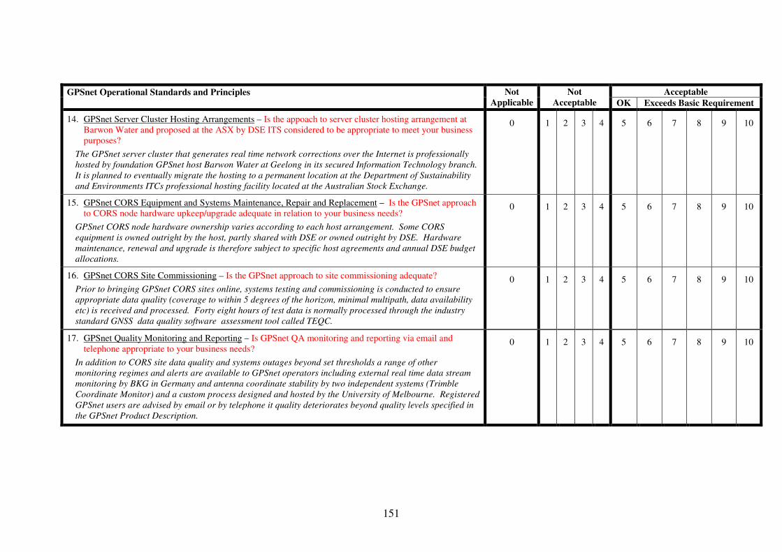
151
Acceptable GPSnet Operational Standards and Principles
Not
Applicable
Not
Acceptable OK Exceeds Basic Requirement
14. GPSnet Server Cluster Hosting Arrangements – Is the appoach to server cluster hosting arrangement at Barwon Water and proposed at the ASX by DSE ITS considered to be appropriate to meet your business purposes?
The GPSnet server cluster that generates real time network corrections over the Internet is professionally hosted by foundation GPSnet host Barwon Water at Geelong in its secured Information Technology branch. It is planned to eventually migrate the hosting to a permanent location at the Department of Sustainability and Environments ITCs professional hosting facility located at the Australian Stock Exchange.
0 1 2 3 4 5 6 7 8 9 10
15. GPSnet CORS Equipment and Systems Maintenance, Repair and Replacement – Is the GPSnet approach to CORS node hardware upkeep/upgrade adequate in relation to your business needs?
GPSnet CORS node hardware ownership varies according to each host arrangement. Some CORS equipment is owned outright by the host, partly shared with DSE or owned outright by DSE. Hardware maintenance, renewal and upgrade is therefore subject to specific host agreements and annual DSE budget allocations.
0 1 2 3 4 5 6 7 8 9 10
16. GPSnet CORS Site Commissioning – Is the GPSnet approach to site commissioning adequate?
Prior to bringing GPSnet CORS sites online, systems testing and commissioning is conducted to ensure appropriate data quality (coverage to within 5 degrees of the horizon, minimal multipath, data availability etc) is received and processed. Forty eight hours of test data is normally processed through the industry standard GNSS data quality software assessment tool called TEQC.
0 1 2 3 4 5 6 7 8 9 10
17. GPSnet Quality Monitoring and Reporting – Is GPSnet QA monitoring and reporting via email and telephone appropriate to your business needs?
In addition to CORS site data quality and systems outages beyond set thresholds a range of other monitoring regimes and alerts are available to GPSnet operators including external real time data stream monitoring by BKG in Germany and antenna coordinate stability by two independent systems (Trimble Coordinate Monitor) and a custom process designed and hosted by the University of Melbourne. Registered GPSnet users are advised by email or by telephone it quality deteriorates beyond quality levels specified in the GPSnet Product Description.
0 1 2 3 4 5 6 7 8 9 10

152
Acceptable GPSnet Operational Standards and Principles
Not
Applicable
Not
Acceptable OK Exceeds Basic Requirement
18. Annual GPSnet CORS Site Inspections – Is this level of CORS site inspection adequate to meet the needs of your business?
GPSnet CORS sites are subject to a minimum annual onsite inspection that incorporates checks of all hardware, potential and actual antenna obstruction, cabling and maintenance of host relationships etc.
0 1 2 3 4 5 6 7 8 9 10
19. GPSnet Antenna Installation – Does the GPSnet antenna placement strategy meet your business needs?
GPSnet antennas are typically established on buildings with clear views to the sky, security for equipment and access to IT connectivity. One key GPSnet site at Melbourne Observatory (MOBS) operates an antenna to Geoscience Australia specifications (tied directly to bedrock).
0 1 2 3 4 5 6 7 8 9 10
20. GPSnet Coverage – Does the location and densification of GPSnet CORS sites within Victoria meet your business needs?
The location and densification of GPSnet sites is based largely on stakeholder consultation and user feedback
0 1 2 3 4 5 6 7 8 9 10
21. GPSnet NTRIP Data Transmission Format – Is the adoption of NRTIP for use in MELBpos and VICpos for transmission of real time correction data appropriate to the needs of your company?
NTRIP is the communications industry data transport format standard adopted for use in the GPSnet real time services (VICpos and MELBpos) to transfer corrections via the mobile Internet to users. NTRIP is available in contemporary GPS survey equipment such as the Trimble R8, Leica Smart Station and Sokkia GSR 2700 IS. NTRIP is also available in hand held GPS devices designed for GIS data capture (such as the Trimble GeoXH).
0 1 2 3 4 5 6 7 8 9 10
22. GPSnet Antenna Coordination – GPSnet antenna coordinates are computed in terms of the Geocentric Datum of Australia ‘realised’ through the Australian Regional GPS Network (ARGN). Does this approach to GPSnet antenna coordination meet your business needs?
GPSnet antenna coordinates provide users with positions more closely approaching true GDA94 coordinates compared to some state spatial control ground marks registered in the state of Victoria’s Survey Marks Enquiry Service (maximum distortion of up to 0.17m is known to exist in the state ground marked geodetic network).
0 1 2 3 4 5 6 7 8 9 10

153
Acceptable GPSnet Operational Standards and Principles
Not
Applicable
Not
Acceptable OK Exceeds Basic Requirement
23. GPSnet Service Availability – Is the target of 99.8% for GPSnet service availability appropriate to meet the needs of your business?
The target uptime for GPSnet services is 99.8% during business hours, Monday to Friday (excluding public holidays).
0 1 2 3 4 5 6 7 8 9 10
24. GPSnet Coordinate Monitoring – Is the GPSnet approach to antenna coordinates monitoring and management appropriate to your business needs?
GPSnet antenna coordinates are monitored for stability at the few millimetre level using two independent software applications, one proprietary and one designed by University of Melbourne GNSS researchers.
0 1 2 3 4 5 6 7 8 9 10
25. GPSnet Alerts and Technical User Advice – Do the methods of advising and alerting GPSnet users meet your business needs and expectations?
GPSnet system outage and data unavailability reports are provided to GPSnet users via email and phone contact in specific cases. A quarterly GPS Technical Support Newsletter is also emailed to registered GPSnet users.
0 1 2 3 4 5 6 7 8 9 10
General Feedback on Operational Standards and Principles
Please provide any comments you may have in relation to Operational Standards and Principles in the space provided below after the line of asterisks. The comments may relate to specific items in the preceding table or concerning any other issues that effect your or your organisations use of GPSnet. ******************************************************************************************************************************************

154
GPSnet™ CORS Network Management - User Assessment Questionnaire Response Form
(Part 3 – Legal Requirements) Acceptable GPSnet Legal Requirements
Not
Applicable
Not acceptable
OK Exceeds Basic
Requirement
1. GPSnet antenna position traceability – Does GPSnet antenna position traceability under Section 13 of the National Measurement Act meet your business needs and expectations?
SII through its GPSnet staff have applied for certification of GPSnet antenna positions under Regulation 13 of the National Measurement Act (GPSnet Melbourne Observatory has already been issued with such a certificate).
0 1 2 3 4 5 6 7 8 9 10
2. GPSnet privacy requirements – Does GPSnet privacy management through DSE privacy policy and state government legislation meet your business needs and expectations?
Only authorised GPSnet staff are permitted to access customer records for use in the management of user accounts and contact. Only authorised GPSnet staff have access to a knowledge of a users real time position when the individual logs onto the VICpos and MELBpos services.
0 1 2 3 4 5 6 7 8 9 10
3. Datum realisation via GPSnet – Is state datum ‘realisation’ using GPSnet acceptable in relation to your business?
GPSnet CORS sites are registered as survey marks in the state’s Survey Marks Enquiry Service (www.land.vic.gov.au/SMES). GPSnet is also recognised by the government as a fundamental part of the state geodetic network. GPSnet antenna positions are used to’ realise’ the GDA94 datum and the network is directly linked to the national GPS network (ARGN).
0 1 2 3 4 5 6 7 8 9 10
4. GPSnet data archiving – Is the GPSnet approach to data archiving appropriate to your business needs?
All GPSnet satellite data is permanently archived onto long life media (such as DVD) and avaialble to registered GPSnet users and researchers.
0 1 2 3 4 5 6 7 8 9 10
5. GPSnet Host Agreements – Are GPSnet cooperative site host agreements an appropriate means of managing network infrastructure from the perspective of your business?
SII and GPSnet hosts, contributors and partners enter into long-term (typically 5 years initial and 5-year ongoing terms) agreements.
0 1 2 3 4 5 6 7 8 9 10

155
GPSnet Legal Requirements
Not
Applicable
Not acceptable Acceptable
6. GPSnet User Licences – Does GPSnet data licensing meet your business needs?
Access to and use of GPSnet data is managed by user registration and data licencing. Data can only be purchased for use and not purchased outright..
0 1 2 3 4 5 6 7 8 9 10
General Feedback on Legal Requirements
Please provide any comments you may have in relation to Legal Requirements in the space provided below after the line of asterisks. The comments may relate to specific items in the preceding table or concerning any other issues that affect your or your organisations use of GPSnet. ******************************************************************************************************************************************

156
GPSnet™ CORS Network Management - User Assessment Questionnaire Response Form
Part 4 (Commercial Arrangements) Acceptable GPSnet Commercial Arrangements
Not
Applicable
Not acceptable
Exceeds Basic
Requirement
• GPSnet Data Pricing – Do the GPSnet data price levels prevent or unduly restrict your companies access to GPSnet satellite correction data?
GPSnet real time and online post processing data is made available to registered GPSnet users for an annual fee of $2200 (includes GST). Multiple seat licence discounts are subject to negotiation. The standard hourly rate for data for post processing is $11 (includes GST). The rate is capped at $55 for access to data in one continuous period of 24 hours.
0 1 2 3 4 5 6 7 8 9 10
• Current GPSnet data access and distribution policy – Do the current methods of data access and distribution adopted for GPSnet users meet your current business needs?
GPSnet data is distributed to registered users primarily and directly through SII / GPSnet staff. Single base station data via fixed radio is also provided in some cases to users via Data Service Providers (DSPs) (Ultimate Positioning at GPSnet Albury and GPSnet RMIT).
0 1 2 3 4 5 6 7 8 9 10
• Future GPSnet data access and distribution policy – Does the planned approach to commercialise access to VICpos and MELBpos GPSnet data through private industry partners meet your future business needs?
It is proposed in future that high volume commercial distribution of VICpos and MELBpos GPSnet data will be via one or more DSPs or Value Added Resellers (VARs). Market prices for data onsold will be set by the DSPs and VARs. SII will continue to supply data to hosts, contributors and partners in addition to key state government stakeholders such as police and emergency services.
0 1 2 3 4 5 6 7 8 9 10
General Feedback on Commercial Arrangements
Please provide any comments you may have in relation to Institutional Arrangements in the space provided below after the line of asterisks. The comments may relate to specific items in the preceding table or concerning any other issues that affect your or your organisations use of GPSnet. *******************************************************************************************************************************************

157
Appendix B — Generic CORS Questionnaire

158
Development of a Model for CORS Network Management and Operation
Questionnaire: Australian CORS User Views
Please read the following information before completing the questionnaire.
1. Background to GNSS and CORS Global Navigation Satellite Systems (GNSS) include the United States Global
Positioning System (GPS), the Russian Federation’s GLONASS and by about 2010,
the European Union’s Galileo. When augmented by ground based Continuously
Operating Reference Station (CORS) networks GNSS provides satellite-
positioning users with improved position, navigation accuracy and integrity.
Accuracy in particular is improved by the process of differential correction of
autonomous GNSS positions — either in real time or post event.
CORS networks are fundamental spatial infrastructure. Together GNSS and CORS
networks support applications important to a wide range of spatially related
public and private sector activities.
Because of this importance, a number of Australian state and territory
governments are or will in the near future facilitate CORS network establishment,
management, and operation. Typically, state sponsored CORS networks have
been developed by agencies responsible for surveying and or mapping. A key
driver for this trend is the desire to reduce reliance on traditional geodetic
networks. However, state and territory governments are also influenced to
manage and operate CORS networks in order to protect and underpin interests
vital to the state such as:
• The realisation of the official spatial datum at the jurisdictional level,
• Providing support for location based services for sensitive government
activities such as emergency services and counter terrorism
• Underpinning the coordination of ‘digital cities’,
• Supporting integration and maintenance of fundamental spatial datasets
and
• Providing support for legal traceability of position.
Jurisdiction sponsored CORS network implementation is at various stages of
planning and development by a number of Australian state and territory
governments. GPS CORS networks currently exist in Victoria (GPSnet™),
Queensland (SunPoz), NSW (SydNET) and the Northern Territory (pilot network).
Western Australia is researching network development while potential GPSnet™
participants in Tasmania and South Australia are investigating working with the
Victorian state government to extend GPSnet™ coverage beyond Victoria into
these adjoining jurisdictions.
159
GNSS CORS networks can provide virtual spatial control coverage that extends
over administrative boundaries to service adjoining jurisdictions. Properly
configured, operated, and managed, strategically located CORS networks can also
be ‘joined up’ to deliver unified high accuracy satellite correction services. This
seamless approach to CORS networking is important for businesses that operate
in multiple jurisdictions and span wide areas. An example is the business of
remote sensing which typically uses aircraft mounted sensors that require high
accuracy spatial control.
Already CORS users are beginning to expect GNSS correction data from CORS
networks in uniform and standardised ways regardless of where and in what
jurisdiction the user is located. To meet this need a CORS Network Management
Model is proposed that can be adopted by Australian state and territory
governments to enable integration and operation of discrete CORS networks
across significant portions of the nation.
2. Purpose of this Questionnaire The purpose of the questionnaire is to support research into the development of a
CORS Network Management Model by seeking the views of current and potential
CORS network users. These views will be used to assess the adequacy of the
proposed Model. A subsequent Gap Analysis will be used to identify components
of the Model which can or should be improved from a user’s perspective.
3. Invitation to Participate The questionnaire is being conducted by Masters of Geomatic Engineering (The
University of Melbourne) candidate, Martin Hale. The research is funded by the
Cooperative Research Centre for Spatial Information (www.crcsi.org.au). The
research is associated with Project 1.2 of the CRCSI (Quality control issues in
real-time positioning). Co-researchers and project supervisors are Dr Philip
Collier and Dr Allison Kealy.
You are invited to participate in this survey as a current or potential CORS
network user. Your involvement in the questionnaire is voluntary and you are
free to withdraw consent at any time, and to withdraw any unprocessed data
previously supplied. You will be asked as a part of the survey, to provide your
views on CORS network management, operation and the services provided to
you. Your response will be made by answering a number of questions which will
then be used in a subsequent Gap Analysis. In addition to selecting between
specific response options, you will have the option of adding written comments
where appropriate.
The collated results and analysis are planned to be published as a part of the
Masters Research thesis and related research publications.
4. Privacy, Confidentiality and Ethics Considerations It is optional to provide your name and contact details on the questionnaire form.
However, by providing this information subsequent follow-up to clarify
responses, if needed, will be facilitated. Any data provided by a respondent can
be accessed again by the same individual. Follow-up will be allowed only if you
choose to authorise this (see Your Details section). You may also choose not to
answer all questions.

160
Answers and comments will be collated, results analysed and summarised in such
a way as to ensure that no individual respondent can be identified. Written
responses will only be presented in research documents and published papers in
anonymous format. Aspects of responses given in this questionnaire that might
identify an individual or organisation will not be disclosed or presented in such a
way as to allow identification. Participants should note the sample size is small.
Confidentiality of data will be maintained by ensuring that data is secured by the
researcher in accordance with the provisions The University of Melbourne Policy
on the Management of Research Data and Records which stipulates that data
must be retained for 5 years and only provided to other researchers for
discussion purposes but only in a way that does not breach confidentiality.
The University Of Melbourne Human Research Ethics Committee has approved
this project. If you have any concerns about the conduct of this research project
please contact the Executive Officer, Human Research Ethics, The University of
Melbourne, ph: (03) 8344 2073; fax (03) 9347 6739.
5. Instructions On How to Fill Out the Questionnaire The questionnaire has been designed to make responses as quick (approximately
15 minutes) and easy as possible. The questions ask you to indicate how state
sponsored CORS networks can be managed and operated under the following
categories :
• Institutional arrangements
• Operational standards and principles
• Commercial arrangements
• Legal requirements
The following CORS network management Model principles will be assessed
against the information provided in your answers:
• Adequate standard of service
• Adequate availability
• Appropriate means of access
• Technology compatibility
• Fair pricing of CORS data
• Sustainability of infrastructure and services
• Protection of user privacy and
• Legally defensible measurements of position
I have read and understood the information provided above and wish to complete
the questionnaire
________________________________________________

161
State Sponsored Australian CORS Network Management and Operation Questionnaire
Section 1: Your Details (Completion of the details in this section is optional)
1.1 Contact Details
Name: Phone: Mobile: Email: Postal Address:
1.2 Industry Sector
Agriculture Emergency Services GIS Local Government Mapping Surveying Utilities Other
1.3 Follow Up Authorisation
� I agree to follow up if clarification is required for any of my responses to this questionnaire
Section 2: Questionnaire
2.1 Institutional Arrangements
2.1.1‘Joined up’ State sponsored CORS networks
‘Joined up’ CORS networks between adjoining Australian state and territory
jurisdictions can be managed to provide seamless, and potentially high accuracy
satellite positioning over significant areas of Australia. To what extent do you see
‘joined up’ CORS networks of benefit to the Australian community as a whole?
Select one...
Not at all Somewhat
Considerable Significant
Additional Comments:
2.1.2 Appropriate category of government management
If CORS networks are to be managed and operated by government bodies in
Australia what level of government do you consider the most appropriate to meet
the needs of users and stakeholders?
Select one...
Local Government State Government Federal Government
Additional Comments:

162
2.1.3 CORS network contribution to ASDI
To what extent do you consider that CORS networks in states and territories of
Australia can contribute to the Australian Spatial Data Infrastructure (ASDI)? Select one...
Not at all
Somewhat Considerable Significant
Additional Comments:
2.1.4 CORS Network Data Custodianship
Which level of government should be responsible for custodianship of CORS data?
Select one... Local Government
State Government Federal Government
Additional Comments:
2.1.5 CORS network stakeholder consultation
Which organisation/s should be responsible for CORS network stakeholder
consultation? Select one...
Australian GNSS Coordination Committee (AGCC) or similar Federal Government body State level GNSS Reference Group led by State Government body Intergovernmental Committee on Surveying and Mapping (ICSM) Other (please list in additional comments)
Additional Comments:
2.2 Operational Standards and Principles
2.2.1 Standard CORS data correction formats available over ‘joined up’ networks
How important is it for ’joined up’ CORS networks to deliver CORS data to users
in standardised and internationally accepted formats?
Select one... Not important Somewhat important Considerably important Highly important
Additional Comments:
2.2.2 CORS network correction accuracy
Networked real time CORS correction accuracy can achieve nominal horizontal
accuracy at better than ±2cm. Does this accuracy meet your positioning and
navigation requirements?
Select one...
Not at all Somewhat Completely Exceeds my requirements

163
Additional Comments:
2.2.3 CORS antenna coordination and control network specification
Corrected receiver position coordinates depend on the CORS antenna coordinates
and the related control network specification. Which level of network, national or
state, do you consider to be the appropriate one?
Select one...
Compatible with Australian Regional GPS Network Relative to local state geodetic network Other (please state below)
Additional Comments:
2.2.4 CORS data quality monitoring and user alerts
CORS networks can be monitored by assessing the raw satellite data received by
CORS stations, stability of CORS antennas, latency of correction etc. How
important is CORS network data quality and user alerting to you?
Select one...
Not important
Somewhat important Considerably important Highly important
Additional Comments:
2.2.5 Current CORS network GNSS reception and processing capability
CORS networks can be configured to receive and process multiple satellite
systems (ie GPS, GLONASS, Galileo). Please indicate the importance of this
capability to you now?
Select one...
Not important Somewhat important Considerably important Highly important
Additional Comments:
2.2.6 CORS network GNSS reception and processing capability – next 4 years
CORS networks can be configured to receive and process multiple satellite
systems (ie GPS, GLONASS, Galileo). The GLONASS satellite constellation is
currently being replenished and the Galileo program has commenced placing
satellites in orbit with full operational capacity anticipated to be in 4 years time
(2010 approximately). Please indicate the importance of this capability to you
over the next 4 years?
Select one... Not important Somewhat important Considerably important Highly important
Additional Comments:

164
2.2.7 CORS Network Real Time Kinematic (NRTK) positioning
Real time positioning is now achievable using CORS networks. NRTK horizontal
positioning accuracy of ±2 cm using CORS networks is readily achievable. How
important is NRTK position correction to you?
Select one...
Not important
Somewhat important Considerably important Highly important
Additional Comments:
2.2.8 CORS data for Post Processing
Data for post processing can be made available from CORS networks. How
important is this form of position correction to you?
Select one...
Not important Somewhat important Considerably important Highly important
Additional Comments:
2.3 Legal Arrangements
2.3.1 Privacy
To what extent do you consider that privacy of location is important to users of
CORS network services?
Select one...
Not important Somewhat important Considerably important Highly important
Additional Comments:
2.3.2 Legal Traceabiltiy of Position
To what extent is legal traceability of position important to CORS network users?
Select one... Not important Somewhat important
Considerably important Highly important
Additional Comments:

165
2.4 Commercial
2.4.1 CORS data distribution
How is satellite correction data best distributed to CORS network users?
Select one... Direct from government agencies On-sold and perhaps with added value through the private sector organisations
Combination of government and private sector organisations Other (please state below)
Additional Comments:
2.5 General Comments
Please provide any additional comments that you may have on the provision of
state sponsored CORS networks in Australia here.

166
Appendix C — GPSnet CORS Network Management Validation Through User Feedback
Paper submitted to the Journal of Spatial Science for publishing 29 July 2007.

167
GPSnet CORS Network Management
Validation Through User Feedback
M. Hale
P. Collier
A. Kealy
ABSTRACT
Australian state sponsored RTK CORS networks, cover limited areas, operate in
isolation and lack consistent management. This has resulted from the independent and
largely uncoordinated efforts of state and territory governments to establish and
manage RTK CORS networks. This study investigated CORS network management in
relation to institutional, legal, commercial and operational requirements. Responses
to two questionnaires, one directed to Victoria’s GPSnet users and another made
available in Australia and internationally, were analysed. The study found user
satisfaction with Victoria’s GPSnet management arrangements, indicating their
potential to underpin a nationally consistent approach to CORS network management
in other jurisdictions.
M. Hale
P. Collier
A. Kealy
CRC for Spatial Information and Department of Geomatics
The University of Melbourne

168
Parkville, Victoria
Australia
INTRODUCTION
Continuously Operating Reference Station (CORS) networks, are a part of the
fundamental infrastructure for the spatial sciences Rizos et al. (2005). The challenge
now is to ensure that Australian real time kinematic (RTK) CORS networks deliver
services to the broadest possible user base, and support nationally significant
applications. To achieve these objectives, CORS networks with high technical
standards need to be combined with appropriate and consistent management practices.
Australia benefits only marginally from RTK CORS networks, with the majority of
state sponsored networks, operating in isolation and providing limited areal
coverage—primarily over capital cities. Current RTK CORS network development
has only occurred through the independent and largely uncoordinated efforts of
government agencies in each jurisdiction. State sponsored RTK CORS networks
under development include Victoria’s GPSnet, New South Wales’ SydNet,
Queensland’s SunPOZ and a Northern Territory CORS network. The government of
Western Australia is also assisting a private operator in the coordination of a first
stage, five-station CORS network known as GPSnetwork Perth, while an investigation
of state sponsored network deployment options is being considered. Victoria’s State
government is also working with government and private sector organisations in

169
Tasmania and South Australia to investigate at least partial GPSnet service coverage
in these jurisdictions.
Cranenbroek et al. (2005) contend that if CORS network operators cannot provide
continuous and reliable services, they cannot confidently charge for those services. In
addition to CORS network operators delivering reliable and continuous services,
networks must also provide a reasonable return on investment. A reasonable return on
investment enables reinvestment to refresh and update CORS network equipment and
systems. This in turn supports long term sustainability of infrastructure and provision
of services. Australian CORS network operators need to consider adopting consistent
management responses to institutional, operational, legal and commercial
requirements if network unification is to be achieved across the nation and thereby to
support nationally important activities and industries. In order to assess the suitability
of GPSnet management arrangements for national adoption, a dual questionnaire
process was developed, and used to investigate the views of GPSnet users and other
CORS network users and stakeholders internationally.
This paper describes the questionnaire process and provides a summary and analysis
of responses which together demonstrate the validity of current GPSnet management
arrangements.
GPSnet
The most advanced network RTK (NRTK) capable CORS network in Australia, in
terms of number of CORS stations deployed, service area coverage, systems
development and management sophistication, is Victoria’s GPSnet
(www.land.vic.gov.au/GPSnet). Figure 1 depicts the status of GPSnet CORS
deployment and NRTK service area coverage as at June 2007.

170
Figure 2. Victoria's cooperative CORS network (GPSnet). Operational and proposed NRTK service
areas defined by dark shading and hatching respectively (note: Adelaide CORS not shown). Source:
DSE.
GPSnet is facilitated and coordinated by the Spatial Information Infrastructure (SII)
group of the Victorian Government’s Department of Sustainability and Environment
(DSE). A distinguishing feature of GPSnet is the high level of cooperation between
SII and all levels of government, academic institutions and the community—as
partners, contributors and hosts. Cooperative hosts include local governments, alpine
resort management boards, utility organisations, academic institutions, botanical
garden managers, catchment authorities, mine operators and precision farmers.
Partners and contributors include, Geoscience Australia, GNSS equipment suppliers,
communication service providers, the Surveyor-General Victoria and VicForests.

171
GPSnet services a growing user base, on a fee-for-service basis. Many GPSnet users
are traditional spatial and related professionals, including surveyors, GIS operators,
remote sensors and engineers. Increasingly, interest in and innovative use of GPSnet
services is coming from less traditional sectors such as precision agriculture,
arboriculture, machine guidance and emergency services.
From an institutional perspective, GPSnet is managed as a part of the state’s core
spatial control infrastructure. GPSnet has been designed to underpin fundamental
spatial data sets within the state and to contribute to the development of the Australian
Spatial Data Infrastructure (ASDI). GPSnet is a part of the Vicmap suite of products
and services, and operated in accordance with a publicly accessible product
description (www.land.vic.gov.au/Vicmap). A GPSnet data custodian, appointed by
SII, forms a link between users and GPSnet management, enabling feedback to be
given in relation to service and data quality compared to the GPSnet product
description. Biannual interaction between GPSnet managers, users and stakeholders,
occurs at meetings of the GNSS Victoria Reference Group (GVRG), and encourages
exchanges on future plans for network development and service improvements.
Guidelines and procedures on hosting GPSnet stations are available from
www.land.vic.gov.au/GPSnet and are used as a basis for negotiations with potential
hosts, partners and contributors. GPSnet, due to its high accuracy, homogeneity and
ability to be constantly monitored, is also Victoria’s realisation of the national
horizontal datum—the Geocentric Datum of Australia (GDA) (Ramm and Hale,
2004). GPSnet’s GDA connection is by direct coordinate computation within the
Australian Regional GPS Network (ARGN).
Millner et al. (2004) describe how geodetic standard GPS/GNSS CORS receivers,
located at DSE regional offices, are connected to the GPSnet Central Server Cluster

172
(CSC). This is done using a managed Virtual Private Network (VPN), built over the
Department’s Wide Area Network (WAN). Non-departmental sites are connected
using Asymmetric Digital Subscriber Line (ADSL) technology. Millner et al. (2006)
also describe how bi-directional satellite Internet access to the GPSnet CSC is
established using Very Small Aperture Terminal (VSAT) technology in remote areas
where the Department’s WAN or ADSL connections are unavailable. Mobile internet
is the primary delivery platform for GPSnet real time services. GPSnet technical
specifications address real time and post processed user needs. International and
industry standard data distribution formats are used to provide optimum user access to
services. Trimble Infrastructure software suite version 2.5.1 is the primary means of
generating networked real time and post processed services. A GPSnet NRTK service
covers Melbourne and Environs (MELBpos) and a Network DGPS (NDGPS) solution
is available state-wide (VICpos).
GPSnet legal arrangements cover formal agreements for cooperative CORS site
hosting, partnerships and financial contributions. Standard network data licensing
documents are made available online (www.land.vic.gov.au/GPSnet). Other GPSnet
agreements include licences for Data Service Providers (DSPs), Value Added
Resellers (VARs) and equipment demonstrator/integrators in addition to service level
agreements with telecommunication and satellite broadband service providers to
supply network connectivity. Legal compliance with government regulations in
relation to privacy and legal traceability of position are a part of the fundamental
GPSnet management arrangements.
GPSnet infrastructure management is performed by a state government agency
(SII/DSE) which has overall responsibility for spatial policy development and
implementation. Commercial data distribution, service enhancement and customer

173
management is in the process of being transitioned to the private sector. DSP and
VAR agreements are the processes currently used by SII to engage the private sector.
Some GPSnet data is supplied by SII direct to key stakeholders, such as the
emergency services. Service provision is subject to government policy in relation to
cost recovery and neutral competitive pricing. One exception to the cost recovery rule
is research institutions which can apply to obtain GPSnet data without cost for non-
commercial applications.
Specific arrangements have been developed by SII since 1996 to meet the
institutional, legal, operational and commercial requirements of GPSnet management.
A well established network and growing user base provided the opportunity to
evaluate responses to GPSnet management arrangements. This paper investigates the
potential for GPSnet arrangements to become a basis for consistent management and
support unification of CORS networks across Australian jurisdictions.
METHOD
GPSnet CORS Registered User and Generic CORS Questionnaires were used to
obtain perspectives on CORS network management in relation to institutional, legal,
commercial and operational requirements. This section describes the format of the
questionnaires, delivery method and target cohorts of potential respondents.
The GPSnet CORS Registered User Questionnaire
To investigate user response to GPSnet management arrangements, a four-part
questionnaire was emailed to thirty eight registered GPSnet users holding annual
licences. The questionnaire addressed the following issues:
• Part 1 Institutional Arrangements (eight questions);

174
• Part 2 Operational Standards and Principles (twenty five questions);
• Part 3 Legal Requirements (six questions); and
• Part 4 Commercial Arrangements (three questions).
Twenty three responses were received which included scored and written feedback. If
any particular question received an average score below five, this finding was used to
identify a potential gap or deficiency in GPSnet management procedures. Table 1 sets
out the scoring system adopted for the GPSnet CORS Registered User Questionnaire.
Acceptable Not
Applicable
Not
Acceptable OK Exceeds Basic Requirement
0 1 2 3 4 5 6 7 8 9 10
Table 2. Questionnaire score format for GPSnet Registered User Questionnaire
The questions and accompanying explanatory information for the GPSnet CORS
Registered User Questionnaire are detailed in the Appendix A.
The Generic CORS Questionnaire
To investigate user and stakeholder response to CORS network management
arrangements more generally, a questionnaire with four parts was devised:
• Part 1 Institutional Arrangements (five questions);
• Part 2 Operational Standards and Principles (eight questions);
• Part 3 Legal Requirements (two questions); and
• Part 4 Commercial Arrangements (one question).
The questionnaire was hosted on-line at www.geom.unimelb.edu.au/simonf/corsq and
advertised to members of the Spatial Sciences Institute, the Institution of Surveyors,
Australia, the Canadian Space Geodesy Forum ([email protected]), GNSS
supply companies, precision farming organisations and GNSS users in general. A

175
hardcopy of the questions was also made available to delegates of conferences held in
Australia in 2006 including, the Spatial Sciences Conference, Melbourne, Spatial
Sciences Regional Seminar, Hobart, International GNSS Symposium 2006, Cairns,
and the Controlled Traffic Farming Conference, Ballarat.
Twenty four responses to the questionnaire were received from sectors including
Federal/Central government (2), Surveying (11), Education/Research (5), GNSS
Manufacturer/Supplier (2), Machine Control Guidance-Aircraft Landing (1), Mapping
(1), and Agriculture (1). By interpreting respondent’s email domain names and
contact details, it was deduced that at least six respondents were of international
origin, including the countries of India, Germany, United Kingdom, Canada, Belgium
and Slovenia. The Generic CORS Questionnaire provided a national and international
comparison with the results of the GPSnet CORS Registered User Questionnaire.
RESULTS AND DISCUSSION
The GPSnet CORS Registered User Questionnaire
This section presents the averaged respondent scores, summary of significant
feedback and discussion.
Part 1 Institutional Arrangements
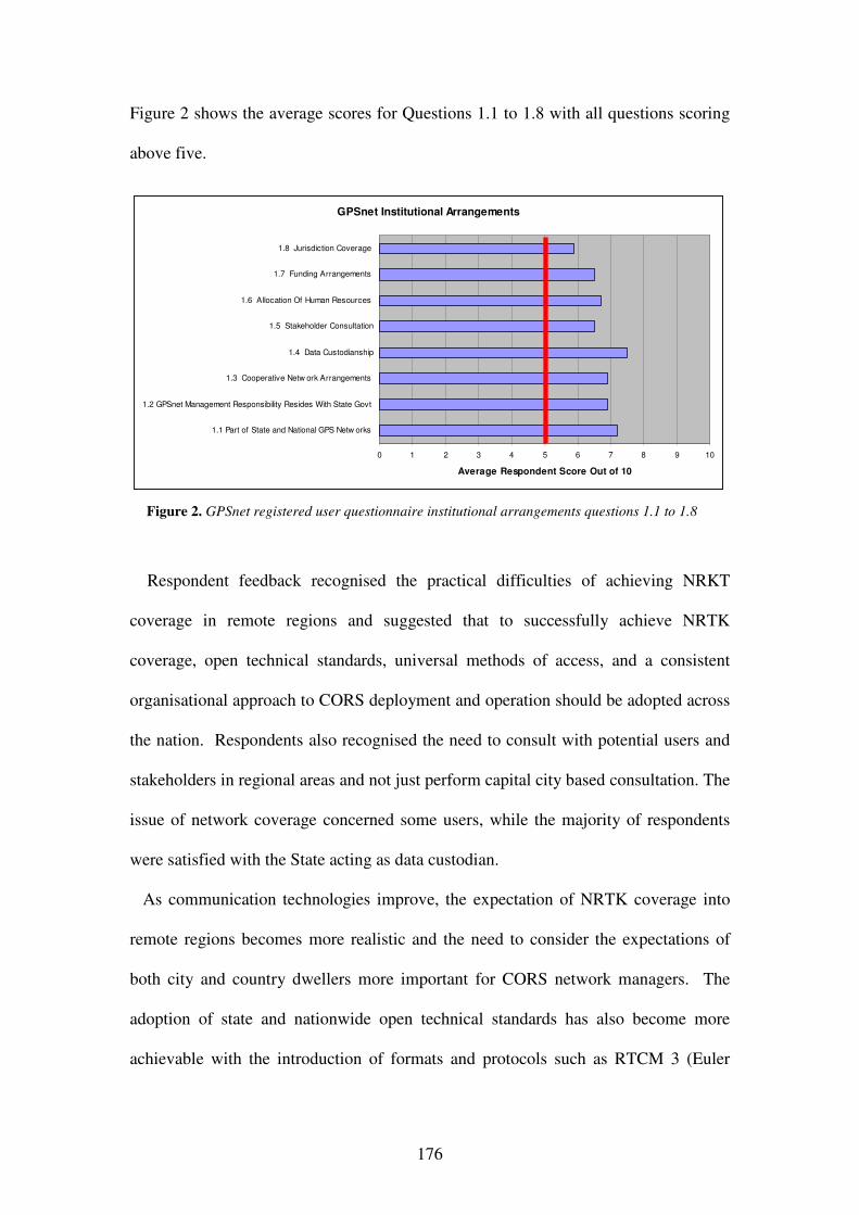
176
Figure 2 shows the average scores for Questions 1.1 to 1.8 with all questions scoring
above five.
Respondent feedback recognised the practical difficulties of achieving NRKT
coverage in remote regions and suggested that to successfully achieve NRTK
coverage, open technical standards, universal methods of access, and a consistent
organisational approach to CORS deployment and operation should be adopted across
the nation. Respondents also recognised the need to consult with potential users and
stakeholders in regional areas and not just perform capital city based consultation. The
issue of network coverage concerned some users, while the majority of respondents
were satisfied with the State acting as data custodian.
As communication technologies improve, the expectation of NRTK coverage into
remote regions becomes more realistic and the need to consider the expectations of
both city and country dwellers more important for CORS network managers. The
adoption of state and nationwide open technical standards has also become more
achievable with the introduction of formats and protocols such as RTCM 3 (Euler
GPSnet Institutional Arrangements
0 1 2 3 4 5 6 7 8 9 10
1.1 Part of State and National GPS Netw orks
1.2 GPSnet Management Responsibility Resides With State Govt
1.3 Cooperative Netw ork Arrangements
1.4 Data Custodianship
1.5 Stakeholder Consultation
1.6 Allocation Of Human Resources
1.7 Funding Arrangements
1.8 Jurisdiction Coverage
Average Respondent Score Out of 10
Figure 2. GPSnet registered user questionnaire institutional arrangements questions 1.1 to 1.8

177
2006), and NTRIP (Network Transport of RTCM over Internet Protocol) (Lenz 2004),
which support the generation and delivery of NRTK services respectively.
Part 2 Operational Standards and Principles.
Figures 3, 4 and 5 show the summary scores for the GPSnet questionnaire questions
2.1 to 2.25 with all questions scoring above five.
GPSnet Operational Principles and Practice (1 to 8)
0 1 2 3 4 5 6 7 8 9 10
2.1 GPSnet Data Formats
2.2 GPSnet Data Quality Monitoring
2.3 GPSnet NRTK GPSnet Data
Access via Mobile Internet
2.4 NDGPS GPSnet Data Access via
Mobile Internet
2.5 GPSnet Real Time GPSnet Data
Access via Fixed Radio Base Stations
2.6 GPSnet Accuracy
2.7 Access to GPSnet Data for Post
Processing via the WWW
2.8 Access to GPSnet Data for Post
Processing from GPSnet Data Archive
Average Respondent Score Out of 10
Figure 3. GPSnet registered user questionnaire operational principles and practice questions 2.1 to 2.8
Figure 4. GPSnet registered user questionnaire operational principles and practice questions 2.9 to 2.16
GPSnet Operational Principles and Practice (9 to 16)
0 1 2 3 4 5 6 7 8 9 10
2.9 GPSnet Product Description
2.10 GPSnet Real Time CORS Data Streaming Via Hybrid Computer Netw ork /
Internet Methodology over Virtual Private Netw ork
2.11 Co-located GPSnet Control Centres
2.12 GPSnet Remote Management and Response
2.13 GPSnet CORS Outage Response
2.14 GPSnet Server Cluster Hosting Arrangements
2.15 GPSnet CORS Equipment & Systems Maintenance, Repair & Replacement
2.16 GPSnet CORS Site Commissioning
Average Respondent Score Out of 10

178
The averaged scores in relation to GPSnet management arrangements for
operational principles and practice indicate overall user satisfaction. However specific
written feedback highlighted that GPSnet provides an incomplete service in some
respects. For example, respondents expected satellite correction data to be provided
error free and that quality monitoring and reporting of CORS performance were basic
requirements. Effective NRTK service area coverage was also reported to be
restricted in some locations due to the lack of mobile internet coverage. The goal of
ubiquitous coverage of NRTK services may well be achieved through broadcast
technology solutions such as geosynchronous communication satellites and digital
television or combinations of technologies depending on location. CORS network
signal distribution is a key management consideration that may lead to future
relationships with broadcast media organisations.
Respondents anticipated …24/7 GPSnet management and response services in the
future. Respondents also indicated that it was important to ensure well managed
cooperative CORS host relationships were maintained in order to secure a stable
network infrastructure. One respondent organisation requested that correction services
GPSnet Operational Principles and Practice (17 to 25)
0 1 2 3 4 5 6 7 8 9 10
2.17 GPSnet Quality Monitoring and Reporting
2.18 Annual GPSnet CORS Site Inspections
2.19 GPSnet Antenna Installation
2.20 GPSnet Coverage
2.21 GPSnet NTRIP Data Transmission Format
2.22 GPSnet Antenna Coordination
2.23 GPSnet Service Availability
2.24 GPSnet Coordinate Monitoring
2.25 GPSnet Alerts and Technical User Advice
Average Respondent Score Out of 10
Figure 5. GPSnet registered user questionnaire operational principles and practice questions 2.17 to 2.25

179
be in terms of ITRF2000 coordinates, in addition to GDA94 and the AHD. This and
other similar services could be addressed by VARs and factored into future CORS
network business models. Feedback also requested that a consistent approach should
be adopted to CORS antenna coordination across all networks to avoid
incompatibilities. GPSnet Albury, located in NSW, highlighted how some
jurisdictions treat coordinate issues differently. The GPSnet approach of adopting
national ARGN coordinates was supported by respondents however the State of New
South Wales currently requires the adoption of local geodetic network relativity for
cadastral operations in accordance with legislative requirements. National agreement
on CORS antenna coordination will be an important milestone for the delivery of
consistent positioning and navigation services across Australia.
One respondent suggested GPSnet service …uptime should be 99.9 percent to
support high value, airborne missions. GPSnet service reliability can be increased
using strategies such as duplicated central server systems and duplicated internet
service provision. However providing services with increased reliability inevitably
comes at increased cost and eventually a balance needs to be struck between the cost
to CORS network operators to increase reliability and the user’s willingness to pay.
As RTK CORS network service providers seek new markets, service reliability will
become another key management consideration.
A land surveying industry respondent identified the need for the surveying industry
governing body to accept legal traceability of GNSS/CORS user positions. This
response highlights only one aspect of a complex and multifaceted issue. CORS
network managers also need to ensure CORS antenna positions are compliant with
appropriate legislation such as the National Measurement Act. Industry-governing
bodies need to establish best practice guidelines, and GNSS/CORS users need to

180
implement those guidelines. Feedback on assurance and auditing of CORS determined
position quality highlighted this as an important issue. If DSPs become a link in the
CORS data supply chain, clear assignment of responsibly for outages in relation to
CORS host sites and data distribution services needs to be defined and agreed
between the parties involved.
Other feedback highlighted that additional funding from state government was
desirable, to increase the pace of CORS network infrastructure establishment and
decrease the emphasis on the cooperative approach.
Part 3 GPSnet legal arrangements.
Figure 6 shows the summary scores for the GPSnet questionnaire questions 3.1 to
3.6 with all questions scoring above five.
Respondents indicated the following as key legal considerations:
• the management of GPSnet CORS sites, preferably over long periods,
particularly at non DSE office locations, using formal agreements;
GPSnet Legal Arrangements
0 1 2 3 4 5 6 7 8 9 10
3.1 GPSnet antenna position traceability
3.2 GPSnet privacy requirements
3.3 Datum realisation via GPSnet
3.4 GPSnet data archiving
3.5 GPSnet Host Agreements
3.6 GPSnet User Licences
Average Respondent Score Out Of 10
Figure 6. GPSnet registered user questionnaire legal arrangements questions 3.1 to 3.6

181
• formal licensing of GPSnet user access to CORS data incorporating defined
quality of service provisions and guaranteed archive data recovery times;
• the need to ensure that GPSnet antenna coordinates are clearly defined and
unambiguously communicated to users; and
• engaging third parties in the GPSnet data supply chain, may introduce
ambiguity in relation to legal responsibility for data quality.
GPSnet users were generally aware of and satisfied with current GPSnet
management responses to legal requirements, however arrangements need to be
continuously reviewed and updated for changes, especially if third parties become
engaged in CORS data creation, value adding and the CORS network data supply
chain.
Part 4 GPSnet commercial arrangements.
Figure 7 shows the summary scores for the GPSnet questionnaire questions 4.1 to
4.3 with all questions scoring above five.
GPSnet Commercial Arrangements
0 1 2 3 4 5 6 7 8 9 10
4.1 GPSnet Data Pricing
4.2 Current GPSnet data access and distribution policy
4.3 Future GPSnet data access and distribution policy
Average Respondent Score Out of 10
Figure 7. GPSnet registered user questionnaire legal arrangements questions 4.1 to 4.3

182
Respondents indicated:
• that current GPSnet pricing arrangements were acceptable;
• the need for multiple modes of access and delivery platforms, for instance via
satellite and digital broadcast technology, if CORS network service delivery is
to be privatised;
• satisfaction with current commercial supply arrangements direct from
government and multiple requests to not privatise GPSnet data supply, due to
an expectation of higher prices, uncertainty of who to contact in case of
problems, uncertain data quality when supplied by a third party; and
• a desire to move beyond the need to have personal contact with GPSnet staff
to access certain categories of data offline.
As SII progressively engages with private industry to distribute GPSnet data
through the issuing of non-exclusive rights, users are afforded a level of protection
against excessive cost increases. Free market competition between DSPs should
constrain prices while also improving customer service. SII already uses private sector
telecommunication companies to provide access to GPSnet services via the mobile
internet and VARs to provide customer services to clients. It is likely that the trend for
government to engage with private industry partners will continue so that the goal of
ubiquitous access to CORS services is achieved. The management issue then becomes
one of communicating benefits to current and potential CORS users, and for users to
decide if these benefits outweigh any negatives.

183
The Generic CORS Questionnaire
The questions and accompanying explanatory information for the Generic CORS
Questionnaire are detailed in the Appendix B while respondent scores, significant
feedback and discussion are contained in this section.
Part 1 Generic CORS Institutional Arrangements.
Respondents indicated strong support for unified CORS networks, providing benefit
for a range of activities that cross state and territory borders including, farming,
freight and fleet management, and large scale construction projects such as roads,
pipelines and emergency services. Through a national approach to datum
harmonisation, homogeneous position coordinates across adjoining CORS networks
can be generated. Of the 24 responses to Question 1.1, 15 indicated Significant, 9
indicated Considerable and no responses were given for Some and No Significant
benefit to the community of joined up state sponsored CORS networks.
Respondents had an equal preference for CORS management by state or federal
government. Seven respondents commented that there should be some form of state
and federal collaboration in relation to operations and standards setting respectively.
Federal government has a direct interest in contributing to the management of state
government CORS networks, particularly in relation to datum harmonisation, to
ensure consistency of positioning across and between Australian jurisdictions. Of the
26 responses to Question 1.2 (two respondents selected both state and federal
government), 13 nominated State Government, 13 nominated Federal Government
and no respondents selected Local Government as the preferred level of government
to manage state sponsored CORS networks.

184
Respondents clearly indicated that state sponsored CORS networks have an
important contribution to make to the ASDI. Of the 24 responses to Question 1.3, 14
indicated Significant, 8 Considerable, 2 Some Contribution and zero respondents
indicated No Contribution by state sponsored CORS networks to the ASDI. This
finding reinforces the location of state sponsored CORS network management in
government agencies that have control of spatial policy development and
implementation such as SII.
Respondents also indicated that federal government could provide an overseer role
for CORS network data custodianship, ensuring standards are maintained between
states, however states could retain the right to own the CORS data. A shared
arrangement already operates in relation to the management of Australian ground
marked geodetic networks, which could be extended to CORS networks. Of the 24
responses to Question 1.4 (two respondents selected multiple responses), 12 indicated
State Government, 14 Federal Government and zero respondents selected Local
Government to manage custodianship of CORS data. Questionnaire respondents
indicated nearly equal preference for state or federal government CORS network data
custodianship, indicating that a shared custodian role, particularly for a unified CORS
network, would be supported.
Respondents gave no clear preference for CORS network stakeholder consultation
between the ICSM, state reference groups or the AGCC. Respondents indicated that a
key requirement of CORS networks is coordination, whether it be through specialist
user groups at state level, or with federal government involvement to ensure strategic
concerns were addressed. In order for the ICSM to fulfil a CORS network
coordination role, it would need to either allocate the task to an existing sub-
committee such as the Geodesy Sub Committee (ICSM GTSC) or create a new sub-

185
committee dedicated to CORS network operation and management. On the 1 July
2006, the AGCC was disbanded, becoming unavailable as an option to engage CORS
network stakeholders. The start up of the AuScope (www.AuScope.org.au)
organisation to oversee the installation of an earth monitoring GNSS CORS network
across Australia for science based research, will help create de facto standards for
Australian CORS networks generally. Some Australian states already operate GNSS
reference groups to engage stakeholders and establish close contact with specific users
groups. A dedicated sub-committee of the ICSM would be a common sense approach
to the overall coordination of jurisdiction CORS networks, doing so in conjunction
with and support from AuScope and State GNSS reference groups. Of the 24
responses to Question 1.5 (one multi-choice response), 10 preferred the
Intergovernmental Committee on Surveying and Mapping (ICSM), 7 State Reference
Groups, 6 the Australian GNSS Coordination Committee (AGCC) and 2 indicated
Other Bodies were the most appropriate to take responsibility for CORS network
stakeholder consultation.
Part 2 generic CORS operational standards and principles.
Respondents indicated that Australian CORS networks are part of an international
activity and should operate with industry/international standards for data and service
provision, supporting industries such as precision agriculture that would benefit from
standardisation. Of the 24 responses to Question 2.1, 19 considered standard CORS
formats over joined up CORS networks to be of High Importance and 5 of
Considerable Importance. No responses were given for Somewhat or No Importance.
The high response level in support of standard correction formats over joined up
CORS networks is understandable as this would minimise confusion amongst users
186
and increase their ability to confidently acquire and operate GNSS equipment with
CORS networks.
Respondents indicated that CORS network accuracy is generally adequate, however
for some specific applications, particularly those with a science focus, it is not
sufficiently accurate. One respondent pointed out that NRTK delivers results in real
time providing great value, and if higher accuracy was needed, then post processing
could be used. The need for improved vertical accuracy to become comparable to
horizontal NRTK accuracy was also highlighted. The responses to this question
indicates the importance of CORS networks supporting new GNSS constellations and
their modernisation, and improving local geoid models. Of the 24 responses to
Question 2.2, 13 were Completely Satisfied with achievable accuracy, 10 were
Somewhat Satisfied, 1 indicated that it Exceeded Requirements. No responses were
given for Somewhat Important or No Importance.
Respondents indicated a clear preference for state and territory CORS network
antenna coordinates to be maintained in terms of the ARGN, which typically has a
lower spatial distortion compared to state geodetic networks. This preference also
supports nation wide CORS network datum harmonisation and unification. Of the 24
responses to Question 2.3, 22 chose ARGN, 1 respondent selected relativity to the
State Geodetic Network and 1 selected Other relativity.
Respondent feedback indicated that CORS data quality monitoring and user alerts
were of high importance to many users. Progress is being made in Australia to meet
this need through the Cooperative Research Centre for Spatial Information
(www.crcsi.com.au) through a project titled Quality Control Issues for Real-Time
Positioning (Project 1.2). A real time quality control (RT-QC) application is being
developed by the CRCSI that will independently and rigorously estimate the quality

187
of CORS network data and rover data, and then combining this information to
produce an authoritative indicator that is communicated to users. Feedback from one
respondent indicated that Too many warning automated emails or SMS alerts can
work against the network, indicating that CORS network managers need to use advice
services judiciously. Of the 23 responses to Question 2.4, 15 gave High Importance to
data quality monitoring and user alerting, 7 Considerable Importance, 1 Somewhat
Important and no respondent selected that it was Not Important.
Respondent feedback clearly identified the need for CORS networks to be managed
in ways that make them capable of being upgraded, …future proofing them to be able
to accept new GNSS systems such as GLONASS, and allow advanced user GNSS
receivers to gain maximum utility from any changes. Of the 24 responses to Question
2.5, 12 indicated High Importance, 3 Considerable Importance, 8 Somewhat
Important and one respondent selected that it was Not Important.
Respondents also, indicated that a four-year window of opportunity exists to
upgrade CORS network capability to incorporate GLONASS, to meet the needs of the
main wave of dual constellation adopters. Expanding CORS network capability to
support GNSS capability however is a significant investment decision for installed
CORS networks. One approach to invest efficiently in GNSS CORS network
upgrades would be to target urban canyons, open cut mine sites and other
environments that would benefit from multi-constellation capability. Although some
GNSS benefits are available through GLONASS now, CORS network managers may
well heed respondent advice to future proof infrastructure and ensure Galileo, as well
as GLONASS reception and processing capability, is allowed for in upgrades from
GPS only tracking and processing capability. Of the 24 responses to Question 2.6, 13

188
indicated High Importance, 8 Considerable Importance, 3 Somewhat Important and
no respondent selected that it was Not Important.
Network RTK was found to be of high or considerable importance to the majority of
respondents, some of whom identify this level of service as important to attracting
new users, and addressing the needs of non-traditional spatial information users.
Respondents also identified that the cost of CORS NRTK services as a critical
determinant of user uptake. If a user can run their own base station for less cost, then
this will undermine CORS network uptake. Although cost is an important
consideration, factors such as convenience, security and certainty of positioning are
also significant benefits that needs to be communicated to potential CORS network
users. Of the 22 responses to Question 2.7, 12 indicated High Importance, 7
Considerable Importance, 1 Somewhat Important and 2 respondents nominated that it
was Not Important.
Respondents highlighted the ongoing need for CORS network operators to support
post-processing even though it was implied that real time applications will eventually
dwarf post processing applications. Respondents also noted the advantages of post
processing that included support for legal traceability, science and research
applications and providing back up when communications outages disrupt or prevent
real time CORS network services. Of the 23 responses to Question 2.8, 7 indicated
High Importance, 10 Considerable Importance, 5 Somewhat Important and no
respondents nominated that it was Not Important. With the cost of digital data storage
declining on a steady basis archiving data for post processing should present a
minimal investment in hardware and media for CORS network operators however the
staff time that needs to be dedicated to this task should not be underestimated.

189
Part 3 Generic CORS Legal Arrangements.
CORS network operators can observe the location coordinates of users when two-
way communication between the processing centre and rover is initiated, to generate
network correction services such as a Virtual Reference Station solution. This
capability raises privacy issues, however this was not considered to be important by
the majority of respondents. The few that did consider it to be of considerable or high
importance, compels CORS network managers to maintain tight control over privacy
of position. Respondents noted that operator knowledge of CORS network user
positions could be …used for evil and should not be readily available to everyone to
protect safety of personnel and equipment. The suggestion by one respondent to set
caveats for sensitive users could be achieved by providing a tick box option on
correction service registration forms requiring network operators to secure privacy of
location in accordance with agreed conditions. Of the 23 responses to Question 3.1, 1
indicated High Importance, 4 Considerable Importance, 9 Somewhat Important and 9
respondents nominated that it was Not Important.
Legal traceability of position was considered by the majority of respondents to be of
high or considerable importance, with a number requiring the ability to defend CORS
corrected positions in a Court of Law. This finding was expected, as almost half of the
respondents to the generic CORS questionnaire have a surveying background and
typically require legal traceability of surveying measurements, particularly in relation
to cadastral surveys. One respondent highlighted the issue of system failure and the
prospect of courts needing to decide if the network or the user was at fault. The
responses to this question highlighted the need for CORS network management to
vigorously pursue and maintain legal traceability of CORS antennas. Of the 23

190
responses to Question 3.2, 10 indicated High Importance, 8 Considerable Importance,
5 Somewhat Important and 1 respondent nominated that it was Not Important.
Part 4 Generic CORS Commercial Arrangements.
CORS network users strongly supported involvement by government and the private
sector in the management and distribution of CORS networks and service distribution.
One respondent reinforced this by noting that CORS networks apply to entire
communities and should be controlled by government. Another respondent pointed
out that the private sector is better at packaging services in an innovative manner and
finding customers and that government at all levels should concentrate on building
and controlling the CORS infrastructure. Another respondent indicated the importance
of government controlling the spatial coordination of CORS networks, even if they
did not own or operate them. The GPSnet approach of splitting infrastructure
management to government and service distribution to the private sector satisfied
most respondent concerns. Of the 24 responses in relation to Question 4.1, 8 indicated
Government, 4 Private, 11 Combination of Government and Private Sectors and 1
respondent nominated Other.
General respondent comments indicated how effective the national RTK service was
in the UK and how it worked almost everywhere. This enthusiasm was tempered by
an Australian response; I'm excited about the future but we must remember that
Australia may never be covered with high quality CORS networks due to its sheer
size. Although Australia can learn by example from other countries it will be prudent
to consider that Australia will probably require a customised approach to CORS
network management and service distribution. Other respondents reinforced the need
to allow expansion of future CORS stations and networks by ensuring …that the

191
existing distributed CORS networks are stitched together homogeneously to allow
simple expansion of future stations and networks. Finally one respondent stated that
for at least one Australian state government, officials had shown little interest in
CORS networks. As a result little or no progress towards CORS networks had
occurred in that jurisdiction. This response emphasised the important role that
Australian governments have in the establishment and management of CORS
networks.
ANALYSIS
All questions in the GPSnet Registered User Questionnaire, scored on average, higher
than five, indicating GPSnet management responses to institutional, legal, operational
and commercial requirements were acceptable to users. Major deficiencies in GPSnet
management responses were also not evident from the written responses to the
questionnaire. The generic CORS questionnaire results provided an Australia wide
and international perspective that on the whole endorsed the general approach to
GPSnet management arrangements. Generic CORS network questionnaire
respondents indicated that minor improvements could be achieved in relation to
CORS network data custodianship and the preferred body for stakeholder
consultation. These minor exceptions could be expected as some, perhaps many,
internationals would not be aware of Australian organisations such as the ICSM, its
mandate and mode of operation.
192
CONCLUSION
GPSnet management arrangements in relation to institutional, legal, operational and
commercial requirements, were assessed by registered GPSnet users, and more
generally by CORS users and those with an interest in CORS, from Australia and
around the world, using specific and general questionnaires respectively. Respondent
feedback indicates that the GPSnet management responses are on average acceptable
to users. If Australia as a whole is to benefit optimally from CORS networks,
consistent management arrangements are fundamental and GPSnet can be used as a
template for national adoption. GPSnet management arrangements could also
underpin an overall management model to support sustainable and unified CORS
networks, such as that proposed by Hale et al. (2005). One method of adopting
nationally consistent CORS network management arrangements would be for all state
and territory government agencies, responsible for managing or coordinating CORS,
to meet as a sub-committee of the ICSM, and use GPSnet as a primary point of
reference.
ACKNOWLEGEMENTS
The CRC-SI is acknowledged for its support of this research. The authors would also
like to thank the Victorian Department of Sustainability and Environment for granting
access to its GPSnet registered user database, Simon Fuller for developing the web
version of the generic CORS questionnaire, and respondents to the GPSnet CORS
registered user and generic CORS questionnaires for their time in providing their
responses.

193
REFERENCES
Cranenbroek, J.V., Lui, V. and Keenan, R. (2005) Making profitable GNSS RTK
network infrastructure, Proceedings of the International Symposium on
GPS/GNSS, Hong Kong.
Euler H. (2006), GNSS solutions: A new version of the RTCM SC-104 standard,
Inside GNSS, October, pp. 20 – 22.
Hale, M., Collier, P. and Kealy, A. (2005) Developing a model for CORS network
management, Proceedings of the International Symposium on GPS/GNSS,
Hong Kong.
Lenz, E. (2004) Networked Transport of RTCM via Internet Protocol (NTRIP) –
Application and Benefit in Modern Surveying Systems, FIG Working Week
2004, Athens, Greece, May 22-27, accessed on 28 July 2007 from
http://www.fig.net/pub/athens/papers/ts03/ts03_2_lenz.pdf
Millner, J., Hale, M., Standen, P. and Talbot, N. (2004) The development and
enhancement of GNSS/GPS infrastructure to support location based services
in Victoria, 2004 International Symposium on GNSS/GPS, Sydney.
Millner, J.C., Asmussen, H.A. and Andreola, R. (2006), Delivery of Networked GPS
Corrections for Machinery Guidance, Proceedings of the Controlled Traffic
Farming Conference, Ballarat, Australia, 27 – 29 September, pp. 86 – 98.
Ramm, P. and Hale, M. (2004) Realisation of the geodetic datum in Victoria, 2004
International Symposium on GNSS/GPS, Sydney.
Rizos, C., Higgins, M. and Hewitson, S. (2005) New GNSS developments and their
impact on survey service providers and surveyors, Proceedings of SSC2005

194
Spatial Intelligence and Praxis: The national biennial Conference of the
Spatial Sciences Institute, Melbourne.
APPENDIX A
THE GPSNET CORS REGISTERED USER QUESTIONNAIRE
Part 1 Institutional Arrangements.
Question 1.1 Part of State and National GPS Networks – Does the placement of the
GPSnet network in the national hierarchy of geodetic networks benefit you or your
organisations use of the network and services?
Question 1.2 GPSnet Management Responsibility Resides With The Victorian State
Government – Is this allocation of management responsibility appropriate to the needs
of your business and its requirements?
Question 1.3 Cooperative Network Arrangements – Is the cooperative CORS
network approach to establishing and operating GPSnet appropriate to you or your
organisation’s needs in using the network and services?
Question 1.4 Data Custodianship – Is the custodianship of GPSnet data by SII
appropriate to your organisation’s needs?
Question 1.5 Stakeholder Consultation – Is the forum approach to stakeholder
consultation appropriate to you and your organisation’s and sector’s requirements?
Question 1.6 Allocation Of Human Resources – Is the level of resources allocated to
the management and operation of the GPSnet CORS network sufficient to provide a
level of service that meets the needs of your organisation?

195
Question 1.7 Funding Arrangements – Does the cooperative approach to funding
GPSnet network establishment meet your organisation’s expectations and
requirements?
Question 1.8 Jurisdiction Coverage – Does the current and future CORS network
coverage plans meet your organisation’s needs and expectations?
Part 2 Operational Standards and Principles.
Question 2.1 GPSnet Data Formats – Are the international and proprietary satellite
correction data formats adopted in GPSnet appropriate to the needs of your business?
Question 2.2 GPSnet Data Quality Monitoring – Do the current arrangements for
GPSnet data quality monitoring meet your GPS data collection needs and that of your
organisation?
Question 2.3 GPSnet NRTK GPSnet Data Access via Mobile Internet – Is mobile
Internet access to NRTK data in the area of coverage for MELBpos Phase 1
(Melbourne and Environs) appropriate to your business operations?
Question 2.4 NDGPS GPSnet Data Access via Mobile Internet – Is mobile Internet
access to real time network DGPS data in the area of coverage for VICpos appropriate
to your business operations?
Question 2.5 GPSnet Real Time GPSnet Data Access via Fixed Radio Base Stations
at CORS Sites – Does this form of access to CORS real time data meet your business
operations?
Question 2.6 GPSnet Accuracy – Does the accuracy of the MELBpos and VICpos
services meet your business needs?

196
Question 2.7 Access to GPSnet Data for Post Processing via the WWW – Is access
via ‘online’ techniques to data for post processing appropriate to your business
operations?
Question 2.8 Access to GPSnet Data for Post Processing from the GPSnet Data
Archive – Is availability via ‘offline’ techniques to 5-second epoch GPSnet data
appropriate to your business operations?
Question 2.9 GPSnet Product Description – Is this type of product specification
adequate for your business purposes?
Question 2.10 GPSnet Real Time CORS Data Streaming Via Hybrid Computer
Network / Internet Methodology over Virtual Private Network – Does the method of
data transmission of raw satellite correction data to the GPSnet central server cluster
meet the requirements of your business application?
Question 2.11 Co-located GPSnet Control Centres – Does this duplicated form of
network control meet your business needs?
Question 2.12 GPSnet Remote Management and Response – Rate the adequacy of
this form of network management and response in terms of its responsiveness to your
business needs.
Question 2.13 GPSnet CORS Outage Response – Is the level of response to GPSnet
CORS outage appropriate to your business purposes?
Question 2.14 GPSnet Server Cluster Hosting Arrangements – Is the approach to
server cluster hosting arrangement at Barwon Water and proposed at the ASX by DSE
ITS considered to be appropriate to meet your business purposes?

197
Question 2.15 GPSnet CORS Equipment and Systems Maintenance, Repair and
Replacement – Is the GPSnet approach to CORS node hardware upkeep/upgrade
adequate in relation to your business needs?
Question 2.16 GPSnet CORS Site Commissioning – Is the GPSnet approach to site
commissioning adequate?
Question 2.17 GPSnet Quality Monitoring and Reporting – Is GPSnet QA
monitoring and reporting via email and telephone appropriate to your business needs?
Question 2.18 Annual GPSnet CORS Site Inspections – Is this level of CORS site
inspection adequate to meet the needs of your business?
Question 2.19 GPSnet Antenna Installation – Does the GPSnet antenna placement
strategy meet your business needs?
Question 2.20 GPSnet Coverage – Does the location and densification of GPSnet
CORS sites within Victoria meet your business needs?
Question 2.21 GPSnet NTRIP Data Transmission Format – Is the adoption of
NTRIP for use in MELBpos and VICpos for transmission of real time correction data
appropriate to the needs of your company?
Question 2.22 GPSnet Antenna Coordination – GPSnet antenna coordinates are
computed in terms of the Geocentric Datum of Australia ‘realised’ through the
Australian Regional GPS Network (ARGN). Does this approach to GPSnet antenna
coordination meet your business needs?
Question 2.23 GPSnet Service Availability – Is the target of 99.8% for GPSnet
service availability appropriate to meet the needs of your business?
Question 2.24 GPSnet Coordinate Monitoring – Is the GPSnet approach to antenna
coordinates monitoring and management appropriate to your business needs?

198
Question 2.25 GPSnet Alerts and Technical User Advice – Do the methods of
advising and alerting GPSnet users meet your business needs and expectations?
Part 3 GPSnet legal arrangements.
Question 3.1 GPSnet antenna position traceability – Does GPSnet antenna position
traceability under Section 13 of the National Measurement Act meet your business
needs and expectations?
Question 3.2 GPSnet privacy requirements – Does GPSnet privacy management
through DSE privacy policy and state government legislation meet your business
needs and expectations?
Question 3.3 Datum realisation via GPSnet – Is state datum ‘realisation’ using
GPSnet acceptable in relation to your business?
Question 3.4 GPSnet data archiving – Is the GPSnet approach to data archiving
appropriate to your business needs?
Question 3.5 GPSnet Host Agreements – Are GPSnet cooperative site host
agreements an appropriate means of managing network infrastructure from the
perspective of your business?
Question 3.6 GPSnet User Licences – Does GPSnet data licensing meet your business
needs?
Part 4 GPSnet commercial arrangements.
Question 4.1 GPSnet Data Pricing – Do the GPSnet data price levels prevent or
unduly restrict your company’s access to GPSnet satellite correction data?

199
Question 4.2 Current GPSnet data access and distribution policy – Do the current
methods of data access and distribution adopted for GPSnet users meet your current
business needs?
Question 4.3 Future GPSnet data access and distribution policy – Does the planned
approach to commercialise access to VICpos and MELBpos GPSnet data through
private industry partners meet your future business needs?
APPENDIX B
THE GENERIC CORS QUESTIONNAIRE
Part 1 Generic CORS Institutional Arrangements
Question 1.1 Joined up State Sponsored CORS Networks – Benefit to community?
Joined up CORS networks between adjoining Australian state and territory
jurisdictions can be managed to provide seamless, and potentially high accuracy
satellite positioning over significant areas of Australia. To what extent do you see
joined up CORS networks of benefit to the Australian community as a whole?
Question 1.2 Appropriate category of Government management – for users and
stakeholders. If CORS networks are to be managed and operated by government
bodies in Australia, what level of government do you consider the most appropriate to
meet the needs of users and stakeholders?
Question 1.3 CORS network contribution to ASDI? To what extent do you consider
that CORS networks in states and territories of Australia can contribute to the ASDI?
Question 1.4 CORS Network Data Custodianship. Which level of government
should be responsible for custodianship of CORS data?

200
Question 1.5 CORS Network Stakeholder Consultation. Which organisation/s
should be responsible for CORS network stakeholder consultation?
Part 2 generic CORS operational standards and principles.
Question 2.1 Standard correction formats over joined up CORS networks? How
important is it for joined up CORS networks to deliver CORS data to users in
standardised and internationally accepted formats?
Question 2.2 CORS Network Accuracy. Networked real time CORS correction
accuracy can achieve nominal horizontal accuracy at better than ±2cm. Does this
accuracy meet your positioning and navigation requirements?
Question 2.3 CORS antenna coordination and control network specification. Correct
receiver position coordinates depend on the CORS antenna coordinates and the related
control network specification. Which level of network, national or state, do you
consider to be the appropriate one?
Question 2.4 CORS Data Quality monitoring and user alerts – importance? CORS
networks can be monitored by assessing the raw satellite data received by CORS
stations, stability of CORS antennas, latency of correction etc. How important is
CORS network data quality and user alerting to you?
Question 2.5 Current CORS network GNSS reception and processing capability –
importance now? CORS networks can be configured to receive and process multiple
satellite systems (ie GPS, GLONASS, Galileo). Please indicate the importance of this
capability to you now?
Question 2.6 CORS network GNSS reception and processing capability – next 4
yrs? CORS networks can be configured to receive and process multiple satellite
systems (ie GPS, GLONASS, Galileo). The GLONASS satellite constellation is

201
currently being replenished and the Galileo program has commenced placing satellites
in orbit with full operational capacity anticipated to be in 4 years time (2010
approximately). Please indicate the importance of this capability to you over the next
4 years?
Question 2.7 CORS NRTK Positioning – importance? Real time positioning is now
achievable using CORS networks. NRTK horizontal positioning accuracy of ±2 cm
using CORS networks is readily achievable. How important is NRTK position
correction to you?
Question 2.8 CORS data for Post Processing – importance? Data for post
processing can be made available from CORS networks. How important is this form
of position correction to you?
Part 3 Generic CORS Legal Arrangements
Question 3.1 Privacy of location – importance? To what extent do you consider that
privacy of location is important to users of CORS network services?
Question 3.2 Legal traceability of Position – importance? To what extent is legal
traceability of position important to CORS network users?
Part 4 Generic CORS Commercial Arrangements
Question 4.1 CORS data distribution – how is it best distributed? How is satellite
correction data best distributed to CORS network users?
General Comments