id no. 22-00650
TRANSCRIPT
MAI-2016-7/8
UNITED STATESDEPARTMENT OF LABOR
MINE SAFETY AND HEALTH ADMINISTRATIONMetal and Nonmetal Mine Safety and Health
REPORT OF INVESTIGATION
Surface Nonmetal Mine(Sand and Gravel)
Fatal Inundation AccidentJune 3, 2016
Harmony Mine &MillGreen Brothers Gravel Company, Inc.
Crystal Springs, Copiah County, MississippiID No. 22-00650
Investigators
Christopher HenslerDistrict Manager
North Central DistrictDuluth, MN
Dustan CrellyAssistant District ManagerRocky Mountain District
James PeckStaff AssistantNorth Central District
Ryan O'BoyleSupervisorMNM Southeast District
Originating Office
Eric GottheldCivil EngineerTechnical Support
Mine Safety and Health AdministrationOffice of the Administrator
201 S. 12th Street S., Arlington, VirginiaKevin G. Strickiin, administrator

TABLE OF CONTENTS
OVERVIEW...........................................................................................................1
GENERAL.............................................................................................................2
DESCRIPTION OF ACCIDENT ............................................................................2
INVESTIGATION OF ACCIDENT .........................................................................4
DISCUSSION........................................................................................................4
Location of the Accident ....................................................................................4Development of the Johnson Pit ........................................................................7Weather.............................................................................................................8
Mining Practice ..................................................................................................9Pit Description and Field Observations After the Accident ..............................10Recent Satellite Imagery .................................................................................12Engineering Assessment .................................................................................12
TRAINING AND EXPERIENCE ..........................................................................13
ROOT CAUSE ANALYSIS ..................................................................................13
CONCLUSION ....................................................................................................14
ENFORCEMENT ACTIONS ...............................................................................15
APPENDIX A ......................................................................................................19
APPENDIX B ......................................................................................................20
APPENDIX C ......................................................................................................21
APPENDIX D ......................................................................................................22
APPENDIX E ...................................................................................................33Material Description .........................................................................................33

OVERVIEW
James "Dee" Hemphill, Dirt Crew Supervisor (age 56), and Emmitt Shorter, Haul TruckDriver (age 24), were killed on June 3, 2016, when the wall of the Johnson Pit failed andinundated the pit with liquefied slurry, engulfing the two miners.
The accident occurred because the mine operator failed to ensure: 1) the impoundmentembankment was substantially constructed; 2) that barricades and warning signs werein place to prevent access or continued mining in the hazardous area of the pit; 3) thatmining did not ensure wall, bank, or slope stability; and 4) that adequate examinationsand corrective actions were implemented to ensure the safety of the miners.

GENERAL
Harmony Mine & Mill is a surface sand and gravel operation owned and operated byGreen Brothers Gravel Company, Inc. (Green Brothers), located in Crystal Springs,Copiah County, Mississippi. The principal operating official is Heyward Green,Owner/Vice President. The mine employs approximately twenty one people andoperates atwelve-hour shift, five days per week.
Material is mined using a single bench method. The operator mines sand and gravel byusing an excavator to extract the material and load haul trucks. The material is hauledto the plant on the mine property where it is processed and sold for construction sandand aggregate.
The Mine Safety and Health Administration (MSHA) completed the last regularinspection at this operation on November 18, 2015
DESCRIPTION OF ACCIDENT
On June 3, 2016, Hemphill and Shorter arrived at the mine around 6:00 a.m. Hemphillwas the shift supervisor the day of the accident. He discussed the day's work schedulewith the dirt crew and made work assignments. Hemphill assigned Raymond White,Excavator Operator, and Willie Owens, Haul Truck Driver, to excavate and haul wastefrom the Sojourner Pit, located on the southeast side of the mine property. Hemphillassigned himself, Shorter and Shontavius Norals, Haul Truck Driver, to work in theJohnson Pit, located at the northeast corner of the mine. Hemphill loaded Norals's andShorter's trucks and they transported the material to the plant or waste dump, asdetermined load-by-load.
At approximately 11:25 a.m., Hemphill was loading Shorter about 50 feet west of theJohnson Pit wall. Norals was parked to the west of the loading operation waiting to beloaded. Norals observed the east wall of the Johnson Pit begin to break and slurry andtailings (waste sand and clay) material breach the wall. He shifted his truck into reverseand backed up the bank on the west side of the pit, before shifting into a forward gear toexit the pit, as the material engulfed the excavator and haul truck that Hemphill andShorter were operating. Norals stated that the entire incident occurred in a matter ofseconds.
Norals contacted Jackie Mullins, Superintendent, and informed him of the failure.Mullins contacted Ann Moore, Office Manager, who called 911. Copiah CountyEmergency Management, Sheriff's Deputies, and Fire and Rescue arrived on scene at11:35 a.m. Rescue workers were unable to gain access to the area where the excavatorand haul truck were buried in the liquefied slurry.
Norman Ford, Green Brothers Assistant Vice President, notified MSHA of the accidentat 11:52 a.m. Central Time, by telephone call to the Department of Labor's NationalContact Center (DOLNCC). The DOLNCC contacted Elwood "Mac" Burris, Staff

Assistant, South Central District, Dallas, TX, who issued a verbal order under theprovisions of Section 103(j) of the Mine Act to ensure the safety of the miners. MSHAmodified the order to a Section 103(k) order when the first MSHA inspector arrived onsite.
RECOVERY
MSHA enforcement personnel began reviewing plans and requests for modification forthe recovery efforts immediately after the accident, including approving the constructionof an access road to try to reach the buried equipment. It was determined that minerscould not be reached due to the dynamic and unstable ground conditions in the area.MSHA Technical Support dispatched its mobile emergency rescue command trailer andcommunications trailer as well as personnel to review ground control plans to assist inrescue and recovery efforts. Efforts to gain access to the equipment continued untilalmost midnight but had to be halted until additional equipment and personnel arrived toensure safety of the rescue workers.
On June 4, MSHA Technical Support arrived and began evaluating the groundconditions of the constructed roadway and failed impoundment above the recoveryoperations. A large crane and decking materials arrived at the mine site and personnelbegan planning and evaluating conditions to set in the pit. The crane then began theprocess of rigging and lifting the equipment. Crane crews worked through the day toattempt to remove the equipment.
On June 5, rescue workers determined there was too much material in the pit andefforts to pull the buried equipment with the crane stopped. The operator decided topump the material from the pit. The plan would use onsite pumps, hoses, and pipes inan attempt to pump mud from the flooded pit to another impoundment onsite away fromthe accident location. Later that same day, the operator decided to not utilize thepumping equipment onsite and decided to bring in other pumps and equipment andpersonnel to perform the work.
On June 6, additional pumps and crews arrived and began running the pumps.Pumping uncovered a fair portion of the equipment and on June 7, a long reachexcavator arrived onsite and was used in combination with the pumping to uncover thetop of the cab of the haul truck. Upon reaching the cab, search and rescue teamsassisted in the search and possibly recovery of the victims. The search and rescueteams were able to cut and remove the top of the haul unit cab. Teams began diggingby hand to make entry into the cab and search for Mr. Shorter. The entire cab wascleared but they were unable to locate Shorter.
On June 8, rescue workers continued using the pumps to lower the material and locatethe other known miner's location, the cab of the excavator. Rescue workers located thecab of the excavator around 3:00 p.m. and at approximately 10:00 p.m. that evening Mr.Hemphill was located in the cab of the excavator. On June 9, Mr. Hemphiil's body wasrecovered at 6:56 a.m.

Pumping continued on June 9 and 10 to remove more material from around themachines in an attempt to locate Mr. Shorter. Rescue crews used ground penetratingradar and cadaver dogs on June 10 to locate Mr. Shorter. The use of radar wasunsuccessful given the material that had flooded the pit location. Crews continued towash and pump material in the area of the truck and were able to locate Mr. Shorter atapproximately 10:00 p.m. on June 10. At approximately 1:30 a.m. on June 11, MSHA,the state search and rescue team and county officials developed a recovery plan and atapproximately 7:00 a.m., workers were able to recover Mr. Shorter and remove himfrom the pit.
INVESTIGATION OF ACCIDENT
On June 20, 2016, MSHA's accident investigation team traveled to the mine to conducta physical inspection of the accident scene, interview employees, and reviewdocuments and work procedures relevant to the accident. MSHA conducted theinvestigation with the assistance of mine management and employees, as well as stateand local authorities.
DISCUSSION
Location of the Accident
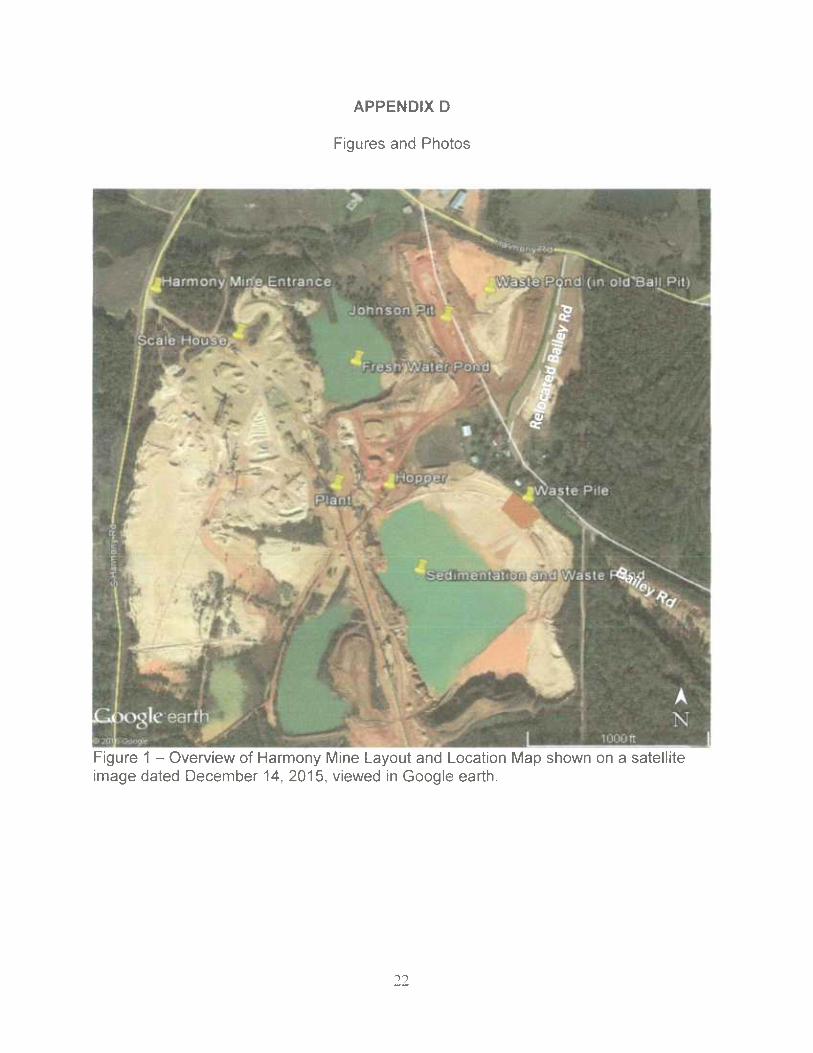
The accident took place at the mine's Johnson Pit near the northeast corner of the mineproperty (as shown in Figure 1 on page 4). The primary access road into the JohnsonPit enters at the Johnson Pit's southwest corner, near the hopper area of the plant. TheJohnson Pit was adjacent to, and immediately west of, an impoundment created in apreviously mined pit, referred to as the Krystal Gravel's Ball Pit (as shown in Figure 2 onpage 5). There was a fresh water pond used by the mine, also created in an old pit, tothe west of the Johnson Pit. The excavator and the truck were positioned near the eastpit wall (as shown in Figure 3 on page 6).
4

Figure 1 —Overview of Harmony Mine Layout and Location Map shown on a satelliteimage dated December 14, 2015, viewed in Google earth.

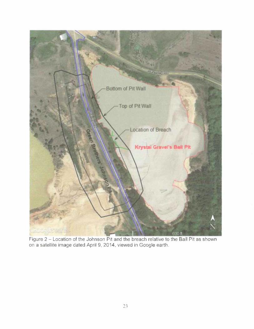
Figure 2 -Outlines the original Ball Pit in relationship to the mining of the Johnson Pit.The area of the Johnson Pit widens where the wall material composition transitions fromprimarily natural sand and gravel to primarily tailings. The excavator and haul truck wereboth on the pit bottom near the location of the failure.
6

,~
;~ j'~:
Figure 3 -The excavator was positioned near the east pit wall facing a northerndirection at the time of the failure. The truck was on the west side of the excavator, andwas facing south to southeast.
The Accident Investigation Team used post-failure pit measurements to estimate thatapproximately 41,000 cubic yards of material failed into the pit, covering an area ofabout 2 acres. The failed material was about 16.9 feet deep at the location of theequipment. The failed material came from an area that covered about 2.8 acres of theBall Pit. The majority of this surface area was occupied by clay tailings.
Development of the Johnson Pit
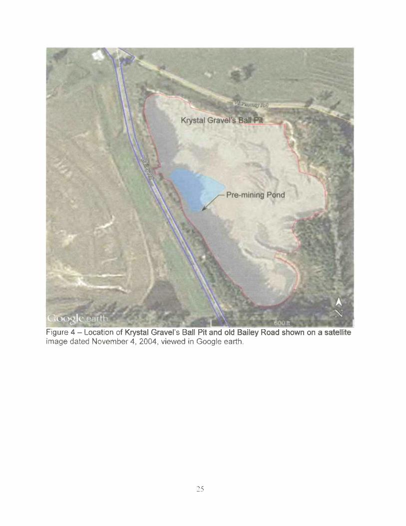
Green Brothers acquired the Ball Pit from Krystal Gravel in 2008. The Ball Pit coveredabout 10 acres (Figure 2), and according to mine permits, was mined to a depth ofabout 50 feet below natural ground. Krystal Gravel completed mining of the Ball Pit priorto 2003 and possibly as early as 1999.
7

Green Brothers began reclamation of the Ball Pit when they acquired it by filling it withhydraulically placed waste sand and clay from the plant to create a tailingsimpoundment in the Pit (Figure 3). They pumped water from the impoundment [Ball Pit]via a pipeline under Bailey Road to the fresh water pond, which was adjacent to andwest of Bailey Road.
In July 2015, Green Brothers proposed and received permission to relocate Baily Roadto the east side of the Ball Pit and mine the material below the "old Baily Road." Thepermit was amended in August 2015 to mine the material located under the old BaileyRoad and would be called the Johnson Pit, which added 1.5 acres and permitted miningto a depth of 80 feet. The permit indicated that the overburden was estimated at 5 to 15feet deep, sand and gravel product material was estimated to be 60 to 75 feet thick, andgroundwater was 110 feet deep. The natural ground elevations in the area of theJohnson Pit range from approximately 460 feet near the southwest corner to about 488feet near the northeast corner. Most of the natural ground around the Johnson Pit wasat or above elevation 480 feet.
Green Brothers paid for the relocation of Bailey Road and employed an engineer toprepare a geotechnical report for construction of the relocated road. An engineeringreport dated March 26, 2015, presents the results of a subsurface investigation;laboratory testing; and recommendations for site preparation, earthwork constructionand pavement design. The mine operator retained another engineering company toprepare a detailed survey of the location of Bailey Road and a map of the survey forconveyance of right-of-way to the county. During construction, compaction testing wasperformed on the subgrade, laboratory testing of the construction materials wasconducted, and compaction testing of the road subbase was performed.
Prior to mining, Green Brothers reportedly stripped about 5 to 6 feet of overburden fromthe proposed footprint of the Johnson Pit, including old Bailey Road. Most of thisoverburden material was stockpiled for topsoil cover and the remaining 1 to 2 feet ofoverburden was pushed into the Ball Pit impoundment along the western shoreline,which was immediately adjacent to and parallel with old Bailey Road. This strippingwork removed the pipeline previously used to pump water from the impoundment to thefresh water pond. The footprint of the Johnson Pit during its early development isdepicted in Figure 4.
Weather
On the morning of Friday, June 3, weather conditions were clear to partly cloudy with atemperature of about 84 degrees Fahrenheit in the late morning. Average wind speedwas 3 to 6 mph. Later that day after the accident, the recorded rainfall for the Jacksonarea was 0.87 inches. The mine recorded 0.70 inches of rainfall from Friday afternoonthrough Saturday morning. Leading up to the accident date, on Tuesday, May 31, themine recorded 0.30 inches of rainfall and on Wednesday, June 1, the mine recorded1.90 inches of rainfall.

Mining Practice
Green Brothers mined the sand and gravel deposit using excavators. It transportedmined material to the hopper in off-road haul trucks and had a permanent plant on mineproperty to process the sand and gravel.
Typically, miners excavated 4- to 6-foot lifts from the bottom of the pit, working from thenorth end to the south. The excavator loaded the raw material into off-road haul trucksand sent them to the plant or a waste dumping location depending on the quality of thematerial. The raw material was stockpiled near the crusher plant where afront-endloader would feed the material into the plant. Conveyors and front-end loaders move theindividual sand and gravel products to separate stockpiles and front-end loaders loadover-the-road trucks from the sand and gravel product stockpiles.
The mine operator did not have a plan for mining along the east side of the Johnson Pittoward the existing Ball Pit impoundment; however, according to statements madeduring the accident investigation interviews, they intended to "leave a gravel wall." Thatis, the operator expected to leave about 20 feet of natural sand and gravel between thepit and the impoundment. The pit was narrower on the north end to "leave a largerbarrier where the mud was." The mud refers to the clay tailings in the impoundment.The operator did not conduct any surveys and did not install stakes to determine wherethe clay tailings were or where the pit wall should have been located to maintain the 20-foot-wide barrier.
Based on interview statements, the mine operator had completed mining in the northernmost portion of the Johnson Pit, and about May 1, 2016, installed a levee across the pitto retain excess water and tailings that spilled from the Ball Pit impoundment. At thetime of the accident, the operator was draining most of the excess surface water (andsome of the clay tailings) from the Ball Pit impoundment via a trench excavated throughthe embankment crest immediately east of the levee. Storm water that entered theimpoundment would drain through this trench and into the northern end of the JohnsonPit. The mine operator stated they had problems with water eroding the embankmentand entering the pit so they constructed the levee to retain it in the completed portion ofthe pit.
Prior to digging the trench, the water seepage had also caused a failure in the upperportion of the pit wall near the northeast corner of the pit. After the levee wasconstructed and the Ball Pit impoundment was drained of surface water, the mineoperator had to install a pump in the northwest corner of the active pit to removeaccumulating water. They ran the pump for several hours about every other day whenthe accumulated water was 3 to 4 feet deep. The mine operator thought that this wasgroundwater seeping into the pit.
During interviews, investigators determined that the mine operator periodicallyinspected for undermining of the pit wall, cracks along the top and cracks along the

impoundment and made daily examinations from the pit floor. During the mining cyclein general, sand on the upstream slope would slide into the impoundment pool.Occasionally, additional sand was hauled to the Ball Pit impoundment in trucks andpushed with dozers into the southwestern corner of the Ball Pit impoundment about 4 to5 feet above the clay tailings in an effort to force the waste material to the north side ofthe impoundment. There was no compaction equipment used and no sampling ortesting of materials.
Along the southeast pit wall, sand tailings that sloughed into Johnson Pit area containedwet clay tailings.
Pit Description and Field Observations After the Accident
The Johnson Pit was about 950 feet long (in the north to south direction) and about 250to 380 feet wide. The pit was narrower at its northern end than at the southern end.The long axis of the pit runs along the natural ridgeline at an azimuth (a directionalmeasurement) of about 337 degrees from North, which was closely parallel to the oldBailey Road. The Johnson Pit covered about 7 acres and had a perimeter about 2,500feet. The west pit wall was 160 feet or more east of the fresh water pond. The bottomof the pit sloped downward to the north at a grade of 3 percent. The pit bottom varied inelevation from sea level at about 434 feet at the southeast corner to about 417 feet atthe south end. As previously mentioned, the operator constructed a levee across the pitabout 200 feet south of the north pit wall and tailings material had flowed from the BallPit impoundment into the Johnson Pit area north of that levee covering the final pitbottom. The actual mined pit bottom is estimated to be at 400 feet. The levee had aminimum height of about 17 feet above the tailings on the north side and at least 12 feetabove the failed material on the south side. The levee was also located where the pitwidth began to widen. The western pit wall was relatively straight and uniform. The pitwidened along its eastern side. The pit bottom near the failure was estimated to be atabout elevation 405 feet and the depth of failed material was about 17 feet. Figure 5shows the orientation and approximate limits of the pit on a satellite image datedDecember 14, 2015, viewed in Google earth with an overlay of an aerial image taken onJune 6, 2016.
The pit walls varied in height and slope. The pit wall on the western side was excavatedin mostly sand from previous pit reclamation. It varied in height from about 15 to 50 feetand had overall slopes between 20 and 40 degrees from horizontal. The slopes wereflatter at the southern end of the pit. The pit walls on the northern and southern endswere excavated in the natural sand and gravel. The southern end of the pit had a wallthat was up to 40 feet high with a slope of about 55 degrees from horizontal. Thenorthern end of the pit was approximately 55 feet high and deeply eroded. The slopesof the northern pit wall varied and were near vertical in some areas, with localizedundercutting from erosion.
10
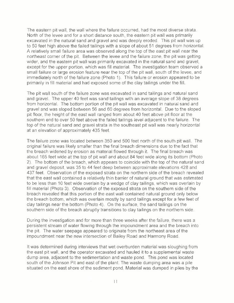
The eastern pit wall, the wall where the failure occurred, had the most diverse strata.North of the levee and for a short distance south, the eastern pit wall was primarilyexcavated in the natural sand and gravel and was deeply eroded. This pit wall was upto 50 feet high above the failed tailings with a slope of about 51 degrees from horizontal.A relatively small failure area was observed along the top of the east pit wall near thenortheast corner of the pit. Between the levee and the failure zone, the pit was gettingwider, and the eastern pit wall was primarily excavated in the natural sand and gravel,except for the upper portion, which was fill material. The investigation team observed asmall failure or large erosion feature near the top of the pit wall, south of the levee, andimmediately north of the failure zone (Photo 1). This failure or erosion appeared to beprimarily in fill material and had exposed some of the clay tailings under the fill.
The pit wall south of the failure zone was excavated in sand tailings and natural sandand gravel. The upper 40 feet was sand tailings with an average slope of 38 degreesfrom horizontal. The bottom portion of the pit wall was excavated in natural sand andgravel and was sloped between 56 and 60 degrees from horizontal. Due to the slopedpit floor, the height of the east wall ranged from about 40 feet above pit floor at thesouthern end to over 50 feet above the failed tailings level adjacent to the failure. Thetop of the natural sand and gravel strata in the southeast pit wall was nearly horizontalat an elevation of approximately 435 feet.
The failure zone was located between 350 and 500 feet north of the south pit wall. Theoriginal failure was likely smaller than the final breach dimensions due to the fact thatthe breach widened by erosion as material flowed through it. The final breach wasabout 165 feet wide at the top of pit wall and about 84 feet wide along its bottom (Photo2). The bottom of the breach, which appears to coincide with the top of the natural sandand gravel deposit, was 35 to 44 feet deep between approximate elevations 428 and437 feet. Observation of the exposed strata on the northern side of the breach revealedthat the east wall contained a relatively thin barrier of natural ground that was estimatedto be less than 10 feet wide overlain by a wedge of clay tailings, which was overlain byfill material (Photo 3). Observation of the exposed strata on the southern side of thebreach revealed that this portion of the east wall contained natural ground only belowthe breach bottom, which was overlain mostly by sand tailings except for a few feet ofclay tailings near the bottom (Photo 4). On the surface, the sand tailings on thesouthern side of the breach abruptly transitions to clay tailings on the northern side.
During the investigation and for more than three weeks after the failure, there was apersistent stream of water flowing through the impoundment area and the breach intothe pit. The water seepage appeared to originate from the northeast area of theimpoundment near the new intersection of Bailey Road and Harmony Road.
It was determined during interviews that wet overburden material was sloughing fromthe east pit wall, and the operator excavated and hauled it to a supplemental wastedump area, adjacent to the sedimentation and waste pond. This pond was locatedsouth of the Johnson Pit and east of the plant. The waste dumping area was a pilesituated on the east shore of the sediment pond. Material was dumped in piles by the
11

trucks and spread out with a dozer. Reportedly, several loads of saturated material wasremoved from the Johnson Pit and dumped at this pile on the day of the accident.During the investigation, three to four loads were observed on the waste dump. Thematerial characteristics are described in Appendix E.
Recent Satellite Imagery
A satellite image obtained from Terraserver.com dated 02/13/2016 shows signs oferosion or other distress on the pit slope where the failure occurred (Figure 6). At thattime, there was a pool of water along the east end of the impoundment, similar to theGoogle image dated 12/14/2015. However, the more recent satellite image showedmore waste sand had been pushed into the southwest corner of the impoundmentcovering the clay tailings, as reported. This image also shows an erosion gulley near thenorthern end of the pit prior to the construction of the levee, and water pooling in the pit.
Engineering Assessment
Based on information gathered by the investigation team, namely satellite images fromGoogle Earth and TerraServer, survey measurements of the pit dimensions, droneimages of the mine, and other observations and information gathered from the site, it isclear that the failure zone was partially situated within the prior owner Krystal Gravel'sBall Pit and occurred where the sand tailings beach transitioned to clay tailings. Thenorthern side of the failure, where the tailings were predominately clay, may have had athin barrier of natural sand and gravel. The top of the natural sand and gravel that wasobserved along the southern portion of the east pit wall is likely the bottom of the BallPit.
Failure of the pit wall caused a sudden breach of the impoundment that releasedsaturated clay and sand tailings. The failure occurred due to the mining along the eastpit wall that removed most of the natural embankment of medium dense sand andgravel and excavated into the less competent tailings deposit. The thin barrier wasfurther compromised by the steep angle of the wall and the deep erosion gullies in thesand and gravel.
In the immediate area of the failure, the tailings transitioned from sand to clay. The claycan be observed in the upper wedge on the north side of the breach and in the bottomof the south side of the breach. Satellite images over several years of operating theimpoundment show that this area was normally upstream of the sand beach. Thestripped overburden material that was pushed into the impoundment was an inadequateembankment, failed to displace or retain the clay tailings, and hid the previous pit walllocation. The additional waste sand pushed into the southwest corner of theimpoundment covered the clay and pushed back the pool water, but it did not stop theseepage, and was inadequate to retain the saturated tailings, and it masked the hazard.
12

TRAINING AND EXPERIENCE
Mr. Hemphill had approximately 17 years of mining experience; he worked for this minefor 6 years, 51 weeks and 5 days. The accident investigation team conducted an in-depth review of the mine operator's training records including records for Mr. Hemphill.MSHA determined that his required MSHA Part 46 Annual Refresher Training was notin compliance and issued anon-contributory citation under 30 CFR Part 46.
Mr. Shorter had approximately 39 weeks, and 5 days of mining experience, all at thismine. The accident investigation team conducted an in-depth review of the mineoperator's training records including records for Mr. Shorter. MSHA determined that hisrequired MSHA Part 46 New Miner Training was not in compliance and issued a non-contributory citation under 30 CFR Part 46.
ROOT CAUSE ANALYSIS
The investigators conducted a root cause analysis of this accident and identified thefollowing root causes and corresponding corrective actions to prevent a recurrence:
Root Cause: The mine operator failed to implement and use proper mining methods tomaintain the wall, bank, and slope stability.
Corrective Action: The mine operator established and implemented methods andprocedures to maintain wall and slope stability by using proven industry methods. Theoperator also created and implemented a training program for all miners to identifyhighwall, bank and slope hazards and a method of reporting hazards to Mine Operatorfor review and correction.
Root Cause: The mine operator failed to ensure the retaining dam was substantiallyconstructed.
Corrective Action: The mine operator established and implemented methods andprocedures to substantially construct dams by using proven industry methods. Theoperator also created and implemented a training program for all miners to identify asubstantially built dam and a method of reporting hazards to competent people forreview and correction.
13

Root Cause: The mine operator failed to install barriers or post warning signs toprevent miners from entering an area that it knew or should have known washazardous, as exhibited by the operator installing the levee on the north side of the pit,causing water and waste material to enter the excavation area from the impoundment
Corrective Action: The mine operator established and implemented methods andprocedures to install barricades and/or warning signs to prevent miners from enteringhazardous areas. The operator also created and implemented a training program for allminers to identify hazardous areas and a method of reporting hazards to the operatorfor review and correction.
Root Cause: The mine operator failed to conduct an adequate workplace examinationand to recognize and correct obvious hazardous ground conditions on the east wall ofthe Johnson Pit and the Ball Pit impoundment.
Corrective Action: The mine operator established and implemented methods andprocedures to examine, recognize and correct hazardous ground conditions. They alsocreated and implemented a training program for all miners to identify hazardous areasand a method of reporting hazards to Mine Operator for review and correction.
CONCLUSION
Two victims sustained fatal injuries when they were engulfed in an impoundment wallcollapse and inundated the pit with liquefied slurry. The victims were in the process ofexcavating material too close to a waste disposal pond. MSHA determined the operatorfailed to maintain the wall, bank and slope stability of the impoundment wall and failedto protect miners from obvious hazards. The operator also failed to conduct anadequate examination to prohibit access to an unsafe area and identify hazardsinvolved in this fatal accident.
14

ENFORCEMENT ACTIONS
Order No. 8867336- issued under the provisions of Section 103(j) of the Mine Act:
An accident occurred at this operation on 06/03/2016 at approximately 17:00. As rescueand recovery work is necessary, this order is being issued, under section 103(j) of theFederal Mine Safety and Health Act of 7977, to assure the safety of all persons at thisoperation. This order is also being issued to prevent the destruction of any evidencewhich would assist in investigating the cause or causes of the accident. It prohibits allactivity at the Johnson Pit until MSHA has determined that it is safe to resume normalmining operations in this area. This order applies to all persons engaged in the rescueand recovery operation and any other persons on-site. This order was initially issuedorally to the mine operator at 12:15 and now has been reduced to writing.
This order was modified to 103(k) of the Mine Act on 06/03/2016 at 3:57 p.m.
Citation No. 8853033 —Issued under provisions of Section 104(d)(1) of the Mine Act fora violation of 30 CFR 56.3130:
On June 3, 2016, the mine operator did not use proper mining methods to maintain thewall and slope stability of the east pit wall in the Johnson Pit. The east pit wall failedresulting in the death of two miners. The mine operator used excavators and dumptrucks to excavate and haul material from the Johnson Pit for processing. This highwallwas 65 feet high and the excavator operator was mining the gravel from the bottomportion of the highwall. The composition of the highwall was about 45 feet of sand at thetop, underlain by an interbedded sand/clay layer as well as finally a 20 foot thick graveldeposit at the bottom. The sand and clay was material that had been back-filled and thegravel was undisturbed material. The mine operator's mining method was deficient forany of the following reasons: 1. Lack of adequate preplanning or mine plan. 2. No use ofengineer support to ensure proper design in slope, stabilization and protectionmeasures. 3. No surveys to define areas to be mined or define the limits of advance. 4.No use of any type of delineation to limit and control the mining advance, for example:stakes, flags, painted marks or cones. 5. No sampling or testing was done to define theareas to be mined or define the limits of advance and 6. Not maintaining a proper angleof repose for the material being mined. A prudent mine operator would have employedany of the above mentioned mining methods to maintain wall and slope stability whilemining near a dam. Furthermore, during the mining process there were indications ofwall and slope instability. These warning signs included material sloughing off thehighwa/l, persistent water seepage, recent rains of approximately 2 inches, and wetsand and clay dropping out of the highwall. This condition exposed up to six miners tothe hazard, including two excavator operators and four haul truck operators working inthe Johnson Pit. The miners stated they were concerned for their safety while working inthe Johnson Pit. Mine Management engaged in aggravated conduct constituting morethan ordinary negligence in that they were aware of the hazards of not using propermining methods additionally the hazard of mining next to a waste dam. This violation isan unwarrantable failure to comply with a mandatory standard.
15
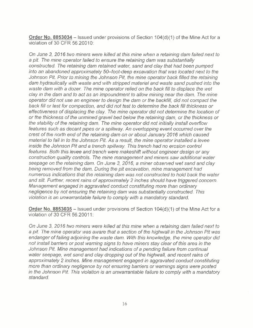
Order No. 8853034 -Issued under provisions of Section 104(d)(1) of the Mine Act for aviolation of 30 CFR 56.20010:
On June 3, 2076 two miners were killed at this mine when a retaining dam failed next toa pif. The mine operator failed to ensure the retaining dam was substantiallyconstructed. The retaining dam retained water, sand and clay that had been pumpedinto an abandoned approximately 50~-foot-deep excavation that was located next to theJohnson Pit. Prior to mining the Johnson Pit, the mine operator back filled the retainingdam hydraulically with waste and with stripped material and waste sand pushed into thewaste dam with a dozer. The mine operator relied on the back fill to displace the wetclay in the dam and to act as an impoundment to allow mining near the dam. The mineoperator did not use an engineer to design the dam or the backfill, did not compact theback fill or test for compaction, and did not test to determine the back fill thickness oreffectiveness of displacing the clay. The mine operator did not determine the location ofor the thickness of the unmined grave! bed below the retaining dam, or the thickness orthe stability of the retaining dam. The mine operator did not initially install overflowfeatures such as decant pipes or a spillway. An overtopping event occurred over thecrest of the north end of the retaining dam on or about January 2016 which causedmaterial to faU in to the Johnson Pit. As a result, the mine operator installed a leveeinside the Johnson Pit and a trench spillway. This trench had no erosion controlfeatures. Both this levee and trench were makeshift without engineer design or anyconstruction quality controls. The mine management and miners saw additional waterseepage on the retaining dam. On June 3, 2016, a miner observed wet sand and claybeing removed from the dam. During the pit excavation, mine management hadnumerous indications that the retaining dam was not constructed to hold back the waterand silt. Further, recent rains of approximately 2 inches should have triggered concern.Management engaged in aggravated conduct constituting more than ordinarynegligence by not ensuring the retaining dam was substantially constructed. Thisviolation is an unwarrantable failure to comply with a mandatory standard.
Order No. 8853035 -Issued under provisions of Section 104(d)(1) of the Mine Act for aviolation of 30 CFR 56.20011:
On June 3, 2076 two miners were killed at this mine when a retaining dam failed next toa pit. The mine operator was aware that a section of fhe highwall in the Johnson Pit wasendanger of failing adjoining the waste dam. With this knowledge, the mine operator didnot install barriers or post warning signs to have miners stay clear of this area in theJohnson Pit. Mine management had indications of a pending failure from continualwater seepage, wet sand and clay dropping out of the highwall, and recent rains ofapproximately 2 inches. Mine management engaged in aggravated conduct constitutingmore than ordinary negligence by not ensuring barriers or warnings signs were postedin the Johnson Pit. This violation is an unwarrantable failure to comply with a mandatorystandard.
16

Order No. 8853036 —Issued under provisions of Section 104(d)(1) of the Mine Act for aviolation of 30 CFR 56.18002(a):
On June 3, 2016 two miners were killed at this mine when a retaining dam failed next toa pit. The person designated by the mine operator to conduct examinations of theJohnson Pit failed to recognize the obvious indications of wall and slope instability onthe east wall of the Johnson Pit. These indications were material sloughing off the highwall, continual water seepage, recent rains of approximately 2 inches, and wet sand andclay dropping out of the highwall. A competent person would have recognized thehazards and would have initiated prompt action to correct the conditions; the mineoperator failed on both counts. Clearly, the work place examinations of the Johnson Pithighwalls were inadequate. The records of the workplace examinations for the JohnsonPit for the day of the accident and prior make no mention of any safety issues. Minemanagement engaged in aggravated conduct constituting more than ordinarynegligence by not having a competent person who could recognize unsafe conditionsand take prompt corrective actions for the Johnson Pit. This violation is anunwarrantable failure to comply with a mandatory standard.
Order No. 8853037 —Issued under provisions of Section 104(d)(1) of the Mine Act for aviolation of 30 CFR 56.3401:
On June 3, 2016 two miners were killed at this mine when a retaining dam failed next toa pit. The person designated by the mine operator to conduct examinations of theJohnson Pit failed to recognize the obvious indications of wall and slope instability onthe east wall of the Johnson Pit. These indications were material sloughing off the highwall, continual water seepage, recent heavy rains and wet sand and clay dropping outof the highwall. A prudent person familiar with mining would have recognized thesehazards and would have tested ground conditions prior to allowing work to commence;the mine operator failed on both counts. Mine management engaged in aggravatedconduct constituting more than ordinary negligence by not recognizing the unsafeground conditions at the Johnson Pit. This violation is an unwarrantable failure tocomply with a mandatory sfandard.
Approved By: Date:G. Stricklin
ministratorMetal and Nonmetal Mine Safety and Health Administration
17

List of Appendices
Appendix A: Persons Participating in the InvestigationAppendix B: Victim Data Information HemphillAppendix C: Victim Data Information ShorterAppendix D: Figures and PhotosAppendix E: Material Description
~`

APPENDIX A
Persons Participating in the Investigation
Green Brothers Gravel Company, Inc.
Andrew Donahoe ................... PresidentJackie Mullins ......................... SuperintendentNorman Ford .......................... Assistant Vice PresidentHeyward Green ...................... Vice PresidentSarah Korwan ........................ Counsel (Law Office of Adele L. Abrams)
Mine Safety and Health Administration
Christopher Hensler ............... District Manager, North Central DistrictDustan Crelly ......................... Assistant District Manager, Rocky Mountain DistrictJames Peck ........................... Staff Assistant, North Central DistrictRyan O'Boyle ......................... Supervisor, MNM Southeast DistrictEric Gottheld .......................... Civil Engineer, Technical Support
19

APPENDIX B
James "Dee" Hemphill Victim Data Information
Accident Investigation Data -Victim Information U.S. Department of Labor /~Event Number. e ~ 3 z 5 s o Mine Safety and Health Administration `~Victim IrAortnation: 1
t Name of InjuredAll Empbyee: i 2. Sex ; 3. V'ictim's Ape ~ a. Deproe of Iry'ury
James D Hemphill M , 56 Of Fatal5. Date(MM/DOMI) and Time(24 Hr) Of DeaCr 6. Date and Time Started:--- - — - —
a. Date.' 0603/2018 b Tkne. 11.30 ~ a. Date' 08AD.Y2016 b. Time 6:00
7 Regular Job Title: 8. Work AcOwty wlxn Injured: _~ ~9 Was this work activiry pan of regular ~ob9 - —
149 DiR Crew SupennsOr _ _' 05o Ope~atlng excaveta. bading !rucks ------- - -- - - -- Yes X ~ No - ~ _ — —
~~ ~"e ~̂ Years Weeks Days Yearn Weeks Days Years Weeks Days Years Weeks Daysa. This b R89~~ c: Thin d. TotalWpk gdivMy 17 0 0 .bb Title: B 51 5 Mline: B 51 5 Minny: ~7 0 0-- - — ---7 t NRiat Oiredly Inflicted Injury aillness? — - -- ~12. NaWre of Inpry or INness: -- --
094 Slurry ImpOundmant failure 170 Gushing inju79s13. Training Defiden6es.
_.... Hazard_ ; NewMewly-EmWoyetl Experiencetl Minx__ . Mnual ~. ~ .Task'---~ - - --- - -- - 1--- ~-----------t4. Comparry of Employment: (It ddterem from productlon operator)
Q~~~ Independern Contractor ID: (if applicable)
15. On-site Emergency Medical Tr~Unerrt
Not AppNcable: ~ First-Aid: CPR: EMT' I Medical Professional: ~ None: IX ~ ----------18. Part 50 Document Gontrot Number. (fpm 7000.7) 77. Union A1fiYaGan of Victim: ggg9 None (No Unan Af/iNefron)
20

APPENDIX C
Emmitt Shorter Victim Data Information
t. Name of Injuredllll Empbyee: 2. Sep 3 Victim's Ape a [~grce of In~W7E-mmilf A. SAatx M 24 01 Fatal
5. Date(MMIDOlYY) arW Time(24 Nr) Ot DeaN~ ! B. Date antl Time Started
e. Defe' OG~D3~2016 b. Time f 1'30 a. Date.' 06'D3/2076 b. lime. 6:00
7. Regular Job Title: ~ 8. Work AcUviry vfien Inryred: .. _..~ 8. Was this work activity part of regular ~oD7f76 Haul Tnrck Drivel 055 Haul Tn~ck Operator Yes X No ~- --- - -- - - - -
Years Weeks Days Yearo Weeks Days
---..Veers Week
—1- _ -~ Years Weeks Daysa Thincerro~~ b ReguWr c 7Ns tl. Tote)
Wak Activ'ily: 0 39 5 JOb Title: 0 39 5 Mine' 0 39 5 MNninC~ 0 39 51 t What Directly In~CeC Injury or tliness7 ~ - - -- - 72. Nature of Iryury or Illness - — ------ ~-
09I SNvey lmpaindment Failuro
—.- - — -
770 Ciushug in/uses— -- - - ~ - -- - --- . _ - -- —
--_13YTraining Deflckncies-H~ro; ~ NewlNewly-Empbyed ExperienCeC Miner. I Aruival' ~ Task.
14 Company W Empbyment (It AiflereM from proAuction operabr) -
~P~~--- - . -— _ _ ~nAepergent ConVactor ID' fd applirahb) '._ - -
75. On-site Emergen[,y MEA~CaI Treatrnenti
Not APPlicaWe;. ~ FirstAiO: j CPR: I i EMT MedkalGrokssionaC __— iNone: ~.
16 Part 50 Documerrt Control Number: (form 7000.1) 17 Unon ARiliaUon of V'~ctim~ 9999 None (No Unbn Alfr6afionJ
21
APPENDIX D
Figures and Photos
?2
Figure 1 —Overview of Harmony Mine Layout and Location Map shown on a satelliteimage dated December 14, 2015, viewed in Google earth.
~;
Figure 2 —Location of the Johnson Pit and the breach relative to the Ball Pit as shownon a satellite image dated April 9, 2014, viewed in Google earth.

~.
~.
~~
Q
a. ~~ '" H ~'-:
Figure 3 -The excavator was positioned near the east pit wall facing a northerndirection at the time of the failure. The truck was on the west side of the excavator, andwas facing south to southeast.
?4
25
Figure 4 —Location of Krystal Gravel's Ball Pit and old Bailey Road shown on a satelliteimage dated November 4, 2004, viewed in Google earth.

G --.. 9r
i ~.
~~ ~
_~~
'l Bottom of Pit Wallj,
Leveet
~4- Top of Pit Wail.. ~~'~
~T ~~ c :~~`~ Location of Breach\
-,, _ z ._ ..
~~~. _ ~~~ , °~ _ -
f ~~ N~ ~\
-~.~. o~~ `~~~
N ~
'q
wp
.•
Figure 5 —Location of the Johnson Pit, the breach, and the previous Ball Pit shown on asatellite image dated December 14, 2015, viewed in Google earth.
26
27
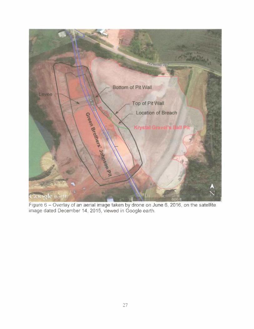
Figure 6 —Overlay of an aerial image taken by drone on June 6, 2016, on the satelliteimage dated December 14, 2015, viewed in Google earth.

~~:
_.
Leve., ',
,~: ; ~" ;.
~, '. ~,T
~~~
0
N,
vO~
7N
'O
Bottom of Pit Waller-- ~ '"°"--
s~ 1 $~Top of Pit Wall ~
~,~~~~
~— Location of Breach
t r
~~"` '~
301%; ~~~OO~I-
Figure 7 —Overlay of an aerial image from TerraServer date February 13, 2016, on thesatellite image dated December 14, 2015, viewed in Google earth.
28

T [91 1•. T___._
~T7
Photo 1 - View of the pit wall on the north side of the failure looking northeast. This view alsodepicts some previous erosion and sloughing adjacent to the failure.

Breach inWall
j,4~. .. r..~F~ , ~ ' '
~,x ~Y '~ f.. Y.
4. .'ll
~ ~ r ~ ~. ~,
Top of Pit Wa
.. _. _ _ _. _. ..._. __ ...._ _. _ - -- -~ - T -.- ~ - -- .._. _.. a__ ~ ~_ e.. __.. -- _._ .__. __. _..,
Sand Tailing
~'.
Natural Sand &Gravel
~ .~ ~ p ::; ~.,.,,~,~, -_
30
Photo 2 —View of the failure area and breach looking easterly from the west side of thepit.

on
JI
Photo 3 — View of the pit wall adjacent to the failure looking southeast. This shows theclay tailings overlying the natural sand and gravel near the top of the pit wall. It alsodepists clay tailings in the lower part of the pit wall on the southern side of the breach.

~` ~ ~ ~ ~ , ~ _ <— ~ Edge of Kryst -
~; * _~..Gravel Pit Wa(~ ,
~~,,~ -. ..
,~.~. _
.,. , , ,, .;;~ ..a . - .:< _ ~__. y ._ ..
.. _ 6
Clay Tailings on~~. North Side of Breach
~»~ -~. t
.. ~ '``~r r•»
_:~
',-~.
"' ',.
. ~~t
t - _ ~ y.~-.. -., yy
~~
Photo 4 —View of the breach area and~the eastern pit wall looking south. This viewdepists clay tailings in the lower part of the pit wall on the southern side of the breachand the inside edge of the western wall of Krystal Gravel's Ball Pit in the background.
JZ

APPENDIX EMaterial Description
Along the southeast pit wall, sand tailings that sloughed into the pit area may havecontained 10 to 25 percent clay tailings. The tailings were wet, but not soupy.
The sand and gravel material being mined was from the Citronelle Formation andconsisted of medium dense to dense sand and gravel with some silt and clay. Thegravel portion was generally hard, rounded, and pea size to 3-inch size. The sandportion was fine to coarse grained. The natural material was dry to moist in situ, andoverall reddish brown in color. The dense sand and gravel appeared to exhibit somemild cohesion, or bonding, which allowed portions of the pit wall to stand near vertical.However, when the sand and gravel is excavated and dumped, it performs like a typicalcohesionless, granular material that forms a pile with side slopes indicative of its angleof repose. Although there were traces ofsome silt and clay in the sand and gravel, therewere also discontinuous lenses of red clay a few inches to one foot thick. The naturalred clay had dry to moist in situ moisture. When excavated it would also break up andwhen dumped, it formed a pile.
The Citronelle Formation occurs along the ridges in Copiah County and its base occursaround elevation 400 feet. Reportedly, this formation has higher gravel content in thenorthern portion of Copiah County. This formation can also have significantly more siltand red clay mixed throughout at other mining locations; making the material at thismine a relatively high-quality deposit.
In the immediate area south of the failure, the sand and gravel material being minedwas overlain by about 40 feet of fine sand tailings with some clay tailings. The sand wasfine grained and light tan to white with traces of red silt and clay. Clean, dry sand is acohesionless material. However, moist sand can exhibit an apparent cohesion due tosurface tension and negative capillary pore water pressure, which will allow the sandbank to stand steeper than its angle of repose. However, this strength is moisturesensitive and transitory. Dry sand and saturated sand lose all apparent cohesion. Thesand tailings appeared to exhibit these moisture sensitive qualities. In its moistcondition, the sand tailings exhibited slopes as steep as 65 degrees along the southeastpit wall. As the sand tailings dried, it lost its apparent cohesive strength and sloughed offto an average slope of about 35 degrees in the pit. The dry, loose sand in a stock pilehad an angle of repose of about 31 to 33 degrees.
As previously mentioned, Green Brothers pumped and hydraulically deposited sand andclay waste materials (tailings) into the impoundment located in Krystal Gravel's Ball Pit.During the settling process, the tailings separate by grain size as the slurry (tailingsmixed with water) is pumped into the impoundment. The coarser material (light coloredsand) settles out near the place deposited and the fines (reddish colored silts and clay)remain in suspension longer and settle upstream of the sand in the pool area. The sandbuilds a beach and excess water drains from the sand that is built up above the pool
33
level. The clay tailings, even when the pool is dewatered, typically retain water longer,but should drain slowly into the sand and natural sand and gravel.
During the investigation, the sand beach in the impoundment area was relatively dryand built up to at least elevation 472, which was 5 to 10 feet above the clay. A sampleof sand tailings was collected from the beach area of the failure for laboratory testingand classification. The sand tailings were composed of almost 99 percent sand-sizedmaterial with 1.3 percent silt and clay and had an in situ moisture content of about 3percent. The surface of the clay tailings deposit in the impoundment area was alsorelatively dry and heavily desiccated in the upper 4 to 12 inches. The consistency of theclay crust was hard. The clay appeared drier and more heavily desiccated around theperimeter of the impoundment. There was vegetation growing over a small area of theclay crust, and although the surface of the clay had dropped down several feet, thecrust did not appear to have exhibited any major lateral movement except near thefailure.
The clay tailings were primarily clay with some sand. The strength of the clay tailings isvery moisture sensitive. The strength increases with decreasing moisture content.Initially, when the clay tailings are deposited, they have very high moisture content andvery little to no strength. As the clay loses moisture, its cohesive strength increases andit shrinks. As the clay dries, it will also begin to crack and become more brittle such thatshear failure through the material results in the sudden loss of its cohesive strength.The clay that flowed from under the crust is an example of its behavior at very lowstrength with high moisture content.
The investigation team collected a sample of the failed tailings from the pit area(southeast of the failure) for laboratory testing and classification. The consistency of thefailed tailings was that of a wet, flowable mud. During sampling, the tailings flowed fromthe approximately 1.5-inch-diameter holes in the excavator bucket. The failed tailingshad a very high moisture content of about 115 percent and were composed of 81percent silt and clay with less than 19 percent sand-sized material. The cracked cruston the top of the impoundment is an example of hard but brittle clay with low moisture.The investigation team also collected a sample of the clay tailings from the surface ofthe impoundment area (east of the failure) for visual classification, but did not send it tothe laboratory for testing. Pocket penetrometer testing on the sample exhibited anunconfined compressive strength greater than 4 tons per square foot, which gives it aconsistency classification of hard.
The waste material observed in piles at the dump site had dried enough to form a hardcrust on the surface of the piles. The surface was lumpy with a texture characteristic ofmaterial that was particularly wet when dumped and later dried. The piles appeared tocontain sand and gravel with large clumps of clay. The clay clumps on the surface haddeep desiccation cracks, were hard and dry on the outside but moist and stiff on theinside; these characteristics were like the desiccated clay tailings in the impoundment.The middle pile was considerably flatter than the others suggesting that this materialwas weaker than the other piles. This pile appeared to be primarily sand and gravel.
34

The northern pile appeared to be mostly moist sand with clumps of dried clay on thesurface. The last pile south appeared to be sand with considerable clay and somegravel. Two samples were collected from the inner portion of the middle and southernpiles. Both samples were wet. A sample of wet, red, mottled with lighter stripes, claywas removed from the southern pile that primarily contained material that was like theclay and sand tailings material. The clay had a very soft consistency, which is acharacteristic of wet tailings. Laboratory tests indicated that this material had a moisturecontent of about 55 percent and contained 78 percent silt and clay with about 18percent sand and less than 5 percent pea-sized gravel material. The finer fraction of thismaterial had a plastic limit of 29 percent and liquid limit of 61 percent moisture content,which produces a Unified Soil Classification System classification of CH for fat clay.Another sample was collected from the middle pile that contained primarily sand andgravel. The sample had excess water and was visually classified as wet. Laboratorytests indicated that this material had a moisture content of about 20 percent andcontained about 27 percent gravel, about 61 percent sand, and about 12 percent silt-and clay-size material. For comparison, the sand and gravel material that was sampledand tested in an engineering report produced for the relocation of Bailey Road had 12 to48 percent silt- and clay-size material and natural moisture contents between 8 and 14percent, which is why 20 percent moisture is considered wet.
JS