ict in disaster risk management initiatives in asia and the pacific
TRANSCRIPT
ICT in Disaster Risk Management Initiatives in Asia and the Pacific
1
The secretariat of the Economic and Social Commission for Asia and the Pacific (ESCAP) is the
regional development arm of the United Nations and serves as the main economic and social
development centre for the United Nations in Asia and the Pacific. Its mandate is to foster cooperation
among its 53 members and 9 associate members. It provides the strategic link between global and
country-level programmes and issues. It supports Governments of countries in the region in
consolidating regional positions and advocates regional approaches to meeting the region’s unique
socioeconomic challenges in a globalizing world. The ESCAP secretariat is in Bangkok. Please visit
the ESCAP website at http://www.unescap.org for further information. This report was prepared with
generous funding support provided by the Development Account Tranche 8th
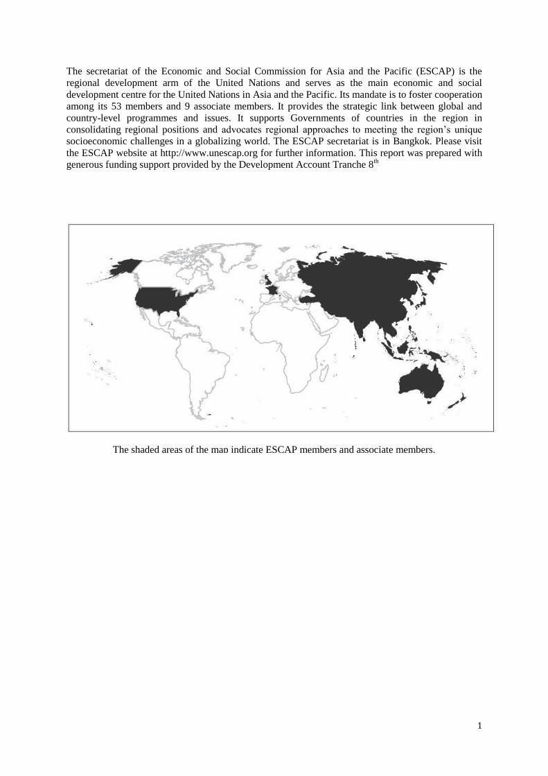
The shaded areas of the map indicate ESCAP members and associate members.
2 | ICT in Disaster Risk Management Initiatives in Asia and the Pacific
ICT in Disaster Risk Management Initiatives in Asia and the Pacific
© United Nations, 2016
Disclaimer:
The designations employed and material presented do not imply the expression of any opinion
whatsoever on the part of the Secretariat of the United Nations concerning the legal status of any
country, territory, city or area, or of its authorities, or concerning the delimitation of its frontiers or
boundaries. References and maps obtained from external sources might not conform to the United
Nations editorial guidelines. Mention of firm names and commercial products does not imply the
endorsement of the United Nations.
For more information contact:
Information and Communications Technology and Disaster Risk Reduction Division
United Nations Economic and Social Commission for Asia and the Pacific
The United Nations Building
Rajadamnern Nok Avenue
Bangkok 10200
Thailand
Telephone: +66 2 288 1234
Fax: +66 2 288 1000
Email: [email protected]
Website: http://www.unescap.org/idd
3
Contents
1 Introduction ...................................................................................................................... 4
1.1 Objective and Methodology ........................................................................................................ 4
2 ICT in Disaster Risk Management.................................................................................. 5
2.1 E-Resilience ................................................................................................................................ 7
3 Identification of Examples ............................................................................................... 8
3.1 Crowdsourcing and Social Media ............................................................................................... 9
3.1.1 What .................................................................................................................................... 9
3.1.2 Why ..................................................................................................................................... 9
3.1.3 Who ..................................................................................................................................... 9
3.1.4 Use Cases .......................................................................................................................... 10
3.1.5 Lessons Learned ................................................................................................................ 12
3.1.6 Outlook .............................................................................................................................. 13
3.2 Aerial Sensing with Humanitarian Drones ............................................................................... 13
3.2.1 What .................................................................................................................................. 13
3.2.2 Why ................................................................................................................................... 15
3.2.3 Who ................................................................................................................................... 15
3.2.4 Use Cases .......................................................................................................................... 16
3.2.5 Lessons Learned ................................................................................................................ 17
3.2.6 Outlook .............................................................................................................................. 17
3.3 Disaster Robotics ...................................................................................................................... 17
3.3.1 What .................................................................................................................................. 18
3.3.2 Why ................................................................................................................................... 19
3.3.3 Who ................................................................................................................................... 19
3.3.4 Use Cases .......................................................................................................................... 20
3.3.5 Lessons Learned ................................................................................................................ 20
3.3.6 Outlook .............................................................................................................................. 21
4 Conclusion ....................................................................................................................... 22
4.1 Recommendations ..................................................................................................................... 22
4.2 Outlook ..................................................................................................................................... 22
5 References ........................................................................................................................ 24
4 | ICT in Disaster Risk Management Initiatives in Asia and the Pacific
1 Introduction
Asia-Pacific remains the region with the largest proportion of natural disasters in the world. The
devastating earthquake in April 2015 in Nepal; the typhoons: Pam in April 2015 in Vanuatu, Haiyan
in 2013, and Pablo in 2012 in the Philippines; the 2011 floods in Thailand; and the 2011 Tohoku
earthquake and tsunami in Japan are some of the major disasters from the past few years. But in the
period 2005-2014, the region had 1,625 reported disaster events—that is over 40 per cent of the global
total.1
During this period, approximately 500,000 people lost their lives, around 1.4 billion people were
affected, and there was USD 523 billion worth of economic damage—accounting for 60 per cent of
global deaths, 80 per cent of those affected, and 45 per cent of economic losses.2
In 2014 alone, although there were no extreme catastrophes, the economic loss due to natural disasters
was estimated at USD 60 billion, with around 80 million people affected by natural disasters, and over
6,000 fatalities.3
According to the World Economic and Social Survey,5 the number of natural disasters increased five-
fold between 1979 and 2010. Asia-Pacific’s vulnerability to disasters is likely to increase with its
large population size (4.4 billion) and high population densities in disaster prone areas. Around 60 per
cent of Asia-Pacific city dwellers, 742 million people, are now at ‘extreme’ to ‘high’ disaster risk. By
2030, it is estimated that the number at ‘high’ or ‘extreme’ risk could reach 980 million.6 Given the
significance of Asia and the Pacific in the world’s economy, major disasters in this region tend to
have adverse global impacts.
1.1 Objective and Methodology
The objective of this paper is to identify innovative initiatives in the Asia-Pacific region that utilize
information and communication technologies (ICTs) to enhance disaster risk management. After an
overview of ICT in disaster risk management in section 2, the third section provides some examples
of innovative ICT solutions used in hazard, vulnerability and risk assessment initiatives in the Asia-
Pacific region. The focus and angle of analysis is on public-private partnerships (PPPs), e-resilience
and community involvement.
The methodology used for developing the paper is largely secondary research of public information
published in journals, publications, conference proceedings, and on the Internet. Information was also
obtained by e-mail correspondence with some of the researchers and practitioners working in ICT and
disaster risk management. As a result, information on initiatives that have not been published yet or
1 United Nations Economic and Social Commission for Asia and the Pacific, Asia-Pacific Disaster Report 2015:
Disasters Without Borders – Regional Resilience for Sustainable Development (Bangkok, 2016). Available from
http://www.unescap.org/sites/default/files/APDR2015%20Full%20Report.pdf. 2 Ibid.
3 United Nations Economic and Social Commission for Asia and the Pacific, “Disasters in Asia and the Pacific:
2014 Year in Review". Available from
http://www.unescap.org/sites/default/files/Year%20In%20Review_Final_FullVersion.pdf. 5 United Nations, World Economic and Social Survey 2011: The Great Green Technological Transformation
(New York, 2011). 6 United Nations Economic and Social Commission for Asia and the Pacific, Asia-Pacific Disaster Report 2015:
Disasters Without Borders – Regional Resilience for Sustainable Development (Bangkok, 2016). Available from
http://www.unescap.org/sites/default/files/APDR2015%20Full%20Report.pdf.
5
shared publicly, including information from private organizations, may not have been included in this
paper.
In order to identify information sources, a keyword search was undertaken using Internet search
engines, library, scientific and open access journal catalogues, and social media. The keywords (along
with their synonyms and conceptually-related terms) used include: Asia-Pacific, geographic
information system (GIS), geospatial, satellite, disaster management, crisis mapping, disaster
communication, crisis communication, technology, information and communication technology, ICT,
application, social media, rescue robotics, drones, and unmanned aerial vehicle (UAV).
2 ICT in Disaster Risk Management
Science and technology can greatly contribute to disaster risk reduction as exemplified and presented
in the series of Geo-information for Disaster Management (Gi4DM) annual conference proceedings
since 2005,8 and a number of other pertinent publications.
9
ICTs in particular are able to provide more sophisticated disaster preparedness, response and recovery
solutions. Rapid advances in imaging sensors and information technologies, for instance, offer the
possibility to identify, map and analyse with unprecedented detail, the facts and figures before, during
and after a disaster.
Social media, crowdsourcing and community sensing were extensively used for the first time in the
immediate aftermath of the Haiti earthquake in 2010, and helped communities by giving them the
tools to actively engage in the disaster risk management process.14
The range of ICT applications in disaster risk reduction can be aligned to the four phases in disaster
risk management (areas with particularly high potential to benefit from the use of ICTs are
highlighted in italics):
1. Mitigation – Minimizing the effects of disaster. Examples: building codes and zoning,
vulnerability analyses, public education.
2. Preparedness – Planning how to respond. Examples: preparedness plans, emergency
exercises and training, early warning systems.
3. Response – Efforts to minimize the hazards created by a disaster. Examples: search and
rescue (robotics), crisis mapping, information management.
4. Recovery – Returning the community to normal state. Examples: temporary housing (rapid
prototyping technologies), grants, medical care.
8 See http://www.gi4dm.net/.
9 Joint Research Centre, Science for Disaster Risk Reduction and Response JRC Thematic Report (Luxembourg,
European Commission Publications Office, 2014). Available from
http://dx.publications.europa.eu/10.2788/65084; UNISDR, “Science is Used for Disaster Risk Reduction”, 2015.
Available from http://www.preventionweb.net/publications/view/42848; UNISDR, “Using Science for Disaster
Risk Reduction”, 2013. Available from http://www.unisdr.org/we/inform/publications/32609; UNOOSA,
Geoinformation for Disaster and Risk Management (Copenhagen, Joint Board of Geospatial Information
Societies, 2010); and Scott Madry, Space Systems for Disaster Warning, Response, and Recovery,
SpringerBriefs in Space Development (New York, Springer, 2015). Available from
http://link.springer.com/10.1007/978-1-4939-1513-2. 14
Joint Research Centre, Science for Disaster Risk Reduction and Response JRC Thematic Report
(Luxembourg, European Commission Publications Office, 2014). Available from
http://dx.publications.europa.eu/10.2788/65084.
6 | ICT in Disaster Risk Management Initiatives in Asia and the Pacific
The main categories of ICT used in disaster risk management are as follows:
ICT infrastructure – Applications and provisions to help realize the benefits of ICTs even
in situations where the main communication infrastructure has been severely affected.
Examples include: DistressNet,15
TVWS initiative in the Philippines16
to solve last-mile
Internet connectivity issues, mobile ICT infrastructure units,17
satellite communications.
Information management – ICTs used to coordinate and direct the flow of information
from a variety of sources to a number of end users such as decision makers, emergency
responders, rescue staff, etc. These systems are by now well established and the most widely
used form of ICT in disaster risk management. Examples include: Sahana,18
a free and open
source disaster risk management system that was developed in Sri Lanka in the aftermath of
the Indian Ocean Tsunami in 2004 and is now widely used; Ushahidi,20
an open-source
crisis-mapping software; ESRI ArcGIS,21
a general purpose, commercial, GIS platform to
manage and analyse geospatial information; and Humanitarian ID,22
a service provided by
the United Nations Office for the Coordination of Humanitarian Affairs (OCHA) for
centralized contact management available to everyone working in humanitarian crises and
disasters.
Remote sensing and geospatial information23
– Space-based information derived from the
analysis of satellite imagery has been one of the longest standing applications of ICT in
disaster risk reduction, and is widely used in hazard and risk mapping.24
Examples of its use
include the assessment of tsunami risk in Indonesia,25
and mapping of the impact of extreme
floods on agriculture in Viet Nam.26
Remote sensing and geospatial information is also used
in the development of early warning systems, such as project NOAH27
by the Department of
15
Harsha Chenji, Wei Zhang, Radu Stoleru and Clint Arnett, “DistressNet: A Disaster Response System
Providing Constant Availability Cloud-like Services”, Ad Hoc Networks, vol. 11, no. 8 (November 2013):
pp.2440-60. 16
Tam Noda, "Phl gov't, Microsoft partner to boost TV White Space tech", Philstar.com, 11 July 2013.
Available from http://www.philstar.com/business/2013/07/11/964278/phl-govt-microsoft-partner-boost-tv-
white-space-tech. 17
Movable & Deployable ICT Resource Unit Project. Accessed 7 April 2015. Available from
http://www.mdru.org/index.php/2-uncategorised/2-about-mdru. 18
Sahana Software Foundation. Accessed 3 May 2015. Available from http://sahanafoundation.org/; and Khanh
Ngo Duc, Tuong-Thuy Vu and Yifang Ban, “Ushahidi and Sahana Eden Open-Source Platforms to Assist
Disaster Relief: Geospatial Components and Capabilities”, in Geoinformation for Informed Decisions, Alias
Abdul Rahman, Pawel Boguslawski, François Anton, Mohamad Nor Said and Kamaludin Mohd Omar, eds.
(Springer International Publishing, 2014). Available from http://link.springer.com/10.1007/978-3-319-03644-
1_12. 20
See http://www.ushahidi.com/. 21
See http://www.esri.com/software/arcgis. 22
See http://humanitarian.id/. 23
Scott Madry, Space Systems for Disaster Warning, Response, and Recovery, SpringerBriefs in Space
Development (New York, Springer, 2015). Available from http://link.springer.com/10.1007/978-1-4939-1513-2. 24
Paul N. Conrad, An Overview of Hazard Mapping in Cambodia: Current State and the Way Forward (Phnom
Penh, People in Need Cambodia, 2013). Available from
http://www.preventionweb.net/publications/view/36110. 25
G. Strunz and others, “Tsunami Risk Assessment in Indonesia”, Natural Hazards and Earth System Science,
vol. 11, no. 1 (January 2011). 26
Vu Ngoc Chau and others, “Using GIS to Map Impacts upon Agriculture from Extreme Floods in Vietnam”,
Applied Geography, vol. 41 (July 2013): pp. 65-74. 27
J. Tablazon and others, “Developing an Early Warning System for Storm Surge Inundation in the
Philippines”, Natural Hazards and Earth System Sciences Discussions, vol. 2, no. 10 (October 2014): pp. 6241-
70.
7
Science and Technology of the Philippines, whose lead scientist was recently honoured with
Europe’s premier geosciences union award.28
Analysis of crowdsourced and social media data – Contributes to the creation of timely
situational awareness in disaster response (for further details see section 3.1).
Robotics and rapid prototyping – Robots and other (semi-) autonomous vehicles are
mostly used during response for search and rescue missions. Whereas rapid prototyping
technology (such as 3D printing and laser cutting) are also used in the recovery phase. 3D
printing of spare parts and other urgently needed supplies locally can drastically ease
logistical bottlenecks and is already becoming a reality.31
2.1 E-Resilience
A generally accepted definition of resilience includes the ability to withstand an external disturbance.
Another definition of resilience is the ability to change in the face of an external disturbance;
changing in a way that enables survival of the system.32
Put differently, resilience is the systemic
ability to withstand external shocks.
In their report, “Linking ICTs and Climate Change Adaptation: A Conceptual Framework for E-
Resilience and E-adaptation,”33
Ospina and Heeks identify the following subproperties of resilience:
a. Robustness is the ability of the system to maintain its characteristics and performance under
external disturbances.
b. Scale refers to the range of resources and structures a system can resort to in order to deal
with disturbances.
c. Redundancy refers to the duplication of a system’s functional architecture in order to
increase reliability.
d. Rapidity refers to how quickly resources and critical infrastructure can be accessed and
mobilized.
e. Flexibility refers to the degree of a system for change while at the same time being able to
maintain its characteristics and functionality.
f. Self-organization is the ability of a system to change its structure and characteristics
independently.
g. Learning refers to the capacity of a system to evolve and improve based on feedback
gained from experience.
Reflecting upon these sub-properties in the light of ICTs sheds some light on the potential role of ICT
for resilience (e-resilience):
a. ICTs and Robustness – ICTs can help strengthen the physical preparedness of livelihood
systems through applications such as GIS, and positioning and modelling applications.
28
Voltaire Tupaz, "UP disaster scientist wins top European geosciences award (Rappler)", 16 April 2015.
Available from http://blog.noah.dost.gov.ph/2015/04/21/up-disaster-scientist-wins-top-european-geosciences-
award-rappler/. 31
Field Ready - Humanitarian Supplies Made-in-the-Field. Accessed 3 May 2015. Available from
http://www.fieldready.org/. 32
Angelica Valeria Ospina and Richard Heeks, "Linking ICTs and Climate Change Adaptation: A Conceptual
Framework for E-Resilience and E–adaptation", CDI Center for Development Informatics, 2010. Available
from http://www.eldis.org/go/home&id=59929&type=Document#.VUSIyyfJ69p. 33
Ibid.
8 | ICT in Disaster Risk Management Initiatives in Asia and the Pacific
b. ICTs and Scale – ICTs can help increase the breadth and depth of resources to which
households and communities have access to, for instance, access to e-health, e-learning and
market information through mobile devices. By reducing the physical distance to service
providers, ICTs can broaden access to information sources and knowledge, and help widen
social networks by providing access to other members of the community through social
media.
c. ICTs and Redundancy – Redundancy through ICTs, made possible for instance, by the
virtualization of markets and institutions (access to information and services through the
Internet) can improve the resilience of communities. If there is a collapse or breakdown of
physical infrastructure and institutions, ICTs can still enable continuation of those services.
Examples are job markets and e-commerce services that allow users to continue to take part
in the job market, and purchase and sell items.
d. ICTs and Rapidity – ICTs can enable swift access to pertinent information and the
coordination of information flows, in particular during the response phase. Mobile banking
and mobile finance can provide rapid access to financial capital and transactions, and
therefore have the potential to not only strengthen local livelihoods but also improve the
speed and efficiency with which local communities are able to cope with and adapt to
hazards and disastrous events.
e. ICTs and Flexibility – Sharing of knowledge and access to more information as catalyzed
by ICTs widens the perspective and in turn the number of possible choices. Therefore, it
increases the degree of flexibility in a system.
f. ICTs and Self-Organization – ICTs, through access to relevant data and information, can
enable the coordination of efforts between stakeholders, facilitating the different stages of
cognition, communication and cooperation. All these processes play a key role in
selforganizational processes.
g. ICTs and Learning – ICTs have long been used for learning and training. Examples in the
domain of disaster risk management include the training of responders in virtual reality
environments;34
a joint World Bank and Global Facility for Disaster Reduction and
Recovery project on simulating disaster risk management decisions with interactive
games;35
and the ‘Sai Fah – The Flood Fighter’36
mobile game on disaster risk reduction,
developed under the aegis of UNESCO to help raise awareness on the importance of flood
safety across Asia-Pacific countries.
3 Identification of Examples
The examples presented herein cover a wide range of ICT use cases, from more conventional Internet,
database-driven information management applications to autonomous, unmanned flying drones and
robots used in search and rescue missions.
34
eLearning Industry, Can Virtual Reality Keep Us Safe During Disasters? Accessed 3 May 2015. Available
from http://elearningindustry.com/can-virtual-reality-keep-us-safe-during-disasters. 35
Understanding Risk, Simulating Disaster Risk Management Decisions through Interactive Games. Accessed 3
May 2015. Available from https://understandrisk.org/simulating-disaster-risk-management-decisions-through-
interactive-games/. 36
UNESCO Bangkok, "Flood fighter game launch takes disaster awareness to new level", 20 January 2014.
Available from http://www.unescobkk.org/news/article/flood-fighter-game-launch-takes-disaster-awareness-to-
new-level-1/.
9
3.1 Crowdsourcing and Social Media
Mobile information technology devices have taken on an increasingly important role in disaster risk
management, may it be for the coordination of responders on the ground through systems like
Humanitarian ID,37
or for communities to exchange and be informed about latest developments. This
section focuses on the use of crowdsourced data in disaster response, although there are other
examples of how social media and crowdsourced data can be used during the other disaster risk
management phases.38
3.1.1 What
In particular during disaster response, community generated data exchanged on the Internet in online
social communities as pictures, messages and tweets can provide critical information for crisis
mapping and situational awareness building through the analysis of such crowdsourced data.39
Crowdsourced disaster response, until a few years ago informal and often chaotic, is now getting more
organized, and is embraced by official humanitarian organizations and integrated into relief
operations. For the first time in 2013 in response to typhoon Haiyan, OCHA deployed officials
charged specifically with coordinating crowdsourced mapping with volunteer groups.40
Volunteer efforts have increased substantially thanks to the arrival of online mapping tools, the
increasing popularity of social networks such as Facebook and Twitter, and the spread of mobile
phones.
3.1.2 Why
During a disaster, the affected communities, response agencies and governments must all quickly
understand who is in need, where they are, what is needed, which agencies can supply the demand,
and where are the safe routes, distribution centres and medical centres, etc. The lack of information,
poor information management and poor communication are often the cause of ineffective response.
Social media platforms and tools for crowdsourced disaster response can help to collate, manage and
disseminate the information required for disaster response. Besides its use as a channel for
information exchange and coordination, social media can raise inter-personal awareness, help enhance
people’s solidarity, and instill empathy for each other.41
3.1.3 Who
37
See http://humanitarian.id/. 38
discover.isif.asia, "How Indonesians Use ICT and Social Media for Disaster Management", 13 March 2014.
Available from http://discover.isif.asia/2014/03/how-indonesians-use-ict-and-social-media-for-disaster-
management/. 39
Wikipedia, “Crowdsourcing”, 29 April 2015. Available from
http://en.wikipedia.org/w/index.php?title=Crowdsourcing&oldid=659889714. 40
Declan Butler, “Crowdsourcing Goes Mainstream in Typhoon Response”, Nature, November 2013. 41
discover.isif.asia, "How Indonesians Use ICT and Social Media for Disaster Management", 13 March 2014.
Available from http://discover.isif.asia/2014/03/how-indonesians-use-ict-and-social-media-for-disaster-
management/.
10 | ICT in Disaster Risk Management Initiatives in Asia and the Pacific
A number of volunteer groups have contributed to disaster response in close coordination with
conventional disaster relief organizations.
Digital Humanitarian Network (DHN)42
is an umbrella group of 16 volunteer technology
organizations created in 2012. It acts as an interface between those groups and conventional
humanitarian organizations. The DHN brings together expertise in GIS, online mapping, data analysis
and statistics. It has also developed a couple of user-friendly tools that enable untrained volunteers to
contribute to responses.
Humanitarian OpenStreetMap Team (HOT)43
is a US-based non-governmental organization,
established in 2009. It had its first operative mission in 2010, when an earthquake struck Haiti, where
it developed one of the first crowdsourced crisis map within days. The HOT team uses satellite and
aerial imagery, and other geographical data sets to create maps with annotations highlighting features
such as damaged and intact buildings, blocked and open roads, and the locations of key infrastructure
such as hospitals.
The Standby Task Force (SBTF),45
also a founding member of the DHN, organizes digital
volunteers into a flexible, trained and prepared network ready to be deployed in crises. Their members
analyse tweets, text messages and other social media data to track an unfolding disaster, and map
damage, infrastructure and user needs.
The International Network of Crisis Mappers46
is an international community of more than 7,500
members in over 160 countries active at the intersection of humanitarian crises, new technology,
crowdsourcing and crisis mapping.
3.1.4 Use Cases
Crowdsourced data and the analysis of data derived from social media such as Facebook and Twitter
have been used in all major disaster responses of the past few years.
Nepal (2015)
All of the above-described groups are currently active in Nepal. At the request of OCHA, the
objective is first to crowdsource the analysis of tweets and media to rapidly assess disaster damage
and needs, and second to identify where humanitarian groups are deployed. Maps are live and
publicly online.47
Vanuatu (2015)
The DHN was activated just hours after Cyclone Pam hit Vanuatu’s many islands. The initial task was
to rapidly assess the damage by analysing multimedia content posted on social media and in the
mainstream news. A digital, interactive crisis map of more than 1,000 geo-referenced pictures of
disaster damage was produced.48
Philippines (2012 and 2013)
42
See http://digitalhumanitarians.com/. 43
See https://hotosm.org/. 45
See http://blog.standbytaskforce.com/. 46
See http://crisismappers.net/. 47
MicroMappers, Maps. Accessed 4 May 2015. Available from https://micromappers.wordpress.com/maps/. 48
Patrick Meier, "How Digital Jedis are Springing to Action in Response to Cyclone Pam", iRevolutions, 7
April 2015. Available from http://irevolutions.org/2015/04/07/digital-jedis-cyclone-pam/.
11
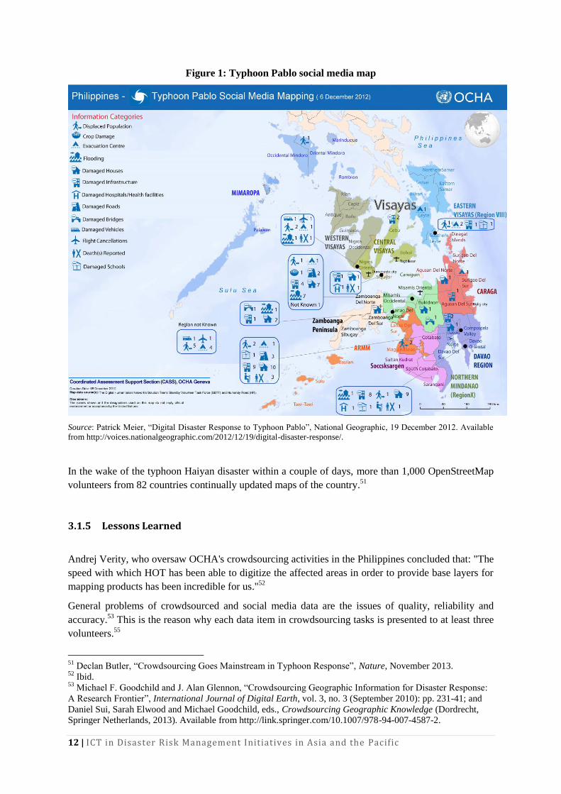
On 5 December 2012 at 3pm Geneva time, OCHA activated the DHN. The task was to compile a
customized situation report for OCHA’s team in the Philippines. Specifically, it was to collect all
relevant tweets about Typhoon Pablo posted on 4 and 5 December, to identify pictures and videos of
damage/flooding shared in those tweets, and geo-locate, time-stamp and categorize this content. The
time allowed for this task was 14 hours. The United Nations requested that the database be ready by
5am Geneva time the following day.49
Within 10 hours, more than 20,000 tweets were analysed using a mix of methodologies. At 4.30am
Geneva time, the database was delivered with 138 highly annotated tweets. A couple of hours later,
OCHA published a map, which depicts damage and flooding following the Typhoon (see Figure 1). It
was the first ever map entirely sourced from social media analysis.
49
Patrick Meier, “Digital Disaster Response to Typhoon Pablo”, National Geographic, 19 December 2012.
Available from http://voices.nationalgeographic.com/2012/12/19/digital-disaster-response/.
12 | ICT in Disaster Risk Management Initiatives in Asia and the Pacific
Figure 1: Typhoon Pablo social media map
Source: Patrick Meier, “Digital Disaster Response to Typhoon Pablo”, National Geographic, 19 December 2012. Available
from http://voices.nationalgeographic.com/2012/12/19/digital-disaster-response/.
In the wake of the typhoon Haiyan disaster within a couple of days, more than 1,000 OpenStreetMap
volunteers from 82 countries continually updated maps of the country.51
3.1.5 Lessons Learned
Andrej Verity, who oversaw OCHA's crowdsourcing activities in the Philippines concluded that: "The
speed with which HOT has been able to digitize the affected areas in order to provide base layers for
mapping products has been incredible for us."52
General problems of crowdsourced and social media data are the issues of quality, reliability and
accuracy.53
This is the reason why each data item in crowdsourcing tasks is presented to at least three
volunteers.55
51
Declan Butler, “Crowdsourcing Goes Mainstream in Typhoon Response”, Nature, November 2013. 52
Ibid. 53
Michael F. Goodchild and J. Alan Glennon, “Crowdsourcing Geographic Information for Disaster Response:
A Research Frontier”, International Journal of Digital Earth, vol. 3, no. 3 (September 2010): pp. 231-41; and
Daniel Sui, Sarah Elwood and Michael Goodchild, eds., Crowdsourcing Geographic Knowledge (Dordrecht,
Springer Netherlands, 2013). Available from http://link.springer.com/10.1007/978-94-007-4587-2.
13
The success of crowdsourcing bears its own problems. The number of people and tasks involved that
have to be coordinated can become a challenge on its own. In the response to the Nepal earthquake,
the Standby Task Force reported on 27 April 2015,56
that they had over 120 people on the deployment
and a long list of more people signed-up to join.
3.1.6 Outlook
Crowdsourced maps still require a lot of manual effort, and are labour- and time-intensive processes.
The volume of digital data generated during major disasters is beyond comprehension. In other
domains this is called ‘big data’. As digital data, notwithstanding the cause or subject domain, keeps
growing in volume, finding relevant, reliable and actionable information in this data becomes ever
more difficult. Other sectors have moved on and adopted machine learning (artificial intelligence)
approaches. Therefore, as in other sectors, it has been suggested to combine both machine and human
intelligence to tackle this challenge in disaster response.57
So far crowdsourcing in disaster response has been used mainly for image analysis, annotation and
categorization of social media feeds to created up-to-date crisis maps. A promising new scenario is
the crowdsourcing and collation of 3D data,58
providing more accurate and detail situation awareness
than what is currently possible. This would also go beyond current practice in the use of humanitarian
drones for aerial image and data acquisition.
3.2 Aerial Sensing with Humanitarian Drones
3.2.1 What
When a disaster strikes, there is an urgent need to assess the extent of the damage, including where
damaged objects are located along with accessibility to those areas. This has traditionally been the
domain of space-based geospatial information, derived from satellite imagery analysis, which is well
documented in the literature59
and is well established in disaster risk management practices.
Satellites have distinctive advantages for the acquisition of aerial images, such as their wide
geographical area coverage; a multitude of available sensors covering ultraviolet, visible and infrared
spectrum; and the mature level of the technology. Furthermore, the image acquisition process is not
affected by weather conditions on the ground. Even in areas with adverse local weather conditions,
such as raging thunderstorms and rough seas, images can be easily captured.
55
Patrick Meier, "How Digital Jedis are Springing to Action in Response to Cyclone Pam", iRevolutions, 7
April 2015. Available from http://irevolutions.org/2015/04/07/digital-jedis-cyclone-pam/. 56
Ben Proctor, “Update #3 on Nepal Earthquake Deployment”, Standby Task Force, 27 April 2015. Available
from http://blog.standbytaskforce.com/2015/04/27/update-3-on-nepal-earthquake-deployment/. 57
Patrick Meier, “Artificial Intelligence Powered by Crowdsourcing: The Future of Big Data and Humanitarian
Action”, iRevolutions, 16 March 2015. Available from http://irevolution.net/2015/03/16/humanitarian-artificial-
intelligence/. 58
Patrick Meier, “Crowdsourcing Point Clouds for Disaster Response”, iRevolutions, 9 April 2015. Available
from http://irevolution.net/2015/04/09/crowdsourcing-point-clouds-for-disaster-response/. 59
Scott Madry, Space Systems for Disaster Warning, Response, and Recovery, SpringerBriefs in Space
Development (New York, Springer, 2015). Available from http://link.springer.com/10.1007/978-1-4939-1513-2.
14 | ICT in Disaster Risk Management Initiatives in Asia and the Pacific
This makes them ideal for long-term planning and for geospatial and vulnerability analysis in large
geographic areas during the mitigation and preparedness phases. With information derived from
satellite imagery (such as vegetation, build-up structures, geomorphological features), and geographic
and elevation data in the form of georeferenced maps and digital elevation models, it is possible to
develop models and simulations of potential disasters along with evacuation routes and plans.
Access to the latest satellite data can be costly. That is why access to satellite data in case of a disaster
is governed by international agreements such as the International Charter on Space and Major
Disasters60
or its regional counterpart, Sentinel Asia.61
Their objective is to provide a unified system
of access to and delivery of space-based data to those affected by natural or man-made disasters
through authorized users at no cost.
On the other hand, satellite-based image acquisition suffers from a couple of disadvantages. Firstly,
satellite images have a comparatively low spatial resolution—about 0.4m/pixel. Secondly, depending
on the satellite revisit time (the time elapsed between observations of the same point on earth), which
can be from a couple of hours to several weeks, this can make timely access to data difficult. Thirdly,
satellite images are taken with a viewpoint looking downward to the object (nadir), which restricts
their usability for damage assessment during response. The satellite picture in Figure 2 illustrates this.
Figure 2: Vertical (nadir) images make damage assessment difficult
Source: Google Earth
Furthermore, factors such as shadowing and low visibility (especially problematic in tropical regions)
can substantially lower the quality of satellite imagery and make assessment even more difficult.
60
International Charter: Space and Major Disasters. Available from
https://www.disasterscharter.org/web/guest/home. 61
Kazuya Kaku and Alexander Held, “Sentinel Asia: A Space-Based Disaster Management Support System in
the Asia-Pacific Region”, International Journal of Disaster Risk Reduction, vol. 6 (December 2013): pp. 1-17.
15
3.2.2 Why
For the above mentioned reasons the use of UAVs or drones for crisis mapping during disaster
response has continuously risen over the last couple of years.62
In Asia-Pacific, UAVs have been used
so far in the following events: Typhoon Morakot (Taiwan), Thailand floods,63
Typhoon Haiyan
(Philippines), Cyclone Pam (Vanuatu), and the Nepal earthquake. There were at least seven
humanitarian UAV teams operating in the aftermath of the Nepal earthquake.65
UAVs are most often
used for: rapid reconnaissance and mapping of the extent of devastation; assessment of the condition
of transportation routes and identification of areas that are cut off; inspection of power lines; and
guidance in hydrological and geological mitigation needed to predict, contain or drain water, etc.
UAVs are easy to deploy, easy to handle and affordable (with a price tag of USD 500-20,000). They
also have a high degree of manoeuvreability, which means they can take pictures and capture data
from a much wider range of viewpoints than satellites.
A recent report68
on the use of drones for humanitarian purposes commissioned by the American Red
Cross came to the conclusion that “drones are one of the most promising and powerful new
technologies to improve disaster response and relief efforts.”69
3.2.3 Who
There are many non-profit associations and private companies that are active in using UAVs for
humanitarian purposes, and most of them have become members of the UAViators (Humanitarian
UAV Network). UAViators was launched based on experiences in the aftermath of Typhoon Haiyan.
Already then many UAVs were used, but coordination, information and data sharing among the
different groups, the local communities and the United Nations was very low.
UAViators was recently endorsed by the United Nations. It is a volunteer driven initiative that
promotes the responsible and effective use of UAVs in a wide range of humanitarian settings. The
network has about 1,000 members in over 70 countries around the world, comprising UAV
manufacturers, experts, policymakers and humanitarian organizations. Out of these, about 200 are
62
Patrick Meier, “Humanitarians in the Sky: Using UAVs for Disaster Response”, iRevolutions, 25 June 2014.
Available from http://irevolution.net/2014/06/25/humanitarians-in-the-sky/. 63
Peter Srivaree-Ratana, “Lessons Learned from the Great Thailand Flood 2011: How UAV Help Scientists
with Emergency Response, Disaster Aversion”. Accessed 3 May 2015. Available from
http://www.academia.edu/5133722/LESSONS_LEARNED_FROM_THE_GREAT_THAILAND_FLOOD_201
1_HOW_UAV_HELP_SCIENTISTS_WITH_EMERGENCY_RESPONSE_DISASTER_AVERSION. 65
Matt Kwong, “Nepal Earthquake: Drones Used by Canadian Relief Team”, CBC News, 27 April 2015.
Available from http://www.cbc.ca/1.3051106; Patrick Meier, “Humanitarian UAV Missions in Nepal: Early
Observations”, iRevolutions, 3 May 2015. Available from http://irevolution.net/2015/05/03/humanitarian-uav-
missions-nepal/; James Rogers, “How Drones are Helping the Nepal Earthquake Relief Effort”, FoxNews.com,
30 April 2015. Available from http://www.foxnews.com/tech/2015/04/30/how-drones-are-helping-nepal-
earthquake-relief-effort/; and Skycatch, “Skycatch Deploying UAVs and Two Engineers to Nepal for
Earthquake Relief”, 28 April 2015. Available from http://blog.skycatch.com/2015/04/28/skycatch-deploying-
uavs-and-two-engineers-to-nepal-for-earthquake-relief/. 68
American Red Cross and Measure, “Drones for Disaster Response and Relief Operations”, April 2015. 69
Matt McFarland, “American Red Cross Takes Serious Look at Using Drones for Disaster Relief, Holds off for
Now”, The Washington Post, 21 April 2015. Available from
http://www.washingtonpost.com/blogs/innovations/wp/2015/04/21/american-red-cross-takes-serious-look-at-
using-drones-for-disaster-relief-holds-off-for-now/.
16 | ICT in Disaster Risk Management Initiatives in Asia and the Pacific
UAV pilots. The network has an official partnership with AirVid, which gives it access to an
additional 700 professional UAV pilots in more than 60 countries worldwide.70
3.2.4 Use Cases
Vanuatu (2015)
Cyclone Pam was the first case where the World Bank activated the digital humanitarian volunteer
groups (DHN and HOT) to analyse the many gigabytes of aerial imagery from Vanuatu that were
captured by drones. The objective was to search and categorize for partially damaged and fully
destroyed houses in the aerial imagery.71
Philippines (2013)
When humanitarian organization Medair arrived in the Philippines after Typhoon Haiyan struck, they
discovered that accurate, up-to-date maps of the region did not exist. The existing local maps were not
geographically accurate in terms of road locations and distances. Communities had to rely on either
hand-drawn or outdated Google maps.
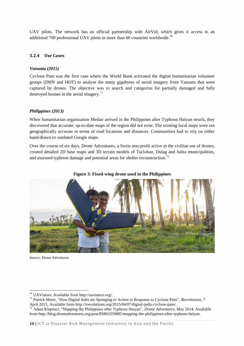
Over the course of six days, Drone Adventures, a Swiss non-profit active in the civilian use of drones,
created detailed 2D base maps and 3D terrain models of Tacloban, Dulag and Julita municipalities,
and assessed typhoon damage and potential areas for shelter reconstruction.72
Figure 3: Fixed-wing drone used in the Philippines
Source: Drone Adventures
70
UAViators. Available from http://uaviators.org/. 71
Patrick Meier, "How Digital Jedis are Springing to Action in Response to Cyclone Pam", iRevolutions, 7
April 2015. Available from http://irevolutions.org/2015/04/07/digital-jedis-cyclone-pam/. 72
Adam Klaptocz, “Mapping the Philippines after Typhoon Haiyan”, Drone Adventures, May 2014. Available
from http://blog.droneadventures.org/post/85863359885/mapping-the-philippines-after-typhoon-haiyan.
17
3.2.5 Lessons Learned
As people still tend to associate drones with military applications and weapons, it is important to
include and get the buy-in of the local communities. Adam Klaptocz of Drone Adventures reports that
the overall response from the community was always positive and local leaders were excited about the
opportunity of having their own accurate and highly detailed maps.73
These observations have been
confirmed by others.74
The recent situation in Nepal has highlighted the importance of several other issues related to the use
of UAVs during disasters:75
Coordination and data sharing among UAV teams is of paramount importance
A generally accepted code of conduct is necessary
Clear regulatory and legal provisions are needed
Standard workflows and standard operating procedures can help streamline the use of
humanitarian drones
3.2.6 Outlook
With advances in technology and usability, the use of UAVs for 3D data capture will increase.
Progress in data analysis and processing will allow the collation and merging of data from a high
number of UAVs. This opens up the possibility for low-cost, high-resolution capture and digitization
of larger areas—from city to county level—in particular for countries that cannot afford costly high-
resolution satellite data. Data and models derived that way can then be used for analysis and
simulations in mitigation and preparedness phases. A promising approach of collaborative mapping
using a combination of ground and aerial robots for the indoor exploration of an earthquake-damaged
building has been demonstrated.76
Using UAVs for the delivery of medical supplies77
and food has also become a (commercial78
) reality,
but in disaster risk management it is still at a conceptual stage.79
3.3 Disaster Robotics
This section provides a short overview of the overall field of robotics used in disaster risk
management, also known as disaster robotics,80
with a focus on remotely operated ground vehicles.
73
Ibid. 74
Robin R. Murphy, Disaster Robotics (The MIT Press, 2014). 75
Patrick Meier, “Humanitarian UAV Missions in Nepal: Early Observations”, iRevolutions, 3 May 2015.
Available from http://irevolution.net/2015/05/03/humanitarian-uav-missions-nepal/. 76
Nathan Michael and others, “Collaborative Mapping of an Earthquake-Damaged Building via Ground and
Aerial Robots”, Journal of Field Robotics, vol. 29, no. 5 (September 2012): pp. 832-41. 77
Jack Nicas, “Deutsche Post DHL to Deliver Medicine via Drone”, Wall Street Journal, 25 September 2014.
Available from http://www.wsj.com/articles/deutsche-post-dhl-to-deliver-medicine-via-drone-1411576151. 78
QuiQui - Automated Drone Delivery Of Pharmacy Items. Available from http://quiqui.me/. 79
Shane Hickey, “Humanitarian Drones to Deliver Medical Supplies to Roadless Areas”, The Guardian, 30
March 2014. Available from http://www.theguardian.com/world/2014/mar/30/humanitarian-drones-medical-
supplies-no-roads-technology. 80
Robin R. Murphy, Disaster Robotics (The MIT Press, 2014).
18 | ICT in Disaster Risk Management Initiatives in Asia and the Pacific
In fact, UAVs are also commonly categorized under robotics, yet this paper has covered them in a
separate section, as the field of UAVs is the most advanced within disaster robotics and UAVs have
already become a common tool in disaster response.
3.3.1 What
Rescue robots are tactical, organic, unmanned systems that allow emergency professionals to perceive
and act at a distance in real time, also known as having a remote presence at the disaster site.
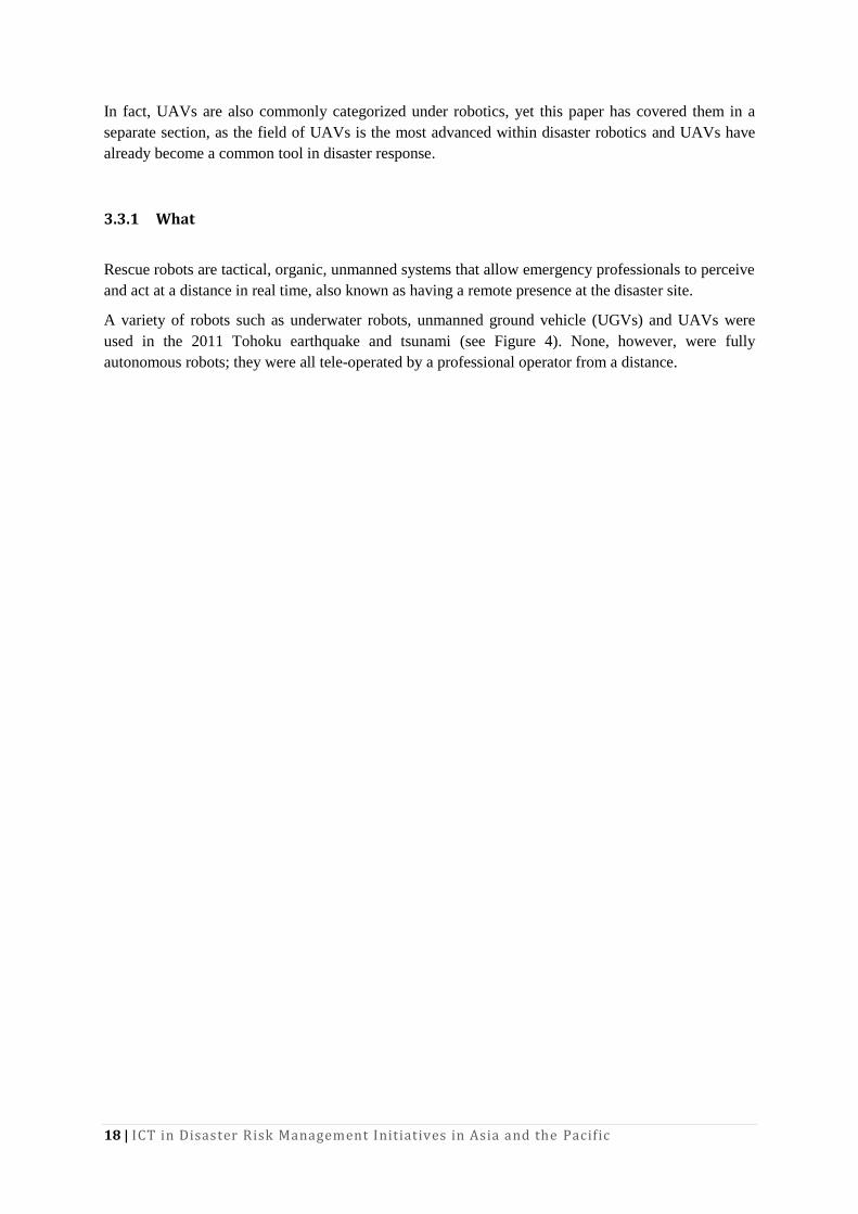
A variety of robots such as underwater robots, unmanned ground vehicle (UGVs) and UAVs were
used in the 2011 Tohoku earthquake and tsunami (see Figure 4). None, however, were fully
autonomous robots; they were all tele-operated by a professional operator from a distance.
19
Figure 4: Robots used in disaster risk management
Source: JSME Research Committee, Lessons Learned from the Great East Japan Earthquake Disaster (Tokyo, Japan
Society of Mechanical Engineers, 2014). Available from http://www.jsme.or.jp/English/report/geje/index.html.
3.3.2 Why
When a disaster happens, civil engineering structures such as bridges and buildings collapse, and it
becomes difficult to approach and enter certain areas without risking of further accidents and
jeopardizing more casualties. This is where robots come into the picture as they make it possible to
enter and explore areas that are prohibitive for humans or other living beings such as search and
rescue dogs. Robots can also carry out important indirect tasks such as acting as a mobile radio
beacon or repeater, serving as a surrogate team member, or shoring a collapse to make it safer for
responders.82
3.3.3 Who
Center for Robot-Assisted Search and Rescue
82
Robin R. Murphy, Disaster Robotics (The MIT Press, 2014).
20 | ICT in Disaster Risk Management Initiatives in Asia and the Pacific
The Center for Robot-Assisted Search and Rescue is active in the development of robotics and
unmanned systems for humanitarian purposes worldwide. It is located at Texas A&M University and
led by Dr. Robin Murphy with its director.
The centre’s mission is to serve existing rescue organizations by providing deployable robot-assisted
search and rescue teams, while fostering research in search-and-rescue robot systems and educating
the public.
International Rescue System Institute
The International Rescue System Institute (IRS) is a Japanese non-profit, industry-government-
academia-civilian research organization that aims to advance and promote high-technologies for
disaster response. It comprises the key players in rescue robotics in Japan, and conducts regular
training, test and evaluation exercises of rescue robots and systems. The IRS is led by Prof. Satoshi
Tadokoro from Tohoku University, one of the most eminent researchers and pioneers in disaster
robotics.
3.3.4 Use Cases
During the 2011 Tohoku earthquake and tsunami, Japanese rescue robots were used at actual disaster
sites for the first time. They were used and tested mainly along the coastline and at the Fukushima
Daiichi nuclear power plant to inspect critical infrastructures, search for missing persons driven
underwater by the tsunami, remove debris in the disaster sites, and inspect buildings that were in
danger of collapsing.
At the coastline, robots investigated underwater, searching for debris and victims. At the Fukushima
Daiichi Nuclear Power Plant it was strictly prohibited for workers to enter the buildings because of
high radioactivity. Therefore, the extent of damage inside the buildings was unknown. “To recover
from such an accident, it is essential to access the buildings and investigate the amount and type of
damage; therefore, the development of many types of tele-operated robotic systems was urgently
needed.”83
3.3.5 Lessons Learned
The cooperation of the public and private sectors is particularly important as many advanced robots
are developed and operated by private corporations.84
For instance, even though Japan is a leading
player in robotics research and development, the first robots to enter buildings after the 2011 Tohoku
earthquake and tsunami were American robots developed by private firm, iRobot. The main reason
being that the Japanese robotics industry is focused on industrial and domestic applications, in sharp
83
JSME Research Committee, Lessons Learned from the Great East Japan Earthquake Disaster (Tokyo, Japan
Society of Mechanical Engineers, 2014). Available from http://www.jsme.or.jp/English/report/geje/index.html. 84
Robin R. Murphy, Disaster Robotics (The MIT Press, 2014).
21
contrast to America’s battle-proof robots that have been deployed many times on battlefields in the
Middle East.85
The most important factor that influences the success of a robot mission is the human-computer
interface. Murphy reports that “50 per cent of the failures are due to human error, which strongly
suggests that human-robot interaction is a, if not the, major barrier facing rescue robotics.”86
However, human error appears to be in large part related to the fairly primitive robot designs and
manufacturing limitations associated with emerging technologies rather than to operator
deficiencies.87
There is a popular misconception that robots have to be human-like robots, particularly in Japan. Or
as Tadokoro argues: “Robots on the ground in disaster areas don't have to think or behave like an
Astro Boy (note: a popular Japanese manga robot comic figure). That's because we humans are much
better at judgment. So people should focus on what they're good at, robots on what they're good at,
and dogs on what they're good at. By having different players with different competencies forming an
integrated rescue team, we will be able to go about saving lives quicker and more efficiently.”88
3.3.6 Outlook
The use of robotics in disaster risk management is still in its early stages and is hampered and
restricted by several limitations. However, technology is developing fast—a couple of years ago,
UAVs were not as commonplace as they have become today. It is therefore not too overly optimistic
to expect that over a timeframe of 5-10 years, prices will further decline, and versatility and
performance will increase.
This further extends the range of possible application scenarios. For instance, recent research has
explored the possibility of using ground and aerial robots for joint 3D mapping of indoor
environments.
Moreover, Tadokoro reported about a recently developed robot. The ‘Active Scope Camera’ is an
elongated, tube-like robot with a miniature camera attached to its head. It can slither through crevices
like a snake, propelling itself forward by vibrating its hair-like structures. It can probe deep into debris
without getting stuck and help locate people trapped there. In demonstrations and tests with rescuers
in active service, the robot won critical acclaim as ‘the robot most likely to be introduced to actual
disaster areas’. It has already been used to investigate a building collapse in the United States.89
85
Hiroko Nakata, “Domestic Robots Failed to Ride to Rescue after No. 1 Plant Blew”, The Japan Times, 6
January 2012. Available from http://www.japantimes.co.jp/news/2012/01/06/national/domestic-robots-failed-to-
ride-to-rescue-after-no-1-plant-blew/. 86
Robin R. Murphy, Disaster Robotics (The MIT Press, 2014). 87
Ibid. 88
Satoshi Tadokoro, “Saving Lives: Rescue Robots Don’t Have to Be an Astro Boy”, Tohoku University, 2014.
Available from http://www.mech.tohoku.ac.jp/e/column/06.html. 89
Trends in Japan, "Rescue Robots: Machines Play Vital Roles in Disaster Relief". Accessed 11 April 2015.
Available from http://web-japan.org/trends/09_sci-tech/sci100909.html.
22 | ICT in Disaster Risk Management Initiatives in Asia and the Pacific
4 Conclusion
4.1 Recommendations
The following recommendations are based and derived from the challenges and best practices
identified from the above presented examples.
1. ICT Infrastructure: To leverage the full potential of ICT in disaster risk management, the
availability of a functioning, reliable and stable network infrastructure is an absolutely
necessary pre-condition. For instance, during the Nepal earthquake response, crowdsourcing
and processing of aerial imagery captured by UAVs were slowed down by bottlenecks in the
Internet infrastructure.90
Therefore, further investments and continuation of efforts in
existing initiatives, such as the Asia-Pacific Information Superhighway91
are of utmost
importance.
2. Technology and Know-How Transfer: Many open-source tools and software applications
exist that could be more widely used in disaster risk reduction. However, it is the lack of
awareness and skilled local personnel that constitutes a barrier to the uptake of these
solutions. Technology and know-how transfer is therefore paramount to bridge the gap.
Projects such as the Philippines UAV start-up, SkyEye Inc., which embarked on an initiative
to develop UAVs to empower grass-roots communities to deploy their own low-cost
xUAVs, and thus support locally-deployed response efforts, should be promoted and
supported in every way possible.92
3. Harmonizing Regulation: Advanced technology in disaster response often has to be
brought from abroad into the affected country. Many times this leads to a lengthy, protracted
process involving many decision makers, like customs, tax and civil aviation authorities. It
is highly recommended to develop a harmonized set of rules and regulations for the import,
export, and deployment of high technology during disaster response.
4. Research and Development Support: Many ICT solutions used in disaster risk
management in Asia-Pacific initiatives have been developed abroad. To build up local and
regional capacity, it is recommended to strengthen regional research and development
activities related to the use of ICT in disaster risk reduction.
5. Exchange of Best Practices and Lessons Learned: The initiatives presented have not
become mainstream yet. A lot remains to be learned in properly and efficiently integrating
new approaches, such as crowdsourced mapping, into the established disaster response
mechanisms. Therefore, regular exchange of best practices and lessons learned along with
the design of standard operating procedures is recommended.
4.2 Outlook
If the recent examples are any indication for the future direction of where ICT in disaster risk
reduction is heading, then the following trends can be identified:
Data analysis will be distributed and based on crowdsourcing and social media. Methods
from artificial intelligence will be used, particularly for automated clustering and
classification to enhance data analysis and its use for decision-making.
90
Patrick Meier, “Humanitarian UAV Missions in Nepal: Early Observations”, iRevolutions, 3 May 2015.
Available from http://irevolution.net/2015/05/03/humanitarian-uav-missions-nepal/. 91
See http://www.unescap.org/our-work/ict-disaster-risk-reduction/asia-pacific-information-superhighway. 92
Patrick Meier, “Humanitarians in the Sky: Using UAVs for Disaster Response”, iRevolutions, 25 June 2014.
Available from http://irevolution.net/2014/06/25/humanitarians-in-the-sky/.
23
The use of UAVs for humanitarian purposes was only the first step in the promotion of and
wider use of robotics in disaster risk management. The use of UAVs will further increase as
they offer a decentralized, cost-effective solution for high-quality aerial image capture,
followed by more specialized ground robots.
A longer-term trend will be the wider deployment of ground-based robots for search and rescue, and
based on similar developments in comparable technologies, costs will decline and the versatility and
dexterity of robots will improve.
The use of rapid manufacturing technologies like 3D printing and laser cutting, not only for supplies
and spare parts but also for shelter and housing, has also high potential in disaster relief as illustrated
by recent media coverage.93
93
TE Halterman, “Power to the People — 3D Printing Being Used in Disaster Relief”, 3DPrint.com, 6 April
2015. Available from http://3dprint.com/56149/3d-printing-disaster-relief/; and Rosanne Roobeek, “3D Printing
and the Future of Disaster Relief", Al Jazeera, 23 October 2014. Available from
http://www.aljazeera.com/indepth/features/2014/10/3d-printing-future-disaster-relief-20141016825642208.html.
24 | ICT in Disaster Risk Management Initiatives in Asia and the Pacific
5 References
American Red Cross and Measure (2015). Drones for Disaster Response and Relief Operations.
ArcGIS Platform. Available from http://www.esri.com/software/arcgis.
Butler, Declan (2013). Crowdsourcing Goes Mainstream in Typhoon Response. Nature, November.
Chau, Vu Ngoc, John Holland, Sue Cassells, and Mike Tuohy (2013). Using GIS to Map Impacts
upon Agriculture from Extreme Floods in Vietnam. Applied Geography, vol. 41 (July), pp. 65-74.
Chenji, Harsha, Wei Zhang, Radu Stoleru, and Clint Arnett (2013). DistressNet: A Disaster Response
System Providing Constant Availability Cloud-like Services. Ad Hoc Networks, vol. 11, no. 8
(November), pp. 2440-60.
Conrad, Paul N. (2013), An Overview of Hazard Mapping in Cambodia: Current State and the Way
Forward, Phnom Penh: People in Need Cambodia. Available from
http://www.preventionweb.net/publications/view/36110.
CrisisMappers. Available from http://crisismappers.net/.
DHN – Leveraging Digital Networks for Humanitarian Response. Available from
http://digitalhumanitarians.com/.
discover.isif.asia (2014). How Indonesians Use ICT and Social Media for Disaster Management, 13
March. Available from http://discover.isif.asia/2014/03/how-indonesians-use-ict-and-social-media-
for-disaster-management/.
Duc, Khanh Ngo, Tuong-Thuy Vu, and Yifang Ban (2014). Ushahidi and Sahana Eden Open-Source
Platforms to Assist Disaster Relief: Geospatial Components and Capabilities. In Geoinformation for
Informed Decisions, Alias Abdul Rahman, Pawel Boguslawski, François Anton, Mohamad Nor Said,
and Kamaludin Mohd Omar, eds. Springer International Publishing, pp. 163-74. Available from
http://link.springer.com/10.1007/978-3-319-03644-1_12.
eLearning Industry. Can Virtual Reality Keep Us Safe During Disasters? Accessed 3 May 2015.
Available from http://elearningindustry.com/can-virtual-reality-keep-us-safe-during-disasters.
Field Ready – Humanitarian Supplies Made-in-the-Field. Available from http://www.fieldready.org/.
Gi4DM. Available from http://www.gi4dm.net/.
Goodchild, Michael F., and J. Alan Glennon (2010). Crowdsourcing Geographic Information for
Disaster Response: A Research Frontier. International Journal of Digital Earth, vol. 3, no. 3
(September), pp. 231-41.
Halterman, T.E. (2015). Power to the People — 3D Printing Being Used in Disaster Relief.
3DPrint.com, 6 April. Available from http://3dprint.com/56149/3d-printing-disaster-relief/.
Hickey, Shane (2014). Humanitarian Drones to Deliver Medical Supplies to Roadless Areas. The
Guardian, 30 March. Available from http://www.theguardian.com/world/2014/mar/30/humanitarian-
drones-medical-supplies-no-roads-technology.
HOT – Humanitarian OpenStreetMap Team. Available from http://hot.openstreetmap.org/.
Humanitarian ID. Available from http://humanitarian.id/.
International Charter: Space and Major Disasters. Available from
https://www.disasterscharter.org/web/guest/home.
Joint Research Centre (2014). Science for Disaster Risk Reduction and Response JRC Thematic
Report. Luxembourg: European Commission Publications Office. Available from
http://dx.publications.europa.eu/10.2788/65084.
25
JSME Research Committee (2014). Lessons Learned from the Great East Japan Earthquake Disaster.
Tokyo: The Japan Society of Mechanical Engineers. Available from
http://www.jsme.or.jp/English/report/geje/index.html.
Kaku, Kazuya, and Alexander Held (2013). Sentinel Asia: A Space-Based Disaster Management
Support System in the Asia-Pacific Region. International Journal of Disaster Risk Reduction, vol. 6
(December), pp. 1-17.
Klaptocz, Adam (2014). Mapping the Philippines after Typhoon Haiyan. Available from
http://blog.droneadventures.org/post/85863359885/mapping-the-philippines-after-typhoon-haiyan.
Kwong, Matt (2015). Nepal Earthquake: Drones Used by Canadian Relief Team. CBC News. 27
April. Available from http://www.cbc.ca/1.3051106.
Madry, Scott (2015). Space Systems for Disaster Warning, Response, and Recovery. SpringerBriefs in
Space Development. New York: Springer. Available from http://link.springer.com/10.1007/978-1-
4939-1513-2.
McFarland, Matt (2015). American Red Cross Takes Serious Look at Using Drones for Disaster
Relief, Holds off for Now. The Washington Post, 21 April. Available from
http://www.washingtonpost.com/blogs/innovations/wp/2015/04/21/american-red-cross-takes-serious-
look-at-using-drones-for-disaster-relief-holds-off-for-now/.
Meier, Patrick (2015). Humanitarian UAV Missions in Nepal: Early Observations. iRevolutions, 3
May. Available from http://irevolution.net/2015/05/03/humanitarian-uav-missions-nepal/.
——— (2015). Crowdsourcing Point Clouds for Disaster Response. iRevolutions, 9 April. Available
from http://irevolution.net/2015/04/09/crowdsourcing-point-clouds-for-disaster-response/.
——— (2015). How Digital Jedis are Springing to Action in Response to Cyclone Pam. iRevolutions,
7 April. Available from http://irevolution.net/2015/04/07/digital-jedis-cyclone-pam/.
——— (2015). Artificial Intelligence Powered by Crowdsourcing: The Future of Big Data and
Humanitarian Action. iRevolutions, 16 March. Available from
http://irevolution.net/2015/03/16/humanitarian-artificial-intelligence/.
——— (2014). Humanitarians in the Sky: Using UAVs for Disaster Response. iRevolutions, 25 June.
Available from http://irevolution.net/2014/06/25/humanitarians-in-the-sky/.
——— (2012). Digital Disaster Response to Typhoon Pablo. National Geographic, 19 December.
Available from http://voices.nationalgeographic.com/2012/12/19/digital-disaster-response/.
Michael, Nathan, and others (2012). Collaborative Mapping of an Earthquake-Damaged Building via
Ground and Aerial Robots. Journal of Field Robotics, vol. 29, no. 5 (September), pp. 832-41.
MicroMappers. Maps. Accessed 4 May 2015. Available from
https://micromappers.wordpress.com/maps/.
Movable & Deployable ICT Resource Unit Project. Accessed 7 April 2015. Available from
http://www.mdru.org/index.php/2-uncategorised/2-about-mdru.
Murphy, Robin R (2014). Disaster Robotics. The MIT Press.
Nakata, Hiroko (2012). Domestic Robots Failed to Ride to Rescue after No. 1 Plant Blew. The Japan
Times Online, 6 January. Available from
http://www.japantimes.co.jp/news/2012/01/06/national/domestic-robots-failed-to-ride-to-rescue-after-
no-1-plant-blew/.
Nicas, Jack (2014). Deutsche Post DHL to Deliver Medicine via Drone. Wall Street Journal, 25
September. Available from http://www.wsj.com/articles/deutsche-post-dhl-to-deliver-medicine-via-
drone-1411576151.
26 | ICT in Disaster Risk Management Initiatives in Asia and the Pacific
Noda, Tam (2013). Phl gov't, Microsoft partner to boost TV White Space tech. Philstar.com, 11 July.
Available from http://www.philstar.com/business/2013/07/11/964278/phl-govt-microsoft-partner-
boost-tv-white-space-tech.
Ospina, Angelica Valeria, and Richard Heeks (2010). Linking ICTs and Climate Change Adaptation:
A Conceptual Framework for E-Resilience and E–adaptation. CDI Center for Development
Informatics. Available from
http://www.eldis.org/go/home&id=59929&type=Document#.VUSIyyfJ69p.
Proctor, Ben (2015). Update #3 on Nepal Earthquake Deployment. Standby Task Force, 27 April.
Available from http://blog.standbytaskforce.com/2015/04/27/update-3-on-nepal-earthquake-
deployment/.
QuiQui - Automated Drone Delivery Of Pharmacy Items. Available from http://quiqui.me/.
Rogers, James (2015). How Drones are Helping the Nepal Earthquake Relief Effort. FoxNews.com,
30 April. Available from http://www.foxnews.com/tech/2015/04/30/how-drones-are-helping-nepal-
earthquake-relief-effort/.
Roobeek, Rosanne (2014). 3D Printing and the Future of Disaster Relief. Al Jazeera, 23 October.
Available from http://www.aljazeera.com/indepth/features/2014/10/3d-printing-future-disaster-relief-
20141016825642208.html.
Sahana Software Foundation. Available from http://sahanafoundation.org/.
Skycatch (2015). Skycatch Deploying UAVs and Two Engineers to Nepal for Earthquake Relief. 28
April. Available from http://blog.skycatch.com/2015/04/28/skycatch-deploying-uavs-and-two-
engineers-to-nepal-for-earthquake-relief/.
Srivaree-Ratana, Peter. Lessons Learned from the Great Thailand Flood 2011: How UAV Help
Scientists with Emergency Response, Disaster Aversion. Accessed 3 May 2015. Available from
http://www.academia.edu/5133722/LESSONS_LEARNED_FROM_THE_GREAT_THAILAND_FL
OOD_2011_HOW_UAV_HELP_SCIENTISTS_WITH_EMERGENCY_RESPONSE_DISASTER_
AVERSION.
Standby Task Force. Available from http://blog.standbytaskforce.com/.
Strunz, G., J., and others (2011). Tsunami Risk Assessment in Indonesia. Natural Hazards and Earth
System Science, vol. 11, no. 1 (January), pp. 67-82.
Sui, Daniel, Sarah Elwood, and Michael Goodchild, eds. (2013). Crowdsourcing Geographic
Knowledge. Dordrecht: Springer Netherlands. Available from http://link.springer.com/10.1007/978-
94-007-4587-2.
Tablazon, J., and others (2014). Developing an Early Warning System for Storm Surge Inundation in
the Philippines. Natural Hazards and Earth System Sciences Discussions, vol. 2, no. 10 (October), pp.
6241-70.
Tadokoro, Satoshi (2014). Saving Lives: Rescue Robots Don’t Have to Be an Astro Boy. Available
from http://www.mech.tohoku.ac.jp/e/column/06.html.
Trends in Japan. Rescue Robots: Machines Play Vital Roles in Disaster Relief. Accessed 11 April
2015. Available from http://web-japan.org/trends/09_sci-tech/sci100909.html.
Tupaz, Voltaire (2015). UP disaster scientist wins top European geosciences award (Rappler). 16
April. Available from http://blog.noah.dost.gov.ph/2015/04/21/up-disaster-scientist-wins-top-
european-geosciences-award-rappler/.
UAViators – Humanitarian UAV Network. Available from http://uaviators.org/.
Understanding Risk. Simulating Disaster Risk Management Decisions through Interactive Games.
Accessed 3 May 2015. Available from https://understandrisk.org/simulating-disaster-risk-
management-decisions-through-interactive-games/.
27
UNESCO Bangkok (2014). Flood fighter game launch takes disaster awareness to new level. 20
January. Available from http://www.unescobkk.org/news/article/flood-fighter-game-launch-takes-
disaster-awareness-to-new-level-1/.
UNISDR (2015). Science is Used for Disaster Risk Reduction. Available from
http://www.preventionweb.net/english/professional/publications/v.php?id=42848.
——— (2013). Using Science for Disaster Risk Reduction. Available from
http://www.unisdr.org/we/inform/publications/32609.
United Nations, ed. (2013). World Economic and Social Survey 2013: Sustainable Development
Challenges. New York.
——— , ed. (2011). World Economic and Social Survey 2011: The Great Green Technological
Transformation. New York.
United Nations Economic and Social Commission for Asia and the Pacific (2016). Asia-Pacific
Disaster Report 2015: Disasters Without Borders – Regional Resilience for Sustainable Development.
Bangkok. Available from
http://www.unescap.org/sites/default/files/APDR2015%20Full%20Report.pdf.
———. Asia-Pacific Information Superhighway. Accessed 30 April 2015. Available from
http://www.unescap.org/our-work/ict-disaster-risk-reduction/asia-pacific-information-superhighway.
———. Disasters in Asia and the Pacific: 2014 Year in Review. Available from
http://www.unescap.org/sites/default/files/Year%20In%20Review_Final_FullVersion.pdf.
UNOOSA (2010). Geoinformation for Disaster and Risk Management: Examples and Best Practices.
Copenhagen: Joint Board of Geospatial Information Societies.
Ushahidi. Available from http://www.ushahidi.com/.
Wikipedia. Crowdsourcing. 29 April 2015. Available from
http://en.wikipedia.org/w/index.php?title=Crowdsourcing&oldid=659889714.