ice sheet overriding of the transantarctic mountainsthe transantarctic mountains (hollin 1962;...
TRANSCRIPT

boulders beyond the Ross I and Alpine I drift limits but withinthe Taylor III drift limit of Denton et al. (1970, figure 3) aregrussified, cavernously weathered, and wind faceted. Stoneson moraines above (and thus older than) low moraines farthersouth in the Transantarctic Mountains are also highlyweathered (Elliot et al. 1974; Mayewski 1975). The sparseweathering of erratics on nunataks in the Lassiter Coast there-fore suggests that the thick-ice stage evidenced in the southernAntarctic Peninsula is late-Wisconsin age.
Field work was done during austral summer 1972-1973 inci-dental to bedrock mapping by the U.S. Geological Survey. Thefield project was financed by National Science Foundation grantAG-187 and logistically supported by U.S. Navy Operation DeepFreeze.
References
Barrett, P. J . , and D. H. Elliot. 1973. Reconnaissance geologic map of theBuckley Island quadrangle, Transantarctic Mountains, Antarctica. (U.S.Geological Survey Antarctic Geologic Map, A-3.) Washington, D.C.:U.S. Government Printing Office.
Carrara, P. 1981. Evidence for a former large ice sheet in the OrvilleCoast-Ronne Ice Shelf area, Antarctica. Journal of Glaciology 27,
487-491.Denton, G. H., R. L. Armstrong, and M. Stuiver. 1970. Late Cenozoic
glaciation in Antarctica-The record in the McMurdo Sound region.Antarctic Journal of the U.S., 5, 15-21.
Denton, G. H., R. L. Armstrong, and M. Stuiver. 1971. The lateCenozoic glacial history of Antarctica. In K. K Turekian (Ed.), The
Late Cenozoic Glacial Ages. New Haven: Yale University Press.Denton, G. H., and T. J. Hughes. 1981. The Last Great Ice Sheets, New
York: Wiley-Interscience.Elliot, D. H., P. J . Barrett, and P. A. Mayewski. 1974. Reconnaissance
geologic map of the Plunket Point quadrangle, Transantarctic Mountains,
Antarctica. (U.S. Geological Survey Antarctic Geologic Map, A-4.)Washington, D.C.: U.S. Government Printing Office.
Hollin, J. T. 1962. On the glacial history of Antarctica. Journal of
Glaciology, 4, 173-195.Mayewski, P. A. 1975. Glacial geology and late Cenozoic history of the
Transantarctic Mountains, Antarctica. The Ohio State University, In-
stitute of Polar Studies, Research Report, 56.Paterson, W. S. B. 1980. Ice sheets and ice shelves. In S. C. Colbeck
(Ed.), Dynamics of snow and ice. New York: Academic Press.Paterson, W. S. B. 1981. The physics of glaciers. New York: Pergamon
Press.Rowley, P. D. and P. L. Williams. 1982. Geology of the northern Lassiter
Coast and southern Black Coast, Antarctic Peninsula. In C. Craddock(Ed.), Antarctic Geoscience. Madison: University of Wisconsin Press.
Rowley, P. D., D. L. Schmidt, and P. L. Williams. 1982. Mount PosterFormation, southern Antarctic Peninsula and western EllsworthLand. Antarctic Journal of the U.S., 17(5), 38-39.
Rowley, P. D., K. S. Kellogg, W. R. Vennum, R. B. Waitt, Jr., and S. J.Boyer. In press. Geology of the southern Black Coast, Antarctic Peninsula.
(U.S. Geological Survey Professional Paper 1170-A.) Washington,D.C.: U.S. Government Printing Office.
Stuiver, M., G. H. Denton, T. J . Hughes, and J. L. Fastook. 1981. Histo-ry of the marine ice sheet in West Antarctica during the last glacia-tion-A working hypothesis. In G. H. Denton and T. J . Hughes(Eds.), The last great ice sheets. New York: Wiley-Interscience.
Thomas, R. H. 1979. The dynamics of marine ice sheets. Journal of
Glaciology, 24, 167-177.Thomas, R. H., and C. R. Bentley. 1978. A model for Holocene retreat
of the West Antarctic ice sheet. Quaternary Research, 10, 150-170.Waitt, R. B., Jr. 1972. Geomorphology and glacial geology of the Methow
drainage basin, eastern Cascade Range, Washington. Unpublished doc-toral dissertation, University of Washington.
Waitt, R. B., Jr. 1981. Radial outflow and unsteady retreat of LateWisconsin to early Holocene icecap in the northern Long Rangeupland, Newfoundland. Geological Society of America Bulletin, Part I,92, 834-838.
Ice sheet overriding of theTransantarctic Mountains
G. H. DENTON, D. E. KELLOGG, and T. B. KELLOGG
Department of Geological Sciences and Institute for Quaternary StudiesUniversity of MaineOrono, Maine 04469
M. L. PRENTICE
Department of Geological SciencesBrown University
Providence, Rhode Island 02912
During the past three austral field seasons, we investigatedlate Tertiary overridings of the Transantarctic Mountains by anexpanded antarctic ice sheet considerably larger than those oflate Quaternary ice ages. Geologic and glaciologic studies bothindicate that eustatic sea-level changes caused by NorthernHemisphere ice sheets drove late Quaternary fluctuations of the
antarctic ice sheet, when it repeatedly grounded on peripheralcontinental shelves but did not thicken sufficiently to inundatethe Transantarctic Mountains (Hollin 1962; Stuiver and others1981). We suggest that eustatic sea level also drove ice-sheetvariations during at least the youngest Tertiary overriding epi-sode, when the mountains were inundated, because evidenceof climatic change at that time is absent in the TransantarcticMountains. If we are correct, the latest overriding episode (andperhaps earlier episodes) reflect large concurrent NorthernHemisphere ice sheets. These large ice sheets could haveshaped major fjords in eastern Canada and Greenland that areothewise difficult to explain by limited late Quaternary ice ex-tent in these regions (Andrews and Miller 1976; Funder andHjort 1973). We outline here evidence for overriding.
The dry valleys region in the Transantarctic Mountains showstwo major imprints of glacial erosion. The older imprint in-cludes major valley systems that occur on the eastern mountainflank where they form the dry valleys, as well as on the westernmountain flank where they lie buried beneath the ice sheet(Drewry 1982). Mountain ranges between dry valleys exhibitglacial erosional features, which complete the older imprint.The major valleys, as well as mountain alpine erosional forms,were cut primarily by a local ice cover rather than by a continent-al ice sheet, because on the western flank of the Transantarctic
931983 REVIEW
4?.
Mountains the valleys descend inland beneath the present icesheet (Drewry 1982).
The younger imprint of glacial erosion records angular over-riding of the preexisting mountain-and-valley topography bynortheastward-flowing ice. We infer that only an extensive icesheet would be thick enough to cover the mountains and flowdiagonally across deep valleys. A local ice cap would simplyflow along preexisting valleys. We have field evidence for sim-ilar angular overriding between Byrd Glacier and the ConvoyRange, which further implies the existence of an ice sheet ratherthan a local ice cap.
The overriding ice sheet modified preexisting alpine topogra-phy in the Asgard and Olympus Ranges, Quartermain Moun-tains, and Kukri Hills, producing an array of subglacial depositsand erosional features. Mountains, cirques, and ridges in theresistant granite and metamorphic bedrock of the eastern dryvalleys were molded and smoothed. Here bedrock surfaceswith dike swarms show subglacial corrugation. Further west,mountains, cirques, and ridges of less resistant Beacon Super-group sedimentary rocks and Ferrar Dolerite sills were moreseverely modified. Alpine cirques and ridge slopes facing up-glacier were abraded into smooth stoss slopes; similar featuresin the lee of ice flow were eroded headward by subglacial melt-water generated during abrasion of adjacent stoss slopes (figure
Figure 1. Fossil alpine horn (2,000 meters) In foreground composedof Beacon Supergroup sedimentary rocks with a Ferrar Dolerite capin the Asgard Range between Taylor and Wright Valleys. An overrid-ing ice sheet produced a smooth, abraded stoss slope on the leftand a plucked lee slope on the right.
1). Such headward erosion produced lee troughs, breacheddivides between opposing cirques, and isolated remnant alpineridges and horns. Advanced subglacial erosion in the centralOlympus Range has left only isolated ridges and peaks sepa-rated by remnant trough floors.
The overriding ice sheet deposited basal sediments on theglacially eroded landscape. On lee slopes and in lee troughs,systematically arranged patches of till and glacially corrugatedbedrock extend in a pattern unbroken by moraines or weather-ing changes from high mountain peaks down to low LatePliocene and Pleistocene moraines near Wright Upper and Tay-
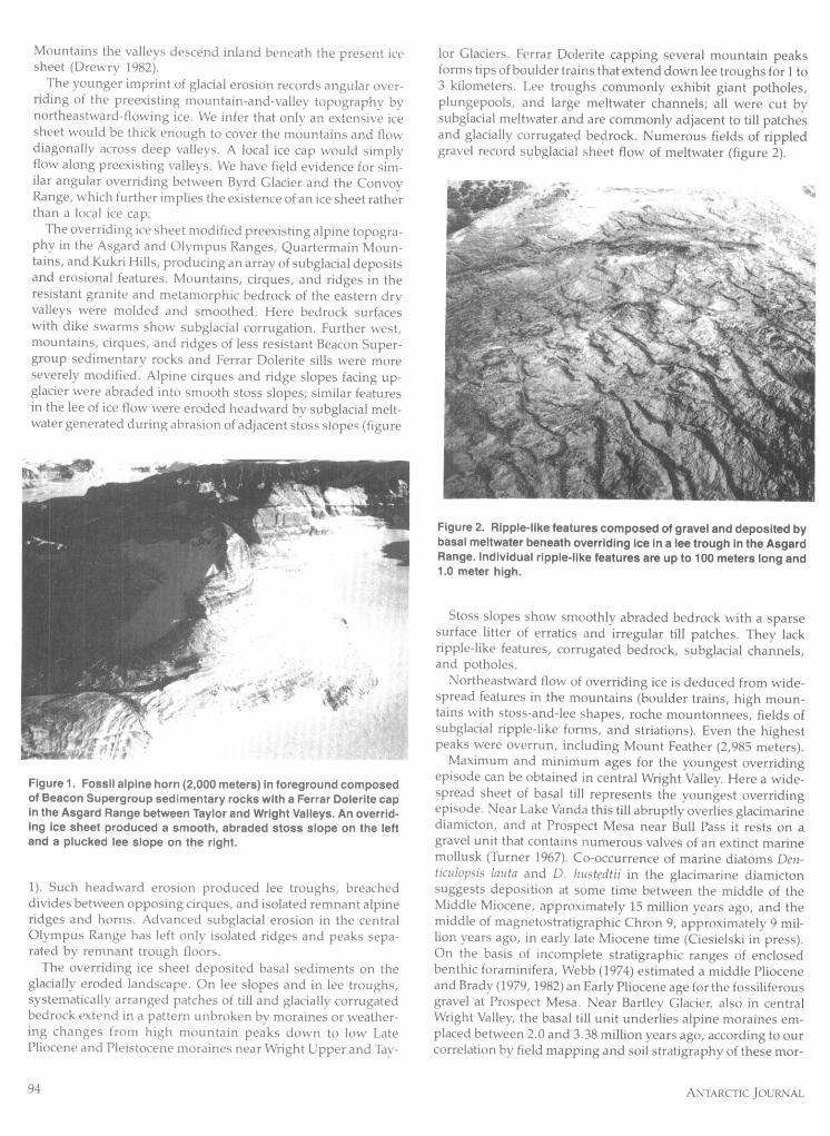
br Glaciers. Ferrar Dolerite capping several mountain peaksforms tips of boulder trains that extend down lee troughs for 1 t3 kilometers. Lee troughs commonly exhibit giant potholes,plungepools, and large meltwater channels; all were cut bysubglacial meltwater and are commonly adjacent to till patchesand glacially corrugated bedrock. Numerous fields of rippledgravel record subglacial sheet flow of meltwater (figure 2).
Figure 2. Ripple-like features composed of gravel and deposited bybasal meltwater beneath overriding ice In a lee trough in the AsgardRange. Individual ripple-like features are up to 100 meters long and1.0 meter high.
Stoss slopes show smoothly abraded bedrock with a sparsesurface litter of erratics and irregular till patches. They lackripple-like features, corrugated bedrock, subglacial channels,and potholes.
Northeastward flow of overriding ice is deduced from wide-spread features in the mountains (boulder trains, high moun-tains with stoss-and-lee shapes, roche mountonnees, fields ofsubglacial ripple-like forms, and striations). Even the highestpeaks were overrun, including Mount Feather (2,985 meters).
Maximum and minimum ages for the youngest overridingepisode can be obtained in central Wright Valley. Here a wide-spread sheet of basal till represents the youngest overridingepisode. Near Lake Vanda this till abruptly overlies glacimarinediamicton, and at Prospect Mesa near Bull Pass it rests on agravel unit that contains numerous valves of an extinct marinemollusk (Turner 1967). Co-occurrence of marine diatoms Den-ticulopsis lauta and D. hustedtii in the glacimarine diamictonsuggests deposition at some time between the middle of theMiddle Miocene, approximately 15 million years ago, and themiddle of magnetostratigraphic Chron 9, approximately 9 mil-lion years ago, in early late Miocene time (Ciesielski in press).On the basis of incomplete stratigraphic ranges of enclosedbenthic foraminifera, Webb (1974) estimated a middle Plioceneand Brady (1979, 1982) an Early Pliocene age for the fossiliferousgravel at Prospect Mesa. Near Bartley Glacier, also in centralWright Valley, the basal till unit underlies alpine moraines em-placed between 2.0 and 3.38 million years ago, according to ourcorrelation by field mapping and soil stratigraphy of these mor-
94 ANTARCTIC JOURNAL

ames with glacial deposits potassium/argon dated in TaylorValley (Denton, Armstrong, and Stuiver 1971; Armstrong 1978).Thus the basal till has a maximum age between 9 and 15 millionyears and may be younger than Middle to Early Pliocene if theage estimates of the fossiliferous gravel at Prospect Mesa arecorrect. Further, the basal till has a minimum age between 2 and3.38 million years.
For reasons given in Denton and others (in preparation), wethink that the overriding was multiple and that one episodeoccurred more than 9 to 15 million years ago.
We obtained an approximate ice-surface elevation of 3000meters for the dry valleys region for the latest overriding epi-sode by adjusting mountain elevations for 300 meters of tec-tonic uplift and then estimating that the highest mountainswere buried by 500 meters of ice, the minimum thickness toaccount for observed subglacial features (Denton et al. inpreparation).
Why were the Transantarctic Mountains overridden? Diago-nal northeastward ice flow across major valleys and intervalleymountain ranges between Byrd Glacier and the Convoy Rangecould only occur if extensive blocking ice in the Ross Sea (andthus West Antarctica) induced burial of the TransantarcticMountains and thickening of the adjacent east antarctic icesheet. Burial of the Transantarctic Mountains would promote aunified antarctic ice sheet with a central dome, because exposedmountains would no longer separate the east and west antarcticice sheets. Thus we conclude that a greatly expanded antarcticice sheet with a high, central dome was responsible for overrid-ing of the Transantractic Mountains (Denton et al. inpreparation).
This work was supported by National Science Foundationgrant DPP 80-23714.
References
Andrews, J. T. and C. H. Miller. 1976. Quaternary glacial chronologyof the eastern Canadian Arctic: A review and contribution on aminoacide dating of Quaternary molluscs from the Clyde Cliffs. In W. Ma-
haney (Ed.), Quaternary stratigraphy of North America, Stroudsburg,Pa. Dowden, Hutchinson, and Ross.
Armstrong, R. L. 1978. K-Ar dating: Late Cenozoic McMurdo VolcanicGroup and dry valley glacial history, Victoria Land, Antarctica. NewZealand Journal of Geology and Geophysics, 21,, 685-698.
Brady, H. T. 1979. A diatom report on DVD1' cores 3, 4a, 12, 14, 15 andother related surface sections. In T. Nagata (Ed.), Proceedings of theSeminar III on Dry Valley Drilling Project, 1978, Special Memoir 13 Tokyo:National Institute of Polar Research.
Brady, H. T. 1982. Late Cenozoic history of Taylor and Wright Valleysand McMurdo Sound inferred from diatoms in Dry Valley DrillingProject cores. In C. Craddock (Ed.) Antarctic geoscience. Madison:University of Wisconsin Press.
Ciesielski, P. F. In press. The Neogene diatom biostratigraphy of DSDP
Leg 71, Subantarctic sediments. In W. J . Ludwig, V. Drashinnikov etal. (Eds.), Initial reports of the Deep Sea Drilling project, leg 71. Wash-ington, D.C.: U.S. Government Printing Office.
Denton, G. H., R. L. Armstrong, and M. Stuiver. 1971. The lateCenozoic glacial history of Antarctica. In K K. Turekian, (Ed.), TheLate Cenozoic glacial ages. New Haven: Yale University Press.
Denton, G. H., M. L. Prentice, D. E. Kellogg, and T. B. Kellogg. Inpreparation. Tertiary history of the Antarctic Ice Sheet: Evidencefrom the dry valleys. Geology.
Drewry, D. J . 1982. Ice flow, bedrock, and geothermal studies fromradio-echo sounding inland of McMurdo Sound, Antarctica. InC. Craddock (Ed.), Antarctic geoscience. Madison: University ofWisconsin Press.
Funder, S., and C. Hjort. 1973. Aspects of the Weichselian chronologyin central East Greenland. Boreas, 2, 69-84.
Hollin, J . T. 1962. On the glacial history of Antarctica. Journal ofGlaciology, 4, 173-195.
Stuiver, M., G. H. Denton, T. J . Hughes, and J. L. Fastook. 1981. Histo-ry of the marine ice sheet in West Antarctica during the last glaciation:A working hypothesis. In G. H. Denton and T. J . Hughes (Eds.), Thelast great ice sheets. New York: Wiley-Interscience.
Turner, R. D. 1967. A new species of fossil Chlamys from Wright Valley,McMurdo Sound, Antarctica. New Zealand Journal of Geology andGeophysics, 10, 446-455.
Webb, P. N. 1974. Micro palaeontology, palaeoecology and correlationsof the Pecten gravels, Wright Valley, Antarctica, and description ofTrocheolphidiella onyxi, n. gen., n. sp. Journal of Foraminiferal Research, 4,184-199.
1983 REVIEW 95