iberia parish - texas general land office · city, the louisiana oil spill coordinator’s office,...
TRANSCRIPT
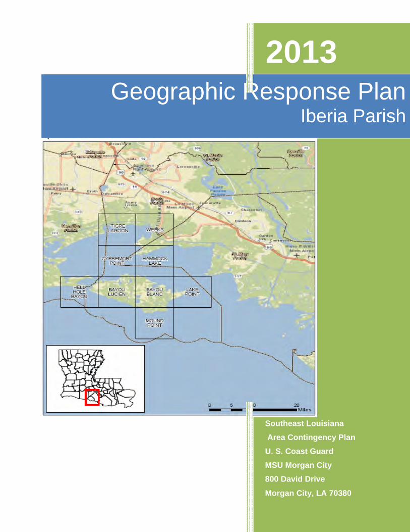
2013 Geographic Response Plan
Iberia Parish
Southeast Louisiana Area Contingency Plan U. S. Coast Guard MSU Morgan City 800 David Drive
Morgan City, LA 70380
Record of Changes
Date Change Number
Summary of Changes Initials of person making
changes
3
Contents Iberia Parish GRP Signature Page ............................................................................... 2 Record of Changes ....................................................................................................... 3 Iberia Parish Geographic Response Plan ................................................................... 5
Introduction................................................................................................................ 5 Scope .......................................................................................................................... 6 Development .............................................................................................................. 6 Guiding Principles of the GRP.................................................................................. 7 Sensitive Resources Addressed by GRPs .............................................................. 8 Evaluation Criteria for GRPs .................................................................................... 9 Prioritization............................................................................................................. 12 Strategy Selection ................................................................................................... 13
GRP Strategy Selection Job-Aid ................................................................................ 14
4
Iberia Parish Geographic Response Plan
Introduction
This Geographic Response Plan (GRP) is an annex to the Southeast Louisiana Area Contingency Plan (SOUTHEAST LOUISIANA ACP) and a key element of both facility and vessel contingency plans. This GRP has two main functions:
From a planning perspective, the GRP provides a description of sensitive biological, cultural, and economic resources that must be addressed to be in compliance with:
• The National Oil and Hazardous Substance Pollution Contingency Plan (NCP, 40 CFR Part 300.210(3)(i).). Area Contingency Plans are required to describe areas of special economic and environmental importance that could be impacted during an oil
spill. • The National Historic Preservation Act of 1966 contains applicable, relevant and
appropriate requirements. The GRPs also address sensitive historic and prehistoric resources.
From an operational perspective, the GRP guides responders in the first 24-48 hours of an oil spill by:
• Providing a prioritized list of tactical response strategies to be implemented during the early hours of an oil spill (usually before the formation of the Unified Command);
• Providing detailed information for booming strategies that could be utilized to minimize impacts to predetermined sensitive resources.
Once the Unified Command is formed, additional operational strategies and tactics will be relayed to the field in the form of the ICS-204 work assignment sheets.
Because the GRP is the primary tool used during an initial phase of the response and fairly broad in their scope, they are not intended to minimize impacts to all possible sensitive areas that could be affected by an oil spill. Likewise, the GRPs are not intended to be an exhaustive list of all the tactical strategies that could, or should, be implemented during a spill.
5

Scope
This Geographic Response Plan (GRP) is intended to help the first responders of an oil discharge or hazardous substance release avoiding the initial confusion that generally accompanies any incident. This document serves as the federal and state on-scene-coordinators “guidance” during an incident in the area covered by this GRP (see Section 2 for area covered). As such it has been approved by the U.S. Coast Guard MSU Morgan City, the Louisiana Oil Spill Coordinator’s Office, and Iberia Parish. Changes to this document are expected as testing is conducted through drills, site visits, and actual use in an incident. To submit comments, corrections, or suggestions please refer to Appendix B.
The scope of this GRP is to identify sensitive sites to be considered for protection in the first 24 to 48 hours of an incident and the generic response strategy for this site considering unique characteristics, noted hydrology and climatic considerations. This index is not all encompassing as sites not identified in this index may need to be evaluated for protection as an incident progresses.
GRPs only address protection of sensitive public resources. It is the responsibility of private resource owners and/or potentially liable parties to address protection of private resources (such as commercial marina and private water intakes).
Development
This Index has been developed for the Coastal Zone, as defined in the National Contingency Plan (40 CFR Part 300) for Iberia Parish. It is prepared through the efforts and cooperation of Louisiana State Trustee Agencies, Parish Representatives, and Federal Trustee Agencies, other federal and state agencies, response organizations, and local emergency responders. This Index was developed through workshops involving federal, state, and local stakeholders. Workshop participants identified resources which require protection and developed operational strategies.
Following the workshops, the data gathered was processed and reproduced in the form of maps and matrices which appear in Chapter 3. The maps were generated using ArcGIS, and the tables were created using Microsoft Access.
The first goal of a GRP is to identify resources needing protection; response resources needed; tribal and local response community contacts; and local conditions that may affect response strategies.
Secondly, response strategies were developed based on the sensitive resources noted hydrology and climatic considerations. Individual response strategies identify the appropriate boom implementation.
Draft maps and matrices were sent out for review and consideration of strategy viability.
6
Verification at local, state, and federal levels was conducted and changed proposed by the participants were included in a semi-final draft, which was offered for final review.
Finally, the final GRP was complied along with site description, reference maps, and information to support logistical needs.
Guiding Principles of the GRP
Safety and health of the responders always takes precedence over the protection of sensitive environmental resources.
Source control and containment are always a HIGER priority over GRP strategy deployments.
The protection strategies in the GRPs have been designed for the use with persistent oils and may not be suitable for other petroleum or hazardous substances.
Environmental conditions (winds, currents, and tides), together with the physical limitations of existing spill response technology, may preclude the effective protection of some areas.
Once a coordinated response has been established during an oil spill incident, booming strategy selection and prioritization are refined and supplemented based on real-time assessments. The UC has the authority to supersede the strategies proposed in the GRPs.
Response personnel may find it necessary to deviate from the exact details provided for deploying a particular strategy. An onsite evaluation of actual conditions is often needed to determine whether a strategy is safe to deploy, whether it will be effective under existing environmental conditions, or effective for the particular type of oil involved. Therefore, field personnel should use their best judgment to modify existing strategies based on real-time conditions and notify command accordingly. Field personnel are also encouraged to notify the command post regarding opportunities for deployment additional strategies that might be used to take advantage of incident-specific conditions.
The GRPs Include the Following Types of Response Strategies:
Collection Booming with On-Water Recovery: Deploying various types of boom to collect oil for mechanical removal using sorbent materials, vacuum trucks, or near shore skimming devices;
Exclusion Booming: Deploying various types of boom to reduce oiling in sensitive areas;
7
Deflection Booming: Deploying various types of boom to divert oil away from a sensitive area and/or divert oil toward a collection point.
GRPs Do Not Include:
In-Situ Burning: Burning oil on the water; usually requires containment by fire-resistant boom. Chapter 9000, Appendix C for additional policy on in-situ burning use;
Dispersants: Applying chemical agents, usually by aircraft, to aid in breaking up surface slicks and dispersing oil within the water column. See Chapter 9000, Appendix D for policy on dispersant use;
Shoreline Cleanup: Physical removal or chemical treatment of stranded oil. See Chapter 9000, Appendix G for the NOAA Shoreline Countermeasure Manual for Tropical Coastal Environments and Appendix F Oil Spill Best Management Practices for guidance on shoreline cleanup;
Open-Water Mechanical Recovery: Physical removal of oil using boats and/or vessels specifically outfitted with collection and separation equipment.
No Action: Appropriate when weather, sea, or other conditions make deployments unsafe and/or infeasible and when response actions or site access will cause further environmental damage (e.g., wetlands)
Sensitive Resources Addressed by GRPs
The NCP, 40 CFR Part 300.120(3)(i) requires that Area Committees identify and prioritize sensitive areas requiring protection. In the SOUTHEAST LOUISIANA ACP, sensitive areas are broken into three main categories described below.
Environmentally Sensitive Resources Key natural resource areas are identified using a wide range of data provided by resource trustees, tribes, plan holders, spill response organizations, contingency plan holders, and other interested stakeholders during the process of GRP development and review. The Environmental Sensitivity Index (ESI) maps developed by NOAA are one example of the type of natural resource information available (http://response.restoration.noaa.gov). When appropriate, tactical response strategies are designed for implementation during the early hours of an oil spill to reduce impacts to those areas, and trajectory models or other assessment techniques are used to establish initial response priorities.
Historically or Culturally Sensitive Resources
Information on sensitive historic and cultural sites is coordinated through contact with the various tribal governments, State Historic Preservation Office (SHPO), and the United
8
States Department of the Interior may assist as needed. Due to the sensitive nature of this information, the specifics regarding the location and nature of such sites are not included in the GRP documents. However, in order to ensure that tactical response strategies do not inadvertently harm historical and culturally sensitive sites, historic preservation specialists are consulted to review the GRP documents prior to finalization. The Louisiana SHPO can be contacted at:
Physical Address: State Historic Preservation Office Division of Archaeology Capital Annex Building 1051 North Third Street
Mailing Address: P.O. Box 44247 Baton Rouge LA, 70804 Phone: (225) 342-8160 (general office) (225) 219-4598 (Division of Archaeology office) Fax: (225) 342-4480
Socio-Economically Sensitive Resources Economically sensitive areas are facilities or locations that rely on a body of water to be economically viable and that could be severely impacted by an oil spill. Economically sensitive areas are broken down into three separate categories: Critical infrastructure, water dependent commercial and recreational areas. Information on economic resources will be gathered for inclusion as an appendix to the GRPs.
Evaluation Criteria for GRPs
Specific strategies for response to spills in the sensitive areas are detailed in the GRPs. Below is a list of some of the biological, cultural, and booming criteria used to determine whether it is appropriate to develop and maintain GRP strategies at specific locations. These criteria are not intended to be exhaustive, or ranked in order of priority, they are meant to help frame the evaluation of GRP strategies.
Key Criteria for Biological Sites, Species, and Habitats of Concern
What is the expected recovery time for habitats of fish and wildlife resources? What is the residence time of the oil?
Substrate-• What is the exposure risk? • What is the likelihood that a habitat or species will be exposed to direct contact with
surface oil or to dispersed/dissolved oil in the water column? • Given the substrate, is clean-up feasible?
9
Habitat quantity, quality, and pattern-• Is the impacted habitat considered scarce at local, regional, or statewide scales? • Is the size of the impacted habitat significant compared to other sites in the region? • Is the species diversity or endemism high? Is this true year-round or is it seasonal? • Is abundance of fish and/or wildlife high? Is this true year-round or is it seasonal? • What life stages of organisms are present? • Is the habitat important to threatened or endangered species? • What is the status of the habitat’s integrity (i.e., is the area undeveloped or highly
altered?) • Does the habitat have a special designation or status (i.e., Marine Protected Area,
biological research area, restoration site, etc.)? • Are the habitat and/or its associated fish and wildlife resources especially
susceptible to injury by oil?
Key Criteria for Archeological and Cultural Sites of Concern Deployment- Does the act of deploying the GRP strategy threaten the archeological site (anchoring the boom, parking vehicles, etc.)
Purpose- Will implementing the GRP strategy type (collection, diversion, deflection) negatively impact the site?
Review- If either of the above is possible, then a review of the site records is necessary to determine the exact location and sensitivity of the site. If the site records are old or insufficient, then a field visit is necessary.
Significant developments- Are there significant developments that may make any concern about the impacts irrelevant (housing developments etc.)?
Additional criteria for archaeological sites without existing GRP strategies
• Impacts- Does the site extend below the high tide line? • Vulnerability- Will it be damaged or destroyed if oil were to hit the area (or by the
placement of response equipment in the area, e.g., vacuum trucks, etc.)? • Integrity- Has the site been disturbed yet, or is it still intact? • Historic Importance- Is the site nominated for, or already on, the National
Register of Historic Places or the State equivalent? • Tribal Importance- Does the site hold special tribal importance? • Parish Importance- Does the site hold special Parish importance? • Feasibility- Is booming the site feasible?
10
Key Criteria for Socio-Economic Sites of Concern
Strictly economic resources are designated as the third priority for dedication of oil spill response resources, following human health and safety and environmental resources. The designation of economic resources is highly dependent upon the priorities of the local government. Each GRP contains detailed information of economic sites in each Parish or Geographical Response Area. This information includes geographic locations of resources, a brief description of the resource at risk, contact names and numbers, and the priority response ranking.
Key Criteria for the Use of Boom
Effectiveness- Is booming the most effective strategy for reducing oil spill impacts? Would other alternatives such as a phone call to an operator, shutting off a water intake, or closing a tidal gate be as effective?
Safety- Determine if safety of human responder will be put at risk for limited likelihood of strategy success.
Strategy- Determine what type of booming strategy would be the most effective at reducing oil impacts to the resource under prevailing conditions (collection, deflection, or exclusion).
Evaluation- Evaluate the site for advantageous characteristics based on:
• Anchoring substrate. Does the substrate allow responders to easily anchor the boom? • Accessibility. Can the site be easily accessed by vessel or vehicles? • Time to arrive on scene. How long will it take to get to the site? • Potential for oiling. Is the site located near shipping activity or fueling operations? • Beach substrate. Used Environmental Sensitivity Index (ESI) or Shore-Zone
classification to determine vulnerability to oiling and likely oil longevity based on the shoreline type.
• Type and quantity of boom. How many sections of boom and what size anchors will be required for deployment? What is the anchoring depth? What type of boom tending will be required? Will this tending be complicated by the amount of time it takes to arrive at the site or the difficulty of access? Is the amount of boom required reasonable (< 1000 ft)?
• Prevailing weather- especially wind and waves. Is a booming strategy realistic for prevailing conditions?
• Tidal influence. At extreme lows will there be nothing but mud flats (very difficult to tend boom when it is stuck in the mud) or at extreme highs will the entire face of a coastal marsh be underwater (thus exposing the entire perimeter to oil)?
• Influence of currents. What velocities can be expected? • Feasibility. Depends on: Boom size, boom length, the number and size of
anchors, the capability of the recruited workboats (to tow boom, set and recover anchors, shelter boat crews, carry boom and associated equipment), the experience of the boat crew, and the effectiveness of the anchoring system (both on shore and in water).
11
Prioritization
Through the priority evaluation process, an area is broken down by type (human health and safety, environmental, economic and cultural) and sensitivity (high, medium, low). This evaluation process focuses on the sensitivities of areas and not jurisdictional boundaries. Once all areas have been evaluated and broken down, three levels of priority are generally all that is needed for pre-spill planning:
A – Protect First
B – Protect After A Areas
C – Protect After B Areas
The following prioritizations were determined by the Geographic Response Plan subcommittee:
Priority A
• Public drinking water intakes • Industrial water intakes with public health and safety impacts (e.g. public utility
intake, supported by state managed early warning network on MISS RIVER) • Tidal Inlets – Primary Tidal Inlets that are protectable • Secondary inlets inside bays that connect to extensive sensitive areas • Breaches, wash-overs and other low areas where oil can enter sensitive habitats • Exceptional/Highly sensitive wetlands with high biodiversity site (e.g. NWR, State
refuges) • Important Bird Areas • Bird nesting islands (e.g. Raccoon Island, Queen Bess Island, Brush Island) • Other bird nesting concentrations including T&E species • Seasonal bird concentration areas onshore (e.g. South Pass) • Freshwater Diversion (Manmade and Natural)
Priority B
• Exceptional Oyster beds in the intertidal • Seagrass Beds in less than 1 meter of water • High use recreational sites • Important Industrial Areas (e.g. fishing ports, marinas, industrial corridors) • Other water intakes not specified in Priority A • Cultural/Historical sites of concern (e.g. contact SHPO/Tribes)
12
Priority C
• Small tidal channels and canal openings • Sheltered tidal flats • Seagrass beds in greater than 1 meter of water • Aquaculture sites and oyster lease areas • Wetland restoration areas • Other industrial areas • Areas identified by local authorities not previously noted in Priority A or B
The following areas were not included due to the initial protection difficulty:
• Open gulf beaches • Exposed wetland shorelines (exposed to waves and currents) (as described in
Appendix G) • Exposed rip-rap
Strategy Selection
Booming strategy recommendations were developed using local knowledge, scientific data, and known operational uses and limitation of common oil spill response equipment. Utilizing publications, such as the Exxon Mobil Oil Spill Response Manual and the National Oceanic Atmospheric Administration’s Characteristic Coastal Habitats Choosing Spill Response Alternatives) a quick reference job-aid was developed to assist with the selection of an appropriate site given the noted hydrology and climatic considerations. This process applies a consistent and standard analysis of each site. All water body openings, cuts, and lengths between two points of land greater than one thousand feet (1,000 ft) received a strategy of Deferred Action due to limited resources available during initial response. All sites related to infrastructure or private resources received a strategy of Notification to Site Manager. However, these sites are considered sensitive and should be given due consideration for more defensive response actions by the Incident Command.
13
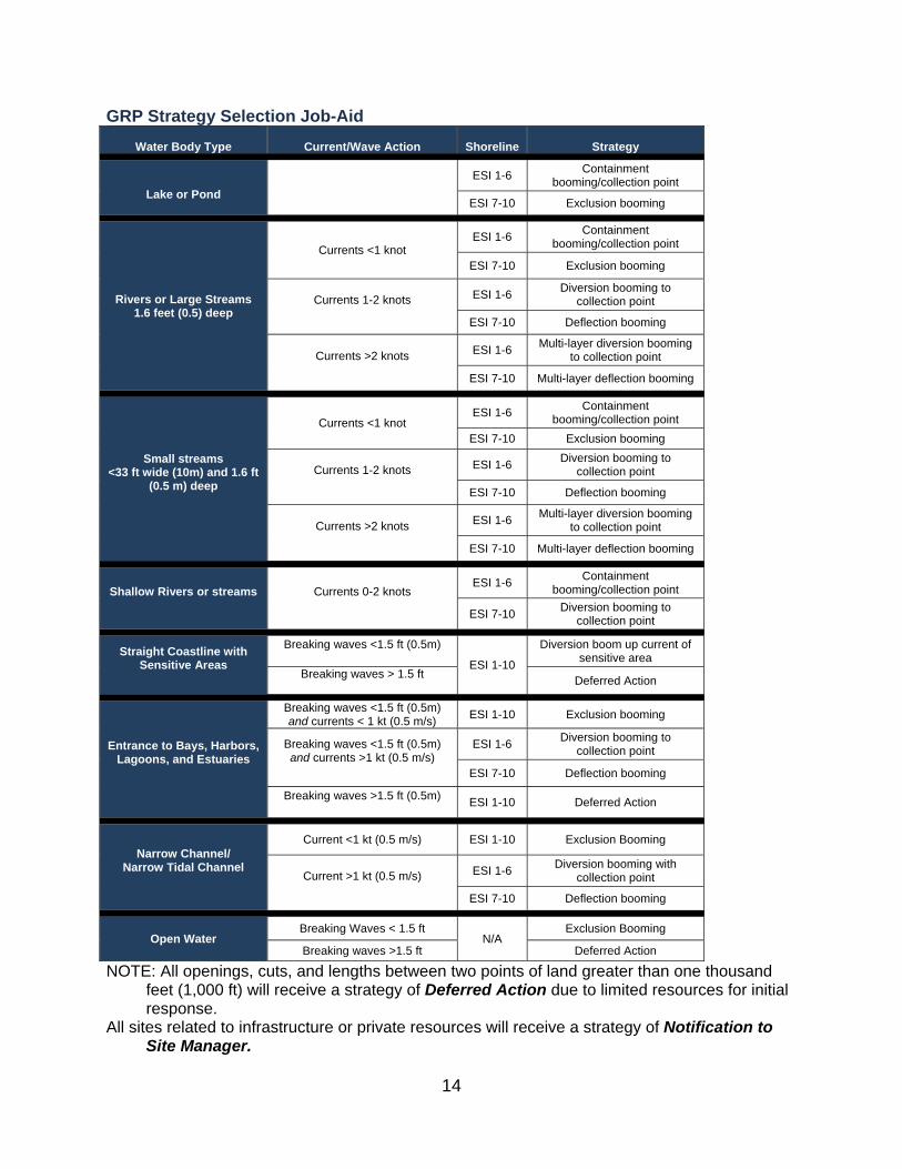
GRP Strategy Selection Job-Aid Water Body Type Current/Wave Action Shoreline Strategy
Lake or Pond ESI 1-6 Containment
booming/collection point
ESI 7-10 Exclusion booming
Rivers or Large Streams 1.6 feet (0.5) deep
Currents <1 knot ESI 1-6 Containment
booming/collection point
ESI 7-10 Exclusion booming
Currents 1-2 knots ESI 1-6 Diversion booming to collection point
ESI 7-10 Deflection booming
Currents >2 knots ESI 1-6 Multi-layer diversion booming to collection point
ESI 7-10 Multi-layer deflection booming
Small streams <33 ft wide (10m) and 1.6 ft
(0.5 m) deep
Currents <1 knot ESI 1-6 Containment
booming/collection point ESI 7-10 Exclusion booming
Currents 1-2 knots ESI 1-6 Diversion booming to collection point
ESI 7-10 Deflection booming
Currents >2 knots ESI 1-6 Multi-layer diversion booming to collection point
ESI 7-10 Multi-layer deflection booming
Shallow Rivers or streams Currents 0-2 knots ESI 1-6 Containment
booming/collection point
ESI 7-10 Diversion booming to collection point
Straight Coastline with Sensitive Areas
Breaking waves <1.5 ft (0.5m)
ESI 1-10
Diversion boom up current of sensitive area
Breaking waves > 1.5 ft Deferred Action
Entrance to Bays, Harbors, Lagoons, and Estuaries
Breaking waves <1.5 ft (0.5m) and currents < 1 kt (0.5 m/s) ESI 1-10 Exclusion booming
Breaking waves <1.5 ft (0.5m) and currents >1 kt (0.5 m/s)
ESI 1-6 Diversion booming to collection point
ESI 7-10 Deflection booming
Breaking waves >1.5 ft (0.5m) ESI 1-10 Deferred Action
Narrow Channel/ Narrow Tidal Channel
Current <1 kt (0.5 m/s) ESI 1-10 Exclusion Booming
Current >1 kt (0.5 m/s) ESI 1-6 Diversion booming with collection point
ESI 7-10 Deflection booming
Open Water Breaking Waves < 1.5 ft
N/A Exclusion Booming
Breaking waves >1.5 ft Deferred Action
NOTE: All openings, cuts, and lengths between two points of land greater than one thousand feet (1,000 ft) will receive a strategy of Deferred Action due to limited resources for initial response.
All sites related to infrastructure or private resources will receive a strategy of Notification to Site Manager.
14
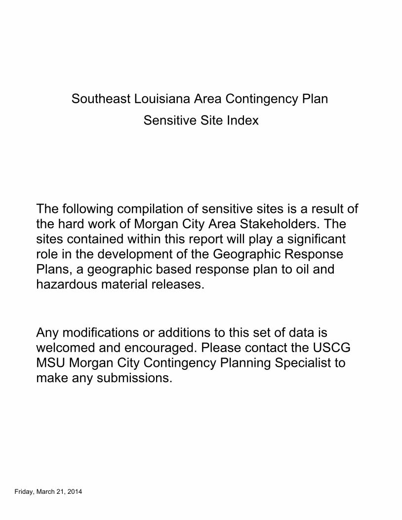
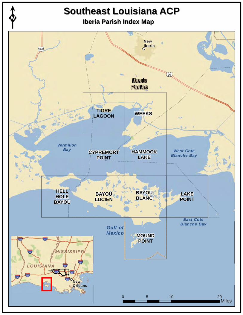
Southeast Louisiana Area Contingency Plan Sensitive Site Index
The following compilation of sensitive sites is a result of the hard work of Morgan City Area Stakeholders. The sites contained within this report will play a significant role in the development of the Geographic Response Plans, a geographic based response plan to oil and hazardous material releases.
Any modifications or additions to this set of data is welcomed and encouraged. Please contact the USCG MSU Morgan City Contingency Planning Specialist to make any submissions.
Friday, March 21, 2014
Gulf ofMexico
West CoteBlanche Bay
East CoteBlanche Bay
VermilionBay
£¤167
£¤90
NewNewIberiaIberia
IberiaParish
MOUNDPOINT
HELLHOLE
BAYOU BAYOULUCIEN
BAYOUBLANC LAKE
POINT
CYPREMORTPOINT
HAMMOCKLAKE
TIGRELAGOON WEEKS
SSoouutthheeaasstt LLoouuiissiiaannaa AACCPPK
0 5 10 Miles
IIbbeerriiaa PPaarriisshh IInnddeexx MMaapp
LOUISIANALOUISIANA
MISSISSIPPIMISSIS SIPPI
§̈¦110
§̈¦310 §̈¦210
§̈¦59
§̈¦220
§̈¦10
§̈¦55
§̈¦12
§̈¦20
§̈¦49
NewNewOrleansOrleans
20

TIGRE LAGOON QUAD 92°0'0"W 91°52'30"W
!
!
!
!
!
!
!
! !
OaksCanal
Avery Canal
B ayouP ortag e
Duga
s Can
al
B ayou Hebert
BayouCas s me r
Three
Bayou
Pipeline Canal
VermilionBay
C6 C5
A3 C4
C3
A2
C1 C2 A1
TIGRE LAGOON CYPREMORT POINT
TIG
RE
LAG
OO
NH
EB
ER
TLA
KE
TIG
RE
LA
GO
ON
WE
EK
S
TIGRE LAGOON
29°5
2'30
"N
29°5
2'30
"N
29°4
5'0"
N
29°4
5'0"
N
VermilionParish
IberiaParish
92°0'0"W 91°52'30"W
Legend ! GRP Sites
Quad Boundaries
Parish Boundaries
0.5 Kilometers
0 1 2 3
Gulf of Mexico
± Miles
0 0.5 1 2 3
MetairieMetairie LafayetteLafayette
New OrleansNew Orleans
§̈¦55
LOUISIANALOUISIANA

Text416:
Southeast Louisiana Area Contingency Plan Sensitive Site Index
Site Information: A1 Location Information Name: Bayou at Intracoastal Waterway Parish: Iberia
Quad Name: Tigre Lagoon
Priority: A Quad Number: 2909109
Site Alias: N/A Mile Marker: 144.5
Managed (Y/N)?: N Site Description: Sensitive Habitat
Latitude: 29° 50' 34.513" N
Longitude: 91° 54' 38.915" W
Response Considerations Site Strategy: Deflection Booming Site Strategy Comments:
Site Waterbody Type: Narrow Tidal Channel
Current Wave Action: Current >1 kt
Waterbody Opening: < 500 ft
Resources At Risk ESI Code: 10A
ESI Description 10A: Salt- and brackish-water marshes
Resources At Risk Comments:
Sensitive Habitat
Contact Information Contact: N/A Special Contact:
Site Statistics Submitted By DEQ-Shane Miller and Steve Lorio
Submit Date: 2013.04.16
State Submitter: DEQ-Shane Miller and Steve Lorio
State Comments: Sensitive Habitat
Friday, March 21, 2014

Text416:
Southeast Louisiana Area Contingency Plan Sensitive Site Index
Site Information: A2 Location Information Name: Mouth of Tigre Lagoon at Intracoastal Waterway Parish: Iberia
Quad Name: Tigre Lagoon
Priority: A Quad Number: 2909109
Site Alias: N/A Mile Marker: 146.1
Managed (Y/N)?: N Site Description: Sensitive Habitat
Latitude: 29° 50' 31.849" N
Longitude: 91° 56' 17.218" W
Response Considerations Site Strategy: Deflection Booming Site Strategy Comments:
Site Waterbody Type: Narrow Tidal Channel
Current Wave Action: Current >1 kt
Waterbody Opening: < 500 ft
Resources At Risk ESI Code: 10D
ESI Description 10D: Scrub-shrub wetlands
Resources At Risk Comments:
Sensitive Habitat
Contact Information Contact: N/A Special Contact:
Site Statistics Submitted By DEQ-Shane Miller and Steve Lorio
Submit Date: 2013.04.16
State Submitter: DEQ-Shane Miller and Steve Lorio
State Comments: Sensitive Habitat
Friday, March 21, 2014

Text416:
Southeast Louisiana Area Contingency Plan Sensitive Site Index
Site Information: A3 Location Information Name: Oaks Canal / Herbert Bayou Parish: Vermilion
Quad Name: Tigre Lagoon
Priority: A Quad Number: 2909109
Site Alias: N/A Mile Marker:
Managed (Y/N)?: N Site Description: Sensitive Habitat
Latitude: 29° 49' 37.968" N
Longitude: 91° 58' 55.616" W
Response Considerations Site Strategy: Deflection Booming Site Strategy Comments:
Site Waterbody Type: Narrow Tidal Channel
Current Wave Action: Current >1 kt
Waterbody Opening: < 500 ft
Resources At Risk ESI Code: 10A
ESI Description 10A: Salt- and brackish-water marshes
Resources At Risk Comments:
Inlet To Marsh From Bay
Contact Information Contact: N/A Special Contact:
Site Statistics Submitted By LDWF-DJ Garland and Cassidy Lejeune
Submit Date: 2013.04.16
State Submitter: LDWF/Lafourche Parish/LDEQ
State Comments:
Friday, March 21, 2014

Text416:
Southeast Louisiana Area Contingency Plan Sensitive Site Index
Site Information: C1 Location Information Name: Entrance to Bayou Petite Anse Parish: Iberia
Quad Name: Tigre Lagoon
Priority: C Quad Number: 2909109
Site Alias: State Recreation Area (Submitted by State) Mile Marker:
Managed (Y/N)?: N Site Description: Marshland and fisheries
Latitude: 29° 50' 46.937" N
Longitude: 91° 55' 56.180" W
Response Considerations Site Strategy: Deflection Booming Site Strategy Comments:
Site Waterbody Type: Narrow Tidal Channel
Current Wave Action: Current >1 kt
Waterbody Opening: 500-1000 ft
Resources At Risk ESI Code: 10A
ESI Description 10A: Salt- and brackish-water marshes
Resources At Risk Comments:
Marshland and fisheries
Contact Information Contact: N/A Special Contact:
Site Statistics Submitted By Prescott Marshall
Submit Date: 2012.09.12
State Submitter: DEQ/St. Mary Parish/DNR/CPRA
State Comments: Point is in question by State
Friday, March 21, 2014
Text416:
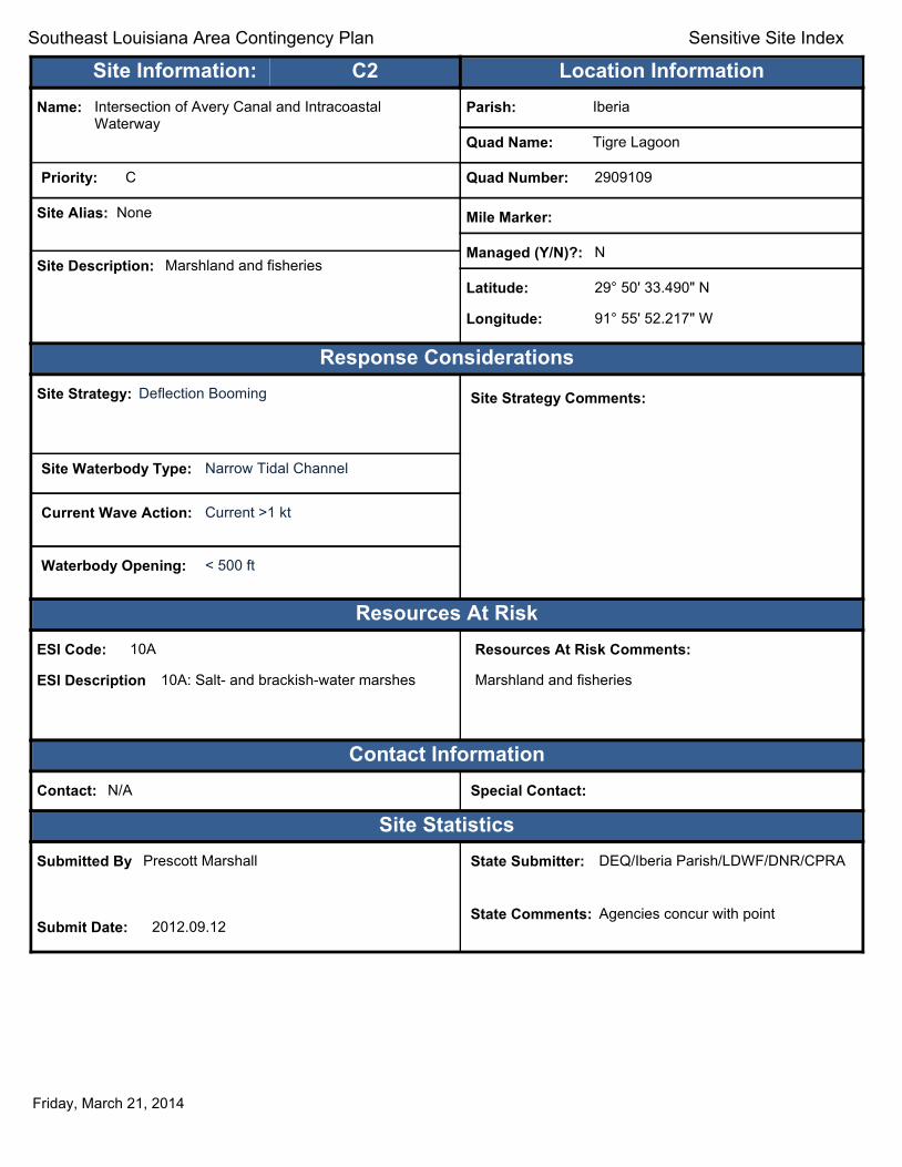
Southeast Louisiana Area Contingency Plan Sensitive Site Index
Site Information: C2 Location Information Name: Intersection of Avery Canal and Intracoastal
Waterway Parish: Iberia
Quad Name: Tigre Lagoon
Priority: C Quad Number: 2909109
Site Alias: None Mile Marker:
Managed (Y/N)?: N Site Description: Marshland and fisheries
Latitude: 29° 50' 33.490" N
Longitude: 91° 55' 52.217" W
Response Considerations Site Strategy: Deflection Booming Site Strategy Comments:
Site Waterbody Type: Narrow Tidal Channel
Current Wave Action: Current >1 kt
Waterbody Opening: < 500 ft
Resources At Risk ESI Code: 10A
ESI Description 10A: Salt- and brackish-water marshes
Resources At Risk Comments:
Marshland and fisheries
Contact Information Contact: N/A Special Contact:
Site Statistics Submitted By Prescott Marshall
Submit Date: 2012.09.12
State Submitter: DEQ/Iberia Parish/LDWF/DNR/CPRA
State Comments: Agencies concur with point
Friday, March 21, 2014
Text416:
Southeast Louisiana Area Contingency Plan Sensitive Site Index
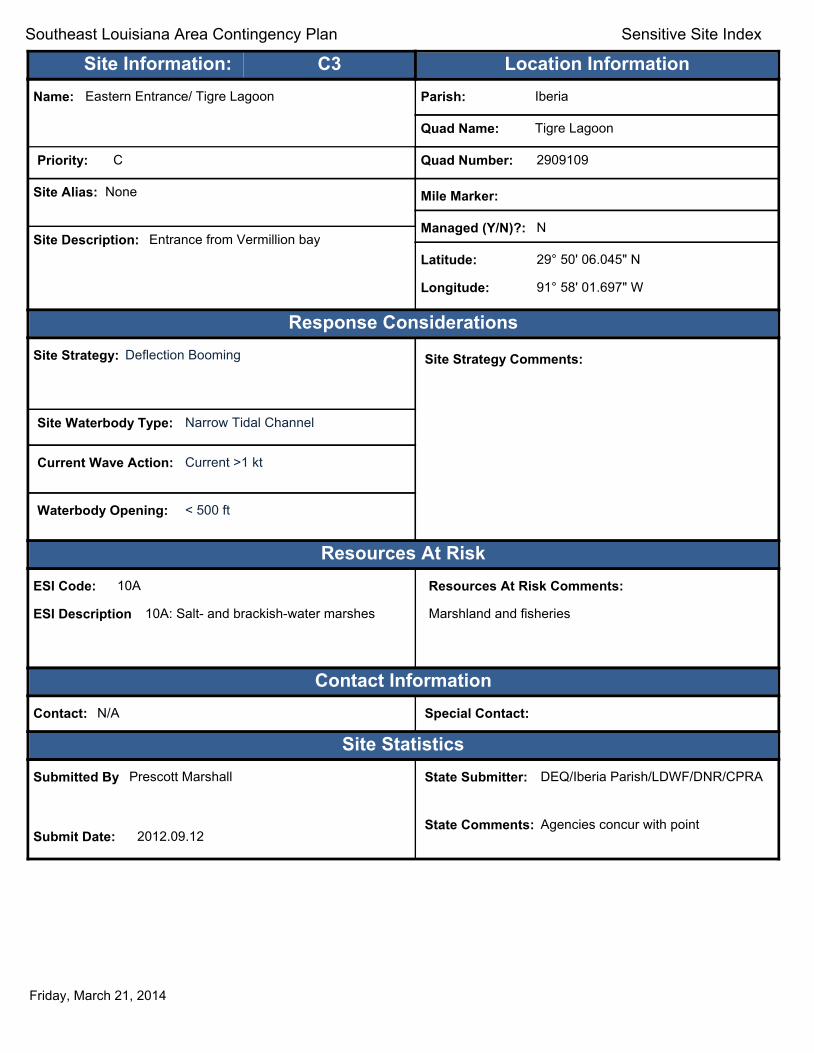
Site Information: C3 Location Information Name: Eastern Entrance/ Tigre Lagoon Parish: Iberia
Quad Name: Tigre Lagoon
Priority: C Quad Number: 2909109
Site Alias: None Mile Marker:
Managed (Y/N)?: N Site Description: Entrance from Vermillion bay
Latitude: 29° 50' 06.045" N
Longitude: 91° 58' 01.697" W
Response Considerations Site Strategy: Deflection Booming Site Strategy Comments:
Site Waterbody Type: Narrow Tidal Channel
Current Wave Action: Current >1 kt
Waterbody Opening: < 500 ft
Resources At Risk ESI Code: 10A
ESI Description 10A: Salt- and brackish-water marshes
Resources At Risk Comments:
Marshland and fisheries
Contact Information Contact: N/A Special Contact:
Site Statistics Submitted By Prescott Marshall
Submit Date: 2012.09.12
State Submitter: DEQ/Iberia Parish/LDWF/DNR/CPRA
State Comments: Agencies concur with point
Friday, March 21, 2014

Text416:
Southeast Louisiana Area Contingency Plan Sensitive Site Index
Site Information: C4 Location Information Name: Western Entrance/Tigre Lagoon Parish: Iberia
Quad Name: Tigre Lagoon
Priority: C Quad Number: 2909109
Site Alias: None Mile Marker:
Managed (Y/N)?: N Site Description: Entrance from Vermillion bay
Latitude: 29° 49' 50.619" N
Longitude: 91° 54' 25.385" W
Response Considerations Site Strategy: Diversion Booming to Collection Point Site Strategy Comments:
Site Waterbody Type: Narrow Tidal Channel
Current Wave Action: Current >1 kt
Waterbody Opening: < 500 ft
Resources At Risk ESI Code: 10A
ESI Description 10A: Salt- and brackish-water marshes
Resources At Risk Comments:
Marshland and fisheries
Contact Information Contact: N/A Special Contact:
Site Statistics Submitted By Prescott Marshall
Submit Date: 2012.09.12
State Submitter: DEQ/Iberia Parish/LDWF/DNR/CPRA
State Comments: Agencies concur with point
Friday, March 21, 2014

Text416:
Southeast Louisiana Area Contingency Plan Sensitive Site Index
Site Information: C5 Location Information Name: Southwestern Entrance/Tigre Lagoon Parish: Iberia
Quad Name: Tigre Lagoon
Priority: C Quad Number: 2909109
Site Alias: None Mile Marker:
Managed (Y/N)?: N Site Description: Entrance from Vermillion bay
Latitude: 29° 49' 20.133" N
Longitude: 91° 55' 35.672" W
Response Considerations Site Strategy: Exclusion Booming Site Strategy Comments:
Site Waterbody Type: Narrow Tidal Channel
Current Wave Action: Currents <1 kt
Waterbody Opening: < 500 ft
Resources At Risk ESI Code: 10A
ESI Description 10A: Salt- and brackish-water marshes
Resources At Risk Comments:
Marshland and fisheries
Contact Information Contact: N/A Special Contact:
Site Statistics Submitted By Prescott Marshall
Submit Date: 2012.09.12
State Submitter: DEQ/Iberia Parish/LDWF/DNR/CPRA
State Comments: Agencies concur with point
Friday, March 21, 2014

Text416:
Southeast Louisiana Area Contingency Plan Sensitive Site Index
Site Information: C6 Location Information Name: Southeastern Entrance/Tigre Lagoon Parish: Iberia
Quad Name: Tigre Lagoon
Priority: C Quad Number: 2909109
Site Alias: None Mile Marker:
Managed (Y/N)?: N Site Description: Entrance from Vermillion bay
Latitude: 29° 49' 14.331" N
Longitude: 91° 55' 56.997" W
Response Considerations Site Strategy: Deflection Booming Site Strategy Comments:
Site Waterbody Type: Narrow Tidal Channel
Current Wave Action: Current >1 kt
Waterbody Opening: < 500 ft
Resources At Risk ESI Code: 10A
ESI Description 10A: Salt- and brackish-water marshes
Resources At Risk Comments:
Marshland and fisheries
Contact Information Contact: N/A Special Contact:
Site Statistics Submitted By Prescott Marshall
Submit Date: 2012.09.12
State Submitter: DEQ/Iberia Parish/LDWF/DNR/CPRA
State Comments: Agencies concur with point
Friday, March 21, 2014
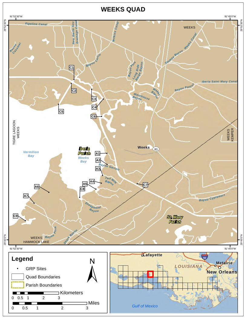
WEEKS QUAD 91°52'30"W 91°45'0"W
!
!
!
!
!
! !
!
!
!
!
!
!
!
!
!
Wilk
ins C
anal
Weeks
Canal
Pipeline Canal
Shark
Bayou
Bayou Cypremort
Bayou Garrett
Bayou
Cassm
er
WarehouseBayou
TwoMileB ayou
New
Iber
ia So
u Dr
aina
ge C
anal
WeeksBayou
Long
Ride
Ba
rge
Bayo
u
Sheeph eadBa y ou
Stumpy Bayou
Ba you Pirr
e
Bay o
uPet e
Iberia Saint Mary Canal
Bayou Carlin
Bayou Pat out
VermilionBay Weeks
Bay
ST83WeeksWeeks
C9
A7
A6 C8A5 A4
C7
A3
A2 A1
C6C5
C4
C2
C3
C1
TIG
RE
LAG
OO
NW
EE
KS
WEEKS HAMMOCK LAKE
WE
EK
SK
EM
PE
R
WEEKS
29°5
2'30
"N
29°5
2'30
"N
29°4
5'0"
N
29°4
5'0"
N
IberiaParish
St. MaryParish
91°52'30"W 91°45'0"W
Legend ! GRP Sites
Quad Boundaries
Parish Boundaries
0.5 Kilometers
0 1 2 3
± Miles
0 0.5 1 2 3
MetairieMetairie LafayetteLafayette
New OrleansNew Orleans
§̈¦55
LOUISIANALOUISIANA
Gulf of Mexico

Text416:
Southeast Louisiana Area Contingency Plan Sensitive Site Index
Site Information: A1 Location Information Name: Canal at Weeks Bay Parish: Iberia
Quad Name: Weeks
Priority: A Quad Number: 2909110
Site Alias: N/A Mile Marker:
Managed (Y/N)?: N Site Description: Sensitive Habitat
Latitude: 29° 48' 01.622" N
Longitude: 91° 49' 19.018" W
Response Considerations Site Strategy: Deflection Booming Site Strategy Comments:
Site Waterbody Type: Narrow Tidal Channel
Current Wave Action: Current >1 kt
Waterbody Opening: < 500 ft
Resources At Risk ESI Code: 10D
ESI Description 10D: Scrub-shrub wetlands
Resources At Risk Comments:
Sensitive Habitat
Contact Information Contact: N/A Special Contact:
Site Statistics Submitted By DEQ-Shane Miller and Steve Lorio
Submit Date: 2013.04.16
State Submitter: DEQ-Shane Miller and Steve Lorio
State Comments: Sensitive Habitat
Friday, March 21, 2014

Text416:
Southeast Louisiana Area Contingency Plan Sensitive Site Index
Site Information: A2 Location Information Name: Bayou Garrett at Weeks Bay Parish: Iberia
Quad Name: Weeks
Priority: A Quad Number: 2909110
Site Alias: N/A Mile Marker:
Managed (Y/N)?: N Site Description: Sensitive Habitat
Latitude: 29° 47' 37.960" N
Longitude: 91° 49' 18.767" W
Response Considerations Site Strategy: Deflection Booming Site Strategy Comments:
Site Waterbody Type: Narrow Tidal Channel
Current Wave Action: Current >1 kt
Waterbody Opening: < 500 ft
Resources At Risk ESI Code: 10A
ESI Description 10A: Salt- and brackish-water marshes
Resources At Risk Comments:
Sensitive Habitat
Contact Information Contact: N/A Special Contact:
Site Statistics Submitted By DEQ-Shane Miller and Steve Lorio
Submit Date: 2013.04.16
State Submitter: DEQ-Shane Miller and Steve Lorio
State Comments: Sensitive Habitat
Friday, March 21, 2014

Text416:
Southeast Louisiana Area Contingency Plan Sensitive Site Index
Site Information: A3 Location Information Name: Two Mouth Bayou at Weeks Bay Parish: Iberia
Quad Name: Weeks
Priority: A Quad Number: 2909110
Site Alias: N/A Mile Marker:
Managed (Y/N)?: N Site Description: Sensitive Habitat
Latitude: 29° 47' 15.026" N
Longitude: 91° 49' 28.062" W
Response Considerations Site Strategy: Exclusion Booming Site Strategy Comments:
Site Waterbody Type: Narrow Tidal Channel
Current Wave Action: Currents <1 kt
Waterbody Opening: < 500 ft
Resources At Risk ESI Code: 10A
ESI Description 10A: Salt- and brackish-water marshes
Resources At Risk Comments:
Sensitive Habitat
Contact Information Contact: N/A Special Contact:
Site Statistics Submitted By DEQ-Shane Miller and Steve Lorio
Submit Date: 2013.04.16
State Submitter: DEQ-Shane Miller and Steve Lorio
State Comments: Sensitive Habitat
Friday, March 21, 2014

Text416:
Southeast Louisiana Area Contingency Plan Sensitive Site Index
Site Information: A4 Location Information Name: Multiple Bayous (north) at Weeks Bay Parish: Iberia
Quad Name: Weeks
Priority: A Quad Number: 2909110
Site Alias: N/A Mile Marker:
Managed (Y/N)?: N Site Description: Sensitive Habitat
Latitude: 29° 46' 58.806" N
Longitude: 91° 49' 30.926" W
Response Considerations Site Strategy: Exclusion Booming Site Strategy Comments:
Site Waterbody Type: Narrow Tidal Channel
Current Wave Action: Currents <1 kt
Waterbody Opening: < 500 ft
Resources At Risk ESI Code: 10A
ESI Description 10A: Salt- and brackish-water marshes
Resources At Risk Comments:
Sensitive Habitat
Contact Information Contact: N/A Special Contact:
Site Statistics Submitted By DEQ-Shane Miller and Steve Lorio
Submit Date: 2013.04.16
State Submitter: DEQ-Shane Miller and Steve Lorio
State Comments: Sensitive Habitat
Friday, March 21, 2014
Text416:
Southeast Louisiana Area Contingency Plan Sensitive Site Index
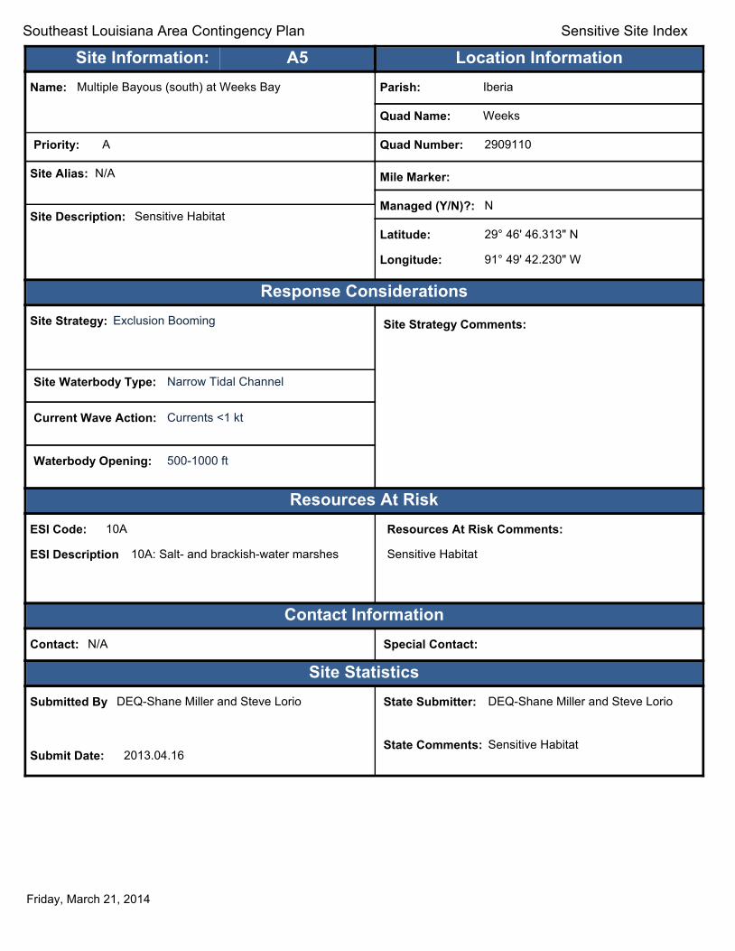
Site Information: A5 Location Information Name: Multiple Bayous (south) at Weeks Bay Parish: Iberia
Quad Name: Weeks
Priority: A Quad Number: 2909110
Site Alias: N/A Mile Marker:
Managed (Y/N)?: N Site Description: Sensitive Habitat
Latitude: 29° 46' 46.313" N
Longitude: 91° 49' 42.230" W
Response Considerations Site Strategy: Exclusion Booming Site Strategy Comments:
Site Waterbody Type: Narrow Tidal Channel
Current Wave Action: Currents <1 kt
Waterbody Opening: 500-1000 ft
Resources At Risk ESI Code: 10A
ESI Description 10A: Salt- and brackish-water marshes
Resources At Risk Comments:
Sensitive Habitat
Contact Information Contact: N/A Special Contact:
Site Statistics Submitted By DEQ-Shane Miller and Steve Lorio
Submit Date: 2013.04.16
State Submitter: DEQ-Shane Miller and Steve Lorio
State Comments: Sensitive Habitat
Friday, March 21, 2014

Text416:
Southeast Louisiana Area Contingency Plan Sensitive Site Index
Site Information: A6 Location Information Name: Canal (north) Parish: Iberia
Quad Name: Weeks
Priority: A Quad Number: 2909110
Site Alias: N/A Mile Marker:
Managed (Y/N)?: N Site Description: Sensitive Habitat
Latitude: 29° 46' 39.606" N
Longitude: 91° 51' 21.062" W
Response Considerations Site Strategy: Exclusion Booming Site Strategy Comments:
Site Waterbody Type: Narrow Tidal Channel
Current Wave Action: Currents <1 kt
Waterbody Opening: < 500 ft
Resources At Risk ESI Code: 10A
ESI Description 10A: Salt- and brackish-water marshes
Resources At Risk Comments:
Sensitive Habitat
Contact Information Contact: N/A Special Contact:
Site Statistics Submitted By DEQ-Shane Miller and Steve Lorio
Submit Date: 2013.04.16
State Submitter: DEQ-Shane Miller and Steve Lorio
State Comments: Sensitive Habitat
Friday, March 21, 2014

Text416:
Southeast Louisiana Area Contingency Plan Sensitive Site Index
Site Information: A7 Location Information Name: Canal (south) Parish: Iberia
Quad Name: Weeks
Priority: A Quad Number: 2909110
Site Alias: N/A Mile Marker:
Managed (Y/N)?: N Site Description: Sensitive Habitat
Latitude: 29° 46' 16.820" N
Longitude: 91° 51' 52.072" W
Response Considerations Site Strategy: Exclusion Booming Site Strategy Comments:
Site Waterbody Type: Narrow Tidal Channel
Current Wave Action: Currents <1 kt
Waterbody Opening: < 500 ft
Resources At Risk ESI Code: 10A
ESI Description 10A: Salt- and brackish-water marshes
Resources At Risk Comments:
Sensitive Habitat
Contact Information Contact: N/A Special Contact:
Site Statistics Submitted By DEQ-Shane Miller and Steve Lorio
Submit Date: 2013.04.16
State Submitter: DEQ-Shane Miller and Steve Lorio
State Comments: Sensitive Habitat
Friday, March 21, 2014
Text416:
Southeast Louisiana Area Contingency Plan Sensitive Site Index
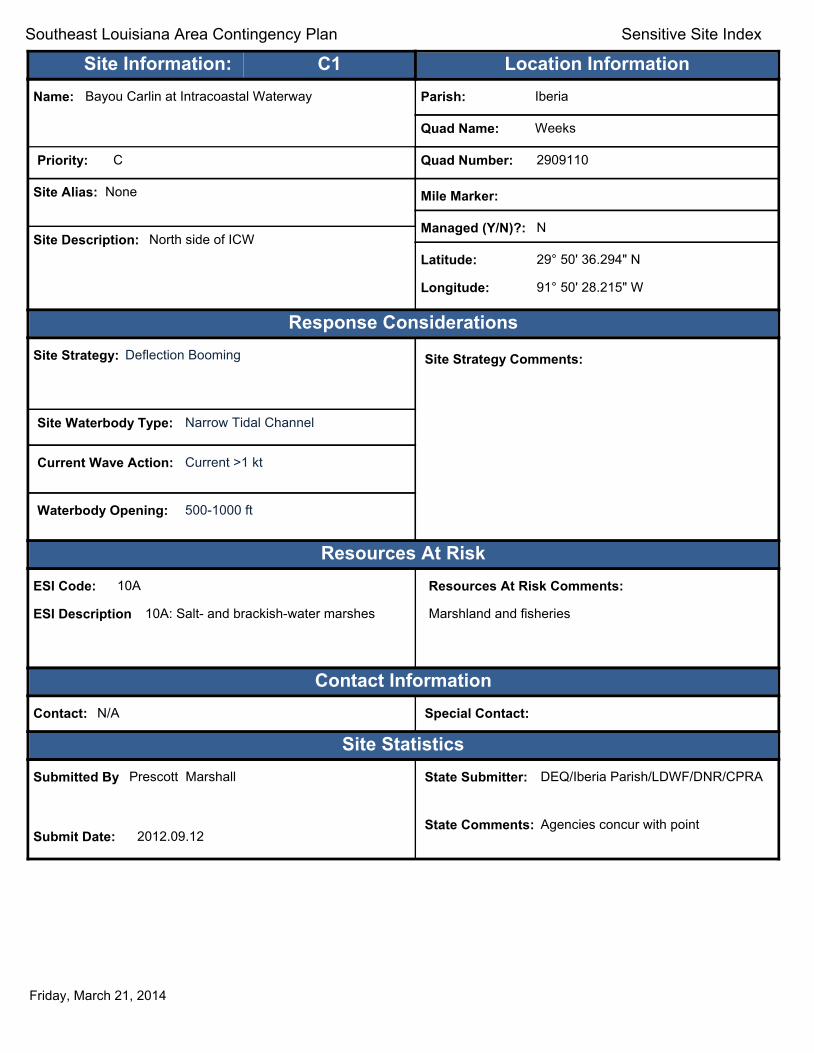
Site Information: C1 Location Information Name: Bayou Carlin at Intracoastal Waterway Parish: Iberia
Quad Name: Weeks
Priority: C Quad Number: 2909110
Site Alias: None Mile Marker:
Managed (Y/N)?: N Site Description: North side of ICW
Latitude: 29° 50' 36.294" N
Longitude: 91° 50' 28.215" W
Response Considerations Site Strategy: Deflection Booming Site Strategy Comments:
Site Waterbody Type: Narrow Tidal Channel
Current Wave Action: Current >1 kt
Waterbody Opening: 500-1000 ft
Resources At Risk ESI Code: 10A
ESI Description 10A: Salt- and brackish-water marshes
Resources At Risk Comments:
Marshland and fisheries
Contact Information Contact: N/A Special Contact:
Site Statistics Submitted By Prescott Marshall
Submit Date: 2012.09.12
State Submitter: DEQ/Iberia Parish/LDWF/DNR/CPRA
State Comments: Agencies concur with point
Friday, March 21, 2014

Text416:
Southeast Louisiana Area Contingency Plan Sensitive Site Index
Site Information: C2 Location Information Name: Weeks Island Channel at Intracoastal Waterway Parish: Iberia
Quad Name: Weeks
Priority: C Quad Number: 2909110
Site Alias: None Mile Marker:
Managed (Y/N)?: N Site Description: Marshland and fisheries
Latitude: 29° 50' 28.123" N
Longitude: 91° 50' 33.906" W
Response Considerations Site Strategy: Deflection Booming Site Strategy Comments:
Site Waterbody Type: Narrow Tidal Channel
Current Wave Action: Current >1 kt
Waterbody Opening: < 500 ft
Resources At Risk ESI Code: 10A
ESI Description 10A: Salt- and brackish-water marshes
Resources At Risk Comments:
Marshland and fisheries
Contact Information Contact: N/A Special Contact:
Site Statistics Submitted By Prescott Marshall
Submit Date: 2012.09.12
State Submitter: DEQ/Iberia Parish/LDWF/DNR/CPRA
State Comments: Agencies concur with point
Friday, March 21, 2014

Text416:
Southeast Louisiana Area Contingency Plan Sensitive Site Index
Site Information: C3 Location Information Name: Bayou at Intracoastal Waterway (north) Parish: Iberia
Quad Name: Weeks
Priority: C Quad Number: 2909110
Site Alias: None Mile Marker:
Managed (Y/N)?: N Site Description: Within the vicinity of Weeks Island
Latitude: 29° 50' 16.121" N
Longitude: 91° 49' 51.200" W
Response Considerations Site Strategy: Deflection Booming Site Strategy Comments:
Site Waterbody Type: Narrow Tidal Channel
Current Wave Action: Current >1 kt
Waterbody Opening: < 500 ft
Resources At Risk ESI Code: 10A
ESI Description 10A: Salt- and brackish-water marshes
Resources At Risk Comments:
Marshland and fisheries
Contact Information Contact: N/A Special Contact:
Site Statistics Submitted By Prescott Marshall
Submit Date: 2012.09.12
State Submitter: DEQ/Iberia Parish/LDWF/DNR/CPRA
State Comments: Agencies concur with point
Friday, March 21, 2014

Text416:
Southeast Louisiana Area Contingency Plan Sensitive Site Index
Site Information: C4 Location Information Name: Bayou at Intracoastal Waterway (central) Parish: Iberia
Quad Name: Weeks
Priority: C Quad Number: 2909110
Site Alias: None Mile Marker:
Managed (Y/N)?: N Site Description: Within the vicinity of Weeks Island
Latitude: 29° 49' 55.370" N
Longitude: 91° 49' 26.618" W
Response Considerations Site Strategy: Deflection Booming Site Strategy Comments:
Site Waterbody Type: Narrow Tidal Channel
Current Wave Action: Current >1 kt
Waterbody Opening: < 500 ft
Resources At Risk ESI Code: 10A
ESI Description 10A: Salt- and brackish-water marshes
Resources At Risk Comments:
Marshland and fisheries
Contact Information Contact: N/A Special Contact:
Site Statistics Submitted By Prescott Marshall
Submit Date: 2012.09.12
State Submitter: DEQ/Iberia Parish/LDWF/DNR/CPRA
State Comments: Agencies concur with point
Friday, March 21, 2014

Text416:
Southeast Louisiana Area Contingency Plan Sensitive Site Index
Site Information: C5 Location Information Name: Weeks Bay Channel Parish: Iberia
Quad Name: Weeks
Priority: C Quad Number: 2909110
Site Alias: None Mile Marker:
Managed (Y/N)?: N Site Description: Tidal inlet from the North side of Weeks
Bay Latitude: 29° 49' 44.438" N
Longitude: 91° 51' 01.003" W
Response Considerations Site Strategy: Deflection Booming Site Strategy Comments:
Site Waterbody Type: Narrow Tidal Channel
Current Wave Action: Current >1 kt
Waterbody Opening: < 500 ft
Resources At Risk ESI Code: 10A
ESI Description 10A: Salt- and brackish-water marshes
Resources At Risk Comments:
Marshland and fisheries
Contact Information Contact: N/A Special Contact:
Site Statistics Submitted By Prescott Marshall
Submit Date: 2012.09.12
State Submitter: DEQ/Iberia Parish/LDWF/DNR/CPRA
State Comments: Agencies concur with point
Friday, March 21, 2014

Text416:
Southeast Louisiana Area Contingency Plan Sensitive Site Index
Site Information: C6 Location Information Name: Bayou at Intracoastal Waterway (south) Parish: Iberia
Quad Name: Weeks
Priority: C Quad Number: 2909110
Site Alias: None Mile Marker:
Managed (Y/N)?: N Site Description: Southeast of Weeks Island
Latitude: 29° 49' 18.806" N
Longitude: 91° 49' 30.210" W
Response Considerations Site Strategy: Deflection Booming Site Strategy Comments:
Site Waterbody Type: Narrow Tidal Channel
Current Wave Action: Current >1 kt
Waterbody Opening: 500-1000 ft
Resources At Risk ESI Code: 10A
ESI Description 10A: Salt- and brackish-water marshes
Resources At Risk Comments:
Marshland and fisheries
Contact Information Contact: N/A Special Contact:
Site Statistics Submitted By Prescott Marshall
Submit Date: 2012.09.12
State Submitter: DEQ/Iberia Parish/LDWF/DNR/CPRA
State Comments: Agencies concur with point
Friday, March 21, 2014

Text416:
Southeast Louisiana Area Contingency Plan Sensitive Site Index
Site Information: C7 Location Information Name: Entrance to old oil drilling channel from Intracoastal
Waterway Parish: Iberia
Quad Name: Weeks
Priority: C Quad Number: 2909110
Site Alias: None Mile Marker:
Managed (Y/N)?: N Site Description: Marshland and fisheries
Latitude: 29° 46' 57.669" N
Longitude: 91° 48' 15.344" W
Response Considerations Site Strategy: Deflection Booming Site Strategy Comments:
Site Waterbody Type: Narrow Tidal Channel
Current Wave Action: Current >1 kt
Waterbody Opening: < 500 ft
Resources At Risk ESI Code: 10A
ESI Description 10A: Salt- and brackish-water marshes
Resources At Risk Comments:
Marshland and fisheries
Contact Information Contact: N/A Special Contact:
Site Statistics Submitted By Prescott Marshall
Submit Date: 2012.09.12
State Submitter: DEQ/Iberia Parish/LDWF/DNR/CPRA
State Comments: Agencies concur with point
Friday, March 21, 2014

Text416:
Southeast Louisiana Area Contingency Plan Sensitive Site Index
Site Information: C8 Location Information Name: Northern Entrance of Shark Bayou Parish: Iberia
Quad Name: Weeks
Priority: C Quad Number: 2909110
Site Alias: None Mile Marker:
Managed (Y/N)?: N Site Description: From Weeks Bay
Latitude: 29° 46' 29.108" N
Longitude: 91° 50' 16.253" W
Response Considerations Site Strategy: Deflection Booming Site Strategy Comments:
Site Waterbody Type: Narrow Tidal Channel
Current Wave Action: Current >1 kt
Waterbody Opening: 500-1000 ft
Resources At Risk ESI Code: 10A
ESI Description 10A: Salt- and brackish-water marshes
Resources At Risk Comments:
Marshland and fisheries
Contact Information Contact: N/A Special Contact:
Site Statistics Submitted By Prescott Marshall
Submit Date: 2012.09.12
State Submitter: DEQ/Iberia Parish/LDWF/DNR/CPRA
State Comments: Agencies concur with point
Friday, March 21, 2014

Text416:
Southeast Louisiana Area Contingency Plan Sensitive Site Index
Site Information: C9 Location Information Name: Western Side of Shark Island Parish: Iberia
Quad Name: Weeks
Priority: C Quad Number: 2909110
Site Alias: None Mile Marker:
Managed (Y/N)?: N Site Description: From Vermillion Bay
Latitude: 29° 45' 40.085" N
Longitude: 91° 52' 10.366" W
Response Considerations Site Strategy: Exclusion Booming Site Strategy Comments:
Site Waterbody Type: Narrow Tidal Channel
Current Wave Action: Currents <1 kt
Waterbody Opening: < 500 ft
Resources At Risk ESI Code: 10A
ESI Description 10A: Salt- and brackish-water marshes
Resources At Risk Comments:
Marshland and fisheries
Contact Information Contact: N/A Special Contact:
Site Statistics Submitted By Prescott Marshall
Submit Date: 2012.09.12
State Submitter: DEQ/Iberia Parish/LDWF/DNR/CPRA
State Comments: Agencies concur with point
Friday, March 21, 2014
u
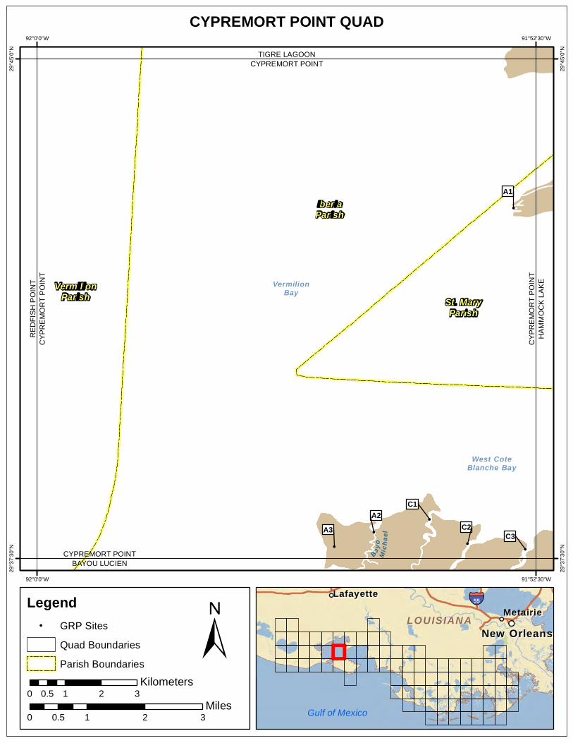
CYPREMORT POINT QUAD 92°0'0"W 91°52'30"W
! !
!
!
!
!
Bayo
Mich
a el
West CoteBlanche Bay
VermilionBay
IberiaParish
St. MaryParish
A3 C2 C3
A2 C1
A1
CYPREMORT POINT BAYOU LUCIEN
CY
PR
EM
OR
T P
OIN
TR
ED
FIS
HP
OIN
T
CY
PR
EM
OR
T P
OIN
TH
AM
MO
CK
LA
KE
CYPREMORT POINT TIGRE LAGOON
29°4
5'0"
N
29°4
5'0"
N
29°3
7'30
"N
29°3
7'30
"N
VermilionParish
92°0'0"W 91°52'30"W
Legend ! GRP Sites
Quad Boundaries
Parish Boundaries
0.5 Kilometers
0 1 2 3
Gulf of Mexico
± Miles
0 0.5 1 2 3
MetairieMetairie LafayetteLafayette
New OrleansNew Orleans
§̈¦55
LOUISIANALOUISIANA
Text416:
Southeast Louisiana Area Contingency Plan Sensitive Site Index
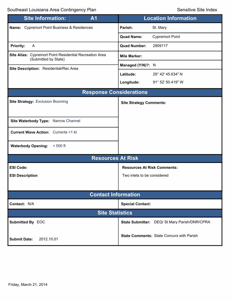
Site Information: A1 Location Information Name: Cypremort Point Business & Residences Parish: St. Mary
Quad Name: Cypremort Point
Priority: A Quad Number: 2909117
Site Alias: Cypremort Point Residential Recreation Area (Submitted by State)
Mile Marker:
Managed (Y/N)?: N Site Description: Residential/Rec Area
Latitude: 29° 42' 45.634" N
Longitude: 91° 52' 50.419" W
Response Considerations Site Strategy: Exclusion Booming Site Strategy Comments:
Site Waterbody Type: Narrow Channel
Current Wave Action: Currents <1 kt
Waterbody Opening: < 500 ft
Resources At Risk ESI Code:
ESI Description
Resources At Risk Comments:
Two inlets to be considered
Contact Information Contact: N/A Special Contact:
Site Statistics Submitted By EOC
Submit Date: 2012.10.01
State Submitter: DEQ/ St Mary Parish/DNR/CPRA
State Comments: State Concurs with Parish
Friday, March 21, 2014

Text416:
Southeast Louisiana Area Contingency Plan Sensitive Site Index
Site Information: A2 Location Information Name: Bayou Michel Parish: Iberia
Quad Name: Cypremort Point
Priority: A Quad Number: 2909117
Site Alias: N/A Mile Marker:
Managed (Y/N)?: Y - Wildlife Refuge Site Description: State Refuge part of Marsh Island Refuge
Latitude: 29° 37' 53.688" N
Longitude: 91° 54' 56.372" W
Response Considerations Site Strategy: Deflection Booming Site Strategy Comments:
Site Waterbody Type: Narrow Tidal Channel
Current Wave Action: Current >1 kt
Waterbody Opening: < 500 ft
Resources At Risk ESI Code: 10A
ESI Description 10A: Salt- and brackish-water marshes
Resources At Risk Comments:
Sensitive habitat
Contact Information Contact: LDWF Special Contact:
Site Statistics Submitted By LDWF-DJ Garland and Cassidy Lejeune
Submit Date: 2013.04.16
State Submitter: LDWF/Lafourche Parish/LDEQ
State Comments:
Friday, March 21, 2014

Text416:
Southeast Louisiana Area Contingency Plan Sensitive Site Index
Site Information: A3 Location Information Name: Multiple Bayous Parish: Iberia
Quad Name: Cypremort Point
Priority: A Quad Number: 2909117
Site Alias: N/A Mile Marker:
Managed (Y/N)?: Y - Wildlife Refuge Site Description: State Refuge part of Marsh Island Refuge
Latitude: 29° 37' 40.759" N
Longitude: 91° 55' 32.247" W
Response Considerations Site Strategy: Exclusion Booming Site Strategy Comments:
Site Waterbody Type: Narrow Tidal Channel
Current Wave Action: Currents <1 kt
Waterbody Opening: 500-1000 ft
Resources At Risk ESI Code: 10A
ESI Description 10A: Salt- and brackish-water marshes
Resources At Risk Comments:
Sensitive habitat
Contact Information Contact: LDWF Special Contact:
Site Statistics Submitted By DEQ-Shane Miller and Steve Lorio
Submit Date: 2013.04.16
State Submitter: DEQ-Shane Miller and Steve Lorio
State Comments: Sensitive Habitat
Friday, March 21, 2014
Text416:
Southeast Louisiana Area Contingency Plan Sensitive Site Index
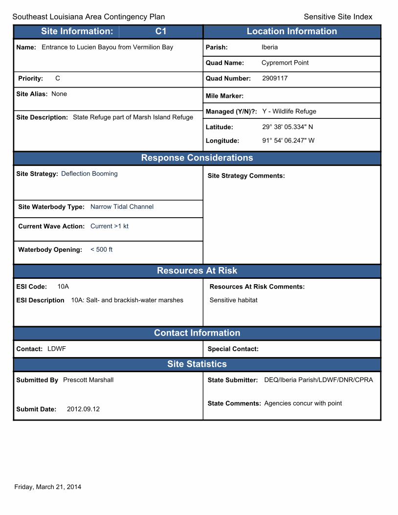
Site Information: C1 Location Information Name: Entrance to Lucien Bayou from Vermilion Bay Parish: Iberia
Quad Name: Cypremort Point
Priority: C Quad Number: 2909117
Site Alias: None Mile Marker:
Managed (Y/N)?: Y - Wildlife Refuge Site Description: State Refuge part of Marsh Island Refuge
Latitude: 29° 38' 05.334" N
Longitude: 91° 54' 06.247" W
Response Considerations Site Strategy: Deflection Booming Site Strategy Comments:
Site Waterbody Type: Narrow Tidal Channel
Current Wave Action: Current >1 kt
Waterbody Opening: < 500 ft
Resources At Risk ESI Code: 10A
ESI Description 10A: Salt- and brackish-water marshes
Resources At Risk Comments:
Sensitive habitat
Contact Information Contact: LDWF Special Contact:
Site Statistics Submitted By Prescott Marshall
Submit Date: 2012.09.12
State Submitter: DEQ/Iberia Parish/LDWF/DNR/CPRA
State Comments: Agencies concur with point
Friday, March 21, 2014
Text416:
Southeast Louisiana Area Contingency Plan Sensitive Site Index
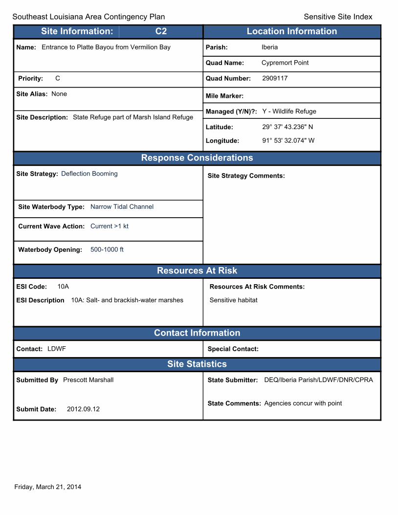
Site Information: C2 Location Information Name: Entrance to Platte Bayou from Vermilion Bay Parish: Iberia
Quad Name: Cypremort Point
Priority: C Quad Number: 2909117
Site Alias: None Mile Marker:
Managed (Y/N)?: Y - Wildlife Refuge Site Description: State Refuge part of Marsh Island Refuge
Latitude: 29° 37' 43.236" N
Longitude: 91° 53' 32.074" W
Response Considerations Site Strategy: Deflection Booming Site Strategy Comments:
Site Waterbody Type: Narrow Tidal Channel
Current Wave Action: Current >1 kt
Waterbody Opening: 500-1000 ft
Resources At Risk ESI Code: 10A
ESI Description 10A: Salt- and brackish-water marshes
Resources At Risk Comments:
Sensitive habitat
Contact Information Contact: LDWF Special Contact:
Site Statistics Submitted By Prescott Marshall
Submit Date: 2012.09.12
State Submitter: DEQ/Iberia Parish/LDWF/DNR/CPRA
State Comments: Agencies concur with point
Friday, March 21, 2014

Text416:
Southeast Louisiana Area Contingency Plan Sensitive Site Index
Site Information: C3 Location Information Name: LDWF Marsh Island Station Parish: Iberia
Quad Name: Cypremort Point
Priority: C Quad Number: 2909117
Site Alias: None Mile Marker:
Managed (Y/N)?: Y - Wildlife Refuge Site Description: State Refuge part of Marsh Island Refuge
Latitude: 29° 37' 38.264" N
Longitude: 91° 52' 39.850" W
Response Considerations Site Strategy: Diversion Booming to Collection Point Site Strategy Comments:
Site Waterbody Type: Narrow Tidal Channel
Current Wave Action: Current >1 kt
Waterbody Opening: < 500 ft
Resources At Risk ESI Code: 10A
ESI Description 10A: Salt- and brackish-water marshes
Resources At Risk Comments:
Sensitive habitat
Contact Information Contact: LDWF Special Contact:
Site Statistics Submitted By Prescott Marshall
Submit Date: 2012.09.12
State Submitter: DEQ/Iberia Parish/LDWF/DNR/CPRA
State Comments: Agencies concur with point
Friday, March 21, 2014
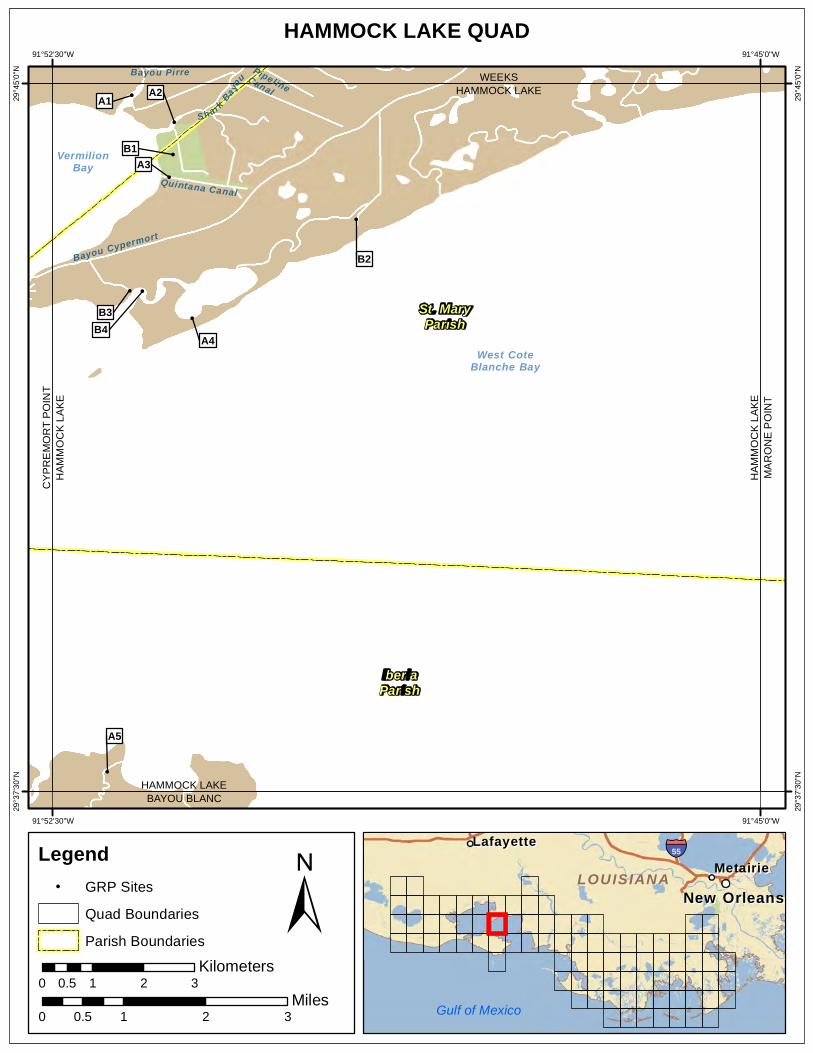
HAMMOCK LAKE QUAD 91°52'30"W 91°45'0"W
!
!
! !
!
!
!
!
!
Bayou Cypermort
Quintana Canal
SharkBa yo
uBayou Pirre PipelineCanal
West CoteBlanche Bay
VermilionBay
IberiaParish
A5
A4
B3 B4
B2
A3B1
A2A1
CY
PR
EM
OR
T P
OIN
TH
AM
MO
CK
LAK
E
HAMMOCK LAKE BAYOU BLANC
HA
MM
OC
K L
AK
EM
AR
ON
E P
OIN
T
HAMMOCK LAKE WEEKS
29°4
5'0"
N
29°4
5'0"
N
29°3
7'30
"N
29°3
7'30
"N
St. MaryParish
91°52'30"W 91°45'0"W
Legend ! GRP Sites
Quad Boundaries
Parish Boundaries
0.5 Kilometers
0 1 2 3
Gulf of Mexico
± Miles
0 0.5 1 2 3
MetairieMetairie LafayetteLafayette
New OrleansNew Orleans
§̈¦55
LOUISIANALOUISIANA
Text416:
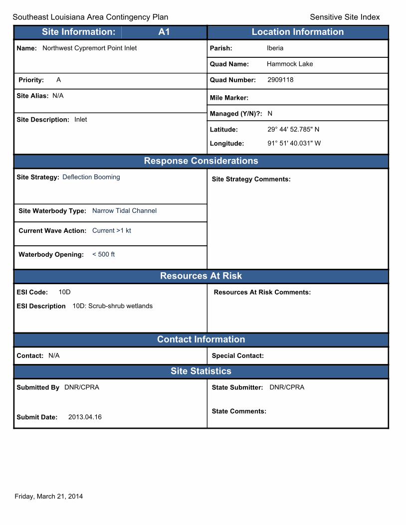
Southeast Louisiana Area Contingency Plan Sensitive Site Index
Site Information: A1 Location Information Name: Northwest Cypremort Point Inlet Parish: Iberia
Quad Name: Hammock Lake
Priority: A Quad Number: 2909118
Site Alias: N/A Mile Marker:
Managed (Y/N)?: N Site Description: Inlet
Latitude: 29° 44' 52.785" N
Longitude: 91° 51' 40.031" W
Response Considerations Site Strategy: Deflection Booming Site Strategy Comments:
Site Waterbody Type: Narrow Tidal Channel
Current Wave Action: Current >1 kt
Waterbody Opening: < 500 ft
Resources At Risk ESI Code: 10D
ESI Description 10D: Scrub-shrub wetlands
Resources At Risk Comments:
Contact Information Contact: N/A Special Contact:
Site Statistics Submitted By DNR/CPRA
Submit Date: 2013.04.16
State Submitter: DNR/CPRA
State Comments:
Friday, March 21, 2014
Text416:
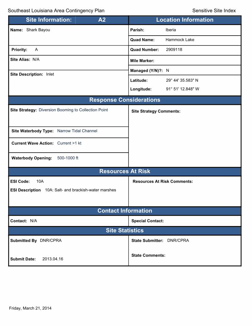
Southeast Louisiana Area Contingency Plan Sensitive Site Index
Site Information: A2 Location Information Name: Shark Bayou Parish: Iberia
Quad Name: Hammock Lake
Priority: A Quad Number: 2909118
Site Alias: N/A Mile Marker:
Managed (Y/N)?: N Site Description: Inlet
Latitude: 29° 44' 35.583" N
Longitude: 91° 51' 12.848" W
Response Considerations Site Strategy: Diversion Booming to Collection Point Site Strategy Comments:
Site Waterbody Type: Narrow Tidal Channel
Current Wave Action: Current >1 kt
Waterbody Opening: 500-1000 ft
Resources At Risk ESI Code: 10A
ESI Description 10A: Salt- and brackish-water marshes
Resources At Risk Comments:
Contact Information Contact: N/A Special Contact:
Site Statistics Submitted By DNR/CPRA
Submit Date: 2013.04.16
State Submitter: DNR/CPRA
State Comments:
Friday, March 21, 2014

Text416:
Southeast Louisiana Area Contingency Plan Sensitive Site Index
Site Information: A3 Location Information Name: Quintana Canal Parish: St. Mary
Quad Name: Hammock Lake
Priority: A Quad Number: 2909118
Site Alias: None Mile Marker:
Managed (Y/N)?: Y - Wildlife Area Site Description: Cypremort Pt. State Park
Latitude: 29° 44' 00.545" N
Longitude: 91° 51' 16.243" W
Response Considerations Site Strategy: Exclusion Booming Site Strategy Comments:
Site Waterbody Type: Narrow Tidal Channel
Current Wave Action: Currents <1 kt
Waterbody Opening: < 500 ft
Resources At Risk ESI Code: 10A
ESI Description 10A: Salt- and brackish-water marshes
Resources At Risk Comments:
State Park
Contact Information Contact: N/A Special Contact:
Site Statistics Submitted By EOC
Submit Date: 2012.10.01
State Submitter: DEQ/ St Mary Parish/DNR/CPRA
State Comments: State Concurs with Parish
Friday, March 21, 2014

Text416:
Southeast Louisiana Area Contingency Plan Sensitive Site Index
Site Information: A4 Location Information Name: Mouth of Hammock Lake (south) Parish: St. Mary
Quad Name: Hammock Lake
Priority: A Quad Number: 2909118
Site Alias: Franklin Canal at ICW (Submitted by State) Mile Marker:
Managed (Y/N)?: N Site Description: Sensitive Habitat
Latitude: 29° 42' 30.928" N
Longitude: 91° 51' 01.618" W
Response Considerations Site Strategy: Deferred Action Site Strategy Comments:
Site Waterbody Type: Entrance to Bays, etc
Current Wave Action: Breaking Waves >1.5 ft
Waterbody Opening: 500-1000 ft
Resources At Risk ESI Code: 10A
ESI Description 10A: Salt- and brackish-water marshes
Resources At Risk Comments:
Sensitive Habitat
Contact Information Contact: N/A Special Contact:
Site Statistics Submitted By EOC
Submit Date: 2012.10.01
State Submitter: DEQ/ St Mary Parish/DNR/CPRA
State Comments: State Concurs with Parish
Friday, March 21, 2014

Text416:
Southeast Louisiana Area Contingency Plan Sensitive Site Index
Site Information: A5 Location Information Name: West Joe Aucoin Bayou Parish: Iberia
Quad Name: Hammock Lake
Priority: A Quad Number: 2909118
Site Alias: N/A Mile Marker:
Managed (Y/N)?: Y - Wildlife Refuge Site Description: State Refuge part of Marsh Island Refuge
Latitude: 29° 37' 42.548" N
Longitude: 91° 51' 55.569" W
Response Considerations Site Strategy: Diversion Booming to Collection Point Site Strategy Comments:
Site Waterbody Type: Narrow Tidal Channel
Current Wave Action: Current >1 kt
Waterbody Opening: < 500 ft
Resources At Risk ESI Code: 10A
ESI Description 10A: Salt- and brackish-water marshes
Resources At Risk Comments:
Sensitive Habitat
Contact Information Contact: LDWF Special Contact:
Site Statistics Submitted By LDWF-DJ Garland and Cassidy Lejeune
Submit Date: 2013.04.16
State Submitter: LDWF/Lafourche Parish
State Comments:
Friday, March 21, 2014

Text416:
Southeast Louisiana Area Contingency Plan Sensitive Site Index
Site Information: B1 Location Information Name: Cypremort Point State Recreation Area Parish: St. Mary
Quad Name: Hammock Lake
Priority: B Quad Number: 2909118
Site Alias: N/A Mile Marker:
Managed (Y/N)?: N Site Description: State park/recreation area
Latitude: 29° 44' 15.018" N
Longitude: 91° 51' 13.732" W
Response Considerations Site Strategy: Deferred Action Site Strategy Comments:
Site Waterbody Type: Straight Coastline
Current Wave Action: Breaking Waves >1.5 ft
Waterbody Opening: Not Applicable
Resources At Risk ESI Code: 10A
ESI Description 10A: Salt- and brackish-water marshes
Resources At Risk Comments:
Contact Information Contact: N/A Special Contact:
Site Statistics Submitted By Preexisting Parish Assessment
Submit Date: 2012.03.13
State Submitter: DEQ/St. Mary Parish/DNR/CPRA
State Comments: Point is in question by State
Friday, March 21, 2014

Text416:
Southeast Louisiana Area Contingency Plan Sensitive Site Index
Site Information: B2 Location Information Name: Inlet near Prince Lake Parish: St. Mary
Quad Name: Hammock Lake
Priority: B Quad Number: 2909118
Site Alias: None Mile Marker:
Managed (Y/N)?: N Site Description: Marshland
Latitude: 29° 43' 33.878" N
Longitude: 91° 49' 17.366" W
Response Considerations Site Strategy: Exclusion Booming Site Strategy Comments:
Site Waterbody Type: Narrow Tidal Channel
Current Wave Action: Currents <1 kt
Waterbody Opening: < 500 ft
Resources At Risk ESI Code: 10A
ESI Description 10A: Salt- and brackish-water marshes
Resources At Risk Comments:
Marshland
Contact Information Contact: N/A Special Contact:
Site Statistics Submitted By Duval Arthur St Mary OEP
Submit Date: 2012.10.01
State Submitter: DEQ/ St Mary Parish/DNR/CPRA
State Comments: State Concurs with Parish
Friday, March 21, 2014

Text416:
Southeast Louisiana Area Contingency Plan Sensitive Site Index
Site Information: B3 Location Information Name: Mouth of Hammock Bayou (north) Parish: St. Mary
Quad Name: Hammock Lake
Priority: B Quad Number: 2909118
Site Alias: None Mile Marker:
Managed (Y/N)?: N Site Description: Sensitive Habitat
Latitude: 29° 42' 48.316" N
Longitude: 91° 51' 41.177" W
Response Considerations Site Strategy: Deflection Booming Site Strategy Comments:
Site Waterbody Type: Narrow Tidal Channel
Current Wave Action: Current >1 kt
Waterbody Opening: < 500 ft
Resources At Risk ESI Code: 10A
ESI Description 10A: Salt- and brackish-water marshes
Resources At Risk Comments:
Contact Information Contact: N/A Special Contact:
Site Statistics Submitted By Preexisting Parish Assessment
Submit Date: 2012.03.13
State Submitter: DEQ/ St Mary Parish/DNR/CPRA
State Comments: State Concurs with Parish
Friday, March 21, 2014

Text416:
Southeast Louisiana Area Contingency Plan Sensitive Site Index
Site Information: B4 Location Information Name: Mouth of Hammock Bayou (central) Parish: St. Mary
Quad Name: Hammock Lake
Priority: B Quad Number: 2909118
Site Alias: None Mile Marker:
Managed (Y/N)?: N Site Description: Two inlets to be considered
Latitude: 29° 42' 48.082" N
Longitude: 91° 51' 33.307" W
Response Considerations Site Strategy: Deflection Booming Site Strategy Comments:
Site Waterbody Type: Narrow Tidal Channel
Current Wave Action: Current >1 kt
Waterbody Opening: < 500 ft
Resources At Risk ESI Code: 10A
ESI Description 10A: Salt- and brackish-water marshes
Resources At Risk Comments:
Two inlets to be considered
Contact Information Contact: N/A Special Contact:
Site Statistics Submitted By EOC
Submit Date: 2012.10.01
State Submitter: DEQ/ St Mary Parish/DNR/CPRA
State Comments: State Concurs with Parish
Friday, March 21, 2014

92°7'30"W 92°0'0"W
HELL HOLE BAYOU QUAD
!
!
!
! !
!
!
! !
! !
!
! !
! !
!
!
Gulf ofMexico
PortageLake Vermilion
Bay
A14
C2
A13B2 A12
C1
B1
A10 A11
A3
A2 A5
A8A9 A7
A6 A4 A1
CH
EN
IER
EA
UTI
GR
EH
ELL
HO
LE B
AYO
U
HE
LLH
OLE
BAY
OU
BAY
OU
LU
CIE
N
HELL HOLE BAYOU REDFISH POINT
HELL HOLE BAYOU
29°3
7'30
"N
29°3
7'30
"N
29°3
0'0"
N
29°3
0'0"
N
VermilionParish
IberiaParish
92°7'30"W 92°0'0"W
Legend ! GRP Sites
Quad Boundaries
Parish Boundaries
0.5 Kilometers
0 1 2 3
± Miles
0 0.5 1 2 3
MetairieMetairie LafayetteLafayette
New OrleansNew Orleans
§̈¦55
LOUISIANALOUISIANA
Gulf of Mexico

Text416:
Southeast Louisiana Area Contingency Plan Sensitive Site Index
Site Information: A1 Location Information Name: Bayou 10 south Vermilion Bay Parish: Vermilion
Quad Name: Hell Hole Bayou
Priority: A Quad Number: 2909232
Site Alias: N/A Mile Marker:
Managed (Y/N)?: N Site Description: Sensitive Habitat
Latitude: 29° 37' 29.830" N
Longitude: 92° 02' 42.114" W
Response Considerations Site Strategy: Exclusion Booming Site Strategy Comments:
Site Waterbody Type: Narrow Tidal Channel
Current Wave Action: Currents <1 kt
Waterbody Opening: < 500 ft
Resources At Risk ESI Code: 10A
ESI Description 10A: Salt- and brackish-water marshes
Resources At Risk Comments:
Sensitive Habitat
Contact Information Contact: National Audubon Society Special Contact:
Site Statistics Submitted By DEQ-Shane Miller and Steve Lorio
Submit Date: 2013.04.16
State Submitter: DEQ-Shane Miller and Steve Lorio
State Comments: Sensitive Habitat
Friday, March 21, 2014

Text416:
Southeast Louisiana Area Contingency Plan Sensitive Site Index
Site Information: A2 Location Information Name: Bayou 03 south Vermilion Bay Parish: Vermilion
Quad Name: Hell Hole Bayou
Priority: A Quad Number: 2909232
Site Alias: N/A Mile Marker:
Managed (Y/N)?: Y - Wildlife Refuge Site Description: State Area part of State Wildlife Refuge
Latitude: 29° 37' 21.103" N
Longitude: 92° 05' 03.173" W
Response Considerations Site Strategy: Exclusion Booming Site Strategy Comments:
Site Waterbody Type: Narrow Tidal Channel
Current Wave Action: Currents <1 kt
Waterbody Opening: < 500 ft
Resources At Risk ESI Code: 10A
ESI Description 10A: Salt- and brackish-water marshes
Resources At Risk Comments:
Sensitive Habitat
Contact Information Contact: LDWF Special Contact:
Site Statistics Submitted By DEQ-Shane Miller and Steve Lorio
Submit Date: 2013.04.16
State Submitter: DEQ-Shane Miller and Steve Lorio
State Comments: Sensitive Habitat
Friday, March 21, 2014

Text416:
Southeast Louisiana Area Contingency Plan Sensitive Site Index
Site Information: A3 Location Information Name: Bayou 02 south Vermilion Bay Parish: Vermilion
Quad Name: Hell Hole Bayou
Priority: A Quad Number: 2909232
Site Alias: N/A Mile Marker:
Managed (Y/N)?: Y - Wildlife Refuge Site Description: State Area part of State Wildlife Refuge
Latitude: 29° 37' 18.113" N
Longitude: 92° 05' 09.151" W
Response Considerations Site Strategy: Exclusion Booming Site Strategy Comments:
Site Waterbody Type: Narrow Tidal Channel
Current Wave Action: Currents <1 kt
Waterbody Opening: < 500 ft
Resources At Risk ESI Code: 10A
ESI Description 10A: Salt- and brackish-water marshes
Resources At Risk Comments:
Sensitive Habitat
Contact Information Contact: LDWF Special Contact:
Site Statistics Submitted By DEQ-Shane Miller and Steve Lorio
Submit Date: 2013.04.16
State Submitter: DEQ-Shane Miller and Steve Lorio
State Comments: Sensitive Habitat
Friday, March 21, 2014

Text416:
Southeast Louisiana Area Contingency Plan Sensitive Site Index
Site Information: A4 Location Information Name: Bayou 09 south Vermilion Bay Parish: Vermilion
Quad Name: Hell Hole Bayou
Priority: A Quad Number: 2909232
Site Alias: N/A Mile Marker:
Managed (Y/N)?: Y - Wildlife Refuge Site Description: State Area part of State Wildlife Refuge
Latitude: 29° 37' 17.254" N
Longitude: 92° 03' 29.758" W
Response Considerations Site Strategy: Exclusion Booming Site Strategy Comments:
Site Waterbody Type: Narrow Tidal Channel
Current Wave Action: Currents <1 kt
Waterbody Opening: < 500 ft
Resources At Risk ESI Code: 10A
ESI Description 10A: Salt- and brackish-water marshes
Resources At Risk Comments:
Sensitive Habitat
Contact Information Contact: LDWF Special Contact:
Site Statistics Submitted By DEQ-Shane Miller and Steve Lorio
Submit Date: 2013.04.16
State Submitter: DEQ-Shane Miller and Steve Lorio
State Comments: Sensitive Habitat
Friday, March 21, 2014

Text416:
Southeast Louisiana Area Contingency Plan Sensitive Site Index
Site Information: A5 Location Information Name: Bayou 04 south Vermilion Bay Parish: Vermilion
Quad Name: Hell Hole Bayou
Priority: A Quad Number: 2909232
Site Alias: N/A Mile Marker:
Managed (Y/N)?: Y - Wildlife Refuge Site Description: State Area part of State Wildlife Refuge
Latitude: 29° 37' 16.741" N
Longitude: 92° 04' 43.707" W
Response Considerations Site Strategy: Deflection Booming Site Strategy Comments:
Site Waterbody Type: Narrow Tidal Channel
Current Wave Action: Current >1 kt
Waterbody Opening: < 500 ft
Resources At Risk ESI Code: 10A
ESI Description 10A: Salt- and brackish-water marshes
Resources At Risk Comments:
Sensitive Habitat
Contact Information Contact: LDWF Special Contact:
Site Statistics Submitted By DEQ-Shane Miller and Steve Lorio
Submit Date: 2013.04.16
State Submitter: DEQ-Shane Miller and Steve Lorio
State Comments: Sensitive Habitat
Friday, March 21, 2014

Text416:
Southeast Louisiana Area Contingency Plan Sensitive Site Index
Site Information: A6 Location Information Name: Bayou 08 south Vermilion Bay Parish: Vermilion
Quad Name: Hell Hole Bayou
Priority: A Quad Number: 2909232
Site Alias: N/A Mile Marker:
Managed (Y/N)?: Y - Wildlife Refuge Site Description: State Area part of State Wildlife Refuge
Latitude: 29° 37' 14.942" N
Longitude: 92° 03' 40.152" W
Response Considerations Site Strategy: Exclusion Booming Site Strategy Comments:
Site Waterbody Type: Narrow Tidal Channel
Current Wave Action: Currents <1 kt
Waterbody Opening: < 500 ft
Resources At Risk ESI Code: 10A
ESI Description 10A: Salt- and brackish-water marshes
Resources At Risk Comments:
Sensitive Habitat
Contact Information Contact: LDWF Special Contact:
Site Statistics Submitted By DEQ-Shane Miller and Steve Lorio
Submit Date: 2013.04.16
State Submitter: DEQ-Shane Miller and Steve Lorio
State Comments: Sensitive Habitat
Friday, March 21, 2014
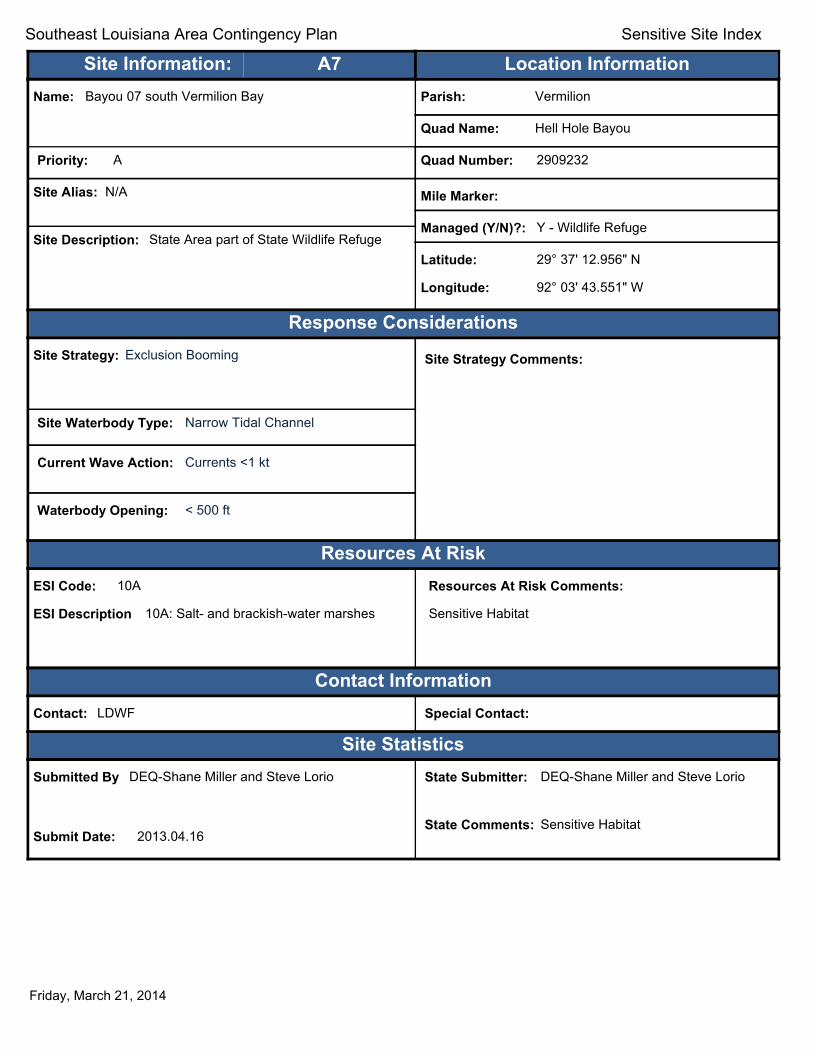
Text416:
Southeast Louisiana Area Contingency Plan Sensitive Site Index
Site Information: A7 Location Information Name: Bayou 07 south Vermilion Bay Parish: Vermilion
Quad Name: Hell Hole Bayou
Priority: A Quad Number: 2909232
Site Alias: N/A Mile Marker:
Managed (Y/N)?: Y - Wildlife Refuge Site Description: State Area part of State Wildlife Refuge
Latitude: 29° 37' 12.956" N
Longitude: 92° 03' 43.551" W
Response Considerations Site Strategy: Exclusion Booming Site Strategy Comments:
Site Waterbody Type: Narrow Tidal Channel
Current Wave Action: Currents <1 kt
Waterbody Opening: < 500 ft
Resources At Risk ESI Code: 10A
ESI Description 10A: Salt- and brackish-water marshes
Resources At Risk Comments:
Sensitive Habitat
Contact Information Contact: LDWF Special Contact:
Site Statistics Submitted By DEQ-Shane Miller and Steve Lorio
Submit Date: 2013.04.16
State Submitter: DEQ-Shane Miller and Steve Lorio
State Comments: Sensitive Habitat
Friday, March 21, 2014

Text416:
Southeast Louisiana Area Contingency Plan Sensitive Site Index
Site Information: A8 Location Information Name: Bayou 05 south Vermilion Bay Parish: Vermilion
Quad Name: Hell Hole Bayou
Priority: A Quad Number: 2909232
Site Alias: N/A Mile Marker:
Managed (Y/N)?: Y - Wildlife Refuge Site Description: State Area part of State Wildlife Refuge
Latitude: 29° 37' 12.349" N
Longitude: 92° 04' 25.394" W
Response Considerations Site Strategy: Deflection Booming Site Strategy Comments:
Site Waterbody Type: Narrow Tidal Channel
Current Wave Action: Current >1 kt
Waterbody Opening: < 500 ft
Resources At Risk ESI Code: 10A
ESI Description 10A: Salt- and brackish-water marshes
Resources At Risk Comments:
Sensitive Habitat
Contact Information Contact: LDWF Special Contact:
Site Statistics Submitted By DEQ-Shane Miller and Steve Lorio
Submit Date: 2013.04.16
State Submitter: DEQ-Shane Miller and Steve Lorio
State Comments: Sensitive Habitat
Friday, March 21, 2014

Text416:
Southeast Louisiana Area Contingency Plan Sensitive Site Index
Site Information: A9 Location Information Name: Bayou 06 south Vermilion Bay Parish: Vermilion
Quad Name: Hell Hole Bayou
Priority: A Quad Number: 2909232
Site Alias: N/A Mile Marker:
Managed (Y/N)?: N Site Description: Sensitive Habitat
Latitude: 29° 37' 09.000" N
Longitude: 92° 04' 00.076" W
Response Considerations Site Strategy: Exclusion Booming Site Strategy Comments:
Site Waterbody Type: Narrow Tidal Channel
Current Wave Action: Currents <1 kt
Waterbody Opening: < 500 ft
Resources At Risk ESI Code: 10A
ESI Description 10A: Salt- and brackish-water marshes
Resources At Risk Comments:
Sensitive Habitat
Contact Information Contact: N/A Special Contact:
Site Statistics Submitted By DEQ-Shane Miller and Steve Lorio
Submit Date: 2013.04.16
State Submitter: DEQ-Shane Miller and Steve Lorio
State Comments: Sensitive Habitat
Friday, March 21, 2014

Text416:
Southeast Louisiana Area Contingency Plan Sensitive Site Index
Site Information: A10 Location Information Name: Hog Bayou Inlet at Vermilion Bay Parish: Vermilion
Quad Name: Hell Hole Bayou
Priority: A Quad Number: 2909232
Site Alias: N/A Mile Marker:
Managed (Y/N)?: Y - Wildlife Refuge Site Description: State Area part of State Wildlife Refuge
Latitude: 29° 37' 05.124" N
Longitude: 92° 06' 46.363" W
Response Considerations Site Strategy: Deflection Booming Site Strategy Comments:
Site Waterbody Type: Narrow Tidal Channel
Current Wave Action: Current >1 kt
Waterbody Opening: < 500 ft
Resources At Risk ESI Code: 10A
ESI Description 10A: Salt- and brackish-water marshes
Resources At Risk Comments:
Sensitive habitat
Contact Information Contact: LDWF Special Contact:
Site Statistics Submitted By LDWF-DJ Garland and Cassidy Lejeune
Submit Date: 2013.04.16
State Submitter: LDWF/Lafourche Parish
State Comments:
Friday, March 21, 2014

Text416:
Southeast Louisiana Area Contingency Plan Sensitive Site Index
Site Information: A11 Location Information Name: Bayou 01 south Vermilion Bay Parish: Vermilion
Quad Name: Hell Hole Bayou
Priority: A Quad Number: 2909232
Site Alias: N/A Mile Marker:
Managed (Y/N)?: Y - Wildlife Refuge Site Description: State Area part of State Wildlife Refuge
Latitude: 29° 37' 03.855" N
Longitude: 92° 05' 37.623" W
Response Considerations Site Strategy: Deflection Booming Site Strategy Comments:
Site Waterbody Type: Narrow Tidal Channel
Current Wave Action: Current >1 kt
Waterbody Opening: < 500 ft
Resources At Risk ESI Code: 10A
ESI Description 10A: Salt- and brackish-water marshes
Resources At Risk Comments:
Sensitive Habitat
Contact Information Contact: LDWF Special Contact:
Site Statistics Submitted By DEQ-Shane Miller and Steve Lorio
Submit Date: 2013.04.16
State Submitter: DEQ-Shane Miller and Steve Lorio
State Comments: Sensitive Habitat
Friday, March 21, 2014

Text416:
Southeast Louisiana Area Contingency Plan Sensitive Site Index
Site Information: A12 Location Information Name: Bird Rookery SW Pass Parish: Vermilion
Quad Name: Hell Hole Bayou
Priority: A Quad Number: 2909232
Site Alias: None Mile Marker:
Managed (Y/N)?: N Site Description: Wading bird rookery
Latitude: 29° 35' 39.893" N
Longitude: 92° 02' 16.964" W
Response Considerations Site Strategy: Deferred Action Site Strategy Comments:
Site Waterbody Type: Straight Coastline
Current Wave Action: Breaking Waves >1.5 ft
Waterbody Opening: Not Applicable
Resources At Risk ESI Code: 10D
ESI Description 10D: Scrub-shrub wetlands
Resources At Risk Comments:
Wading bird rookery
Contact Information Contact: National Audubon Society Special Contact:
Site Statistics Submitted By Preexisting Parish Assessment
Submit Date: 2012.03.13
State Submitter: DEQ/Vermilion Parish/LDWF/DNR/CPRA
State Comments: Agencies Concur with point
Friday, March 21, 2014
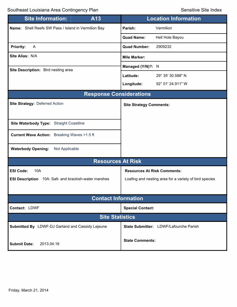
Text416:
Southeast Louisiana Area Contingency Plan Sensitive Site Index
Site Information: A13 Location Information Name: Shell Reefs SW Pass / Island in Vermilion Bay Parish: Vermilion
Quad Name: Hell Hole Bayou
Priority: A Quad Number: 2909232
Site Alias: N/A Mile Marker:
Managed (Y/N)?: N Site Description: Bird nesting area
Latitude: 29° 35' 30.588" N
Longitude: 92° 01' 24.911" W
Response Considerations Site Strategy: Deferred Action Site Strategy Comments:
Site Waterbody Type: Straight Coastline
Current Wave Action: Breaking Waves >1.5 ft
Waterbody Opening: Not Applicable
Resources At Risk ESI Code: 10A
ESI Description 10A: Salt- and brackish-water marshes
Resources At Risk Comments:
Loafing and nesting area for a variety of bird species
Contact Information Contact: LDWF Special Contact:
Site Statistics Submitted By LDWF-DJ Garland and Cassidy Lejeune
Submit Date: 2013.04.16
State Submitter: LDWF/Lafourche Parish
State Comments:
Friday, March 21, 2014

Text416:
Southeast Louisiana Area Contingency Plan Sensitive Site Index
Site Information: A14 Location Information Name: Lighthouse Point / Island Parish: Iberia
Quad Name: Hell Hole Bayou
Priority: A Quad Number: 2909232
Site Alias: N/A Mile Marker:
Managed (Y/N)?: Y - Wildlife Refuge Site Description: State Refuge part of Marsh Island Refuge
Latitude: 29° 34' 39.766" N
Longitude: 92° 01' 55.797" W
Response Considerations Site Strategy: Deferred Action Site Strategy Comments:
Site Waterbody Type: Straight Coastline
Current Wave Action: Breaking Waves >1.5 ft
Waterbody Opening: Not Applicable
Resources At Risk ESI Code: 6A
ESI Description 6A: Gravel beaches
Resources At Risk Comments:
Tern nesting area
Contact Information Contact: LDWF Special Contact:
Site Statistics Submitted By LDWF-DJ Garland and Cassidy Lejeune
Submit Date: 2013.04.16
State Submitter: LDWF/Lafourche Parish
State Comments:
Friday, March 21, 2014

Text416:
Southeast Louisiana Area Contingency Plan Sensitive Site Index
Site Information: B1 Location Information Name: Portage Lake Primary Inlet Parish: Vermilion
Quad Name: Hell Hole Bayou
Priority: B Quad Number: 2909232
Site Alias: None Mile Marker:
Managed (Y/N)?: Y - Wildlife Refuge Site Description: State Area part of State Wildlife Refuge
Latitude: 29° 36' 47.325" N
Longitude: 92° 05' 59.802" W
Response Considerations Site Strategy: Deflection Booming Site Strategy Comments:
Site Waterbody Type: Narrow Tidal Channel
Current Wave Action: Current >1 kt
Waterbody Opening: < 500 ft
Resources At Risk ESI Code: 10A
ESI Description 10A: Salt- and brackish-water marshes
Resources At Risk Comments:
Sensitive habitat / Paul J. Rainey Sanctuary
Contact Information Contact: LDWF Special Contact:
Site Statistics Submitted By Rebecca Broussard
Submit Date: 2012.09.12
State Submitter: DEQ/Vermilion Parish/LDWF/DNR/CPRA
State Comments: Agencies Concur with point
Friday, March 21, 2014

Text416:
Southeast Louisiana Area Contingency Plan Sensitive Site Index
Site Information: B2 Location Information Name: Canal Parish: Vermilion
Quad Name: Hell Hole Bayou
Priority: B Quad Number: 2909232
Site Alias: None Mile Marker:
Managed (Y/N)?: Y - Wildlife Area Site Description: Primary Inlet
Latitude: 29° 35' 37.552" N
Longitude: 92° 04' 14.608" W
Response Considerations Site Strategy: Exclusion Booming Site Strategy Comments:
Site Waterbody Type: Narrow Tidal Channel
Current Wave Action: Currents <1 kt
Waterbody Opening: < 500 ft
Resources At Risk ESI Code: 10A
ESI Description 10A: Salt- and brackish-water marshes
Resources At Risk Comments:
Paul Rainey Sanctuary
Contact Information Contact: National Audubon Society Special Contact:
Site Statistics Submitted By Rebecca Broussard
Submit Date: 2012.09.12
State Submitter: DEQ/Vermilion Parish/LDWF/DNR/CPRA
State Comments: Agencies Concur with point
Friday, March 21, 2014

Text416:
Southeast Louisiana Area Contingency Plan Sensitive Site Index
Site Information: C1 Location Information Name: Shell Reefs SW Pass / Porpoise Point Parish: Iberia
Quad Name: Hell Hole Bayou
Priority: C Quad Number: 2909232
Site Alias: None Mile Marker:
Managed (Y/N)?: Y - Wildlife Area Site Description: Sensitive Habitat
Latitude: 29° 35' 36.434" N
Longitude: 92° 00' 31.330" W
Response Considerations Site Strategy: Deflection Booming Site Strategy Comments:
Site Waterbody Type: Narrow Tidal Channel
Current Wave Action: Current >1 kt
Waterbody Opening: < 500 ft
Resources At Risk ESI Code: 10A
ESI Description 10A: Salt- and brackish-water marshes
Resources At Risk Comments:
Sensitive habitat - many small inlets to refuge marshes
Contact Information Contact: LDWF Special Contact:
Site Statistics Submitted By Prescott Marshall
Submit Date: 2012.09.12
State Submitter: DEQ/Iberia Parish/LDWF/DNR/CPRA
State Comments: Agencies concur with point
Friday, March 21, 2014
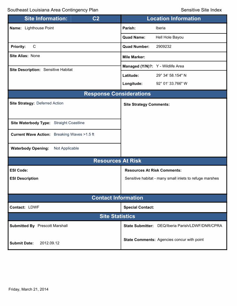
Text416:
Southeast Louisiana Area Contingency Plan Sensitive Site Index
Site Information: C2 Location Information Name: Lighthouse Point Parish: Iberia
Quad Name: Hell Hole Bayou
Priority: C Quad Number: 2909232
Site Alias: None Mile Marker:
Managed (Y/N)?: Y - Wildlife Area Site Description: Sensitive Habitat
Latitude: 29° 34' 58.154" N
Longitude: 92° 01' 33.766" W
Response Considerations Site Strategy: Deferred Action Site Strategy Comments:
Site Waterbody Type: Straight Coastline
Current Wave Action: Breaking Waves >1.5 ft
Waterbody Opening: Not Applicable
Resources At Risk ESI Code:
ESI Description
Resources At Risk Comments:
Sensitive habitat - many small inlets to refuge marshes
Contact Information Contact: LDWF Special Contact:
Site Statistics Submitted By Prescott Marshall
Submit Date: 2012.09.12
State Submitter: DEQ/Iberia Parish/LDWF/DNR/CPRA
State Comments: Agencies concur with point
Friday, March 21, 2014
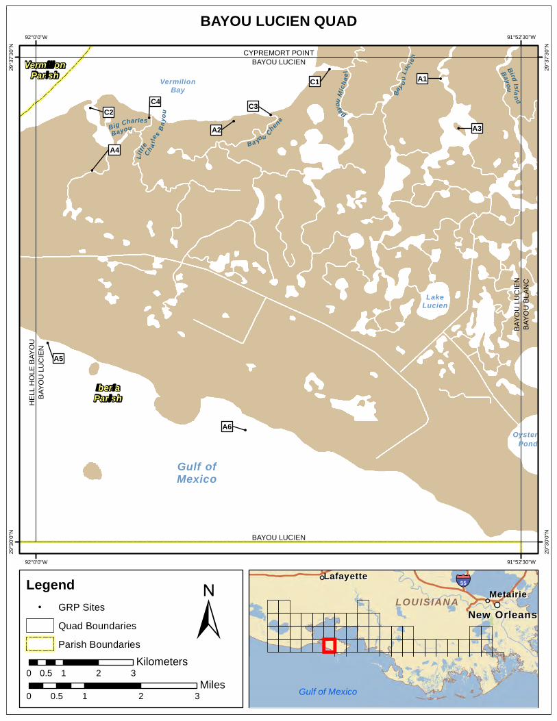
BAYOU LUCIEN QUAD 92°0'0"W 91°52'30"W
!
!
!
! !
!
!
!
!
!
Big CharlesBayou
BirdIslan d
Bayou
Ba
y ouLu
c i en
Bayou
Mich
ael
Little Cha r
les
Bayo
u
Ba you Ch
en e
Gulf ofMexico
LakeLucien
OysterPond
VermilionBay
A6
A5
A4
C4
A2 A3 C2 C3
C1 A1
BAY
OU
LU
CIE
N
HE
LL H
OLE
BAY
OU
BAY
OU
LU
CIE
NB
AYO
UB
LAN
C
BAYOU LUCIEN CYPREMORT POINT
BAYOU LUCIEN
29°3
7'30
"N
29°3
7'30
"N
29°3
0'0"
N
29°3
0'0"
N
VermilionParish
IberiaParish
92°0'0"W 91°52'30"W
Legend ! GRP Sites
Quad Boundaries
Parish Boundaries
0.5 Kilometers
0 1 2 3
± Miles
0 0.5 1 2 3
MetairieMetairie LafayetteLafayette
New OrleansNew Orleans
§̈¦55
LOUISIANALOUISIANA
Gulf of Mexico
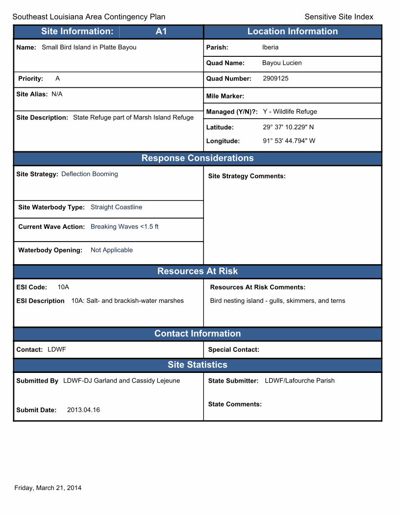
Text416:
Southeast Louisiana Area Contingency Plan Sensitive Site Index
Site Information: A1 Location Information Name: Small Bird Island in Platte Bayou Parish: Iberia
Quad Name: Bayou Lucien
Priority: A Quad Number: 2909125
Site Alias: N/A Mile Marker:
Managed (Y/N)?: Y - Wildlife Refuge Site Description: State Refuge part of Marsh Island Refuge
Latitude: 29° 37' 10.229" N
Longitude: 91° 53' 44.794" W
Response Considerations Site Strategy: Deflection Booming Site Strategy Comments:
Site Waterbody Type: Straight Coastline
Current Wave Action: Breaking Waves <1.5 ft
Waterbody Opening: Not Applicable
Resources At Risk ESI Code: 10A
ESI Description 10A: Salt- and brackish-water marshes
Resources At Risk Comments:
Bird nesting island - gulls, skimmers, and terns
Contact Information Contact: LDWF Special Contact:
Site Statistics Submitted By LDWF-DJ Garland and Cassidy Lejeune
Submit Date: 2013.04.16
State Submitter: LDWF/Lafourche Parish
State Comments:
Friday, March 21, 2014

Text416:
Southeast Louisiana Area Contingency Plan Sensitive Site Index
Site Information: A2 Location Information Name: West Bayou Chene / Multiple Tidal Inlets Parish: Iberia
Quad Name: Bayou Lucien
Priority: A Quad Number: 2909125
Site Alias: N/A Mile Marker:
Managed (Y/N)?: Y - Wildlife Refuge Site Description: State Refuge part of Marsh Island Refuge
Latitude: 29° 36' 30.717" N
Longitude: 91° 56' 56.736" W
Response Considerations Site Strategy: Deflection Booming Site Strategy Comments:
Site Waterbody Type: Narrow Tidal Channel
Current Wave Action: Current >1 kt
Waterbody Opening: < 500 ft
Resources At Risk ESI Code: 10A
ESI Description 10A: Salt- and brackish-water marshes
Resources At Risk Comments:
Sensitive habitat
Contact Information Contact: LDWF Special Contact:
Site Statistics Submitted By LDWF-DJ Garland and Cassidy Lejeune
Submit Date: 2013.04.16
State Submitter: LDWF/Lafourche Parish/LDEQ
State Comments:
Friday, March 21, 2014

Text416:
Southeast Louisiana Area Contingency Plan Sensitive Site Index
Site Information: A3 Location Information Name: Large Bird Island in Platte Bayou Parish: Iberia
Quad Name: Bayou Lucien
Priority: A Quad Number: 2909125
Site Alias: N/A Mile Marker:
Managed (Y/N)?: Y - Wildlife Refuge Site Description: State Refuge part of Marsh Island Refuge
Latitude: 29° 36' 24.084" N
Longitude: 91° 53' 28.167" W
Response Considerations Site Strategy: Deflection Booming Site Strategy Comments:
Site Waterbody Type: Straight Coastline
Current Wave Action: Breaking Waves <1.5 ft
Waterbody Opening: Not Applicable
Resources At Risk ESI Code: 10A
ESI Description 10A: Salt- and brackish-water marshes
Resources At Risk Comments:
Bird nesting island - gulls, skimmers, and terns
Contact Information Contact: LDWF Special Contact:
Site Statistics Submitted By LDWF-DJ Garland and Cassidy Lejeune
Submit Date: 2013.04.16
State Submitter: LDWF/Lafourche Parish
State Comments:
Friday, March 21, 2014

Text416:
Southeast Louisiana Area Contingency Plan Sensitive Site Index
Site Information: A4 Location Information Name: Big Charles Bayou Parish: Iberia
Quad Name: Bayou Lucien
Priority: A Quad Number: 2909125
Site Alias: N/A Mile Marker:
Managed (Y/N)?: Y - Wildlife Refuge Site Description: State Refuge part of Marsh Island Refuge
Latitude: 29° 35' 45.030" N
Longitude: 91° 59' 08.389" W
Response Considerations Site Strategy: Deflection Booming Site Strategy Comments:
Site Waterbody Type: Narrow Tidal Channel
Current Wave Action: Current >1 kt
Waterbody Opening: < 500 ft
Resources At Risk ESI Code: 10A
ESI Description 10A: Salt- and brackish-water marshes
Resources At Risk Comments:
Wading bird nesting colony
Contact Information Contact: LDWF Special Contact:
Site Statistics Submitted By LDWF-DJ Garland and Cassidy Lejeune
Submit Date: 2013.04.16
State Submitter: LDWF/Lafourche Parish
State Comments:
Friday, March 21, 2014
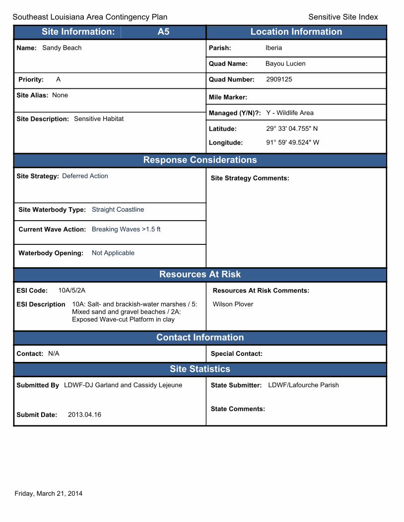
Text416:
Southeast Louisiana Area Contingency Plan Sensitive Site Index
Site Information: A5 Location Information Name: Sandy Beach Parish: Iberia
Quad Name: Bayou Lucien
Priority: A Quad Number: 2909125
Site Alias: None Mile Marker:
Managed (Y/N)?: Y - Wildlife Area Site Description: Sensitive Habitat
Latitude: 29° 33' 04.755" N
Longitude: 91° 59' 49.524" W
Response Considerations Site Strategy: Deferred Action Site Strategy Comments:
Site Waterbody Type: Straight Coastline
Current Wave Action: Breaking Waves >1.5 ft
Waterbody Opening: Not Applicable
Resources At Risk ESI Code: 10A/5/2A
ESI Description 10A: Salt- and brackish-water marshes / 5: Mixed sand and gravel beaches / 2A: Exposed Wave-cut Platform in clay
Resources At Risk Comments:
Wilson Plover
Contact Information Contact: N/A Special Contact:
Site Statistics Submitted By LDWF-DJ Garland and Cassidy Lejeune
Submit Date: 2013.04.16
State Submitter: LDWF/Lafourche Parish
State Comments:
Friday, March 21, 2014

Text416:
Southeast Louisiana Area Contingency Plan Sensitive Site Index
Site Information: A6 Location Information Name: Exposed shell reefs / Island at GOM Parish: Iberia
Quad Name: Bayou Lucien
Priority: A Quad Number: 2909125
Site Alias: N/A Mile Marker:
Managed (Y/N)?: N Site Description: State Refuge just south of Marsh Island
Refuge shoreline Latitude: 29° 31' 43.838" N
Longitude: 91° 56' 46.135" W
Response Considerations Site Strategy: Deferred Action Site Strategy Comments:
Site Waterbody Type: Straight Coastline
Current Wave Action: Breaking Waves >1.5 ft
Waterbody Opening: Not Applicable
Resources At Risk ESI Code:
ESI Description
Resources At Risk Comments:
Bird loafing area
Contact Information Contact: LDWF Special Contact:
Site Statistics Submitted By LDWF-DJ Garland and Cassidy Lejeune
Submit Date: 2013.04.16
State Submitter: LDWF/Lafourche Parish
State Comments:
Friday, March 21, 2014

Text416:
Southeast Louisiana Area Contingency Plan Sensitive Site Index
Site Information: C1 Location Information Name: Entrance to Bayou Michael from Vermilion Bay Parish: Iberia
Quad Name: Bayou Lucien
Priority: C Quad Number: 2909125
Site Alias: None Mile Marker:
Managed (Y/N)?: Y - Wildlife Refuge Site Description: State Refuge part of Marsh Island Refuge
Latitude: 29° 37' 19.180" N
Longitude: 91° 55' 28.007" W
Response Considerations Site Strategy: Deflection Booming Site Strategy Comments:
Site Waterbody Type: Narrow Tidal Channel
Current Wave Action: Current >1 kt
Waterbody Opening: 500-1000 ft
Resources At Risk ESI Code: 10A
ESI Description 10A: Salt- and brackish-water marshes
Resources At Risk Comments:
Sensitive habitat / Marshland and fisheries
Contact Information Contact: LDWF Special Contact:
Site Statistics Submitted By Prescott Marshall
Submit Date: 2012.09.12
State Submitter: DEQ/Iberia Parish/LDWF/DNR/CPRA
State Comments: Agencies concur with point
Friday, March 21, 2014

Text416:
Southeast Louisiana Area Contingency Plan Sensitive Site Index
Site Information: C2 Location Information Name: Entrance to Big Charles Bayou from Vermilion Bay Parish: Iberia
Quad Name: Bayou Lucien
Priority: C Quad Number: 2909125
Site Alias: None Mile Marker:
Managed (Y/N)?: Y - Wildlife Refuge Site Description: State Refuge part of Marsh Island Refuge
Latitude: 29° 36' 42.903" N
Longitude: 91° 59' 10.002" W
Response Considerations Site Strategy: Deferred Action Site Strategy Comments:
Site Waterbody Type: Narrow Tidal Channel
Current Wave Action: Current >1 kt
Waterbody Opening: 1000-1500 ft
Resources At Risk ESI Code: 10A
ESI Description 10A: Salt- and brackish-water marshes
Resources At Risk Comments:
Sensitive habitat / Marshland and fisheries
Contact Information Contact: LDWF Special Contact:
Site Statistics Submitted By Prescott Marshall
Submit Date: 2012.09.12
State Submitter: DEQ/Iberia Parish/LDWF/DNR/CPRA
State Comments: Agencies concur with point
Friday, March 21, 2014

Text416:
Southeast Louisiana Area Contingency Plan Sensitive Site Index
Site Information: C3 Location Information Name: Entrance to Bayou Chene from Vermilion Bay Parish: Iberia
Quad Name: Bayou Lucien
Priority: C Quad Number: 2909125
Site Alias: None Mile Marker:
Managed (Y/N)?: Y - Wildlife Refuge Site Description: State Refuge part of Marsh Island Refuge
Latitude: 29° 36' 36.487" N
Longitude: 91° 56' 22.591" W
Response Considerations Site Strategy: Deflection Booming Site Strategy Comments:
Site Waterbody Type: Narrow Tidal Channel
Current Wave Action: Current >1 kt
Waterbody Opening: < 500 ft
Resources At Risk ESI Code: 10A
ESI Description 10A: Salt- and brackish-water marshes
Resources At Risk Comments:
Sensitive habitat / Marshland and fisheries
Contact Information Contact: LDWF Special Contact:
Site Statistics Submitted By Prescott Marshall
Submit Date: 2012.09.12
State Submitter: DEQ/Iberia Parish/LDWF/DNR/CPRA
State Comments: Agencies concur with point
Friday, March 21, 2014
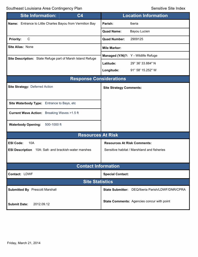
Text416:
Southeast Louisiana Area Contingency Plan Sensitive Site Index
Site Information: C4 Location Information Name: Entrance to Little Charles Bayou from Vermilion Bay Parish: Iberia
Quad Name: Bayou Lucien
Priority: C Quad Number: 2909125
Site Alias: None Mile Marker:
Managed (Y/N)?: Y - Wildlife Refuge Site Description: State Refuge part of Marsh Island Refuge
Latitude: 29° 36' 33.884" N
Longitude: 91° 58' 15.252" W
Response Considerations Site Strategy: Deferred Action Site Strategy Comments:
Site Waterbody Type: Entrance to Bays, etc
Current Wave Action: Breaking Waves >1.5 ft
Waterbody Opening: 500-1000 ft
Resources At Risk ESI Code: 10A
ESI Description 10A: Salt- and brackish-water marshes
Resources At Risk Comments:
Sensitive habitat / Marshland and fisheries
Contact Information Contact: LDWF Special Contact:
Site Statistics Submitted By Prescott Marshall
Submit Date: 2012.09.12
State Submitter: DEQ/Iberia Parish/LDWF/DNR/CPRA
State Comments: Agencies concur with point
Friday, March 21, 2014
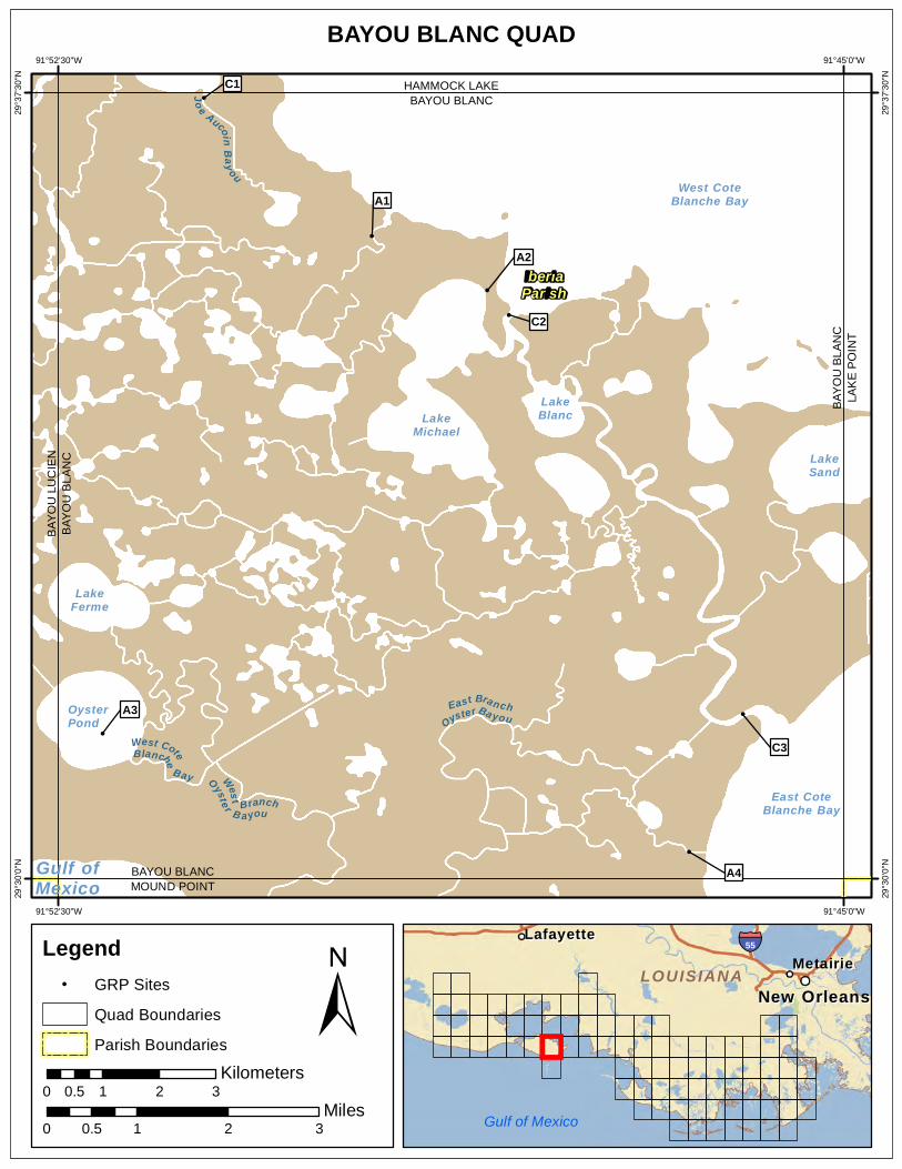
BAYOU BLANC QUAD 91°52'30"W 91°45'0"W
!
!
!
!
!
!
!
West CoteBlanche
Bay
Jo e Aucoin Bay ou West Branch
Oyste r B ayou
East BranchOyster Ba you
Gulf ofMexico
LakeMichael
LakeFerme
OysterPond
LakeBlanc
LakeSand
West CoteBlanche Bay
East CoteBlanche Bay
A4
A3
C3
C2
A2
A1
C1B
AYO
UB
LAN
C
BAYOU BLANC MOUND POINT
BAY
OU
BLA
NC
LAK
E P
OIN
T
BAYOU BLANC HAMMOCK LAKE
29°3
7'30
"N
29°3
7'30
"N
29°3
0'0"
N
29°3
0'0"
N
IberiaParish
BAY
OU
LU
CIE
N
91°52'30"W 91°45'0"W
Legend ! GRP Sites
Quad Boundaries
Parish Boundaries
0.5 Kilometers
0 1 2 3
± Miles
0 0.5 1 2 3
MetairieMetairie LafayetteLafayette
New OrleansNew Orleans
§̈¦55
LOUISIANALOUISIANA
Gulf of Mexico

Text416:
Southeast Louisiana Area Contingency Plan Sensitive Site Index
Site Information: A1 Location Information Name: Gordy Lake Bayou at West Cote Blanche Bay Parish: Iberia
Quad Name: Bayou Blanc
Priority: A Quad Number: 2909126
Site Alias: N/A Mile Marker:
Managed (Y/N)?: Y - Wildlife Refuge Site Description: State Refuge part of Marsh Island Refuge
Latitude: 29° 36' 08.094" N
Longitude: 91° 49' 30.566" W
Response Considerations Site Strategy: Deflection Booming Site Strategy Comments:
Site Waterbody Type: Narrow Tidal Channel
Current Wave Action: Current >1 kt
Waterbody Opening: < 500 ft
Resources At Risk ESI Code: 10A
ESI Description 10A: Salt- and brackish-water marshes
Resources At Risk Comments:
Sensitive habitat
Contact Information Contact: LDWF Special Contact:
Site Statistics Submitted By LDWF-DJ Garland and Cassidy Lejeune
Submit Date: 2013.04.16
State Submitter: LDWF/Lafourche Parish/LDEQ
State Comments:
Friday, March 21, 2014
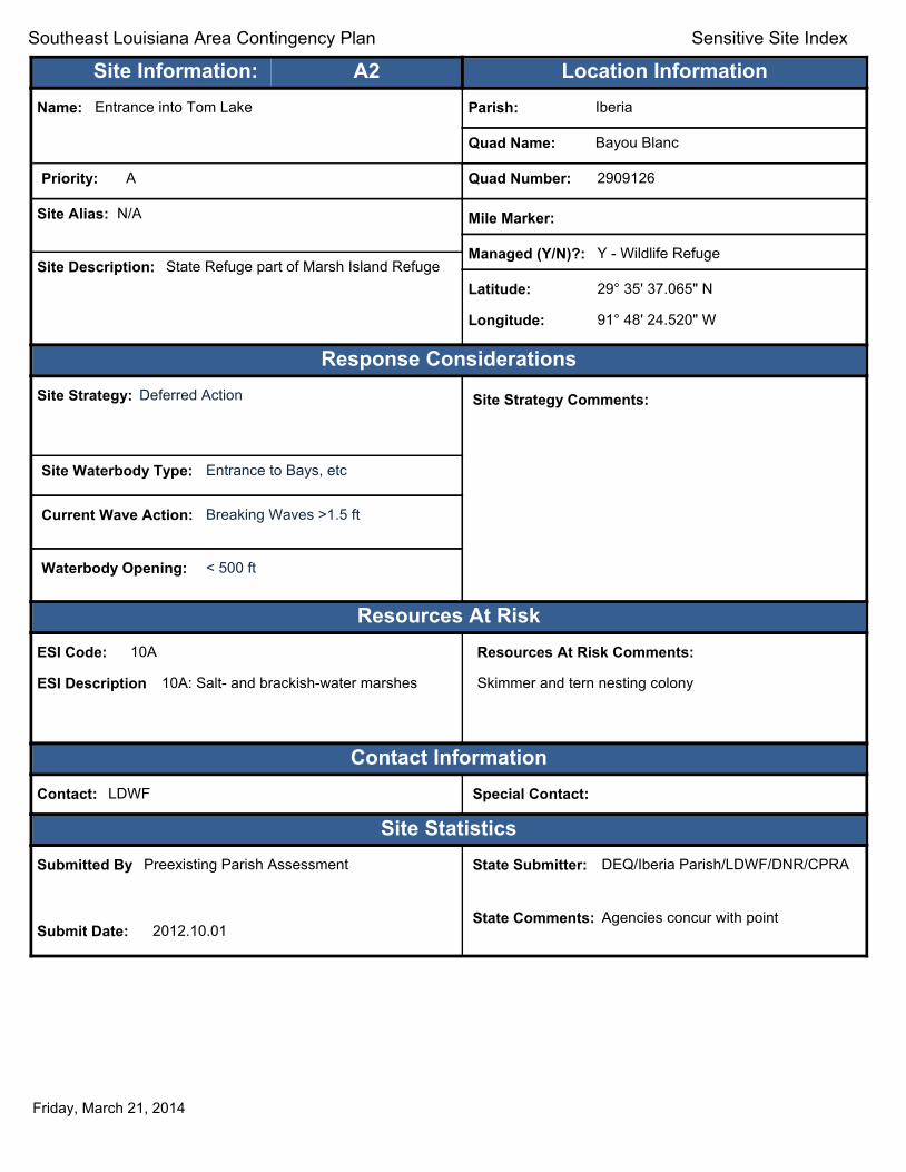
Text416:
Southeast Louisiana Area Contingency Plan Sensitive Site Index
Site Information: A2 Location Information Name: Entrance into Tom Lake Parish: Iberia
Quad Name: Bayou Blanc
Priority: A Quad Number: 2909126
Site Alias: N/A Mile Marker:
Managed (Y/N)?: Y - Wildlife Refuge Site Description: State Refuge part of Marsh Island Refuge
Latitude: 29° 35' 37.065" N
Longitude: 91° 48' 24.520" W
Response Considerations Site Strategy: Deferred Action Site Strategy Comments:
Site Waterbody Type: Entrance to Bays, etc
Current Wave Action: Breaking Waves >1.5 ft
Waterbody Opening: < 500 ft
Resources At Risk ESI Code: 10A
ESI Description 10A: Salt- and brackish-water marshes
Resources At Risk Comments:
Skimmer and tern nesting colony
Contact Information Contact: LDWF Special Contact:
Site Statistics Submitted By Preexisting Parish Assessment
Submit Date: 2012.10.01
State Submitter: DEQ/Iberia Parish/LDWF/DNR/CPRA
State Comments: Agencies concur with point
Friday, March 21, 2014

Text416:
Southeast Louisiana Area Contingency Plan Sensitive Site Index
Site Information: A3 Location Information Name: Loafing/Nesting Birds Island in Oyster Lake Parish: Iberia
Quad Name: Bayou Blanc
Priority: A Quad Number: 2909126
Site Alias: N/A Mile Marker:
Managed (Y/N)?: Y - Wildlife Refuge Site Description: State Refuge part of Marsh Island Refuge
Latitude: 29° 31' 23.180" N
Longitude: 91° 52' 04.830" W
Response Considerations Site Strategy: Deferred Action Site Strategy Comments:
Site Waterbody Type: Straight Coastline
Current Wave Action: Breaking Waves >1.5 ft
Waterbody Opening: Not Applicable
Resources At Risk ESI Code:
ESI Description
Resources At Risk Comments:
Seabird loafing area
Contact Information Contact: LDWF Special Contact:
Site Statistics Submitted By LDWF-DJ Garland and Cassidy Lejeune
Submit Date: 2013.04.16
State Submitter: LDWF/Lafourche Parish
State Comments:
Friday, March 21, 2014

Text416:
Southeast Louisiana Area Contingency Plan Sensitive Site Index
Site Information: A4 Location Information Name: Bayou south of Bayou Blanc at GOM Parish: Iberia
Quad Name: Bayou Blanc
Priority: A Quad Number: 2909126
Site Alias: N/A Mile Marker:
Managed (Y/N)?: Y - Wildlife Refuge Site Description: State Refuge part of Marsh Island Refuge
Latitude: 29° 30' 15.450" N
Longitude: 91° 46' 28.848" W
Response Considerations Site Strategy: Deferred Action Site Strategy Comments:
Site Waterbody Type: Entrance to Bays, etc
Current Wave Action: Breaking Waves >1.5 ft
Waterbody Opening: < 500 ft
Resources At Risk ESI Code: 10A/2A
ESI Description 10A: Salt- and brackish-water marshes / 2A: Exposed Wave-cut Platform in clay
Resources At Risk Comments:
Sensitive habitat - inlet to prime waterfowl habitat
Contact Information Contact: LDWF Special Contact:
Site Statistics Submitted By LDWF-DJ Garland and Cassidy Lejeune
Submit Date: 2013.04.16
State Submitter: LDWF/Lafourche Parish
State Comments:
Friday, March 21, 2014

Text416:
Southeast Louisiana Area Contingency Plan Sensitive Site Index
Site Information: C1 Location Information Name: Joe Aucoin Bayou entrance at West Cote Blanche
Bay (drilling channel) Parish: Iberia
Quad Name: Bayou Blanc
Priority: C Quad Number: 2909126
Site Alias: None Mile Marker:
Managed (Y/N)?: Y - Wildlife Refuge Site Description: State Refuge part of Marsh Island Refuge
Latitude: 29° 37' 27.194" N
Longitude: 91° 51' 06.857" W
Response Considerations Site Strategy: Deflection Booming Site Strategy Comments:
Site Waterbody Type: Narrow Tidal Channel
Current Wave Action: Current >1 kt
Waterbody Opening: < 500 ft
Resources At Risk ESI Code: 10A
ESI Description 10A: Salt- and brackish-water marshes
Resources At Risk Comments:
Sensitive habitat / Marshland and fisheries
Contact Information Contact: LDWF Special Contact:
Site Statistics Submitted By Prescott Marshall
Submit Date: 2012.09.12
State Submitter: DEQ/Iberia Parish/LDWF/DNR/CPRA
State Comments: Agencies concur with point
Friday, March 21, 2014
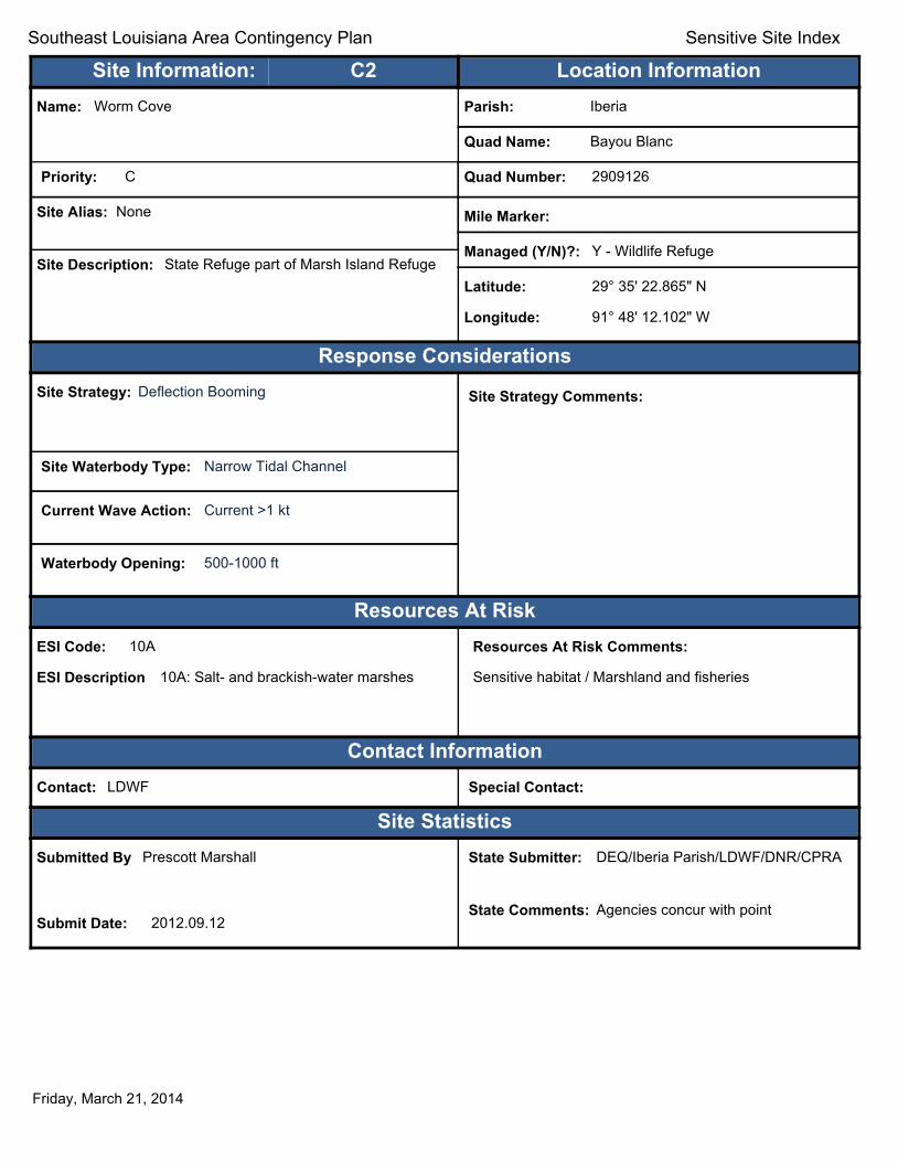
Text416:
Southeast Louisiana Area Contingency Plan Sensitive Site Index
Site Information: C2 Location Information Name: Worm Cove Parish: Iberia
Quad Name: Bayou Blanc
Priority: C Quad Number: 2909126
Site Alias: None Mile Marker:
Managed (Y/N)?: Y - Wildlife Refuge Site Description: State Refuge part of Marsh Island Refuge
Latitude: 29° 35' 22.865" N
Longitude: 91° 48' 12.102" W
Response Considerations Site Strategy: Deflection Booming Site Strategy Comments:
Site Waterbody Type: Narrow Tidal Channel
Current Wave Action: Current >1 kt
Waterbody Opening: 500-1000 ft
Resources At Risk ESI Code: 10A
ESI Description 10A: Salt- and brackish-water marshes
Resources At Risk Comments:
Sensitive habitat / Marshland and fisheries
Contact Information Contact: LDWF Special Contact:
Site Statistics Submitted By Prescott Marshall
Submit Date: 2012.09.12
State Submitter: DEQ/Iberia Parish/LDWF/DNR/CPRA
State Comments: Agencies concur with point
Friday, March 21, 2014
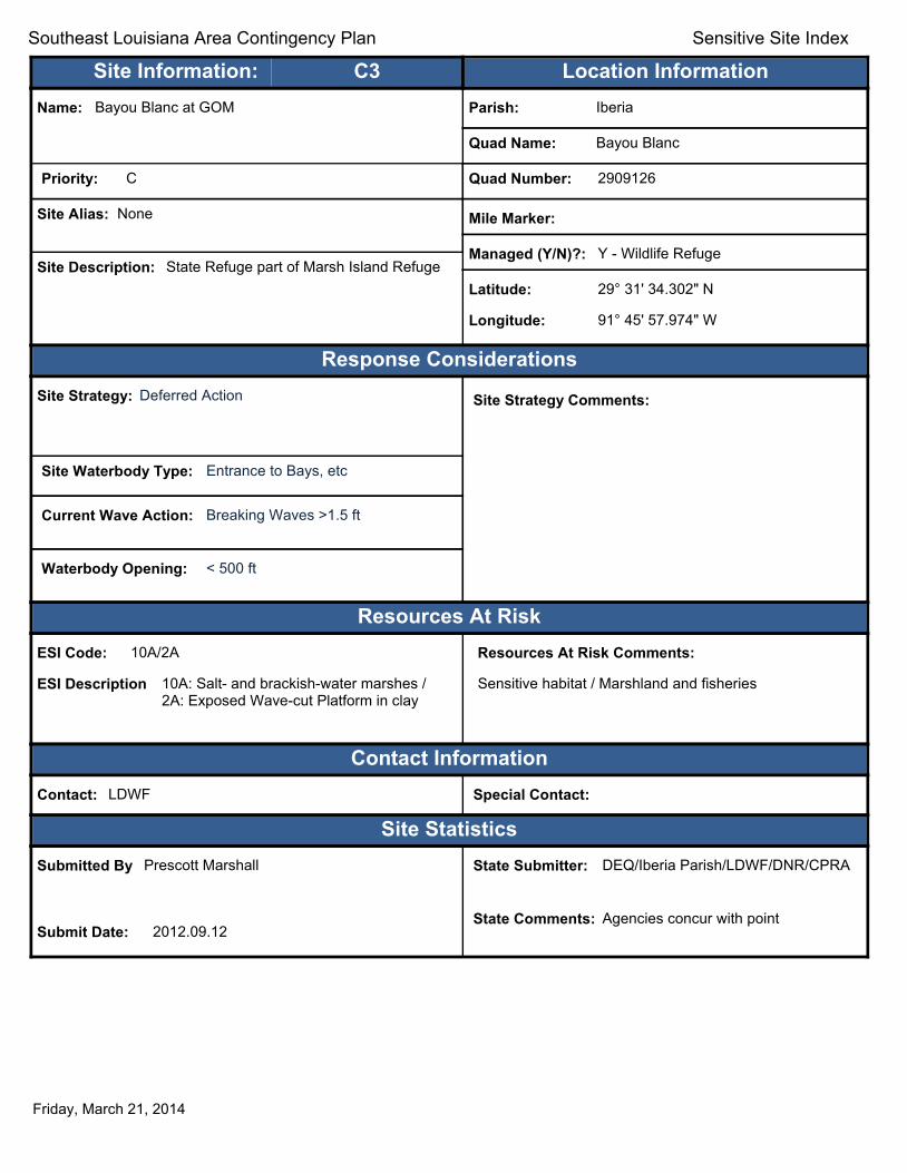
Text416:
Southeast Louisiana Area Contingency Plan Sensitive Site Index
Site Information: C3 Location Information Name: Bayou Blanc at GOM Parish: Iberia
Quad Name: Bayou Blanc
Priority: C Quad Number: 2909126
Site Alias: None Mile Marker:
Managed (Y/N)?: Y - Wildlife Refuge Site Description: State Refuge part of Marsh Island Refuge
Latitude: 29° 31' 34.302" N
Longitude: 91° 45' 57.974" W
Response Considerations Site Strategy: Deferred Action Site Strategy Comments:
Site Waterbody Type: Entrance to Bays, etc
Current Wave Action: Breaking Waves >1.5 ft
Waterbody Opening: < 500 ft
Resources At Risk ESI Code: 10A/2A
ESI Description 10A: Salt- and brackish-water marshes / 2A: Exposed Wave-cut Platform in clay
Resources At Risk Comments:
Sensitive habitat / Marshland and fisheries
Contact Information Contact: LDWF Special Contact:
Site Statistics Submitted By Prescott Marshall
Submit Date: 2012.09.12
State Submitter: DEQ/Iberia Parish/LDWF/DNR/CPRA
State Comments: Agencies concur with point
Friday, March 21, 2014
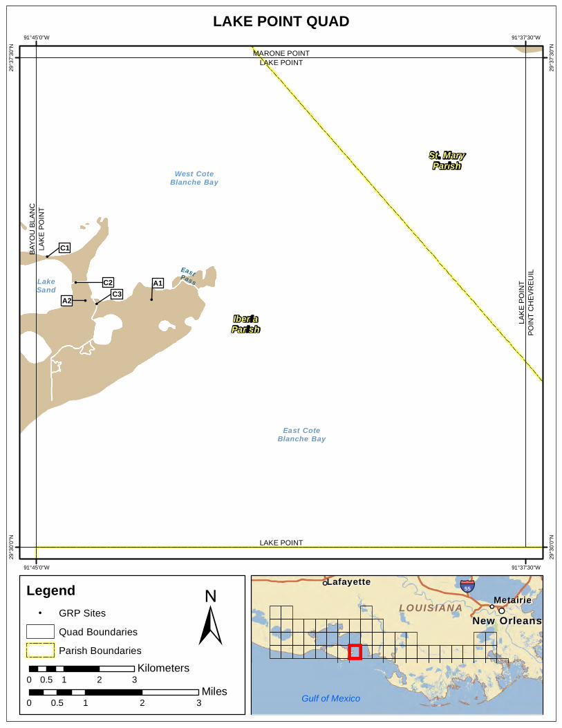
91°45'0"W 91°37'30"W
LAKE POINT QUAD
! !
!
!
!
EastPassLakeSand
West CoteBlanche Bay
East CoteBlanche Bay
A2 C3 A1C2
C1BAY
OU
BLA
NC
LAK
E P
OIN
T
LAK
E P
OIN
TP
OIN
T C
HE
VR
EU
IL
LAKE POINT MARONE POINT
LAKE POINT
29°3
7'30
"N
29°3
7'30
"N
29°3
0'0"
N
29°3
0'0"
N
IberiaParish
St. MaryParish
91°45'0"W 91°37'30"W
Legend ! GRP Sites
Quad Boundaries
Parish Boundaries
0.5 Kilometers
0 1 2 3
± Miles
0 0.5 1 2 3
MetairieMetairie LafayetteLafayette
New OrleansNew Orleans
§̈¦55
LOUISIANALOUISIANA
Gulf of Mexico

Text416:
Southeast Louisiana Area Contingency Plan Sensitive Site Index
Site Information: A1 Location Information Name: East Location Canal Parish: Iberia
Quad Name: Lake Point
Priority: A Quad Number: 2909127
Site Alias: N/A Mile Marker:
Managed (Y/N)?: Y - Wildlife Refuge Site Description: State Refuge part of Marsh Island Refuge
Latitude: 29° 33' 47.673" N
Longitude: 91° 43' 14.270" W
Response Considerations Site Strategy: Exclusion Booming Site Strategy Comments:
Site Waterbody Type: Narrow Tidal Channel
Current Wave Action: Currents <1 kt
Waterbody Opening: < 500 ft
Resources At Risk ESI Code: 10A
ESI Description 10A: Salt- and brackish-water marshes
Resources At Risk Comments:
Sensitive habitat
Contact Information Contact: LDWF Special Contact:
Site Statistics Submitted By LDWF-DJ Garland and Cassidy Lejeune
Submit Date: 2013.04.16
State Submitter: LDWF/Lafourche Parish/LDEQ
State Comments:
Friday, March 21, 2014

Text416:
Southeast Louisiana Area Contingency Plan Sensitive Site Index
Site Information: A2 Location Information Name: Canal Parish: Iberia
Quad Name: Lake Point
Priority: A Quad Number: 2909127
Site Alias: N/A Mile Marker:
Managed (Y/N)?: Y - Wildlife Refuge Site Description: State Refuge part of Marsh Island Refuge
Latitude: 29° 33' 46.820" N
Longitude: 91° 44' 15.257" W
Response Considerations Site Strategy: Exclusion Booming Site Strategy Comments:
Site Waterbody Type: Narrow Tidal Channel
Current Wave Action: Currents <1 kt
Waterbody Opening: < 500 ft
Resources At Risk ESI Code: 10A
ESI Description 10A: Salt- and brackish-water marshes
Resources At Risk Comments:
Sensitive Habitat
Contact Information Contact: LDWF Special Contact:
Site Statistics Submitted By DEQ-Shane Miller and Steve Lorio
Submit Date: 2013.04.16
State Submitter: DEQ-Shane Miller and Steve Lorio
State Comments: Sensitive Habitat
Friday, March 21, 2014

Text416:
Southeast Louisiana Area Contingency Plan Sensitive Site Index
Site Information: C1 Location Information Name: Lake Sand Terraces Parish: Iberia
Quad Name: Lake Point
Priority: C Quad Number: 2909127
Site Alias: None Mile Marker:
Managed (Y/N)?: Y - Wildlife Refuge Site Description: State Refuge part of Marsh Island Refuge
Latitude: 29° 34' 27.266" N
Longitude: 91° 44' 50.312" W
Response Considerations Site Strategy: Deferred Action Site Strategy Comments:
Site Waterbody Type: Entrance to Bays, etc
Current Wave Action: Breaking Waves >1.5 ft
Waterbody Opening: 1000-1500 ft
Resources At Risk ESI Code: 10A
ESI Description 10A: Salt- and brackish-water marshes
Resources At Risk Comments:
Tern, gull, and skimmer nesting area / Marshland and fisheries
Contact Information Contact: LDWF Special Contact:
Site Statistics Submitted By Prescott Marshall
Submit Date: 2012.09.12
State Submitter: DEQ/Iberia Parish/LDWF/DNR/CPRA
State Comments: Agencies concur with point
Friday, March 21, 2014
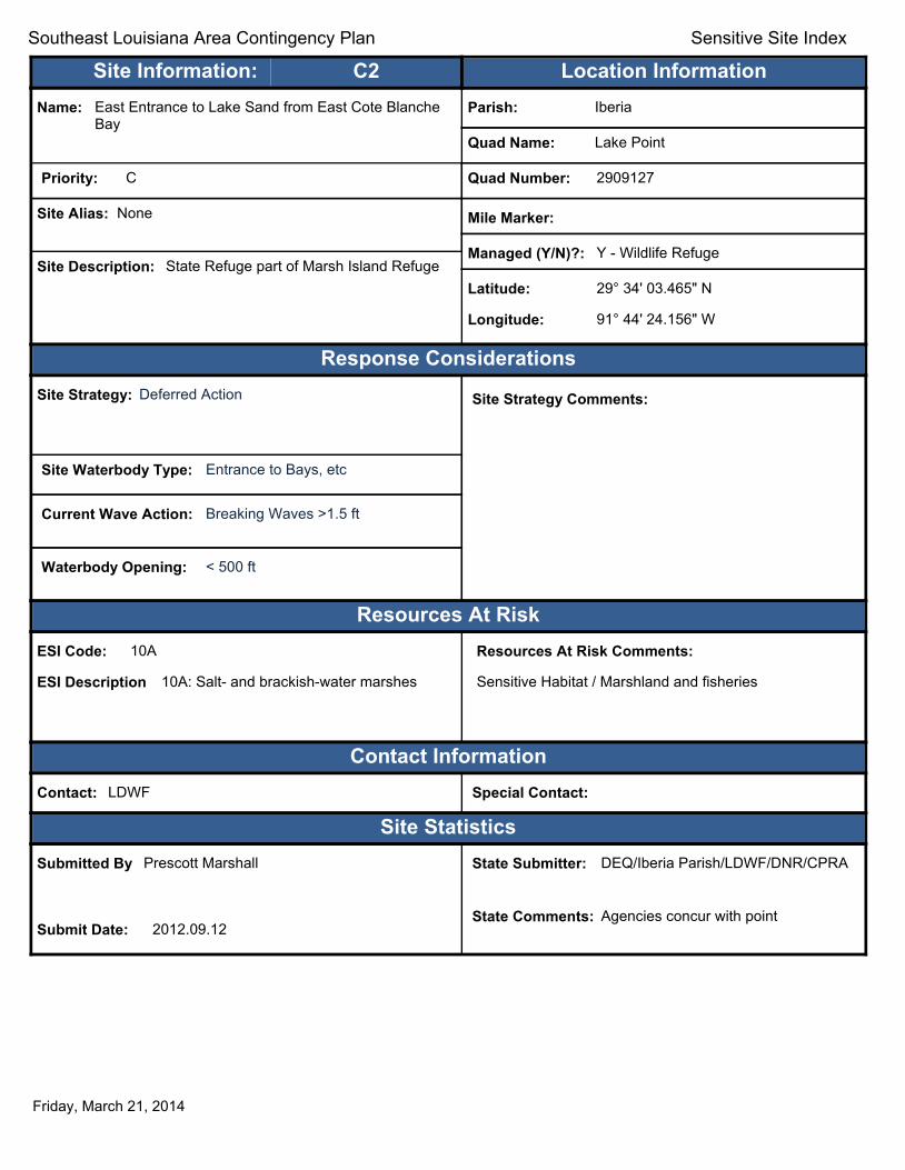
Text416:
Southeast Louisiana Area Contingency Plan Sensitive Site Index
Site Information: C2 Location Information Name: East Entrance to Lake Sand from East Cote Blanche
Bay Parish: Iberia
Quad Name: Lake Point
Priority: C Quad Number: 2909127
Site Alias: None Mile Marker:
Managed (Y/N)?: Y - Wildlife Refuge Site Description: State Refuge part of Marsh Island Refuge
Latitude: 29° 34' 03.465" N
Longitude: 91° 44' 24.156" W
Response Considerations Site Strategy: Deferred Action Site Strategy Comments:
Site Waterbody Type: Entrance to Bays, etc
Current Wave Action: Breaking Waves >1.5 ft
Waterbody Opening: < 500 ft
Resources At Risk ESI Code: 10A
ESI Description 10A: Salt- and brackish-water marshes
Resources At Risk Comments:
Sensitive Habitat / Marshland and fisheries
Contact Information Contact: LDWF Special Contact:
Site Statistics Submitted By Prescott Marshall
Submit Date: 2012.09.12
State Submitter: DEQ/Iberia Parish/LDWF/DNR/CPRA
State Comments: Agencies concur with point
Friday, March 21, 2014

Text416:
Southeast Louisiana Area Contingency Plan Sensitive Site Index
Site Information: C3 Location Information Name: Entrance to Hawkins Bayou from East Cote Blanche
Bay Parish: Iberia
Quad Name: Lake Point
Priority: C Quad Number: 2909127
Site Alias: None Mile Marker:
Managed (Y/N)?: Y - Wildlife Refuge Site Description: State Refuge part of Marsh Island Refuge
Latitude: 29° 33' 43.722" N
Longitude: 91° 44' 04.766" W
Response Considerations Site Strategy: Deflection Booming Site Strategy Comments:
Site Waterbody Type: Narrow Tidal Channel
Current Wave Action: Current >1 kt
Waterbody Opening: < 500 ft
Resources At Risk ESI Code: 10A
ESI Description 10A: Salt- and brackish-water marshes
Resources At Risk Comments:
Sensitive Habitat / Marshland and fisheries
Contact Information Contact: LDWF Special Contact:
Site Statistics Submitted By Prescott Marshall
Submit Date: 2012.09.12
State Submitter: DEQ/Iberia Parish/LDWF/DNR/CPRA
State Comments: Agencies concur with point
Friday, March 21, 2014
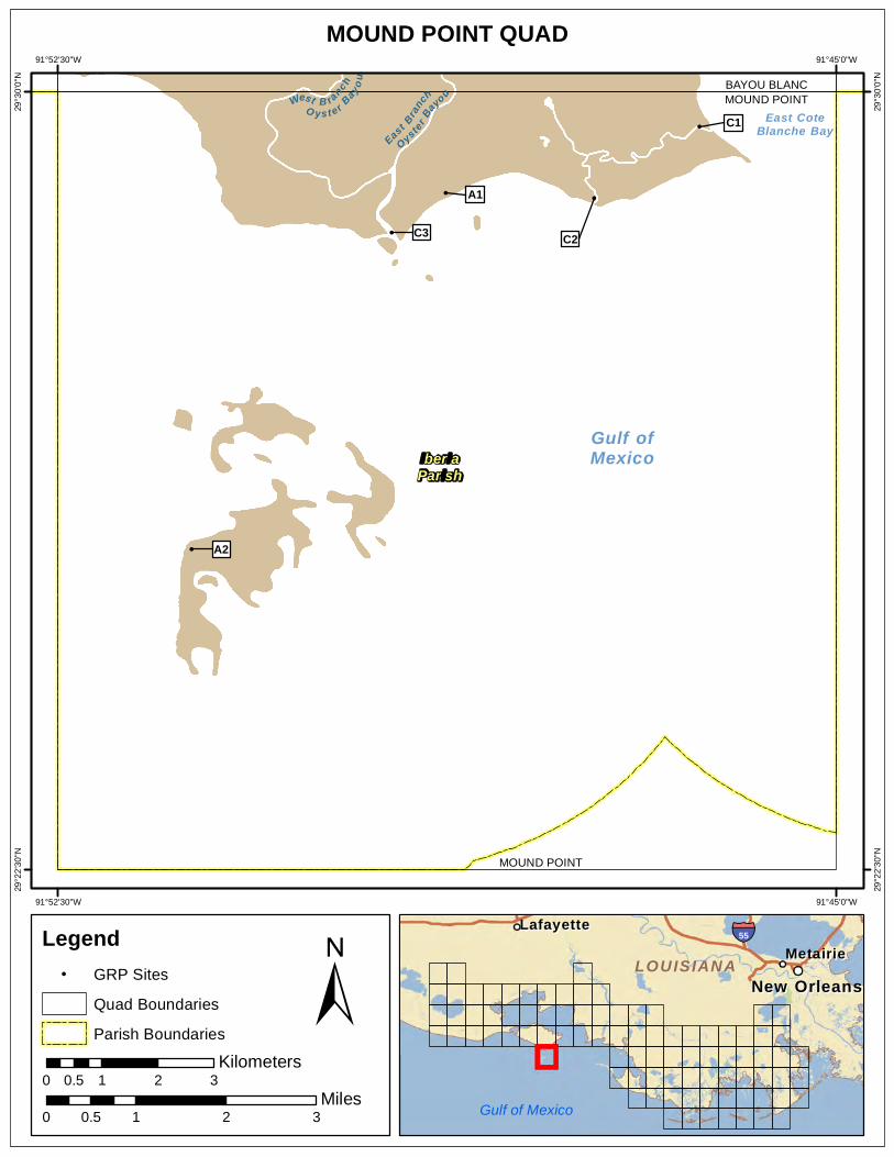
91°52'30"W 91°45'0"W
MOUND POINT QUAD
Legend ! GRP Sites
Quad Boundaries
Parish Boundaries
0.5 Kilometers
0 1 2 3
Gulf of Mexico
!
!
! !
!
East Bran
ch
OysterBa
youWest B ranc h
O ys t e r Bay ou
Gulf ofMexico
East CoteBlanche Bay
A2
C3
A1
C2
C1 MOUND POINT BAYOU BLANC
MOUND POINT
29°3
0'0"
N
29°3
0'0"
N
29°2
2'30
"N
29°2
2'30
"N
IberiaParish
91°52'30"W 91°45'0"W
± Miles
0 0.5 1 2 3
MetairieMetairie LafayetteLafayette
New OrleansNew Orleans
§̈¦55
LOUISIANALOUISIANA

Text416:
Southeast Louisiana Area Contingency Plan Sensitive Site Index
Site Information: A1 Location Information Name: Skimmer Colony Parish: Iberia
Quad Name: Mound Point
Priority: A Quad Number: 2909134
Site Alias: None Mile Marker:
Managed (Y/N)?: Y - Wildlife Area Site Description: Sensitive Habitat
Latitude: 29° 29' 01.670" N
Longitude: 91° 48' 46.090" W
Response Considerations Site Strategy: Deferred Action Site Strategy Comments:
Site Waterbody Type: Straight Coastline
Current Wave Action: Breaking Waves >1.5 ft
Waterbody Opening: Not Applicable
Resources At Risk ESI Code: 6A/2A/7
ESI Description 6A: Gravel beaches / 2A: Exposed Wave-cut Platform in clay / 7: Exposed tidal flats
Resources At Risk Comments:
Skimmer Colony
Contact Information Contact: N/A Special Contact:
Site Statistics Submitted By LDWF-DJ Garland and Cassidy Lejeune
Submit Date: 2013.04.16
State Submitter: LDWF/Lafourche Parish
State Comments:
Friday, March 21, 2014

Text416:
Southeast Louisiana Area Contingency Plan Sensitive Site Index
Site Information: A2 Location Information Name: Shell Keys National Wildlife Refuge Parish: Iberia
Quad Name: Mound Point
Priority: A Quad Number: 2909134
Site Alias: N/A Mile Marker:
Managed (Y/N)?: Y - Wildlife Refuge Site Description: State Refuge part of National Wildlife
Refuge Latitude: 29° 25' 35.502" N
Longitude: 91° 51' 12.870" W
Response Considerations Site Strategy: Deferred Action Site Strategy Comments:
Site Waterbody Type: Straight Coastline
Current Wave Action: Breaking Waves >1.5 ft
Waterbody Opening: Not Applicable
Resources At Risk ESI Code: 10A
ESI Description 10A: Salt- and brackish-water marshes
Resources At Risk Comments:
Sensitive habitat - exposed reef system - large bird loafing area
Contact Information Contact: USFWS Special Contact:
Site Statistics Submitted By LDWF-DJ Garland and Cassidy Lejeune
Submit Date: 2013.04.16
State Submitter: LDWF/Lafourche Parish
State Comments:
Friday, March 21, 2014
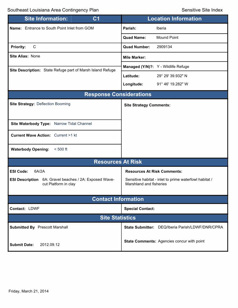
Text416:
Southeast Louisiana Area Contingency Plan Sensitive Site Index
Site Information: C1 Location Information Name: Entrance to South Point Inlet from GOM Parish: Iberia
Quad Name: Mound Point
Priority: C Quad Number: 2909134
Site Alias: None Mile Marker:
Managed (Y/N)?: Y - Wildlife Refuge Site Description: State Refuge part of Marsh Island Refuge
Latitude: 29° 29' 39.932" N
Longitude: 91° 46' 19.282" W
Response Considerations Site Strategy: Deflection Booming Site Strategy Comments:
Site Waterbody Type: Narrow Tidal Channel
Current Wave Action: Current >1 kt
Waterbody Opening: < 500 ft
Resources At Risk ESI Code: 6A/2A
ESI Description 6A: Gravel beaches / 2A: Exposed Wave-cut Platform in clay
Resources At Risk Comments:
Sensitive habitat - inlet to prime waterfowl habitat / Marshland and fisheries
Contact Information Contact: LDWF Special Contact:
Site Statistics Submitted By Prescott Marshall
Submit Date: 2012.09.12
State Submitter: DEQ/Iberia Parish/LDWF/DNR/CPRA
State Comments: Agencies concur with point
Friday, March 21, 2014

Text416:
Southeast Louisiana Area Contingency Plan Sensitive Site Index
Site Information: C2 Location Information Name: Oyster Bayou (east branch) at GOM Parish: Iberia
Quad Name: Mound Point
Priority: C Quad Number: 2909134
Site Alias: None Mile Marker:
Managed (Y/N)?: Y - Wildlife Refuge Site Description: State Refuge part of Marsh Island Refuge
Latitude: 29° 28' 58.546" N
Longitude: 91° 47' 20.076" W
Response Considerations Site Strategy: Deflection Booming Site Strategy Comments:
Site Waterbody Type: Narrow Tidal Channel
Current Wave Action: Current >1 kt
Waterbody Opening: < 500 ft
Resources At Risk ESI Code: 10A/2A
ESI Description 10A: Salt- and brackish-water marshes / 2A: Exposed Wave-cut Platform in clay
Resources At Risk Comments:
Sensitive habitat - inlet to prime waterfowl habitat / Marshland and fisheries
Contact Information Contact: LDWF Special Contact:
Site Statistics Submitted By Prescott Marshall
Submit Date: 2012.09.12
State Submitter: DEQ/Iberia Parish/LDWF/DNR/CPRA
State Comments: Agencies concur with point
Friday, March 21, 2014

Text416:
Southeast Louisiana Area Contingency Plan Sensitive Site Index
Site Information: C3 Location Information Name: Oyster Bayou at GOM Parish: Iberia
Quad Name: Mound Point
Priority: C Quad Number: 2909134
Site Alias: None Mile Marker:
Managed (Y/N)?: Y - Wildlife Refuge Site Description: State Refuge part of Marsh Island Refuge
Latitude: 29° 28' 38.741" N
Longitude: 91° 49' 17.215" W
Response Considerations Site Strategy: Deflection Booming Site Strategy Comments:
Site Waterbody Type: Narrow Tidal Channel
Current Wave Action: Current >1 kt
Waterbody Opening: < 500 ft
Resources At Risk ESI Code: 10A/2A/7
ESI Description 10A: Salt- and brackish-water marshes / 2A: Exposed Wave-cut Platform in clay / 7: Exposed tidal flats
Resources At Risk Comments:
Sensitive habitat - inlet to prime waterfowl habitat / Marshland and fisheries
Contact Information Contact: LDWF Special Contact:
Site Statistics Submitted By Prescott Marshall
Submit Date: 2012.09.12
State Submitter: DEQ/Iberia Parish/LDWF/DNR/CPRA
State Comments: Agencies concur with point
Friday, March 21, 2014
Appendix A: GRP Content Contributors
Captain Peter Gautier Captain David McClellan Captain Jonathan Burton Brian Wynn Karolien Debusschere David Gisclair Rebecca Broussard Chris Boudreaux Duval Arthur Earl Eues Prescott Marshall Todd Folse Ann Howard Chip McGimsey Kyle Jellison Jeff Dauzat Laura Carver Nicholas LaCroix LCDR Keith Smith LCDR Chance Greene LCDR Lushan Hannah Brian BlackTanner Kneese Fernando Terceros Sarah Clavo Terry Posey Ronald Johnson Cliff Collins
Federal On-Scene Coordinator Federal On-Scene Coordinator Federal On-Scene Coordinator
Louisiana Oil Spill Coordinators Office Louisiana Oil Spill Coordinators Office Louisiana Oil Spill Coordinators Office Vermilion Parish OEP Lafourche Parish OEP Saint Mary Parish OEP Terrebonne Parish OEP Iberia Parish OEP Coastal Protection and Restoration Authority Coastal Protection and Restoration Authority
State Historic Preservation Officer National Oceanic and Atmospheric Administration Louisiana Department of Environmental Quality Louisiana Department of Wildlife and Fisheries
Louisiana Department of Natural Resources U.S. Coast Guard U.S. Coast Guard U.S. Coast Guard U.S. Coast Guard The Response Group The Response Group The Response Group Oil Mop Environmental Services Oil Mop Environmental Services Oil Mop Environmental Services
Appendix B: GRP Comments/Corrections/Suggestions
If you have any questions regarding this document or find any errors, please notify the following agency: U.S. Coast Guard MSU Morgan City Phone number: (985) 380-5330 Internet/E-mail Address: [email protected]
Address: Commander U.S. Coast Guard
800 David Drive Morgan City, LA 70380
Attn: Brian Black
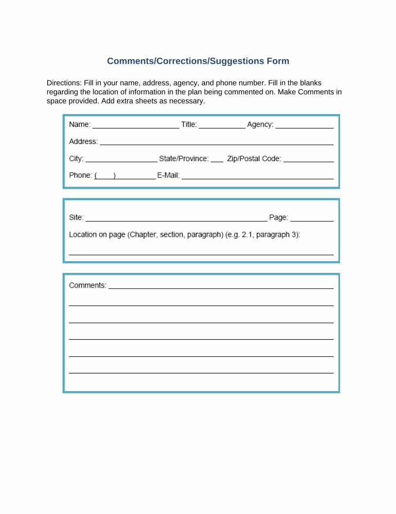
Comments/Corrections/Suggestions Form
Directions: Fill in your name, address, agency, and phone number. Fill in the blanks regarding the location of information in the plan being commented on. Make Comments in space provided. Add extra sheets as necessary.