i. introduction2 ii. location and description...
TRANSCRIPT

Village of Mt. Horeb Urban Service Area Amendment Request
VANDEWALLE & ASSOCIATES 1 Amended Draft: April 2008
I. INTRODUCTION......................................................................................................... 2
II. LOCATION AND DESCRIPTION OF THE PROPOSED ADDITION TO THE URBAN SERVICE AREA........................................................................................................... 2
III. NEED.......................................................................................................................... 5 A. VILLAGE PLANS 5 B. PROPOSED AMENDMENT 5
IV. PROPOSED DEVELOPMENT PATTERN........................................................................ 6
V. DEVELOPMENT PHASING.......................................................................................... 6
VI. URBAN SERVICE PROVISIONS .................................................................................. 6 A. UTILITY SERVICES 7
1. Sanitary Sewer .................................................................................................................................. 7 a. Wastewater Collection ............................................................................................................ 7 b. Wastewater Treatment............................................................................................................. 7
2. Water.................................................................................................................................................. 8 a. Distribution.................................................................................................................................. 8 b. Supply and Demand ................................................................................................................ 8 c. Storage ....................................................................................................................................... 8
B. NATURAL, AND CULTURAL RESOURCES 8 1. Natural Resources ............................................................................................................................ 8 2. Cultural Resources ........................................................................................................................... 9
C. PUBLIC SAFETY 9 1. Fire Department/Emergency Medical Services .......................................................................... 9 2. Police.................................................................................................................................................. 9
D. PUBLIC WORKS 9 1. Storm Water Management .......................................................................................................... 10 2. Transportation ................................................................................................................................. 11 3. Parks And Open Space................................................................................................................. 11 4. Schools ............................................................................................................................................. 11
VII. NEEDS ASSESSMENT........................................................................................... 12
A. EMERGING ENVIRONMENTAL PROTECTION 12 B. QUARRY AND PIT AREAS 12 C. LONG-RANGE UTILITY SYSTEM INVESTMENTS 12 D. LANDS CURRENTLY NOT ON THE MARKET 12 ATTACHMENT 1: VILLAGE OF MT. HOREB NORTHEAST NEIGHBORHOOD PLAN 13 ATTACHMENT 2: PLAN COMMISSION AND VILLAGE BOARD RESOLUTIONS 15 ATTACHMENT 3: MT. HOREB URBAN SERVICE AREA HOUSING UNIT AND LAND USE ANALYSIS 17 ATTACHMENT 4: SCHROEDER AREA PROPOSED LOT LAYOUT 19 ATTACHMENT 5: POTENTIAL SEWER LAYOUT, LUKKEN PROPERTY 21 ATTACHMENT 6: VILLAGE OF MT. HOREB WASTEWATER TREATMENT STRATEGIC UPDATE 23 ATTACHMENT 7: WATER DISTRIBUTION SCHEMATICS, CTH ID 25

Village of Mt. Horeb Urban Service Area Amendment Request
VANDEWALLE & ASSOCIATES 2 Amended Draft: April 2008
I. Introduction The purpose of the proposed amendment is to allow the Village of Mt. Horeb to provide sanitary sewer, water, and other urban services to parcels of land located on the northeast side of the Village.
The Village of Mt. Horeb has been working on plans for continued growth of the Village since the early 1990’s. This work includes the Village of Mt. Horeb East Corridor Land Use Plan (2001), the Village of Mt. Horeb Comprehensive Plan (2005), and the Village of Mt. Horeb Outdoor Recreation Plan (2005), and the Village of Mt. Horeb Northeast Neighborhood Plan (2007). (see Attachment 1)
The Town of Springdale is aware of the Village’s plans for this area. Town representatives were involved in the planning process for the Village of Mt Horeb Northeast Neighborhood Plan, which details the planned land uses for the USAA area. The Town received a copy of the Public Hearing Draft of the Plan and was notified of the hearing. The Town presented no objections to the Plan recommendations.
II. Location and Description of the Proposed Addition to the Urban Service Area The proposed addition to the Urban Service Area includes land totaling approximately 339 acres, located adjacent to the current Urban Service Area The land is currently located in the Towns of Springdale and Blue Mounds. The area is held by a number of property owners. The property is primarily undeveloped farmland and woodland.
The proposed addition is located adjacent to current Urban Service Area and directly north and east of existing development. Map 1 shows the location of the proposed expansion area in relation to the Village.

Village of Mt. Horeb Urban Service Area Amendment Request
VANDEWALLE & ASSOCIATES 3 Amended Draft: May 2008
Map 1: Project Location and Planned Land Use

Existing Stormwater
S
78
18 151
ID
Schlapbach Creek
Additional Water Quality Improvements
Park
Storm- water
Storm- water
Storm- water
Storm- water
Storm- water
Stormwater
2
2
Fox Run Rd
Brookw
ood Dr
Tel
emar
k P
kwy
Brian St
Ala
n D
r
Manor Dr
Getz R
d
Witte R
d
Hollfeld
er Dr
Ridgeview Rd
78
92
School Site
Private Park
Military Ridge Trail
The Village of Mount Horeb
USA AMENDMENT REQUEST
LEGEND
M A P 1 : P R O J E C T L O C A T I O N & F U T U R E L A N D U S E
0' 400' 800' 1600'
Planned Land Use
Existing Stormwater PondPlanned Stormwater Pond
Existing Major RoadsExiting RoundaboutPlanned RoundaboutMilitary Ridge TrailPlanned Bike and/or Pedestrian Trails
Planned General BusinessPlanned Neighborhood CommercialPlanned Mixed ResidentialPlanned Two Family ResidentialPlanned Single Family ResidentialPlanned School Site with PlaygroundPlanned Private Park & Open SpacePlanned Stormwater Management AreasPlanned Conservancy, Environmental Corridor & Woodlands
Proposed Urban Service Area Boundary
Existing Urban Service Area Boundary
General BusinessOfficeGeneral IndustrialMixed ResidentialTwo Family ResidentialSingle Family Residential (Sewered)Single Family Residential (Rural)InstitutionalAgriculture/Rural/VacantPublic Open SpaceWoodlands
Existing Land Use
NOTE: Stormwater management facilities and local road networks illustrated on this plan are conceptual and for illustrative purposes. For instance, the pattern of local roads depicted is intended to communicate that the Village will encourage connectivity and internal flow when evaluating planned transportation improvements. Those illustrated on this map are not intended to be the precise locations or alignments. The specific local road network layout and locations of stormwater management facilities will be refined upon more detailed engineering study prior to, or during preliminary plat development.
Created: November 8, 2007Revised: April 17, 2008, May 5, 2008
2
Initial planning by Vandewalle & Associates, preliminary engineering by Held Engineering Associates Inc..
2007

Village of Mt. Horeb Urban Service Area Amendment Request
VANDEWALLE & ASSOCIATES 5 Amended Draft: May 2008
III. Need A. Village Plans
The Village of Mt. Horeb Comprehensive Plan shows the USAA as “planned neighborhood”, a mix of residential development types and institutional, park, office, and business uses. The recently adopted Village of Mt. Horeb Northeast Neighborhood Plan gives more specific development plans for the area. The Village’s recently updated Official Map recommends an extension of a collector street to provide a connection from CTH ID to STH S through the USAA.
On August 13, 2007, the Village of Mt. Horeb Plan Commission passed Resolution #2007-33, stating that the plans for this area are consistent with the goals and objectives of the Comprehensive Plan, and authorizing the request to amend the Urban Service Area. On September 5, 2007, the Village of Mt. Horeb Board adopted Resolution #2007-24, stating its support for the Urban Service Area amendment (see Attachment 2).
The Village has been very consistent in requiring new growth to be in the USA. It is the Village’s intent to grow in a compact and orderly manner rather than to “leap frog”. The proposed expansion area is adjacent to the current USA.
B. Proposed Amendment The Village is proposing to add approximately 339 acres to the Urban Service Area. The Northeast Neighborhood Plan map (Attachment 2) shows the planned land uses for the USAA.
The table below shows details regarding the planned land uses for the area. Single-family development comprises a large portion of the areas shown for development, with smaller amounts of two-family and mixed residential development. The single-family development will serve mainly families, and the multi-family will serve a mix of residents, including potential elderly and disabled residents. A large portion of the USAA is planned for park and public open space, and conservancy environmental corridor & woodlands. An area of general business is planned for the southern portion of the USAA along CTH ID and Telemark Parkway. Some neighborhood business is indicated for the areas near the intersection of STH 78 and CTH S. A planned school site is located on the north side of the USAA, along CTH S.
According to Dane County Community Analysis and Planning Division, the Mt. Horeb USA should not exceed 2,912 acres. With the current USA at 2,214 acres, the Village has the potential to add 698 acres to the USA (see Attachment 3).

Village of Mt. Horeb Urban Service Area Amendment Request
VANDEWALLE & ASSOCIATES 6 Amended Draft: May 2008
IV. Proposed Development Pattern
Planned Land Uses Gross Acres
% of Total Acres
Existing Dev.
Environmental Corridor
Housing Units
Single-family 62.6 18.5% 2.3 Two-family 0.3 0.1% Mixed residential 10.5 3.1%
***Up to 480
Commercial 11.1 3.3% ROW 37.6 11.1% 8.4 - - School site 17.0 5.0% - - - Private Park & Other Open Space
5.4 1.6% - -
Conservancy, Environmental Corridor, Woodlands*
119.7 35.3% 119.7 -
Stormwater Management** 16.0 4.7% 7.1 - Agriculture/Rural/Vacant 58.7 17.3% Total 338.9 100% 17.8 119.7 Up to 408 All acres in the Town of Springdale and Blue Mounds *This category includes environmental corridor, public park area, and the Military Ridge Trail corridor. **The total amount of acres needed for stormwater management will depend on the final design and layout of the development. ***The actual number of housing units will depend on the final layout of the residential developments within the USAA. Up to 408 residential units can be accommodated with the current capacity of the Brookwood and Wayside pumping stations.
V. Development Phasing No formal phasing plan is currently in place for the USAA. However, it is expected that the Schroeder property on the southern side of the USAA will be developed within the next 5 years (see Attachment 4). However, all development is anticipated to occur in the next 10 years as a result of the lack of property owners within the existing USA who are willing to develop their lands.
The USAA is part of the 20-year growth area designated in the Village of Mt. Horeb Comprehensive Plan. The growth area has been designed to provide enough land for approximately 25-35 years of growth at a moderate rate, incorporating a market flexibility factor. The detailed Neighborhood Plan is meant to provide a clear understanding of the Village’s overall expectation for the future development of the planning area, when land owners are ready to develop.
VI. Urban Service Provisions It is intended that the proposed USA expansion areas be provided with the full range of urban services when urban development occurs. The full range of services would include public sanitary sewer, public water, police and fire protection, and streets and public works maintenance and management services.
Village of Mt. Horeb Urban Service Area Amendment Request
VANDEWALLE & ASSOCIATES 7 Amended Draft: May 2008
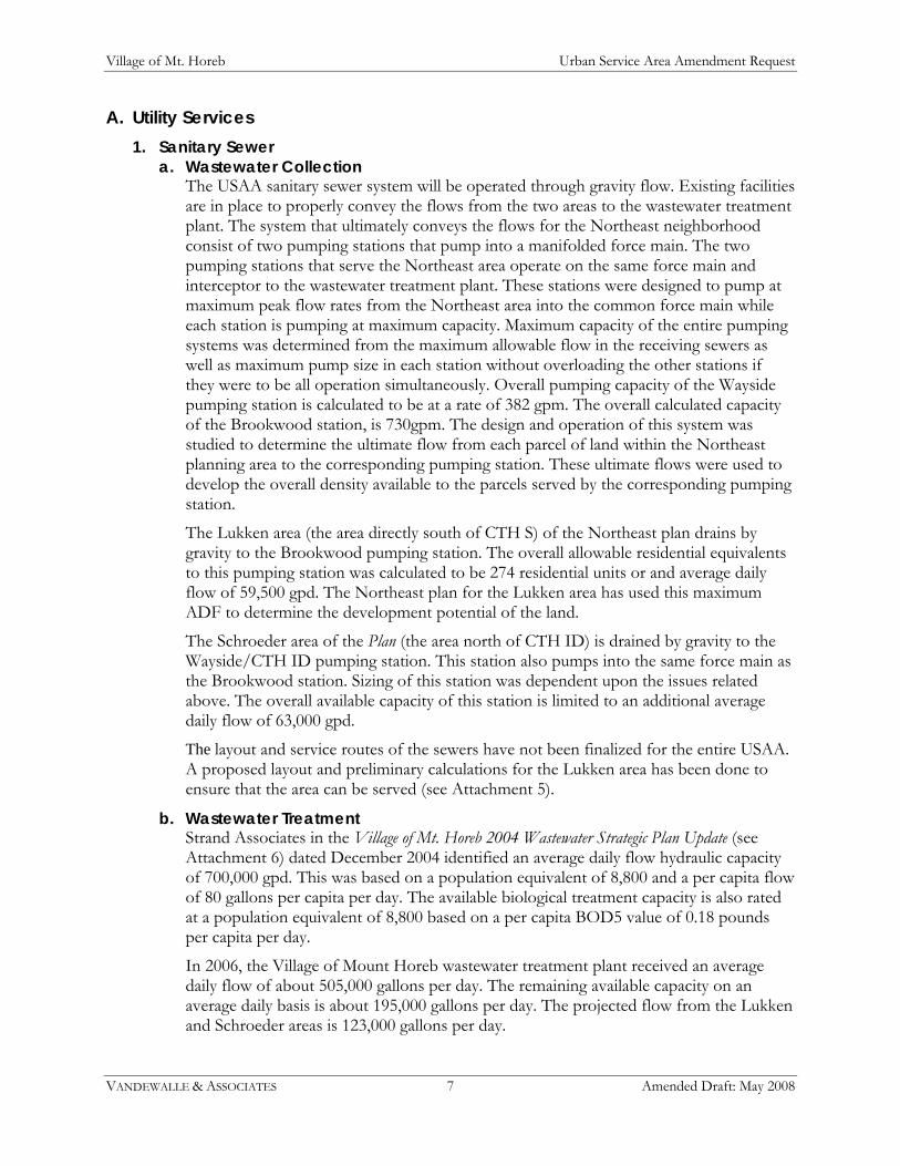
A. Utility Services 1. Sanitary Sewer
a. Wastewater Collection The USAA sanitary sewer system will be operated through gravity flow. Existing facilities are in place to properly convey the flows from the two areas to the wastewater treatment plant. The system that ultimately conveys the flows for the Northeast neighborhood consist of two pumping stations that pump into a manifolded force main. The two pumping stations that serve the Northeast area operate on the same force main and interceptor to the wastewater treatment plant. These stations were designed to pump at maximum peak flow rates from the Northeast area into the common force main while each station is pumping at maximum capacity. Maximum capacity of the entire pumping systems was determined from the maximum allowable flow in the receiving sewers as well as maximum pump size in each station without overloading the other stations if they were to be all operation simultaneously. Overall pumping capacity of the Wayside pumping station is calculated to be at a rate of 382 gpm. The overall calculated capacity of the Brookwood station, is 730gpm. The design and operation of this system was studied to determine the ultimate flow from each parcel of land within the Northeast planning area to the corresponding pumping station. These ultimate flows were used to develop the overall density available to the parcels served by the corresponding pumping station.
The Lukken area (the area directly south of CTH S) of the Northeast plan drains by gravity to the Brookwood pumping station. The overall allowable residential equivalents to this pumping station was calculated to be 274 residential units or and average daily flow of 59,500 gpd. The Northeast plan for the Lukken area has used this maximum ADF to determine the development potential of the land.
The Schroeder area of the Plan (the area north of CTH ID) is drained by gravity to the Wayside/CTH ID pumping station. This station also pumps into the same force main as the Brookwood station. Sizing of this station was dependent upon the issues related above. The overall available capacity of this station is limited to an additional average daily flow of 63,000 gpd.
The layout and service routes of the sewers have not been finalized for the entire USAA. A proposed layout and preliminary calculations for the Lukken area has been done to ensure that the area can be served (see Attachment 5).
b. Wastewater Treatment Strand Associates in the Village of Mt. Horeb 2004 Wastewater Strategic Plan Update (see Attachment 6) dated December 2004 identified an average daily flow hydraulic capacity of 700,000 gpd. This was based on a population equivalent of 8,800 and a per capita flow of 80 gallons per capita per day. The available biological treatment capacity is also rated at a population equivalent of 8,800 based on a per capita BOD5 value of 0.18 pounds per capita per day.
In 2006, the Village of Mount Horeb wastewater treatment plant received an average daily flow of about 505,000 gallons per day. The remaining available capacity on an average daily basis is about 195,000 gallons per day. The projected flow from the Lukken and Schroeder areas is 123,000 gallons per day.

Village of Mt. Horeb Urban Service Area Amendment Request
VANDEWALLE & ASSOCIATES 8 Amended Draft: May 2008
2. Water a. Distribution
The existing water distribution system has been designed to accommodate Village growth in the USAA. There is a 12-inch water main routed along Brookwood Drive which extends north of County ID. A 10-inch water main extends along Telemark Parkway to the north side of County ID and splits into two 8-inch diameter stubs. These are intended to serve areas north of ID (see Attachment 7).
b. Supply and Demand The Village of Mt. Horeb operates four wells which supply water to the system. Wells No. 3, 4, 5, and 6 have capacities of 500, 550, 750, and 1,000 gallons per minute (gpm) respectively.
The well supply has a total capacity of roughly 4 million gallons per day (mgd) and a firm capacity of roughly 2.6 mgd. The firm capacity is calculated assuming the highest producing well is out of service.
In 2006, the Village had an average day water demand of 595,500 gallons per day and a maximum day pumpage of 997,000 gallons. From a system design standpoint, the system should be able to satisfy the maximum day demand with the firm supply capacity. Under current demands, the system has roughly 1.6 mgd of excess well capacity intended to facilitate future growth of the Village and perhaps account for the abandonment of Well No. 3.
The two elevated tanks have identical overflow elevations of 1,386.4 feet MSL. Pressure in the water distribution system is regulated by the water level in these tanks. DNR code states that water system pressure be in the range of 35 to 100 psi. Ground elevations in any proposed service area need to be checked to determine if the operating pressure will stay within this range. The elevation corresponding to 35 psi is roughly 1,305 ft MSL and the elevation corresponding to 100 psi is roughly 1,155 ft MSL. Area to be served outside of these elevations may require pressure reducing facilities or booster stations.
With the new 400,000 gallon elevated tank online, the Village has sufficient storage to meet peak water demands and 2,000 gpm for 2.5 hours for fire fighting needs out to around the year 2020. Village fire hydrants are fire flow tested and marked with their flow capabilities for the fire department.
c. Storage Each well facility includes water storage reservoirs with capacities of 90,000 gallons, 350,000 gallons, 110,000 gallons, and 100,000 gallons respectively. The Village has two elevated water storage tanks with capacities of 300,000 gallons and 400,000 gallons, and 600,000 gallons of ground storage.
B. Natural, and Cultural Resources 1. Natural Resources
The proposed addition contains some mature hardwood woodland, mainly south of the Military Ridge Trail. Schlapbach Creek, an Exceptional Resource Water, runs through the eastern portion of the USA addition. The area surrounding the Creek and the Trail contains steep slopes.

Village of Mt. Horeb Urban Service Area Amendment Request
VANDEWALLE & ASSOCIATES 9 Amended Draft: May 2008
According to CAPD mapping, no portion of the areas currently planned for development contains wetland or floodplain.
2. Cultural Resources No known historic structures or archeological resources are located in the proposed USA addition area.
C. Public Safety 1. Fire Department/Emergency Medical Services
The proposed USAA will be served by fire hydrants that will be added as part of the utility improvements. The nearest hydrants are currently in the developed single-family areas south of the USAA.
The Mount Horeb Volunteer Fire Department and Emergency Medical Service provides BLS-EMS, rescue, fire prevention, fire suppression, hazmat, first responder control, public fire and EMS education for the Mount Horeb Area Fire District. Municipalities included in the district are villages of Mount Horeb and Blue Mounds; Townships of Blue Mounds; Cross Plains, Perry, Primrose, Springdale, and Vermont; all in Dane County, Wisconsin. The Service protects 13,000 people living in an area of 132 square miles. The department is a municipal department with 65 members all operating on a volunteer status, and one full-time fire chief.
The fire station, housing both fire and EMS services, is located nearby at 120 South First Street in the Village of Mt. Horeb, approximately 1.5 miles from the proposed USA addition. The anticipated response time to the addition area is approximately 4-5 minutes.
The District has three engines with tanks, two ambulances, one ladder, and three command cars. The ISO fire rating for the Village is 3.
2. Police The proposed USA addition will be served by the Village Mt. Horeb Department. The Police department facility is located nearby at 222 East Front Street. The building contains administrative office space, a booking area, interview rooms, a conference room, a dispatch area, a large squad room, evidence processing and storage areas, and an attached police garage.
The Mount Horeb Police Department is a full service 24-hour a day police department. A staff of ten full-time and eight part-time officers serve the Village of Mount Horeb. All officers are responsible for patrol duties in addition to their assigned special tasks.
D. Public Works The Village offers a full range of services, including storm water management, an integrated transportation system, a park and open space system. These systems are described in more detail below. The Village also provides snow removal and refuse collection. Refuse and recycling pickup is accomplished through contract with a private waster hauler. The Village collects recyclables as required by the State of Wisconsin. The Village also provides electric service to this area and recently added a large electric substation on CTH S to serve future development.

Village of Mt. Horeb Urban Service Area Amendment Request
VANDEWALLE & ASSOCIATES 10 Amended Draft: May 2008
1. Storm Water Management It is anticipated that large regional basins will be constructed as depicted in the Northeast Neighborhood Plan. Smaller, private basins may be necessary on commercial lots to further control oil and grease. Private basins are required to have a long term maintenance agreement on place prior to construction that allow the Village to perform inspections and maintenance if the property owner is not performing the proper operation and maintenance of the stormwater management features. The Village is currently investigating the creation of a stormwater utility as a further funding method for management, maintenance, and operation of the Village owned basins.
Stormwater management measures will mostly consist of large regional ponds to reduce thermal impacts and peak discharge rates from the development. The proposed stormwater management features that have been depicted on the plan will meet or exceed the requirements that Dane County has required the Municipalities to adopt. Specifically the ponds will be designed for the following:
Trap at least 80% total suspended solids and the 5 micron particles. Control thermal pollution by using the TURM model for runoff leaving the basins and
entering Schlapbach Creek. Control the 10-year post-development storm to the 10-year pre-development storm
discharge rate. Where appropriate, require infiltration to the Dane County standards. However due to
shallow bedrock over a majority of the site, separation distances may be problematic. Rain gardens have been required in other developments within the Village to meet the infiltration goals.
Meet or exceed NR 151 requirements for stormwater discharges.
By providing the sediment removal rates and the thermal reductions required within the ordinance, that actual pond discharge would control the 100-year event to pre-development levels. It is anticipated that the proposed ponds would function at the same level of efficiency in relation to peak discharge rates. Area upstream of the Brookwood Road crossing of Schlapbach Creek will contain a small water quality pond to treat run-off from the currently developed portion of the Village. These water quality ponds will further protect the headwaters of Schlapbach Creek that currently receive untreated waters from the Village. It is anticipated that this pond will be constructed during the installation of the proposed Brookwood crossing of the creek.
Stormwater management controls and downstream protection will be required per local ordinance. For areas to develop that are tributary to a planned regional basin, the basins shall first be constructed. The developments erosion control plan shall be reviewed and permitted only if it meets the Dane county requirements for sediment loss rates (7.5 tons/acre/year) as well the DNR standards. A rigorous review process is undertaken by the Village in order to protect the Schlapbach Creek watershed to the maximum extent practicable. Basins that receive water from the proposed developments will be required to be constructed in the initial stage of construction, prior to any additional earth moving operations.

Village of Mt. Horeb Urban Service Area Amendment Request
VANDEWALLE & ASSOCIATES 11 Amended Draft: May 2008
2. Transportation The transportation system for the proposed urban service area expansion will follow the transportation plan included in the Mt. Horeb Comprehensive Plan, recommendations of the Official Map, and the transportation recommendations of the Northeast Neighborhood Plan.
The Northeast Neighborhood Plan map depicts recommendations for highways, major streets, local streets, and bike and pedestrian routes. In general, the proposed transportation system is designed to respond to the proposed land uses, provide an interconnected system of collector and local streets to allow easy access to neighborhoods, tie new roads into the existing network, and provide safe and effective pedestrian and bicycle access.
Sidewalks will be provided along all new streets within the development. The Military Ridge Trail provides a multi-use path with direct connection into the heart of the Village. Bicycle lanes are planned for two neighborhood collector streets and two residential collector streets. A number of off street paths are illustrated on the Northeast Neighborhood Plan map. These paths form an interconnected loop in the USAA, running along the west side of the proposed park, around the perimeter of the potential school site, along the south side of the CTH S from Brookwood Drive to STH 78, and potential extension west across STH 78 to Stewart Park. The path is envisioned as a paved pathway of 10 feet in width to accommodate two-way bicycle traffic as well as other types of activity – such as inline skating. In certain cases, off street paths may substitute for sidewalk on one side of the road as approved by the Plan Commission, A crushed gravel path, primarily for pedestrian use, is planned along Schlapbach Creek.
There is no bus service in the Village of Mt. Horeb. There is no taxi service based in the Village; however, taxis based in Madison could provide service to the area. No formal carpool organizations are based in the Village. Two programs available to residents of the Village include the Wisconsin Department of Transportation’s RIDESHARE program and the Wisconsin of Department of Administration’s Vanpool program.
3. Parks And Open Space The proposed USAA will be well-served with parks and open space. The Military Ridge Trail runs through the area, providing a multi-use path with a direct connection to the Village’s downtown. The Northeast Neighborhood Plan proposed a large new community park, located centrally in the USAA, and directly southeast of the proposed school site. In addition, much of the land north and south of the Military Ridge Trail is shown as conservancy, environmental corridor, and woodlands, with planned pedestrian/bicycle trails along Schlapbach Creek.
4. Schools The proposed development is within the Mt. Horeb Area District boundary. The Early Learning Center is located at 300 Spellman St., and the Primary Center is at 207 Academy St., both approximately 1.5 miles southwest of the proposed USAA. The Intermediate Center is located at 200 Hanneman Blvd., the Middle School is at 900 E. Garfield St., and the High School is at 305 S. 8th St., all approximately 1.5 miles southwest of the proposed USAA. In addition, the Northeast Neighborhood Plan proposes a school site on the north side of the USAA.

Village of Mt. Horeb Urban Service Area Amendment Request
VANDEWALLE & ASSOCIATES 12 Amended Draft: May 2008
VII. Needs Assessment The Village has special circumstances which contribute to the need to expand the existing USA. These issues are described below:
A. Emerging Environmental Protection and Increased Densities Responsible development in Mt Horeb must consider the slopes, shallow topsoils and high bedrock, and high quality surface water resources in the area. The historic densities in the Village reflect development patterns and practices that showed little regard for the environmental challenges of development in the driftless area. The Village is committed to pursuing more compact development through a greater emphasis on mixed use, multi-family, and attached housing forms. The Village’s detailed work on the Northeast Neighborhood Plan – the basis for this USA Amendment, which includes detailed erosion control, stormwater management and grading studies, and coordinated with Dane County Conservation and WisDNR staff – indicates that expected residential densities will be 5.5 per gross acre, versus historic practices of 3.96 per gross acre.
B. Quarry and Pit Areas There are two areas of current extraction activity within the USA, totaling approximately 38 acres. These should be eliminated from the inventory of developable areas.
C. Long-Range Utility System Investments The Village has recently invested in substantial utility expansion projects to serve the proposed USA addition area. These include a new water tower, new regional stormwater facilities, new electric substation, upgraded transportation facilities (e.g. CTH ID), and planned expansion of the wastewater treatment plant. These investments were long-planned based on the previous USA math.
D. Lands Currently Not on the Market Numerous parcels within the current USA are currently not for sale, according to contacts made during April 2008 related to the High School siting study now being undertaken by the School District and Village.

Village of Mt. Horeb Urban Service Area Amendment Request
VANDEWALLE & ASSOCIATES 13 Amended Draft: May 2008
Attachment 1: Village of Mt. Horeb Northeast Neighborhood Plan

V i l l a g e o f M o u n t H o r e b , W i s c o n s i n
N o r t h e a s t N e i g h b o r h o o d P l a n
Approved: September 24, 2007
Adopted by Planning Commission: August 6, 2007
Certified by Village Board: September 24, 2007
2007Vandewalle & Associates, Inc.VandecdMadison & Milwaukee, WisconsinShaping Places, Shaping Change

Mount Horeb Northeast Neighborhood Plan
Adopted: September 24, 2007 1
Table of Contents
Table of Contents .......................................................................................................... 1
Introduction ................................................................................................................... 3
Planning Process ........................................................................................................... 5Map 1: Existing Conditions ............................................................................................................................................ 7
Summary of Existing Conditions .................................................................................. 9A. Location ........................................................................................................................................................................ 9B. Natural Features .......................................................................................................................................................... 9C. Existing Land Use Pattern ......................................................................................................................................... 9D. Existing Transportation Facilities ............................................................................................................................. 9E. Recommendations of the Village of Mount Horeb Comprehensive Plan....................................................... 10F. Recommendations of the Village of Mount Horeb Comprehensive Outdoor Recreation Plan.................. 11G. Recommendation of the Official Map................................................................................................................... 12
Plan Objectives ........................................................................................................... 13
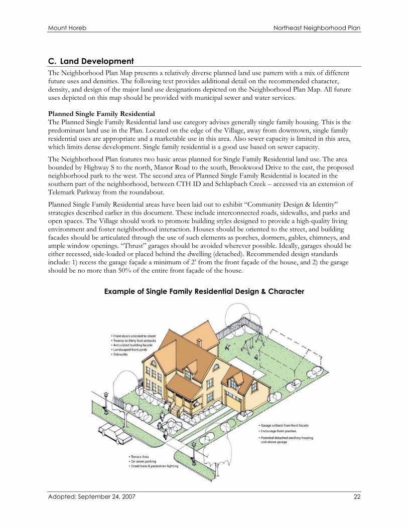
Specific Recommendations....................................................................................... 17A. Transportation ........................................................................................................................................................... 17B. Environment/Recreation......................................................................................................................................... 20C. Land Development ................................................................................................................................................... 22
Map 2: Transportation .................................................................................................................................................. 29Map 3: Neighborhood Plan ........................................................................................................................................... 31

Mount Horeb Northeast Neighborhood Plan
Adopted: September 24, 2007 2

Mount Horeb Northeast Neighborhood Plan
IntroductionThe Village of Mount Horeb Northeast Neighborhood Plan (NENP) has been prepared as a component of the Village’s Comprehensive Plan under Section 62.23, Wisconsin Statutes. This Plan is a detailed neighborhood development plan for the area to the northeast of the Village; the study area boundaries are generally defined as the area bordered by Highway 78 to the west, Highway S to the north, and Highway ID to the south (within Sections 7 and 8). The purpose of the NENP is to provide detailed recommendations for the arrangement of land uses, private development design, transportation systems, and parks and open spaces within the planning area.
This neighborhood plan follows up on general recommendations of the Village’s Comprehensive Plan adopted in 2005. The Comprehensive Plan indicated this area as a future development area and established several priorities or considerations that should be addressed concurrent with any future development, including attention to water quality, location of a future school and community park site, and an interconnected Village transportation network. The NENP was also informed by the Village’s 2005 Park & Open Space Plan. In instances where conflicts between the recommendations of the NENP and previous plans occur, the recommendations of the NENP take precedence.
This detailed plan provides a clear understanding of the Village’s overall expectations for the future development of the planning area, when land owners are ready to develop. Future development projects should be generally consistent with the NENP; however, future development needs will change over time based on market demand, the Village should also be open to considering improvements to this Plan as future private development proposals are brought forward. Subsequent detailed engineering, environmental studies, and market demand may necessitate change. The NENP is designed to provide land owners, developers, and public decision makers with a more precise vision of the desired form, pattern, and location of future growth near the northeast edge of the Village of Mount Horeb – particularly given the unusual constraints on development in this area posed by the combination of topography, limited sanitary sewer capacity, and the presence of both Schlapbach Creek and the Military Ridge State Trail.
Adopted: September 24, 2007 3

Mount Horeb Northeast Neighborhood Plan
Adopted: September 24, 2007 4

Mount Horeb Northeast Neighborhood Plan
Planning Process The process to prepare this Plan incorporated the input and expertise of various stakeholders. Village staff contacted several groups and individuals during this process in order to learn as much as possible about existing conditions, priorities, and future opportunities for the area. Interviews and focus groups included outreach with property owners, natural resources and transportation specialists and agency representative, the Village parks department, the Mount Horeb Area School District and representatives from the Town of Springdale.
Preparation of the NENP was guided by:
� Focus Groups: Park & School, Transportation, Natural Resources July 2006
� Site Assessment & Property Owner Interviews August – September 2006
� Presentation of Alternative Concepts to Plan Commission (Open to Public)
October 2006
� Focus Group Discussion of Alternatives November 2006
� Distribution of Alternative Concepts to Stakeholders November 2006
� Detailed Neighborhood Development Engineering (Held Engineering Associates)
December 2006 – June 2007
� Presentation of Draft Neighborhood Plan June 2007
� Plan Commission Public Hearing and Recommendation August 6, 2007
� Village Board (Public Hearing) September 5, 2007
� Village Board Adoption September 24, 2007
The unique characteristics of this site, particularly topography that will necessitate mass grading and limit sanitary sewer system capacity, resulted in particular considerations associated with development. To anticipate and respond to those issues, detailed engineering analysis was conducted by Held Engineering Associates, to help to ensure that the neighborhood development plan presented a development pattern that was cost feasible. D’Onofrio Kottke Associates prepared a more detailed engineering concept for the southern portion of the planning area. These more detailed analyses established the street network, grading plan, lotting pattern, and overall density balanced by sanitary sewer capacity. Vandewalle & Associates did not conduct an independent analysis of these issues. The recommendations included in this Plan are therefore based in part on the detailed work conducted by Held Engineering Associates and D’Onofrio Kottke Associates.
Adopted: September 24, 2007 5

Mount Horeb Northeast Neighborhood Plan
Adopted: September 24, 2007 6

ExistingStormwater
S
78
18 151
ID
Schlapbach Creek
Bro
okw
ood
Dr
Bro
okw
ood
Dr
Reduce Speed Limit
EXISTING CONDITIONS
2007
Adopted: September 24, 2007
0' 400' 800' 1600'
Existing Stormwater
Existing Major RoadsExiting RoundaboutMilitary Ridge Trail
Current Pump Station Service Areas
The Village of Mount Horeb
NORTHEASTNEIGHBORHOOD PLAN
General BusinessOfficeGeneral IndustrialMixed ResidentialTwo Family ResidentialSingle Family Residential (Sewered)Single Family Residential (Rural)InstitutionalAgriculture/Rural/VacantPublic Open SpaceWoodlandsEnvironmental Corridor
Existing Land Use

Mount Horeb Northeast Neighborhood Plan
Summary of Existing Conditions A. LocationThe boundaries of the NENP area are generally defined as the area bordered by Highway 78 to the west, Highway S to the north, and Highway ID to the south (within Sections 7 and 8), covering approximately 230 acres. The NENP planning area encompasses areas both in and outside of the Village’s 2007 municipal boundaries and urban service area. Portions of the planning area outside of the Village’s 2007 municipal boundaries are in the Town of Springdale. The Military Ridge State Trail bisects the southeastern portion of the planning area.
B. Natural Features The Village is situated on the Military Ridge – at the divide of two major basins. As a result of this position, natural features are an important consideration to this planning effort. The topography of the site is rolling, with several areas of steep slopes present. The steep slopes include slopes between 12 and 20% grade, as well as those areas with greater than 20% grade. Most of the steep slopes are located along small drainage ways that form the headwaters of Schlapbach Creek.
The Village is at the headwaters of Schlapbach Creek, an Exceptional Resources Water, which flows easterly from the planning area. Schlapbach Creek ultimately drains into the Upper Sugar River Watershed – which is also an Exceptional Resource Water (under NR102) and a high priority for the Wisconsin Department of Natural Resources (WisDNR).
The planning area contains areas where the depth to bedrock is fairly shallow. Throughout most of the planning area, it is less than 16 inches. This suggests that any development within the area may require blasting for grading and utilities.
Woodlands in the planning area are primarily located south of the Military Ridge Trail.
Nearly all natural features, illustrated on the Base Map/Site Analysis, are based on county and State data and have not been surveyed on site. The mapped environmental corridors consist of steep slopes, water, hydric soils, and 100 year flood plains. The compiled data provides general regional information, and may not be completely accurate for specific development purposes. Site surveys will be required for follow-up detailed planning and development of individual sites within this planning area.
C. Existing Land Use Pattern A majority of the planning area is currently agricultural, rural and vacant lands with some rural farmsteads and residences.
Adjacent to the northeastern portion of the planning area is a residential area. The intent is to weaves these existing residential areas together with the new neighborhood through pedestrian and bicycle trail connections, appropriate street connections, and logical transitions of uses.
D. Existing Transportation Facilities The planning area is served by the following arterial and collector roads:
� State Highway 78 connects Mount Horeb with municipalities to the north (Sauk City) and south (down to Illinois border). Highway 78 forms the western boundary of the planning area.
� County Highway S, from its intersection with STH 78, leads to Madison approximately 20 miles to the northeast.
Adopted: September 24, 2007 9

Mount Horeb Northeast Neighborhood Plan
� County Highway ID, from its intersection with USH 18 – 151 serves as the southern boundary of the study area.
� Brookwood Drive is a north-south connection that serves the North Cape Commons neighborhood south of CTH ID, and runs north of ID to the Brookwood pumping station.
� Several Local and Neighborhood collectors are located in and near the planning area, including: Perimeter Road, Manor Drive, Brian Street, Telemark Parkway, Waltz Road, Witte Road, and Getz Road.
The planning area is also served by the Military Ridge State Trail, which traverses the central part of the planning area. The trail, owned by the WisDNR, is a 40-mile regional bicycle and pedestrian trail that connects Dodgeville to Madison.
E. Recommendations of the Village of Mount Horeb Comprehensive Plan The NENP was prepared as a component of the Village’s Comprehensive Plan, adopted in 2005. In that regard, it carries forward and provides more detail on the recommendations in the Comprehensive Plan. The recommendations from the Comprehensive Plan that relate to the NENP area include the following.
Land Use and Natural Resources: � Most of the area was designated within the Planned Neighborhood Future Land Use Category, indicating
that the area could be planned for a carefully designed mixture of predominantly single-family uses, combined with limited duplex, multi-family, and potentially neighborhood scale commercial development.
� Work with the WisDNR and developers to fund watershed restoration to protect and improve water quality in Schlapbach Creek. This would require intensive stormwater management and erosion control at construction sites.
� Preservation of the Schlapbach Creek Environmental Corridor, and the area between Schlapbach Creek and the Military Ridge State Trail through dedication. The Village and WisDNR should work together to develop a footpath.
� Continue to require maintenance of an open space buffer along the Military Ridge Trail. Preserve a 50 – 100 foot open space buffer as public parkland along the Military Ridge Trail as the Northeast Neighborhood area is developed. This requirement is in addition to and distinct from the 65 foot deep rear yard building setback required for all lots located along the Trail.
Transportation: � Design new or expanded collector roads and an interconnected network of local streets in a manner
compatible with adjoining land uses, topography, and natural areas, including:
� Recommended extension of Brookwood Drive, including a crossing of Schlapbach Creek drainageway and Military Ridge State Trail
� Extension of Brian Street � Extension of Manor Drive
� Establish bicycle paths and routes to connect neighborhoods with schools, parks and shopping.
� Northern extensions of collector streets across the Schlapbach Creek corridor. The Plan recommended extensions of both Telemark Parkway and Perimeter and East-West connections between.
� Establishment of a footpath parallel to the Military Ridge State Trail along the Schlapbach Creek drainageway.
Adopted: September 24, 2007 10

Mount Horeb Northeast Neighborhood Plan
Community Facilities: � Plan for, officially map, and acquire a community park in the Northeast Growth Area, adjacent to the
Military Ridge State Trail to provide a connection west to Waltz and Liberty Parks, and potentially adjacent to a new school site.
� Work with the School District to identify a new school site, and potentially a shared park and recreation facility of 15-25 acres of generally level to gently sloping grade.
Utilities: � Detailed study of treatment plant and pipe capacity limitations to understand maximum density of
growth for the area.
Housing: � Require that the mix of development in the new neighborhood complies with the Village’s historic
housing mix. In general, not less than 65% of all new housing units in any new neighborhood should be single family detached, and a maximum of 20% two-family and 25% multi-family.
F. Recommendations of the Village of Mount Horeb Comprehensive Outdoor Recreation Plan The Village of Mount Horeb Comprehensive Outdoor Recreation Plan made recommendations for both active and passive recreation facilities in the NENP area. These included:
� Acquire and develop a New Northeast Community Park, containing a combination of active recreation space and natural area. The plan recommended the following associated with a Northeast Community Park:
� Location adjacent to the Military Ridge State Trail is preferred � Explore collaboration with School District to co-locate park and new school facility, ideally 15 acres
minimum in size � Explore potential for community center in this location � Prepare a detailed park development master plan to determine the facilities offered at the park, and
plan for capital improvements. Some potential facilities suggested included: playground facilities, basketball court, playfields, shelter & restrooms, a PAR course.
� Develop an Integrated Paths and Trail System. In the NENP, recommendations included:
� Off-road bicycle and pedestrian path connecting the Military Ridge State Trail to the intersection of STH 78 and CTH S, ultimately extending to Stewart Park
� Footpath walking trail in the Schlapbach Creek environmental corridor roughly paralleling the Military Ridge State Trail
� On-street bicycles routes, including dedicated bicycle lanes on major new streets, and bicycle route markers and street improvements in other locations. In particular, routes were recommended for extensions of Brookwood Drive, Brian Street, Manor Drive, Perimeter Drive, and Telemark Parkway.
� Designation of the Schlapbach Creek environmental corridor as a special use conservation area, in particular the area that includes the drainageway north to the Military Ridge State Trail.
Adopted: September 24, 2007 11

Mount Horeb Northeast Neighborhood Plan
G. Recommendation of the Official Map Under State Statutes, the Village’s Official Map reserves rights-of-way for future streets, pedestrian and bicycle paths, schools, parks, drainageways and other public facilities – both within municipal limits and its extraterritorial jurisdictions (generally extending 1.5 miles from the boundary of the Village in all directions). The Village’s Official Map has been recently updated. The key recommendation that relates to the NENP area is an extension of a collector street to provide a connection from CTH ID to STH S through the planning area. The 2007 Official Map illustrates this as an extension of Brookwood Road north to CTH S.
Adopted: September 24, 2007 12

Mount Horeb Northeast Neighborhood Plan
Plan Objectives The Mount Horeb Northeast Neighborhood Plan Map, included at the end of this document, depicts several distinct planned development groupings characterized by different land uses, mixes, and densities. These groupings are intended to be tied together by an interconnected road network and the area’s open space system. The planned road network is also designed to provide appropriate connections to the rest of the Village and region.
The development scheme is complemented by environmental and recreation corridors that anchors the planning area. The open space corridors, featuring Schlapbach Creek and the Military Ridge State Trail, follow existing areas with significant development limitations. They also could link various development areas with existing and planned recreation facilities.
The NENP is based on and reflects the following more specific objectives:
Growth Management 1. Manage the rate and intensity of planned development to coincide with the Village’s ability to provide
services and manage impacts. In the Northeast Neighborhood, overall development density is limited by sanitary sewer pumping station capacity.
2. Direct development away from Schlapbach Creek and other environmentally sensitive areas through providing substantial undeveloped and vegetated buffers; and plan for new development that does not negatively impact the environment or other property owners.
3. Attempt to work cooperatively with the Town of Springdale on issues such as municipal boundaries (e.g., making sure annexations do not create town islands), stormwater management, and road maintenance.
Development Arrangement 1. Provide attractive settings for housing, recreation, school facilities, small-scale neighborhood compatible
business, and high-quality planned commercial development in proper relationships to one another. 2. Consider the topography in the site in proposing the arrangement of uses to minimize grading costs to
the extent possible. 3. Concentrate higher intensity development (planned commercial and neighborhood commercial) near
major intersections (e.g. STH 78 and CTH S, CTH ID and Telemark Parkway). 4. Direct lower intensity, predominantly residential and active recreation uses to areas adjacent to the
Schlapbach Creek corridor and other open space areas. 5. Locate a school facility and community park considering access and ultimate site planning, proximity to
the Schlapbach Creek environmental corridor and Military Ridge State Trail, traffic circulation, bicycle and pedestrian connectivity, and stormwater management impacts.
6. Relate neighboring land uses to each other through integrated site planning, lighting and signage control, and interconnections for walking, biking, and driving.
Community Design and Identity 1. Assure that new development includes high-quality building, site, landscaping, signage, and lighting
design (consistent with Village ordinances), and fits within the context of a mid-sized Village. 2. Design new developments in a manner that respects the pedestrian as well as the automobile (e.g.,
separated walkways, connections between developments). 3. Orient new development to adjoining open space without restricting public access or views to that open
space. 4. Within planned residential areas (single-family, two-family and multi-family), promote the following
design concepts:
Adopted: September 24, 2007 13

Mount Horeb Northeast Neighborhood Plan
� Mix of housing types, lot sizes, and densities, including single family housing, condominiums, apartments, and senior housing.
� Orientation to the pedestrian through sidewalks, paths, and inter-connections. � Modest front yard setbacks and avoidance of “garage-scape” street appearance. � Use of natural stormwater management to control water quality and quantity.
Residential Streetscape Example
Transportation 1. Provide safe, convenient transportation connections for motorists, non-motorists, children, and adults
within different parts of the neighborhood and to important community facilities outside of the neighborhood.
2. Extend Brookwood Drive to provide a critical north-south connection between the north and south sides of the neighborhood across the Schlapbach Creek environmental corridor while maintaining residential speeds on that street, and in particular in the area of the potential school facility and community park. The dispersion of neighborhood cut-through traffic should be achieved through providing multiple connections with CTH S and throughout the Northeast Neighborhood area.
3. For planned local streets, emphasize safety, access and connectivity over moving traffic quickly. 4. Provide bike and pedestrian routes through the environmental corridor, park and school sites, and along
neighborhood streets. 5. Prohibit driveway access onto STH 78, CTH S, and CTH ID and minimize driveway access onto
collectors, such as Brookwood Drive When such streets are built or reconstructed, consider traffic control features to control speeds and increase pedestrian and bicyclist safety, including pedestrian refuge medians, bulb-outs at intersections, and bike lanes.
Adopted: September 24, 2007 14
Mount Horeb Northeast Neighborhood Plan
Open Space and Recreation 1. Protect and buffer the Schlapbach Creek environmental corridor and other natural resources, and
recognize development opportunities and constraints that these features present. 2. Recognize that environmentally constrained lands shown in this Plan have been mapped from
generalized sources, and that actual conditions may vary. Refine the boundaries of environmentally constrained lands as development projects are proposed, with refinements based on actual site conditions.
3. Encourage neighborhood and site development design that responds to, and is sensitive towards water quality issues.
4. Pursue the dedication and acquisition of land for the community park adjacent to the Schlapbach Creek environmental corridor.
5. Reserve low-lying areas for stormwater management basins. Develop an on-line stormwater management basin in the Schlapbach Creek drainage way. Encourage regional stormwater basins wherever possible. Design stormwater management facilities to reduce pollutants entering surface water from developed properties, considering features such as bioretention, vegetated swales, infiltration trenches, and filter/buffer strips.
6. Use low-impact street design techniques for roads crossing and adjacent to environmentally sensitive lands to minimize surface water pollution.
Adopted: September 24, 2007 15

Mount Horeb Northeast Neighborhood Plan
Adopted: September 24, 2007 16
Mount Horeb Northeast Neighborhood Plan
Specific Recommendations The following recommendations are intended to expand upon the above objectives and the attached Mount Horeb Northeast Neighborhood Plan Map. The recommendations are divided into three categories: A) Transportation, B) Environment/Recreation, and C) Land Development. Existing and planned roads and environmentally constrained lands establish a critical framework for the planned land use pattern.
A. TransportationThe Neighborhood Plan Map depicts recommendations for highways, major streets, local streets, and bike and pedestrian routes based on land use, environmental constraints, and travel patterns. In addition, the Village should work cooperatively with surrounding governments on future road alignments and maintenance.
Specific development proposals and detailed traffic engineering may justify adjustments to the road plan, including slight changes to the arterial and collector road intersection points, changes in the shapes and alignments of roads, and possibly even removal of certain local roads. However, the following principles in road system and land use planning should be maintained:
� Public roads should respond to the surrounding land uses. Public rights-of-ways should be designed to standards that help reinforce travel speeds, serve the intended users of the street, and provide opportunities for pedestrian and bike travel.
� Public road connections should be made through and between parcels so that local traffic does not have to use major streets to travel between adjacent developments and subdivisions, unless this objective is prevented by topographic or environmental constraints.
� Where different categories of planned land use are shown on either side of a planned road, any approved realignment of that road should consider the reconfiguration of planned land use areas to maintain the same relationship across the road.
Major transportation recommendations of this Plan include:
� The STH 78 and CTH S Intersection provides an opportunity for realignment to more efficiently and safely move traffic through this intersection. Currently, much of the traffic commuting from the Village into the Madison area travels through this intersection – resulting in defined peaks, with relatively low volume at non-peak travel times. The current intersection is not signalized. A consideration for realignment is to design the intersection as a roundabout, providing access to an eventual westward connection. This may require re-aligning the intersection south of the existing intersection to facilitate this western connection in a location with more gentle terrain.
� Brookwood Drive is a planned neighborhood collector that has long been planned and Officially Mapped as the crossing of Schlapbach Creek and the Bike Trail, extending north to CTH S. This road will be designed with limited access, driveway cuts, and landscaping that provides a strong connection, yet maintains the residential character of the area. The connection is important for the following reasons:
� Provides an alternative north-south STH 78 connection that effectively connects the southern edge of the Village with the northern edge of the Village.
� Significantly improves safety and access for public safety concerns. � Provides a grade-separated crossing of Schlapbach Creek. � Locates the Creek and Bike Trail crossings where the road can drain into the proposed water quality
basin being required by WisDNR to reduce stormwater quality impacts to Schlapbach Creek. � Locates the Creek crossing in conjunction with the stormwater quality basin impoundment berm to
minimize disruptions to the Creek and save money.
Adopted: September 24, 2007 17

Mount Horeb Northeast Neighborhood Plan
� Coordinates with the planned location of the stormwater management basin on the north side of the Bike Trail.
Special attention will be taken to create a pedestrian friendly environment along Brookwood Drive. Crosswalks will be prevalent, and intersections will be designed to maintain safe speeds. Additional traffic calming measures should be designed to maintain safe travel speeds for both automobiles and pedestrians. In particular, a pedestrian underpass and well-signed crosswalks should be installed at the crossing between the potential school facility and the proposed community park. Brookwood Drive is planned to be routed below the Military Ridge State Trail; the path/railroad grade is currently raised nearly 25-ft above the ground at the location that Brookwood Drive crosses.
Extending Perimeter Road as the means of crossing Schlapbach Creek and the Bike Trail, as the alternative to Brookwood Drive, was closely examined by the Village Engineer during the Spring of 2007, and again in September of 2007. The Perimeter Road alternative was not recommended because it:
� Disrupted the location and design of the stormwater quality basin at the headwaters of Schlapbach Creek as approved in concept by WisDNR.
� Conflicted with the location of the stormwater quality and quantity basin planned adjacent to the north side of the Bike Trail.
� Would create an oblique crossing of the Bike Trail, thereby raising costs.
� Was not consistent with over 25 years of Comprehensive Plan or Official Map recommendations.
� Coordinate with the Town of Springdale on the alignment of Witte Road north and south of CTH S, and the extension of Brookwood Drive to CTH S.
� Recommended Street Type and Cross-sections: The Transportation Map included at the end of the document illustrates proposed street locations and cross-sections. The letters of the streets correspond with the proposed street cross-sections. The street hierarchy ranges from widest (Street A) rights-of-way to narrowest (Street D). The roads vary in width based on intensity of use. All streets should have sidewalks on both sides of the street. The following describes proposed road dimensions:
� Neighborhood Collector Streets (Street A) are proposed in two locations in the Northeast Neighborhood. The first location is an extension of Brookwood Drive and serves as a major north/south collector. This street would provide a grade-separated crossing of Schlapbach Creek. The second location is off of Springdale Street/Highway ID and provides access to future commercial uses north of Springdale Street. The recommended design and cross-sections of these streets are as follows:
� 80’ r.o.w. � 50’ pavement � Two 12’ travel lanes � Two 8’ parking lanes � Two 5’ bicycle lanes � 10’ terraces; 5’ sidewalks
� The existing portion of Brookwood Drive, located between CTH ID and Schlapbach Creek, is not recommended for widening. Traffic calming measures, however, should be considered for this area, as well as along the bike trail, school and park frontage areas to the north, including:
o Pedestrian crossing “bump-outs” or circular landscaped islands at intersections
o Speed reduction platforms
o Landscaped medians
Adopted: September 24, 2007 18

Mount Horeb Northeast Neighborhood Plan
o The retrofitting of public sidewalk along one or both sides of the existing portions of Brookwood Drive should also be evaluated. Brookwood residents, who have indicated their opposition to the extension of Brookwood to CTH S, do not wish to bear the costs of either traffic calming or sidewalk retrofits in front of their homes.
� Residential Collector Streets (Street C) are proposed throughout the Northeast Neighborhood. These streets provide primary access through residential neighborhoods and connect the Northeast Neighborhood to existing Village neighborhoods.
� 60’ r.o.w. � 34’ pavement � Two 9’ travel lanes � Two 8’ parking lanes � 7’ terraces; 5’ sidewalks
� Residential Collector Streets with Bike Lanes (Streets B1 and B2) connect residential land uses to the proposed school. For this reason, on-street bike lanes are proposed on these streets to provide a designated area for bicyclists.
Street B1 is proposed as new street connecting Alan Drive to the elementary school site on the north edge of the neighborhood.
� 70’ r.o.w. � 44’ pavement � Two 10’ travel lanes � Two 7’ parking lanes � Two 5’ bicycle lanes � 7’ terraces; 5’ sidewalks
Street B2 is proposed as an extension of existing Manor Drive, which has a 66’ r.o.w. and development on both sides of the street. Bike lanes located on Manor Drive will connect to bike lanes on Brookwood Drive Extended. Since Manor Drive has an existing 66’ wide cross section, the proposed cross section has bike lanes on both sides of the street with parking only on the north side of the street, adjacent to Manor Street fronting homes.
� 66’ r.o.w. � 37’ pavement � Two 10’ travel lanes � One 7’ parking lane on the north side of the street � Two 5’ bicycle lanes � 9.5’ terraces; 5’ sidewalks
� The narrowest streets, Low Volume Residential (Street D), are located to the interior of residential neighborhoods. These streets are designed for local traffic only.
� 60’ r.o.w. � 28’ pavement � One 12’ shared travel lane � Two 8’ parking lanes � 10’ terraces; 5’ sidewalks
� On and Off-Street Bicycle and Pedestrian Routes provide safe and convenient routes for pedestrians and bicyclists within the neighborhood, and connections between the neighborhood and other parts of the Village. Given the location of a potential school facility and community park, it is particularly important to provide accommodations for pedestrians and bicyclists. The key recommendations are as follows:
Adopted: September 24, 2007 19

Mount Horeb Northeast Neighborhood Plan
� Off Street Paths are illustrated on the Neighborhood Plan Map. These paths are illustrated to form an interconnected loop in the neighborhood, running along the west side of the proposed park, around the perimeter of the potential school site, along the south side of the CTH S from Brookwood Drive to STH 78, and potential extension west across STH 78 to Stewart Park. This is envisioned as a paved pathway of 10 feet in width to accommodate two-way bicycle traffic as well as other types of activity – such as inline skating. In certain cases, off street paths may substitute for sidewalk on one side of the road as approved by the Plan Commission.
� Schlapbach Creek Path: a 6’ wide crushed gravel path that is primarily intended to serve as a footpath is recommended to be located away from the creek, within the environmental corridor area. Locating the path away from the creek will help maintain water quality.
� On-Street Bicycle Routes: several of the streets in the neighborhood are proposed to be designed to accommodate bicycle traffic. On particular streets, 5 foot wide bicycle lanes are recommended on both sides of the street. All proposed on-street bicycle routes should be signed and properly maintained.
B. Environment/RecreationThe NENP is bisected by the Schlapbach Creek environmental corridor. Because of this critical resource in the planning area, this neighborhood plan seeks to create a connected network of open spaces consisting of undisturbed natural areas and active recreation areas tied together with paths. Overall, the planned natural and recreational areas will help define the planning area as it develops in the future.
Major environmental and recreational recommendations of the NENP include:
� Refinement and Protection of “Planned Open Space/Environmental Corridors”: Protected open space comprises more the half of the planning area. The Schlapbach Creek environmental corridor is a functional center-point of the NENP. The Environmental Corridors/Preserved Open Space delineation on the plan map includes all Dane County recognized environmental corridors, as well as additional preservation areas recommended by the Village through this Plan. New development should be discouraged in these areas. Development types on adjacent lands should be limited to those which will not impair the resource, and should ideally be buffered from the edges through space and vegetation. Generally appropriate uses within the environmental corridors include open space, non-structural recreational uses, and farming. These lands may be considered for more intensive uses if (a) detailed studies reveal that the characteristic(s) which resulted in their designation as Environmental Corridors/Preserved Open Space is not actually present, (b) approvals from appropriate agencies are granted to alter a property so that the characteristic which resulted in its designation will no longer exist, or (c) a mapping error has been identified.
Within the Schlapbach Creek environmental corridor, the Village, Dane County, WisDNR, and Upper Sugar River Watershed should collaborate on the establishment of buffer margins between yards/lots and the environmental corridor. Potential dedication of this area should be explored, or management by a homeowners association. The following are areas where the above parties could collaborate:
� Seeking County, State and Federal funding for conservation practices within the environmental corridor area
� Promoting best management practices – including “do not mow” policies and planting of native grassland species in the buffer margin
� Developing and promoting adherence to standards for the buffer area � Exploring potential enforcement mechanisms for buffer area standards
� Progressive erosion control and stormwater management: Given its location at the headwaters of Schlapbach Creek and the Upper Sugar River Watershed, the Village should practice and require progressive stormwater management. Overall, post-development stormwater runoff should not exceed
Adopted: September 24, 2007 20

Mount Horeb Northeast Neighborhood Plan
pre-development levels—both in terms of water quantity and quality. Various techniques may achieve that goal, including overland water transfer, maximum impervious surface ratios for development sites, natural landscaping, rain gardens, and site or regional detention basins. All development should be required to follow the Village’s stormwater ordinance. In addition, the Village could consider collaboration with the Upper Sugar River Watershed Association, Dane County, and the WisDNR on cooperative erosion control and stormwater management practices, identification of existing and potential erosion problems, establishment of buffer margins between yards/lots and the Schlapbach Creek environmental corridor, and competing for County, State and Federal funding to ensure the ability to adopt and enforce Best Management Practices.
The Plan map identifies conceptual areas for regional stormwater detention, based on an analysis of drainage patterns and low points.
� Development of off-street bike and pedestrian path system: A key recommendation of the Village’s 2005 Comprehensive Plan and Comprehensive Park and Outdoor Recreation Plan is a Village-wide path system – connecting existing parks and recreational resources such as Waltz Park and the Military Ridge State Trail with new neighborhoods and facilities – specifically the proposed community park and potential school facility. The bike and pedestrian routes advised in the NENP provide an important component of this Village-wide system.
� Dedication of a New Community Park: The Plan suggests a park to be located adjacent to the Military Ridge State Trail and Schlapbach Creek corridor, and in close proximity to a school site. Given the varied topography of the area, this park should contain a combination of active recreation space and natural areas. There is a strong benefit to locating the park adjacent to the potential school site in consolidating the total acreage that is required for both sites. This co-location of a community park and potential school facility also provides the opportunity for educational programs that are focused around the park. For instance, classes could use natural areas in the park for ecological studies, for instance, as a cooperative partner in the Schlapbach Creek watershed protection.
� Provision of a Private Park Associated with Multi-Family Development: A 1.5 acre private park is proposed on the western side of the NENP area. The park serves several benefits, including:
� Provides active recreational space and a central gathering place for the multi-family development. � Serves as an effective land use transition between more intensive multi-family residential
development and single-family residential development.
Adopted: September 24, 2007 21
Mount Horeb Northeast Neighborhood Plan
C. Land Development The Neighborhood Plan Map presents a relatively diverse planned land use pattern with a mix of different future uses and densities. The following text provides additional detail on the recommended character, density, and design of the major land use designations depicted on the Neighborhood Plan Map. All future uses depicted on this map should be provided with municipal sewer and water services.
Planned Single Family Residential The Planned Single Family Residential land use category advises generally single family housing. This is the predominant land use in the Plan. Located on the edge of the Village, away from downtown, single family residential uses are appropriate and a marketable use in this area. Also sewer capacity is limited in this area, which limits dense development. Single family residential is a good use based on sewer capacity.
The Neighborhood Plan features two basic areas planned for Single Family Residential land use. The area bounded by Highway S to the north, Manor Road to the south, Brookwood Drive to the east, the proposed neighborhood park to the west. The second area of Planned Single Family Residential is located in the southern part of the neighborhood, between CTH ID and Schlapbach Creek – accessed via an extension of Telemark Parkway from the roundabout.
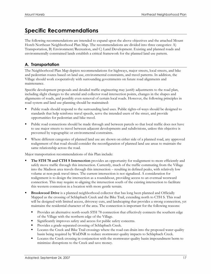
Planned Single Family Residential areas have been laid out to exhibit “Community Design & Identity” strategies described earlier in this document. These include interconnected roads, sidewalks, and parks and open spaces. The Village should work to promote building styles designed to provide a high-quality living environment and foster neighborhood interaction. Houses should be oriented to the street, and building facades should be articulated through the use of such elements as porches, dormers, gables, chimneys, and ample window openings. “Thrust” garages should be avoided wherever possible. Ideally, garages should be either recessed, side-loaded or placed behind the dwelling (detached). Recommended design standards include: 1) recess the garage façade a minimum of 2’ from the front façade of the house, and 2) the garage should be no more than 50% of the entire front façade of the house.
Example of Single Family Residential Design & Character
Adopted: September 24, 2007 22

Mount Horeb Northeast Neighborhood Plan
Planned Two-Family Residential Planned Two-Family Residential uses (typically duplexes or zero-lot line owner occupied residences) are proposed in select areas of the neighborhood to expand the range of housing options available. Proposed locations include select lots along CTH S, adjacent to the Neighborhood Business and Multi-Family residential, and the neighborhood park – located in the western portion of the neighborhood. The Planned Two-Family Residential in these locations provides a logical land use transition, while achieving a broader range of housing choices in the neighborhood.
Planned Multi-Family Residential Planned Multi-Family Residential areas are designed to provide a diversity of housing options for residents of the Village. Appropriate residential types for this land use are two-family and multiple family residences; including condominiums and apartments. Alternative housing options such as manufactured homes could fall under this land use. Multi-Family Residential areas are also appropriate for retirement or elderly care communities, including medical and other services for residents. In general, Planned Multi-Family Residential uses are proposed in the northwestern part of the neighborhood at the intersection of STH 78 and CTH S, and in the southern part of the neighborhood as a transition between Planned Commercial uses and predominantly Single-Family Residential. Adjacent to the multi-family residential, a private park is planned to serve the residents. Development and maintenance of this Private Park area would be the responsibility of the developers. In the long-term maintenance would likely be the responsibility of a residents’ association or property manager.
Example of Multi-Family Residential Design & Character
The following design guidelines should apply within the Planned Multi-Family Residential areas:
1. Incorporate architectural design that fits the context of the surrounding neighborhood. Particularly in areas near the center of the planning area, encourage layouts where buildings appear as a grouping of smaller residences.
Adopted: September 24, 2007 23

Mount Horeb Northeast Neighborhood Plan
2. Promote use of brick and other natural materials on building facades. 3. Avoid monotonous facades and box-like buildings. Incorporate balconies, porches, garden walls, varied
building and facade setbacks, varied roof designs, and bay windows. 4. Orient buildings to the street with modest front yard setbacks, bringing street-oriented entries close to
public sidewalks to increase pedestrian activity. Include private sidewalk connections. 5. Locate dumpsters and other unattractive uses behind buildings and/or screen them. 6. For parking lots and garages, (a) locate garage doors and parking lots so they are not the dominant visual
element; (b) screen parking areas from public view; (c) break up large parking lots with landscaped islands and similar features; (d) provide direct links to building entrances by pedestrian walkways physically separated from vehicular movement areas; (e) large parking garages are undesirable, but where necessary, break up facades with foundation landscaping, varied facade setbacks, and recessed garage doors.
7. Provide on-site recreational and open space areas to serve the needs of residents. 8. Provide generous landscaping of sufficient size at time of planting. Emphasize landscaping (a) along all
public and private street frontages; (b) along the perimeter of all paved areas and in islands in larger parking lots; (c) along all building foundations; (d) along yards separating land uses which differ in intensity, density or character; (e) around all outdoor storage areas such as trash receptacles and recycling bins (also include screening walls in these areas); (f) around all utility structures or mechanical structures visible from public streets or less intensive land uses
Neighborhood Commercial The Neighborhood Commercial land use designation identifies areas appropriate for neighborhood supporting retail, service and office uses that preserve residential character of the area through appropriate building scale and appearance, generous landscaping, and limited signage. The portion of the neighborhood where Neighborhood Commercial is mapped is at the southeast corner of the intersection of STH 78 and CTH S. Neighborhood Commercial areas should generally be zoned Neighborhood Business (NB).
Planned Commercial The Planned Commercial land use designation is designed for retail and commercial service uses serving both community residents and travelers. This designation is intended to allow high-quality indoor retail, commercial services, office, and institutional uses with generous landscaping, modest lighting, and limited signage. Development approvals within these areas should only be granted after submittal and public review of unified, high-quality, detailed development plans. If developed incrementally, the individual pieces should be in accordance with a well-conceived plan for the entire area. Site layouts, development scale, and building groupings should be designed to promote the proper relationships between different land uses.
The map identifies Planned Commercial Uses along CTH ID.
Adopted: September 24, 2007 24

Mount Horeb Northeast Neighborhood Plan
Example of Planned Commercial Design & Character
As the location of Planned Commercial Development at the Village’s “entryways,” development should be tastefully designed. Signs should not be allowed to clutter the landscape or present hazards to motorists. Perimeter landscaping should be used to tie the development together and soften its exterior. In many cases, lots may be fronting on a planned local access road rather than CTH ID. In these cases of reverse frontage, four-sided architecture should be required to ensure the appearance from CTH ID is attractive.
The following design guidelines should be applied in the development of these areas:
1. High quality landscaping treatment of bufferyards, street frontages, paved areas and building foundations. 2. Intensive activity areas such as building entrances, service and loading areas, parking lots, and trash
receptacle storage areas oriented away from less intensive land uses. 3. Parking lots heavily landscaped with perimeter landscaping and/or landscaped islands, along with
screening to block views from streets and residential uses. 4. Parking to the sides and rear of buildings, rather than having all parking in the front. 5. Signage that is high quality and not excessive in height or total square footage. Monument signs are the
preferred type of ground signs. 6. Location of loading docks, dumpsters, mechanical equipment, and outdoor storage areas behind
buildings and away from less intensive land uses. 7. Screening of loading docks, dumpsters, mechanical equipment, and outdoor storage areas through use of
landscaping, walls, and architectural features. 8. Limited number of access drives along arterial and collector streets.
Adopted: September 24, 2007 25

Mount Horeb Northeast Neighborhood Plan
9. Safe, convenient, and separated pedestrian and bicycle access to the site, from the parking areas to the buildings, and to adjacent commercial developments.
10. Illumination from lighting kept on site through use of cut-off luminaries. 11. High quality building materials, such as brick, wood, stone, and tinted masonry, with a de-emphasis on
corporate franchise architecture. 12. Low reflectant, solid earthtone, and neutral building colors. 13. Canopies, awnings, trellises, bays, windows and other architectural details to add visual interest to facades. 14. Variations in building height and roof line, including parapets, multi-planed, and pitched roofs and
staggered building facades (variations in wall depth and/or direction). 15. Materials on all building facades of similar quality as the front building facade. 16. Central features which add to community character, such as patios and benches.
Planned Commercial areas should generally be zoned Planned Business (PB).
Planned School Site and Community Park One of the overall objectives of this Plan was to identify a potential site for a new school facility and community park. Some of the criteria that were considered in identification of the sites included adequate acreage (15 to 20 acres minimum in combination with park); relatively level land; and adequate access for automobiles, bicycles and pedestrians. The area identified on the Neighborhood Plan for the potential school facility is located in the center of the northern portion of the neighborhood – bounded by CTH S to the north and the extension of Brookwood Drive to the east. The proposed park is located to the east of the Brookwood Drive extension, south of the school.
Due to the topography of the overall neighborhood, these were among the only feasible locations to site a use necessitating the amount of acreage required by a school and park facility. Still, several issues will need to be taken under consideration when the site plans for the school and park are developed – configuration of the school building, driveway access points to the sites, bicycle and pedestrian access to and within the sites, stormwater management impact and mitigation measures, and relationship between the potential school facility and the proposed community park. It is desired to establish strong connectivity between the school facility and the Schlapbach Creek environmental corridor to take advantage of opportunities for ecological and environmental studies opportunities. The crossing of Brookwood Drive between the potential school facility and the proposed community park will need to be carefully considered, engineered, and designed.
Additional input and planning should be considered in developing the park site, including an assessment of desired facilities and activities, to complement those offered at nearby facilities – including Waltz Park and the proposed new neighborhood park in the NENP area.
Although it is the strong recommendation of this Plan to provide a school site within the Northeast Neighborhood, if the “Planned School Site” does not develop as a school as intended, there may be an opportunity to develop up to 45 residential units on the site. The feasibility from a layout and sewer system capacity would have to be examined in greater detail if this contingency arose, which should ultimately determine the number of additional residences that could be served in this area. It is the Village’s objective to promote connectivity throughout the neighborhood through the school site and minimize cul de sacs on this site, if it is developed as anything other than a school site. The following illustration shows a potential alignment of streets and connectivity with the rest of the neighborhood should the school not be sited at this location.
Adopted: September 24, 2007 26

Mount Horeb Northeast Neighborhood Plan
Adopted: September 24, 2007 27

Mount Horeb Northeast Neighborhood Plan
Adopted: September 24, 2007 28
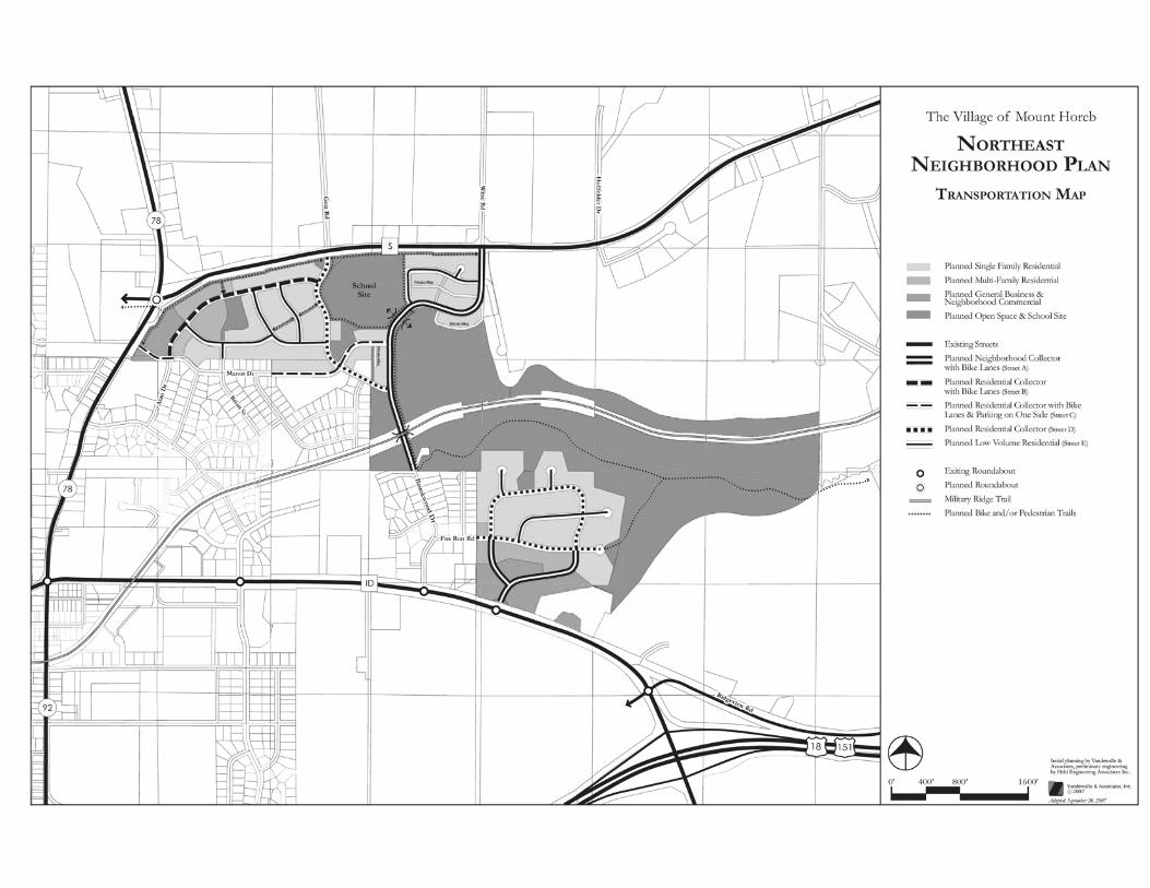

ExistingStormwater
Service by BrookwoodPumping Station allows for up to 294 Residential
Units or equivalent
Service by WaysidePumping Station allows for up to 134 Residential
Units or equivalent
S
78
18 151
ID
Schlapbach Creek
Reduce Speed L
imit
Reduce
Speed L
imit
Additional WaterQuality Improvements
Park
Storm-water
Storm-water
Storm-water
Storm-water
Storm-water
Stormwater
2
2
Private Alley
Private Alley
Private Alley
Fox Run Rd
Brookw
ood Dr
Tel
emar
k P
kwy
Brian St
Ala
n D
r
Manor Dr
Getz R
d
Witte R
d
Hollfeld
er Dr
Ridgeview Rd
78
92
School Site
Abandon existing right of way
Work with town of Springdale to align the centerline of Brookwood extended with Witte Road
Abandon existing right of way
Reconfigure road to have access from Brookwood Dr Extended
PedestrianUnderpass
PrivatePark
Military Ridge Trail
The Village of Mount Horeb
NORTHEASTNEIGHBORHOOD PLAN
LEGEND
0' 400' 800' 1600'
Planned Land Use
Existing StormwaterPlanned Stormwater
Existing Major RoadsExiting RoundaboutPlanned RoundaboutMilitary Ridge TrailPlanned Bike and/or Pedestrian Trails
Current Pump Station Service Areas
Planned General BusinessPlanned Neighborhood CommercialPlanned Mixed ResidentialPlanned Two Family ResidentialPlanned Single Family ResidentialPlanned School Site with PlaygroundPlanned Park & Public Open SpacePlanned Conservancy, Environmental Corridor & Woodlands
General BusinessOfficeGeneral IndustrialMixed ResidentialTwo Family ResidentialSingle Family Residential (Sewered)Single Family Residential (Rural)InstitutionalAgriculture/Rural/VacantPublic Open SpaceWoodlands
Existing Land Use
NOTE: Stormwater management facilities and local road networks illustrated on this plan are conceptual and for illustrative purposes. For instance, the pattern of local roads depicted is intended to communicate that the Village will encourage connectivity and internal flow when evaluating planned transportation improvements. Those illustrated on this map are not intended to be the precise locations or alignments. The specific local road network layout and locations of stormwater management facilities will be refined upon more detailed engineering study prior to, or during preliminary plat development.
Adopted: September 24, 2007
2
Initial planning by Vandewalle & Associates, preliminary engineering by Held Engineering Associates Inc..
2007
Village of Mt. Horeb Urban Service Area Amendment Request
VANDEWALLE & ASSOCIATES 15 Amended Draft: May 2008
Attachment 2: Plan Commission and Village Board Resolutions


Village of Mt. Horeb Urban Service Area Amendment Request
VANDEWALLE & ASSOCIATES 17 Amended Draft: May 2008
Attachment 3: Mt. Horeb Urban Service Area Housing Unit and Land Use Analysis
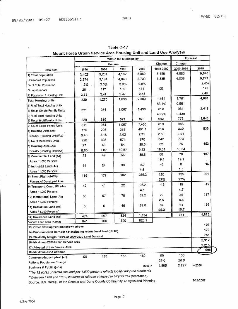

Village of Mt. Horeb Urban Service Area Amendment Request
VANDEWALLE & ASSOCIATES 19 Amended Draft: May 2008
Attachment 4: Schroeder Area Proposed Lot Layout
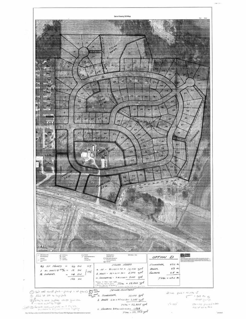

Village of Mt. Horeb Urban Service Area Amendment Request
VANDEWALLE & ASSOCIATES 21 Amended Draft: May 2008
Attachment 5: Potential Sewer Layout, Lukken Property


Village of Mt. Horeb Urban Service Area Amendment Request
VANDEWALLE & ASSOCIATES 23 Amended Draft: May 2008
Attachment 6: Village of Mt. Horeb Wastewater Treatment Strategic Update

Village of Mt. Horeb Urban Service Area Amendment Request
VANDEWALLE & ASSOCIATES 24 Amended Draft: May 2008
Attachment 6: Village of Mt. Horeb Wastewater Treatment Strategic Update(Please contact the CARPC office for more information on Attachment 6)

Village of Mt. Horeb Urban Service Area Amendment Request
VANDEWALLE & ASSOCIATES 25 Amended Draft: May 2008
Attachment 7: Water Distribution Schematics, CTH ID