i i i f n r n r i n a y n; p i ,o m n r; t j yflwimllsl ... · hoxt of roi hr, 5 r\t j t m ^,n...
TRANSCRIPT

E CTING GEOPHYSICS LTD. :
32E13SE*a32 2.1976 ATKINSON LAKE 010 NOV :
PROJECTS UNIT
i i i f n r n r i n A y n; P i ,o M n r; t J'viiiniii'iri/j Vi i; i Y ''; n :!.;Yu
yflWiMLLSL?,JrlQ'.inf'iitfiJ
D, t x : t r c inn rjri q U.o r.M??upyg r. rs t f j. A H o pufcfrAnfl i1 1 1 j r o c D n -*jc! ?i u r A;'17L' 'J, n 7j?;fii!fif) holtf h]/ f i if d o o ri Uay 177; j. do ra t A on oucJ! uf,:i ; ;,;*t C: o,, lid,, ;'n ivhofc if! roforror! to on the on idum." ur;M, f; i.- r. -o in Dfitc,5?J.u* Ihu object of tho
,;ys; I'-'f'fj u"" uirLiJ.teo DO tlio Q i? nun d cootiucf'.Avo i':c?noo In rn (;xj;hoi'fuj nXocti'nn
Yhr.j f'fi.TJ.nv.f.lnn ropnrt cnrl r.ficonpnnyirir) nnpn c!nt;f:,tAbc!.1 1C ('f Ut!: !.;l!j.-U(;O*
, . oi)?:uoycd or.*o ^,ri i- h o oroa of! m;, c s- (Jolonv l da.; (! ; h:a Woo f.- 2GO/0 nnti /itliinr.on Loko Aroo (f'.Trn fJo 0 IM ''t,;/?) f, h:a;'',:.-5.t;t of CtH;hrnno 9 Potcu[.*inc) Uf.iu;;,oicin rif i.!jtov5,0o 'Hso project ?.o fofor^of! tn f j s tho 't: tirij'' : '"'ii i'-' -H* o;.- i'Jc-'Ot tin tUo oi-oa rocilarjAcnily io r. 1 1 exton C:AGn into ( t{(:ri;':' 1 f) cif- v-Stat if) rfifoja-Gd to fiti ti'io Tdrotin
Vtici r:.'r;)ln rjrc pocDC rud rij;c; ::-!'jDVi{) 's [K; o. "i. o. l r, ; r. firn T/cuji (.'(.;Goui'f.DO c; f' 1 {'fvirrr/i.c
A

PROSPECTING GEOPHYSICS LTD.;
CHO!!!'
P 42.l20n to P 421200 j.nnluoivo
P 421200 to P 4212X2
P 42HJ.4 to P 42X14? "
Tho w; on with?,n t'tWnh tho t.XnJ.u groups nro Xocntoc!:".D tin c^tiMiicJj'n nf lh o ho.'! t of vo.lc;ntuco tht.it OKtna'Jo f r on I,1 :.)i:. t.SH!tc^tt,);u i:t'c":L;.;n f ci'OUG tho boi.'ficii; into Ontru'&Oo ThohoXt of roi hr, 5 r\t J t M ^,n {'a.K o i c to r^fin uolcnnxro inter-- .''.fiyois.K' t:.'l',11 r'.ct^" M:, (J c;,! jf i in p oJ,X ot 1 which ot^iito An n f;c;riOE(!.l t''C!r-i,'"^"':(;j^, r;5 3.'f:,t.:U,i.Yn* t J u r ;i t ^ j: o u f 'i intviuiivfjo nono of fii'MiiiU.t; f,!tfi rif't.ocj irtrjri j;f3Cko nrn found udtijxn tho
c.f'.:;h t t '.o c.|j15-UCiO :;:i?vc; u;:!:c:n
r.'irTUffi'i. Ann, ifjf.'.TnuRKOT^nAT
Tho JT? f jj, t ve 'nnflnn tfl n nurvoyo v:oro c" nd out mmr o t 300 foot .nt "
on Uu; fi?;c.-;*rii[H')uyAnfj wnptu Thohono )J,no nnd t,lorc'; c;Ur::lfiiO!' but tUa crono Ainoo ^Xong v;M,r.!i t in o
:-:. ^'itciisK^tcui t'iOX'M not chaAmuJ* Rc)B('lm;ct i-ioro.'-nr) (.'Un Jiuan nt XU[) foot. Ant o rvn .le I'.hJ.oi'i v;i??o
:cQ'J I'o.f ittj t'.c; c^otiio (lottvcDn tho tr;o (ipnrr.tfkh'O* WutnX I'lfL'i'o jt.'M.ir.Ofi f'ii tbo ct^jductiua KDIIOO fnr futuvo i-oft!!.-- Mjfl Ut:/!;',1 n?;f,' fr'.'L'iiCci !.)O the t.ir.p*
Ti'ii.i c?;,M|ni;;cnt lined in tho nui-v/oy lyftD o noanAr.o ON* 1 7:ii^il-M.!l^iJlLfM. v.'Xtti o jilip fijot co i X AnttigytiiU In
OfUiOCi" n j'Jun J'mvt c-caJ. J.nfc(ji-vaX i'?no tiotni Ftu; jvi)i.;i'i;jt;:ct3.f..'iu "i ho .vcoisJ.t.o of tho Ciiiruoy n?"u pXotfcoU on tho r',:x:ot::i^';:ny.M-?() f^p f-n f; J^^^ji f l j, m; h ta AGO fnnt. In tho , h'-.rS.wmi.i--?. XOOM tytto nf .r iuj.*voy bM;ii tho j.n--j*hfiG(? f -i rt d cu;t-*i ' i'-; f h f ; : i r. ! t ; fi t, i; -s i f t CijtllLJllLJ, h D o c ; c p n on f V f 1 1) l d fo.' c. ^ iiii ;: i t,? i.: u r cui* TC'ibcu" (":"{j,';!;;^,'.;.l (,t;o}.T;ctorJi.otxcc wr.t'ic j.)DitoXbXc f; fciriy ccciiroio cy ('!?.i!r.l?.i;a of uliiD noncSuntivdty, A cofiL'uctnr c;:;L!c.ijd by rt.tViliAcJo riij.nornXAjrotion vj'XX pi"oc3i!Co c ciui'vc f;:i.c .nrj f;.'t*r,i j-c,o;U:MK) i'-o^o'.ngD thi-ourjh 203.v o to noyotiuo end i!Cf;[: (if;(.,ln l'* (iOf;.,1", t.vjo* Uoth tiio ?,n-phooo o.nti oiit-*or-phoco i;cic:ci.f.(Hjti r.ltt.)i. ; j tUo t. : fM"D ^cjrtnroX cui'vo* The ji'C'tia b[;twoon I'.t'j ?,n^nh:.{;a fitrl m.it-of"phar,a roodinQo Duor D conductor lo C'ii i'.nt!.i,cf)tirHj r' C U'so t-ctrK'uotiviiy of the boc'y* A QDOCJ crsnr'-t'QtoJ: wunXn ocas no n tjrcntor ijovlntlan of tho In^phnco UifiiiKtnont tlsc ; f5 t h ci out- c^f^pliocc coi.i^ortcrste Tho oppDGito i,o tiH'Q of ci ()0;..;: totMjycfcnr*

PROSPF CTING GFOPHYSICS LTD.
wf.iu.Yr. ar vnr: r(Fr:Ynnnar.nrTn: sumos* ... , . .i,..*,^, s*Wfiili.i, t-- :\ . '.. -. . . ". " i" .'. , '. .'. - ' :, . ,. . . . .-, v ;. -, .f-i^^^touNs*-,., .n. ; ,;.': t ,u . SW, f ****
^ In Am JILJl^ i.y in
Tho {,;n;-n,?oy nnUJniod JTmjr fionnrato coociuctivo ^'.Ottoi;^j(j i\c^]jj^lx,^t^jl for l-0fc i ron{;0 pUi'pOOCC. AH O
in ehorc.ii;toi,'JU;tieo endnonr
f.:?.1 o Or:
f CI: t,
a fout of
hoc o to bc; fm.Lf.iu!'> id cum
of nhciut ono ftllo nrir!but ttiiti nay b G tUin io u
s.nr ( liffili Jr., {K.scolblo {'-(torn thox-o A f. rtrt octuol t5nvt;ui!3.' s iSuj .location Au vSu; i'ioAi* j, o i:
i: a i,l)0 l; t if; fjAX), (k;tf;.vf.i;.rKi Uuj cr'?;;.-cr;t loDntion nf tho
X 9 20D Font nouth of "rt" ?;ono rntJ 6 p {iOH ftjot* H; J. o uoj:y
t c* t ^"- i '' As'* oil nuipocitfi orjf.:! from bhy ).onnth of tho T. (''Ut, i Mf..f-c-f;(,f) oA:cp!tltc! df; tho PO jor i;our-o of tho
^C" /nrH! lin r, M .Ifinrjth of ohout i p 600 font nruJ couldho a vji;c';lo;Ji/ o^Li/iK^.oa of "B"
; io ct tho nant en ri of tho property csnri hoc ijLsi of .i 0 00r. foot but 5.0 c; t.111 cpon ot
; CH'Jo H, 6n;.-(:.!i:i?;o to bo alony tho ccwo t; t i.1 ut; tin;-Do cU'iko" :( tho
r,
'flu* r.i.i};voy tin thAti cAx c: .In ir. rjpoup oufclinor! on ore.UitivuIy ':,::'::I;^ {::ont|ucitjir for1 c lomjth of nbaut 400 foote 7ii"6'~'(;'i'yL': i'if.''T;'r~i^K:r":To{Vj 5.3 northiicrt ftrui thnro j. ci r: D IT; o
o:*,o JJ.no i-:or.:!c };oo;,;orjnc!0 ^( oi?o obtelnoo riru:i it trm y bo rirortnv- [10HOfcirutiorj ?,o
. PROSPrcTING GEOPHYSICS LTD.
r; f; ..UP f:'
OM ouUl.nud A (s o siavlh;:if;ot r}ij;ecfcAOH ru;?ooii tho control port
tho pi:oijr:2tyo V.joy M: a vosry oinilcr in nw pi.k ohr.ib.V,/ r-;:o r J?. ku.^tod elot'H} the CDWO ( 'entitle r.ttcl c'-y }J!:fj),y i'fjp?;cocnt nAMiloi" oonduc;tl,iro t;.;.! tori H), o TUc; d?,}.' J.ji non?.* uorticril but in oor.sn cuir.ofi it CfU'iufi to ihr; (I'eUiiOf.fito Trts^ ttto Intounity c?f feho 5.U p.loctjr;,, vUu rvi.j/bi^'tjoa nhouXd n-Jt bo ^ront'.* Fnan tha L'Mijrt^utiJ.ty i:n : ' Ut;: onutitu.to^Od o t in oxpooto r;mphS.t5,r, but (.hoi/a r;:j'j,i.(.i ha !-i!jr;;;(;xntod nulnhitloo*
nun f;;-f;n[3t',.ian to tho lo Oho ici l,!ir.t r; ru,- 1.5 u 1 ; f M:, l, oovnos: Df tlic firopcu'ty. Vhifi onn h;; o nn ot.ot'/.iof;*:. l.;;(;ur! i^ixoh nay 5.(ir;.icafeo n ti?.5.f]ht. chnrt^o ffi the ?.'(,(!?.rtj:r.!j ni,
J.fH.!5.c.f,itcidr;Ci.l.|,..A.!jitiruul/. "i'Ur..:
M in rf^jv-ntm i.nt
c
usJlnri n jVQILV-, ')? c 1 1', c. i;1 r.v:ni.iny no it Ac
hu c'uc to conductive cnr o j;- Li w: c i c ri*
Tlif.u '^-oun unrs n.tno nurvoyod with a .MO roil inter*-
i "cHst'-nr-'l""^^; rns'.fjisniia rur;nontirtn fjono conduntivn
f
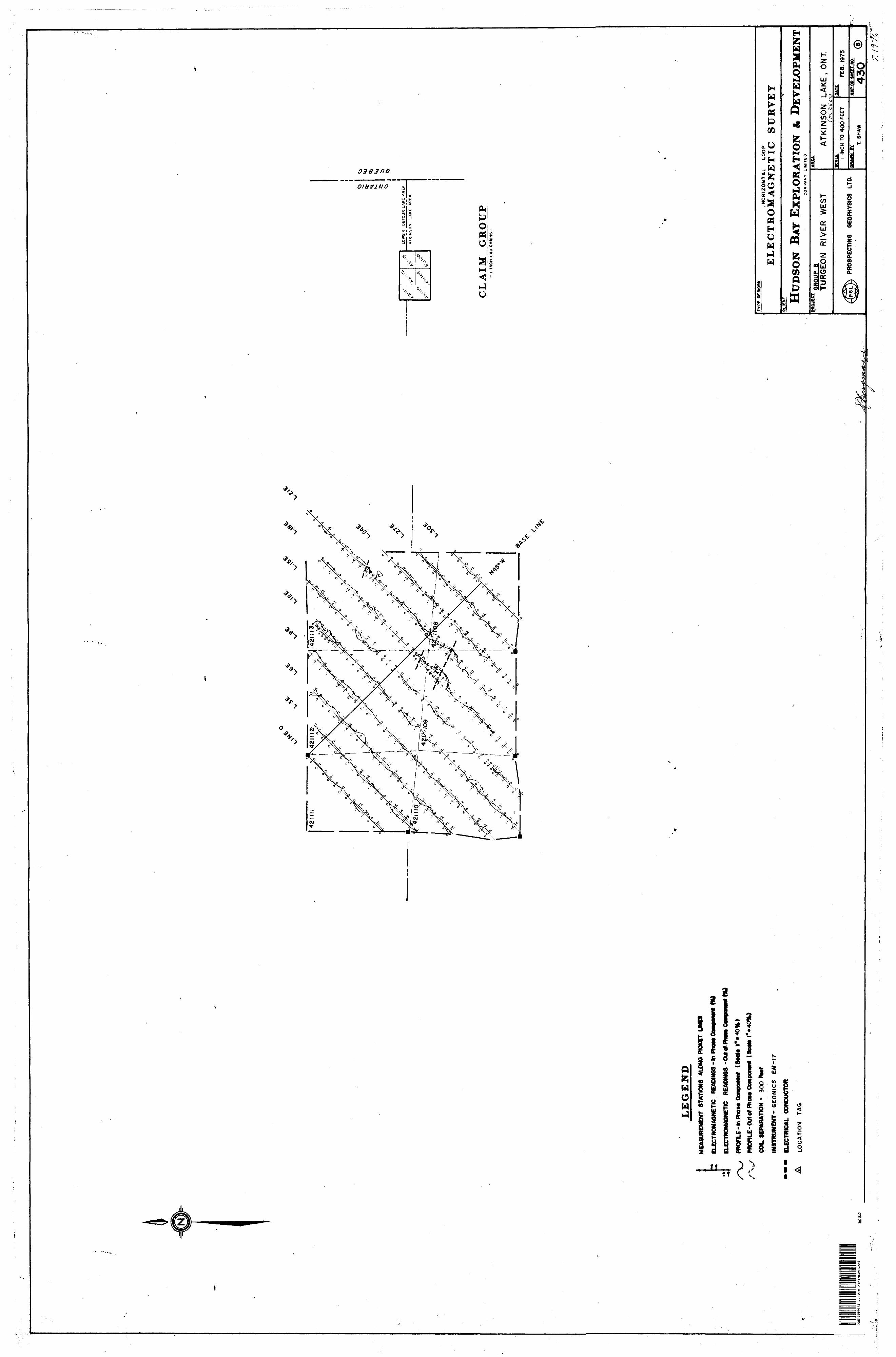
Tho o-^S'Vuy f;n l h 5. t- nroup chown jtuo r.c?frt ;. of conduc-.t: iyQ.....i:nj;ioo 6 o:;cj ts'f.M'Kixr^j f^uit-ooot In tho r.outh part of "1-ho p5."0fioi.'l.y !';Ui),c tho r:a:,!u)?; ccl in tho northern portion otrJLko;, nni-tUvxif.i'U j i. l. l of tha ccnuiuctort; ns?t: c;uito i'Tid tho t'j.fj j, r; i,'Vo!..ir:l-:.Xy to tho no;cth but thir. Ar not ton
In placon M:-^ up to 100 fret*
Ylto f;ooc!i,K.;t{)5,\r i nro 9 In a.lX |Uvobabi.'J.by ? c; ri us od by.(.ri o/ a -i- r:uJ.[j'ii.dao and fjcolooi^ol oxD;;?ifK,ition nay
he; ip it) o r,-!0?:o ficc;uj;'t;t(i

PROSPECTING GEOPHYSICS LTD.
'i' r - AH, j m. j';
TUo n^ocf'X'onnfinotxo nu^vnj/n ivofo succor-oFm?. In.HllJUK) f::?iU?-I!r:U UO ^'{'WICS OR O J. 3. pJ'OpDJTtiOO iHlt', fiFOUp t
s) r:-!} f ;...-r,t';s:; f' O'td O tho KOnoo WOI'O qultu ucnk and
onnc'i.tot. Avo jroncD v:oz?o outXinod on Groupo A tf, nrici P tho^ fj?.-o .tu n? ? f!;:;-(il)nt)ill.("-}; rntiood hy rjrtiphifcfit CKl/o;.' on.i.i.iJiiM'orio *ih(j i; c r 3 p r* no o xri plnrcio io ntu'h that thc5?ii'o.vl;u;.'f;i;;i'j i,.:, y !ui r;Es;'5l ^ot:ij, in uh.lr.;h coco
f uho
^^f11 o j e'* Morn-; ;oiii-nt, P,,, .'.".MM*.
r Dy ^U 0 197!*

Ministry of Natural ResourcesFile.
Ontario
TECHNIc .- ..-.
900muai UOJM l AIN INTERPRETATION, CONCLUSIONS ETC.
RECEIVED
NOV l 8 1975PROJECTS UNIT
Type of Survey(s). Township or Area.
Claim Holdcr(s)—
Electromagnetic
Atkinson Lake (M-2622)
Hudson Bay Exploration and
Development Company Limited
Survey Company. Prospecting Geophysics Ltd.Author of Report H. J. Berqmann, P. Enq.Address of Author 3518 Vendome Ave. ,Montreal, Que.Covering Dates of Survey..
Total Miles of Line Cut —
January 6/to February 27 , 197{linecutting to office)
_____74.8________________
SPECIAL PROVISIONS CREDITS REQUESTED
ENTER 40 days (includes line cutting) for first survey.ENTER 20 days for each additional survey using same grid.
Geophysical—Electromagnetic.—Magnetometer—.
—Radiometric——
—Other______
DAYS per claim
40
Geological.Geochemical.
AIRBORNE CREDITS (Special provision credits do not apply to airborne surveys)
Magnetometer. .Electromagnetic. . Radiometric(enter days per claim)
Nov. 17.1975 SIONATITRF.- hAM^^TlAuthor of Report or Agent
Res. Gcol.. .Qualifications. 6Previous Surveys
File No. Type Date Claim Holder
MINING CLAIMS TRAVERSED List numerically
(prefix) (number)

,-C,.A, MK '"""a
UNIT
r^Al^NO- PAYS CLAIM NO. DAYS
P 423. 073 40 p 421 151 40P 42.3. 074 40 P 423 152 40P 42.3 075 40 P 421 153 40P 423 076 40 p 421 154 40P 423 077 40 P 421 155 40P 421 078 40 P 421 156 40P 421 079 40 P 421 178 40P 421 080 40 P 421 179 40P 421 083 40 P 421 180 40P 421 082 40 P 421 3.81 40P 421 083 40 P 421 182 40P 421 084 40 P 421 383 40P 423. 085 40 P 42.1 184 40P 421 086 40 p 42.1 185 40P 421 087 40 P 421 186 40P 421 088 40 P 42.1 187 40P 421 089 40 P 423 188 40P 421 090 40 P 421 189 40P 421 091 40 P 42.3 190 40P 421 092 40 P 421 191 40P 421 O93 j [40 P 421 192 40P 421 094^ C ovjf';*'4lO P 421 193 40P 421 095 40 P 421 194 40P 421 096 40 P 42.1 195 40P 421 343 40 P 421 196 40P 421 3.44 40 P 421 197 40P 421 345 40 jp. 42.1 198 40P 421 346 40 C P 421 199^ |0P 421 147 40 -:^;p 421 201 XL C "0X^0P 423 148 40 P 421 202 40P 421 349 40 P 421 203 40P 421 350 40 P 421 204 40
64 claims 2,560 days

Ontario
Ministry of Natural Resources
GEOPHYSICAL - GEOLOGICAL - GEOCHEMICAL TECHNICAL DATA STATEMENT
File../? 7 1
TO BE ATTACHED AS AN APPENDIX TO TECHNICAL REPORTFACTS SHOWN HERE NEED NOT BE REPEATED IN REPORT
TECHNICAL REPORT MUST CONTAIN INTERPRETATION, CONCLUSIONS ETC.
RECEIVED
NOV l 8 1975
PROJECTS UNIT
Type of Survey(s). Township or Area. Claim Holder(s)—
ElectromagneticAtkinson Lake (M-2622)Hudson Bay Exploration andDevelopment Company Limited
Survey Company —^ Author of Report —
Address of Author
Prospecting Geophysics Ltd.H. J. Bergmann, P. Eng.———^—.3518 Vendome Ave..Montreal, Que.
Covering Dates of Survey-
Total Miles of Line Cut —-
February 5 to 15. 1975.(linecutting to office)
___ 5.5
SPECIAL PROVISIONS CREDITS REQUESTED
ENTER 40 days (includes line cutting) for first survey.ENTER 20 days for each additional survey using same grid.
Geophysical—Electromagnetic.
—Magnetometer™.
—Radiometric———Other——————
, per/daim
-i
Geological.
Geochemical.
AIRBORNE CREDITS (Special provision credits do not apply to airborne surveys)
Magnetometer. -Electromagnetic, . Radiometric(enter days per claim)
HATR- NOV. 17,1975 SinNATi;RF. ;Author of Report or Agent
Res. Gcol.. . Qualifications.Previous Surveys
File No. Type Date Claim Holder
MINING CLAIMS TRAVERSED List numerically
....s....(prefix)
..4.21...2D.5.(number)
.4JU...2.P.6.
..4.21..2Q.7..
..4.21..2Q.8.
I
TOTAL CLAIMS.

IND
UC
ED
PO
LAR
IZA
TIO
NR
ES
IST
IVIT
Y
GR
AV
ITY
E
LEC
TR
OM
AG
NE
TIC
M
AG
NE
TIC
1-3 S
S"II
S, 3
o^
CL
EL
O
O
rtrT
f
ECrt
' U
~-
B
0-
x;
Q-
3n
CTQ
5*
0*
2
3 S
5
-!
rt
J2.
o
O
3
ST"
^
W
2 n.
3
5"
rt Q
3
3 D
~ g
5* s
o o
^pi
rt —i
3
r'rt
ST
r*.
^
pi
H".
3
-*
S5-
s
r-^ 3
1 rt
o
?3 ft)
3 Di— i
r^
n
*r
T o
T o0
C
Crs
o
3
3rt
0
x:
x: o 0 3 fa 5'
ft: o ^
ST c ^ ~ n ftj c^ ^ rt M "^
n^r
^) ^g
:;j*
nn
:r
5S
K
2; S
rt^
rto
o^
rt^S
l^^E
""!
""3
2. 2
a-^-S
23
o'
3D
o"
o"x:2
r?
23
i2. i
ui
"^w
w3
3rT
"r*
3 O 'i-' n CL iH- o s- W CO (D B) G.
O rt i o Ml ^
1 n
g, f
Q)
<0)
r
O
;*i
O |
3 ~
O 3 D 3 rt 01 o HI DI O) O S 2. V H < Hi
J.
(D J Qi
H-1
CTi
i—]
0
U
ft) orq
Z.
n"
I+ M0
~
^
K
SN
a. ^^ g; 1Pi" r? *^ D 0 o cr D
PT _ E5J
(.H 3 5' o a •D ft! sL 2. 5" rt
w
0
0 Hi o (D rt
tK -s J. s^ i rt ^ -i D S 0 0 1 0 H
01 y V ^
Q M i H O w *) 1^ -x]
9 ^
- ?
wK
c>
^
3 a,
s. S
ft;
B)
Sfl
o
r*
^
--
"-
3rt
S S.
rt ^
grtg
cf
CA
C/o
gr'C
~!
;C'-.-
~I
r*
r-t
^
ft-
3
t—'
S
3
Oft!
ft)
'
rt5
3
SL.
'-^
i— ,
r*
r*
rt
X!
Q
r-.fjO
^J
C
O
^
! P
i - "i
3
3
"l
~
^
rt
CO
o^
EL
rt ^
0 rt
-'
2L^.
o
x
oX
" ^
^
O3
5'
3 c
ft;
-.
2
S3
-
3-
C
^
0
2
3^
"-!
Q-
r*
SL
ft!
rt
Ti
^J^
^ p^ —
^
ft:
i
-S
r*
M H- ts O D1 II •P*
O N^
Q*
C/3
Ul o Hi
(D (D
rt hj _ i
0 O Hi
CD
(D rt
M -J 00
^— -.
w1
r-* 2 w/ 'X f st S *"
^c y: •——
*
——
I
^ f*". S 2 ^ i
gi
o5
2•3
3*j
EG*^
rS
o
n0
^—
i C
"1
1- S
"3"
3" f
rt g
W)
CT
*"O
o
s 1
2.
o -
OQ
jo rt p a. 5" aq
U)
0 0 Hi
D D
-t
M OD
9
w G
o- S
~" S
S 5
I" i
K H
o
^h-
t-j
- -1 r! <

Ontario
Ministry of Natural Resources
GEOPHYSICAL - GEOLOGICAL - GEOCHEMICAL TECHNICAL DATA STATEMENT
il- O?*File
l TO BE ATTACHED AS AN APPENDIX TO TECHNICAL REPORTFACTS SHOWN HERE NEED NOT BE REPEATED IN REPORT
[ TECHNICAL REPORT MUST CONTAIN INTERPRETATION. CONCLUSIONS ETC.
RECEIVED
NOV l 8 1975
PROJECTS UNIT.
Type of Sur Township o
Claim Hold
Survey Con Author of F
Address of j
Covering Di
Total Miles
vey(s)
r Area
^r(s)
ipany
leport
Author
ites of Surv
of Line Cut
ElectromagneticAtkinson Lake (M-2622)HudsonDevelop
Bay Exploration andDment Company Limited
Prospecting Geophysics Ltd.H. J. Bergmann, P r Eng.3518 Vendome Ave. .Montreal, Que
™y FebT""^TV Q -(-r, IR 1 Q7 ^
SPECIAL PROVISIONS CREDITS REQUESTED
ENTER 40 days (includes line cutting) for first survey.ENTER 20 days for each additional survey using same grid.
AIRBORNE CREDITSMagnetome
D ATE: 03
Res. Geol.
ter
7. 17. 1
Previous SurveysFile No. Type
(linecutting to office)
5.5
DAYS*-^ , . , nw claim. Geophysical 7 \— F.)prtrnmag"^ir l J
— Map-nptometer V S
— RadiomPtrir,-Other
flfnlngirMl
npnrhpmirnl
(Special provision credits do not apply to airborne surveys)
ilectromagr(enter c
223 SIGN/
letir Rarlinmptrirays per claim)
iTIIRF,- /^^- /^M^MULJ^i^/nAuthor of Report or Agent
Qualifications (O ^ ' ' ^ ** ®•*^
Date Claim Holder
MINING CLAIMS TRAVERSEDList numerically
P 421 2Q9(prefix) (number)
P 421 210
P 421 211
P . ... ... 421 .212...
f A
ATt/1
TOTAL CI, A IMS 4
1
Z4"T
jt!

GEOPHYSICAL TECHNICAL DATA
GROUND SURVEY^ If more than one survey, specify data for each type of survey
Number of Stations.
Station interval —^
Profile scale..^^^.
Contour interval.
240
50 feet or 100 feet l inch = 40^
.Number of Readings
.Line spacing ————
240
300 feet
uh—i
H W ^O
Instrument.
Accuracy — Scale constant.
Diurnal correction method.
Base Station check-in interval (hours).
Base Station location and value ————
CJ*— *H Wy,O
H U Wt— Jw
Instrument GEONICS EM-17Horizontal Loop, co-planar 400 feet
A.12L
Coil configuration
Coil separation ——
Accuracy ——^^
Method:
Frequency————{specify V.L.F. station)
Parameters measured in~phase and out-of-phase componente of secondary field
CD Fixed transmitter 1600 Hz^-—-——
D Shoot back In line Parallel line
Hk—4
SO
Instrument.
Scale constant
Corrections made.
Base station value and location
Elevation accuracy.
x,oH-*
H ^NHH
C*H-3
O OHQ Wu ;jQ x;
Instrument ——-^^—^^——
Method D Time Domain
Parameters - On time ——-
- Off time ___
CD Frequency Domain
_. Frequency _____
_ Range ^—-———-—
Delay time.
— Integration time .
Power
Electrode array——
Electrode spacing .
Type of electrode

Ontario
Ministry of Natural Resources
GEOPHYSICAL - GEOLOGICAL - GEOCHEMICAL TECHNICAL DATA STATEMENT
File.
TO BE ATTACHED AS AN APPENDIX TO TECHNICAL REPORTFACTS SHOWN HERE NEED NOT BE REPEATED IN REPORT
TECHNICAL REPORT MUST CONTAIN INTERPRETATION, CONCLUSIONS ETC.
RECE/VEDNOV l 8 1975PROJECTS
Type of Survey(s) ElectromagneticTownship or Area Atkinson Lake (M-2622)——— Claim Holder(s) Hudson Bay Exploration and
Development Company Limited Survey Company Prospecting Geophysics Ltd. Author of Report _H. J. Bergmann. P. Eng.____ Address of Author 351.8 Vendome Ave. ,Montreal,
Covering Dates of Survey_________5jJ2—^^^^——.^^^^—
Total Miles of Line Cut ...————(linecutting to office)
SPECIAL PROVISIONS CREDITS REQUESTED
ENTER 40 days (includes line cutting) for first survey.
ENTER 20 days for each additional survey using same grid.
Geophysical—Electromagnetic
—Magnetometer_—Radiometric———Other—————Geological.
Geochemical.
AIRBQRNE CREDITS (Special provision credits do not apply to airborne surveys)
Magnetometer. .Electromagnetic. . Radiometric(enter days per claim)
nATP.-Nov. 17,1975 SIGNATURE: AAuthor of Report or Agent
Res. Geo].. . Qualifications.Previous Surveys
File No. Type Date Claim Holder
MINING CLAIMS TRAVERSED List numerically
(prefix) (number)
..P.............
..P......p
.............421..11Q..
......A21..U.L.
TOTAL CLAIMS.

GEOPHYSICAL TECHNICAL DATA
jND SURVl'^YS If more than one survey, specify data for each type of survey
Number of Stations.
Station interval ^—^ Profile scale ——.—.
Contour interval.
29450 feet or 100 feet
.Number of Readings JLine spacing ——.——
294
300 feet
uh—4 l—l
Wxo
Instrument.
Accuracy - Scale constant. Diurnal correction method.Base Station check-in interval (hours). Base Station location and value ____
UH W XO
H Ow J w
Instrument GKONICS EM-17Horizontal Loop, co-planar300 feet
Coil configuration Coil separation ——.
Accuracy .^-—^—
Method:Frequency-^———
(specify V.L.F. station)
Parameters measured in-phage and out-pf-phase components of secondary field
Q Fixed transmitter 1600 Hz_______
CH Shoot back E In line CD Parallel line
H
Instrument.
Scale constant.Corrections made.
^ Base station value and location .
Elevation accuracy-
xoh— 4
H<Nk-H
(^<JOOL,
QWuI-J/"Nk— J
)— *
^H
Hfc— 4
>h — j
Wt — iWrt
Instrument ^-—-———^^^—-
Method di Time Domain Parameters — On time ^.—
- Off time —^
l l Frequency Domain _ Frequency _____
_ Range ——-——-^——.
- Delay time.
— Integration time.
Power.
Electrode array — Electrode spacing .
Type of electrode

LOWER DETOUR LAKE-M. 2603
49 052'30"
N- COCD CM
l LU
o:^ oH UJ Q
UJ-J
49 045-
I0727410714 ' 4107 I5,44I603
400VE5|400966 j i ^ 400967r - r ~*~ ~ ^
p PIP l4 \ 9 l 071 419 100 l 419099-*— — —r ~~ —
P p IIP400970,400969 400968
P j P |P
400971 14009721400973L . 1. ^
41 9 l 01 419098 i 41 32551j^ ._
P P p
4V 9 10514 \9I02 1 4190 97, 413256 l l fi/,,** \ ' l
419103 i 413258 413257
441582V 441583
P \ P 421786 142 1787 .421/913
112 1759^21760
. - J- - - 42/0^0 ,4 2TOBI ,4 2 10^2 l 4)2 l 383 ' 42108^ 42.--,- - --- —-.__ ^--,(l-;--J-.3J---|--Sft pv "k l V tp -' v-* ' 1P^3,42 TOW 42TO717 .42JCTL6 l42l783|42t7fl4 I42I7B5 1421756 ^421757
42 I0\74 . 421073
P i P41 O 300 ' 410305 410307—— - L — -—
142I857|42I8V^8] 42I839 | 40IQ38 ( 40l030 , 401040 40104~ T— -~
42 1144 42 l 149 42- - f- - 4- -4102 99 410306. 4103 08
x X ;x x y i x X21145 (421148 '421153 |42tl80|42llll 14/1194 42/2942 1854] 40 1045 Uo 10 4*1 ' 401043 '40104421 890
^~P Tp l P Slip L.- . . . l^ 13 ^ 96 Ul3392 '-..oaoo r^ ,u 3U3(P ' P
4133701^,0- ' ' V Ip 'pS 'p 'p 'p l |il218521413404 /4I3368, rtJ^IS/Bei 421 88 7 | 42 l 886 ( 42 l 86 5 42 l 8 8 4 l l l , l ^^t
-i- — — V L i l lv f - - — — /— 15ZI853T 5- - -^-S- - -- , - - -4- - -f -\- -413401, 413/397 , 4 133 93.413389 1422 O 61 | p , p401047* 401048 '40104 421146,421147,421154,421181 421190 1421195- 4- - -f - ~
. Fear413405 -413369 ,413371 ,L 2|a7g 42l845|42l844J 427554 4275^
~ "ci ~1 — ~ ~\ — — — — ~ ^^|O)
121155 ,42118^2 [42118942I647~-
P 142205 422069 422067
421881 .421882 421818 3i
413402 '413398 /l 4I3394 ( 4I3390|422062 P P P P P
A l /\ ; /S X
2M56|42II63 ' 4 2 l l 8 8 ' 42 11 9 7413406 .'413407 , 413372 /42I8\78 i4 2( l 67^4 2 187 6 421875 421874
P .P .P
.413372 j 4- — i— - — -L-
*3M3 4 l \3OWit
|40 1096 ! 40I097|. t uiua*i i v\ ^ J.4 O 109
00 45,1099,401098
-401102 .401103 '3884174,388475
j38 8 4 6 5 3 884] 6 6
388471 388472 1386473,L - J . .
49 0 4544' 43' 42 41 40 39' 38' 36 35' 34 33 32 31
79 0 30'
KINGROY LAKE-M.265932E13SE8032 2.1976 ATKINSON LAKE 200 497793
AREA OF S-/'
ATKINSOirraKE
DISTRICT OFCOCHRANE
PORCUPINE MINING DIVISION
SCALE: 1-INCH-4O CHAINS
LJEGJENJ3
PATENTED LANDCROWN LAND SALELEASESLOCATED LANDLICENSE OF OCCUPATIONMINING RIGHTS ONLYSURFACE RIGHTS ONLYROADSIMPROVED ROADSKING'S HIGHWAYS
RAILWAYSPOWER LINESMARSH OR MUSKEGMINESCANCELLED
C.S.
Loc.LO.
M.R.O.
S.RO.
NOTES
400' surface rights reservation along the
shores of all lakes and rivers.
DATE OF ISSUE
NOV 19 1975.P NATURAL
NATIONAL TOPOGRAPHIC SERIES 32 E 13
PLAN NO.- M. 2622
ONTARIO
MINISTRY OF NATURAL RESOURCESSURVEYS AND MAPPING BRANCH
LE
GE
ND
ME
AS
UR
EM
EN
T ST
ATI
ON
S AU
ONG
PIC
KET
LIN
ES
ELEC
TRO
MA
GN
ETIC
R
EAD
ING
S -I
n P
how
Com
ponw
t (H
I
ELEC
TRO
MA
GN
ETIC
R
EAD
ING
S ~
0i*
of R
OM
PRO
FILE
-m
Pb
oM
Com
pone
nt
(So
olt
l<l
PR
OR
LE
-Ou
tofP
hcM
Com
pont
nl (
Soo
to r
-40%
)
CO
IL S
EPA
RA
TIO
N -
3O
O P
Mt
INS
TR
UM
EN
T-
GE
ON
l CS
E
M-1
7
ELE
CTR
ICA
L C
ON
DU
CTO
R
LOC
ATI
ON
TA
G
32E
I35E
0032
2.1
976
AT
KIN
SO
N
LAK
E2
10
VV
*V
S
.rvLO
WE
R
DE
TOU
R
LAK
E
AR
EA
AT
KIN
SO
N
LA
KE
A
RE
A
CL
AIM
G
RO
UP
-
l IN
CH
s 4
0 C
HA
INS
-
TY
PE O
F W
ORK
.HO
RIZ
ON
TA
L
LO
OP
EL
EC
TR
OM
AG
NE
TIC
S
UR
VE
YC
LIE
NT HU
DSON
BAT
EXP
LORA
TION
J. D
EVEL
OPM
ENT
CO
MP
AN
Y
LIM
ITE
D
MtO
JEC
TG
RO
UP
B
TUR
GEO
N
RIV
ER
W
EST
PR
OS
PE
CTI
NG
G
EOPH
YSIC
S LT
D.
ATK
INS
ON
LA
KE
, O
NT
(M.
SC
ALE l
INC
H
TO 4
00 F
EE
T
BY
T.
SH
AW
DATE
FEB
. 19
75
MAP
Oft
SHEE
T
430
J

CL
AIM
G
RO
UP
-
\ IN
CH
s 4
0 C
HA
INS
-
t*
LE
GE
ND
ME
AS
UR
EM
EN
T ST
ATI
ON
S A
LON
G P
ICK
ET U
NO
ELEC
TRO
MA
GN
ETIC
R
EAD
ING
S -
Hi P
ho
* O
ompO
MgH
(M
ELEC
TRO
MA
GN
ETIC
R
EAD
ING
S -O
utt
fftl
PR
OF
ILE
-In
Ph
OM
OM
^on
tnt
(So
ol*
l" 4
0%
)
/\^
/
PR
OFI
LE-O
ut o
f P
ho
M C
ompo
fwil
(So
olt
T
CO
IL S
EPA
RA
TIO
N -
3O
O
ffM
t
INS
TR
UM
EN
T*
GE
ON
ICS
E
M-1
7
---
ELE
CTR
ICA
L C
ON
DU
CTO
R
A
LOC
AT
ION
TA
G
32E13SE0B3
2 2.1976 ATKINSON LAKE
220
</
i S
T Y M
HO
RIZ
ON
TA
L
LOO
P
EL
EC
TR
OM
AG
NE
TIC
S
UR
VE
YSU
ET HUDS
ON B
AY E
XPLO
RATI
ON A
. DEV
ELOP
MEN
TC
OM
PA
NY
L
MIT
1D
HS3E
TQR
OUP
CTU
RG
EON
R
IVE
R
WES
T
PRO
SPEC
TIN
G
GEO
PHYS
ICS
LTD
.
AH
IA
ATK
INS
ON
LA
KE
, O
N'T
.
INCH
TO
40
0 F
EET
t SH
AW
DA
TEFE
B. 1
975
MftT
itfT
ttff
fT fl
fli
431
-. \
^ -^
^.
.^
..,
- - \.
- -*
-ZL-
.-.
.-..
'176

^-.
•P-J
^-P
--"
va@
' V
ffl'
PC"
'
P4
4212
05
32E
13860033
2.1
976
ATK
INS
ON
LA
KE
LE
GE
ND
ME
AS
UR
EM
EN
T
STA
TIO
NS
A
UO
WO
PtC
KT
r U
NE
S
ELE
CTR
OM
AG
NE
TIC
R
EA
DIN
GS
- In
PhO
M C
ELE
CTR
DM
A6N
ETI
C
RE
AD
INO
S
- O
ur O
f
PR
OF
ILE
-In
Ph
ow
Com
poot
nt-
(So
olt
.P
RO
FR^-
Out
orP
hOM
Com
poot
nl (
. ' "
.C
OIL
SE
PA
RA
TIO
N -
400
fiit
t
INS
TR
UM
EN
T-
GE
ON
lCS
E
M-1
7
EL
EC
TR
ICA
L
CO
ND
UC
TOR
LO
CA
TIO
N
TA
G
V^
NV
V
\
XV-
nK
,,.-rf*J|-V
si*ll'JK
-.
.
k *^
-H
CL
AIM
G
RO
UP
"- (
'INC
H ^
40
CH
AIN
S -
TY
PE
O
F W
OR
K.. ^
'^.
TH
OR
lZO
NfA
L
CO
OP
EL
EC
TR
OM
AG
NE
TIC
HUDS
ON B
AY E
XPLO
RATI
ON

LE
GE
ND
ME
AS
UR
EM
EN
T S
TATI
ON
S
AUO
WG
PIC
KE
T U
ME
S
ELE
CTB
OM
AO
NE
T1C
R
EA
WN
OS
- t
o P
taft
Co
mp
mn
r (M
RE
AO
M8S
- (So
oto
C
-40%
)
l"-4
0*1
HO
RIZ
ON
TA
L
LOO
P
EL
EC
TR
OM
AG
NE
TIC
S
UR
VE
Y
HUDS
ON B
AY E
XPLO
RATI
ON
CL
AIM
GR
OU
PA
TKIN
SO
NTU
RG
i&N
R
IVE
R
^.-g
SK
ft^M
l^f -
^S
^rf^
^SrM
H*-
1' y-'
":^;-"
'*

.c^
\ V
S 4
^
s; •s/
CL
AIM
G
RO
UP
-
l IN
CH
s 4
0 C
HA
INS
-
o