i. fire environmentcdfdata.fire.ca.gov/pub/fireplan/fpupload/fpppdf430.pdf · i. fire environment...
TRANSCRIPT
I. Fire Environment Wildland fires are affected by fuels, weather, topography and population impacts. The alignment of all these factors contributes to San Luis Obispo County being at risk for wildland urban interface fires each fire season.
A. Population Dynamics
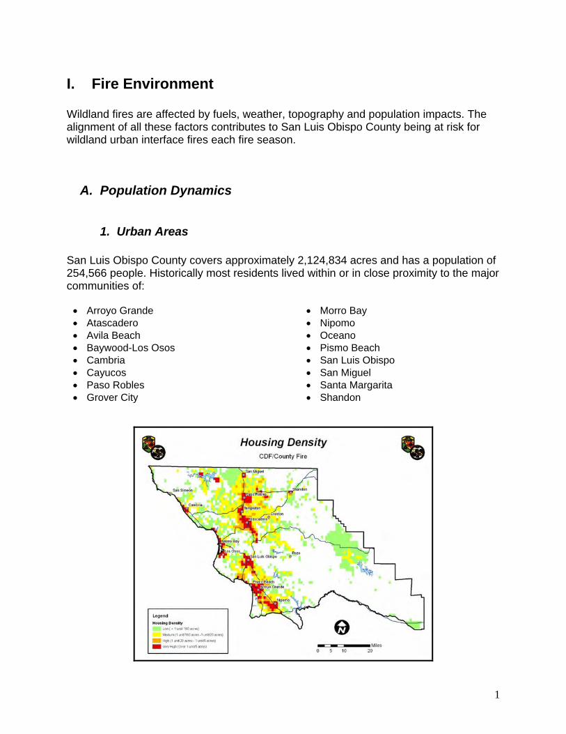
1. Urban Areas San Luis Obispo County covers approximately 2,124,834 acres and has a population of 254,566 people. Historically most residents lived within or in close proximity to the major communities of:
• Arroyo Grande • Atascadero • Avila Beach • Baywood-Los Osos • Cambria • Cayucos • Paso Robles • Grover City
• Morro Bay • Nipomo • Oceano • Pismo Beach • San Luis Obispo • San Miguel • Santa Margarita • Shandon
1
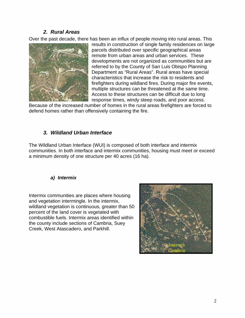
2. Rural Areas Over the past decade, there has been an influx of people moving into rural areas. This
results in construction of single family residences on large parcels distributed over specific geographical areas remote from urban areas and urban services. These developments are not organized as communities but are referred to by the County of San Luis Obispo Planning Department as “Rural Areas”. Rural areas have special characteristics that increase the risk to residents and firefighters during wildland fires. During major fire events, multiple structures can be threatened at the same time. Access to these structures can be difficult due to long response times, windy steep roads, and poor access.
Because of the increased number of homes in the rural areas firefighters are forced to defend homes rather than offensively containing the fire.
3. Wildland Urban Interface The Wildland Urban Interface (WUI) is composed of both interface and intermix communities. In both interface and intermix communities, housing must meet or exceed a minimum density of one structure per 40 acres (16 ha).
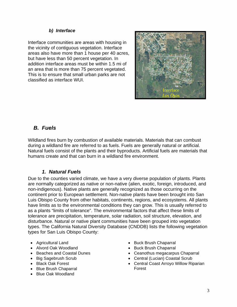
a) Intermix Intermix communities are places where housing and vegetation intermingle. In the intermix, wildland vegetation is continuous, greater than 50 percent of the land cover is vegetated with combustible fuels. Intermix areas identified within the county include sections of Cambria, Suey Creek, West Atascadero, and Parkhill.
Intermix Cambria
2
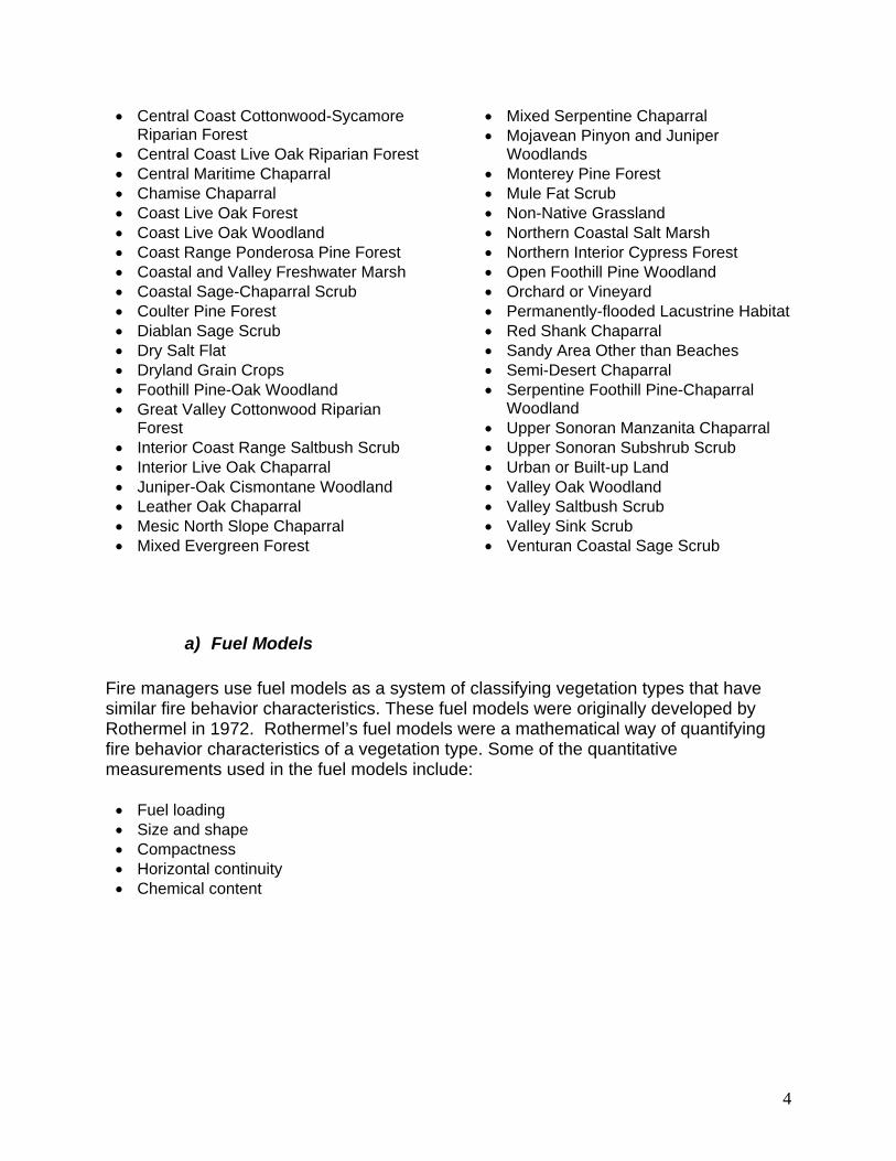
b) Interface Interface communities are areas with housing in the vicinity of contiguous vegetation. Interface areas also have more than 1 house per 40 acres, but have less than 50 percent vegetation. In addition interface areas must be within 1.5 mi of an area that is more than 75 percent vegetated. This is to ensure that small urban parks are not classified as interface WUI.
Interface Los Osos
B. Fuels Wildland fires burn by combustion of available materials. Materials that can combust during a wildland fire are referred to as fuels. Fuels are generally natural or artificial. Natural fuels consist of the plants and their byproducts. Artificial fuels are materials that humans create and that can burn in a wildland fire environment.
1. Natural Fuels Due to the counties varied climate, we have a very diverse population of plants. Plants are normally categorized as native or non-native (alien, exotic, foreign, introduced, and non-indigenous). Native plants are generally recognized as those occurring on the continent prior to European settlement. Non-native plants have been brought into San Luis Obispo County from other habitats, continents, regions, and ecosystems. All plants have limits as to the environmental conditions they can grow. This is usually referred to as a plants “limits of tolerance”. The environmental factors that affect these limits of tolerance are precipitation, temperature, solar radiation, soil structure, elevation, and disturbance. Natural or native plant communities have been grouped into vegetation types. The California Natural Diversity Database (CNDDB) lists the following vegetation types for San Luis Obispo County:
• Agricultural Land • Alvord Oak Woodland • Beaches and Coastal Dunes • Big Sagebrush Scrub • Black Oak Forest • Blue Brush Chaparral • Blue Oak Woodland
• Buck Brush Chaparral • Buck Brush Chaparral • Ceanothus megacarpus Chaparral • Central (Lucian) Coastal Scrub • Central Coast Arroyo Willow Riparian
Forest
3
• Central Coast Cottonwood-Sycamore Riparian Forest
• Central Coast Live Oak Riparian Forest • Central Maritime Chaparral • Chamise Chaparral • Coast Live Oak Forest • Coast Live Oak Woodland • Coast Range Ponderosa Pine Forest • Coastal and Valley Freshwater Marsh • Coastal Sage-Chaparral Scrub • Coulter Pine Forest • Diablan Sage Scrub • Dry Salt Flat • Dryland Grain Crops • Foothill Pine-Oak Woodland • Great Valley Cottonwood Riparian
Forest • Interior Coast Range Saltbush Scrub • Interior Live Oak Chaparral • Juniper-Oak Cismontane Woodland • Leather Oak Chaparral • Mesic North Slope Chaparral • Mixed Evergreen Forest
• Mixed Serpentine Chaparral • Mojavean Pinyon and Juniper
Woodlands • Monterey Pine Forest • Mule Fat Scrub • Non-Native Grassland • Northern Coastal Salt Marsh • Northern Interior Cypress Forest • Open Foothill Pine Woodland • Orchard or Vineyard • Permanently-flooded Lacustrine Habitat • Red Shank Chaparral • Sandy Area Other than Beaches • Semi-Desert Chaparral • Serpentine Foothill Pine-Chaparral
Woodland • Upper Sonoran Manzanita Chaparral • Upper Sonoran Subshrub Scrub • Urban or Built-up Land • Valley Oak Woodland • Valley Saltbush Scrub • Valley Sink Scrub • Venturan Coastal Sage Scrub
a) Fuel Models Fire managers use fuel models as a system of classifying vegetation types that have similar fire behavior characteristics. These fuel models were originally developed by Rothermel in 1972. Rothermel’s fuel models were a mathematical way of quantifying fire behavior characteristics of a vegetation type. Some of the quantitative measurements used in the fuel models include:
• Fuel loading • Size and shape • Compactness • Horizontal continuity • Chemical content
4
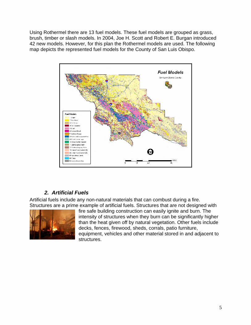
Using Rothermel there are 13 fuel models. These fuel models are grouped as grass, brush, timber or slash models. In 2004, Joe H. Scott and Robert E. Burgan introduced 42 new models. However, for this plan the Rothermel models are used. The following map depicts the represented fuel models for the County of San Luis Obispo.
2. Artificial Fuels Artificial fuels include any non-natural materials that can combust during a fire. Structures are a prime example of artificial fuels. Structures that are not designed with
fire safe building construction can easily ignite and burn. The intensity of structures when they burn can be significantly higher than the heat given off by natural vegetation. Other fuels include decks, fences, firewood, sheds, corrals, patio furniture, equipment, vehicles and other material stored in and adjacent to structures.
5
C. Weather San Luis Obispo County is characterized by a Mediterranean climate, which implies that almost all of the rainfall comes during the cooler part of the year. However, it is also
characterized by great diversity ranging from a cool damp north coast to the intensely hot and arid Cuyama Valley in the southeast corner. Among the factors that strongly influence local weather are the proximity of the Pacific Ocean on the west side and the arrangement of the mountain ranges, which stand parallel to the coast. Dominating the western part of the County is the Santa Lucia Range extending almost the entire length of the County. Rising sharply from the shore at the northern boundary, the
Santa Lucia Range trends gradually away from the coast toward the south. South of Morro Bay a region of high hills called the San Luis Range, or Irish Hills, is situated next to the coastline.
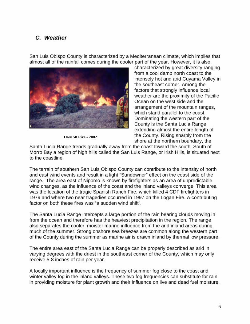
Hwy 58 Fire - 2002
The terrain of southern San Luis Obispo County can contribute to the intensity of north and east wind events and result in a light “Sundowner” effect on the coast side of the range. The area east of Nipomo is known by firefighters as an area of unpredictable wind changes, as the influence of the coast and the inland valleys converge. This area was the location of the tragic Spanish Ranch Fire, which killed 4 CDF firefighters in 1979 and where two near tragedies occurred in 1997 on the Logan Fire. A contributing factor on both these fires was “a sudden wind shift”. The Santa Lucia Range intercepts a large portion of the rain bearing clouds moving in from the ocean and therefore has the heaviest precipitation in the region. The range also separates the cooler, moister marine influence from the arid inland areas during much of the summer. Strong onshore sea breezes are common along the western part of the County during the summer as marine air is drawn inland by thermal low pressure. The entire area east of the Santa Lucia Range can be properly described as arid in varying degrees with the driest in the southeast corner of the County, which may only receive 5-8 inches of rain per year. A locally important influence is the frequency of summer fog close to the coast and winter valley fog in the inland valleys. These two fog frequencies can substitute for rain in providing moisture for plant growth and their influence on live and dead fuel moisture.
6
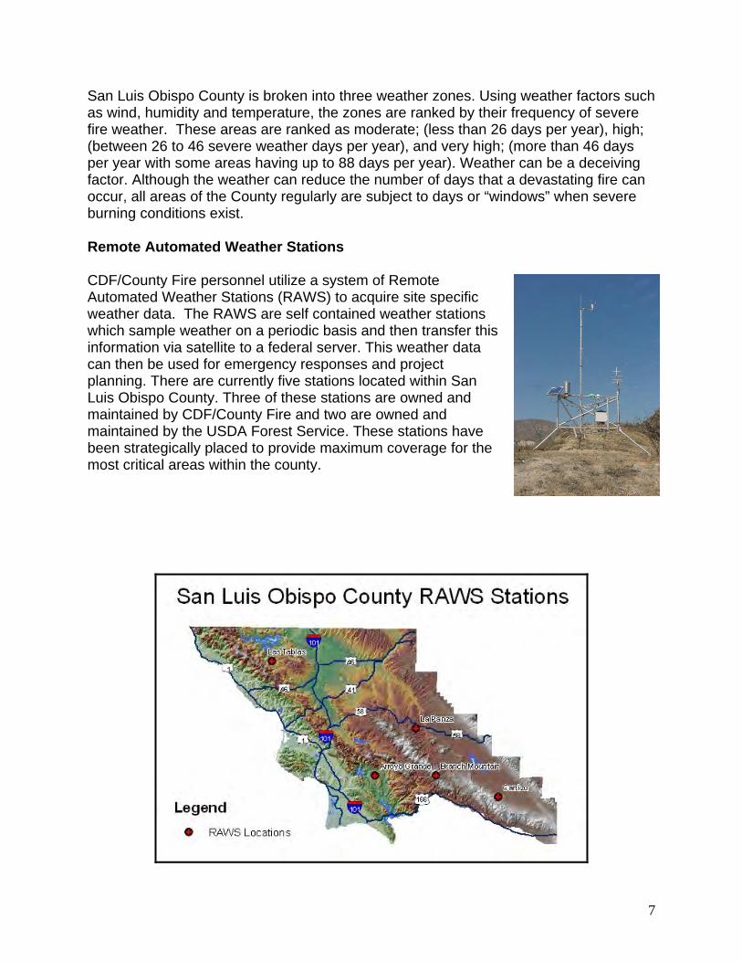
San Luis Obispo County is broken into three weather zones. Using weather factors such as wind, humidity and temperature, the zones are ranked by their frequency of severe fire weather. These areas are ranked as moderate; (less than 26 days per year), high; (between 26 to 46 severe weather days per year), and very high; (more than 46 days per year with some areas having up to 88 days per year). Weather can be a deceiving factor. Although the weather can reduce the number of days that a devastating fire can occur, all areas of the County regularly are subject to days or “windows” when severe burning conditions exist. Remote Automated Weather Stations CDF/County Fire personnel utilize a system of Remote Automated Weather Stations (RAWS) to acquire site specific weather data. The RAWS are self contained weather stations which sample weather on a periodic basis and then transfer this information via satellite to a federal server. This weather data can then be used for emergency responses and project planning. There are currently five stations located within San Luis Obispo County. Three of these stations are owned and maintained by CDF/County Fire and two are owned and maintained by the USDA Forest Service. These stations have been strategically placed to provide maximum coverage for the most critical areas within the county.
7
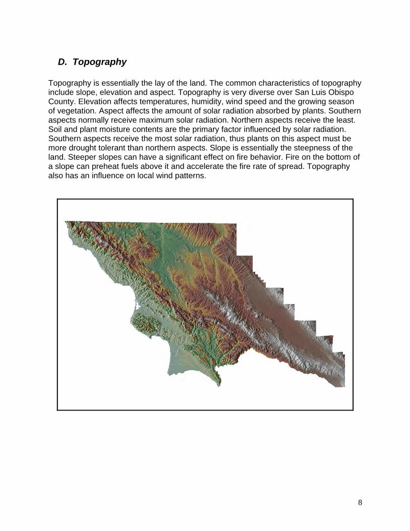
D. Topography Topography is essentially the lay of the land. The common characteristics of topography include slope, elevation and aspect. Topography is very diverse over San Luis Obispo County. Elevation affects temperatures, humidity, wind speed and the growing season of vegetation. Aspect affects the amount of solar radiation absorbed by plants. Southern aspects normally receive maximum solar radiation. Northern aspects receive the least. Soil and plant moisture contents are the primary factor influenced by solar radiation. Southern aspects receive the most solar radiation, thus plants on this aspect must be more drought tolerant than northern aspects. Slope is essentially the steepness of the land. Steeper slopes can have a significant effect on fire behavior. Fire on the bottom of a slope can preheat fuels above it and accelerate the fire rate of spread. Topography also has an influence on local wind patterns.
8
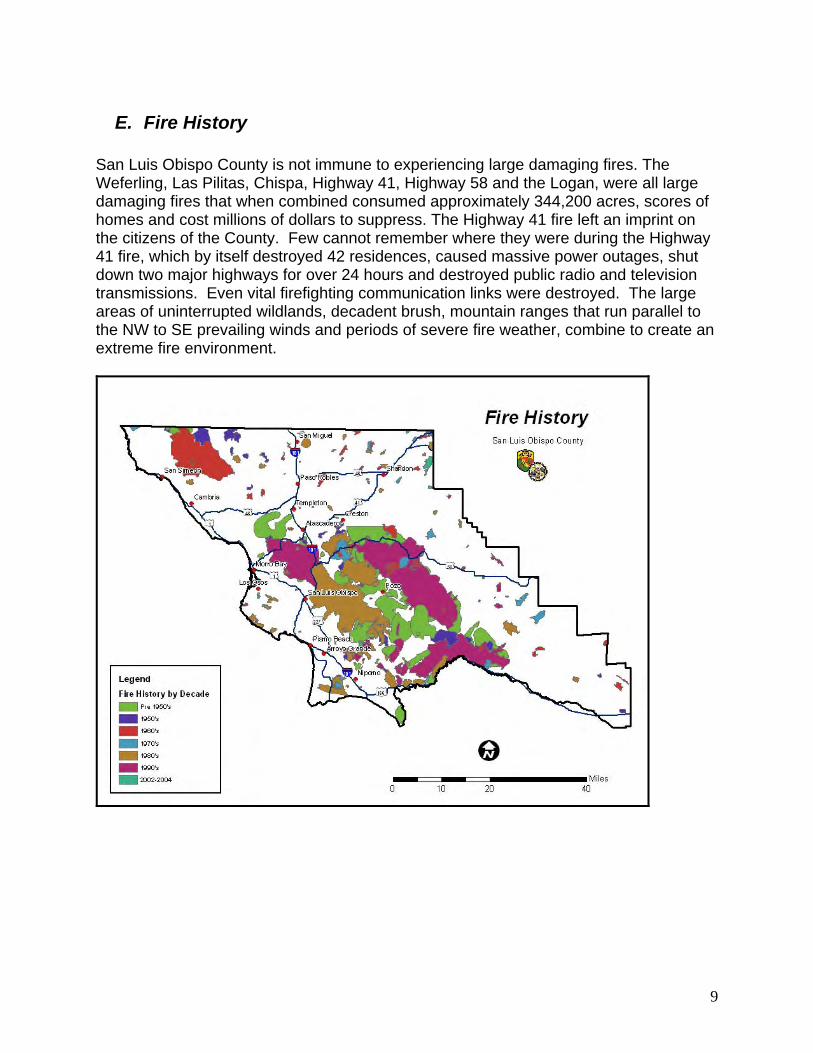
E. Fire History San Luis Obispo County is not immune to experiencing large damaging fires. The Weferling, Las Pilitas, Chispa, Highway 41, Highway 58 and the Logan, were all large damaging fires that when combined consumed approximately 344,200 acres, scores of homes and cost millions of dollars to suppress. The Highway 41 fire left an imprint on the citizens of the County. Few cannot remember where they were during the Highway 41 fire, which by itself destroyed 42 residences, caused massive power outages, shut down two major highways for over 24 hours and destroyed public radio and television transmissions. Even vital firefighting communication links were destroyed. The large areas of uninterrupted wildlands, decadent brush, mountain ranges that run parallel to the NW to SE prevailing winds and periods of severe fire weather, combine to create an extreme fire environment.
9
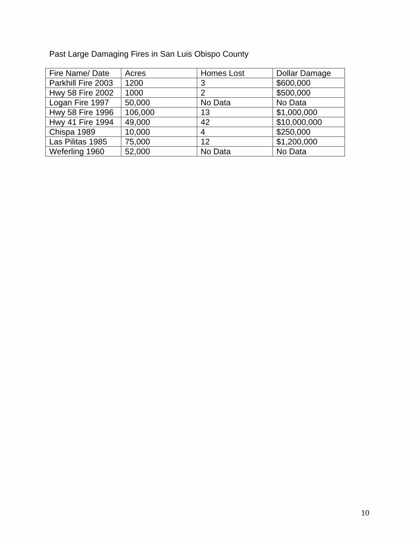
Past Large Damaging Fires in San Luis Obispo County Fire Name/ Date Acres Homes Lost Dollar Damage Parkhill Fire 2003 1200 3 $600,000 Hwy 58 Fire 2002 1000 2 $500,000 Logan Fire 1997 50,000 No Data No Data Hwy 58 Fire 1996 106,000 13 $1,000,000 Hwy 41 Fire 1994 49,000 42 $10,000,000 Chispa 1989 10,000 4 $250,000 Las Pilitas 1985 75,000 12 $1,200,000 Weferling 1960 52,000 No Data No Data
10