i a soil resource and land use survey · a soil resource and land use survey of the halfway indian...
TRANSCRIPT


i
A SOIL RESOURCE AND LAND USE SURVEY
OF THE
HALFWAY INDIAN RESERVE #168
William J. Watt and L. Farstad
1973
Edited by: Dr. R. E. Carlyle
Report No. 273, Research Station, Agriculture Canada, 6660 N.W. Marine Drive, Vancouver 8, B.C.
2
Contents
Acknowledgements Summary -
........................................... ...................................................
Introduction ...............................................
General Description of the Area ............................ Location and size ..................................... Climate ............................................... Nature of the Landscape ............................... Vegetation ............................................
Soi1 Classification and Descriptions ....................... 8 Chief's Cabin Creek Series ........................... 8 Allen Series .......................................... 10 Branham Series ........................................ 10 Taylor Series ........................................ 11 Halfway Complex ....................................... 11 Lynx Series .......................................... 12 Centurion Series ...................................... 12 Grayling Series ....................................... 13 Eaglesham Series ...................................... 13 Kenzie Series ......................................... 14
Land Use Guidance .......................................... 14 Capability of the Halfway Indian Reserve Soils ........ 14 Suitability Classification ............................ 14 Land Use .............................................. 16
Page
Physical and Chemical Properties of the Halfway Indian Reserve Soils . . . . . . . . . . . . . . . . . 18
- Typical profile descriptions of the Halfway Indian Reserve Soils . . . . . . . . . . . . . . . . . 18
Table 1 - Halfway Indian Reserve: Physical Properties of Five Soils . . . . . . . . . . . . . . . . . 26
Table 2 - Halfway Indian Reserve: Chemical Properties of Five Soils . . . . . . . . . . . . . . . . . 27
Table 3 - Agricultural Capability Classes - Guiding Criteria . . . . . . . . . . . . . . . . . 29
Table 4 - Capability, Suitability and Land Use of the Soils of the Halfway Indian Reserve . . . . . . . . . . . . . . . . . 30
References . . . . . . . . ..*........ . . . . . . . . . . . . . . . . . . . . . . . . . . 31
Maps Figure 1 - Halfway Indian Reserve: Location Map Figure 2 - Halfway Indian Reserve No. 168: Idealized cross-section
showing vegetation soils and soi1 textures. Figure 3 - Soi1 Map Figure 4 - Suitability for cereal crops Figure 5 - Suitability for forage crops Figure 6 - Suitability for pasture Figure 7 - Land Use Map

4
Acknowledgements
The authors of this report wish to acknowledge their appreciation of assistance from the following groups.
The Chief of the Halfway Indian Reserve, Band Councillors and several individual Band members provided assistance and helped with access to the less developed parts of the Reserve.
Officiais of the Department of Indian Affairs and Northern Development supplied important background information.
The aerial photographs were provided by the Air Survey Division, Land Service Victoria, B.C. The aerial photo mosiac for the maps was prepared and printed by the Cartography Section, Soi1 Research Institute, Ottawa.
The soi1 analysis, drafting of maps and illustrations including the caver design were carried out by members of the Soi1 Survey Section, Canada Department of Agriculture, Vancouver.
4 .
A SOIL RESOURCE AND LAND USE SURVEY OF THE
HALFWAY INDIAN RESERVE NO. 168
Summary
This report presents the results of a survey of the soi1 resources of the Halfway Indian Reserve. The survey revealed 10 soi1 units plus some gravel-bar formations. Each soi1 series is described in general terms and profile descriptions are given in pages 18-25. The climate and topography are described in general terms along with three general categories of crops. In addition, each soi1 series is given a capability and suitability rating. Finally, land use is discussed in simple practical terms.
The soils on the reserve are well suited for a ranching enterprise such as is being carried out at the present time. There is a reasonable balance between arable land for cereal and forage production and areas for improved pastures. Some land remains for unimproved grazing and the retention and encouragement of wildlife.
There is an estimated 3500 acres of arable land capable of sustained forage production. The Taylor series of approximately 855 acres consistently should produce cereal crops of 1200-2040 lbs. per acre if good management practices are maintained. Twenty-four hundred acres are suitable for improved pasture land, The remaining acreage may be used for improved native range. The non-arable (flood and erosion susceptible) land adjacent to the Halfway River and steeply sloping land between terraces should be used for forestry. The grave1 bars are an important source of materials for road building and other types of construction.
In general, soi1 management is reasonably correct. If the Lynx soils are put into production, organic matter maintenance and erosion prevention require attention. In some of the range areas compaction of the surface soi1 is a problem, Cultivation of the Allen and Branham soils must be shallow to prevent turning up the calcareous layer and increasing alkalinity.
Range and pasture management requires improvement. Over- grazing is apparent in some areas. Weeds are prevalent and dominate the vegetation in many places. Control measures are required and reseeding of grasses and clovers needs attention.

5
Lastly, the Grayling soils (690 acres) on the Upper terraces cari be left in the natural state. Wildlife should be encouraged SO that a significant population of ungulates (moose and deer) become established. Grouse cari be encouraged along with other game bird species. The location (Upper terrace), the extent, topography and vegetation offer a place where the Indian cari retain at least a part of his traditional way of life.
Introduction
In recent years the Canadian Department of Indian Affairs and Northern Development became aware of a need for soi1 and trop technical information on the Indien reserves with agricultural potential. This report is one of a group describing the soi1 resources of some of the Indian reserves in British Columbia. These surveys are done by the Soi1 Survey Section, Research Branch, Canada Department of Agriculture, Vancouver at the request of the Department of Indian Affairs and Northern Development.
The Halfway Indian Reserve No. 168 has a listed population of 176.
Ranching is the principal agricultural occupation. Beef cattle are raised and sold as feeders. Some of the arable land is used to produce forage and cereal feeds, The Upper terrace, unimproved, is grazed by horses. The intermediate and lower terraces, except where cultivated, are grazed by the beef herd.
The objectives of this report are as follows;
(a) to assess the soi1 resources of the Reserve,
(b) to map the soils as to suitability for the production of cereals, forage and pasture use,
cc> to map a land use proposa1 for the soils of the Reserve,
(d) to suggest improvement in the soi1 management of the Reserve.
Economie assessments are not included in this survey but the economic soundness of a11 suggestions has been kept in mind.
TO achieve the objectives, a preliminary discussion was held with some of the Reserve's residents 'including Council members. Then, the soils of the Reserve were systematically mapped and samples were collected for chemical analysis. Special attention was given to the present agricultural practices.
6
General Description of the Area
Location and Size
The Halfway Indian Reserve No. 168 is located on the north bank of the Halfway River upstream from its junction with the Cameron River in the Peace River region of British Columbia. A grave1 road connects the Reserve with the Alaska Highway. The community of Wonowon is located approximately 30 miles to the northeast. The Reserve lies within National Topographie Sheets $tA/12 West and 94A/5 West (sec Figure 1).
The Reserve consists of approximately 8,320 acres' of which 680 acres are cultivated, This land is located on a series of raised alluvial terraces of different ages with the Upper one dating back to Pleistocene.
Climate
Annual precipitation 22 inches May to September precipitation 12 inches Mean annual temperature 35'F Mean summer temperature 51°F May to Sept., inclusive Average frost free period Growing degree days above 42'F
60-85 days 1700-2000
Normally about one-half the rainfall occurs from June to September. Dry periods of short duration occur most years but irrigation is impractical, for the present time. The temperature drops below freezing during the summer frequently enough to be a growth restricting factor. However, data from the #2 Canada Land Inventory Studies (7) in the area indicate a climate favorable for agriculture. Growth of a wide variety of crops is possible. These are alfalfa, red, alsike and sweet clover, hardy vegetables (broadbeans., celery, potatoes, peas), brome grass, timothy and raspberries. Among the cereals, oats, barley and wheat cari be grown successfully if the varieties are carefully chosen.
Nature of the Landscape
Bedrock exposures are absent in the Reserve. Surficial de- posits are alluvial and aeolian in origin. A series of alluvial terraces (Figure 21, dating from Pleistocene to recent and now modified, is a prominent landscape feature. The highest terrace is sand to silt loam in texture. The next major terrace is medium textured sediments over sands and gravels. The last
1 Acreages were detcrmined by acri FJ-! photogr:jph m':a:;urr:mr:n 1.:;.

7
I I
Miles
Fig.1 HALFWAY INDIAN RESERVE No.168: LOCATION MAP


major series of terraces consist of medium sands over gravels. The Halfway River which delineates the southern Reserve border now is forming a new terrace which is still subject to flooding. The terraces are closely related to several of the soils found in the Reserve.
Vegetation
The Halfway Indian Reserve is situated in the Mixedwood Section of the Boreal Forest Region of Canada (10). The coarser textured soils on the higher terraces support thin stands of lodgepole pine with some aspen. The finer textured soils on the same terraces support aspen, balsam, poplar and willow. Shrubs consist of wild rose, kinnikinnick and Saskatoon berry. Poorly drained areas support groundbirch, larch and black spruce. The present river flood plain supports a dense stand of white spruce with alder found in depressional areas. Native wheat grass, bluegrass and wild rye grass dominate the drier Upper terraces. Several sedges and mosses are present in bog areas on the terraces.
Soi1 Classifications and Descriptions
The soils of the Reserve are classified into nine series, (Figure 31, one complex and a miscellaneous land type using the System of Soi1 Classification for Canada (4). Profile descriptions for the nine soils are contained in pages 18-25. The major genetic horizons of five soils were sampled and analyzed. Analyses were based on determinations useful for soi1 classification and land use. The physical and chemical analyses data are contained in Tables 1 and 2.
Chief's Cabin Creek Series (Cc> - (330 acres>
The Chief's Cabin Creek soils are well drained nearly level to gently undulating loamy sand deposits of recent origin. These soils occur in small areas as low terraces along the Halfway River. Run-off is slow and permeability is rapid.
The surface layer is grayish brown loamy sand approximately five inches thick (C-horizon). The lower subsoil is gray and white sands.

Vegetation consists of dense stands of white spruce with an understory of alder, willow, horsetail and Jacob's ladder. These soils are good for timber production as well as wildlife habitat. They are moderately fertile, neutral to slightly alkaline in reaction. The frequency of flooding makes these soils unsuitable for cultivated crops.
Allen Series (An) - (79 acres - plus 230 acres Allen-shallow phase)
The Allen soils are rapidly drained, sandy loam alluvium on nearly level to undulating topography. They occur dominantly on the lower sections of numerous terraces along the Halfway River. Permeability is rapid and run-off is slow.
The surface layer is dark brown sandy loam to loam averaging five inches thick, weak in structure and with moderate organic matter accumulation. It is underlain by a brown sandy loam six inches in depth. The lower subsoil is black, white and brown calcareous Sand.
Vegetation consists of forage grasses, wild rose and many weed species. Aspen and poplar occur in patches.
The Allen soils are only moderately suited to cultivation, the coarse texture being a limiting factor. They are neutral to moderately alkaline in reaction. A moderately high organic matter content in the surface layer favorably affects fertility. A major difficulty is grave1 deposits which make these soils unsuitable for cultivation. These occurrences are noted as Allen series - shallow phase.
Branham Series (Br) - (860 acres>
The Branham soils and associated gravelly phase consist of rapidly to well drained fine sandy loam to silt loam deposits on level to undulating topography. These soils occur on portions of intermediate terraces along the Halfway River. Run-off is slow and permeability rapid.
The surface layer consists of yellowish brown silt loam to fine sandy loam approximately six inches thick. It is underlain by 10 to 14 inches of grayish brown calcareous silt loam to fine sandy loam. The lower subsoil is weakly stratified, grayish brown, calcareous, with similar textures to the surface layer.
Mixed popular and lodgepole pine with an understory of wild rose, native grasses and legumes make up the vegetation.

11
The Branham soils are moderately fertile and slightly to moderately alkaline in reaction. The finer textured soils are suitable for cultivation but the gravelly and coarser textured groups are not cultivated successfully. Where the lime content is high tillage should be shallow. These soils provide fair native range. Timber production is low, usually ranging from 25 to 40 cubic feet per acre per year for lodgepole pine.
Taylor Series (Ty) - (710 acres plus 145 acres, Taylor shallow phase)
The Taylor Series and a Taylor-shallow phase are well drained silty clay loam deposits on nearly level to gently undulating topography. These soils occur in large portions of intermediate terraces along the Halfway River. Run-off is slow and permeability is moderate. The classification is based on soils disturbed by cultivation and is not necessarily the same as the virgin soil. However, these soils are classed as Rego Black Chernozems. Where gravels and stones are near the surface, Taylor-shallow phase is mapped.
The surface layer is a dark brown to black loam with moderate organic matter content, about seven inches in depth. It is under- lain by approximately 13 inches of dark grayish calcareous silty clay loam. The lower subsoil is grayish brown calcareous silt loam.
These soils are cultivated and SO are devoid of native vegetation.
The Taylor soils are fertile. Their moderately fine textured Upper layers with favorable granular structure and organic mat-ter content make them suitable for cultivation. High lime content cari be a limitation in productivity but this is overcome by shallow tillage practices.
The subsoil of the shallow phase (gravelly sandy loam) is less suitable for cultivation but it remains in the same management unit.
Halfway Com-plex' - (1800 acres>
The Halfway Complex consists of a group of well drained, steeply sloping (25-40 percent) silt loam to sandy (sometimes gravelly) deposits. These soils occur in small areas along the escarpment separating the Upper and intermediate terraces along the Halfway River. They have been developed on alluvial-colluvial materials.
'A mapping unit containing mixtures of soils which cannot be separated individually because of intricate pattorns.

12
'JJhr: :xT.I'cIc~~ Layer varie-s in color through yellow to red to grayish brown and in texture from fine sandy loam to silt loam four to seven inches thick. It is underlain by highly calcareous similarly textured subsoil.
Sparse aspen, lodgepole pine, wild rose and Saskatoon berry make up the main vegetative species. Native grasses are found on the southern slopes. Gullies support dense stands of lodgepole pine and white spruce.
These soils are moderate to low in fertility with a slight to moderate alkaline reaction. The steep slopes are unsuited for cultivation but provide native range. A native habitat for wildlife is provided.
Lynx Series (Ly) (925 acres>
The Lynx Series is well drained, level to gently undulating silt loam deposits. This Series occurs on the uppermost terrace. Run-off is slow and permeability is moderate,
The surface layer of brown silt loam is about four inches in depth and is covered with an average of two and one-half inches of dark brown leaf litter. Next is another four-inch layer of light yellowish brown sandy loam, followed by a two inch layer of yellowish brown silty clay 1oa.m. The subsoil is calcareous (pH 8.5) and a grayish brown silt loam.
Most of the Lynx soils are covered with moderately dense stands of mixed aspen and balsam poplar. The undergrowth is native grasses, pea vine and vetch. The Lynx soils are suitable for cultivated crops and are moderately fertile in the virgin condition. If put into cultivation, rotations should be used which emphasize legumes and grasses interspersed with occasional cereal crops. This Will maintain and possibly increase the organic matter content which in turn induces aggregation and assists in reducing crusting and erosion.
Centurian Series (Ce> - (130 acres>
The Centurian soils consist of poorly drained level to depressional loam deposits. Occurrence is in localized depressional areas of the Upper terrace along the Halfway River valley. Run-off and permeability is slow.
The surface layer of very dark brown to black semi-decomposed organic materials is approximately five inches thick. It is underlain by an average of 13 inches of calcareous dark gray loam. The subsoil is grayish, very calcareous loarn and sandy loam.

The vegetation is ground birch, willow, sedges and mosses.
These soils are strongly alkaline and low in fertility. They are not suited to cultivated crops but if drained, permanent forage crops cari be grown. In their native state they are rated as moderate for grazing. Wild life is quite plentiful.
Grayling Series (Gn) - (690 acres)
The Grayling soils are well drained gently undulating to hilly loamy sand dune deposits. These soils occur on the uppermost terrace and are fairly extensive in the eastern part of the reserve. Run-off is slow and permeability is rapid.
The surface layer is seven inches in depth, the Upper one inch being an overlay of pine needles, leaves and fine Sand. The second layer is reddish brown loamy sand about seven inches thick. The third layer is a gray loamy Sand.
The vegetation consists of sparse stands of lodgepole pine with an understory of kinnickinnick, wild rose and native grasses.
Topography and coarse texture make these soils unsuitable for cultivation. If broken they would be susceptible to wind erosion. They provide moderate native range. Forestry potential is low, but a moderate wildlife habitat is provided.
Eaglesham Series (Eg) - (625 acres>
The Eaglesham soils are very poorly drained level and depressional semi-decomposed organic deposits overlying silt loam deposits. These soils occur in localized depressions on the Upper and intermediate terraces along the Halfway River.
The surface layer of brown and dark brown moderately well decomposed sedges is approximately 17 inches thick. Beneath this layer is about 15 inches of black moderate to well decomposed plant materials, The subsoil is blue gray to dark gray silt loam.
The vegetation consists of sedges and coarse grasses with varying amounts of groundbirch and willow.
These soils are moderately low in fertility. They are mildly acid. Runoff is slow and drainage must be facilitated before agricultural development is practical. Once drained these soils could be used for permanent forage production. In their native state they may provide limiting grazing.

14
Kenzies Series (Kz) - (81 acres)
The Kenzies soils are very poorly drained semi-decomposed organic deposits in basin-like depressions. They occur in the "hummocky " topograp y h of the Upper terrace along the Halfway River in association with the Groundbirch Series. 'IXe watertable is usually near the surface.
The surface layer (o-16 inches) is decomposed moss, twigs and leaves overlain with fibrous and springy living sphagnum moss. The second layer consists of approximately 17 inches of dark brown to grayish brown decomposed organic materials. The subsoil is dark gray silt loam.
Most of the Kenzie Series is covered with sphagnum mosses, labrador tea, black spruce, willows and larch.
The Kenzies soils are acid in reaction and of low fertility. Without watertable control they are unsuitable for cultivation. Reclamation is difficult because these soils occur in topographie depressions that are hard to drain. The potential for forestry and wildlife is low.
Land Use Guidance
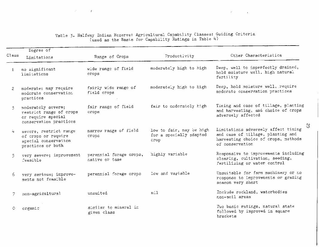
Capability of the Halfway Indian Reserve Soils X
Using the soi1 survey data and the Canada Land Inventory classification system, the soils of the Halfway Indian Reserve have been given capability ratings (Table 4).
Various factors restrict trop production on the Reserve. First, several areas have slopes exceeding 15 percent and some exceed 30 percent, thus topography eliminates cultivated crops on significant acreages.
A generally rigorous climate causes restriction in several ways. Temperatures occasionally drop below the freezing point during the growing season. These are not killing frosts but plant growth is retarded. Heat units (growing degree days) are relatively low. Rainfall is reasonably adequate but many of the soils have rapid permeability (low water retention). These climatic characteristics result in lower trop yields and increased time to mature a trop.

15
The major trop restrictions directly related to the soils are low fertility, rapid permeability, coarse textures, poor drainage and calcareous concentrations. Each soi1 series is affected detrimentally by one or more of these factors.
The Taylor Series is fairly fertile but the calcareous concentration precludes deep cultivation. The Lynx Scries falls in the same category but thcsc soils are less fertile and have some inherent aggregation problems. High permeability and low fertility significantly restrict the productivity of the Branham, Allen, Grayling and Chief's Cabin Creek soils. The Centurian soils have a low permeability, poor drainage and are quite alkaline. The Eaglesham and Kenzie Series are poorly drained organic soils with little immediate potential for trop production.
Suitability Classification
The suitability classification (Figure 4,5, and 6) Is a means of determining the behaviour of soils in relation to specific crops and is based on climate, topography and soi1 properties. Climate limits the range of crops compatible with a certain area. Topography must permit the use of modern machinery thus highly suitable areas are limited to slopes less than 15% and unsuitable areas are slopes of 30% or greater. With climate and topography suitable, the soils properties are the third factor of suitability.
In the Halfway Indian Reserve forage crops, cereal grains and pasture are paramount trop groups in the suitability comparisons of the soils (Table 4). The Taylor soils, being nearly level, relatively fertile and occurring in accessible areas, are suitable for a11 three trop groups. However, since the other soils (except the Lynx series) are not suitable for cereals, it becomes necessary to concentrate cereal production on the Taylor soils. The Lynx soils are similar in suitability to the Taylor soils except they are lower in fertility and organic matter and are frequently subject to erosion and crusting. This is not a serious detriment and with suitable rotations and added fertilizers, the Lynx soils should be reasonably productive. Both these soils are rated "good" for a11 three types of crops.
Branham soils show less "genetic " development than the Taylor and Lynx series, In addition, the third horizon (Ckl -6-18 inches)

16
is highly calcareous and would restrict root development of most crops. The suitability rating is "moderate" to "poor" for both cereals and forage and "good" to "moderate" for improved pasture.
The wetness of the Centurian soils rates them "poor" for cereal grains, but they are "moderately" suited to forage and pasture production. These soils are calcareous and alkaline enough (pH 8.1 - 8.5) to retard cereal production and some forage crops. Drainage and careful species selection permits a "moderate" rating for forage and pasture crops.
The coarse textured Allen soils are suited to pasture crops but are rated "poor" to "moderate" for cereal and forage crops. Surface grave1 deposits of the shallow phase interferes with cultivation.
Unfavorable topography makes the Halfway Complex soils un- suitable for cereal and forage production. T~US the rating is "unsuitable" for cereals and forage and "poor" for pasture.
The Grayling soils are rated "unsuitable" for cereals and forage and "poor" for pasture. The topography makes cultivation difficult and the textures are coarse SO water retention is poor. Even native vegetation is sparse.
The Eaglesham soils are rated "unsuitable" for cereals, "un- suitable" to "poor" for forage and "moderate" for pasture. These organic soils require drainage to be productive.
The Kenzie soils, also organic and water logged, have the added disadvantage of being located in the hummocky Upper terrace. The suitability rating is "unsuitable" for both cereals and forage and "poor" for pasture.
A suitability rating for the soils of the Halfway Reserve is contained in Table 4.
Land Use
Land use (Figure 7) on the Halfway Indian Reserve is only partially adequate. Generally speaking the soi1 survey reveals that each series of soils is being utilized properly as far as the type of trop is concerned. That is, cereals are grown on the most fertile soil, the Taylor series, and infertile or uncultivatable soils are devoted to pasture. However, improved practices and reclamation would improve, materially, the general productiveness of the soi1 resources.
17
The main agricultural operation of the Reserve is the maintenance of approximately 300 head of Hereford and Shorthorn breeder CO~S. The calves are sold each fa11 as feeders and this is the main source of agricultural income. Thus, the soi1 resources are used mainly to grow cereals and forage for winter feeding of the cow herd and maintaining adequate summer pasture for the cows and calves during the summer months, Approximately 25 head of horses are maintained on the Reserve.
The Taylor soils are being used for cereal and forage production with a small portion (30 acres) used for pasture. This accounts for an estimated 860 acres of the best arable land on the Reserve, Forage production cari be increased materially by clearing and cultivating the Lynx soils. An estimated 925 acres were mapped and of this only 120 acres are cultivated. The bulk of cereal and forage production should be grown on the Taylor and Lynx soils. Soi1 analyst reports reveal low available potash in the Lynx soils.
The Branham and Allan soils are suitable for improved pasture. At the present time the pasture areas are poorly utilized. They tend to be infested with weeds and pasture manage- ment should be improved. Some soi1 test records reveal a low available potassium in the Branham soils. Visual observations suggest that a pasture fertilizer program should either be started or reinforced.
Reclamation of the Centurian and Eaglesham soils by drainage Will provide additional acreage for permanent pasture. This study, however, did not examine the economics of drainage systems. Some type of ground water level control may be required,
Grayling soils should not be cultivated. Greater use of these soils cari be effected by range seeding. These soils are susceptible to wind erosion SO surface disturbance should be minimal.
The Chief's Cabin Creek soils lie in positions which are inundated during the freshet of the Halfway River. These soils support good stands of white spruce which act as erosion control and are a source of prime timber. Clearing of the Chief's Cabin Creek soi1 areas should be discouraged.
The land use map (Figure 7) delineates the soils discussed in this section. Land use designations are listed in Table 4.
18
Physical and Chemical Properties of the Halfway Indian Reserve Soils
The major horizons of the Taylor, Branham, Lynx, Centurian and Allen series were sampled and analyzed.
The physical properties investigated were particle size distribution and bulk density. The particle size analysis was done by the pipette method (11). The bulk density was determined by the tore method (31, using a tore volume of 45.68 cubic centimeters.
Organic matter content was determined using the Walkley-Black method (31, which is recommended for soils with free carbonates present. The soi1 reaction was determined by a glass electrode using a 1:l soi1 to water paste and in a 1:2 soi1 to 0.01 M. CaCl suspension (9). The Kjeldahl method (21, and exchangeable cations2 were determined by atomic absorption. The available zinc, copper and manganese from a dilute hydrochloric acid extraction (31, were determined by atomic absorption.
The results of the physical and chemical analyses are contained in Tables 1 and 2.
Typical Profile Description of the Halfway Indian Reserve Soils
The Chief's Cabin Creek Series (Cc>
The Chief's Cabin Creek soils (Cumulic Regosols) loamy sands occur on the recent floodplain and are subject to annual inundation.
The soils are on nearly level to undulating topography and drainage is rapid.
The soi1 consists of a mixture of undecomposed organic materials.
minera1 and relatively
A typical profile is described as follows:
Depth Horizon (inches) Description
C o-3 Gray loamy Sand; structureless, single grained; many fine rOOtSi no reaction to dilute hydro- chloric acid.
IIAhb 3-22 Grayish brown sandy loam; mixture of sands and organic material consisting of spruce cones and twigs; structureless, single grained; fine roots common; neutral reaction.
IIC 22+ Gray and white Sand; structureless, single grained; slightly calcareous; underlain by gravels at variable depths.
Allen Series (An)
The Allen Soils (Orthic Regosols) sandy loams occur on the lower alluvial terraces.
These soils occur on nearly level to undulating topography, and are rapidly drained.
A disturbed Ah horizon lies directly over the calcareous parent material.
The profile of a
Depth Horizon (inches)
Apl o-2 1/2
Ap2 2 1/2-5
AC 5-11
Ck ll+
typical sandy loam is described as follows:
Description
Very dark brown (10 YR 212 d.) sandy loam; structureless; single grained; loose, very friable; many fine roots; pH 6.6.
Dark brown (10 YR 3/3 d) loam; very weak medium blocky; loose; many fine roots; pH 6.2.
Brown (10 YR 4/3 d) sandy loam; structureless, single grained; loose; fine roots common; pH 6.1.
Black, brown and white Sand; structureless, single grained; calcareous; pH 8.2.
Allen - shallow phase
Allen - shallow phase is mapped in areas where gravels and coarse sands occur at a depth of less than 2 feet.
Branham Series (Br)
Branham soils (Orthic Eutric Brunisols) are developed on intermediate terraces and on medium textured deposits which are often gravelly.
These soils are well drained.
The topography is gently undulating.

20
A typical profile is as follows:
Depth Horizon (inches) Description
L-H 1 1/2 -0 A mat of leaf litter and roots.
Bm o-6 Yellowish brown (10 YR 5/4 d> silt loam; weak medium angular blocky; soft, very friable;
ckl 6-18 Grayish brown (10 YR 5/Z d) silt loam; weak, coarse, angular blocky; soft, friable; (very cdcareous); pH 8.4.
Ck2 lO-30+ Grayish brown (10 YR 5/2 d) silt loam; weakly stratified; soft, very friable; pH 8.6.
Branham - gravelly phase
Locally the texture of these soils is subject to considerable variation. Textures of gravelly loam to gravelly sandy loam over gravelly sand are representative of the gravelly phase.
Taylor Series (Ty)
The Taylor soils (Rego Black Chernozems) silty clay loams have developed on fine textured materials of the intermediate terraces. The classification of these soils is based on soils disturbed by cultivation and is not necessarily the same as the virgin soil. A virgin soi1 in this type of environment would encourage the development of a Rego Dark Gray Chernozem.
These soils are formed on level to undulating topography, Where gravels and stones are present near the surface, Taylor- shallow phase is mapped.
Taylor soils are well drained yet have an adequate water storage capacity for crops.

21
Horizon
AP
AC
CA
Ckl
IIAhb
IICk
Depth (inches)
O-7
7-12
12-20
20-24
24-27
27+
Description
Very dark grayish brown (10 YR 3/1 d) silty clay loam; strong medium granular structure; soft, friable; many fine roots; pH 7.7.
Dark grayish brown (10 YR 4/2 d) silty clay loam; strong medium blocky; slightly hard, friable; many fine roots; pH 8.2.
Dark grayish brown (10 YR 4/2 d) silty clay loam; strong coarse and medium blocky; slightly hard, friable; roots common; pH 8.5.
Grayish brown (10 YR 5/2 d) silt loam; weak coarse blocky; soft, friable; pH 8.7.
Very dark grayish brown (10 YR 3/2 d) silt loam; strong medium and fine granular; soft, friable; calcareous; pH 8.4.
Grayish brown (10 YR 5/2 d) silt loam; weak angular blocky; soft,friable; pH 8.5.
Halfway Complex
The Halfway Complex is dominated by Degraded Eutric Brunisols with minor inclusions of Orthic Regosols. These soils are developed on alluvial-colluvial materials of medium and coarse textures. They occur on steep slopes exceeding 25 percent.
This steep sloping land separates the Upper and intermediate terraces. It is the remains of a river tut feature which has since been subject to "slumping" causing irregular topography in a few areas.
The soils are well to rapidly drained. Permeability is moderate, and runoff is fast.
Degraded Eutric Brunisolic loams and sandy loams occur on slopes between 25 and 40 percent. The leaf litter is very thin or non-existant. Where there is no forest litter a thin Ahe horizon is common. The Ae horizon is thin and although irregular, it is continuous. Directly underlying the Ae is a Bm horizon 4 to 8 inches thick with weak fine granular structure. A highly calcareous Ck horizon underlies the Bm.
22
0rLh.i c l?-gosol~ 45 percent.
arc; common on the steep slopes which exceed Textures vary from silt loam to sandy loam. A silt
loam profile consists of a dark grayish brown Ah horizon 3 to 5 inches thick overlying a highly calcareous Ck similar in appearance to the Ck horizons of the Lynx and Taylor soils.
Lynx Series (Ly)
The Lynx soils (Brunisolic Gray Luvisols) silt loams occur near the edge of the highest terrace. They are associated with Centurian, Eaglesham, Kenzie and Grayling soils.
The topography is level to gently undulating.
The profile is brownish in color. Beneath a 2.5 inch organic litter lies a 4-inch Bm horizon, followed by a 4-inch Ae horizon. The thickness of a typical Bt varies considerably, The Zone of maximum clay accumulation varies from 0.5 to 4 inches in thickness and occurs in the top of the Bt. The underlying material is calcareous and silt loam in texture.
The profile of a typical silt loam is described as follows:
Depth Horizon (inches)
L-H 2 1/2-o
Bm o-4
Ae2 4-8
Bt 8-10
Btk 10-20
Ck 20+
Description
Dark brown leaf litter.
Brown (10 YR 4/3 d) silt loam; weak fine granular; loose, very friable; some small concretions; pH 6.0
Light yellowish brown (10 YR 6/3 d) sandy loam; weak fine platy to weak fine granular; loose, very friable; pH 6.4.
Yellowish brown (10 YR 5/4 d) silty clay loam; medium and coarse subangular blocky; hard, firm; few fine roots; pH 7.1.
Light grayish brown (10 YR 6/2 d) silty clay weak subangular blocky; loose, friable; some carbonate cementation; pH 8.4.
Grayish brown (10 YR 5/2 d) silt loam; structureless, amorphous and pseudo platy; highly calcareous; pH 8.5.

23
Centurian Series (Ce>
The Centurian soils (Carbonated Rego Humic Gleysols - peaty phase) loams occur in depressional areas on the uppermost terrace. They are associated with Lynx, Kenzie and Eaglesham soils.
Centurian soils are found in depressional areas and are only a few feet lower than the well drained Lynx soils.
The drainage is poor and the water table is subject to fluctuation.
Centurian soils are characterized by their dark colored and highly calcareous peaty surface underlain by a highly calcareous Ah horizon.
A typical loam profile is described as follows:
Depth Horizon (inches) Description
Oh 5-o Very dark brown to black mat of decomposed organic materials; pH 8.1.
Ah O-13 Dark gray (10 YR 4/1 d) loam; medium and coarse granular; very friable, slightly hard; few faint mottles; fine roots common; pH 8.2.
CM1 13-21 Grayish brown (2.5 Y 5/2 d) loam; fine granular; very friable, slightly hard; many distinct medium mottles; pH 8.5.
Ch2 21+ Grayish brown (2.5 Y5/2 d) sandy loam; structureless, amorphous; very friable, soft; lime accumulation near top of the horizon; few faint mottles; pH 8.5:
Grayling Series (Gn)
The Grayling soils, (Degraded Eutric Brunisols) loamy sands are found on duned sand deposits. These soils are associated with Lynx, Eaglesham and Kenzie soils. Grayling soils are recognized by the authors within localized areas mapped as Ground- birch soils (Brunisolic Gray Luvisols) in the Peace River Area Soi1 Survey (8).
The topography ranges from gently undulating to hilly.
Drainage is rapid. The subsoil is sand in tc:xturr: and gravr; I - free.

The organic surface litter is usually very thin ( up to one inch thick) and overlies a thin gray leached Aej horizon. A brown Bm horizon lies immediately below the Aej horizon.
The profile of a typical Grayling loamy sand is described as follows:
Horizon Depth
(inches)
L-H
Aej
1-o
o-1
Bm 1-8
BC 8-9
Ck
Description
Brown layer of pine needles and leaves.
Pinkish gray (7.5 Y 7/2 m> loamy fine Sand; structureless, single grained; loose; slightly acid.
Reddish brown (5 YR 5/3 a) loamy Sand; structureless, single grained; loose; slightly acid.
Grayish brown (10 YR 5/2 m> loamy Sand; structureless, single grained; loose; neutral reaction.
9+ Gray (10 YR 5/1 m> sand and loamy Sand; structureless, single grained; loose; alkaline reaction.
Eaglesham Series (Eg)
This organic soi1 consists largely of the semi-decomposed remains of sedges, coarse grasses and Woody materials and is classified as a Terric Mesisol.
The topography is level to depressional.
These soils are very poorly drained.
A typical profile is described as follows:

25
Depth Horizon (inches) Description
L 4-o A mat of grass and deciduous leaves.
Oml o-17 Brown and dark brown moderately well decomposed sedges.
Om2 17-31 Black moderately well to well decomposed plant remains.
IIC 3l+ Blue gray to dark gray silt loam; structureless, amorphous; usually faintly mottled.
Kenzie Series (Kz)
Kenzie soils (Terric Mesisols - sphagnic type) consist of peat formed mainly from sphagnum. These soils occur in deep basin-like depressions associated with Grayling soils.
The drainage is very poor and the water table is usually near the surface.
A typical profile is described as follows:
Depth Horizon (inches) Description
L 3-O
Of o-16
O?n 16-27
Oh 27-33
IIC 33+
Grave1 bar
Living sphagnum moss, fibrous and spongy; hummocky producing relief of up to 16 inches.
Yellowish brown to dark brown, semi-decomposed moss, twigs and leaves; water table common in this horizon; pH 4.5.
Dark brown moderately well decomposed moss; few recognizable plant remains; pH 4.5.
Grayish brown, well decomposed organic material; pH 5.0.
Dark grayish silt loam; structureless, amorphous; faintly mottled.
This land type consists of exposed grave1 and sand deposits in the river channel which are completely submerged during the freshet stage. These bars are subject to annual changes due to both erosion and accumulation and are largely devoid of vegetation except for small areas in the late summer. Soi1 development is not evident.

26
Table 1 - Halfway Indian Reserve: Physical Properties of Five Soils
DeDth % Sand % Silt %Clay %Fine Textural Bulk Horizon (inLhes> 2-.5mm .5-.002mm .002&m Clay Class Densi ty
Apl Ap2 AC Ck
o-2 1/2" 2 1/2-5" 5-11" 11"+
57.5 32.6 9.9 4.2 49.1 66.8 2:-7
11.2 4.9
6:3 8.7 4.7
91.0 2.6 1.3
SL L
SL S
Branham Series
L-H Bm Ck Ck' Ck2
AP ?
1 1/2-O" o-6" 6-12'1 12-18" 18"+ 6"
26.6 5718 15.6 22.6 63.6 13.8
3;:; 76.4 14.7 53-5 6.6
32.0 53.4 14.6
j:;
3:s 4.1
Si1 Si1 Si1 Si1
L
Centurian Series
om Ah% Ckgl Ch2
5-O" O-13" 13-21" 21"+
4015 4517 13.8 413 L 51.5 37.4 11.1 5.6 L 55.0 36.9 8.2 3*2 SL
Lynx Series
L-H Bm Ae Bt Btk Ck
2 1/2-O" O-4" 4-8" 8-10" 10-20" 20"+
4114 - 51.6 50.6 43.0 67:: 14.3 50.4 1.2 73.4
38.8 55.3
1.9 Si1 1.4 SL
18.7 SiCL 9.3 Sic 3.4 Si1
Taylor Series
AP O-7" 60.1 38.2 13.0 SiCL AC 7-12" 82 58.0 33.2 9.0 SiCL CA 12-20" 8.1 52.1 39.8 15.0 SiCL Ck 20-24" 27.4 58.7 14.0 5.3 SiL IIAhb 24-27" 28.9 64.0 7.1 2.2 SiL IICB 27"+ 22.9 60.0 17.1 5.5 SiL
Allen Series
1.1 1.3
1.1
0.8 1.1 1.3 1.2
ISampled in field adjacent to virgin soi1 described.
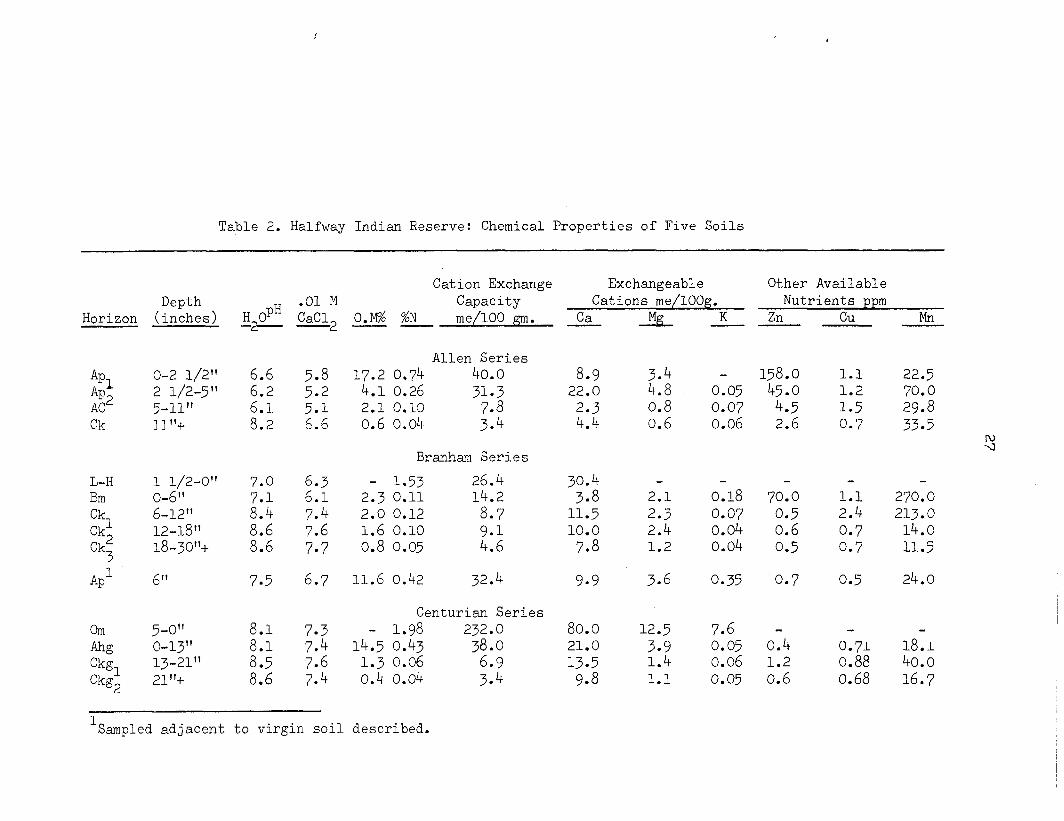
Table 2. Halfway Indian Reserve: Chemical Properties of Five Soils
Depth Horizon (inches)
*p1 *p2 AC Ck
o-2 1/2" 2 1/2-5” 5-11" 11°C
L-H 1 1/2-O" Bm o-6” Ck Ck'
6-12"
Ck; 12-18” 18-30”+
AP1 6”
om 5-O” hz O-13" Ckgl 13-21" Ckg2 21%
H OPH -.
.Ol M Cation Exchange Exchangeable Other Available
Capacity Cations me/lOOg. Nutrients ppm CaC12 %N O.% me/100 gm. Ca AL K Zn --
6.6 6.2
8::
Allen Series 5.8 17.2 0.74 40.0 5*2 4.1 0.26 5.1 2.1 0.10 'Z 6.6 0.6 0.04 3:4
8.9 3.4 158.0 1.1 22.0 4.8 0.05 45.0 1.2
2.3 0.8 0.07 4.5 1.5 4.4 0.6 0.06 2.6 0.7
Branham Series
7.0
87:;
8::
6.3 - 1.53 26.4 6.1 2.3 0.11 14.2 7.4 2.0 0.12 8.7
7.6 1.6 0.10 7.7 0.8 0.05 4:;
3;-: . 2.1 0.18 70.0 1.1 270.0 11.5 2.3 0.07 0.5 2.4 213.0 10.0 2.4 0.04 0.6 0.7 14.0
7.8 1.2 0.04 0.5 0.7 11.5
7.5 6.7 11.6 0.42 32.4 9.9 3.6 0.35 0.7
8.1
ii?:; 8.6
Centurian Series 7.3 - 1.98 232.0 7.4 14.5 0.43 38.0 7.6 1.3 0.06 6.9 7.4 0.4 0.04 3.4
80.0 12.5 7.6 - 21.0 3.9 0.05 0.4 13.5 1.4 0.06 1.2 9.8 1.1 0.05 0.6
CU
0.5
0.71 0.88 0.68
Mn
22.5 70.0 29.8 33.5
2
24.0
18.1 40.0 16.7
1 Sampled adjacent to virgin soi1 described.
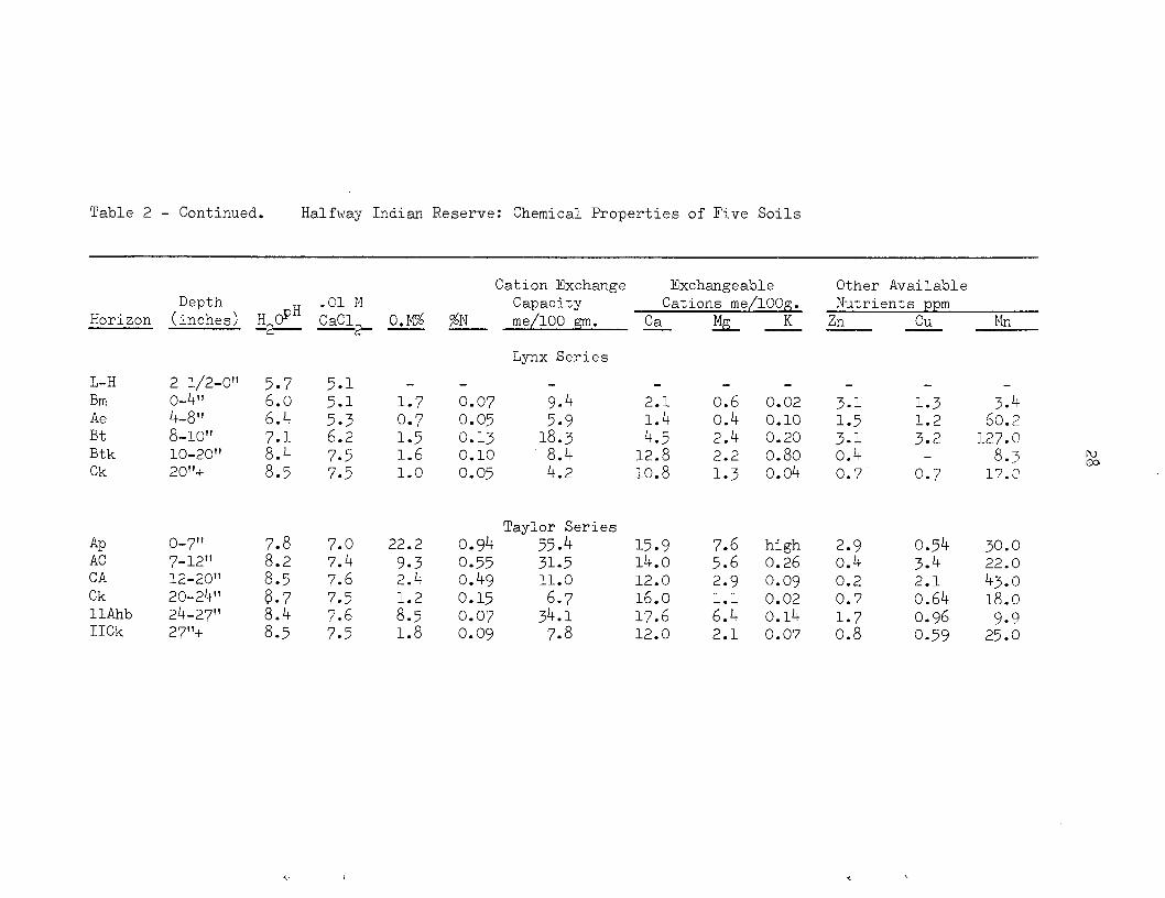
Table 2 - Continued. HalfwJay Indien Reserve: Chemical Properties of Five Soils
Depth Horizon (inches)
L-H 2 1/2-O" Bm O-4" Ae 4-8" Bt 8-10" Btk 10-20" Ck 20°C
AP O-7" AC 7-12" CA 12-20" Ck 20-24" IIAhb 24-27" IICk 27"+
5.7 6.0 6.4
87:; 8.5
7.8 8.2 8.5
8-l . 8.5
.Ol M CaCl+ O.ti P -
5.1 5.1
2: 7:5 7.5
7:: 7.6 7.5 7.6 7.5
1.7 0.07 9.4 2.1 0.6 0.02 0.7 0.05 5.9 1.4 0.4 0.10 1.5 0.13 18.3 4.5 2.4 0.20 1.6 0.10 8.4 12.8 2.2 0.80 1.0 0.05 4.2 10.8 1.3 0.04
22.2
z-t .
ii:: 1.8
Taylor Series 0.94 55.4 15.9 7.6 high 0.55 31.5 14.0 5.6 0.26 0.49 11.0 12.0 2.9 0.09
0.15 6.7 16.0 0.07 34.1 17.6 6:; 02.: 0.09 7.8 12.0 2.1 0.07
Cation Exchange Exchangeable Capacity Cations me/lOOg.
%N me/100 gm. Ca EL K
Lynx Series
Other Available Nutrients ppm
Zn CU IMn
3.1. 1.3 3.4 1.5
;:2 60.2
3.1 127.0 0.4 - 8.3 0.7 0.7 17.P
2.9 0.54 30.0 0.4 3.4 22.0 0.2 2.1 43.0 0.7 0.64 18.0 1.7 0.96 9.9 0.8 0.59 25.0
3
2 Q.0
7-i M
k 0
0
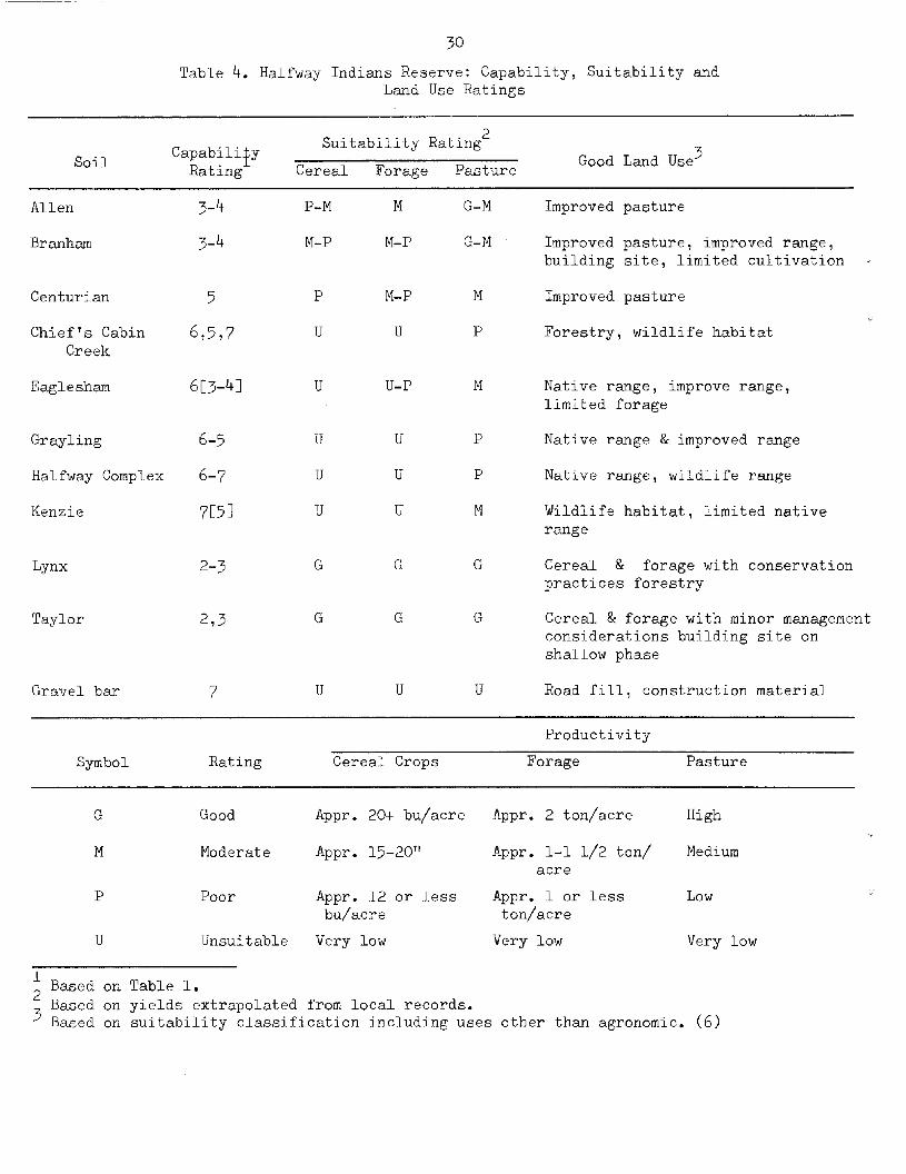
Table 4. Halfway Indians Reserve: Capability, Suitability and Land Use Ratings
Soi1 Suitability Rating2
Capabilify Good Land Use 3 Rating Cereal Forage Pasture
Allen
Branham
3-4
3-4
Centurian
Chief's Cabin Creek
Eaglesham
5 P
6,5,7 U
6C3-41 U
Grayling 6-5
Halfway Complex 6-7
Kenzie 7c51
Lynx 2-3 G
Taylor 273
Grave1 bar 7
P-M
M-P
G
U
M
M-P
M-P
U
U-P
G
G
U
G-M
G-M
Improved pasture
Improved pasture, improved range, building site, limited cultivation I
Improved pasture
Forestry, wildlife habitat
Native range, improve range, limited forage
Native range & improved range
Native range, wildlife range
Wildlife habitat, limited native range
Cereal & forage with conservation practices forestry
Cereal & forage with minor management considerations building site on shallow phase
Road fill, construction material
Symbol Rating Cereal Crops
Productivity
Forage Pasture
G Good Appr, 20+ bu/acre Appr. 2 ton/acre High
M Moderate Appr. 15-20rt Appr. l-l 1/2 ton/ Medium acre
P Poor Appr. 12 or less Appr. 1 or less Low bu/acre ton/acre
U Unsuitable Very low Very low Very low
1 2 Based on Table 1.
3 Based on yields extrapolated from local records. Based on suitability classification including uses other than agronomie. (6)
References
1. Anonymous 1972, Climate Capability for Agriculture. Climatology Report Number 1, Second edition, British Columbia Land Inventory (C.L.I.). Victoria, B.C.
2. Atkinson, H.J., Giles, G.R., MacLean, A.J. and Wright, J.R. 1958. Chemical Methods of Soi1 Analysis. Canada Department of Agriculture, Ottawa, Ontario.
3* Black, C.A., Editor-in-Chief. 1965. Methods of Soi1 Analysis. Parts 1 and 2, Agronomy Monogram No. 9. American Society of Agronomy, Inc. Madison, Wisconsin, U.S.A.
4. Canada Department of Agriculture, 1970. The System of Soi1 Classification for Canada. Queen's Printer, Ottawa, Ontario.
5. Canada Department of Transport. 1967. Temperature and Precipit- ation Tables for British Columbia. Meterological Branch, Queen's Printer,Ottawa, Ontario.
6. Canada Department of Regional Economie Expansion. 1970 (2nd edition). Objectives, Scope and Organization. The Canada Land Inventory, Queen<s Printer, Ottawa, Ontario.
7. The Canada Land Inventory, Report No. 2, 1969. Department of Regional Economie Expansion, Ottawa.
8. Farstad, L., Lord, T.M., Green, A.J. and Hortie, H.J. 1965. Soi1 Survey of the Peace River Area in British Columbia. Report No. 8 British Columbia Soi1 Survey, Canada Department of Agriculture, Queen's Printer, Ottawa, Ontario.
9. Jackson, M.L. 1958. Soi1 Chemical Analysis. Prentice-Hall Inc. Englewood Cliffs, N.J. U.S.A.
10. Rowe, J S. 1959. Forest Regions of Canada. Canada Dept. of Northern Affairs National Resources. Bulletin 123. Ottawa, Ontario.
11. Toogood, J.A. and Peters, T.W. 1953. Comparison of methods of mechanical analysis of soils. Canadian Journal of Agricultural Science 33: 159-171.