i-35 traveler information during construction
TRANSCRIPT

I-35 Traveler Information During Construction

®
Highlights: I-35 expansion project
Last 96 miles – Central Texas 14 segments/19 projects Costs: ~$2.1B
• Construction = $1.6B • Right-of-way = $410M+ • Utility relocation = $110M
Complete 2017 Traffic Volumes
• 55,000 – 111,000 vehicles/day • Trucks: 25% – 30%
Over 5 years, ~ 185 million trips

®
I-35 survey respondents want…
1. Expected delays between major points along I-35 2. Current travel times between major points 3. Current locations of incidents 4. Locations and times for freeway lane closures 5. Projected travel times between major points 6. Detour routes/maps 7. Current speeds on each segment 8. Snapshots of freeway conditions at selected points

®
Project Innovation
Agency Cooperation Public
Participation
I-35 efforts focused on…

®
I-35 Waco district infrastructure
• Few existing resources
• 100 miles of construction
• Initial focus on device deployment o low-cost
o non-intrusive
o relatively simple to relocate
• Integration with TxDOT TMC solutions
• Satisfy traveler information needs

®
Initial traveler information goals
• Current segment travel times / speeds
• Destination travel times
• Lane closure notifications
• Snapshots
• Real-time map

®
I-35 field deployments • Bluetooth travel time detection
o 40 segments, 2-5 miles in length o 10-15 additional segments in the Austin and San
Antonio Districts
• 17 Wavetronix radar detector sites
• 6 CCTV cameras sites
o PTZ o At locations of interest
• 21 portable changeable message signs
(PCMS) o ~10 per direction at approximate10 mile spacing

®

®
Travel time integration w/ LoneStar
• Field: o Sensors collect data
• TTI
o Receives and aggregates data o Determines travel time message o Passes message to LoneStar via C2C for posting
• TxDOT
o Operates LoneStar o Communicates to field devices (PCMS) o Posts all messages o Has default messages o Travel time messages can be overridden for events of higher priority

®
Disseminating travel times • 30 second data cycles • 5-minute message updates • 21 signs • Signs procured via projects
and rental
PCMS Destinations NB SB
I35 E/W West
Hillsboro Elm Mott
West Waco
Elm Mott Hewitt
Waco Troy
Hewitt Temple
Lorena Belton
Troy Salado
Temple
Belton
®
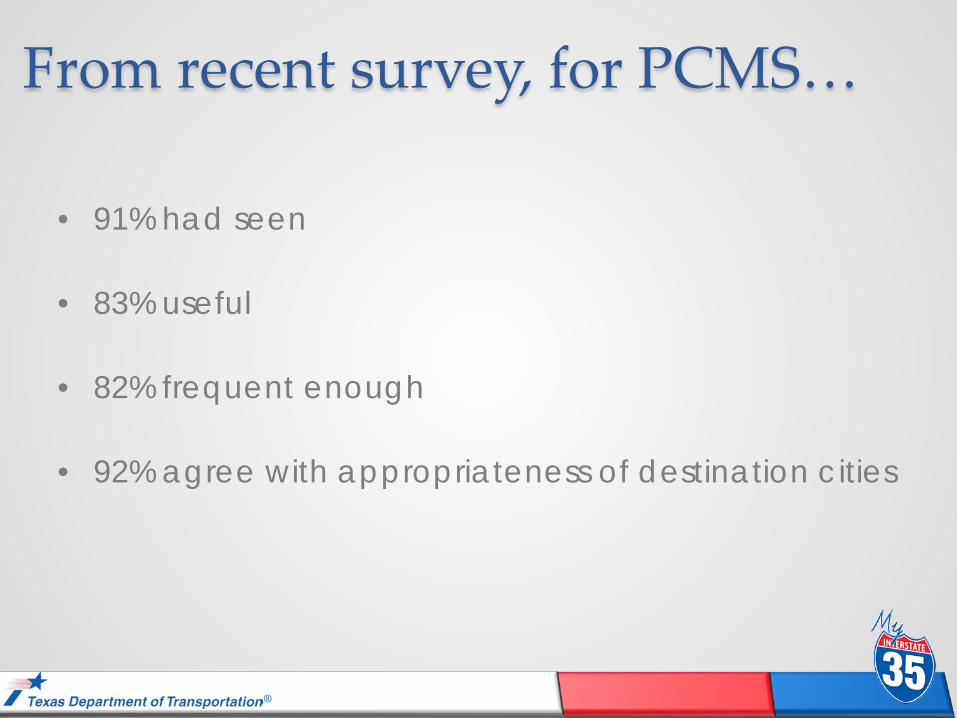
From recent survey, for PCMS…
• 91% had seen
• 83% useful
• 82% frequent enough
• 92% agree with appropriateness of destination cities

®
ELM MOTT 12 miles
BT segment NB 341-343
BT segment NB 334-337
BT segment NB 339-341
BT segment NB 337-339
BT segment NB 330-334
05
1015202530
05
05
05
Accident Location
BT Segment Travel Times (minutes)
05
1015
8:00
9:00
10:0
0
11:0
0
12:0
0
13:0
0
14:0
0
Accident: 10-9-2012: NB: Waco

®
0
5
10
15
20
25
30
35
8:00
9:00
10:0
0
11:0
0
12:0
0
13:0
0
14:0
0Trav
el T
ime
(min
)
BT-Travel time PCMS (NB-7)
Corresponding travel times

®
Lane closures: 1/2012 - present
• ~7% (38) on cross streets • Long-term closures Construction
71%
Maintenance 27%
Utility Work 2%
Accident Investigation
0%
TYPE OF WORK Construction 405 Maintenance 151 Utility Work 10 Accident Investigation 3

®
Lane closure impact assessment From To Expected
Queue (mi) Expected Delay (min/veh)
Worse Case* Queue (mi)
Worse Case* Delay (min/veh)
07:00 PM 08:00 PM 0.5 2.7 1.5 7.3
08:00 PM 09:00 PM 1.0 4.6 3.0 13.9
09:00 PM 10:00 PM 0.3 2.0 3.1 14.8
10:00 PM 11:00 PM 0.0 0.0 3.0 14.8
11:00 PM 12:00 AM 0.0 0.0 2.4 12.5
12:00 AM 01:00 AM 0.0 0.0 0.5 3.2
01:00 AM 02:00 AM 0.0 0.0 0.0 0.0
02:00 AM 03:00 AM 0.0 0.0 0.0 0.0
03:00 AM 04:00 AM 0.0 0.0 0.0 0.0
04:00 AM 05:00 AM 0.0 0.0 0.0 0.0
05:00 AM 06:00 AM 0.0 0.0 0.0 0.0
06:00 AM 07:00 AM 0.0 0.0 0.0 0.0

®
Lane closure notifications
• Recipients o >1000, daily o >900, 7-day o >150 high-impact
• Usefulness o 81% useful o 91% easy to understand o 93% abbreviations easy
to understand o 90% right amount of detail
• Format: o 67% continue current o 33% customize for my location o Points to through nature of trips
Austin 17%
Belton 4%
Brucevill-Eddy 4%
Dallas 11%
Fort Worth 14%
Georgetown 2%
Hillsboro 3%
Round Rock 7%
Salado 7%
San Antonio 4%
San Marcos 3%
Temple 6%
Waco 18%

®
Project dynamic traveler info

®
Future traveler information goals
• Continued refinements to Build 1
• End of queue monitoring system
• Forecast corridor delay
• Construction delay signs
• Long-term WZ protection at select locations
• Performance metrics

®
Data Sources
Pre-Trip Information
En-Route Information
(Lane Closure Notifications)
(Construction Delay)
(Web) (Social Media) (Email)
(Travel Times) (CCTV Snapshots)
(Volumes)
Lane Closure Assessment)
(LoneStar)
(Queue Warning System)
(Smartphones)
(Travel Times)
I-35 data inputs and outputs

®
End of queue warning system • Provide dynamic safety information on
queues and congestion • Generate detailed data on delay near
work zones • Input into the construction delay
calculations and sign posting • Challenges
o Procurement of mobile system o Procurement of semi-permanent system

®
End of queue warning system Automated
monitoring near a work zone
Warning of slow speeds
Warning location of stop and go traffic

®
Forecasting delay… • Display forecasted delays due to lane closures
• Forecast is for when driver is expected to arrive at start of corridor section
• Drivers interpret delay as additional travel time for their trip
• Calculations use current travel times and volumes plus end of queue data
• Updated every 5 minutes
• System updates automatically
• Communications via LoneStar

®
Delay signs: Human factors testing
• Simplified Graphical Route Information Panel Design (GRIP)
• Consistent interpretation
• Correct assumption of “construction-only” delays

®
Proposed sign locations

®
Future: Additional social media

®
Project Innovation
Agency Cooperation Public
Participation
I-35 success comes from …

®
For more information: Robert E. Brydia
[email protected] Texas A&M Transportation Institute
Tel 979.845.8140
Larry Colclasure [email protected]
Texas Department of Transportation Tel 254.867-2800