hypercable telecommunications system design with … · 3 © 2010 intermap technologies. ......
TRANSCRIPT

Hypercable telecommunications system design with Intermap Technologies Telecommunication Products

Intermap Online Surface ProfilesHypercable link budget

© 2010 Intermap Technologies. All rights reserved.3
Terrain Profiles for Microwave Link Planning
Intermap’s Online Terrain Profile
Provide a uniformly accurate, wide-area topographic model of the earth's surface
Including buildings, vegetation, roads, and natural terrain
Supports Microwave planning in a unique way to
- Do feasibility checks in the pre-planning phase
- Find the best possible sites and height for Antennas
- Decrease number and costs of site surveys

© 2010 Intermap Technologies. All rights reserved.4
Terrain Profiles for Microwave Link Planning
Customer Quotes:
Scandinavian Telecom Professional Services Provider:
“We are saving up to 80% of our site visits using this Intermap service”
Operator in Germany:
“Our target is to decrease our surveying costs by min. 30%”
Telecom Professional Services Provider:
“By using this Service we have increased our efficiency in the planning”

© 2010 Intermap Technologies. All rights reserved.5
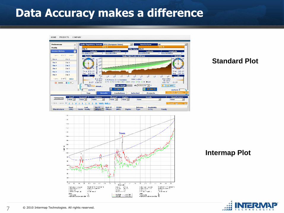
Data Accuracy makes a difference
Standard Plot Intermap Plot
Intermap„s Online Terrain Profiles are derived from the Company„s high-resolution NEXTMap surface model and allow significantly more precise evaluation of the terrain than standard data.

© 2010 Intermap Technologies. All rights reserved.6
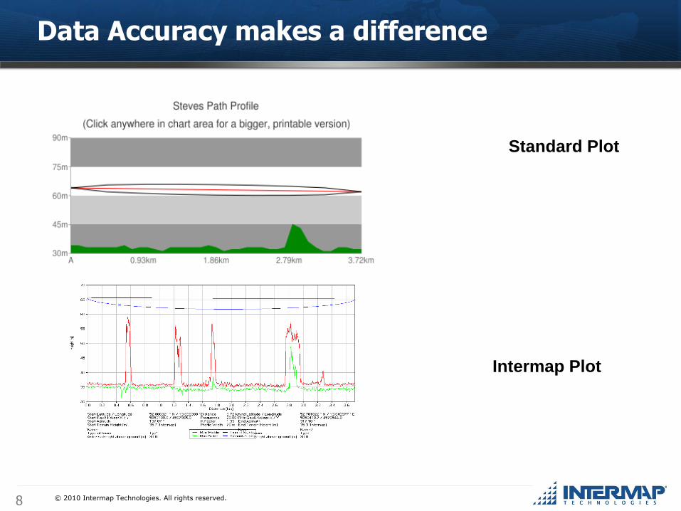
Data Accuracy makes a difference
Standard Plot Intermap Plot
Using highly accurate NEXTMap digital surface models as database for creating Online Terrain Profiles, provides you with realistic information about the height and surface appearance of the Earth surface.
© 2010 Intermap Technologies. All rights reserved.7
Data Accuracy makes a difference
Intermap Plot
Standard Plot
© 2010 Intermap Technologies. All rights reserved.8
Data Accuracy makes a difference
Intermap Plot
Standard Plot

© 2010 Intermap Technologies. All rights reserved.9
Data Accuracy makes a difference
Location displayed:
Industry overestimated
Intermap Surface Model
Example: ±50 m corridor used for
calculation of the max. profile
Surface Model from Clutter Data
For visualisation: profile lines
draped on surface model from clutter data

© 2010 Intermap Technologies. All rights reserved.10
Easy accessible application
Two option to get access:
1. via Intermap„s free client:
2. or through a Web browser via www.intermap.com

© 2010 Intermap Technologies. All rights reserved.11
Online Terrain Profiles – Example profile
Test profile: Lorsbach – Ruppertshain, Germany
Line of sight (LOS)
Min. height of profile
Max. height of profile
Fresnel Zone
Clear and concise profiles for accurate analysis

© 2010 Intermap Technologies. All rights reserved.12
Online Terrain Profiles – Example profile
Intermap‟s Online Terrain Profiles are provided as .kml and .txt files
Visualization of profile over forested areas
Height information of the terrain surface (incl. vegetation height)
Highest point within the defined 50m corridor
Line of sight (LOS)
1st Fresnel Zone

© 2010 Intermap Technologies. All rights reserved.13
Complementary Service to existing planning tools for microwave link planning
Significant accuracy advantage over standard
clutter data and terrain models
Precise data service helping to reduce unnecessary
site survey costs
Enables Efficient and cost-effective planning
Easy accessible Web-based application
Get a free test account for evaluation
Online Terrain Profiles for Microwave Link Planning
© 2010 Intermap Technologies. All rights reserved.14
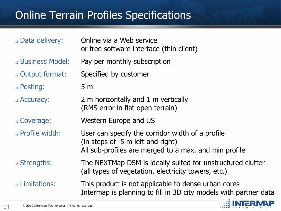
Data delivery: Online via a Web serviceor free software interface (thin client)
Business Model: Pay per monthly subscription
Output format: Specified by customer
Posting: 5 m
Accuracy: 2 m horizontally and 1 m vertically (RMS error in flat open terrain)
Coverage: Western Europe and US
Profile width: User can specify the corridor width of a profile(in steps of 5 m left and right)All sub-profiles are merged to a max. and min profile
Strengths: The NEXTMap DSM is ideally suited for unstructured clutter(all types of vegetation, electricity towers, etc.)
Limitations: This product is not applicable to dense urban coresIntermap is planning to fill in 3D city models with partner data
Online Terrain Profiles Specifications
© 2010 Intermap Technologies. All rights reserved.15
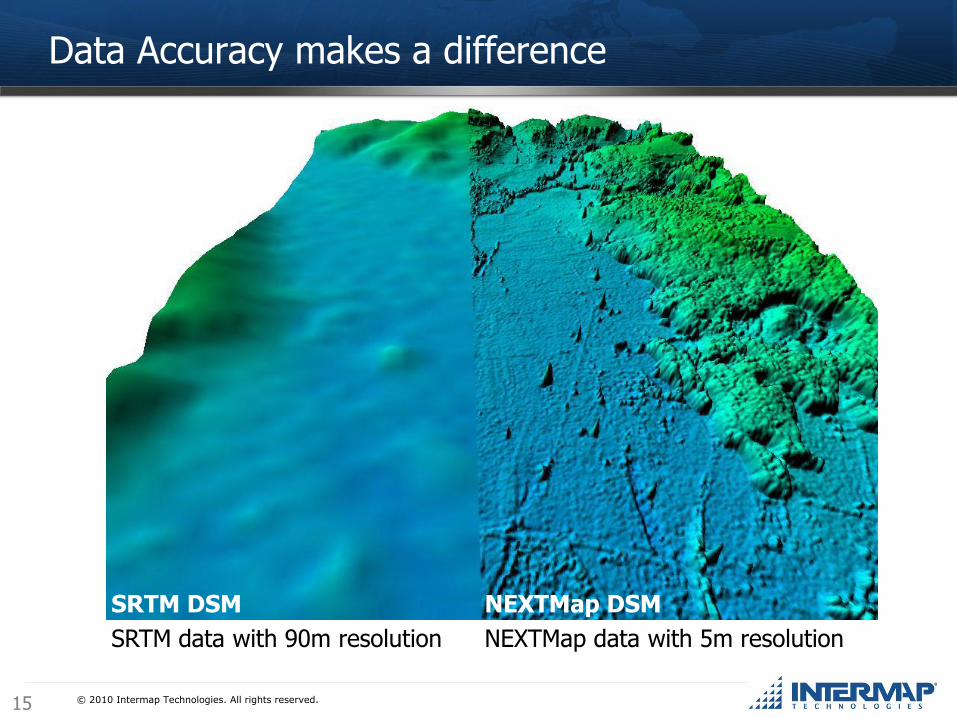
Data Accuracy makes a difference
SRTM DSM
SRTM data with 90m resolution
NEXTMap DSM
NEXTMap data with 5m resolution

NEXTMap® for RF Planning

© 2010 Intermap Technologies. All rights reserved.17
NEXTMap® for RF Planning
Optimum placement of radio towers ensures:
- High service quality
- Revenue increase
Accurate elevation data ensures:
- Optimum placement of radio towers ensures
- Only the minimum number of base stations are installed
- Major cost reduction

© 2010 Intermap Technologies. All rights reserved.18
Our Customer
Intermap Telecom Market Customers
within less than one year:
Intermap first telecom customer:

© 2010 Intermap Technologies. All rights reserved.19
NEXTMap® for Radio Planning
Majority of the operators are paving the way for 4G (LTE)
- First target for LTE is broadband in rural areas
- Frequency for digital dividend will become free soon to be used for LTE planning
- Power of computing has increased, producing accurate large scale predictions
of a transmitter service area, using highly accurate data have become a reality
- Intermap elevation data is sole source of accurate, wide-area topographic
models of the earth's surface with a uniformly accurate coverage
© 2010 Intermap Technologies. All rights reserved.20
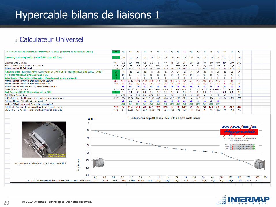
Calculateur Universel
Hypercable bilans de liaisons 1
© 2010 Intermap Technologies. All rights reserved.21
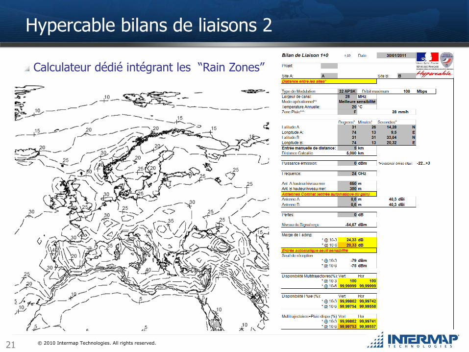
Calculateur dédié intégrant les “Rain Zones”
Hypercable bilans de liaisons 2

© 2010 Intermap Technologies. All rights reserved.2222
Contact: Jean-Claude [email protected]
Questions ?