hydrologic investigations and data-collection network … · hydrologic investigations and...
TRANSCRIPT

HYDROLOGIC INVESTIGATIONS AND
DATA-COLLECTION NETWORK IN STRIPPASLE
COAL AREAS IN NORTHWESTERN NEW MEXICO
By H. R. Hejl, Jr,
U.S. GEOLOGICAL SURVEY
Open-File Report 82-358
Albuquerque, New Mexico
January 1982

UNITED STATES DEPARTMENT OF THE INTERIOR
JAMES G. WATT, Secretary
GEOLOGICAL SURVEY
Dallas L. Peck, Director
For additional information write to:
District Chief U.S. Geological Survey, WRD 505 Marquette NW, Room 720 Albuquerque, New Mexico 87102
For sale by:
U.S. Geological Survey Open-File Services Section Branch of Distribution Box 25425, Federal Center Denver, Colorado 80225
11

CONTENTS
Page
Abstract .............................................................. 1
Introduction .......................................................... 2
Purpose and scope ................................................ 2Study area .............................>.......................... 3
Hydrologic investigations ............................................. 5
Geohydrology of northwestern New Mexico and its relationship toenergy-resources development ................................... 5
Hydrologic surveillance of coal-lease areas in northwesternNew Mexico ..................................................... 6
Quality-of-water monitoring in the Chaco River basin innorthwestern New Mexico 1 s energy-development area .............. 7
Precipitation-runoff modeling of watershed systems innorthwestern New Mexico ........................................ 8
Water-resources monitoring of coal development in the San JuanBasin, New Mexico .............................................. 9
Exploration of techniques for separation and quantification ofindividual coal mine effects from cumulative effects data ...... 10
Hydrologic data-collection network .................................... 11
Cooperating agencies ............................................. 11Streamflow and water-quality station network ..................... 12Miscellaneous water quality of streamflow data-collectionnetwork ........................................................ 17
Annual maximum discharge gaging-station network .................. 21Observation-well network ......................................... 25
Sources of hydrologic information ..................................... 31
Reports of interpretive hydrologic investigations ................ 31Annual compilation report ........................................ 31National Water Data Storage and Retrieval System (WATSTORE) ...... 32Other sources of water data ...................................... 32
iii

ILLUSTRATIONS
Page
Figure 1. Map showing location of strippable coal in northwesternNew Mexico ............................................... 4
2. Map showing location of streamflow and water-qualitystations ................................................. 13
3. Map showing location of miscellaneous water quality ofstreamflow data-collection stations ...................... 20
4. Map showing location of annual maximum discharge stations .. 22
5. Map showing location of observation wells .................. 26
TABLES
Table 1. Streamflow and water-quality stations ....................... 14
2. Miscellaneous water quality of streamflow data-collectionstations .................................................. 18
3. Annual maximum discharge stations ........................... 23
4. Observation wells ........................................... 27
iv

ffYDROLOGIC INVESTIGATIONS AND DATA-COLLECTION
NETWORK IN STRIPPABLE COAL AREAS IN
NOR TH WESTERN NEW MEXICO
BY H. R. HEJL, JR.
ABSTRACT
Expansion of coal mining to help meet the nation 1 s needs in becoming energy self-sufficient has resulted in the need for hydrologic information for coal development and environmental protection. The Surface Mining Control and Reclamation Act (SMCRA) of 1977, Public Law 95-87, provides comprehensive regulations to protect the environment from the impacts of surface mining for coal. The purpose of this report is to inform State and Federal agencies, private companies, and the public of the hydrologic investigations and hydrologic data collection conducted by the U.S. Geological Survey in the strippable coal areas of northwestern New Mexico. The coal deposit that currently is of greatest interest is the strippable coal found in the Fruitland Formation in the San Juan structural basin.
INTRODUCTION
Expansion of coal mining to help meet the nation's needs in becoming energy self-sufficient has resulted in the need for hydrologic information for coal development and environmental protection. The Surface Mining Control and Reclamation Act (SMCRA) of 1977, Public Law 95-87, provides comprehensive regulations to protect the environment from the impacts of surface mining for coal. Assessment of the water-resource characteristics and the impacts on the prevailing hydrologic balance are part of the evaluation required by SMCRA.
Purpose and scope
The purpose of this report is to inform State and Federal agencies, private companies, and the public of the hydrologic investigations and hydrologic data collection being conducted by the U.S. Geological Survey in the strippable coal areas of northwestern New Mexico. Streamflow, ground- water, .and quality-of-water data in the strippable coal areas are being collected to provide information about baseline or prevailing hydrologic conditions. The data are needed for writing stipulations to minimize adverse impacts to water resources and for determining appropriate water-quality standards for mining and reclamation operations.
The network of hydrologic data-collection sites in the strippable coal areas of the Fruitland Formation was designed to meet the need of detailed investigations, including site-specific studies, and to provide hydrologic data in support of the expanding mining activity. Prior to 1974, the U.S. Geological Survey's hydrologic data-collection network in the coal-lease areas was limited to 9 continuous-record streamflow-gaging stations (6 included water-quality sampling) and 21 annual maximum discharge stations. The hydrologic data-collection network was expanded; in 1981 the network consisted of 34 continuous-record streamflow-gaging stations (32 included water-quality sampling), 20 miscellaneous water quality of streamflow stations, 12 annual maximum discharge stations, 27 observation wells completed in strata associated with the strippable coal seams, and 24 observation wells completed in channel alluvium downstream from strippable coal areas. Subsequent sections of this report detail the information available from the hydrologic investigations and the data-collection network.
Study area
The coal deposit that currently is of greatest interest in New Mexico is the strippable coal found in the Fruitland Formation. This strippable coal lies within 250 feet of the land surface and is located along the western and southern margins of the San Juan Basin in northwestern New Mexico (fig. 1). The Fruitland Formation is composed of shale, sandstone, siltstone, and coal, with occasional thin beds of limestone interspersed throughout the lower part of the formation. The lower part of the Fruitland Formation contains thicker and more numerous coal beds than the upper part. Surface mining in the Fruitland Formation to furnish coal for power-generating plants in the vicinity of Farmington has been taking place for several years. Several new surface coal mines are proposed along the Fruitland strippable coal band. Surface mining for coal in the Menefee Formation of the Mesaverde Group is taking place in the vicinity of Gallup (fig. 1).

107'
37
ARCH VL i T
% >
rrrt,/>^: AZTEC
/ 0 A R
EXPLANATION
STRIPPABLE COAL AREAS * FRUITLAND
ALBUQUERQUFORMATION COAL
, ..., MESAVERDE cHi3 GROUP COAL I S 0 t A LAGUNA
10 20 30 MILES
0 10 20 30 40 50 KILOMETERS
Figure 1.--Location of strippable coal in northwestern New Mexico.
4

HYDROLOGIC INVESTIGATIONS
The hydrologic investigations in the coal-resource areas of northwestern New Mexico are directed towards: (1) Monitoring and documenting baseline hydrologic characteristics of streamflow and ground-water quantity and quality prior to and during surface mining and subsequent to reclamation;(2) developing transfer techniques to estimate water-resources characteristics at ungaged areas by obtaining a knowledge of the principles and processes affecting the local and regional flow systems; and(3) developing methods to predict the effects of surface mining and associated development of water resources on the local and regional flow systems.
Geohydrology of northwestern New Mexico and its relationship to energy-resources development
Project number: NM 75-221 (terminated September 1980)
Cooperating agencies: New'Mexico Bureau of Mines and Mineral Resources,New Mexico State Engineer Office, and Bureau of Indian Affairs San Juan Regional Uranium Study
Project chief: Peter F. Frenzel
Problem; Large reserves of minerals currently are being developed in the San Juan Basin of New Mexico. Expanded exploration and production of these minerals will be accompanied by an increasing need for large supplies of water. Production and disposal of waste water in a rather fragile environment are also anticipated. The Bureau of Indian Affairs and numerous communities are concerned with the effects of development on ground water in the area. The well records that are available in the area indicate that there are usable ground-water supplies available locally; however, these probably are somewhat limited.
Objectives: Objectives of the study included: (1) Evaluation of the aquifers within the project area; (2) determination of ground-water levels for the various aquifers; (3) estimation of the effects of various degrees of withdrawals upon the water levels; and (4) determination of the chemical and radiochemical quality of the ground water.
Approach: All geohydrologic data collected from the area during previous studies were incorporated in this study, but emphasis was placed on recent developments and on those areas where mineral exploration and development were most likely to occur. Ground-water quality was determined.
Reports published or in press:
Lyford, F. P., 1979, Ground water in the San Juan Basin, New Mexico and*Colorado: U.S. Geological Survey Water-Resources Investigations 79-73, 22 p.
Lyford, F. P., Frenzel, P. F., and Stone, W. J., 1980, Preliminary estimates of effects of uranium-mine dewatering on water levels, San Juan Basin: New Mexico Bureau of Mines and Mineral Resources, Memoir 38, p. 320-333.
Stone, W. J., Lyford, F. P., Frenzel, P. F., Mizell, N. H., and Padgett, E. T., 1982, Hydrogeology and water resources of the San Juan Basin, New Mexico: New Mexico Bureau of Mines and Mineral Resources Hydrologic Report 6, [in press].
Hydrologic surveillance of coal-lease areas in northwestern New Mexico
Project number; NM 75-321
Cooperating agency: Bureau of Land Management
Project chief: Henry R. Hejl, Jr.
Problem: Certain areas of the San Juan Basin in northwestern New Mexico are undergoing water- and land-use changes, most of which are related to energy development. Among these developments are strip mining of coal, oil and gas exploration, electric power generation, coal gasification, and agriculture. These developments may affect the condition of the water resources by changing drainage patterns, increasing sediment yield, and altering the chemical quality of water.
Objectives: The objectives of this project are to document variabilities in quantity and quality of streamflow and ground water associated with the coal seams, obtain a knowledge of the flow-systems and the principles and processes in effect, and determine the effects of coal extraction and associated development on the quantity and quality of water resources in the coal-lease areas of northwestern New Mexico.

Approach: Streamflow, ground-water, and water-quality data are being collected prior to surface extraction of coal and related activities to establish baseline conditions of the quantity and quality of water resources. All water-resources data being collected in and near the coal-resource areas in northwestern New Mexico are being used to develop transfer techniques to estimate strearaflow characteristics at ungaged basins and to develop predictive capabilities to estimate changes in quantity and quality during surface mining for coal and after spoil piles are reclaimed.
Reports published;
Hejl, H. R. Jr., 1980, Preliminary appraisal of ephemeral-streamflowcharacteristics as related to drainage area, active-channel width, and soils in northwestern New Mexico: U.S. Geological Survey Open-File Report 81-64, 15 p.
U.S. Department of the Interior, 1976, Resource and potential reclamationevaluation, Bisti Wect study site Bisti coal field: Bureau of Land Management EMRIA Report 5-1976, p. 69-80, F1-F16.
_____1981, Resource and potential reclamation evaluation, Kimbeto studyarea: Bureau of Land Management EMRIA Report 17-1977, p. J1-J7, L13-L18, Q1-Q19.
____1981, Resource and potential reclamation evaluation, Ojo Encino studyarea: Bureau of Land Management Technical Investigations Report 19-78, p. C17-C20, J1-J9, Ql-Q-12.
Quality-of-water monitoring in the Chaco River basin in northwestern New Mexico's energy development area
Project number: NM 75-325 (terminated April 1980)
Cooperating agency: U.S. Environmental Protection Agency
Project chief: Kirn Ong
Problem: The demand to develop energy mineral resources in the Chaco River basin and the concern to protect the environment surrounding these resources have created the need to study the associated hydrologic system. The flow in the Chaco River and the ground water in the channel alluvium may be impacted by these developments. There is concern that water quality may be impair*- ; downstream in the San Juan River and ultimately in the Colorado River. In

the past, the water resources of the Chaco River basin were not studied because the basin is sparsely populated, the natural flow in the Chaco River is ephemeral and unpredictable, the Chaco River's contribution to the total flow in the San Juan River is thought to be small, and the quality of the water resources in the basin is considered to be poor. Consequently, insufficient water-resource data existed to define adequately the natural conditions and to assess effects of energy developments.
Objective; The objective of this project was to collect water-resources data from selected sites along the Chaco River system that might be impacted by energy developments, particularly uranium mining and coal mining.
Approach: A network of 12 water quality of streamflow sites equipped with single-stage samplers was established. In addition, one of the sites was equipped to collect continuous streamflow data and another site was equipped with an automatic pump sampler. Water samples from shallow alluvial wells were collected and analyzed. Emphasis was placed on collecting water-quality data. The data collected under this project, combined with the data collected from other studies, may be used to define natural or present water-resources conditions, to assist in resolving Chaco River water-supply concerns at energy developments, and to help predict impacts on the Chaco River by these energy developments.
Precipitation-runoff modeling of watershed systems in northwestern New Mexico
Project number; NM 79-333
Cooperating agency; Bureau of Land Management
Project chief; Henry R. Hejl, Jr.
Problem; The effects of surface mining for coal on surface runoff and sediment yield in strippable coal-lease areas in the San Juan Basin during the period of mining and post-mining reclamation are unknown. The Bureau of Land Management needs a method to predict these effects in order to determine whether or not to lease the coal-bearing areas of the public domain.
Objectives; The objectives of this project are to develop, test, and verify precipitation-runoff models for predicting surface runoff and sediment yield under various land-use conditions in the coal-lease areas in northwestern New Mexico. The model will be developed from intensive data collection on a typical basin in a strippable coal area for use in similar ungaged basins; however, data collection at the ungaged basins will be limited only to basin physical characteristics, soil and overburden characteristics, and vegetation data.

Approach; Ah-shi-sle-pah Wash basin was selected as being representative of typical strippable coal-lease areas in northwestern New Mexico. The basin, which has a drainage area of 8.21 square miles, is equipped with instruments for collecting data on streamflow, water quality, precipitation, temperature, solar intensity, wind, relative humidity, and soil moisture. The basic model being developed by a cooperative effort between the Geological Survey and the Bureau of Land Management is a modular package using a distributed-parameter approach. The model uses mathematical relationships to represent the hydrologic system. To aid in model development and refinement of data- collection procedures, the basic model is recalibrated as additional data become available. The long-term rainfall required as one of the variables for the model will be simulated by a statistical rainfall generator using rainfall data being collected throughout the coal-resource region of the San Juan Basin in New Mexico.
Water-resources monitoring of coal development in the San Juan Basin, New Mexico
Project number: NM 77-406
Project chief; Henry R. Hejl, Jr.
Problem; Coal mining and associated developments in the San Juan Basin may have an adverse effect on the water resources of the area. Mine dewatering, changes in land use, water disposal, stream-channel realignment, and water withdrawals for industries and municipalities may alter streamflow and ground-water systems, interfere with traditional water uses, and may cause deterioration of remaining water resources.
Objectives; The objectives of the program are to monitor surface and ground water in the coal area, to detect and document changes in water quantity or quality that may result from coal mining and associated activities, and to obtain knowledge of the regional flow system and the principles and processes in effect.
Approach; The existing water-resources monitoring program was evaluated for its regional surveillance value, and hydrologic data-collection sites were added to upgrade the existing network. The hydrologic data-collection network is continuously being modified to meet data needs for documenting changes that may be caused by the expanding surface coal-mining activities and for refinements in understanding the regional surface-flow and ground-water systems in coal areas of northwestern New Mexico.
Exploration of techniques for separation and quantification of Individual coal mine effects from cumulative effects data
Project number; NM 80-411
Project chief: Carole L. Goetz
Problem: Legal requirements of regulatory agencies have created a need to evaluate the hydrologic effects of proposed and actual coal mining activities. The situation on the San Juan River in northwest New Mexico offers a promising set of circumstances to determine whether the effects of a single coal mine are large enough to be measured and separated from other natural and cultural effects using the cumulative hydrologic data collected at stream sites.
Objectives: The objective of the study is to investigate various data- analysis techniques that can be used to quantify and separate individual coal mine effects on streamflow, water quality, and sedimentation from cumulative natural and cultural effects.
Approach; The major project work element will be the analysis of existing streamflow, water-quality, and sediment data. The analysis will include the use of trilinear plots, hydrographs, isogram maps, Stiff and Collins diagrams, mass diagrams, and low flow frequency curves. Statistical techniques will include regression analyses; frequency-distribution analyses; and calculation of ratios, minimum, maximum, mean, and standard deviation. Geochemical techniques will be applied to determine mineral equilibrium.
Reports published; -
Goetz, C. L., 1981, Preliminary analysis of historical streamflow and water- quality records for the San Juan River Basin, New Mexico and Colorado, in Environmental geology and hydrology in New Mexico: New Mexico Geological Society Special Publication No. 10, p. 21-25.
10

HYDROLOGIC DATA-COLLECTION NETWORK
The types of hydrologic data being collected in the coal areas of northwestern New Mexico include information on discharge of ephemeral and perennial streams, ground-water data on alluvial and coal-associated water-bearing strata, and water quality of streamflow and ground water. Sources from which the hydrologic data may be obtained are described in the "Sources of Hydrologic Data" section of this report.
Cooperating agencies
The hydrologic data-collection network in the strippable coal areas in northwestern New Mexico is or was funded by various Federal and State agencies under cooperative agreements with the U.S. Geological Survey, Water Resources Division. Part of this work is sponsored entirely by the U.S. Geological Survey from funds allocated to coal hydrology. The agencies that fund or funded the station operations are indicated in the tables in this report and are abbreviated as follows:
Agency name Abbreviation
Bureau of Land Management BLM
Colorado State Engineer Office CO
National Park Service NPS
New Mexico Environmental Improvement Division BID
New Mexico State Engineer Office/Interstate Stream Commission SEO/ISC
New Mexico State Highway Department SHD
U.S. Environmental Protection Agency EPA
U.S. Geological Survey USGS
11

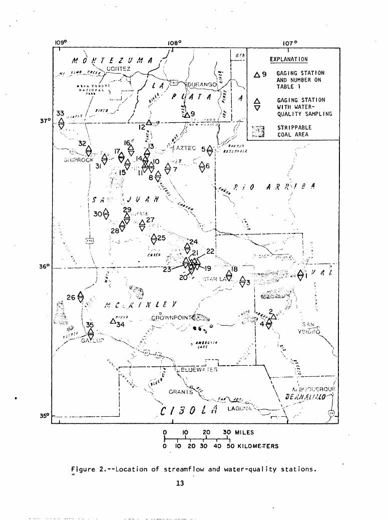
Streamflow and water-quality station network
The network of streamflow and water-quality stations is shown in figure 2 and listed in table 1. The first column in table 1 contains the numbers given to station locations in figure 2, and the second column contains the station-identification numbers needed to obtain data from published reports and computer-storage systems. The third and fourth columns contain the station name (stream name and nearby city, town, or major feature) and the drainage area of the basin. The fifth through eighth columns contain the period of record for discharge, chemical-quality, sediment, and biological data.
Daily values of streamflow discharge are available at all streamflow- gaging stations in table 1. The frequency of water-quality analysis is dependent upon the needs of the funding agency. In general, the water- quality information includes temperature, specific conductance, pH, dissolved oxygen, major and minor constituents, nutrients, radiochemical level, suspended-sediment concentration, particle-size distribution of sediment, and biological data.
12
I09C 108'
37<
107°
I
EXPLANATION
GAGING STATION AND NUMBER ON TABLE 1
GAGING STATION WITH WATER- QUALITY SAMPLING
STRIPPABLE COAL AREA
36°
** /» tf I ¥ / /" Vi'* *. v A * ft * *> '',< «!
it \35 VA
-^ !
v\ V5-~5̂^^.
jlMtXS*><1 i*tti
-J
/
(T»
'fUJ 1
GRANTS^"V-.
\
35° -- C I 3 0 LA
10 20 30 MILES
0 10 20 30 40 50 KILOMETERS
Figure 2.--Location of streamflow and water-quality stations.* i
13
Table
I.
Stre
amfl
ow and
water-quality
stations
(A dash (-)
after
a date
Indicates
data are
curr
entl
y be
ing
coll
ecte
d.
Funding
agen
cies
ar
e:
USGS,
Unit
ed States Geol
ogic
al Su
rvey
; SEO, New
Mexi
co St
ate
Engineer O
ffic
e; IS
O,
Inte
rsta
te Stream Commission; BLM, Bureau of Land Management;
CO,
Colo
rado State
Engi
neer
Office;
NFS,
Na
tion
al Park Service; EID, New
Mexi
co En
viro
nmen
tal
Improvem
ent
Division]
Number
Infigure
2 1 2 3 4
Station
Iden
ti f 1 ca
t Io
nnumber
08332700
08334000
08334300
0834
0500
Drainage
area
(square
Statio
n na
me
ml les
)
San
Pabl
o Creek
near Cuba,
NM
12.8
Rio
Puerco ab
ove
Arro
yo C
hlco,
420
near Guadalupe, NM
Pape
rs Wash near St
ar La
ke T
rading
20.3
Post,
NM
Arroyo C
hlco near Guadalupe, NM
1,39
0
Type and
period of record
Chemical
Disc
harg
e quality
1 979-
1 979
-
1951-
1 978
- 1 978
-
| 944-
1 948-56
1978-
Fundlng
Sedi
ment
Biological
agen
cies
1979-
- US
GS
1981
-
SEO/
ISC
1978-
1979-80
USGS
1979-81
- BLM
5 6 7 8 9 10 1 1
0935
5500
09356565
0935
7100
09357250
09363500
0936
4500
0936
t>00
0
San
Juan
River
near Archuleta, NM
Cano
n La
rgo
Wash near Blanco,
NM
San
Juan River
at Hammond
Brid
ge
near
Bl
oomf
leld,
NM
Gal le
gos
Canyon
Wa
sh ne
ar
Farm
lngt
on,
NM
An I ma
s Ri
ver
near Ce
dar HIM, NM
An Imas
River
at Fa
rmln
gton
, NM
San
Juan
Ri
ver
at Fa
rmln
gton
, NM
1,39
0
3,260
1,700
5,540
290
1,09
0
1,36
0
7,24
0
1944
-
1955
-
1978-81
1978-81
1978-81
1934
-
1904-
1913
-
1948-56
1979-81
1978-
1955-81
1978-81
1978-81
1978-81
1978
-81
1978
-81
1978
-81
-
1 940
- 1 950
-
1 962-
BLM
SEO/ISC
1 978-80
USGS
1 978-80
USGS
1 978-80
USGS
SEO/ISC
1970-
SEO/
ISC
1970
-78
SEO/ISC

Ui
12
0936
6500
La Pl
ata
Rive
r at
331
1920
-CoI or
ado-
New
Mexi
co S
tate li
ne
13
0936
7400
La Pl
ata
Rive
r Tr
ibut
ary
near
1,
03
1979
-Fa
rmln
gton
, NM
14
09367500
La Pl
ata
Rive
r ne
ar Fa
rmln
gton
, NM
San
Juan Ri
ver
near
Frultland, NM
Shumway
Arroyo ne
ar Fr
ultl
and,
NM
Shumway
Arroyo ne
ar Wa
terf
low,
NM
Chac
o Wash ne
ar St
ar La
ke Trading
Post
, NM
Chac
o Wash at
Ea
st Bo
unda
ry at
Cha
co
Nati
onal
Monument,
NM
Fajada Wa
sh at
Cha
co C
anyon, NM
Chaco
Wash
at Ch
aco
Canyon Na
tion
al
Monument,
NM
22
0936
7682
Ga
llo
Wash at
Ch
aco
Canyon National
36.2
1978-81
Monument,
NM
23
09367683
Chac
o Wash at P
ueblo
Bonl
to at C
haco
-
1980
-Ca
nyon
, NM
24
09367685
Ah-s
hl-s
le-p
ah Wa
sh near Kl
mbet
o, NM
8.
21
1977
-
25
09367710
De-n
a-zl
n Wash
ne
ar Blstl
Trad
ing
184
1976
-Po
st,
NM
15 16 17 18 19 20 21
0936
7540
0936
7555
0936
7561
0936
7660
0936
7676
0936
7678
0936
7680
1979
-1979-
1979-81
1979-81
1980-
1980-
1977-
1977-
1976
- 1976-
CO USGS
583
8,01
0 62.8
73,8
59,0 - -
578
1938-
1 978-80
1975-
1975
-
1978-
1980
-
. 1980-
1976-
1 970-73
1978
-
1978
-81
1976-
1975-
1978
-
1980
-
1980-
1976-
1978-81
1978-80
1978-81
1978
-80
1 976
-
1 975-
1 975-80
1978
- 19
78-8
0
1 980-
1 980-
1976
- -
.
SEO/
USGS
BLM
BLM
USGS
NPS
NPS
USGS
USGS
NPS
BLM
BLM

Ta
ble
I.
Str
ea
mflo
w
and
wa
ter-
qu
alit
y
sta
tio
ns -
Co
ncl
ud
ed
Number
In
figure
2 26 27 28 29 30 31 32 33 34 35
Stat
ion
Identification
numb
er
09367900
09367930
09367934
09367936
09367938
0936
7950
0936
8000
0937
1010
0939
5350
0939
5500
Station
name
Black
Springs
Wash
near Mexican
Springs, NM
Hunter Wa
sh at
Blstl
Trading
Post,
NM
Teec
-nl-
dl-t
so Wa
sh near Burnham, NM
Burnham
Wash
near Bu
rnha
m, NM
Chac
o River
near Burnham, NM
Chaco
River
near
Wa
terf
low,
NM
San
Juan
Ri
ver
at Shlprock,
NM
San
Juan Ri
ver
at Four Corners, NM
Puerco R
iver ne
ar Ch
urch
Rock,
NM
Puerco R
iver at
Ga
ll up, NM
Drainage
area
(square
ml les)
7.05
45.6 7.2
8.6
3,64
0
4,35
0
12,9
00
14,6
00 193
558
Type a
nd period of
record
Disc
harg
e
1979-
1975-
1978
-
1978
-
1978
-
1976
-
1927
-
1978
-
1978
-
1978-
Chemlcal
qual Ity
1979-
1975
-
1978-
1978-
1978
-
1976-
1941-45
1951-
1978
-
- 1975
-
Fund
ing
Sedi
ment
Biological
agen
cies
1 979
- -
USGS
1975
- -
BLM
1978
- 1979-80
USGS
1978
- 1978-80
USGS
1978
- 1978-80
USGS
1976-
1977-80
USGS
1951
- 19
77-
SEO/
ISC
& US
GS
1978
- 1979-80
SEO/
ISC
& US
GS
EID
EID
& SEO/ISC
Miscellaneous water quality of streamflow data-collection network
The network of miscellaneous water quality of streamflow data-collection stations is shown in figure 3 and listed in table 2. The first column in table 2 contains the numbers given to station locations in figure 3, and the second column contains the station-identification numbers needed to obtain data from published reports and computer-storage systems. Also included in table 2 are the station name, drainage area (if determined), period and type of record, and funding agencies.
The frequency of water-quality analysis is dependent upon the needs of the funding agency. In general, the information available includes specific conductance, pH, major and minor constituents, nutrients, and suspended- sediment concentration.
17

Tabl
e 2.
Miscellaneous
water
qual
ity
of st
ream
flow
data-collectio
n st
atio
ns
IA d
ash
(-)
after
a da
te In
dica
tes
data
ar
e cu
rren
tly
bein
g co
llec
ted.
Funding
agencies:
BLM, Bu
reau
of La
nd Ma
nage
ment
; US
GS,
U.S.
Ge
olog
ical
Su
rvey
; EPA, En
viro
nmen
tal
Prot
ecti
on Ag
ency
]
oo
Number
In
figure
3 1 2 3 4 5 6
7 8
Stat
ion
Identification
numb
er
0936
7700
.093
6793
2
3558
4110
8081
810
3606
4110
8103
810
3606
1410
7572
010
3607
4310
7571
410
3608
0910
8323
410
3611
3710
8202
110
Drai
nage
ar
ea
(squ
are
Station
name
miles)
Alam
o Wash near Tanner Lake,
MM
-
Hunter Wa
sh tr
ibut
ary
near
Bl
stl
Trad
ing
8.47
Po
st,
NM
K 1 m-me-n
1 -o
1 1 Wash near Phillips Mine
near
Cr
ownp
olnt
, NM
K 1 m-me-n
1 -o
1 1 Wash near La
ke Va
lley
, NM
Esca
vado
Wash at H
ighw
ay 56
Bridge
near
Chaco
Cany
on Tr
adin
g Po
st,
NM
Tsosle Sw
ale
near Kl
mbet
o, NM
Coyote Wa
sh ne
ar Na
schl
ttl,
NM
Chac
o Ri
ver
below
De-n
a-zl
n Wa
sh ne
ar
Type and
Chem
ical
qual Ity
1976
-81
1976
-81
1978-
1978
-
1976-81
1978-81
1976
-81
1975-80
peri
od of
re
cord
Sed Iment
1976-81
1976
-81
1978
-
1978-
1976-81
1978-81
1976
-81
1975
-80
Fund Ing
agency
BLM
BLM
USGS
USGS
USGS
BLM
USGS
ERA
10
3614
0410
8074
710
3614
4510
8071
510
Blstl
Trad
ing
Post
, NM
Coal Cr
eek
above
Tanner La
ke ne
ar Bl
stl
Trading
Post
, NM
De-n
a-zl
n Wa
sh 1.
5 miles
northeast
and
above
Tanner Lake,
NM
1976
-81
1976
-81
1976
-81
1976-81
BLM
BLM

11
362813
103344110
12
3634
17108334910
13
3640
4210
8271
410
14
364158
1082
6071
0
15
364348
108251310
16
364621
108250710
17
3646
31108250810
18
364631
1082
6101
0
19
364637
108251010
20
364706
108262610
21
364737
1082
5471
0
Sano
stee
Wash near Sanostee,
MM
Chaco
Wash
abov
e Fo
ur Corners
Powe
r-
plan
t near Frultland, NM
Navajo Mi
ne 1973 reclamation
plot near
Frultland, NM
Navajo Mi
ne 1976 re
clam
atio
n plot near
Frultland, NM
Navajo M
ine
1978 reclamation
plot ne
ar
Frultland, NM
San
Juan
Mi
ne 19
78 re
clam
atio
n plot
near Fr
ultl
and, NM
San
Juan
Mi
ne 1977 gr
aded
pile near
Frultland, NM
Shumway
Arroyo
above
Dun la
p Farm near
Wate
rflo
w, NM
San
Juan
Mine 1974 re
clam
atio
n plot
near Fr
ultl
and, NM
Powe
rpla
nt Arro
yo be
low
San
Juan
Powerplant Rese
rvoi
r, NM
West
wate
r Arroyo
at San
Juan
Powerplant,
NM
1976-81
1976
-81
1979
-
1979-
1979-
1979
-
1979
-
1976
-81
1979
-
1976
-
1976
-
1976-81
1976-81
1979
-
1979-
1979
-
1979-
1979
-
1979
-
USGS
USGS
BLM
BLM
BLM
BLM
BLM
USGS
BLM
USGS
USGS

109° 108* 107
37°
36°
35°
STATION LOCATION V, AND NUMBER ON
3 TABLE 2
i 1 STRIPPABLEu >.*..J COAL AREA
\ i\ A1B-OUERQUE
\ 8£&**:C / B 0 LA
10 20 30 MILES
0 10 20 30 40 50 KILOMETERSi
Figure 3. Location of miscellaneous water quality of streamflow
data-collection stations.
20
Annual maximum discharge gaging-station network
The network of annual maximum discharge .gaging stations is shown in figure 4 and listed in table 3. The first column in table 3 contains numbers given to station locations in figure 4, and the second column contains the station-identification numbers needed to obtain data from published reports and computer-storage systems. Table 3 also contains the station name, drainage area of the basin, and the period of record.
The data available from this network includes the annual maximum discharges during the period of record, corresponding maximum stage relative to gage datum, and estimate of date of occurrence.
21

109° 108' 107'
37°
MON7EZVMA <
ARCH V(t £ 7
,, e-^ <\A '
t # t * >-**"" ---^ * ^' ^ GALLUP ^20: /V
EXPLANATiON
A GAGING STATION 20 AND NUMBER ON
TABLE 3
STRIPPABLE COAL AREA C I B 0 LA35° -
10 20 30 MILES I____i
0 10 20 30 40 50 KILOMETERS
Figure ^.--Location of annual maximum discharge stations
22

Table 3. Annual maximum discharge stations
[All stations funded In cooperation with New Mexico State Highway Department. A dash (-) after a date Indicates data are currently being collected.l
Number In
f i gure 4
-----
1
2
3
4
5
6
. 7
8
9
10
II
12
13
StationI dent i f leaf i on
number - '
08332700
09355700
09356400
09356520
09356750
09357200
09357230
09367400
09367530
09367550
09367840
09367860
09367880
Station name
San Pablo Creek near Cuba, NM
Gobernador Canyon near Gobernador, NM
.Manzanares Canyon near Turley, NM
Burro Canyon near LIndrlth, NM
Valdez Draw near Bloomfleld, NM
Gal legos Canyon tributary nearNageezl, NM
West Draw near Farmlngton, NM
La Plata River tributary nearFarmtngton, NM
Locke Arroyo near Klrtland, NM
Stevens Arroyo near Klrtland* NM
Yazzle Wash near Mexican Springs, NM
Chusca Wash near Mexican Springs, NM
Catron Wash near Mexican Springs, NM
Drainage area
(square niles)
12.8
19.8
3.20
9.11
1.3
.20
.32
1.03
2.96
4.52
2.1(approx)
8.70
26.9
Per 1 od of
record
1 970-79*
1956-
1956-
1970-
1 956-67
1952-
1975-
1970-79*
1951-
1970-
1938-42,1953-54,1956-
1937-42,1953-76
1937-42, 1954,1956-67
14 09367900 Black Springs Wash near MexicanSprings, NM
15 09367920 Coyote Wash tributary nearNaschlttl, NM
7.05
12.0
1954-79*
1967-
23

Table 3. Annual maximum discharge stations - Concluded
Number In
figure 4
16
17
18
19
20
21
22
Drainage Station area
Identification (square number Station name miles)
09367932 Hunter Wash tributary near Blsti 8.47Trading Post, NM
09367940 Pefia Blanca Arroyo near Newcomb, NM 46.8
09367950 Chaco River near Water flow, NM 4350
09367960 Pajarlto Creek near Shlprock, NM 80
09395400 Milk Ranch Canyon near Fort Wlngate, NM 14.0
09395500 Puerco River at Gallup, NM 558
09395600 Wagon Tral 1 Wash near Gamerco, NM .38
Period of
record
1975-
1967-80
1959-69,1975*
1953-58
1949,1953-
1940-45,1956-76*
1951-74
*Converted to continuous-record station.
24
Observation-well network
The observation-well network is shown in figure 5 and listed in table 4. The first column in table 4 contains the numbers given to well locations in figure 5, and the second column contains the well-identification numbers needed to obtain data from published reports and computer-storage systems. The third column contains the well location; the fourth column contains the geologic formation in which the well is completed. The fifth column contains the period of record, and the sixth column contains the funding agencies.
The network includes observation wells completed in the Menefee Formation, Pictured Cliffs Sandstone, Fruitland coal seam, Fruitland overburden, and channel alluvium. The frequency of water-level measurement and water-quality analysis is dependent upon the needs of the funding agency. Water levels and comprehensive water-quality analyses are available except when an observation well was found dry or produced insufficient water for an analysis.
25

109° 108° 107'
MONTEZUM 4 / -
37°
36°
PAGOSA 1/ SPRINGS vyS
Si I
(/i £ T
'^' : i^-!-^y»^5(f/V^':i#''C? ^ A i!/?£> / /"V t v '.?-:&-jf--''s?jii "' **' ?V-^.,:O I ^'-^teMr
037 WELL AND NUMBER ON TABLE J*
? K i STRIPPABLE 350 . ,J COAL AREA
\
\\ v ;- "3/ »3 /\ :.' * f\jfl /| 4,\ _--"
C / B 0 LA
10 20 30 MILES
0 10 20 30 40 50 KILOMETERS
Figure 5.~~Location of observation wells.
26
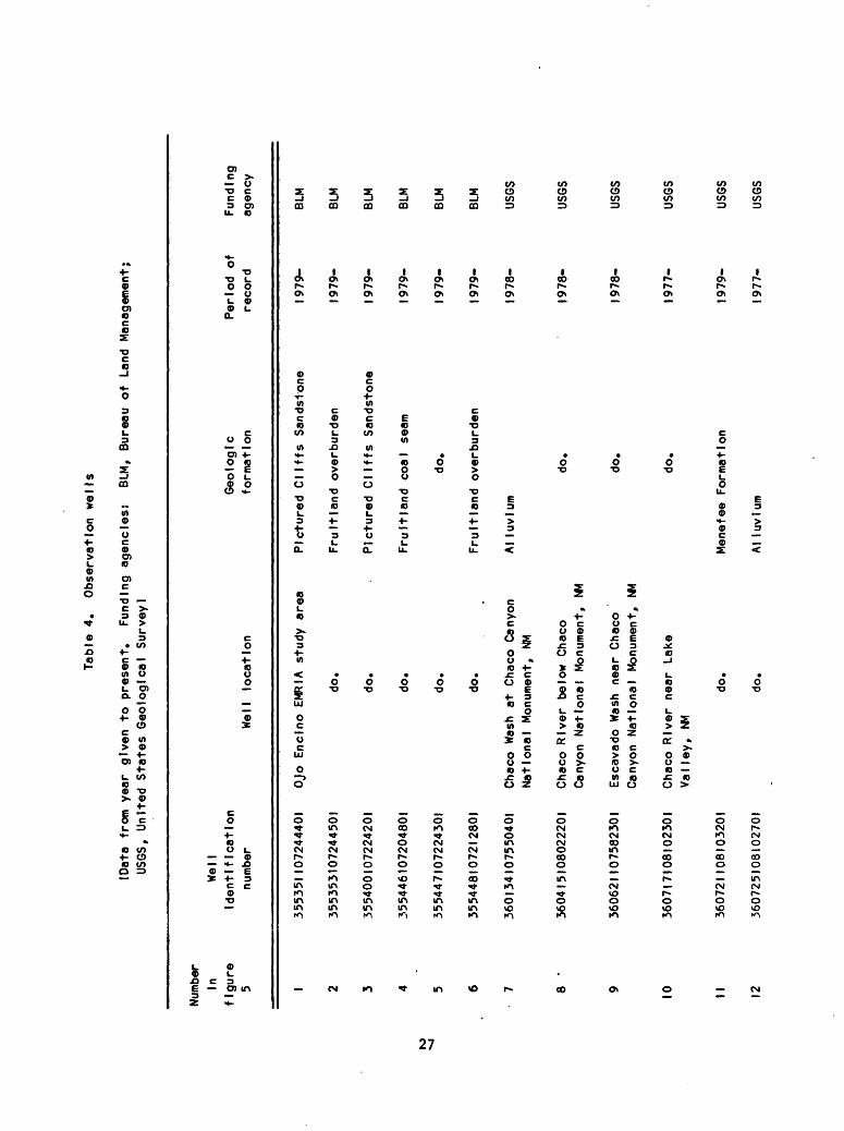
Tabl
e 4.
Ob
serv
atio
n wells
(Dat
a fr
om y
ear
given
to pr
esen
t.
Funding
agencies:
BLM, Bureau of
Land Ma
nage
ment
; US
GS,
United States Ge
olog
ical
Su
rvey
]
10
Numb
erIn
figure
5 1 2 3 4 5 6 7
Wel
1Id
enti
fica
tion
nu
mber
355351 107
2444
01
3553
5310
7244
501
3554
0010
7224
201
3554
4610
7204
801
355447107224301
3554
481 0721
280
1
3601
3410
7550
401
Well
location
Ojo
Encl
no E
MRIA
study
area
do.
do.
do.
do.
do.
Chaco
Wash
at Ch
aco
Canyon
Geologic
form
atio
n
Pictured C
liff
s Sa
ndst
one
Fruit la
nd overburden
Pictured C
liffs
Sand
ston
e
Fruit la
nd coal seam
do.
Fruit la
nd ov
erbu
rden
Al luvlum
Period of
re
cord
1979-
1979
-
1979-
1979
-
1979-
1979
-
1978
-
Fundlng
agency
BLM
BLM
BLM
BLM
BLM
BLM
USGS
10 11 12
3604
1510
8022
201
3606
2110
7582
301
360717108102301
3607
2110
8103
201
360725108102701
National Mo
nume
nt,
NM
Chaco
Rive
r be
low
Chac
o Canyon
Na
tion
al Monument,
NM
Escavado W
ash
near
Chaco
Cany
on Na
tion
al Mo
nume
nt,
NM
Chaco
Rive
r near Lake
Valley,
NM
do.
do.
do.
do.
do.
Menefee
Formation
Al luvlum
1978
-
1978
-
1977
-
USGS
USGS
USGS
1979
- US
GS
1977
- US
GS

Table
4.
Obse
rvat
ion
well
s - Continued
Numb
er
In
figu
re
5 13 14 15 16ro
oo
17 18 19 20 21 22 23 24 25 26
Well
identification
numb
er
360726 108 102
801
3607
2910
8102
901
3607
33 108 103
201
3607
34 108103201
360731 107494701
360734107523101
3607
5410
7505
201
3608
2210
7561
601
3608
2310
7544
001
3608
4910
7561
801
360857 107
53 100
1
3609
1610
7543
901
36094
II 075
6 16
01
3610
0810
7543
901
Well lo
cati
on
Chaco
River
near
Lake
Valley,
MM
do.
do. I/
do.
Klmbeto
EMRIA
stud
y area
do.
do.
do.
do.
do.
do.
do.
do.
do.
Geo
1 og
1 c
form
atio
n
A 1
1 uv
1 urn
do.
do.
do.
Pict
ured
Cli
ffs
Sandstone
Frui
t la
nd co
al seam
Frul
tlan
d ov
erbu
rden
Pict
ured
Cl
iffs
Sa
ndst
one
Frul
tlan
d co
al seam
do.
Frul
tlan
d overburden
Pict
ured
Cl
iffs
Sa
ndst
one
Frul
tlan
d ov
erbu
rden
Frul
tlan
d co
al se
am
Period of
reco
rd
1977-
1977-
1978-
1977-
1977-
'
1977
-
1977
-
1977-
1977-
1977
-
1977-
1977
-
1977-
1977
-
Fundlng
agen
cy
USGS
USGS
USGS
USGS BLM
BLM
BLM
BLM
BLM
BLM
BLM
BLM
BLM
BLM

VO
27 28 29 30 31 32 33 34 35 36 37 38 39 40 41
36II42108220401
36I3I8I08I5I40I
361407108081901
361435108093001
361 44
6108
0837
01
361446108090801
361447108090901
36I457I0808I90I
361 51
3108
0907
01
361503108243801
361 55
4108
3332
01
362I45I083I090I
362208108341201
362210108341001
36221
I 108340601
Chac
o Ri
ver
belo
w De-na-zln
Wash ne
ar Blstl
Trad
ing
Post,
MM
De-n
a-zl
n Wa
sh ne
ar Blstl
Trad
ing
Post,
MM
Blst
l We
st EMRIA
stud
y ar
ea
do.
do.
do.
do.
do.
do.
Hunter Wa
sh ne
ar Bu
rnha
m Tr
adin
g Po
st,
NM
Chac
o River
above
Hunter
Wash ne
ar Bu
rnha
m Trading
Post,
MM
Brlmhall Wa
sh near Bu
rnha
m Tradin
g Po
st,
NM
Chac
o Ri
ver
near
Bu
rnha
m Trading
Post
, NM
do.
do.
AI luvlum
do.
Pict
ured
Cliffs Sa
ndst
one
do.
Fruit la
nd ov
erbu
rden
Frultland
coal
se
am
Frui
t I and overburden
Pict
ured
Cliffs Sandstone
Frultland
coal seam
AIluvlum
do.
do.
AI luvlum
do.
do.
1977
-
1978
-
USGS
USGS
1975
-
1975
-
1976
-
1976-
1977
-
1975-
1977
-
1978
-
BLM
BLM
BLM
BLM
BLM
BLM
BLM
USGS
1978
-
1978
-
1979
-
1979
-
1979-
USGS
USGS
USGS
USGS
USGS

Table
4.
Obse
rvat
ion
well
s - Co
nclu
ded
Number
in
f Igure
5
42 43 44 45
U)
O
46 47 48 49 50 51
Well
Id
entl
f Icatlon
numb
er
36221 21 08340701
36221 31
083
4050
1
3622
17 108
3357
01
3629
0210
8334
801
36311 3108333501
363503 108342 101
3643
2510
8353
001
364744108225001
3647
5010
8214
701
3648
45 1082 14
201
Wet
1 lo
cati
on
Chac
o Ri
ver
near Burnham
Trad
ing
Post
, NM
do. I/
do.
Plna
bete
Ar
royo
near Burnham
Trad
ing
Post
, NM
Cott
onwo
od Ar
royo
near
Burn
ham
Trad
ing
Post
, NM
Chaco
Rive
r ab
ove
Hogback, NM
Chaco
Well
be
low
Hogb
ack
near
Wate
r fl
ow,
NM J/
West
ern
Coal
Company
Mine
do.
do.
Geol
ogic
formation
do.
do.
do.
do.
do.
do.
do.
Pictured Cl
iffs
Sa
ndst
one
Frul
tlan
d overburden
Fruit la
nd co
al se
am
Period of
record
1979-
1978-
1979-
1977
-
1978-
1978-
1978-
1977-
1977-
1977-
Fundlng
agen
cy
USGS
USGS
USGS
USGS
USGS
USGS
.
USGS BLM
BLM
BLM
J/W
e!l
eq
uip
pe
d
with
co
nti
nu
ou
s
reco
rder.

SOURCES OF HYDROLOGIC INFORMATION
This section briefly describes sources of hydrologic information about the coal-resource areas in northwestern New Mexico. Additional information about any of these sources may be obtained by contacting the District Chief, U.S. Geological Survey, Water Resources Division, 505 Marquette N.W., Room 720, Albuquerque, New Mexico 87102, telephone: (505) 766-2246.
Reports of interpretive hydrologic investigations
Published reports of interpretive hydrologic investigations are generally available to the public from the agency sponsoring the investigation or the U.S. Geological Survey. Hydrologic data collected for these investigations are published in the annual compilation report and stored in WATSTORE. Both the annual compilation report and WATSTORE are described in sections that follow.
Annual compilation report
"U.S. Geological Survey Water Resources Data for New Mexico" is an annual compilation of water-resources information collected on a systematic basis and published for each water year (October 1 to September 30). Included are data collected in the strippable coal areas for hydrologic investigations in the northwestern part of the State. The bulk of the data consists of streamflow discharge and water-quality records. The report also includes ground-water levels and water-quality data. This report may be obtained from the U.S. Geological Survey.
31

National Water Data Storage and Retrieval System (WATSTORE)
Water-resources information collected at sites shown in this report is accessible through WATSTORE, the central computerized repository of water data collected by the U.S. Geological Survey. The information available includes data on quantity and quality of both surface and ground water. Information for a specific site included in this report may be retrieved from WATSTORE by furnishing the unique identifier given in the second column in tables 1-4, or sites within a stream reach may be obtained by furnishing the unique identifier of the upstream and downstream stations. All streamflow, ground-water, and associated water-quality information stored within an area may be obtained by specifying latitude and longitude coordinates that bound the area of interest. The computer cost incurred in obtaining the information is passed on to the requester.
Other sources of water data
The Office of Water Data Coordination '(OWDC) of the U.S. Geological Survey coordinates water-data acquisition of Federal agencies. This office maintains a catalogue of information on water data.
The National Water Data Exchange (NAWDEX) is a confederation of water-oriented organizations. NAWDEX is centrally managed by a Program Office within the U.S. Geological Survey, Water Resources Division in Reston, Virginia. This office serves as a focal point to help those in need of water data by determining what information is available and referring the requester to the organization that retains the data required.
32