hyde-1 exploration drilling environment plan summary · 2014-02-19 · hyde-1 exploration drilling...
TRANSCRIPT
APACHE ENERGY LTD (ABN 39 009 301 964) 100 ST GEORGES TERRACE / PERTH / WA / 6000 TEL (08) 6218 7100 / FAX (08) 6218 7200
Hyde-1 Exploration Drilling
Environment Plan Summary

Hyde-1 Exploration Drilling Environment Plan Summary 2 of 25
CONTENTS
1. INTRODUCTION .................................................................................................................................... 3
1.1 Schedule ............................................................................................................................................. 3
1.2 Compliance......................................................................................................................................... 3
2. DESCRIPTION OF THE ACTIVITY ............................................................................................................ 4
3. DESCRIPTION OF THE RECEIVING ENVIRONMENT ................................................................................ 6
3.1 Physical environment ......................................................................................................................... 6
3.2 Biological environment ...................................................................................................................... 6
3.3 Socio-economic environment ............................................................................................................. 7
4. ENVIRONMENTAL HAZARDS AND CONTROLS ...................................................................................... 9
5. MANAGEMENT APPROACH .................................................................................................................10
6. HYDROCARBON SPILL PREPAREDNESS AND RESPONSE .......................................................................11
7. CONSULTATION ...................................................................................................................................12
8. CONTACT DETAILS ...............................................................................................................................13
9. MANAGEMENT CONTROLS FOR THE DRILLING ACTIVITY ....................................................................14
10. REFERENCES ......................................................................................................................................25

Hyde-1 Exploration Drilling Environment Plan Summary 3 of 25
1. INTRODUCTION
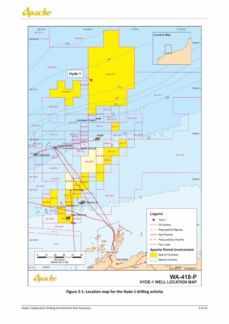
Apache Northwest Pty Ltd (Apache) proposes to drill the Hyde-1 exploration well located in Commonwealth waters offshore of Western Australia, in permit area WA-418-P (Figure 2–1). The objective of the drilling program is to target the Lower Keraudren Sandstone formation that is expected to contain light crude oil.
1.1 Schedule
The Hyde-1 exploration well is expected to commence as early as Q1 2014 but may be delayed until later in the year, taking approximately 26-42 days to complete. The required timeframe to complete the well will be influenced by weather operations.
1.2 Compliance
The EP has been prepared to comply with the Commonwealth Offshore Petroleum and Greenhouse Gas Storage (Environment) Regulations 2009 (OPGGS (E) Regulations). The EP has been reviewed and accepted by the National Offshore Petroleum Safety and Environmental Management Authority (NOPSEMA) on the 11 February 2014.
This EP summary has been prepared in accordance with the requirements of Regulation 11 (7) and (8) of the referenced OPGGS(E) Regulations.

Hyde-1 Exploration Drilling Environment Plan Summary 4 of 25
2. DESCRIPTION OF THE ACTIVITY
The Activity covered by this EP includes drilling and abandonment of the Hyde-1 exploration drilling well. The work will be undertaken by a semi-submersible mobile offshore drilling unit (MODU) to be anchored on location during the operation.
The Hyde-1 well will be located in an approximate water depth of 393 m. The location of the Hyde-1 well is provided in Table 2-1 and Figure 2-1.
Table 2-1: Surface location for the well
Location Permit Area Coordinates (Datum/Projection: GDA 94 Zone 50) Approx.
Water Depth (m) Latitude Longitude Easting Northing
Hyde-1 WA-418-P 18o 53’ 08.72” S 116o 33’ 32.69” E 453,298 7,911,755 393 m
Anchor-handling vessels (AHV) will be required to deploy and retrieve the anchors upon arrival and departure from the drilling location.
A 500 m petroleum safety zone around the semi-submersible Mobile Offshore Drilling Unit (MODU), when stationary onsite at the drill location, will define the exclusion zone and operational area for the drilling activity.
At least one support vessel will be utilised during the Activity to monitor and maintain the 500 m exclusion zone around the MODU, whilst further support vessel/s will be utilised to supply food, bulk drilling materials, transportation of equipment as required (allowed to enter the 500 m exclusion zone).
Hyde-1 Exploration Drilling Environment Plan Summary 5 of 25
Figure 2-1: Location map for the Hyde-1 drilling activity
Hyde-1 Exploration Drilling Environment Plan Summary 6 of 25
3. DESCRIPTION OF THE RECEIVING ENVIRONMENT
3.1 Physical environment
The drilling activity is located on the North West Shelf. The region lies in the arid tropics experiencing high summer temperatures, periodic cyclones and associated rainfall. Rainfall in the region is generally low with evaporation exceeding rainfall throughout the year. Intense rainfall may occur during the passage of summer tropical cyclones and thunderstorms (NSR, 1995). Mean sea surface temperatures over the NWS
range from a minimum of 15C in winter to a maximum of 33C in summer (WNI, 1996). Due to the arid climate, daytime visibility in the area is generally greater than five nautical miles (SSE, 1991).
During the summer period, the prevailing non-storm winds are from the southwest, west and northwest, bringing with them warm, humid air. Average wind speeds are less than 10 knots, with peak average speeds of 15–25 knots, and maximum speeds of 30 knots. The hotter and more humid summer season (October–March) is also associated with higher rainfall and periodic tropical cyclones and thunderstorms (NSR, 1995). During extreme cyclonic events, winds may reach 95 knots.
Winds in winter (May–August) are more variable in direction than in summer. Non-storm winds prevail from the northeast through to southeast, carrying dry air from the continent’s interior. Winds during this period are generally lighter, with average speeds of 5–6 knots, peak average speeds of 10–15 knots, and maximum speeds of 20 knots. Transitional wind periods, during which either pattern may predominate, can be experienced in April and September of each year.
The wave climate is generally composed of locally generated wind waves (seas) and swells that are propagated from distant areas (WNI, 1995; 1996). In summer, seas typically approach from the west and southwest, while in winter from the south and east. Mean sea wave heights of less than 1 m with peak heights of less than 2 m are experienced in all months of the year (WNI, 1995). Mean swell heights are low at around 0.4–0.6 m in all months of the year. Tropical cyclones have generated significant swell heights of up to 5 m in this area, although the predicted frequency of swells exceeding 2 m is less than 5% (WNI, 1995). In the open ocean, sustained winds result in wind-forced currents of approximately 3% of the wind speed (Holloway and Nye, 1985).
The dominant sea surface offshore current (typically seaward of the 200 m isobath) is the Leeuwin Current, which carries warm tropical water south along the edge of WA's continental shelf, reaching its peak strength in winter and becoming weaker and more variable in summer. The Indonesian Throughflow is the other important current influencing the upper 200 m of the outer NWS (Woodside, 2005).
Offshore drift currents are represented as a series of interconnected eddies and connecting flows that can generate relatively fast (1–2 knots) and complex water movement. These offshore drift currents also tend to persist longer (days to weeks) than tidal current flows (hours between reversals).
3.2 Biological environment
Benthic habitats within the 500 m exclusion zone around the MODU comprise soft sediments and associated benthic fauna. Soft sediments support a diverse benthic infauna consisting predominantly of mobile burrowing species which include molluscs, crustaceans (crabs, shrimps and smaller related species), polychaetes, sipunculid and platyhelminth worms, asteroids (sea stars), echinoids (sea urchins) and other small animals.
Within the wider environment considered in impact assessment of unplanned spill scenarios, benthic habitats including coral reefs, macroalgae, seagrasses, hard substrate and associated assemblages are also found. These habitats are found near the shoreline of the mainland coast and offshore reefs such as the Rowley Shoals. Shoreline habitats within the impact assessment for spill scenarios included sandy beaches, intertidal and subtidal zones and rocky shorelines, as well as marine protected areas.
An EPBC Act Protected Matters search (DoE, 2013) identified 17 Key Ecological Features (KEF) (parts of the marine ecosystem that are considered to be important for the biodiversity or ecosystem functioning and

Hyde-1 Exploration Drilling Environment Plan Summary 7 of 25
integrity of the Commonwealth Marine Area) within the environment assessed for impacts resulting from the worst case credible spill scenario due to a loss of well control. The EPBC search of the area identified 160 listed marine species, 23 of which are threatened species (endangered or vulnerable) and 81 of which are migratory species. The EPBC search also identified 41 whales and other cetaceans, of which 5 are threatened species (endangered or vulnerable) and 14 of which are migratory. The species listed, or habitat important for these species, may occur within the predicted PSTA impact as a result of a loss of well control.
3.3 Socio-economic environment
Both the offshore and coastal waters in the NWS Region support a valuable and diverse commercial fishing industry, mainly dominated by the Pilbara fisheries. The Commonwealth licensed fisheries Western Tuna and Billfish Fishery, North West Slope Trawl Fishery, the Western Skipjack Tuna Fishery and the Southern Bluefin Tuna Fishery all fall within the operational boundary and worst case credible spill assessment area, although none of these fisheries have had recent fishing effort reported.
In addition, 26 State managed fisheries (Fletcher and Santoro, 2012) have boundaries that overlie or are in close proximity to part or all of the operational boundary and the worst case credible spill assessment area:
Pilbara Trap Managed Fishery;
Pilbara Fish Trawl Managed Fishery;
Pearl Oyster Managed Fishery (Zones 1, 2
and 3);
Onslow Prawn Managed Fishery;
Nickol Bay Prawn Managed Fishery;
Kimberley Prawn Managed Fishery;
Broome Prawn Managed Fishery;
Kimberley Gillnet and Barramundi Managed
Fishery;
Northern Demersal Scalefish Fishery;
Aquaculture Pearling Sites;
West Coast Rock Lobster Managed Fishery;
Roe’s Abalone Fishery;
Abrolhos Islands and Mid West Trawl
Managed Fishery;
West Coast Deep Sea Crab Managed Fishery;
West Coast Demersal Gillnet and Demersal
Longline Managed Fishery;
West Coast Demersal Scalefish Managed
Fishery;
Exmouth Gulf Prawn Managed Fishery;
Gasgoyne Demersal Scalefish Fishery;
Shark Bay Prawn and Scallop Managed
Fishery;
Shark Bay Crab Managed Fishery;
Shark Bay Beach Seine and Mesh Net
Managed Fishery;
Mackerel Managed Fishery;
Beche-de-Mer Fishery;
Marine Aquarium Fish Managed Fishery;
Octopus; and
Specimen Shell Managed Fishery.

Hyde-1 Exploration Drilling Environment Plan Summary 8 of 25
The worst case credible spill assessment area falls primarily within the North West Coast Bioregion. Within the North West Coast Bioregion, recreational fishing is experiencing significant growth, with a distinct seasonal peak in winter when the local population increases significantly from tourists visiting the Exmouth/Onslow area and Dampier Archipelago (Fletcher and Santoro, 2012). Offshore islands, coral reefs, shoals (e.g. Rankin Bank and Glomar Shoals) and the continental shelf provide species of major recreational interest (Fletcher and Santoro, 2012). However, recreational fishing within the 500 m exclusion zone around the MODU is unlikely given the distance offshore.
The Hyde-1 drilling centre is situated approximately 25 km to the west of the main northern approach shipping lanes that service the Port of Dampier. This is a busy shipping lane serving a port which is the world’s second largest bulk export port that also provides a base for servicing the offshore oil and gas fields.
The area of the NSW is a major oil and gas hub in Australia, with several companies operating on the Shelf. The Hyde-1 exploration drilling operational area occurs in a particularly isolated area of the NWS with respect to the main oil and gas operational and exploratory fields. There are currently no operating fields in the WA-418-P permit area. The nearest operating facility is the Santos Mutineer-Exeter field, located approximately 45 km south from the proposed drilling location.
In the waters immediately surrounding the operational area, tourism activities are limited due to its distance from the mainland and island shorelines. Aquatic recreational activities such as boating, diving and fishing occur nearer the coast and offshore islands. The likelihood of vessel traffic involved with tourism-based activity to be transiting through the operational area is low.
There are no World Heritage, Commonwealth Heritage or National Heritage sites, or Wetlands of International Importance (Ramsar sites) in or adjacent to the operational boundary. No registered Aboriginal heritage sites are located within or in close proximity to the drilling activity location.
No shipwrecks were recorded within the operational area. A search of the Protected Matters Database revealed 14 shipwrecks in the worst case spill trajectory area.
Hyde-1 Exploration Drilling Environment Plan Summary 9 of 25
4. ENVIRONMENTAL HAZARDS AND CONTROLS
The environmental risk assessment for routine and accidental events for the Activity centred around the hazard identification workshop attended by a subset of Apache’s environmental scientists and drilling personnel, held on 23 July 2013. Throughout the preparation of this EP, further evaluation of risks were undertaken as appropriate, as the activity scope was defined. Apache’s Environmental Scientists and other participants from Drilling, Logistics and Safety were also involved where necessary.
The purpose of the risk assessment was to understand and identify the potential environmental hazards, their causes and the potential impacts associated with the drilling activity to ensure they are reduced to As Low As Reasonably Practicable (ALARP). Apache's management and mitigation actions corresponding to the potential hazards and impacts have been developed from experience in the environmental management of offshore petroleum activities in Australia, and are based on Australian petroleum industry best practice environmental management guidelines, as defined by the APPEA Code of Environmental Practice (2008).
The environmental risk assessment identified nine routine environmental hazards and nine non-routine (unplanned events) environmental risks. The environmental hazards, risks and control measures to be applied to the drilling activity are provided in Section 9. The control measures are consistent with Apache corporate and project specific performance objectives, standards and criteria. All commitments associated with these will be used to reduce environmental risk to ALARP and will be of an acceptable level.
Hyde-1 Exploration Drilling Environment Plan Summary 10 of 25
5. MANAGEMENT APPROACH
The Activity will be managed in compliance with all measures and controls detailed within the EP accepted by NOPSEMA under the OPGGS(E) Regulations, other environmental legislation and Apache’s Management System (e.g. Apache Environmental Management Policy).
The objective of the EP is to ensure that potential adverse environmental impacts associated with routine operational events and unplanned events associated with the drilling activity, are identified and assessed and to stipulate mitigation measures to avoid and/or reduce any adverse impacts to the marine environment to ALARP.
The EP details specific performance objectives, standards and procedures, and identifies the range of controls to be implemented (consistent with the standards) to achieve the performance objectives. The controls for the drilling activity are summarised in Section 9. The EP also identifies the specific measurement criteria and records to be kept to demonstrate the achievement of each performance objective.
As described in the EP, the implementation strategy includes the following:
1. Details on the systems, practices and procedures to be implemented; 2. Key roles and responsibilities; 3. Training, competencies and on-going awareness; 4. Monitoring, auditing, management of non-conformance and review; 5. Incident response including an Oil Spill Contingency Plan (Hyde-1 Exploration Drilling OSCP); 6. Record management; and 7. Stakeholder consultation.
The reporting requirements for routine events and environmental incidents (recordable and reportable) and reporting on overall compliance of the Activity with the EP are also detailed.
Hyde-1 Exploration Drilling Environment Plan Summary 11 of 25
6. HYDROCARBON SPILL PREPAREDNESS AND RESPONSE
Credible hydrocarbon spill scenarios identified in the EP as requiring 1, 2, and 3 spill response tiers include:
Tier 1: spill from vessel and/or MODU such as during refuelling;
Tier 2: spill from a vessel collision resulting in a ruptured fuel tank; and
Tier 3: spill from a loss of well control discharging at the seabed or at the MODU floor.
These oil spill scenarios include the worst-case spill scenario. Strategies for oil spill response are outlined in the Hyde-1 Exploration Drilling OSCP. The response strategies include:
Source control: including relief well and well intervention – all tiers;
Monitoring and evaluation: surveillance and spill fate modelling – all tiers;
Mechanical dispersion: used to assist with the natural dispersion process of hydrocarbon at sea
surface – tier 2 and 3 spills;
Protection and deflection: implement if spill is predicted to impact sensitive shoreline/ emergent
habitats – tier 3 spills;
Shoreline clean-up: used to assist with the natural dispersion process of hydrocarbon at sea surface –
tier 3 spills;
Oiled wildlife response: vessel-based hazing; pre-emptive capture and cleaning/rehabilitation – tier 2
and 3 spills; and
Scientific monitoring: impact and recovery assessment of sensitive marine receptors exposed to oil –
tier 2 and 3 spills.
Hyde-1 Exploration Drilling Environment Plan Summary 12 of 25
7. CONSULTATION
As stated in Apache’s Environmental Management Policy, our company is committed to maintaining open community and government consultation regarding its activities and environmental performance.
Apache’s operating presence (e.g. gas processing facilities at Devil Creek and Varanus Island) off the North West Shelf ensures that communication is regular with relevant stakeholders, including those potentially affected by this activity.
The identified stakeholders are commercial fishers in the region, fishing bodies, federal departments and regulators. Relevant stakeholders identified for the drilling activity based on the defined operational area are summarised in Table 7-1.
Table 7-1: Summary of stakeholders relevant to the drilling activity
Group Stakeholder
Commercial fisheries Australian Fisheries Management Authority (AFMA)
Department of Fisheries (State)
Western Australian Fishing Industry Council (WAFIC)
Commonwealth Fisheries Association (CFA)
A Raptis and Sons
WestMore Seafoods
Shark Bay Seafoods
Austral Fisheries
MG Kalis
Pearl Producers Association
Recreational fisheries RecFish West
Conservation Department of Parks and Wildlife (State)
Marine activities, spill response and safety
Australian Marine Oil Spill Centre (AMOSC)
Australian Maritime Safety Authority (AMSA)
Department of Mines and Petroleum (State)
Department of Defence (State)
Department of Transport (State)
Department of Environment (formerly DSEWPaC)
Karratha/Dampier stakeholder reference group
Shire of Roebourne
Dampier Port Authority
Tourism Marine Tourism WA
Consultation regarding the Hyde-1 exploration well was initiated by means of a Consultation Pack distributed to all listed stakeholders in August 2013. Stakeholders were provided with an update notification document in November 2013.
Apache has commenced with issuing quarterly updates to relevant stakeholders. These updates consist of details for the on-going, plus proposed upcoming activities on the NWS for the next 6–9 months. This update provides the stakeholders with information inclusive of proposed activity, activity location and the activity duration, and gives the stakeholders an opportunity to request additional information on the specific activities that may be of interest to them. The quarterly update issued in September 2013, included this drilling activity.
During the consultation process, where stakeholders have raised queries, Apache has conducted meetings and/or provided additional information in response to the stakeholder queries.
Hyde-1 Exploration Drilling Environment Plan Summary 13 of 25
8. CONTACT DETAILS
Further information about the Hyde-1 exploration drilling activity can be obtained from:
Libby Howitt
Deputy Environment Manager
Apache Energy Limited
100 St Georges Terrace, Perth, Western Australia, 6000
Phone: 08 6218 7181
Email: [email protected]
Hyde-1 Exploration Drilling Environment Plan Summary 14 of 25
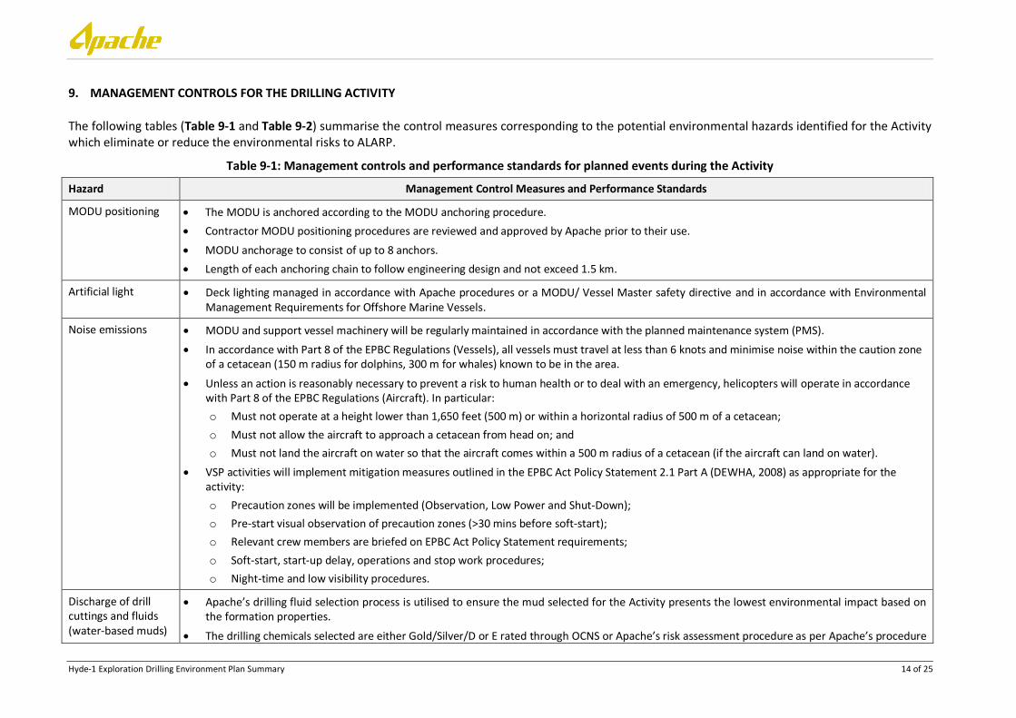
9. MANAGEMENT CONTROLS FOR THE DRILLING ACTIVITY
The following tables (Table 9-1 and Table 9-2) summarise the control measures corresponding to the potential environmental hazards identified for the Activity which eliminate or reduce the environmental risks to ALARP.
Table 9-1: Management controls and performance standards for planned events during the Activity
Hazard Management Control Measures and Performance Standards
MODU positioning The MODU is anchored according to the MODU anchoring procedure.
Contractor MODU positioning procedures are reviewed and approved by Apache prior to their use.
MODU anchorage to consist of up to 8 anchors.
Length of each anchoring chain to follow engineering design and not exceed 1.5 km.
Artificial light Deck lighting managed in accordance with Apache procedures or a MODU/ Vessel Master safety directive and in accordance with Environmental Management Requirements for Offshore Marine Vessels.
Noise emissions MODU and support vessel machinery will be regularly maintained in accordance with the planned maintenance system (PMS).
In accordance with Part 8 of the EPBC Regulations (Vessels), all vessels must travel at less than 6 knots and minimise noise within the caution zone of a cetacean (150 m radius for dolphins, 300 m for whales) known to be in the area.
Unless an action is reasonably necessary to prevent a risk to human health or to deal with an emergency, helicopters will operate in accordance with Part 8 of the EPBC Regulations (Aircraft). In particular:
o Must not operate at a height lower than 1,650 feet (500 m) or within a horizontal radius of 500 m of a cetacean;
o Must not allow the aircraft to approach a cetacean from head on; and
o Must not land the aircraft on water so that the aircraft comes within a 500 m radius of a cetacean (if the aircraft can land on water).
VSP activities will implement mitigation measures outlined in the EPBC Act Policy Statement 2.1 Part A (DEWHA, 2008) as appropriate for the activity:
o Precaution zones will be implemented (Observation, Low Power and Shut-Down);
o Pre-start visual observation of precaution zones (>30 mins before soft-start);
o Relevant crew members are briefed on EPBC Act Policy Statement requirements;
o Soft-start, start-up delay, operations and stop work procedures;
o Night-time and low visibility procedures.
Discharge of drill cuttings and fluids (water-based muds)
Apache’s drilling fluid selection process is utilised to ensure the mud selected for the Activity presents the lowest environmental impact based on the formation properties.
The drilling chemicals selected are either Gold/Silver/D or E rated through OCNS or Apache’s risk assessment procedure as per Apache’s procedure

Hyde-1 Exploration Drilling Environment Plan Summary 15 of 25
Hazard Management Control Measures and Performance Standards
Drilling Fluid and Chemical Selection (EA-91-II-007) to ensure product is environmentally acceptable.
Chemicals which are not Gold/Silver/D or E rated have a complete risk assessment of the environmental impact of the chemicals to ensure product is environmentally acceptable.
WBM cuttings returned to the MODU are treated through the on board cuttings management system (shale shakers and centrifuges – if required) to maximise reconditioning and re-use of residual mud and minimise the discharge of drilling fluids.
Shaker screens are selected and inspected daily during drilling operations once the BOP and riser are in place, by the Mud Engineer on location and are in an acceptable condition for treatment of drill cuttings ensuring efficient re-use.
Re-use and treatment of mud maximised by maintaining the cuttings management system in accordance with the PMS.
To ensure correct volumes are recorded, mud pit sensor calibration is checked every two weeks, with re-calibration only required if calibration is out.
If cuttings centrifuge system is required, it is inspected daily during drilling operations.
All hoses used for pumping of mud and drilling fluids are maintained according to PMS to ensure ‘fit for purpose’.
Discharge of drill cuttings and fluids (synthetic-based muds)
Apache’s drilling fluid selection process is utilised to ensure the mud selected for the Activity presents the lowest environmental impact based on the formation properties.
The drilling chemicals selected are either Gold/Silver/D or E rated through OCNS or Apache’s risk assessment procedure as per Apache’s procedure Drilling Fluid and Chemical Selection (EA-91-II-007) to ensure product is environmentally acceptable.
Chemicals which are not Gold/Silver/D or E rated have a complete risk assessment of the environmental impact of the chemicals to ensure product is environmentally acceptable.
SBM cuttings returned to the MODU are treated through the on board cuttings management system (shale shakers, centrifuges and cuttings dryers) and discharged with an average of <10% oil on cuttings for each section. Measurement is made with a retort and is reported as weight percentage of oil on dry rock. Measurement method as per Apache’s Operational Guidelines and Environmental Performance Measures for Handling and Usage of Drilling Fluids and Bulks (DR-91-ID-016).
Shaker screens are selected by the Mud Engineer on location and are in an acceptable condition for treatment of drill cuttings.
SBM displaced from the well bore (and returned base oil, surfactant/solvent/high viscosity pills) are collected and stored for re-use or onshore disposal. Only interface fluids (seawater/brine/WBM) with residual oil (SBM) content <1% is discharged overboard, measurement is made with a hand crank 100 ml centrifuge as per Apache’s Operational Guidelines and Environmental Performance Measures for Handling and Usage of Drilling Fluids and Bulks (DR-91-ID-016).
The volume and oil content of seawater/brine/WBM discharged overboard as part of SBM displacement is recorded and the total volume of oil included in the calculation of oil on cuttings for the well selection.
Average oil on cuttings is <10% for each well section.
Re-use and treatment of mud maximised by maintaining the cuttings management system in accordance with the PMS.
Cuttings dryer and centrifuge system are inspected daily during drilling operations.

Hyde-1 Exploration Drilling Environment Plan Summary 16 of 25
Hazard Management Control Measures and Performance Standards
All hoses used for pumping of mud and drilling fluids are maintained according to PMS to ensure ‘fit for purpose’.
Discharge of cement The chemicals selected are either Gold/Silver/D or E rated and have a complete risk assessment of the environmental impact of the chemicals as per Apache’s Drilling Fluid and Chemical Selection in Activities (EA-91-II-007) to ensure produce is environmentally acceptable.
Chemicals which are not Gold/Silver/D or E rated have a complete risk assessment of the environmental impact of the chemicals as per Apache’s Drilling Fluid and Chemical Selection in Activities (EA-91-II-007) to ensure produce is environmentally acceptable
Left-over bulk cement will be stored on board and transferred to a licensed carrier or to an onshore reception facility, in accordance with the Environmental Protection (Controlled Waste) Regulations (2004).
While cementing prior to riser installation, a remotely operated vehicle (ROV) will monitor the top of the well to ensure excessive volumes of cement are not pumped.
Liquid or semi liquid cement that returns to surface or is flushed during tank/pipe cleaning will be diverted overboard. If using SBM OOC measurements will be taken and included in the interval totals as per Apache’s Environmental Performance Measures for Handling and Usage of Drilling Fluids and Bulks (DR-91-ID-016).
Hard cement which returns to surface and is removed through the on board cuttings management system will be diverted overboard. If using SBM OOC measurements will be taken and included in the interval totals as per Apache’s Environmental Performance Measures for Handling and Usage of Drilling Fluids and Bulks (DR-91-ID-016).
Bulk cement will not be discharged overboard except in an emergency; it will either be left on board for the subsequent campaign, returned to a supply vessel for re-use or will be sent back to shore for storage or appropriate disposal. The majority of cement will be mixed and used downhole below the seabed, resulting in limited discharges of any mixed cement. Through inventory control and well planning, left over cement product will be minimised.
Cement volume requirements are calculated using the volume of cement necessary plus industry accepted excess volumes to meet the downhole requirements and minimise surface discharges. Calliper logs will be used for this calculation when available.
PMS is up to date and includes drill cuttings management system equipment.
Planned discharges Untreated sewage will be stored on board and only discharged at a distance of more than 12 nautical miles from the territorial baseline in accordance with Regulation 11 of MARPOL Annex IV or disposed of onshore at a reception facility or to a carrier licensed to receive the waste.
Treated sewage will be discharge in compliance with Regulation 11 of MARPOL Annex IV.
The sewage (treatment) system will be compliant with Regulation 9 of MARPOL Annex IV and maintained in accordance with PMS.
Persons on board (POB) do not exceed the maximum carrying capacity of the MODU or support vessels’ sewage system.
Food waste collected, stored, processed and disposed of in accordance with MODU/support vessel Garbage Management Plan (as required under Regulation 9 of MARPOL); and/ or Shipboard Waste Management Plan (as required under AMSA Marine Order 95: Marine Pollution Prevention – Garbage).
In accordance with MARPOL Annex V Regulation 9.1, AMSA placards will be displayed on support vessels and MODU to provide guidance on garbage disposal requirements.
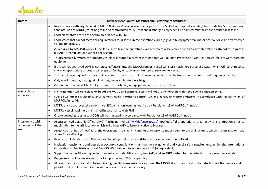
Hyde-1 Exploration Drilling Environment Plan Summary 17 of 25
Hazard Management Control Measures and Performance Standards
In accordance with Regulation 4 of MARPOL Annex V, food waste discharge from the MODU and support vessels (when inside the 500 m exclusion zone around the MODU) must be ground or comminuted to <25 mm and discharged only when >12 nautical miles from the territorial baseline.
Food macerators are maintained in accordance with PMS.
Food waste that cannot meet the requirements for disposal in the operational area (e.g. due to equipment failure or otherwise) will be transferred to land for disposal.
As required by MARPOL Annex I Regulations, while in the operational area, support vessels may discharge oily water after treatment to 15 ppm in a MARPOL compliant oily water filter system.
To discharge oily water, the support vessels will require a current International Oil Pollution Prevention (IOPP) certificate for oily water filtering equipment.
If a MARPOL approved OWS is not present/functioning, the MODU/support vessel will store machinery space oily water which will be shipped to shore for appropriate disposal at a reception facility or to a carrier licensed to receive the waste.
Scupper plugs or equivalent deck drainage control measures available where chemicals and hydrocarbons are stored and frequently handled.
Only non-hazardous, biodegradable detergents used for deck washing.
Continuous bunding will be in place around all machinery or equipment with potential to leak.
Atmospheric emissions
No incineration will take place on board the MODU and support vessels will not use incinerators within the 500 m exclusion zone.
Fuel oil will meet regulated sulphur content levels in order to control SOx and particular matter emissions in accordance with Regulation 14 of MARPOL Annex VI.
MODU and support vessel engines meet NOx emission levels as required by Regulation 13 of MARPOL Annex VI.
MODU/ vessel machinery maintained in accordance with PMS.
Ozone-depleting substances (ODS) will be managed in accordance with Regulation 13 of MARPOL Annex VI.
Interference with other users of the sea
Australian Hydrographic Office (AHO) (including [email protected]) notified of the operational area, activity and duration prior to mobilisation to the drill location, which will trigger AHO to issue a ‘Notice to Mariners’.
AMSA RCC notified of notified of the operational area, activity and duration prior to mobilisation to the drill location, which triggers RCC to issue an AusCoast Warning.
Relevant stakeholders identified and notified of operation area, activity and duration prior to mobilisation.
Navigation equipment and vessels procedures compliant with all marine navigational and vessel safety requirements under the International Convention of the Safety of Life at Sea (SOLAS) 1974 and Navigation Act 2012 (or equivalent).
Support vessels will be equipped with an automatic identification system (AIS) and an ARPA system for the detection of approaching vessels.
Bridge-watch will be maintained on all support vessels 24 hours per day.
At least one support vessel to be monitoring the 500 m exclusion zone around the MODU at all times to aid in the detection of other vessels and to provide additional communication with other vessels where necessary.
Hyde-1 Exploration Drilling Environment Plan Summary 18 of 25
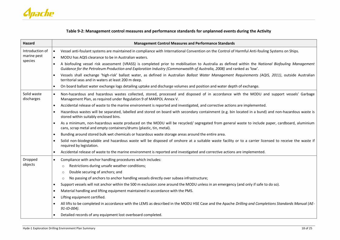
Table 9-2: Management control measures and performance standards for unplanned events during the Activity
Hazard Management Control Measures and Performance Standards
Introduction of marine pest species
Vessel anti-foulant systems are maintained in compliance with International Convention on the Control of Harmful Anti-fouling Systems on Ships.
MODU has AQIS clearance to be in Australian waters.
A biofouling vessel risk assessment (VRASS) is completed prior to mobilisation to Australia as defined within the National Biofouling Management Guidance for the Petroleum Production and Exploration Industry (Commonwealth of Australia, 2008) and ranked as ‘low’.
Vessels shall exchange ‘high-risk’ ballast water, as defined in Australian Ballast Water Management Requirements (AQIS, 2011), outside Australian territorial seas and in waters at least 200 m deep.
On board ballast water exchange logs detailing uptake and discharge volumes and position and water depth of exchange.
Solid waste discharges
Non-hazardous and hazardous wastes collected, stored, processed and disposed of in accordance with the MODU and support vessels’ Garbage Management Plan, as required under Regulation 9 of MARPOL Annex V.
Accidental release of waste to the marine environment is reported and investigated, and corrective actions are implemented.
Hazardous wastes will be separated, labelled and stored on board with secondary containment (e.g. bin located in a bund) and non-hazardous waste is stored within suitably enclosed bins.
As a minimum, non-hazardous waste produced on the MODU will be recycled/ segregated from general waste to include paper, cardboard, aluminium cans, scrap metal and empty containers/drums (plastic, tin, metal).
Bunding around stored bulk wet chemicals or hazardous waste storage areas around the entire area.
Solid non-biodegradable and hazardous waste will be disposed of onshore at a suitable waste facility or to a carrier licensed to receive the waste if required by legislation.
Accidental release of waste to the marine environment is reported and investigated and corrective actions are implemented.
Dropped objects
Compliance with anchor handling procedures which includes:
o Restrictions during unsafe weather conditions;
o Double securing of anchors; and
o No passing of anchors to anchor handling vessels directly over subsea infrastructure;
Support vessels will not anchor within the 500 m exclusion zone around the MODU unless in an emergency (and only if safe to do so).
Material handling and lifting equipment maintained in accordance with the PMS.
Lifting equipment certified.
All lifts to be completed in accordance with the LEMS as described in the MODU HSE Case and the Apache Drilling and Completions Standards Manual (AE-91-ID-004).
Detailed records of any equipment lost overboard completed.
Hyde-1 Exploration Drilling Environment Plan Summary 19 of 25
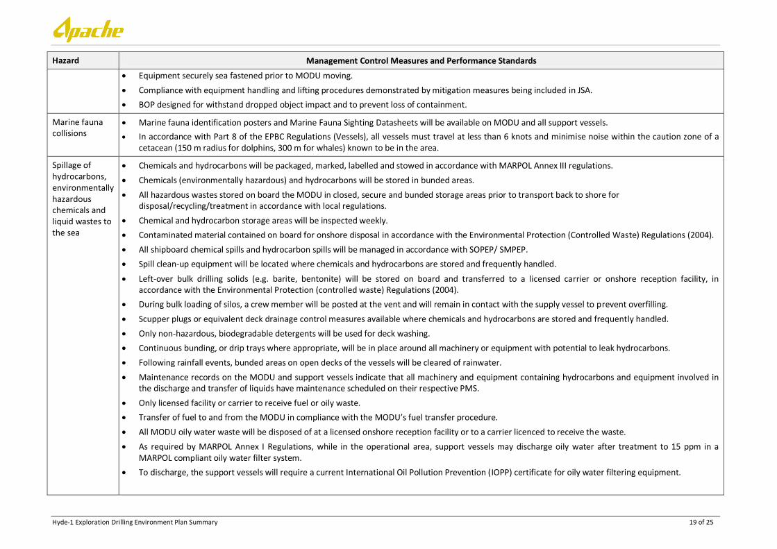
Hazard Management Control Measures and Performance Standards
Equipment securely sea fastened prior to MODU moving.
Compliance with equipment handling and lifting procedures demonstrated by mitigation measures being included in JSA.
BOP designed for withstand dropped object impact and to prevent loss of containment.
Marine fauna collisions
Marine fauna identification posters and Marine Fauna Sighting Datasheets will be available on MODU and all support vessels.
In accordance with Part 8 of the EPBC Regulations (Vessels), all vessels must travel at less than 6 knots and minimise noise within the caution zone of a cetacean (150 m radius for dolphins, 300 m for whales) known to be in the area.
Spillage of hydrocarbons, environmentally hazardous chemicals and liquid wastes to the sea
Chemicals and hydrocarbons will be packaged, marked, labelled and stowed in accordance with MARPOL Annex III regulations.
Chemicals (environmentally hazardous) and hydrocarbons will be stored in bunded areas.
All hazardous wastes stored on board the MODU in closed, secure and bunded storage areas prior to transport back to shore for disposal/recycling/treatment in accordance with local regulations.
Chemical and hydrocarbon storage areas will be inspected weekly.
Contaminated material contained on board for onshore disposal in accordance with the Environmental Protection (Controlled Waste) Regulations (2004).
All shipboard chemical spills and hydrocarbon spills will be managed in accordance with SOPEP/ SMPEP.
Spill clean-up equipment will be located where chemicals and hydrocarbons are stored and frequently handled.
Left-over bulk drilling solids (e.g. barite, bentonite) will be stored on board and transferred to a licensed carrier or onshore reception facility, in accordance with the Environmental Protection (controlled waste) Regulations (2004).
During bulk loading of silos, a crew member will be posted at the vent and will remain in contact with the supply vessel to prevent overfilling.
Scupper plugs or equivalent deck drainage control measures available where chemicals and hydrocarbons are stored and frequently handled.
Only non-hazardous, biodegradable detergents will be used for deck washing.
Continuous bunding, or drip trays where appropriate, will be in place around all machinery or equipment with potential to leak hydrocarbons.
Following rainfall events, bunded areas on open decks of the vessels will be cleared of rainwater.
Maintenance records on the MODU and support vessels indicate that all machinery and equipment containing hydrocarbons and equipment involved in the discharge and transfer of liquids have maintenance scheduled on their respective PMS.
Only licensed facility or carrier to receive fuel or oily waste.
Transfer of fuel to and from the MODU in compliance with the MODU’s fuel transfer procedure.
All MODU oily water waste will be disposed of at a licensed onshore reception facility or to a carrier licenced to receive the waste.
As required by MARPOL Annex I Regulations, while in the operational area, support vessels may discharge oily water after treatment to 15 ppm in a MARPOL compliant oily water filter system.
To discharge, the support vessels will require a current International Oil Pollution Prevention (IOPP) certificate for oily water filtering equipment.
Hyde-1 Exploration Drilling Environment Plan Summary 20 of 25
Hazard Management Control Measures and Performance Standards
Hydrocarbon spill during refuelling at sea
Refuelling will only take place if more than 12 nautical miles from the territorial baseline.
Fuel transfers will be undertaken in accordance with Apache’s/ Atwood’s Refuelling and Chemical Transfer Management Procedure, safe work procedure and checklist for fuel transfers, including but not limited to:
o Manual sounding of fuel tanks;
o Visual inspection of dry break couplings and hoses;
o Permit-to-work documentation is complete and signed off to ensure refuelling is undertaken in accordance with the refuelling procedure; and
o All refuelling hoses fitted with dry break couplings and are buoyant or fitted with floats.
Sulphur content of fuel oil complies with Regulation 14 of MARPOL Annex VI in order to control SOx and particulate matter emissions.
Adequate bunding in fuel transfer areas as per MARPOL Annex IV.
Deck drains closed prior to fuel transfer. Drainage and bunding systems are subject to on-going monitoring and maintenance to ensure integrity and capacity.
Support vessels have oily water filtering systems that are compliant (i.e. discharge oily water only when oil in water <15 ppm), and surveyed, as per MARPOL Annex I/ Marine Order 91.
Diesel storage tanks and fuel transfer hose maintenance (including replacement of refuelling hoses every six months) undertaken in accordance with the PMS.
Oil spill response executed in accordance with the Apache Hyde-1 Exploration Drilling OSCP (EA-00-R1-281/2).
Oil spill response executed in accordance with the vessel’s Shipboard Oil Pollution Emergency Plan (SOPEP) as required under MARPOL.
Oil spill exercise will be conducted prior to the commencement of the Activity and then every three months thereafter.
In line with MARPOL Annex I, all vessels involved in the Activity over 400 gross tonnage will have a current SOPEP in place and a valid IOPP.
Hydrocarbon spill due to ruptured vessel tanks due to vessel collision
Notification provided to key stakeholders including relevant Australian Government agencies.
AHO (including [email protected]) notified of operational area, activity and duration prior to mobilisation, which triggers AHO to issue ‘Notice to Mariners’.
AMSA RCC notified of operational area, activity and duration prior to mobilisation, which triggers RCC to issue an AusCoast Warning.
Australian Fisheries Management Authority (AMFA), Department of Fisheries and commercial fishing stakeholders notified prior to mobilisation.
Navigation equipment and vessel procedures will be compliant with all marine navigation and vessel safety requirements under the International Convention of the SOLAS 1974 and Navigation Act 2012 (or equivalent).
Support vessels equipped with an automatic identification system (AIS) and an ARPA system for the detection of approaching vessels.
Bridge-watch on all support vessels 24 hours per day.
At least one support vessel monitoring the MODU 500 m exclusion zone at all times to aid in the detection of other vessels and provide additional communication with other vessels where necessary.
Sulphur content of fuel oil complies with Regulation 14 of MARPOL Annex VI in order to control SOx and particulate matter emissions.
Hyde-1 Exploration Drilling Environment Plan Summary 21 of 25
Hazard Management Control Measures and Performance Standards
Oil spill response executed in accordance with the Apache Hyde-1 Exploration Drilling OSCP (EA-00-RI-281/2).
Oil spill response executed in accordance with the MODU and support vessel’s SOPEP as required under MARPOL.
Oil spill exercise will be conducted prior to the commencement of the Activity and then every three months thereafter.
Hydrocarbon spill due to loss of well control
WOMP details specific well control standard for this Activity and will be approved prior to the commencement of the Activity.
Well designed to meet technical specifications to ensure a margin of safety.
During preparation of the MODU safety case, all risk associated with well blowout are assessed and reduced to ALARP.
After BOP’s are installed, the well will have two barriers maintained during drilling, suspension and abandonment activities in accordance with Apache’s Drilling and Completions Standards Manual (AE-91-004, Section 11).
The well will be drilled in accordance with Apache’s Well Management System Drilling (WMSD) to ensure blowout prevention and well control.
Apache’s Fluid Selection Process will be followed in order to select the most appropriate drilling mud following offset well data reviews and analysis.
Well control equipment (e.g. BOP) included on the PMS as per Apache’s Drilling and Completions Standards Manual (AE-91-004, Section 11).
All well control equipment, casings and wellhead equipment will be tested to MASP in accordance with the Apache Drilling and Completions Barrier Standard (AE-91-ID-004).
Oil spill response executed in accordance with the Apache Hyde-1 Exploration Drilling OSCP (EA-00-RI-281/2).
Oil spill response executed in accordance with the vessel’s SOPEP as required under MARPOL.
Oil spill exercises will be conducted as per the Apache Hyde-1 Exploration Drilling OSCP (EA-00-RI-281/2) and SOPEP.
Hydrocarbon spill response
Management controls for activities and associated hazards relating to the following are described above:
Disturbance to marine habitat and seabed;
Artificial light;
Noise;
Drilling and cementing liquid discharges;
Oily water discharges;
Liquid non-hazardous and potentially hazardous materials;
Discharge of sewage and sullage;
Discharge of cooling water;
Desalination brine discharge;
Atmospheric emissions;
Interaction with commercial and recreational fishing;
Interaction with shipping;
Disruption to tourism and/or visual amenity;
Hyde-1 Exploration Drilling Environment Plan Summary 22 of 25
Hazard Management Control Measures and Performance Standards
Marine pest introduction;
Non-hazardous and hazardous solid waste;
Disturbance to marine fauna; and
Surface release of diesel.
Performance standards applicable to all response strategies include:
Planning and design:
Response priorities and activities to be documented in Incident Action Plan (IAPs) – including NEBA of response options for the receptor(s) of concern.
Development of targeted response plans prior to initiating response.
Approvals for access, restrictions, prioritisation and relocation considerations required from DoT and/ or DPaW received prior to implementation of response plans.
Prior demarcation (at shoreline protection areas and clean-up areas) delineating no-go zones and hot/warm/cold zones based on protecting environmental sensitivities;
No machinery to be used in mangroves or on turtle nesting beaches.
Flushing and washing (as part of Shoreline Clean-up Plan) to only use water.
Waste generated to be managed in accordance with the Waste Management Plan;
Prioritisation of conservation status fauna in all Oiled Wildlife Response (OWR) activities.
Personnel and equipment:
Lead response personnel are trained and experienced for the activities assigned and/ or sensitive receptors targeted.
OWR field teams accompanied by wildlife experts experienced with identification and behaviour of wildlife at risk.
Collected fauna begin transport to intended destination within two hours of capture.
Confirmation that the OWF facility able to accommodate washing and rehabilitation of intakes received prior to collection of fauna.
Regular (at least daily) check and maintenance of deflection booms.
Use of chemical dispersants:
Chemical dispersants confirmed to be acceptable for use in the marine environment by:
o Being approved with the Australian NatPlan OSCA register as either ‘listed’; or
o Evaluated as acceptable using Apache’s Environmental Chemical Approval Procedure for Operational Activities (EA-91-II-10001) and Apache’s Environmental Chemical Risk Assessment Form (AE-00-NI-10003), prior to use.
Discharge of subsea chemical dispersants limited to the period of installation of capping stack.
Monitoring and maintenance:
Booming equipment only deployed in weather/ sea state conditions conducive to successful protection/ deflection of sensitive habitats.
Surveillance data and spill trajectory modelling predictions incorporated into daily IAP preparation process for response strategies.
Hyde-1 Exploration Drilling Environment Plan Summary 23 of 25
Hazard Management Control Measures and Performance Standards
Scientific monitoring of shoreline habitats to inform on post-tier 2/ tier 3 spill event recovery.
Water quality scientific monitoring will be undertaken to evaluate entrained oil concentrations in marine waters.
Dispersant efficacy testing to ensure operational requirement of subsea chemical dispersant application can be achieved with dispersant proposed for use.
Subsea Application of Chemical Dispersants Response Strategy:
Selection of chemical dispersants to prioritise those dispersants approved with the Australian NatPlan OSCA register as ‘listed’. Chemical dispersants listed as transitional on the OSCA register, or not listed with the register, are to be evaluated using Apache’s Environmental Chemical Risk Assessment Form (EA-00-NI-10003). Chemical dispersants are only to be used if they are found to be acceptable by the risk assessment process.
Operational monitoring will be undertaken to evaluate dispersant efficacy;
Water quality scientific monitoring will be undertaken to evaluate entrained oil concentrations in marine waters; and
Dispersant operations will be constantly reviewed by the ICT through the Incident Action Plan process taking into account NEBA of impacts to sensitive receptors due to entrained oil.
Protection and Deflection Response Strategy:
Development of targeted protection and deflection plans that consider environmental conditions (sea state, currents, habitats), protection priorities against the NatPlan priorities for protection, prior to implementation of boom;
Prior demarcation at shoreline protection areas delineating no-go zones based on protecting environmental sensitivities;
Equipment appropriate for the environmental conditions;
Lead response personnel trained and experienced in planning and deployment of protection and deflection booming;
Booming not deployed during periods of weather and sea state conditions that are not conducive to successful protection; and
Regular (at least daily) check and maintenance of boom to ensure boom is functioning as intended.
Shoreline Clean-up Response Strategy:
Development of shoreline clean-up plan appropriate to the nature and scale of the activity;
Lead response personnel trained and experienced in shoreline clean-up operations;
Shoreline assessments used to plan clean-up operations;
Flushing and washing to only use seawater;
Shoreline access permissions and restrictions to be provided by Department of Parks and Wildlife (DPaW) and Department of Transport (DoT) prior to implementation of clean-up operations;
In the case of natural recovery, scientific monitoring of shoreline habitats to inform on recovery;
Pre-planning to include access requirements, no-go zones, and hot/warm/cold zones;
Pre-cleaning of shorelines predicted for contact will reduce the volume of oily waste and reduce the required clean-up resources;
No machinery to be used in mangroves or on turtle nesting beaches; and
Hyde-1 Exploration Drilling Environment Plan Summary 24 of 25
Hazard Management Control Measures and Performance Standards
Waste generated to be managed in accordance with the Waste Management Plan.
Oiled Wildlife Response (OWR) Strategy:
Development of oiled wildlife response plan appropriate to the nature and scale of the activity;
Lead response personnel trained and experienced in OWR activities;
Field teams accompanied by wildlife experts experienced with identification and behaviour of wildlife at risk;
Planning and implementation of OWR activities to be led by trained and experienced personnel;
Planning of capture and relocation activities to be approved by DPaW prior to implementation;
Effective provision of operational monitoring data to OWR planning teams to identify and prioritise oiled habitats and areas predicted for contact;
Provision of capture equipment appropriate for the fauna being targeted;
Provision of timely and adequate resources to ensure collected fauna begin transport to intended destination within two hours of capture;
Confirmation that the OWR facility able to accommodate washing and rehabilitation of intakes received prior to collection of fauna; and
Prioritisation of conservation status fauna in all OWR activities.
Hyde-1 Exploration Drilling Environment Plan Summary 25 of 25
10. REFERENCES
APPEA (2008). Code of Environmental Practice. Australian Petroleum Production and Exploration Association. Canberra.
DEWHA (2008). EPBC Act Policy Statement 2.1 – Interaction between offshore seismic exploration and whales. Department of the Environment, Water, Heritage and the Arts, Canberra, Australia.
DoE (2013). Protected matters search tool. Database of fauna listed as Threatened and Migratory Marine Species under the EPBC Act. Department of the Environment. Last accessed for this proposed activity November 2013.
Fletcher, W.J. and Santoro, K. (Eds). (2012). Status Reports of the Fisheries and Aquatic Resources of Western Australia 2011/12: The State of the Fisheries. Department of Fisheries, Western Australia. 370pp.
Holloway P.E. and Nye, H.C. (1985). Leeuwin current and wind distributions on the southern part of the Australian North West Shelf between January 1982 and July 1983. Australian Journal of Marine and Freshwater Research 36(2): 123–137.
NSR (1995). Wandoo full field development. Public Environmental Report for Ampolex Ltd, NSR Environmental Consultants Pty Ltd. November 1995.
SSE (1991). Normal and extreme environmental design criteria. Campbell and Sinbad locations, and Varanus Island to Mainland Pipeline. Volume 1. Prepared for Hadson Energy Limited by Steedman Science and Engineering. Report E486. March 1991.
WNI (1995). Preliminary report on ambient and non-cyclonic design criteria for the Stag location. WNI Science & Engineering. December 1995.
WNI (1996). Metocean Conditions on the North West Shelf of Australia, Cape Lambert to the North West Cape Relating to Jack-up Drilling Operation (DR-50-ED-001). July 1996.
Woodside (2005). The Vincent Development. Draft EIS. EPBC Referral 2005/2110. Woodside Energy. Perth.