hunter corridor regional planning study 1
TRANSCRIPT

Hunter Corridor Regional Planning Study
1
Prepared for:
Town of Hunter Village of Hunter
Village of Tannersville
Prepared by:
Greene County Soil and Water Conservation District Greene County Watershed Assistance Program (WAP) Greene County Economic Development, Tourism and Planning Delaware Engineering, P.C. The LA Group Creighton Manning Engineering, LLP Funding provided by:
Catskill Watershed Corporation Local Technical Assistance Program Schoharie Watershed Impact Studies Grants
October 20, 2010
Revised February 2011

Hunter Corridor Regional Planning Study
1
Prepared for:
Town of Hunter
Village of Hunter
Village of Tannersville
Prepared by:
Greene County Soil and Water Conservation District
Greene County Watershed Assistance Program (WAP)
Greene County Economic Development, Tourism and Planning
Delaware Engineering, P.C.
The LA Group
Creighton Manning Engineering, LLP
Funding provided by:
Catskill Watershed Corporation Local Technical Assistance Program
Schoharie Watershed Impact Studies Grants
October 20, 2010
Revised February 2011

PROJECT ADVISORY TEAM
Paul Dibbell Town of Hunter Deputy Supervisor Jeff Flack GCSWCD Executive Director Warren Hart Director, Greene County Economic Development, Tourism and Planning Mark Hyer Town of Hunter Planning Board Chair and Consultant to Village of Tannersville Planning Board David Kukle Town of Hunter Planning Board Member Dennis Lucas Town of Hunter Supervisor William Maley Village of Hunter Mayor Lee McGunnigle Village of Tannersville Mayor Paul Slutzky Town of Hunter Planning Board Vice Chair and Village of Hunter Planning Board Chair René VanSchaack Greene County IDA Director of Community & Environmental Programs Michelle Yost GCSWCD Watershed Assistance Program Coordinator

Hunter Corridor Regional Planning Study
Delaware Engineering, P.C. i
HUNTER CORRIDOR REGIONAL PLANNING STUDY TABLE OF CONTENTS
EXECUTIVE SUMMARY .......................................................................................................... 1 1.0 INTRODUCTION ................................................................................................................ 10
1.1 Study Area .......................................................................................................................... 12 1.2 Catskill Park and New York City Watershed ..................................................................... 12 1.3 Influences of the New York City Watershed...................................................................... 13
2.0 ENVIRONMENTAL SETTING ......................................................................................... 14
2.1 Soils..................................................................................................................................... 14 2.2 Topography......................................................................................................................... 14 2.3 Water Resources ................................................................................................................. 16 2.4 Wetlands ............................................................................................................................. 20 2.5 Hydric Soils ........................................................................................................................ 24 2.6 Wildlife ............................................................................................................................... 26 2.7 Recreational and Scenic Resources .................................................................................... 29 2.8 Historic and Cultural Resources ......................................................................................... 33
2.8.1 Historical Resources – Town of Hunter....................................................................... 33 2.8.2 Historical Resources – Village of Hunter .................................................................... 34 2.8.3 Historical Resources – Village of Tannersville ........................................................... 35 2.8.4 Cultural Resources ....................................................................................................... 35
2.9 Other Planning Studies and Documents ............................................................................. 36 3.0 INFRASTRUCTURE ........................................................................................................... 38
3.1 Water, Wastewater and Stormwater ................................................................................... 38 3.1.1 Town of Hunter............................................................................................................ 38 3.1.2 Village of Hunter ......................................................................................................... 41 3.1.3 Village of Tannersville ................................................................................................ 50
3.2 Parking, Transportation and Traffic.................................................................................... 53 3.2.1 Town of Hunter............................................................................................................ 54 3.2.2 Village of Hunter ......................................................................................................... 55 3.2.3 Village of Tannersville ................................................................................................ 56
4.0 BUILD-OUT ANALYSIS..................................................................................................... 57
4.1 Introduction......................................................................................................................... 57 4.2 Methodology....................................................................................................................... 57 4.3 Build-Out Analysis and Conclusions.................................................................................. 58
5.0 COST OF COMMUNITY SERVICES ANALYSIS ......................................................... 60
5.1 Introduction......................................................................................................................... 60 5.2 Methodology....................................................................................................................... 60 5.3 Local Services..................................................................................................................... 61 5.4 Cost of Community Services Findings ............................................................................... 61
5.4.1 Findings – Town of Hunter.......................................................................................... 62

Hunter Corridor Regional Planning Study
Delaware Engineering, P.C. ii
5.4.2 Findings – Village of Hunter ....................................................................................... 62 5.4.3 Findings – Village of Tannersville .............................................................................. 63
6.0 CURRENT REGULATIONS .............................................................................................. 64 7.0 ANALYSIS AND RECOMMENDATIONS....................................................................... 66
7.1 Cost of Services and Build-Out Recommendations............................................................ 66 7.2 Environmental Conditions .................................................................................................. 68
7.2.1 Analysis........................................................................................................................ 68 7.2.2 Recommendations........................................................................................................ 70
7.3 Infrastructure....................................................................................................................... 75 7.3.1 Analysis........................................................................................................................ 75 7.3.2 Recommendations........................................................................................................ 81
7.4 Local Land Use Regulations Analysis and Recommendations .......................................... 90 7.4.1 Analysis........................................................................................................................ 90 7.4.2 Recommendations for all Communities....................................................................... 91 7.4.3 Tool Kit........................................................................................................................ 96 7.4.4 Land Use Law Recommendations for the Town of Hunter....................................... 106 7.4.5 Land Use Law Recommendations for the Village of Hunter .................................... 107 7.4.6 Land Use Law Recommendations for the Village of Tannersville............................ 108
8.0 RESOURCES...................................................................................................................... 109
8.1 Mountain Top Mapping .................................................................................................... 109 8.2 Electronic Resources......................................................................................................... 111 8.3 Funding Opportunities ...................................................................................................... 113
9.0 REFERENCES.................................................................................................................... 115
LIST OF TABLES
Table 2.1 Stream Management Plans for Greene County, New York.......................................... 18 Table 2.2 Town of Hunter NWI Wetland Classifications............................................................. 21 Table 2.3 Hydric Soils in the Town of Hunter.............................................................................. 25 Table 2.4 Protected Bird Species in Hunter, New York ............................................................... 26 Table 2.5 2010 Plant Status List - Active Inventory List for Greene County .............................. 27 Table 2.6 New York Nature Explorer List of Rare Plant and Animals ........................................ 28 Table 2.7 New York Nature Explorer List of Significant Natural Communities ......................... 28 Table 2.8 Recreation Plans for Greene County and New York State........................................... 29 Table 2.9 Recreational and Scenic Opportunities......................................................................... 31 Table 2.10 Historic Sites in the Town of Hunter .......................................................................... 34 Table 2.11 Historic Sites in the Village of Hunter........................................................................ 35 Table 2.12 Historic Sites in the Village of Tannersville............................................................... 35 Table 2.13 Cultural Resources...................................................................................................... 35 Table 3.1 Village of Hunter Water Usage .................................................................................... 43 Table 3.2 Average and Peak Flows for the Village of Hunter WWTP......................................... 46 Table 3.3 Current Capacity Available in an Extreme Drought (2009) ......................................... 51 Table 4.1 Hunter Corridor Project Study Area Land Use............................................................. 58

Hunter Corridor Regional Planning Study
Delaware Engineering, P.C. iii
Table 4.2 Development Projections for the Town of Hunter........................................................ 59 Table 4.3 Development Projections for the Village of Hunter ..................................................... 59 Table 4.4 Development Projections for the Village of Tannersville ............................................ 59 Table 5.1 Town of Hunter 2008 Assessment Roll ........................................................................ 62 Table 5.2 Village of Hunter 2008 Assessment Roll ..................................................................... 63 Table 5.3 Village of Tannersville 2008 Assessment Roll............................................................. 63 Table 7.1 Environmental Benefits and Drawbacks of BMPs ....................................................... 71 Table 7.2 Impacts of Impervious Cover and Stormwater Runoff................................................. 71 Table 7.3 Total Phosphorous Source Areas.................................................................................. 72 Table 7.4 Storm Elevations........................................................................................................... 77 Table 7.5 Conventional Minimum Parking Ratios ....................................................................... 93 Table 7.6 Water Quality Effectiveness of Various Pavers ........................................................... 94 Table 7.7 Minimum Dimensions for Reducing Impervious Cover .............................................. 98 Table 7.8 Watershed Preservation Zoning Techniques .............................................................. 101 Table 7.9 Stormwater Treatment Vegetation Characteristics ..................................................... 102
LIST OF FIGURES Figure 1.1 Project Advisory Team meeting.................................................................................... 3 Figure 2.1 View of the Mountains in the Town of Hunter ........................................................... 15 Figure 2.2 Schoharie Creek in the Town of Hunter...................................................................... 16 Figure 2.3 Sediment in a tributary to the Schoharie ..................................................................... 16 Figure 2.4 Regulated Watercourses .............................................................................................. 17 Figure 2.5 Streams on Hunter Mountain....................................................................................... 18 Figure 2.6 Section of updated FIRM panel................................................................................... 19 Figure 2.7 An Unobstructed Floodplain by the Schoharie Creek................................................. 20 Figure 2.8 Building on bank of creek destroyed by flood waters................................................. 20 Figure 2.9 DEC Wetlands and Hydric Soils in the Village of Tannersville ................................. 20 Figure 2.10 Wetland Areas ........................................................................................................... 22 Figure 2.11 NWI Wetlands in the Hunter Corridor ...................................................................... 22 Figure 2.12 Typical Hunter Mountain West Wetlands................................................................. 23 Figure 2.13 Vernal Pools .............................................................................................................. 23 Figure 2.14 Environmental Resource Mapper .............................................................................. 27 Figure 2.15 Dolan’s Lake Park ..................................................................................................... 30 Figure 2.16 Mountain Cloves Scenic Byway Map ....................................................................... 32 Figure 2.17 Scenic Roadways in the Corridor .............................................................................. 32 Figure 2.18 State Historic Preservation Office Map for the Town of Hunter .............................. 33 Figure 2.19 Hunter Mountain Fire Tower..................................................................................... 34 Figure 3.1 Septic Tank Flooding on Route 23A........................................................................... 39 Figure 3.2 Flooded Basement in the Village of Hunter ................................................................ 39 Figure 3.3 Town of Hunter Downstream Swale (September 2005) ............................................. 40 Figure 3.4 Stormwater Retrofit at Hunter Mountain .................................................................... 40 Figure 3.5 Water Usage Data for the Village of Hunter from Wells and Surface Water ............. 43 Figure 3.6 Glen Avenue culvert in need of repair ........................................................................ 47 Figure 3.7 Tannersville Reservoir (July 2007) ............................................................................. 50

Hunter Corridor Regional Planning Study
Delaware Engineering, P.C. iv
Figure 3.8 Installation of porous pavement at the WAP Office in Tannersville .......................... 52 Figure 3.9 Flooding along the Sawmill Creek .............................................................................. 52 Figure 3.10 Village of Hunter Welcome Sign .............................................................................. 55 Figure 3.11 Recommended Bike Signage Routes......................................................................... 56 Figure 4.1 Build-Out Analysis Corridor Boundary Map.............................................................. 57 Figure 7.1 Scenic and Recreational Opportunities ....................................................................... 69 Figure 7.2 Examples of Construction Practices without Stormwater Controls ............................ 71 Figure 7.3 Floodplain Expansion as a result of New Development ............................................. 72 Figure 7.4 Pollutant Pathways ...................................................................................................... 73 Figure 7.5 Sugar Maples Stormwater Management ..................................................................... 74 Figure 7.6 Stormwater Runoff Carries Sediments........................................................................ 76 Figure 7.7 Botti Drive Crossing.................................................................................................... 77 Figure 7.8 Route 23A Reconstruction .......................................................................................... 78 Figure 7.9 Vortech System Installed in Village of Hunter ........................................................... 78 Figure 7.10 Trib 140 (April 2007) ................................................................................................ 79 Figure 7.11 Mad Brook Stream Crossing ..................................................................................... 79 Figure 7.12 Dolan’s Lake Span Bridge......................................................................................... 88 Figure 7.13 Relation of Street Width to Number of Accidents .................................................... 91 Figure 7.14 Cul-de-sac Design to Reduce Imperious Surfaces .................................................... 91 Figure 7.15 Alternative Turn-Around Design to Reduce Impervious Surfaces ........................... 92 Figure 7.16 Open Vegetated Channels ......................................................................................... 92 Figure 7.17 Typical Wet Swale Design ........................................................................................ 93 Figure 7.18 Alternative Lot Layouts............................................................................................. 94 Figure 7.19 Stream Buffer Zones.................................................................................................. 95 Figure 7.20 Excessive Impervious Cover ..................................................................................... 96 Figure 7.21 Impervious Cover as a Function of Land Use ........................................................... 97 Figure 7.22 Phosphorus Loads under Different Land Uses and BMPs ........................................ 97 Figure 7.23 Conventional Subdivision ......................................................................................... 99 Figure 7.24 Conservation Subdivision.......................................................................................... 99 Figure 7.25 Section through typical Mixed-Use Development .................................................. 100 Figure 7.26 Filter Strips .............................................................................................................. 102 Figure 7.27 Bioretention Area .................................................................................................... 103 Figure 7.28 Example of a Grassed Swale in the Town of Hunter .............................................. 103 Figure 7.29 Dry Swale Aerial View ........................................................................................... 104 Figure 7.30 Green Roof .............................................................................................................. 104 Figure 7.31 Green Wall with Ivy ................................................................................................ 105 Figure 7.32 Landscaped Areas break up impervious cover in parking lots................................ 106 Figure 7.33 Cluster Development vs. Conventional Development ............................................ 107 Figure 7.34 Comparing Impervious Cover of Cul-de-sac Alternatives...................................... 107 Figure 7.35 Infiltration Island in parking lot .............................................................................. 108 Figure 7.36 Relation of cul-de-sac radius to impervious surface area........................................ 108 Figure 8.1 Mt. Top Mapping Application Map .......................................................................... 110 Figure 8.2 Capital and Financial Planning Process .................................................................... 113 Figure 8.3 Watershed Planning and Implementation.................................................................. 114

Hunter Corridor Regional Planning Study
Delaware Engineering, P.C. v
LIST OF MAPS
Map 1.1 Study Area Map Map 1.2 Catskill Forest Preserve Map Map 2.1 Bedrock and Surficial Geology Map Map 2.2 Soils Map Map 2.3 Topographic Map Map 2.4 Steep Slopes Map Map 2.5 NYS DEC Stream Classification Map Map 2.6 Flood Zones Map Map 2.7 Wetlands Map Map 2.8 Significant Natural Communities Map Map 2.9 Rare Plants and Animals Map Map 2.10 Town of Hunter Recreation Map Map 2.11 Village of Hunter Historic Resources Map Map 2.12 Village of Tannersville Historic Resources Map Map 2.13 Town of Hunter Resources Inventory Map Map 3.1 Water Systems Map Map 3.2 Sewer Systems Map Map 4.1 2009 Land Use Map
APPENDICES
APPENDIX A Soil Surveys NRCS Community Soil Reports Soil Suitability Tables and Soil Summaries Greene County Soil Survey APPENDIX B Ecological Resources NWI Wetlands Classification List Federal Endangered Species in Greene County Bird Species in the Town of Hunter NY Natural Heritage Program Rare Plants in Greene County NY Nature Explorer Report APPENDIX C Community Characteristics Mt. Top Community Resource Strategy Town of Hunter Recreational, Cultural and Historic Resources Demographics, Land Use and Community Services APPENDIX D Development Analysis Build Out Analysis Cost of Services Analysis APPENDIX E Transportation Evaluation

Hunter Corridor Regional Planning Study
Delaware Engineering, P.C. vi
APPENDIX F Code Review and Sample Regulations Existing Site Plan Application Procedures MSR 4 Community Code Reviews and Recommendations Sample Stream Buffer Local Law Sample Density Bonus Local Law Special District Process in New York State APPENDIX G Planning Tools Better Site Design Tool Kit Mt. Top Mapping User Guide Funding Opportunities

Hunter Corridor Regional Planning Study
Delaware Engineering, P.C. 1
EXECUTIVE SUMMARY BACKGROUND Located in the Northern Catskill Region some 50 miles southwest of Albany and 90 miles north of New York City, the Town of Hunter and the Villages of Hunter and Tannersville (“the Hunter Communities”) are poised for significant growth and development due to an outstanding array of natural, scenic and recreational resources coupled with recently developed infrastructure capacity. The implementation of several aspects of the New York City Watershed Memorandum of Agreement (“MOA”) over the past ten years has resulted in changes to the built and regulatory environment that balances growth and development with water quality protection. Chief among the MOA-derived changes with influence in the Hunter Communities is the construction of the wastewater collection and treatment system in the Village of Hunter and the establishment of designated Hamlets and Village Extension Areas which are intended to concentrate growth and development near existing population centers. Bolstered by funding made available through the Shandaken Tunnel SPDES Permit negotiations dedicated to proactive planning, the Hunter Communities working with the Greene County Soil and Water Conservation District Watershed Assistance Program (“WAP”), the Greene Business Alliance (formerly the Greene Industrial Development Agency), and the Greene County Department of Economic Development, Tourism and Planning have prepared the Hunter Regional Corridor Planning Study (“the Hunter Corridor Study”) to address the need to plan for the long term sustainability of the Town and its valuable natural, built and human resources. The study area (“the Corridor”) includes the land surrounding the NYS Route 23A Corridor from the Jewett Town Line travelling eastward through the Villages of Hunter and Tannersville to the Hamlet of Haines Falls. It includes the Villages, Village Extensions and the Designated Hamlets of Haines Falls and Onteora Park. The Corridor in entirely within the New York City Watershed and was defined as the area in the Hunter Communities most likely to experience growth and development in the future. The primary objective of the Hunter Corridor Study is to engage in inter-municipal discussions that characterize and focus the nature of development and growth to be sensitive to the Corridor setting and to encourage a common vision for the Route 23A Corridor (“the Corridor”). Secondary objectives in support of the primary objective are to provide an analysis of environmental conditions and infrastructure that both constrains and supports desired land uses; evaluation of federal, state, regional and local regulations that shape land use; and, identification of planning tools and recommendations that may be implemented by the Hunter Communities to bring the shared vision of future development along the Corridor to fruition while protecting and conserving the intrinsic resources that give the Hunter Communities a sense of place. The scope of the Hunter Corridor Study incorporates the actions identified as necessary to support the objectives of the Study. These include:
Development of an inventory of existing information including community plans, land use and other relevant regulations, environmental data and mapping, etc.

Hunter Corridor Regional Planning Study
Delaware Engineering, P.C. 2
Characterization of important natural resources within the Corridor including wetlands, streams, floodplains, soils, topography, wildlife resources and visual and scenic character.
Identification of current municipal infrastructure and service strengths and weaknesses including wastewater treatment, water supply and distribution, solid waste, stormwater management, transportation infrastructure, community and emergency services, and traffic patterns within the Corridor.
Evaluation of growth potential and the cost of community services within the Corridor.
Identification of policies, strategies and measures that could be implemented to encourage sustainable development and mitigate potential impacts to the environment.
Public participation to obtain input and feedback from stakeholders in the local land use arena including the general public, planning and town boards, and interested and involved agencies.
Development of a detailed written study that incorporates the results of the Hunter Corridor Study into an integrated document that can be used actively and cooperatively by the Hunter Communities.
The inventory and analysis of environmental and infrastructure conditions will assist the Hunter Communities in encouraging desired growth and development while avoiding unintended negative impacts to natural resources and quality of life. The Hunter Corridor Study incorporates an inventory of existing environmental conditions as well as analyses of potential impacts from future development on environmental, community and infrastructure resources. Furthermore, the document discusses regional development trends and offers recommendations regarding measures aimed at encouraging improved site planning aimed at mitigating negative impacts to the environment while protecting community character. The Hunter Corridor Study integrates existing planning and land use documents to provide a compendium of resources available for local land use planning. The preparation of the Hunter Corridor Study has involved elected and appointed officials, residents, and regional agencies to foster an inclusive understanding and direction for the scale and location of new development in order to minimize adverse impacts to the Hunter Communities environmental and infrastructure resources. Through dialogue, the Hunter Communities have identified and assessed existing and potential growth patterns within the Corridor. The Hunter Corridor Study serves as a planning tool and resource for municipal boards, planning boards, and property owners to guide future development in a manner that safeguards the environment and protects community character.
Hunter Corridor Regional Planning Study
Delaware Engineering, P.C. 3
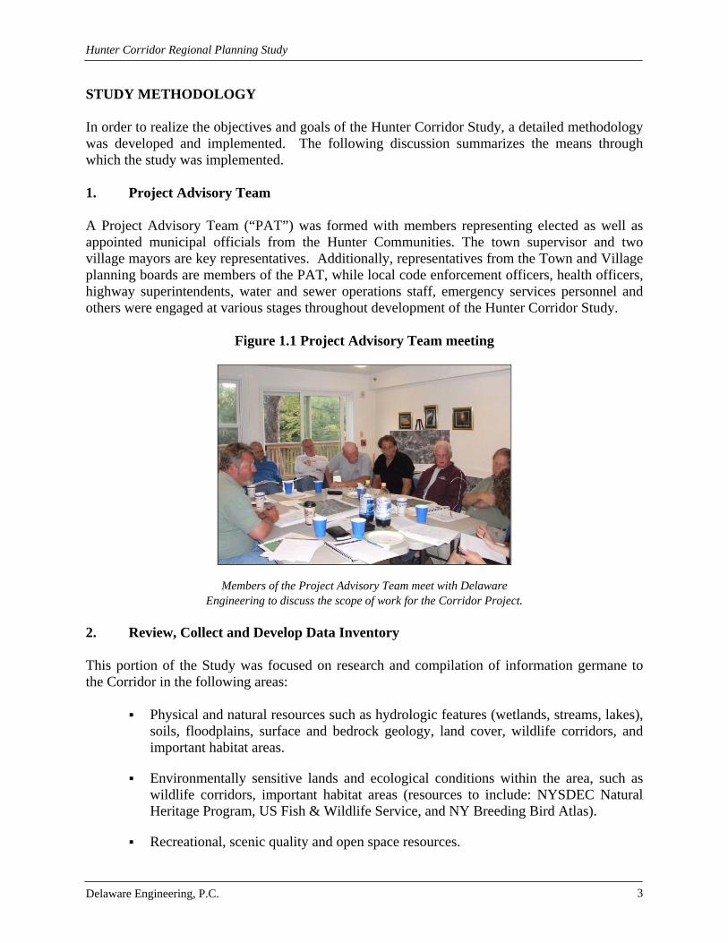
STUDY METHODOLOGY In order to realize the objectives and goals of the Hunter Corridor Study, a detailed methodology was developed and implemented. The following discussion summarizes the means through which the study was implemented. 1. Project Advisory Team A Project Advisory Team (“PAT”) was formed with members representing elected as well as appointed municipal officials from the Hunter Communities. The town supervisor and two village mayors are key representatives. Additionally, representatives from the Town and Village planning boards are members of the PAT, while local code enforcement officers, health officers, highway superintendents, water and sewer operations staff, emergency services personnel and others were engaged at various stages throughout development of the Hunter Corridor Study.
Figure 1.1 Project Advisory Team meeting
Members of the Project Advisory Team meet with Delaware Engineering to discuss the scope of work for the Corridor Project.
2. Review, Collect and Develop Data Inventory This portion of the Study was focused on research and compilation of information germane to the Corridor in the following areas:
Physical and natural resources such as hydrologic features (wetlands, streams, lakes), soils, floodplains, surface and bedrock geology, land cover, wildlife corridors, and important habitat areas.
Environmentally sensitive lands and ecological conditions within the area, such as wildlife corridors, important habitat areas (resources to include: NYSDEC Natural Heritage Program, US Fish & Wildlife Service, and NY Breeding Bird Atlas).
Recreational, scenic quality and open space resources.

Hunter Corridor Regional Planning Study
Delaware Engineering, P.C. 4
Current land use patterns including infrastructure, housing, subdivision, traffic, building permit trends, and commercial and business establishments.
Local land use codes, state, federal and regional (NYC) regulations that shape development within the Hunter Corridor Communities.
Demographic information from 1990 and 2000 US Census and projection through 2009.
Information to conduct a comprehensive build-out and cost of community services analyses of the Corridor.
Current status of municipal infrastructure (sewer, water, stormwater) as well as projections of impacts and constraints on future use of these resources.
3. Development Analysis A Build-Out Analysis was conducted for each of the Hunter Corridor Communities. The development analysis was informed by a similar analysis prepared for the Village of Tannersville in 2006. Using past growth data and expectations for foreseeable new development, growth projections were prepared. In addition to the development analysis, a Cost of Community Services study was prepared. 4. Inventory and Analysis of Land Use Regulations Existing local codes and land use regulations were identified, collected and analyzed to evaluate strengths and weaknesses in promoting Low Impact Development practices that protect water quality and community character. Local, state and federal regulations, as well as the NYC Watershed Rules and Regulations were also examined. Existing land use controls were evaluated in relation to the Hunter Corridor Communities’ Comprehensive Plans, current development patterns and projected development pressures. Findings of this analysis are integrated into specific recommendations for each of the Hunter Corridor Communities. 5. Hunter Corridor Study Report This report has been compiled based on the information gathered and evaluated in the conduct of the study. In summary, this report contains the following:
a. Executive summary – including a cover sheet, table of contents, and overview of the project.
b. Introduction – highlights the relevance of conducting a thorough corridor study for the
public benefit and to safeguard natural resources, including a description of the project area with respect to each municipality, geographic location, and a list of involved and interested agencies.
Hunter Corridor Regional Planning Study
Delaware Engineering, P.C. 5
c. Environmental Setting, Infrastructure, and Growth/Cost of Services Potential – an inventory of natural resources, infrastructure and growth/cost of services potential to assess existing conditions that support and hinder development, Build-Out and Cost of Community Services Analysis, and land use regulation recommendations:
Natural resources including wetlands, streams, wildlife corridors, important
habitat areas, outdoor recreational areas, public lands, topography and soils.
Water and wastewater treatment availability and capacity to meet demands from new development.
Stormwater management techniques currently in use and recommendations for improving site and land use planning and infrastructure to characterize stormwater management and water quality concerns in the Corridor. Current regulatory policies pertaining to stormwater management are described and their impacts on development.
Transportation existing and future conditions as well as public parking capacity, needs and options in the Villages and Hamlet.
Community services are identified and examined in relation to their ability to provide adequate services, e.g., police, fire, EMS, school districts, etc.
Historical, cultural, and scenic resources are summarized from the perspective of how these resources create the Hunter Communities sense of place and need for protection and enhancement.
d. Identification of local land use policies, strategies and measures that could be
implemented to encourage future development that safeguards resources, minimizes costs of municipal services, protects the Hunter Communities sense of place, and mitigate potential impacts to the environment.
6. Public Participation The culmination of the Hunter Corridor Study was dissemination of the draft report to stakeholders within the Corridor and conduct of meetings with the public, local planning boards and code enforcement officials, land owners and other involved agencies. Participation was sought from private landowners, business owners, developers and agencies as well as interests related to economic development, tourism-based and housing development. STUDY CONCLUSIONS AND RECOMMENDATIONS The Corridor Study delineates the characteristics of the Communities that combine to poise the area for growth. Furthermore, the Study describes a common vision for development in the Corridor that provides a sound tax base while promoting best practices in site and land use planning. To achieve these goals, existing local land use regulations require updating to reflect state-of-the art planning tools and techniques that protect resources, recognize the impact of
Hunter Corridor Regional Planning Study
Delaware Engineering, P.C. 6
development with respect to the cost of municipal services, and result in improved site planning that reduces negative impacts to the environment particularly water quality and quality of life. The following summary provides the major recommendations of the Study, grouped according to major categories of analysis: Municipal Codes and Land Use Controls
1. Current and future development has the potential to impact water quality due to erosion and sedimentation during and after construction. The implementation of Better Site Design practices is recommended to mitigate this impact.1
2. Evaluate methods to encourage shovel ready site preparation, mixed use, promote
commercial and retail uses, support infill development and discourage sprawl through the creation and effective use of special districts, shared services, and density bonus incentives to stabilize the tax base/revenue when compared to the cost and demand for services.2
3. Update local land use regulations to encourage the use of Low Impact Development
principals that minimize impervious surfaces, protect natural areas, and integrate stormwater controls in site planning.1
4. Employ the Tool Kit to guide future development towards avoiding adverse impacts on
the environment, more specifically impacts on water quality due to stormwater runoff and phosphorus.1
5. Together with updates to local land use regulations, evaluate application forms and
procedures to support the common vision for economically beneficial and environmentally sensitive development throughout the Corridor.
6. Consider establishing performance criteria for improved site design that is protective of
natural, scenic and recreational resources, and create a streamlined local approval process for projects that meet the criteria.
7. Evaluate the addition of surface water protection overlay districts to local land use
regulations to guide development within floodplains and adjacent to surface water bodies within the villages and hamlets.
Transportation and Parking
8. Evaluate the four pedestrian/bike accidents within the Villages to determine the need for improvements to existing signage and/or pedestrian and bike facilities.3
1 Recommended by Hunter Corridor Planning Study 2 Recommended by the Build-Out Analysis and the Cost of Community Services Analysis 3 Recommended by the Transportation Evaluation

Hunter Corridor Regional Planning Study
Delaware Engineering, P.C. 7
9. Monitor the intersection of Hill Street and Railroad Avenue with Route 23A to determine if increases in trips due to growth trigger a “no right turn on red” limitation in the future.3
10. Monitor accident data for the Clum Hill Road intersection with Route 23A to confirm if
limited sight distances cause crashes at the intersection as the area grows.3
11. As parcels become available for purchase in both Villages, consideration should be given for land acquisition to support additional parking. As a rule of thumb, 125 cars will fit on a one acre parcel of land.3
12. Traffic impact studies should be required for future development plans to determine site-
specific traffic-related impacts and mitigations.3
13. Investigate the potential to adopt transportation capacity improvements guidelines that limit the potential impacts to building and overall village/rural character.3
14. Utilize the Access Management Checklist during site plan review to evaluate and facility
implementation of planned pedestrian connections, shared driveways, cross access connections, access and turn restrictions, align driveways/roadways, and rear/side/shared parking.3
Multi-Modal Transportation
15. Work with appropriate agencies with jurisdiction (e.g. NYSDOT, Greene County Highway Department, municipal highway departments) to designate selected roadways as bike routes.3
16. Work to extend the Huckleberry Trail north approximately ½ mile on Bloomer Road
where access easements could be pursued to reconnect with the former railroad bed west towards the Village of Hunter.3
17. Investigate the impediments to construction of a multi-use path or sidewalk along NY
Route 23A between the Villages to provide a more direct connection for pedestrians and bicyclists.3
Potable Water Supply, Treatment, Storage and Distribution Systems
18. During the SEQR and site plan review process for projects proposed in the Town of
Hunter, the planning board should consider water supply documentation as part of the site plan and/or subdivision review process to ensure the safety and adequacy of supplies. Separation distances should be considered during the review of site plans. For community systems, the planning board should review a report from a qualified engineer or geologist regarding the adequacy of water supplies.1
19. In the Village of Hunter, additional raw water capacity is needed to accommodate
substantial development. It is recommended that all new developments with demands

Hunter Corridor Regional Planning Study
Delaware Engineering, P.C. 8
beyond those for a minor subdivision be required to conduct a water system evaluation during the site plan and SEQR process.1
20. In the Village of Tannersville, additional source water capacity is needed to address
current regulatory concerns as well as to accommodate future development.1
a. Investigation of construction of an infiltration gallery within the gravel deposits along the stream to make use of the existing transmission infrastructure is recommended.
b. Use of the existing well in the Park is recommended in combination with drilling a
second well in the vicinity and installation of a treatment system to address arsenic.
c. Explore the potential to capture water from springs and seeps in the area above
Reservoir No. 2 and below Reservoir No. 3 by digging test pits in the area to assess quality and quantity of flows.
21. The Tannersville water treatment plant is permitted to treat 500,000 gpd, which is
sufficient to meet the Village’s needs. However, upgrades are needed due to age. It is recommended that the Village pursue financing for the upgrades through the New York Drinking Water State Revolving Fund.1
Wastewater Collection, Treatment and Discharge
22. The following recommendations are made with respect to wastewater treatment for projects located in the Town of Hunter:1
a. Carefully evaluate site plans to determine if proposed wastewater disposal systems
meet regulatory standards including percolation rate, system design, limiting distances and separation distances from water bodies and wells.
b. For larger developments where centralized systems are proposed, consider hiring
an engineering consultant whose costs are funded by the applicant to assist the planning board in evaluating the proposed wastewater collection and treatment system during the site plan and SEQR review.
c. Coordinate with NYSDEC and NYCDEP as appropriate to obtain input on
proposed wastewater disposal systems early in the review process to avoid the need to change plans later in the review process.
23. It is recommended that the Village of Tannersville coordinate with NYCDEP to gain a
common understanding of the procedures and requirements for connection to the City-owned wastewater collection and treatment system. As development opportunities arise in the Village, it will be important for the Village to be able to effectively communicate the request for connection and hook up process to prospective developers. In addition,

Hunter Corridor Regional Planning Study
Delaware Engineering, P.C. 9
the Village should be cognizant of the capacity and availability of wastewater capacity at the City-owned plant as land use and planning decisions are made.1
Stormwater Management
24. Working with the GCSWCD, seek funding to hire a technical stormwater assistant to work with the Hunter Communities and other in the Schoharie Basin to support local planning board reviews of development projects for compliance with applicable state, federal and regional guidance and regulations and to encourage the integration of innovative best management practices into site plans.
25. Evaluate means to fund technical assistance for stormwater reviews such as special
districts, permit fees, impact assessments, etc. 26. The communities should seek funding to implement the capital projects identified in the
comprehensive stormwater assessments. Some of the identified projects have been constructed in both Villages; however, on-going evaluation of priorities and implementation is the only means to improve drainage, obviate flooding and reduce sedimentation and erosion.1
27. The Hunter Corridor Communities are encouraged to recommend the implementation of
use Better Site Design principles (See Section 7.2.2) for public and private land development projects. These are land planning techniques that reduce the potential impact of development and construction on water quality. This study incorporates recommendations and tools that can be used by the communities during the site plan review process to shape development plans to avoid significant impacts to water quality, protect natural and scenic resources, reduce cost of services and maintenance, and preserve the character of the communities.1
28. The Town of Hunter may wish to consider the implementation of drainage districts for
proposed projects or for areas in the town likely to be subject to intense development. The Town and villages may consider execution of intermunicipal agreements to address multi-jurisdictional projects and/or drainage basins to foster implementation of common standards. The Communities should evaluate the potential to craft local government stormwater protection plans as described in Section 18-81 of the NYC Watershed Rules and Regulations. Under this Section, local governments can develop plans that with the City’s approval allow the local government to undertake some or all provisions of the Watershed Regulations relative to stormwater pollution prevention plans and impervious surfaces and to obtain waivers from some provisions of the Watershed Regulations.1

Hunter Corridor Regional Planning Study
Delaware Engineering, P.C. 10
1.0 INTRODUCTION The nature and pace of development in the Hunter Communities have ebbed and flowed over the past two centuries much as the waters of the Schoharie Creek. The Creek and the surrounding mountains as well as the geology and vegetative community have shaped the existing character and patterns of land use in the Corridor. There was a time when tanneries and small subsistence farms dotted the landscape during the mid-19th century. However, the resources needed to sustain those land uses ebbed quickly. The proximity to New York City and the pastoral landscape attracted summer-time residents to camps, cottages, and great houses and hotels in the late 19th and early 20th centuries, but changing times and economic factors affected those land uses as well. In the post World War II era, a renewed interest in outdoor recreation and investment capital focused land use and development on the downhill skiing industry through the mid to late 20th century. Regulations proposed in the 1990’s intended to ensure clean drinking water to millions of residents of the City of New York and surrounding suburbs had the potential to threaten many existing and potential land uses in the Watershed. A unique partnership between the City of New York, the watershed communities, the State of New York, the US Environmental Protection Agency and a myriad of local and regional agencies such as the Greene County Soil and Water Conservation District has created programs and provided funding as well as technical assistance with the aim of protecting the watershed while providing opportunities for well planned, environmentally sensitive development. The partnership between the many stakeholders was memorialized in the Memorandum of Agreement (MOA), executed in January 1997. The City of New York’s Water Supply Permit and Filtration Avoidance Determination are subject to periodic renewal, a process that involves evaluation of the effectiveness of the protective measures enumerated in the MOA. The MOA embodies the recognition that the goals of water quality protection and economic vitality within New York City’s Watershed are not mutually exclusive. Supporting this assertion are the Partnership and Protection programs defined within the MOA. These programs account for community sustainability by providing funding to support technical assistance, planning and infrastructure projects as well as the designation of Villages, Village Extensions and Hamlet areas. Watershed regulations that apply to these designated areas recognize the nature and character of these concentrations of human activity and development and accommodate more intensive development. Another aspect of the Partnership and Protection programs is a Land Acquisition Program, the purpose of which is for the City of New York to purchase land and conservation easements on parcels that meet certain criteria to prevent development that could threaten water quality. Land acquisition by the City for watershed protection purposes is prohibited within Villages, designated Village Extensions and Hamlets. As part of the periodic renewal of the City of New York’s Water Supply Permit, watershed communities have been given an opportunity to extend the designated Hamlet areas and Village Extensions. The purpose of the extension of designated Hamlet areas and Village Extensions is to provide a land base for sustainable development within the Watershed that is shielded from the City’s Land Acquisition Program. A number of communities in the City’s West of Hudson Watershed have been working through a multi-year process negotiating extensions of Hamlets

Hunter Corridor Regional Planning Study
Delaware Engineering, P.C. 11
and Village Extensions. Agreements in principal for the extensions have been reached. The Town of Hunter is designating an additional 3,250 acres of Hamlet and Village Extension areas. Maps of the amended Hamlets and Village Extensions will be available in the Town and Village Halls after adoption. It is in the spirit of this balance between water quality protection and sensible development that a regional planning study for the Town of Hunter focusing specifically on the Route 23A Corridor between and encompassing the Villages of Hunter and Tannersville is being conducted. As with much of the New York City West of Hudson Watershed, three major issues have shaped and provided opportunities or inhibited development, namely potable water supply, wastewater treatment and stormwater control. The Village of Tannersville has long hosted a New York City owned wastewater treatment plant and owned and operated their own water supply system. Until recently the Village of Hunter did not have a community wastewater collection and treatment system and potable water was supplied by a number of separate privately owned systems. Prior to the construction and commencement of operations of a publicly owned treatment works and collection system of 2007, wastewater disposal in the Village of Hunter was accommodated by on-lot septic systems or in some areas small scale privately operated collection and treatment systems. Prior to just a few years ago, stormwater management in the Hunter Communities was minimal, in-cohesive and at times, ineffective. Over the years, many store fronts and small businesses have prospered and failed in the villages. A trend of decline and disuse in both communities is in transition towards vitality. The Village of Tannersville has experienced modest interest in investment in recent years due to a successful campaign by local not-for-profit agencies to improve the appearance of the main street with a façade program. The Village of Hunter has also experienced the benefits of not-for-profit investment in a number of vacant or underutilized parcels and structures in recent years. With the construction of the NYCDEP New Infrastructure Program funded wastewater collection/ treatment system and creation of a single public water supply system in the Village of Hunter, the Village of Hunter is now poised to develop. Notwithstanding these efforts by the not-for-profit sector of the local economy, both villages are in need of private sector investment to strengthen the local economy. The two Villages bookend a three-mile section of Route 23A through the Town of Hunter that hosts primarily commercial development with a great deal of vacant land in close proximity to public utilities and excellent access to transportation. While the regional, state and national economies as well as the credit crisis have slowed a great deal of development, the economy is cyclical and it is very wise to invest in thoughtful planning of this Corridor in the near term. This will allow the communities to proactively consider the nature, scale and location of appropriate development in the Corridor and create land use regulations or tools to guide, assist and regulate future development. This report is the result of a comprehensive land use and development analysis for the State Route 23A Corridor Area conducted by the Hunter Communities with the assistance of the Greene County agencies including the Soil and Water Conservation District’s Watershed Assistance Program, the Greene Business Alliance (formerly the Greene Industrial Development Agency) and Greene County Economic Development, Tourism and Planning. The purpose of the study is to assess the potential impacts from future development on the municipalities’

Hunter Corridor Regional Planning Study
Delaware Engineering, P.C. 12
environmental, community and infrastructure resources. The report identifies suitable areas for community growth that are compatible with the Villages and Hamlet Extension areas using scenarios that project future development. It also addresses tools that each community can utilize to enhance water quality protection while supporting the unique features that distinguish the Route 23A Corridor located in the Town of Hunter. Services and resources examined include: unique environmental features; scenic, historical and recreational resources; community and emergency services; historical and projected land use; potable water; wastewater; stormwater; transportation; vehicular and pedestrian traffic; parking; and, Town, Village, State, Federal and Regional regulations and local codes. This document serves as a detailed planning and development analysis and as a planning tool for local development projects.
1.1 Study Area The Hunter Corridor Regional Planning Study Area (“the Corridor”) includes the land surrounding NYS Route 23A from the Jewett Town Line traveling eastward through the Villages of Hunter and Tannersville to the Hamlet of Haines Falls. It includes the Villages, Village Exten-sions and the Designated Hamlets of Haines Falls and Onteora Park. It also focuses on the large parcels that lie within a mile of NYS Route 23A. These properties are prime areas for potential growth and development. NYS Route 23A is the primary transportation route in the Town and provides access to NYS Route 32, Interstate 87 and Interstate 88 via NYS Route 23. The Corridor is approximately 12,600 acres or nearly 20 square miles. Within the Corridor, the Village of Hunter is 892 acres (1.4 sq. mi.) and the Village of Tannersville is 691 acres (1.1 sq. mi.) A Study Area Map is included as Map 1.1.
1.2 Catskill Park and New York City Watershed The Corridor falls within the Catskill Park, a 700,000 acre geographic region encompassing the most mountainous tracts in Ulster, Greene, Delaware, and Sullivan Counties. A Catskill Forest Preserve Map is included as Map 1.2. Over half of the land in the Catskill Park is privately owned. The remainder is a publicly-owned forest preserve. The Town of Hunter, in Greene County, NY is located in the northeastern portion of the Catskill Mountains. About two-thirds of the Town, including the two Villages and the entire Corridor, is located within the New York City (NYC) Watershed. New York State Department of Environmental Conservation (NYSDEC) and New York City Department of Environmental Protection (NYCDEP) classified streams and water bodies, and National Wetlands Inventory (NWI) and NYSDEC wetlands traverse the Hunter area. Federal Emergency Management Agency (FEMA) Flood Zones are located along the Schoharie Creek. The Corridor is considered a prime development area due to superior access in the form of a state highway, the availability of water and wastewater infrastructure, and land with minimal environ-mental constraints such as large parcels with modest slopes. The Corridor also boasts a number of very attractive scenic and recreational resources such as mountain views, water courses, and historic sites. Nonetheless, vast tracks of land constrained by steep slopes, wetlands and water-courses as well as some areas with sensitive habitat and species provide barriers to land use and development in the Hunter Communities. The public ownership of vast tracks of land reduces the tax base significantly. In some cases, land development must demonstrate consistency with the

Hunter Corridor Regional Planning Study
Delaware Engineering, P.C. 13
State of New York’s Master Plan for the Catskills. Visual impacts are an important factor in assessing development that can be seen from public roads and lands. 1.3 Influences of the New York City Watershed The Catskills are located in the upper reaches of the watershed that provide drinking water to New York City. Land development in the Catskills is shaped by the need to protect drinking water quality for New York City and other communities that use New York City’s water supplies. Water used for potable purposes in NYC and surrounding suburbs flows from the Schoharie Creek Reservoir through the Shandaken Tunnel where it is discharged into the Esopus Creek. To protect this water supply, development practices that reduce adverse impacts to water quality are encouraged and regulated by the Rules and Regulations for the Protection from Contamination, Degradation and Pollution of the New York City Water Supply and Its Sources (Watershed Rules and Regulations). The Watershed Memorandum of Agreement (MOA), executed in 1997, was integral to the City’s receipt of a Filtration Avoidance Determination (FAD) from the US Environmental Protection Agency, which allowed the City to avoid compliance with the filtration mandate of the Safe Drinking Water Act. The MOA and Watershed Rules and Regulations provide regulations as well as programs and funding intended to protect the watershed from degradation. Historical state legislation as well as the MOA incorporates a number of programs that influence land use and development in the Hunter Communities. The Village of Tannersville’s wastewater system is owned, operated and financed by the City of New York under an agreement with the Village dated in the early 1920’s. The Village of Hunter recently constructed a $20 million wastewater collection system and state of the art treatment plant funded by the MOA-created New Infrastructure Program (NIP). A number of existing wastewater treatment plants within the Town were upgraded to meet stringent discharge standards with the improvements funded by the City’s Regulatory and SPDES Upgrade Programs. The Catskill Watershed Corporation (CWC) is a non-profit agency created by the MOA that provides technical assistance and funding for water quality protection programs and projects throughout the watershed. The Hunter Communities have been the recipients of technical assistance and funding from the CWC, including the Local Technical Assistance Program that provided funding for this study. Since the regulations are unique to the watershed, additional levels of approval are required under certain circumstances, which can add to the time and cost of development projects within the Hunter Corridor. Separate from these regulatory controls, the declining regional and national economy has had its own influence on the Corridor communities, resulting in lost businesses and residential sales. However, given the intrinsic assets of the region (scenic beauty, recreational and cultural resources), the Hunter Corridor communities are poised for growth when the economy rebounds. This study is intended to provide the planning basis for the Hunter Communities to accommodate development that is economically advantageous and protective of water quality and community character.

Hunter Corridor Regional Planning Study
Delaware Engineering, P.C. 14
2.0 ENVIRONMENTAL SETTING An understanding of the environmental setting of the Hunter Corridor is necessary to evaluate the influence that various aspects of the natural environment have on past, present and future development within the Corridor. This section presents baseline environmental conditions; impacts and mitigations are discussed in Section 7.0 Analysis and Recommendations.
2.1 Soils The Stony Clove Formation, which is characterized by sandstone and conglomerate with small amounts of shale, underlies all of the Catskill Mountains. Red sandstone and shale substrate make up the soils in the area. The presence of silt and clay soil, along with steep slopes and poor infiltration rates contribute to high runoff rates and turbidity in surface water bodies during rain events. High turbidity in surface water bodies is problematic for many reasons, including impacts to aquatic life, sedimentation, and inhibition of potable water treatment. The Schoharie Reservoir is listed on the NYSDEC’s Priority Waterbody List (Section 303(d)). This is a list of impaired water bodies wherein improvement is needed to restore condition and highest and best use function of the waterbody. The Schoharie Reservoir is listed as impaired due to excessive sedimentation that is discharged to the Reservoir through the Shandaken Tunnel to the Esopus Creek, which supplies the Reservoir. The Schoharie Creek contributes water to the Shandaken Tunnel flow, thus while much of the lucustrine and glacial till soils blanket the streambeds and banks of the region, disturbing clay soils without proper mitigation measures or sequence of controls exacerbates water quality problems and increases turbidity in the local waterways. (Schoharie Turbidity Reduction Strategy, 2008). A Bedrock and Surficial Geology Map is included as Map 2.1 and a Soils Map is included as Map 2.2. Appendix A contains detailed soil information for the Corridor including a copy of the USDA Greene County Soil Survey (1993) and custom soil reports prepared by the Natural Resource Conservation Service (NRCS) Web Soil Survey Application (http://websoilsurvey. nrcs.usda.gov/app/WebSoilSurvey.aspx). In addition, summary tables of the major soil types in the Corridor and their suitability for development were prepared after analyzing NRCS Digital Soil Survey Data (2006). Many soil types are classified as having properties which make development difficult and costly.
2.2 Topography Because of its location in the Catskill Mountains, some of the land in the Town of Hunter is comprised of slopes between 15% and 25%. Most of the steepest slopes (>25%) are located outside of the Villages, in the southwestern portion of the Town. A Topographic Map and a Steep Slopes Map are included as Map 2.3 and Map 2.4. The topography of the land in the Town presents some challenges when it comes to development. Most of the development has been located in the two Villages, which have the slightest slopes. Development on steep slopes can cause construction issues. It also generates more erosion and stormwater runoff, which results in the need for additional stormwater treatment measures.

Hunter Corridor Regional Planning Study
Delaware Engineering, P.C. 15
Recent changes to the conditions for coverage under the State Pollutant Discharge Elimination System (SPDES) General Permit for Construction Stormwater Discharges have resulted in soils classified as very steep (class E or F slopes) that are tributary to class AA or AA-s waters (with a highest and best use as a drinking water source) being ineligible for coverage under the General Permit. Rather, these construction activities require an individual SPDES permit which incorporates site specific analysis and more stringent discharge restrictions within the permit. Furthermore, in response to acute and chronic erosion and sedimentation caused by construction activities, coverage under a SPDES Permit for Construction Stormwater Discharges (General or Individual permit) is required for the disturbance of one or more acres of land. Prior to 1994, a SPDES permit was required for disturbance of five or more acres of land. Construction on steeply sloped land is not encouraged due to the resulting erosion, sedimenta-tion and down gradient flooding, as well as the potential for visual impacts. Stormwater velocity and erosion increase with an increase in slope. As a result, it is more challenging and costly to develop steeply sloped land due to the measures needed to capture and control stormwater run-off. To summarize, “The construction of housing on steep slopes is generally undesirable because of the high costs associated with development as well as safety issues such as the greater chance of building instability, erosion, and excessive runoff” (Greene County Housing Action Plan).
Figure 2.1 View of the Mountains in the Town of Hunter
Studies performed by researchers at SUNY Environmental Science and Forestry and presented at yearly Watershed Science and Technical Conferences organized by the New York Water Environment Association (NYWEA) explored future growth trends in the NYC Watershed and the resulting impact on water quality. Information was gathered from the NYS Office of Real Property, local communities, aerial imagery, and soil data. Building permits, percentage of impervious surface, road density, soil K factor (soil erodability) and population growth were used to evaluate the rate of development in the area. The study found that the Towns of Windham and Hunter were the fastest growing in terms of land use change and extrapolating those data, the study further concluded that the development could result in 5,760 or more acres of impervious surface by the year 2022. Nutrient loading is correlated with impervious cover; therefore, increased development will lead to an increase in nutrients in waterways. Another study conducted by principal SUNY ESF researcher Rene Germain found that while forests can be full of trees, they can also be unhealthy from a silvicultural perspective and high

Hunter Corridor Regional Planning Study
Delaware Engineering, P.C. 16
water quality is associated with healthily forested watersheds. Low density rural residential development can cause just as much damage to a watershed as medium and high density residential subdivision. Low density development is linked to non-point source pollution from fertilizers, pesticides, and faulty septic systems. The study and findings emphasize the importance of the implementation of Best Management Practices to ensure healthy forests.
2.3 Water Resources The Schoharie Creek, running parallel to Route 23A, is the largest watercourse in the Town of Hunter. The Schoharie Creek Watershed, a mainly forested mountainous area, makes up a portion of the Schoharie Creek drainage basin upstream of the Schoharie Reservoir. The Schoharie Creek Watershed is shown on Map 1.1. The Schoharie Reservoir is a NYC Water Supply Reservoir with a drainage area of 315 square miles. The upper watershed is located entirely within Greene County. The presence of silt and clay soil, along with steep slopes and poor infiltration rates contribute to large volumes of runoff with high velocities during rain events. These naturally occurring conditions result in elevated turbidity in the Schoharie Creek and are exacerbated by stormwater runoff from terrestrial sources across the landscape (Davis, et al, 2007; Balmori & Benoit, 2007). While the Schoharie Creek is an asset to the community, during severe precipitation events it floods in some locations resulting in damage to private and public property.
Figure 2.2 Schoharie Creek in the Town of Hunter
Figure 2.3 Sediment in a tributary to the Schoharie
Sediment entering a tributary to the Schoharie from a development project upstream.
Hunter Corridor Regional Planning Study
Delaware Engineering, P.C. 17
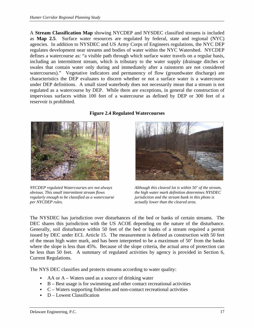
A Stream Classification Map showing NYCDEP and NYSDEC classified streams is included as Map 2.5. Surface water resources are regulated by federal, state and regional (NYC) agencies. In addition to NYSDEC and US Army Corps of Engineers regulations, the NYC DEP regulates development near streams and bodies of water within the NYC Watershed. NYCDEP defines a watercourse as: “a visible path through which surface water travels on a regular basis, including an intermittent stream, which is tributary to the water supply (drainage ditches or swales that contain water only during and immediately after a rainstorm are not considered watercourses).” Vegetative indicators and permanency of flow (groundwater discharge) are characteristics the DEP evaluates to discern whether or not a surface water is a watercourse under DEP definitions. A small sized waterbody does not necessarily mean that a stream is not regulated as a watercourse by DEP. While there are exceptions, in general the construction of impervious surfaces within 100 feet of a watercourse as defined by DEP or 300 feet of a reservoir is prohibited.
Figure 2.4 Regulated Watercourses
NYCDEP regulated Watercourses are not always Although this cleared lot is within 50’ of the stream, obvious. This small intermittent stream flows the high water mark definition determines NYSDEC regularly enough to be classified as a watercourse jurisdiction and the stream bank in this photo is per NYCDEP rules. actually lower than the cleared area. The NYSDEC has jurisdiction over disturbances of the bed or banks of certain streams. The DEC shares this jurisdiction with the US ACOE depending on the nature of the disturbance. Generally, soil disturbance within 50 feet of the bed or banks of a stream required a permit issued by DEC under ECL Article 15. The measurement is defined as construction with 50 feet of the mean high water mark, and has been interpreted to be a maximum of 50’ from the banks where the slope is less than 45%. Because of the slope criteria, the actual area of protection can be less than 50 feet. A summary of regulated activities by agency is provided in Section 6, Current Regulations. The NYS DEC classifies and protects streams according to water quality:
AA or A – Waters used as a source of drinking water B – Best usage is for swimming and other contact recreational activities C – Waters supporting fisheries and non-contact recreational activities D – Lowest Classification

Hunter Corridor Regional Planning Study
Delaware Engineering, P.C. 18
Figure 2.5 Streams on Hunter Mountain
Some streams that are classified as AA-C also can support trout populations (T) and trout spawning (TS). All of these streams are protected under Article 15 of the Environmental Conservation Law (ECL) and the Protection of Waters Regulatory Program. In an effort to coordinate stream management activities at all levels of government, comprehensive steam management plans were developed by the GCSWCD in partnership with NYCDEP and with extensive input from local, regional, state, city and federal stakeholders. Table 2.1 lists the main streams for which stream management plans have been completed in the Schoharie Basin.
Table 2.1 Stream Management Plans for Greene County, New York
Name Year Batavia Kill Stream Management Plan 2003 East Kill Stream Management Plan 2007 West Kill Stream Management Plan 2006 Schoharie Creek Stream Management Plan 2007 Stony Clove Creek Stream Management Plan 2004 West Kill Stream Management Plan 2005 Broad Street Hollow Stream Management Plan 2003 Manor Kill Stream Management Plan 2009 Schoharie Basin Stream Management Implementation Action Plan 2009-2011

Hunter Corridor Regional Planning Study
Delaware Engineering, P.C. 19
The purpose of the stream management plans is to document the built and natural conditions of the stream corridors, identify and prioritize critical stream reaches with severe erosion and conduct demonstration projects using fluvial geomorphology and natural channel design, and encourage the communities to use the plans as a guidance document to coordinate stream management efforts and general recommendations that apply to land use and development. Many of the recommendations in the Schoharie Stream Management Plan (which was adopted by the Hunter Corridor Communities) are highly relevant to furthering the goal of this study, namely positioning the communities to encourage development that is protective of community character and natural resources. Floodplains The Federal Emergency Management Agency (FEMA) 100 Year Flood Zones for Greene County were updated in 2008. A section of the updated Flood Insurance Rate Map (FIRM) is included below. A complete Flood Zones Map of the Corridor is included as Map 2.6 The 100 Year Flood Zone runs along Main Street in the Village of Hunter and along State Route 23A just to the south west through the Corridor and then south of Main Street in the Village of Tannersville. It also runs along State Route 214 and slightly west of Bloomer Road. Development in flood zones should be discouraged and avoided where possible.
Figure 2.6 Section of updated FIRM panel
Stricter regulations were promulgated in 2007 for communities participating in the National Flood Insurance Program (NFIP) to limit building in floodplains due to the high cost of claims by landowners and resulting burden on taxpayers. Moreover, construction within a floodplain results in compacting of soils, changes in soil stability, and potentially hydraulic restrictions that exacerbate flooding. In addition to the economic impacts and hardship associated with property destruction, flooding can cause stream bank erosion, increased sediment loading and mobilization of pollutants. See the Town of Hunter’s Flood Damage Prevention Law and Greene County’s Hazard Mitiga-tion Plan (2009) for a detailed view of which areas of the flood plain development should avoid.

Hunter Corridor Regional Planning Study
Delaware Engineering, P.C. 20
Figure 2.7 An Unobstructed Floodplain by the Schoharie Creek
Figure 2.8 Building on bank of creek destroyed by flood waters
2.4 Wetlands The New York State Freshwater Wetlands Act was adopted in 1975 with the intent to preserve freshwater wetlands and the benefits they provide. This act provides a 100 foot buffer around wetlands that are greater than 12.4 acres in size and that have been mapped by NYSDEC. Wetlands are also protected by the Army Corps of Engineers under the Clean Water Act. The Environmental Conservation Act, Article 24, protects freshwater wetlands from construction of buildings, streets and roads, septic systems, dams, docs and the removal of vegetation. Wetlands, recognized as an important ecological resource, are found throughout the Hunter region. They provide a number of beneficial functions such as stabilizing soils, providing erosion control, altering stormwater runoff, improving water quality, providing fish and wildlife habitat, and offering recreational opportunities like fishing and hunting. A Wetlands Map is included as Map 2.7. Wetlands are identified when the area demonstrates prolonged periods of saturation or flooding, there is a predominance of hydrophytic vegetation (plants that grow partially or wholly in water), and hydric soil types are present. NYS DEC wetlands can be found throughout the Town of Hunter, excluding the Village of Hunter. There are about 352 acres of wetlands covering the entire Town. Rip Van Winkle Lake, located in the southeastern portion of the Village of Tannersville is designated as a 43 acre wetland. There are no DEC wetlands in the Village of Hunter.
Figure 2.9 DEC Wetlands and Hydric Soils in the Village of Tannersville
Source: NYSDEC Wetlands and Greene Co. Hydric Soils GIS Layers
NYSDEC Wetlands
Hydric Soils

Hunter Corridor Regional Planning Study
Delaware Engineering, P.C. 21
National Wetland Inventory (NWI) classified wetlands can also be found throughout the Hunter Communities. There are over 600 acres of NWI classified wetlands in the Town with 26 and 40 of those acres belonging to the Village of Hunter and Village of Tannersville, respectively. These wetlands are categorized as freshwater ponds, freshwater emergent wetlands (palustrine), lakes (lucastrine) and riverines. The NWI inventory is not exhaustive and local site analysis by qualified personnel is necessary to confirm the presence or absence of wetlands. The NYCDEP has a wetlands monitoring program in place to characterize and assess the functions of wetlands in the NYC Watershed and to use in guiding regulatory and non-regulatory protection programs.
Table 2.2 Town of Hunter NWI Wetland Classifications
NWI Wetland Classification
Description System; (Subsystem); Class; Subclass; Modifiers
L1UBHh Lake Lacustrine; (Limnetic); Unconsolidated Bottom; Permanently Flooded; Diked/Impounded
PEM1A Freshwater Emergent Wetland Palustrine; Emergent; Persistent; Temporarily Flooded
PFO1A Freshwater Forested/Shrub Wetland
Palustrine; Forested; Broad-Leaved Deciduous; Temporarily Flooded
PSS1A Freshwater Forested/Shrub Wetland
Palustrine; Scrub-Shrub; Broad-Leaved Deciduous; Temporarily Flooded
PUBF Freshwater Pond Palustrine; Unconsolidated Bottom; Semi permanently Flooded
R2USC Riverine Riverine; (Lower Perennial); Unconsolidated; Seasonally Flooded
R3USA Riverine Riverine; (Upper Perennial); Unconsolidated; Temporarily Flooded
Riverine Communities lack persistent emergent vegetation, but do include areas with submerged or floating-leaved aquatic vegetation. Lacustrine Communities are situated in topographic depressions or damned river channels, lacking persistent emergent vegetation, but include areas with submerged or floating-leaved aquatic vegetation. Palustrine Communities are characterized by emergent vegetation. There are over 24,000 acres of palustrine wetlands identified in the NYC Watershed by the NWI. These wetlands are permanently saturated by seepage, perma-nently flooded wetlands and seasonally/intermittently flooded wetlands. Emergent wetlands found in the NYC Watershed (“watershed”) consist of marshes and wet meadows. Plant species found in marshes in the watershed can include: cattails; bulrushes, bur-reeds, reed canary grass, blueflag iris, swamp milkweed, arrow leaved tearthumb and smart-weeds. Wet meadow species found in the watershed include: tussock; goldenrods; soft rush; blue vervain; Joe-Pye-weed; sensitive fern; meadow rue; and, rice cutgrass. Invasive species often found in emergent wetlands are common reed, purple loosestrife and Japanese siltgrass. Woody plants, less than 20 feet in height, are heavily dispersed in scrub-shrub wetlands within the watershed. Groundwater has a large impact on the species that dwell in these wetlands. Typical shrub species located in scrub-shrub wetlands and the watershed include: alder, osier dogwood, winterberry holly, northern arrowwood, nannyberry, spice bush, steeple bush, meadowsweet, highbush berry and swamp azalea.

Hunter Corridor Regional Planning Study
Delaware Engineering, P.C. 22
Figure 2.10 Wetland Areas
North of Route 23A South of Looking Glass Road and West of Glen Avenue, looking North Forested wetlands in the watershed are often comprised of red maple swamps. Other tree species that also occur in these wetlands include: yellow birch; hemlock; green ash; and, American elm. White pine, black gum and trembling aspen are species that are common in the Catskill Mountain area. Shrubs in this wetland include: spicebush; northern arrowwood; silky dogwood; highbush blueberry; and, winter berry. See Wetlands in the Watersheds of the New York City Water Supply for more detailed information. See Appendix C for a more extensive list of NWI Wetlands found in the Town of Hunter.
Figure 2.11 NWI Wetlands in the Hunter Corridor
Source: NWI Wetlands Mapper
The presence of wetlands can impact the total developable land in an area. While wetlands are protected by several different layers of regulation (federal, state and regional), the identification of wetlands on a site by site basis together with applying mitigation measures on a project by project basis does not provide an opportunity for the greatest measure of protection and enhancement that would result from ecology-based identification, impact evaluation and mitigation. While wetlands are generally not suitable for most development due to the presence of hydric soils, the practice of filling wetlands to create developable land remains an issue notwithstanding regulatory protections. Some land uses are compatible with the presence of wetlands, such the cultivation of crops or growth of woodlands.
NWI Wetlands

Hunter Corridor Regional Planning Study
Delaware Engineering, P.C. 23
Figure 2.12 Typical Hunter Mountain West Wetlands
Vernal pools are temporary or seasonal wetlands located in upland forests, typically dry in the summer and flooded the rest of the year. They are usually not protected under state or federal regulations as they are smaller than 12.4 acres and are not present year-round. These areas are important for reproduction of reptiles, amphibians and invertebrates, as there are no predator fish in the vernal pools to interfere with the development of offspring. Since most are unregulated, they are often overlooked during planning and development. Large forest systems, which contribute to water quality and quantity, are indicated to be in good health when there are woodland amphibians present.
Figure 2.13 Vernal Pools
Seepy woods with wild ramps are Typical vernal pool indicators of this vernal pool.

Hunter Corridor Regional Planning Study
Delaware Engineering, P.C. 24
Protection of wetlands and vernal pools is best achieved through a coordinated multi-jurisdictional approach. A number of measures are available to protect wetlands and vernal pools on a local level, including:
Increase public awareness and hold educational exhibitions
Development projects should be located on non-wetland sites and avoid wetland buffers
Avoid landscaping with invasive plant species that may harm nearby wetlands
Offer incentives (tax incentives, cost sharing, etc.) to protect/restore wetlands
Consider a regional, multi-jurisdictional approach to wetland protection that addresses the gaps between the federal and state wetland regulations.
2.5 Hydric Soils Table 2.3 summarizes the classification of hydric soils found in and around wetlands, streams and bodies of water throughout the Town of Hunter. Hydric Soil lists were obtained from Greene County Soil and Water Conservation District and soil properties were found in the Greene County Soil Survey (See Appendix A). Hydric soils are depicted on the Soils Map 2.2 and Wetlands Map 2.7. The tables show that none of the hydric soils found in the area are listed as suitable for development of housing, streets or septic tanks systems; however, depending on actual site conditions and permissible activities, development may still be allowed. As the maps demonstrate, only a small portion of the land in the Town features hydric soils.
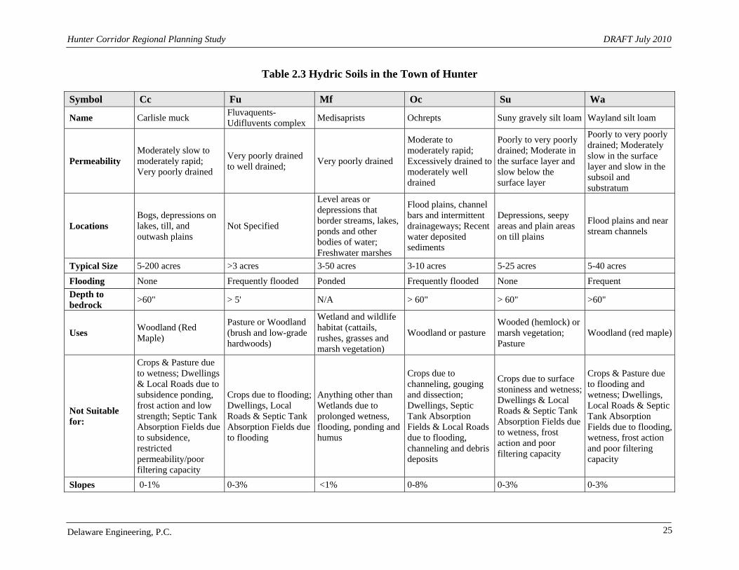
Hunter Corridor Regional Planning Study DRAFT July 2010
Delaware Engineering, P.C. 25
Table 2.3 Hydric Soils in the Town of Hunter
Symbol Cc Fu Mf Oc Su Wa
Name Carlisle muck Fluvaquents- Udifluvents complex
Medisaprists Ochrepts Suny gravely silt loam Wayland silt loam
Permeability Moderately slow to moderately rapid; Very poorly drained
Very poorly drained to well drained;
Very poorly drained
Moderate to moderately rapid; Excessively drained to moderately well drained
Poorly to very poorly drained; Moderate in the surface layer and slow below the surface layer
Poorly to very poorly drained; Moderately slow in the surface layer and slow in the subsoil and substratum
Locations Bogs, depressions on lakes, till, and outwash plains
Not Specified
Level areas or depressions that border streams, lakes, ponds and other bodies of water; Freshwater marshes
Flood plains, channel bars and intermittent drainageways; Recent water deposited sediments
Depressions, seepy areas and plain areas on till plains
Flood plains and near stream channels
Typical Size 5-200 acres >3 acres 3-50 acres 3-10 acres 5-25 acres 5-40 acres
Flooding None Frequently flooded Ponded Frequently flooded None Frequent
Depth to bedrock
>60" > 5' N/A > 60" > 60" >60"
Uses Woodland (Red Maple)
Pasture or Woodland (brush and low-grade hardwoods)
Wetland and wildlife habitat (cattails, rushes, grasses and marsh vegetation)
Woodland or pasture Wooded (hemlock) or marsh vegetation; Pasture
Woodland (red maple)
Not Suitable for:
Crops & Pasture due to wetness; Dwellings & Local Roads due to subsidence ponding, frost action and low strength; Septic Tank Absorption Fields due to subsidence, restricted permeability/poor filtering capacity
Crops due to flooding; Dwellings, Local Roads & Septic Tank Absorption Fields due to flooding
Anything other than Wetlands due to prolonged wetness, flooding, ponding and humus
Crops due to channeling, gouging and dissection; Dwellings, Septic Tank Absorption Fields & Local Roads due to flooding, channeling and debris deposits
Crops due to surface stoniness and wetness; Dwellings & Local Roads & Septic Tank Absorption Fields due to wetness, frost action and poor filtering capacity
Crops & Pasture due to flooding and wetness; Dwellings, Local Roads & Septic Tank Absorption Fields due to flooding, wetness, frost action and poor filtering capacity
Slopes 0-1% 0-3% <1% 0-8% 0-3% 0-3%

Hunter Corridor Regional Planning Study DRAFT September 2010
Delaware Engineering, P.C. 26
2.6 Wildlife Mammalian species in Greene County include coyote, deer, snow-shoe and cottontail rabbits, bear, bobcat, fisher, mink, muskrat, beaver, porcupine, and red squirrel. The major game bird species are the ruffed grouse, ring-necked pheasant, various duck species and Canada goose. There are no Threatened species located in Greene County. According to the U.S Fish and Wildlife Services, federally listed endangered species found in Greene County include the Indiana Bat (Myotis sodalist) and the Shortnose Sturgeon (Acipenser brevirostrum). The Indiana Bat is a small mammal, approximately 2 inches long. They spend their winters hibernating in caves or mines in the central eastern U.S. The Shortnose sturgeon is about 4.5 feet in length, one of the smallest breeds of sturgeon. They migrate from lower portions of the Hudson River to higher portions to spawn. The Bald eagle was delisted in 2007. While it is no longer protected under some regulations it is protected under the Bald and Golden Eagle Protection Act. See Appendix B. Although it is not federally listed, the NYS Breeding Bird Atlas (2000-2005) lists the Peregrine falcon (Falco peregrinus) as the only endangered bird in the Town of Hunter. Recorded in the table below are other species of birds found in the Hunter Communities. All wild birds are listed as Protected, unless otherwise stated. According to the Environmental Conservation Law, protected species may not be taken, possessed or transported in any way unless otherwise stated by a DEC permit. Species of Special Concern are those not listed as endangered or threatened, but show evidence of such conditions. Game species are those that may be hunted, either during specified or unspecified times of the year. Unprotected species may be taken, possessed or transported at any time.
Table 2.4 Protected Bird Species in Hunter, New York
Common Name Scientific Name
Bicknell's Thrush Catharus bicknelli
Cerulean Warbler Dendroica cerulea
Cooper's Hawk Accipiter cooperii
Red-shouldered Hawk Buteo lineatus
Sharp-shinned Hawk Accipiter striatus
See Appendix B for a more extensive list of Bird Species in the Corridor. The New York Natural Heritage Program was established to help conserve and protect rare plants and animals and natural ecosystems throughout New York State. Below are tables that depict rare and threatened plant and animal species along with natural conservations areas. Map 2.8 Significant Natural Communities and Map 2.9 Rare Plants and Animals are included. These Maps were generated using the Environmental Resource Mapper application on the NYSDEC website (http://www.dec.ny.gov/imsmaps/ERM/index.htm). This application can be used by anyone wishing to acquire more information regarding rare plants and animals and important environmental features in a specific area of New York State.

Hunter Corridor Regional Planning Study DRAFT September 2010
Delaware Engineering, P.C. 27
Figure 2.14 Environmental Resource Mapper
Source: www.dec.ny.gov; Environmental Resource Mapper Online Application
Map 2.8 Significant Natural Communities shows solid pink areas indicating the locations of significant natural communities such as rare and/or high quality wetlands, vernal pools, forests, grasslands, ponds, streams and other habitats, ecosystems and ecological areas. Pink gridlines depict a ½ mile buffer radius of each significant natural community. Map 2.9 Rare Plants and Animals shows general areas where the National Heritage Program’s Biodiversity Database has information regarding the location of plants and animals. Species in these areas can include: all animals listed by NYS as Endangered or Threatened; all plants listed by NYS as Endangered or Threatened; some animals listed by NYS as Species of Special Concern; some plants listed by NYS as Rare; some species not officially listed by NYS, but which are rare.
Table 2.5 2010 Plant Status List - Active Inventory List for Greene County
Scientific Name Common Name Status
Adoxa moschatellina Musk Root Endangered
Bidens bidentoides Delmarva Beggar-ticks Rare
Boechera grahamii Purple Rock-cress Rare
Botrychium oneidense Blunt-lobe Grape Fern ALBA Endangered
Carex davisii Davis' Sedge Threatened
Cynoglossum virginianum var. boreale Northern Wild Comfrey Endangered
Isoetes riparia Riverbank Quillwort Endangered
Myriophyllum pinnatum Green Parrot's-feather Endangered
Pedicularis lanceolata Swamp Lousewort Threatened
Symphyotrichum boreale Northern Bog Aster Threatened
Woodsia glabella Smooth Cliff Fern Endangered
The New York Natural Heritage Program published a Rare Plant Status List in June 2010 which includes many species in Greene County. Table 2.5 lists plants considered highly vulnerable to expiration with less than 30 documented occurrences over the past 20-30 years. These plants are

Hunter Corridor Regional Planning Study DRAFT September 2010
Delaware Engineering, P.C. 28
protected under the NYS Environmental Conservation Law which states that “It is a violation for any person, anywhere in the state to pick, pluck, sever, remove, damage by the application of herbicides or defoliants, or carry away, without the consent of the owner, any protected plant.” An expanded Plant List is included in Appendix B. The New York Nature Explorer (http://www.dec.ny.gov/animals/57844.html) is a tool that can be used to identify rare plants, rare animals, and important natural communities in a user defined area of interest. Birds listed are from the 2000-2005 NYS Breeding Bird Atlas. Reptiles and amphibians listed are from the 1990-1999 NYS Herp Atlas. Other categories are included in New York Natural Heritage Program databases. The application was designed to provide a better understanding of the diversity of wildlife and help with land use, planning and permitting decisions. The Town of Hunter data is summarized in Tables 2.6 and 2.7. The full New York Nature Explorer Report is included in Appendix B. The Schoharie Wildlife and Fishery Study section in the Schoharie Stream Management Plan includes more information on plants and animals in the Schoharie Watershed and Corridor.
Table 2.6 New York Nature Explorer List of Rare Plant and Animals Common Name Scientific Name Grouping NYS Protection Status Appalachian Firmoss Huperzia appressa Plant: Clubmosses Threatened Appalachian Sandwort Minuartia glabra Plant: Flowering Plant Threatened Bicknell's Thrush Catharus bicknelli Animal: Thrushes and Bluebirds Special Concern Drooping thread moss Bryum algovicum Plant: Mosses Not Given Musk Root Adoxa moschatellina Plant: Flowering Plant Endangered
Northern Wild Comfrey Cynoglossum virginianum var. boreale
Plant: Flowering Plant Endangered
Roseroot Rhodiola rosea Plant: Flowering Plant Endangered Rough Avens Geum virginainum Plant: Flowering Plant Endangered West Virginia White Pierie virigiensis Animals: Butterflies and Skippers Not Given
Table 2.7 New York Nature Explorer List of Significant Natural Communities
Common Name Scientific Name Grouping State Conservation
Rank Appalachian Oak-Pine Forest Apalacian oak-pine forest Forested Uplands S4 Beech-Maple Mesic Forest Beech-maple mesic forest Forested Uplands S4 Chestnut Oak Forest Chestnut-oak forest Forested Uplands S4 Cliff Community Cliff community Open Uplands S4
Hemlock-Northern Hardwood Forest
Hemlock-northern hardwood forest
Forested Uplands S4
Mountain Spruce-Fir Forest Mountain spruce-fir forest Forested Uplands S2S3
Pitch Pine-Oak-Heath Rocky Summit
Pitch pine-oak-heath rocky summit
Barrens and Woodlands S3S4
Spruce-Fir Rocky Summit Spruce-fir rocky summit Barrens and Woodlands S3
Spruce-Northern Hardwood Forest Spruce-northern hardwood forest
Forested Uplands S3S4
S2 = 6-20 occurrences; very few remaining individuals, acres, or miles S3 = 21-100 occurrences; few remaining individuals, acres, or miles S4 = Apparently Secure in NY

Hunter Corridor Regional Planning Study DRAFT September 2010
Delaware Engineering, P.C. 29
2.7 Recreational and Scenic Resources The mountaintop region of Greene County features exceptional scenic and recreational resources, which contribute to attracting visitors, residents and businesses to the Hunter area. The recreational resources, Hunter Mountain ski center in particular, have influenced the location and nature of development over the past 40 years. Protecting the mountaintop’s natural landscape is a goal referenced a number of the region’s town and village planning documents and is a goal of the Hunter Regional Planning Study as well. The Corridor is included in numerous Recreation Plans that have been developed by various regional and State Agencies. Table 2.8 lists planning documents that focus on recreational activities in Greene County and the Catskills.
Table 2.8 Recreation Plans for Greene County and New York State
Name Year
Catskill Forest Preserve Public Access Plan 1999
Greene County Open Space and Recreation Plan 2002
Greene County Parks and Recreation Plan 1998
Statewide comprehensive Outdoor Recreation Plan 2003
Mountaintop Recreation Strategy 2009
NYSDEC Catskill Park State Land Master Plan 2008
Scenic Byway Plan 2008
One of the recent plans, The Mountaintop Community Resource Strategy (Appendix C), involved inter-municipal collaboration and outlined recommendations for improving recreation, cultural and scenic resources in the mountaintop region. It also inventoried community resources, their locations and contact information for each community in the mountaintop area. Community plans for the Town of Hunter (2000), Village of Hunter (2002) and the Village of Tannersville (2004) recognize the importance of scenic, cultural, and outdoor recreational activities to the local economy. Example recommendations from each plan that are reinforced in the Mountaintop Strategy include:
Town of Hunter Comprehensive Plan Preserve scenic values and resources by pursuing a Scenic Byways designation (A
Scenic Byway Corridor Management Plan for the Mountain Cloves which includes the Hunter Communities is pending)
Maintain and improve fishery resources and stream access Support existing multi-use paths Improve public access to state and city lands Improve marketing efforts by developing signage and promotional material
Village of Hunter Comprehensive Plan Promote more cultural activities and amenities Maintain and improve fishery resources and stream access Improve the lack of retail and specialty service opportunities

Hunter Corridor Regional Planning Study DRAFT September 2010
Delaware Engineering, P.C. 30
Village of Tannersville Infrastructure Revitalization Plan Support for community and recreational facilities
The Mountaintop Community Resource Strategy recommends the creation of a multi-use trail system that would traverse the mountaintop, allowing non motorized vehicular access to villages and hamlet areas. Improved parking facilities are needed and bike lanes should be designated with wider highway shoulders. Implementation teams are working on small segments to open public trials in Windham and Haines Falls. The Mountaintop Community Resource Strategy also encourages local governments to direct future development to be more compatible with the natural environment through the establishment of building codes and design standards and recommends the development of response plans to deal with stream related issues that affect the quality and quantity of scenic resources. The version of the Recreation Map which accompanies this study is included as Map 2.10 and focuses on recreation resources in the Hunter Corridor.
Figure 2.15 Dolan’s Lake Park
Sitting Area Park Entry
Fishing Area Scenic View
Source: GCWAP Table 2.9 lists a number of recreational and scenic opportunities available in the Hunter Communities, derived from the Scenic Byway Corridor Management Plan. An expanded version with contact information can be found in Appendix C.

Hunter Corridor Regional Planning Study
Delaware Engineering, P.C. 31
Table 2.9 Recreational and Scenic Opportunities
Category Resource
Fishing/Parks & Playgrounds North-South Lake State Park
Golf Colonial Golf Club
Health club/Spa Mountain Club Spa
Municipal Fishing Access Rip Van Winkle Lake
Outdoor Bear Creek Landing
Outdoor Sports Hunter Mountain Ski Bowl
Outdoor View Fawn's Leap
Parking Becker Hollow Parking Lot
Parks & Playgrounds Boathouse and Pavilion at Rip Van Winkle Lake
Rentals Snow Bird Shop
Scenic Road Stony Clove Road/ NYS Route 214
Scenic Roadway Kaaterskill Clove/Rip Van Winkle Trail
Themed Trail Catskill Mountain Heritage Trail
Trails & Trail Head Devil's Path Lean-To
Waterfall Haines Falls
A variety of recreational opportunities ranging from hiking, snowshoeing, bird-watching, mountain biking, cross-country skiing, camping, horseback riding, hunting, fishing, and trapping are available. The Hunter Mountain Wild Forest is positioned in the Town of Hunter along with the Towns of Jewett and Lexington. Hunter Mountain Wild Forest has six main peaks which include; Evergreen Mountain, Hunter Mountain, Packsaddle Mountain, Pine Island Mountain, Rusk Mountain and Southwest Hunter Mountain. The Hunter area is very rugged (see Section 2.2 Topography) which provides limited access to the mountains’ trails, scenic views and streams. The Forest can be accessed though trail heads and parking areas located along Route 214 and County Route 6. Another relevant inter-municipal project involving the Hunter Communities with similar objectives is the Mountain Cloves Scenic Byway Corridor Management Plan (CMP). The three municipalities have been coordinating for close to two years as they pursue designation of additional segments to be added to the existing Kaaterskill, Stony and Platte Cloves Scenic Byways. The CMP proposes adding the main stem of Route 23A from Haines Falls to the Village of Hunter, a seven mile section of County Route 16 from the Schoharie Creek headwaters to Tannersville, the remainder of Route 214 from Lanesville to the Town of Hunter, a loop around County Routes 23C and 25, and County Route 18 from Haines Falls to North-South Lake.

Hunter Corridor Regional Planning Study
Delaware Engineering, P.C. 32
Figure 2.16 Mountain Cloves Scenic Byway Map
If the CMP is approved by the state Scenic Byway Committee, the existing and additional segments will quality the Hunter Communities for financial aid to preserve and enhance the intrinsic qualities along the Byway. In an effort to bolster the economy while proactively managing the outstanding scenic resources along the Byway, the Hunter Communities are taking the lead in coordinating with regional agencies and local businesses to safeguard these precious resources that are the hallmark of the Byway.
Figure 2.17 Scenic Roadways in the Corridor
A winding stretch of Route 23A near Palenville View of Kaasterskill High Peak and Roundtop (across Platte Clove)
Source: Mountain Cloves Scenic Byway Corridor Management Plan

Hunter Corridor Regional Planning Study
Delaware Engineering, P.C. 33
2.8 Historic and Cultural Resources Many historic and cultural resources exist in the Hunter community and surrounding areas. They are located throughout the Hunter Communities, mostly in the northern portions of the Town. Historic resources include those listed on the National Register of Historic Sites. Cultural resources such as music, art and theatre can be found in the Hunter area along with the entire mountaintop region. See Appendix C for an extensive list of recreational, scenic, historic and cultural resources within the Town of Hunter. The National Historic Preservation Act of 1966 and the New York State Historic Preservation Act of 1980 established the National and State Registers of Historic Places. These are official lists of structures, districts and sites which have historical, archaeological or cultural significance to New York State and the Nation. (http://nysparks.state.ny.us/shpo/national-register/ ). Below is a map of the Town of Hunter generated by the National Register Program which depicts Archeological Sensitive areas and National Register listed properties.
Figure 2.18 State Historic Preservation Office Map for the Town of Hunter
Archeo Sensitive Area National Register Listed
Source: http://www.oprhp.state.ny.us/nr/main.asp
See Maps 2.11 and 2.12 for a closer view of archeological sensitive areas and National Register Properties in the Villages of Hunter and of Tannersville. Map 2.13 is a version of the Mountain Top Community Resources Inventory Map from the Mountaintop Community Resources Strategy which focuses on the Town of Hunter. This map shows historical, cultural natural and recreational resources in the Corridor area.
2.8.1 Historical Resources – Town of Hunter Approximately 18% of the Town of Hunter is classified by the State Historic Preservation Office as an Archeological Sensitive Area. These areas are concentrated in the two Villages and in the southwestern portion of the Town along Platte Clove Road and Route 23A. Two of the largest National Register Listed properties include the Onteora State Historic Park and Twilight Park Historic District. See Table 2.10 for a list of all the listed properties in the Town of Hunter.
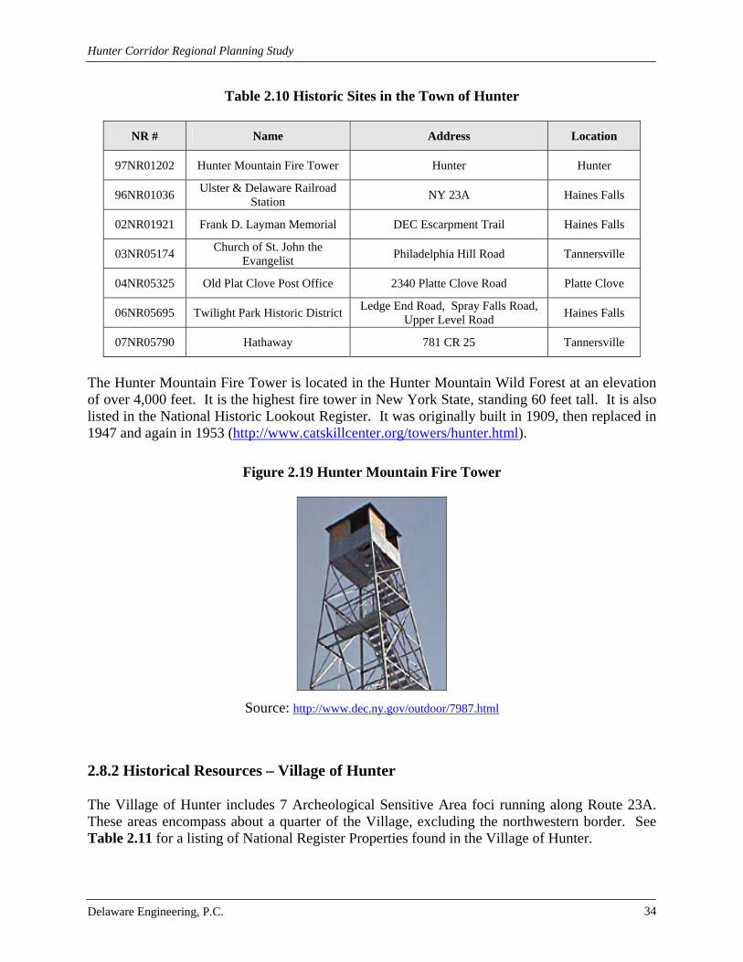
Hunter Corridor Regional Planning Study
Delaware Engineering, P.C. 34
Table 2.10 Historic Sites in the Town of Hunter
NR # Name Address Location
97NR01202 Hunter Mountain Fire Tower Hunter Hunter
96NR01036 Ulster & Delaware Railroad
Station NY 23A Haines Falls
02NR01921 Frank D. Layman Memorial DEC Escarpment Trail Haines Falls
03NR05174 Church of St. John the
Evangelist Philadelphia Hill Road Tannersville
04NR05325 Old Plat Clove Post Office 2340 Platte Clove Road Platte Clove
06NR05695 Twilight Park Historic District Ledge End Road, Spray Falls Road,
Upper Level Road Haines Falls
07NR05790 Hathaway 781 CR 25 Tannersville
The Hunter Mountain Fire Tower is located in the Hunter Mountain Wild Forest at an elevation of over 4,000 feet. It is the highest fire tower in New York State, standing 60 feet tall. It is also listed in the National Historic Lookout Register. It was originally built in 1909, then replaced in 1947 and again in 1953 (http://www.catskillcenter.org/towers/hunter.html).
Figure 2.19 Hunter Mountain Fire Tower
Source: http://www.dec.ny.gov/outdoor/7987.html
2.8.2 Historical Resources – Village of Hunter The Village of Hunter includes 7 Archeological Sensitive Area foci running along Route 23A. These areas encompass about a quarter of the Village, excluding the northwestern border. See Table 2.11 for a listing of National Register Properties found in the Village of Hunter.

Hunter Corridor Regional Planning Study
Delaware Engineering, P.C. 35
Table 2.11 Historic Sites in the Village of Hunter
NR # Name Address Location
99NR01451 Saint Mary's of the Mountain Church
NY 23A Hunter
99NR01559 Hunter Synagogue Main Street (NY 23A) Hunter
00NR01595 Harry Fischel House aka
"Fairlawn" 6302 Main Street Hunter
02NR04994 I.O. Odd Fellows Hall 6325 Main Street Hunter
2.8.3 Historical Resources – Village of Tannersville There is one Archeological Sensitive Area located in the Village of Tannersville. It is located at the intersection of Route 23C and Route 23A and partially in the Downtown Historic District. Table 2.12 shows a listing of National Register Properties located in the Village of Tannersville.
Table 2.12 Historic Sites in the Village of Tannersville
NR # Name Address Location
02NR05001 Onteora Park Historic District Onteora Club property Onteora Park
08NR05916 Tannersville Main Street
Historic District* Main Street Tannersville
*Listing in progress
2.8.4 Cultural Resources
Table 2.13 Cultural Resources
Cultural Resources in the Town of Hunter
Music/Theatre Program Catskill Mountain Foundation Doctorow Center for the Arts
Music/Theatre Program Catskill Mountain Foundation Mountain Cinema
Music/Theatre Program Horton by the Stream, Outdoor Summer Theatre
Artist Program Platte Clove Preserve Artist in Residence Program
Museum Catskill Mountain Foundation Pleshakov Piano Museum
Bookstore Catskill Mountain Foundation Village Square Bookstore & Literary Arts Center
For a more extensive list of historical and cultural resources see Appendix C. Contact the Greene County Historical Society (http://www.gchistory.org/barns.php) or the Mountain Top Historical Society (http://www.mths.org/) for more information.

Hunter Corridor Regional Planning Study
Delaware Engineering, P.C. 36
2.9 Other Planning Studies and Documents The Hunter communities have been the subject of a number of plans, all of which underscore the importance of protecting and enhancing the visual landscape and water resources, as well as historic and recreational resources. This report builds on existing ideas and concepts put forth by previous planning documents. Comprehensive Plans
Village of Hunter Comprehensive Plan, 2002 Town of Hunter Comprehensive Plan, 2002 Village of Tannersville Infrastructure Reutilization Master Plan, 2004
Economic Plans and Reports West of Hudson Economic Development Study for Catskill Fund for the Future, 1999 Greene County Parks and Recreation Plan, 1998 Town of Hunter: Economic Development Strategy, 1998
NYSDEC Documents Catskill Forest Preserve Access Plan, 1999 Catskill State Park Land Master Plan, 2008 Plateau Mountain-Indian Head Mountain Wilderness Area, 1992 Windham High Peak Wild Forest, 1994 Hunter Mountain Wild Forest, 1995
Stream Management Plans prepared by the CGSWCD in partnership with NYCDEP Batavia Kill Stream Management Plan, 2003 East Kill Stream Management Plan, 2007 Schoharie Creek Stream Management Plan, 2007 Stony Clove Creek Stream Management Plan, 2004 West Kill Stream Management Plan, 2005 Broad Street Hollow Stream Management Plan, 2003 Schoharie Turbidity Reduction Strategy, 2008 Schoharie Wildlife and Fishery Study, Section 2.9 in the Schoharie Creek SMP Manor Kill Stream Management Plan
Resource Management Plans Mountain Cloves Scenic Byway Proposed Corridor Management Plan (Town of Hunter) Mountaintop Community Recreation, Cultural Resources and Scenic Quality Strategy
(Mountaintop Community Resource Strategy) Greene County Plans
Agricultural Development & Farmland Protection Plan Greene County Economic Development Plan, 2007 Greene County Labor Market Report, 2008 Housing Action Plan Hudson River Corridor Study
Hunter Corridor Regional Planning Study
Delaware Engineering, P.C. 37
Labor Market Study Marist College Economic Study of the Hudson Valley, 2006 Oxford Economics Tourism Impact Study Water Dependent Use Study Cultural Resources Survey Report for Route 23A Palenville to Haines Falls Greene
County, 1980 Greene County All Hazards Mitigation Plan, 2009
Traffic Plans and Studies Transportation Project Report Route 23A Village of Tannersville: Design Report
/Environmental Assessment, 1988 Traffic Impact Study, Hunter-Tannersville Condominiums, Creighton Manning
Engineering, 2003 The Catskill Center for Conservation and Development, a not-for-profit organization that provides regional planning assistance, also has many plans and technical assistance guidance documents that can be found at http://www.catskillcenter.org/. The Catskill Center has been instrumental working with the Hunter Communities on the Mountain Cloves Scenic Byway Corridor Management Plan.

Hunter Corridor Regional Planning Study
Delaware Engineering, P.C. 38
3.0 INFRASTRUCTURE An evaluation of infrastructure including water, sewer, stormwater, transportation and parking systems is an important element of planning capital and operational improvements as well as in the review of development projects. Identified infrastructure improvements include expanding and improving potable water service; implementation of stormwater controls that are effective in controlling runoff and reducing the transport of sediment; identification and remediation of stormwater infiltration and inflow into sanitary sewer systems; replacement and/or repair of aged infrastructure; pedestrian safety improvements; and, area wide sidewalks and trails to provide multi-modal travel and recreation opportunities.
3.1 Water, Wastewater and Stormwater
3.1.1 Town of Hunter
3.1.1.1 Town of Hunter Water
The Town of Hunter lacks a public water system. Most residents receive water from private wells. Some residents located in close proximity to either of the Villages’ boundaries may be connected to those corresponding water systems. There are no state regulations that apply to privately owned wells. Owners are responsible for the testing and proper disinfection of water. Groundwater resources in Greene County occur in unconsolidated coarse-grained glacial deposits and in bedrock. The bedrock aquifers yield water through faults, joints, cracks and bedding planes. The localized bedrock aquifers used for private and public water supplies are Ordovician age shale of the Normanskill sandstone, shale and limestone formations deposited during the Devonian period. Evidence suggests that wells drilled into bedrock within or in close proximity to the Schoharie Creek have yields ranging from 60 to 300 gallons per minute.
3.1.1.2 Town of Hunter Wastewater The Town does not have a public wastewater system. Residents employ privately owned, on-site septic systems to treat and dispose of wastewater. Some residents located in close proximity to either Village may be connected to those corresponding wastewater treatment systems. Structures not within the wastewater collection areas of either Village dispose of wastewater through the use of septic tanks, leach fields and raised or fill systems. Inappropriately designed septic systems combined with a lack of required system maintenance have resulted in non-point source pollution. Many soil types in the Town are unsuitable for the proper performance of on-site septic systems (See Section 2.1 Soils). The NYSDOH Wastewater Treatment Standards, Appendix 75-A and NYC Watershed Rules and Regulations provide design standards for new septic systems as well as regulations regarding modification and/or alteration of existing systems. The NYC regulations state that soils with a percolation rate of faster than 3 minutes or slower than 60 minutes are unacceptable; however, the regulations further state that DEP is to assist the landowners in determining the most suitable location and design for systems that are not in compliance.

Hunter Corridor Regional Planning Study
Delaware Engineering, P.C. 39
NYCDEP has funded sewer extensions for properties in the Town of Hunter to hook up to the City-owned Tannersville WWTP including approximately 100 new connections east of the Tannersville municipal line. Another section in the Town of Hunter along County Route 23C and Showers Road is in the planning and design stage to extend the infrastructure to approximately 20 additional hook ups to the City-owned WWTP.
Figure 3.1 Septic Tank Flooding on Route 23A
The Town adopted a Sewer Use Law in 2002 that provides regulations for connection to the NYC-owned Village of Tannersville WWTP. The local law was established to ensure that all rules and regulations of the MOA are followed. The purpose of this local law is to provide for efficient, economic, environmentally safe, and legal operation of the Tannersville wastewater system for properties in the Town of Hunter that are connected or may be connected in the future. More specifically, the local law calls for the prevention of: the introduction of substances into the collection system that will negatively interfere with the system in any way; contravention of the State’s waters; increases in the cost of the disposal of sludge; the endangerment of employees; air or groundwater pollution; and, public nuisances. It also calls for the elimination of existing sources of infiltration and inflow and the prevention of new sources of infiltration and inflow, which is a reoccurring problem in the system.
Figure 3.2 Flooded Basement in the Village of Hunter
3.1.1.3 Town of Hunter Stormwater
The Town of Hunter does not currently have any local stormwater regulations or any stormwater drainage districts. Stormwater controls located in the Town portion of the Corridor are those related to roads and large scale housing and commercial developments. Conventional

Hunter Corridor Regional Planning Study
Delaware Engineering, P.C. 40
stormwater controls associated with roads and housing/commercial developments include culverts, catch basins, drainage swales and stormwater ponds and wetlands. Stormwater from the Town ultimately flows to the Schoharie Creek where a significant amount of sediment has been observed in stormwater discharge during periods of heavy rain and snow melt. The high density land use within the Village, the close proximity of the Schoharie Creek on the south side of Route 23A and the mountainous terrain on the north side of Route 23A severely restrict the options available for standard stormwater management practices.
Figure 3.3 Town of Hunter Downstream Swale (September 2005)
A substantial system of stormwater controls is present at Hunter Mountain, located in the Town and Village of Hunter. The stormwater system is privately owned and maintained. Within the 10 acre parking area that serves Hunter Mountain, a series of catch basins capture stormwater and direct it through continuous deflective separation units prior to discharge to existing swales and ultimately into the Schoharie Creek.
Figure 3.4 Stormwater Retrofit at Hunter Mountain Continuous Deflective Separation Unit (CWC Grant 2005)

Hunter Corridor Regional Planning Study
Delaware Engineering, P.C. 41
Stormwater control issues exist at the margins of developed and undeveloped land clustered around the two villages. In the Town and Village of Hunter, stormwater runoff from Clearview Road, Rusk Hollow and Hunter Lane has caused down gradient erosion. The construction of the roads and homes predates the implementation of stormwater regulations. Within the Hunter Communities, there are a number of locations where existing and proposed up gradient building lots have the potential to generate excessive down gradient erosion and sedimentation. This is an area of the Town and villages where intermunicipal cooperation is needed to develop a suitable solution.
3.1.2 Village of Hunter
3.1.2.1 Village of Hunter Water The Village of Hunter owns and operates a public water supply system that serves residences and businesses within the Village as well as parcels adjacent to the Village located in the Town. Components of the Village’s water system were originally developed by private interests over the years beginning in the 1960’s with the development of Hunter Mountain ski center. For a two year period from 2000 to 2002, the Village negotiated purchase of the several systems of supply, treatment, storage, transmission and distribution that serve the Village and surrounding areas. In 2002, the Village applied for and received a public water supply permit for a municipal system for the Village of Hunter. At the same time, improvements were planned and implemented to address source water quality and volume, treatment and upgrades to distribution lines. Map 3.1 Water Systems depicts the service area for the Village of Hunter water system. As part of the consolidation of the private water systems, the Village of Hunter purchased a water treatment plant from the Hunter Water Supply Corporation (HWSC) in 2003. The water resources purchased from the HWSC included three wells and a surface water/spring source. The surface water supply is drawn from the Shanty Hollow Brook (a tributary of the Schoharie Creek), a stream that originates from springs on the north face of Hunter Mountain. There are two existing water storage tanks (total of 650,000 gallons of storage) in the system. The existing tanks provide more than adequate storage capacity under both emergency potable and fire flow demands. There are approximately 32 hydrants located throughout the system, predominantly in commercial and residential areas. The Valley Water system consists of two wells with a permitted capacity of 28,200 gallons per day (gpd), and serving 35 customers. The water system was acquired by the Village in April 2006. There is no interconnection with the main Village supply. The wells pump to a storage tank located at the top of Botti Drive. Water quality in this system has been a source of complaints for some time, due to sulfur, brown and red water, and excess chlorine. These problems may stem from stagnant water in the tanks and lines. The Village currently has three wells connected to the main Village supply. A new well (known as the Finn well) has been drilled and tested (well testing by Alpha Geoscience in 2006). During peak use periods, especially during winter and summer months, water demands exceeded the limitations established in the Village’s water supply permit for existing sources. Valley Water wells and the Finn well have been added to the sources of supply for the Village system.

Hunter Corridor Regional Planning Study
Delaware Engineering, P.C. 42
Review of the Village’s existing sources of supply is summarized as follows. Well No. 1 does not provide acceptable chlorine contact time and is frequently a common source of complaints. Additionally, methyl terta-butyl ether (MTBE)4 has been detected in low levels in this well, though concentrations have not exceeded the maximum contaminant level (MCL)5, nor does there appear to be an increase in concentration accompanying sustained pumping of the well. Raw water from Well No. 2 is high in iron and manganese and is slightly saline. During recent construction of the new treatment facility, Well No. 2 was connected in order to provide treatment. It is currently the only groundwater source for which filtration is provided. In Well No. 3 undesirable taste and odor have been detected during routine sampling. While available to the rest of the Village as an emergency source of supply, Well No. 3 is currently used to supply only the Hunter Highlands development. The Finn Well (Well No. 4) was approved as an additional source of supply for the Village of Hunter in January 2007. Originally drilled as a privately owned well in 2006, this well was purchased by the Village to help meet peak demands. Initial water quality sampling has indicated that the well is relatively low in sulfur, iron, and manganese. A fifth well is permitted to supply 18 gpm to the Valley Water Service Area. Water from this source has been subject to water quality complaints due to sulfur, iron, and manganese, and as such, is isolated from the rest of the distribution system by a check valve.
While water quality monitoring of all sources confirms compliance with the current NYS Sanitary Code, arsenic6 has been detected in Wells No. 1 and No. 2 at levels approaching the limits set in the new Arsenic Rule (10 parts per billion). Radon in Well No. 2 was detected at greater than the proposed lower MCL of 300 pCi/L (pico Curies per Liter). Sulfur has been detected in all three of the groundwater wells and color complaints are common in the Hunter Highlands Water Service Area (Well No. 3). Disinfection by-product monitoring results indicate a rise in total trihalo-methane (TTHM) levels in the distribution system over the past ten years. The water treatment facility currently consists of three multimedia filters, each consisting of a clarifying filter and multimedia filter. Each filter is capable of treating 125 gpm of raw water.
Peak daily demands, particularly during the winter skiing season, often require groundwater pumping rates in excess of their permitted capacity. Distribution system pressures have been a
4 MTBE is a member of a group of chemicals commonly known as fuel oxygenates. Oxygenates are added to fuel to increase its oxygen content. MTBE is used in gasoline throughout the United States to reduce carbon monoxide and ozone levels caused by auto emissions. MTBE replaces the use of lead as an octane enhancer since 1979. Releases of MTBE to ground and surface water can occur through leaking underground storage tanks and pipelines, spills, emissions from marine engines into lakes and reservoirs, and to some extent from air deposition (www.epa.gov). 5 The highest level of a contaminant that is allowed in drinking water. MCLs are set as close to MCLGs as feasible using the best available treatment technology and taking cost into consideration (www.epa.gov). 6 EPA has set the arsenic standard for drinking water at .010 parts per million (10 parts per billion) to protect consumers served by public water systems from the effects of long-term, chronic exposure to arsenic. Non-cancer effects can include thickening and discoloration of the skin, stomach pain, nausea, vomiting; diarrhea; numbness in hands and feet; partial paralysis; and blindness. Arsenic has been linked to cancer of the bladder, lungs, skin, kidney, nasal passages, liver, and prostate (www.epa.gov).
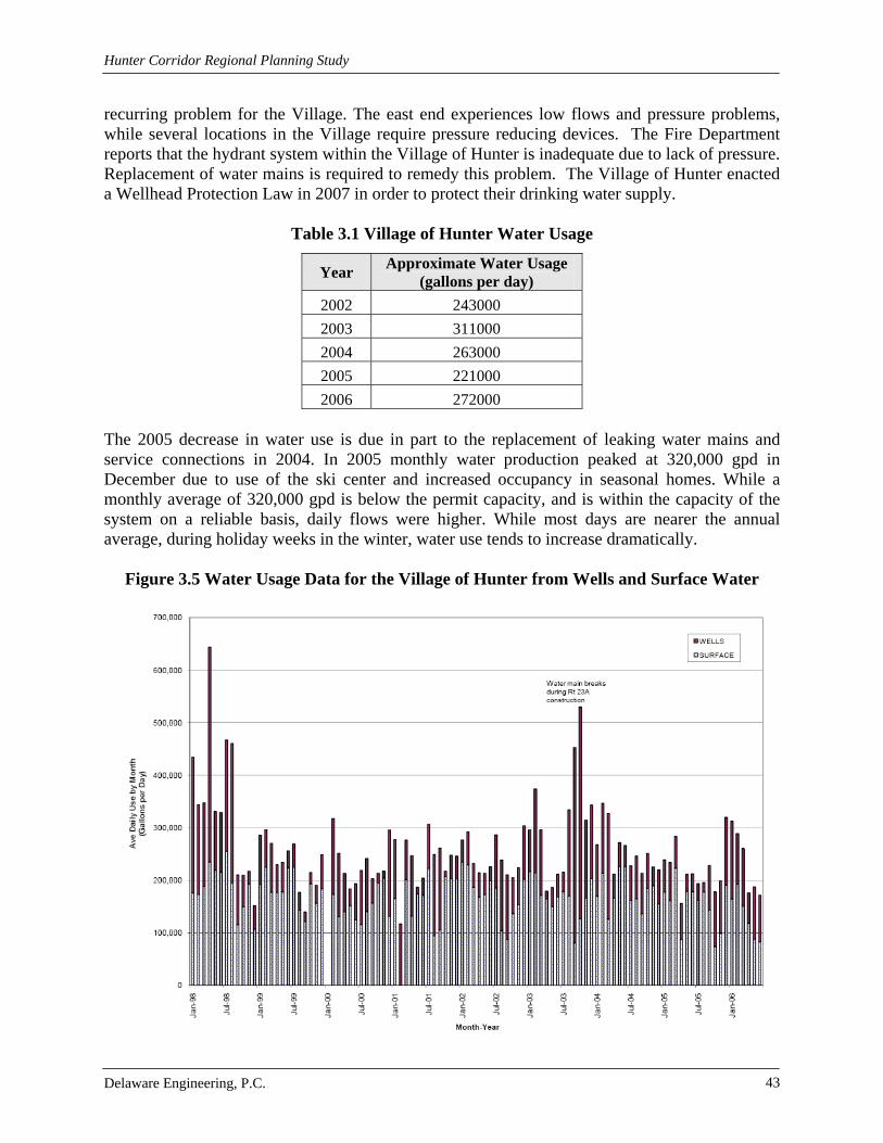
Hunter Corridor Regional Planning Study
Delaware Engineering, P.C. 43
recurring problem for the Village. The east end experiences low flows and pressure problems, while several locations in the Village require pressure reducing devices. The Fire Department reports that the hydrant system within the Village of Hunter is inadequate due to lack of pressure. Replacement of water mains is required to remedy this problem. The Village of Hunter enacted a Wellhead Protection Law in 2007 in order to protect their drinking water supply.
Table 3.1 Village of Hunter Water Usage
Year Approximate Water Usage
(gallons per day)
2002 243000
2003 311000
2004 263000
2005 221000
2006 272000 The 2005 decrease in water use is due in part to the replacement of leaking water mains and service connections in 2004. In 2005 monthly water production peaked at 320,000 gpd in December due to use of the ski center and increased occupancy in seasonal homes. While a monthly average of 320,000 gpd is below the permit capacity, and is within the capacity of the system on a reliable basis, daily flows were higher. While most days are nearer the annual average, during holiday weeks in the winter, water use tends to increase dramatically.
Figure 3.5 Water Usage Data for the Village of Hunter from Wells and Surface Water

Hunter Corridor Regional Planning Study
Delaware Engineering, P.C. 44
The DEC permit capacity was based mainly on well capacity which was incorrectly assigned as double what the 1988 groundwater pump tests actually indicated. In reality, the Village has and continues to rely on Shanty Hollow Brook for most of its supply. Since the DOH directed the operators to minimize use of the surface water until filtration was in place, there was pressure to run the wells as much as possible. Use of the well water in turn caused customer complaints, which were addressed by flushing lines and overfilling tanks, which artificially inflated water use and depleted groundwater. Historically, water supply capacity has been limited by a combination of factors, including:
Surface water was being used without filtration, which did not meet the requirements of the Surface Water Treatment Rule. Thus, the Village was directed to use surface water only as a last resort and rely primarily on wells.
Water lines on Main Street and elsewhere were shallow, corroded and leaking,
resulting in low water flow and pressure for many homes and businesses and the need to continually blow-off water to either prevent freezing or reduce customer complaints.
The three Village wells draw from the same area of the aquifer interfere with one
another and limit yield.
Poor water quality was resulting in excessive waste of water as tanks were over-filled. Wells and their facilities were in poor condition and water from the different source
could not be used efficiently.
A Filter Plant was placed in service in August 2006. Since that time, the wells have not been run except for maintenance. Water mains and tanks have been flushed and cleaned and customer complaints on water quality have lessened. With better control and monitoring of the tanks they are no longer routinely overfilled. And the new water mains have allowed the blow-offs to be shut, further reducing water waste. In 2005, the operating records indicate that an estimated 22% of the water was lost to blow-offs and overfilling tanks.
The new DEC Permit being issued for water use is as follows:
Shanty Hollow Brook 109,440 gallons per day Well No. 1 100,800 gallons per day Well No. 2 100,800 gallons per day Well No. 3 43,200 gallons per day Finn Well 47,520 gallons per day Valley Water Wells 27,360 gallons per day TOTAL 429,120 gallons per day

Hunter Corridor Regional Planning Study
Delaware Engineering, P.C. 45
Since the well yields are on a 180-day basis, short-term use of the wells at slightly higher rates is a practical and efficient means of meeting peak weekend demands which storage or normal pumping may be unable to meet. Summer usage averages 260,000 gpd; winter use averages 320,000 gpd. The projected high month flows, based on the past eight years data are 320,000 gpd in the summer and 400,000 gpd in the winter. Based on records obtained prior to the installation of new water mains and during a time when blow-offs and overfilling of aboveground storage tanks were routine, it appears that these historical monthly high averages are indicative of current usage.
3.1.2.2 Village of Hunter Wastewater
Prior to the construction of the Village’s wastewater treatment plant, the majority of households had on-site septic systems for wastewater disposal. Many were inappropriately designed and lacked required maintenance, which likely resulted in non-point source pollution. The CWC has funded the replacement of 148 septic tanks in the Village of Hunter between 1998 and 2010. The average cost of each replacement was $10,000. The wastewater treatment plant (WWTP) is located at the western end of the Village, three miles from the Village of Tannersville’s treatment plant. It was created through the New Infrastructure Program (NIP) under the NYC Watershed MOA. The treatment train of the Village of Hunter wastewater plant consists of an influent pump station, primary clarification, extended aeration activated sludge process, secondary clarification, tertiary filtration with phosphorus removal through continuously backwashed upflow DualSand filters, chlorination for disinfection, dechlorination, and a surface discharge to the Schoharie Creek. The wastewater treatment system also includes a residuals management system consisting of sludge digestion and a belt press for sludge dewatering. Dried sludge is disposed of at an approved off-site facility. The majority of the Village of Hunter is connected to the sewer system, with only a very small portion of properties on the east side of the Village not served due to topography prohibiting gravity flow and the excessive cost of a pump station for the benefited properties. The wastewater treatment plant also serves a limited number of parcels in neighboring areas of the Town, primarily to the south of the Village associated with Hunter Mountain. Map 3.2 Sewer Systems depicts the Village of Hunter’s sewer service area and sewer mains.
In addition to the Village wastewater treatment plant, there is one private wastewater treatment plant located in the Village. It is owned and operated by Hunter Highlands, a condominium development on the southeast side of the Village. Hunter Highlands operates a tertiary treatment plant that discharges to a tributary of the Schoharie Creek. In planning the WWTP, subsurface disposal of effluent was deemed infeasible due to site charac-teristics and land ownership patterns. As a result, effluent is discharged to the Schoharie Creek through a large concrete culvert outfall structure with rip rap to accomplish aeration and trap sediments. The Schoharie is classified as a Class C (TS) stream in the area of the outfall. Class C streams are defined as water supporting fisheries and non-contact recreational activities. Streams can also be classified as supporting trout populations (T) and trout spawning (S). All of these streams are protected under Article 15 of ECL and the Protection of Waters Regulatory Program.

Hunter Corridor Regional Planning Study
Delaware Engineering, P.C. 46
Table 3.2 Average and Peak Flows for the Village of Hunter WWTP
Year Average Yearly
Flow (gpd) Peak Yearly Flow (gpd)
Month of Peak Ave Day Excess
Capacity* Peak Day Excess
Capacity**
2005 56,564 121,200 October 269,336 204,700
2006 149,933 252,600 November 175,967 73,300
2007 155,183 235,000 March 170,717 90,900
2008 137,882 204,500 December 188,018 121,400
2009 134,733 163,700 July 191,167 162,200
2010 143,467 268,100 March 182,433 57,800
* Difference in SPDES Permit Flow of 325,900 and the Average Monthly Flow
**Difference in SPDES Permit Flow of 325,900 and the Peak Monthly Flow
In addition to the approximately 11 miles of collection lines constructed by the Village when the WWTP was constructed, the Forrester Motor Lodge, Camp Loyaltown, Colonel’s Chair and Liftside sewer service areas and collection systems are part of the Village WWTP service area. There are several pump stations that convey wastewater in the Village system. These include pump stations located in proximity to the former outfalls for the Liftside and Colonel’s Chair WWTPs. In addition, all wastewater collected in the Village system is pumped to the WWTP via an influent pump station located on Route 23A at the WWTP site. A 2005 Infiltration and Inflow (I&I) study documented that the existing Colonel’s Chair wastewater collection system is subject to extensive I&I. This causes the system to greatly exceed its existing State Pollutant Discharge Elimination System (SPDES) permit of 30,000 gpd. The sewer mains were completely replaced to mitigate this problem. Liftside sanitary sewers also show significant I&I during wet periods. Flows have peaked around 325,000 gpd while the permitted flow is only 81,000 gpd. About 800 feet of gravity sewer was replaced along Lake Avenue travelling towards the pump station to mitigate clogs and sewage backup. Manhole covers were also modified to mitigate stormwater inflow.
3.1.2.3 Village of Hunter Stormwater The Village’s stormwater system consists of swales, culverts, pipes and other structures. Stormwater runoff from Village roads is generally directed via sheet flow to roadside drainage swales. Drainage swales within the Village generally discharge to water courses that ultimately discharge to the Schoharie Creek. Anecdotal evidence suggests that there are some capacity shortfalls within this system indicating that improvements are needed. Upgrades to the storm drainage system invite the opportunity to implement Best Management Practices, such as settling ponds, grassy swales, and rock filters, for control of both water quantity and quality. Significant modifications to the stormwater system along Route 23A were performed in 2006 as a result of the full depth reconstruction of the road, east of the intersection with Route 296. Modifications included the installation of three Vortech stormwater treatment Units and a stormwater treatment dry swale.

Hunter Corridor Regional Planning Study
Delaware Engineering, P.C. 47
The stormwater infrastructure assessment conducted under the CWC Retrofit Program in the Village of Hunter identified swales, culvert inlet/outlets and flood prone areas that represent sediment sources that increase the sediment load in stormwater runoff during storm events. Sediment and chemicals from this area are ultimately deposited in the New York City watershed. Along some roads runoff flows directly to adjacent upland areas.
Stormwater runoff from streets located in the northeast section of the Village of Hunter discharge to a tributary of the Schoharie Creek designated Tributary 140 (Trib 140) by the NYSDEC. Significant flooding has historically occurred in the vicinity of Trib 140. The Trib 140 drainage area is approximately 385 acres, with approximately 200.8 acres of drainage located east of where Botti Drive crosses Trib 140. Trib 140 flows east to west through the Village on the north side of Route 23A until it turns south and flows beneath Route 23A and discharges to the Schoharie Creek. Stormwater runoff from residential lots on Botti Drive, Gaby Drive and Dolan’s Lane contributes to the overloading of Trib 140. Stormwater from Glen Avenue, Margarenten Park and a section of Route 23A all discharge to the Mad Brook. Mad Brook also receives drainage from a large area of undeveloped land north of Route 23A. Mad Brook discharges into the Schoharie Creek. There are swales and culverts located along Glen Avenue and Looking Glass Road that represent potential stormwater runoff sediment sources.
Figure 3.6 Glen Avenue culvert in need of repair
Stormwater runoff from Garfield Road east of the intersection with Point Breeze Drive and runoff from Prince and Lookout Mountain Drive currently discharge directly to the Schoharie Creek via a culvert underneath Route 23A. Within this drainage area there are five swales and five culverts that represent potential stormwater runoff sediment sources. The steep terrain and drainage patterns west of the Garfield Road and east of the Route 296 inter-sections with Route 23A prohibit installation of any stormwater treatment structures between Garfield Road and Route 296. West of the Route 296 intersection with Route 23A the steep slope down to the Schoharie Creek on the south side of Route 23A prohibits situating a standard or non-standard standard stormwater treatment practices on the south side of Route 23A. On the north side of Route 23A the mountainous terrain significantly increases the pervious acreage within the contributory drainage to the existing drainage swale on the north side of Route 23A, which prohibits situating of stormwater treatment structures in this area do to size constraints and physical constraints associated with underground water and sewer utilities.

Hunter Corridor Regional Planning Study
Delaware Engineering, P.C. 48
Stormwater runoff from Point Breeze, Linda Lane, Chief Lane and Garfield west of Point Breeze discharges to two intermittent stream channels that merge on the north side of Route 23A and discharge via a culvert under Route 23A to the Schoharie Creek. The stream channel located on the east side of Point Breeze has been channelized and areas of this channel represent a potential sediment source. Three other swales and nine culverts in this area represent potential stormwater runoff sediment sources. The Route 296 drainage area includes stormwater runoff from Route 296, Dolinsky, Brook and Route 23A west of the intersection with Route 296. Runoff from these areas discharges to the Schoharie Creek via a combination of intermittent stream channels that are culverted beneath Route 23A and swales that discharges to culverts that cross beneath Route 23A. Swales and culverts/structures within this area represent potential sediment source areas. The area that collects stormwater runoff from Highlands, Hunter Road, Ski Bowl Road and the east side of Height Mountain are generally in good condition and do not represent a significant source of sediment to stormwater. Runoff from swales on Highlands, Hunter Road and the eastern section of Ski Bowl (east of intersection with Hunter Road) discharges to a channelized intermittent stream along Ski Bowl Road. This stream then discharges to the outlet from Dolan’s Lake, which discharges to the Schoharie Creek. Flow from the upper area of Mountain Drive, Lake Road, Colonels Drive, Berry Lane Overlook and Riverside Drive discharges to a watercourse that flows under Riverside Drive. The swales on Mountain Drive, Berry Lane and most of the swales on the upper area of Lake Road have been regraded. There is no vegetation in these swales; until new vegetation colonizes the swales, it could be a source of sedimentation. Thirteen culverts within this drainage area represent potential erosion zones and stormwater runoff sediment sources.
Figure 3.7 Clogged culvert under driveway
Swales on Mountain Drive, Pine Lane, Creek Lane and Riverside cross under Riverside and discharge to the Schoharie Creek. Most of the swales and culverts in this area are generally in good condition and do not represent significant stormwater sediment source area. Stormwater runoff from Pine Lane and Mountain Drive discharges to the Hunter Mountain snow making pond through various water courses. The snow making pond provides sediment deposition area for coarse grained suspended sediments entrained stormwater. The pond functions as a sediment trap although it was not created for this purpose. The pond discharges to the Schoharie Creek via a stream channel that crosses Maple Avenue.
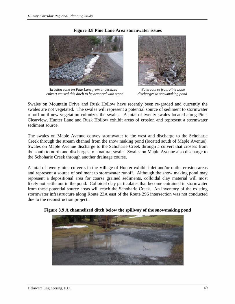
Hunter Corridor Regional Planning Study
Delaware Engineering, P.C. 49
Figure 3.8 Pine Lane Area stormwater issues
Erosion zone on Pine Lane from undersized Watercourse from Pine Lane
culvert caused this ditch to be armored with stone discharges to snowmaking pond Swales on Mountain Drive and Rusk Hollow have recently been re-graded and currently the swales are not vegetated. The swales will represent a potential source of sediment to stormwater runoff until new vegetation colonizes the swales. A total of twenty swales located along Pine, Clearview, Hunter Lane and Rusk Hollow exhibit areas of erosion and represent a stormwater sediment source. The swales on Maple Avenue convey stormwater to the west and discharge to the Schoharie Creek through the stream channel from the snow making pond (located south of Maple Avenue). Swales on Maple Avenue discharge to the Schoharie Creek through a culvert that crosses from the south to north and discharges to a natural swale. Swales on Maple Avenue also discharge to the Schoharie Creek through another drainage course. A total of twenty-nine culverts in the Village of Hunter exhibit inlet and/or outlet erosion areas and represent a source of sediment to stormwater runoff. Although the snow making pond may represent a depositional area for coarse grained sediments, colloidal clay material will most likely not settle out in the pond. Colloidal clay particulates that become entrained in stormwater from these potential source areas will reach the Schoharie Creek. An inventory of the existing stormwater infrastructure along Route 23A east of the Route 296 intersection was not conducted due to the reconstruction project.
Figure 3.9 A channelized ditch below the spillway of the snowmaking pond

Hunter Corridor Regional Planning Study
Delaware Engineering, P.C. 50
3.1.3 Village of Tannersville
3.1.3.1 Village of Tannersville Water
The Village of Tannersville’s water treatment facility is located on Leach Road, in the northern end of the Village. The facility was completed and start-up took place during the summer of 1985. The system was recently updated in 2009. Water is obtained from surface and groundwater reserves including the Schoharie Creek. The Schoharie Creek is the largest watercourse in the Village. This creek flows to the Schoharie Reservoir and forms part of the drinking water supply for New York City. The system serves a majority of the developed parcels within the Village as well as some neighboring areas in the Town of Hunter.
Figure 3.7 Tannersville Reservoir (July 2007)
The primary raw water source for the Village is an upland reservoir. Given the lack of ownership and control of the watershed, the Village has not implemented any watershed control measures. The watershed for the reservoir area is located north of the Village and south of the Onteora and Parker Mountains. The land is within the State Catskill Forest Preserve and is privately owned. There are no watershed rules or regulations in place for the reservoir watershed at this time, besides controls placed by NYCDEP. Map 3.1 Water Systems depicts the service area for the Village of Tannersville water system.
Hunter Corridor Regional Planning Study
Delaware Engineering, P.C. 51
Table 3.3 Current Capacity Available in an Extreme Drought (2009)
Source Capacity (gallons per day) Reservoir #1 43,000 Reservoir #3 32,000 Dibble’s Dam 0 Rip Van Winkle Well 80,000 Sunny View Well 8,000
3.1.3.2 Village of Tannersville Wastewater
The wastewater treatment system, owned by NYC DEP, serves a majority of the developed parcels within the Village along with some parcels in neighboring areas of the Town. The wastewater treatment plant (WWTP) is maintained by NYC under an agreement that arose from Section 1100 of the Public Health Law. The sewerage system was originally constructed in 1925, but has been updated since. The WWTP is located on the southwest side of the Village. Based on an agreement from the 1920’s, users within the incorporated Village boundary are not charged a fee for services. Extensions outside of the Village are required to be approved by NYC DEP. NYC has extended the sewer collection system west of the Village along Route 23A in the recent past; however, extensions are not encouraged by the City. Wastewater treatment processes include screenings and grit removal, primary settling, biological treatment, sand filtration, membrane microfiltration and disinfection. The wastewater treatment system discharges to the Gooseberry Creek which is classified as a Class C (TS) Stream. Class C (TS) streams are defined as waters supporting fisheries and non-contact recreational activities, which also support trout spawning. NYCDEP has information about the Tannersville WWTP including the SPDES permit flow, monthly average flows, I&I issues and the ability of the WWTP to accommodate additional flow due to growth in the community. Map 3.2 Sewer Systems depicts the Village of Tannersville’s sewer service area and sewer mains.
3.1.3.3 Village of Tannersville Stormwater
Stormwater infrastructure includes an antiquated conveyance system which relies on open swales, culverts, pipes and other structures. Stormwater runoff from Village roads is generally directed via sheet flow to roadside drainage swales. Drainage swales within the Village generally discharge to water courses that ultimately discharge to the Schoharie Creek. Anecdotal evidence together with the results of a Community Stormwater Assessment conducted in 2007 suggests that there are some capacity shortfalls within this system indicating that improvements are needed. Upgrades to the storm drainage system invite the opportunity to implement BMPs, such as settling ponds, grassy swales, and rock filters, for control of water quantity and quality. According to the Stormwater Assessment, there are known problem areas in the Village of Tannersville where the stormwater collection system no longer performs effectively or where recent, significant storm events have exposed weaknesses. Steep topography along with erodible and limited permeability soils with limited permeability found around Tannersville make effective control of erosion, sedimentation and stormwater flooding difficult.

Hunter Corridor Regional Planning Study
Delaware Engineering, P.C. 52
Figure 3.8 Installation of porous pavement at the WAP Office in Tannersville
Source: GCWAP
The system has failed to convey stormwater during routine rainfall and snowfall events to the extent that it overflows roadways. This has created icy and dangerous roads, concentrated flows down embankments or other areas not able to handle it, thus creating erosion and sediment depositions. It is conceivable that the Village Department of Public Works can perform many of the smaller tasks and contract out for the larger projects as funding is made available. Two of the larger contracts have already been accomplished along the Huckleberry Bike Trail via contractors for projects endorsed and at least partially funded by NYCDEP and CWC. One example of the fragility of local environment is the severe erosion and deposition of sediment into Rip Van Winkle Lake that reputedly occurred during a storm event in 1996. Massive flows of sediment from Cortina Valley Ski Resort reputedly inundated the Gooseberry Creek and filled a significant portion of the eastern portion of Rip Van Winkle Lake. The lake at present suffers from a severe lack of depth and dense aqueous vegetation. Eutrophication has reduced the depth of the water significantly hampering the water body’s ability to self-cleanse. The lake is classified as a wetland under by federal and state jurisdiction. As such, removal of the sedimentation would require extensive permitting. The east end of the lake is virtually unfishable. Other storm water problems include frequent flooding along Sawmill Creek and flooding in residential areas of Spring Street. Erosion during storm events is a problem along Sawmill Creek, and especially along Railroad Street and Spruce Street. On South Main Street the outfall has created a new sedimentation problem in Rip Van Winkle Lake.
Figure 3.9 Flooding along the Sawmill Creek

Hunter Corridor Regional Planning Study
Delaware Engineering, P.C. 53
Swales on Pleasant View Drive, Raspberry Lane, Allen Lane, Leach Lane, Jerro Drive, Renwick Street, Penrose Avenue, Sunset Avenue, Lake View Avenue, Railroad Avenue, Church Street, Thompkins Street, Hill Street, Brookside Drive, Park Lane, Sylvan Side Avenue, Lichtenstein Drive, Spring Street, Gray Lane, Fromer Street, South Main Street and Lake Road, have erosion and sedimentation problems. They need to be cleaned of sediment and debris, re-graded and stabilized with new vegetation, rip-rap or asphalt. Some need to be reshaped due to changes from erosion and sedimentation. Catch basins and culverts also need to be repaired or replaced. Improper conveyance of stormwater by these mechanisms has caused basement flooding. This has caused sewage and chemicals to be enter into Sawmill Creek, Gooseberry Creek and Rip Van Winkle Lake. Several of the roads are comprised of gravel, which contribute to the high amounts of sedimentation in many swales and corresponding stormwater conveyance techniques. Frasier Engineering recommends paving of the roads to reduce this sedimentation. Roads and driveways that are already paved have unstable conditions due to heavy stormwater runoff from swales. Salt storage areas should be updated to provide maximum protection from stormwater runoff. Various features of the stormwater controls in the Village of Tannersville, particularly roadside swales, are prone to erosive forces from high runoff events. The swales are predominantly vegetated without stone or other more stable lining. Water velocity and depth of flow are the main factors in the de-stabilization of the bottom and banks of drainage courses. The relatively steep topography of many areas within the Village contributes to these higher velocities. Lack of stable lining has contributed to generated sediments found within some of the culverts, catch basins and swales downstream of these eroded areas. It appears most eroded areas have been repaired in kind without the benefit of aggressive controls to limit further erosion and sedimentation. Many of the physical infrastructure needs can be met with improved materials and methods of repairs by Village forces while others dictate significant infrastructure improvements with funding and utility contractors. Water quantity management is particularly important in the Sawmill Creek Watershed since development is in close proximity to the waterbody and the Stormwater Assessment identifies flooding issues.
3.2 Parking, Transportation and Traffic Greene County and the Town of Hunter have pursued a number of planning efforts aimed at evaluation and recommendations for enhancements to the transportation systems including the highways, local streets, bicycle and pedestrian infrastructure serving the Corridor. Of particular note are the Mountaintop Community Recreation, Cultural Resources and Scenic Quality Strategy (Mountaintop Recreation Strategy) dated January 2009 and the Mountain Clove Scenic Byway Proposed Corridor Management Plan (Scenic Byway Plan) which will be under formal review by the State Scenic Byway Committee in late 2010. These documents define a plan to accommodate future development while maintaining the rural character of Greene County and the Town of Hunter. A number of goals and steps are required to pursue this overall objective. The Transportation Evaluation (Appendix E) conducted as part of the Hunter Corridor Study builds on the previous transportation studies.

Hunter Corridor Regional Planning Study
Delaware Engineering, P.C. 54
The purpose of the transportation evaluation is to define the baseline conditions in the Corridor, identify areas of potential impacts associated with future development in the Hunter Communities and to provide recommendations to accommodate future development. A qualita-tive assessment of typical transportation conditions in the Corridor including pedestrian and bicycle accommodations, typical intersection control and operations, pavement conditions, roadway character, parking inventory and accident history was completed. The study area analyzed in the Transportation Evaluation encompasses the NYS Route 23A Corridor from NYS Route 296 at the west end of the Village of Hunter to County Road 25 east of the Village of Tannersville. The intersections of NYS Route 23A/NYS Route 214, NYS Route 23A/Hill Street (CR 23C)/Railroad Avenue and NYS Route 23A/Clum Hill Road were included in the study. There are known problem areas in the Village of Tannersville where the stormwater collection system no longer performs effectively or where recent, significant storm events have exposed weaknesses. The steep topography and erodible and limited permeability soils found around Tannersville make effective control of stormwater related erosion, sedimentation and flooding difficult. Traffic volumes on NYS Route 23A near the Corridor peak during the summer months and again during the winter, though the summer peak (August) is higher than the winter peak (December). The winter peak is due to the presence of Hunter Mountain which is a regional ski destination in the Village of Hunter. The Build-Out Analysis for the study states that year-round residential ownership in the Hunter Communities is about 20% with the remaining 80% seasonal ownership. The majority of traffic enters the Corridor on Friday and Saturday. The majority of traffic exits the Corridor on Sunday. These trends are consistent with second or seasonal home ownership. Regional and interstate bus service is provided by Greyhound. There are several permanent bus stop locations in each Village. Additionally, Greene County operates a once weekly bus service through the area.
3.2.1 Town of Hunter In the Town of Hunter between the two Villages, the posted speed limit is 55 miles per hour (mph) and no parking is allowed on the shoulders. Land use along this segment of NYS Route 23A is primarily open with sparsely spaced commercial and residential land uses with large building setbacks. Between the Villages there is no on-street parking and the shoulders of the road are wide enough to accommodate bicycles.
The intersection of NYS Route 23A/NYS Route 214 is located in the Town of Hunter between the two Villages. It operates under stop sign control on the northbound NYS Route 214 approach to NYS Route 23A. The NYS Route 214 and NYS Route 23A approaches to the intersection provide a single lane for shared travel movements. There are no sidewalks or crosswalks at the intersection. There are 9 to 10 foot paved shoulders along NYS Route 23A.

Hunter Corridor Regional Planning Study
Delaware Engineering, P.C. 55
3.2.2 Village of Hunter The posted speed limit is 35 mph in the Village of Hunter. On-street parking and sidewalks are provided within the Village boundaries. Land uses in the Village are typical of a village setting with closely spaced commercial parcels and minimal building setbacks with a mix of land uses. Along Main Street, the road width is approximately 44 feet which will accommodate two traffic lanes, each 12 feet wide, and a 10 foot wide parallel parking lane on either side of the street. The speed limit along Route 23A in the downtown business district is 35 mph. This speed limit changes to 45 mph near Garfield Avenue and near Ferraro Road. This gradual decrease in speed limit is intended to create a village environment and encourage commercial and retail uses.
Figure 3.10 Village of Hunter Welcome Sign
There is a small public parking lot located near Dolan’s Lake. The availability of on-street parking throughout through the Village is variable. On street parking is very limited on the east end of the Village due to recent highway reconstruction work that reclaimed the highway right of way. However, on street parking is provided on the western end of the Village where there is a concentration of retail and commercial land uses. A 10 foot wide shoulder on either side of Main Street (Route 23A) meets current parking needs for the approximately 55 businesses located there. A total of approximately 250 on-street parking spaces are provided. If retail and com-mercial land uses grow, there may soon be a need for a public parking lot in the central and western areas of the Village. This lot should be sited within walking distance of the downtown business district, but should not be located on Main Street because it would detract from the appearance of the downtown business district. Sidewalks in the Village are generally 5 feet wide. In most areas they are located on both sides of Route 23A. There are no signalized intersections within the Village and therefore no controlled crosswalks. The availability of on-street parking and the width of the paved shoulder vary providing an inconsistent environment for bicyclists. Full depth road reconstruction was accomplished on Route 23A in 2002/2003 due to the install-ation of underground utilities including a new sewer collection system and replacement of the water supply lines throughout the Village. Improvements were made to street drainage, parking, lighting and plantings. Conventional “cobra” style streetlights were replaced with Victorian style lighting at a pole height of 15 feet to create a more inviting appearance along Main Street.
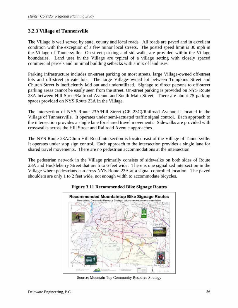
Hunter Corridor Regional Planning Study
Delaware Engineering, P.C. 56
3.2.3 Village of Tannersville The Village is well served by state, county and local roads. All roads are paved and in excellent condition with the exception of a few minor local streets. The posted speed limit is 30 mph in the Village of Tannersville. On-street parking and sidewalks are provided within the Village boundaries. Land uses in the Village are typical of a village setting with closely spaced commercial parcels and minimal building setbacks with a mix of land uses. Parking infrastructure includes on-street parking on most streets, large Village-owned off-street lots and off-street private lots. The large Village-owned lot between Tompkins Street and Church Street is inefficiently laid out and underutilized. Signage to direct persons to off-street parking areas cannot be easily seen from the street. On-street parking is provided on NYS Route 23A between Hill Street/Railroad Avenue and South Main Street. There are about 75 parking spaces provided on NYS Route 23A in the Village.
The intersection of NYS Route 23A/Hill Street (CR 23C)/Railroad Avenue is located in the Village of Tannersville. It operates under semi-actuated traffic signal control. Each approach to the intersection provides a single lane for shared travel movements. Sidewalks are provided with crosswalks across the Hill Street and Railroad Avenue approaches.
The NYS Route 23A/Clum Hill Road intersection is located east of the Village of Tannersville. It operates under stop sign control. Each approach to the intersection provides a single lane for shared travel movements. There are no pedestrian accommodations at the intersection The pedestrian network in the Village primarily consists of sidewalks on both sides of Route 23A and Huckleberry Street that are 5 to 6 feet wide. There is one signalized intersection in the Village where pedestrians can cross NYS Route 23A at a signal controlled location. The paved shoulders are only 1 to 2 feet wide, not enough width to accommodate bicycles.
Figure 3.11 Recommended Bike Signage Routes
Source: Mountain Top Community Resource Strategy
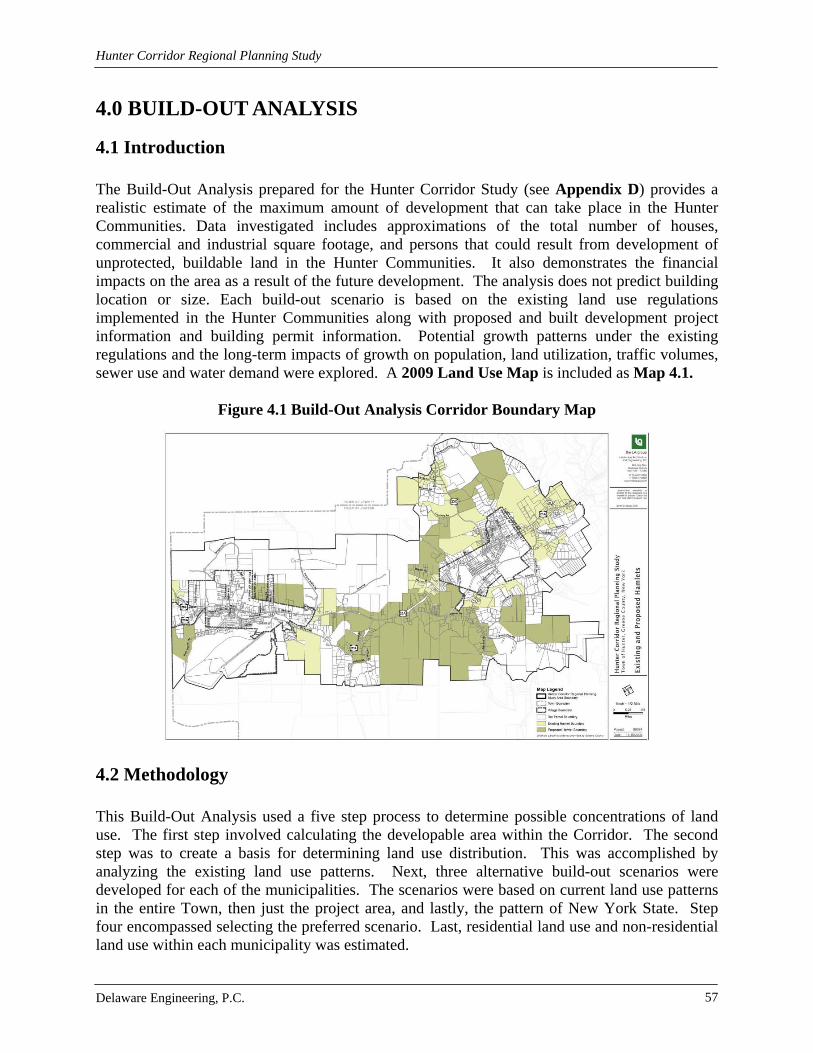
Hunter Corridor Regional Planning Study
Delaware Engineering, P.C. 57
4.0 BUILD-OUT ANALYSIS
4.1 Introduction The Build-Out Analysis prepared for the Hunter Corridor Study (see Appendix D) provides a realistic estimate of the maximum amount of development that can take place in the Hunter Communities. Data investigated includes approximations of the total number of houses, commercial and industrial square footage, and persons that could result from development of unprotected, buildable land in the Hunter Communities. It also demonstrates the financial impacts on the area as a result of the future development. The analysis does not predict building location or size. Each build-out scenario is based on the existing land use regulations implemented in the Hunter Communities along with proposed and built development project information and building permit information. Potential growth patterns under the existing regulations and the long-term impacts of growth on population, land utilization, traffic volumes, sewer use and water demand were explored. A 2009 Land Use Map is included as Map 4.1.
Figure 4.1 Build-Out Analysis Corridor Boundary Map
4.2 Methodology This Build-Out Analysis used a five step process to determine possible concentrations of land use. The first step involved calculating the developable area within the Corridor. The second step was to create a basis for determining land use distribution. This was accomplished by analyzing the existing land use patterns. Next, three alternative build-out scenarios were developed for each of the municipalities. The scenarios were based on current land use patterns in the entire Town, then just the project area, and lastly, the pattern of New York State. Step four encompassed selecting the preferred scenario. Last, residential land use and non-residential land use within each municipality was estimated.

Hunter Corridor Regional Planning Study
Delaware Engineering, P.C. 58
4.3 Build-Out Analysis and Conclusions The Corridor is approximately 12,235 acres using Greene County 2008 Real Property parcel data. After taking existing environmental constraints and site limitations into account, the Net Developable land area for the entire Corridor is 5,974 acres and 3,713 acres for the Village areas.
Table 4.1 Hunter Corridor Project Study Area Land Use
Hunter Corridor Project Study Area Land Use
Parcels Acres % Acres
Residential Properties >10 acres 48 2,097 22%
Vacant 774 3,614 38%
Recreation and Entertainment 40 1,494 16%
Private Wild and Forested Lands and Private Hunting and Fishing Clubs
26 2,341 25%
Total 888 9,546 100%
Past land use concentrations were used to predict future land use types and concentrations. Local planning documents are also analyzed as they are intended to guide future development patterns.
Net developable land in each area was calculated using land use information gathered and property class codes assigned by the local assessor for 2009. The developable area is found by subtracting developed land and areas limited by environmental constraints from the Corridor. Future land uses were calculated by using existing land use patterns. Consideration was also given to local planning documents and input from local officials. Three development scenarios were examined. The first used land use patterns within the Town of Hunter, the second reviewed land use patterns within NYS and the third examined land use patterns within the Corridor only. The preferred development scenario corresponds to 71.2% residential land use, 9% commercial land use, 19.1% recreation and entertainment land use and 0.7% community services in the Hunter Communities. Residential land use was further broken down into year-round and seasonal residential categories using data from the local assessor and existing development data. The ratio used was 1:4 year-round to seasonal. Water and sewer infrastructure can also have an impact on future development. Future land use categories were further broken down into primary and secondary development areas. Consistent with the hamlet and village extension areas, properties within 1000 feet of water or sewer lines were considered primary development areas. This area is more likely to be densely populated. The properties beyond 1000 feet are considered secondary development areas. These areas are considered to be less densely populated because of the lower potential of connection to water and sewer infrastructure.

Hunter Corridor Regional Planning Study
Delaware Engineering, P.C. 59
According to the build-out analysis, the Study Area will encompass 4,252 acres of residential development, 538 acres of commercial land, 1141 acres of recreational uses and 42 acres of community services. Eighty percent of the residential development is projected to be seasonal residences. Assuming all residential building activity will occur within the Corridor, an additional 220 housing units could be built by 2019. New housing units are expected to mirror the current blend of single family and multi-family dwellings such as condominiums and townhouses. Commercial land use is projected to increase up to 10 acres and recreation and entertainment uses could increase by 24 acres by 2019.
Table 4.2 Development Projections for the Town of Hunter
Primary/Secondary Development Projections for the Town of Hunter
Primary Dev. Area (acres) Secondary Dev. Area (acres)
Residential 1,790 2,087
Residential Year-Round 358 417
Residential Seasonal 1,432 1,670
Commercial/Industrial 226 264
Other 480 560
Recreation and Entertainment 18 21
TOTAL 2,514 2,932
Table 4.3 Development Projections for the Village of Hunter
Primary/Secondary Development Projections for the Village of Hunter
Primary Dev. Area (acres) Secondary Dev. Area (acres)
Residential 199 14
Residential Year-Round 40 3
Residential Seasonal 159 11
Commercial/Industrial 25 2
Other 53 4
Recreation and Entertainment 2 0
TOTAL 280 20
Table 4.4 Development Projections for the Village of Tannersville
Primary/Secondary Development Projections for the Village of Tannersville
Primary Dev. Area (acres) Secondary Dev. Area (acres)
Residential 161 2
Residential Year-Round 32 0
Residential Seasonal 129 2
Commercial/Industrial 20 0
Other 43 0
Recreation and Entertainment 2 0
TOTAL 226 2

Hunter Corridor Regional Planning Study
Delaware Engineering, P.C. 60
5.0 COST OF COMMUNITY SERVICES ANALYSIS
5.1 Introduction A Cost of Community Services Analysis (COCS) was conducted for the Hunter Communities within the Corridor. A copy of the complete Cost of Community Services Analysis is included in Appendix D. The COCS identifies the revenues gained from specific types of land uses present in the communities. The analysis allows the identification of the amount of revenue that each type of land use (residential, commercial/industrial, recreation and entertainment, and other) contributes and the amount that is expended to provide services to each. Results of the analysis will change each year as the mix of land uses change in accordance with zoning and other local codes. In this case, the analysis reviews 2008 financial data, the last year for which complete records were available. The study focuses on the implications of proposed hamlet designation for additional parcels though out the Hunter Corridor. The analysis identifies financial and land use implications of the newly designated parcels on the communities. The purpose of this Cost of Community Services model is not to determine what current or future actions are best for the communities, but to provide information to help local officials and citizens address financial implications of land conservation, development and sprawl.
5.2 Methodology The first step in the analysis was to establish the categories of land uses. Land uses are categorized according to definitions from the NYS Office of Real Property Services’ Property Type Classification and Ownership Codes. All properties within the Corridor were grouped according to the following categories: residential, commercial/industrial, recreation and entertainment, vacant, and other. Residential land includes that which has permanent residential homes, seasonal homes or apartments. Full time and seasonal residences were put into sub categories, according to zip-code, as they require different services. Permanent residences require services relating to highway maintenance, water and sewer services, police protection, etc. Seasonal residences do not demand services from the school district but still produce revenue through the use of real property tax. Commercial/industrial properties include those where people go to buy, sell and make use of services available. They only utilize some services from local government, but do not require any services from school districts. These properties are usually revenue positive. Properties classified as recreation and entertainment, within the Corridor, is primarily associated with ski resorts. Vacant properties are those not in use, in temporary use, or ones that lack permanent improvement. Everything else, including agricultural community services, public services, conservation land and public parks are classified as other. Land uses in the two Villages are influenced and will be influenced by their zoning regulations. The second step in the analysis was to collect the data needed to compile the report. The NYS Office of the State Comptroller was the primary source for financial data for local governments and public school districts. Additional financial and operating information was collected from local governments regarding municipal water and sewer services. Information on local fire companies and emergency medical services were collected directly from those sources.

Hunter Corridor Regional Planning Study
Delaware Engineering, P.C. 61
The third step involved allocating revenues and expenses to land uses. The allocation of revenues and expenses to land use categories was based on the percentage of total equalized value of each of the land uses. This assumes that revenues and expenses are in proportion to the respective equalized full value in each community. Full time residential properties were assigned 100% of the school district’s expenses because they are the only land use utilizing educational services. Lastly, the cost of services ratios, cost per acre and breakdown points were calculated. The costs of services ratio is calculated by dividing the total expenses for each land use by the total revenues generated by each land use. This was done for local government expenses and revenues and local school district expenses and revenues. The ratios will show the impact that each service has on the various land uses. Cost per acre is calculated by taking the difference of the allocated revenues and expenses and dividing it by the total acreage for each of the land uses. The breakdown point will show what the average value of each full time residential property needs to be in order for the amount of revenue it contributes to cover costs associated with providing local government and public school district services.
5.3 Local Services Local governments are responsible for providing services to residents within the community. The Highway/DPW, water/sewer systems and emergency services represent the largest financial portion of the local budget. The primary function of the water/sewer services is to distribute clean water and collect wastewater. Water and sewer services are not a means for local governments to generate revenue. User fees are designed to cover costs for the provision of service. Emergency services can have a direct impact on the cost of community services because they are expensive due to staffing, equipment and facilities. Fire protection and EMS services funding can come from many sources such as municipal budget, local contracts with communities, insurance billings, taxing districts or donations. Educational services receive a large portion of taxes paid by local residents and property owners. Educational institutions have significant expenses associated with the operation and maintenance of facilities along with salaries for faculty and staff and other school related programs. Unlike other services, school districts only provide services to those residents with school aged children. The main difference between year-round and seasonal residents is the cost of educational services.
5.4 Cost of Community Services Findings For the 2008 fiscal year, the study revealed that in each community, tax revenues from residen-tial properties are not sufficient to support the cost of services provided to them. Real property tax revenues represent the primary source of revenue for local governments. Each of the other land uses is considered a revenue generator. Large amounts of year-round residential develop-ment and an increase in population would result in considerable increases in the expenses associated with the provision of local services, especially educational services. Local revenue would likely not be sufficient to cover the increase in the costs for providing services to a significant increase in year-round residential development.
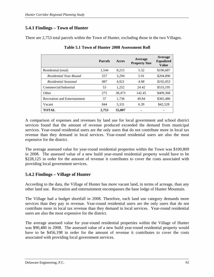
Hunter Corridor Regional Planning Study
Delaware Engineering, P.C. 62
5.4.1 Findings – Town of Hunter There are 2,753 total parcels within the Town of Hunter, excluding those in the two Villages.
Table 5.1 Town of Hunter 2008 Assessment Roll
Parcels Acres
Average Property Size
Average Equalized
Value
Residential (total) 1,544 8,215 5.32 $196,687
Residential Year-Round 557 3,294 5.91 $204,896
Residential Seasonal 987 4,921 4.98 $192,053
Commercial/Industrial 53 1,252 24.42 $533,195
Other 275 38,473 142.45 $409,368
Recreation and Entertainment 37 1,736 49.84 $365,486
Vacant 844 5,331 6.39 $42,528
TOTAL 2,753 55,007 - -
A comparison of expenses and revenues by land use for local government and school district services found that the amount of revenue produced exceeded the demand from municipal services. Year-round residential users are the only users that do not contribute more in local tax revenue than they demand in local services. Year-round residential users are also the most expensive for the district. The average assessed value for year-round residential properties within the Town was $100,809 in 2008. The assessed value of a new build year-round residential property would have to be $228,125 in order for the amount of revenue it contributes to cover the costs associated with providing local government services.
5.4.2 Findings – Village of Hunter According to the data, the Village of Hunter has more vacant land, in terms of acreage, than any other land use. Recreation and entertainment encompasses the base lodge of Hunter Mountain. The Village had a budget shortfall in 2008. Therefore, each land use category demands more services than they pay in revenue. Year-round residential users are the only users that do not contribute more in local tax revenue than they demand in local services. Year-round residential users are also the most expensive for the district. The average assessed value for year-round residential properties within the Village of Hunter was $90,480 in 2008. The assessed value of a new build year-round residential property would have to be $456,198 in order for the amount of revenue it contributes to cover the costs associated with providing local government services.

Hunter Corridor Regional Planning Study
Delaware Engineering, P.C. 63
Table 5.2 Village of Hunter 2008 Assessment Roll
Parcels Acres
Average Property
Size
Average Equalized
Value
Residential (total) 540 320 0.63 $140,598
Residential Year-Round 159 89 0.56 $135,348
Residential Seasonal 381 231 0.61 $143,379
Commercial/Industrial 48 71 1.5 $230,380
Other 16 78 4.81 $368,811
Recreation and Entertainment 6 58 9.5 $2,715,657
Vacant 172 347 2.05 $30,329
TOTAL 782 874 - -
5.4.3 Findings – Village of Tannersville According to the data, year-round residential properties comprise most of the Village. The Village of Tannersville has more vacant land, in terms of acreage, than any other land use.
Table 5.3 Village of Tannersville 2008 Assessment Roll
Parcels Acres
Average Property
Size
Average Equalized
Value
Residential (total) 381 242 0.66 $149,682
Residential Year-Round 161 92 0.57 $147,941
Residential Seasonal 220 150 0.68 $152,184
Commercial/Industrial 61 50 0.86 $288,398
Other 12 11 0.89 $613,329
Recreation and Entertainment 6 99 16.45 $197,724
Vacant 129 275 2.23 $26,399
TOTAL 589 677 - -
A comparison of expenses and revenues by land use for local government and school district services found that the amount of revenue produced exceeded the demand from municipal services. Year-round residential users are the only users that do not contribute more in local tax revenue than they demand in local services. Year-round residential users are also the most expensive for the district. The average assessed value for year-round residential properties within the Village of Tannersville was $87,093 in 2008. The assessed value of a new build year-round residential property would have to be $218,293 in order for the amount of revenue it contributes to cover the costs associated with providing local government services.

Hunter Corridor Regional Planning Study
Delaware Engineering, P.C. 64
6.0 CURRENT REGULATIONS Local planning documents and land use regulations guide development patterns. Development can have both positive and negative impacts on the environment and the character and intensity of development results in a tax revenue profile. Accordingly, the Hunter Communities land use codes were reviewed in consideration of development principles that promote better site design practices that reduce costs to municipalities, preserve undisturbed areas, and reduce impervious cover. The review was based in part on the Center for Watershed Protection protocol and includes recommendations for amendments, enhancements and modifications to local land use regulations that focus on low impact development techniques. The first step of the analysis was to gather all of the development rules from the Hunter Communities. Extensive research was required to locate a comprehensive compendium of documents that influence land development in each community. Local regulations were obtained through the GCSWCD WAP, local communities as well as online resources including at www.townofhuntergov.com and www.tannersvilleny.org. Land use codes and regulations that govern development practices were analyzed including site plan review laws, subdivision regulations, the Village of Hunter zoning code, the proposed Village of Tannersville zoning law, street standards, stormwater regulations, clearing and grading control, floodplain protection, and riparian buffer protection. In addition to evaluating the local law requirements relative to development, the application processes for each community were identified. Appendix F includes a comparative table showing the application processes for the Hunter Communities. After gathering the local development codes, the next step was to compare them with the model development principals (MDP) created by the Center for Watershed Protection (CWP). The model development principles introduced by the CWP’s Code and Ordinance Worksheet are similar to BSD techniques. They were designed to reduce impervious cover, conserve natural areas and reduce storm water pollution associated with new and redevelopment. Issues dealt with include: size, shape and construction of parking lots, road ways and driveways; regulations for residential lot size and shape, housing density and the overall design of neighborhoods; protection and incorporation of open space. Some benefits of the Model Development Principles are: protection of local and state wide bodies of water; reduction of stormwater; reduction of soil erosion during construction activities; reduction of development and construction costs; pedestrian oriented neighborhoods with safer streets; increased open space for recreational uses; preservation of native vegetation. Questions were asked about local practices such as minimum road width, amount of green space required in subdivisions, etc. If the local development rules compared favorably to the model development principles then points were awarded. The total number of points a community can receive is 100. The overall score will indicate a community’s capability of sustaining environmentally sensitive development. This review is an important tool that can be used to help mold land use regulations and principles that guide site plan review. It helps to identify specific areas where development rules could be changed to encompass environmentally friendly practices. It also identifies where communities are excelling in using environmentally friendly practices.

Hunter Corridor Regional Planning Study
Delaware Engineering, P.C. 65
The local code review worksheets are incorporated in Appendix F. The results of the local code review indicate that all three Hunter Communities would benefit from systematic review and update of their land use regulations to incorporate appropriate, beneficial MDPs. An important goal of the Corridor Study is to provide the Hunter Communities with a foundation to support economically sensible development that is protective of water quality and natural resources. Not all model development principles may be applicable to the Hunter Communities, however, and each community is scheduled to undertake further study to identify practices that can be implemented to allow development while at the same time reducing impervious surfaces, conserving natural areas and reducing storm water runoff. The Town of Hunter will be conducting a Land Use Review and Revision project with the intent to investigate innovative land use practices that further community goals of low impact design, climate smart and smart growth. The two villages, along with four Mountaintop towns, will be participating in a Mountaintop Better Site Design Workshop project to identify which land use codes in their communities need updating to promote better site design practices as highlighted in the Better Site Design Tool Kit in Appendix G.

Hunter Corridor Regional Planning Study
Delaware Engineering, P.C. 66
7.0 ANALYSIS AND RECOMMENDATIONS One goal of the Hunter Corridor Study is to address the need to plan for the long term sustainability of the Town’s tax base and its valuable natural, built and human resources. This is to be accomplished by encouraging growth in areas within proximity to the existing population centers that are most suitable for high-quality development that can be supported by existing water and sewer infrastructure while providing the tools necessary to ensure the most environmentally sensitive development. It is important to characterize the potential for development and its associated fiscal impacts as a backdrop to the analysis and recommendations to guide future growth in the Hunter Communities that safeguards resources and protects community character.
7.1 Cost of Services and Build-Out Recommendations The means thorough which municipalities such as towns and villages as well as school districts can raise revenues is restricted in New York State. Property taxes, fees, and ‘rents’ for special improvement districts (e.g. water, sewer, lighting, fire protection, police protection, etc.) are among the most common means to generate revenue. There are categories of land uses that are gainers and categories that are losers. Gainer categories are those that provide more tax revenue than they demand in the cost of services to them usually by virtue of higher assessed values and low or non-existing demands on services. For example, industry and light industry generally have very high assessed values and pay commensurately for the use of water and sewer infrastructure, but do not generate children to be educated or have significant needs for police and fire protection. Retail and commercial land uses generate revenue in access of need because they also do not generate children to be educated, although they place greater demands on police and fire protection than industrial land uses. Residential land uses generally demand more in the cost of services than they fund in tax revenues. In general terms in rural communities, there is a planning concept that encourages a diversity of land uses within a taxing jurisdiction as an attempt to provide adequate revenue to cover the cost of the services provided within the jurisdiction. In the past, cities and villages were often blessed with a perfect blend of industry, commercial/retail and residential land uses which allowed for a high level of community service with a balanced budget. Towns were generally very sparsely populated and expected to provide very little by way of services. Deindustrialization, shifting demographics, aging populations, migration patterns, improved transportation and suburbanization have changed the time-honored formula for a diverse, centralized tax base. Adding to the complexity of the cost versus tax formula in the Hunter Corridor Communities is the abundance of tax-exempt lands and a proliferation of second homes. Unimproved land generates little tax revenue, and tax exempt land generates none. While unimproved land demands virtually no services, tax exempt land may demand services, for which there is no direct revenue source. There are a number of parcels in the Hunter Corridor that are improved, but are tax exempt for any number of reasons, including not-for-profit and religious designations. Primary and secondary homes are taxed similarly; however second homes do not demand educational services, which is generally a net positive gain for school districts.

Hunter Corridor Regional Planning Study
Delaware Engineering, P.C. 67
For the 2008 fiscal year, the cost of services analysis revealed that in each community of the Hunter Corridor Communities tax revenues from residential properties were insufficient to support the cost of services provided to them. Year-round residential land uses are the only uses that do not contribute more in local tax revenue than they demand in local services and year-round residential land uses cost the most in local services, with the demand and cost for educational services the most significant imbalance. Each of the other land uses evaluated were gainer or revenue generators from a tax perspective. Large amounts of year-round residential development and an increase in population would result in considerable increases in the expenses associated with the provision of local services, especially educational services. Without an increase in non-year round residential land uses to provide additional revenue and no demand for educational services, it is predicted that local revenue would not be sufficient to cover the increase in the costs for providing services to a significant increase in year-round residential development. To better understand the potential for growth in the Corridor a Build-Out Analysis was performed. Using existing development patterns in the Corridor, a development mix with 71.2% residential land use, 9% commercial land use, 19.1% recreation and entertainment land use and 0.7% community services was modeled for the Hunter Communities. Residential land use was further broken down into year-round and seasonal residential categories using data from the local assessor and existing development data. The ratio used was 1:4 year-round to seasonal. With this ratio, 80% of new residential development is projected to be seasonal. In order to stabilize the tax base/revenue when compared to the cost and demand for services, the following recommendations should be considered for implementation by the Hunter Corridor Communities:
Encourage Mixed Use – Mixed use allows for a structure or structures on a single tax parcel to serve multiple compatible purposes. Good examples of mixed uses are first floor shops with second floor apartments or front shops with back apartments. This is often an inexpensive option for business space and housing for sole proprietors, resulting in lower operating costs. The benefit to this from a cost of services perspective is an increase in assessment and a decrease in demand for services.
Promote Commercial and Retail Uses – Commercial and retail land uses contribute
more in tax revenue than they demand in the cost of services. In addition, the anticipated continuing trend of residential development should demand additional services such as shops, restaurants, and consumer services.
Support Infill Development and Discourage Sprawl – Infill development takes
advantage of existing infrastructure at little of no additional cost of service while sprawl increases the cost of services. A good example is to consider police protection. The local police services are constantly patrolling within the Villages and along the major highway corridors so adding an infill home or business is unlikely to add patrol time or personnel. A development located in the countryside will require a new patrol route, additional time, and possible the commitment of additional vehicle and personnel resources.
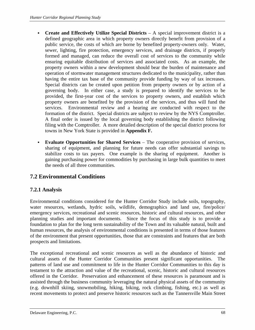
Hunter Corridor Regional Planning Study
Delaware Engineering, P.C. 68
Create and Effectively Utilize Special Districts – A special improvement district is a defined geographic area in which property owners directly benefit from provision of a public service, the costs of which are borne by benefited property-owners only. Water, sewer, lighting, fire protection, emergency services, and drainage districts, if properly formed and managed, can reduce the overall cost of services to the community while ensuring equitable distribution of services and associated costs. As an example, the property owners within a new development should bear the burden of maintenance and operation of stormwater management structures dedicated to the municipality, rather than having the entire tax base of the community provide funding by way of tax increases. Special districts can be created upon petition from property owners or by action of a governing body. In either case, a study is prepared to identify the services to be provided, the first-year cost of the services to property owners, and establish which property owners are benefited by the provision of the services, and thus will fund the services. Environmental review and a hearing are conducted with respect to the formation of the district. Special districts are subject to review by the NYS Comptroller. A final order is issued by the local governing body establishing the district following filing with the Comptroller. A more detailed description of the special district process for towns in New York State is provided in Appendix F.
Evaluate Opportunities for Shared Services – The cooperative provision of services,
sharing of equipment, and planning for future needs can offer substantial savings to stabilize costs to tax payers. One example is the sharing of equipment. Another is gaining purchasing power for commodities by purchasing in large bulk quantities to meet the needs of all three communities.
7.2 Environmental Conditions
7.2.1 Analysis Environmental conditions considered for the Hunter Corridor Study include soils, topography, water resources, wetlands, hydric soils, wildlife, demographics and land use, fire/police/ emergency services, recreational and scenic resources, historic and cultural resources, and other planning studies and important documents. Since the focus of this study is to provide a foundation to plan for the long term sustainability of the Town and its valuable natural, built and human resources, the analysis of environmental conditions is presented in terms of those features of the environment that present opportunities, those that are constraints and features that are both prospects and limitations. The exceptional recreational and scenic resources as well as the abundance of historic and cultural assets of the Hunter Corridor Communities present significant opportunities. The patterns of land use and commitment to life in the Hunter Corridor Communities to this day is testament to the attraction and value of the recreational, scenic, historic and cultural resources offered in the Corridor. Preservation and enhancement of these resources is paramount and is assisted through the business community leveraging the natural physical assets of the community (e.g. downhill skiing, snowmobiling, hiking, biking, rock climbing, fishing, etc.) as well as recent movements to protect and preserve historic resources such as the Tannersville Main Street
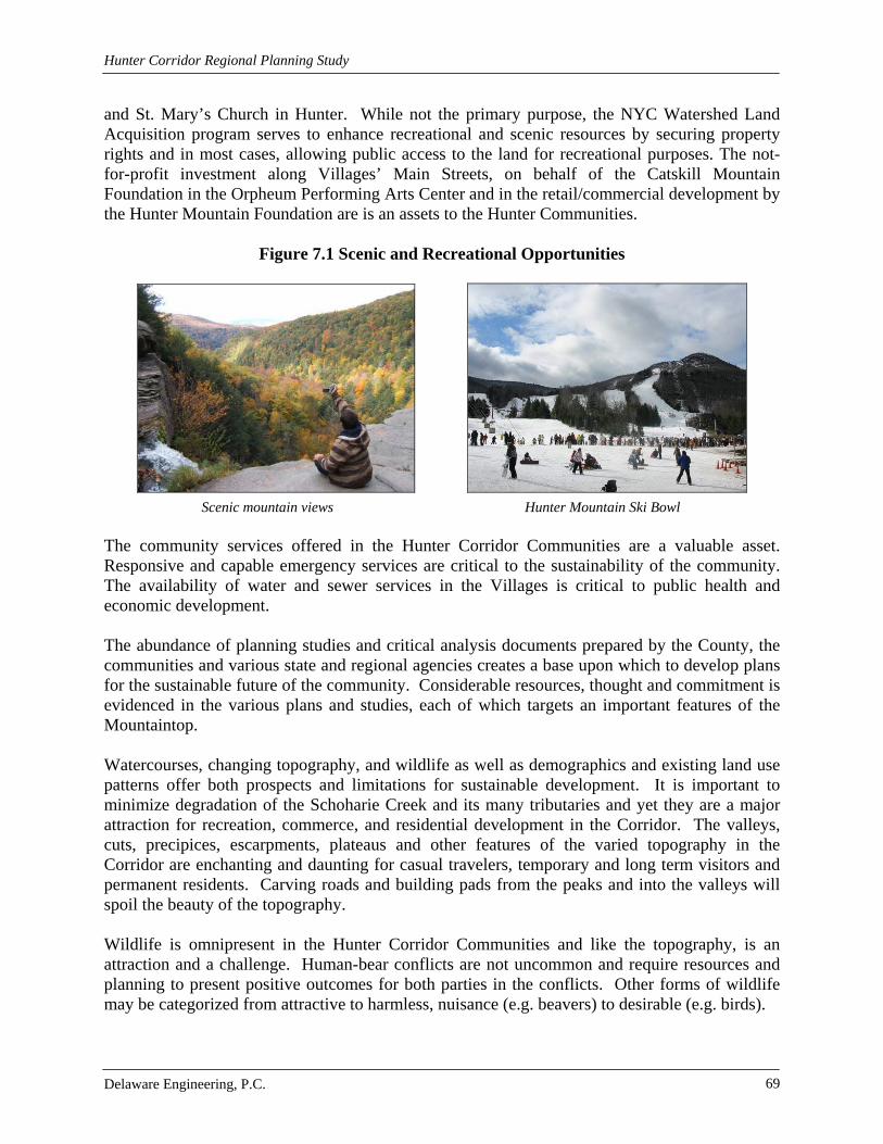
Hunter Corridor Regional Planning Study
Delaware Engineering, P.C. 69
and St. Mary’s Church in Hunter. While not the primary purpose, the NYC Watershed Land Acquisition program serves to enhance recreational and scenic resources by securing property rights and in most cases, allowing public access to the land for recreational purposes. The not-for-profit investment along Villages’ Main Streets, on behalf of the Catskill Mountain Foundation in the Orpheum Performing Arts Center and in the retail/commercial development by the Hunter Mountain Foundation are is an assets to the Hunter Communities.
Figure 7.1 Scenic and Recreational Opportunities
Scenic mountain views Hunter Mountain Ski Bowl The community services offered in the Hunter Corridor Communities are a valuable asset. Responsive and capable emergency services are critical to the sustainability of the community. The availability of water and sewer services in the Villages is critical to public health and economic development. The abundance of planning studies and critical analysis documents prepared by the County, the communities and various state and regional agencies creates a base upon which to develop plans for the sustainable future of the community. Considerable resources, thought and commitment is evidenced in the various plans and studies, each of which targets an important features of the Mountaintop. Watercourses, changing topography, and wildlife as well as demographics and existing land use patterns offer both prospects and limitations for sustainable development. It is important to minimize degradation of the Schoharie Creek and its many tributaries and yet they are a major attraction for recreation, commerce, and residential development in the Corridor. The valleys, cuts, precipices, escarpments, plateaus and other features of the varied topography in the Corridor are enchanting and daunting for casual travelers, temporary and long term visitors and permanent residents. Carving roads and building pads from the peaks and into the valleys will spoil the beauty of the topography. Wildlife is omnipresent in the Hunter Corridor Communities and like the topography, is an attraction and a challenge. Human-bear conflicts are not uncommon and require resources and planning to present positive outcomes for both parties in the conflicts. Other forms of wildlife may be categorized from attractive to harmless, nuisance (e.g. beavers) to desirable (e.g. birds).

Hunter Corridor Regional Planning Study
Delaware Engineering, P.C. 70
Human settlement patterns and demographic conditions offer a mix of promise in terms of a ready base of good workers to limitation in terms of lack of a cohesive built environment. The most cohesive development pattern is offered in the Village of Tannersville, and the community has taken advantage of this and has attracted significant attention within the region and in the New York Metropolitan Area. An infusion of public and private investment in both Villages is poised to set the stage for scale and use appropriate growth as the economy improves. The Hunter Corridor Communities host a full time resident population that is capable of contributing significantly to the economy, but may be considered chronically underemployed due to the seasonal nature of the local economy. Winter and summer months offer the best employment opportunities, while shoulder seasons in the spring and fall can be more challenging. Anecdotal evidence suggests that many full time residents work at several jobs throughout any given year, and some must leave the Mountaintop for work. Constraints to development are present in the form of steep slopes, hydric soil conditions and the presence of wetlands. Development on steep slopes can cause erosion and unstable soil condi-tions. Sedimentation caused by erosion can change drainage patterns and cause flooding. Hydric soils do not support construction of substantial foundations nor can septic systems be properly sited and constructed in the presence of steep slopes and hydric soils. Wetlands serve an important function to provide habitat for plants and animals and ameliorate flooding, but their presence significantly constrains the development-appropriate available land base. The Hunter Corridor presents a number of opportunities and constraints to sustainable development. While there is a need to strengthen the local economy, the purpose of this study is to identify potential impacts of development on the environment, in particular water quality and offer mitigation measures and recommendations that provide a means to accomplish sustainable economic development. This study identifies one of the most significant challenges to sustainable development as conventional site design that results in negative consequences to water quality, the environment and the cost of community services. 7.2.2 Recommendations Better Site Design (BSD) is the use of innovative planning techniques for the purposes of reducing stormwater runoff which minimizes the negative effects it has on the environment and the cost of community services. BSD is intended to reduce overall impervious cover, integrate stormwater management into site design more effectively, and preserve natural areas. Vegetated cover and natural soils allow for better infiltration of stormwater. The decrease in impervious cover will result in a decrease in stormwater runoff, associated pollutants, and infrastructure maintenance costs. Chapter 18 of the NYC Watershed Rules and Regulations define BMPs as “means methods, measures or practices determined to be the most practical and effective in preventing or reducing the contamination to or degradation of the water supply. Best Management Practices include, but are not limited to, structural and nonstructural controls and operations and maintenance procedures, that can be applied before, during or after regulated activities to achieve the purposes stated herein.”
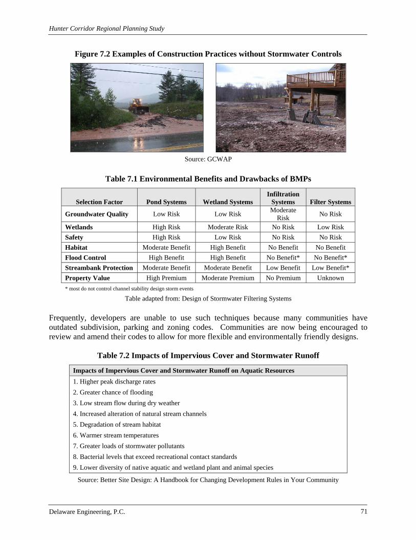
Hunter Corridor Regional Planning Study
Delaware Engineering, P.C. 71
Figure 7.2 Examples of Construction Practices without Stormwater Controls
Source: GCWAP
Table 7.1 Environmental Benefits and Drawbacks of BMPs
Selection Factor Pond Systems Wetland Systems Infiltration
Systems Filter Systems
Groundwater Quality Low Risk Low Risk Moderate
Risk No Risk
Wetlands High Risk Moderate Risk No Risk Low Risk
Safety High Risk Low Risk No Risk No Risk
Habitat Moderate Benefit High Benefit No Benefit No Benefit
Flood Control High Benefit High Benefit No Benefit* No Benefit*
Streambank Protection Moderate Benefit Moderate Benefit Low Benefit Low Benefit*
Property Value High Premium Moderate Premium No Premium Unknown
* most do not control channel stability design storm events
Table adapted from: Design of Stormwater Filtering Systems
Frequently, developers are unable to use such techniques because many communities have outdated subdivision, parking and zoning codes. Communities are now being encouraged to review and amend their codes to allow for more flexible and environmentally friendly designs.
Table 7.2 Impacts of Impervious Cover and Stormwater Runoff
Impacts of Impervious Cover and Stormwater Runoff on Aquatic Resources
1. Higher peak discharge rates
2. Greater chance of flooding
3. Low stream flow during dry weather
4. Increased alteration of natural stream channels
5. Degradation of stream habitat
6. Warmer stream temperatures
7. Greater loads of stormwater pollutants
8. Bacterial levels that exceed recreational contact standards
9. Lower diversity of native aquatic and wetland plant and animal species
Source: Better Site Design: A Handbook for Changing Development Rules in Your Community

Hunter Corridor Regional Planning Study
Delaware Engineering, P.C. 72
Construction and post-construction stormwater runoff often results in erosion, flooding and severe degradation of surface waters (wetland, lake, stream, river). Unless stormwater is controlled it will harm the local quality of life through flooding, washouts, pollution of drinking water and swimming areas, degradation of natural systems and a loss of native species. Developers can reduce impacts on the environment by using BSD practices to reduce impervious cover and increase green space.
Figure 7.3 Floodplain Expansion as a result of New Development
Source: NYS Stormwater Management Design Manual
Phosphorus is a substance found in nature and in substances such as pesticides and fertilizers. Stormwater runoff carries phosphorus to local bodies of water. Impervious cover increases the amount of runoff and the amount of phosphorus deposited in water bodies where at excessive levels, it causes eutrophication resulting in algal blooms that affect water quality. The algal blooms may cause a condition called oxygen sag, where the levels of dissolved oxygen in the water fluctuate radically creating an environment that cannot support diverse aquatic life. In addition, the presence of algae in drinking water supplies can result in unpleasant taste and odor and the creation of unhealthy byproducts in the presence of chlorine disinfectant.
Table 7.3 Total Phosphorous Source Areas
Source of Phosphorous Phosphorous Concentration
(mg/L) Rooftop 0.11
Commercial Parking Lot 0.45
Industrial Parking Lot 0.65
Residential Street 0.63
Commercial Street 0.47
Urban Highway 0.40
Lawn 1.67
Driveway 1.16
Typical Stormwater 0.30
Table adapted from: Design of Stormwater Filtering Systems

Hunter Corridor Regional Planning Study
Delaware Engineering, P.C. 73
Eutrophic conditions can cause hypoxia, a low concentration of oxygen in a body of water. It is caused by the introduction of excess nutrients like nitrogen and phosphorus. These excess nutrients support increased algal growth. The low levels of oxygen are a result of dead algae decomposition. Nutrients (Nitrogen and Phosphorus) can come from sources such as:
Fertilizers and pesticides Erosion of soil and other organic matter Discharges from wastewater treatment plants
Hypoxia kills fish, aquatic vegetation, land animals which feed on them and disrupt ecosystems. Some aquatic animals can survive a hypoxic event by migrating to waters where there is more oxygen present. Less mobile animals like mussels and crabs are often killed. Hypoxia causes a severe decrease in the amount of aquatic life. It also affects the ability of young aquatic animals to find food and habitat necessary to thrive in adulthood. As a result aquatic animal populations become less stable because less young are able to reach adulthood. Hypoxia also affects groups of animals that rely on fish for food.
Figure 7.4 Pollutant Pathways
Source: Better Site Design: A Handbook for Changing Development Rules in Your Community
Streets provide several pathways for stormwater pollutants. Atmospheric pollutants settle and are washed onto streets during rain events. Pavement fragments, vehicle emissions, tire and brake pad particles also contribute. Snow collected on the street edge melts and contributes salts and sediment. Leaves and grass, which naturally contain phosphorus, are blown into the street. Curb and gutter systems collect all of the stormwater runoff from the streets and transport it directly into local bodies of water.
Because the Hunter Communities are located in the upper reaches of the watershed that provide drinking water to NYC, they have an impact on drinking water quality for Southern New York. It is important to encourage LID in order to protect water quality. By making land use regulations more flexible and educating site plan reviewers on BSD, the Hunter Communities can meet community goals. Low Impact Development (LID) is an alternative approach to site planning and design that uses creativity in designing projects to minimize costs and landscape impacts. LID places more emphasis on changing and updating municipal codes. BSD puts more emphasis on water quality. LID includes BSD planning and implementation of BMPs. Incorporating LID concepts into local codes would allow more options to encourage creative project designs that could cost the community less in the long run.

Hunter Corridor Regional Planning Study
Delaware Engineering, P.C. 74
The Sugar Maples Center for Creative Arts in nearby Maplecrest has incorporated innovative stormwater management practices. These include the creation of a wetland, pervious parking and walking paths, and the implementation of a rain garden.
Figure 7.5 Sugar Maples Stormwater Management
Permeable walking path during construction Permeable walking path after grass establishment
Raingarden in front of Ceramic Arts Building Reconstructed Wetland
Partially completed permeable parking area. Stormwater wetland in center of photo, Stone subbase, topped by geoweb filled with permeable parking area to the left soil and stone. and kiosk behind the wetland.

Hunter Corridor Regional Planning Study
Delaware Engineering, P.C. 75
7.3 Infrastructure
7.3.1 Analysis
7.3.1.1 Water The geology in the region presents a number of challenges to the development of water supplies within the Town of Hunter. Low or instable production rates as well as the presence of arsenic, radon and sodium in ground water sources area not uncommon. For the Village of Hunter, the new sources incorporated in the Village water supply permit results in 29,000 gallons of excess capacity available to accommodate new connections. This is based on a comparison of water supply versus the highest peak day. At 250 gpd per single family residence, this equates to approximately 116 housing units of capacity. Further, recent construction enhancements suggest that additional excess water capacity will soon be apparent as on-going water records are monitored. In the Village of Tannersville, NYSDOH views the capacity of the existing water system as inadequate despite the system having supplied the needs of the Village for some time. The system does not have sufficient raw water resources. Peak daily demand needs to be met which means they Village needs a 200,000 gallon per day reservoir to be located off-line in the case that peak day demand is met. There is an unused water storage tank located near the Sun View residential area. Moreover, from a practical perspective, in the event of an extended drought it is likely that the Village would have to deal with water shortages and restrictions. The lack of source capacity will also eventually pose a problem to the Village in that it will limit economic development and new tax base opportunities. However, DOH states that while the filters perform well, the plant is old and needs attention in several areas. The DOH has stated that additional connections to the water system will not be approved until existing problems are eradicated. Major concerns for the Tannersville water system are: treatment of the Rip Van Winkle well for arsenic; development of additional source capacity; address the line from Dibble Dam; make improvements to the plant. Source capacity needs to be increased and the water treatment plant needs to be upgraded according to the DOH.
7.3.1.2 Wastewater Soil conditions and topography limit the locations where subsurface wastewater disposal systems can be successfully implemented in the Town of Hunter. Construction of mound, fill and raised systems are often offered by those wishing to develop land as mitigation for poor soil conditions. Larger scale developments (more than a multi family home) must either construct centralized or decentralized treatments systems or seek to connect to the existing collection systems in the Villages. The Village of Hunter wastewater collection system and treatment plant are state-of-the-art and operate in compliance with applicable regulations. Infiltration and inflow issues with several collection systems consolidated into the new collection system and treatment plant have been addressed. The Village currently has excess capacity of approximately 182,000 gallons per day

Hunter Corridor Regional Planning Study
Delaware Engineering, P.C. 76
on an average day and 57,800 gallons per day on a peak day. This equates to roughly 1200 housing units of capacity on an average day and 230 housing units of capacity on a peak day. The Village has a Sewer Use Law that governs use of the Village’s sewer system. Connection fees are established by the Village Board. The sewage collection system and wastewater treatment plant that serves the Village of Tannersville is owned and operated by the NYCDEP. Add info once received from DEP.
7.3.1.3 Stormwater The CWC study for the Village of Hunter observed swales that exhibited areas of erosion. Within the swale or immediately adjacent to the swale, there was poor vegetative cover or excessive sediment buildup. Only a section of the swale needed to exhibit one or more of these criteria to be considered in poor condition and in most cases only a section of the swale and not the entire swale was in poor condition. These swales represent a potential source of suspended solids to stormwater. Generally, any one individual swale may not represent a significant source of sediment; however the cumulative sediment load from stormwater runoff from all impacted swales could increase the stormwater sediment loading to the Schoharie Creek. Culvert inlets and outlets represent sediment source areas. Areas of erosion and runoff patterns in bare soil were observed at either the inlet or outlet of many culverts in the Village of Hunter. Generally, any one individual culvert may not represent a significant source of sediment; however, the cumulative sediment load to stormwater runoff from all impacted culverts could increase the stormwater sediment loading to the Schoharie Creek. Stabilization of problem culvert areas would reduce the sediment loading to stormwater.
Figure 7.6 Stormwater Runoff Carries Sediments to Local Streams and other Bodies of Water

Hunter Corridor Regional Planning Study
Delaware Engineering, P.C. 77
Significant flooding has periodically occurred in the downstream reach of Trib 140. In addition to the economic impacts and hardship associated with property destruction, flooding can cause stream bank erosion, increased sediment loading and mobilization of pollutants. Trib 140 flooding is a function of several factors. Two primary factors limiting stormwater flow in Trib 140 include the low gradient between Botti Drive and Route 23A and the Trib 140 culvert at Route 23A. The Trib 140 culvert at Route 23A is currently a 4’x6’ arched culvert, which is insufficient to carry storm water flows. Stormwater runoff from the Trib 140 watershed to the Route 23A culvert for a 25-year and a 50- year storm was analyzed. Data indicate that for both a 25-year and a 50-year storm, stormwater would overflow Route 23A and would therefore flood adjacent properties between Botti Drive and the Trib 140 box culvert on Route 23A.
Table 7.4 Storm Elevations
Route 23A Elevation 25-Year Storm Elevation 50-Year Storm Elevation
1,596 feet amsl* 1,597.24 feet amsl 1,599.22 feet amsl *above mean sea level A reduction in the frequency and extent of flooding in Trib 140 west of Botti Drive will require diversion of stormwater runoff that exceeds the capacity of Trib 140 west of Botti Drive and modification of the Trib 140 outlet at Route 23A. The Trib 140 culvert/outlet at Route 23A will be replaced as part of the New York State Department of Transportation funded reconstruction of Route 23A through the Village of Hunter. The Trib 140 Route 23A crossing has been redesigned and is scheduled to be completed during the 2006 construction season.
Figure 7.7 Botti Drive Crossing
The Route 23A reconstruction project was a unique one time opportunity to implement a Trib 140 stormwater diversion project. By combining the stormwater diversion with the Route 23A reconstruction the stormwater diversion was accomplished at a reduced cost by eliminating a separate contractor procurement phase for the diversion project and using the volume unit rates provided by the Route 23A contractor.

Hunter Corridor Regional Planning Study
Delaware Engineering, P.C. 78
Figure 7.8 Route 23A Reconstruction
A full depth reconstruction of Route 23A east of the intersection with Route 296 began in 2005. This reconstruction involved significant modification of the existing Route 23A stormwater system. Therefore, an inventory of the existing stormwater infrastructure along Route 23A east of the Route 296 intersection was not conducted. The reconstruction project included installation of three Vortech stormwater treatment units and a stormwater treatment dry swale. These projects will improve the stormwater quality prior to discharge to the Schoharie Creek. The reconstruction also includes stabilization of an eroding bank along the Schoharie Creek. Stabilization of the bank will reduce the Schoharie Creek sediment load during storm events.
Figure 7.9 Vortech System Installed in Village of Hunter
The steep terrain and drainage patterns west of the Garfield Road and east of the Route 296 intersections with Route 23A prohibit installation of any stormwater treatment structures between Garfield Road and Route 296. West of the Route 296 intersection with Route 23A the steep slope down to the Schoharie Creek on the south side of Route 23A prohibits situating a standard or non-standard standard stormwater treatment practices on the south side of Route 23A. On the north side of Route 23A the mountainous terrain significantly increases the pervious acreage within the contributory drainage to the existing drainage swale on the north side of Route 23A, which prohibits situating of stormwater treatment structures in this area do to size constraints and physical constraints associated with underground water and sewer utilities.

Hunter Corridor Regional Planning Study
Delaware Engineering, P.C. 79
Part of the stormwater flow from Trib 140 east of Botti Drive was diverted to the Schoharie Creek by installing a new stormwater sixty inch drainage line south on Botti Drive, cross beneath Route 23A and discharge to the Schoharie creek. The Trib 140 base flow continues to flow west down Trib 140 through a twenty-four inch culvert beneath Botti Drive. Stormwater modeling indicates that this configuration reduces flooding west of Botti Drive.
Figure 7.10 Trib 140 (April 2007)
Looking North toward SR23 Looking South from SR23 The channel of the Mad Brook at Glen Avenue is created by dry masonry stone walls that connect to a box culvert which conveys the Mad Brook under State Route 23A. Approximately 20 feet on the southwest corner of the box culvert disturbed during construction of the sanitary sewer lines was repaired before 2005. In 2005 heavy rains and flooding compromised the dry masonry stone walls. In addition to the repairs necessary for the channel at the Mad Brook, the heavy rains washed out the sidewalk on the north side of NYS Route 23A from Ferraro Road to St. Mary’s Church. This sidewalk, while located within the NYSDOT Right-of-Way is the maintenance responsibility of the Village under Section 46 of the Highway Law. Federal money was secured by the Village in order to make appropriate repairs.
Figure 7.11 Mad Brook Stream Crossing
West of Glen Avenue, Looking North

Hunter Corridor Regional Planning Study
Delaware Engineering, P.C. 80
There are known problem areas in the Village of Tannersville where the stormwater collection system no longer performs effectively or where recent, significant storm events have exposed weaknesses. The steep topography and erodible and limited permeability soils found around Tannersville make effective control of stormwater related erosion, sedimentation and flooding difficult. The system has failed to convey stormwater during routine rainfall and snowfall events to the extent that it overflows roadways. This results in icy conditions in the winter and erosion and sedimentation in warmer months. Residential and business properties connect sump pumps to their sewer laterals in order to get rid of stormwater that has flooded their basements. This flooding causes damage to properties along with serious health and safety issues. One recent example of the fragility of local environment is the severe erosion and deposition of sediment into Rip Van Winkle Lake that reputedly occurred during a storm event in 1996. Massive flows of sediment from Cortina Valley Ski Resort reputedly inundated the Gooseberry Creek and filled a significant portion of the eastern portion of Rip Van Winkle Lake. The lake at present suffers from a severe lack of depth and dense aqueous vegetation. Eutrophication has reduced the depth of the water significantly hampering the water body’s ability to self-cleanse. The lake has still not recovered and silt has yet to be dredged. The east end of the lake is virtually unfishable. Other storm water problems include frequent flooding along Sawmill Creek and flooding in residential areas of Spring Street. Erosion during storm events is a problem along Sawmill Creek, and especially along Railroad Street and Spruce Street. On South Main Street the outfall has created a new sedimentation problem in Rip Van Winkle Lake Various features of the stormwater controls in the Village of Tannersville, particularly roadside swales, are prone to erosive forces from high runoff events. The swales are predominantly vegetated without stone or other more stable lining. Water velocity and depth of flow are the main factors in the de-stabilization of the bottom and banks of drainage courses. The relatively steep topography of many areas within the Village contributes to these higher velocities. Lack of stable lining has contributed to generated sediments found within some of the culverts, catch basins and swales downstream of these eroded areas. It appears most eroded areas have been repaired in kind without the benefit of aggressive controls to limit further erosion and sedimentation.
7.3.1.4 Traffic, Transportation and Parking To identify the potential traffic growth associated with the future development, a trip generation analysis was completed. Trip generation determine the quantity of traffic expected to travel to/from a proposed site. With the high percentage of future growth attributed to residential land uses (see Build-Out Analysis), it is anticipated that the Commercial, Recreation and Enter-tainment, and Community Services land uses will be intricately connected to the residential uses. In addition, the location of the future growth immediately adjacent to the Village boundaries provides an opportunity for multi-modal or multi-use trips. Trip generation estimates were prepared based entirely upon residential land uses. At low build out conditions, the number of trips at the study intersections increased four fold, with the highest growth scenario resulting in up to a thirteen times increase in trips. Given growth the slow growth trend of the past decade and the current economic outlook, the traffic analysis focuses on doubling traffic at the studied intersections and doubling that again (four times existing) which matches the low growth projection.

Hunter Corridor Regional Planning Study
Delaware Engineering, P.C. 81
Intersection Level of Service (LOS) and capacity analysis relate traffic volumes to the physical characteristics of an intersection. Levels of service range from A to F with level of service A conditions considered excellent with very little delay while level of service F generally represents conditions with very long delays. LOS for streets in the Corridor under currently conditions are A to B, with a single C rating for Clum Hill Road northbound. Doubling traffic drops the level of service from B to D at Route 214 northbound and B to F at Clum Hill northbound. Four times the existing number of trips results in a number of failures and considerable delays at most intersections in the Corridor. Accident data was requested from NYSDOT to determine accident trends along NY Route 23A within the Corridor. Accident summaries and details were provided by the NYSDOT Safety and Information Management System for the latest three years of available data from the period between November 1, 2006 and October 31, 2009. Based on the NYSDOT accident records, a majority of the accidents occurring on the studied roadways and intersections involved collisions with fixed objects and animals due to the rural characteristics of the area, driver error and inattention, alcohol involvement, and unsafe speeds. Both sight distance and stopping distance was evaluated for the major intersections in the Corridor. The Route 214 intersection with Route 23A provides both adequate sight and stopping distances under existing conditions. The Route 23A intersection with Hill Street and Railroad Avenue does not feature recommended sight distances although adequate stopping distances are provided. The Route 23A Clum Hill Road intersection does not provide adequate sight distance or stopping distance.
7.3.2 Recommendations
7.3.2.1 Water During the SEQR and site plan review process for projects proposed in the Town of Hunter, the planning board should take a hard look at the siting of on-site wells and require conformance with NYSDEC well drilling and testing practices. Water supplies should be established and documented as part of the site plan and/or subdivision review process to ensure the safety and adequacy of supplies. Separation distances recommended in NYSDEC and NYSDOH guidance should be considered during the review of site plans. If community systems are proposed, it is recommended that the planning board require submission of a report from a qualified engineer or geologist for review during the local approval process. Additional source water capacity is needed in both Villages. In the Village of Hunter, additional capacity is needed to accommodate substantial development. Recent investments in a new water filtration plant as well as the replacement of leaking lines are sufficient for a reasonable planning horizon; however, it is recommended that all new developments with demands beyond those for a minor subdivision be required to conduct a water system evaluation during the site plan and SEQR process. The purpose of the water system evaluation is to determine the demands of the project, the capacity of the existing system to serve the project in terms of water volume, quality and pressure, and necessary mitigation measures.

Hunter Corridor Regional Planning Study
Delaware Engineering, P.C. 82
In the Village of Tannersville, additional source water capacity is also needed to address current regulatory concerns as well as to accommodate future development. Plans to reconstruct Dibble Dam would encounter multiple State and Federal environmental permitting issues related to fisheries, habitat disturbance, wetlands, dam safety, and DEP stormwater controls that would have to be overcome in order to rebuild the dam. While it may be possible to permit reconstruction of Dibble Dam, it would be a long and costly process. In addition, the permit capacity would likely be much less than the 366,000 gpd for which it is currently permitted, since neither DEC or DEP would allow the Village to divert the entire stream flow in drought conditions. As stated, there is an array of permit issues that will limit activities to rebuild Dibbles Dam. In addition, water withdrawals from a surface intake will be restricted during times of drought when an additional water source is needed the most. The most feasible option to make use of the existing transmission infrastructure from this source appears to be construction of an infiltration gallery along the stream. Ledge rock is present at the dam, but there appears to be some depth of gravel upstream at the newer pump house. To evaluate the feasibility of construction of an infiltration gallery at the site, it will be necessary to drill a number of soil test borings to confirm there is a sufficient depth of saturated sand and gravel from which to draw water. The existing bedrock well at the Park yields 80,000 gpd, but the water contains arsenic as well as sulfur. Water from this well will need to be treated if the Village is to continue using it. One option to increase the capacity would be to drill a second well in the same vicinity and run both to a common treatment system. A slightly larger filter to treat a second well would add little to the cost and could potentially double the supply from this source. While this is probably a viable option, there is little that can be done to confirm viability short of drilling the actual production well which is a significant cost. The existing wells are drilled in bedrock. But there may also exist water bearing sand and gravel above the bedrock which, if developed would have the potential to supply a better quality water than the existing well. To assess whether such a water source exists, it will be necessary to drill one or more test holes to bedrock. If observations during drilling suggest a potentially viable water source, then further detailed test holes would be needed in a second phase of work to optimize production well locations. The area above Reservoir No. 2 and below Reservoir No. 3 is reportedly the site of springs and seeps which are a further potential source of water. The seeps occur along the stream and at the foot of the very steep hills to the west. This is not likely to be true “spring” water, but it is likely to be of much better quality that the surface waters, particularly in the summer when manganese problems at the plant are the worst. There is an existing water line nearby that could be used to convey water collected from the seeps to the treatment plant. To assess the potential capacity of these springs, the first step would be to dig a series of test pits in this area, allowing the seepage to run and making a qualitative assessment of flow. If significant flow is observed, the excavated areas would be left open for observation over the summer months to determine the sustainability of this potential source.

Hunter Corridor Regional Planning Study
Delaware Engineering, P.C. 83
The Tannersville water treatment plant is permitted to treat 500,000 gpd, which is sufficient to meet the Village’s needs. However, DOH states that while the filters perform well, the plant is old and needs attention in several areas. DOH’s review is based on limited time spent at the facility and may be misguided or an overreaction in some cases and may have even missed sig-nificant issues. While the DOH’s concerns merit discussion, their priorities for the plant include:
Filters are old and the backwash mechanism may not be working as originally designed. Chemicals should be tested to see if better cleaning of the filters is possible. The filter inlet should be improved.
One flocculation basin is out of service and the equipment speed may need to be reduced
to improve efficiency of treatment. Clarification and Settling Basins should be covered to keep leaves and animals out and
for safety reasons. In addition, a screen should be installed before the filters. Security and remote monitoring of the plant needs to be improved. Chemical loading and storage facilities need to be improved. While DOH does make a
direct statement, uncontained storage of chemicals in the Watershed is a liability and risk for the Village.
Drums of paint waste were noted at the plant. These need to be tested and disposed of
since they could be a hazardous waste, stored there in violation of DEC and DEP regulations.
The backwash basins discharge to a storm drain. It needs to be determined whether there
is a DEC permit for this discharge. Water plants of this age often do not have a permit, since DEC and DOH did not require one at the time of construction.
Eliminate the pressurized raw water line going back to Dibble Dam. It needs to be
determined whether there are raw water connections to customers. Extend the inlet pipe in the tank to improve disinfection of the water. Address issues at Sunny View tank.
The final improvements that comprise a comprehensive project are upgrades to the treatment plant itself. There are miscellaneous areas of steel and concrete decay that can be addressed by DPW staff or the operators over time or if more feasible, this work could be completed by an outside contractor. The main component of the plant is the Infilco-Degremont filters. These units are over 20-years old and are still producing water that DOH found to be of consistently good quality. Nevertheless, more than most treatment systems, the filters rely on mechanical systems that wear overtime and eventually break down.

Hunter Corridor Regional Planning Study
Delaware Engineering, P.C. 84
One other issue at the plant that requires consideration is the discharge from the filter backwash system. At the time the plant was built, a SPDES (discharge) permit was not commonly issued for discharge of waste backwash water from filter plants. However, issuance of such permits became routine ten or more years ago. Not unlike other plants of a similar age, the Tannersville plant still does not have a permit. There are significant consequences for a municipality and for the operator personally for what DEC now considers an unpermitted discharge.
7.3.2.2 Wastewater The following recommendations are made with respect to wastewater treatment for projects located in the Town of Hunter:
a. Carefully evaluate site plans to determine if proposed wastewater disposal systems meet regulatory standards including percolation rate, system design, limiting distances and separation distances from waterbodies and wells.
b. For larger developments where centralized systems are proposed, consider hiring an engineering consultant whose costs are funded by the applicant to assist the planning board in evaluating the proposed wastewater collection and treatment system during the site plan and SEQR review.
c. Coordinate with NYSDEC and NYCDEP as appropriate to obtain input on proposed wastewater disposal systems early in the review process to avoid the need to change plans later in the review process.
There are no recommendations with respect to regulatory compliance or capacity building for either Village wastewater collection or treatment system. The Village of Hunter has a Sewer Use Law in place that is intended to govern the use of the sewer system and that will ensure that capacity is evaluated as each request for connection is made. It is recommended that the Village of Tannersville coordinate with NYCDEP to gain a common understanding of the procedures and requirements for connection to the City-owned system. As development opportunities arise in the Village, it will be important for the Village to be able to effectively communicate the request for connection and hook up process to prospective developers. In addition, the Village should be cognizant of the capacity and availability of wastewater capacity at the City-owned plant as land use and planning decisions are made.
7.3.2.3 Stormwater Implementation of effective stormwater management is a critical element in accommodating environmentally sensitive development that also contributes to the Hunter Communities economy. Major recommendations are:
Create and fund a dedicated stormwater technical assistant Implement the capital projects identified in the Comprehensive Stormwater Assessments Incorporate Better Site Design principal into local land use regulations Consider creating special districts and/or adopting local laws to govern and fund
stormwater management

Hunter Corridor Regional Planning Study
Delaware Engineering, P.C. 85
The creation and funding of a stormwater specialist is strongly recommended. The Hunter Communities, together with all of the communities in the Schoharie Basin, would benefit greatly from the guidance and technical assistance that could be provided by a stormwater specialist. The stormwater specialist would act as a technical resource to guide planning boards, building inspectors, landowners, and developers in the site plan review process, incorporating green infrastructure techniques, and interpreting state and city stormwater regulations in relation to site designs. The stormwater specialist could serve as a conduit for regulatory agencies engagement and review to ensure standards are followed in accordance with local, state, federal and city requirements. While professional assistance is engaged by some communities for the review of some development projects, a resource that is consistently available for the review of all development and local conditions not associated with development is unavailable. The stormwater specialist would serve the entire Schoharie basin (eleven communities) and build on stormwater mitigation recommendations set forth in this plan, as well as other land use planning projects funded under the Schoharie Watershed Impact Studies, such as Windham’s Generic Environmental Impact Statement (GEIS), Jewett’s Generic Environmental Impact Statement, the Manor Kill Watershed GEIS, and the Roxbury GEIS. It is recommended that funding to support the stormwater specialist is requested from the Shandaken Tunnel SPDES permit. Establishment of funding for a five year pilot position under the umbrella of the GCSWCD is recommended. The stormwater specialist could work from the the Schoharie Watershed Program office in Tannersville, making use of existing facilities and equipment. There is broad support for the establishment of the stormwater specialist from the Hunter Communities’ land use officials who recognize that professional assistance is needed to provide guidance in the implementation of BSD practices and stormwater pollution prevention plans. In addition, the stormwater specialist could assist the communities in developing local stormwater protection plans, stormwater infrastructure maintenance programs, public outreach and education, and the implementation of drainage districts. The communities should seek funding to implement the capital projects identified in the comprehensive stormwater assessments. Some of the identified projects have been constructed in both Villages; however, on-going evaluation of priorities and implementation is the only means to improve drainage, obviate flooding and reduce sedimentation and erosion. If funding is available to hire a stormwater specialist, that person could assist the communities in planning the implementation of the capital projects identified in the Stormwater Assessments. In addition, the Hunter Corridor Communities are encouraged to adopt the use of Better Site Design principals (See Section 7.2.2). These are land planning techniques that reduce the poten-tial impact of development and construction on water quality. This study incorporates recom-mendations and tools that can be used by the communities during the site plan review process to shape development plans to avoid significant impacts to water quality. Another benefit of the proposed stormwater specialist could be to assist landowners and developers in incorporating BSD principles in the planning and design of development projects. Working proactively to incorporate BSD principles early in the planning of a project should reduce the upfront time and funding required to obtain a SEQR determination and site plan approval. It should also reduce the need to retrofit inadequate stormwater controls after development has occurred.

Hunter Corridor Regional Planning Study
Delaware Engineering, P.C. 86
The Town of Hunter may wish to consider the implementation of drainage districts for existing and proposed projects or for areas in the town likely to be subject to intense development. Appendix F provides a summary of the statutory process to establish a special district under New York State Town Law. The implementation of drainage districts could be accomplished in several ways. One approach is proactive, another is on a project specific basis and yet another is to address existing stormwater problems. Under the proactive approach, the proposed stormwater specialist would assist the town in using this study along with local plans to identify the areas in the Town most likely to be subject to intense development before it occurs. These areas would be analyzed to determine major drainage basins. The boundary of each area under consideration would be geographically defined and the area reviewed to ensure that it is unified from a watershed perspective (so stormwater management can be cohesive) and is appropriately sized to be efficiently managed. With assistance from the stormwater specialist, the Town would craft a district or districts so that a comprehensive and cohesive watershed based stormwater management plan can be implemented when development occurs within a district. Additionally, development within the district would fund the cost of planning and maintaining the infrastructure. The project specific approach to drainage districts would involve the Town requiring each development that will have permanent stormwater controls to create a drainage district. The drainage district would provide the mechanism for the Town to regulate the use of the stormwater system (e.g. no cross connections with sanitary systems, etc.) and a means for the Town to fund the maintenance and repair of the stormwater controls located within the development. In this way, the property owners that benefit from the provision of a particular stormwater system fund its operation and maintenance. As with the proactive approach, the stormwater specialist could assist the Town in establishing project specific districts. Another approach to implementing drainage districts would be for the proposed stormwater specialist to assist the Town in identifying existing problems, delineating the watershed impacted, and forming a drainage district to fund and govern stormwater improvements and controls to be implemented. For cross-jurisdictional stormwater issues (e.g. those in the town and a village) an intermuncipal agreement could be executed between the Town and the village that would allow the drainage district regulations to apply to the appropriate designated portion of the village. With respect to the villages, Village Law does not provide for the creation of special improvement districts per se, although Section 22 of Village Law that allows Villages to apportion the cost of an improvement upon benefited properties or to share the cost between benefited properties and the Village as a whole. This tool could be used by the Village as a means to implement cross-jurisdictional stormwater regulations/improvement projects or a stormwater improvement project wholly within the Village. The Town and villages may also consider evaluating Subchapter H, Watershed Protection Plans as provided in Section 18-81 of the NYC Watershed Regulations. This section provides that a local government of a town, village or county in the watershed may submit a proposed local

Hunter Corridor Regional Planning Study
Delaware Engineering, P.C. 87
government stormwater protection plan to the City for review and approval to allow the local government to undertake all or some aspects of the watershed protection set forth in Section 18-39 (Stormwater Pollution Prevention Plans (SWPPP) and Impervious Surfaces). In addition to the local government undertaking all or some aspects of watershed protection relative to SWPPPs and impervious surface regulations, the stormwater plan could support a request to waive the implementation of specific provisions of Section 18-39 including the limiting distance of 100 feet from a watercourse or wetland or within 300 feet of a reservoir, reservoir stem or controlled lake for projects located within some or all of the geographic boundary of the local government. The stormwater plan would have to meet certain criteria including delineation of the mechanisms that are at least as protective of the watershed as the provisions of Section 18-39 from which a waiver is sought and documentation of the local government’s commitment to implement the stormwater plan and coordinate projects for SEQR review as well as a description of the number and experience of technical personnel and resources that will be dedicated to implementing the stormwater plan. DEP approval of the plan is required to be recognized under this Section of the NYC Watershed Rules and Regulations. These approaches are among many. If the stormwater specialist is available, he or she could assist the Town (and all Towns within the Schoharie Basin) in creating customized approaches to implementing drainage districts and/or local government stormwater protection plans. 7.3.2.4 Traffic, Transportation and Parking The transportation recommendations incorporated in the Hunter Corridor Study are consistent with previous planning work including the Mountaintop Recreation Strategy and the Mountain Cloves Scenic Byway Corridor Management Plan (CMP). The Mountain Cloves CMP presents an opportunity to align strategies and tools to protect the resources the Hunter Communities feel are important to their sense of place. The Scenic Byway Plan identifies 17 objectives, four of which relate to the transportation network. These objectives include:
promoting access management on major corridors bicycle and pedestrian plans traffic mitigation for new developments intersection and travel way capital improvement plans
The Mountaintop Recreation Strategy has 17 recommendations with several specifically related to the transportation networks in and around Route 23A. One is the creation of a family multi-use trail across the Mountaintop beginning with the Kaaterskill Rail Trail, a project currently being implemented through a local trails committee. This recommendation is aimed at converting an old railroad bed into a multiuse path by connecting to the Huckleberry trail and connecting North/South Lake in Haines Falls to Dolan’s Lake in the Village of Hunter. Another recommendation of this study is the establishment of bike signage and lane designations/ enhanced shoulders on Route 23A, Route 23, Route 214, and County Roads 23C and 25.

Hunter Corridor Regional Planning Study
Delaware Engineering, P.C. 88
Figure 7.12 Dolan’s Lake Span Bridge
Intersection improvements such as construction of turn lanes and installation of traffic signals will likely impact right of way in the Corridor. Construction of turn lanes were buildings are located close to the sidewalk within the Villages will impact existing on-street parking, sidewalks and possibly buildings on corner parcels. It is recommended that the Hunter Communities monitor the impact current and future growth could have on the character of the Corridor and implement tools to accommodate growth without jeopardizing the scenic character of the Corridor Analysis of accident data reveals that most accidents were caused by driver behavior and/or were unavoidable (e.g. animals); however, the four pedestrian/bike accidents within the Villages should be evaluated to determine the need for improvements to existing signage and/or pedestrian and bike facilities. While the intersection of Hill Street and Railroad Avenue with Route 23A does not provide recommended sight distances, accident data does not currently support restricting the intersection with “no right turn on red” limitations under existing conditions. The intersection should be monitored to determine if increases in trips due to growth trigger a “no right turn on red” limitation in the future. While the intersection of Clum Hill Road with Route 23A does not meet recommended guidelines for sight and stopping distances, the condition is caused by the existing vertical curve in the road as well as the placement of existing buildings and vegetation. There is limited opportunity for mitigation of this condition other than the existing warning signs; nonetheless, the intersection should be monitored via accident trends to confirm if limited sight distances cause crashes at the intersection as the area grows. Sufficient parking is provided to accommodate current demands in both Villages within the Corridor. However, a concerted effort by the Hunter Corridor Communities and Greene County may result in additional demands for parking, particularly in the Village of Hunter where off-street parking is very limited and there is virtually no on-street parking on the east end of the Village. As a result of an analysis of vacant land for sale or located in proximity to land uses likely to demand parking, a number of potential parking lot locations were identified for the Village of Hunter, including an existing overflow parking lot owned by Hunter Mountain. While Tannersville’s commercial core is very compact and existing on and off street parking

Hunter Corridor Regional Planning Study
Delaware Engineering, P.C. 89
accommodates existing demands, growth may generate additional parking demands. An analysis resulted in identification of several parcels that may be suitable for parking lots, although crossing of the Sawmill Creek and topography limit potential parking locations. As parcels become available for purchase in both Villages, consideration should be given for land acquisition to support additional parking. As a rule of thumb, 125 cars will fit on a one acre parcel of land. Traffic impact studies should be required for future development plans to determine site-specific traffic-related impacts and mitigations. The Hunter Corridor Communities should investigate the potential to adopt transportation capacity improvements guidelines that limit the potential impacts to building and overall village/rural character. This type of policy may require that the Hunter Communities accept lower levels of services and operational capacities as a by product of preserving the character of the Corridor, especially in the built-up portions of the Corridor. This type of policy would require coordination with NYSDOT on state maintained and regulated roadways and intersections. As growth and development occur in the Corridor, it will become important to manage and control access to existing and newly developed parcels. Access Management is aimed at balancing the mobility function of the roadway with the access needs of the adjacent land uses. Benefits are many, including fewer decision points and conflicts for motorists, cyclists are given safer options for travel, pedestrians face fewer motorist access points, transit stops become more convenient, business owners benefit by easier access and parking, and communities gain a safer traveling environment with less need for roadway widening to accommodate increases in traffic. There are six access management techniques recommended for consideration by the planning boards of the Hunter Corridor Communities during site plan review. These techniques include planned pedestrian connections, shared driveways, cross access connections, access and turn restrictions, align driveways/roadways, and rear/side/shared parking. An Access Management Site Plan Review Checklist (AM Checklist) has been provided to facilitate planning boards in implementing these strategies. Local planning boards have some of the greatest powers with respect to roadway access and site planning. The AM Checklist incorporates evaluation questions that will assist the planning board in determining whether or not the necessary level of on-site management has been provided for both pedestrians and vehicles. Implementation of the various access management techniques will help to maintain qualities of the Corridor while allowing future development in targeted areas in the Hunter Corridor Communities. This is a goal of both the Corridor Study and the Scenic Byway CMP. The limited right-of-way and on-street parking in the Villages makes it difficult for bicycles to share the road with vehicles. However, as recommended in the Mountaintop Recreation Strategy, converting the abandoned railroad bed into a multi-use trail is a good way to provide a bicycle connection between the Villages. The Huckleberry Trail currently terminates at Bloomer Road and recent construction in the planned path of the trail will necessitate realignment. To continue the trail, it could proceed north approximately ½ mile on Bloomer Road where access easements could be pursued to reconnect with the former railroad bed.

Hunter Corridor Regional Planning Study
Delaware Engineering, P.C. 90
In addition, there may be an opportunity to construct a multi-use path or sidewalk along NY Route 23A between the Villages to provide a more direct connection for pedestrians and bicyclists, although there are a number of design constraints associated with this concept including open drainage ditches, stream crossings, heavy vehicle conflicts and the topography in general. The north side of Route 23A between Mitchell Road and St. Mary of the Mountain Church appears to be the logical location for a multi-use path. Further investigation is recommended to gain a better understanding of the desired characteristics of the path (e.g. seasonal versus year road, width, etc.). The Mountaintop Recreational Strategy suggests designating several roadways as bike routes. The designation of a roadway as a bike route requires installation of approved signage along a continuous routing with approval of the appropriate agency with jurisdiction (e.g. NYSDOT or County Highway). The communities are encouraged to continue working with the Greene County Highway Department and GCSWCD in establishing bike signage on local, county and state roads that meet the Manual on Uniform Traffic Control Devices standards as identified in Appendix E of the Transportation Evaluation.
7.4 Local Land Use Regulations Analysis and Recommendations
7.4.1 Analysis The Code Analysis performed as part of the Hunter Corridor Regional Planning Study can be found in Appendix F. Now that the codes have been reviewed the three communities must decide which development rules can be changed to promote BSD. The local codes serve as an excellent foundation for environmentally sensitive development practices and provide opportu-nity to include measures that encourage BSD principals in site planning. The Hunter Community will see significant growth in the near future given its infrastructure capacity and desirable location. This review will help guide development towards environmentally friendly practices. Not only are there environmental benefits to implementing MDPs, but the cost of doing business can be less for developers, especially in terms of reduced infrastructure costs, as more concentrated development is focused in the hamlet areas and parcels within 1,000 feet of existing water and sewer infrastructure. Providing guidelines that will direct future development would be helpful and advisable as the three communities grow and prosper. The Village of Hunter would like to update their zoning and implement a subdivision law. The Village of Tannersville is adopting zoning for the first time and the Town of Hunter would like to review codes in context with other projects they have going on (Climate Smart Growth action plan). The initial code review conducted under this project has positioned each community to advance to the next stage with making codes more environmentally friendly. To date there has been little flexibility in regards to using Low Impact Development practices. The NYS DEC Stormwater Design Manual is changing this year to include more MDPs and the NYC DEP regulations, amended in April 2010, are more aligned with the NYSDEC SPDES General Permit for continuity. Although differences of opinion on the efficacy of certain practices to mitigate stormwater remain, the regulatory agencies have endeavored to close that gap through the recent amendments.

Hunter Corridor Regional Planning Study
Delaware Engineering, P.C. 91
7.4.2 Recommendations for all Communities Recommendations for enhancements to local laws targeted towards water quality for all three communities include:
Design residential streets for the minimum width required to support traffic volume and
emergency services. Specify a maximum right-of-way width of 45 feet.
Figure 7.13 Relation of Street Width to Number of Accidents
This chart is from a traffic study relating street width to number of accidents. It shows that the occurrence of accidents decreased with as the width of the street decreased from 50 feet to 24 feet.
Source: Better Site Design: A Handbook for Changing Development Rules in Your Community
Specify a minimum cul-de-sac radius of 45 feet and encourage the creation of landscaped
islands in the middle. Cul-de-sac radii should be the minimum required to accommodate emergency vehicle access. Added landscaped islands will decrease the overall impervious cover, increase the amount of stormwater infiltration and add aesthetic effect.
Figure 7.14 Cul-de-sac Design to Reduce Imperious Surfaces
Source: Better Site Design: A Handbook for Changing Development Rules in Your Community

Hunter Corridor Regional Planning Study
Delaware Engineering, P.C. 92
Allow alternative turn-arounds in low density residential areas. Encourage alternative turn-arounds, such as the ones pictures below, instead of large paved cul-de-sacs. These have less paved area than conventional cul-de-sacs and will save costs associated with clearing, grading and paving.
Figure 7.15 Alternative Turn-Around Design to Reduce Impervious Surfaces
Source: Better Site Design: A Handbook for Changing Development Rules in Your Community
Specify that curb and gutters are not required for residential streets. Give developers
design criteria for other systems such as swales and biofilters that will provide stormwater treatment.
Figure 7.16 Open Vegetated Channels
Source: Introduction to Stormwater: Concept, Purpose, Design By Bruce K. Ferguson
Hammerhead Looped Road

Hunter Corridor Regional Planning Study
Delaware Engineering, P.C. 93
Figure 7.17 Typical Wet Swale Design
Source: www.polytechnic.edu.na
Provide shared parking agreements which encourage individuals to implement shared
parking. See the Transportation Evaluation (Appendix E) and the referenced Access Management Manual for additional information.
Specify parking stall dimensions (for commercial lots) of 9 feet by 18 feet. This will help
reduce impervious cover.
Table 7.5 Conventional Minimum Parking Ratios
Parking Requirement
Land Use Parking Ratio Typical Range
Single family homes 2 spaces per dwelling unit 1.5 - 2.5
Shopping center 5 spaces per 1000 ft2 GFA* 4.0 - 6.5
Convenience store 3.3 spaces per 1000 ft2 GFA 2.0 - 10.0
Industrial 1 space per 1000 ft2 GFA 0.5 - 2.0
Medical/dental office 5.7 spaces per 1000 ft2 GFA 4.5 - 10.0
* GFA = Gross Floor Area Source: www.stormwatercenter.net
Specify that a minimum percentage (10% for example) of parking lots need to be
landscaped with native vegetation.

Hunter Corridor Regional Planning Study
Delaware Engineering, P.C. 94
Require that open spaces be consolidated; require that a minimum percentage of open space be preserved with native vegetation (See NYS Open Space Conservation Plan 2009, http://www.dec.ny.gov/docs/lands_forests_pdf/osp09complete.pdf).
State that irregular shaped lots are allowed in the community.
Figure 7.18 Alternative Lot Layouts
Source: Better Site Design: A Handbook for Changing Development Rules in Your Community
Specify a minimum sidewalk width of 4 feet (ADA specifies a minimum width of 4 feet).
Do not require that sidewalks be located on both sides of the street; specify that sidewalks must be sloped towards front yards, so stormwater can drain to pervious areas.
Specify that one and two lane driveways should be 9 feet and 18 feet wide, respectively.
Allow residential driveways to be composed of alternative and pervious pavers. Allow “two track” driveway designs to be used. This will reduce impervious cover and the amount of stormwater generated as a result of large paved driveways.
Table 7.6 Water Quality Effectiveness of Various Pavers
Material Water Quality Effectiveness
Conventional Asphalt/ Concrete Low
Brick (in a loose configuration) Medium
Natural Stone Medium
Gravel High
Wood Mulch High
Cobbles Medium
Source: www.stormwatercenter.net
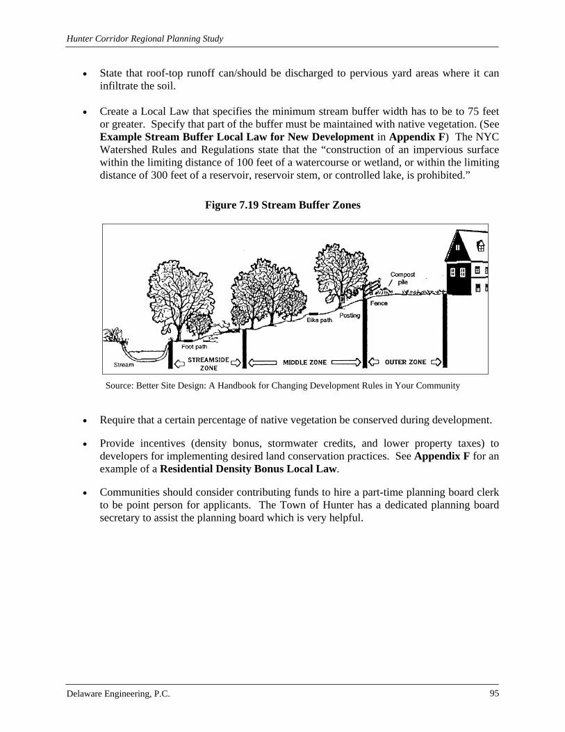
Hunter Corridor Regional Planning Study
Delaware Engineering, P.C. 95
State that roof-top runoff can/should be discharged to pervious yard areas where it can infiltrate the soil.
Create a Local Law that specifies the minimum stream buffer width has to be to 75 feet
or greater. Specify that part of the buffer must be maintained with native vegetation. (See Example Stream Buffer Local Law for New Development in Appendix F) The NYC Watershed Rules and Regulations state that the “construction of an impervious surface within the limiting distance of 100 feet of a watercourse or wetland, or within the limiting distance of 300 feet of a reservoir, reservoir stem, or controlled lake, is prohibited.”
Figure 7.19 Stream Buffer Zones
Source: Better Site Design: A Handbook for Changing Development Rules in Your Community
Require that a certain percentage of native vegetation be conserved during development. Provide incentives (density bonus, stormwater credits, and lower property taxes) to
developers for implementing desired land conservation practices. See Appendix F for an example of a Residential Density Bonus Local Law.
Communities should consider contributing funds to hire a part-time planning board clerk
to be point person for applicants. The Town of Hunter has a dedicated planning board secretary to assist the planning board which is very helpful.

Hunter Corridor Regional Planning Study
Delaware Engineering, P.C. 96
7.4.3 Tool Kit The Tool Kit (included in Appendix G) is intended to informally guide future development towards avoiding adverse impacts on the environment, more specifically impacts on water quality due to stormwater runoff and phosphorus. It can also serve as a refresher for developers who may have forgotten important details needed in site planning and design. Included in the Tool Kit are techniques for developers and homeowners to help reduce stormwater runoff and associated negative effects from phosphorus. A site plan review checklist is supplied to help site plan reviewers and developers in the review process. Topics discussed in the Tool Kit include:
Preservation of Natural Features: Natural features can include vegetated areas, wetlands, floodplains and critical habitat areas. Slope, hydrology and erodible soils are also considered natural features. These elements provide a framework for site layout and design. By preserving natural features a developer can maintain the site’s natural hydrology, reduce erosion, reduce phosphorus loading and reduce costs associated with clearing and grading. Greene County produced a natural resources inventory in the 1980s that will help developers identify important natural features.
Example of a Local Law that Encourages BSD
“…in reasonable conformity to existing topography, in order to minimize grading, cut and fill, to retain… the natural contours, limit stormwater runoff and to conserve the natural cover and soil…” -Village of Tannersville Subdivision Law
Reduction of Impervious Cover: Residential, streets, sidewalks, driveways, parking areas
and any surface that does not allow the infiltration of water is considered impervious cover. An increase in impervious cover results in an increase in stormwater and associated pollutants, which can cause harm to land and aquatic environment. Site planners and developers can easily reduce impervious cover by implementing BSD and LID principles outlined in the Tool Kit. Stormwater is also related to higher peak discharge rates and higher floodplain elevations.
Figure 7.20 Excessive Impervious Cover
Source: Horsley Witten Group

Hunter Corridor Regional Planning Study
Delaware Engineering, P.C. 97
Figure 7.21 Impervious Cover as a Function of Land Use
Source: Introduction to Stormwater: Concept, Purpose, Design By Bruce K. Ferguson
Figure 7.22 Phosphorus Loads under Different Land Uses and BMPs
0.5
1.25
0.75 0.75
0.45
0
0.2
0.4
0.6
0.8
1
1.2
1.4
Development Scenarios
Ann
ual P
hos.
Loa
d (l
bs/a
cre/
year
)
background phosphorus load
phosphorus load for a 60% impervious iste
60% impervious site but with an effective BMP (40% removal)
site is configured to reduce imperviousness to 37% but with an effective BMP (40% removal)
site is configured to reduce imperviousness to 37%
Adapted from: Site Planning for Urban Stream Protection (Chapter 2)
Model Development Principals: The constraints outlined below were created by the Center for Watershed Protection as a means to help site planners and developers reduce the impacts that new and re-development have on the environment, specifically important local water resources. This topic is discussed in greater detail in Section 7.4.

Hunter Corridor Regional Planning Study
Delaware Engineering, P.C. 98
Table 7.7 Minimum Dimensions for Reducing Impervious Cover
Minimum Dimensions for Reducing Impervious Cover
Street width allowed in low density residential developments that have less than 500 ADT*
18-22 feet
Right of way width for a residential street < 45 feet
Radius allowed for cul-de-sacs < 35 feet
Parking ratio for a professional office building < 3 spaces/1000ft2 GFA**
Parking ratio for a shopping center < 4.5 spaces/1000ft2 GFA
Parking ratio for a single family home < 2 spaces/1000ft2 GFA
Stall width for a standard parking space < 9 feet
Stall length for a standard parking space < 18 feet
Requirement for front setbacks for a 1/2 acre lot < 20 feet
Requirement for rear setbacks for a 1/2 acre lot < 25 feet
Requirement for side setbacks for a 1/2 acre lot < 8 feet
Sidewalk width allowed in the community < 4 feet
One lane driveway width < 9 feet
Two lane driveway width < 18 feet
*ADT = Average Daily Trips ** GFA = Gross Floor Area
Source: Better Site Design: A Handbook for Changing Development Rules in Your Community
Conservation Subdivision: The use of BSD techniques can help developers design
conservation subdivisions. These subdivisions reduce impervious cover and associated stormwater runoff. Pictured below is first a conventional subdivision, then a conservation subdivision. Identifying areas to be preserved before development occurs will ensure that they are protected to the fullest extent. Residential lots are decreased and community green space is increased in this type of design. This type of development gives residents a sense of togetherness and reduces construction costs.

Hunter Corridor Regional Planning Study
Delaware Engineering, P.C. 99
Figure 7.23 Conventional Subdivision
This subdivision design has large lots and large paved roadways. No measures were taken to preserve any natural features.
Source: www.community.mynorth.com
Figure 7.24 Conservation Subdivision
This subdivision design follows BSD principles outlined in the Tool Kit. It features the same number of housing units as the Conventional Subdivision but has a lot more open green space.
Source: www.community.mynorth.com

Hunter Corridor Regional Planning Study
Delaware Engineering, P.C. 100
Planned Unit Development (PUD): This type of development allows for the preservation of open space and reduction of impervious cover while providing flexible site design options.
Density Bonus: Developers are allowed to design for additional density if a specified
amount of open space is preserved, certain community recreational facilities are provided or if other amenities desired by the community are incorporated into the design. See Greene County’s Housing Action Plan for more details.
Mixed Use Development: Areas that combine residential, commercial and industrial land
uses are classified as mixed-use developments. They implement BSD techniques and contain many of the same features as conservation subdivisions.
Figure 7.25 Section through typical Mixed-Use Development
Source: www.city.burnaby.bc.ca
Zoning: The Village of Hunter and the Village of Tannersville currently have zoning regulations. The Town of Hunter does not. Zoning techniques the communities may wish to research and apply are described in the table below.

Hunter Corridor Regional Planning Study
Delaware Engineering, P.C. 101
“A review of communities that have zoning in the County indicates that while multifamily housing is permitted, the development of multifamily homes may be constrained by large lot requirements and requirements for infrastructure. In addition, a number of the applicable residential districts permit multifamily housing only by special use permit. While these communities are utilizing tools for reduced lot sizes (like cluster development and planned unit developments), some of the communities may consider decreasing the required lot sizes and/or permitting multifamily by right to encourage additional development of a range of housing types”
-Greene County Housing Action Plan
Table 7.8 Watershed Preservation Zoning Techniques
Planning Technique Description Utility as a Watershed Protection Technique
Watershed-Based Zoning Watershed and subwatershed boundaries are the foundation for land use planning
Protects receiving water quality on the subwatershed scale by relocating development outside of particular subwatersheds
Incentive Zoning
Applies bonuses or incentives to encourage creation of amenities or environmental protection
Encourages development within a specific watershed or to obtain open space in exchange for a density bonus at the site level
Performance Zoning Specifies a performance requirement that accompanies a zoning district
Requires additional levels of performance within a subwatershed or at the site level
Impervious Overlay Zoning Specific overlay zoning that limits total impervious cover within mapped districts
Protects receiving water quality at the subwatershed and site level
Source: www.dec.ny.gov
In addition, the communities may wish to consider establishment of floodplain and riparian buffer overlay districts. These overlay districts could provide a framework to protect property as well as the important functions of floodplains and riparian areas.
The 8 Tools for Watershed Protection (from the EPA Watershed Academy)
1. Land Use Planning 2. Land Conservation 3. Aquatic Buffers 4. Better Site Design 5. Erosion and Sediment Control 6. Stormwater BMPs 7. Non-Stormwater Discharges 8. Watershed Stewardship Programs

Hunter Corridor Regional Planning Study
Delaware Engineering, P.C. 102
Filter Strips: Pollutants such as phosphorus are removed through the use of filter strips via filtration and infiltration through vegetation and underlying soils. This practice can be especially useful when designing for impervious cover disconnection in residential areas.
Figure 7.26 Filter Strips
Source: www.ohioline.osu.edu
Bioretention Area: Rain gardens, also called bioretention areas, are landscaping features
adapted to provide on-site treatment of stormwater runoff. They can be located in parking lot islands or within small pockets of residential land uses. They work best with native vegetation.
Table 7.9 Stormwater Treatment Vegetation Characteristics Characteristics of Vegetation used for Stormwater Treatment
1. Tolerant of site-specific and climatic conditions
2. Non-invasive
3. Tolerant of typical stormwater pollutant concentrations
4. Can uptake, store or remove pollutants
5. Easy to establish and resilient to stress
6. Low maintenance requirements
7. Salt-tolerant in areas with high concentrations of soluble salts or cold climates where de-icing agents are used
8. Aesthetically pleasing; attracts birds and provides visual interest
9. Readily available
Source: www.stormwatercenter.net

Hunter Corridor Regional Planning Study
Delaware Engineering, P.C. 103
Figure 7.27 Bioretention Area
Source: Better Site Design: A Handbook for Changing Development Rules in Your Community
Open Channel: Open channel systems treat stormwater runoff through a combination of
filtration through infiltration. Design variations of open channels include dry swales, wet swales and grassed channels.
Figure 7.28 Example of a Grassed Swale in the Town of Hunter

Hunter Corridor Regional Planning Study
Delaware Engineering, P.C. 104
Figure 7.29 Dry Swale Aerial View
Source: Stormwater Managers Resource Center www.stormwatercenter.net
Green Roofs and Walls: The construction of a green roof consists of adding soil and
vegetation to the top of a flat or slightly sloped roof. Green roofs can reduce total runoff volumes, replace the vegetative footprint, moderate building temperatures and reduce energy costs.
Figure 7.30 Green Roof
Source: www.ia.nrcs.usda.gov
ROADWAY
ADDITIONAL STORAGE
WETLAND PLANTINGS
INFLOW
RIPRAP
PRETREATMENT
OPTIONAL CHECK DAMS
SHOULDER

Hunter Corridor Regional Planning Study
Delaware Engineering, P.C. 105
Figure 7.31 Green Wall with Ivy
Source: pink-to-green.blogspot.com
Lawn Chemicals: Nitrogen and Phosphorus are found in many household fertilizers and
pesticides. When applied improperly they can be washed away with stormwater runoff. Increased amounts of these elements can cause toxic algal blooms which can harm the aquatic environment and degrade water quality by depleting needed oxygen.
The Greene County Solid Waste Management Department, located on Hylan Road in the Town of Hunter, will process solid waste and recyclables. Every year they hold an event to collect household hazardous waste. The collection has to be approved by NYS DEC every year. This Department ensures that wastes are disposed of correctly. See http://00644c9.netsolhost.com/department/solidwaste/index.htm for more details.
Rain Barrels: Rain barrels are a simple and aesthetically pleasing way to collect runoff
from roof tops. This water, which contains no chemicals, can then be used to water lawns and gardens.
Tree Conservation and Planting: Trees can provide bank stabilization and erosion and
sediment control. They can help conserve energy used in your home associated with heating and cooling. Tree conservation saves costs associated with clearing and erosion controls. Native trees can be used to screen development outside of the Villages. This will help conserve the rural “look” of the area.
Checklists to guide Planning Boards in different aspects of the site plan review process.

Hunter Corridor Regional Planning Study
Delaware Engineering, P.C. 106
7.4.4 Land Use Law Recommendations for the Town of Hunter Development codes from the Town of Hunter used in the review included: Subdivision Regulations from 2009 and 1993, Regulating Standards for the Dedication of Town Roads from 1972 and the Environmental Quality Review Act from 1977. The Town of Hunter relies on its Subdivision Regulations, updated in 2009, to direct future development. Other regulations are outdated by at least 10 years. There are currently no zoning regulations in the Town. The Code and Ordinance Worksheet used to evaluate the Town’s regulations is attached in Appendix F. Recommendations for enhancements to local laws targeted at improving water quality specifically for the Town of Hunter include:
Change the minimum cul-de-sac radius from 60 feet to 45 feet and encourage the creation
of landscaped islands in the middle. Landscaped islands reduce impervious cover, increase the amount of vegetation and can be designed to be aesthetically pleasing.
Encourage the use of shared parking and provide shared parking agreements. This will
reduce impervious cover caused by parking lots and driveways.
Allow the use of bioretention areas and other stormwater practices within landscaped areas of parking lots. This will help reduce stormwater runoff.
Figure 7.32 Landscaped Areas break up impervious cover in parking lots
Source: www.ia.nrcs.usda.gov Source: www.epa.gov
Create a local law pertaining to Open Space or Cluster Development. Require that open
spaces be consolidated and that a minimum percentage of open space be preserved with native vegetation.

Hunter Corridor Regional Planning Study
Delaware Engineering, P.C. 107
Figure 7.33 Cluster Development vs. Conventional Development
Source: Better Site Design: A Handbook for Changing Development Rules in Your Community
7.4.5 Land Use Law Recommendations for the Village of Hunter
Development codes from the Village of Hunter included: Zoning Law from 2007 and the Architectural Review Law. The Village of Hunter relies on its Community Plan developed in 1993 and it’s Zoning Law from 2007 to direct future development. There are no other local laws issued by the Village that relate to development or water quality. Recommendations for enhancements to local laws targeted at improving water quality specifically for the Village of Hunter include:
Specify a minimum street width of 18 to 22 feet in low density residential areas or the
minimum width required by fire codes. Studies have found that the narrower the road the slower a driver will go, which means local roads will be safer.
Allow utilities to be placed in the right-of-way. This can reduce the amount of soil
disturbance and reduce clearing of trees and native vegetation nearby.
Specify a cul-de-sac radius of 45 feet or less and encourage the creation of landscaped islands in the middle. This reduces impervious cover and costs associated with paving.
Figure 7.34 Comparing Impervious Cover of Cul-de-sac Alternatives
0
1,000
2,000
3,000
4,000
5,000
6,000
40 foot radius 40 foot radius with 15foot radius island
30 foot radius 30 foot radius with 10foot radius island
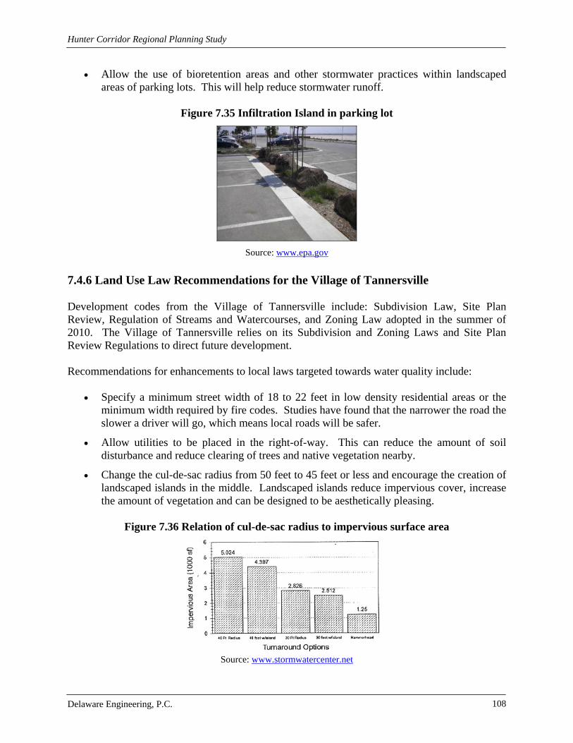
Hunter Corridor Regional Planning Study
Delaware Engineering, P.C. 108
Allow the use of bioretention areas and other stormwater practices within landscaped areas of parking lots. This will help reduce stormwater runoff.
Figure 7.35 Infiltration Island in parking lot
Source: www.epa.gov
7.4.6 Land Use Law Recommendations for the Village of Tannersville
Development codes from the Village of Tannersville include: Subdivision Law, Site Plan Review, Regulation of Streams and Watercourses, and Zoning Law adopted in the summer of 2010. The Village of Tannersville relies on its Subdivision and Zoning Laws and Site Plan Review Regulations to direct future development.
Recommendations for enhancements to local laws targeted towards water quality include:
Specify a minimum street width of 18 to 22 feet in low density residential areas or the
minimum width required by fire codes. Studies have found that the narrower the road the slower a driver will go, which means local roads will be safer.
Allow utilities to be placed in the right-of-way. This can reduce the amount of soil disturbance and reduce clearing of trees and native vegetation nearby.
Change the cul-de-sac radius from 50 feet to 45 feet or less and encourage the creation of landscaped islands in the middle. Landscaped islands reduce impervious cover, increase the amount of vegetation and can be designed to be aesthetically pleasing.
Figure 7.36 Relation of cul-de-sac radius to impervious surface area
Source: www.stormwatercenter.net
Hunter Corridor Regional Planning Study
Delaware Engineering, P.C. 109
8.0 RESOURCES
8.1 Mountain Top Mapping Greene County Planning and Economic Development received a grant from the NYS Department of State to fund an innovative regional mapping project for the Mountaintop communities in Greene County, New York. Participating municipalities are the nine Greene County municipalities located within the NYC Watershed, collectively referred to as the “Mountaintop.” The Mountaintop communities are the Towns of Ashland, Halcott, Hunter, Jewett, Lexington, Prattsville, and Windham and the Villages of Hunter and Tannersville. In addition to Greene County Planning and Economic Development and these communities, other regional organizations such as the Greene County Soil and Water Conservation District, Greene County Cornell Cooperative Extension, Catskill Center for Conservation Development and the Catskill Watershed Corporation also contributed. The purpose of the Mountaintop Regional Watershed Mapping Project was to assist municipalities in the review of development projects through compilation of existing maps, databases, reports and land use information; provisions of an interactive digital mapping CD and user manual customized to each community; a series of development review checklists with prompts for critical analysis; marketing and educational materials; and training for local government officials and representatives. The project focuses on assisting communities in the review of development projects from a water quality perspective. The initial phase of work involved visiting each planning board on the Mountaintop to observe the means and methods the boards use to conduct SEQR, site plan and subdivision reviews. There was a general impression that the planning boards could utilize review checklists and critical analysis guidance in the SEQR, site plan and subdivision processes. In attending planning board meetings it was discovered that the boards are very versed and effective in reviewing small scale projects, such as minor subdivisions and basic site plans. The boards are very familiar with their local codes and understand the importance of quality evaluation during the site plan phase of review. For small scale, straightforward projects the boards conducted SEQR using Short Form Environmental Assessments and were reasonable in performing a “hard look.” The vast majority of projects on the agendas of the Mountaintop communities’ planning boards are small scale and straightforward. However, unusual or complex small scale projects as well as mid to large scale projects present a unique challenge to the Mountaintop Planning Boards. For very large projects, the planning boards seek the assistance of a reviewing engineer, who then assists with the answers to these questions. It is for the mid-size or small unique/complex projects that the boards required assistance. A series of checklists and guidance documents were developed to assist the communities in the areas of review where assistance was needed. Although Greene Co. has a robust GIS Web Map application, many of the communities can not fully utilize it due to a lack of high-speed internet access. A customized application was created for each community using Arc Explorer Java Edition for Education (AEJEE). AEJEE is a light-

Hunter Corridor Regional Planning Study
Delaware Engineering, P.C. 110
weight GIS program that is used most commonly in the classroom. It can be distributed freely as long as the original installer, license agreement and data files are provided. The custom application was provided to Planning Boards on a CD, along with the GIS data for their community and a user manual. An in-depth training session for key planning Board members was held in March 2010 at the Hunter-Tannersville School which covered the installation and use of the application. This GIS mapping application can be used along with the Tool Kit provided to assist developers and site plan reviewers in the site plan review processes. The User Guide is attached in Appendix G.
Figure 8.1 Mt. Top Mapping Application Map

Hunter Corridor Regional Planning Study
Delaware Engineering, P.C. 111
8.2 Electronic Resources Listed are some of the many thousands of electronic resources regarding the topics covered in this report. A Holistic Approach to Stormwater Management: http://www.civil.ryerson.ca/Stormwater/index.htm Catalog of Federal Domestic Assistance (CFDA): https://www.cfda.gov/ Catalog of Federal Funding Sources for Watershed Protection: http://cfpub.epa.gov/fedfund/ Catskill Center for Conservation and Development: http://www.catskillcenter.org/ Catskill Streams: http://www.catskillstreams.org/ Catskill Streams Buffer Initiative (CSBI): http://www.catskillstreams.org/CSBI/ Catskill Watershed Corporation: http://www.cwconline.org/ Census Bureau: http://www.census.gov/ Center for Watershed Protection: http://www.cwp.org/ Georgia Stormwater Management Manual: http://www.georgiastormwater.com/ GRANTS.GOV: http://www.grants.gov/ Green County Chamber of Commerce: www.greenecounty-chamber.com Green County GIS Services: www.gcswcd.com/publications/GISbrochure.pdf Greene County Historical Society: http://www.gchistory.org/barns.php Greene County IDA: http://www.greeneida.com/ Greene County Mapping Services: http://greenebusiness.com/mapping/mapping-services Greene County Planning Services: http://greenebusiness.com/planning/programs-services Greene County Soil & Water Conservation District: www.gcswcd.com Jordan’s Cove Urban Watershed Project, Waterford, CT: http://www.jordancove.uconn.edu/ Mountain Top Historical Society: http://www.mths.org/ National Water Information System (NWIS): http://waterdata.usgs.gov/nwis

Hunter Corridor Regional Planning Study
Delaware Engineering, P.C. 112
National Water Quality Assessment (NAWQA) Program: http://water.usgs.gov/nawqa/
Natural Resource Conservation Service: http://www.nrcs.usda.gov/
New York City Department of Environmental Protection: http://www.nyc.gov/html/dep/html/home/home.shtml
New York Natural Heritage Program: http://www.acris.nynhp.org/
New York State Department of Environmental Conservation: http://www.dec.ny.gov/
NYS DEC Open Space Conservation Plan: www.dec.ny.gov/lands/47990.html
NYS DEC Smart Growth Plan: www.dec.ny.gov/lands/45970.html
Northeast States & Caribbean Islands Regional Water Center: http://www.usawaterquality.org/NESCI/focus_areas/NEMO/default.html
Ohio State University: www.ohioline.osu.edu
Polytechnic of Nabia: www.polytechnic.edu.na
Schoharie Watershed Program: http://www.gcswcd.com/wap/
State of Maine Bureau of Land and Water Quality: http://www.maine.gov/dep/blwq/watersh.htm
State Historic Preservation Office: http://nysparks.state.ny.us/shpo/
Stormwater Managers Resource Center: http://www.stormwatercenter.net/
Town of Hunter: www.townofhuntergov.com/
Town of Hunter Chamber of Commerce: http://www.hunterchamber.org/
United States Army Corps of Engineers: http://www.usace.army.mil/
United States Environmental Protection Agency: http://www.epa.gov/
United States Environmental Protection Agency Enviromapper: http://www.epa.gov/emefdata/em4ef.home
Village of Hunter: www.hunterchamber.org/village_of_hunter.php
Village of Tannersville: www.tannersvilleny.org/
Virginia Stormwater Management Handbook: http://www.dcr.virginia.gov/documents/swmhndbkdrft_ch10.pdf

Hunter Corridor Regional Planning Study
Delaware Engineering, P.C. 113
8.3 Funding Opportunities There are numerous funding opportunities for communities such as those found in the Town of Hunter. Agencies that provide funding include the US Environmental Protection Agency, US Department of Agriculture, US Department of the Interior and US Department of Commerce just to name a few. Funding can be provided for many projects pertaining to drinking water systems, wastewater systems, stormwater conveyance, watershed protection, energy efficiency, rural communities, small businesses and many more. There are also many tools to assist municipalities and individuals with financial decisions such as the Guidebook of Financial Tools: Paying for Environmental Systems written by the US EPA in 2008. It discusses different “tools for financing sustainable environmental systems”. The US EPA also has a Catalog of Federal Funding Sources for Watershed Protection (http://www.epa.gov/owow/watershed/pdf/flyer.pdf or http://cfpub.epa.gov/fedfund/) that allows one to choose specific criteria to make your funding search easier. Searchable Criteria consist of type of organization, type of assistance sought and keywords to narrow your search.
Figure 8.2 Capital and Financial Planning Process
(adapted from Raftelis, 1989)
Source: http://stormwaterfinance.urbancenter.iupui.edu/manual2.htm
Try also viewing the following for funding resources:
Meeting Future Financing Needs of Water Utilities (1993) by E.J. Amatteti
Capital Projects: New Strategies for Planning, Management, and Finance (1989) by J. Matzer

Hunter Corridor Regional Planning Study
Delaware Engineering, P.C. 114
The Arthur Young Guide to Water and Wastewater Finance and Pricing (1989) by G.A. Raftelis
A Revenue Guide for Local Government (1989) by R.L. Bland
Handbook on Coordinated Funding for Water and Wastewater Infrastructure: A Compilation of State Approaches (2003) by USEPA Office of Water
Handbook for Developing Watershed Plans to Restore and Protect Our Waters (2008) by USEPA Office of Water
Figure 8.3 Watershed Planning and Implementation
Source: Handbook for Developing Watershed
Plans to Restore and Protect Our Waters See Appendix G for an extensive list of available funding opportunities.

Delaware Engineering, P.C. 115
9.0 REFERENCES AMEC Earth and Environmental et al. 2001. Stormwater Management Manual. Atlanta Regional Commission. Atlanta, GA. Available from http://www.georgiastormwater.com/ Arendt, Randall. 1996. Conservation Design for Subdivisions. American Planning Association. Chicago, IL. Better Site Design. 2008. New York State Department of Environmental Conservation: Department of Water. Prepared by Horsley Witten Group and Center for Watershed Protection. Blaine, Thomas W., Schear, Peggy. Cluster Development. Ohio State University Extension. Available from http://ohioline.osu.edu BMPs for Phosphorus Management. (2003). Retrieved November 10, 2009 from the University of Idaho Extension, Moscow, Idaho website http://www.uiweb.uidaho.edu Center for Watershed Protection. 1998. Better Site Design: A Handbook for Changing Development Rules in Your Community. Prepared for the Site Planning Roundtable. Ellicott City, Maryland. Catskill Streams Buffer Initiative. Protecting Our Living Streamsides. Available from: http://www.nyc.gov/html/dep/pdf/brochures/csbi_brochure.pdf County of Fairfax. 2009. Storm Drain Easements. Fairfax County, Virginia. Available from http://www.fairfaxcounty.gov Design of Stormwater Filtering Systems. Prepared by Richard A. Claytor and Thomas R. Schueler, The Center for Watershed Protection. December 1996. Ferguson, Bruce K. 1998. Introduction to Stormwater: Concept, Purpose, Design. Fraiser, Kenneth J. and Associates. 2007. Village of Tannersville Community Stormwater Infrastructure Assessment. Gilley, John E., Eghball, Bahman. Erosion Control Systems. University of Tennessee Extension. Available from http://www.extension.org High Bridge Environmental Commission. Retrieved December 14, 2009, from www.highbridge.org/environmental_commission.html How to Plant a Tree. Retrieved November 23, 2009, from the American Forests website: http://www.americanforests.org Korb, Gary. 2008. Rethinking Yard Care. University of Wisconsin-Extension. Madison, WI.

Delaware Engineering, P.C. 116
Miskowiak, Douglas, Stoll, Linda. 2006. Planning Implementation Tools: Planned Unit Development. University of Wisconsin-Extension. Madison, WI. Available from www.uwsp.edu MU Extension. Home A Syst Environmental Risk Assessment Guide. University of Missouri-Columbia. Available from www.muextension.missouri.edu New York State Breeding Bird Atlas 2000 [Internet]. 2000 - 2005. Release 1.0. Albany (New York): New York State Department of Environmental Conservation. [updated 2007 Jun 11; cited 2010 Jun 25]. Available from: http://www.dec.ny.gov/animals/7312.html. New York State Department of Environmental Conservation (NYSDEC). 2008. Response to Comments on MS4 Permit: Code and Ordinance Worksheet. Available at http://www.dec.ny.gov New York State Department of Environmental Conservation (NYSDEC). 2008. New York State Stormwater Management Design Manual. Albany, NY. Available from http://www.dec.state.ny.us New York State Geological Association. 1967. Guide Book. SUNY College at New Paltz. New York State Stormwater Management Design Manual, April 2008 http://www.dec.ny.gov/docs/water_pdf/dpremoval.pdf Owen, Marion. 1996. 163 Things You Can Compost. Retrieved December 1, 2009 from PlanTea website http://www.plantea.com/ Reschke, C. 1990. Ecological Communities of New York State. New York Natural Heritage Program. New York State Department of Environmental Conservation. Latham, N.Y. Schueler, T. 1997. Comparative Pollutant Removal Capability of Urban BMPs: A Reanalysis. Watershed Protection Techniques 2(4): 515-520. Schueler, T. 1996. Site Planning for Urban Stream Protection: http://www.ci.milpitas.ca.gov/_pdfs/cwp_site_planning/ch2.pdf Site Planning Roundtable. 1998. Consensus agreement on Model Development Principles to Protect our Streams, Lakes and Wetlands. Stormwater Managers Resource Center: http://www.stormwatercenter.net/ The Importance of Imperviousness. Feature article from Watershed Protection Techniques. 1(3): 100-111. United States Census Bureau. Information available from: http://www.census.gov/. United States Environmental Protection Agency (EPA). 2006. Zoning. Washington, DC. Available from http://www.epa.gov/

Delaware Engineering, P.C. 117
United States Environmental Protection Agency (EPA). 2008. Brownfields Tax Incentive Facts Sheet. Washington, DC. Available from http://www.epa.gov/ United States Environmental Protection Agency (EPA), Environmental Finance Program. 2008. Guidebook of Financial Tools: Paying for Environmental Systems. Available from: http://www.epa.gov/efinpage/publications/GFT2008.pdf United States Environmental Protection Agency Office of Water. 2008. Handbook for Developing Watershed Plans to Restore and Protect Our Waters. Available from: http://www.epa.gov/owow/nps/watershed_handbook Virginia Department of Conservation and Recreation. 2009. Supplemental Documentation for the Runoff Reduction Method – Redevelopment. Available from http://www.dcr.virginia.gov/ Watershed Protection Techniques: A Quarterly Bulletin on Urban Watershed Restoration and Protection Tools Vol. 1, No. 2 — Summer, 1994. Center for Watershed Protection. Wetlands in the Watersheds of the New York City Water Supply System. 2009. New York City Department of Environmental Protection, Bureau of Water.