human spatial navigation - chapter 1
TRANSCRIPT
1
C H A PT E R 1
INTRODUCTION
As researchers in human spatial navigation, we are frequently told: “I’m such a bad navigator, you should study me.” Indeed, almost half of the college students in one study rated their navigational abilities as below average (Hegarty et al. 2006). One particular complaint is trouble when navigating in new places. These types of com-plaints fall into a category of navigational errors that we will discuss in some detail in this book: our tendency to favor habitual, well- learned routes, affecting the ability to reason about new spatial layouts. These complaints showcase how navigation is often error prone and, for many people, a source of significant frustration. They also highlight how all forms of navigation are not the same and can differ simply based on our familiarity with a route.
Difficulties navigating can lead to serious consequences for individuals with neu-rological conditions affecting brain function. One particularly devastating example of this is Alzheimer’s disease and dementia, where patients often report difficulty navigating and a tendency to get lost, even in familiar neighborhoods (Cushman, Stein, and Duffy 2008; Kunz et al. 2015). As the disease worsens, some patients become lost even in highly familiar neighborhoods, wandering along the paths of telephone lines into the wilderness (Johnson 2010). Even normal aging involves a decline in spatial navigation, with changes in the ability to navigate using land-marks and a tendency to favor using familiar paths. Thus, errors in everyday navi-gation are not only a part of life but also a hallmark of neurobiological diseases and even healthy aging (Moffat 2009).
Is it possible that we as a species are just poor navigators? Evidence from studies of navigation in other species might readily seem to support this argument. Sea turtles can navigate thousands of kilometers in the ocean to search for food using combinations of ocean currents and sensitivity to the magnetic pole, and they can still manage to find their way back to the same nesting grounds (Lohmann and Lohmann 1996). Desert ants search for food at distances of up to hundreds of me-ters from their nest, covering a radius that would be equivalent, in human terms, to about 38 kilometers. Yet these ants, once they find food, can plot a direct course back to their nest and find it within 1 square centimeter of error (Wehner and Srini-vasan 1981; Gallistel 1990). While the mechanisms underlying these nonhuman feats of navigation differ, there is little doubt that other species are capable of in-credible feats of navigation, which nonetheless would appear central to their daily survival.
Still, if we consider human history, there are many examples of navigational feats that are so remarkable they might seem to better represent those of a sea turtle or a desert ant. Perhaps some of the most striking examples, which we will discuss in
© Copyright, Princeton University Press. No part of this book may be distributed, posted, or reproduced in any form by digital or mechanical means without prior written permission of the publisher.
For general queries, contact [email protected]

2 C H A P T E R 1
detail, involve humans navigating— in some cases, thousands of kilometers across the open ocean— with few or no mechanical aids. These feats will also introduce us to important and useful concepts we will use throughout this book. Our first example involves Puluwat sailors, a seafaring people in the Polynesian Islands, which in turn will help us understand the important concepts of externally versus internally guided navigation and the idea of path integration. Lest we think that Pu-luwat navigation represents a feat that only a highly adept, practiced, and skilled subset of our population is capable of, we will also consider the journey of the James Caird, in which stranded sailors navigated nearly 1000 kilometers to safety in a com-pletely unfamiliar part of the Antarctic Ocean. The journey of the James Caird, in turn, will help us understand the idea of the cognitive map. Last, we discuss how exceptional navigational skills in Inuit living above the tree line, close to the North Pole, are fundamental to their survival in some of the harshest living conditions of the world.
Navigation of the Puluwat: Path Integration in Action
Puluwat is a small island in the southern Pacific Ocean that is part of a larger chain of islands known today as the Carolines. The Puluwat are renowned within the Car-olines for their wayfinding abilities, which include navigating between islands sepa-rated by distances of up to 800 kilometers. Much of their navigation occurs across the open ocean with no visible islands or landmarks. In fact, recent attempts to circumnavigate the globe using no mechanical aids (spearheaded by Nainoa Thompson) involved training with such Polynesian sailors in order to perfect their techniques (Parker 2015). So what do the Puluwat know that the rest of us do not?
For centuries, the Puluwat have relied on multiple nonmechanical internal and external cues to navigate. The internal cues, which we will discuss in detail through-out this book, include using mental estimates of direction and distances over the course of their journey; we term this approach to navigation path integration. The external cues involve using the stars as a compass and other landmarks, like reefs and islands, as reference points. These achievements are quite amazing when one consid-ers the specifics involved. The Puluwat outrigger sailing canoes are approximately six to nine meters in length and about two meters across and must accommodate groups of five to six people, including a navigator. Yet the Puluwat can navigate these boats between islands even over great distances, successfully arriving at their destination and returning home with little problem (Gladwin 1970). How is this possible? What navigational strategies do these sailors employ?
To learn to navigate, the Puluwat spend their first decades of life in an appren-ticeship that focuses on one of two different schools of navigational training: Warieng and Fanur (figure 1.1A). One aspect of training focuses on learning relevant external cues: the locations of the constellations within the sky and how these change over the course of the night from sundown to sunrise. The stars serve as a basic compass system, providing Puluwat sailors with a bearing to maintain their course. For example, if a sailor wishes to plot a course to an island such as Satawal, he would use the star Beta Aquilae, which provides an approximate heading direc-tion for arriving at this island (figure 1.1B; in our terminology, this would be
© Copyright, Princeton University Press. No part of this book may be distributed, posted, or reproduced in any form by digital or mechanical means without prior written permission of the publisher.
For general queries, contact [email protected]

3I N T R O D U C T I O N
FIGURE 1.1. Feats of human spatial navigation: navigation in the Puluwat. A. Puluwat sailing boat. B. The star compass employed by the Puluwat to navigate (see Goodenough and Ward 1953).
A
B SettingPositions
N
S
W ETRUE EQUATOR
NO
RTH
STA
R(P
OLA
RIS)
SOU
THER
N C
ROSS
(AT
45°)
SOUTHERN CROSSSHAULAANTARESCORVUS
ORION‘S BELTBETA AQUILAEALTAIR
GAMMA AQUILAE
ALDEBARAN
PLEIADES
VEGA
CASSIOPEIA
BIG DIPPERLITTLE D
IPPER
ORION‘S BELT
BETA AQUILAE
ALTAIRGAMMA AQUILAEALDEBARANPLEIADES
VEGACASSIO
PEIA
BIG D
IPPER
LITT
LE D
IPPE
R
SOU
THERN
CROSS
(UPRIG
HT)
SOU
THERN
CROSS
(AT 45°)
SOUTHERN CROSS
SHAULA
ANTARES
CORVUS
RisingPositions
© Copyright, Princeton University Press. No part of this book may be distributed, posted, or reproduced in any form by digital or mechanical means without prior written permission of the publisher.
For general queries, contact [email protected]

4 C H A P T E R 1
approximately northwest). However, the star course they are taught also takes into consideration the ocean currents surrounding these islands. Thus, using Beta Aquilae as a navigation compass takes into account the slight push northward that will occur owing to typical currents and is thus slightly southward of the true goal. In this way, the Puluwat use the stars as external cues much like we use a compass.
Another critical aspect of the Puluwat training involves learning to use internal cues, like one’s sense of direction, to navigate. This is because stars alone are not sufficient to navigate between islands. For example, the vast majority of Pulu-wat trips begin in the daylight (around noon), and thus the initial direction can-not depend on using the stars to determine bearing. Instead, this is where the use of internal cues becomes important. The Puluwat use another island that they have mentally located (but that they cannot see) to determine the direction in which to head out from their home island. This method is referred to in Puluwat as etak— roughly the equivalent of a term that we will use throughout this book: a cognitive map. Put simply, a cognitive map is a mental representation of the position and spa-tial relations among multiple landmarks in the external world (Tolman 1948; O’Keefe and Nadel 1978; Sholl 1987).
After having determined their initial bearing based on their knowledge of the relative positions of islands from their cognitive map, navigators must then be sure to plot as straight a course as possible. As the navigator departs with his crew, he looks behind him at prominent landmarks on the island— in this case, using external cues to validate his sense of internal heading. Plotting a course to one island will involve sighting the position of himself relative to several different landmarks on the island, which must line up precisely based on the navigator’s viewpoint as the boat heads out to sea (figure 1.2). Using a landmark to guide our navigation, either toward or away from that specified landmark, is termed piloting. In this case, pilot-ing involves using the position of multiple landmarks relative to the sailor to plot his exact angle of departure, which we term egocentric navigation because he bases
FIGURE 1.2. Backsighting employed by the Puluwat to estimate their initial heading when beginning a journey out into the sea.
© Copyright, Princeton University Press. No part of this book may be distributed, posted, or reproduced in any form by digital or mechanical means without prior written permission of the publisher.
For general queries, contact [email protected]

5I N T R O D U C T I O N
his estimate of direction and distance relative to himself and landmarks. In this way, the sailor can estimate fairly precisely his angle of departure based on his memory for the view angles corresponding to relative bearings.
Once the island is out of sight, the Puluwat navigator must be sure to maintain his course and not to veer too far from his initial bearing. Here is where his ability to path integrate, or keep track of both direction and distance traveled, becomes most important (figure 1.3). From his position on the boat, the Puluwat navigator tries to maintain a specific bearing based on his internal sense of how much the boat has turned. The Puluwat have detailed knowledge of different types of waves that present within the Caroline Islands, some of which originate from the north and others from the east. When one of these waves hits the boat, by determining the angle at which the main boat and outrigger hit the wave, the navigator can es-timate direction and update his sense of direction. In this way, the Puluwat sailor uses a keenly developed internal representation of bearing and then updates his course based on information he obtains from knowledge of waves that hit the boat at different angles.
In addition to bearing, the navigator also computes distance traveled based on his estimate of the speed of the boat and the time of day. Again, he uses external cues to update and correct this estimate. Based on the time it takes for the crests of two different waves to pass, the sailor can estimate the relative speed of the boat. The Puluwat sailor thus uses these various external cues to update and estimate his internal estimate for direction and distance. By having an internal representation for both direction and distance, which the sailor continuously updates based on
Actual directionand distance
Waves provide additionalinformation on direction
Internal estimate of direction, distance from reef and cognitive map
If this is correctI should pass
the reef soon . . .
FIGURE 1.3. Path integration in the Puluwat.
© Copyright, Princeton University Press. No part of this book may be distributed, posted, or reproduced in any form by digital or mechanical means without prior written permission of the publisher.
For general queries, contact [email protected]
6 C H A P T E R 1
external cues, he is able to maintain a fairly good idea of how far he has traveled and in what direction.
Path integration, though, would not be particularly helpful to the sailor unless he had some idea of where islands were located as he traveled. Recall that the Puluwat, upon beginning the journey, have a precise idea of their initial bearing based on their representation of their home island relative to other islands in the Carolines— what we have termed the cognitive map. This knowledge of the rela-tive positions of other islands and landmarks is what we term an allocentric form of navigation and reasoning because it is based on the relative position of multiple external landmarks to each other independent of the navigator. Thus, as a sailor nav-igates to a distant island, he uses a reef or another island that is not visible but can be pictured in his mind’s eye based on his estimate of progress from his path inte-gration representation.
Confirmatory evidence of the position of an island or a reef can be obtained by seeing it (from about 16 kilometers away) or, in the case of an island, by sighting seabirds, which can range up to 64 kilometers from a given island. In this way, the cognitive map serves the important function of combining path integration infor-mation with the expectation of different landmarks the sailor will encounter (see figure 1.3). Encountering these landmarks, which can occur in a manner either con-sistent or inconsistent with path integration representations, provides an indica-tion either of success or of the need to make a slight adjustment to course. The final landmark the sailor looks for is the destination island— his goal— at which time the sailor relies on piloting by simply using the island as a visual aid and correcting course accordingly until the island is finally reached.
What We Can Learn from the Puluwat
For anyone not accustomed to sailing and traveling by sea, even getting a boat out of a harbor might appear challenging and certainly requires a fair amount of skill; the idea of navigating hundreds of kilometers in the open ocean with no obvious visual cues seems, at first, impossible. As we discussed earlier, however, the Puluwat make use of a wealth of cues, both external and internal, that most of us are probably unaware are even useful for navigation. As we will see in chapter 2, we use similar estimates of direction and distance during walking in new and familiar environ-ments, and, just like the Puluwat, we correct our internal estimates based on evidence from visual features. In this way, we can think of navigation as an inherently multi-sensory integration process that combines multiple cues to accurately find our way to our goal (Berthoz and Viaud- Delmon 1999; Angelaki and Cullen 2008).
But what is perhaps most striking is the Puluwat’s highly cultivated and sophis-ticated use of an internal tracking of direction and distance: their path integration system. It may seem difficult to believe that our brain has a built- in system for es-timating the direction we are traveling and how far we have traveled. But this is precisely what path integration, at its core, involves. Right now, you are probably sitting in a chair or lying on a couch reading this book. Try standing up for a mo-ment. Now, close your eyes and try walking to a location that you can picture in your head, like another chair in your living room. Stop when you think you have
© Copyright, Princeton University Press. No part of this book may be distributed, posted, or reproduced in any form by digital or mechanical means without prior written permission of the publisher.
For general queries, contact [email protected]

7I N T R O D U C T I O N
reached your destination. As you walk, you will probably have a fairly good sense of how far you need to travel and whether you need to take any turns to get there. Hopefully, you have experienced the sense that our brain can, in fact, keep track of both direction and distance, even in the absence of any visual cues to confirm that our internal system was correct.
Computing Head Direction
We may often forget about what some call our “sixth sense,” our vestibular system, because its specific contributions to everyday life may not be obvious (Wolfe 2006). Our vestibular system, an intricate series of fluid- filled canals in our inner ear, is critical for functions like balance and updating our eye position with head move-ments. Perhaps most important for our current considerations, our vestibular sys-tem is also critical to tracking our bearing by updating our brain about changes in our head position. As an example of its importance, lesions to our vestibular sys-tem produce profound deficits in navigation (Russell et al. 2003; Brandt et al. 2005).
Our vestibular system works much like a level, a tool frequently used by carpen-ters to estimate the angle of a board or other object (figure 1.4A). A level is usually a long, straight bar containing one or more tubes filled with water and an air bub-ble, with marks indicating the center position. If a carpenter wishes to determine whether an object is level or at an angle, she can position a level relative to the ob-ject. If the bubble deviates to the side, she knows that the object is not level. If the bubble is even relative to the center marks, she knows that the object is level.
A BSuperior
semicircularcanal
Posteriorsemicircular
canal
Lateralsemicircular
canal
Looseparticles
Membranebarrier
FIGURE 1.4. Path integration and the vestibular system. A. The vestibular system works on the same principles as a carpenter’s level. B. The semicircular canals, which enable our estimate of head direction.
© Copyright, Princeton University Press. No part of this book may be distributed, posted, or reproduced in any form by digital or mechanical means without prior written permission of the publisher.
For general queries, contact [email protected]

8 C H A P T E R 1
The vestibular system works in much the same way, except it contains vessels for each of three different perpendicular directions. These curved canals contain a watery fluid that moves, or is displaced, every time we move our head. The three ca-nals that detect these rotations are termed semicircular canals (figure 1.4B). Because each semicircular canal is perpendicular to the other two, the three curved canals cover all three possible primary orientations in three- dimensional space. Thus, movement of your head in any direction in three- dimensional space will activate at least one of your semicircular canals, allowing you to detect displacement in almost any angular direction.
Within each semicircular canal, tiny hairs called cilia detect the movement of this fluid. The hairs act much like seaweed does when a wave passes over it in the ocean. Just as the seaweed bends to follow the direction of the current’s movement, the hair cells in our semicircular canal are pushed by the movement of the water in our inner ear. For example, when you shake your head from left to right and back, fluid in your semicircular canals moves hair cells in your inner ears in opposite di-rections. Based on the rate at which the fluid deflects the hair cells, we now have a way of computing the angular acceleration of our head movement. When we turn our head, either with our body or independent of our body, our semicircular ca-nals, via our hair cells, provide information about how quickly we moved our head and when we stopped. Neurons in our vestibular nerve code this displacement by a change in the activity of neural signals called action potentials, which we will dis-cuss in greater depth later. These, in turn, provide a signal for the acceleration of your head in one direction versus another.
Based on the degree of angular acceleration and the time between accelerating and stopping, we can then get a fairly good estimate of how far our head has turned. Thus, our semicircular canals provide relevant information— particularly when combined with input from our proprioceptive system and our other vestibular or-gans, the otoliths— for estimating the angle at which we have turned our head (an-other example of multisensory integration; see also Angelaki and Cullen 2008). This information is then read out, in some detail, by a network of brain areas called the head direction system, which provides an estimate of the position of our head rela-tive to where we are in the environment (Valerio and Taube 2012), a topic that we will discuss in depth in chapter 3. In this way, our vestibular system, in conjunc-tion with our head direction system, provides a fairly precise readout of our angu-lar rotation.
Path Integration: Direction and Distance
While our semicircular canals, in conjunction with our head direction system, pro-vide a fairly precise means of estimating angular head direction, our otoliths provide information on linear acceleration. Our otoliths are another component of our vestibular system and provide information about changes in our movement as we initiate a step and when we counteract gravitational forces to balance. Using this in-formation, the otoliths can decode linear accelerations and decelerations (Angelaki and Cullen 2008). From this, we can obtain a rough initial estimate of our velocity, and, in principle, a good guess at our distance.
© Copyright, Princeton University Press. No part of this book may be distributed, posted, or reproduced in any form by digital or mechanical means without prior written permission of the publisher.
For general queries, contact [email protected]

9I N T R O D U C T I O N
In practice, though, our ability to estimate durations of time, a critical piece of estimating our velocity, is not particularly good (Friedman 1993; Grondin 2010). A much better way of estimating our distance, as it turns out, is keeping track of ap-proximately how many steps we have taken. When we walk, our legs swing back and forth at different angles, and thus a part of our sensory system, called our pro-prioceptive system, can provide a fairly good estimate for how fast our feet and legs are moving. If we add in our sense of touch when our feet hit the ground and how frequently this occurs in time, we now have a way of estimating the distance we have traveled.
But even without any movement of our legs and updating of our vestibular sys-tem, we can use other cues to estimate how fast we are traveling. An important such cue is called optic flow, which refers to the rate at which objects pass us by visually when we navigate (Warren 2001). Humans can use optic flow to estimate distance of travel (Redlick and Harris 2001). Another source of useful information comes from something called motor efference copy. Here, we can compare our expected movement, based on muscle output, with our actual movement, based on sensory feedback. For example, if we begin to take a big step, we have a sense of going a larger distance than a small step, which we can confirm based on subsequent sensory and proprioceptive feedback as we complete the step (Gallistel 1980). Together, all of these multisensory cues (yet another example of multisensory inte-gration in navigation) allow us to path integrate as we walk.
The Cognitive Map: Is It the Map in Your Head?
Navigation on the ocean, of course, involves no walking. Instead, distance must be computed based on a combination of estimates of movement speed from the oto-liths, windspeed, and ocean currents. Thus, in addition to using their path integra-tion system, the Puluwat also use landmarks such as other islands or reefs to correct any mistakes in their estimate of their direction and distance. In the case of the Puluwat training, an apprentice may spend years learning the relative positions of different islands and reefs in the Caroline Islands chain. A core element of this training is extensive study and testing of the ability to accurately draw the relative direction and positions of islands in the sand. In this way, the sailor’s memory for the relative positions of reefs and islands forms the basis of an internal representa-tion that we often refer to as a cognitive map.
As tempting as it might be to think of a cognitive map as an actual map, it is im-portant to note that it is not the same as the type of map we buy at a gas station or consult at a shopping mall (termed a cartographic map). We discuss the reasons for this throughout this book, but the primary reason is that our cognitive map must serve first and foremost as a good- enough approximation for what we need when navigating and does not necessarily include all the details we might expect from an actual cartographic map. In this way, we can think of a cognitive map as topo-logical, or maintaining the relationships between objects, rather than necessarily providing the exact metric distances. A second reason is that a cognitive map must allow interpretation of information primarily from a first- person perspective rather than from looking down on an environment from above, as is the usual setup of a
© Copyright, Princeton University Press. No part of this book may be distributed, posted, or reproduced in any form by digital or mechanical means without prior written permission of the publisher.
For general queries, contact [email protected]

10 C H A P T E R 1
cartographic map. If a Puluwat sailor fails to see a reef after traveling for several hours northeast, he must adjust his position with the expectation that he needs to travel slightly south. In this way, the cognitive map does share some of the qualities of a cartographic map in that it must represent relative directions and distances of im-portant landmarks, but it must be applied based on current bearing (Sholl 1987).
Whether the Puluwat actually need a cognitive map to navigate, though, is less certain. The Puluwat apprenticeship involves receiving feedback from more expe-rienced navigators while sailing. The extensive training and apprenticeship the Pu-luwat experience, particularly while sailing, leaves open the possibility that they are not actually using the map they have learned but, instead, have fine- tuned their path integration system based on feedback from their instructor. For example, while sailing, if the apprentice’s internal estimate is slightly too far off to the north, the instructor might point this out based on seeing a reef or an island. The navigator will learn to correct his estimates, and the more he navigates the route, the better he will get. For highly familiar routes, though, as we will discuss in chapter 6, no map is even necessary (Packard and McGaugh 1996; Iaria et al. 2003). To demon-strate the importance and utility of a cognitive map in a completely unfamiliar situation, perhaps one of the best examples involves an incredible feat of naviga-tion: the voyage of Ernest Shackleton’s crew following marooning of their ship in the Antarctic.
Journey of the James Caird: The Cognitive Map in Action
Ernest Shackleton intended to be the first European to discover Antarctica, but in 1911 was beaten by Norwegian Roald Amundsen. Not to be deterred, Shackleton returned to Antarctica, where he intended to be the first to complete a transant-arctic expedition involving crossing the entire continent by sea and land. Unfortu-nately, disaster struck, and his ship, the Endurance, along with Shackleton and all of his crew, were marooned within the shifting ice of Antarctica. Needing a means of escape, his crew used three smaller boats to successfully navigate to the nearby Elephant Island (figure 1.5). Elephant Island, however, was uninhabited and proved difficult to live on owing to the strong winds and few sheltered locations to avoid the driving snow. Therefore, Shackleton’s crew plotted a course to distant Georgia Island, which offered a whaling camp and thus the possibility of rescue.
Shackleton assembled a small crew, including the skilled navigator Captain Frank Worsley. Worsley packed a compass, a chronometer, and a sextant, which would normally provide sufficient information for estimating both latitude and lon-gitude. He also packed sea charts and maps, which he could then use to compare his progress based on published positions for latitude and longitude. As it turned out, these devices were of only limited help during their voyage, which involved traveling approximately 700 nautical miles (1300 kilometers) northeast to Georgia Island across the Weddell Sea (see figure 1.5). Extremely difficult weather condi-tions made using all of these devices next to impossible.
Upon embarking in the relatively small (6.5 meters long) vessel named the James Caird, the crew encountered large waves and vicious gale storms, with wave crests reported to be as high as 15 meters and wind gusts over 250 kilometers per
© Copyright, Princeton University Press. No part of this book may be distributed, posted, or reproduced in any form by digital or mechanical means without prior written permission of the publisher.
For general queries, contact [email protected]

11I N T R O D U C T I O N
hour. All the contents of the James Caird were completely soaked and then frozen over, with all of Worsley’s maps rendered essentially useless. Using a cartographic map— normally indispensable in naval navigation— was not an option. Even more problematic, estimation of latitude and longitude with a sextant became extremely difficult owing to the rocking movement of the boat. Thus, navigation depended al-most completely on Worsley’s internal sense of direction and distance as well as his detailed memory for the positions of islands within the Weddell Sea.
Worsley was limited primarily to compass readings. We can think of a compass much like the Puluwat sense of direction. It can tell us if our heading is correct, just as one’s passage relative to celestial bodies does, but it provides no readout of distance or where landmarks are. Because the storms produced extremely strong crosswinds, Worsley relied primarily on his ability to estimate distance based on sea currents, wind strength, and a compass reading to path integrate. It is worth em-phasizing what was at stake. Based on the wind and sea currents, missing Georgia
The Endurance Expedition
South Georgia Island
Elephant IslandSouth Orkneys
Clarence Island
Endurance crushed
CairdCoast
N200 nautical miles0
Wedell Sea
LarsenIce
Shelf
Vahsel Bay
Entered thepack ice
Sandwich Islands
The Journey of the James Caird
Lassiter Coast
Gra
ham
Lan
d Antarctic Circle
Open boat journey
200 statute miles0
200 km0
FIGURE 1.5. The journey of the James Caird through the Antarctic Ocean.
© Copyright, Princeton University Press. No part of this book may be distributed, posted, or reproduced in any form by digital or mechanical means without prior written permission of the publisher.
For general queries, contact [email protected]

12 C H A P T E R 1
Island would mean sailing into completely open ocean in the Atlantic, with the next land being South Africa.
Amazingly, Worsley navigated to Georgia Island with little overall error and only intermittent positional readings when these were possible. Because his charts were unavailable, he relied on his internal cognitive map for the positions of Elephant Island relative to Georgia Island and his ability to update his representation of his position based on the knowledge of their relative positions. While his path inte-gration and bearing helped him estimate his relative position, successful navigation required intimate knowledge of both the distance and directions of these islands relative to each other. While it is valid then to think of his cognitive map as a memory for the cartographic maps and charts with which he was so intimately familiar, it is important to note that Worsley had never navigated this precise route before. Thus, unlike the Puluwat sailors, he had no teacher or master to train him in estimating the relative positions of islands in the Antarctic. The essence of what Worsley was doing was remembering the relative position of landmarks in his head and using these to update his path integration system. Without his cognitive map, his path in-tegration system would have been useless because he had never before navigated between these different islands.
What Did We Learn from the Voyage of the James Caird?
Perhaps what we can best understand from the voyage of the James Caird is that a mental representation that resembles, in some form or another, an actual carto-graphic map is extremely useful for navigation. In Worsley’s case, because he had never navigated the route that he took from Elephant Island to Georgia Island, he relied on his memory for the positions of these islands in the Weddell Sea as well as estimates of how far he had traveled (based on the wind speed and ocean cur-rents) and the relative bearing of the boat (based on his compass). We can compare Worsley’s navigational feat, although on a much smaller scale and with far less at stake, to how we might navigate in a new city. If someone tells us that a restaurant we are searching for is about a ten- minute walk, two streets up and to the left, we may form some kind of rough image in our head of the different blocks we are going to pass and that we will need to walk about a quarter of a mile. It may even be useful to remember other landmarks we have seen on a map that we may pass, such as a different restaurant. While there would certainly be other ways to navi-gate to the restaurant (for example, simply remembering that we walk straight past two streets and turn left), it is also fairly clear that many of us use a strategy of imag-ining positions and directions of objects to help us navigate. What is perhaps most amazing about the journey of James Caird is that Worsley and his crew were able to navigate this way under some of the most inhospitable and difficult conditions imaginable.
We have discussed so far the idea that in many situations it is highly advanta-geous to have a mental image of the positions and directions of locations we might pass when we have a navigational goal in mind. We may form these representations either by repeatedly navigating (like the Puluwat) or by having seen these locations on a cartographic map (like Worsley). While a cognitive map may not always be
© Copyright, Princeton University Press. No part of this book may be distributed, posted, or reproduced in any form by digital or mechanical means without prior written permission of the publisher.
For general queries, contact [email protected]

13I N T R O D U C T I O N
necessary for navigating— for example, when we are walking to our next- door neighbor’s house— using one to navigate is extremely advantageous. In the case of the voyage of the James Caird, it is clear that a cognitive map, an internal represen-tation of the direction and position of the islands in the Weddell Sea, played a central role in this accomplishment.
Navigation of the Inuit in the Arctic
The Inuit in Northern Canada live in extraordinarily harsh conditions. Most reside permanently above the tree line— that is, the earth’s parallel above which no plants have sufficient warmth to grow during their short summer, or for their roots and seeds to survive the harsh arctic winter. For millennia, the Inuit’s only food source came from hunting and fishing. Yet they live so close to the North Pole that they have complete darkness three months out of the year. The other nine months, visibility during navigation is often obstructed by blizzards in the winter or fog during the summer. So how can they navigate to survive?
For centuries, they have found their way through seemingly homogeneous land-scapes without using maps or navigation devices, and thus their exceptional navi-gational skills are one of the primary reasons for their survival (Aporta 2009). Like the Puluwat, the Inuit employ a variety of environmental features to navigate, in-cluding the direction of prevailing winds that they identify by name. They then use the shapes of snowdrifts created by these wind currents to orient themselves in space. Just like the Puluwat, they also make use of the stars by memorizing their positions at the different times of the year (MacDonald 1998). When traveling by boat, they use the direction that seaweed points toward when a stone is attached to the tips to determine water currents and thus their relative direction.
The Inuit language itself includes these spatial relations— for instance, different words are used for inbound and outbound travel. The Inuit refer to eight different cardinal directions, instead of the four cardinal directions used in southern Canada. In addition to their environmental cues, the Inuit use an inuksuk (a cairn to iden-tify a location) when an important landmark needs to be identified, such as a food source buried under the snow, a dangerous cliff, or a nearby village. The fact that they use these ever- changing features implies that they are constantly forming complex spatial relationships between their current location, these environmental features, and their destination. Lessons from the Inuit remind us of one basic fundamental fact: before our current technological age, navigational skills were essential to our survival.
Studying Neural Signals in Humans
While it is always helpful to use anecdotes and examples to try to explain a scien-tific concept, this approach does not necessarily prove that this is how our brain works. To demonstrate that our brain uses a code like a cognitive map, we will need to show through quantifiable behavior and neural measurements that this is actu-ally a means we employ to navigate, with the additional hope that we can demon-strate a link between behavioral and neural signals. We will discuss behavioral
© Copyright, Princeton University Press. No part of this book may be distributed, posted, or reproduced in any form by digital or mechanical means without prior written permission of the publisher.
For general queries, contact [email protected]
14 C H A P T E R 1
approaches to understanding human spatial navigation in detail in chapter 2, and much of the rest of this book will be concerned with neural recordings (both in rats and in humans), brain imaging, and patient studies that help us understand how we navigate. Here, we will briefly review some of the neural approaches, particu-larly the use of a cognitive map.
Studying navigation in humans, particularly its neural basis, is challenging. One of the major obstacles we face, in contrast to work in nonhuman animal models, is that direct intracranial recordings (that is, performed within the skull) are rare and are possible only in clinical situations in which patients already have electrodes im-planted for surgical planning (for example, treating epilepsy or removing a tumor). Much of what we know about navigation more generally, however, was discovered from freely navigating rodents with implanted intracranial electrodes. In fact, this was how neurons called place cells, which are an important component of the cog-nitive map, were first discovered in 1971 by John O’Keefe and Jonathan Dostrovsky (O’Keefe and Dostrovsky 1971). We will discuss this topic in detail in chapter 3. The goal of our book, however, is not to understand rat navigation but instead to un-derstand the fundamentals of how the human brain enables navigation. Although place cells have been identified in humans through invasive recordings in patients with implanted electrodes (Ekstrom et al. 2003), much of our focus will be on non-invasive methods, which have also provided important insight into the neural basis of human navigation. These include functional magnetic resonance imaging (fMRI) and the study of lesions caused by brain injury and disease.
Another important question regards exactly how we might study navigation in the lab in the first place, particularly given our examples in which navigation occurs over large scales of space and even time. Simply put, it would not be practical or even possible to perform brain recordings, which involve expensive equipment that is usually stationary and delicate, under most ecological navigation conditions. While it is possible, of course, to study people’s memory of navigational experiences, such as navigating in a city like Toronto or Santa Barbara, and many researchers have (Rosenbaum et al. 2004; Uttal et al. 2010), studying in situ navigation pro-vides the most direct insight into what behavioral processes and neural signals underlie navigation.
One of the most widely used approaches for studying human spatial navigation is virtual reality (VR), which allows us to construct complex, large- scale environ-ments on desktop and laptop computers, and even some that can be navigated ac-tively by walking (Grant and Magee 1998). Virtual reality had its origins in the 1980s at institutions like NASA, the Air Force, and Bell Labs that were eager to use in-creasingly complex computer graphics to create flight simulators and military applications (Biocca and Levy 2013). As VR caught on in these specialized research applications, researchers began to ask to what extent it captured the same “essence” that navigation in physical space did. In one such study, researchers compared individuals who navigated a virtual version of a building with participants who navigated a real- world building and studied a map. When participants imagined the building following navigation, both route distance and straight- line estimates of distances (estimating the most direct route between two landmarks) were corre-lated with the real- world distance and angles. These findings suggested that VR
© Copyright, Princeton University Press. No part of this book may be distributed, posted, or reproduced in any form by digital or mechanical means without prior written permission of the publisher.
For general queries, contact [email protected]

15I N T R O D U C T I O N
does mimic at least some aspects of the real world (Richardson, Montello, and Hegarty 1999).
Given our discussion of the importance of path integration to navigation, which involves using our vestibular, sensory, proprioceptive, and motor systems to esti-mate direction and distance, it might be surprising that VR could mimic real- world navigation at all (Taube, Valerio, and Yoder 2013). At the same time, we are pri-marily visual creatures (see chapter 4), particularly compared to rodents, and optic flow, the relative movement of visual objects as we navigate, is a core part of how we path integrate (Warren et al. 2001; Ekstrom 2015). Importantly, in this regard, several studies suggest that our path integration system may be at least partially active when we navigate virtual environments. This is based on the fact that we can extract relevant navigational information in terms of estimating turns and distance traveled primarily, or even exclusively, from optic flow (Wolbers et al. 2008). How good an approximation of reality is virtual reality? Our current understanding is that it is overall a reasonable approximation, although detailed studies comparing navigation in VR during visual- only tests versus vestibular input in large- scale space remain to be performed to fully address this issue.
The value of VR is most obvious, though, when we consider neural recordings. As mentioned earlier, performing brain recording during real- world navigation in humans, at least with intracranial recordings, is extremely difficult and potentially hazardous, as patients with implanted electrodes are at a greatly increased risk of falling and therefore suffering head injuries. fMRI is possible only in an environ-ment involving strong magnetic fields when participants are lying supine. Thus VR provides the unprecedented opportunity to study navigation using a laptop or a computer display, allowing us to examine the neural correlates of navigation. An additional advantage of VR in this case is that we have tighter control over exactly what participants encounter and when. While recollections of real- world experi-ences are valuable, it is difficult, if not impossible, to control for the degree of fa-miliarity across subjects for different geographical locations. Thus VR also offers the unique advantage of presenting novel spatial environments to participants, allowing us to better control for the tricky issue of preexposure (exposure to envi-ronments before testing).
Direct Intracranial Recordings from the Human Brain
The discovery of the neuron by Ramon y Cajal in the 1880s (Ramon y Cajal [1892] 1995) and subsequent demonstration that cells carry electrical signals called action potentials (Curtis and Cole 1942; Hodgkin and Huxley 1952) led to a focus in contemporary neuroscience on recordings of single neurons. This is not without good reason: many of the seminal discoveries relating to how we understand the relationship between brain and behavior have come from such recordings, three of which were the subject of the Nobel Prize. These studies involve the placement of wires that can conduct weak electrical signals to a system that can amplify and record them. We term these types of recordings extracellular recordings because they involve recording from neurons that are located near where we have placed our electrode (figure 1.6A).
© Copyright, Princeton University Press. No part of this book may be distributed, posted, or reproduced in any form by digital or mechanical means without prior written permission of the publisher.
For general queries, contact [email protected]

16 C H A P T E R 1
There are many examples of important brain functions that we have learned about from extracellular recordings. These include the idea that the visual cortex has neurons that respond to the orientation of lines, which forms the basis of how we understand the neural underpinnings of visual perception (Hubel and Wiesel 1962). Another example is place cells, which we discussed previously and which are neurons that increase their activity during navigation at specific spatial locations (O’Keefe and Dostrovsky 1971). Both these examples involve recordings that were performed in monkeys and rats, respectively. However, given the enormous impact of being able to relate changes in the activity of neurons to behavior, it seems that similar recordings would be invaluable in humans for (1) determining if we even have such neural codes for behavior, and (2) determining if we might differ in any way from what is observed in other species.
As it turns out, such recordings are indeed possible in humans in clinical situa-tions, as mentioned earlier (Fried et al. 1999; Engel et al. 2005; Mukamel and Fried 2012). These recordings are most commonly taken from patients with epilepsy that is resistant to treatment from drugs, termed pharmacologically intractable epilepsy. To treat seizures in these cases, one approach is to remove the brain tissue thought to produce the seizure activity (figure 1.6B). To do so, however, surgeons must attempt to localize the region of the brain from which the epilepsy originates. Therefore, prior to performing the surgical removal, certain cases require that neurosurgeons lower electrodes into the brain and perform recordings in these patients, either acutely in the operating room or over the span of several weeks while the patient is
A B
C
Tetrode
FIGURE 1.6. Extracellular recordings in humans. A. An example of how both action potentials and local field potentials can be isolated with electrode recordings (Buzsaki 2004). B. Neurosurgeon Itzhak Fried (center), an early pioneer in invasive recordings in humans. C. Placement of electrodes in the human parahippocampal cortex, an area in humans important to navigation (red arrow). Also shown is the human hippocampus, which is located just superior (above) the parahippocampal cortex. Reproduced from Ekstrom et al. 2003.
© Copyright, Princeton University Press. No part of this book may be distributed, posted, or reproduced in any form by digital or mechanical means without prior written permission of the publisher.
For general queries, contact [email protected]
17I N T R O D U C T I O N
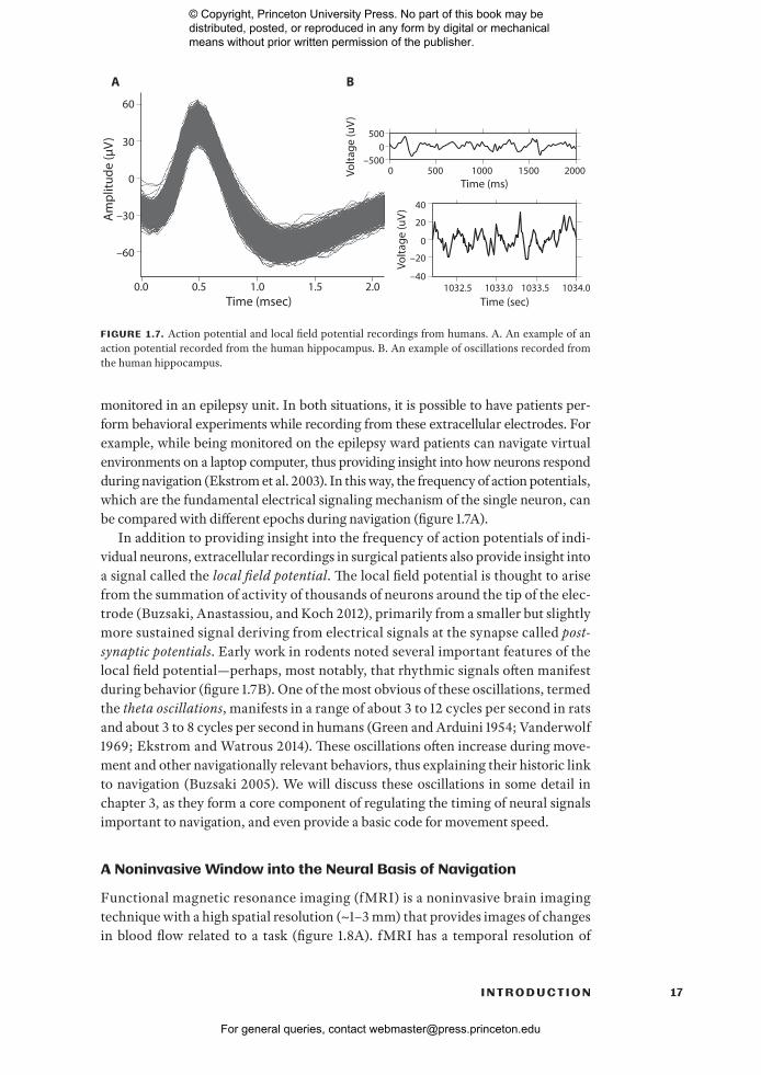
monitored in an epilepsy unit. In both situations, it is possible to have patients per-form behavioral experiments while recording from these extracellular electrodes. For example, while being monitored on the epilepsy ward patients can navigate virtual environments on a laptop computer, thus providing insight into how neurons respond during navigation (Ekstrom et al. 2003). In this way, the frequency of action potentials, which are the fundamental electrical signaling mechanism of the single neuron, can be compared with different epochs during navigation (figure 1.7A).
In addition to providing insight into the frequency of action potentials of indi-vidual neurons, extracellular recordings in surgical patients also provide insight into a signal called the local field potential. The local field potential is thought to arise from the summation of activity of thousands of neurons around the tip of the elec-trode (Buzsaki, Anastassiou, and Koch 2012), primarily from a smaller but slightly more sustained signal deriving from electrical signals at the synapse called post- synaptic potentials. Early work in rodents noted several important features of the local field potential— perhaps, most notably, that rhythmic signals often manifest during behavior (figure 1.7B). One of the most obvious of these oscillations, termed the theta oscillations, manifests in a range of about 3 to 12 cycles per second in rats and about 3 to 8 cycles per second in humans (Green and Arduini 1954; Vanderwolf 1969; Ekstrom and Watrous 2014). These oscillations often increase during move-ment and other navigationally relevant behaviors, thus explaining their historic link to navigation (Buzsaki 2005). We will discuss these oscillations in some detail in chapter 3, as they form a core component of regulating the timing of neural signals important to navigation, and even provide a basic code for movement speed.
A Noninvasive Window into the Neural Basis of Navigation
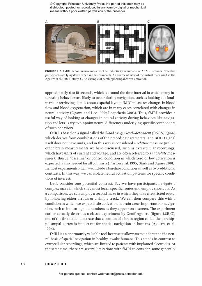
Functional magnetic resonance imaging (fMRI) is a noninvasive brain imaging technique with a high spatial resolution (~1– 3 mm) that provides images of changes in blood flow related to a task (figure 1.8A). fMRI has a temporal resolution of
60
–60
30
0
0.0 0.5 1.0 2.0Time (msec)
Time (ms)
Time (sec)
Am
plitu
de (μ
V)
1.5
0 500 1000 20001500
–30
5000
Volta
ge (u
V)
–500
1032.5 1033.0 1033.5 1034.0
0
20
40
–20
Volta
ge (u
V)
–40
A B
FIGURE 1.7. Action potential and local field potential recordings from humans. A. An example of an action potential recorded from the human hippocampus. B. An example of oscillations recorded from the human hippocampus.
© Copyright, Princeton University Press. No part of this book may be distributed, posted, or reproduced in any form by digital or mechanical means without prior written permission of the publisher.
For general queries, contact [email protected]
18 C H A P T E R 1
approximately 6 to 10 seconds, which is around the time interval in which many in-teresting behaviors are likely to occur during navigation, such as looking at a land-mark or retrieving details about a spatial layout. fMRI measures changes in blood flow and blood oxygenation, which are in many cases correlated with changes in neural activity (Ogawa and Lee 1990; Logothetis 2003). Thus, fMRI provides a useful way of looking at changes in neural activity during behaviors like naviga-tion and lets us try to pinpoint neural differences underlying specific components of such behaviors.
fMRI is based on a signal called the blood oxygen level– dependent (BOLD) signal, which derives from combinations of the preceding parameters. The BOLD signal itself does not have units, and in this way is considered a relative measure (unlike other brain measurements we have discussed, such as extracellular recordings, which have units of current and voltage, and are often referred to as absolute mea-sures). Thus, a “baseline” or control condition in which zero or low activation is expected is also needed for all contrasts (Friston et al. 1995; Stark and Squire 2001). In most experiments, then, we include a baseline condition as well as two additional contrasts. In this way, we can isolate neural activation patterns for specific condi-tions of interest.
Let’s consider one potential contrast. Say we have participants navigate a complex maze in which they must learn specific routes and employ shortcuts. As a comparison, we can employ a second maze in which they take a restricted route, by following either arrows or a simple track. We can then compare this with a condition in which we expect little activation in brain areas important for naviga-tion, such as indicating odd numbers as they appear on a screen. The experiment earlier actually describes a classic experiment by Geoff Aguirre (figure 1.8B,C), one of the first to demonstrate that a portion of a brain region called the parahip-pocampal cortex is important for spatial navigation in humans (Aguirre et al. 1996).
fMRI is an enormously valuable tool because it allows us to understand the neu-ral basis of spatial navigation in healthy, awake humans. This stands in contrast to extracellular recordings, which are limited to patients with implanted electrodes. At the same time, there are several limitations with fMRI to consider, some generally
A B C
start
FIGURE 1.8. f MRI: A noninvasive measure of neural activity in humans. A. An MRI scanner. Note that participants are lying down when in the scanner. B. An overhead view of the virtual maze used in the Aguirre et al. (2006) study. C. An example of parahippocampal cortex activation.
© Copyright, Princeton University Press. No part of this book may be distributed, posted, or reproduced in any form by digital or mechanical means without prior written permission of the publisher.
For general queries, contact [email protected]

19I N T R O D U C T I O N
related to the method and others related specifically to spatial navigation. One issue, particularly in comparison to extracellular recordings, is that the neural basis of the BOLD signal remains debated. There are certainly conditions under which cellular activity, both at the level of single cells and the local field potential, correlate with the BOLD signal (Logothetis 2003), but there are also other situations when this correlation appears to break down (Ekstrom 2010). Currently our understanding of exactly when neural activity and the BOLD signal relate or dissociate is unclear, with the emerging consensus being that different brain regions appear to show different relationships with underlying neural activity (Ekstrom 2010; Ojemann, Ojemann, and Ramsey 2013). This means that we must be cautious in interpreting BOLD differences between different brain areas, although we can feel fairly confident that BOLD relates, in some form, to neural processing during navigation.
Another issue for fMRI with regard to spatial navigation specifically is that par-ticipants must lay supine in the scanner (for example, see figure 1.8A). For partici-pants to navigate, they must view an environment by looking up (either through MRI- compatible goggles or through a mirror system) and navigate with a joystick. This produces a mismatch between how we would normally experience navigation and how we experience it in the scanner, as lying down is an awkward and unnat-ural way to navigate. Furthermore, it produces a mismatch between vestibular and visual cues (Taube, Valerio, and Yoder 2013). Our vestibular cues tell us we are lying down, while our visual cues tell us we are moving forward! While this is a poten-tial issue with studying navigation in the scanner, as discussed earlier our path in-tegration system can often rely largely on visual input (via optic flow) and ignore vestibular input, as unnatural as this might seem (Ekstrom 2015).
Another way to deal with this issue, as alluded to earlier, is to have participants retrieve memories of spatial environments rather than navigate them directly. It might seem surprising that having people merely think about a navigational expe-rience would recruit similar networks to actually navigating; however, if we con-sider our everyday lives, visual imagination is a powerful way of re- creating past experiences and even envisioning new experiences (Addis et al. 2004). Just the act of remembering details from a recent event is powerful enough to recruit many of the same brain areas involved in encoding the event in the first place (Watrous and Ekstrom 2014). This approximation of navigation seems to work well overall, as sev-eral studies suggest partially overlapping brain networks when imaging naviga-tional experiences versus actually navigating (Mellet et al. 2000).
There is one last issue to mention with both extracellular and fMRI approaches to studying navigation. Both approaches are what we term correlational. They in-dicate that a neural signal or brain region is involved, in some form, in computa-tions important to navigation, but they do not show that these signals are necessary (Rosenbaum, Gilboa, and Moscovitch 2014). Given how striking neural responses to location often are in the rodent brain, it seems surprising not to think of these changes in neural activity as necessary for successful navigation. While it is the case that lesions to some of the same brain regions where we see location- specific cod-ing often impair spatial navigation (Morris et al. 1982), this is not always the case (Ekstrom, Arnold, and Iaria 2014). We might think of a brain signal as contribut-ing in some form to navigation but that navigation could occur without it.
© Copyright, Princeton University Press. No part of this book may be distributed, posted, or reproduced in any form by digital or mechanical means without prior written permission of the publisher.
For general queries, contact [email protected]
20 C H A P T E R 1
How could this be? Think for example of the battery of a car. A car can still start without a battery (if it is jump- started), and the car will run just fine in this case. Similarly, a car can still go from one location to another without a muffler, although it will be noisy. So neither of these important components of a car are necessary for it to run. However, damage or loss of either component will result in changes in how the car runs, even though it may not be clear that either component is dam-aged if we happen to pass the car on a highway. Thus, we can think of brain regions that show changes in activation or changes in neural firing rate as likely contribut-ing something important to navigation, but their necessity to navigation cannot be proven.
Brain Lesions and Navigation
Brain damage can occur in a variety of different ways, including from stroke, from brain damage owing to a traumatic episode, from surgery to treat epilepsy or tumors, and from viral infections (Gazzaniga, Ivry, and Mangun 2014). We dis-cuss many of these types of damage in detail in chapter 7. These patients, particu-larly those who suffer damage that is selective (also termed focal), provide a rare opportunity for better understanding deficits that might occur in navigation fol-lowing certain types of brain damage. The relative absence of a brain region also allows us to make a critical inference about the potential necessity of a brain re-gion to navigation because we are now positioned to see how the brain functions differently in the absence of that critical brain region (Sarter, Berntson, and Ca-cioppo 1996). It is essential, however, that we select our control participants in a way that accounts for other differences that might occur following brain damage, including lowered intellectual functioning. Assuming we can accomplish this, however, patients with selective brain damage offer a powerful way of examining which brain regions are most fundamental to navigation.
One of the most famous examples of how selective brain damage can inform us about behavior is the case of H.M., a patient who had parts of his hippocampi and surrounding cortex removed bilaterally to treat epilepsy (see also chapters 6 and 9). The surgery that successfully reduced the number of seizures experienced by H.M. had the unfortunate consequence of leaving him densely amnesic, unable to recover memories of events from before the surgery and severely impaired at en-coding new memories (Scoville and Milner 1957). Memories from before his surgery— for example, members of the hospital staff, or evenwhere he was— were completely abolished. In addition, for decades following his surgery H.M. showed profound impairments in learning new information, such as what he had had for dinner and different people he had met over various periods of time. Thus, dam-age to H.M.’s hippocampi resulted in profound amnesia (Corkin 2002).
Subsequent work, however, demonstrated that patients with amnesia, like H.M., do have some intact forms of memory, including the ability to learn new motor skills as well as new facts about the world (Tulving, Hayman, and Macdonald 1991; Gabrieli et al. 1993). In contrast, patients with damage outside their hippocampus show impairments in acquiring both new motor skills and semantic memories, suggesting that other brain regions mediate these important functions (Martin
© Copyright, Princeton University Press. No part of this book may be distributed, posted, or reproduced in any form by digital or mechanical means without prior written permission of the publisher.
For general queries, contact [email protected]

21I N T R O D U C T I O N
and Chao 2001; Yin and Knowlton 2006). Patterns of impaired episodic memory for events but not skill learning in patients with hippocampal damage, and im-paired skill learning but not episodic memory in patients with an intact hippo-campus but with damage elsewhere in the brain represent a double dissociation (Baddeley 2003; Rosenbaum, Gilboa, and Moscovitch 2014). In other words, damage to different brain regions results in different patterns of effects on mem-ory, suggesting that different brain circuits handle, at least in part, these various components of behavior. Together, these findings argued for the so- called mul-tiple memory systems perspective— that different brain regions were responsible for different aspects of memory (Milner, Squire, and Kandel 1998).
The history with regard to studying the effects of brain damage on navigation is a little more complicated, at least with regard to the hippocampus. H.M., although densely amnesic, showed some intact navigational abilities (Bohbot and Corkin 2007). Other patients with similar patterns of damage to the hippocampus and re-lated regions within the medial temporal lobes who are also densely amnesic also show intact navigation— for example, in neighborhoods that were familiar to them for many years (Teng and Squire 1999; Rosenbaum et al. 2000). We will discuss this issue in chapter 9 in some detail and thus will leave more in- depth consider-ation of this issue until later. Again, though, situations in which brain lesions se-verely impair some processes, like episodic memory, but leave at least some aspects of spatial navigation intact also provide important insight into how the two behav-iors might depend, to some extent, on different brain circuits. Thus, throughout this book we will turn to the study of brain lesions as a valuable technique for un-derstanding the necessity of a brain region to a cognitive process, particularly when we compare and dissociate different cognitive processes and patterns of brain damage from each other.
Like many topics of study in science, however, the effects of brain lesions are not typically as straightforward as “one brain region, one necessary cognitive func-tion” (Rosenbaum, Gilboa, and Moscovitch 2014). This is particularly true with the complex set of intertwined processes that make up spatial navigation, an issue we will discuss in depth in chapters 4 and 8. For example, neurologists and physi-cians have appreciated for some time that lesions often give rise to widespread neu-ral changes well outside of the area of damage— a process called diaschisis, which was first identified in 1902 by Constantin von Monakow (for a review, see Finger et al. 2004). Indeed, new techniques for studying the brain as an interconnected network— rather than a set of modules operating in relative isolation— have signifi-cantly changed how we view both localized brain function and the specificity of lesions to cognitive function, an issue we will consider in detail in chapters 8 and 9. These include the idea of looking at connectivity and functional interactions across the brain, rather than activity isolated within brain regions (Sporns 2011; Carrera and Tononi 2014).
That said, the idea of neural specialization— that certain brain regions perform specific cognitive functions and not others— forms a core of much of the research in cognitive neuroscience since the first work by Scoville and Milner on H.M. In-deed, there is plenty of evidence to support the idea of neural specialization with regard to navigation, much of which we will review in detail throughout this book,
© Copyright, Princeton University Press. No part of this book may be distributed, posted, or reproduced in any form by digital or mechanical means without prior written permission of the publisher.
For general queries, contact [email protected]

22 C H A P T E R 1
starting in chapter 3. We believe that the correct answer is probably somewhere between: that there is certainly neural specialization in different brain regions that predisposes them to certain cognitive functions, but that at the same time the human brain is a fundamentally flexible, adaptive organ, and different brain re-gions can alter their function, dependent on the demands of the task. Throughout this book, we have tried to strike a balance, as much as possible, between a historic focus in spatial navigation on specialized function with an emerging new consen-sus that the brain acts in many ways more as an interconnected yet specialized net-work than as a set of disconnected modules operating in relative isolation.
Summary
Although we often view ourselves as poor navigators, there are numerous coun-terexamples among our species, three of which we discuss in detail. As our exam-ples demonstrated, the Puluwat sailors, Worsley, and the Inuit used mechanisms to navigate that are present within all typical humans: the path integration system and the cognitive map. Although these three examples are helpful in terms of un-derstanding the basis of how we might navigate, the study of human spatial navi-gation is a scientific discipline rooted in methods that span numerous different areas, including psychology, cognitive neuroscience, geographical science, and environmental psychology. We focus on methods for studying human spatial navi-gation, particularly its neural basis, that include invasive electrophysiological record-ings, functional and structural magnetic resonance imaging, studies of patients with focal lesions that affect their ability to navigate, and techniques that allow us to consider the brain as an interconnected, dynamic network. As we begin our voy-age into the study of human spatial navigation, we invite you to keep an open mind regarding our navigational abilities and the notion that brain systems present in all of us allow these unique skills to emerge.
© Copyright, Princeton University Press. No part of this book may be distributed, posted, or reproduced in any form by digital or mechanical means without prior written permission of the publisher.
For general queries, contact [email protected]