human history and palaeoenvironmental change at site 17 ... · human history and...
TRANSCRIPT

Lentfer, Felgate, Mills & Specht q a r | Vol. 16 | 2013 | 141
Human History and Palaeoenvironmental Change at Site 17, Freshwater Beach, Lizard Island, Northeast Queensland, Australia
Carol J. Lentfer1, Matthew W. Felgate2, Robynne A. Mills3 and Jim Specht4,5
1 School of Social Science, The University of Queensland, Brisbane QLD 4072, Australia [email protected]
2 Department of Anthropology, Archaeology and Sociology, School of Arts and Social Sciences, James Cook University, PO Box 6811, Cairns QLD 4870, Australia [email protected]
3 Mills and Wilkinson Consulting Archaeology, Kiama NSW 2533, Australia [email protected]
4 Australian Museum, 6 College Street, Sydney NSW 2010, Australia [email protected]
5 Department of Archaeology, School of Philosophical and Historical Inquiry, University of Sydney, NSW 2006, Australia
Late Holocene patterns of change in occupation and use of islands along the eastern coast of Queensland have long been debated in terms of various drivers, though much of this discussion relates to regions south of Cairns, with comparatively little study of the far northern Great Barrier Reef islands. The numerous middens, stone arrangements and art sites on Lizard Island suggest long-term use by Indigenous people, but recent discoveries of pottery give tantalising glimpses of a prehistoric past that may have included a prehistoric economy involving pottery. Here we review previous archaeological surveys and studies on Lizard Island and report on new archaeological and palaeoenvironmental studies from the Site 17 midden at Freshwater Beach, with an oldest date of 3815–3571 cal BP. We identify two major changes in the archaeological and palaeoenvironmental records, one associated with more recent European influences and the other at c.2000 cal BP. Pottery from the intertidal zone is as yet undated. When dates become available the relationship between the Site 17 results reported here and the use of pottery on the island may be clarified.
Introduction Late Holocene patterns of change in occupation and use of islands and other aspects of the archaeological record along the eastern coast of Queensland have long been debated in terms of environmental change, ENSO events, economic adaptation, demographic restructuring, insularity and culture contact with introduction of new technology (e.g. Barker 2004; Beaton 1985; Lamb 2011; Rowland 2008; Turney and Hobbs 2006; Ulm 2011). Much of this debate has been inconclusive due to lack of direct evidence, and there is no consensus regarding the cause(s) of developments, implied by the archaeological record. Furthermore, most of the research on which the debate is based has been conducted in the islands and coastal regions to the south of Cairns, and comparatively little has so far been reported for Far North Queensland (Ulm 2011:Figure 19.1). The present paper, with a focus on Lizard Island, lying on the Great Barrier Reef to the north of Cairns, is a step towards improving this situation. We review prior archaeological research undertaken on the island including that of Mills (1992); report on findings from a new excavation of the Site 17 midden at Freshwater Beach originally excavated by Mills; and present results of palaeoenvironmental analyses of that site.
The discovery of pottery sherds on Lizard Island (Felgate et al. 2010; Tochilin et al. 2012) raises important questions about the role of external influences in the region and has sparked a renewed interest in the human prehistory of the island itself. This has been further fuelled by the recent discoveries of Lapita pottery at Caution Bay along the south coast of Papua New Guinea (PNG) dating to 2800–2900 cal BP (David et al. 2011; McNiven et al. 2011), and undecorated pottery on Wari Island at the extreme eastern end of New Guinea around 3000 cal BP (Negishi and Ono 2009). Pottery (including
some red-slipped sherds) is also present in the Torres Strait possibly as early as 2600 cal BP on Pulu Island (McNiven et al. 2006) and at c.2000 cal BP on Dauan Island (Carter 2002). Wright and Dickinson (2009) provide a later date of c.1600–1300 cal BP for pottery on Mabuyag Island.
The Lizard Island pottery sherds were found on Mangrove Beach in an intertidal context. Some sherds have a granite-derived, quartz-sand temper. Although the U-Pb ages of zircon grains isolated from temper in a sample of sherds was found to broadly accord with zircon crystals in a granite outcrop on the island and sands from local beaches, local production on the island itself is by no means proved (Tochilin et al. 2012). There is sandy clay on the island with suitable plasticity for making pots (Lentfer, pers. obs.) although tests to assess firing characteristics have yet to be undertaken.
The Site 17 midden at Freshwater Beach is located on a hill near the Lizard Island intertidal pottery finds and new dates for the site show that the midden sequence spans the last c.3800–3500 years. Hence, it is well-placed, both spatially and temporally, to reflect any palaeo-environmental and/or economic changes that might be linked to pottery use. Geographical Setting Lizard Island, in the northern section of the Great Barrier Reef, Queensland (14o40'S 145o28'E) lies 27km directly off the Australian mainland to the north of Cooktown and Cape Flattery and at the northeastern end of a string of islands, reefs, coral atolls and sand spits (Figure 1). The continental island (c.12km2) was formed mainly by an orogenic pluton of porphyritic biotite-muscovite, thought to be part of the Finlayson Granite formation of Permian age (Lucas and de Keyser 1965). Prior to the post-Pleistocene sea-level rise the island would have

142 | 2013 | Vol. 16 | q a r Change at Site 17, Freshwater Beach, Lizard Island
Figure 1. Location map showing islands and reefs between Cape Flattery and Lizard Island, northeastern Queensland. been a conspicuous mountainous landform on a gently sloping coastal plain approximately 20km from the sea. With rising sea-levels and a retreating coastline it appears to have formed as an island by c.7000 BP (Woodroffe 2009; Yu and Zhao 2010). This approximation is supported by the rapid increase in mangrove pollen at this time (Proske and Haberle 2012). The topography of the island is very rugged for the most part with large areas of exposed granite ridges and boulders, but with several low areas formed by erosion deposits and reef detritus (Rees et al. 2006). To the south, three small islands – Palfrey, South and Bird – are connected to the main island by a fringing coral reef which encloses a deep lagoon. Much of the reef is exposed at low tide allowing access to the islands by foot during neap tides at certain times of the year. The highest point on the main island is Cook’s Look at 370m, and from the summit it is possible to see the outer Great Barrier Reef about 20km to the east, Cape Flattery, Cape Melville on the mainland to the west, and several islands in the Cooktown direction to the southwest.
The hot tropical climate of northeast Queensland is moderated on the island by a strong maritime influence. The humidity is moderate to high and the air temperature ranges from 20–34oC. From March through to October southeast trade winds blow fairly consistently between 15 and 25 knots, and from October to March winds become lighter and variable with long periods of calm or light north-westerlies. Rainfall varies between 1500 to 2000mm annually with the rainy season commencing in December and finishing in April. Cyclones are relatively common, with over 70 tracking in close proximity to the
island within a hundred year period (Bureau of Meteorology 2013). These occur throughout the austral summer and early autumn with higher impacts during La Niña than during El Niño. There are permanent water supplies on the island, although surface water availability is ephemeral. Captain James Cook reported taking freshwater from a creek flowing into the northern end of Watson’s Beach (Beaglehole 1962). Presently, this is not a permanent source of water and now the island’s water supply is drawn from a bore within the stream’s catchment, in a pandanus glade further inland, while a second bore behind the northern end of Watson’s Beach is fitted with a hand pump to provide yachts, campers and walkers with freshwater. Other than that, several springs occur along beaches around the island including Mangrove Beach where the pottery sherds were discovered, but at times this is unpalatably acidic to taste. Fresh potable water can be obtained from small holes dug by hand, even in the driest times of the year. Access to freshwater along this beach may have been similar since the period of sea-level stabilisation in the middle Holocene.
Today, the island’s vegetation consists of a mosaic of distinct plant communities dominated by Themeda australis Stapf. and Arundinella nepalensis Trin. grassland and smaller patches of closed forest (i.e. rainforest,) and low closed forest (i.e. semi-deciduous notophyll forest – often referred to as dry rainforest – DRF), woodland dominated by Acacia crassicarpa Cunn. ex Benth./A. humifusa Benth., Eucalyptus tessellaris Muell., shrubby heath with Thryptomene oligandra Muell., pandanus swamp, mangroves, coastal dune and

Lentfer, Felgate, Mills & Specht q a r | Vol. 16 | 2013 | 143
strand vegetation (Figure 2A) (Byrnes et al. 1977; Lentfer 2010). The pollen record from a core taken from the edge of a mangrove swamp at Watson’s Bay and spanning the last 8000 years shows evidence that similar vegetation communities prevailed on the island for the entire period (Proske and Haberle 2012). However, continuing sea-level rise and flooding of the continental shelf in the early Holocene, which resulted in the isolation of Lizard Island, led to the gradual establishment and expansion of mangrove forest. This ran parallel to the contraction of the near-coastal palm and grass-dominated vegetation (Proske and Haberle 2012).
Although there are a range of different vegetation communities, no native mammals have been recorded on the island in recent history except for black flying-foxes (Pteropus alecto Temminck, 1837), several smaller insectivorous bat species and the water rat (Hydromys chrysogaster Geoffroy, 1804). The water rat was first identified from tracks on Freshwater Beach in 2009 and is thought to be a very recent arrival. Two Melomys species, M. cervinipes (Gould, 1852) and M. capensis (Tate, 1951), occur on smaller islands in the region, including South Island (A. Hoggett, pers. comm, 2010), but neither species has been found on Lizard Island. Reptiles, including the yellow-spotted monitor (Varanus panoptes Storr, 1980), and a variety of bush birds are common in the various habitats. Additionally, there are extensive sea bird rookeries on the small adjacent islands. There is an abundance of marine life in the lagoon and associated reefs. Dugongs occasionally forage in the lagoon, and green (Chelonia mydas Linnaeus, 1758) and loggerhead (Caretta caretta Linnaeus, 1758) turtles nest on the islands during spring. There is a very rich array of shellfish including clams, oysters, top shells and conch species. Historical Background The traditional custodians of the island are the Dingaal Aboriginal people who believe that the group of islands was created in the Dreamtime. Known traditionally as ‘Jiigurru’, meaning ‘stingray’, Lizard Island is regarded as a sacred site and was used for the initiation of young males and as a meeting place between neighbouring clans. Ethnographic records suggest that in the recent past residence on the island was not permanent, but could last for several months during initiation (Gordon Charlie cited in Mills 1995a). The island was also regarded as an important food source for the Guugu Yimidhirr tribe from around Cooktown and Cape Flattery who are said to have accessed it via Rocky, South Direction and North Direction islands in hollowed-out canoes for gathering wild yam, wild arrowroot, clam shell, sea gull eggs and hunting turtle, fish, dugong and pigeons (William Daku via Ted Bowen, pers. comm., cited in Mills 1995b). In keeping with this, historical records from Captain James Cook and Joseph Banks in 1770 (Beaglehole 1962) and Captain Owen Stanley in 1848 (McGillivray 1862) record the presence of huts on prominent hilltops on the island with good exposure to southeasterly winds. Canoes, piles of shellfish, turtle shells and meat drying on trees were also observed on Lizard and neighbouring islands. Cook described the canoes as ‘poor embarkations’ which implies they were probably simple dugout hulls (Beaglehole 1962:103). Whether or not they were fitted
with outriggers is not recorded (cf. King 1826 vol. 2:16-17). Cook saw numerous goannas on the island which led him to the name Lizard Island. He climbed the northernmost hill of the island now known as Cook’s Look and from there was able to survey a safe passage through the reef. From then on, following his recommendations, the island was a stop-off point for ships engaged in major explorations of the Queensland coast. These included the HMS Beagle in 1839, the HMS Fly in 1843, and the HMS Rattlesnake in 1848. Oswald Brierly, an artist from the Rattlesnake, noted that a fire was lit by a group of Aboriginal people on the island the instant the Rattlesnake departed. In response to this, another fire was lit on the mainland, then both were extinguished (Falkiner and Oldfield 2000:22).
John McGillivray, a naturalist and collector aboard the bêche-de-mer brig, the Julia Percy, visited the island in 1861 and noted that bêche-de-mer vessels from Sydney, Singapore and Hong Kong had been operating there for 15 years already. In addition to its 76 passengers and crew, the Julia Percy carried pigs, poultry, dogs and a good supply of yams (Falkiner and Oldfield 2000:23). The party of 76 included 17 Europeans, 10 Chinese and islanders from New Caledonia, the Solomons and other islands, including 10 women and two children. They established a settlement of several ‘grass’ huts and a large stone building for storage and drying bêche-de-mer at Watson’s Bay. Granite for this was quarried from an outcrop close to the settlement site, and beach sand and burnt coral (as lime) were used to make the mortar. Bêche-de-mer were collected from nearby islands for sale to Asian markets, but according to the records, the enterprise failed after several months and the site was abandoned. MacGillivray (1852 vol. 1:110) recorded ‘a pit dug as a well’ and a small stream of freshwater in a swamp about a quarter of a mile from the beach, probably the same noted by Cook, from which barrels could be rolled over level ground to the creek and floated downstream at high tide. He also noted that the island provided a good supply of firewood, and in times of need supplied visiting vessels with food in the form of cabbage palm hearts, several kinds of native fruits and yams.
In 1879 Captain R.F. Watson and his partner, George Fuller, established another bêche-de-mer operation at Watson’s Bay. They modified the old stone building for their living quarters and established gardens. This settlement was again short-lived, ending with conflict with Aboriginal people and the death of Mrs Mary Watson, her child and two Chinese servants in 1881 (Falkiner and Oldfield 2000). The subsequent massacre of innocent Aboriginal people in later retributions was devastating for the Aboriginal communities in the region. Their traditional economies, already in decline following the expansion of pastoralism and the discovery of gold which resulted in the establishment of Cooktown in 1873, were severely compromised. In 1886 the first mission was established at Elim, Cape Bedford by German Lutherans. This was the precursor to the present Hope Vale settlement where a large number of the Dingaal currently reside (Ganter 2009; Poland 1988). In 1939, Lizard Island was declared a National Park, and the Lizard Island Research Station, adjacent to Casuarina Beach, was established by the Australian Museum in 1973. The Lizard Island Resort opened in 1975.

144 | 2013 | Vol. 16 | q a r Change at Site 17, Freshwater Beach, Lizard Island
Figure 2. Lizard Island. A (top): Distribution of vegetation (after Byrnes et al. 1977) and location of the core site at Watson’s Bay marked by a black cross (Proske and Haberle 2012). B (bottom): Location of Site 17 marked as a white cross, other middens, rock art sites and stone arrangements reported by Mills (1992, 1995a, 1995b) and Specht (1978). Figure adapted from Proske and Haberle (2012).

Lentfer, Felgate, Mills & Specht q a r | Vol. 16 | 2013 | 145
Archaeological Investigations Surveys Compared with other island groups in Queensland (see overview by Ulm 2011), there has been little archaeological research undertaken on Lizard Island. In 1973 Beaton undertook preliminary surveys of the central saddle portion of the island and the south-facing dunes as part of a wider survey of the Queensland Barrier Reef Islands. He noted a large midden with surface scatters of quartz flakes with edge wear, and an axe-like cobble with edge-grinding. This was in the vicinity of the airstrip which was then under construction. Specht undertook a more comprehensive survey of the island in 1978, noting the presence of several middens and stone arrangements. Two of these arrangements were on Cook’s Look, one a linear feature and the second, a group of several stone features which may have been those seen by Brierly in 1848 (Specht 1978:4-5). At another location on the northernmost ridge of the island a series of 11 stone arrangements, some of roughly circular form, were observed (Specht 1978:13-14). Specht (1978:7-9) also recorded an extensive midden site on the access road to the Lizard Island Research Station. Parts of the midden were partially obscured by thick undergrowth but four ‘areas’ with particularly dense shell concentrations were identified. Among the surface items was a piece of worked shell possibly from a Melo sp. shell that could be a scoop or shallow container (Figure 3A). This midden, Site 17, was excavated by Mills in 1992 and re-excavated in 2009, and forms the focus of this paper.
Further to Specht’s survey, Mills undertook more extensive surveys in the 1990s and recorded 19 middens, four stone arrangements and two art sites (Figure 2B, adapted from Mills 1992:44). She located three additional midden sites during subsequent surveys (Mills 1995a, 1995b). One of these at the southern bank of the airport runway could be that identified by Beaton. Quartz fragments occur in association with outcrops, scree slopes and beaches and there is little doubt that material for stone tool production was from local sources. Two possible quarry sites were identified but no on-site production was in evidence (Mills 1995b). The majority of middens are close to the extensive reef and lagoons on the south western side of the island, mostly located on dunes but four are on headlands. The stone arrangements consist of cairns, low walls and open ended triangular structures made from weathered granite rocks. Three occur on exposed headlands and one group is on Cook’s Look. These are all situated where stone would have been readily at hand. Two rock art sites in the central rugged area of the island are in rockshelters formed by large granite boulders. Red ochre has been used at both locations. At one of these sites, Gecko Rockshelter, one painting is an irregular elongated shape and the other is an irregular three-pronged shape (Mills 1992:Figures 14, 17). Both are reminiscent of yam tubers. The painting at the other shelter has similar irregular but less yam-like protuberances. Excavations Mills’ 1992 Excavations Gecko Rockshelter: The shelter is under a large granite boulder adjacent to a water course, approximately 60m above the valley floor located north of the southeastern
end of the airstrip below Cook’s Look. The excavation (100cm x 50cm) revealed a shallow, 39cm-deep deposit above granitic bedrock with a quartz artefact and marine shells including Strombidae and Trochidae species. No dates were obtained but Mills (1992:95-97) suggests it might have been used as a lookout point in relatively recent times to monitor European activities at Watson’s Bay. Site 17 Midden: This is located on the southern side of Lizard Island at 14o40'54"S, 145o27'10"E (Figure 2B). It is a large midden covering a total area of about 7000m2 along the dune crest and slopes about 75m inland and 20m above Freshwater Beach (also known as ‘One Tree Coconut Beach’) which is immediately west of Mangrove Beach. It has a panoramic outlook over the sea and small islands to the south and southeast of Lizard (Figures 4–5).
Mills excavated a 100cm x 50cm trench (Trench 1) to a depth of 130cm and examined lower deposits by augering to a total depth of c.210–220cm below ground surface (Mills 1992:61, Figure 23). She excavated using 5cm spits (excavation units) and a 2.5mm sieve and identified six stratigraphic layers. Three radiocarbon dates were obtained (Table 1). These are calibrated using CALIB 6.0.2 (Reimer et al. 2009), and the ranges are quoted at 2-sigma. Two Tectus niloticus (Linnaeus, 1767) shells (formerly Trochus niloticus Linnaeus, 1767) from Layers 1 and 3 gave results of 228–1* cal BP and 1870–1562 cal BP respectively (the nomenclature for molluscs cited in this paper follows the World Register of Marine Species: WoRMS Editorial Board 2012). For sample Wk-2690 a R value of 12±10 years was applied following Ulm (2006:Table 1); sample Wk-2689 is too young to apply this correction and is cited with the default R value of 0±0 years. The basal Layer 6 produced a range of 3358–2929 cal BP on charcoal at 120–130cm depth.
Given the acidic nature of the sandy sediments, it is not surprising that organic materials were poorly-preserved in the lower and older parts of the deposit, but were reasonably well-preserved in the more recent deposits of the midden near the top of the deposit (Tables 2–4). Layer 6 contained only a small amount of material evidence for human occupation including quartz flakes and charcoal. Layers 4 and 5 were lenses of grey to brown sand; Layer 4 contained a few small pieces of stone, bone, shell, crustacea and charcoal in its upper section. Shells, bones, stone artefacts and charcoal were more abundant in the upper layers. The stone artefacts included three pieces of ground basalt and about 900 definite and possible quartz and quartz crystal artefacts (mostly ≤25mm long) (Figure 3). Most of the quartz and quartz crystal artefacts came from spits 2 to 9 and were made by bipolar reduction (Mills 1992:79, Figure 30). Fragments of granite and pumice were also found throughout the deposit and, like quartz, would not be natural elements of dune deposits that formed 20m above the sea.
The shells were predominantly Strombidae species (Tables 3–4), especially Conomurex luhuanus (Linnaeus, 1758) (formerly Strombus luhuanus Linnaeus, 1758) and Lambis lambis (Linnaeus, 1758); Trochidae, mostly Tectus niloticus (Linnaeus, 1767) (formerly Trochus niloticus Linnaeus, 1767); and Tridacnidae, mostly T. crocea (Lamarck, 1819). There were minor occurrences of Saccostrea cucullata (Born, 1778), Tegillarca granosa

146 | 2013 | Vol. 16 | q a r Change at Site 17, Freshwater Beach, Lizard Island
Figure 3. Selected artefacts from surface collections and excavations at Site 17, Lizard Island. Scale bars=20mm, except for A and C, which are 50mm. All items are in the Queensland Museum (QM) collections, Brisbane. Those from the Mills excavation are identified by FB=Freshwater Beach, Trench 1, excavation square (A or B), and spit. Items A, B, D, E and I were collected by J. Specht in 1978 and have QM registrations numbers S357/1 and 2 (Photographs: Jim Specht). A. Exterior and interior of a shell (possibly Melo sp.) scoop or container. Site 17 area 1B, surface. QM S357/1. B. Ground basalt(?) chunk, possibly an abrader. Site 17 area 1D, surface. C. Flaked basalt(?) piece. Site 17 area 1A, surface. QM S357/2. D. Possible basalt tool with blunted end. Site 17, Mills’ excavation, FB/A spit 3. E. Quartz core. Site 17 area 1D, surface. F. Quartz piece possibly shaped to a point. Site 17, Mills’ excavation, FB/A-B spit 6. G. Quartz core(?) Site 17, Mills’ excavation, FB/A spit 9. H. Quartz core(?) Site 17, Mills’ excavation, FB/A spit 8. I. Quartz flake. Site 17 area 1C, surface. J. Two views of a possible quartz tool. Site 17, Mills’ excavation, FB/A spit 5.

Lentfer, Felgate, Mills & Specht q a r | Vol. 16 | 2013 | 147
Figure 4. View to the west over Mangrove Bay and Freshwater Beach, Lizard Island. The location of Site 17 is marked by the white arrow (Photograph: Carol Lentfer).
Figure 5. View from the Site 17 midden overlooking Freshwater Beach towards the southeast (Photograph: Carol Lentfer).

148 | 2013 | Vol. 16 | q a r Change at Site 17, Freshwater Beach, Lizard Island
Table 1. Radiocarbon dating results from Site 17 on Lizard Island, based on Mills (1992), Lentfer and Specht (2010) and information received from the University of Waikato Radiocarbon Dating Laboratory, New Zealand. All samples were calibrated using the atmospheric and marine datasets of CALIB 6.0.2 (Reimer et al. 2009). Sample Wk-2690 was calibrated using R=12±10 years for the northeast Queensland coast (Ulm 2006:Figure 1). Sample Wk-2689 lies outside the range for calibration with this R value and was calibrated using the default value of 0±0 years.
Lab. No. Spit Depth (cm)
Material Weight
(g) 13C (‰)
Trench 1 (1992) Trench 2 (2009)14C Age (years BP)
Calibrated Age BP 95.4%
14C Age (years BP)
Calibrated Age BP 95.4%
Wk-2689 1 0-5 Tectus niloticus shell
132.00 3.5±0.0 450±55 228-1*
Wk-2690 7 30-35 Tectus niloticus shell
150.02 3.9±0.0 2150±60 1870-1562
Wk-30014 7 60-70 charcoal 0.36 25.4±0.2 1059±29 1053-927 Wk-30012 12 110-120 charcoal 0.12 25.5±0.2 2919±34 3206-2959 Wk-2691 20 120-130 charcoal 7.13 25.7±0.2 2970±80 3358-2929 Wk-30013 14 130-140 charcoal 0.16 25.6±0.2 3408±31 3815-3571

Lentfer, Felgate, Mills & Specht q a r | Vol. 16 | 2013 | 149
Table 2. Finds from Trench 1 at Site 17, Lizard Island, standardised as g/10kg of sediment (adapted from Mills 1992). The ‘Quartz’ values are based on the ‘Artefact’ weights in Mills’ (1992) Appendix 4, as no total weights for quartz are listed. As the weights of the ‘Basalt?’ pieces are not given, only presence (P) is indicated.
Spit Calibrated
Age BP 95.4%
Sediment (kg)
Pumice (g/10kg)
Coral (g/10kg)
Quartz (g/10kg)
Granite (g/10kg)
Basalt? (g/10kg)
Shell (g/10kg)
Bone (g/10kg)
Metal (g/10kg)
Total (g/10kg)
1 288-1* 36.2 2.2 2.7 8.7 71.0 0.0 178.1 0.2 1.1 264.0
2 21.9 0.0 1.9 2.5 16.5 0.0 41.1 0.2 0.3 62.5
3 26.9 2.7 17.0 39.4 282.4 P 1767.5 2.4 0.0 2111.4
4 32.1 2.9 8.5 38.8 169.5 P 739.6 4.0 0.0 963.3
5 32.0 0.1 0.0 4.4 18.2 0.0 82.7 0.4 0.0 105.8
6 41.3 0.5 0.0 12.6 102.6 0.0 890.1 2.8 0.0 1008.6
7 1870-1562 39.9 0.3 1.5 12.9 177.4 0.0 200.4 8.7 0.0 401.2
8 33.8 0.7 0.0 11.7 77.9 P 234.1 4.0 0.0 328.4
9 61.2 0.1 0.6 6.5 40.1 0.0 2.7 0.5 0.0 50.5
10 60.0 0.1 0.1 1.3 3.1 0.0 1.1 0.4 0.0 6.1
11 51.3 0.7 0.0 4.1 4.6 0.0 2.6 0.1 0.0 12.1
12 52.2 0.0 0.0 0.1 1.7 0.0 2.4 <0.1 0.0 4.2
13 47.8 0.0 0.0 17.3 2.2 0.0 0.0 <0.1 0.0 19.5
14 47.3 0.1 0.0 0.1 0.9 0.0 0.0 0.0 0.0 1.1
15 41.3 0.1 0.1 0.2 1.1 0.0 0.0 <0.1 0.0 1.5
16 37.9 0.0 0.0 0.1 1.3 0.0 0.0 0.0 0.0 1.4
17 44.6 0.1 0.0 0.1 1.0 0.0 0.0 0.0 0.0 1.2
18 29.6 0.2 0.0 0.4 287.0 0.0 0.0 <0.1 0.0 287.6
19 42.8 0.1 0.0 1.9 21.0 0.0 0.0 0.0 0.0 23.0
20 3358-2929 47.4 0.0 0.0 8.9 12.6 0.0 0.0 0.0 0.0 21.5
Total 827.5 10.9 32.4 172.1 1292.1 P 4142.4 23.8 1.4 5674.9

150 | 2013 | Vol. 16 | q a r Change at Site 17, Freshwater Beach, Lizard Island
Table 3. Summary of shellfish recovered from Trench 1 at Site 17, Lizard Island, presented as raw weight in grams (adapted from Mills 1992:Appendix 4). Mills (1992:Appendix 3) lists Charonia tritonis (Linnaeus, 1758) as present. This taxon is not listed separately in Appendix 4, and is presumably included in the ‘Indet.’ column.
Gastropods Bivalves Conidae Strombidae Trochidae Turbinidae Arcidae Tridacnidae Ostreidae
Indet. Spit
Conus quercinus (Lightfoot, 1786)
Conomurex luhuanus (Linnaeus, 1767)
Lambis lambis (Linnaeus, 1758)
Tectus niloticus (Linnaeus, 1767)
Turbo marmoratus (Linnaeus, 1758)
Tegillarca granosa (Linnaeus, 1758)
Tridacna spp. Saccostrea cucullata (Born, 1778)
1 0.0 333.1 0.0 159.5 0.0 0.0 151.4 2.5 2.5 2 12.6 578.0 23.8 83.2 0.0 0.0 217.7 7.3 43.7 3 0.0 3004.2 56.9 741.9 0.0 0.0 740.0 0.0 88.4 4 0.0 1443.9 91.8 182.0 0.0 0.0 652.5 3.9 95.7 5 0.0 1725.4 193.5 98.3 0.0 31.5 628.7 0.0 193.5 6 0.0 3045.3 36.2 357.1 20.1 0.0 21.3 5.9 62.2 7 0.0 484.7 0.0 254.9 0.0 0.0 57.4 2.4 2.4 8 0.0 105.6 0.0 685.8 0.0 0.0 0.0 0.0 0.0 9 0.0 0.0 0.0 0.0 0.0 0.0 0.0 0.0 0.0 10 0.0 6.5 0.0 0.0 0.0 0.0 0.0 0.0 0.0 11 0.0 10.8 0.0 0.0 0.0 0.0 2.4 0.0 0.0 12 0.0 12.3 0.0 0.0 0.0 0.0 0.0 0.0 0.0 13 0.0 0.0 0.0 0.0 0.0 0.0 0.0 0.0 0.0 14 0.0 0.0 0.0 0.7 0.0 0.0 0.0 0.0 0.0 15 0.0 0.0 0.0 0.0 0.0 0.0 0.0 0.0 0.0 16 0.0 0.0 0.0 0.0 0.0 0.0 0.0 0.0 0.0 17 0.0 0.0 0.0 0.0 0.0 0.0 0.0 0.0 0.0 18 0.0 0.0 0.0 0.0 0.0 0.0 0.0 0.0 0.0 19 0.0 0.0 0.0 0.0 0.0 0.0 0.0 0.0 0.0 20 0.0 0.0 0.0 0.0 0.0 0.0 0.0 0.0 0.0
Total 12.6 10749.8 402.2 2563.4 20.1 31.5 2471.4 22.0 488.4

Lentfer, Felgate, Mills & Specht q a r | Vol. 16 | 2013 | 151
Table 4. Shellfish families in Trench 1 at Site 17, Lizard Island, standardised as g/10kg of sediment (adapted from Mills 1992).
Spit Sediment
(kg)
Gastropods Bivalves Indet.
(g/10kg) Total
g/10 kg Strombidae (g/10kg)
Trochidae (g/10kg)
Conidae (g/10kg)
Turbinidae (g/10kg)
Tridacnidae (g/10kg)
Ostreidae (g/10kg)
Arcidae (g/10kg)
1 36.2 91.5 44.1 0.0 0.0 41.8 0.7 0.0 0.6 178.7
2 21.9 274.8 38.0 5.8 0.0 99.4 3.3 0.0 20.0 441.3
3 26.9 1138.0 275.8 0.0 0.0 275.1 0.0 11.7 32.9 1733.5
4 32.1 478.4 56.7 0.0 0.0 194.9 1.2 0.0 29.8 761.0
5 32.0 599.7 2.6 0.0 0.0 196.5 0.0 0.0 60.5 859.3
6 41.3 746.1 86.5 0.0 4.9 51.2 1.4 0.0 15.1 905.2
7 39.9 123.7 63.7 0.0 0.0 14.4 0.6 0.0 0.6 203.0
8 33.8 27.1 175.9 0.0 0.0 0.0 0.0 0.0 0.0 203.0
9 61.2 0.0 0.0 0.0 0.0 0.0 0.0 0.0 0.0 0.0
10 60.0 1.1 0.0 0.0 0.0 0.0 0.0 0.0 0.0 1.1
11 51.3 2.1 0.0 0.0 0.0 0.5 0.0 0.0 0.0 2.1
12 52.2 2.4 0.0 0.0 0.0 0.0 0.0 0.0 0.0 2.4
13 47.8 0.0 0.0 0.0 0.0 0.0 0.0 0.0 0.0 0.0
14 47.3 0.0 0.2 0.0 0.0 0.0 0.0 0.0 0.0 0.2
15 41.3 0.0 0.0 0.0 0.0 0.0 0.0 0.0 0.0 0.0
16 37.9 0.0 0.0 0.0 0.0 0.0 0.0 0.0 0.0 0.0
17 44.6 0.0 0.0 0.0 0.0 0.0 0.0 0.0 0.0 0.0
18 29.6 0.0 0.0 0.0 0.0 0.0 0.0 0.0 0.0 0.0
19 42.8 0.0 0.0 0.0 0.0 0.0 0.0 0.0 0.0 0.0
20 47.4 0.0 0.0 0.0 0.0 0.0 0.0 0.0 0.0 0.0
Total 827.5 3484.9 743.3 5.8 4.9 873.8 7.2 11.7 159.5 5291.1
152 | 2013 | Vol. 16 | q a r Change at Site 17, Freshwater Beach, Lizard Island
(Linnaeus, 1759) (formerly Anadara granosa Linnaeus, 1758), Charonia tritonis (Linnaeus, 1758), and possibly of Turbo marmoratus (Linnaeus, 1758) (Mills 1992:Appendices 3–4). The bone was dominated by turtle (562.7g), mostly found in spits 4 to 7, and dugong (23.8g), with only minor quantities of bird and fish (Mills 1992:84, Graphs 47-58, Appendix 4).
Due to the small amount of artefactual material present in the basal deposits, Mills interpreted the site as being occupied initially by a small group of people. From 3358–2929 cal BP to 1870–1562 cal BP activity at the site was limited, but thereafter activities included production of artefacts from quartz and quartz crystal and subsistence based on shellfish collecting, fishing, and hunting for turtles and dugong. These activities continued until the recent past (Mills 1992:67). The 2009 investigation of the Site 17 Midden Funding for the broader Lizard Island project, research permits and a heritage agreement with Dingaal included examination of Site 17 as a means for tracking mid-to-late Holocene environmental history and site use over the likely period of the pottery on Mangrove Beach. In October 2009 Lentfer, Specht and Jonathan Charlie (representing the Dingaal people) excavated a 60cm x 40cm trench (Trench 2), 2m to the east of Mills’ trench to a depth of 140cm, using 10cm spits and a 4mm sieve (Lentfer and Specht 2010). Whereas Mills recorded the quantity of excavated sediment by weight, the 2009 investigation measured sediment volume in litres. Consequently, the tables for the standardised values of the various categories of finds from 1992 and 2009 are based on different procedures but allow broad comparisons. The 2009 stratigraphy, with six discernible layers, accords well with that of Trench 1 (Figure 6). Three 14C AMS dates were obtained from charcoal collected within the excavation from spits 7, 12 and 14 (Table 1).
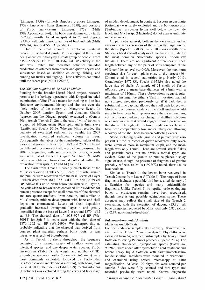
The finds from Trench 2 broadly match those of the Mills’ excavation (Tables 5–6). Pieces of quartz, granite and pumice were recovered from the basal levels of Layer 6 which dates from 3815–3571 cal BP to 3206–2959 cal BP. Above this up to 70cm below the surface in Layer 5, the yellowish-to-brown sands contained little evidence for human presence except for small amounts of fine charcoal and rare quartz artefacts. From here-on, and similar to Mills’ trench, midden development with bone and shell deposition commenced. Levels of shell deposition gradually increased throughout Layer 4 and greatly intensified from the base of Layer 3 at around 1870–1562 cal BP. The charcoal date of 1053–927 cal BP (Wk-30014) for Spit 7 is inconsistent with the shell date of 1870–1562 cal BP (Wk-2690). We interpret this as probably indicating that the charcoal was derived from younger plant material, perhaps burnt roots, or was intrusive as a result of bioturbation.
As in Trench 1, shells throughout the sequence consisted of a narrow variety of shallow water and intertidal species, and one deeper water species, Turbo marmoratus (Table 7). By weight and number (MNI), Strombidae species (mostly Conomurex luhuanus) were most commonly exploited, followed by Tridacnidae (Tridacna crocea and Tridacna maxima), both being most dense at 10 to 30cm depth (Tables 8–9). Tectus niloticus (Trochidae) was exploited during the early and later stage
of midden development. In contrast, Saccostrea cucullata (Ostreidae) was rarely exploited and Turbo marmoratus (Turbinidae), a species living well below the low tide level, and Mactra sp. (Mactridae) do not appear until late in the sequence.
Of particular interest, both in the excavation and at various surface expressions of the site, is the large size of the shells (Specht 1978:9). Table 10 shows results of a Student’s t-test (2-tail) analysis of the basic size data for the most common Strombidae species, Conomurex luhuanus. There are no significant differences in shell length between any of the pairs of spits compared at the 95% confidence level (=0.05). Moreover, the maximum specimen size for each spit is close to the largest (60–80mm) cited in several authorities (e.g. Hardy 2013; Cernohorsky 1972:83). Specht (1978:9) also noted the large size of shells. A sample of 21 shells of Tectus niloticus gave a mean base diameter of 85mm with a maximum of 110mm. These observations suggest, inter alia, that this might be either a ‘first hit’ location that had not suffered predation previously or, if it had, then a substantial time gap had allowed the shell beds to recover. Moreover, on current evidence, the shell midden would seem to have been built up over more than a millennium, yet there is no evidence for change in shellfish selection or change in size that would suggest human pressure on the stocks. Throughout this time, predation levels must have been comparatively low and/or infrequent, allowing recovery of the shell beds between collecting events.
Stone, including quartz, granite and pumice were also present. Of the 71 pieces of quartz recovered, only seven were 30mm or more in maximum length, and the mean length was only 18mm. There are several struck flakes and possible cores, but no obvious formal types are evident. None of the granite or pumice pieces display signs of use, though the presence of fragments of granite probably reflects, as Mills (1992:72) noted, their use as heat retainers.
Similar to Trench 1, the lowest bone recovered in Trench 2 came from Layer 5 (Table 6). The range of bone fragments includes a possible bird bone, a left dentary of a Scaridae fish species and many unidentifiable fragments. Unlike Trench 1, no reptile, turtle or dugong bones or crustacean remains have been recognised, though there is one possible echinoderm spine. These absences may reflect the small size of the Trench 2 excavation; with the exception of dugong (23.8g), all bone categories recovered by Mills total only 6.82g (Mills 1992:84, non-standardised data). Palaeoenvironmental Analysis Materials and Methods Fourteen sediment samples taken at every 10cm down the east face of Trench 2 were analysed. Phytoliths were extracted from 5g sediment subsamples by heavy liquid flotation following Piperno’s protocol (Piperno 2006). For estimating abundance, Lycopodium spores (Batch no. 938943) were added after hydrochloric acid treatment and before heavy liquid flotation with cadmium/potassium iodide solution. Residues were mounted in ‘Permount’ and examined using optical microscopy at x400 magnification. At least 100 phytoliths were counted per sample. Slides were fully scanned and rare types not recorded previously were noted. Known diagnostic

Lentfer, Felgate, Mills & Specht q a r | Vol. 16 | 2013 | 153
Figure 6. Profile of the western face of Trench 1 (adapted from Mills 1992:Figure 23) and the eastern face of Trench 2 at the Site 17 midden, Lizard Island. Table 5. Reconciliation of the 1992 and 2009 excavations at Site 17, Lizard Island.
Trench 1 (1992) Trench 2 (2009)
Layer Spits Depth (cm)
Finds Spits Depth (cm)
Finds
1 1-2 0-10 Metal. Granite, quartz, pumice. Shell, turtle, reptile, fish, bird,
other bone, coral 1 0-5/10 Granite, quartz. Shell, bone
2-3 3-8 10-~38 Granite, quartz, pumice. Shell,
turtle, dugong, reptile, bird, fish, crustacea, other bone, coral
2-3 10-30 Granite, quartz, pumice. Shell, bone, coral
4 9-14 ~38-75 Granite, quartz, basalt, pumice.
Shell, turtle, reptile, fish, crustacea, other bone, coral
3-5 30-50 Granite, quartz, pumice. Shell,
echinoderm(?), fish, bird(?), other bone, coral
5 15-20 75-110 Granite, quartz, pumice. Reptile,
other bone, coral 6-9 50-90 Granite, quartz, pumice. Shell, bone
6 16-20 90-115 Granite, quartz, pumice. Coral 10-14 90-140 Granite, quartz, basalt, pumice
154 | 2013 | Vol. 16 | q a r Change at Site 17, Freshwater Beach, Lizard Island
Table 6. Summary of finds from Trench 2 at Site 17, Lizard Island, standardised as g/10 l of sediment Notes: (a) Spit 4 – granite: largest pieces 62.4g and 68.9g; (b) Spit 4 – bone: includes one scarid left dentary, 1.4g; (c) Spit 5 – granite: largest piece 20.3g; (d) Spit 5 – bone: one possible bird long bone, 0.2g; (e) Spit 6 – granite: largest piece 46.7g; (f) Spit 12 – granite: largest piece 12.1g; and (g) Spit 14 – granite: largest piece 90.0g.
Spit Calibrated
Age BP 95.4%
Volume (l)
Sediment Description Munsell Colour
pH Pumice (g/10 l)
Coral (g/10 l)
Quartz (g/10 l)
Granite (g/10 l)
Basalt? (g/10 l)
Shell (g/10 l)
Echinoid? (g/10 l)
Bone (g/10 l)
Total (g/10 l)
1
40 Brownish-black, medium sand with fine charcoal and roots 10YR 3/2 5.4 0.0 0.0 9.2 24.2 0.0 297.5 0.0 2.0 332.9
2
12 Brownish-black, medium sand with fine charcoal, roots and other organic matter
10YR 2/2 5.0 0.3 3.8 10.7 173.2 0.0 192.2 0.0 0.6 380.9
3
15 Brownish-black, fine sand with fine charcoal and roots 10YR 2/2 5.5 1.0 1.4 10.5 66.7 0.0 1374.2 0.0 6.2 1460.0
4
17 Brownish-black, fine sand with roots and other organic matter 10YR 2/2 5.5 1.6 0.0 13.3 297.0a 0.0 554.2 <0.1 6.1b 872.2
5
26 Brownish-black, fine-to-medium sand with roots and fine gravel 10YR 3/2 5.5 0.4 2.0 4.1 40.2c 0.0 32.9 0.0 1.3d 80.9
6
30 Brown, fine-to-medium sand with charcoal, roots and other organic matter
10YR 3/4 5.5 0.0 0.0 3.4 15.3e 0.0 2.0 0.0 0.1 20.8
7 1053-927
36
Brown fine-to-medium sand with charcoal and roots 10YR 3/4 5.5 0.1 0.0 1.1 0.9 0.0 0.3 0.0 0.0 2.4
8
36 Brown fine-to-medium sand with charcoal and roots 10YR 4/4 5.5 0.0 0.0 0.0 0.0 0.0 0.0 0.0 0.0 0.0
9
33 Brown fine-to-medium sand with charcoal fragments and roots 10YR 4/4 5.5 0.0 0.0 2.0 0.0 0.0 0.0 0.0 0.0 2.0
10
22 Grayish yellow-brown, fine-to-medium sand with charcoal and roots 10YR 4/2 5.5 0.0 0.0 0.0 0.0 0.0 0.0 0.0 0.0 0.0
11
23 Dull yellowish-brown, fine-to-medium sand with charcoal and roots 10YR 5/4 5.5 0.0 0.0 0.0 0.0 0.0 0.0 0.0 0.0 0.0
12 3206-2959 24 Brown, fine-to-medium sand with charcoal and roots 10YR 4/6 5.5 0.0 0.0 0.3 5.8f 0.0 0.0 0.0 0.0 6.1
13
26 Brown, fine-to-medium sand with charcoal fragments and roots 10YR 4/4 5.5 0.0 0.0 0.0 2.1 0.0 0.0 0.0 0.0 2.1
14 3815-3571 25 Greyish yellow-brown, fine-to-medium sand with charcoal fragments and roots
10YR 4/2 5.5 0.0 0.0 0.2 41.3g 0.0 0.0 0.0 0.0 41.5
Total 365 3.4 7.2 54.8 666.7 0.0 2453.3 <0.1 16.3 3201.8.0

Lentfer, Felgate, Mills & Specht q a r | Vol. 16 | 2013 | 155
Table 7. Shellfish recovered from Trench 2 at Site 17, Lizard Island, presented as raw weights (g). Mollusc Taxa Spit 1
(g) Spit 2
(g) Spit 3
(g) Spit 4
(g) Spit 5
(g) Spit 6
(g) Spit 7
(g) Total
(g) Strombidae Conomurex luhuanus (Linneaus, 1767) 659.9 1491.7 849.8 477.3 59.0 0.0 0.0 3537.7Lambis sp. 21.2 49.3 0.0 118.2 0.0 0.0 0.0 188.7Strombus sp. 0.0 0.0 0.0 0.0 0.0 4.1 1.0 5.1 Trochidae Tectus niloticus (Linnaeus, 1767) 119.3 70.7 0.0 220.6 1.0 0.0 0.0 411.6 Trochus sp. 0.0 0.0 20.3 12.6 0.0 0.2 0.0 33.1 Turbinidae Turbo marmoratus (Linnaeus 1758) 36.7 0.0 0.0 0.0 0.0 0.0 0.0 36.7 Tridacnidae Tridacna crocea (Lamarck, 1819) 42.2 164.5 103.0 0.0 0.0 0.0 0.0 309.7 Tridacna maxima (Röding, 1798) 0.0 165.4 358.6 0.0 0.0 0.0 0.0 524.0 Tridacna sp. 217.3 317.7 640.4 84.3 25.5 0.0 0.0 1285.2 Mactridae Mactra sp. 5.7 0.0 0.0 0.0 0.0 0.0 0.0 5.7 Ostreidae Saccostrea cucullata (Born, 1778) 1.4 0.0 0.0 1.1 0.0 0.0 0.0 2.5
Marine indet. 86.1 47.5 89.2 28.2 0.0 1.6 <0.1 252.6
Terrestrial indet. 0.3 0.0 0.0 0.0 0.0 0.0 0.0 0.3
Total 1190.1 2306.8 2061.3 942.3 85.5 5.9 1.0 6592.9

156 | 2013 | Vol. 16 | q a r Change at Site 17, Freshwater Beach, Lizard Island
Table 8. Shellfish families represented in Trench 2 at Site 17, Lizard Island, standardised as g/10 l of sediment.
Spit Layer Volume
(l)
Marine Marine Indet. g/10 l
Land Indet. g/10 l
Total g/10 l
Gastropods Bivalves Strombidae
g/10 l Trochidae
g/10 l Turbinidae
g/10 l Mactridae
g/10 l Tridacnidae
g/10 l Ostreidae
g/10 l 1 1 40 17.0 3.0 0.9 <0.1 6.5 <0.1 2.2 <0.1 29.6
2 2-3 12 128.4 5.9 0.0 0.0 54.0 0.00 4.0 0.0 192.3
3 3 15 56.7 1.7 0.0 0.0 73.5 0.00 6.0 0.0 137.9
4 4 17 25.0 13.7 0.0 0.0 5.0 0.1 1.7 0.0 45.5
5 4 26 2.3 <0.1 0.0 0.0 1.0 0.0 3.3 0.0 6.6
6 5 30 0.1 <0.1 0.0 0.0 0.0 0.0 0.1 0.0 0.2
7 5 36 0.1 0.0 0.0 0.0 0.0 0.0 <0.1 0.0 0.1
8 5 36 0.0 0.0 0.0 0.0 0.0 0.0 0.0 0.0 0.0
9 5 33 0.0 0.0 0.0 0.0 0.0 0.0 0.0 0.0 0.0
10 6 22 0.0 0.0 0.0 0.0 0.0 0.0 0.0 0.0 0.0
11 6 23 0.0 0.0 0.0 0.0 0.0 0.0 0.0 0.0 0.0
12 6 24 0.0 0.0 0.0 0.0 0.0 0.0 0.0 0.0 0.0
13 6 26 0.0 0.0 0.0 0.0 0.0 0.0 0.0 0.0 0.0
14 6 25 0.0 0.0 0.0 0.0 0.0 0.0 0.0 0.0 0.0
Total 365 229.6 24.3 0.9 <0.1 140.0 0.1 17.3 <0.1 412.2 Table 9. MNI of shellfish in Trench 2 at Site 17, Lizard Island.
Family Genus/Species
Spit
1 2 3 4 5 6 7
Gas
trop
ods Strombidae Conomurex luhuanus (Linnaeus, 1758) 187 833 333 418 35 7 3
Strombidae Lambis sp. 3 8 0 12 0 0 0
Trochidae Tectus niloticus (Linnaeus, 1767) 5 8 7 12 4 3 0
Turbinidae Turbo marmoratus (Linnaeus, 1758) 3 0 0 0 0 0 0
Biv
alve
s
Tridacnidae Tridacna crocea (Lamarck, 1819) 5 8 20 0 0 0 0
Tridacnidae Tridacna maxima (Röding, 1798) 0 8 13 0 0 0 0
Mactridae Mactra sp. 3 0 0 0 0 0 0
Ostreidae Saccostrea cucullata (Born, 1778) 3 0 0 6 0 0 0
Total 209 865 373 448 39 10 3

Lentfer, Felgate, Mills & Specht q a r | Vol. 16 | 2013 | 157
Table 10. Heights (mm) of Conomurex luhuanus shells from Trench 2 at Site 17, Lizard Island.
Spit
1 2 3 4
Count 24 73 41 4
Range 40-63 38-65 41-70 43-59
Mean 48.8 51.4 51.5 52.0
SD 7.04 6.44 7.64 6.00
Spits 1 v 2 t = -1.71 p=0.0911
Spits 1 v 3 t = -1.42 p=0.1601
Spits 1 v 4 t = -0.87 p=0.3931
Spits 2 v 3 t = -0.05 p=0.9609
Spits 2 v 4 t = -0.18 p=0.8555
Spits 3 v 4 t = 0.14 p=0.8925

158 | 2013 | Vol. 16 | q a r Change at Site 17, Freshwater Beach, Lizard Island
morphotypes were categorised into plant groups according to comparative reference material collected on Lizard Island in 2009 (Lentfer 2010; Lentfer and Specht 2010) and other reference material from elsewhere in the Asia/Pacific region (e.g. Kealhofer and Piperno 1998; Lentfer 2003). Unknown morphotypes were given descriptives (Lentfer 2003; Madella et al. 2003) and, where possible, assigned to vegetation categories. As a proxy for burning, burnt phytoliths and all black, opaque micro-charcoal particles >5µm were counted (see Lentfer et al. 2010; Piperno and Becker 1996). All scores were converted to percentage values for phytolith diagrams. Square root values were used to standardise scores for principal component analysis with SPSS. Results Phytoliths and micro-charcoal are present in all samples (Figures 7–9). Phytolith assemblages are dominated by lamellate morphotypes, some double-walled and derived from the epidermis of a large range of different plants excluding grasses and sedges. Others, described as lam./-/- , are platy phytolith fragments without clearly defined walls that could not be assigned to any particular plant group. The latter are excluded from the phytolith and summary diagrams (Figure 7) as well as the principal component analysis, but frequencies of both lamellate morphotypes are compared in Figure 9. The highest frequencies of micro-charcoal occur in Layer 6 at the base of the deposit at 3815–3571 cal BP, and at the top of this layer between 90 and 100cm (3206–2959 to 1870–1562 cal BP). There are also three spikes in burnt phytoliths, the first at the base of the profile in Layer 6, at 110 and 120cm depth at 3206–2959 cal BP and two peaks towards the top of the profile in association with the shell midden in Layer 4 at 40–50cm (1870–1562 to 228–1* cal BP), and Layer 3 at 10–20cm (1870–1562 to 228–1* cal BP) (Table 1, Figure 6).
Patterns of phytolith deposition reflect major changes in the vegetation history, which are well correlated with the archaeological record and midden development (Figure 7B). Five major phases are indicated by the principal component analyses (Figure 8), as marked on the phytolith and finds’ curves (Figure 7B). In Phase 1 at the base of the deposit, phytoliths include morphotypes from Dilleniidae. This subclass includes the Moraceae, Tiliaceae, Euphorbiaceae and Urticaceae families comprising several species that are common in the present-day dry rainforest growing along the sheltered strand plains and dune formations on Lizard Island (Lentfer 2010). Other phytoliths, such as many of the globular (gl.) as well as the ovate (ov.), cuneate (cun.) and polyhedral (plyhdrl.) morphotypes, are also common in these deposits. Thus, given their association with the diagnostic group of dry rainforest (DRF) morphotypes, these could well be derived from a similar complex of species from this vegetation type. However, since these morphotypes occur across a broad range of plant groups (Lentfer 2003) they have been assigned as non-grass (indet.) for this analysis. Notably, Myrtaceae morphotypes are poorly represented at this level. These are probably derived from Syzygium suborbiculare Benth. Hartley and Perry and Planchonella obovata (R.Br.) Pierre, and Eucalyptus tesselaris Muell., which grows on the perimeter of DRF, on dry ridge tops and less protected
locations; or possibly from the smaller shrub Thryptomene oligandra Muell., a common component of heath on many of the exposed dunes on Lizard Island. It is only in Phase 2 as DRF elements decline, that Myrtaceae morphotypes become more common. During Phase 3, diagnostic DRF morphotypes disappear altogether and are replaced by morphotypes derived from Fabaceae, possibly scramblers including Canavalia rosea (Sw.) DC. and Derris trifoliata Lour. and/or native broom, Jacksonia thesioides Benth., which presently grows in dense thickets on dune slopes, or myrtaceous and other non-grass species. Frequencies of all these morphotypes decline during the middle of Phase 3 as lamellate morphotypes increase. The lack of diagnostic phytoliths during this period makes it difficult to determine the precise vegetation type, but given the relative decline in phytolith abundance a more open habitat with less plant biomass is indicated. Directly above this, there is a recovery of myrtaceous elements, and other non-grass species including Acacia spp. This trend continues throughout Phase 4 during the period of shell deposition and it is not until Phase 5, the uppermost level that grass morphotypes appear, signifying a major change in vegetation structure associated with a much more disturbed and open environment following the period of maximum shell deposition.
Peaks in burning levels, as indicated by abundance of micro-charcoal, are directly associated with major shifts in vegetation change throughout the sequence. Dry rainforest elements decline and are replaced by myrtaceous heath following high levels of burning in the basal deposits, Phases 1 and 2. In the lower levels of Phase 3, higher frequencies of herbs and scramblers, indicative of more open vegetation, are in direct association with high frequencies of charcoal. Following a major peak in charcoal, diagnostic markers for shrubs and trees decline along with a decline in phytolith abundance and it is not until later in the sequence, immediately preceding levels with shell deposition, that myrtaceous vegetation recovers. Further increases occur during Phase 4 in conjunction with denser deposits of shells and more consistent levels of charcoal.
The three spikes in burnt phytoliths coincide with significant shifts in vegetation and perhaps this signifies burning episodes that were sufficiently hot to char the occluded carbon in phytoliths. The first major spike in Phase 2 precedes the sudden increase in Myrtaceae and a similar pattern of change is seen at the base of Phase 4. Then, further up the sequence a major change occurs in Phase 5 when grasses appear in the sequence for the first time. This occurs immediately after a spike in burnt phytoliths at the upper level of Phase 4.
These patterns of change are also reflected in the Watson’s Bay pollen/spore and charcoal records. Notably from c.1500 years ago in conjunction with increased fire frequency (Proske and Haberle 2012:10) there is a marked increase in Cyclosorus sp., a hardy pioneer fern and a disturbance indicator.
Finally, there is a correlation between micro-charcoal and burnt phytoliths, and abundance levels of double-walled lamellate (lam./dw./epid.) vs lamellate fragments (lam./-/-), which could indicate increased rates of weathering promoted by burning. Most notably, there are two peaks in lamellate fragments in the lower levels of

Lentfer, Felgate, Mills & Specht q a r | Vol. 16 | 2013 | 159
Figure 7. A - Phytolith curve based on % composition of phytoliths at Site 17, Lizard Island. Numbers at the top of curves correspond to the morphotypes shown in the principal component plots (Figure 8). The -/-/stom. morphotype no. 24 with a value of less than 0.3% was excluded from this diagram. Dots mark very low values of morphotypes with <0.5%. B - Combined summary plot with phytolith, charcoal composition and archaeological finds from Trench 2. Dots represent low values for archaeological finds of <0.5g/l of excavated deposit. Unfilled lines in the archaeological finds represent x10 exaggeration.

160 | 2013 | Vol. 16 | q a r Change at Site 17, Freshwater Beach, Lizard Island
Figure 8. Biplots showing associations in phytolith assemblages in Trench 2 at the Site 17 midden, Lizard Island. Numbers in the sample plots correspond to spit numbers (see Table 3), and the morphotype numbers (see Figure 7A). A - Sample plot (A) and vector plot (B) for the first and second principal components account for 44% of variation in the phytolith assemblages. No. 24 represents the rare -/-/stom. morphotype not shown in Figure 8B. B - Sample plot (A) and vector plot (B) for the first and third principal components account for 41% of variation in the phytolith assemblages. No. 24 represents the rare -/-/stom. morphotype not shown in Figure 7.
Figure 9. Comparison between patterns of distribution of lamellate morphotypes, charcoal, burnt phytoliths and phytolith abundance in Trench 2 at Site 17, Lizard Island.

Lentfer, Felgate, Mills & Specht q a r | Vol. 16 | 2013 | 161
Phase 3 following the burnt phytolith spike in Phase 2 and the major spike in charcoal in Phase 3, respectively. A similar trend is seen in Phase 4. In contrast, there is a peak in complete double-walled lamellate morphotypes in Phase 3 which directly correlates with low levels of charcoal and burnt phytoliths. Notably, these patterns are not repeated in the uppermost level Phase 5 but this could be explained by the relatively recent deposition of phytoliths and less exposure to weathering elements. Discussion Excavation of the Site 17 midden and palaeo-environmental analyses provide significant information about the prehistoric occupation of the island and environmental change, much of which stems from the impact of human activities. Major trends, summarised in Figure 7B and Table 11, show the history of human use of the site from 3815–3571 cal BP to the present with vegetation changing from dry rainforest to more open vegetation and with increasing dominance of myrtaceous heath elements and Acacia spp; and finally, the appearance of grasses. The prominence of grasses in the latest Phase 5 is most likely related to land clearance associated with European use of Lizard Island; this is also reflected in the results of pollen/spore and charcoal analyses from Watson’s Bay (Proske and Haberle 2012). The patterns of burning show direct relationships with vegetation change, indicating that burning was a significant factor causing the shifts from DRF to more fire-tolerant heath vegetation at the site, and then, to the promotion of grasses. There is strong evidence for burning from the base of the sequence, which also correlates well with the charcoal analysis from the Watson’s Bay core (Proske and Haberle 2012:Figures 3–4). It is difficult to determine whether burning in the earlier phases of the sequence, before the most active period of the midden formation, was due to natural fires or human activities. Several studies have shown that the establishment of the modern ENSO-mode within the last 5000 years and its intensification around c.3000 years ago affected tropical northeastern Australia (Gagan et al. 2004; Haberle et al. 2010; Shulmeister and Lees 1995). Consequently, Proske and Haberle (2012) suggest that prolonged drought periods throughout this period may have led to greater ignition potential on Lizard Island. However, given the evidence for human presence from c.3800 cal BP for the entire sequence, anthropogenic burning is likely to have had a significant influence on burning intensity and frequency. Indeed, if this is the case, it implies a longer and/or more intensive history of human activity on the island than gauged by Mills’ original interpretation. Moreover, it suggests that people had watercraft capable of voyages from the mainland to Lizard Island – perhaps via the smaller islands and reefs in between – well before the earliest records for the occupation of the Flinders group of islands c.2500 cal BP (Beaton 1985). The latter, according to Beaton, was dependent on the arrival of a canoe technology capable of undertaking the water-crossings, an hypothesis which has long been dispelled (cf. Rowland 2008).
The shellfish remains raise an intriguing issue. The absence of shell from the lower levels of Trench 1 and Trench 2 may be attributed – in part, at least – to the acidic nature of the sediments, which breaks down
calcareous material over time. There may have been deposition of shells before the development of the midden; if so, we might expect some remnants of the shells to have survived. It is possible that prior to the development of midden at the excavated area, shell deposition took place at another part of the site or elsewhere on the island.
The issue of pottery on Lizard Island will be discussed in detail elsewhere, but we note here that no pottery was found in either excavations or surface collections at Site 17. This, together with the absence of dates for the Mangrove Beach finds make it difficult at this stage to correlate the deposition of pottery at the island within the palaeoenvironmental records of Watson’s Bay and Site 17. The vegetation changes (Proske and Haberle 2012) and incidence of hot burns occurred within the period of pottery use in Torres Strait and Papua New Guinea (Carter 2002; McNiven et al. 2006; McNiven et al. 2011). On the other hand, the exploitation of marine resources, particularly molluscs, has a long history at Walaemini shelter on the mainland adjacent to Princess Charlotte Bay, where it extends back to around 5200 years ago (Beaton 1985). Thus, it could be argued that the Site 17 midden accords with long-term Indigenous subsistence practices in this region, though the large size of the shells does not suggest continuous, sustained exploitation, and may reflect periodic use of the island through seasonal visits for foraging or ceremonial activities.
Finally, both the Site 17 and Watson’s Bay palaeo-environmental results record significant vegetation changes within the last millennium that almost certainly reflect the onset of impacts caused by visiting ships and eventual settlement and management of the island by non-Aboriginal Australians. Resolution of this period in these records is imprecise, but sufficient to indicate a significant shift in the vegetation. Conclusions and Future Research Limited archaeological investigations on Lizard Island have revealed a history of use stretching back to at least 3800–3500 cal BP. The palaeoenvironmental record from Watson’s Bay extends to the early Holocene but offers no clear indication of human presence at that time. While this may seem to place Lizard Island in line with several other Barrier Reef Islands in not producing early evidence for occupation or use, we emphasise the limited nature of investigations to date.
A major phase of activity began shortly before 1870–1562 years ago with increasing intensity in formation of the shell midden at Site 17. The main shell families comprising the surface scatters of this midden (Strombidae, Trochidae, Tridacnidae) reflect those of the two excavations. The same families are also prominent at other midden sites, though in all cases other families are present in low frequencies.
As noted above, the major change in the shell midden formation commenced prior to 1870–1562 cal BP in Phase 4 and from concurrence between the phytolith analysis at Site 17 and pollen/spore analysis at Watson’s Bay, is estimated to be around 2000 years ago. The timing of this accords with trends in the Torres Strait and PNG and could be linked to the presence of pottery at the island. However, as no diagnostic cultural material was recovered we cannot determine if the change was limited

162 | 2013 | Vol. 16 | q a r Change at Site 17, Freshwater Beach, Lizard Island
Table 11. Summary 3800-year history of vegetation, burning and human activity at Site 17, Lizard Island. Calibrated
Age BP Phase Vegetation and Burning Pattern Human Activity
228-1* 5 Open myrtaceous heath with grass and scattered DRF elements – burning levels moderate, cool burns
Midden abandoned in latter phase – introduction of grasses related to land clearance associated with European settlement
1870-1562 4
Myrtaceous heath with Acacia spp. – increase associated with moderate levels of burning and occasional hot burns possibly from cooking fires or more widespread fires
Frequent use of the site with exploitation of dugongs and increasing exploitation of fish, turtles and marine shellfish, possibly at intervals long enough for the shell beds to maintain mature molluscs; quartz artefact production continues
3
Myrtaceous elements recovering in the latter phase
↑ More open following a major burning event – possible dune instability and rapid accumulation of sand
↑ Open heath leguminous scramblers and some DRF elements in the early phase
↑
Increased site usage with exploitation of marine shellfish, fish and turtles
↑ Low levels of site usage, possibly related to infrequent visits to the island
↑ Burning continues, becoming more intense, possible related to hunting or intentional burning for plant manipulation, but possibly accounted for by ENSO-induced drought and increasing ignition potential of myrtaceous heath; quartz artefact production continues
3206-2959 2
DRF with high proportion of myrtaceous elements encouraged by previous burning – differential survival of heath over DRF from hot burns
↑
3815-3571 1
DRF with low proportions of Myrtaceae – moderate-to-high levels of burning
Low level and/or infrequent use of the site – production of quartz artefacts. Burning possibly related to hunting activities and/or intentional land clearance related to plant manipulation in the vicinity of the site
to Indigenous shifts in settlement and subsistence practices involving exploitation of island and reef resources or otherwise. More investigation is needed, and should include the environmental impacts of minor climatic and weather fluctuations, particularly ENSO events, and their possible effects on the stability of the dune within which Site 17 is situated. The dune surface is currently unstable, and this instability is likely to have been a feature throughout the dune’s history. Rapid accumulation of sediments may be indicated by the relative paucity of phytoliths and culturally-derived materials in Phase 3, while at other times there may have been deflation. In the latter situation, the formation of lag deposits is a distinct possibility, though the low level of recoveries below the shell midden makes it difficult to assess this possibility. Better chronological controls and further sediment analysis may help to resolve these issues. Given the large area of surface scatters at Site 17 (around 7000m2), the area excavated to date (c.1.5m2) is insufficient for the development of wide-ranging interpretations. Therefore, more excavation of this site and investigation of sites in other parts of the island are prerequisite to gaining a better understanding of the island’s prehistory and the dynamics of socio-cultural developments in the broader region. Finally, we need to address the issue of the lack of evidence for mammals on the island with the exception of bats, flying fox and the recent immigrant, the water rat. Given the availability of freshwater, the diversity of habitats and the relatively
recent isolation of the island from the mainland, why are there no marsupials? Does this come down to a preservation problem in older deposits and if so, does this relate to the sharp increase in the density of shell in Phases 4 and 5 in the upper part of the deposit? Alternatively, have the island’s small size (12km2) and competition from the monitor lizards played a role? Hunting to extinction in the past is also a possibility. Further archaeological investigation may provide answers. Acknowledgements Financial support for this project came from the Australia and Pacific Science Foundation, with additional support from the Smithsonian Institute, Washington DC, and the National Museum of Ethnology, Osaka, Japan. Permits to undertake field research were issued and administered by the Environmental Protection Agency of the Queensland Parks and Wildlife Service and the Great Barrier Reef Marine Park Authority. We greatly appreciate the assistance provided by Dr Anne Hoggett and Dr Lyle Vail and staff of the Lizard Island Research Station. We also wish to thank the Dingaal traditional owners for permission to conduct work on their traditional land and, especially, their representative Mr Jonathan Charlie for his assistance and advice in the field. We are grateful to Dr Brit Asmussen for helping us to access archival material at the Queensland Museum. We thank Brit and Michael Rowland for their constructive comments on the paper.

Lentfer, Felgate, Mills & Specht q a r | Vol. 16 | 2013 | 163
References Barker, B. 2004 The Sea People: Late Holocene Maritime
Specialisation in the Whitsunday Islands, Central Queensland. Terra Australis 20. Canberra: Pandanus Books.
Beaglehole, J. 1962 The Voyage of the Endeavour 1768-1771. Cambridge: Cambridge University Press for the Hakluyt Society.
Beaton, J.M. 1973 An Archaeological Reconnaissance of Some Islands of the Great Barrier Reef: A Survey Carried Out Under the Auspices of the Royal Society and Universities of Queensland Expedition to the Great Barrier Reef. Unpublished report to Royal Society and the Universities of Queensland, Brisbane.
Beaton, J. 1985 Evidence for a coastal occupation time-lag at Princess Charlotte Bay (north Queensland) and implications for coastal colonisation and population growth theories for Aboriginal Australia. Archaeology in Oceania 20(1):1-20.
Bureau of Meteorology 2013 Tropical Cyclones in Queensland. Retrieved 28 January 2013 from http://www.bom.gov.au/ cyclone/about/eastern.shtml#history.
Byrnes, N.B., S.L. Everist and S.T. Reynolds 1977 The vegetation of Lizard Island, north Queensland. Proceedings of the Royal Society of Queensland 88:1-15.
Carter, M. 2002 Recent results of excavations on the Murray Islands, eastern Torres Strait and implications for early links with New Guinea: Bridge and barrier revisited. In S. Ulm, C. Westcott, J. Reid, A. Ross, I. Lilley, J. Prangnell and L. Kirkwood (eds), Barriers, Borders, Boundaries: Proceedings of the 2001 Australian Archaeological Association Annual Conference, pp.1-10. Tempus 7. Brisbane: Anthropology Museum, University of Queensland.
Cernohorsky, W.O. 1972 Marine Shells of the Pacific. Vol. 2. Sydney: Pacific Publications.
David, B., I.J. McNiven, T. Richards, S.P. Connaughton, M. Leavesley, B. Barker and C. Rowe 2011 Lapita sites in the Central Province of mainland Papua New Guinea. World Archaeology 43:580-597.
Falkiner, S. and A. Oldfield 2000 Lizard Island: The Journey of Mary Watson. Crows Nest, NSW: Allen and Unwin.
Felgate, M., S. Haberle, J. Specht, C. Lentfer, W.R. Dickinson, P. Sheppard, W. Ambrose, F. Cameron and H. Bader 2010 Searching for the Lapita Culture Complex on North Queensland’s Coral Coast. Paper presented at the Australian Archaeological Association Annual Conference, Batemans Bay, NSW, December 2010.
Gagan, M.K., E.J. Hendy and S.G. Haberle 2004 Post-glacial evolution of the Indo-Pacific Warm Pool and El Niño-Southern Oscillation. Quaternary International 118-119:127-143.
Ganter, R. 2009 Cape Bedford Mission (Hope Vale) (1886-1942). Retrieved 19 August 2011 from http://missionaries.griffith.edu.au/qld-mission/cape-bedford-mission-hope-vale-1886-1942.
Haberle, S.G., S. Rule, P. Roberts, H. Heijnis, G. Jacobsen, C. Turney, R. Cosgrove, Å. Ferrier, P. Moss, S. Mooney and P. Kershaw 2010 Paleofire in the wet tropics of northeast Queensland, Australia. PAGES News 18(2):78-80.
Hardy, E. 2013 Hardy’s Internet Guide to Marine Gastropods: Conomurex luhuanus (Linnaeus, 1767). Retrieved 21 February 2013 from http://www.gastropods.com/ 5/Shell_205.shtml.
Kealhofer, L. and D.R. Piperno 1998 Opal Phytoliths in Southeast Asian Flora. Smithsonian Contributions to Botany 88.Washington, D.C.: Smithsonian Institution Press.
King, P.P. 1826 Narrative of a Survey of the Intertropical and Western Coasts of Australia: Performed between the Years 1818 and 1822. London: Murray.
Lamb, L. 2011 Rock of Ages. South Molle Island Quarry, Whitsunday Islands: Use and Distribution of Stone through Space and Time. BAR International Series 2262. Oxford: Archaeopress.
Lentfer, C.J. 2003 Plants, People and Landscapes in Prehistoric Papua New Guinea: A Compendium of Phytolith (and Starch) Analyses. Unpublished PhD thesis, Centre for Geoarchaeology and Palaeoenvironmental Research, Southern Cross University, Lismore.
Lentfer, C.J. 2010 The Distribution, Abundance and Diversity of the Lapita Cultural Complex along the Great Barrier Reef Coastline in the Third Millennium BP - Year 1 - Lizard Island: The Palaeoenvironmental Record. Unpublished report to Queensland Environmental Protection Agency for permit WITK06318909.
Lentfer, C., C. Pavlides and J. Specht 2010 Natural and human impacts in a 35 000-yr vegetation history in central New Britain, Papua New Guinea. Quaternary Science Reviews 29:3750-3767.
Lentfer, C.J. and J. Specht 2010 Excavation Report and Palaeoenvironmental Analysis of the Midden Site 17, Lizard Island, North Queensland. Unpublished report to Lizard Island Research Station, Dr M. Felgate, Auckland, and Queensland Parks and Wildlife Service, Brisbane.
Lucas, K.G. and F. de Keyser 1965 Cape Melville, Qld. Sheet SD/55-9 International Index. 1:250,000 Geological Series – Explanatory Notes. Canberra: Australian Government Publishing Service.
MacGillivray, J. 1852 Narrative of the Voyage of the H.M.S Rattlesnake. 2 vols. London: Boone.
McGillivray, J. 1862 Wandering in Tropical Australia, Parts 1-11. Sydney Morning Herald 6 January to 1 April.
Madella, M., A. Alexandre and T. Ball 2003 International code for phytolith nomenclature 1.0. The Phytolitharien: Bulletin of the Society of Phytolith Research 15(1):7-16.
McNiven, I.J., B. David, T. Richards, K. Aplin, B. Asmussen, J. Mialanes, M. Leavesley, P. Faulkner and S. Ulm 2011 New direction in human colonisation of the Pacific: Lapita settlement of south coast New Guinea. Australian Archaeology 72:1-6.
McNiven, I.J., W.R. Dickinson, B. David, M. Weisler, F. von Gnielinski, M. Carter and U. Zoppi 2006 Mask Cave: Red-slipped pottery and the Australian-Papuan settlement of Zenadh Kes (Torres Strait). Archaeology in Oceania 41(2):49-81.
Mills, R.A. 1992 Aboriginal Occupation of Lizard Island. Unpublished MLitt thesis, Department of Archaeology, University of Sydney, Sydney.
Mills, R. 1995a Archaeological Survey of the Proposed Extension to the Lizard Island Lodge Resort. Unpublished report to Suncorp, Brisbane.
Mills, R. 1995b Cultural Heritage Study of the Clynder Sub-Lease, Lizard Island. Unpublished report to Department of Environment and Heritage, Queensland Government, Brisbane.

164 | 2013 | Vol. 16 | q a r Change at Site 17, Freshwater Beach, Lizard Island
Negishi, Y. and R. Ono 2009 Kasasinabwana shell midden: The prehistoric ceramic sequence of Wari Island in the Massim, Eastern Papua New Guinea. People and Culture in Oceania 25:23-52.
Piperno, D.R. 2006 Phytoliths: A Comprehensive Guide for Archaeologists and Palaeoecologists. Oxford: Alta Mira Press.
Piperno, D.R. and P. Becker 1996 Vegetational history of a site in the Central Amazon Basin derived from phytoliths and charcoal records from natural soils. Quaternary Research 45:202-209.
Poland, W.G.F. 1988 Loose Leaves: Reminiscences of a Pioneer North Queensland Missionary. Adelaide: Lutheran Publishing House.
Proske, U. and S.G. Haberle 2012 Island ecosystem and biodiversity dynamics in northeastern Australia during the Holocene: Unraveling short-term impacts and long-term drivers. The Holocene 22(10):1097-1111.
Rees, S.A., B.N. Opdyke, P.A. Wilson, L.K. Fifield and V. Levchenko 2006 Holocene evolution of the granite based Lizard Island and MacGillivray Reef systems, Northern Great Barrier Reef. Coral Reefs 25:555-565.
Reimer, P.J., M.G.L. Baillie, E. Bard, A. Bayliss, J.W. Beck, C.J.H. Bertrand, P.G. Blackwell, C. Bronk Ramsey, C.E. Buck, G. Burr, R.L. Edwards, M. Friedrich, P.M. Grootes, T.P. Guilderson, I. Hajdas, T.J. Heaton, A.G. Hogg, K.A. Hughen, K.F. Kaiser, B. Kromer, F.G. McCormac, S. Manning, R.W. Reimer, D.A. Richards, J.R. Southon, S. Talamo, C.S.M. Turney, J. van der Plicht and C.E. Weyhenmeyer 2009 IntCal09 and Marine09 radiocarbon age calibration curves, 0-50,000 years cal BP. Radiocarbon 51:1111-1150.
Rowland, M.J. 2008 Colonization, environment and insularity: Prehistoric island use in the Great Barrier Reef Province, Queensland, Australia. In J. Conolly and M. Campbell (eds), Comparative Island Archaeologies, pp.85-104. BAR International Series1829. Oxford: Archaeopress.
Shulmeister, J. and B.G. Lees 1995 Pollen evidence from tropical Australia for the onset of an ENSO-dominated climate at c. 4000 BP. The Holocene 5:10-18.
Specht, J. 1978 An Archaeological Survey of Lizard Island, Queensland. Unpublished report to Trustees of the Australian Museum, Sydney.
Tochilin, C., W.R. Dickinson, M.W. Felgate, M. Pecha, P. Sheppard, F.H. Damon, S. Bickler and G.E. Gehrels 2012 Sourcing temper sands in ancient ceramics with U-Pb ages of detrital zircons: A southwest Pacific test case. Journal of Archaeological Science 39:2583-2591.
Turney, C.S.M. and D. Hobbs 2006 ENSO influence on Holocene Aboriginal populations in Queensland, Australia. Journal of Archaeological Science 33:1744-1748.
Ulm, S. 2006 Australian marine reservoir effects: A guide to R values. Australian Archaeology 63:57-60.
Ulm, S. 2011 Coastal foragers on southern shores: Marine resource use in northeast Australia since the late Pleistocene. In N. Bicho, J. Haws and L. Davis (eds), Trekking the Shore: Changing Coastlines and the Antiquity of Coastal Settlement, pp.441-461. New York: Springer.
Woodroffe, S.A. 2009 Testing models of mid to late Holocene sea-level change, North Queensland, Australia. Quaternary Science Reviews 28:2474-2488.
WoRMS Editorial Board 2012 World Register of Marine Species. Retrieved 16 July from http://www. marinespecies.org.
Wright, D. and W. Dickinson 2009 Movement of ideas not materials: Locally manufactured pottery on Mabuyag Island, Western Torres Strait. Archaeology in Oceania 44(1):38-41.
Yu, K.F. and J.X. Zhao 2010 U-series dates of Great Barrier Reef corals suggest at least +0.7m sea level ~7000 years ago. The Holocene 20:161-168.