how warsaw was rebuilt as a major european metropolis post
TRANSCRIPT
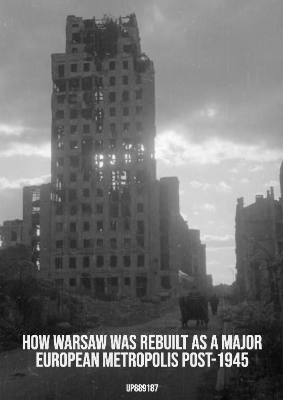
How Warsaw was rebuilt as a major European metropolis post-1945
up889187

contents
abstract palace of culture and science
introduction
route w-z
ursynów północny
2
4
20
40
64
88
98
100
conclusion
bibliography
illustrations
Fig 1. Remains of the Warsaw Ghetto. © Z. Siemaszko.

Fig 2. Warsaw Old Town 1945.
abstract
2
Warsaw suffered almost six years of Nazi occupation during the Second World War. Despite ninety per cent of the city destroyed, it was then rebuilt to become a major European capital city. Its cultural and social significance saw thousands of Varsovians return to the capital and begin rebuilding,rebuilding, even before the last German soldier retreated from Warsaw.
Although there were doubts whether rebuilding Warsaw was feasible, a handful of architects pioneered the reconstruction phases, achieving something that was thought humanely impossible. This dissertation explores how architects rebuilt and modernised Warsaw as a city, utilising urbanurban planning to create new thoroughfares and wider roads.
Even though the city was being modernised, political tension came when the strained economy took on the burden of building the Soviet Union’s gift to the capital. Modern urbanisation continued when programmes of mass-produced housing were made to address the acute shortages. shortages.

introduction Warsaw was bombed within the very first hours of the Second World War, and when the enemy attack was repelled, the capital was placed under siege. It lasted until September 28th 1939. On October 1st, the Wehrmacht entered Warsaw and the occupation began. Around ten percent of buildingsbuildings were destroyed, and another forty were heavily damaged when the siege ended.
The Warsaw Uprising was launched on 1st August 1944, leading to a barrage of German artillery and mortar shells for sixty-three days and nights. Following the systematic destruction and ethnic cleansing, around 800,000 civilians were killed, or 60% of the pre-war population [Gliński, 2015]. [Gliński, 2015].
The final stages of Warsaw’s destruction began after the Uprising. The city was burned and looted by German Verbrenungskommandos until it was abandoned in January 1945 as the Red Army advanced in from the east. Around nine hundred monuments were destroyed andand 100,000 original prints, maps and manuscripts were burned in the Zamoyski Library [Chelminski, 1997]. Thousands of holes were drilled into the Royal Castle, dynamite charges were placed and the castle was then detonated, and this happened to nearly all the buildings in WWarsaw.
By this point, between eighty-four and ninety percent of Warsaw had been
5
Fig 4. Parade of the 1st Polish People’s Army in ruined Warsaw on Marszałkowska Street, 19th January 1945.
Fig 3. Preparation for destruction of the Royal Castle in Warsaw, 1944.

destroyed. On recapturing the city, General Berling’s First Polish Army were met with a sea of rubble; no electricity, no gas and no water. Twenty million cubic metres of debris and forty-five tons of explosives and mines were left behind by the Wehrmacht [Zakrzewski, 2020]. The LublinLublin authorities expected around 900,000 inhabitants when Soviet and Polish forces finally took Warsaw back, however, there were only a few hundred “Varsovian Robinson Crusoes” left in the ruins of the city [Piątek, 2015].
At the time of the Yalta Conference in February 1945, when Poland’s new borders were confirmed, and Warsaw was re-established as the capital, the National Council called for Warsaw’s reconstruction. Bolesław Bierut, the Chairman of the State National Council, movedmoved the Polish People’s Republic
leadership to Warsaw. And so, on 14th February 1945, the Biuro Odbudowy Stolicy (Office for the Reconstruction of the Capital, BOS for short) was formed by Marian Spychalski, the Mayor of Warsaw [Gliński, 2015]. The BOS was responsible for the reconnaissance, surveying, demolition,demolition, planning and reconstruction work in Warsaw [Elżanowski, 2014]. Understanding to what extent the capital was destroyed was crucial to direct the reconstruction of the city appropriately while also considering the modernisation of the city. The reconstruction and expansionexpansion of Warsaw would preoccupy Bierut in the years that followed [Eisler, 2014].
People returned to Warsaw to start rebuilding even before the last German soldier had retreated in January 1945.
Fig. 5 - Prudential Building destroyed during the Warsaw Uprising. © Zbyszko Siemaszko
Fig. 6 - ‘Warsaw is Free!’, Życie Warszawy (Life of Warsaw) newspaper, 18 January 1945. (National Library).6 7

Figs. 7 and 8 - Map of Warsaw at scale 1:20,000 and inventory of the devastation perpetrated by the Germans during the War, 1939-1945. © L. Kowalski, F. Piątkowski, Główny Urząd Pomiarów Kraju (National Measurement Office).
9

Jerzy Putrament, a poet, commented that people were returning “not to property, not to home, just to a point on the globe, to the abstract concept of Warsaw” as he saw crowds arriving to the ruins of the capital [Piątek, 2015].
WhenWhen BOS surveyors began to prepare detailed maps and surveys, they sometimes covered a distance of 20 kilometres each day by foot, dodging mines in snow and ice. Each city block was surveyed, building by building [Elżanowski, 2014]. The surveyors then plottedplotted the information on maps of the city, each block of buildings assessed and categorised, showing the level of damage on them. Each block was then labelled either for reconstruction, conversion, or demolition. Elżanowski describes the surveys as a “type of ruin autopsy”. The surveyorssurveyors established the “cause of death” of each building, which was indicated by how it was destroyed. The buildings fell into either of two categories; fit for rebuilding or not fit for rebuilding [Elżanowski, 2014].
In terms of planning the new city of Warsaw, BOS architects and urbanists sought to learn from the “mistakes” of the nineteenth century city planning. Their views and politics were aligned with modernist views on reconstruction in post-war Eastern and Western Europe. BOSBOS views on urban regeneration opposed the nineteenth century “bourgeois” ideals, further allying themselves with the new
10 11
Fig. 9 - Old Town Market Place, 1945.

Fig. 10 - Aerial photograph of northern Warsaw Ghetto area and the KL Warschau (KZ Warschau) concentration camp.12
pro-Soviet government. They received full support from the new communist government to demolish substantial parts of the city to fully devote themselves to new modernist ideas of urbanism [Elżanowski, 2014].
TheThe BOS was teeming with architects, engineers, urban planners and designers. Their “mandate was to prepare a new capital city for socialist Poland” [Elżanowski, 2014] and through this they planned not only to reconstruct damaged historical buildings and monuments, but alsoalso modernise the capital for a new architectural era.
The reconstruction of Warsaw was to be pioneered by a housing reform, a plan to solve the housing shortages [Piątek, 2015]. The BOS became one of the only sources of stable income in 1945 Warsaw. “Those who had shoes went [surveying], those who had none, sat in the office and drafted.”drafted.” Stanislaw Jankowski, a key member of BOS, had the largest responsibility for the urban side of the Warsaw project [Elżanowski, 2014].
Architects and urban planners from BOS were given the opportunity to build a modern city, modelled according to modern, socialist ideals and approved bythethe Soviet powers in control of the Polish People’s Republic. Stanisław Dziewulski commented that the “destruction of Warsaw in 1944, through a tragic coincidence of events, made our concepts ‘realistic’” in an article for Skarpa Warszawska (Warsaw Escarpment) in 1945.1945. The publication of “Skarpa Warszawska” from October 1945 allowed

the planners and architects in BOS to communicate their ideas and concepts to the general public in discussions about Warsaw’s future [Górski, 1976]. Elżanowski stated that the aims of the publications were to “encourage interactions between theoreticians, experts andand those people rooted in life who understand its basic needs, hidden pains and missed opportunities”. The reconstruction of Warsaw was the responsibility of BOS as much as it was up to the average Varsovian.
A shortage in building materials made the engineers and architects turn to the only available material resource – rubble. Eugeniusz Olszewski wrote that rubble “became an ore… converted into units of‘rubble-concrete’” [Elżanowski, 2014]. In
an article for “Inżynieria i Budownictwo” (Engineering and Construction), rubble-concrete was praised as a “valuable source of raw material” that “fundamentally changed the approach to reconstruction”. Muranów’s housing district, designed by Bohdan Lachert in the idealsideals of pre-war modernism, was built on the rubble of the former Warsaw Ghetto. Lachert specifically asked for the building foundations of Muranów be set into the excavated rubble. Elżanowski commented that Lachert had a “deep understanding of the human and cultural tragedy behind the materialmaterial transformation”. The new housing estates of Muranów were built from the recycled rubble-concrete blocks and remained unpainted in homage to the “ashes of those who had perished on the grounds of Muranów” [Elżanowski, 2014].
14 15
Fig 11 - Piwna Street, seen from Castle Square 1947. © Henry N. Cobb
Fig. 12 - Old Town Market. © Henry N. Cobb
Fig, 13 - Plac Krasińskich. © Henry N. Cobb
Fig. 14 - Szpitalna Street near Boduen Street. © Henry N. Cobb

“No other city in Europe – not even Berlin or Stalingrad – was taken down so methodically.”
Rudolph Chelminski
Fig. 15 - Napoleon Square with Prudential Building on left. © Edward Falkowski

The reconstruction of Warsaw is effectively still ongoing to this day. Around Warsaw, there are numerous abandoned buildings that are stuck in the past. It was fundamental for Warsaw to be rebuilt. Without Warsaw, there would be no Poland. It was the epicentre for one of thethe largest underground resistance movements during the war, and the feelings of nationalism and patriotism can be seen in the way the reconstruction took place after the war. People were returning even before the German army had left the capital in January 1945.
Fig. 16 - View of Warsaw from plane, 1946. © Wacław Żdżarski
trasa
w-z
20 21
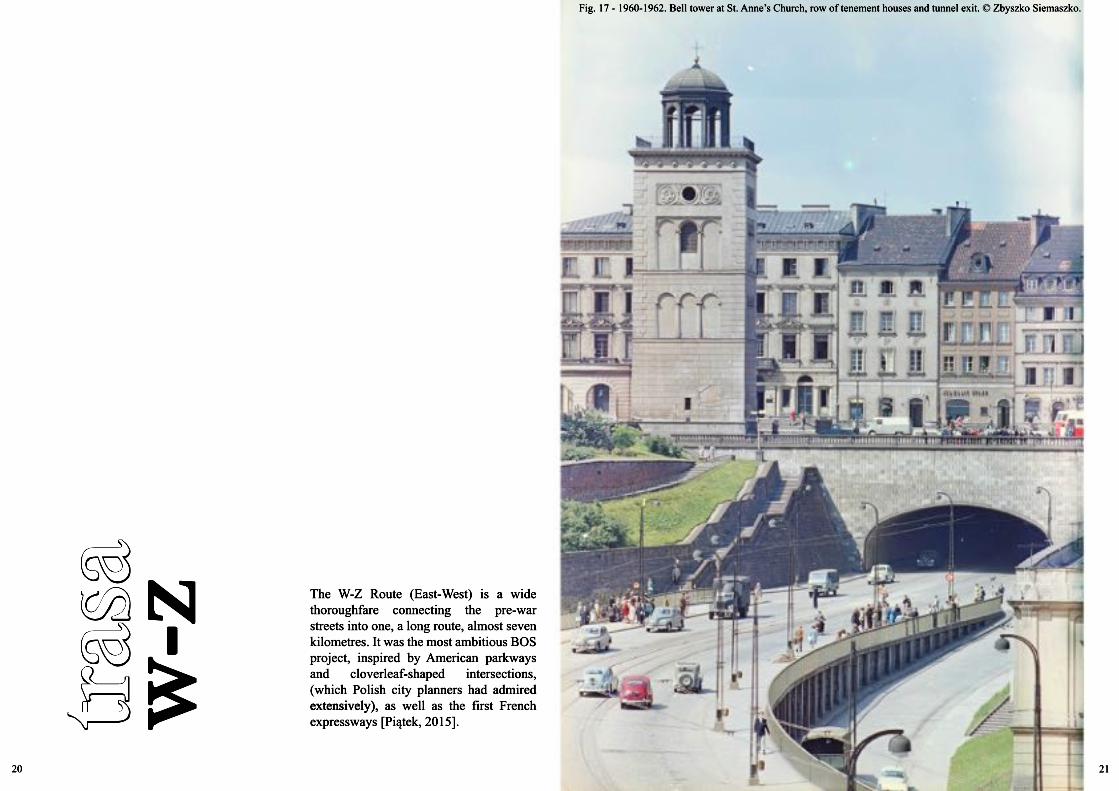
The W-Z Route (East-West) is a wide thoroughfare connecting the pre-war streets into one, a long route, almost seven kilometres. It was the most ambitious BOS project, inspired by American parkways and cloverleaf-shaped intersections, (which Polish city planners had admired extensively),extensively), as well as the first French expressways [Piątek, 2015].
Fig. 17 - 1960-1962. Bell tower at St. Anne’s Church, row of tenement houses and tunnel exit. © Zbyszko Siemaszko.

“The route was a piece of healthy, young tissue on the body of a city that had died recently during the war.” Grzegorz Piątek in his book, Najlepsze Miasto Swiata: Odbudowa Warszawy 1944-1949. (2015).
Fig. 18 - plan of Warsaw 1948. The black dashed lines represent the proposed directions of the new route. © A. Kwiatkowski, A. Marcinkiewicz.

When planning the route, the architects underestimated the number of commuters in the city. Only 12,732 vehicles were registered in Warsaw after the war, over a hundred times less than present day [Piątek, 2015]. The limited availability of trams and buses meant that they were overloadedoverloaded with people each day, so after the war, many people relied on their feet as the only reliable mode of transportation in Warsaw.
Warsaw allowed architects such as Sigalin, Jankowski and Knothe to build a modern city to accommodate future generations with wide streets and wide pavements, and generous space between dwellings.
TheThe newly formed communist government of Poland was determined to beat the pre-war capitalist government in construction, so Route W-Z became a priority after the war. Henryk Stamatello, one of the main designers of the route’s tunnel, was inspired by a visit to RotterdamRotterdam and the tunnel under the Waal River, which was lined with clinker bricks. The tunnel’s design also referenced the highway in Saint-Cloud near Paris [Janczewski, 1986].
24 25
Fig. 19 - map of Warsaw Old Town from 1939.
Fig. 20 - map of Warsaw from 1955, with the new route cutting underneath the Old Town via the tunnel.

Fig. 23 - Tunnel construction, 1947-1948.
Fig. 24 - Construction work at tunnel entrance underneath Miodowa Street. © National Archives.26
Fig. 21 - sketch of western tunnel entrance by Architect Engineer Zygmunt Stępiński, 1947.
Fig. 22 - sketch of eastern tunnel entrance by Architect Engineer Zygmunt Stępiński, 1947.

The city planners did not want to completely erase the older 17th Century buildings to make way for the route, but rather create a harmony with past and present.
TheThe tunnel, the shortcut connected the bridge over the Wisła river with Środmieście, was not drilled through, but rather dug out, necessitating the demolition of the destroyed quarter of the buildings between Krakowskie Przedmieście, Miodowa and Senatorska Streets.Streets. These however were planned to be reconstructed in a corrected form [Piątek, 2015].
28
Fig. 25 - Józef Sigalin explains the model of Route W-Z to Bolesław Bierut.
Fig. 26 - building of tunnel.

Fig. 27 - the route leading to the tunnel on the eastern side. On the left, St Anne’s Church, tenement houses, tunnel exit, Copper-Roof Palace, Zygmunt’s Column, 1960-1962. © Zbyszko Siemaszko.
“Rather than removing the obstacle to traffic flow, the traffic itself can be diverted or, conditions permitting, its passage can be forced by tunnelling beneath the obstacle.”
Le Corbusier’s The Athens Charter.

The construction of this route epitomised Warsaw’s future. Modern and comfortable tower block estates lined the thoroughfare, becoming iconic and giving birth to the popular “WuZetka” cake, named after the W-Z Route. The sponge cake being the tower blocks on either side of the route, andand the cream filling represented the W-Z Route [Hatherley, 2015].
Fig. 29 - aerial view of Warsaw and Route W-Z with marked out route.
Fig. 30 - information board near the entrance to the construction site of the W-Z Route.
Fig. 28 - WuZetka Cake © Dr Oetker.
32

To consider pedestrians, an escalator was designed, to lead straight onto Castle Square from W-Z Route. Part of John’s House was rebuilt to accommodate the new escalators. The installation of the escalators allowed a person to overcome the twelve-meter difference in altitude in halfhalf a minute and was able to move around 30,000 people an hour [Sztompke, Krzesińska, 2017]. Buildings such as John’s House were rebuilt using Bernardo Bellotto’s paintings – it was purely scenography. Most of these buildings and monuments were reenvisaged, such as ZygmuntZygmunt’s Column in Castle Square,
Fig. 33 - Pedestrian tunnel connecting to escalators up to John’s Tenement House.
Fig. 35 - Light bowls. © sztuka.net
Fig. 34 - “Together in Rebuilding”. © sztuka.net
34 35
Fig. 31 - John’s Tenement House. © Dennis Jarvis.
Fig. 32 - King Zygmunt returns to his new column.
which had been moved six metres to the northeast and slightly rotated so that it faced Krakowskie Przedmieście [Piątek, 2015].
OwenOwen Hatherley described the underpass as “a piece of Moscow Metro in Warsaw” since the project was partly designed and built by the employees of Moscow company Metrostroi (Метрострой) (Małcużyński, 1955). It was dubbed as “Little Moscow” by Varsovians for it recalledrecalled the beautiful architecture of Moscow’s metro stations, with lamps that were “Soviet in derivation… heaven-in-the-bowels-of-the-earth style” (Hatherley, 2015).

Fig. 36 - Opening of the Route W-Z in Warsaw, 22nd July 1949. © National Archives.
Fig. 37 - President Bolesław Bierut and Prime Minister Józef Cyrankiewicz greet the residents of the capital during the opening ceremony of the W-Z Route. 22nd July 1949. © CAF
37
“I have had the honor of reporting to the nation about the successful and early completion of a responsible task, which is of great importance for the reconstruction of our heroic capital - Warsaw. A very important communication artery of the city, the W-Z Route.”
Bolesław Bierut at the opening ceremony of Route W-Z.

The opening of the W-Z Route took place on the 22nd July 1949 and thousands of Varsovians arrived to see the opening of Warsaw’s major new artery. Piątek describes the W-Z Route as the fulfilment that “the reconstruction of Warsaw would be a synthesis of the most valuable local traditions,traditions, and the greatest achievements of modern civilisation”.
The W-Z Route was a major step forward in Warsaw’s reconstruction, a step forward into modernity. It proved that despite the tragedy that had befallen Warsaw during the Second World War, the reconstruction offered hope and optimism that in the Old Town, also paid tribute to its cultural heritage.heritage.
38Fig. 39 - aerial view of the route in 1970.
Fig. 40 - Interior of the tunnel 1972. © Lubomir Winnik.
Fig. 38 - Opening of the W-Z Route, 22nd July 1949.
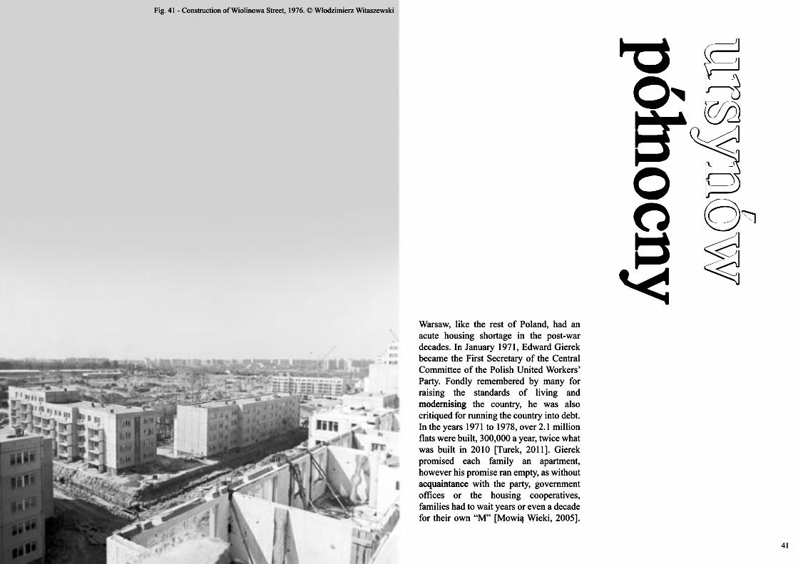
Warsaw, like the rest of Poland, had an acute housing shortage in the post-war decades. In January 1971, Edward Gierek became the First Secretary of the Central Committee of the Polish United Workers’ Party. Fondly remembered by many for raising the standards of living and modernisingmodernising the country, he was also critiqued for running the country into debt. In the years 1971 to 1978, over 2.1 million flats were built, 300,000 a year, twice what was built in 2010 [Turek, 2011]. Gierek promised each family an apartment, however his promise ran empty, as without acquaintanceacquaintance with the party, government offices or the housing cooperatives, families had to wait years or even a decade for their own “M” [Mowią Wieki, 2005].
41
Fig. 41 - Construction of Wiolinowa Street, 1976. © Włodzimierz Witaszewski ursynówpółnocny

Ursynów is the southernmost district of Warsaw, and the third largest. Its redevelopment began in 1971 with a competition announced by the Association of Polish Architects. The competition opened for designs of an area of North Ursynów, around 220 hectares of land. It requiredrequired a detailed and functional plan for a housing complex for 40,000 inhabitants. The competition was won by trio Ludwik Borawski, Jerzy Szczepanik-Dzikowski and Andrzej Szkop. However, Ludwik Borawski passed away in November 1971 and his successor was Marek Budzyński, whowho returned from Denmark to work on Ursynów. He possessed knowledge and experienced gained in Scandinavia of materials and approaches that professionals behind the Iron Curtain could only dream of [Pańków, 2017].
Fig. 42 - Ursynów Architects. From the left, Jerzy Szczepanik-Dzikowski, Andrzej Szkop, Marek Budzyński, Zbigniew Zawistowski and others. © Włodzimierz Witaszewski
Fig. 43 - Project of the Ursynów Północ housing estate, developed by the team under the leadership of Marek Budzyński. © Włodzimierz Witaszewski
42 43
Budzyński formed a team and quickly provided two design variants to the Warsaw Development Planning Office. One variant using wielka płyta (plattenbau or prefabricated concrete panels) so the house factories could produce materials at a fast pace. The second variant – a more fragmented,fragmented, with differing dimensions of the buildings with a “social and humanistic” layer, a plan of pavilions, clubs and social spaces for the integration of residents.
Budzyński’s team pushed the second version forwards, which reflected the team’s collaborative ideas and aesthetics more than the first. The team was supported by the deputy chief architect of Warsaw, Tadeusz Szumielewicz [Pańków, 2017].

The Party gave them four years from 1974-77 to do “everything” – to build a housing estate, equipped with schools and all necessary services. Budzyński advocated the idea that the designs should be focused to cater the individual residents in Ursynów. Sociologists, psychologists, demographersdemographers and educators were consulted in the design stage. There were discussions on the organisation of human life in communities, futurology and visions of accelerated urbanisation. This idea of social engineering played a big part in Budzyński’s and his team’s vision of massmass housing in Ursynów. Wlodzimierz Witaszewski recalled that the team needed someone who would “explain this ideology” of social engineering [Pańków, 2017]. Their biggest fear was that in the future Ursynów would become a slum!
Krzysztof Herbst, a housing sociologist specialising in metropolitan areas was given the opportunity to go beyond theoretical speculation by working with Budzyński’s team. The team researched the future of urban areas and living spaces up to the year 2000. The team “questioned everything”everything” – from the technologies of nutrition to the ways of functioning within a family. Using these assumptions, they attempted to develop a new model of the apartment – different from typical functionalist blocks.
Fig. 44 - Surowiecki Street, 1977. © Grażyna Rutowska
44

A mentor of Budzyński’s was Jane Jacobs, a New York journalist. She promoted communities within neighbourhoods, urban activism and openly advocated against American urban doctrines in the years after the Second World War – which she saw as causing the collapse of US cities.cities. Budzyński and Jacobs both observed behaviours of groups and drew conclusions – they saw the wisdom in these observations, and the lessons to be learnt [Pańków, 2017].
Fig. 49 - The design of the streets under the name "Pedestrian Street - the Functional and Spatial Backbone of Residential Complexes”. © Andrzej Szkop i Jerzy Szczepanik-Dzikowski
46 47
Figs. 45, 46, 47 and 48 - construction of Ursynów. © Grażyna Rutowska

Figs. 50 and 51 - Winter at Ursynów with the peacock sculpture in the foreground of both photos, 1977. © Włodzimierz Witaszewski
4948

The original trio’s design contained the idea that the Ursynovians should co-create their new housing estate. Borawski, Szczepanik-Dzikowski and Szkop all believed that “an architect serves society” [Życie i Nowoczesnosci, 1971]. In today’s world, social awareness is more diverse andand modern sources of information allow design engagement to be formed between architects and residents [Pańków, 2017]. They believed that cooperation during the design phase would further tighten the social bonds of the new residents and inhabitants – this was necessary for the furtherfurther work planned on the ‘city’, or in this case, on the housing estate. Herbst took a step further, and proposed the establishment of an Apartment Selection Office, to enable communication between the future tenants and the architects. The officials listened to the comments and suggestions,suggestions, paying most attention to their own individual needs. It was planned as a fully democratic service and Herbst believed that “anyone who can say what their new home should look like would be more ‘at home’ [Pańków, 2017]. Szkop believed that the principle for creating a successfulsuccessful housing estate lay in mixing service and residential buildings together – “we approached the idea that there was to be a city, not a large estate. It makes a difference” [Życie i Nowoczesnosci, 1971].
Fig. 52 - Block at Pięciolinii 3. © Włodzimierz Witaszewski50 51

The design team, along with engineer Irena Bajerska, wanted to save as many trees as possible in the area around Ursynów. According to Bajerska, the post-agricultural land was good [Pańków, 2017]. Large fragments of orchards were therefore saved, as well as many other treestrees such as poplars, maples and oaks. The designers believed that the soil from excavations should be put around the blocks, and the embankment should be managed by the future residents of Ursynów.
Fig. 54 - building of Nutki Street and Puszczyka Street. Trees that were saved by the architects can be seen, and are still growing to this day. © Włodzimierz Witaszewski
Fig. 53 - many trees were saved through Irena Bajerska’s green architecture programme. © Włodzimierz Witaszewski
52 53

Szkop admired the prefabrication within Corbusier’s and Gropius’ architecture and called it a “great invention”. However, he criticised the house factory and prefabrication methods in Poland as “taking the building’s soul away” and strictly “associated with the socialist system”.system”. Within Northern Ursynów, the architects “wanted to restore this soul” and hence created richer plans for the estates [Pańków, 2017].
The prefabrication units were assembled in two different systems: Szczecin system and WK-70. The Party management was reluctant to invest in improvements and modifications, so the architects had to use the existing constructional elements. The
Szczecin system was a basic format of 4.8 metres by 2.4 metres, originating from the USSR and extensively used in Miasto Projekt Szczecin, hence the name [Pańków, 2017].
RunningRunning through the middle of the prefabricated concrete wall is a filling of expanded clay. The modernised WK-70 system was imported from the GDR – the outer wall had a layer of mineral wool which better insulated heat and sound. The panels had a wider span, up to 6 metres. TheThe structure was based on a transverse system of load-bearing walls, but the wider range of lengths allowed for greater flexibility in apartment arrangements [Pańków, 2017].
Fig. 55 - Prefabricated WC. © Włodzimierz Witaszewski
Fig. 57 - Prefabricated elements under construction. ©Aleksander Jalosiński
Fig. 56 - construction base at Stokłosy. Enough prefabricated elements to build a living room. © Włodzimierz Witaszewski
54

Fig. 58 - residential block at 1 Puszczyka Street, 1977. © Grażyna Rutowska
When the Ursynów Północny plan was ready, it represented a clear departure from the typical socialist “prison cell”. Budzyński in an interview with Dariusz Bartosiewicz for “Gazeta Wyborcza” explained that “instead of thirty types of prefabricated elements, which could be mademade into five different types of apartments, we proposed opening the system to more diverse window openings, for example” [Budzyński, 2015]. A total of a hundred different versions came out and as a result, there were over fifty different layouts of apartments for Ursynów. This freedfreed up the design opportunities for the buildings - “thicker, thinner, taller, lower” [Budzyński, 2015].
The new modernised system received the green light from the United Construction Industry in Warsaw. It became the basis for the construction of apartments, public buildings and services in Ursynów. The system was modified in such a way that it included skylights, flat roofs, suspended ceilings,ceilings, railings, sun visors, balustrades, external and internal partitions etc. The prefabricated structures enabled a larger variety of configurations. There was also a new design of balconies – two vertical walls and a shelf suspended on them. This praised H-frame technology was an innovationinnovation by designers Janusz Nowak and Piotr Sembrat. They stated that the prefabricated terraces “enlivened the architectural forms of the buildings” [Pańków, 2017].
57

Fig. 60 - Block by 1 Puszczyka Street. © Grażyna Rutowska
The phased sequence of construction however did not follow the intended plan. Houses made up colonies, and colonies formed housing estates. Contractors should have stuck to this composition step by step, but the blocks were built randomly, in different neighbourhoods and withoutwithout a precise strategy. Some houses in one colony were unfinished, where others were. Prefabricated elements were produced in a way that they would not have to adjust the production lines to make it easier. When one batch of prefabricated elements arrived, work could not commencecommence without several other elements [Pańków, 2017].
Pańków explained how some small prefabricated elements designed to bring the architecture of Ursynów together
Fig. 59 - inconsistencies with building the blocks. © Aleksander Jałosiński
58
made the designers grieve over the workmanship. Elzbieta Zawistowska commented how “everything was lopsided and lumpy”. Many small prefabricated elements such as pots, walls and stairs to make Ursynów “look beautiful” was abandoned [Pańków, 2017].
ParkingParking spaces were not adequately thought through by contemporary standards, they estimated the ownership of cars to be around 110 per 1,000 inhabitants, rising to only 250 in the future – the designers focused more on the footpath and the pedestrian way of transportation.transportation. Cars, lorries and other methods of transportation were to be invisible to the pedestrians of Ursynów [Pańków, 2017].

In 1977, the beginning of the resettlement began. When Gierek visited Ursynów, expounding on the success of his housing policies, he praised the architecture of Ursynów Polnocny. The first blocks at Puszczyka Street were finished and the first residents had started moving in. But onon the other side of the estates, the blocks at Konski Jar were handed over without central heating, just before the winter, so that on paper it looked better statistically. Witaszewski commented that “nobody had the courage to say no” [Pańków, 2017] and Budzyński’s team with their hands tied witnessedwitnessed the handover of incomplete buildings.
Fig. 61 - Gierek’s visit to Ursynów. © TVP Achiwum
Fig. 62 - Panoramic photo at Koński Jar. © Zdzisław Lewicki

The apartments in Ursynów received criticism, and despite their large size, they were still considered tight and poorly planned [Halo Ursynów, 2019]. The timescale was not met adequately – while the flats had been built, the schools, clinics and shops remained unfinished. ContractorsContractors and supervisors took schedules lightly – “when Tuesday is at a standstill, they will arrive on a Thursday at the latest” [Pańków, 2017].
While there were criticisms about the housing policies implemented by Gierek (cheap materials, long build times, a waiting list to receive an apartment etc.), Budzyński and his team designed a successful housing estate for forty thousand people. They accomplished a uniqueunique looking housing estate, full of greenery and unlike a typical grey cluster of concrete monoliths. The housing boom helped coin the term “ciasne ale własne”, meaning “cramped but mine”, which to this day is reminisced in Polish culture and heritage.
Fig. 63 - Ursynów Północny, 2020. © Maciej Mazur
62 63

Fig. 64 - Close-up of tower. 2014 (Wikimedia Commons).
palace of culture
and science
64
The Palace of Culture and Science was created as a symbol of peace and Polish-Soviet friendship [Culture.pl, 2015]. The construction lasted three years and it was built in the middle of the destroyed Środmieście district, becoming the tallest building in Poland and the eightheighth tallest in Europe. The originator of the project was Joseph Stalin himself, as a gift from the Soviet Union, but many considered the Palace a symbol of Soviet dominance over post-war Poland [Zaborowska, 1999].

The architect, Lev Rudnev, modelled the palace on American art deco skyscrapers, like the Empire State Building and those of Raymond Hood, but wanted the building to remain in “contact with old Warsaw” and possess characteristic Polish elements [Majewski, 2019]. Lev Rudnev travelled PolandPoland with a team of Soviet architects to analyse historical Polish towns which survived the Second World War, unlike Warsaw’s Old Town [Culture.pl, 2015]. He was inspired by the renaissance building of Sukiennice in Kraków’s Old Town, as well as the arcaded courtyard and cloisters of BaranówBaranów Castle. The precedent of
Chełmno town hall’s pinnacle can also be seen in the Palace’s spire. [Skalimowski, Weszpiński, 2018].
TheThe Palace of Culture and Science was designed in the style of the “Seven Sisters” of the USSR, a group of high-rises in the Stalinist architectural style (also sometimes referred to as Socialist Classicism), but incorporating Polish renaissance details, such as the parapet and thethe decorative crenellations, that Rudnev was inspired by in Kraków and Zamość [Zaborowska, 1999].
Fig. 65 - Krakow Cloth Hall. © Maksym Kozlenko
Fig. 67 - Chełmno town hall.
Fig. 66 - details of crenellations atop Krakow Cloth Hall. © Andrzej O.
Fig. 68 - Arcaded courtyard of Baranów Castle. © Jerzy Strzelecki
66 67

The construction of the Palace took three years, from 1952 to 1955. Nearly 3,500 Soviet workers helped build the high-rise. It was an expensive “gift” – further burdening the economy of war-ravaged Poland [Zaborowska, 1999]. The Soviet workers received their own housing complexcomplex at Poland’s expense; Osiedle Przyjaźni Polsko – Radzieckiej (The Polish-Soviet Housing Estate of Friendship). There were two types of accommodation; hotel pavilions for the workers, and single-family homes for the technical staff. These homes were transportedtransported to Warsaw in pre-cut elements and then assembled at the new housing estate. They were then either painted in a blue-white or blue-red colour scheme [Zieliński, 2012].
The Palace was expensive in terms of the economy and human lives. Around sixteen
workers had lost their lives in accidents during the three-year construction [Culture.pl, 2015]. A few drunk workers fell into freshly poured concrete, and were left there, as the project was already financially strained and it would have been too expensive to retrieve the bodies of the workersworkers [Zaborowska, 1999]. Zaborowska commented how “the blood, sweat, and actual flesh-and-bone of the proletariat served as the foundations”. The Palace of Culture and Science was completed with forty million bricks and twenty-six thousand tons of steel structure. Four hundredhundred square meters of wall surfaces were plastered, and ten thousand walls, columns and floors were covered with artificial marble. In its completed state, it has forty-four floors, and 3,288 rooms cover an area of more than 123,000 square meters [Culture.pl, 2015].
Fig. 69 - construction of foundations of the Palace of Culture and Science, 1952.
69

The construction of the Palace took three years, from 1952 to 1955. Nearly 3,500 Soviet workers helped build the high-rise. It was an expensive “gift” – further burdening the economy of war-ravaged Poland [Zaborowska, 1999]. The Soviet workers received their own housing complexcomplex at Poland’s expense; Osiedle Przyjaźni Polsko – Radzieckiej (The Polish-Soviet Housing Estate of Friendship). There were two types of accommodation; hotel pavilions for the workers, and single-family homes for the technical staff. These homes were transportedtransported to Warsaw in pre-cut elements and then assembled at the new housing estate. They were then either painted in a blue-white or blue-red colour scheme [Zieliński, 2012].
Fig. 71 - construction of precut elements at the Housing Estate of Friendship. 71
Fig. 70 - “Stolica” 1954 – issue 28. “In The Housing Esate of Friendship”.

The Palace was expensive in terms of the economy and human lives. Around sixteen workers had lost their lives in accidents during the three-year construction [Culture.pl, 2015]. A few drunk workers fell into freshly poured concrete, and were left there, as the project was already financiallyfinancially strained and it would have been too expensive to retrieve the bodies of the workers [Zaborowska, 1999]. Zaborowska commented how “the blood, sweat, and actual flesh-and-bone of the proletariat served as the foundations”. The Palace of Culture and Science was completed with fortyforty million bricks and twenty-six thousand tons of steel structure. Four hundred square meters of wall surfaces were plastered, and ten thousand walls, columns and floors were covered with artificial marble. In its completed state, it has forty-four floors, and 3,288 rooms covercover an area of more than 123,000 square meters [Culture.pl, 2015].
Fig. 72 - construction of the Palace of Culture and Science viewing platform, 1952.
72Fig. 73 - Soviet workers of the Palace of Culture and Science, 1954.

The Palace of Culture became a fixed landmark in the city of Warsaw. In photographs of the time of its construction, in a wasteland of ruined buildings, demolished city blocks and undeveloped urban space, the Palace could be seen from miles away, with its white sandstone clad exterioexterior.
Fig. 74 - View of Palace of Culture and Science between Śliska and Sienna Streets 1957. None of the buildings (apart from the Palace) exist today. © John Schultz
74 75

The exterior of the Palace is extraordinary, surrounded by colossi in the style of Michelangelo’s ignudi, Polish heroes such as astronomer Kopernik and poet Mickiewicz guard entrances to the Palace [Pyzik, 2015]. TheThe Soviets valued symbolic figures of knowledge, work, education, the sciences, and the arts. A sculpture depicting the Polish-Soviet friendship established after the war was to be a joint Polish-Soviet workpiece. Sculptures were made in a typical socialist realist style; characters werewere monumental, with massive limbs, sharp faces and entirely depicted without emotion [Skup, 2015]. The Congress Hall is decorated with figures of young people from various races set in niches, Skup considered that this was a reference to the World Youth Festival in 1955.
Fig. 75 - sculpture of man with a tome of the classics of communism; Marx, Engels and Lenin.
Fig 76 - Statue of Mikołaj Kopernik by Ludwik Nitschow. © Adrian Grycuk
Fig. 77 - sculpture representing central Asian woman. © M. Skup
76

Fig. 78 - Marble Hall at the Palace of Culture and Science. © Adrian Grycuk78
“… the Yuri Gagarin Hall, where a circle of smooth Doric columns surrounds a tinselly chandelier; the red-veined marble floor by the lifts…”
Owen Hatherley, Landscapes of Communism.

Fig. 79 - Trójki Hall. © Adrian Grycuk
Fig. 81 - Mikołaj Kopernik Hall. © Adrian Grycuk
Fig. 80 - Władysław Broniewski Hall. © Adrian Grycuk
Inside, the Palace of Culture and Science, the interiors are adorned with marble floors and glass chandeliers [Hatherley, 2015]. The building is home to a cinema, theatre, cafes and clubs, the Congress Hall, the Museum of Technology and Evolution, a swimming pool, parts of the university, thethe seat of the Polish Academy of Sciences and the city hall; it is often labelled as a “city within a city” [Culture.pl, 2015]. The Polish authorities insisted during the design phase of the project for the Palace that the building remains for public use, rather than a university or luxury flats [Hatherle[Hatherley, 2015]. In a sense, the Palace was a temple of worship, a celebration of arts, culture and sciences, which was the dominant “religion” of Socialism [Zaborowska, 1999].
Fig. 82 - Stefan Starzyński Hall. © Adrian Grycuk
80 81

Fig. 83 - The Palace at night from the intersection of Marszałkowska and Świętokrzyska streets. 1955. © Zbyszko Siemaszko
83
“The Palace of Culture and Science is fantastic and an exceptionally effective case of communist architecture, urban planning and… social engineering. It is a building that works so well because the land it stands on was taken from its pre-war owners and not pre-war owners and not ‘returned’… It is a building that resists the chaos of ‘wild capitalism’: property restitution, twenty-storey billboards, downtown poverty, and rampant gentrification that surround it. The Palace of Culture and Science – despite Culture and Science – despite attempts made – has never been privatised.” Michał Murawski in his book, The Palace Complex. (2019)

85
“It was both a specimen of civil architecture designed for everyday pleasure, and a sacred monument to the dominant dominant ideology.” Magdalena Zaborowska in her book, The Height of (Architectural) Seduction: Reading the Changes through Stalin’s Palace in Warsaw, Poland. (1999).
Fig. 84 - Palace of Culture in background, view from Świętokrzyska Street. On the left, ruins of the Postal Savings Bank (PKO – the largest bank in Poland), 1957. © Wil Hofwijk

The Palace was a subject of many disputes after its constructions, with many people supporting the demolition of the building, others argue that the Palace is a symbol of the reborn city of Warsaw [Murawski, 2019]. But to demolish the Palace would mean to deny Warsaw a point of reference, toto rob it of the most symbolic example of socialist realist architecture outside of the former Soviet Union, and also a
well-known symbol of the city. However, during the construction phase, it financially burdened Poland to the point that other reconstructive works of historic buildings were restricted or were entirely put on hold. The contract of the Palace of Culture and Science wasn’t something that couldcould be delayed, in fact the threat of deadlines was “a risk of breaking the international system” [Majewski, 2016].
Fig. 85 – Palace of Culture behind ruins of Kryński tenement houses, 1960. © Harrison Forman
86 Fig. 86 - View from a window in Hotel “Polonia”. 1960-1970.

Fig. 87 - view of Warsaw from plane, 1946, Prudential Building seen in centre. © Wacław Żdżarski
89
The reconstruction of Warsaw is effectively still ongoing to this day. Around Warsaw, there are numerous abandoned buildings that are stuck in the past. It was fundamental for Warsaw to be rebuilt. Without Warsaw, there would be no Poland. It was the epicentre for one of thethe largest underground resistance movements during the war, and the feelings of nationalism and patriotism can be seen in the way the reconstruction took place after the war. People were returning even before the German army had left the capital in January 1945.
conclusion
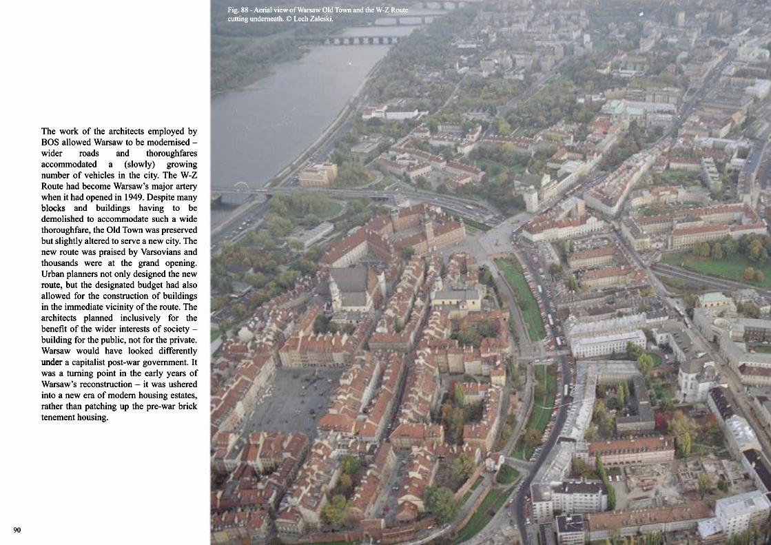
Fig. 88 - Aerial view of Warsaw Old Town and the W-Z Route cutting underneath. © Lech Zaleski.
The work of the architects employed by BOS allowed Warsaw to be modernised – wider roads and thoroughfares accommodated a (slowly) growing number of vehicles in the city. The W-Z Route had become Warsaw’s major artery when it had opened in 1949. Despite many blocksblocks and buildings having to be demolished to accommodate such a wide thoroughfare, the Old Town was preserved but slightly altered to serve a new city. The new route was praised by Varsovians and thousands were at the grand opening. Urban planners not only designed the new route,route, but the designated budget had also allowed for the construction of buildings in the immediate vicinity of the route. The architects planned inclusively for the benefit of the wider interests of society – building for the public, not for the private. Warsaw would have looked differently underunder a capitalist post-war government. It was a turning point in the early years of Warsaw’s reconstruction – it was ushered into a new era of modern housing estates, rather than patching up the pre-war brick tenement housing.
90
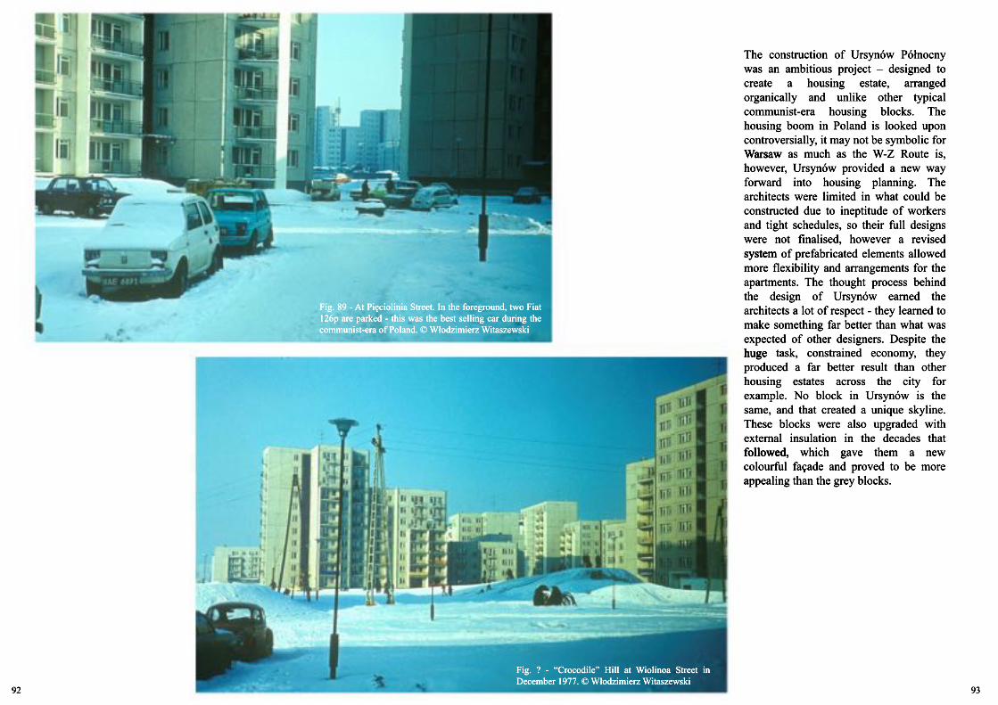
Fig. ? - “Crocodile” Hill at Wiolinoa Street in December 1977. © Włodzimierz Witaszewski
Fig. 89 - At Pięciolinia Street. In the foreground, two Fiat 126p are parked - this was the best selling car during the communist-era of Poland. © Włodzimierz Witaszewski
92 93
The construction of Ursynów Północny was an ambitious project – designed to create a housing estate, arranged organically and unlike other typical communist-era housing blocks. The housing boom in Poland is looked upon controversially, it may not be symbolic for WarsawWarsaw as much as the W-Z Route is, however, Ursynów provided a new way forward into housing planning. The architects were limited in what could be constructed due to ineptitude of workers and tight schedules, so their full designs were not finalised, however a revised systemsystem of prefabricated elements allowed more flexibility and arrangements for the apartments. The thought process behind the design of Ursynów earned the architects a lot of respect - they learned to make something far better than what was expected of other designers. Despite the hugehuge task, constrained economy, they produced a far better result than other housing estates across the city for example. No block in Ursynów is the same, and that created a unique skyline. These blocks were also upgraded with external insulation in the decades that followed,followed, which gave them a new colourful façade and proved to be more appealing than the grey blocks.

The Palace of Culture and Science is a controversial symbol of Warsaw. It had been regarded with disdain, and when it was built in 1955, it had immensely strained the economy of Poland. The construction of the Palace could not be paused, and so many other reconstruction projectsprojects around Warsaw had to be restricted. To many it is a symbol of the USSR’s control over Poland, and it was only in recent years, particularly by the younger generation, that the Palace became a symbol of Warsaw. While disdain towards the eastern neighbour remains,remains, the communist era is long behind in Poland’s history, the Palace still stands and serves as a symbol of a reborn city.
Fig. ? - Palace of Culture and Science. © Mogens Tørsleff Fig. 91 - Palace of Culture and Science behind the ruins of Stefan Kryński House. © Mogens Tørsleff
94 95
Fig. 92 - Palace of Culture and Science from a window © Mogens Tørsleff

Fig. 94 - Warsaw by night. © Adam Borkowski.97
When Warsaw was liberated in January 1945, returning Varsovians were met with an ocean of rubble instead of the capital city they remembered. Many of them believed that the reconstruction of Warsaw was impossible. Yet through the incredible work of the urban planners in the early yearsyears after the war, the implementation of Polish culture and heritage in the tallest building, and the mass-produced housing policies to solve shortages, Warsaw was rebuilt to become a major European metropolis.
Word Count: 5210

Janczewski, H. (1986). Całe życie z Warszawą (Whole Life with Warsaw). Państwowy Instytut Wydawniczy, p. 163-164.Hatherley, O. (2015). Landscapes of Communism: A History Through Buildings. (2nd ed.). Penguin.Zakrzewski, P. (2020) Warszawa 1945. Przewodnik po mieście ruin (Warsaw 1945. A guide to the city of ruins). Culture.pl. https://culture.pl/pl/superartykul/warszawa-1945-przewodnik-po-miescie-ruin Piątek, G. (2020). Najlepsze Miasto Świata:Piątek, G. (2020). Najlepsze Miasto Świata: Warszawa w odbudowie 1944-1949 (The Best City in the World: Rebuilding Warsaw 1944-1949) (1st ed.) Wydawnictwo W.A.B.Gliński, M. (2015). Kto odbudował Warszawę? I dlaczego tak? (Who rebuilt Warsaw? And why in that way?). Culture.pl. https://culture.pl/pl/artykul/kto-odbudowal-warszawe-i-dlaczego-tak Chelminski, R. (1997).Chelminski, R. (1997). Warsaw The City That Would Not Die. Smithsonian Magazine 28 (8). Chelminski, R. (2011). Warsaw On The Rise. Smithsonian Magazine 41 (10).Elżanowski, J. (2012). Ruins, Rubble and Human Remains: Negotiating Culture and Violence in Post-Catastrophic Warsaw. Public Art Dialogue, 2 (2), 114-146. EisleEisler, J. (2014). Siedmu Wspaniałych. Poczet Pierwszych Sekretarzy KC PZPR (The Magnificent Seven: first secretaries of the PZPR). Wydawnictwo Czerwone i Czarne. Tyszka, K. W. (1948). Problemy odgruzowania miast. (Problems of Rubble Removal in Cities). Inżynieria i Budownictwo 5 (3). Dziewulski, S. (1946). Wytyczne planu przestrzennego (Guidelines for Spatial Planning). Skarpa Warszawska. Jabłoński, K. (1979).Jabłoński, K. (1979). Warsaw, A Portrait of a City. (1st ed.). Arkady. Górski, J. (1976). Drugie narodziny miasta: Warszawa 1945 (The Second Birth of City: Warsaw 1945) (1st ed.) Państwowy Instytut Wydawniczy, p. 228. Małcużyński, K. (1955). Szkice Warszawskie (Warsaw Sketches) (1st ed.). Książka i Wiedza, p. 58.Kośka, M. (2020). Ruchome Schody PrzyKośka, M. (2020). Ruchome Schody Przy Trasie W-Z (Escalators on the W-Z Route). IgiMag. Retrieved from: https://igimag.pl/2020/01/ruchome-schody-przy-trasie-w-z/ Skalimowski, A., Weszpiński, P, E. (2018). Plan Warszawy 1955 (Plans of Warsaw 1955) (1st ed.). Muzeum Warszawy.Zupagrafika. (2019). Eastern Blocks: Concrete Landscapes of the Former Eastern Bloc. (1st ed.). Zupagrafika, p. 59.Sztompke, E., & Krzesińska,Sztompke, E., & Krzesińska, A. (2017). Sekrety Warszawy: kamienica przy Krakowskim Przedmieściu (Secrets of Warsaw: Tenement House at Krakowskie Przedmieście). Polska Mówi. Retrieved from: https://www.polskamowi.pl/historia/sekrety-warszawy-czesc-xxvi/ Murawski, M. (2019). The Palace Complex: A Stalinist Skyscraper, Capitalist Warsaw, and a City Transfixed. (1st ed.). Indiana University Press. Majewski, Majewski, P. (2019). Czas końca czas początku (Time for End, Time for Beginning). (1st ed.) Bellona. Skup, M. (2015). Rzeźby Pałacu Kultury i Nauki (Sculptures of the Palace of Culture and Science). Polski Socrealizm. Retrieved from: http://polskisocrealizm.org/sztuka/rzezby-palacu-kultury-i-nauki Skup, M. (2015) Polskie inspiracje w architekturze PKiN (Polish Inspirations in the Skup, M. (2015) Polskie inspiracje w architekturze PKiN (Polish Inspirations in the Architecture of PKiN). Polski Socrealizm. Retrieved from: http://polskisocrealizm.org/sztuka/polskie-inspiracje-w-architekturze-palacu-kultury-i-nauki
Pyzik, A. (2015). Warsaw’s Palace of Culture, Stalin’s ‘Gift’. The Guardian. Retrieved from: https://www.theguardian.com/cities/2015/may/08/warsaw-palace-of-culture-stalin-a-history-of-cities-in-50-buildings-day-32 Zieliński, J. (2012). Pałac Kultury i Nauki (Palace of Culture and Science). Księżny Młyn, p. 32-34. Zaborowska, J. M. (1999).Zaborowska, J. M. (1999). The Height of (Architectural) Seduction: Reading the “Changes” through Stalin’s Palace in Warsaw, Poland. Centre for Cultural Research, University of Aarhus. Retrieved from: http://www.hum.au.dk/ckulturf/pages/publications/mz/architect.htm#top Culture.pl. (2015) Pałac Kultury i Nauki ma ponad 60 lat (The Palace of Culture and Science is over 60 years old). Culture.pl. Retrieved from: https://culture.pl/pl/artykul/palac-kultury-i-nauki-ma-ponad-60-lat PRPRL 1976 Budujemy Drugą Polskę. (2013, July 18). [Video]. Retrieved from: https://www.youtube.com/watch?v=ilgzCTGz3XU Pańków, L. (2017). Bloki w Słońcu: Mała Historia Ursynówa Północnego (Blocks in the Sun: A Small History of Northern Ursynów) (1st ed.). Wydawnictwo Czarne. Bartoszewicz, D., & Budzyński, M. (2015). Moje jest dobre: BUBartoszewicz, D., & Budzyński, M. (2015). Moje jest dobre: BUW wspaniały, Ursynów udany (Mine is Good: BUW is wonderful, Ursynów is successful). Gazeta Wyborcza. Retrieved from: https://warszawa.wyborcza.pl/warszawa/1,34862,17331453,Moje_jest_dobre__BUW_wspanialy__Ursynów_udany.html TTurek, B. (2011). Edward Gierek… największym deweloperem w historii (Edward Gierek… the biggest developer in history). Forbes. Retrieved from: https://www.forbes.pl/wiadomosci/edward-gierek-najwiekszym-deweloperem-w-historii/8z5skc4 Halo Ursynów Editors. (2019). Ursynówska Rocznica (UrsynówHalo Ursynów Editors. (2019). Ursynówska Rocznica (Ursynów Anniversary). Halo Ursynów. Retrieved from: https://www.haloUrsynów.pl/artykuly/Ursynówska-rocznica-42-lata-temu-zamieszkali-tu-pierwsi-lokatorzy,3158.htm Mowią Wieki Editors. (2005). Mieszkać w PRL (Living in PPR). Onet.pl. Retrieved from: https://wiadomosci.onet.pl/kiosk/mieszkac-w-prl/4g6ddBorawski, L., Szczepanik-Dzikowski, J., & Szkop,Borawski, L., Szczepanik-Dzikowski, J., & Szkop, A. (1971). Życie i Nowoczescność, nr. 62 (Life and Modernity, issue 62). Warszawskie Wydawnictwo Prasowe RSW “Prasa”. Digitised version retrieved from: http://bc.radom.pl/dlibra/publication/35868/edition/34695/content
98 99
bibliography

1. Remains of the Warsaw Ghetto. © Z. Siemaszko. https://commons.wikimedia.org/wiki/File:Warsaw_Ghetto_destroyed_by_Germans,_1945.jpg 2. Old Town in Warsaw after the war. 1945. https://commons.wikimedia.org/wiki/File:Warsaw_Old_Town_1945.jpg3. Preparation for Destruction of Royal Castle in Warsaw, 1944. https://commons.wikimedia.org/wiki/File:Preparation_for_Destruction_of_Royal_Castle_in_Warsaw.jpg 4.4. Parade of the 1st Polish People’s Army in ruined Warsaw on Marszałkowska Street, 19th January 1945. https://commons.wikimedia.org/wiki/File:Polish_Army_Parade_waf-2012-1502-29_(1945).jpg 5. Prudential Building (first skyscraper in Warsaw), destroyed during the Warsaw Uprising. Photo taken 1945. Zbyszko Siemaszko (photographer of the Central Photographic Agency in Warsaw). https://commons.wikimedia.org/wiki/File:Prudential_Building_Warsaw,_1945.jpg 6. ‘Warsaw is Free!’, the front page of the Życie Warszawy (Life of Warsaw) newspaper, 18 January 1945, photo: National Library / Polona.pl7.7. L. Kowalski, F. Piątkowski, Główny Urząd Pomiarów Kraju. “Map of Warsaw at Scale 1:20,000 and Inventory of the Devastation Perpetrated by the Germans during the War 1939–1945.” 1947. Detail of Warsaw’s central districts. State Archives of the capital city of Warsaw. Digital version retrieved from: http://fotopolska.eu/1095472,foto.html?a=11512&b=21740&c=58.8. L. Kowalski, F. Piątkowski, Główny Urząd Pomiarów Kraju. “Map of Warsaw at Scale 1:20,000 and Inventory of the Devastation Perpetrated by the Germans during the War 1939–1945.” 1947. Detail of Warsaw’s central districts. State Archives of the capital city of Warsaw. Digital version retrieved from: http://fotopolska.eu/1095472,foto.html?a=11512&b=21740&c=59. Old Town Market Place, 1945. https://commons.wikimedia.org/wiki/File:Old_Town_Warsaw_waf-2012-1501-31(1945).jpg 10.10. Aerial photograph of northern Warsaw Ghetto area (north direction on the top). In the middle German Concentration Camp in Warsaw (named KL Warschau or KZ Warschau). Warsaw, capital of Poland during German occupation (1939-1945). Photo most likely taken November 1944. Retrieved from: https://collections.ushmm.org/search/catalog/pa29047 11. Henry N. Cobb, Piwna Street, seen from Royal Castle Square, Warsaw, 1947. Photo: press materials / Dom Spotkan z Historia. https://culture.pl/en/gallery/colours-of-ruins-the-photographs-of-henry-n-cobb-image-gallery 12.12. Henry N. Cobb, Old Town Market, Warsaw, 1947. Photo: press materials / Dom Spotkan z Historia. https://culture.pl/en/gallery/colours-of-ruins-the-photographs-of-henry-n-cobb-image-gallery13. Plac Krasinskich. Henry N. Cobb. 1947. http://milimetr.net/wp-content/uploads/2011/10/WARSAW_AUGUST_1947_CHenryNCobb.pdf 14. Henry N. Cobb, Szpitalna Street near Boduen Street, 1947. Photo: press materials / Dom Spotkan z Historia. https://culture.pl/en/gallery/colours-of-ruins-the-photographs-of-henry-n-cobb-image-gallery15.15. Napoleon Square with Prudential Building on left. © Edward Falkowski. National Archives. https://nac.gov.pl/16. Wacław Żdżarski, view of Warsaw from plane, 1946. National Archives. https://nac.gov.pl/17. 1960-1962. Bell tower at St. Anne’s Church, row of tenement houses and tunnel exit. Zbyszko Siemaszko. National Archives (audiovis.nac.gov.pl)18. plan of Warsaw. 1948. A. Kwiatkowski. A. Marcinkiewicz. Kartografowie W.I.G. http://maps.mapywig.org/m/City_plans/Central_Europe/PLAN_M_ST_WARSZAWY_25K_1948.jpg19.19. Map of Warsaw 1939/1940 by Cukrzyński W., Goliński S. Digitized version retrieved from: http://maps.mapywig.org/m/City_plans/Central_Europe/Plan_Warszawy_1939-1940_incomplete.jpg20. Plan of central districts in the capital city of Warsaw, 1955. National Cartography Office. Digitized version: http://maps.mapywig.org/m/City_plans/Central_Europe/PLAN_DZIELNIC_CENTRALNYCH_M.ST._WARSZAWY_1955.jpg21.21. sketch of western tunnel entrance by Architect Engineer Zygmunt Stępiński, 1947. https://stanislawjankowskiagaton.pl/po-wojnie/odbudowa-i-planowanie-warszawy/trasa-w-z/ 22. sketch of eastern tunnel entrance by Architect Engineer Zygmunt Stępiński, 1947. https://stanislawjankowskiagaton.pl/po-wojnie/odbudowa-i-planowanie-warszawy/trasa-w-z/23. Tunnel construction, 1947-1948. Retrieved from: https://plock.fotopolska.eu/1570321,foto.html?o=b88023
24. Construction work at tunnel entrance underneath Miodowa Street. In the background on the right, Church of St. Anne. National Archives (audiovis.nac.gov.pl )25. Józef Sigalin explains the model of Route W-Z to Bolesław Bierut. https://stanislawjankowskiagaton.pl/po-wojnie/odbudowa-i-planowanie-warszawy/trasa-w-z/ 26.26. Building of tunnel. https://stanislawjankowskiagaton.pl/po-wojnie/odbudowa-i-planowanie-warszawy/trasa-w-z/27. the route leading to the tunnel on the eastern side. On the left, St Anne’s Church, tenement houses, tunnel exit, Copper-Roof Palace, Zygmunt’s Column, 1960-1962. © Zbyszko Siemaszko. National Archives (audiovis.nac.gov.pl )28.28. WuZetka Cake. https://www.oetker.pl/pl-pl/nasze-przepisy/r/wuzetka-z-masa-smietanowa 29. Aerial view of Route W-Z. © Google Earth30. Information board near the entrance to the construction site of the W-Z Route. 1947-1949. https://commons.wikimedia.org/wiki/File:Tablica_informacyjna_budowa_trasy_W-Z.jpg31.31. John’s Tenement House and Zygmunt’s Column. © Dennis Jarvis. https://commons.wikimedia.org/wiki/File:John_house_and_Sigismund_column.jpg 32. King Zygmunt (Sigismund) returns to his new column. 12th July 1949. https://stanislawjankowskiagaton.pl/po-wojnie/odbudowa-i-planowanie-warszawy/trasa-w-z/33. renovated pedestrian tunnel. https://zdm.waw.pl/aktualnosci/nieczynna-winda-przy-trasie-w-z/34.34. “Together in Rebuilding”. © sztuka.net http://www.sztuka.net/palio/html.run?_Instance=sztuka&_PageID=853&newsId=1580&callingPageId=852&_cms=newser&_CheckSum=-2045296413 35. Light bowls. 2004. © sztuka.net http://www.sztuka.net/palio/html.run?_Instance=sztuka&_PageID=853&newsId=1580&callingPageId=852&_cms=newser&_CheckSum=-204529641336.36. opening of the Route W-Z in Warsaw, 22nd July 1949. National Archives (audiovis.nac.gov.pl)37. President Bolesław Bierut and Prime Minister Józef Cyrankiewicz greet the inhabitants of the capital during the opening ceremony of the W-Z Route. 22nd July 1949. © CAF https://warszawa.wyborcza.pl/warszawa/7,54420,22500303,reprywatyzacja-w-warszawie-koniec-dekretu-bieruta.html 38.38. Opening of the Route W-Z 1949. https://stanislawjankowskiagaton.pl/po-wojnie/odbudowa-i-planowanie-warszawy/trasa-w-z/ 39. The route in 1970. https://stanislawjankowskiagaton.pl/po-wojnie/odbudowa-i-planowanie-warszawy/trasa-w-z/40.40. Interior of the tunnel 1972. Lubomir Winnik. https://plock.fotopolska.eu/1120795,foto.html?o=b8802341. Construction of Wiolinowa Street, 1976. © Włodzimierz Witaszewski https://ursynow.org.pl/zdjecia/ 42. Ursynów Architects. From the left, Jerzy Szczepanik-Dzikowski, Andrzej Szkop, Marek Budzyński, Zbigniew Zawistowski and others. © Włodzimierz Witaszewski https://ursynow.org.pl/zdjecia/ 43.43. Project of the Ursynów Północ housing estate, developed by the team under the leadership of Marek Budzyński. © Włodzimierz Witaszewski. Bloki W Słońcu by Lydia Pańków.
100 101
illustrations

44. Surowiecki Street, 1977. © Grażyna Rutowska. National Archives (audiovis.nac.gov.pl )45. Construction of Ursynów. © Grażyna Rutowska. National Archives (audiovis.nac.gov.pl )46. Construction of Ursynów. © Grażyna Rutowska. National Archives (audiovis.nac.gov.pl )47. Construction of Ursynów. © Grażyna Rutowska. National Archives (audiovis.nac.gov.pl )48. Construction of Ursynów. © Grażyna Rutowska. National Archives (audiovis.nac.gov.pl )49.49. The design of the streets under the name "Pedestrian Street - the Functional and Spatial Backbone of Residential Complexes”. © Andrzej Szkop i Jerzy Szczepanik-Dzikowski. Bloki W Słońcu by Lydia Pańków.50. Winter at Ursynów with the peacock sculpture in the foreground of both photos, 1977. © Włodzimierz Witaszewski https://ursynow.org.pl/zdjecia/51. Winter at Ursynów with the peacock sculpture in the foreground of both photos, 1977. © Włodzimierz Witaszewski https://ursynow.org.pl/zdjecia/52. Block at Pięciolinii 3. © Włodzimierz Witaszewski https://ursynow.org.pl/zdjecia/53.53. Many trees were saved through Irena Bajerska’s green architecture programme. © Włodzimierz Witaszewski https://ursynow.org.pl/zdjecia/54. Building of Nutki Street and Puszczyka Street. Trees that were saved by the architects can be seen, and are still growing to this day. © Włodzimierz Witaszewski https://ursynow.org.pl/zdjecia/55. Prefabricated WC. © Włodzimierz Witaszewski https://ursynow.org.pl/zdjecia/56. Construction base at Stokłosy. Enough prefabricated elements to build a living room. © Włodzimierz Witaszewski https://ursynow.org.pl/zdjecia/57.57. Prefabricated elements under construction. ©Aleksander Jalosiński https://culture.pl/en/article/building-blocks-polands-most-popular-homes 58. Residential block at 1 Puszczyka Street, 1977. © Grażyna Rutowska. National Archives (audiovis.nac.gov.pl ) 59. Inconsistencies with building the blocks. © Aleksander Jałosiński. Bloki W Słońcu by Lydia Pańków. 60. Block by 1 Puszczyka Street. © Grażyna Rutowsk. National Archives (audiovis.nac.gov.pl )61. Gierek’s visit to Ursynów. © TVP Achiwum https://ursynow.org.pl/zdjecia/62.62. Panoramic photo at Koński Jar. © Zdzisław Lewicki https://ursynow.org.pl/zdjecia/63. Ursynów Północny, 2020. © Maciej Mazur https://ursynow.org.pl/zdjecia/gallery/2020/ 64. Close-up of tower. https://commons.wikimedia.org/wiki/File:Palac_Kultury_i_Nauki_Detal_80_30017.jpg65. Krakow Cloth Hall. © Maksym Kozlenko https://commons.wikimedia.org/wiki/File:2018-07-04_Sukiennice_at_Old_Town_Market_Square_in_Krak%C3%B3w_1.jpg66.66. Details of crenellations atop Krakow Cloth Hall. © Andrzej O. https://commons.wikimedia.org/wiki/File:Krakow_Sukiennice_detal.jpg 67. Chełmno town hall. https://commons.wikimedia.org/wiki/File:Chelmno_ratusz_03.jpg68. Mannerist arcaded courtyard of Baranów Sandomierski Castle. © Jerzy Strzelecki. https://commons.wikimedia.org/wiki/File:Baranow6.jpg 69.69. building of foundations for the Palace of Culture and Science. 1952. https://commons.wikimedia.org/wiki/File:Wykopy_pod_fundamenty_Pa%C5%82acu_Kultury_i_Nauki_1952.jpg 70. “Stolica” 1954 – issue 28. “In The Housing Esate of Friendship”. http://cab.waw.pl/tyogdnik-stolica-fotoreportaz-z-osiedla-przyjazn/71. Construction of precut elements at the Housing Estate of Friendship. http://cab.waw.pl/budowa-osiedla-przyjazn/ 72.72. Construction of the Palace of Culture and Science viewing platform, 1952. https://commons.wikimedia.org/wiki/File:Budowa_Pa%C5%82acu_Kultury_i_Nauki_widziana_z_podestu_widokowego_1952.jpg 73. Soviet workers of the Palace of Culture and Science, 1954. https://commons.wikimedia.org/wiki/File:Budowa_Pa%C5%82acu_Kultury_i_Nauki_1954a.jpg74.74. View of Palace of Culture and Science between Śliska and Sienna Streets 1957. None of the buildings (apart from the Palace) exist today. © John Schultz https://plock.fotopolska.eu/667265,foto.html?o=b2480&p=5 75. Sculpture of man with a tome of the classics of communism; Marx, Engels and Lenin. (own photograph)
76. Statue of Mikołaj Kopernik by Ludwik Nitschow. © Adrian Grycuk https://commons.wikimedia.org/wiki/File:Ludwika_Nitschowa_Pomnik_Miko%C5%82aja_Kopernika_Pa%C5%82ac_Kultury_i_Nauki.JPG77. Sculpture representing central Asian woman. © M. Skup. http://polskisocrealizm.org/sztuka/rzezby-palacu-kultury-i-nauki 78. Marble Hall at the Palace of Culture and Science. © Adrian Grycuk https://commons.wikimedia.org/wiki/File:Sala_Marmurowa_Pa%C5%82ac_Kultury_i_Nauki.jpg79.79. Trójki Hall. © Adrian Grycuk https://upload.wikimedia.org/wikipedia/commons/3/39/Sala_Trojki_Pa%C5%82ac_Kultury_i_Nauki_w_Warszawie_2016.jpg 80. Władysław Broniewski Hall. © Adrian Grycuk https://commons.wikimedia.org/wiki/File:Sala_im._W%C5%82adys%C5%82awa_Broniewskiego_Pa%C5%82ac_Kultury_i_Nauki.jpg 81.81. Mikołaj Kopernik Hall. © Adrian Grycuk https://commons.wikimedia.org/wiki/File:Sala_im._Miko%C5%82aja_Kopernika_Pa%C5%82ac_Kultury_i_Nauki.jpg 82. Stefan Starzyński Hall. © Adrian Grycuk https://commons.wikimedia.org/wiki/File:Sala_im._Stefana_Starzy%C5%84skiego_Pa%C5%82ac_Kultury_i_Nauki.jpg 83.83. The Palace at night from the intersection of Marszałkowska and Świętokrzyska streets. 1955. © Zbyszko Siemaszko National Archives (audiovis.nac.gov.pl)84. Palace of Culture in background, view from Świętokrzyska Street. On the left, ruins of the Postal Savings Bank (PKO – the largest bank in Poland), 1957. © Wil Hofwijk https://gdansk.fotopolska.eu/712183,foto.html?galeria_zdjec&autor=Wil-Hofwijk&&autor=Wil-Hofwijk 85. Palace of Culture behind ruins of Kryński tenement houses, 1960. © Harrison Forman. https://plock.fotopolska.eu/1285979,foto.html?o=b2480&p=8 86.86. View from a window in Hotel “Polonia”. 1960-1970. https://plock.fotopolska.eu/1435266,foto.html 87. View of Warsaw from plane, 1946, Prudential Building seen in centre. © Wacław Żdżarski. National Archives (audiovis.nac.gov.pl)88. Aerial view of Warsaw Old Town and the W-Z Route cutting underneath. © Lech Zaleski. National Archives (audiovis.nac.gov.pl)89. At Pięciolinia Street. In the foreground, two Fiat 126p are parked - this was the best selling car during the communist-era of Poland. © Włodzimierz Witaszewski. https://ursynow.org.pl/zdjecia/ 90.90. “Crocodile” Hill at Wiolinoa Street in December 1977. © Włodzimierz Witaszewski. https://ursynow.org.pl/zdjecia/91. Palace of Culture and Science behind the ruins of Stefan Kryński House. © Mogens Tørsleff National Archives (audiovis.nac.gov.pl)92. Palace of Culture and Science from a window © Mogens Tørsleff National Archives (audiovis.nac.gov.pl)93. Palace of Culture and Science. © Mogens Tørsleff National Archives (audiovis.nac.gov.pl)94.94. Warsaw by night. © Adam Borkowski. https://unsplash.com/@borkography 95. Front Cover. Destroyed Prudential Building. © Stefan Rassalski. National Archives (audiovis.nac.gov.pl)
102 103
