how to involve structural modeling for cartographic object recognition tasks in high-resolution...
TRANSCRIPT
Pattern Recognition Letters 31 (2010) 1109–1119
Contents lists available at ScienceDirect
Pattern Recognition Letters
journal homepage: www.elsevier .com/locate /patrec
How to involve structural modeling for cartographic object recognition tasksin high-resolution satellite images?
Guray Erus a,*, Nicolas Loménie a,b
a Department of Mathematics and Informatics, LIPADE Laboratory, SIP Team, Paris Descartes University, 45 rue des Saints-Pères, 75006 Paris, Franceb CNRS – IPAL – UMI 2955, Singapore
a r t i c l e i n f o
Article history:Available online 15 January 2010
Keywords:Object recognitionStructural analysisSatellite imagesCBIR
0167-8655/$ - see front matter � 2010 Elsevier B.V. Adoi:10.1016/j.patrec.2010.01.013
* Corresponding author. Tel.: +1 334 787 75 11; faxE-mail address: [email protected] (G. Er
a b s t r a c t
With the new generation of satellite systems, very high resolution satellite images will be available dailyat a high delivery rate. The exploitation of such a huge amount of data will be made possible by the designof high performance analysis algorithms for decision making systems. In particular, the detection and rec-ognition of complex man-made objects is a new challenge coming with this new level of resolution. Inthis study, we develop a system that recognizes such structured and compact objects like bridges orroundabouts. The original contribution of this work is the use of structural shape attributes in an appear-ance-based statistical learning method framework leading to valuable recognition and false alarm rates.This hybrid structural/statistical approach aims to construct an intermediate step between the low-levelimage characteristics and high-level semantic concepts.
� 2010 Elsevier B.V. All rights reserved.
1. Introduction ing set. Our method is evaluated on a cartographic object recogni-
The new satellite systems like PLEIADES or QuickBird will pro-vide satellite images up to 70 cm per pixel spatial resolution witha high delivery rate. Thus, new challenges for automatic interpre-tation of these valuable images are coming up. Much work hasbeen done so far about the segmentation/recognition of texturedareas like urban ones at low resolution. The detection of transportnetworks like roads or rivers considered as lineic structure net-works in images has also been intensely studied and efficient algo-rithms have been proposed so far like in (Tupin et al., 1998; Mayeret al., 2006). However, few results have been presented for the rec-ognition of complex, cartographic structures like bridges or round-abouts. These versatile objects do not lend themselves to classicalstatistical approaches for which a set of quantitative measuresabout the intensity distribution within a normalized window feedsa global statistical classifier used to discriminate between differentobjects. In the case of roundabouts for instance, the spatial config-urations of object’s parts are so versatile that a global statistical ap-proach is not applicable. While the decomposition of the objectsinto parts is almost unavoidable, a purely structural part-based ap-proach (Erus and Lomenie, 2005), is not appropriate to be appliedon a real detection task, mainly due to the difficulty of segmentingthe target objects to well-defined primitive shapes.
We propose in this study a hybrid approach based on learningthe spatial configuration of structural primitives constituting anobject, according to their statistical distribution in a labeled train-
ll rights reserved.
: +1 215 614 02 66.us).
tion task defined in the framework of a national program calledTechnovision that aims to assess the state of the art in object rec-ognition (project ROBIN). For that academic-industrial joint study,The French Space Agency (CNES) prepared a database of satelliteimages containing cartographic objects. The recognition taskconsists of classifying images of size 100 � 100 pixels into one ofthe categories, like bridges, roundabouts, crossroads or isolatedbuildings.
In the object category recognition domain, the need for morestructural analysis is progressively growing. In particular, low-levelas well as high-level spatial relationships of object components areused as part of the object model definitions (Ferrari et al., 2008).However, the handling of such spatial relationships is not obvioussince symbolic/linguistic reasoning is more or less involved (Erusand Lomenie, 2005) and the concept of spatial ontology is notstraightforwardly usable in current image processing lines (Hude-lot, 2005). However preliminary examples of the use of spatial rela-tions in a recognition task can be found for example in (Colliot etal., 2006; Cao et al., 2009).
2. The image database
In the frame of the ORFEO program,1 CNES prepared a databaseof high resolution cartographic object images. These images are sim-ulations of the PLEIADES acquisition system based on SPOT5 images.In fact, the actual PLEIADES images will be available around 2010.
1 The research program set up to prepare, accompany and promote the use and theexploitation of the images derived from future Pleiades satellites.
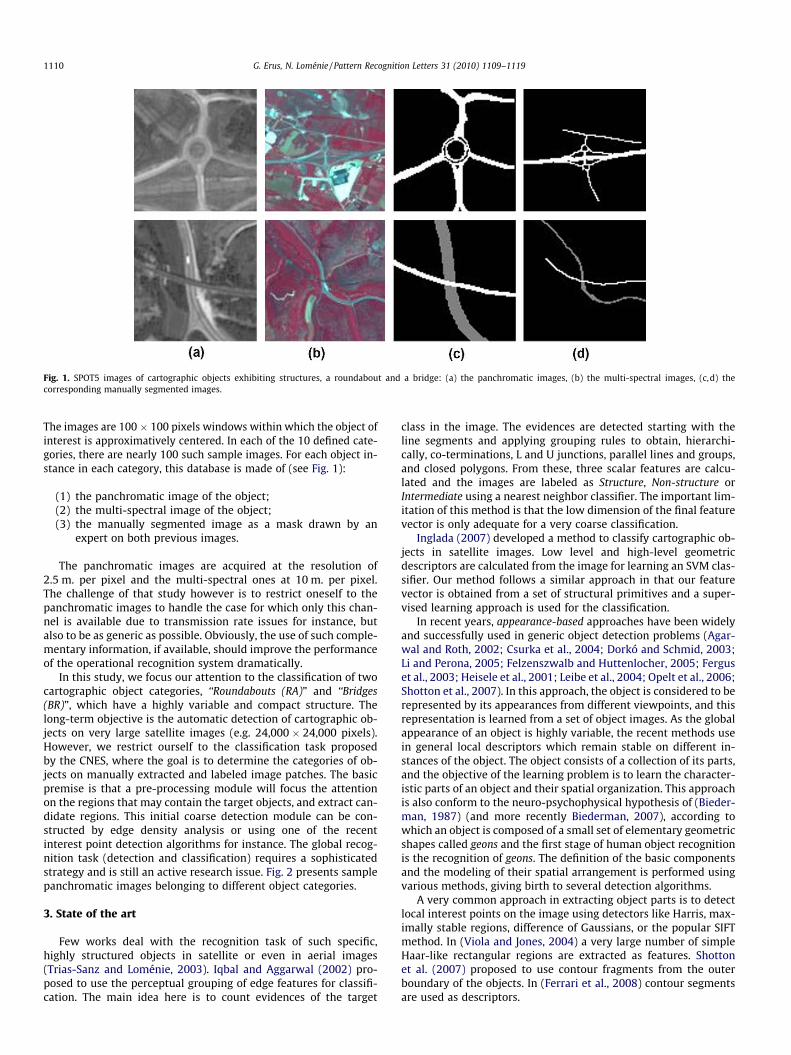
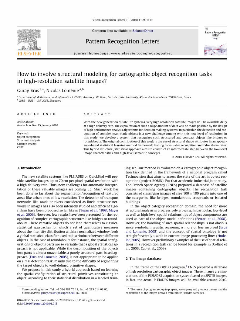
Fig. 1. SPOT5 images of cartographic objects exhibiting structures, a roundabout and a bridge: (a) the panchromatic images, (b) the multi-spectral images, (c,d) thecorresponding manually segmented images.
1110 G. Erus, N. Loménie / Pattern Recognition Letters 31 (2010) 1109–1119
The images are 100 � 100 pixels windows within which the object ofinterest is approximatively centered. In each of the 10 defined cate-gories, there are nearly 100 such sample images. For each object in-stance in each category, this database is made of (see Fig. 1):
(1) the panchromatic image of the object;(2) the multi-spectral image of the object;(3) the manually segmented image as a mask drawn by an
expert on both previous images.
The panchromatic images are acquired at the resolution of2.5 m. per pixel and the multi-spectral ones at 10 m. per pixel.The challenge of that study however is to restrict oneself to thepanchromatic images to handle the case for which only this chan-nel is available due to transmission rate issues for instance, butalso to be as generic as possible. Obviously, the use of such comple-mentary information, if available, should improve the performanceof the operational recognition system dramatically.
In this study, we focus our attention to the classification of twocartographic object categories, ‘‘Roundabouts (RA)” and ‘‘Bridges(BR)”, which have a highly variable and compact structure. Thelong-term objective is the automatic detection of cartographic ob-jects on very large satellite images (e.g. 24,000 � 24,000 pixels).However, we restrict ourself to the classification task proposedby the CNES, where the goal is to determine the categories of ob-jects on manually extracted and labeled image patches. The basicpremise is that a pre-processing module will focus the attentionon the regions that may contain the target objects, and extract can-didate regions. This initial coarse detection module can be con-structed by edge density analysis or using one of the recentinterest point detection algorithms for instance. The global recog-nition task (detection and classification) requires a sophisticatedstrategy and is still an active research issue. Fig. 2 presents samplepanchromatic images belonging to different object categories.
3. State of the art
Few works deal with the recognition task of such specific,highly structured objects in satellite or even in aerial images(Trias-Sanz and Loménie, 2003). Iqbal and Aggarwal (2002) pro-posed to use the perceptual grouping of edge features for classifi-cation. The main idea here is to count evidences of the target
class in the image. The evidences are detected starting with theline segments and applying grouping rules to obtain, hierarchi-cally, co-terminations, L and U junctions, parallel lines and groups,and closed polygons. From these, three scalar features are calcu-lated and the images are labeled as Structure, Non-structure orIntermediate using a nearest neighbor classifier. The important lim-itation of this method is that the low dimension of the final featurevector is only adequate for a very coarse classification.
Inglada (2007) developed a method to classify cartographic ob-jects in satellite images. Low level and high-level geometricdescriptors are calculated from the image for learning an SVM clas-sifier. Our method follows a similar approach in that our featurevector is obtained from a set of structural primitives and a super-vised learning approach is used for the classification.
In recent years, appearance-based approaches have been widelyand successfully used in generic object detection problems (Agar-wal and Roth, 2002; Csurka et al., 2004; Dorkó and Schmid, 2003;Li and Perona, 2005; Felzenszwalb and Huttenlocher, 2005; Ferguset al., 2003; Heisele et al., 2001; Leibe et al., 2004; Opelt et al., 2006;Shotton et al., 2007). In this approach, the object is considered to berepresented by its appearances from different viewpoints, and thisrepresentation is learned from a set of object images. As the globalappearance of an object is highly variable, the recent methods usein general local descriptors which remain stable on different in-stances of the object. The object consists of a collection of its parts,and the objective of the learning problem is to learn the character-istic parts of an object and their spatial organization. This approachis also conform to the neuro-psychophysical hypothesis of (Bieder-man, 1987) (and more recently Biederman, 2007), according towhich an object is composed of a small set of elementary geometricshapes called geons and the first stage of human object recognitionis the recognition of geons. The definition of the basic componentsand the modeling of their spatial arrangement is performed usingvarious methods, giving birth to several detection algorithms.
A very common approach in extracting object parts is to detectlocal interest points on the image using detectors like Harris, max-imally stable regions, difference of Gaussians, or the popular SIFTmethod. In (Viola and Jones, 2004) a very large number of simpleHaar-like rectangular regions are extracted as features. Shottonet al. (2007) proposed to use contour fragments from the outerboundary of the objects. In (Ferrari et al., 2008) contour segmentsare used as descriptors.
Fig. 2. Panchromatic SPOT5 images of cartographic objects: (a) highway, (b) secondary road, (c) path, (d) isolated building, (e) housing estate and (f) crossroad.
G. Erus, N. Loménie / Pattern Recognition Letters 31 (2010) 1109–1119 1111
Spatial relations between parts can be modeled in a large spec-trum of approaches, from appearance-only models that ignorethem completely as in the bag of words approach (Csurka et al.,2004; Li and Perona, 2005), to structural, graph-based approachesas pictorial structures model, or constellation model. The PictorialStructures proposed initially by Fischler and Elschlager (1973) forface recognition has been recently used for the moving person rec-ognition task in (Felzenszwalb and Huttenlocher, 2005). The idea isto represent the configuration of the components by elastic con-nections. The recognition proceeds by the minimization of a costfunction assessing the needed deformation of the elastic structuralmodel to the unknown configuration. By an expectation-minimiza-tion approach, Weber et al. (2000) learn a constellation model whichis a star-shaped graph representing the components and their po-sition around a fixed point, often chosen as the center of the object.
Obviously, these approaches rely dangerously on the quality ofthe component segmentation process. We can notice here theimportant ambiguous role played by the spatial reference. It is of-ten the cornerstone for the structural modeling. In medical images,the anatomical substructure provides a straightforward spatial ref-erence (left and right lung for instance). Contrarily, in the case ofaerial images, one loses any classical spatial reference like above,below, left or right. A central point is often the easiest choice tobe made. But, according to us, the choice of a spatial referenceshould deserve much more investigation.
In (Leibe et al., 2004) a codebook of local appearances is ob-tained by clustering rectangular image patches according to theirnormalized greyscale correlation measure. An implicit shape mod-el, in the form of the spatial probability distribution of each clusterrelative to the object center, is constructed using a probabilisticvoting procedure, by matching patches extracted from the trainingset to the clusters. A similar approach in the construction of thecodebook is used in (Agarwal and Roth, 2002), but binary spatialrelations are represented by a sparse matrix obtained from the his-togram of distances and angles all pairs of patches. We can finallycite the work of (Fergus et al., 2003) where the components andthe structure are learned jointly using EM algorithm.
The whole set of these methods that attempt to learn an objectcategory from the appearance of local components and their spa-tial organization, offers a methodological framework well adaptedto cartographic objects. However they have been used so far for therecognition of object categories exhibiting little structural varia-tion like bicycles, cars or faces. Furthermore, the target objectshave generally a constant viewpoint and orientation, according towhich the spatial relations are defined. By nature, the configura-tion of a roundabout or a bridge is much more versatile. We believethat, in the case of cartographic objects, the parts of objects can benaturally associated to geometric primitives with a still higher le-vel of representation. At the new resolution of satellite images, thatrepresentation is totally justified by efficient low-level image pro-cessing methods to extract such features.
In satellite imagery, most of the accomplished studies focus onthe extraction of extended surfaces like road networks or urbanareas (Lorette et al., 2000; Tupin et al., 1998). This specific topic
of interest was related with the low level of resolution at whichthe objects of interest were much more handled as textured areasto be segmented in the image. Now, the resolution makes it possi-ble to focus on more localized and compact objects like a round-about or a bridge.
To end up with the structural pattern recognition community, afew works cope with the purely structural modeling of complexobjects in order to address the difficult issue of the semantic gapbetween the low-level descriptors and the high-level concepts.The Attributed Relational Graphs (ARG) are often used as a high-le-vel model of representation for the arrangement of regions (Petra-kis and Faloutsos, 1995; Shao and Kittler, 1999) or the modeling ofskeletons (Bardinet et al., 2000; Di Ruberto, 2004). The construc-tion or learning of such structural models is addressed in (Hongand Huang, 2004; Sangineto, 2003; Cordella et al., 2002). Eventhough these purely structural approaches are very interesting,they are not efficient as such for recognition/detection purposesin cluttered environments where the object of interest and thebackground are not easily separable.
4. The cartographic codebook modeling
The component-based approaches are well adapted for themodeling of cartographic objects with two main reasons:
� the articulated nature of the objects: for example, a roundaboutis composed of a central circle and roads articulated around thecircle;
� the intra-class variation is very high and this variation is oftendue to affine transformations of the object components.
Cartographic objects have well-defined, mostly geometricstructures. For this reason, we propose to exploit the geometricnature of cartographic objects in a component-based learningframework. The originality of this approach lies in:
� the intensive use of geometric primitives to build the appear-ance codebook;
� the joint learning of this cartographic codebook and of thestructure.
In our work, the object components correspond to geometricprimitives extracted from the images. However, due to their gene-ricity, their informative content is weak and the matching betweentwo such primitives in two images is not a definitive clue about thesimilarity between these two images. This is the reason why thejoint modeling of components and structure is required. We pro-pose to extract all eventual geometric primitives that may belongto the object, and learn jointly the components and the structureby defining the components not only by their geometric propertiesbut by their spatial properties as well. Then, we select the most sig-nificant spatio-geometric primitives to represent the object. A sim-plified structural representation of this object may then bedisplayed for the naive user of the final interface.
1112 G. Erus, N. Loménie / Pattern Recognition Letters 31 (2010) 1109–1119
Let m be the number of different geometric primitive types usedfor representing the objects, and P ¼ fp1 . . . pmgwhere fpi 2 Rdigm
i¼1
be the set of primitive types, each represented by a correspondingfeature vector denoting attributes such as position, orientation andgeometric properties. Let ITrain be the training set consisting ofimages containing the target object with label l. Primitives are ex-tracted from each image in ITrain and combined in pTrain ¼fp1; . . . ; png, where n is the total number of extracted primitives,and fpj 2 Pgn
j¼1. A codebook dictionary is built up by grouping theprimitives in pTrain relatively to their types i 2 f1; . . . ;mg, and clus-tering them in the corresponding feature space Rdi . Then the bestclusters, which correspond to words in our structural codebook,are automatically selected. A codebook is built up for each categoryof object. This codebook, which we call as the Structural ModelCodebook (SMC), works as a structural model carrying both geo-metric component and structure information. Note that the learn-ing step does not need negative examples and is thus apparentedto the original category of one-class classifiers (Tax, 2001; Wanget al., 2004).
In a probabilistic framework, the SMC can be considered as amodel that is used for estimating }ðpijlÞ; i ¼ f1; . . . ;mg, the multi-variate probability density function (pdf) of each primitive type idefined on Rdi , given the object category l.
Given a test image I, from which a set of primitives pI ¼fp1; . . . ; pqg is obtained, the classification into category l is essen-tially performed by calculating a class membership score obtainedby accumulating the evidences of observing a component of theobject category with label l in pI . The likelihood of a primitive tobelong to category l is estimated from the pdfs learned by the SMC.
Algorithm 1 briefly presents an overview of the algorithmic pro-cedure. A detailed formulation of each module is given in the fol-lowing subsections.
Algorithm 1. Global Algorithm of the components-and-structure method
Require:
iTrain: Learning set of positive imagesiTest: Test set of imagesEnsures: Membership scores of test images
LEARNINGfor all Ii 2 ITrain do
Extract pi: the geometric primitives extractedfrom Ii
Compute ai: the attribute vectors calculated frompi
end forConstruct Cobject: clusters obtained by clusteringa ¼
Sai by mean-shift clustering
Construct SMCobject, the structural model codebook ofthe object: clusters selected from Cobject
CLASSIFICATIONfor all Ii 2 ITest do
Extract pi: the geometric primitives extracted from IiCompute ai: the attribute vectors calculated from pi
for all aij 2 ai dosaij
: the likelihood of the attribute calculated fromSMCobject
end forsi : normalized
Psaij
end forReturn s ¼
Ssi
4.1. The primitive extraction and representation
The segmentation of aerial images is not straightforward dueto:
(1) the non-homogeneity of the radiometry of objects;(2) the non-separability of the object from the background even
for the human eye.
The manually segmented images of Fig. 1c and d illustrate theimportant amount of contextual information involved for the hu-man expert to produce the segmentation ground truth. For thisreason, we propose to extract geometric primitives that representwell the structure of man-made cartographic objects. The extrac-tion is performed on the whole image, and eventual false positivesare eliminated by the feature selection mechanisms at subsequentsteps. Two types of primitives, the straight lines, and the circle arcsare extracted using both an edge-based and a region-based meth-od. The two sets of primitives are used in conjunction in order torely on a larger feature vector. The point is always to find a balancebetween the degree of expressiveness of a primitive and the diffi-culty to extract it. The more expressive the primitive is, the smallerthe feature vector is, but more difficult the extraction becomes. Tocompare with (Iqbal and Aggarwal, 2002), circular primitives arealso extracted, and a larger feature vector, taking into consider-ation primitives’ geometric, relational and spatial attributes, isconstructed.
The edge-based extraction is done on a Gaussian image pyramidwith four levels, in order to detect the primitives on differentscales. Given the original image I0, the multiscale representationis obtained by
Ilþ1 ¼ g � Il; l 2 f0;1;2g;
where g is a Gaussian kernel and � is the convolution operator. Foreach fIig3
i¼0 the following steps for the primitive extraction are ap-plied and the resultant primitives are grouped together:
� Sub-pixel edge detection (Devernay, 1995) using a modifiedCanny (1986) edge detector. Sub-pixel precision is necessaryin order to guarantee a robust approximation by line segmentsor arcs.
� Grouping of edge points Ei into a set of edge-chains Ci ¼fC1
i ; . . . ;Cpi g, such that p is the total number of edge-chains in
Ei, and each edge-chain fCjig
pj¼1 is a list of connected edge pixels.
A new chain is started in each junction.� Polygonal approximation on each edge-chain Cj
i using Douglas–Peucker algorithm (Douglas and Peucker, 1973), to obtain Sj
i, aset of adjacent line segments that fit Cj
i with the smallest error.� Detection of arcs in each Sj
i. As a result of the polygonal approx-imation, the circular lines are also approximated by line seg-ments. In order to detect them, we propose a recursive fusionalgorithm. For each adjacent line segment pairs sk; skþ1 2 Sj
i, thecircle ck that best fits the corresponding edge points in a leastsquares sense is calculated, together with the approximationerror eðck; sk; skþ1Þ. If eðck; sk; skþ1Þ < t, a predefined circularitythreshold, sk and skþ1 are replaced by ck. This procedure isrepeated until eðck; sk; skþ1Þ > t; 8k.
In parallel to edge-based extraction, region-based primitives areextracted by mean-shift segmentation (Comaniciu and Meer, 2002),an efficient non-parametric segmentation method. It is a general-ization of the mean-shift clustering algorithm for segmentation,by mapping image pixels to a joint spatial-range domain, wherefor grey-level images the range corresponds to pixel intensity. Eachpixel is associated with a significant mode of the joint domain den-sity located in a predefined spatial and intensity neighborhood. We
G. Erus, N. Loménie / Pattern Recognition Letters 31 (2010) 1109–1119 1113
used a search window of size 6 in the intensity domain and of size15 in the spatial domain.
This procedure generally results in an over-segmentation of theimage that does not allow the detection of object components indifferent sizes. To overcome this problem, we applied an iterativefusion algorithm similar to the one applied for the line segments.
Let R0 ¼ fr1; . . . ; rng be the set of regions obtained applying themean-shift segmentation on image I, V0 ¼ fv1; . . . ;vng the areas ofthese regions, G0 ¼ fg1; . . . ; gng their average intensities, andN 2 f0;1gn�n the adjacency matrix of R0. A similarity matrix S iscalculated as
Si;j ¼jgi � gjj if Ni;j ¼ 1;
þ1 if Ni;j ¼ 0:
�
A more sophisticated metric, that also considers region regularityfor instance may also be used, but not preferred for efficiency rea-sons. At each iteration t the most similar two regions rk and rl arereplaced by a new region rnþt obtained by merging rk and rl. Theintensity of the new region is calculated as
gnþt ¼gk � vk þ gl � v l
vk þ v l
This procedure is repeated t� times, where t� is the number of iter-ations required so that the total number of regions is lower than afixed threshold. For each region ri; i ¼ f1; . . . ;nþ t�g, a circularityscore si
c and an eccentricity score sie are calculated. si
e is defined asthe scalar that specifies the eccentricity of the ellipse that has the
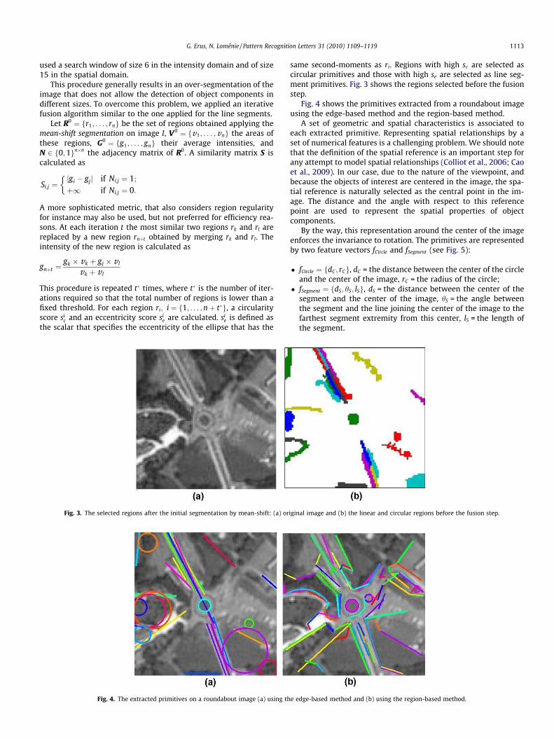
Fig. 3. The selected regions after the initial segmentation by mean-shift: (a) or
Fig. 4. The extracted primitives on a roundabout image (a) using th
same second-moments as ri. Regions with high sc are selected ascircular primitives and those with high se are selected as line seg-ment primitives. Fig. 3 shows the regions selected before the fusionstep.
Fig. 4 shows the primitives extracted from a roundabout imageusing the edge-based method and the region-based method.
A set of geometric and spatial characteristics is associated toeach extracted primitive. Representing spatial relationships by aset of numerical features is a challenging problem. We should notethat the definition of the spatial reference is an important step forany attempt to model spatial relationships (Colliot et al., 2006; Caoet al., 2009). In our case, due to the nature of the viewpoint, andbecause the objects of interest are centered in the image, the spa-tial reference is naturally selected as the central point in the im-age. The distance and the angle with respect to this referencepoint are used to represent the spatial properties of objectcomponents.
By the way, this representation around the center of the imageenforces the invariance to rotation. The primitives are representedby two feature vectors fCircle and fSegment (see Fig. 5):
� fCircle ¼ fdC ; rCg, dC = the distance between the center of the circleand the center of the image, rC = the radius of the circle;
� fSegment ¼ fdS; hS; lSg, dS = the distance between the center of thesegment and the center of the image, hS = the angle betweenthe segment and the line joining the center of the image to thefarthest segment extremity from this center, lS = the length ofthe segment.
iginal image and (b) the linear and circular regions before the fusion step.
e edge-based method and (b) using the region-based method.
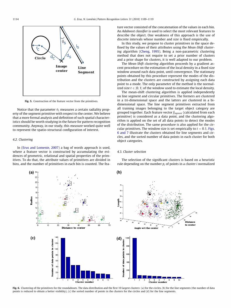
Fig. 5. Construction of the feature vector from the primitives.
1114 G. Erus, N. Loménie / Pattern Recognition Letters 31 (2010) 1109–1119
Notice that the parameter hS measures a certain radiality prop-erty of the segment primitive with respect to the center. We believethat a more formal analysis and definition of such spatial character-istics should be worth studying in the future for pattern recognitioncommunity. Anyway, in our study, this measure worked quite wellto represent the spatio-structural configuration of interest.
4.2. Clustering
In (Erus and Lomenie, 2007) a bag of words approach is used,where a feature vector is constructed by accumulating the evi-dences of geometric, relational and spatial properties of the prim-itives. To do that, the attribute values of primitives are divided inbins, and the number of primitives in each bin is counted. The fea-
Fig. 6. Clustering of the primitives for the roundabouts. The data distribution and the firspoints is reduced to obtain a better visibility), (c) the sorted number of points in the clu
ture vector consisted of the concatenation of the values in each bin.An Adaboost classifier is used to select the most relevant features todescribe the object. One weakness of this approach is the use ofdiscrete intervals whose number and size is fixed empirically.
In this study, we propose to cluster primitives in the space de-fined by the values of their attributes using the Mean-Shift cluster-ing algorithm (Cheng, 1995). Being a non-parametric clusteringmethod that does not require to set a prior number of clustersand a prior shape for clusters, it is well adapted to our problem.
The Mean-Shift clustering algorithm proceeds by a gradient as-cent procedure on the estimation of the local density in a fixed sizewindow around each data point, until convergence. The stationarypoints obtained by this procedure represent the modes of the dis-tribution and the clusters are constructed by assigning each datapoint to a mode. The only parameter of the method is the normal-ized size t 2 ½0;1� of the window used to estimate the local density.
The mean-shift clustering algorithm is applied independentlyon line segment and circular primitives. The formers are clusteredin a tri-dimensional space and the latters are clustered in a bi-dimensional space. The line segment primitives extracted fromall training images belonging to the target object category aregrouped together. Each feature vector fSegment (calculated from eachprimitive) is considered as a data point, and the clustering algo-rithm is applied on the set of all data points to detect the modesof the distribution. The same procedure is also applied for the cir-cular primitives. The window size is set empirically to t ¼ 0:1. Figs.6 and 7 illustrate the clusters obtained for line segments and cir-cles, and the sorted number of data points in each cluster for bothobject categories.
4.3. Cluster selection
The selection of the significant clusters is based on a heuristicrule depending on the number pi of points in a cluster i normalized
t 10 largest clusters: (a) for the circles, (b) for the line segments (the number of datasters for the circles and (d) for the line segments.
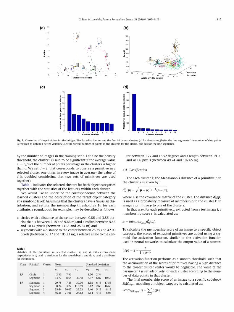
Fig. 7. Clustering of the primitives for the bridges. The data distribution and the first 10 largest clusters (a) for the circles, (b) for the line segments (the number of data pointsis reduced to obtain a better visibility), (c) the sorted number of points in the clusters for the circles, and (d) for the line segments.
G. Erus, N. Loménie / Pattern Recognition Letters 31 (2010) 1109–1119 1115
by the number of images in the training set n. Let d be the densitythreshold, the cluster i is said to be significant if the average value�ni ¼ pi=n of the number of points per image in the cluster i is higherthan d. We set d ¼ 2, that corresponds to observe a primitive in aselected cluster one times in every image in average (the value ofd is doubled considering that two sets of primitives are usedtogether).
Table 1 indicates the selected clusters for both object categoriestogether with the statistics of the features within each cluster.
We would like to underline the correspondence between thelearned clusters and the description of the target object categoryat a symbolic level: Assuming that the clusters have a Gaussian dis-tribution, and setting the membership threshold as 1r for eachattribute, a roundabout, for example, may be described as follows:
� circles with a distance to the center between 0.86 and 3.86 pix-els (that is between 2.15 and 9.66 m) and a radius between 5.46and 10.14 pixels (between 13.65 and 25.34 m) and
� segments with a distance to the center between 25.35 and 42.09pixels (between 63.37 and 105.23 m), a relative angle to the cen-
Table 1Statistics of the primitives in selected clusters. li and ri values correspondrespectively to dC and rC attributes for the roundabouts, and dS , hS and lS attributesfor the bridges.
Class Primitif Cluster Mean Standard deviation
l1 l2 l3 r1 r2 r3
RA Circle 1 2.36 7.80 1.50 2.34Segment 1 33.72 8.65 30.48 8.37 6.87 10.58
BR Segment 1 29.78 7.45 39.06 11.38 6.15 17.55Segment 2 8.24 3.27 119.59 5.12 2.60 16.60Segment 3 25.64 20.07 26.03 3.40 5.13 8.13Segment 4 46.38 21.01 24.12 6.14 4.15 6.96
ter between 1.77 and 15.52 degrees and a length between 19.90and 41.06 pixels (between 49.74 and 102.65 m).
4.4. Classification
For each cluster k, the Mahalanobis distance of a primitive p tothe cluster k is given by:
dkMðpÞ ¼
ffiffiffiffiffiffiffiffiffiffiffiffiffiffiffiffiffiffiffiffiffiffiffiffiffiffiffiffiffiffiffiffiffiffiffiffiffiffiffiffiffiffiðp� lÞTR�1ðp� lÞ
q;
where R is the covariance matrix of the cluster. The distance dkMðpÞ
is used as a probability measure of membership to the cluster k, toassign a primitive p to one of the clusters.
In that way, for each primitive pi extracted from a test image I, amembership score si is calculated as:
si ¼ mink2SMCobjectdk
MðpiÞ:
To calculate the membership score of an image to a specific objectcategory, the scores of extracted primitives are added using a sig-moid-like activation function, similar to the activation functionused in neural networks to calculate the output value of a neuron:
fkðpÞ ¼ 2� 21þ e�kp
:
The activation function performs as a smooth threshold, such thatthe accumulation of the scores of primitives having a high distanceto the closest cluster center would be negligible. The value of theparameter k is set adaptively for each cluster according to the num-ber of data points in that cluster.
The final membership score of an image to a specific codebookSMCobject modeling an object category is calculated as:
ScoreSMCobjectðIÞ ¼
Xpi2I
fkðpiÞ:
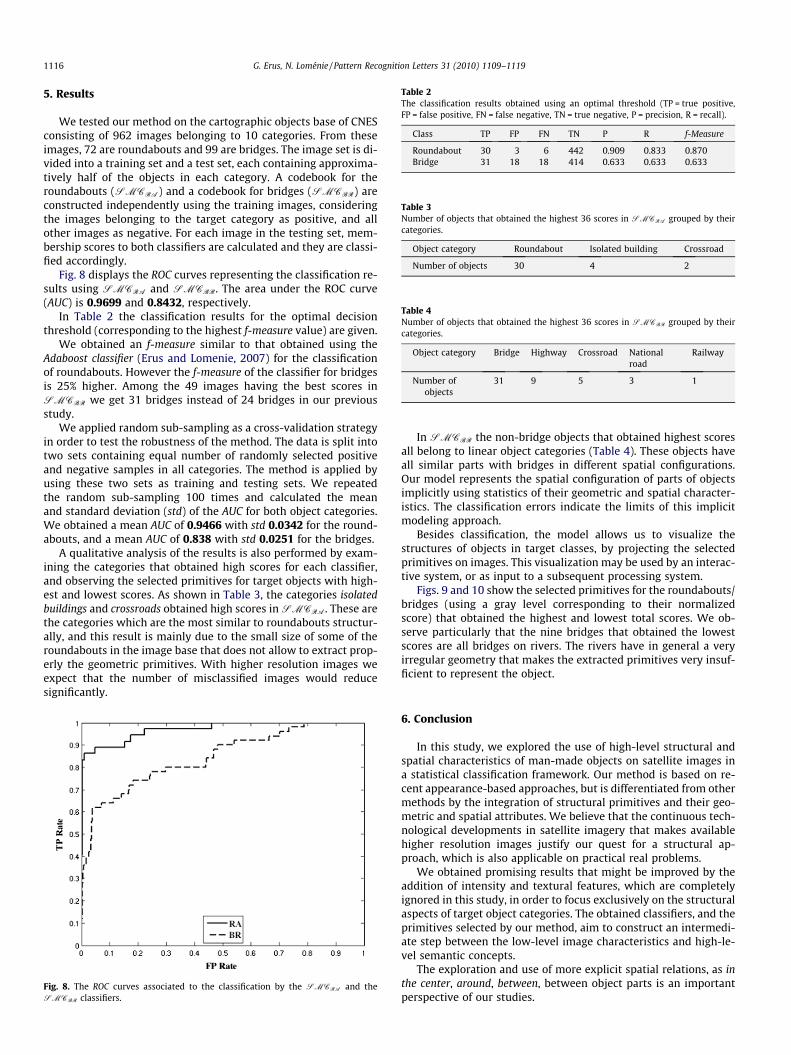
Table 2The classification results obtained using an optimal threshold (TP = true positive,FP = false positive, FN = false negative, TN = true negative, P = precision, R = recall).
Class TP FP FN TN P R f-Measure
Roundabout 30 3 6 442 0.909 0.833 0.870Bridge 31 18 18 414 0.633 0.633 0.633
Table 3Number of objects that obtained the highest 36 scores in SMCRA grouped by theircategories.
Object category Roundabout Isolated building Crossroad
Number of objects 30 4 2
Table 4Number of objects that obtained the highest 36 scores in SMCBR grouped by theircategories.
Object category Bridge Highway Crossroad Nationalroad
Railway
Number ofobjects
31 9 5 3 1
1116 G. Erus, N. Loménie / Pattern Recognition Letters 31 (2010) 1109–1119
5. Results
We tested our method on the cartographic objects base of CNESconsisting of 962 images belonging to 10 categories. From theseimages, 72 are roundabouts and 99 are bridges. The image set is di-vided into a training set and a test set, each containing approxima-tively half of the objects in each category. A codebook for theroundabouts (SMCRA) and a codebook for bridges (SMCBR) areconstructed independently using the training images, consideringthe images belonging to the target category as positive, and allother images as negative. For each image in the testing set, mem-bership scores to both classifiers are calculated and they are classi-fied accordingly.
Fig. 8 displays the ROC curves representing the classification re-sults using SMCRA and SMCBR. The area under the ROC curve(AUC) is 0.9699 and 0.8432, respectively.
In Table 2 the classification results for the optimal decisionthreshold (corresponding to the highest f-measure value) are given.
We obtained an f-measure similar to that obtained using theAdaboost classifier (Erus and Lomenie, 2007) for the classificationof roundabouts. However the f-measure of the classifier for bridgesis 25% higher. Among the 49 images having the best scores inSMCBR we get 31 bridges instead of 24 bridges in our previousstudy.
We applied random sub-sampling as a cross-validation strategyin order to test the robustness of the method. The data is split intotwo sets containing equal number of randomly selected positiveand negative samples in all categories. The method is applied byusing these two sets as training and testing sets. We repeatedthe random sub-sampling 100 times and calculated the meanand standard deviation (std) of the AUC for both object categories.We obtained a mean AUC of 0.9466 with std 0.0342 for the round-abouts, and a mean AUC of 0.838 with std 0.0251 for the bridges.
A qualitative analysis of the results is also performed by exam-ining the categories that obtained high scores for each classifier,and observing the selected primitives for target objects with high-est and lowest scores. As shown in Table 3, the categories isolatedbuildings and crossroads obtained high scores in SMCRA. These arethe categories which are the most similar to roundabouts structur-ally, and this result is mainly due to the small size of some of theroundabouts in the image base that does not allow to extract prop-erly the geometric primitives. With higher resolution images weexpect that the number of misclassified images would reducesignificantly.
Fig. 8. The ROC curves associated to the classification by the SMCRA and theSMCBR classifiers.
In SMCBR the non-bridge objects that obtained highest scoresall belong to linear object categories (Table 4). These objects haveall similar parts with bridges in different spatial configurations.Our model represents the spatial configuration of parts of objectsimplicitly using statistics of their geometric and spatial character-istics. The classification errors indicate the limits of this implicitmodeling approach.
Besides classification, the model allows us to visualize thestructures of objects in target classes, by projecting the selectedprimitives on images. This visualization may be used by an interac-tive system, or as input to a subsequent processing system.
Figs. 9 and 10 show the selected primitives for the roundabouts/bridges (using a gray level corresponding to their normalizedscore) that obtained the highest and lowest total scores. We ob-serve particularly that the nine bridges that obtained the lowestscores are all bridges on rivers. The rivers have in general a veryirregular geometry that makes the extracted primitives very insuf-ficient to represent the object.
6. Conclusion
In this study, we explored the use of high-level structural andspatial characteristics of man-made objects on satellite images ina statistical classification framework. Our method is based on re-cent appearance-based approaches, but is differentiated from othermethods by the integration of structural primitives and their geo-metric and spatial attributes. We believe that the continuous tech-nological developments in satellite imagery that makes availablehigher resolution images justify our quest for a structural ap-proach, which is also applicable on practical real problems.
We obtained promising results that might be improved by theaddition of intensity and textural features, which are completelyignored in this study, in order to focus exclusively on the structuralaspects of target object categories. The obtained classifiers, and theprimitives selected by our method, aim to construct an intermedi-ate step between the low-level image characteristics and high-le-vel semantic concepts.
The exploration and use of more explicit spatial relations, as inthe center, around, between, between object parts is an importantperspective of our studies.
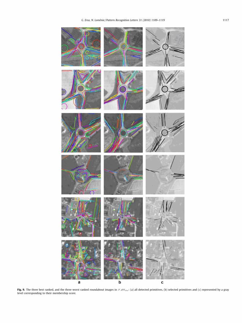
Fig. 9. The three best ranked, and the three worst ranked roundabout images in SMCRA: (a) all detected primitives, (b) selected primitives and (c) represented by a graylevel corresponding to their membership score.
G. Erus, N. Loménie / Pattern Recognition Letters 31 (2010) 1109–1119 1117
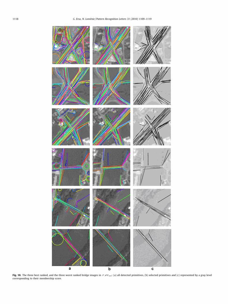
Fig. 10. The three best ranked, and the three worst ranked bridge images in SMCBR: (a) all detected primitives, (b) selected primitives and (c) represented by a gray levelcorresponding to their membership score.
1118 G. Erus, N. Loménie / Pattern Recognition Letters 31 (2010) 1109–1119

G. Erus, N. Loménie / Pattern Recognition Letters 31 (2010) 1109–1119 1119
Acknowledgements
The authors thank French Space Agency – CNES, Toulouse, andespecially Gilbert Pauc and Jordi Inglada for their support.
References
Agarwal, S., Roth, D., 2002. Learning a Sparse Representation for Object Detection.In: ECCV ’02: Proc. 7th Eur. Conf. on Computer Vision-Part IV.
Bardinet, E., Vidal, S., Arroyo, S., Malandain, G., Blanca, N., 2000. Structural objectmatching, DECSAI-000303, Spain.
Biederman, I., 1987. Recognition-by-components: A theory of human imageunderstanding. Psychol. Rev. 2, 115–147.
Biederman, I., 2007. Recent psychophysical and neural research in shaperecognition. In: Osaka, N., Rentschler, I., Biederman, I. (Eds.), ObjectRecognition, Attention, and Action. Springer, pp. 71–88.
Canny, J., 1986. A computational approach to edge detection. IEEE Trans. PatternAnal. Machine Intell., 679–698.
Cao, L., Kobayashi, Y., Kuno, Y., 2009. Spatial relation model for object recognition inhuman–robot interaction. ICIC (1), 574–584.
Cheng, Y., 1995. Mean shift, mode seeking, and clustering. IEEE Trans. Pattern Anal.Machine Intell. 17 (8), 790–799.
Colliot, O., Camara, 0., Bloch, I., 2006. Integration of fuzzy spatial relations indeformable models – Application to brain MRI segmentation. PatternRecognition 39, 1401–1414.
Comaniciu, D., Meer, P., 2002. Mean shift: A robust approach toward feature spaceanalysis. IEEE Trans. Pattern Anal. Machine Intell. 24 (5), 603–619.
Cordella, L.P., Foggia, P., Sansone, C., Vento, M., 2002. Learning structuralshape descriptions from examples. Pattern Recognition Lett. 23 (12), 1427–1437.
Csurka, G., Bray, C., Dance, C., Fan, L., 2004. Visual categorization with bags ofkeypoints. In: ECCV Internat. Workshop on Statistical Learning in ComputerVision, pp. 1–22.
Devernay, F., 1995. A Non-Maxima Suppression Method for Edge Detection withSub-Pixel Accuracy, INRIA, France, RR-2724, 20 p.
Di Ruberto, C., 2004. Recognition of shapes by attributed skeletal graphs. PatternRecognition 37 (1), 21–31.
Dorkó, G., Schmid, C., 2003. Selection of scale-invariant parts for object classrecognition. In: ICCV ’03: Proc. Ninth IEEE Internat. Conf. on Computer Vision.
Douglas, D.H., Peucker, T.K., 1973. Algorithms for the reduction of the number ofpoints required to represent a digitized line or its caricature. Canad. Cartograph.10, 112–122.
Erus, G., Lomenie, N., 2005. Automatic learning of structural models of cartographicobjects. In: IAPR, Graph-Based Representations in Pattern Recognition. LecturesNotes in Computer Science, vol. 3434. Springer, pp. 273–280.
Erus, G., Lomenie, N., 2007. Classification of structural cartographic objects usingedge-based features. ISVC07, Lake Tahoe, USA, pp. 385–392.
Felzenszwalb, P.F., Huttenlocher, D.P., 2005. Pictorial structures for objectrecognition. Int. J. Comput. Vision. 61 (1), 55–79.
Fergus, R., Perona, P., Zisserman, A., 2003. Object class recognition by unsupervisedscale-invariant learning. In: Proc. IEEE Comput. Soc. Conf. on Computer Visionand Pattern Recognition. 264–271.
Ferrari, V., Fevrier, L., Jurie, F., Schmid, C., 2008. Groups of adjacent contoursegments for object detection. IEEE Trans. Pattern Anal. Machine Intell. 30 (1),36–51.
Fischler, M.A., Elschlager, R.A., 1973. The representation and matching of pictorialstructures. IEEE Trans. Comput. 22 (1), 67–92.
Heisele, B., Serre, T., Pontil, M., Vetter, T., Poggio, T., 2001. Categorization byLearning and Combining Object Parts. MIT Press. pp. 1239–1245.
Hong, P., Huang, T.S., 2004. Spatial pattern discovery by learning a probabilisticparametric model from multiple attributed relational graphs. Discrete Appl.Math. 139 (1–3), 113–135.
Hudelot, C., 2005. Towards a Cognitive Vision Platform for Semantic ImageInterpretation, Application to the Recognition of Biological Organisms.Universit de Nice Sophia Antipolis – INRIA.
Inglada, J., 2007. Automatic recognition of man-made objects in high resolutionoptical remote sensing images by SVM classification of geometric imagefeatures. PandRS 62 (3), 236–248.
Iqbal, Q., Aggarwal, J.K., 2002. Retrieval by classification of images containing largemanmade objects using perceptual grouping. Pattern Recognition J. 35 (7),1463–1479.
Leibe, B., Leonardis, A., Schiele, B., 2004. Combined object categorization andsegmentation with an implicit shape model. In: ECCV’04 Workshop onStatistical Learning in Computer Vision, May.
Li, F., Perona, P., 2005. A Bayesian hierarchical model for learning natural scenecategories. In: CVPR ’05: Proc. 2005 IEEE Comput. Soc. Conf. on Computer Visionand Pattern Recognition (CVPR’05), vol. 2. pp. 524–531.
Lorette, A., Descombes, X., Zerubia, J., 2000. Texture analysis through a Markovianmodelling and fuzzy classification: Application to urban area extraction fromsatellite images. Internat. J. Comput. Vision 36 (3), 221–236.
Mayer, H., Hinz, S., Bacher, U., Baltsavias, E., 2006. A test of automatic roadextraction approaches, PCV06.
Opelt, A., Pinz, A., Zisserman, A., 2006. A boundary-fragment-model for objectdetection. In: Proc. Eur. Conf. on Computer Vision.
Petrakis, E.G.M., Faloutsos, C., 1995. Similarity Searching in Large Image Databases,Department of Computer Science, University of Maryland.
Sangineto, E., 2003. An abstract representation of geometric knowledge for objectclassification. Pattern Recognition Lett. 24 (9-10), 1241–1250.
Shao, Z., Kittler, J., 1999. Shape representation and recognition based on invariantunary and binary relations. Image Vision Comput. 17 (5–6), 429–444.
Shotton, J., Blake, A., Cipolia, R., 2007. Multi-scale categorical object recognitionusing contour fragments. IEEE Trans. Pattern Anal. Machine Intell..
Tax, D.M.J., 2001. One-class classification: Concept-learning in the absence ofcounter-examples. PhD Thesis. Delft University of Technology, Delft, TheNetherlands.
Trias-Sanz, R., Loménie, N., 2003. Automatic bridge detection in high-resolutionsatellite images. In: 3rd Internat. Conf. on Computer Vision Systems (ICVS’03).LNCS. Springer, pp. 172–181.
Tupin, F., Maitre, F., Mangin, J.-F., Nicolas, J.M., Pechersky, E., 1998. Detection oflinear features in SAR images: application to the road network extraction. IEEETrans. Geosci. Remote Sensing 36 (2), 434–453.
Viola, P., Jones, M.J., 2004. Robust real-time face detection. Internat. J. Comput.Vision 57 (2), 137–154.
Wang, Q., Seabra-Lopes, L., Tax, D.M.J., 2004. Visual object recognition through one-class learning. In: Proc. ICIAR’04, vol. I, pp. 463–470.
Weber, M., Welling, M., Perona, P., 2000. Unsupervised learning of models forrecognition. In: ECCV ’00: Proc. 6th Eur. Conf. on Computer Vision-Part I.Springer-Verlag, pp. 18–32.