horsforth cragg hill and woodside is a this appraisal and ... cragg hill and woodside caa...a number...
TRANSCRIPT
1
Horsforth Cragg Hill and Woodside C O N S E R V A T I O N A R E A A P P R A I S A L A N D M A N A G E M E N T P L A N
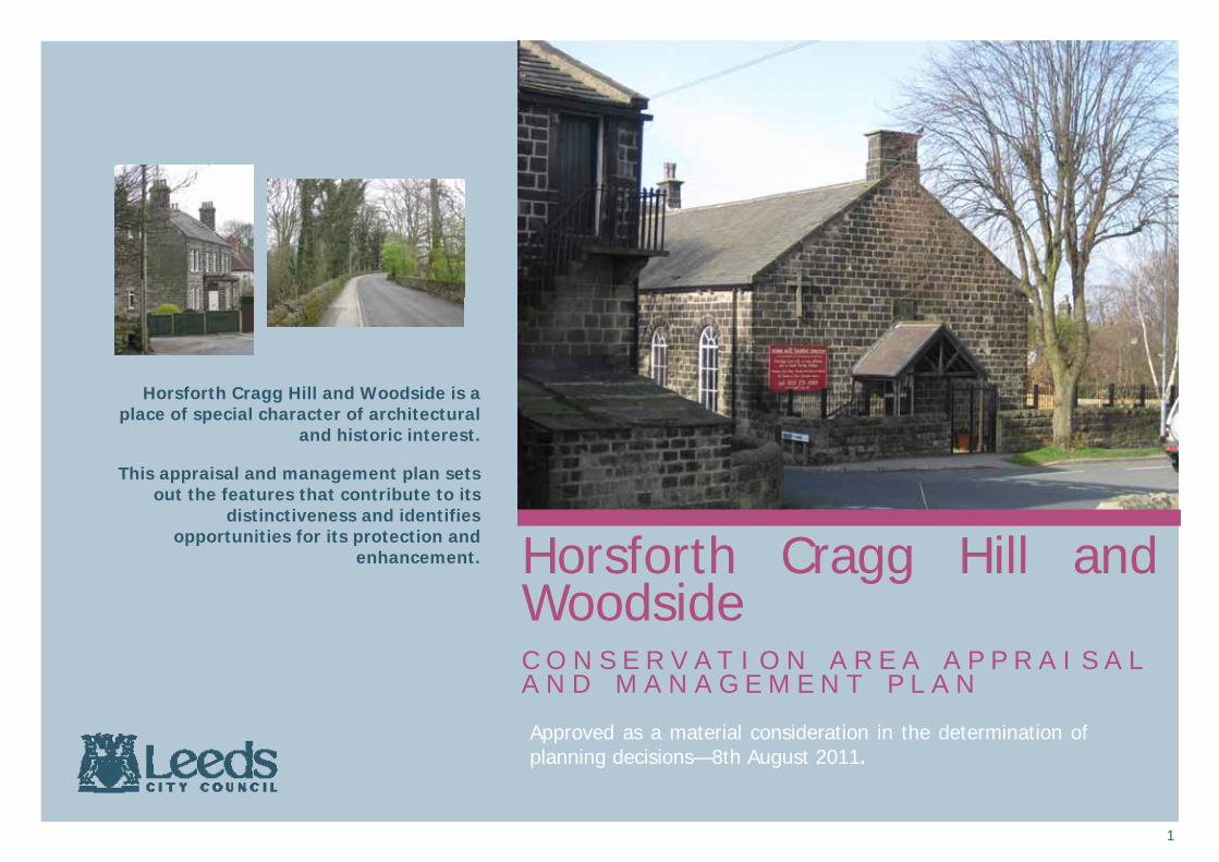
Horsforth Cragg Hill and Woodside is a place of special character of architectural
and historic interest.
This appraisal and management plan sets out the features that contribute to its
distinctiveness and identifies opportunities for its protection and
enhancement.
Approved as a material consideration in the determination of planning decisions—8th August 2011.
2
Summary of Special Interest The special architectural and historic interest of Horsforth Cragg Hill and Woodside Conservation Area can be summarised as follows; • A varied building stock resulting
from a slow and piecemeal development spanning three centuries; early 19th century non-conformist places of worship, 19th century h igh status suburban developments, late 19th century industrial growth and 1930s semi-detached houses all exist and make a positive contribution to this tightly defined area through their high quality and lack of alteration.
• Steeply sloping land giving attractive long distance views to the south and east. This landscape has a important impact on the built environment. This landscape was given further interest by the opening of the Cragg Hill quarry in the late 19th century.
• Interspersed within the landscape are green spaces important to the h i s t o r y , c h a r a c t e r a n d appearance. The heavily treed areas of Little Hawksworth Wood and Cragg Wood, open green space of historic origin and the former quarry site emphasise the age, maturity and historic development of the area.
The area originally arose as the two distinct settlements of Cragg Hill and Woodside which together combined to form a coherent area of architectural, historic and natural significance worthy of conservation area status.
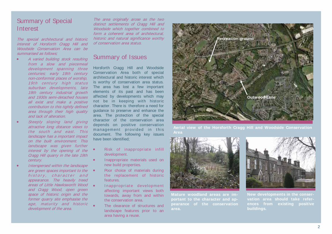
Summary of Issues Horsforth Cragg Hill and Woodside Conservation Area both of special architectural and historic interest which is worthy of conservation area status. The area has lost a few important elements of its past and has been affected by developments which may not be in keeping with historic character. There is therefore a need for guidance to preserve and enhance the area. The protection of the special character of the conservation area depends on positive conservation management prov ided in th i s document. The following key issues have been identified; • Risk of inappropriate infil l
development. • Inappropriate materials used on
new build properties. • Poor choice of materials during
the replacement of historic features.
• Inappropr iate development affecting important views both towards, away from and within the conservation area.
• The clearance of structures and landscape features prior to an area having a reuse.
New developments in the conser-vation area should take refer-ences from existing positive buildings.
Aerial view of the Horsforth Cragg Hill and Woodside Conservation Area
Mature woodland areas are im-portant to the character and ap-pearance of the conservation area.
Outwood Lane
Recreation ground
3
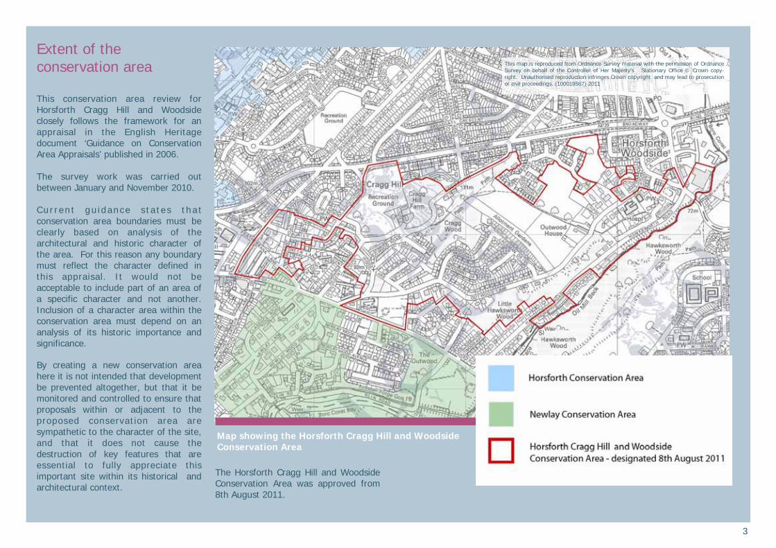
Extent of the conservation area This conservation area review for Horsforth Cragg Hill and Woodside closely follows the framework for an appraisal in the English Heritage document ‘Guidance on Conservation Area Appraisals’ published in 2006. The survey work was carried out between January and November 2010. Cur ren t gu idance s ta tes tha t conservation area boundaries must be clearly based on analysis of the architectural and historic character of the area. For this reason any boundary must reflect the character defined in this appraisal. It would not be acceptable to include part of an area of a specific character and not another. Inclusion of a character area within the conservation area must depend on an analysis of its historic importance and significance. By creating a new conservation area here it is not intended that development be prevented altogether, but that it be monitored and controlled to ensure that proposals within or adjacent to the proposed conservation area are sympathetic to the character of the site, and that it does not cause the destruction of key features that are essential to fully appreciate this important site within its historical and architectural context.
The Horsforth Cragg Hill and Woodside Conservation Area was approved from 8th August 2011.
Map showing the Horsforth Cragg Hill and Woodside Conservation Area
This map is reproduced from Ordnance Survey material with the permission of Ordnance Survey on behalf of the Controller of Her Majesty’s Stationary Office © Crown copy-right. Unauthorised reproduction infringes Crown copyright and may lead to prosecution or civil proceedings. (100019567) 2011
4
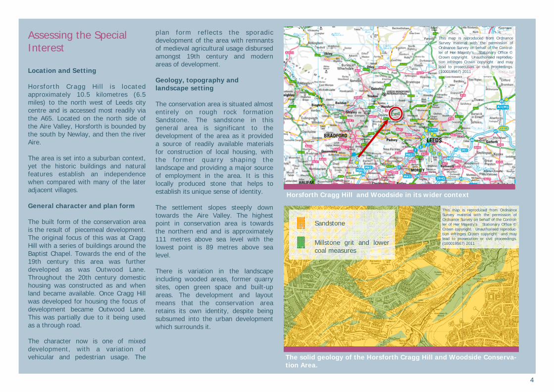
Assessing the Special Interest Location and Setting Horsforth Cragg Hill is located approximately 10.5 kilometres (6.5 miles) to the north west of Leeds city centre and is accessed most readily via the A65. Located on the north side of the Aire Valley, Horsforth is bounded by the south by Newlay, and then the river Aire. The area is set into a suburban context, yet the historic buildings and natural features establish an independence when compared with many of the later adjacent villages. General character and plan form The built form of the conservation area is the result of piecemeal development. The original focus of this was at Cragg Hill with a series of buildings around the Baptist Chapel. Towards the end of the 19th century this area was further developed as was Outwood Lane. Throughout the 20th century domestic housing was constructed as and when land became available. Once Cragg Hill was developed for housing the focus of development became Outwood Lane. This was partially due to it being used as a through road. The character now is one of mixed development, with a variation of vehicular and pedestrian usage. The
plan form reflects the sporadic development of the area with remnants of medieval agricultural usage disbursed amongst 19th century and modern areas of development. Geology, topography and landscape setting The conservation area is situated almost entirely on rough rock formation Sandstone. The sandstone in this general area is significant to the development of the area as it provided a source of readily available materials for construction of local housing, with the former quarry shaping the landscape and providing a major source of employment in the area. It is this locally produced stone that helps to establish its unique sense of identity. The settlement slopes steeply down towards the Aire Valley. The highest point in conservation area is towards the northern end and is approximately 111 metres above sea level with the lowest point is 89 metres above sea level. There is variation in the landscape including wooded areas, former quarry sites, open green space and built-up areas. The development and layout means that the conservation area retains its own identity, despite being subsumed into the urban development which surrounds it.
The solid geology of the Horsforth Cragg Hill and Woodside Conserva-tion Area.
Horsforth Cragg Hill and Woodside in its wider context
This map is reproduced from Ordnance Survey material with the permission of Ordnance Survey on behalf of the Control-ler of Her Majesty’s Stationary Office © Crown copyright. Unauthorised reproduc-tion infringes Crown copyright and may lead to prosecution or civil proceedings. (100019567) 2011
This map is reproduced from Ordnance Survey material with the permission of Ordnance Survey on behalf of the Control-ler of Her Majesty’s Stationary Office © Crown copyright. Unauthorised reproduc-tion infringes Crown copyright and may lead to prosecution or civil proceedings. (100019567) 2011
Sandstone
Millstone grit and lower coal measures

5
Origins and Evolution Prehistoric origins Although there is no known evidence of preh istor ic act iv i ty wi th in the Conservation Area, a carved gritstone rock, thought to date from the Bronze Age (2,000 BC – 800 BC), is situated in the north pavement of the A65, just west of the conservation area. The rock is a Scheduled Ancient Monument, and is in the form of a triangular-sectioned pillar; the carving consists of three cups on the top of the pillar. The rock is not thought to be in its original location. ‘Burley Field’ visible on the Tithe Award map of 1839 and situated near the summit of Cragg Hill contains a place name element (‘burh’) indicative of possible former status as a defended site (of uncertain date). The field is now built over and is bounded by Cragg Terrace and Burley Lane. The Medieval period A number of Anglo-Saxon coins (dated 895AD – 905AD) found across Yorkshire and Lancashire (none have been found south of the Humber) have provided the provenance ‘Orsna Forda’ which is thought to stand for the Old English ‘Horsna-ford’. Horsforth seems to be the only northern place name to at all resemble this. Horsforth is therefore the possible site of a mint at this date and this may relate to the ‘burh’ place-name. In the Domesday Book of 1086 Horsforth is listed as ‘Horseford’, and it
was only in 1246 that the settlement was first referenced as ‘Horsforth’. Horsforth is interpreted as deriving from ‘horse ford’, meaning ‘one which a horse can cross’. The location of the ‘ford’ is unknown, but the nearest crossing of the River Aire is by Newlay Bridge, which is south-east of the conservation area. The only recorded medieval ‘feature’ situated within the conservation area is ‘Elf Knoll’, a small hillock which is first recorded in a Kirkstall Abbey deed of 1451 as ‘le Elff Knolles’ on the east of the vill of Horsforth’. It is possible that there may have been prehistoric remains visible at this date which were ascribed a supernatural origin. Today, the Knoll itself survives as a small grassy field, and the nearest street, Knoll Wood Park, takes its name from the same source. The 18th and 19th Centuries Map evidence (Jeffery’s map of 1775 and the 1st Edition OS map of 1848) suggests that the land within the conservation area remained rural and undeveloped throughout the medieval and early post-medieval periods. It is thought to have consisted of rural hamlets, namely Cragg Hill and the village of Outwood (through which ran Outwood Lane to join Featherbank Lane). ‘Crag House’, located at Cragg Hill, is a Grade II Listed farmhouse of 17th-century origins, and indicates the agricultural nature of the land at the time. The actual village core of Horsforth developed to the north-west
of the conservation area and consists of a number of Grade II Listed 18th and 19th century houses. During the 18th and 19th centuries, this area of Horsforth began to develop as a centre for industry. A possible early 18th century glassworks may have been located at Woodside, off Low Lane; this is indicated from a supposed ‘Glass’ field name featured on the Cardigan Estate map of 1709. Also at Woodside (immediately south of the ring road but outside the conservation area) is Corn Mill Fold, an 18th century water corn mill, built by William Wright on the site of a small former 17th-century farm holding. The mill complex was built
between 1772 and 1797 and continued in use throughout the 19th century. It
Thomas Jeffery’s map of 1775
The heavily deteriorated corn mil, though outside the conservation area, is a significant structure in the development of both Wood-side and Horsforth.

6
was originally water-powered (the dam still partially survives to the north of the mill), but is thought to have been converted to steam by 1850, which is a rather early date for corn mills in this area. The remaining evidence of the industrialisation of Woodside stands in the form of the former “Horsforth Mill”, on Low Lane (now called The Old Silk Mill). This visually dominant building was constructed around the turn of the 20th century and was originally a worsted spinning mill. It has since been successfully converted into offices. In the early 19th century, there is also evidence of a tannery sited at Tanhouse Hill. Although now demolished, the tannery was initially sited on part of the farm of the Stables family of Outwood House. The tannery was established in 1816 by James Watson; the Watsons were a particularly prominent 19th
century family of Horsforth, and owned a paper mill (location unknown) as well as the tannery. They are reputed to have built numerous stone terrace houses for their workers within the conservation area such as ‘Paradise Place’ in Low Lane and ‘Watson Row’ in Regent Road. The introduction of the railway to Horsforth was very significant to development of the area in the mid to late 19th century, allowing the ‘business class’ to move to more idyllic locations. The large villa properties on Outwood Lane were most likely the result of this, and housed the businessmen catching the train from nearby Newlay to Leeds.
The Cragg Hill/Outwood area also had a prominent trend of practising Non-Conformists in the 19th century. The aforementioned Watson and Wright families were active Methodists, and together were the co-founders of Woodside Methodist Chapel on Outwood Lane in 1839. Prior to the building of the Woodside Chapel, it has been suggested that there were two small practising cottage chapels in the vicinity of Outwood; firstly, an informal meeting room in the upper room of a cottage (now demolished) adjoining Corn Mill Fold, and second, a chapel and schoolroom in Tanhouse Hill in 1822. In 1895, the 1839 chapel was superseded by the adjacent church, with the original church still used as the Methodist Sunday school and hall. Meanwhile at Cragg Hill, there is an early 19th century Baptist Church and Sunday School. Cragg Hill Baptist Church was built in 1803 of coursed squared sandstone, with a chapel cottage attached at the west end. Across the road, is the Sunday School (also with attached house), which was built later in 1864. Both are Grade II Listed buildings. Modern developments Since the early 20th century the conservation area has undergone a gradual increase in its housing. During this period the urban sprawl of Leeds g radua l l y engu l f ed the a rea , t ransforming Horsfor th into a predominantly suburban settlement. Despite this the conservation area came out relatively unscathed, with only
pockets of infill developments taking place, the most significant being Jackman Drive and Woodway, just off Outwood Lane. The high quality 1930s properties of Outwood Lane and Beech Avenue specifically make an important contribution to the area by instating a high standard of 20th century domestic architecture in an area dominated by older buildings. The high retention of green space and historic buildings makes the area of special interest and retains a sense of independence among the surrounding suburbs.
The 2nd edition Ordnance Survey map (1894) shows the lack of devel-opment in the area. The most conspicuous areas of development are the historic buildings of Cragg Hill and the 19th century villas along Out-wood Lane.
Woodside Methodist Church, and Church Hall, are important exam-ples of the non-conformist reli-gious activity which took place in the area
7
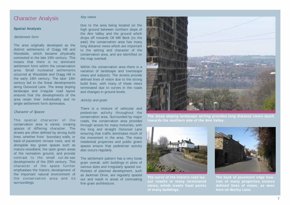
Character Analysis Spatial Analysis Settlement form The area originally developed as the distinct settlements of Cragg Hill and Woodside, which became physically connected in the late 19th century. This means that there is no dominant settlement form within the conservation area. Small nucleated settlements occurred at Woodside and Cragg Hill in the early 19th century. The later 19th century led to the linear developments along Outwood Lane. The steep sloping landscape and irregular road layout ensures that the developments of the area retain their individuality and no single settlement form dominates. Character of Spaces The spat ia l charac ter o f the conservation area is varied, creating spaces of differing character. The streets are often defined by strong build lines, whether front boundary walls, or back-of-pavement terrace rows, and sit alongside key green spaces such as mature woodland, the open green areas of the recreation ground, and provide contrast to the small cul-de-sac developments of the 20th century. This character of the space further emphasises the historic development of the important natural environment of the conservation area and its surroundings.
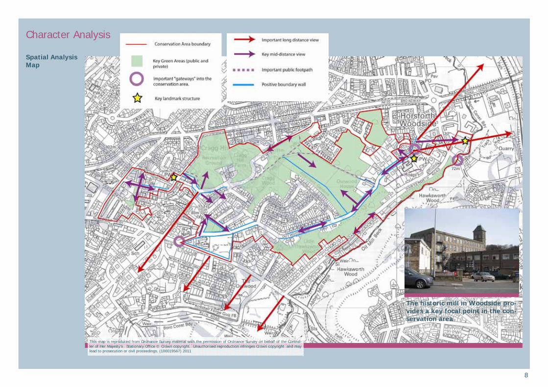
Key views Due to the area being located on the high ground between northern slope of the Aire Valley and the ground which drops off towards Oil Mill Beck (to the east) the conservation area has many long distance views which are important to the setting and character of the conservation area, and are identified on the map overleaf. Within the conservation area there is a variation of landscape and townscape views and subjects. The streets provide defined lines of vision due to the strong build lines, with many of these views terminated due to curves in the roads and changes in ground levels. Activity and grain There is a mixture of vehicular and pedestrian activity throughout the conservation area. Surrounded by major roads, the conservation area provides through access for many motorists, with the long and straight Outwood Lane ensuring that traffic dominates much of the movement in the area. The many residential properties and public green spaces ensure that pedestrian activity also occurs regularly. The settlement pattern has a very loose grain overall, with buildings in plots of various sizes and irregularly spaced out. Pockets of planned development, such as Jackman Drive, are regularly spaced out and result in areas of contrasting fine grain architecture.
The curve of the historic road lay-out results in many terminated views, which create focal points of many buildings.
The back of pavement edge loca-tion of many properties creates defined lines of vision, as seen here on Burley Lane.
The steep sloping landscape setting provides long distance views south towards the southern side of the Aire Valley.
8
Character Analysis Spatial Analysis Map
The historic mill in Woodside pro-vides a key focal point in the con-servation area
This map is reproduced from Ordnance Survey material with the permission of Ordnance Survey on behalf of the Control-ler of Her Majesty’s Stationary Office © Crown copyright. Unauthorised reproduction infringes Crown copyright and may lead to prosecution or civil proceedings. (100019567) 2011
9
Character Analysis Built Environment Architectural characteristics The conservation area has a cross-section of buildings the majority of which date from the early 19th to early 20th centuries. Several of the larger late 19th century houses on Outwood Lane r e s emb l e V i c t o r i a n V i l l a s i n neighbouring Newlay, whilst the terrace rows developed in tandem with the increase of industry as well as the active quarrying in the area, are common to much of Leeds. The industrial development of the area is represented by the historic buildings in the Woodside area which were powered off Oil Mill Beck. Due to the landscape of the area and style of development, those properties facing main roads through the area are those which establish the character of the area. Later cul-de-sac style developments are often more discreetly located, and contribute less to the character and appearance of the area. There are various architectural characteristics which make a positive impact on the appearance of the area. These are discussed in more detail in the separate character areas. • The design of all the structures is
generally simple, with the majority of positive buildings having very little architectural
ornament. This lack of ornament is key to the retention of the rural and historic character and appearance of the area. Some of the large 19th century villas, and 1930s properties do make use of more ornate details.
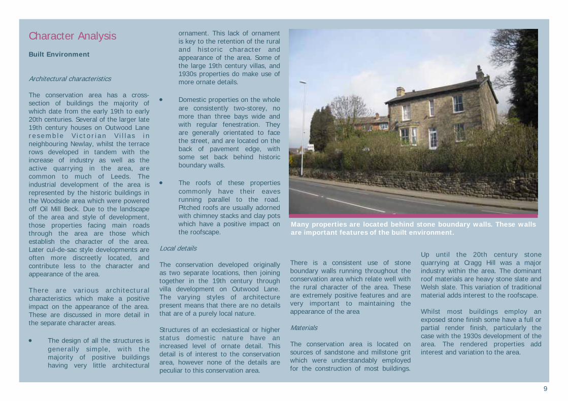
• Domestic properties on the whole
are consistently two-storey, no more than three bays wide and with regular fenestration. They are generally orientated to face the street, and are located on the back of pavement edge, with some set back behind historic boundary walls.
• The roofs of these properties
commonly have their eaves running parallel to the road. Pitched roofs are usually adorned with chimney stacks and clay pots which have a positive impact on the roofscape.
Local details The conservation developed originally as two separate locations, then joining together in the 19th century through villa development on Outwood Lane. The varying styles of architecture present means that there are no details that are of a purely local nature. Structures of an ecclesiastical or higher status domestic nature have an increased level of ornate detail. This detail is of interest to the conservation area, however none of the details are peculiar to this conservation area.
There is a consistent use of stone boundary walls running throughout the conservation area which relate well with the rural character of the area. These are extremely positive features and are very important to maintaining the appearance of the area Materials The conservation area is located on sources of sandstone and millstone grit which were understandably employed for the construction of most buildings.
Up until the 20th century stone quarrying at Cragg Hill was a major industry within the area. The dominant roof materials are heavy stone slate and Welsh slate. This variation of traditional material adds interest to the roofscape. Whilst most buildings employ an exposed stone finish some have a full or partial render finish, particularly the case with the 1930s development of the area. The rendered properties add interest and variation to the area.
Many properties are located behind stone boundary walls. These walls are important features of the built environment.
10
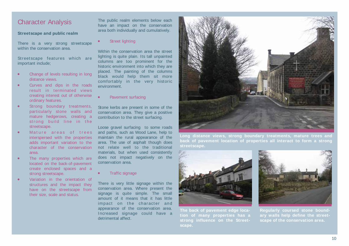
Character Analysis Streetscape and public realm There is a very strong streetscape within the conservation area. Streetscape features which are important include; • Change of levels resulting in long
distance views. • Curves and dips in the roads
result in terminated views creating interest out of otherwise ordinary features.
• Strong boundary treatments, particularly stone walls and mature hedgerows, creating a s t rong bu i ld l ine in the streetscape.
• M a t u r e a r e a s o f t r e e s interspersed with the properties adds important variation to the character of the conservation area.
• The many properties which are located on the back-of-pavement create enclosed spaces and a strong streetscape.
• Variation in the orientation of structures and the impact they have on the streetscape from their size, scale and status.
The public realm elements below each have an impact on the conservation area both individually and cumulatively. • Street lighting Within the conservation area the street lighting is quite plain. Its tall unpainted columns are too prominent for the historic environment into which they are placed. The painting of the columns black would help them sit more comfortably in the very historic environment. • Pavement surfacing Stone kerbs are present in some of the conservation area. They give a positive contribution to the street surfacing. Loose gravel surfacing to some roads and paths, such as Wood Lane, help to maintain the rural appearance of the area. The use of asphalt though does not relate well to the traditional materials, but when used consistently does not impact negatively on the conservation area. • Traffic signage There is very little signage within the conservation area. Where present the signage is quite simple. The small amount of it means that it has little impact on the character and appearance of the conservation area. Increased signage could have a detrimental affect.
Long distance views, strong boundary treatments, mature trees and back of pavement location of properties all interact to form a strong streetscape.
Regularly coursed stone bound-ary walls help define the street-scape of the conservation area.
The back of pavement edge loca-tion of many properties has a strong influence on the Street-scape.

11
Character Analysis Greenscape Trees, verges and open green space are all essential elements of the Horsforth Cragg Hill and Woodside Conservation Area. Many of the mature trees and green areas are located amongst the housing and have a positive impact throughout. They are an integral feature in the conservation area, identifying it more as a green and rural location than would be first assumed. The change of levels of the area, due to its landscape setting, emphasises this green space even further. The areas which make an important contribution to the greenscape are; • Cragg Wood and Wood Lane This area has a very natural feel to it due to heavy woodland and accessibility through out it. This environment is further emphasised by the fall of levels allowing key views from Wood Lane, particularly in a south-easterly direction. The green undulating land that forms the former historic quarry site provides reference to former activities of the area, with its lack of development adding variation to the natural environment. The unadopted Wood Lane and its informal surface treatment increases the rural feel and sets the area apart from much of the suburbia that it is surrounded by, giving it a secluded and idyllic feel.
• Open green land to the rear of Outwood House
This area is partially privately owned but provides a strong impact on the green and rural feel of the area due to the public footpath which runs from Outwood Lane to Cragg Wood (known locally as “Conker Alley”). This open pasture land is a remnant of the former historic field system that was prevalent until the early 20th century. The adjacent allotments are evidence of the even earlier strip field system in the area, possibly dating from the Medieval period. The fact the footpath runs through the area, and the open views of it from public space, makes it an important green area, regardless of the fact that it is privately owned. This space enhances both the character and appearance of the conservation area. • Little Hawksworth Wood Due to its steep sloping nature, the area located between Outwood Lane and Hawksworth Road is less accessible than Cragg Wood, but the large mature trees and landscape setting means it has a huge impact on the appearance of the area. From Hawksworth Road views of Oil Mill Beck (the conservation area boundary) adds further interest. The landscape and steep slopes leading down to the beck allow the natural environment in this area to dominate the housing development, further emphasising the rural and natural feel which is so prevalent.
• Cragg Hill recreation ground This well maintained space has a very significant impact on the green and rural feel of the conservation area, due its accessibility and open nature. Unlike the heavily wooded areas, or private land, this recreation ground aids permeability through the northern part of the conservation area, and emphas ises the importance of accessible green space. The open grass land, mature trees and low boundary walls all enhance the natural and rural feel of this area.
The former quarry site is an im-portant green space in the con-servation area, even though it is privately owned.
Mature tree coverage, such as Little Hawksworth Wood on the left hand side of the picture, has a strong influence on the rural and natural feel-ing of the conservation area.

12
Character Analysis Character Areas There are sub-areas within the proposed conservation area known as “character areas”, the boundaries of which are not always distinct, but nonetheless have distinct qualities. The areas have different spatial characters and distinct form and functions generated by their uses and historic development. Unifying the character areas is a shared sense of history and connectivity to one another. Horsforth Cragg Hill and Woodside Conservation Area is not a uniform area. As set out earlier, it developed at different periods in history and contains different types of buildings and spaces. Four character areas have been identified within the Horsforth Cragg Hill and Woodside Conservation Area. They are; • Character area 1 - Woodside • Character area 2 - Historic Green Space • Character area 3 - Cragg Hill and Victorian villa development • Character area 4 - 20th century development
Positive buildings On the individual character area maps buildings coloured blue make a positive contribution to the character of the area. This contribution may be in one or more of the following ways: • Landmark buildings • Buildings which provide evidence of
the area’s history and development
• Buildings of architectural merit • Buildings with local historical
associations • Buildings which exemplify local
vernacular styles • Groups of buildings which together
make a positive contribution to the streetscape
There should be a presumption in favour of the retention of positive structures in all but exceptional circumstances. Any application to demolish a positive building will require justification taking into account the considerations at HE9.4 of Planning Policy Statement 5: Planning for the Historic Environment.
This map is reproduced from Ordnance Survey material with the permission of Ordnance Survey on behalf of the Control-ler of Her Majesty’s Stationary Office © Crown copyright. Unauthorised reproduction infringes Crown copyright and may lead to prosecution or civil proceedings. (100019567) 2011

13
Character Analysis Character area 1- Woodside Woods ide was once a sma l l independent settlement. There is a high concentration of historic buildings, many very s ign i f i cant to the development of the area. Woodside probably first began life as an industrial community with the early 16th century listed Horsforth Corn Mill (just outside the conservation area) testament to this. Later tanneries and silk mills were built, with only The Old Silk Mill (originally a worsted spinning mill) remaining, and has a special importance because of this. The significant Woodside Methodist Church was built in the late 18th century. Later 19th century villa housing developed in the area, making the area more residential as industry declined. The variation of buildings means that there are many characteristics which contribute to the character area. Each type of structure and its positive characteristics are outlined below; Historic mill buildings; • Consistent use of coursed
sandstone and traditional roofing materials.
• Loose grain built form. • Character and appearance of an
industrial complex.
Detached 19th century villa buildings; • Simple coursed sandstone
construction and traditional roofing materials.
• Pa r t i a l u s e o f b r i c k on Hawksworth Road
• Two-three storeys in height. • Street facing orientation. • Ornate detailing often present. Terrace rows; • Two-storey eaves height. • Regularly coursed sandstone with
stone slate or welsh slate roofing material.
• Fine grain built form. • Orientated to face the road. • Ornate detailing, employing door
hoods and monolithic lintels. Key ways to retain or enhance character: • Use of regularly coursed sandstone
as the predominant walling material. • Variation in the built environment. • Retention of prominent industrial
buildings, such as The Old Silk Mill, as many other industrial structures have been lost to redevelopment. There is an opportunity at the Old Silk Mill to sympathetically develop the site. Removing of the post-war additions and developing the site in sympathy with the historic mill building would improve the visual appearance of the site. New build in this area could enhance the character and appearance of both the mill and conservation area.
• Retention of slate roofs and chimneys.
• Retention of informal layout of buildings, though all properties built directly onto the street should be orientated to face them.
• Avoidance of plot subdivision and cul-de-sac type of development.
This map is reproduced from Ordnance Survey material with the permission of Ordnance Survey on behalf of the Controller of Her Majesty’s Stationary Office © Crown copyright. Unauthorised reproduc-tion infringes Crown copyright and may lead to prosecution or civil proceedings. (100019567) 2011
Most properties have a simple form, but many 19th century vil-las make use of more ornate de-tailing.
14
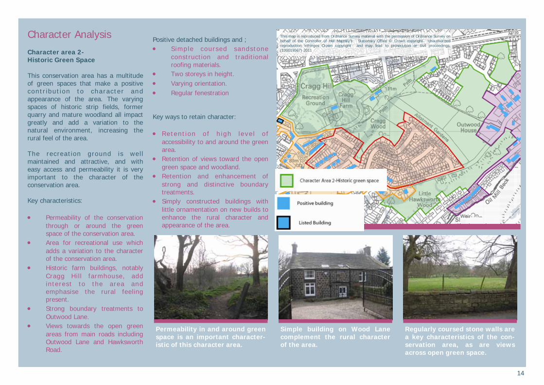
Character Analysis Character area 2- Historic Green Space This conservation area has a multitude of green spaces that make a positive contr ibut ion to character and appearance of the area. The varying spaces of historic strip fields, former quarry and mature woodland all impact greatly and add a variation to the natural environment, increasing the rural feel of the area. The recreation ground is well maintained and attractive, and with easy access and permeability it is very important to the character of the conservation area. Key characteristics: • Permeability of the conservation
through or around the green space of the conservation area.
• Area for recreational use which adds a variation to the character of the conservation area.
• Historic farm buildings, notably Cragg Hill farmhouse, add interest to the area and emphasise the rural feeling present.
• Strong boundary treatments to Outwood Lane.
• Views towards the open green areas from main roads including Outwood Lane and Hawksworth Road.
Positive detached buildings and ; • Simple coursed sandstone
construction and traditional roofing materials.
• Two storeys in height. • Varying orientation. • Regular fenestration Key ways to retain character: • Retent ion o f h igh leve l o f
accessibility to and around the green area.
• Retention of views toward the open green space and woodland.
• Retention and enhancement of strong and distinctive boundary treatments.
• Simply constructed buildings with little ornamentation on new builds to enhance the rural character and appearance of the area.
This map is reproduced from Ordnance Survey material with the permission of Ordnance Survey on behalf of the Controller of Her Majesty’s Stationary Office © Crown copyright. Unauthorised reproduction infringes Crown copyright and may lead to prosecution or civil proceedings. (100019567) 2011
Regularly coursed stone walls are a key characteristics of the con-servation area, as are views across open green space.
Simple building on Wood Lane complement the rural character of the area.
Permeability in and around green space is an important character-istic of this character area.
15
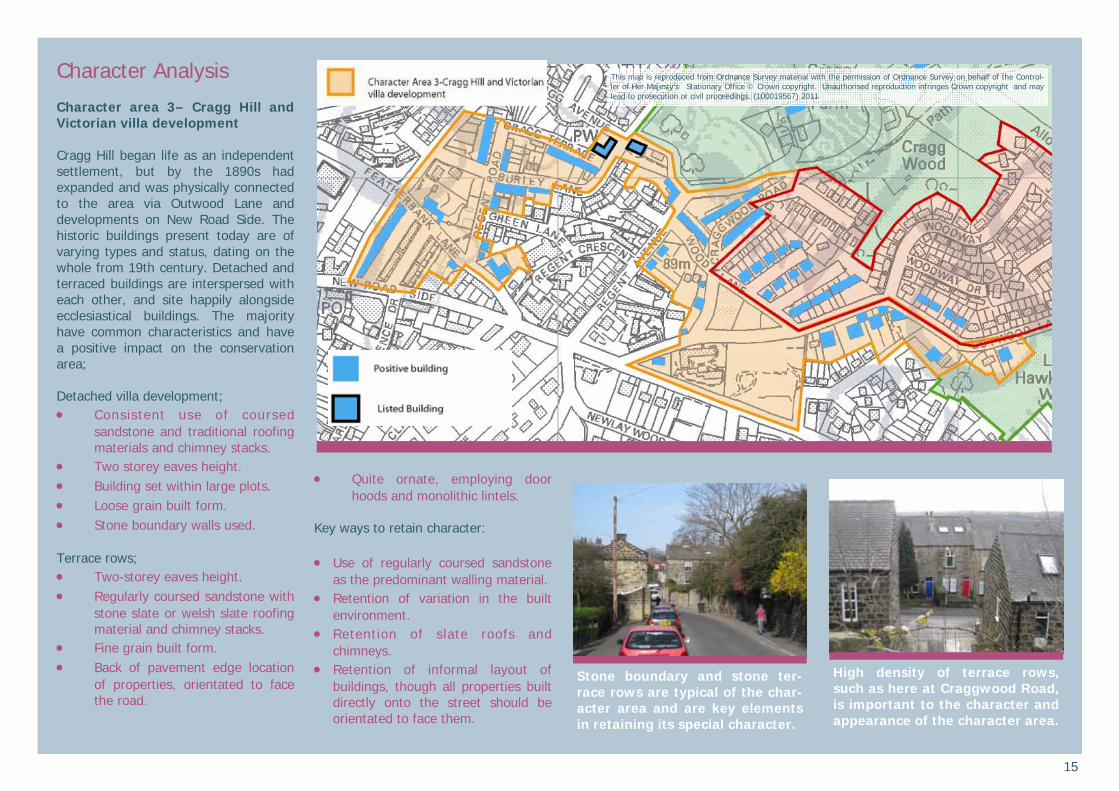
Character Analysis Character area 3– Cragg Hill and Victorian villa development Cragg Hill began life as an independent settlement, but by the 1890s had expanded and was physically connected to the area via Outwood Lane and developments on New Road Side. The historic buildings present today are of varying types and status, dating on the whole from 19th century. Detached and terraced buildings are interspersed with each other, and site happily alongside ecclesiastical buildings. The majority have common characteristics and have a positive impact on the conservation area; Detached villa development; • Consistent use of coursed
sandstone and traditional roofing materials and chimney stacks.
• Two storey eaves height. • Building set within large plots. • Loose grain built form. • Stone boundary walls used. Terrace rows; • Two-storey eaves height. • Regularly coursed sandstone with
stone slate or welsh slate roofing material and chimney stacks.
• Fine grain built form. • Back of pavement edge location
of properties, orientated to face the road.
• Quite ornate, employing door hoods and monolithic lintels.
Key ways to retain character: • Use of regularly coursed sandstone
as the predominant walling material. • Retention of variation in the built
environment. • Retention of slate roofs and
chimneys. • Retention of informal layout of
buildings, though all properties built directly onto the street should be orientated to face them.
This map is reproduced from Ordnance Survey material with the permission of Ordnance Survey on behalf of the Control-ler of Her Majesty’s Stationary Office © Crown copyright. Unauthorised reproduction infringes Crown copyright and may lead to prosecution or civil proceedings. (100019567) 2011
High density of terrace rows, such as here at Craggwood Road, is important to the character and appearance of the character area.
Stone boundary and stone ter-race rows are typical of the char-acter area and are key elements in retaining its special character.
16
is map is reproduced from Ordnance Survey material with the permission of Ordnance Survey on behalf of the Control-ler of Her Majesty’s Stationary Office © Crown copyright. Unauthorised reproduc-tion infringes Crown copyright and may lead to prosecution or civil proceedings. (100019567) 2010
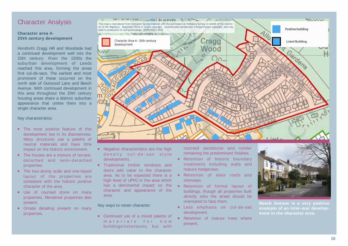
Character Analysis Character area 4- 20th century development Horsforth Cragg Hill and Woodside had a continued development well into the 20th century. From the 1930s the suburban development of Leeds reached this area, forming the areas first cul-de-sacs. The earliest and most prominent of these occurred on the north side of Outwood Lane and Beech Avenue. With continued development in this area throughout the 20th century housing areas share a distinct suburban appearance that unites them into a single character area. Key characteristics: • The most positive feature of this
development lies in its discreetness. Many structures use a palette of neutral materials and have little impact on the historic environment.
• The houses are a mixture of terrace, detached and semi-detached properties.
• The two-storey scale and one-bayed layout of the properties are consistent with the historic positive character of the area.
• Use of coursed stone on many properties. Rendered properties also present.
• Ornate detailing present on many properties.
• Negative characteristics are the high d e n s i t y c u l - d e - s a c s t y l e developments.
• Traditional timber windows and doors add value to the character area. As to be expected there is a high level of UPVC in the area which has a detrimental impact on the character and appearance of the area.
Key ways to retain character: • Continued use of a mixed palette of
m a t e r i a l s f o r n e w buildings/extensions, but with
coursed sandstone and render remaining the predominant finishes.
• Retention of historic boundary treatments including walls and mature hedgerows.
• Retention of slate roofs and chimneys.
• Retention of formal layout of buildings, though all properties built directly onto the street should be orientated to face them.
• Less emphasis on cul-de-sac development.
• Retention of mature trees where present.
This map is reproduced from Ordnance Survey material with the permission of Ordnance Survey on behalf of the Control-ler of Her Majesty’s Stationary Office © Crown copyright. Unauthorised reproduction infringes Crown copyright and may lead to prosecution or civil proceedings. (100019567) 2011
Beech Avenue is a very positive example of an inter-war develop-ment in the character area.
17
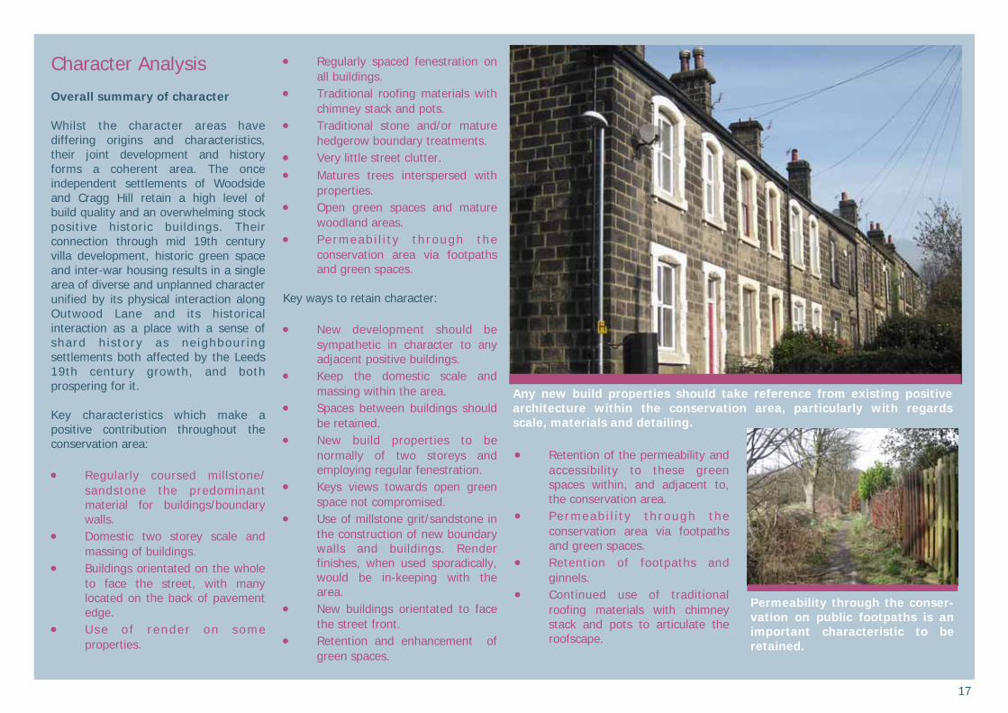
Character Analysis Overall summary of character Whilst the character areas have differing origins and characteristics, their joint development and history forms a coherent area. The once independent settlements of Woodside and Cragg Hill retain a high level of build quality and an overwhelming stock positive historic buildings. Their connection through mid 19th century villa development, historic green space and inter-war housing results in a single area of diverse and unplanned character unified by its physical interaction along Outwood Lane and its historical interaction as a place with a sense of shard h istory as neighbour ing settlements both affected by the Leeds 19th century growth, and both prospering for it. Key characteristics which make a positive contribution throughout the conservation area: • Regularly coursed millstone/
sandstone the predominant material for buildings/boundary walls.
• Domestic two storey scale and massing of buildings.
• Buildings orientated on the whole to face the street, with many located on the back of pavement edge.
• Use o f render on some properties.
• Regularly spaced fenestration on all buildings.
• Traditional roofing materials with chimney stack and pots.
• Traditional stone and/or mature hedgerow boundary treatments.
• Very little street clutter. • Matures trees interspersed with
properties. • Open green spaces and mature
woodland areas. • Permeab i l i t y th rough the
conservation area via footpaths and green spaces.
Key ways to retain character: • New development should be
sympathetic in character to any adjacent positive buildings.
• Keep the domestic scale and massing within the area.
• Spaces between buildings should be retained.
• New build properties to be normally of two storeys and employing regular fenestration.
• Keys views towards open green space not compromised.
• Use of millstone grit/sandstone in the construction of new boundary walls and buildings. Render finishes, when used sporadically, would be in-keeping with the area.
• New buildings orientated to face the street front.
• Retention and enhancement of green spaces.
• Retention of the permeability and accessibility to these green spaces within, and adjacent to, the conservation area.
• Permeab i l i t y th rough the conservation area via footpaths and green spaces.
• Retention of footpaths and ginnels.
• Continued use of traditional roofing materials with chimney stack and pots to articulate the roofscape.
Any new build properties should take reference from existing positive architecture within the conservation area, particularly with regards scale, materials and detailing.
Permeability through the conser-vation on public footpaths is an important characteristic to be retained.
18
Management Plan—Opportunities for management and enhancement This section highlights opportunities to further enhance the character and setting of the Horsforth Cragg Hill and Woodside Conservation Area. Not all opportunities for enhancement involve the reworking of an inappropriate structure, rather they can apply to street furniture, open spaces and highways issues. This list is by no means exhaustive, as conservation areas can always be improved upon.
Protection and enhancement of G r e e n S p a c e w i t h i n t h e conservation area
The Conservation Area has a multitude of green spaces due to the original layout of the site and subsequent site clearance. Many of these are accessible and visible to the public and so have a large impact on the conservation area. The green space, along with important elements such as mature trees and historic boundaries, should be preserved and well maintained where appropriate. The footpaths in and around these areas should similarly be maintained to improve access and movement through the conservation area.
Action: Ensure that any future proposals respect the importance of green space in and around the conservation area. Also ensure that the movement through and around the conservation area isn’t restricted due to development. Tree management
Trees form an important part of the character of the area. Conservation area designation affords some degree of protection. A tree that has a trunk diameter of 7.5cm when measured at 1.5 metres above ground level is protected within a conservation area. Six weeks notification to Leeds City Council is required to undertake works to trees above this size. If the works are deemed unacceptable then a Tree Preservation Order may be made to give the tree permanent protection. If possible a tree strategy could be undertaken to identify the most significant trees in a conservation area. This could lead to the designation of more Tree Preservation Orders (TPOs) and can also identify general tree management issues if further required. A replanting strategy should also be considered in order to manage the impact of loss of trees through over maturity.
Action: Consideration should be given to formulating a tree strategy to protect and enhance the local green character.
Terrace Housing
The historic terrace rows are very important to the character and appearance of the conservation area. Their integrity can be compromised by unsympathetic and inappropriate alterations to detailing and fenestration. This is already apparent with the irregular installation of dormer windows. When possible in the future terrace properties should conform to the strong and consistent character which is already in place.
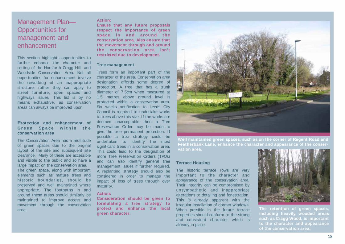
Well maintained green spaces, such as on the corner of Regent Road and Featherbank Lane, enhance the character and appearance of the conser-vation area.
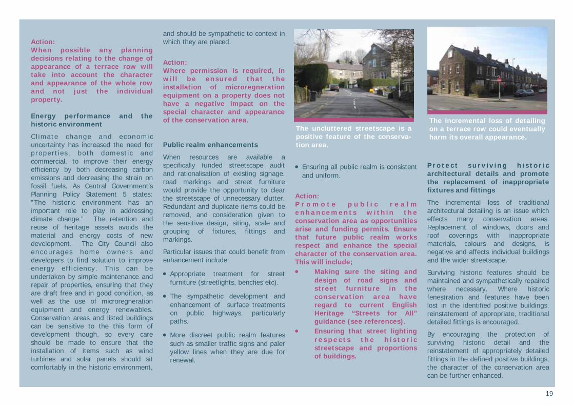
The retention of green spaces, including heavily wooded areas such as Cragg Wood, is important to the character and appearance of the conservation area.
19
Action: When possible any planning decisions relating to the change of appearance of a terrace row will take into account the character and appearance of the whole row and not just the individual property. Energy performance and the historic environment
C l imate change and economic uncertainty has increased the need for propert ies, both domest ic and commercial, to improve their energy efficiency by both decreasing carbon emissions and decreasing the strain on fossil fuels. As Central Government’s Planning Policy Statement 5 states: ”The historic environment has an important role to play in addressing climate change.” The retention and reuse of heritage assets avoids the material and energy costs of new development. The City Council also encourages home owners and developers to find solution to improve energy efficiency. This can be undertaken by simple maintenance and repair of properties, ensuring that they are draft free and in good condition, as well as the use of microregneration equipment and energy renewables. Conservation areas and listed buildings can be sensitive to the this form of development though, so every care should be made to ensure that the installation of items such as wind turbines and solar panels should sit comfortably in the historic environment,
and should be sympathetic to context in which they are placed.
Action: Where permission is required, in will be ensured that the installation of microregneration equipment on a property does not have a negative impact on the special character and appearance of the conservation area.
Public realm enhancements
When resources are available a specifically funded streetscape audit and rationalisation of existing signage, road markings and street furniture would provide the opportunity to clear the streetscape of unnecessary clutter. Redundant and duplicate items could be removed, and consideration given to the sensitive design, siting, scale and grouping of fixtures, fittings and markings.
Particular issues that could benefit from enhancement include:
• Appropriate treatment for street furniture (streetlights, benches etc).
• The sympathetic development and enhancement of surface treatments on public highways, particularly paths.
• More discreet public realm features such as smaller traffic signs and paler yellow lines when they are due for renewal.
• Ensuring all public realm is consistent and uniform.
Action: P r o m o t e p u b l i c r e a l m e nh anc em en t s w i th in th e conservation area as opportunities arise and funding permits. Ensure that future public realm works respect and enhance the special character of the conservation area. This will include; • Making sure the siting and
design of road signs and street furniture in the conservation area have regard to current English Heritage “Streets for All” guidance (see references).
• Ensuring that street lighting r e s p e c t s t h e h i s t o r i c streetscape and proportions of buildings.
Protect surv iv ing h is tor ic architectural details and promote the replacement of inappropriate fixtures and fittings
The incremental loss of traditional architectural detailing is an issue which effects many conservation areas. Replacement of windows, doors and roof coverings with inappropriate materials, colours and designs, is negative and affects individual buildings and the wider streetscape.
Surviving historic features should be maintained and sympathetically repaired where necessary. Where historic fenestration and features have been lost in the identified positive buildings, reinstatement of appropriate, traditional detailed fittings is encouraged.
By encouraging the protection of surviving historic detail and the reinstatement of appropriately detailed fittings in the defined positive buildings, the character of the conservation area can be further enhanced.
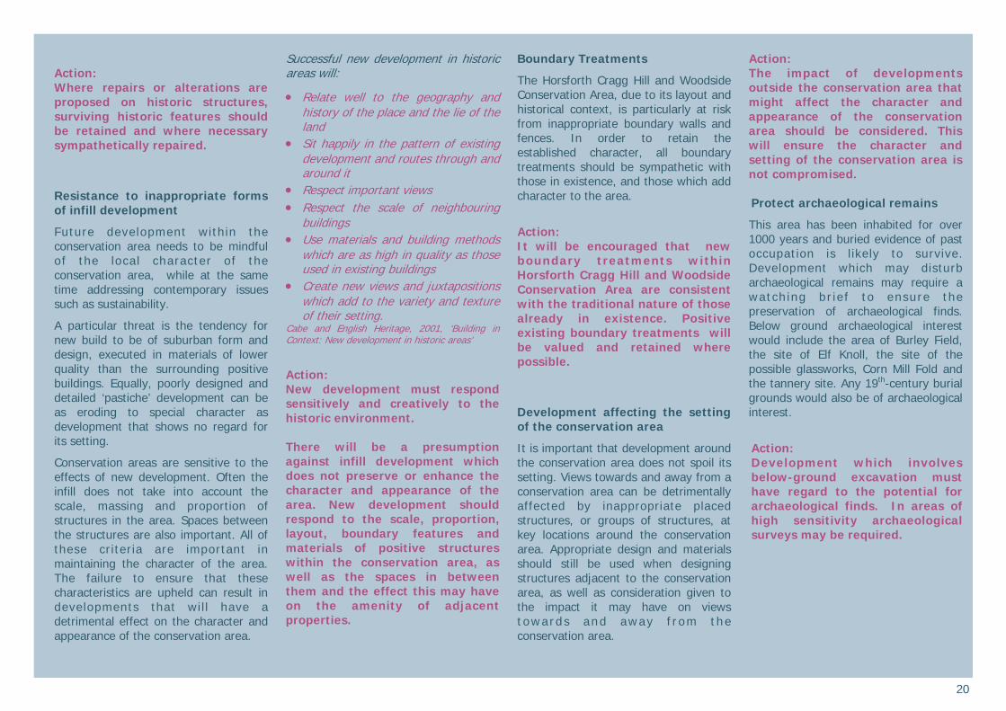
The uncluttered streetscape is a positive feature of the conserva-tion area.
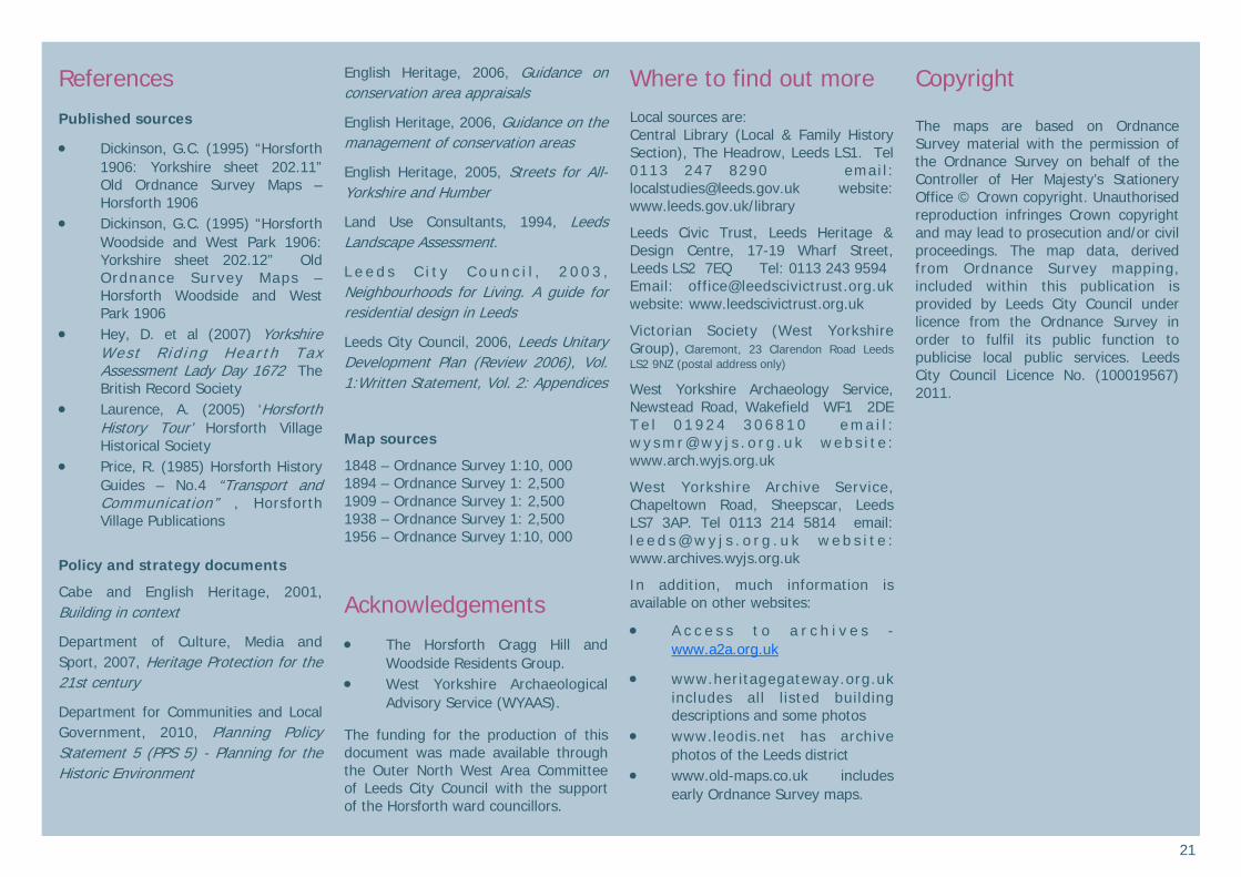
The incremental loss of detailing on a terrace row could eventually harm its overall appearance.
20
Action: Where repairs or alterations are proposed on historic structures, surviving historic features should be retained and where necessary sympathetically repaired.
Resistance to inappropriate forms of infill development
Future development within the conservation area needs to be mindful of the local character of the conservation area, while at the same time addressing contemporary issues such as sustainability.
A particular threat is the tendency for new build to be of suburban form and design, executed in materials of lower quality than the surrounding positive buildings. Equally, poorly designed and detailed ‘pastiche’ development can be as eroding to special character as development that shows no regard for its setting.
Conservation areas are sensitive to the effects of new development. Often the infill does not take into account the scale, massing and proportion of structures in the area. Spaces between the structures are also important. All of these criteria are important in maintaining the character of the area. The failure to ensure that these characteristics are upheld can result in developments that wil l have a detrimental effect on the character and appearance of the conservation area.
Successful new development in historic areas will:
• Relate well to the geography and history of the place and the lie of the land
• Sit happily in the pattern of existing development and routes through and around it
• Respect important views • Respect the scale of neighbouring
buildings • Use materials and building methods
which are as high in quality as those used in existing buildings
• Create new views and juxtapositions which add to the variety and texture of their setting.
Cabe and English Heritage, 2001, ‘Building in Context: New development in historic areas’
Action: New development must respond sensitively and creatively to the historic environment. There will be a presumption against infill development which does not preserve or enhance the character and appearance of the area. New development should respond to the scale, proportion, layout, boundary features and materials of positive structures within the conservation area, as well as the spaces in between them and the effect this may have on the amenity of adjacent properties.
Boundary Treatments
The Horsforth Cragg Hill and Woodside Conservation Area, due to its layout and historical context, is particularly at risk from inappropriate boundary walls and fences. In order to retain the established character, all boundary treatments should be sympathetic with those in existence, and those which add character to the area.
Action: It will be encouraged that new boundary treatments within Horsforth Cragg Hill and Woodside Conservation Area are consistent with the traditional nature of those already in existence. Positive existing boundary treatments will be valued and retained where possible.
Development affecting the setting of the conservation area
It is important that development around the conservation area does not spoil its setting. Views towards and away from a conservation area can be detrimentally affected by inappropriate placed structures, or groups of structures, at key locations around the conservation area. Appropriate design and materials should still be used when designing structures adjacent to the conservation area, as well as consideration given to the impact it may have on views t owards and away f r om the conservation area.
Action: The impact of developments outside the conservation area that might affect the character and appearance of the conservation area should be considered. This will ensure the character and setting of the conservation area is not compromised. Protect archaeological remains
This area has been inhabited for over 1000 years and buried evidence of past occupation is likely to survive. Development which may disturb archaeological remains may require a watch ing br ie f to ensure the preservation of archaeological finds. Below ground archaeological interest would include the area of Burley Field, the site of Elf Knoll, the site of the possible glassworks, Corn Mill Fold and the tannery site. Any 19th-century burial grounds would also be of archaeological interest.
Action: Development which involves below-ground excavation must have regard to the potential for archaeological finds. In areas of high sensitivity archaeological surveys may be required.
21
References Published sources
• Dickinson, G.C. (1995) “Horsforth 1906: Yorkshire sheet 202.11” Old Ordnance Survey Maps – Horsforth 1906
• Dickinson, G.C. (1995) “Horsforth Woodside and West Park 1906: Yorkshire sheet 202.12” Old Ordnance Survey Maps – Horsforth Woodside and West Park 1906
• Hey, D. et al (2007) Yorkshire Wes t R id ing Hear th Tax Assessment Lady Day 1672 The British Record Society
• Laurence, A. (2005) ‘Horsforth History Tour’ Horsforth Village Historical Society
• Price, R. (1985) Horsforth History Guides – No.4 “Transport and Communication” , Horsforth Village Publications
Policy and strategy documents Cabe and English Heritage, 2001, Building in context
Department of Culture, Media and Sport, 2007, Heritage Protection for the 21st century
Department for Communities and Local Government, 2010, Planning Policy Statement 5 (PPS 5) - Planning for the Historic Environment
English Heritage, 2006, Guidance on conservation area appraisals
English Heritage, 2006, Guidance on the management of conservation areas
English Heritage, 2005, Streets for All-Yorkshire and Humber
Land Use Consultants, 1994, Leeds Landscape Assessment.
L e e d s C i t y C o u n c i l , 2 0 0 3 , Neighbourhoods for Living. A guide for residential design in Leeds
Leeds City Council, 2006, Leeds Unitary Development Plan (Review 2006), Vol. 1:Written Statement, Vol. 2: Appendices
Map sources
1848 – Ordnance Survey 1:10, 000 1894 – Ordnance Survey 1: 2,500 1909 – Ordnance Survey 1: 2,500 1938 – Ordnance Survey 1: 2,500 1956 – Ordnance Survey 1:10, 000
Acknowledgements
• The Horsforth Cragg Hill and Woodside Residents Group.
• West Yorkshire Archaeological Advisory Service (WYAAS).
The funding for the production of this document was made available through the Outer North West Area Committee of Leeds City Council with the support of the Horsforth ward councillors.
Where to find out more
Local sources are: Central Library (Local & Family History Section), The Headrow, Leeds LS1. Tel 0113 247 8290 emai l : [email protected] website: www.leeds.gov.uk/library
Leeds Civic Trust, Leeds Heritage & Design Centre, 17-19 Wharf Street, Leeds LS2 7EQ Tel: 0113 243 9594 Email: [email protected] website: www.leedscivictrust.org.uk
Victorian Society (West Yorkshire Group), Claremont, 23 Clarendon Road Leeds LS2 9NZ (postal address only)
West Yorkshire Archaeology Service, Newstead Road, Wakefield WF1 2DE T e l 0 1 9 2 4 3 0 6 8 1 0 e m a i l : w y s m r @ w y j s . o r g . u k w e b s i t e : www.arch.wyjs.org.uk
West Yorkshire Archive Service, Chapeltown Road, Sheepscar, Leeds LS7 3AP. Tel 0113 214 5814 email: l e e d s @ w y j s . o r g . u k w e b s i t e : www.archives.wyjs.org.uk
In addition, much information is available on other websites:
• A c c e s s t o a r c h i v e s - www.a2a.org.uk
• www.heritagegateway.org.uk includes all l isted building descriptions and some photos
• www.leodis.net has archive photos of the Leeds district
• www.old-maps.co.uk includes early Ordnance Survey maps.
Copyright The maps are based on Ordnance Survey material with the permission of the Ordnance Survey on behalf of the Controller of Her Majesty’s Stationery Office © Crown copyright. Unauthorised reproduction infringes Crown copyright and may lead to prosecution and/or civil proceedings. The map data, derived from Ordnance Survey mapping, included within this publication is provided by Leeds City Council under licence from the Ordnance Survey in order to fulfil its public function to publicise local public services. Leeds City Council Licence No. (100019567) 2011.
22
Finding Out More What is a conservation area?
A conservation area is ‘an area of special architectural or historic interest the character or appearance of which it is desirable to preserve or enhance’.
Section 69 of the Planning (Listed Buildings and Conservation Areas) Act 1990.
What does conservation area status mean?
Conservation area status provides the opportunity to promote the protection and enhancement of the special character of the defined area. Designation confers a general control over development that could damage the area’s character. The details are complex but can be summarised as: • Most demolition requires permission
and will be resisted if the building makes a positive contribution to the area.
• Some minor works to houses is no longer "permitted development" and will require planning permission. Examples are rear dormer windows, external cladding and most satellite dishes on front elevations.
• Advertisement controls are tighter • Most work to trees has to be notified
to the Council which has six weeks in which to decide to impose restrictions.
• Generally, higher standards of design apply for new buildings and alterations to existing ones.
Change is inev i tab le in most conservation areas and it is not the intention of the designation to prevent the continued evolution of places. The challenge within conservation areas is to manage change in a way that maintains, reinforces and enhances the special qualities of the area. What is the purpose of this appraisal?
This appraisal provides a basis for making informed, sustainable decisions in the positive management, protection and enhancement of the conservation area. It provides a clear understanding of the special interest of Horsforth Cragg Hill and Woodside by: • accessing how the settlement has
developed • analysing its present day character • ident i fy ing opportuni t ies for
enhancement This appraisal follows the current guidance set out by English Heritage in the 2006 publication Guidance on Conservation Area Appraisals. The appraisal is not intended to be comprehensive and the omission of any particular building, feature or space should not be taken to imply that it is of no interest.
Planning policy context
This appraisal should be read in conjunction with the wider national, regional and local planning policy and guidance. Relevant documents include: • Planning (Listed Buildings and
Conservation Areas) Act 1990 • Department for Communities and
Local Government, 2010, Planning Policy Statement 5 (PPS 5) - Planning for the Historic Environment
• Leeds C i ty Counc i l , Un i tary Development Plan Review 2006, particularly Chapter 5 Environment and Appendices A3 Building Design, Conservation and Landscape Design and A4 Archaeological Policies
• L e e d s C i t y C o u n c i l , L o c a l Development Framework, emerging framework that will ultimately replace the Local Plan.
More background information can be found on www.planningportal.gov.uk
Community involvement and adoption
A draft version of this appraisal went through a six week public consultation process, which included; • Ident i f i ed s takeho lders and
interested parties being directly notified.
• The appraisal and response form being made available through the Council’s website.
• Information in Horsforth library from 14th June 2010.
• Posters were placed around the conservation area directing residents towards the information on-line and the public meeting which took place on 13 July 2010 at Woodside Methodist Church, Woodside.
• The consultation was placed on Leeds City Council’s ‘Talking Point’ public consultation system.
• Press releases were distributed. The responses were evaluated and the appraisal was amended. A second draft of this document then went through a three week public consultation process from 8-29 November 2010; • Those parties who responded to the
initial consultation were notified about the reconsultation period.
• Press release was distributed. • The appraisal was made available
through the Council’s website • Posters were placed around the
conservation area directing residents towards the information at available online.
The consultation responses were evaluated and the appraisal amended in light of comments received. This document will be proposed for approval at the Leeds City Council Executive Board and Planning Board. The appraisal is a material consideration when applications for change within the conservation area or its setting are considered by the Council.
Published in August 2011 by the Sustainable Development Unit, Leeds City Council, The Leonardo Building, 2 Rossington Street, Leeds LS2 8HD Tel 0113 222 44 09 email: [email protected] website www.leeds.gov.uk/conservation