horningsea conservation area appraisal 2006
TRANSCRIPT
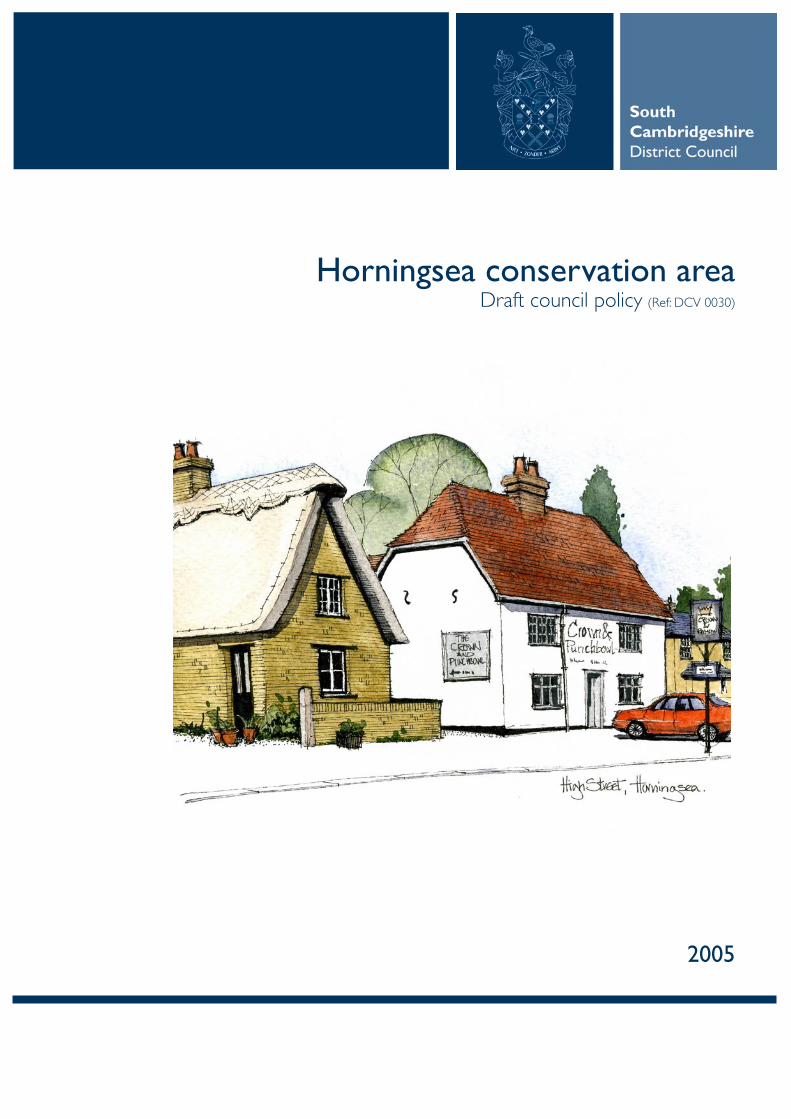
Horningsea conservation areaDraft council policy (Ref: DCV 0030)
2005

1.0 INTRODUCTION1.1 The Horningsea Conservation Area was designated on 17 May 1990. This document aims to fulfil South Cambridgeshire District Council’s duty to ‘draw up and publish proposals for the preservation and enhancement’ of these areas as required by the Planning (Listed Buildings and Conservation Areas) Act 1990 and the commitment made by policy EN29 in the adopted Local Plan.
1.2 This section to report on public consultation and confirm the status of the appraisal as supplementary planning guidance / document.
2.0 WHAT ARE CONSERVATION AREAS?2.1 Conservation Areas are defined as ‘areas of special architectural or historic interest, the character or appearance of which it is desirable to preserve or enhance’.
2.2 When a Conservation Area has been designated, it increases the Council’s powers, with planning applications judged by their impact on the character and appearance of the area. Greater controls over the demolition of buildings and structures are imposed whilst the rights that owners have to do works to their properties without the prior need to obtain planning permission (known as ‘permitted development rights’) are reduced or may be taken away. Stricter controls are also exercised over the design of new buildings, and owners must give the Council six weeks’ notice of their intention to carry out works to trees. Planning applications affecting a Conservation Area must be advertised on site and in the local press to give people the opportunity to comment.
3.0 OVERVIEW OF THE AREA3.1 Horningsea is a small attractive village with buildings mostly arranged alongside the Fen Ditton to Waterbeach Road, together with two narrower ancient lanes leading down to the river to the west.
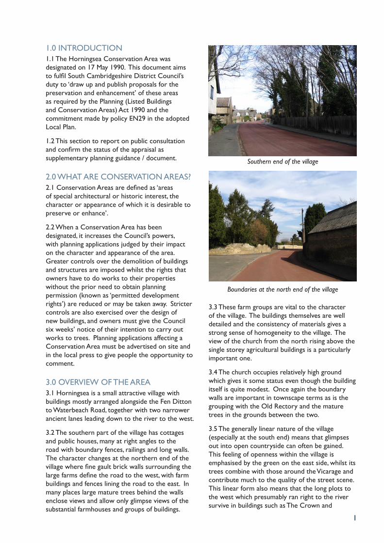
3.2 The southern part of the village has cottages and public houses, many at right angles to the road with boundary fences, railings and long walls. The character changes at the northern end of the village where fine gault brick walls surrounding the large farms define the road to the west, with farm buildings and fences lining the road to the east. In many places large mature trees behind the walls enclose views and allow only glimpse views of the substantial farmhouses and groups of buildings.
Southern end of the village
Boundaries at the north end of the village
3.3 These farm groups are vital to the character of the village. The buildings themselves are well detailed and the consistency of materials gives a strong sense of homogeneity to the village. The view of the church from the north rising above the single storey agricultural buildings is a particularly important one.
3.4 The church occupies relatively high ground which gives it some status even though the building itself is quite modest. Once again the boundary walls are important in townscape terms as is the grouping with the Old Rectory and the mature trees in the grounds between the two.
3.5 The generally linear nature of the village (especially at the south end) means that glimpses out into open countryside can often be gained. This feeling of openness within the village is emphasised by the green on the east side, whilst its trees combine with those around the Vicarage and contribute much to the quality of the street scene. This linear form also means that the long plots to the west which presumably ran right to the river survive in buildings such as The Crown and
1
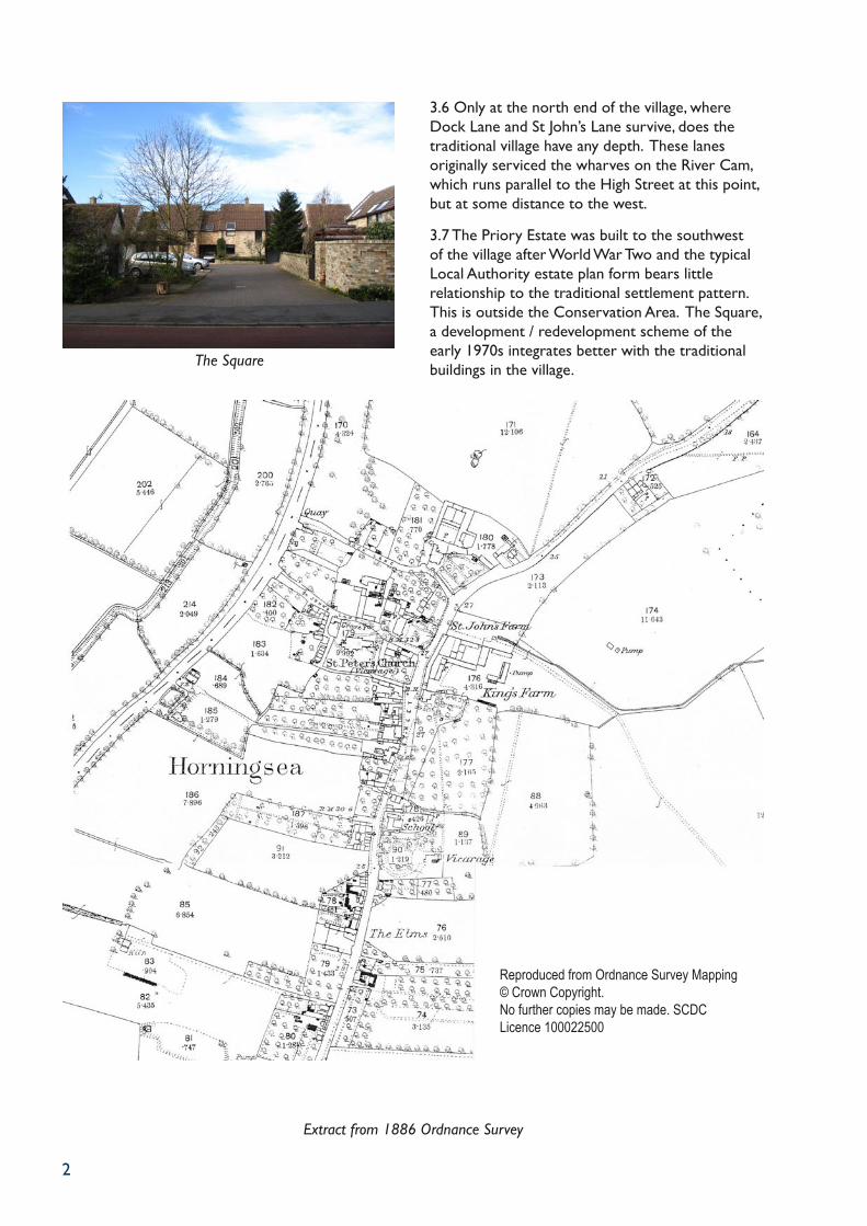
The Square
3.6 Only at the north end of the village, where Dock Lane and St John’s Lane survive, does the traditional village have any depth. These lanes originally serviced the wharves on the River Cam, which runs parallel to the High Street at this point, but at some distance to the west.
3.7 The Priory Estate was built to the southwest of the village after World War Two and the typical Local Authority estate plan form bears little relationship to the traditional settlement pattern. This is outside the Conservation Area. The Square, a development / redevelopment scheme of the early 1970s integrates better with the traditional buildings in the village.
2
Reproduced from Ordnance Survey Mapping © Crown Copyright.No further copies may be made. SCDC Licence 100022500
Extract from 1886 Ordnance Survey
3
4.0 A BRIEF HISTORY OF THE VILLAGE4.1 The name of Horningsea probably derives from the Old English word for a hill and island. Certainly in the 2nd millennium BC, the site of the village stood on a chalk promontory between tidal water and marsh, and in the early Middle Ages the parish comprised an elongated peninsular jutting northward into undrained fenland.
4.2 There has been settlement along the edges of the fen around the village since the Iron Age evidenced by the remains of a C1 and C3 settlement comprising a single enclosure between 3 ditches which stood to the south of two C2 limekilns. A major Roman pottery industry was also established around the site of Eye Hall.
4.3 The Mediaeval settlement of Horningsea developed along the river and St John’s Lane and Dock Lane are ancient routes down to the hithes and wharves which lined the Cam. The oldest surviving building, on high ground roughly in the middle of the present village, is the church which may occupy the site of a C9-10 Minster.
4.4 The Cam was used for waterborne transport during the Roman period and throughout the Middle Ages. In 1700 a series of locks were constructed between Baits Bite Lock and Clayhithe. There were further obstructions downstream and in 1703 the Conservators of the River Cam were appointed to improve navigation. In the late C19 lighters were still in use between Horningsea and Kings Lynn.
4.5 Meadowland, near the river was probably grazed by oxen as early as the C11. In 1086 (Doomsday Survey) there were 51 peasant households in the combined parish of Fen Ditton and Horningsea and by 1279 there were about 90 landholders in Horningsea alone. The population had risen to 293 by 1801 and by 1841 it stood at 295. Despite some emigration to Australia, numbers increased to 371 by 1841 and 433 in 1871. The population declined to 312 by the 1930s and to 274 by 1971, although it rose to 336 by 1991 and remains at a similar level today.
4.6 In 1066 Ely Abbey held the manor of ‘Fen Ditton with Horningsea’. Horningsea and Fen Ditton were a single parish until divided by Ely in 1412, although most of Horningsea formed part of the Fen Ditton Estate during the C17 to early C19s. in 1810, 910 acres were owned by Thomas Panton and part was sold to King’s College before being sold again in the 1960s.
4.7 Attempts to drain the land around the village date from the Middle Ages with renewed activity in the C17 and C18 when a main watercourse was connected to Bottisham Lode. Crops have therefore been grown in the area since the C14 with barley particularly popular from the C14 to C18, whilst sugar beet is regularly grown today.
4.8 The land was enclosed in 1810 and by the later C19, there were three main farms in the village. Manor Farm had 207 acres, St John’s Farm 145 acres whilst King’s Farm had 118 acres in Horningsea and a further 112 acres in Fen Ditton. In 1861, Manor Farm also had 27 men working as coprolite diggers and the industry clearly flourished in the late C19 with 85 men employed in the trade within the parish. The effects of the coprolite industry are still visible in the ponds and trenches of ‘Poor Fen’ to the north of the parish.
4.9 Clay and gault from Horningsea and Clayhithe was used for pottery making from C2. In the C16 bricks were either made or stored in Clayhithe. And by the C19 the Clayhithe kilns specialised in bricks, including the white facing bricks much in demand in Cambridge. A small brick pit on the southwest side of the village survived in the mid C19. These locally-made bricks are widely used for buildings in the village (often cladding earlier timber-framed structures) and are an important characteristic of Horningsea.
5.0 GEOLOGY AND LANDSCAPE SETTING5.1 Horningsea lies around four miles northeast of Cambridge on the east bank of the River Cam. The land is low lying, in places below 5m above sea level, rising to around 10m in the southeast of the parish. The southern half of the parish lies on chalk and the northern half on clay, both overlain in places with gravel. Patches of peat and alluvium still survive near Clayhithe, whilst along the banks of the Cam there are alluvial river gravels, and in the northwest of the parish peat overlies Cambridge Greensand.
5.2 There are clay soils that contain coprolite (nodules of calcium phosphate) that were extensively quarried in the late C19 for fertiliser and explosives. Near the Cam were areas of common meadow that were used for peat digging and/or turf cutting.
5.3 Most of the land surrounding the village is today grade 3 agricultural land with some grade 2 land in the east of the parish. Flat farm land

4
therefore provides the setting of the village which can only be approached by road from the north and south. The A14 is dominant in views south from the village, whilst the elevated Fen Ditton to Waterbeach road over the A14 gives something of a panorama of the village from the south. The river forms the western boundary of the village, with the village of Milton just visible in the distance to the west.
5.4 The village lies within the Fens Landscape Character Area and is within the Cambridge Green Belt. The Low Fen Drove Way is a County Wildlife Site.
6.0 ARCHAEOLOGY6.1 The earliest finds in the area include one Palaeolithic, one Mesolithic and two Neolithic axes found in the chalk soils in the south of the parish. Bronze Age burial discoveries include three axes, a rapier, a spear made of bronze and a knife and dagger of flint whilst the remains of Bronze Age burial mounds have also been identified near the border with Fen Ditton.
6.2 A major Roman pottery industry appears to have thrived around Eye Hall which is believed to be the site of a villa or similar building. Seven kilns were excavated in 1911 which may have produced thick walled jars used for the storage and transport of grain in the C2 and C3. Small Roman farmsteads to the south of the village have also been identified on aerial photographs.
6.3 The parish of Horningsea was of considerable importance by the middle Saxon period when coins and shards of pottery are known from a site near the Roman kilns, and there are indications of the commercial use of the riverside from the same period.
6.4 A monastic site was founded in the area with the arrival of Christianity, but was destroyed by the Danes when they overran the area in 870. A fragment of a carved coffin lid from the C10 is preserved in the church.
6.5 Eye Hall, to the north of the Conservation Area, was in existence in 870 and was described as a separate settlement in 1279. Around the hall the earthwork remains of an old village street survived in living memory.
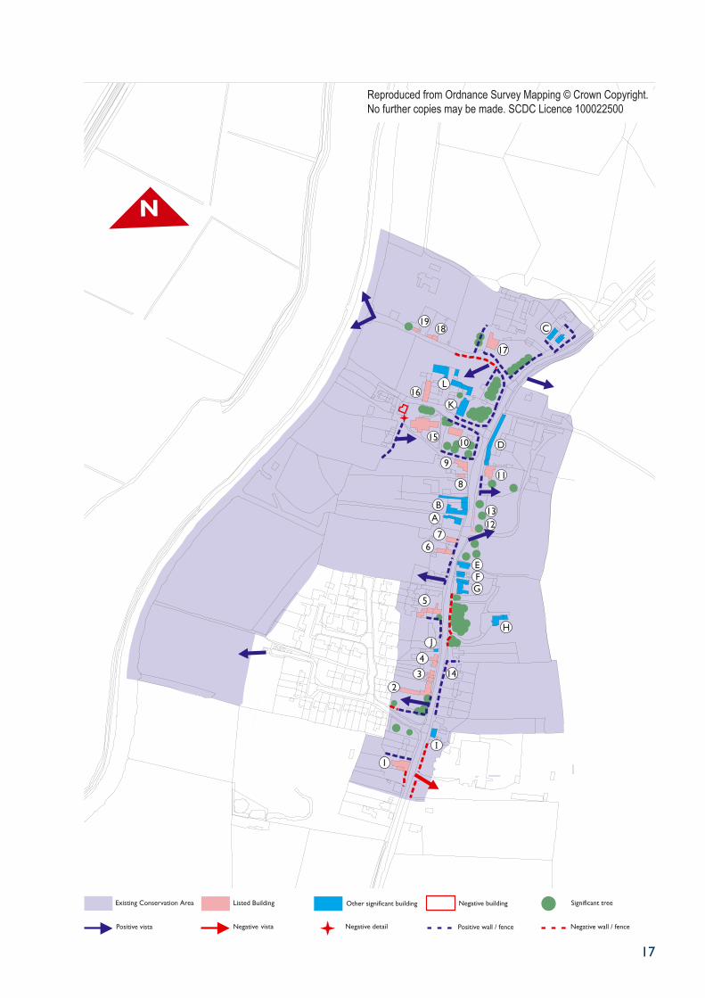
7.0 TOWNSCAPE ANALYSISHigh Street (west side)
7.1 High Street has been recently surfaced in red tarmac throughout its length within the village as part of a traffic calming initiative. While this is effective in identifying the 30mph area, the colour does not complement the traditional pallet of colours in the village and a more appropriate colour should be selected when the road is next re-surfaced. Entering the village from the south, the first property is Holly Tree Cottage. Now a single dwelling, this was originally a pair of C19 cottages, now much altered with rendered walls and a concrete pantiled roof incorporating a prominent solar panel.
The Plough and Fleece Public House
7.2 Beyond, and also on the footpath edge is the Plough and Fleece Public House (map:1). This is a Grade II Listed Building with painted brick walls and a plain tile mansard roof extended as a lean-to at the rear and with perpendicular single storey ranges with pantiled roofs. The car park entrance to the north has a gault brick wall with trees visible to the rear. To the south of the Public House is an open area that affords views of the single storey roofs along the side of the listed building.
7.3 North of the Plough and Fleece are Nos. 51-55, a group of probably 1950s red brick former local authority houses with hipped tiled roofs. Unlike the first two buildings, these are set back behind gardens, now converted to car parking in the two end houses.
7.4 At the entrance to Priory Road is a pleasant green area with mature trees and adjacent to this is The Priory, a Grade II listed builing. The boundary to The Priory has a good mix of mature trees and rebuilt front walls with ball finial piers. The gap through allows views of the single storey rear
5
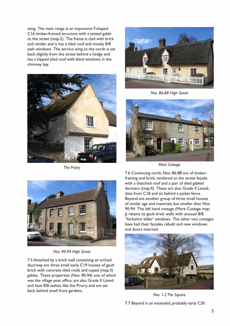
wing. The main range is an impressive T-shaped C16 timber-framed structure with a jettied gable to the street (map:2). The frame is clad with brick and render and it has a tiled roof and mostly 8/8 sash windows. The service wing to the north is set back slightly from the street behind a hedge and has a hipped tiled roof with blind windows in the chimney bay.
The Priory
Nos. 90-94 High Street
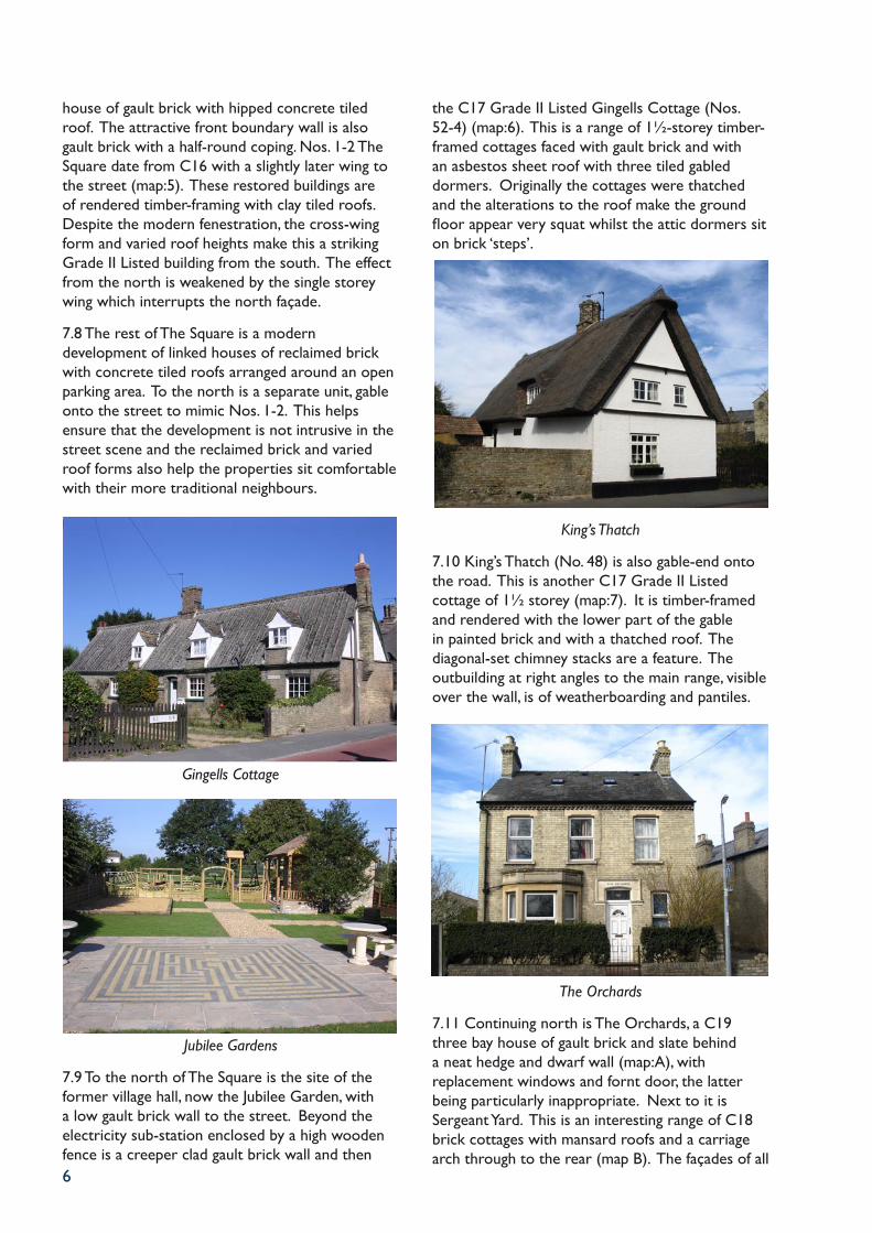
7.5 Attached by a brick wall containing an arched doorway are three small early C19 houses of gault brick with concrete tiled roofs and coped (map:3) gables. These properties (Nos. 90-94) one of which was the village post office, are also Grade II Listed and have 8/8 sashes, like the Priory, and are set back behind small front gardens.
Nos. 86-88 High Street
More Cottage
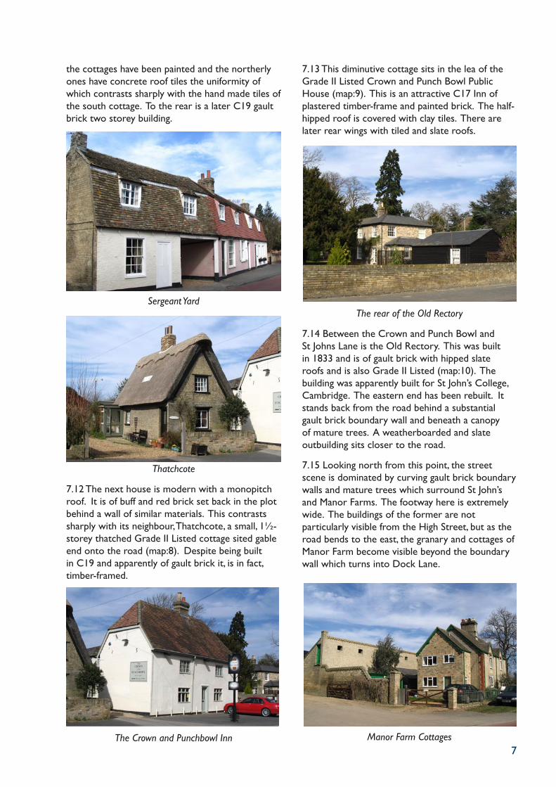
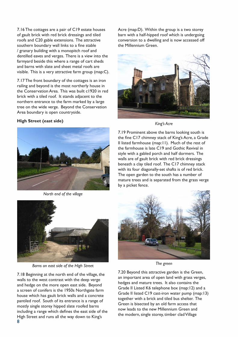
7.6 Continuing north, Nos. 86-88 are of timber-framing and brick, rendered to the street façade with a thatched roof and a pair of tiled gabled dormers (map:4). These are also Grade II Listed, date from C18 and sit behind a picket fence. Beyond are another group of three small houses of similar age and materials, but smaller than Nos. 90-94. The left hand cottage (More Cottage map:J) retains its gault brick walls with unusual 8/8 ‘Yorkshire slider’ windows. The other two cottages have had their façades rebuilt and new windows and doors inserted.
Nos. 1-2 The Square
7.7 Beyond is an extended, probably early C20
6
house of gault brick with hipped concrete tiled roof. The attractive front boundary wall is also gault brick with a half-round coping. Nos. 1-2 The Square date from C16 with a slightly later wing to the street (map:5). These restored buildings are of rendered timber-framing with clay tiled roofs. Despite the modern fenestration, the cross-wing form and varied roof heights make this a striking Grade II Listed building from the south. The effect from the north is weakened by the single storey wing which interrupts the north façade.
7.8 The rest of The Square is a modern development of linked houses of reclaimed brick with concrete tiled roofs arranged around an open parking area. To the north is a separate unit, gable onto the street to mimic Nos. 1-2. This helps ensure that the development is not intrusive in the street scene and the reclaimed brick and varied roof forms also help the properties sit comfortable with their more traditional neighbours.
Gingells Cottage
Jubilee Gardens
7.9 To the north of The Square is the site of the former village hall, now the Jubilee Garden, with a low gault brick wall to the street. Beyond the electricity sub-station enclosed by a high wooden fence is a creeper clad gault brick wall and then
the C17 Grade II Listed Gingells Cottage (Nos. 52-4) (map:6). This is a range of 1½-storey timber-framed cottages faced with gault brick and with an asbestos sheet roof with three tiled gabled dormers. Originally the cottages were thatched and the alterations to the roof make the ground floor appear very squat whilst the attic dormers sit on brick ‘steps’.
King’s Thatch
7.10 King’s Thatch (No. 48) is also gable-end onto the road. This is another C17 Grade II Listed cottage of 1½ storey (map:7). It is timber-framed and rendered with the lower part of the gable in painted brick and with a thatched roof. The diagonal-set chimney stacks are a feature. The outbuilding at right angles to the main range, visible over the wall, is of weatherboarding and pantiles.
The Orchards
7.11 Continuing north is The Orchards, a C19 three bay house of gault brick and slate behind a neat hedge and dwarf wall (map:A), with replacement windows and fornt door, the latter being particularly inappropriate. Next to it is Sergeant Yard. This is an interesting range of C18 brick cottages with mansard roofs and a carriage arch through to the rear (map B). The façades of all
7
the cottages have been painted and the northerly ones have concrete roof tiles the uniformity of which contrasts sharply with the hand made tiles of the south cottage. To the rear is a later C19 gault brick two storey building.
Sergeant Yard
Thatchcote
7.12 The next house is modern with a monopitch roof. It is of buff and red brick set back in the plot behind a wall of similar materials. This contrasts sharply with its neighbour, Thatchcote, a small, 1½-storey thatched Grade II Listed cottage sited gable end onto the road (map:8). Despite being built in C19 and apparently of gault brick it, is in fact, timber-framed.
The Crown and Punchbowl Inn
7.13 This diminutive cottage sits in the lea of the Grade II Listed Crown and Punch Bowl Public House (map:9). This is an attractive C17 Inn of plastered timber-frame and painted brick. The half-hipped roof is covered with clay tiles. There are later rear wings with tiled and slate roofs.
The rear of the Old Rectory
7.14 Between the Crown and Punch Bowl and St Johns Lane is the Old Rectory. This was built in 1833 and is of gault brick with hipped slate roofs and is also Grade II Listed (map:10). The building was apparently built for St John’s College, Cambridge. The eastern end has been rebuilt. It stands back from the road behind a substantial gault brick boundary wall and beneath a canopy of mature trees. A weatherboarded and slate outbuilding sits closer to the road.
7.15 Looking north from this point, the street scene is dominated by curving gault brick boundary walls and mature trees which surround St John’s and Manor Farms. The footway here is extremely wide. The buildings of the former are not particularly visible from the High Street, but as the road bends to the east, the granary and cottages of Manor Farm become visible beyond the boundary wall which turns into Dock Lane.
Manor Farm Cottages
8
7.16 The cottages are a pair of C19 estate houses of gault brick with red brick dressings and tiled roofs and C20 gable extensions. The attractive southern boundary wall links to a fine stable / granary building with a monopitch roof and dentilled eaves and verges. There is a view into the farmyard beside this where a range of cart sheds and barns with slate and sheet metal roofs are visible. This is a very attractive farm group (map:C).
7.17 The front boundary of the cottages is an iron railing and beyond is the most northerly house in the Conservation Area. This was built c1920 in red brick with a tiled roof. It stands adjacent to the northern entrance to the farm marked by a large tree on the wide verge. Beyond the Conservation Area boundary is open countryside.
High Street (east side)
North end of the village
Barns on east side of the High Street
7.18 Beginning at the north end of the village, the walls to the west contrast with the deep verge and hedge on the more open east side. Beyond a screen of conifers is the 1950s Northgate farm house which has gault brick walls and a concrete pantiled roof. South of its entrance is a range of mostly single storey hipped slate roofed barns including a range which defines the east side of the High Street and runs all the way down to King’s
Acre (map:D). Within the group is a two storey barn with a half-hipped roof which is undergoing conversion to a dwelling and is now accessed off the Millennium Green.
King’s Acre
7.19 Prominent above the barns looking south is the fine C17 chimney stack of King’s Acre, a Grade II listed farmhouse (map:11). Much of the rest of the farmhouse is late C19 and Gothic Revival in style with a gabled porch and half dormers. The walls are of gault brick with red brick dressings beneath a clay tiled roof. The C17 chimney stack with its four diagonally-set shafts is of red brick. The open garden to the south has a number of mature trees and is separated from the grass verge by a picket fence.
The green
7.20 Beyond this attractive garden is the Green, an important area of open land with grass verges, hedges and mature trees. It also contains the Grade II Listed K6 telephone box (map:12) and a Grade II listed C19 cast-iron water pump (map:13) together with a brick and tiled bus shelter. The Green is bisected by an old farm access that now leads to the new Millennium Green and the modern, single storey, timber clad Village
9
Hall. Behind this is a two storey 1950s brick and concrete tile farmhouse. This latter building is due for demolition following completion of a new dwelling on the adjacent site.
Rose Cottage, looking south from the Green
7.21 The south side of the green is defined by the long single storey rear range of Rose Cottage (map:E). This extensive lean-to outbuilding range is very large for such a modest cottage and is of brick with a pantiled roof of two heights and a large chimney stack at the west end. The cottage itself is C17 and of timber-framing with a brick façade. It is 1½ storey with a steeply pitched asbestos sheet roof with a single catslide dormer on the south elevation. There is a taller block with a pantiled roof at the east end.
Pair of C19 houses on the High Street
The Old School
7.22 To the south is a pair of C19 houses of gault brick and slate each with a single metal casement window to each floor (map:F). Adjacent to these cottages and of similar materials is the former village school and school master’s house (map:G). This was built in 1841 and extended in 1871 and 1882. It has a prominent gable at the north end with a Tudor Gothic entrance adjacent to it. The fine chimney stacks add to the attractive silhouette. The school was converted to a house in 1976.
7.23 Beyond, are the extensive tree-filled grounds of the Vicarage. Although the fence to the road is poor, the variety of mature trees is a significant landscape feature in the village complementing the green further north. The house itself, which is difficult to see from the road, was built in 1872 and is a Tudor Gothic composition of red brick with a clay tiled roof (map:H).
Grade II Listed water pump
7.24 Next are Nos. 78 and 80, a pair of C19 cottages of render and slate. Both have been extensively altered and the house to the south substantially extended. They sit behind a picket fence with a side wall of gault brick. Beyond are three pairs of probably interwar local authority houses with rendered walls and tiled roofs. The boundary walls are mostly of gault brick and set into the garden of the northernmost cottage is a second Grade II Listed cast-iron water pump (map:14).
10
St John’s Lane (north side)
St John’s Farmhouse
7.30 The north side of the lane is defined by the fine gault brick boundary wall to St John’s Farm and the substantial trees behind it. Only when the road bends is the farm house visible. It is an imposing C19 house of gault brick with a striped tiled roof like the church (map K). It has a gabled entrance porch with arched stair light window above and a large ground floor bay at the north end.
7.31 Beyond are the former agricultural buildings of the farm (map:L). The best is a large, Grade II listed C18 timber-framed barn with weatherboarded walls and a sheet asbestos roof (map:16), now undergoing conversion to a dwelling. Between it and the farmhouse are a range of lower buildings in a mixture of gault brick and weatherboarding under slate and corrugated iron roofs, whilst further east is an open crew yard with an unattractive metal gate. From the end of the lane are views across an old orchard and down towards the river.
Church End
The church viewed from St John’s Lane
7.32 Church End is a narrow lane running to the east of the church. Whilst the view of the west tower of the church is rather spoiled by a flat roofed garage in the foreground, very fine views of the church, which sits on higher ground with a retaining wall of gault brick, can be gained from lower down the lane. At the end of the lane on the east side are a group of C19 brick houses with slate roofs most now altered and fine views of the river from the end of the lane. In between these houses and St John’s Lane is a very set back 1950s house (Terrell) of red brick with a concrete pantiled roof.
Dock Lane (north side)
Manor Farm
7.33 This is the most northerly of the village lanes which ran down to the river. Its entrance is defined by attractive gault brick walls with mature trees behind. Those to the north belong to Manor Farm which is a 2.5 storey C17 house with mid C19 extensions (map:17). This Grade II Listed house has walls of rendered timber-framing with a tiled roof to the south range and slates to the north. Views across the entrance to the brick and slate farm buildings can be gained.
The Folly
Nos. 60 and 62 High Street
7.25 South of these pairs of houses is a group of C19 houses. No. 64 is of painted and rendered brickwork and has been considerably extended. This is set back slightly from the road. Next to it, No. 62 is of gault brick and slate and is parallel to the street. It has replacement windows and the original central front door has been crudely blocked. Adjoining at right angles is No. 60 also of gault brick and slate and with all its attractive 8/8 sash windows surviving (map:I).
7.26 South of this group, and at the entrance to the Conservation Area, are the modern single storey buildings of the garden centre. The buildings are not within the Conservation Area, but the fence line with its planting areas in front and behind is. The appearance of the entrance to the village will be significantly improved when this planting becomes better established as at present extensive views can be gained across the large car park.
St John’s Lane (south side)
The Old Rectory
7.27 St John’s Lane is the most southerly of the ancient lanes which originally ran down to the river with its hithes and wharves. The first house is the Old Rectory (already mentioned in paragraph 7.14)
which is surrounded by a gault brick wall which opens up to reveal a prospect of the symmetrical entrance front with its 6/6 sash windows (map:10). The eastern part of the garden and the church yard have a host of mature trees including a huge Wellingtonia. These initially hide views of the church, whilst the gault brick wall becomes one of flints, clay batts and old narrow bricks around the churchyard.
St Peter’s Church
7.28 Only at the gateway can the church be easily seen (map:15). This Grade I Listed building, dedicated to St Peter, is of the early C12 and was extended in the following 200 years. Its wall are of limestone, clunch, flint and brick and there is a C13 west tower. The tiled roof with stripes of buff / brown and red clay tiles is modern.
7.29 Behind the church is a curious 1950s house with a mansard roof. This sits at the entrance to Church End. On the opposite corner is a probably early C19 house with rendered walls and pantiled roof with a large modern continuous dormer. Attached to the east is an earlier cottage of brick and pantiles but significantly altered, whilst at the east end is a later C19 house with timber studs and a weatherboarded gable. On its end gable a verandah looks towards the river.
Corner of St John’s Lane and Church End
11
St John’s Lane (north side)
St John’s Farmhouse
7.30 The north side of the lane is defined by the fine gault brick boundary wall to St John’s Farm and the substantial trees behind it. Only when the road bends is the farm house visible. It is an imposing C19 house of gault brick with a striped tiled roof like the church (map K). It has a gabled entrance porch with arched stair light window above and a large ground floor bay at the north end.
7.31 Beyond are the former agricultural buildings of the farm (map:L). The best is a large, Grade II listed C18 timber-framed barn with weatherboarded walls and a sheet asbestos roof (map:16), now undergoing conversion to a dwelling. Between it and the farmhouse are a range of lower buildings in a mixture of gault brick and weatherboarding under slate and corrugated iron roofs, whilst further east is an open crew yard with an unattractive metal gate. From the end of the lane are views across an old orchard and down towards the river.
Church End
The church viewed from St John’s Lane
7.32 Church End is a narrow lane running to the east of the church. Whilst the view of the west tower of the church is rather spoiled by a flat roofed garage in the foreground, very fine views of the church, which sits on higher ground with a retaining wall of gault brick, can be gained from lower down the lane. At the end of the lane on the east side are a group of C19 brick houses with slate roofs most now altered and fine views of the river from the end of the lane. In between these houses and St John’s Lane is a very set back 1950s house (Terrell) of red brick with a concrete pantiled roof.
Dock Lane (north side)
Manor Farm
7.33 This is the most northerly of the village lanes which ran down to the river. Its entrance is defined by attractive gault brick walls with mature trees behind. Those to the north belong to Manor Farm which is a 2.5 storey C17 house with mid C19 extensions (map:17). This Grade II Listed house has walls of rendered timber-framing with a tiled roof to the south range and slates to the north. Views across the entrance to the brick and slate farm buildings can be gained.
The Folly
Nos. 60 and 62 High Street
7.25 South of these pairs of houses is a group of C19 houses. No. 64 is of painted and rendered brickwork and has been considerably extended. This is set back slightly from the road. Next to it, No. 62 is of gault brick and slate and is parallel to the street. It has replacement windows and the original central front door has been crudely blocked. Adjoining at right angles is No. 60 also of gault brick and slate and with all its attractive 8/8 sash windows surviving (map:I).
7.26 South of this group, and at the entrance to the Conservation Area, are the modern single storey buildings of the garden centre. The buildings are not within the Conservation Area, but the fence line with its planting areas in front and behind is. The appearance of the entrance to the village will be significantly improved when this planting becomes better established as at present extensive views can be gained across the large car park.
St John’s Lane (south side)
The Old Rectory
7.27 St John’s Lane is the most southerly of the ancient lanes which originally ran down to the river with its hithes and wharves. The first house is the Old Rectory (already mentioned in paragraph 7.14)
which is surrounded by a gault brick wall which opens up to reveal a prospect of the symmetrical entrance front with its 6/6 sash windows (map:10). The eastern part of the garden and the church yard have a host of mature trees including a huge Wellingtonia. These initially hide views of the church, whilst the gault brick wall becomes one of flints, clay batts and old narrow bricks around the churchyard.
St Peter’s Church
7.28 Only at the gateway can the church be easily seen (map:15). This Grade I Listed building, dedicated to St Peter, is of the early C12 and was extended in the following 200 years. Its wall are of limestone, clunch, flint and brick and there is a C13 west tower. The tiled roof with stripes of buff / brown and red clay tiles is modern.
7.29 Behind the church is a curious 1950s house with a mansard roof. This sits at the entrance to Church End. On the opposite corner is a probably early C19 house with rendered walls and pantiled roof with a large modern continuous dormer. Attached to the east is an earlier cottage of brick and pantiles but significantly altered, whilst at the east end is a later C19 house with timber studs and a weatherboarded gable. On its end gable a verandah looks towards the river.
Corner of St John’s Lane and Church End
12
7.34 Some of the boundary walls to the farmhouse are of flint, but beyond the farm the scene becomes much more rural with hedges, verges and trees, and a view of the gable end of The Folly. This was two cottages but is now a single dwelling and was built in the late C17 (map:18). It has painted brick clad timber-framed walls and a thatched roof with four eyebrow dormers on the south elevation.
The Thatch
7.35 Both The Folly and the next cottage to the east, The Thatch (map:19), are Grade II Listed. The latter is probably older and has an impressive brick chimney stack at its east end and a single gabled dormer. The timber-framed walls are mostly clad with painted brick and like its neighbour the roof is reed thatched. The cottage which contains some interesting original windows is in poor condition.
7.36 Nearest to the river is Riverside Bungalow, an extensive 1960s brick built dwelling with a large garden. This is set back some way from the lane. The lane continues down to the river where views across to the tow path on the opposite bank with its over mature trees and the open countryside beyond are particularly attractive. The electricity sub station at the end of the lane could be better screened.
Dock Lane (south side)7.37 The south side of the street has no buildings directly addressing it. The entrance has gault brick walls and mature shrubs but these give way to a poor chain link fence surrounding an open paddock. There are some extremely fine views across the St John’s Farm buildings to the church tower beyond. This grouping with its modest slate roofed buildings with the stepped parapet of the church tower and tall mature trees beyond is an enduring image.
View to St John’s Farm and the church
7.37 The south side of the street has no buildings directly addressing it. The entrance has gault brick walls and mature shrubs but these give way to a poor chain link fence surrounding an open paddock. There are some extremely fine views across the St John’s Farm buildings to the church tower beyond. This grouping with its modest slate roofed buildings with the stepped parapet of the church tower and tall mature trees beyond is an enduring image.
7.38 The prominent gable end of the 1950s mansard roofed house behind the church is a less attractive focus of views, though the farm buildings in the foreground, including those with raised ventilators at the ridge are worthy of retention and restoration.
8.0 KEY CHARACTERISTICS8.1 Scale: Only Manor Farmhouse rises to 2.5 storeys. Otherwise the tallest domestic buildings in the village are 2 storeys including C19 houses and cottages and the most substantial timber-framed structures such as the Priory and Nos. 1 and 2 The Square. Other buildings in the village are generally 1.5 storeys.
8.2 Walling Materials: The presence of local brick-pits mean that gault brick is the pre-eminent building material. In many cases this covers earlier timber-framed structures, and occasionally the bricks are painted. Otherwise, painted render is commonly found with red bricks mostly seen as detailing on C19 houses or for houses built from the 1930s-50s. Weatherboarding is very common in the village for agricultural buildings, outbuildings and occasionally on the gable ends of some houses.
8.3 Roofing Materials: The oldest domestic buildings in the village have thatched roofs; those
on Dock Lane with reed thatch. Some houses in the village have had the roofs replaced by asbestos sheet or clay peg tiles. The latter, in the attractive ‘Cambridgeshire mix’ combination of buff and brown tiles are attractive in their own right. The church and St John’s Farmhouse, unusually, have stripes of red tiles mixed in with the more traditional local tiles. Welsh slate roofs are common on the C19 buildings in the village.
8.4 Roof forms: There are a variety of roof forms in the village including mansards and hipped forms. Some roofs have parapet gables and there are several others with gablets and half dormers. There are also full dormers (usually gabled) and catslides on several houses. The earliest and vernacular buildings have steeply pitched roofs usually to accommodate thatch, whilst the C19 Gothic Revival houses have them more for aesthetic effect. Some of the lower pitched roofs in the village are on C19 buildings and are covered with Welsh Slate. Many of these are hipped.
8.5 Chimneys: Prominent chimneys are a feature of the village and adorn relatively grand houses such as King’s Acre (where a C17 stack is reused from a previous building) and more modest cottages such as The Thatch or the outbuilding at Rose Cottage. Together with the varied roof forms, these give many village properties an interesting silhouette.
8.6 Location on the plot: Many buildings within Horningsea are gable-end onto the street. Whilst this gives considerable interest to the street scene, it means that the ‘backs’ as well as the ‘fronts’ of properties are easily visible. Several properties have side or rear service wings. Many other properties sit parallel with the street either directly on the back of the footway or more often behind small front gardens. Only the largest properties (such as the vicarage) are some distance from the road in extensive grounds.
8.7 Windows and doors: Sash windows, especially 8/8 sashes are remarkably common in the village on both grand and more modest houses. Multi-paned ‘Yorkshire sliders’ and more common casement windows are also much in evidence though several houses have been disfigured by the insertion of modern windows and doors.
8.8 Boundary walls are a major component of the village character especially at the northern end of the village where they are of gault brick. Flint is also found in the walls surrounding the church and Manor Farm, whilst picket fences and simple
iron railings surround several of the cottages in the village.
8.9 The agricultural character of the village is very important especially at the northern end of the village where barns line the road and there are views of the fine groups of farm buildings. The linear nature of much of the village also means that views out into the open fields surrounding Horningsea can be seen from many parts of the village.
8.10 Vistas towards the river can be gained from the end of the Priory Estate and St John’s and Dock Lanes whilst the open countryside can be seen from the green and the northeast and southeast ends of the village.
8.11 The village is well provided with mature trees and shrubs. Key groups are around the Priory, the vicarage and the green, the church and Old Rectory and St John’s Farm in particular. Some of the trees have considerable scale and provide a backcloth for the traditional buildings in the village.
8.12 Spaces: The linear nature of the village means that there are no formal open spaces. However the green gives a feeling of openness in the centre of the village whilst the church yard, especially when viewed from the west is of a reasonable scale. Otherwise, only the slight widening of the road outside the Crown and Punchbowl Public House hints at a small square.
9.0 PROPOSED CHANGES TO THE CONSERVATION AREA BOUNDARY9.1 No changes to the Conservation Area boundary are proposed.
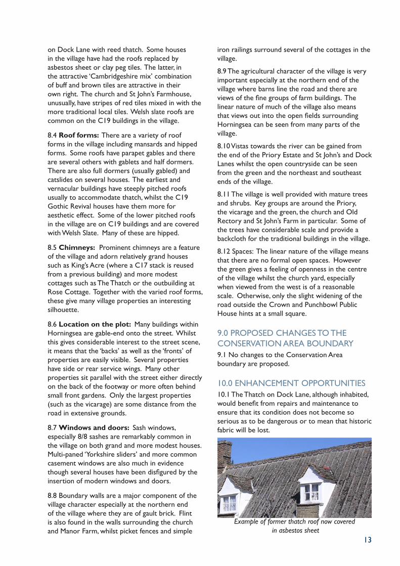
10.0 ENHANCEMENT OPPORTUNITIES10.1 The Thatch on Dock Lane, although inhabited, would benefit from repairs and maintenance to ensure that its condition does not become so serious as to be dangerous or to mean that historic fabric will be lost.
Example of former thatch roof now covered in asbestos sheet
13
7.34 Some of the boundary walls to the farmhouse are of flint, but beyond the farm the scene becomes much more rural with hedges, verges and trees, and a view of the gable end of The Folly. This was two cottages but is now a single dwelling and was built in the late C17 (map:18). It has painted brick clad timber-framed walls and a thatched roof with four eyebrow dormers on the south elevation.
The Thatch
7.35 Both The Folly and the next cottage to the east, The Thatch (map:19), are Grade II Listed. The latter is probably older and has an impressive brick chimney stack at its east end and a single gabled dormer. The timber-framed walls are mostly clad with painted brick and like its neighbour the roof is reed thatched. The cottage which contains some interesting original windows is in poor condition.
7.36 Nearest to the river is Riverside Bungalow, an extensive 1960s brick built dwelling with a large garden. This is set back some way from the lane. The lane continues down to the river where views across to the tow path on the opposite bank with its over mature trees and the open countryside beyond are particularly attractive. The electricity sub station at the end of the lane could be better screened.
Dock Lane (south side)7.37 The south side of the street has no buildings directly addressing it. The entrance has gault brick walls and mature shrubs but these give way to a poor chain link fence surrounding an open paddock. There are some extremely fine views across the St John’s Farm buildings to the church tower beyond. This grouping with its modest slate roofed buildings with the stepped parapet of the church tower and tall mature trees beyond is an enduring image.
View to St John’s Farm and the church
7.37 The south side of the street has no buildings directly addressing it. The entrance has gault brick walls and mature shrubs but these give way to a poor chain link fence surrounding an open paddock. There are some extremely fine views across the St John’s Farm buildings to the church tower beyond. This grouping with its modest slate roofed buildings with the stepped parapet of the church tower and tall mature trees beyond is an enduring image.
7.38 The prominent gable end of the 1950s mansard roofed house behind the church is a less attractive focus of views, though the farm buildings in the foreground, including those with raised ventilators at the ridge are worthy of retention and restoration.
8.0 KEY CHARACTERISTICS8.1 Scale: Only Manor Farmhouse rises to 2.5 storeys. Otherwise the tallest domestic buildings in the village are 2 storeys including C19 houses and cottages and the most substantial timber-framed structures such as the Priory and Nos. 1 and 2 The Square. Other buildings in the village are generally 1.5 storeys.
8.2 Walling Materials: The presence of local brick-pits mean that gault brick is the pre-eminent building material. In many cases this covers earlier timber-framed structures, and occasionally the bricks are painted. Otherwise, painted render is commonly found with red bricks mostly seen as detailing on C19 houses or for houses built from the 1930s-50s. Weatherboarding is very common in the village for agricultural buildings, outbuildings and occasionally on the gable ends of some houses.
8.3 Roofing Materials: The oldest domestic buildings in the village have thatched roofs; those
on Dock Lane with reed thatch. Some houses in the village have had the roofs replaced by asbestos sheet or clay peg tiles. The latter, in the attractive ‘Cambridgeshire mix’ combination of buff and brown tiles are attractive in their own right. The church and St John’s Farmhouse, unusually, have stripes of red tiles mixed in with the more traditional local tiles. Welsh slate roofs are common on the C19 buildings in the village.
8.4 Roof forms: There are a variety of roof forms in the village including mansards and hipped forms. Some roofs have parapet gables and there are several others with gablets and half dormers. There are also full dormers (usually gabled) and catslides on several houses. The earliest and vernacular buildings have steeply pitched roofs usually to accommodate thatch, whilst the C19 Gothic Revival houses have them more for aesthetic effect. Some of the lower pitched roofs in the village are on C19 buildings and are covered with Welsh Slate. Many of these are hipped.
8.5 Chimneys: Prominent chimneys are a feature of the village and adorn relatively grand houses such as King’s Acre (where a C17 stack is reused from a previous building) and more modest cottages such as The Thatch or the outbuilding at Rose Cottage. Together with the varied roof forms, these give many village properties an interesting silhouette.
8.6 Location on the plot: Many buildings within Horningsea are gable-end onto the street. Whilst this gives considerable interest to the street scene, it means that the ‘backs’ as well as the ‘fronts’ of properties are easily visible. Several properties have side or rear service wings. Many other properties sit parallel with the street either directly on the back of the footway or more often behind small front gardens. Only the largest properties (such as the vicarage) are some distance from the road in extensive grounds.
8.7 Windows and doors: Sash windows, especially 8/8 sashes are remarkably common in the village on both grand and more modest houses. Multi-paned ‘Yorkshire sliders’ and more common casement windows are also much in evidence though several houses have been disfigured by the insertion of modern windows and doors.
8.8 Boundary walls are a major component of the village character especially at the northern end of the village where they are of gault brick. Flint is also found in the walls surrounding the church and Manor Farm, whilst picket fences and simple
iron railings surround several of the cottages in the village.
8.9 The agricultural character of the village is very important especially at the northern end of the village where barns line the road and there are views of the fine groups of farm buildings. The linear nature of much of the village also means that views out into the open fields surrounding Horningsea can be seen from many parts of the village.
8.10 Vistas towards the river can be gained from the end of the Priory Estate and St John’s and Dock Lanes whilst the open countryside can be seen from the green and the northeast and southeast ends of the village.
8.11 The village is well provided with mature trees and shrubs. Key groups are around the Priory, the vicarage and the green, the church and Old Rectory and St John’s Farm in particular. Some of the trees have considerable scale and provide a backcloth for the traditional buildings in the village.
8.12 Spaces: The linear nature of the village means that there are no formal open spaces. However the green gives a feeling of openness in the centre of the village whilst the church yard, especially when viewed from the west is of a reasonable scale. Otherwise, only the slight widening of the road outside the Crown and Punchbowl Public House hints at a small square.
9.0 PROPOSED CHANGES TO THE CONSERVATION AREA BOUNDARY9.1 No changes to the Conservation Area boundary are proposed.
10.0 ENHANCEMENT OPPORTUNITIES10.1 The Thatch on Dock Lane, although inhabited, would benefit from repairs and maintenance to ensure that its condition does not become so serious as to be dangerous or to mean that historic fabric will be lost.
Example of former thatch roof now covered in asbestos sheet

14
10.2 Several of the formerly thatched properties in the village now have asbestos sheet roof coverings. The reinstatement of the appropriate type of thatch would significantly enhance the appearance of these dwellings and the character and appearance of the Conservation Area generally.
10.3 When the High Street is next due for re-surfacing, a more appropriate colour should be selected for the tarmac that is more sympathetic to the colour pallet of the materials prevalent in the village.
Road frontage to the Vicarage
10.4 In some cases property and field boundaries in the village are of poor design or have become ramshackle. Encouraging property owners to provide more suitable fences, walls or hedges would improve the appearance of several key areas in the village, particularly along St John’s Lane and along the road frontage of the Vicarage.
Cast-iron water pump located on the Green
10.5 The two Grade II Listed cast-iron water pumps would benefit from regular maintenance to ensure that their condition does not deteriorate significantly. The paving around both pumps offer the scope for significant improvement.
10.6 The District Council may seek to make ‘Article 4 Directions’ to retain traditional detailing on the exterior of non-listed buildings within the Conservation Area, where such details have not already been lost.
10.7 Subject to the availability of funding, the District Council may make discretionary grants available towards the repair of certain historic buildings and structures within the district. These grants are made to encourage the use of traditional materials and craft techniques and are generally targeted at Listed Buildings, though visually prominent non-listed buildings within Conservation Areas may also be eligible for grant aid. More specific advice on the availability of grants, as well as on appropriate materials and detailing, is available from the Conservation Section within Development Services Directorate at the District Council.
11.0 POLICIES TO PRESERVE THE CHARACTER OF THE AREA11.1 These policies should be read in conjunction with those in the South Cambridgeshire Local Plan. Summaries of relevant policies are provided in Appendix A, but it is advisable to consult the Local Plan itself.
11.2 In considering the design of new buildings or extensions to existing ones, the Council will take into account the impact of the proposal on the setting of Listed Buildings and the character and appearance of the Conservation Area. Section 8 of this document sets out some of the key characteristics which need to be considered if a design is to fit comfortably with its neighbours. The following will also be important in determining whether a new development is acceptable:-
Scale - buildings should not exceed two storeys in height. Steeply-pitched roof forms are the norm for vernacular buildings in the area, but care must be taken to ensure that the roof proportion is appropriate for the building and location. Any dormers etc should be appropriately detailed and scaled and rooflights ideally only provided on less visible slopes.
Location on the plot - buildings should respect
established building lines unless there are good reasons for setting back further within the plot to maintain frontage trees or hedgelines.
Materials - Horningsea has a limited palette of materials illustrated in part 8 of this report. This palette should be used as a guide for new development, though care should be taken to ensure that, for example, high status materials are not used for low-key building styles.
Building Form - traditional buildings in the village have a narrow plan form, most with steeply pitched roofs of varying styles. It is important that new buildings respect this tradition to build upon the characteristics of the area. However no one building form dominates the village and care should be taken to ensure that form and detailing are not ‘mixed and matched’ resulting in eclectic buildings of indefinable and inappropriate character.
11.3 Boundaries, and in particular the gault brick walls, are very important to the character of the village and those identified in this report should be repaired and retained. When new buildings are being considered, or new walls or fences erected to surround existing buildings, it is important to ensure that the style and material chosen is appropriate for the type of building and its location within the village. Formal boundaries around
cottage-style dwellings will not be appropriate.
11.4 Trees are very important to the character of the village and therefore trees should not be removed when they contribute positively to the character of the village generally or the setting of specific buildings or groups. Where such trees have to be removed for safety reasons, replanting with appropriate species should take place. Owners of the significant tree groups should be encouraged to undertake an arboricultural survey to ensure that trees are replaced as they become over-mature to ensure that the form of the groups in maintained.
11.5 In an attempt to reduce accidents in the village, the road has recently been re-surfaced a red colour and the white lines removed. It is important that the High Street retains its simple uncluttered character and therefore the District Council will encourage the Highway Authority and statutory undertakers to reduce the visual clutter and impact of plant, road signs and other street furniture. Where signs are needed, their size should be kept to the minimum allowable and, wherever possible, they should be fixed to existing features rather than being individually pole-mounted. Appropriate designs and colours for street furniture will be encouraged and necessary but unattractive plant should be appropriately screened.
15
10.2 Several of the formerly thatched properties in the village now have asbestos sheet roof coverings. The reinstatement of the appropriate type of thatch would significantly enhance the appearance of these dwellings and the character and appearance of the Conservation Area generally.
10.3 When the High Street is next due for re-surfacing, a more appropriate colour should be selected for the tarmac that is more sympathetic to the colour pallet of the materials prevalent in the village.
Road frontage to the Vicarage
10.4 In some cases property and field boundaries in the village are of poor design or have become ramshackle. Encouraging property owners to provide more suitable fences, walls or hedges would improve the appearance of several key areas in the village, particularly along St John’s Lane and along the road frontage of the Vicarage.
Cast-iron water pump located on the Green
10.5 The two Grade II Listed cast-iron water pumps would benefit from regular maintenance to ensure that their condition does not deteriorate significantly. The paving around both pumps offer the scope for significant improvement.
10.6 The District Council may seek to make ‘Article 4 Directions’ to retain traditional detailing on the exterior of non-listed buildings within the Conservation Area, where such details have not already been lost.
10.7 Subject to the availability of funding, the District Council may make discretionary grants available towards the repair of certain historic buildings and structures within the district. These grants are made to encourage the use of traditional materials and craft techniques and are generally targeted at Listed Buildings, though visually prominent non-listed buildings within Conservation Areas may also be eligible for grant aid. More specific advice on the availability of grants, as well as on appropriate materials and detailing, is available from the Conservation Section within Development Services Directorate at the District Council.
11.0 POLICIES TO PRESERVE THE CHARACTER OF THE AREA11.1 These policies should be read in conjunction with those in the South Cambridgeshire Local Plan. Summaries of relevant policies are provided in Appendix A, but it is advisable to consult the Local Plan itself.
11.2 In considering the design of new buildings or extensions to existing ones, the Council will take into account the impact of the proposal on the setting of Listed Buildings and the character and appearance of the Conservation Area. Section 8 of this document sets out some of the key characteristics which need to be considered if a design is to fit comfortably with its neighbours. The following will also be important in determining whether a new development is acceptable:-
Scale - buildings should not exceed two storeys in height. Steeply-pitched roof forms are the norm for vernacular buildings in the area, but care must be taken to ensure that the roof proportion is appropriate for the building and location. Any dormers etc should be appropriately detailed and scaled and rooflights ideally only provided on less visible slopes.
Location on the plot - buildings should respect
established building lines unless there are good reasons for setting back further within the plot to maintain frontage trees or hedgelines.
Materials - Horningsea has a limited palette of materials illustrated in part 8 of this report. This palette should be used as a guide for new development, though care should be taken to ensure that, for example, high status materials are not used for low-key building styles.
Building Form - traditional buildings in the village have a narrow plan form, most with steeply pitched roofs of varying styles. It is important that new buildings respect this tradition to build upon the characteristics of the area. However no one building form dominates the village and care should be taken to ensure that form and detailing are not ‘mixed and matched’ resulting in eclectic buildings of indefinable and inappropriate character.
11.3 Boundaries, and in particular the gault brick walls, are very important to the character of the village and those identified in this report should be repaired and retained. When new buildings are being considered, or new walls or fences erected to surround existing buildings, it is important to ensure that the style and material chosen is appropriate for the type of building and its location within the village. Formal boundaries around
cottage-style dwellings will not be appropriate.
11.4 Trees are very important to the character of the village and therefore trees should not be removed when they contribute positively to the character of the village generally or the setting of specific buildings or groups. Where such trees have to be removed for safety reasons, replanting with appropriate species should take place. Owners of the significant tree groups should be encouraged to undertake an arboricultural survey to ensure that trees are replaced as they become over-mature to ensure that the form of the groups in maintained.
11.5 In an attempt to reduce accidents in the village, the road has recently been re-surfaced a red colour and the white lines removed. It is important that the High Street retains its simple uncluttered character and therefore the District Council will encourage the Highway Authority and statutory undertakers to reduce the visual clutter and impact of plant, road signs and other street furniture. Where signs are needed, their size should be kept to the minimum allowable and, wherever possible, they should be fixed to existing features rather than being individually pole-mounted. Appropriate designs and colours for street furniture will be encouraged and necessary but unattractive plant should be appropriately screened.

16
1
23
4
5
67
AB
8
9
1015
K16
L
1819
17
C
D
11
1213
EFG
H
14
I
J
N
Existing Conservation Area
Negative Negative detail
Reproduced from Ordnance Survey Mapping © Crown Copyright.No further copies may be made. SCDC Licence 100022500
17
1
23
4
5
67
AB
8
9
1015
K16
L
1819
17
C
D
11
1213
EFG
H
14
I
J
N
Existing Conservation Area
Negative Negative detail
Reproduced from Ordnance Survey Mapping © Crown Copyright.No further copies may be made. SCDC Licence 100022500

18
19
APPENDIX A
1.0 RELEVANT PLANNING POLICIES
Cambridgeshire Structure Plan (adopted October 2003)
P1/2 Protection of sites of archaeological, historical or architectural value.
P7/6 Local authorities will protect and enhance the distinctiveness of the historic built environment.
South Cambridgeshire Local Plan (adopted February 2004)
This section summarises the main Local Plan policies that are relevant to Conservation Areas.
SE10 Protected Village Amenity Areas
HG10 The design and layout of residential schemes should be informed by the wider character and context of the local townscape and landscape.
HG12 Extensions and alterations to dwellings should be in keeping with local character.
EM6 Small scale employment in villages.
SH6 Resistance to loss of shops in villages.
CS7 Utility companies to be urged to place pipes, fibres, wire and cables underground where this would not have unacceptable environmental impacts.
CS8 location of telecommunications installations to minimise visual impact.
CS9 Protection of village pubs and recreational facilities.
EN1 Importance of maintaining character and distinctiveness.
EN4 Protection of the historic landscape, whether or not they are statutorily designated.
EN5 Retention of trees and hedges in new developments.
EN15 Protection, preservation and enhancement of known and suspected sites of archaeological importance.
EN16 Public access to archaeological sites and records.
EN17 Building preservation notices and spot listing of buildings of archaeological or historic interest to protect unlisted buildings.
EN18 Presumption against demolition of Listed Buildings.
EN19 Recording and salvage if consent for demolition is granted.
EN20 Unsympathetic extensions to Listed Buildings.
EN21 Preservation or salvage (including public record) of fabric or features of Listed Buildings where consent for extensions or alterations is granted.
EN22 Imposition of conditions to protect the fabric and character of buildings.
EN23 Preservation of the character of roofs of Listed Buildings, in particular long straw and gault clay roofs.
EN24 Use of planning powers to secure the sound repair of Listed Buildings.
EN25 Maintenance of register of ‘buildings at risk’.
EN26 Considerations to be applied when considering the conversion of Listed Buildings to new uses.
EN27 Applications for planning permission and Listed Building consent will not be considered separately. Requirement for the consideration of Listed Building applications and planning applications, including the need to consider the full effects of proposals on the building and its setting.
EN28 Requirement to submit illustrative and technical material to allow the impact of proposals affecting a Listed Building, its curtilage and wider setting.
EN30 Requirement for applications for planning permission in Conservation Areas to be accompanied by sufficient details to allow their impact to be assessed.
EN31 High quality of design, planting and materials connected with landscaping of developments in Conservation Areas.
EN32 Controls over consent for demolition of buildings in a Conservation Area.
EN33 Salvage of materials and pictorial record if consent for demolition in a Conservation Area is granted.
EN34 Retention of the character, materials, features and details of unlisted buildings in Conservation Areas.
EN35 Restrictions of permitted development rights to safeguard elements of the character of Conservation Areas.
EN36 Control over external cladding which affect the character of Conservation Areas.
EN37 Control over location and design of meter boxes on Listed Buildings.
EN38 Need to retain traditional shopfronts and their details.
EN39 Controls over design of advertisements and signs on Listed Buildings and in Conservation Areas.
EN40 Controls over design of advertisements and outside Conservation Areas. Area of Special Control is in place.
EN41 Coordination of planning permissions and consent for demolition or felling of trees in Conservation Areas.
EN42 Promotion of enhancement schemes in Conservation Areas.
EN43 Statutory undertakers and utility companies should consult and seek to agree works in Conservation Areas.
20

Conservation SectionDevelopment ServicesSouth Cambridgeshire District CouncilCambourne Business ParkCambourneCambridgeshire CB3 6EA
t: 08450 450 500
www.scambs.gov.uk
Produced in association with
DCV 0030