history and geography world - core knowledge foundation knowledge history and geography ... human...
TRANSCRIPT

World RiversTeacher Guide
History and GeoGrapHy
Women praying in the Ganges River
Boats on the Nile River
Congo RiverMurray River


World Rivers
Teacher Guide
ISBN
: 978
-1-6
8380
-036
-1
Creative Commons LicensingThis work is licensed under a Creative Commons Attribution-NonCommercial-ShareAlike 4.0 International License.
You are free:to Share—to copy, distribute, and transmit the work to Remix—to adapt the work
Under the following conditions:Attribution—You must attribute the work in the following manner:
This work is based on an original work of the Core Knowledge® Foundation made available through licensing under a Creative Commons Attribution-NonCommercial-ShareAlike 4.0 International License. This does not in any way imply that the Core Knowledge Foundation endorses this work.
Noncommercial—You may not use this work for commercial purposes.
Share Alike—If you alter, transform, or build upon this work, you may distribute the resulting work only under the same or similar license to this one.
With the understanding that: For any reuse or distribution, you must make clear to others the license terms of this work. The best way to do this is with a link to this web page:
https://creativecommons.org/licenses/by-nc-sa/4.0/
Copyright © 2016 Core Knowledge Foundation www.coreknowledge.org
All Rights Reserved.
Core Knowledge®, Core Knowledge Curriculum Series™, Core Knowledge History and Geography™ and CKHG™ are trademarks of the Core Knowledge Foundation.
Trademarks and trade names are shown in this book strictly for illustrative and educational purposes and are the property of their respective owners. References herein should not be regarded as affecting the validity of said trademarks and trade names.

World RiversTable of Contents
Introduction . . . . . . . . . . . . . . . . . . . . . . . . . . . . . . . . . . . . . . . . . . . . . . . . . . . . . . .1
World Rivers Sample Pacing Guide . . . . . . . . . . . . . . . . . . . . . . . . . . . . . . . . . . . . 24
Chapter 1 Rivers Bring Life to Farms and Cities . . . . . . . . 26
Chapter 2 Rivers Make Our Lives Better . . . . . . . . . . . . . . . . . 35
Chapter 3 A River Viewed from Above . . . . . . . . . . . . . . . . . . . 41
Chapter 4 Dangers and Navigation Along Rivers . . . . . . .45
Chapter 5 Wildlife on Wild Rivers . . . . . . . . . . . . . . . . . . . . . . . . . .51
Chapter 6 Three Rivers and Many Waterfalls . . . . . . . . . . . .57
Chapter 7 Rivers and Trade . . . . . . . . . . . . . . . . . . . . . . . . . . . . . . . . .62
Teacher Resources . . . . . . . . . . . . . . . . . . . . . . . . . . . . . . . . . . . . . . . . . . . . . . . . . 67


1INTRODUCTION
UNIT 1
IntroductionAbout this unit
The Big IdeaMaps and globes are convenient ways to show the location and some of the human and physical
characteristics of our planet. Among the most important of those physical characteristics to
human life and history are the great world rivers.
People have always gravitated to and settled along the rivers and streams of the world. Rivers supply water for drinking, bathing, laundering, recreation, and transportation. Rivers also irrigate our farms, groves, and rice paddies. They are an important source of food. Rivers often establish natural boundaries between states, countries, provinces, and districts. They sculpt our planet.
The mightiest world rivers are celebrated in song, art, literature, history, and even religion. We know their names, though perhaps we know few details about them. The Nile, Congo, Ganges, Huang He, Chang Jiang, Rhine, Danube, Volga, Mississippi, Yukon, Amazon—these are rivers that have supported dense populations and sometimes destroyed lives.

2 GRADE 3 | UNIT 1 | WORLD RIVERS
What Students Need to LearnThe first seven objectives were previously taught in Grade 2 in Core Knowledge schools but are also included as Grade 3 objectives to ensure that these fundamental skills and concepts are reviewed and practiced. The geography units differ from most of the history units in that map skills and geography concepts taught in earlier grades are systematically reviewed in every subsequent grade. Students will learn the following skills and concepts:
• To understand that maps have keys or legends with symbols and their uses
• To find directions on a map: east, west, north, and south
• To identify major oceans: Pacific, Atlantic, Indian, Arctic
• To identify the seven continents: Asia, Europe, Africa, North America, South America, Antarctica, Australia
• To locate the United States, Mexico, and Central America on a map or globe
• To name their own continent, country, state, and community
• To locate the equator, the Northern and Southern Hemispheres, and the North and South Poles
What Students Should Already KnowStudents in Core Knowledge schools should be familiar with
the following:
• What maps and globes represent and how to use them
• What rivers, lakes, and mountains are and how they are represented on maps and globes
• The location of the Atlantic, Pacific, Indian, and Arctic Oceans, the North and South Poles, and the seven continents
• The name and location of their continent, country, state, and community
• The use of map keys and symbols and directions (east, west, north, south) on a map
• The location of Mexico and Central America, the countries of Northern America (Canada and the United States), the equator, the Northern and Southern Hemispheres, and the North and South Poles
• The meaning of peninsula, harbor, bay, island, coast, valley, prairie, desert, and oasis

3INTRODUCTION
The following objectives are new to Grade 3:
• To measure straight-line distances using a map (scale)
• To use an atlas and, if available, online sources to find geographic information
• To identify important world rivers:
- Asia’s Ob, Yellow (or Huang He), Yangtze (or Chang Jiang), Ganges, Indus, Tigris, and Euphrates Rivers
- Africa’s Nile, Niger, and Congo Rivers
- South America’s Amazon, Paraná, and Orinoco rivers
- North America’s Mississippi, Mackenzie, and Yukon Rivers
- Australia’s Murray and Darling Rivers
- Europe’s Volga, Danube, and Rhine Rivers
• To identify the terms including source, mouth, delta, reservoir, drainage basin, tributary, channel, isthmus, and strait
4 GRADE 3 | UNIT 1 | WORLD RIVERS
At A GlAnce
The most important ideas in Unit 1 are the following:
• Students will be able to name and locate on a map the continent, country, state, and community in which they live.
• Maps have keys, or legends, to explain their symbols, which represent human and physical characteristics of place.
• Unless otherwise indicated, most maps are oriented with the North Pole at the top.
• Students should be able to measure distance on a map and use an atlas.
• Students should be able to locate on a map or globe the seven continents and four oceans, the North and South Poles, and major rivers on each continent.
• The equator is an imaginary line around the center of the world that divides the globe into the Northern and Southern Hemispheres.
• All continents are located in at least two hemispheres at once—Northern or Southern, and Eastern or Western.
• Students should have frequent opportunities to work with maps and globes, not only as part of their geography study, but also while studying topics in world and American history.
• Every continent except Antarctica has several great rivers, which have played important roles throughout human history.
• Rivers provide many important benefits and resources, but they also have great destructive power.
• Students should understand the meaning of and be able to use the terms source, mouth, delta, reservoir, drainage basin, tributary, channel, isthmus, and strait.
WhAt teAchers need to knoW
Spatial Sense
Geographic knowledge includes a spatial sense of the world, a sense of the interactions between humans and their environment, an understanding of the relations between place and culture, and an awareness of the characteristics of specific regions and cultures.
In Grades 1 and 2, students in Core Knowledge schools begin to learn about different regions and nations of the world. By Grade 3, most students should be able to talk about many animals, plants, and places in relation to those

5INTRODUCTION
regions. These may include the rainforests in Brazil, the Nile River in Egypt on the African continent, the pampas in Argentina and Uruguay, the Ganges River in India, the Great Wall of China, and Mt. Fuji in Japan.
The Continents
Places and regions have certain characteristics that distinguish them from other places and regions. These characteristics are physical (such as landforms, climate, and vegetation) as well as human (such as population, settlement, and culture, including form of government, economic activity, and other aspects of a people’s way of life). No two places have the same physical and human characteristics.
The North and South Poles and the four oceans—Pacific, Atlantic, Indian, and Arctic—are human categories for natural phenomena. These classifications, or categories, are ways that people make sense of what they see.
“Continents” is a similar category. There are seven continents, or large landmasses: Asia, Africa, North America, South America, Antarctica, Europe, and Australia. People live on all the continents, as do plants and animals. While people are not native to Antarctica, a number of countries keep research camps on the continent today.
Asia
Asia and Europe share the Eurasian landmass. Asia is the largest continent of the seven. The Arabian Peninsula and the eastern shore of the Mediterranean, as well as Iran and Iraq, are called the Middle East. India, Pakistan, and Bangladesh are known as South Asia. China, Korea, and Japan are known as East Asia. The peninsula that includes Thailand, Vietnam, Laos, Cambodia, and the island countries of Indonesia and the Philippines are together known as Southeast Asia.
Africa
Africa is the second-largest continent. More than any other continent, Africa illustrates the latitudinal banding of climates and ecosystems. Temperate climates prevail in the south and northwest, while the northern and southern interiors experience hot, dry, desert conditions. Hot, wet, tropical environments are found in the equatorial latitudes in areas known as rainforests. Between the desert and the rainforest, tropical conditions support savanna grasslands, a region that is periodically wet and dry and is home to Africa’s varied wild life, including large mammals.
North America
North America is the third-largest continent. Students should associate it with the location of the United States. While Mexico and the countries of Central America are often referred to as being part of Latin America, geographically
6 GRADE 3 | UNIT 1 | WORLD RIVERS
they are part of the North American continent. It is their Spanish-speaking culture that ties them to Latin America.
South America
South America is the fourth-largest continent. The Andes Mountains range from north to south on the far western side of South America. The equatorial portion of the continent, including much of Brazil, is covered by tropical rainforest.
Antarctica
Antarctica is the fifth-largest continent and is ice- and snow-covered year-round. People did not live on Antarctica until the middle of the 1900s, when several countries set up more than forty research camps for scientists. It would be incorrect to say that no plants live on Antarctica, but the lichens, mosses, and fungi that do survive on the continent may be unfamiliar to students. Seals, penguins, and whales live on the coasts and in the offshore waters of the continent.
Europe
Europe is the sixth-largest continent. It shares part of the same landmass as Asia, but the two are considered separate continents, separated by the Ural Mountains. The part of Europe that is near the North Pole is cool to cold much of the year. As one moves south, the climate becomes warm and sunny much of the year.
Australia
Australia is the smallest of the seven continents and is often referred to as “the land down under.” Students in Core Knowledge schools learn this term when they first study hemispheres in Grade 1. Much of the western portion of the continent, along with the central region, is hot and dry, while the eastern side is milder and wetter. It is in this area along the higher mountains in the Great Dividing Range that snow falls. About 90 percent of the people of Australia live near the coasts, most in a narrow ribbon along the eastern and southeastern coasts. Less populous areas that are located in the middle of the continent and are far from large cities are known as the “outback.”
The Oceans
The world’s four major oceans are the Pacific, Atlantic, Indian, and Arctic.
Note: In the spring of 2000, the International Hydrographic Organization established the Southern Ocean and determined its limits. Those limits include all water below 60 degrees latitude south of the equator. Some of the water, like the Arctic Ocean, is frozen. Grade 3 students in Core Knowledge schools are only expected to know the Atlantic, Pacific, Indian, and Arctic Oceans.

7INTRODUCTION
Pacific Ocean
The Pacific is the largest and deepest of the four oceans, extending over about one-third of the surface of Earth. The Pacific reaches from the Arctic to Antarctica and separates North and South America from Asia and Australia. Thousands of islands dot the ocean’s surface from the Bering Strait to the South China Sea and beyond to the southeast. These include the islands of Oceania, such as Guam and the Marshalls, as well as Japan, the Philippines, Hawaii, and New Zealand. The Ring of Fire is a series of volcanoes that ring the Pacific Ocean.
Atlantic Ocean
The Atlantic Ocean is the second-largest of the world’s four oceans. It separates North and South America from Europe and Africa and reaches from the Arctic to Antarctica. A major feature of the ocean is the Gulf Stream, a warm ocean current. The current begins off the northern coast of South America in the Atlantic Ocean and flows into the Gulf of Mexico, where it takes the name Gulf Stream. As the current, with a water temperature of 80° Fahrenheit (26.7° Celsius) at the surface, flows northeast into the Atlantic, it becomes the North Atlantic Drift. Although the water temperature gradually decreases as it flows across the Atlantic, it is still responsible for the year-round moderate climate of Western Europe.
Indian Ocean
The Indian Ocean is the world’s third-largest ocean. It stretches from Antarctica in the south to southern Africa in the west to Australia and Indonesia in the east. The Arabian Sea, Persian Gulf, Gulf of Aden, Red Sea, Bay of Bengal, and Andaman Sea are its major arms. Among the largest islands in the Indian Ocean are Madagascar, Sri Lanka, and Zanzibar. An important climate feature that the ocean contributes to in south Asia is the monsoon. This wind system reverses direction with the seasons, bringing cool, dry weather in winter and very wet, hot weather in summer.
Arctic Ocean
The Arctic Ocean is the smallest of the four oceans. It is ice-covered year-round except along the edges. It is bordered by Greenland, Canada, Russia, Norway, and Alaska in the United States. Its access to the Pacific is through the Bering Sea and to the Atlantic through the Greenland Sea.
North America and Its Nations
North America is the third-largest continent and is part of both the Northern Hemisphere and the Western Hemisphere. The continent stretches from the Isthmus of Panama to the Arctic Circle and includes Greenland, Canada, the United States (including Hawaii), Mexico, the Caribbean islands, and the Central
8 GRADE 3 | UNIT 1 | WORLD RIVERS
American nations of Belize, Guatemala, El Salvador, Honduras, Nicaragua, Costa Rica, and Panama. North America is bordered by the Arctic Circle in the north, the Atlantic Ocean in the east, and the Pacific Ocean and Bering Sea in the west. To the south is the continent of South America.
The United States is the oldest independent country on the North American continent. Its founding predates modern Mexico, Canada, and the countries of Central America. The Latin American countries did not gain their independence from European countries until the early 1800s, whereas the United States declared its independence in 1776 and defeated the British in 1781. Canada, which was also once a British colony, is today a member of the British Commonwealth of Nations, with an elected prime minister and parliament. Greenland is part of the kingdom of Denmark and is not an independent country.
State and Community
The original thirteen of the United States’ fifty states joined the Union between 1787 and 1790. By 1800, Vermont, Kentucky, and Tennessee had been admitted to statehood. In 1912, when New Mexico and Arizona joined the Union, the United States consisted of the forty-eight contiguous states. The remaining two states, Alaska and Hawaii, were admitted to statehood in 1959. Alaska had been purchased from Russia in 1867, and Hawaii had been annexed by the United States in 1898.
Your students should know about their own state and community. You can learn about states from encyclopedias and online resources. To learn about your local community, visit your local public library, historical society, or Chamber of Commerce either in person or online.
Explain to students that an atlas is a good source of geographic information. In addition to maps, a contemporary atlas may provide information in the form of charts and graphs on temperature, precipitation, population, and elevation. A pictorial atlas may also provide text about geographic features, as well as pictures of interesting places. A historical atlas provides maps of different places at different times in history.
Maps, Symbols, and Keys
A map is a representation of a place. Different kinds of maps show different things—countries, states, cities, and towns. Maps also show rivers, lakes, mountains, and oceans. A map of a town or city will show streets and important places such as municipal buildings, schools, churches, mosques, synagogues, and shopping centers. A town or city map may also show the location of houses and apartment buildings.
A map is not the same as a picture of a place. It does not show the actual places or things in an area but uses symbols to represent them, such as a thin line
9INTRODUCTION
for a street and a thicker line for a highway. Map symbols may be lines, colors, shapes, or pictures. To understand the symbols, maps have keys, also known as legends, which show the symbol with an explanation next to it. Symbols represent human and physical characteristics. To reinforce the uses of maps, show students a local map of your community, or have them help you draw a map of the school’s immediate neighborhood. If possible, also show students a satellite image of your community up close, such as those available through MapQuest or Google Earth, and compare the satellite image with the map of the area.
Scale
All maps are drawn to scale, that is, they are smaller than the things they represent. Scale is the ratio between the representation and the thing it represents. A map may be drawn so that an inch equals five yards or 250 miles. Maps as well as globes almost always indicate the scale at which they are drawn.
The scale of a map makes a difference in the amount of detail shown on a map and the kinds of questions that can be asked and answered about what is shown. A large-scale map (i.e., one closest in size to what it represents) will show less area but more detail than a small-scale map. For example, a road map of a state, with a scale of one inch equivalent to ten miles, may show public campgrounds, points of interest, and county roads, whereas a state map in an atlas with a smaller scale of one inch equivalent to sixty miles may show only major highways and major cities. This difference in detail is a function of the scale of the map.
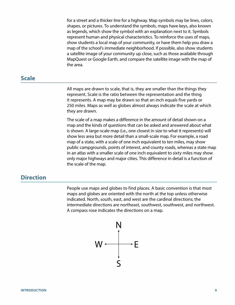
Direction
People use maps and globes to find places. A basic convention is that most maps and globes are oriented with the north at the top unless otherwise indicated. North, south, east, and west are the cardinal directions; the intermediate directions are northeast, southwest, southwest, and northwest. A compass rose indicates the directions on a map.
N
S
EW

10 GRADE 3 | UNIT 1 | WORLD RIVERS
The Equator, Poles, and Hemispheres
Earth rotates on its axis as it revolves around the sun. The North and South Poles are the points through which the axis passes; they are the northern- and southernmost points on Earth. These points are called Earth’s poles.
Because Earth is round, it cannot be seen completely at any one time. Even an astronaut looking down from space can see only half the world at once. Half the world is called a hemisphere, meaning half of a sphere. The northern part of Earth is called the Northern Hemisphere, and the southern part of the globe is called the Southern Hemisphere. But the world can also be looked at as having a Western Hemisphere and an Eastern Hemisphere. Any continent occupies portions of at least two hemispheres. For example, North America is in the Northern Hemisphere and also the Western Hemisphere. Europe falls within three hemispheres (Northern, Eastern, and Western) and Africa within all four.
Around the center of the Earth is an imaginary line called the equator. It is 0° latitude and is located halfway between the North and South Poles. The equator divides Earth into Northern and Southern Hemispheres. The dividing lines for the Eastern and Western Hemispheres are the prime meridian (also called the Greenwich meridian) and the 180th meridian. The prime meridian refers to 0° longitude, an imaginary line that runs from the North Pole to the South Pole going through the Royal Observatory in Greenwich, a suburb of London, England. The international date line also runs from the North Pole to the South Pole, generally following the 180th meridian (it deviates in a few places to avoid dividing Siberia and again to include the Aleutian Islands with Alaska). The prime meridian (0° longitude) and the 180th meridian are on opposite sides of Earth and together divide the globe into the Eastern (0° to 180° east of the prime meridian) and Western (0° to 180° west of the prime meridian) hemispheres.
Geographical Terms and Features
In Grades 1 and 2, students in Core Knowledge schools learn a variety of physical geography terms.
A peninsula is a piece of land sticking out into a body of water so that it is almost surrounded by water. Florida and Baja California are both peninsulas that jut out into water. The word peninsula comes from Latin: paene (almost) + insula (island). This etymology neatly captures the meaning of the term: a peninsula is almost an island.
A harbor is a part of a body of water that is next to land and provides a safe place for ships to anchor. It is an inlet along a coast. While there are natural harbors, today the term usually applies to an area in which ships can anchor or dock and that has facilities to load and unload passengers and cargo.
A bay is a small area of an ocean or a lake that creates an opening in the land. Some bays are large and deep enough to be used as ship harbors, such as San Francisco Bay and Galveston Bay.

11INTRODUCTION
An island is land completely surrounded by water. It is smaller than a continent, however, so Australia is not considered an island.
The coast is the land that runs along an ocean, bay, or gulf. It is also called the coastline or the shore. Continents have coasts, as do islands and peninsulas. America’s original thirteen colonies were mostly settled along the eastern coastline.
A valley is a low area of land surrounded by higher ground, such as hills or mountains. Some valleys have rivers or streams flowing along the length of the valley floor. The Tennessee River flows through a long valley.
A prairie is a large area of level or gently rolling grasslands. The Canadian plains are prairie, as are the Great Plains in the United States.
A desert is dry land that gets little moisture. Most deserts are rock- and stone-covered. Very few of the world’s deserts are sand. The Sahara in Africa is the world’s largest desert. The Mojave Desert in Southern California is home to Death Valley.
An oasis is an area of green in a desert. An oasis may be very small or thousands of square miles in area. Underground springs or streams flowing into a desert from a moister region provide water for the trees and grasses that grow and also water for humans and animals. Today, some countries are creating oases in the desert to claim land for habitation and cultivation. An example is Israel, which has built oases in the Negev.
As students study world and American history topics in Grade 3, they will be coming in contact with a number of terms that represent geographical features. Be sure to focus on the following terms in this grade:
A boundary is the edge of a country or of an area, its outside limit. It may also be called a border.
A channel is a body of water joining two larger bodies of water. The English Channel, which separates England from France, lies between the North Sea and the Atlantic Ocean.
A delta is land created by silt deposits at the mouth of a river. Cairo lies at the head, or beginning, of the Nile Delta, where it begins to fan out. The Nile Delta has rich, fertile soil.
An isthmus is a narrow strip of land between two bodies of water that joins two larger land areas. Panama is an isthmus that joins South America to North America; to its east is the Caribbean Sea, and to the west is the Pacific Ocean.
A plateau is a large area of high, flat ground. Other names for plateau are mesa and tableland. Plateaus are often found among mountains. The Mexican Plateau lies between the Sierra Madre Occidental and the Sierra Madre Oriental. It was in this area that the Aztec built their empire.
A reservoir is a lake created by people for the purpose of storing water. Stream runoff is caught and held for release into the water systems of communities, where people use the water for bathing, drinking, cooking, irrigating farms, and industry.

12 GRADE 3 | UNIT 1 | WORLD RIVERS
A strait is a narrow body of water that connects two large bodies of water. The Strait of Magellan joins the Atlantic and Pacific Oceans at the tip of South America.
Important World Rivers
The source of a river is the point where it begins—often in highland areas. The source of the Mississippi River is Lake Itasca, Minnesota, 1,463 feet above sea level. One of the sources of the Nile River is the Luvironza River above Lake Victoria (Victoria Nyanza) in Burundi. The Nile itself begins as water exits Lake Victoria near Ripon Falls.
The mouth of a river is the point where it empties into a larger body of water. The mouth of the Amazon River is on the Atlantic Ocean. Note also the term estuary, which is where the fresh water of a river meets the salt water of the sea.
A tributary is a river that flows into another river. The Mississippi River has more than 250 tributaries. Its main tributaries are the Missouri and Ohio Rivers.
A drainage basin is the area drained by a main river and other connected rivers.
The Amazon River has hundreds of tributaries, and together the river system drains 40 percent of South America, most of it through rainforest. The Mississippi River basin is some 1.2 million square miles of fertile farmland that stretches from the Appalachians to the Rockies.
Asian Rivers
Ob River
Origin: Russia (Siberia)
Empties Into: Estuary on the Arctic Ocean
Important Facts:
• World’s fourth-longest river
• Chief tributary: Irtysh River
• Frozen for half the year
• Major transportation route
• Major port: Novosibirsk
Yellow River (Huang He)
Origin: China (Kunlun Mountains in Tibet region) and flows east through China
Empties Into: Bo Hai, an arm of the Yellow Sea
Important Facts:
• Area of early Chinese civilization
• Historically, an important agricultural area

13INTRODUCTION
• Known as “China’s Sorrow” because of the destruction caused by its flooding
• Named because of the fertile yellow silt it carries as it flows east
• Created a delta known as the Great China Plain
• 50-year dam project begun in 1955 to harness water for electric power
Yangtze (Chang Jiang)
Origin: China (southwest)
Empties Into: East China Sea
Important Facts:
• Longest river in Asia
• Third-longest river in the world
• The river’s Three Gorges Dam is world’s largest dam and a world leader in hydroelectricity production
• Major route for commerce between east and west China
• Source of 40 percent of China’s electrical power
• Drains about 25 percent of China’s arable land
Ganges River
Origin: Himalayas
Empties Into: Joins Brahmaputra in Bangladesh and empties into Bay of Bengal
Important Facts:
• Flows through Gangetic Plain in India and Ganges delta in Bangladesh
• Holy river to Hindus
• Considered reincarnation of Hindu deity Ganga
• Important irrigation source for India and Bangladesh
Indus River
Origin: Tibet region of China
Empties Into: Joins five smaller rivers and empties into the Arabian Sea
Important Facts:
• Site of early Indus Valley civilization
• Flows through infertile delta of clay and mud

14 GRADE 3 | UNIT 1 | WORLD RIVERS
• Navigable only for small ships
• Used for irrigation and hydroelectric power
Tigris River
Origin: Taurus Mountains in Turkey
Empties Into: Joins with the Euphrates River to form the Shatt al-Arab, which flows into the Persian Gulf
Important Facts:
• With the longer Euphrates River, helped define and border Mesopotamia, historical region that gave rise to earliest western human civilizations
• Flows through huge flood plain as it nears the Persian Gulf
• Used for irrigation and hydroelectric power.
• Has changed course considerably as a result of human and natural forces
Euphrates River
Origin: Eastern Turkey
Empties Into: Joins with the Tigris River to form the Shatt al-Arab, which flows into the Persian Gulf
Important Facts:
• With the shorter Tigris River, helped define and border Mesopotamia, historical region that gave rise to earliest western human civilizations
• Used for irrigation and hydroelectric power
African Rivers
Nile River
Origin: Luvironza River in Burundi
Empties Into: Mediterranean Sea
Important Facts:
• Site of ancient Egyptian civilization
• World’s longest river
• Flows north
• White Nile and Blue Nile become the Nile proper at Khartoum, Sudan
• Creates huge delta at river mouth
• Used to flood annually; now dammed;
• Aswan Dam forms Lake Nasser, a huge reservoir in southern Egypt

15INTRODUCTION
Niger River
Origin: Central Guinea
Empties Into: Gulf of Guinea
Important Facts:
• Long, winding river
• Forms part of Niger’s southwest border with Benin
• Benue River, chief tributary
• Forms delta at mouth
• Interrupted in places by series of rapids
Congo River
Origin: Chambezi River, Zambia
Empties Into: Atlantic Ocean
Important Facts:
• Named after early African kingdom of Kongo
• World’s second-largest river in volume of water
• Long, winding river
• Important transportation route, although navigation is limited in some places by falls and rapids
• Setting of Joseph Conrad’s famous novella Heart of Darkness
South American Rivers
Amazon River
Origin: Junction of Ucayali and Marañón Rivers in northern Peru
Empties Into: Atlantic Ocean
Important Facts:
• Second-longest river in the world
• Hundreds of tributaries
• Largest volume of river water in the world
• Drainage basin for more than 40 percent of South America
• No waterfalls; navigable almost entire length
• Flows through world’s largest rainforest
• Empties through delta in northern Brazil

16 GRADE 3 | UNIT 1 | WORLD RIVERS
Paraná River
Origin: Junction of Paranaíba River and Rio Grande in southeast Brazil
Empties Into: Atlantic Ocean
Important Facts:
• Meets the Uruguay River to form, with other rivers, the Rio de la Plata estuary
• Paraguay River, largest tributary
• Major transportation route
• Source of hydroelectric power
• Second-largest drainage basin in South America
Orinoco River
Origin: Mt. Délgado Chalbaud in Guiana Highlands
Empties Into: Atlantic Ocean
Important Facts:
• Connected to Amazon River through a natural canal
• Navigability depends on seasonal rains
• Flows through large, marshy delta
North American Rivers
Mississippi River
Origin: Lake Itasca in Minnesota
Empties Into: Gulf of Mexico
Important Facts:
• With the Missouri, world’s third-longest river
• Tributaries: Minnesota, Missouri, Arkansas, Illinois, Ohio
• Drains plains between Rocky and Appalachian Mountains
• Highly destructive floods
• Forms a bird’s-foot-shaped delta of mixed salt marshes and forested swamp
• Memorably described in Mark Twain’s works, including Adventures of Huckleberry Finn and Life on the Mississippi

17INTRODUCTION
Mackenzie River
Origin: Great Slave Lake, Northwest Territories, Canada
Empties Into: Beaufort Sea (in the Arctic Ocean)
Important Facts:
• Navigable only June through October because of ice
• Flows through a largely uninhabited region
• Drains northern part of Great Plains
• Delta
Yukon River
Origin: Atlin Lake in British Columbia
Empties Into: Bering Sea
Important Facts:
• Flows through Canada and Alaska
• Navigable only July through September because of ice
• Potential for hydroelectric power
• Delta
• Gold discovered on a tributary in 1896, leading to the
• Gold discovered on a tributary in 1896, leading to the Klondike Gold Rush, in which many prospectors traveled hundreds of miles down the Yukon River in primitive boats
Australian Rivers
Murray River
Origin: Australian Alps near Mt. Kosciuszko
Empties Into: Indian Ocean
Important Facts:
• Tributaries: Darling, Murrumbidgee, Mitta Mitta
• With tributaries, drains 14 percent of continent
• Source of electric power and irrigation
Darling River
Origin: Eastern highlands; formed by Dumaresq and Macintyre Rivers
Empties Into: Indian Ocean after merging with the Murray River

18 GRADE 3 | UNIT 1 | WORLD RIVERS
Important Facts:
• Longest river in Australia
• Tributaries: Gwydir, Namoi, Castlereagh
• Source of irrigation
European Rivers
Volga River
Origin: Valday Hills near Moscow, Russia
Empties Into: Caspian Sea
Important Facts:
• Longest river in Europe
• Known as “Mother Volga”
• Immortalized in Igor Stravinsky’s “Song of the Volga Boatmen” and Ilya Repin’s painting of the Volga boatmen
• Shores dotted with old monasteries and churches
• Principal water transportation route in Russia
• Linked by canals to other rivers
• Source of hydroelectric power and irrigation
• Delta
Danube River
Origin: Formed by Brege and Brigach Rivers in Black Forest in southwest Germany
Empties Into: Black Sea
Important Facts:
• Important transportation route
• Flows through Budapest, Hungary
• Part of Rhine-Main-Danube Canal
• Linked by canals to other rivers
• Swampy delta
• Subject of a famous waltz by Johann Strauss, “Blue Danube”
Rhine River
Origin: Rheinwaldhorn glacier in the Swiss Alps
Empties Into: North Sea

19INTRODUCTION
Important Facts:
• Important commercial route
• German industrial cities along river include Bonn, Düsseldorf, and Cologne
• Flows past many old castles
• Linked by canals to other rivers
• Forms delta in the Netherlands
For more background information about the content taught in this unit, see:
www.coreknowledge.org/about-important-rivers-of-the-world
unit resources
Student Component
The World Rivers Student Reader—seven chapters. An atlas of maps showing the world rivers discussed in each chapter is included at the end of the Student Reader, immediately preceding the glossary.
Teacher Components
World Rivers Teacher Guide—seven chapters. This includes lessons aligned to each chapter of the World Rivers Student Reader with a daily Check For Understanding and Additional Activities, such as virtual field trips and map-related activities, designed to reinforce the unit content. A Unit Assessment, Performance Task Assessment, Activity Pages, and Nonfiction Excerpt are included at the end of this Teacher Guide in Teacher Resources, beginning on page 67.
• The Unit Assessment tests knowledge of the entire unit, using standard testing formats.
• The Performance Task Assessment requires students to apply and share the knowledge learned during the unit in map-related activities.
• The Activity Pages are designed to reinforce and extend content taught in specific chapters throughout the unit, as well as to provide opportunities to review and practice map-related skills. These optional activities are intended to provide choices for teachers.

20 GRADE 3 | UNIT 1 | WORLD RIVERS
usinG the teAcher Guide
Pacing Guide
The World Rivers unit is one of seven history and geography units in the Grade 3 Core Knowledge Curriculum Series™. A total of ten days have been allocated to the World Rivers unit. We recommend that you do not exceed this number of instructional days to ensure that you have sufficient instructional time to complete all Grade 3 units.
At the end of this Introduction, you will find a Sample Pacing Guide that provides guidance as to how you might select and use the various resources in this unit during the allotted time. However, there are many options and ways that you may choose to individualize this unit for your students, based on their interests and needs. So we have also provided you with a blank Pacing Guide that you may use to reflect the activity choices and pacing for your class. If you plan to create a customized pacing guide for your class, we strongly recommend that you preview this entire unit and create your pacing guide before teaching the first chapter.
Reading Aloud
In each chapter, the teacher or a student volunteer will read various sections of the text aloud. When you or a student reads aloud, always prompt students to follow along. By following along in this way, students become more focused on the text and may acquire a greater understanding of the content.
Turn and Talk
In the Guided Reading Supports section of each chapter, provide students with opportunities to discuss the questions in pairs or in groups. Discussion opportunities will allow students to more fully engage with the content and will bring “to life” the themes or topics being discussed.
Big Questions
At the beginning of each Teacher Guide chapter, you will find a Big Question, also found at the beginning of each Student Reader chapter. The Big Questions are provided to help establish the bigger concepts and to provide a general overview of the chapter. The Big Questions, by chapter, are:

21INTRODUCTION
Chapter Big Questions
1 Why are crops grown close to the Nile and Yellow Rivers?2 Why do so many people settle close to major rivers?3 What is the difference between the source and the mouth of
a river?4 What are the dangers boats face on rivers?5 How do rivers support wildlife?6 How do rapids and waterfalls affect river travel?7 Why are the Rhine, Danube, Volga, and Niger Rivers so important
to the countries they flow through?
Core Vocabulary
Domain-specific vocabulary, phrases, and idioms highlighted in each chapter of the Student Reader are listed at the beginning of each Teacher Guide chapter, in the order in which they appear in the Student Reader. Student Reader page numbers are also provided. The vocabulary, by chapter, is:
Chapter Vocabulary
1 river, riverbank, source, irrigation, silt, flow2 flood, dam, reservoir, source, delta, civilization, mouth3 drainage basin, orchard, vineyard, pasture4 “river pilot,” sandbar, current, tributary, swamp, wasteland,
thermometer5 piranha, humid, waterfall, Arctic Ocean, Northern Hemisphere,
migrate6 landlocked, rapids7 toll, “manufactured good,” network, canal
Activity Pages
The following activity pages can be found in Teacher Resources, pages 77–89. They are to be used with the chapter specified. Be sure to make sufficient copies for your students prior to conducting the activities.
• Chapter 1—World Map (AP 1.1)
• Chapter 1—Map Scale (AP 1.2)
• Chapter 1—Geographical Terms (AP 1.3)
• Chapters 1–7—Cool Facts About World Rivers (AP 1.4)
• Chapter 4—Domain Vocabulary: Chapters 1–4 (AP 4.1)
• Chapter 7—Domain Vocabulary: Chapters 5–7 (AP 7.1)
Activity Pages
22 GRADE 3 | UNIT 1 | WORLD RIVERS
Nonfiction Excerpts
The following nonfiction excerpt can be found in Teacher Resources, page 95. It may be used with the chapter specified either for additional class work or at the end of the unit as review and/or a culminating activity. Be sure to make sufficient copies for your students prior to conducting the activities.
Chapter 4—Excerpt from Mark Twain’s “Old Times on the Mississippi” (NFE 1)
Additional Activities and Website Links
An Additional Activities section, related to material in the Student Reader, may be found at the end of each chapter. You may choose from among the varied activities when conducting lessons. Many of the activities include website links, and you should check the links prior to using them in class.
books
Aloian, Molly. The Yangtze: China’s Majestic River, by Molly Aloian (Crabtree Publishing Company, 2010).
Berton, Pierre. The Klondike Question: A Photographic Essay 1897–1899, by Pierre Berton (Boston Mills Press, 2005).
Fowler, Allan, The Mississippi River, by Allan Fowler (Children’s Press, 2000).
Fowler, Allan. The Nile River, by Allan Fowler (Children’s Press, 2000).
Goode’s World Atlas 22nd Edition (Pearson, 2009).
Leavitt, Amie. The Rhine River, by Amie Leavitt (Mitchell Lane Publishers, 2012).
Lewin, Ted. Sacred River, by Ted Lewin (Houghton Mifflin, 1995).
Lewin, Ted, and Betsy. Top to Bottom: Down Under, by Ted and Betsy Lewin (Lee & Low Books, Inc., 2005).
Kids’ Beginner’s World Atlas (National Geographic, 2011).
Marx, Trish, and Karp, Cindy. Everglades Forever: Restoring America’s Great Wetland, by Trish Marx and Cindy Karp (Lee & Low Books, Inc., 2008).
Mora, Pat, and So, Meilo. Water Rolls, Water Rises: El Agua rueda, el agua sube, by Pat Mora and Meilo So (Children’s Book Press, an imprint of Lee & Low Books, Inc., 2014).
Miller, Gary G. The Tigris and Euphrates: Rivers of the Fertile Crescent, by Gary G. Miller (Crabtree Publishing Company, 2010).

23INTRODUCTION
Osborne, Mary Pope. Afternoon on the Amazon (Magic Tree House #6). New York: Random House, 1995.
Reynolds, Jan. Down Under (Vanishing Culture Series). Lee & Low Books, 2007.
Reynolds, Jan. Amazon Basin (Vanishing Culture Series). Lee & Low Books, 2007.
Watson, Galadriel. Angel Falls: The Highest Waterfall in the World. New York. Weigl Publishers, Inc., 2004.

24 GRADE 3 | UNIT 1 | WORLD RIVERS
World rivers sAmple pAcinG Guide
For schools using the Core Knowledge® Sequence and/or CKLA
TG–Teacher Guide; SR–Student Reader; AP–Activity Page; NFE–Nonfiction Excerpt
Week 1
Day 1 Day 2 Day 3 Day 4 Day 5
World Rivers
“World Geography”(TG—Chapter 1, Additional Activities, AP 1.1)
“Geographical Terms” and “Map Scale”(TG—Chapter 1, Additional Activities, AP 1.2–1.3)
“Rivers Bring Life to Farms and Cities” Core Lesson(TG & SR—Chapter 1, “Cool Facts About World Rivers” Additional Activities, AP 1.4)
“Rivers Make Our Lives Better” Core Lesson(TG & SR—Chapter 2, “Cool Facts About World Rivers” Additional Activities, AP 1.4)
“A River Viewed from Above” Core Lesson(TG & SR—Chapter 3, “Cool Facts About World Rivers” Additional Activities, AP 1.4)
CKLA
“Classification of Animals” “Classification of Animals” “Classification of Animals” “Classification of Animals” “Classification of Animals”
Week 2
Day 6 Day 7 Day 8 Day 9 Day 10
World Rivers
“Dangers and Navigation Along Rivers” Core Lesson(TG & SR—Chapter 4, “Cool Facts About World Rivers” Additional Activities, AP 1.4)
“Wildlife on Wild Rivers” Core Lesson(TG & SR—Chapter 5, “Cool Facts About World Rivers” Additional Activities, AP 1.4)
“Three Rivers and Many Waterfalls” Core Lesson(TG & SR—Chapter 6,“Cool Facts About World Rivers” Additional Activities, AP 1.4)
“Rivers and Trade” Core Lesson (TG & SR—Chapter 7, “Cool Facts About World Rivers” Additional Activities, AP 1.4)
World Rivers Unit Assessment(TG, pages 68–71)
CKLA
“Classification of Animals” “Classification of Animals” “Classification of Animals” “Classification of Animals” “Classification of Animals”

25INTRODUCTION
World rivers pAcinG Guide
‘s Class
(A total of ten days have been allocated to the World Rivers unit in order to complete all Grade 3 history and geography units in the Core Knowledge Curriculum SeriesTM.)
Week 1
Day 1 Day 2 Day 3 Day 4 Day 5
World Rivers
CKLA
Week 2
Day 6 Day 7 Day 8 Day 9 Day 10
World Rivers
CKLA

26 GRADE 3 | UNIT 1 | WORLD RIVERS
CHAPTER 1
Rivers Bring Life to Farms and CitiesThe Big Question: Why are crops grown close to the Nile and Yellow Rivers?
Primary Focus Objectives
✓ Measure straight-line distances on a map using a map scale. (RI.3.7)
✓ Use the maps in the atlas of the Student Reader to find geographic information. (RI.3.7)
✓ Describe two ways that rivers bring life to farms and cities. (RI.3.1, RI.3.2)
✓ Compare the Nile River and the Yellow River. (RI.3.3)
✓ Understand the meaning of the following domain-specific vocabulary: river, riverbank source, irrigation, silt, and flow. (RI.3.4)
What Teachers Need to Know
For more background information about the content taught in this lesson, see:
www.coreknowledge.org/about-important-rivers-of-the-world
Note: Prior to conducting this Core Lesson in which students read Chapter 1 in the World Rivers Student Reader, we strongly recommend that you first conduct the activities titled World Map (AP 1.1), Map Scale (AP 1.2), and Geographical Terms (AP 1.3), described at the end of this chapter under Additional Activities. The activity pages are found in Teacher Resources, pages 77–89). It is important to provide students with a review of basic map skills before beginning the study of world rivers.
Materials Needed
• Enlarged version of the activity page AP 1.1, found in Teacher Resources, pages 77–78
• colored pencils
Activity Pages
AP 1.1

27CHAPTER 1 | RIVERS BRING LIFE TO FARMS AND CITIES
Core Vocabulary (Student Reader page numbers listed below)
river, n. a body of moving or flowing water that follows a set path (2)Example: Cars drove across a bridge to get from one side of the river to the other side.Variation(s): rivers
riverbank, n. the land at the edge of a river (4)Example: Many trees and plants grew on the riverbank. Variation(s): riverbanks
source, n. a supply where an item such as water can be obtained (4)Example: The river was the town’s only source of drinking water.Variation(s): sources
irrigation, n. watering of crops by moving water from a well, a river, or a lake, to a place where it does not rain enough to grow crops (5)
Example: The farmer used irrigation to keep the corn plants in his field alive.Variation(s): irrigate
silt, n. tiny pieces of soil or earth carried by the water in a river (6)Example: The flood left behind a thick layer of silt on the ground.
flow, v. to move; water moves (or flows) downstream in a river (6)Example: I like to listen to the sound of the river as it flows over the rocks.Variation(s): flows, flowed, flowing
the core lesson 25 min
Introduce the World Rivers Student Reader 5 min
Distribute copies of the World Rivers Student Reader, and suggest students take a few minutes to look at the cover and flip through the Table of Contents and illustrations in the book. Ask students to identify images they notice as they browse; record this information in a list on the board or chart paper. Students may note features such as rivers, rapids, dams, boats, and farmland.
Explain to students that they will be reading about rivers, which play a central role in the history of humankind—and in the modern life of people around the world. Explain that rivers provided resources that made possible the development and success of the earliest civilizations. Rivers also provide resources that sustain life and economic activity today. For these reasons, rivers in many cultures have had spiritual and religious significance.

28 GRADE 3 | UNIT 1 | WORLD RIVERS
Introduce “Rivers Bring Life to Farms and Cities” 5 min
If you are able to display images from a computer, use the primary unit link www.coreknowledge.org/hgca-g3-world-rivers-activities to go to the Core Knowledge web page, where specific links to maps of the following cities may be found:
• Basra, Iraq (Tigris and Euphrates Rivers: Mesopotamia—Grade 1)
• Cairo, Egypt (Nile River: Ancient Egypt—Grade 1)
• Anyang, China (Yellow River: Early Asian Civilizations—Grade 2)
As you display each map and the related image(s), first help students identify the name of the country and continent depicted on the map, as well as the name of each river. After students have seen all of the maps and images, ask what geographic feature these cities have in common. If students are unsuccessful, or if you are unable to display images for the class, tell them that these cities, and many others, are located on a river or multiple rivers. Explain that because people need drinking water to survive, many of the world’s civilizations and cities sprang up along rivers. For those students in Core Knowledge schools, remind them that in Grades 1 and 2, they learned about important rivers around which ancient civilizations developed—the Tigris and Euphrates Rivers, around which Mesopotamia, the “cradle of Western civilization” grew; the Nile River, around which the ancient Egyptian civilization was established; and the Yellow River, around which early Asian civilizations were founded.
People continue to use rivers as a source of transportation. Call attention to the Big Question, and encourage students, as they read through the text, to look for reasons why crops are grown close to the Nile and Yangtze Rivers.
Guided Reading Supports for “Rivers Bring Life to Farms and Cities” 15 min
When you or a student reads aloud, always prompt students to follow along. By following along, students may acquire a greater understanding of the content. Remember to provide discussion opportunities.
“The Nile River,” Pages 2–5
Scaffold understanding as follows:
CORE VOCABULARY—Read the title of the first section, “The Nile River,” and discuss the meaning of the word river. Review the definition provided in the reader, and explain further the difference between a river and a lake, a body of standing water that does not move or flow from one direction to another along a path. Invite students to identify examples of rivers they have seen or are familiar with in their own environments.
29CHAPTER 1 | RIVERS BRING LIFE TO FARMS AND CITIES
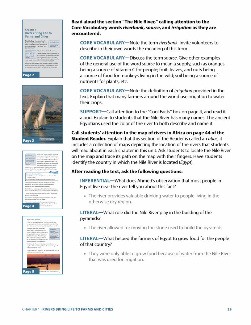
Read aloud the section “The Nile River,” calling attention to the Core Vocabulary words riverbank, source, and irrigation as they are encountered.
CORE VOCABULARY—Note the term riverbank. Invite volunteers to describe in their own words the meaning of this term.
CORE VOCABULARY—Discuss the term source. Give other examples of the general use of the word source to mean a supply, such as oranges being a source of vitamin C for people; fruit, leaves, and nuts being a source of food for monkeys living in the wild; soil being a source of nutrients for plants; etc.
CORE VOCABULARY—Note the definition of irrigation provided in the text. Explain that many farmers around the world use irrigation to water their crops.
SUPPORT—Call attention to the “Cool Facts” box on page 4, and read it aloud. Explain to students that the Nile River has many names. The ancient Egyptians used the color of the river to both describe and name it.
Call students’ attention to the map of rivers in Africa on page 44 of the Student Reader. Explain that this section of the Reader is called an atlas; it includes a collection of maps depicting the location of the rivers that students will read about in each chapter in this unit. Ask students to locate the Nile River on the map and trace its path on the map with their fingers. Have students identify the country in which the Nile River is located (Egypt).
After reading the text, ask the following questions:
INFERENTIAL—What does Ahmed’s observation that most people in Egypt live near the river tell you about this fact?
» The river provides valuable drinking water to people living in the otherwise dry region.
LITERAL—What role did the Nile River play in the building of the pyramids?
» The river allowed for moving the stone used to build the pyramids.
LITERAL—What helped the farmers of Egypt to grow food for the people of that country?
» They were only able to grow food because of water from the Nile River that was used for irrigation.
Chapter 1Rivers Bring Life to Farms and Cities The Nile River “Hey, over here!” A young boy waves to you with a smile. He invites you to join him on his small sailboat. “I can show you the Nile River!”
“Why should I see the Nile River?” you ask.
The boy can hardly believe anyone would ask
such a question. “The Nile is one of the great
rivers of the world. In fact, it’s the longest
river in Africa. It’s also the longest river in the
world, and the most important river in my country, Egypt!”
You look out across the Nile. There are boats of all kinds, large and
small. The hot sun shines on the water. A breeze would feel good.
So would a rain shower. Maybe it will be cooler out on the water.
2
The Big Question
Why are crops grown close to the Nile and Yellow Rivers?
Vocabulary
river, n. a body of moving or flowing water that follows a set path
G3_U1_Chap01_SE.indd 2 8/31/16 9:11 AM
Page 2
3
The Nile River flows through the heart of Cairo, Egypt’s capital.
G3_U1_Chap01_SE.indd 3 8/31/16 9:11 AM
Page 3
Cool Facts About the Nile River• The Nile River looks black when it floods because of the color of the
sediment it carries.
• Ancient Egyptians called the river Ar or Aur, which means “black.”
4
“OK, let’s go!” you say. Your new friend tells
you his name is Ahmed (/ah*med/). He is in
his early teens, and he earns money guiding
tourists on the Nile River. Together, the two
of you set off in Ahmed’s boat. After a few
minutes, you look back at the land. You see
trees lined up on the riverbank. Behind
the trees there is sand. It stretches as far as you can see into the
distance. The Nile River flows right through the Sahara, the largest
and one of the driest deserts in the world.
“Nearly everyone in my country lives close to the Nile River,”
Ahmed says. “It’s our main source of drinking water. It also
provides the water that farmers use to grow food.”
The Nile River is a wide and powerful river. It carries Ahmed’s boat as if
it were a feather. Suddenly you see something familiar in the distance.
“Do you see the Great Pyramids (/pihr*uh*mihdz/)?” Ahmed says,
pointing to them proudly.
You remember learning about the pyramids in first grade. Now
you decide to show off what you learned.
“Thousands of people worked for many years to build those
pyramids,” you say. “They brought huge blocks of stone to build
them. They used boats on this river to carry the stone.”
Vocabulary
riverbank, n. the land at the edge of a river
source, n. a supply where an item such as water can be obtained
G3_U1_Chap01_SE.indd 4 8/31/16 9:11 AM
Page 4
The Nile River provides valuable water used to irrigate farmers’ crops in the dry desert.
5
Ahmed nods in agreement.
It’s hot, and you’re getting thirsty. You think about all those
workers sweating in the fierce sun to build the pyramids. “What
did workers eat and drink out here in the desert?” you ask Ahmed.
“I think they drank water from the Nile,”
Ahmed replied. “Even though most of my
country is desert, farmers have always grown
plenty of food,” he explains. “After all, they
had to feed thousands of people living in
cities. But the only way they could do it in
this dry place was to use water from the Nile
River for irrigation (/ihr*uh*gae*shun/).
“For thousands of years, we have depended on the river for
irrigation of the farmers’ crops. We say the river’s water gives life
to the farmers’ thirsty crops.”
The sun is setting in a golden sky. You and Ahmed make plans to
visit the pyramids on another day.
Vocabulary
irrigation, n. watering of crops by moving water from a well, a river, or a lake, to a place where it does not rain enough to grow crops
G3_U1_Chap01_SE.indd 5 8/31/16 9:12 AM
Page 5

30 GRADE 3 | UNIT 1 | WORLD RIVERS
“Huang He: The Yellow River,” Pages 6–7
Scaffold understanding as follows:
CORE VOCABULARY—Read aloud the first paragraph of the section. Note the definition of the term silt and its role in the name of the Yellow River.
CORE VOCABULARY—Explain the meaning of the word flow. Invite volunteers to use this word in a sentence.
Have students read the remainder of the section to themselves.
SUPPORT—Call students’ attention to the map of rivers in Asia on page 48 of the Student Reader. Ask students to locate the Yellow River on the map and trace its path on the map with their fingers. Have students identify the country the Yellow River is located in (China).
After students finish reading the text, ask the following questions:
LITERAL—How did the Yellow River get its name?
» The water of the river appears yellow as a result of the silt suspended in the river water.
EVALUATIVE—What does the story of the young girl tell you about the role of the Yellow River in the lives of people living along its banks?
» The river is important for many reasons. It is used for irrigation so that rice plants grow. Many people, like this young girl’s family, sell rice as a way to make money and make a living.
check for understAndinG 5 min
Ask students to do one of the following:
• Turn and Talk—Ask a partner the answer to the Big Question, “Why are crops grown close to the Nile and Yellow Rivers?”
» Key points students should cite in their answers include: These rivers provide water necessary for the growth of crops. The closer crops are grown to the rivers, the easier it is to irrigate the crops with the river water.
• Choose one of the Core Vocabulary words (river, riverbank, source, irrigation, silt, or flow), and write a sentence using the word.
To wrap up the lesson, ask several students to share their responses.
6
Huang He: The Yellow River
Another river that brings water to farmers’ fields is what the
Chinese call Huang He (/hwang/hee/)—the Yellow River. This river
is in China on the continent of Asia, and its name comes from the
yellow color of its water. That color comes from the tons of silt
in the river.
Now imagine you are traveling on this
river. You see a young girl helping her
father in a rice field near the Yellow River.
You stop to ask the girl what she is doing.
“Why are you standing in this ditch?”
you ask.
“I’m clearing out the weeds and twigs so the water can get
through,” she answers.
“Why do you have to do this?” you ask.
“We clean out the ditches used for irrigation so the water from the
Yellow River can flow through them. The water brings life to our
rice field,” she answers.
“If we don’t put water on our rice plants in exactly the right way,”
she continues, “the rice won’t grow. If the rice doesn’t grow, my
family won’t have rice to sell. We will lose money. Then I may not
be able to get a new bicycle. That’s what I’m saving my money for.”
You smile at the girl. As you set off again down the river, you offer
words of encouragement.
“I hope the rice grows and you get that bicycle!”
Vocabulary
silt, n. tiny pieces of soil or earth carried by the water in a river
flow, v. to move; water moves (or flows) downstream in a river
G3_U1_Chap01_SE.indd 6 8/31/16 9:12 AM
Page 6
7
The Huang He, or Yellow River, gets its name from the color of its waters.
G3_U1_Chap01_SE.indd 7 8/31/16 9:12 AM
Page 7

31CHAPTER 1 | RIVERS BRING LIFE TO FARMS AND CITIES
Additional Activities
World Geography (RI.3.7) 30 min
Background for Teachers: Before beginning this activity, review “What Teachers Need to Know” on pages 4–9 of the Introduction.
This activity is best introduced prior to teaching the Chapter 1 Core Lesson, so it can serve as an introduction and reinforcement for students of the basics of world geography and map skills.
Materials Needed: Display copy and sufficient student copies of the World Map (AP 1.1), found in Teacher Resources, pages 77–78; colored pencils or markers; and sufficient rulers for all students
Display the enlarged World Map for all students to see, and distribute copies of World Map (AP 1.1), colored pencils or markers, and rulers. Encourage students to follow along with their copies of the world map as you highlight various features on the enlarged version. Point first to the compass rose, and review each of the cardinal directions—north, south, east, and west—relative to the map.
Point to the map scale on the map. Measuring straight-line distances using a map scale is a new skill for Grade 3 Core Knowledge students. Explain to them that the map scale is used to measure distances on a map. Explain to students that the scale shows how one inch on the map equals one thousand miles (1609 kilometers). Demonstrate how they can use a ruler to measure the number of inches between two points on the map. Then, explain how they can multiply the number of inches by one thousand to get the straight-line distance between those points.
Identify the equator on the map. Remind students that the equator marks the boundary between the Northern and Southern Hemispheres. Have students color the equator purple. Ask students to identify the continents that exist solely in the Northern Hemisphere (Europe, North America), and have students color these yellow. Ask students to identify the continents that exist solely in the Southern Hemisphere (Antarctica, Australia), and have students color them red. Have students identify the continents that appear in both the Northern and Southern hemispheres (South America, Asia, Africa), and have students color these orange.
Then point to the United States and the approximate location of the state in which your students live. Next, have students name their state and identify in general the part of the state in which their community is located, also naming their community. Have students draw a gray star on the state in which they live.
Activity Page
AP 1.1

32 GRADE 3 | UNIT 1 | WORLD RIVERS
Next, point to each of the continents in the following order, asking students to verbally identify each one: North America, South America, Antarctica, Australia, Asia, Africa, and Europe. Point out the symbols (lines) on each continent that indicate rivers. Have students color the rivers on the map light blue. Explain that over the next few days, they’ll be learning a great deal about the major world rivers.
Ask students to explain how the map shows the difference between land, such as the continents, and bodies of water, such as the oceans. Ask students to identify the earth’s four oceans (Pacific Ocean, Atlantic Ocean, Indian Ocean, and Arctic Ocean). Have students color each ocean dark blue. After identifying each ocean, point out that Panama is a part of North America. It is also an isthmus, or a small piece of land with water on both sides that connects two larger pieces of land. The isthmus of Panama separates the Pacific Ocean in the west from the Atlantic Ocean in the east. A canal, or a manmade waterway used for travel, crosses the isthmus of Panama and connects the two oceans. It is called the Panama Canal.
Call attention to the Bering Strait on the map. Explain to students that a strait is a small body of water that connects two larger bodies of water. Have students draw a black circle around the Bering Strait.
After you finish reviewing the map, point out the map key at the bottom of the page, noting that the only information included in the key shows that the symbols (lines) drawn on the continents are rivers. Explain to students that they can add more information to this map key using the colors they’ve added to the map. Demonstrate for students by drawing a map key on the enlarged version. A sample map key is provided below. Have students create their own map keys.
Bering Straitequator
river
ocean
home state
continents in the Southern Hemisphere
continents in the Northern Hemisphere
continents in both the Northern and Southern Hemispheres
Ask students to use the map to answer the questions that follow. You may choose to do this as a whole-class activity so that you can scaffold and provide assistance, or you may choose to have students work with partners or small groups. If students work with partners or small groups, be sure to review the answers to the questions with the whole class. If students are able to work more independently after the whole-group review, you might also consider assigning the AP 1.1 questions for homework.

33CHAPTER 1 | RIVERS BRING LIFE TO FARMS AND CITIES
Map Scale (RI.3.7) 15 min
Materials Needed: Sufficient student copies of the Map Scale (AP 1.2) found in Teacher Resources, pages 79–80
Distribute copies of Map Scale (AP 1.2). This activity may be used for additional practice with map scales. Review directions with students aloud. Students may work on the assignment independently, in partners, or in small groups. This activity may also be assigned as homework.
Geographical Terms (RI.3.4) 15 min
Materials Needed: Sufficient student copies of Geographical Terms (AP 1.3), found in Teacher Resources, page 81
Distribute copies of Geographical Terms (AP 1.3). This activity may be used for additional practice with or review of geographical terms. Review directions with students aloud. Students may work on the assignment independently, in partners, or in small groups. This activity may also be assigned as homework.
Cool Facts About World Rivers (RI.3.7) 20 min
Materials Needed: Sufficient copies of Cool Facts About World Rivers (AP 1.4), found in Teacher Resources, pages 82–87
Distribute copies of Cool Facts About World Rivers (AP 1.4). This activity should be assigned either later in the day or as homework as students complete each chapter. Students should use the activity page to document in writing what they have learned about each river. Some facts for the chart will be easy for students to find in their Readers. Other information requires additional research, and you can encourage students to use atlases and other resources while working on this activity. Students should concentrate on the sections about the Nile and Yellow Rivers when they complete the chart for the first time, after reading Chapter 1, and may fill in additional facts each time they return to this activity in later chapters.
Using an Atlas (RI.3.7) 30 min
Materials Needed: Student access to atlases or online sources of geographic information
Background for Teachers: You can use this activity as an extension of your introduction to “Rivers Bring Life to Farms and Cities,” in which you presented students with maps of several major cities located on rivers.
Activity Page
AP 1.2
Activity Page
AP 1.3
Activity Page
AP 1.4

34 GRADE 3 | UNIT 1 | WORLD RIVERS
Conduct Geographic Research
Direct students to use an atlas or online source of geographic information to identify an example of a city or town in their state that has grown up along a river. Suggest students use the atlas or online source to first identify a river in their state. Students can search for maps of their state that show rivers and other bodies of water. Assist students as needed to locate the symbols used to represent rivers.
Once students have identified the river or rivers in their state, direct them to identify a city or town that is located on the banks of the river. Again, assist students in finding maps that show cities or towns along with the rivers.
This activity may also be assigned as homework.
If you do not have access to a grade-appropriate print atlas, you may use the primary unit link, which will take you to the Core Knowledge web page, where links to student atlases may be found.
www.coreknowledge.org/hgca-g3-world-rivers-activities

35CHAPTER 2 | RIVERS MAKE OUR LIVES BETTER
CHAPTER 2
Rivers Make Our Lives Better The Big Question: Why do so many people settle close to major rivers?
Primary Focus Objectives
✓ Explain how dams can change rivers to improve people’s lives. (RI.3.1)
✓ Refer to a map and describe the locations of the Yangtze, Indus, and Ganges Rivers. (RI.3.1)
✓ Explain why the Ganges River is important to people in India. (RI.3.2)
✓ Understand the meaning of the following domain-specific vocabulary: flood, dam, reservoir, source, delta, civilization, and mouth. (RI.3.4)
Core Vocabulary (Student Reader page numbers listed below)
flood, n. what happens when a river overflows its banks (10)Example: The flood covered the fields with five feet of water. Variation(s): floods, flooding, flooded
dam, n. a structure that blocks a flowing river and allows water to fill in behind it (10)
Example: The dam on the river created a lake. Variation(s): dams
reservoir, n. a lake created by people for the purpose of storing water (11)Example: The reservoir supplied the whole city with drinking water. Variation(s): reservoirs
source, n. the starting point or beginning of a river’s water (11)Example: The river’s source was high in the mountains. Variation(s): sources
delta, n. land created by silt deposits at the mouth of a river (11)Example: Over time, many people settled on the river’s delta, where the soil was rich.Variation(s): deltas

36 GRADE 3 | UNIT 1 | WORLD RIVERS
civilization, n. a society, or group of people, with similar religious beliefs, customs, language, and form of government (11)
Example: A great civilization grew along the Nile River. Variation(s): civilizations
mouth, n. the place where a river empties into a sea or other large body of water (13)
Example: The boat sailed through the river’s mouth and into the sea.Variation(s): mouths
the core lesson 25 min
Introduce “Rivers Make Our Lives Better” 5 min
Ask students to recall the rivers they learned about in the previous chapter. What are the names of the rivers, and where are they located?
Ask students to turn to page 48 in the Reader, to the map titled Some Major Rivers of Asia. Ask students to locate and point to the following rivers, tracing their paths on the map with their fingers: Yangtze River, Indus River, and Ganges River. Point out that these three rivers are all located on the continent of Asia. Have students locate the countries through which the rivers flow: China, Pakistan, and India. Call attention to the Big Question, and encourage students, as they read the text, to look for reasons why people settle near major rivers.
Guided Reading Supports for “Rivers Make Our Lives Better” 20 min
When you or a student reads aloud, always prompt students to follow along. By following along, students may acquire a greater understanding of the content. Remember to provide discussion opportunities.
“Chang Jiang—The Yangtze River,” Pages 8–11
Read aloud the section “Chang Jiang—The Yangtze River,” calling attention to the Core Vocabulary words flood, dam, and reservoir as they are encountered.
Scaffold understanding as follows:
CORE VOCABULARY—Before reading the fourth paragraph aloud, preview the terms dam and floods. Read the definitions provided, and explain that these terms are related—people often build dams as a way of controlling and reducing floods.
SUPPORT—Explain that dams use special equipment to capture the energy of river water as it flows through openings in the dam. This energy is turned into electricity.
Chapter 2Rivers Make Our Lives BetterChang Jiang—The Yangtze River Whoosh! Your small boat is almost flying through crashing waters. You are on the Chang Jiang (/chang/jyang/), or Yangtze (/yang*see/) River, in China. The person in charge of your boat gives up trying to steer because the water is too wild.
“Oh no!” you shout. “Rocks ahead!” Everyone in the boat works hard
to keep the boat from tipping over. Then your little boat shoots out
like a cannonball fired from a cannon. Suddenly the boat slows down.
The river becomes calm and peaceful.
You have just gone through one of the famous gorges of the Yangtze
River, located on the continent of Asia. A gorge is a narrow space
between two cliffs or mountains.
8
The Big Question
Why do so many people settle close to major rivers?
G3_U1_Chap02_SE.indd 8 8/31/16 9:11 AM
Page 8

37CHAPTER 2 | RIVERS MAKE OUR LIVES BETTER
SUPPORT—Call attention to the “Cool Facts” box on page 10, and read it aloud. Explain that even though the river is very long, most of its path is through the mountains, not on flat land.
SUPPORT—After reading the entire section aloud, call students’ attention to the map of rivers in Asia on page 48 of the Student Reader. Ask students to again locate the Yangtze River on the map and trace its path on the map with their fingers.
After reading the text, ask the following questions:
CHALLENGE—What does the passage tell you about how a river’s water often passes through a gorge?
» The river often moves swiftly and wildly through a gorge.
LITERAL—What are three reasons given for the building of a great dam on the Yangtze River?
» The dam helps control flooding. It stores water for use by people and farmers. The dam also produces electricity.
EVALUATIVE—How does a dam help stop flooding?
» The dam allows for storage of water in a reservoir. The dam operators are able to control the flow of water through the dam, slowing it down when there is a large amount of water in the river.
“The Indus River” Pages 11–12
Read aloud the section “The Indus River,” calling attention to the Core Vocabulary words source, delta, and civilization as they are encountered.
Scaffold understanding as follows:
CORE VOCABULARY—In the first paragraph, call students’ attention to the term source, and explain that the word source used in this context specifically means the place where the water of a river starts. Remind students that they learned a more general definition of this term in Chapter 1 (a supply where an item such as water can be obtained), so the word source, like many words, can have different meanings depending on
9
The Yangtze River travels through many different types of terrain, including mountains and gorges.
G3_U1_Chap02_SE.indd 9 8/31/16 9:11 AM
Page 9
10
The Yangtze River is a mighty river. Like the Nile, it has supplied
people with water for thousands of years. But in history, the
Yangtze River has often caused floods.
Time and again, the raging river has
overflowed its banks. Floods have carried
away crops, animals, and even people. A
history of floods is one reason why China
built a great dam on the river.
Have you ever read about the Great Wall of
China? Well, the dam on the Yangtze River is sort of like the Great
Wall built in water. It’s as wide as twenty-two football fields. In fact,
it’s the largest dam in the world! It is called the Three Gorges Dam.
This huge dam holds back the mighty Yangtze River.
Vocabulary
flood, n. what happens when a river overflows its banks
dam, n. a structure that blocks a flowing river and allows water to fill in behind it
Cool Fact About the Yangtze RiverMore than 75 percent of the Yangtze River’s path winds through mountains in China.
G3_U1_Chap02_SE.indd 10 8/31/16 9:12 AM
Page 10
11
How do dams work? They slow and control
a river’s flow. The dam blocks much of a
river’s flowing water. It holds that water in
large reservoirs (/reh*zuh*vwarz/). The
reservoir behind the Three Gorges Dam is
four hundred miles long. Dam operators
let a little of this water flow out of the
reservoir slowly and steadily. As a result,
there are fewer floods.
Reservoirs also store water for drinking
and for irrigating crops. In addition, dams
use the power of flowing water to make
electricity. This source of power helps
many people and businesses in China.
The Indus River
Did you know that the Indus River is one of the longest rivers
in Asia? The river’s sources are in Tibet and India, and it flows
through Pakistan to its delta. In ancient times, people living along
the Indus River did not have computers or electricity. But they did
build a great civilization. The river helped them do this.
Some 4,500 years ago, people living near the Indus River in present-
day Pakistan built the city of Mohenjo-daro (/moe*hen*joe/dahr*oe/).
This well-planned city had many amazing buildings and spaces. One
of the most interesting is called the Great Bath. It was a pool about
half the size of a basketball court. It was made of brick. Water for the
Vocabulary
reservoir, n. a lake created by people for the purpose of storing water
source, n. the starting point or beginning of a river’s water
delta, n. land created by silt deposits at the mouth of a river
civilization, n. a society, or group of people, with similar religious beliefs, customs, language, and form of government
G3_U1_Chap02_SE.indd 11 8/31/16 9:12 AM
Page 11

38 GRADE 3 | UNIT 1 | WORLD RIVERS
the context. Remind students of the other examples of this general use of the word source to mean a supply that you discussed in Chapter 1, such as oranges being a source of vitamin C for people; fruit, leaves, and nuts being a source of food for monkeys living in the wild; soil being a source of nutrients for plants; etc. Point out the definition provided in the Student Reader in Chapter 2, and help students recognize the nuance of this other meaning.
CORE VOCABULARY—Point out the term delta in the first paragraph. After reading the definition, explain that some rivers—but not all rivers—form deltas.
CORE VOCABULARY—Note the term civilization, and ask a volunteer to read the definition provided. Remind students in Core Knowledge schools that they studied about early Asian civilizations that developed along the Indus River in Grade 2. Note to students that they will encounter the word civilization in different units and different grades of the Core Knowledge curriculum.
SUPPORT—After reading the entire section aloud, call students’ attention to the map of rivers in Asia on page 48 of the Student Reader. Ask students to again locate the Indus River on the map and trace its path on the map with their fingers.
After reading the text, ask the following questions:
LITERAL—Where are the sources for the Indus River?
» The river’s sources are in Tibet and India.
EVALUATIVE—How do you think the Indus River helped an ancient civilization grow?
» Possible answers: The river may have been a source of drinking water and also helped people grow food. The river may also have been used for transportation and may have allowed for trade with other civilizations.
CHALLENGE—What does the Great Bath tell you about the city of Mohenjo-daro?
» The Great Bath indicates that the builders of the city in ancient times were capable of building complex structures. They likely had wealth with which to build public places, like the Great Bath.
12
pool came from a well fed by the Indus River. The pool may have
been used for some kind of religious ceremony.
The Ganges River
To many people in India, which is located in Asia, the water of the
Ganges (/gan*jeez/) River is special. To followers of the Hindu religion,
the Ganges is a holy river. Poets have written poems and songs about
it. Sculptors have carved fountains and statues to honor it.
Many Indians call the Ganges River Mother Ganges. They use this
name because the river brings life to dry lands. Each year, the
dry season comes. It turns everything to dust. The Ganges River,
however, still has water in it.
Four thousand five hundred years ago, people living along the Indus River built the city of Mohenjo-daro, with its Great Bath.
G3_U1_Chap02_SE.indd 12 8/31/16 9:12 AM
Page 12

39CHAPTER 2 | RIVERS MAKE OUR LIVES BETTER
“The Ganges River,” Pages 12–13
Read the section aloud, calling attention to the vocabulary word mouth when you come to it in the third paragraph.
CORE VOCABULARY—Explain that the definition for mouth provided here is specific to geography and rivers. Invite students to offer examples of other meanings of the word.
SUPPORT—After reading the entire section aloud, call students’ attention to the map of rivers in Asia on page 48 of the Student Reader. Ask students to again locate the Ganges River on the map and trace its path on the map with their finger.
Then, ask the following questions:
LITERAL—Which group of people believes the Ganges River is sacred?
» The river is sacred to the followers of the Hindu religion in India.
LITERAL—Why do people call the Ganges “Mother Ganges”?
» The river gives life to dry lands and to the people in that area.
INFERENTIAL—What is found at the mouth of the Ganges?
» A delta is found at the mouth of the Ganges.
check for understAndinG 5 min
Ask students to do one of the following:
• Turn and Talk—Ask a partner the answer to the Big Question, “Why do so many people settle close to major rivers?”
» Key points students should cite include: Rivers help nourish the land and provide important resources to people.
• Choose one of the Core Vocabulary Words (flood, dam, reservoir, source, delta, civilization, or mouth), and write a sentence using the word.
To wrap up the lesson, ask several students to share their responses.
12
pool came from a well fed by the Indus River. The pool may have
been used for some kind of religious ceremony.
The Ganges River
To many people in India, which is located in Asia, the water of the
Ganges (/gan*jeez/) River is special. To followers of the Hindu religion,
the Ganges is a holy river. Poets have written poems and songs about
it. Sculptors have carved fountains and statues to honor it.
Many Indians call the Ganges River Mother Ganges. They use this
name because the river brings life to dry lands. Each year, the
dry season comes. It turns everything to dust. The Ganges River,
however, still has water in it.
Four thousand five hundred years ago, people living along the Indus River built the city of Mohenjo-daro, with its Great Bath.
G3_U1_Chap02_SE.indd 12 8/31/16 9:12 AM
Page 12
13
The river also brings life to the people in the
country of Bangladesh (/bang*la*desh/).
This is where the Ganges River’s mouth is
found. As the great river approaches its end
near the Indian Ocean, it breaks into many
small waterways. The water slows, and it drops the silt it has been
carrying. The silt piles up at the mouth of the Ganges and forms a
wedge of land called a delta.
Hindu pilgrims bathe in the Ganges River because they believe the water is holy.
Vocabulary
mouth, n. the place where a river empties into a sea or other large body of water
G3_U1_Chap02_SE.indd 13 8/31/16 9:13 AM
Page 13

40 GRADE 3 | UNIT 1 | WORLD RIVERS
Additional Activities
Cool Facts About World Rivers (RI.3.7) 30 min
Materials Needed: Sufficient copies of Cool Facts About World Rivers (AP 1.4), found in Teacher Resources, pages 82–87
Distribute copies of Cool Facts About World Rivers (AP 1.4). This activity should be assigned either later in the day or as homework as students complete each chapter. Students should use the activity page to document in writing what they have learned about each river. Some facts for the chart will be easy for students to find in their Readers. Other information requires additional research, and you can encourage students to use atlases and other resources while working on the activity. Students should concentrate on the sections about the Yangtze, Indus, and Ganges Rivers at the end of Chapter 2 but may add facts about other rivers each time they return to this activity.
Activity Page
AP 1.4

41CHAPTER 3 | A RIVER VIEWED FROM ABOVE
CHAPTER 3
A River Viewed from Above The Big Question: What is the difference between the source and the mouth of a river?
Primary Focus Objectives
✓ Describe the mouth and the source of a river. (RI.3.1)
✓ Refer to a map and identify the location of the Murray River. (RI.3.1)
✓ List at least two ways people use the Murray River. (RI.3.2)
✓ Understand the meaning of the following domain-specific vocabulary: drainage basin, orchard, vineyard, and pasture. (RI.3.4)
Core Vocabulary (Student Reader page numbers listed below)
drainage basin, n. the area drained by a main river and other connected rivers (16)
Example: The drainage basin for the river covered several states. Variation(s): drainage basins
orchard, n. an area where a large number of fruit trees have been planted (16)Example: The apple orchard covered the entire field. Variation(s): orchards
vineyard, n. an area where grapes are grown on plants called vines (18)Example: The vineyard produced a special type of grape. Variation(s): vineyards
pasture, n. land set aside for cows, horses, or other animals to feed off the natural grasses (18)
Example: Dozens of cows stood quietly in the pasture. Variation(s): pastures

42 GRADE 3 | UNIT 1 | WORLD RIVERS
the core lesson 25 min
Introduce “A River Viewed from Above ” 5 min
Ask students if they have ever looked down on the ground from a tall building, an airplane, or another elevated location, such as the top of a mountain. Have these students describe how things look on the ground from this higher view. (Things look smaller; you can see over a larger area, but you can’t see small details.) Tell students that in this lesson they will read about looking down on a big river from an airplane. What do they think a river might look like from the sky?
Call attention to the Big Question, and ask students to recall the definitions for the Core Vocabulary words source and mouth. Encourage students to think about the difference between these two parts of a river as they read the text.
Guided Reading Supports for “A River Viewed from Above” 20 min
When you or a student reads aloud, always prompt students to follow along. By following along, students may acquire a greater understanding of the content. Remember to provide discussion opportunities.
“The Murray River,” Pages 14–18
Read the section title, “The Murray River,” and the first sentence of the first paragraph aloud. Ask students to refer to the map of rivers in Australia on page 49 of the Student Reader. Ask them to locate the Murray River on the map and trace its path on the map with their fingers.
Read aloud the rest of the section “The Murray River,” calling attention to the Core Vocabulary words drainage basin, orchard, vineyard, and pasture as they are encountered.
Scaffold understanding as follows:
CORE VOCABULARY—Call attention to the term drainage basin on page 16 of the text. Help students understand that rivers “drain” the land, by collecting water that falls on the land in the form of rain or snow. Much of this water flows into rivers and then drains away.
CORE VOCABULARY—Explain the terms orchard on page 16 and vineyard on page 18 of the text. Have volunteers read the definitions provided. Ask students to explain the difference between these terms. (Orchards consist of trees, but vineyards only have grape vines.)
CORE VOCABULARY—In the last paragraph of the section on page 18, point out the word pasture. Direct students to visualize or imagine a green field filled with farm animals like sheep and cows.
Chapter 3A River Viewed from AboveThe Murray River The Murray River is the longest river in Australia. It is also a popular one for vacations. To really see this river, you need to be high up in the sky!
“Where do you want to start exploring the Murray River?” your
pilot asks.
“Start at the beginning, please,” you answer. “Let’s go to the source
of the river.” The source is the very beginning of a river. Often,
a river’s source is a tiny trickle of water hidden away in hills or
mountains.
14
The Big Question
What is the difference between the source and the mouth of a river?
G3_U1_Chap03_SE.indd 14 8/31/16 9:12 AM
Page 14
15
Mount Kosciuszko is the tallest mountain in Australia and part of the Great Dividing Range.
G3_U1_Chap03_SE.indd 15 8/31/16 9:12 AM
Page 15
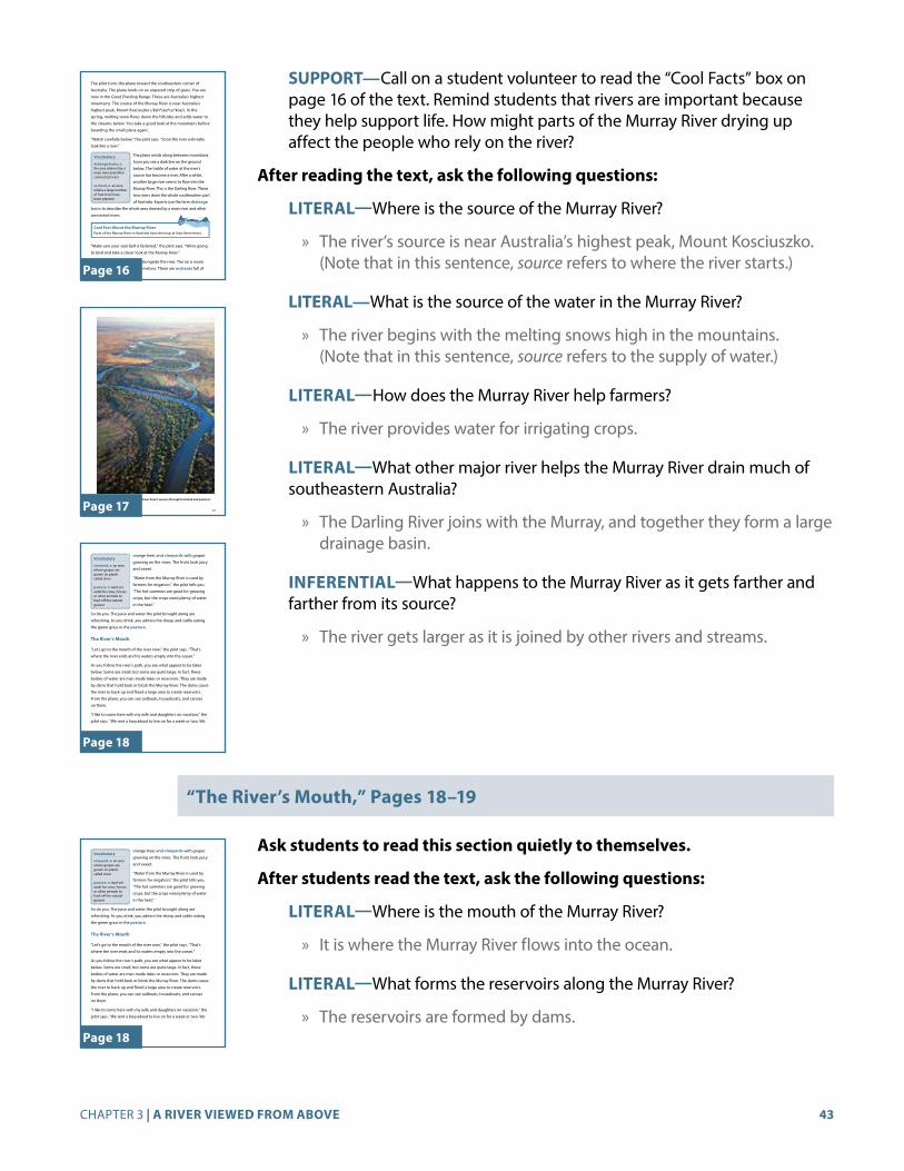
43CHAPTER 3 | A RIVER VIEWED FROM ABOVE
SUPPORT—Call on a student volunteer to read the “Cool Facts” box on page 16 of the text. Remind students that rivers are important because they help support life. How might parts of the Murray River drying up affect the people who rely on the river?
After reading the text, ask the following questions:
LITERAL—Where is the source of the Murray River?
» The river’s source is near Australia’s highest peak, Mount Kosciuszko. (Note that in this sentence, source refers to where the river starts.)
LITERAL—What is the source of the water in the Murray River?
» The river begins with the melting snows high in the mountains. (Note that in this sentence, source refers to the supply of water.)
LITERAL—How does the Murray River help farmers?
» The river provides water for irrigating crops.
LITERAL—What other major river helps the Murray River drain much of southeastern Australia?
» The Darling River joins with the Murray, and together they form a large drainage basin.
INFERENTIAL—What happens to the Murray River as it gets farther and farther from its source?
» The river gets larger as it is joined by other rivers and streams.
“The River’s Mouth,” Pages 18–19
Ask students to read this section quietly to themselves.
After students read the text, ask the following questions:
LITERAL—Where is the mouth of the Murray River?
» It is where the Murray River flows into the ocean.
LITERAL—What forms the reservoirs along the Murray River?
» The reservoirs are formed by dams.
16
The pilot turns the plane toward the southeastern corner of
Australia. The plane lands on an unpaved strip of grass. You are
now in the Great Dividing Range. These are Australia’s highest
mountains. The source of the Murray River is near Australia’s
highest peak, Mount Kosciuszko (/kah*zee*us*koe/). In the
spring, melting snow flows down the hillsides and adds water to
the streams below. You take a good look at the mountains before
boarding the small plane again.
“Watch carefully below,” the pilot says. “Soon the river will really
look like a river.”
The plane winds along between mountains.
Soon you see a dark line on the ground
below. The trickle of water at the river’s
source has become a river. After a while,
another large river seems to flow into the
Murray River. This is the Darling River. These
two rivers drain the whole southeastern part
of Australia. Experts use the term drainage
basin to describe the whole area drained by a main river and other
connected rivers.
Vocabulary
drainage basin, n. the area drained by a main river and other connected rivers
orchard, n. an area where a large number of fruit trees have been planted
“Make sure your seat belt is fastened,” the pilot says. “We’re going
to land and take a closer look at the Murray River.”
Now you are on the ground, alongside the river. The air is warm
and dry. You see fields full of melons. There are orchards full of
Cool Fact About the Murray RiverParts of the Murray River in Australia have dried up at least three times.
G3_U1_Chap03_SE.indd 16 8/31/16 9:12 AM
Page 16
17
An aerial view of the Murray River shows how it weaves through farmland and pastures.
G3_U1_Chap03_SE.indd 17 8/31/16 9:13 AM
Page 17
18
orange trees and vineyards with grapes
growing on the vines. The fruits look juicy
and sweet.
“Water from the Murray River is used by
farmers for irrigation,” the pilot tells you.
“The hot summers are good for growing
crops, but the crops need plenty of water
in the heat.”
So do you. The juice and water the pilot brought along are
refreshing. As you drink, you admire the sheep and cattle eating
the green grass in the pasture.
The River’s Mouth
“Let’s go to the mouth of the river now,” the pilot says. “That’s
where the river ends and its waters empty into the ocean.”
As you follow the river’s path, you see what appear to be lakes
below. Some are small, but some are quite large. In fact, these
bodies of water are man-made lakes or reservoirs. They are made
by dams that hold back or block the Murray River. The dams cause
the river to back up and flood a large area to create reservoirs.
From the plane, you can see sailboats, houseboats, and canoes
on them.
“I like to come here with my wife and daughters on vacation,” the
pilot says. “We rent a houseboat to live on for a week or two. We
Vocabulary
vineyard, n. an area where grapes are grown on plants called vines
pasture, n. land set aside for cows, horses, or other animals to feed off the natural grasses
G3_U1_Chap03_SE.indd 18 8/31/16 9:13 AM
Page 18

44 GRADE 3 | UNIT 1 | WORLD RIVERS
CHALLENGE—What do the types of boats on the reservoirs suggest about how people use the reservoirs?
» There are sailboats and canoes on the reservoirs. These types of boats are generally used for fun, not work. People use the reservoirs for recreation.
check for understAndinG 5 min
Ask students to do one of the following:
• Turn and Talk—Ask a partner the answer to the Big Question, “What is the difference between the source and the mouth of a river?”
» Key points students should cite in their answers include: The source is where the river begins to flow, and the mouth is where the river ends by opening into a larger body of water, such as an ocean.
• Choose one of the Core Vocabulary words (drainage basin, orchard, vineyard, or pasture), and write a sentence using the word.
To wrap up the lesson, ask several students to share their responses.
Additional Activities
Cool Facts About World Rivers (RI.3.7) 20 min
Materials Needed: Sufficient copies of Cool Facts About World Rivers (AP 1.4), found in Teacher Resources, pages 82–87
Distribute copies of Cool Facts About World Rivers (AP 1.4). This activity should be assigned either later in the day or as homework as students complete each chapter. Students should use the activity page to document in writing what they have learned about each river. Some facts for the chart will be easy for students to find in their Readers. Other information requires additional research, and you can encourage students to use atlases and other resources while working on the activity. Students should concentrate on the sections about the Murray and Darling Rivers at the end of Chapter 3 but may add facts about other rivers each time they return to this activity.
19
like to swim and fish. Sometimes we go to one of the nature parks
where we can see pelicans, kangaroos, and parrots.”
“Sounds cool!” you say. The pilot turns the plane toward home.
You sit back and relax as you fly high up in a beautiful clear sky.
Dams along the Murray River create reservoirs.
G3_U1_Chap03_SE.indd 19 8/31/16 9:14 AM
Page 19
Activity Page
AP 1.4

45CHAPTER 4 | DANGERS AND NAVIGATION ALONG RIVERS
CHAPTER 4
Dangers and Navigation Along RiversThe Big Question: What are the dangers boats face on rivers?
Primary Focus Objectives
✓ List three dangers that boat captains must look out for on rivers. (RI.3.1)
✓ Describe the dangers on the Mississippi River and the Ob River. (RI.3.1)
✓ Describe the locations of the Mississippi River and the Ob River. (RI.3.1)
✓ Understand the meaning of the following domain-specific vocabulary: sandbar, current, tributary, swamp, wasteland, and thermometer; and of the phrase “river pilot.” (RI.3.4)
Core Vocabulary (Student Reader page numbers listed below)
“river pilot,” (phrase), a person whose job is to guide boats safely on a river (20)
Example: The river pilot steered the boat safely away from the rocks in the river. Variation(s): river pilots
sandbar, n. a buildup of sand formed by the movement of flowing water (22)Example: If a boat hit a sandbar in the river, it might get stuck. Variation(s): sandbars
current, n. the ongoing movement of water, such as in a river (22)Example: The river’s current carried the boat downstream. Variation(s): currents
tributary, n. a stream or smaller river that flows into a larger river (22)Example: The stream was a tributary of the mighty Mississippi River. Variation(s): tributaries
swamp, n. a flat wooded area that is often flooded (25)Example: Alligators often live in or near swamps.Variation(s): swamps

46 GRADE 3 | UNIT 1 | WORLD RIVERS
wasteland, n. land that is not useful to people (25)Example: No people live in or near this part of the country, which is a wasteland that cannot be used. Variation(s): wastelands
thermometer, n. an object that measures the temperature of certain things, such as air or water (25)
Example: The thermometer showed that the water was very cold. Variation(s): thermometers
the core lesson 25 min
Introduce “Dangers and Navigation Along Rivers ” 5 min
Call attention to the title of the chapter, and read it out loud. Explain to students that to navigate means to travel—or plan how to travel—from one place to another.
For example, a captain navigates up and down the river on a boat. Ask students to imagine looking down at water in a swimming pool. Then have them imagine looking down at water in a river. How might the water in a pool look different than the water in a river? (The water in the river would be moving, but the water in the pool would be still if no one were in it. The water in the swimming pool would be clear, but you might not be able to see through the river water). Call attention to the Big Question, and encourage students to look for the different dangers that boats face as they navigate on rivers.
Guided Reading Supports for “Dangers and Navigation Along Rivers” 20 min
When you or a student reads aloud, always prompt students to follow along. By following along, students may acquire a greater understanding of the content. Remember to provide discussion opportunities.
“The Mississippi River,” Pages 20–24
Read aloud the title of this section, “The Mississippi River.” Ask students if they have heard of this river before. Students in Core Knowledge schools may recall learning about the Mississippi in Grade 2 when they studied westward expansion and/or the Battle of New Orleans during the War of 1812.
SUPPORT—Ask students to refer to the map of rivers in North America on page 45 of the Student Reader. Ask them to locate the Mississippi River on the map, identify the country in which it is located, and trace its path on the map with their fingers.
Chapter 4Dangers and Navigation Along RiversThe Mississippi River In the 1850s, a young man named Sam was learning to be a river pilot on the mighty Mississippi River, located in North America.
A river pilot steers boats around dangerous
places in a river. He brings people and cargo
safely to shore. If he makes a mistake, all may
be lost. It is a big responsibility. As Sam once
said, “Your true [river] pilot cares nothing
about anything on earth but the river, and his pride in his [job is
greater than] the pride of kings.”
Vocabulary
“river pilot,” (phrase), a person whose job is to guide boats safely on a river
20
The Big Question
What are the dangers boats face on rivers?
G3_U1_Chap04_SE.indd 20 8/31/16 9:12 AM
Page 20

47CHAPTER 4 | DANGERS AND NAVIGATION ALONG RIVERS
Read “The Mississippi River” aloud to the class. Call attention to the Core Vocabulary words “river pilot,” sandbar, current, and tributary as they are encountered.
Scaffold understanding as follows:
CORE VOCABULARY—Call attention to the first paragraph and the phrase “river pilot.” Note that this term is made up of two familiar words. Invite students to describe their understanding of the word pilot (someone who flies a plane), and explain that a river pilot is someone who directs or steers a boat.
CORE VOCABULARY—Call attention to the terms sandbar and current on page 22. After reading the definitions provided in the Student Reader, point out that sandbars are formed by currents.
CORE VOCABULARY—Call attention to the term tributary on page 22. Use the definition provided in the student reader to help students understand the meaning of this term.
SUPPORT—Have a student volunteer read the “Cool Facts” box on page 22 of the text. Explain that an Olympic-sized pool is fifty meters long, or about half the length of a football field, and two meters, or about six feet, deep. It takes over six hundred thousand gallons of water to fill a pool that size.
After reading the text, ask the following questions:
INFERENTIAL—Why is the job of the river pilot such a big responsibility?
» A mistake on a river can be disastrous, and there are many hazards that can cause a mistake.
LITERAL—What does the text mean when it says that the Mississippi River changes “hour by hour”?
» This statement refers to the way currents shift the surfaces and objects in the water. These changes can threaten the safe passage of boats.
INFERENTIAL—Why do you think Sam grew worried as the river pilots told him about their travels?
» He got worried because he realized how difficult it was to stay safe on the river.
CHALLENGE—Was Sam, the character described in this section, a real or fictitious (imaginary) person? How do you know?
» Sam was a real person. His name was Samuel Clemens. He wrote books using the name Mark Twain.
21
The mighty Mississippi River contains many hazards.
G3_U1_Chap04_SE.indd 21 8/31/16 9:13 AM
Page 21
22
Like many rivers, the Mississippi changes
hour by hour. A stretch that was safe
a week ago may be dangerous today.
Sandbars form and shift. The water
changes course. Currents roll logs over
and hide them under the surface. River
pilots have to watch out for signs of
trouble. Tiny ripples or a dark patch in
the water might hide a log or rock. These
things can cause a wreck. There is a lot for
river pilots to look out for!
The Mississippi has other rivers flowing into it. A river that flows
into a larger river is called a tributary (/trih*byue*tehr*ee/). Two
major tributaries of the Mississippi River are the Ohio River and
the Missouri River. At places where rivers join, waters can be very
tricky, and river pilots must be very careful.
Sam was helping out on a riverboat that carried a number of river
pilots as passengers. They were checking on the logs, sandbars,
and other dangers of the river. The pilots told each other about
Cool Fact About the Mississippi RiverIn 1927, the Mississippi River flooded. This historic flood moved enough water to fill twenty-six Olympic-size swimming pools every second.
Vocabulary
sandbar, n. a buildup of sand formed by the movement of flowing water
current, n. the ongoing movement of water, such as in a river
tributary, n. a stream or smaller river that flows into a larger river
G3_U1_Chap04_SE.indd 22 8/31/16 9:13 AM
Page 22
23
their own travels. They asked each other questions. Sam learned
a lot. But as the other pilots talked, Sam became more and more
worried. Years later he remembered how he had felt.
Sam’s full name was Samuel Langhorne Clemens. He wrote many
stories about his days on the river. When he wrote these stories, he
used the name Mark Twain.
Two of Mark Twain’s best-known books are The Adventures of Tom
Sawyer and The Adventures of Huckleberry Finn. These books are
both set on the Mississippi River. They tell of the river’s charm—
and dangers. They are still popular today.
In the 1800s, riverboats were a common sight on the Mississippi River.
G3_U1_Chap04_SE.indd 23 8/31/16 9:13 AM
Page 23
24
This scene from The Adventures of Tom Sawyer shows the characters Tom, Joe, and Huck on the Mississippi River.
G3_U1_Chap04_SE.indd 24 8/31/16 9:14 AM
Page 24

48 GRADE 3 | UNIT 1 | WORLD RIVERS
“The Ob River,” Page 25
Scaffold understanding as follows:
Read aloud the title of this section, “The Ob River.” Ask students to refer to the map of rivers in Asia on page 48 of the Student Reader. Ask them to locate the Ob River on the map and trace its path on the map with their fingers. Be sure students understand that the Ob River is on a different continent (Asia) than the Mississippi River (North America).
Invite student volunteers to read this section aloud as students follow along. Explain the following vocabulary words as they are encountered: swamps, wasteland, and thermometer.
CORE VOCABULARY—In the third paragraph of the section on page 25, pause to provide definitions of the terms swamps and wastelands. Note for students that swamps may be considered a kind of wasteland.
CORE VOCABULARY—In the last paragraph of the section, point out the term thermometer. After you read the definition provided, point out that this term is made up of two parts—thermo, which comes from a Greek word for heat, and meter, which means measure.
After students read the text, ask the following questions:
LITERAL—What is the greatest danger to boats on the Ob River?
» Ice is the greatest danger.
LITERAL—Why do river pilots on the Ob River have to keep a close eye on the calendar and thermometer?
» They must not plan to be on the river too late in the year, when freezing may occur.
check for understAndinG 5 min
Ask students to do one of the following:
• Turn and Talk—Ask a partner the answer to the Big Question, “What are the dangers boats face on rivers?”
» Key points students should cite in their answers include: sandbars, logs or other objects under the water, tricky currents, and ice.
• Choose one of the Core Vocabulary words (sandbar, current, tributary, swamp, wasteland, or thermometer), or the phrase “river pilot” and write a sentence using the word.
To wrap up the lesson, ask several students to share their responses.
25
The Ob River
You know that captains and pilots of boats face many dangers. In
some places the dangers include ice.
One example is the Ob (/ahb/) River in Asia. This river’s source is in
the mountains of central Asia near Mongolia.
The Ob River flows north for hundreds of miles. It passes through
swamps, forests, and vast wastelands of Siberia. Finally, the Ob
reaches its mouth at the Arctic Ocean.
As the river flows north, the climate changes. Temperatures begin
to drop below freezing. Ice forms on the river.
This ice creates the greatest danger along
the Ob River. Boats that hit a large piece
of ice can suffer serious damage. Winter
begins early and lingers late in the Arctic.
This means river pilots on the Ob must
keep a close eye on the calendar and on
the thermometer. If they launch their
boats too early in the spring or too late
in the fall, they may find huge ice blocks
jamming northern stretches of the river.
Because of the cold, ships can travel parts
of this river for only a few months out of the year.
Vocabulary
swamp, n. a flat wooded area that is often flooded
wasteland, n. land that is not useful to people
thermometer, n. an object that measures the temperature of certain things, such as air or water
G3_U1_Chap04_SE.indd 25 8/31/16 9:14 AM
Page 25

49CHAPTER 4 | DANGERS AND NAVIGATION ALONG RIVERS
Activity Page
AP 1.4
Activity Page
AP 4.1
Additional Activities
Cool Facts About World Rivers (RI.3.7) 20 min
Materials Needed: Sufficient copies of Cool Facts About World Rivers (AP 1.4), found in Teacher Resources, pages 82–87
Distribute copies of Cool Facts About World Rivers (AP 1.4). This activity should be assigned either later in the day or as homework as students complete each chapter. Students should use the activity page to document in writing what they have learned about each river. Some facts for the chart will be easy for students to find in their Readers. Other information requires additional research, and you can encourage students to use atlases and other resources while working on the activity. Students should concentrate on the sections about the Mississippi and Ob Rivers at the end of Chapter 4 but may add facts about other rivers each time they return to this activity.
Domain Vocabulary: Chapters 1–4 (RI.3.7) 30 min
Materials Needed: Sufficient copies of the Domain Vocabulary: Chapters 1–4 (AP 4.1), found in Teacher Resources, page 88
Distribute Domain Vocabulary: Chapters 1–4 (AP 4.1), and review directions as a class. Encourage students to use the glossary in their Student Readers if they need help.
You may choose to have students work in pairs to complete AP 4.1, or you may assign it for homework.
Challenge: Mark Twain and “Old Times on the Mississippi” (RI.3.2) 30 min
Materials Needed: Sufficient copies of nonfiction excerpt from Mark Twain’s “Old Times on the Mississippi” (NFE 1), found in Teacher Resources, page 95
Distribute nonfiction excerpt from Mark Twain’s “Old Times on the Mississippi” (NFE 1). Prior to reading this excerpt, tell students that understanding this passage may be challenging because of the very specific and sometimes old-fashioned vocabulary that is used. Read the passage aloud to students, modeling a close reading approach, stopping as needed to explain unusual vocabulary and to summarize each paragraph.
Words to help students define include the following:
1. Plum Point—a location on the Mississippi River
2. false point—a manmade place that appears on a map

50 GRADE 3 | UNIT 1 | WORLD RIVERS
3. reef—a piece of jagged rock or coral just beneath the water’s surface
4. quarter less twain—a unit of measure to determine the depth of water, equivalent to 10.5 feet
5. bend—places where the path of the river twists and turns instead of flowing in a straight line
6. stern—the back of a boat
7. cottonwood—a type of tree
8. mark twain—to mark two fathoms on the lead line (used to measure depth)
9. leadsmen—people responsible for monitoring the lead line and measuring depth
After you finish reading the passage, briefly discuss the following questions with the class:
1. How would you describe young Sam’s—or Mark Twain’s—feelings about the job of river pilot?
Twain is passionate about the job of a river pilot, but he also understands that it’s very challenging. A river pilot has to know more than just the river; he has to know all of the surroundings and places the boat passes through, as well.
2. What explains Twain’s feelings about what he is hearing?
Twain’s use of the phrase “running through my mind” shows that he is experiencing excitement and maybe a little bit of nervousness. He knows that he has a lot to learn to be successful as a river pilot.
3. What do you think Twain means when he writes about building a “warm personal acquaintanceship” with hazards in the river?
Twain means that it’s important for a river pilot to know all of the challenges he faces on the river. Understanding where the boat could possibly run into trouble could help a river pilot prevent an accident.
4. How would you summarize the job of river pilot as it is described here?
A river pilot is responsible for navigating a boat up or down the river. This means much more than just knowing which direction the river flows. River pilots have to know important landmarks as well as places where the boat might run into trouble.

51CHAPTER 5 | WILDLIFE ON WILD RIVERS
CHAPTER 5
Wildlife on Wild RiversThe Big Question: How do rivers support wildlife?
Primary Focus Objectives
✓ Explain how rivers provide good habitats for wildlife. (RI.3.1)
✓ Refer to a map and describe the locations and major features of the Amazon, Orinoco, and Mackenzie Rivers. (RI.3.1)
✓ Understand the meaning of the following domain-specific vocabulary: piranha, humid, waterfall, Arctic Ocean, Northern Hemisphere, and migrate. (RI.3.4)
Materials Needed
• Photographs of piranhas to show students
Core Vocabulary (Student Reader page numbers listed below)
piranha, n. type of flesh-eating fish of South America that lives in fresh water (26)Example: The piranha’s mouth is full of sharp teeth. Variation(s): piranhas
humid, adj. having a lot of moisture in the air (26)Example: The humid air made my skin feel damp and sticky. Variation(s): humidity
waterfall, n. a place where water flows over the edge of a cliff (31)Example: People traveled from long distances to view the great waterfall. Variation(s): waterfalls
Arctic Ocean, n. one of the four major oceans, located in the Northern Hemisphere. It is the smallest and shallowest of the world’s major oceans. (31)
Example: Ice is a major danger for ships on the Arctic Ocean.
Northern Hemisphere, n. the half of the earth located north of the equator (31)Example: The United States is located in the Northern Hemisphere.

52 GRADE 3 | UNIT 1 | WORLD RIVERS
27
Riverbanks of the Amazon River and its tributaries support very dense vegetation.
G3_U1_Chap05_SE.indd 27 8/31/16 9:13 AM
Page 27
Chapter 5Wildlife on Wild RiversThe Amazon River Your canoe slips silently through the darkness. Strange sounds come from all around. Something gently brushes your arm. You hope it is a leaf!
You are in Brazil in South America. You are paddling down a tributary
of the Amazon River. Your guide wants you to hear the rainforest
sounds at night.
You were nervous before starting the canoe trip. Other tourists had
gone swimming in the river during the day. They had joked about
piranhas in the water. One man had said that a school of these
small, fierce fish working together could eat
a human being in a couple of minutes. This
talk had made you nervous, and so you had
chosen to stay on the riverbank.
Now, however, you are glad you are in a
canoe. As you glide through the humid
darkness, the guide asks you to look up into
the thick trees. “You may not see much,” she says. “But the monkeys,
birds, and snakes can see you!”
Vocabulary
piranha, n. type of flesh-eating fish of South America that lives in fresh water
humid, adj. having a lot of moisture in the air
26
The Big Question
How do rivers support wildlife?
G3_U1_Chap05_SE.indd 26 8/31/16 9:13 AM
Page 26
migrate, n. to move to a different place (31)Example: Every year, the birds migrate to land farther south. Variation(s): migrating, migration
the core lesson 25 min
Introduce “Wildlife on Wild Rivers” 5 min
Ask students to recall what they’ve learned about the ways that rivers bring life to people living in cities and on farms. (Rivers provide water for drinking, irrigation, transportation, and recreation.) Explain that rivers also bring life to plants and animals by providing habitats (living places) where they can find food and water to survive. Call attention to the Big Question, and encourage students to look for ways rivers support wildlife as they read the text.
Guided Reading Supports for “Wildlife on Wild Rivers” 20 min
When you or a student reads aloud, always prompt students to follow along. By following along, students may acquire a greater understanding of the content. Remember to provide discussion opportunities.
“The Amazon River,” Pages 26–29
Read aloud the section title, “The Amazon River.” Ask students to refer to the map of rivers in South America on page 46 of the Student Reader. Ask them to locate the Amazon River on the map and trace its path on the map with their fingers. Identify the different countries through which the Amazon flows.
Read aloud the section “The Amazon River,” calling attention to the Core Vocabulary words piranhas and humid as they are encountered.
Scaffold understanding as follows:
CORE VOCABULARY—Call attention to the Core Vocabulary term piranhas on page 26. If possible, provide students with images of piranhas to give them a point of reference. Note that while some people in the story joke about the dangers of piranhas and the main character did not go swimming in the Amazon after hearing this, these fish usually do not pose a threat to humans.
CORE VOCABULARY—Call attention to the Core Vocabulary word humid on page 26. Explain to students that when the air is humid, there is moisture in the air and so the air feels moist. When the air is humid, it feels much heavier and can make the temperature feel warmer than it actually is.

53CHAPTER 5 | WILDLIFE ON WILD RIVERS
28
You know that although
the Amazon is the second
longest river in the world,
it carries more water than
any other river. You also
know that the lands along
the Amazon support
an amazing number of
animals, reptiles, and
insects. The Amazon is
their home. They live here
year-round.
This is a Brazilian Rainbow Boa.
The next day, you paddle the final stretch of the tributary.
Finally, you enter the Amazon River itself. You begin to see
more canoes and fishing boats. But mostly you see rainforest.
You also hear birds and insects chirping in the trees. In the
daytime, it is sunny and hot on the river. When you tie up
the canoe to explore, you find the forest refreshingly cool
and shady.
Dozens of rivers flow into the Amazon. You have learned that
the area into which a river’s tributaries drain is called a drainage
basin. The Amazon River has the world’s largest drainage basin.
In places on your journey, you see what appear to be two rivers
flowing side by side. This illusion is caused by the fact that some
Cool Fact About the Amazon RiverThe Amazon River has the world’s largest drainage basin, and the Amazon carries more water than any other river in the world.
G3_U1_Chap05_SE.indd 28 8/31/16 9:14 AM
Page 28
29
tributaries are different in color. This difference is caused by many
things including the presence of silt and decaying plants in the
water. When a tributary of one color enters the waters of another
color, it can take a while for the waters to mix.
The Orinoco River
After exploring the Amazon River, you set off to see the Orinoco
(/or*uh*noe*koe/) River. This river shares much in common with
the Amazon. It crosses the northern part of South America and
empties into the Atlantic Ocean. Many boats travel up and down
the river. You can find a boat tour with no problem.
As you travel along the Orinoco River, you see that the land to the
north is wild and beautiful. Venezuelans (/ven*uh*zway*lunz/)
This satellite photo shows the Amazon River and some of the larger tributaries in the Amazon’s drainage basin. There are many others that are too small to see.
G3_U1_Chap05_SE.indd 29 8/31/16 9:14 AM
Page 29
After reading the text, ask the following questions:
LITERAL—Where is the Amazon River located?
» The Amazon is on the continent of South America. It flows through several countries, including Brazil.
LITERAL—What animals does the guide say are watching from the trees along the banks of the river? Why can’t the people in the canoe see the animals?
» The guide says there are monkeys, birds, and snakes in the trees. The people can’t see them because it is nighttime and it is dark.
LITERAL—What interesting facts did you learn from the text about the Amazon and its great size?
» The Amazon is the second longest river in the world, and it carries more water than any other river. The Amazon and its tributaries form the world’s largest drainage basin.
LITERAL—Why does the Amazon River sometimes appear to be made up of two rivers flowing side by side?
» This effect happens when a tributary that has different-colored water first joins the Amazon. The colors appear separate before the two streams of flowing water have a chance to mix.
“The Orinoco River,” Pages 29–31
Scaffold understanding as follows:
Read aloud the section title, “The Orinoco River.” Ask students to refer to the map of rivers in South America on page 46 of the Student Reader. Ask them to locate the Orinoco River on the map and trace its path on the map with their fingers.
Ask a student volunteer to read this section aloud, as the other students follow along, pausing and explaining the vocabulary word waterfall when it is encountered.
CORE VOCABULARY—Call attention to the Core Vocabulary term waterfall in the last paragraph of the section. Invite a student volunteer to read the definition of the term. Direct students’ attention to the photograph on page 30 of Angel Falls, which is the tallest waterfall in the world.
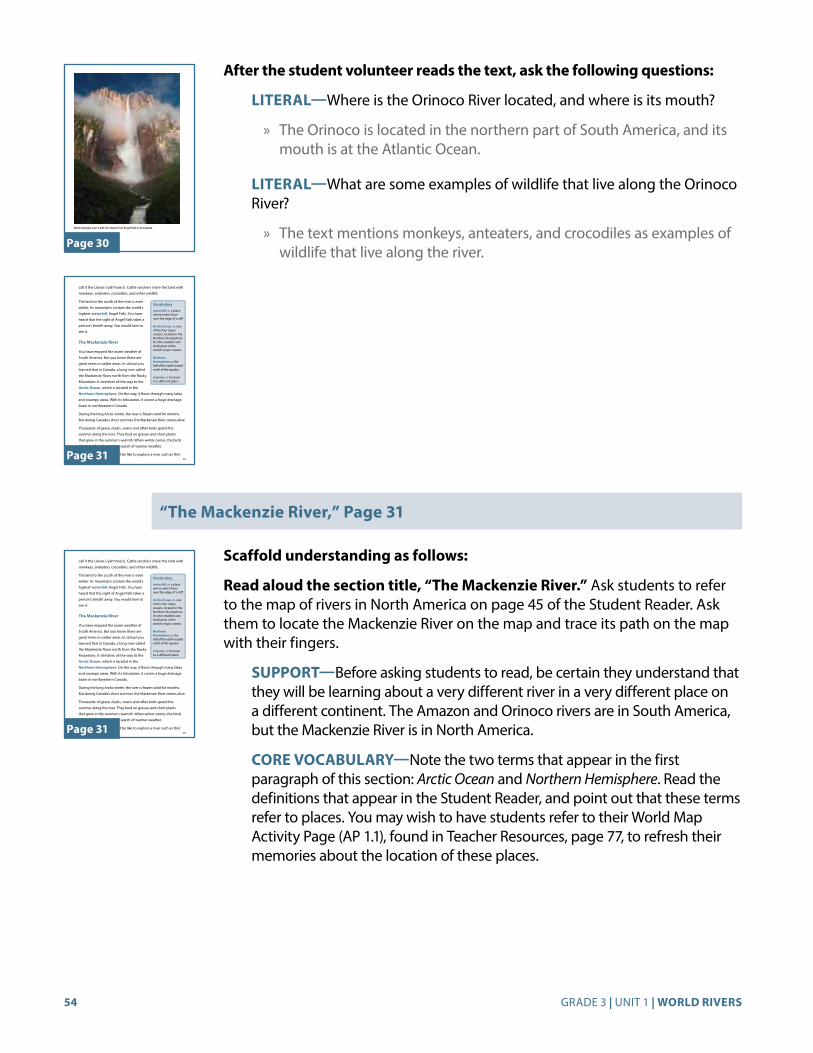
54 GRADE 3 | UNIT 1 | WORLD RIVERS
After the student volunteer reads the text, ask the following questions:
LITERAL—Where is the Orinoco River located, and where is its mouth?
» The Orinoco is located in the northern part of South America, and its mouth is at the Atlantic Ocean.
LITERAL—What are some examples of wildlife that live along the Orinoco River?
» The text mentions monkeys, anteaters, and crocodiles as examples of wildlife that live along the river.
“The Mackenzie River,” Page 31
Scaffold understanding as follows:
Read aloud the section title, “The Mackenzie River.” Ask students to refer to the map of rivers in North America on page 45 of the Student Reader. Ask them to locate the Mackenzie River on the map and trace its path on the map with their fingers.
SUPPORT—Before asking students to read, be certain they understand that they will be learning about a very different river in a very different place on a different continent. The Amazon and Orinoco rivers are in South America, but the Mackenzie River is in North America.
CORE VOCABULARY—Note the two terms that appear in the first paragraph of this section: Arctic Ocean and Northern Hemisphere. Read the definitions that appear in the Student Reader, and point out that these terms refer to places. You may wish to have students refer to their World Map Activity Page (AP 1.1), found in Teacher Resources, page 77, to refresh their memories about the location of these places.
30
Water plunges over 3,200 feet down from Angel Falls in Venezuela.
G3_U1_Chap05_SE.indd 30 8/31/16 9:15 AM
Page 30
31
call it the Llanos (/yah*noes/). Cattle ranchers share this land with
monkeys, anteaters, crocodiles, and other wildlife.
The land to the south of the river is even
wilder. Its mountains contain the world’s
highest waterfall, Angel Falls. You have
heard that the sight of Angel Falls takes a
person’s breath away. You would love to
see it.
The Mackenzie River
You have enjoyed the warm weather of
South America. But you know there are
great rivers in colder areas. In school you
learned that in Canada, a long river called
the Mackenzie flows north from the Rocky
Mountains. It stretches all the way to the
Arctic Ocean, which is located in the
Northern Hemisphere. On the way, it flows through many lakes
and swampy areas. With its tributaries, it covers a huge drainage
basin in northwestern Canada.
During the long Arctic winter, the river is frozen solid for months.
But during Canada’s short summer, the Mackenzie River comes alive.
Thousands of geese, ducks, swans and other birds spend the
summer along the river. They feed on grasses and short plants
that grow in the summer’s warmth. When winter comes, the birds
migrate. They fly south in search of warmer weather.
You wonder what it would be like to explore a river such as this!
Vocabulary
waterfall, n. a place where water flows over the edge of a cliff
Arctic Ocean, n. one of the four major oceans, located in the Northern Hemisphere. It is the smallest and shallowest of the world’s major oceans
Northern Hemisphere, n. the half of the earth located north of the equator
migrate, v. to move to a different place
G3_U1_Chap05_SE.indd 31 8/31/16 9:15 AM
Page 31

55CHAPTER 5 | WILDLIFE ON WILD RIVERS
Direct students to read the section quietly to themselves. Remind them to refer to the definitions in the vocabulary boxes if they do not understand the meaning of any of the vocabulary words.
After students read the text, ask the following questions:
LITERAL—Where is the Mackenzie River located, and where is its mouth?
» The Mackenzie River is located in the Northern Hemisphere, and it flows northward from the Rocky Mountains through Canada to its mouth at the Arctic Ocean.
EVALUATIVE—What does the section mean when it says that the Mackenzie River “comes alive” in the summer?
» During the short Canadian summer, the ice on the river melts, and thousands of geese, ducks, swans, and other birds come to the river.
LITERAL—What happens to the many birds that visit the Mackenzie River when summer is over?
» They migrate south, where the climate is warmer.
check for understAndinG 5 min
Ask students to do one of the following:
• Turn and Talk—Ask a partner the answer to the Big Question, “How do rivers support wildlife?”
» Key points students should cite in their answers include: Rivers provide a habitat for fish or other aquatic creatures. The trees that line the banks support many insects, birds, reptiles, and mammals. Some rivers, such as the Mackenzie River, provide only a temporary home for birds who must migrate after the summer.
• Choose one of the Core Vocabulary words (piranha, humid, waterfall, Arctic Ocean, Northern Hemisphere, or migrate), and write a sentence using the word.
To wrap up the lesson, ask several students to share their responses.

56 GRADE 3 | UNIT 1 | WORLD RIVERS
Additional Activities
Cool Facts About World Rivers (RI.3.7) 30 min
Materials Needed: Sufficient copies of Cool Facts About World Rivers (AP 1.4), found in Teacher Resources, pages 82–87
Distribute copies of Cool Facts About World Rivers (AP 1.4). This activity should be assigned either later in the day or as homework as students complete each chapter. Students should use the activity page to document in writing what they have learned about each river. Some facts for the chart will be easy for students to find in their Readers. Other information requires additional research, and you can encourage students to use atlases and other resources while working on the activity. Students should concentrate on the sections about the Amazon, Orinoco, and Mackenzie Rivers at the end of Chapter 5 but may add facts about other rivers each time they return to this activity.
Activity Page
AP 1.4

57CHAPTER 6 | THREE RIVERS AND MANY WATERFALLS
CHAPTER 6
Three Rivers and Many WaterfallsThe Big Question: How do rapids and waterfalls affect river travel?
Primary Focus Objectives
✓ Explain how waterfalls make river navigation difficult. (RI.3.1)
✓ Describe ways that boats can travel on rivers with waterfalls. (RI.3.1)
✓ Refer to maps and describe the locations of the Iguaçu, Paraná, Congo, and Yukon Rivers. (RI.3.1)
✓ Understand the meaning of the following domain-specific vocabulary: landlocked and rapids. (RI.3.4)
Core Vocabulary (Student Reader page numbers listed below)
landlocked, adj. cut off from the seacoast; surrounded by land (34)Example: The country is landlocked, without any access to the ocean or sea.
rapids, n. a place on a river where the water moves swiftly and violently (34)Example: The canoe bumped through the rapids at high speed.
the core lesson 25 min
Introduce “Three Rivers and Many Waterfalls” 5 min
Ask students to briefly summarize what they have learned about rivers so far. How do rivers support life for both humans and animals? What kinds of challenges and dangers might one encounter while trying to navigate different rivers?
Ask students to turn to page 30 in their Readers to examine the picture of Angel Falls in South America. Ask them to think about what causes a waterfall (a sudden drop in the river’s elevation). Call attention to the Big Question, and explain the meaning of the vocabulary word rapids; encourage students to look for ways rapids and waterfalls can affect river travel.

58 GRADE 3 | UNIT 1 | WORLD RIVERS
34
Iguaçu Falls is located in southern Brazil on the Iguaçu River
in South America. The Iguaçu River is a tributary of the
Paraná River. Of course, boats cannot go over the falls. But
at the river’s mouth on the Atlantic Ocean, large ships can
sail up the river. In fact, ships can
travel a full four hundred miles up
the Iguaçu. They can reach Paraguay
(/par*uh*gway/). This river traffic is
very important for Paraguay. You see,
Paraguay is a landlocked country. It has
no ocean coast. The river helps people
in Paraguay get goods to and from
other countries.
The Congo River
Now imagine a wide river in the middle of Africa. This river has
many small waterfalls and islands in it. This is the Congo River. It
rises from its source in central Africa. From there, it flows in a long
curve to the Atlantic Ocean.
Vocabulary
landlocked, adj. cut off from the seacoast; surrounded by land
rapids, n. place on a river where the water moves swiftly and violently
It is impossible for boats to travel too far on the Congo River.
Sooner or later they have to stop because of rapids, islands,
Cool Fact About the Congo RiverTigerfish in the Congo River often hunt in groups. They have very sharp teeth and sometimes eat large animals.
G3_U1_Chap06_SE.indd 34 8/31/16 9:14 AM
Page 34
Guided Reading Supports for “Three Rivers and Many Waterfalls” 20 min
When you or a student reads aloud, always prompt students to follow along. By following along, students may acquire a greater understanding of the content. Remember to provide discussion opportunities.
“The Iguaçu River,” Pages 32–34
Read aloud the section title, “The Iguaçu River.” Review with students the pronunciation of Iguaçu provided in the Student Reader.
SUPPORT—Ask students to refer to the map of rivers in South America on page 46 of the Student Reader. Ask them to locate the Iguaçu River on the map and trace its path on the map with their fingers. Also locate the Paraná River, and explain that the Iguaçu River is a tributary of the Paraná River.
Ask student volunteers to read the entire section aloud to the class while the other students follow along.
CORE VOCABULARY—After students read the section, call attention to the Core Vocabulary term landlocked on page 34. Break down the term into its two parts—land and locked. Discuss with the class how a piece of land can be “locked,” or sealed off, from access to open water.
Ask the following questions:
LITERAL—What is the location of the Iguaçu River? What are the river’s features?
» It is located in South America. It features Iguaçu Falls in southern Brazil. Its mouth is at the Atlantic Ocean, and ships are able to sail four hundred miles from that point, providing important ocean access to Paraguay. The Iguaçu River is a tributary of the Paraná River.
LITERAL—Can boats go over the Iguaçu Falls? Why or why not?
» Boats cannot go over the Iguaçu Falls. The water from the Iguaçu River flows over the cliff with tremendous force. A boat would be destroyed if it fell over the waterfall.
LITERAL—Why is the Iguaçu River so important to the people of Paraguay?
» The country is landlocked, so the river provides a means for ships to reach Paraguay to ship goods in and out of the country.
Chapter 6Three Rivers and Many WaterfallsThe Iguaçu River Imagine a waterfall so powerful that its water “boils with foam.” The water “hurls itself into space.” It then tumbles over a cliff and crashes below with enough force to shake the earth.
Such a waterfall really exists. It is called Iguaçu (/ee*gwuh*soo/) Falls,
and it is one of the biggest waterfalls in the world. Iguaçu Falls creates
huge clouds of mist that rise into the air. It looks like water is flowing
up to the sky!
32
The Big Question
How do rapids and waterfalls affect river travel?
G3_U1_Chap06_SE.indd 32 8/31/16 9:13 AM
Page 32
33
The Iguaçu Falls are almost three times wider than Niagara Falls.
G3_U1_Chap06_SE.indd 33 8/31/16 9:14 AM
Page 33

59CHAPTER 6 | THREE RIVERS AND MANY WATERFALLS
35
and other dangers. Today there is a railroad along the part of
the river where boats cannot pass. Boats pull over at one end
of the railroad. Their passengers and cargo are moved onto
trains. Then the trains carry everything to the other end of the
railroad. Everything is loaded onto other boats to continue
the journey.
The Yukon River
It is risky to ignore the danger of rivers! In 1897 thousands of
people learned this the hard way on the Yukon River in Canada,
located in North America.
Fish traps in the raging Congo River
G3_U1_Chap06_SE.indd 35 8/31/16 9:14 AM
Page 35
34
Iguaçu Falls is located in southern Brazil on the Iguaçu River
in South America. The Iguaçu River is a tributary of the
Paraná River. Of course, boats cannot go over the falls. But
at the river’s mouth on the Atlantic Ocean, large ships can
sail up the river. In fact, ships can
travel a full four hundred miles up
the Iguaçu. They can reach Paraguay
(/par*uh*gway/). This river traffic is
very important for Paraguay. You see,
Paraguay is a landlocked country. It has
no ocean coast. The river helps people
in Paraguay get goods to and from
other countries.
The Congo River
Now imagine a wide river in the middle of Africa. This river has
many small waterfalls and islands in it. This is the Congo River. It
rises from its source in central Africa. From there, it flows in a long
curve to the Atlantic Ocean.
Vocabulary
landlocked, adj. cut off from the seacoast; surrounded by land
rapids, n. place on a river where the water moves swiftly and violently
It is impossible for boats to travel too far on the Congo River.
Sooner or later they have to stop because of rapids, islands,
Cool Fact About the Congo RiverTigerfish in the Congo River often hunt in groups. They have very sharp teeth and sometimes eat large animals.
G3_U1_Chap06_SE.indd 34 8/31/16 9:14 AM
Page 34
35
and other dangers. Today there is a railroad along the part of
the river where boats cannot pass. Boats pull over at one end
of the railroad. Their passengers and cargo are moved onto
trains. Then the trains carry everything to the other end of the
railroad. Everything is loaded onto other boats to continue
the journey.
The Yukon River
It is risky to ignore the danger of rivers! In 1897 thousands of
people learned this the hard way on the Yukon River in Canada,
located in North America.
Fish traps in the raging Congo River
G3_U1_Chap06_SE.indd 35 8/31/16 9:14 AM
Page 35
“The Congo River,” Pages 34–35
Read aloud the section title, “The Congo River.” Ask students to refer to the map of rivers in Africa on page 44 of the Student Reader. Ask them to locate the Congo River on the map and trace its path on the map with their fingers.
Ask students to quietly read this section to themselves. Remind them to refer to the definition in the vocabulary box for rapids if they do not remember the meaning.
SUPPORT—Call attention to the “Cool Facts” box on page 34, and read it aloud. Ask students to think about why the tiger fish hunt in packs (because they’re not able to take down a large animal on their own).
After students read the text, ask the following questions:
LITERAL—Where is the Congo River located?
» It is in Central Africa.
LITERAL—Why is there a need for a railroad along parts of the Congo River?
» The river has rapids, islands, and other dangers that make it impossible for boats to travel the entire length of the river. The railroad allows people to use the river for shipping for those stretches that are safe for boats and to rely on the railroad when there are rapids.
“The Yukon River,” Pages 35–37
Read aloud the section title, “The Yukon River” and ask students to refer to the map of rivers in North America on page 45 of the Student Reader. Ask them to locate the Yukon River on the map and trace its path on the map with their fingers.
Direct students to read the section quietly to themselves.
After students read the text, ask the following questions:
INFERENTIAL—What effect did the possibility of finding gold in the Klondike region have on people in the late 1800s?
» People dreamed of getting rich. They went to the Klondike region, built boats, and sailed down the Yukon River without knowing anything about the dangers of the Yukon River.

60 GRADE 3 | UNIT 1 | WORLD RIVERS
LITERAL—How many boats attempted to sail down the Yukon River, and how many were destroyed?
» About 800 boats attempted the journey, and 150 of them were wrecked.
check for understAndinG 5 min
Ask students to do one of the following:
• Turn and Talk—Ask a partner the answer to the Big Question, “How do rapids and waterfalls affect river travel?”
» Key points students should cite in their answers include: Rapids and waterfalls may force people to seek alternative transportation—such as railroads. Rapids and waterfalls may destroy the boats of people who attempt to sail through or over them.
• Choose one of the Core Vocabulary words (landlocked or rapids), and write a sentence using the word.
To wrap up the lesson, ask several students to share their responses.
36
At first, the people were excited! They had heard that people
were finding gold in the Klondike. This is an area where the Yukon
River and the Klondike River meet. People rushed to the Klondike.
They hoped to find gold and get rich.
Few of these travelers knew much about the Klondike. They
didn’t know there were small waterfalls in the Yukon River.
They probably would not have cared, anyway. Their minds
were on one thing—gold! So, they hiked up mountain trails to
a lake near the source of the Yukon River. There they quickly
built simple boats to sail down the Yukon to the gold fields.
They used anything they could get their hands on to build
their boats.
At the end of May, some eight hundred boats headed down the
river. About 150 of them were wrecked on the way. Ten people
drowned. In their hurry, those seeking gold often put too many
people on their boats.
Nearly one hundred thousand people tried to follow the Yukon
River to the gold fields. Historians tell us that while many did find
some gold, not quite so many “struck it rich!”
G3_U1_Chap06_SE.indd 36 8/31/16 9:14 AM
Page 36
37
The Klondike River joins the Yukon River in what is today Dawson City in Canada.
G3_U1_Chap06_SE.indd 37 8/31/16 9:14 AM
Pge 37

61CHAPTER 6 | THREE RIVERS AND MANY WATERFALLS
Additional Activities
Cool Facts About World Rivers (RI.3.7) 30 min
Materials Needed: Sufficient copies of Cool Facts About World Rivers (AP 1.4), found in Teacher Resources, pages 82–87
Distribute copies of Cool Facts About World Rivers (AP 1.4). This activity should be assigned either later in the day or as homework as students complete each chapter. Students should use the activity page to document in writing what they have learned about each river. Some facts for the chart will be easy for students to find in their Readers. Other information requires additional research, and you can encourage students to use atlases and other resources while working on the activity. Students should concentrate on the sections about the Iguaçu, Paraná, Congo, and Yukon Rivers at the end of Chapter 6 but may add facts about other rivers each time they return to this activity.
Activity Page
AP 1.4

62 GRADE 3 | UNIT 1 | WORLD RIVERS
CHAPTER 7
Rivers and Trade The Big Question: Why are the Rhine, Danube, Volga and Niger Rivers so important to the countries they flow through?
Primary Focus Objectives
✓ Explain how rivers help people trade with each other. (RI.3.2)
✓ Refer to a map and describe the locations of the Rhine, Danube, Volga, and Niger Rivers. (RI.3.1)
✓ Understand the meaning of the following domain-specific vocabulary: toll, network, and canal; and of the phrase “manufactured good.” (RI.3.4)
Core Vocabulary (Student Reader page numbers listed below)
toll, n. money charged for use of a road or waterway (40)Example: River pilots were charged a toll for traveling on the river. Variation(s): tolls
“manufactured good,” (phrase), item made in large numbers for sale or trade (41)
Example: The country was known for producing a certain type of manufactured good. Variation(s): manufactured goods
network, n. a connected system such as roads or waterways (41)Example: The country’s trade was aided by its large network of roads. Variation(s): networks
canal, n. a channel dug by people, used by boats or for irrigation (41)Example: Workers finished the canal, which greatly increased the region’s trade. Variation(s): canals

63CHAPTER 7 | RIVERS AND TRADE
Chapter 7Rivers and TradeThe Rhine River Did you know that there really are castles like the ones in fairy tales? Many old castles stand along the rivers of Europe.
The Rhine River has many castles along its
banks. People built them for protection
against enemy attacks. A castle often has tall towers with windows
at the top. From there, a lookout could see an enemy coming from
far away.
38
The Big Question
Why are the Rhine, Danube, Volga, and Niger Rivers so important to the countries they flow through?
G3_U1_Chap07_SE.indd 38 8/31/16 9:11 AM
Page 38
39
The Rhine River flows past many castles.
G3_U1_Chap07_SE.indd 39 8/31/16 9:11 AM
Page 39
the core lesson 25 min
Introduce “Rivers and Trade” 5 min
Ask students to think about the last time they made a trade with some friends. Call on students to share their responses out loud. Students may trade snacks or parts of their lunches. Trade can happen when one good is given for another. It can also happen when money is given in exchange for a good. Explain to students that many rivers around the world are used for trade.
Call attention to the Big Question, and encourage students to look for reasons why the Rhine, Danube, Volga, and Niger Rivers are important to the countries they run through.
Guided Reading Supports for “Rivers and Trade” 20 min
When you or a student reads aloud, always prompt students to follow along. By following along, students may acquire a greater understanding of the content. Remember to provide discussion opportunities.
“The Rhine River” and “The Danube River,” Pages 38–40
Read the section titles on page 38, “The Rhine River,” and on page 40, “The Danube River.” Ask students to refer to the map of rivers in Europe on page 47 of the Student Reader. Ask them to first locate the Rhine River on the map and trace its path on the map with their fingers and then repeat the same procedure for the Danube River.
Ask student volunteers to read the section “The Rhine River” aloud, pausing when the vocabulary word toll is encountered.
CORE VOCABULARY—Call attention to the Core Vocabulary word toll on page 40 of the section “The Rhine River.” Point out to students that people often pay tolls in this country when they use certain types of highways or when crossing a bridge or using a tunnel.
Ask students to read the section “The Danube River” quietly to themselves.
SUPPORT—Call attention to the “Cool Fact” box on page 40, and read it aloud. Explain to students that the Danube River has been important to many different peoples across time.

64 GRADE 3 | UNIT 1 | WORLD RIVERS
41
Vocabulary
“manufactured good,” (phrase), item made in large numbers for sale or trade
network, n. a connected system such as roads or waterways
canal, n. a channel dug by people, used by boats or for irrigation
The Volga River
Far to the east of the Rhine and Danube
rivers is Russia’s most important river.
It is called the Volga River. Russian folk
songs call the Volga Beloved Mother. That’s
because so many people depend on it.
Russians use the Volga to deliver food,
coal, lumber, and manufactured goods.
The Volga flows into the Caspian Sea. It
does not flow directly into an ocean. A
network of rivers and canals links the
Cranes stand ready to load or unload cargo from ships on the Volga River.
G3_U1_Chap07_SE.indd 41 8/31/16 9:11 AM
Page 41
42
Volga to the Baltic Sea and to the Black Sea. From the Baltic Sea,
ships can reach the Atlantic Ocean. From the Black Sea, they
can sail to the Mediterranean Sea. The Volga helps Russia stay
connected by water with other countries.
The River Niger
Sometimes the cities on riverbanks reveal how important the
river is. The city of Timbuktu in the African nation of Mali is one
example. It is located along the Niger River.
Over five hundred years ago, Timbuktu was the capital of a
mighty African empire. It was also a great trading center. Its
bazaar (/buh*zahr/), or marketplace, was a busy place. The
shouts of buyers and sellers filled the air. Smelly camels strolled
the streets. Vendors sold salt, ivory, wooden statues, and
copper rings. The air smelled of sweet watermelons and grilled
fish and onions.
These and many other goods moved up and down the Niger River
on boats. Traders passed hippopotamuses bathing lazily in the
water. Nearby, fishing boats caught fish for market.
Even today, local marketplaces still depend on the Niger River.
People in Western Africa still use the river to carry goods. The
hustle and bustle of their marketplaces remind us that civilization
not only springs up, but still prospers by the riverside.
G3_U1_Chap07_SE.indd 42 8/31/16 9:11 AM
Page 42
After students read the text, ask the following questions:
INFERENTIAL—Where is the Rhine River’s mouth, and why do you think it is especially busy at this location?
» The Rhine River’s mouth is at the North Sea. This is a point where many ships enter the sea and also where many ships from the sea try to enter the river.
LITERAL—Where is the mouth of the Danube River?
» The river’s mouth is at the Black Sea.
EVALUATIVE—Why do you think the banks of the Rhine and Danube Rivers were good locations for castles?
» Rivers provided boat traffic for which castle owners could charge tolls. Rivers were also probably a common means for armies to travel, so having castles along the banks helped to stop enemy attacks at their source.
INFERENTIAL—Why did all the nations that use the Danube River agree not to interrupt use of the river for any reason?
» Possible answer: They knew that they all needed the river and that without agreeing to respect each other’s right to use the river there would be serious disagreements and perhaps even war.
“The Volga River,” Pages 41–42
Read aloud the title of the section, “The Volga River.” Ask students to refer to the map of rivers in Europe on page 47 of the Student Reader. Ask them to first locate the Volga River on the map and trace its path on the map with their fingers. Call attention to the fact that the Volga River is located in the country of Russia.
Read the entire section aloud, instructing students to follow along. Pause to explain the meaning of the following vocabulary words when they are encountered: “manufactured good,” network, and canals.
CORE VOCABULARY—Point out the phrase “manufactured goods” in the first paragraph of this section. Explain that many manufactured goods are made in factories.
CORE VOCABULARY—Note the terms network and canals in the second paragraph. Make clear that the network of waterways in Russia includes both rivers and canals.
After reading the text, ask the following questions:
LITERAL—Why is the Volga River called Beloved Mother?
» Many people depend on the river for many things.
40
Castles also have thick stone walls. These
made it hard for an enemy to break
through. Still, castles along the Rhine were
destroyed and rebuilt many times.
Building and owning a castle was not cheap! Castle owners
stopped boats on the river. They made boats pay a toll to pass
safely. The Rhine always had lots of traffic. Castle owners collected
a lot of money.
The Rhine is still busy today. In fact, it is one of the world’s busiest
rivers. This is especially true near the Rhine’s mouth at the North
Sea. Many cargo ships and passenger boats sail these waters.
Captains must be very careful.
The Danube River
You can also find castles along the Danube River. Both the Rhine
and the Danube have their sources in Central Europe. The Rhine
flows mainly toward the north. The Danube flows to the east.
It glides through valleys, forests, cities, and plains. Finally, it
reaches its mouth at the Black Sea.
The Danube touches seven countries. The river is so important
to these countries that their leaders long ago made a promise.
They agreed that everyone could use the river, even when their
countries disagree about other things.
Vocabulary
toll, n. money charged for use of a road or waterway
Cool Fact About the Danube RiverAncient Greek sailors conducted trade along the Danube River, and ancient Romans patrolled its waters.
G3_U1_Chap07_SE.indd 40 8/31/16 9:11 AM
Page 40

65CHAPTER 7 | RIVERS AND TRADE
42
Volga to the Baltic Sea and to the Black Sea. From the Baltic Sea,
ships can reach the Atlantic Ocean. From the Black Sea, they
can sail to the Mediterranean Sea. The Volga helps Russia stay
connected by water with other countries.
The River Niger
Sometimes the cities on riverbanks reveal how important the
river is. The city of Timbuktu in the African nation of Mali is one
example. It is located along the Niger River.
Over five hundred years ago, Timbuktu was the capital of a
mighty African empire. It was also a great trading center. Its
bazaar (/buh*zahr/), or marketplace, was a busy place. The
shouts of buyers and sellers filled the air. Smelly camels strolled
the streets. Vendors sold salt, ivory, wooden statues, and
copper rings. The air smelled of sweet watermelons and grilled
fish and onions.
These and many other goods moved up and down the Niger River
on boats. Traders passed hippopotamuses bathing lazily in the
water. Nearby, fishing boats caught fish for market.
Even today, local marketplaces still depend on the Niger River.
People in Western Africa still use the river to carry goods. The
hustle and bustle of their marketplaces remind us that civilization
not only springs up, but still prospers by the riverside.
G3_U1_Chap07_SE.indd 42 8/31/16 9:11 AM
Page 42
43
Even today, camels are a common sight on the streets of Timbuktu.
G3_U1_Chap07_SE.indd 43 8/31/16 9:12 AM
Page 43
INFERENTIAL—Based on this reading, what seems to be the most important use of the Volga River?
» The river seems to be especially important for the transportation of goods.
EVALUATIVE—Why did people in Russia see the need to connect the Volga with larger bodies of water, such as the Baltic and Black Seas?
» Only by building canals could river traffic have access to the different oceans and the rest of the world.
“The River Niger,” Pages 42–43
Read aloud the title of the section, “The River Niger.” Ask students to refer to the map of rivers in Africa on page 44 of the Student Reader. Ask them to first locate the Niger River on the map and trace its path on the map with their fingers. Be sure students understand the Niger River is located on a different continent (Africa) than the Rhine, Danube, and Volga Rivers (Europe).
Direct students to read the section quietly to themselves.
After students read the text, ask the following question:
LITERAL—How does the city of Timbuktu demonstrate the importance of the Niger River?
» Because of its location on the Niger River, Timbuktu became the center of a great African empire and a center for trade. The city remains an important trading center.
check for understAndinG 5 min
Ask students to do one of the following:
• Turn and Talk—Ask a partner the answer to the Big Question, “Why are the Rhine, Danube, Volga, and Niger Rivers so important to the countries they flow through?”
» Key points students should cite in their answers include: The rivers continue to support traffic and especially the movement of goods to and from markets.

66 GRADE 3 | UNIT 1 | WORLD RIVERS
• Choose one of the Core Vocabulary words (toll, network, or canal) or the phrase “manufactured good”, and write a sentence using the word.
To wrap up the lesson, ask several students to share their responses.
Additional Activities
Cool Facts About World Rivers (RI.3.7) 30 min
Materials Needed: Sufficient copies of Cool Facts About World Rivers (AP 1.4), found in Teacher Resources, pages 82–87
Distribute copies of Cool Facts About World Rivers (AP 1.4). This activity should be assigned either later in the day or as homework as students complete each chapter. Students should use the activity page to document in writing what they have learned about each river. Some facts for the chart will be easy for students to find in their Readers. Other information requires additional research, and you can encourage students to use atlases and other resources while working on the activity. Students should concentrate on the sections about the Rhine, Danube, Volga, and Niger Rivers at the end of Chapter 7 but may add facts about other rivers.
Domain Vocabulary: Chapters 5–7 (RI.3.7) 30 min
Materials Needed: Sufficient copies of the Domain Vocabulary: Chapters 5–7 (AP 7.1), found in Teacher Resources, page 89
Distribute Domain Vocabulary: 5–7 (AP 7.1), and review directions as a class. Encourage students to use the glossary in their Student Readers if they need help.
You may choose to have students work in pairs to complete AP 7.1, or you may assign it for homework.
Activity Page
AP 1.4
Activity Page
AP 7.1

67TEACHER RESOURCES
UNIT 1
Teacher ResourcesUnit Assessment: World Rivers 68
Performance Task: World Rivers 72
• Performance Task Activity: Rivers of the Western Hemisphere 73
• Performance Task Activity: Rivers of the Eastern Hemisphere 75
Activity Pages
• World Map (AP 1.1) 77
• Map Scale (AP 1.2) 79
• Geographical Terms (AP 1.3) 81
• Cool Facts About World Rivers: Chapters 1–7 (AP 1.4) 82
• Domain Vocabulary: Chapters 1–4 (AP 4.1) 88
• Domain Vocabulary: Chapters 5–7 (AP 7.1) 89
Answer Key: World Rivers 90
Nonfiction Excerpt
• Excerpt from Mark Twain’s “Old Times on the Mississippi” (NFE 1) 95

68 GRADE 3 | UNIT 1 | WORLD RIVERS
Name Date
Unit Assessment: World Rivers
Circle the letter of the best answer.
1. The Nile River is located on which continent?a) Europe
b) Africa
c) North America
d) Australia
2. Which of the following could you see from a boat on the Nile River?a) Angel Falls
b) many castles
c) a vast rainforest
d) ancient pyramids
3. The Yellow River takes its name from the a) silt that flows in the river.
b) deserts that surround the river.
c) brightly colored fish in the river.
d) pollution in the river.
4. A key feature that the Nile River and the Yellow River share is that they a) provide transportation to Europe.
b) provide irrigation to surrounding fields.
c) are famous for having large waterfalls.
d) are located in the same country.
5. On this river, people have built a great dam, in part because of the river’s long history of flooding.a) the Amazon River
b) the Ob River
c) the Yangtze River
d) the Mackenzie River
6. When a dam is built, which of the following things results?a) a waterfall
b) a gorge
c) a reservoir
d) a canal

69TEACHER RESOURCES
7. An unusual feature of the Ganges River is that it a) has a delta at its mouth.
b) is used for irrigation.
c) is considered holy by Hindu people.
d) has the world’s largest dam.
8. The Murray and Darling Rivers combine to form a a) drainage basin.
b) source.
c) mouth.
d) canal network.
9. For the Murray River, a small trickle of water near Mount Kosciuszko, high in the Australian mountains, is the location of the river’sa) mouth.
b) delta.
c) source.
d) tributary.
10. Being a river pilot on the Mississippi River is especially difficult becausea) there are many rapids in the river.
b) the river changes all the time.
c) the river is often frozen solid.
d) the river has very few tributaries.
11. Samuel Langhorne Clemens, or Mark Twain, wrote about these people. a) the merchants in riverside markets along the Niger River
b) the people who built castles along the Rhine and Danube Rivers
c) river pilots along the Mississippi River
d) the workers who built the pyramids along the Nile River
12. Special dangers in navigating the Ob River, which empties into the Arctic Ocean, area) powerful rapids.
b) shifting sandbars.
c) freezing temperatures and ice.
d) the waterfalls.
13. You might hear a warning about piranhas if you were taking a boat tour of this river in South America.a) the Amazon River
b) the Mackenzie River
c) the Rhine River
d) the Congo River

70 GRADE 3 | UNIT 1 | WORLD RIVERS
14. Which statement about the Amazon River is correct?a) It is the longest river in North America.
b) It carries the most water of any river in the world.
c) It is has the largest dam in Asia.
d) It has the largest waterfall of any river in the world.
15. The Amazon River flows through this type of surrounding environment. a) a frozen wasteland
b) a harsh desert
c) high mountains and deep gorges
d) a lush rainforest
16. A visitor to the Mackenzie River in the Northern Hemisphere might see this wildlife.a) piranhas
b) a hippopotamus
c) migrating birds
d) camels
17. Boats traveling on the Congo River switch their cargo to railroad cars to help avoid this type of danger on the river.a) flooding
b) rapids
c) dams
d) landlocked canals
18. The Yukon River played a big part in this era of history. a) the age of castles in Europe
b) the growth of ancient Asian civilization
c) the search for gold in the Klondike
d) the building of the Great Pyramid in Egypt
19. The Rhine River and the Danube River share this feature.a) They are both landlocked.
b) They both have their mouths at the Atlantic Ocean.
c) They both connect to the Baltic and Black Seas through canals.
d) They both have their source in the central part of Europe.
20. The River Niger was key to the growth of the a) city of Timbuktu in Africa.
b) Klondike gold rush in North America.
c) Hindu religion in Asia.
d) trade of Paraguay in South America.

71TEACHER RESOURCES
Match each term to its definition.
21. irrigation a) land created by silt deposits at the mouth of a river
22. tributary b) cut off from the seacoast; surrounded by land
23. civilization c) a channel dug by people that connects two bodies of water
24. sandbar d) watering of crops by moving water from a well, a river, or a lake to a place where it does not rain enough to grow crops
25. mouth e) a buildup of sand formed by the movement of flowing water
26. delta f) a stream or smaller river that flows into a larger river
27. migrate g) a place on a river where the water moves swiftly and violently
28. canal h) a society, or group of people, with similar religious beliefs, customs, language, and form of government
29. rapids i) the place where a river empties into a sea or other large body of water
30. landlocked j) to move to a different place

72 GRADE 3 | UNIT 1 | WORLD RIVERS
Performance Task: World Rivers
Rivers are a geographic feature that appear in all parts of the world, except Antarctica. Every continent on which human beings live and work has rivers that support their efforts.
Make sufficient copies of pages 73–76, “Rivers of the Eastern Hemisphere” and “Rivers of the Western Hemisphere,” for all students. Ask students to identify and answer questions about the major world rivers that they have learned about in this unit and in earlier geography units.

73TEACHER RESOURCES
Name Date
Performance Task Activity: Rivers of the Western Hemisphere
A
B
C
E
F
ARCTIC OCEAN
D
Equator
N
S
EW
0 500 miles
NORTH AMERICA
SOUTH AMERICA
ATLANTIC OCEANGulf of
Mexico
PACIFICOCEAN

74 GRADE 3 | UNIT 1 | WORLD RIVERS
Name Date
Performance Task Activity: Rivers of the Western Hemisphere, Continued
Use the map and what you have learned from the unit to answer the questions.
1. The letter ‘A’ on the map appears next to which river?
2. The letter ‘B’ on the map appears next to which river?
3. The letter ‘C’ on the map appears next to which river?
4. The letter ‘D’ on the map appears next to which river?
5. The letter ‘E’ on the map appears next to which river?
6. The letter ‘F’ on the map appears next to which river?
7. Which river has its mouth in the Arctic Ocean?
8. Which rivers have their mouths on the southern side of the equator?

75TEACHER RESOURCES
Name Date
Performance Task Activity: Rivers of the Eastern Hemisphere
A
I
B
H
G
C
F
D
N
S
EW
0 1,000 milesE

76 GRADE 3 | UNIT 1 | WORLD RIVERS
Name Date
Performance Task Activity: Rivers of the Eastern Hemisphere, Continued
Use the map and what you have learned from the unit to answer the questions.
1. The letter ‘A’ on the map appears next to which river?
2. The letter ‘B’ on the map appears next to which river?
3. The letter ‘C’ on the map appears next to which river?
4. The letter ‘D’ on the map appears next to which river?
5. The letter ‘E’ on the map appears next to which river?
6. The letter ‘F’ on the map appears next to which river?
7. The letter ‘G’ on the map appears next to which river?
8. The letter ‘H’ on the map appears next to which river?
9. The letter ‘I’ on the map appears next to which river?
10. This river has its source about 1,000 miles to the east of the source of the Indus River.
11. This river is on the same continent as the Murray River.
12. Of the rivers shown, which is the southernmost river that is not on the continent of Australia?
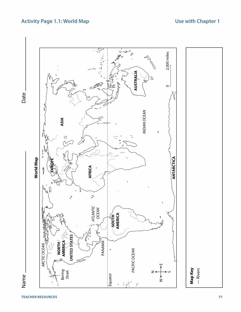
77TEACHER RESOURCES
Activity Page 1.1: World Map Use with Chapter 1
N S
EW
02,
000
mile
s
ATLA
NTI
C O
CEAN
PACI
FIC
OCE
AN
Equa
tor
PAN
AM
A
Berin
gSt
rait
IND
IAN
OCE
AN
ARCT
IC O
CEAN
AN
TARC
TICA
AU
STRA
LIA
NO
RTH
A
MER
ICA
SOU
TH
AM
ERIC
A
EURO
PE
ASI
A
AFR
ICA
UN
ITED
STA
TES
Wor
ld M
ap
Nam
e D
ate
Map
Key
— R
iver
s

78 GRADE 3 | UNIT 1 | WORLD RIVERS
Name Date
Activity Page 1.1: Continued Use with Chapter 1
Directions: Answer the following questions using the information found on the map.
1. On this map, describe the symbol in the map key that represents a river.
2. Suppose you wanted to sail from North America to Africa. Measure the shortest possible distance between these two places in inches. Then, use the scale to find out about how long the distance is in miles.
3. What continent is found directly south of Europe?
4. Which continents lie entirely in the Southern Hemisphere?
5. Which oceans does the equator pass through?
6. Which ocean is located between North America and Europe?
7. Which continents are located entirely in the Northern Hemisphere?
Directions: Fill in the blank with the correct Core Knowledge vocabulary word.
8. The is an imaginary east-west line that divides the globe in half.
9. An is a small piece of land with water on both sides that connects two
larger pieces of land.
10. A is a small body of water that connects two larger bodies of water.
CHALLENGE: What are the names of the continent, state, and town or community in which you live?

79TEACHER RESOURCES
Name Date
Activity Page 1.2: Map Scale Use with Chapter 1
Directions: Study the two maps, and answer the questions that follow. Then measure distances as indicated between two places, and compare your findings.
9
BACKB AY
FENS
NO RTHEASTE RNUNIVERSITYSIMMONS
C OLLEGE
SOUTHEND
90
Back St
Berkeley St
Marginal Rd
Marginal Rd
Fayette St
Melrose St
Warrenton
Exetert
RingRd.
Mas
on S
t
ugh St
N ewbury St
r S t
Trem
ont S
t
Stuart St
Elliot StPark PlazaLagrange St
Kn
Oak St
West
Te
Avery St
arles St
Arlington St
Charles St South
HeraldS t
Clarendon St
Dartm
outh St
Boylston St
Columbus A
v
Boylston St
mmonwealth Av
morial Dr
BOSTONCOMMON
PUBLICGARDENS
ArlingtonChurch
Library
WashingtonMonument
CHINBACKBAY
CentralCemetery
St James Av
0 0.5 miles0.25 miles
Map 1:Small Scale
Map 2:Large Scale
i
3
3
2
3
93
93
90 90
Unity
StHull St
H a v ila nd S t
DaltonS t
Back St
Arlington St
Charles St
Charles St South
Herald St
Clarendon St
Clarendo
Dartm
outh St
Bow
doin
St
Som
erse
t St
Sudbury St
Merrimac St
Lomasney W
y
Stan
iford
St
Causway St Washington St
New
Atlantic A
v
Congress St
Purchase St
Atlantic Av
Cross St
Cross St
Beacon St
Boylston St
Trem
ont S
t
hing
ton
Av
Broadway
Boylston St Essex StCongr
Cambrid
ge Pkw
y
Edwin
Land B
l
Bridge
harles River Dam
Dorc
hest
er A
v
Portland St
North St
School StBerkeley StExeter St
Massachusetts Av
Cambridge St
Commonwealth Av
l Dr
Memorial Dr
Main StMassachusetts Av
Commonwealth Av
Longfellow Bridge
Harvard Bridge
Storrow Memorial Dr.BOSTONCOMMON
NORTH END PARK
CHRISTOPHERCOLUMBUS PARK
PUBLICGARDENS
ED WARD J.S ENNOTT PARK
Charles River
Fort
Poin
t Cha
nnel
MassachusettsInstitute of
Technology
ARK M.I.
FEN WAYPARK
GranaryCemetery
ArlingtonChurch
Library
CentralCemetery
WashingtonMonument
CityHall
Fleet Center/North Station
CambridgeGalleria
Museum ofScience
HaydenPlanetarium
CHINATOWN
BEACONHILL
FENWAY
SOUTHBOSTON
NORTHEND
BOSTON
CAMBRIDGE
i
Pinckney St
Walnut S t
P ark
Mt. Vernon S t
C hestnut S t
Myrtle StCedar S t
R iver S t
B rimm
er S t
R evere S t
C ardinal O'connell
Gar
den
StIrv
ing
St
Joy
St
Han
cock
St
B lossom St
Fruit StParkman St
mba
nkm
ent R
d
Phillips St
Gro
ve S
tB eacon S t
C
Bow
doin
St
New
C
Wy
Sta n
i ford
St
C ambridge S t
Longfellow B ridge
BEACONHILL
BOS
BACKBAY
Nashua St
Columbus A
v
New Chardon St
Commercial St
0 1.0 miles0.5 miles
Beacon St
Congress St

80 GRADE 3 | UNIT 1 | WORLD RIVERS
Name Date
Activity Page 1.2: Continued Use with Chapter 1
Directions: Answer each question by writing LS for the larger-scale map or SS for the smaller-scale map.
1. Which map would you use to drive from South Boston to the North End?
2. Which map would you use to walk from the Library to the Washington Monument?
3. Which map would be more useful for getting on Interstate 93?
4. Which map would be more useful if you wanted to visit Cambridge?
5. Which map would be more useful to you if you wanted to explore the streets south of the Public
Gardens?
Use the scale/key for each map to make a ruler for each map on a separate sheet of paper. Label each ruler “larger-scale ruler” or “smaller-scale ruler.” Then use the rulers to estimate the distances in miles between the places listed. Assume that you must travel along roads and cannot cut through buildings. If the estimates from the two maps are not exactly the same, which one do you think is probably more accurate and why? Discuss with your class.
Map 1: Small Scale Map 2: Large Scale
Arlington Church to Washington Monument • •
Corner of Columbus Avenue and Berkeley Street to the corner of Commonwealth Avenue and Berkeley Street
• •
Arlington Church to Central Cemetery • •
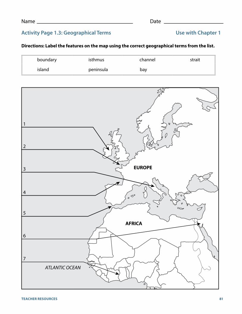
81TEACHER RESOURCES
Name Date
Activity Page 1.3: Geographical Terms Use with Chapter 1
Directions: Label the features on the map using the correct geographical terms from the list.
boundary isthmus channel strait
island peninsula bay
AFRICA
EUROPE
1
2
3
4
5
7
ATLANTIC OCEAN
6

82 GRADE 3 | UNIT 1 | WORLD RIVERS
Activity Page 1.4 Use with Chapters 1–7
Rive
r Nam
eCo
ntin
ent a
nd O
rigi
nEm
ptie
s In
toIm
port
ant F
acts
Am
azon
Riv
er
Cong
o Ri
ver
Dan
ube
Rive
r
Nam
e D
ate
Cool
Fac
ts A
bout
Wor
ld R
iver
s: C
hapt
ers 1
–7D
irec
tion
s: F
ill in
the
appr
opri
ate
cont
inen
t and
the
rest
of t
he c
olum
ns a
s yo
u st
udy
the
rive
rs o
f the
wor
ld.

83TEACHER RESOURCES
Activity Page 1.4: Continued Use with Chapters 1–7
Rive
r Nam
eCo
ntin
ent a
nd O
rigi
nEm
ptie
s In
toIm
port
ant F
acts
Dar
ling
Rive
r
Gan
ges
Rive
r
Indu
s Ri
ver
Nam
e D
ate
Cool
Fac
ts A
bout
Wor
ld R
iver
s: C
hapt
ers 1
–7D
irec
tion
s: F
ill in
the
appr
opri
ate
cont
inen
t and
the
rest
of t
he c
olum
ns a
s yo
u st
udy
the
rive
rs o
f the
wor
ld.
84 GRADE 3 | UNIT 1 | WORLD RIVERS
Activity Page 1.4: Continued Use with Chapters 1–7
Rive
r Nam
eCo
ntin
ent a
nd O
rigi
nEm
ptie
s In
toIm
port
ant F
acts
Mac
kenz
ie R
iver
Mis
siss
ippi
Riv
er
Mur
ray
Rive
r
Nam
e D
ate
Cool
Fac
ts A
bout
Wor
ld R
iver
s: C
hapt
ers 1
–7D
irec
tion
s: F
ill in
the
appr
opri
ate
cont
inen
t and
the
rest
of t
he c
olum
ns a
s yo
u st
udy
the
rive
rs o
f the
wor
ld.
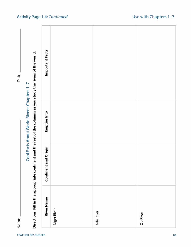
85TEACHER RESOURCES
Rive
r Nam
eCo
ntin
ent a
nd O
rigi
nEm
ptie
s In
toIm
port
ant F
acts
Mac
kenz
ie R
iver
Mis
siss
ippi
Riv
er
Mur
ray
Rive
r
Activity Page 1.4: Continued Use with Chapters 1–7
Rive
r Nam
eCo
ntin
ent a
nd O
rigi
nEm
ptie
s In
toIm
port
ant F
acts
Nig
er R
iver
Nile
Riv
er
Ob
Rive
r
Nam
e D
ate
Cool
Fac
ts A
bout
Wor
ld R
iver
s: C
hapt
ers 1
–7D
irec
tion
s: F
ill in
the
appr
opri
ate
cont
inen
t and
the
rest
of t
he c
olum
ns a
s yo
u st
udy
the
rive
rs o
f the
wor
ld.

86 GRADE 3 | UNIT 1 | WORLD RIVERS
Activity Page 1.4: Continued Use with Chapters 1–7
Rive
r Nam
eCo
ntin
ent a
nd O
rigi
nEm
ptie
s In
toIm
port
ant F
acts
Orin
oco
Rive
r
Para
ná R
iver
Rhin
e Ri
ver
Nam
e D
ate
Cool
Fac
ts A
bout
Wor
ld R
iver
s: C
hapt
ers 1
–7D
irec
tion
s: F
ill in
the
appr
opri
ate
cont
inen
t and
the
rest
of t
he c
olum
ns a
s yo
u st
udy
the
rive
rs o
f the
wor
ld.
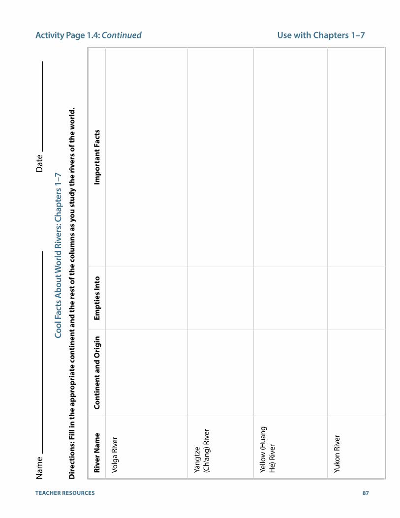
87TEACHER RESOURCES
Activity Page 1.4: Continued Use with Chapters 1–7
Rive
r Nam
eCo
ntin
ent a
nd O
rigi
nEm
ptie
s In
toIm
port
ant F
acts
Volg
a Ri
ver
Yang
tze
(Ch’
ang)
Riv
er
Yello
w (H
uang
H
e) R
iver
Yu
kon
Rive
r
Nam
e D
ate
Cool
Fac
ts A
bout
Wor
ld R
iver
s: C
hapt
ers 1
–7D
irec
tion
s: F
ill in
the
appr
opri
ate
cont
inen
t and
the
rest
of t
he c
olum
ns a
s yo
u st
udy
the
rive
rs o
f the
wor
ld.

88 GRADE 3 | UNIT 1 | WORLD RIVERS
Name Date
Domain Vocabulary: Chapters 1–4 (AP 4.1) Use with Chapter 4Note: This activity refers to content in Chapters 1–4.
Directions: Circle the correct term from the options presented to complete each sentence.
Example: The people used the river as a form of to get from one place to another.
energy transportation food
1. The river’s was at the ocean, where the water flowed into the bay.
mouth dam sandbar
2. The river’s was high in the mountains, where winter snows melted in the spring.
flow source delta
3. The largest river and several other connective rivers formed a that carried water away from a large part of the country.
pasture drainage basin river pilot
4. The river’s water had a yellow color because of the that it carried.
orchard drainage basin silt
5. The small flowed into the larger river.
pasture tributary riverbank
6. The farmers used the river to provide for their crops.
irrigation reservoir thermometer
7. Silt deposits at the mouth of the river formed a triangular shape called a .
vineyard wasteland delta
8. The small town drank water held in the local .
flood source reservoir
9. The river made it possible for a great to develop thousands of years ago.
pasture civilization sandbar
10. The people depended on the river as a of drinking water.
source dam delta

89TEACHER RESOURCES
Name Date
Domain Vocabulary: Chapters 5–7 (AP 7.1) Use with Chapter 7Note: This activity refers to content in Chapters 5–7.
Use the words in the Word Bank to answer each riddle.
Northern Hemisphere rapids landlocked network
piranha canal Arctic Ocean waterfall
manufactured goods humid toll migrate
1. The birds are happy they get to do this when the weather gets cold. What is it?
2. We’re building one of these to connect the river to the ocean. What is it?
3. We ship these down the river on boats after they are made at the factory. What are they?
4. The only way people in this country can reach the ocean is by sailing down a river. How would you
describe this country?
5. This is a place where the river is wild and fast-moving. What do you call it?
6. The people were talking about these, which can strip the flesh off an animal in just a few minutes.
What are they?
7. This is the part of Earth that lies to the north of the equator. What is it?
8. The five rivers and two canals form one of these. What is it?
9. The people who owned castles collected this from boats that passed by. What is it?
10. The air is very hot, thick, and sticky, and it feels like it’s about to rain. What would you call the air?
11. At the place, the water flows over the cliff and tumbles hundreds of feet to the rocks below. What
is this place?
12. This is the smallest and shallowest of its type, and it has a lot of ice in it. What is it?

90 GRADE 3 | UNIT 1 | WORLD RIVERS
Answer Key: World RiversUnit Assessment
1. b 2. d 3. a 4. b 5. c 6. c 7. c 8. a 9. c 10. b 11. c 12. c 13. a 14. b 15. d 16. c 17. b 18. c 19. d 20. a 21. d 22. f 23. h 24. e 25. i 26. a 27. j 28. c 29. g 30. b
Performance Task Activity
Rivers of the Western Hemisphere
1. Mackenzie River
2. Mississippi River
3. Orinoco River
4. Yukon River
5. Paraná River
6. Amazon River
7. Mackenzie
8. The Amazon River and the Paraná River
Rivers of the Eastern Hemisphere
1. Volga River
2. Ganges River
3. Nile River
4. Rhine River
5. Murray River
6. Niger River
7. Yellow River (Huang He)
8. Ob River
9. Danube River
10. Yangtze River
11. Darling River
12. Congo River
Activity Pages
World Map (AP 1.1)
1. The symbol for rivers appears as a straight line in the map key.
2. approximately 3,100 miles
3. Africa
4. Australia and Antarctica
5. The Pacific, Atlantic, and Indian Oceans
6. Atlantic Ocean
7. North America, Europe
8. equator
9. isthmus
10. strait
Map Scale (AP 1.2)
1. SS
2. LS
3. SS
4. SS
5. LS
Arlington Church and Washington Monument: LS (approximately 0.25), SS (approximately 0.2)
Corner of Columbus Avenue and Berkley Street and the corner of Commonwealth Avenue and Berkeley Street: LS (approximately 0.5), SS (approximately 0.5)
Arlington Church to Central Cemetery: LS (approximately 0.75), SS (approximately 1.0)
Geographical Terms (AP 1.3)
1. island
2. channel
3. peninsula
4. bay
5. strait
6. isthmus
7. boundary

91TEACHER RESOURCES
World Rivers (AP 1.4)
82G
RAD
E 3 | UN
IT 1 | WO
RLD
RIV
ERS
Activity Page 1.4 U
se with Chapters 1–7
River Name Continent and Origin Empties Into Important Facts
Amazon River
Congo River
Danube River
Name Date
Cool Facts About World Rivers: Chapters 1–7Directions: Fill in the appropriate continent and the rest of the columns as you study the rivers of the world.
Possible answers include:• Second-longest river in the world• Hundreds of tributaries• Largest volume of river water in the
world• Drainage basin for more than 40% of
South America• No waterfalls; navigable almost entire
length• Flows through world’s largest rainforest• Empties through delta in northern Brazil
South America
Junction of Ucayali and Marañón Rivers in northern Peru
Africa
Chambezi River, Zambia
Europe
Formed by Brege and Brigach Rivers in Black Forest in southwest Germany
Atlantic Ocean
Atlantic Ocean
Black Sea
• Named after early African kingdom of Kongo
• World’s second-largest river in volume of water
• Long, winding river• Important transportation route, although
navigation is limited in some places by falls and rapids
• Setting of Joseph Conrad’s “Heart of Darkness”
• Important transportation source• Flows through Budapest, Hungary• Part of Rhine-Main-Danube Canal• Linked by canals to other rivers• Swampy delta• Subject of a famous waltz by Johann
Strauss, “Blue Danube”
G3_U
1_TResources.indd 82
23/08/16 3:24 pm
83TEA
CH
ER RESO
URC
ES
Activity Page 1.4: Continued U
se with Chapters 1–7
River Name Continent and Origin Empties Into Important Facts
Darling River
Ganges River
Indus River
Name Date
Cool Facts About World Rivers: Chapters 1–7Directions: Fill in the appropriate continent and the rest of the columns as you study the rivers of the world.
Australia
Eastern highlands; formed by Dumaresq and Macintyre Rivers
Asia
Himalayas
Asia
Tibet region of China
Joins five smaller rivers and empties into the Arabian Sea
Joins Brahmaputra in Bangladesh and empties into Bay of Bengal
Indian Ocean after it merges with the Murray River
Possible answers include:• Longest river in Australia• Tributaries Gwydir, Namoi, Castlereagh• Source of irrigation
• Flows through Ganges Plain in India and delta in Bangladesh
• Holy river to Hindus• Considered reincarnation of Hindu deity
Ganga• Important irrigation source for India and
Bangladesh
• Site of early Indus River Valley civilization
• Flows through infertile delta of clay and mud
• Navigable only for small ships• Used for irrigation and hydroelectric
power
G3_U
1_TResources.indd 83
23/08/16 3:24 pm

92 GRADE 3 | UNIT 1 | WORLD RIVERS
84G
RAD
E 3 | UN
IT 1 | WO
RLD
RIV
ERS
Activity Page 1.4: Continued U
se with Chapters 1–7
River Name Continent and Origin Empties Into Important Facts
Mackenzie River
Mississippi River
Murray River
Name Date
Cool Facts About World Rivers: Chapters 1–7Directions: Fill in the appropriate continent and the rest of the columns as you study the rivers of the world.
North America
Great Slave Lake, Northwest Territories, Canada
Gulf of Mexico Possible answers include:• Navigable only June through October
because of ice• Flows through a largely uninhabited
region• Drains northern part of Great Plains Delta
North America
Lake Itasca in Minnesota
Gulf of Mexico • With the Missouri, world’s third-longest river
• Tributaries: Minnesota, Missouri, Arkansas, Illinois, Ohio
• Drains plains between Rocky and Appalachian Mountains
• Floods highly destructive• Has formed a bird’s-foot-shaped delta of
mixed salt marshes and forested swamp• Memorably described in Mark Twain’s
works, e.g., The Adventures of Huckleberry Finn and Life on the Mississippi
Australia
Australian Alps near Mt. Koscuisko
Indian Ocean • Tributaries: Darling, Murrumbidgee, Mitta Mitta
• With tributaries, drains 14% of continent• Source of electric power and irrigation
G3_U
1_TResources.indd 84
23/08/16 3:24 pm
85TEA
CH
ER RESO
URC
ES
River Name Continent and Origin Empties Into Important Facts
Mackenzie River
Mississippi River
Murray River
Activity Page 1.4: Continued U
se with Chapters 1–7
River Name Continent and Origin Empties Into Important Facts
Niger River
Nile River
Ob River
Name Date
Cool Facts About World Rivers: Chapters 1–7Directions: Fill in the appropriate continent and the rest of the columns as you study the rivers of the world.
Africa
Central Guinea
Gulf of Guinea
Africa
Luvironza River in Burundi
Mediterranean Sea
Europe
Russia (Siberia)
Estuary on the Arctic Ocean
Possible answers include:• Long, winding river• Forms part of Niger’s southwest border
with Benin• Benue River is the chief tributary• Forms delta at mouth• Interrupted by a series of rapids in places
along the river
• Site of ancient Egyptian civilization• World’s longest river• Flows south to north• White Nile and Blue Nile become the Nile
proper at Khartoum, Sudan• Creates huge delta at river mouth• Used to flood annually; now dammed;
Aswan Dam created Lake Nasser, a huge reservoir in southern Egypt
• World’s fourth-longest river• Chief tributary: Irtysh River• Frozen for half of the year• Major transportation route• Major port: Novosibirsk
G3_U
1_TResources.indd 85
23/08/16 3:24 pm

93TEACHER RESOURCES
86G
RAD
E 3 | UN
IT 1 | WO
RLD
RIV
ERS
Activity Page 1.4: Continued U
se with Chapters 1–7
River Name Continent and Origin Empties Into Important Facts
Orinoco River
Paraná River
Rhine River
Name Date
Cool Facts About World Rivers: Chapters 1–7Directions: Fill in the appropriate continent and the rest of the columns as you study the rivers of the world.
South America
Mt. Délgado Chalbaud in Guiana Highlands
Atlantic Ocean
South America
Junction of Paranaíba River and Rio Grade in southeast Brazil
Atlantic Ocean
Europe
Rheinwaldhorn glacier in the Swiss Alps
North Sea
Possible answers include: • Connected to Amazon River through a
natural canal• Navigability depends on season rains• Flows through large, marshy delta
• Meets the Uruguay River to form, with other rivers, the Rio de la Plata estuary
• Paraguay River, largest tributary• Major transportation routeSource of
hydroelectric power• Second-largest drainage basin in South
America
• Important commercial route and Cologne
• German industrial cities along river include Bonn, Düsseldorf,
• Flows past many old castles• Linked by canals to other rivers• Forms delta in the Netherlands
G3_U
1_TResources.indd 86
23/08/16 3:24 pm
87TEA
CH
ER RESO
URC
ES
Activity Page 1.4: Continued U
se with Chapters 1–7
River Name Continent and Origin Empties Into Important Facts
Volga River
Yangtze (Ch’ang) River
Yellow (Huang He) River
Yukon River
Name Date
Cool Facts About World Rivers: Chapters 1–7Directions: Fill in the appropriate continent and the rest of the columns as you study the rivers of the world.
Europe
Valday Hills near Moscow, Russia
Asia
China (southwest)
Asia
China (Kunlun Mountains in Tibet region)
North America
Atlin Lake in British Columbia
Caspian Sea
East China Sea
Bo Hai, an arm of the Yellow Sea
Bering Sea
Possible answers include:• Longest river in Europe• Known as “Mother Volga”• Immortalized in Igor Stravinsky’s “Song of the Volga Boatmen” and Ilya
Repin’s painting of the Volga boatmen• Shores dotted with old monasteries and churches• Principal water transportation route in Russia• Linked by canals to other rivers• Source of hydroelectric power and irrigation
• Longest river in Asia• Third-longest river in the world• Once the Three Gorges Dam is complete, it will be the world’s largest
dam and provide more hydroelectricity than any other facility• Major route for commerce between east and west China• Source of 40% of China’s electrical power• Drains about 25% of China’s arable land
Possible answers include: • Area of early Chinese civilization• Historically an important agricultural area• Known as “China’s Sorrow” because of the destruction caused by its
flooding• Named because of the fertile yellow silt it carries as it flows east• Created a delta known as the Great China Plain• 50-year dam project begun in 1955 to harness water for electric power
• Flows through Canada and Alaska• Navigable only July through September because of ice• Potential for hydroelectric power• Delta • Gold was discovered on a tributary of the Yukon in 1896, leading to
the Klondike Gold Rush. Many prospectors traveled hundreds of miles down the Yukon River in primitive boats.
G3_U
1_TResources.indd 87
23/08/16 3:24 pm
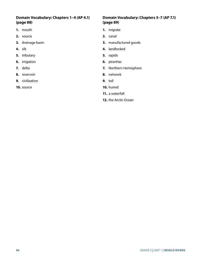
94 GRADE 3 | UNIT 1 | WORLD RIVERS
Domain Vocabulary: Chapters 1–4 (AP 4.1) (page 88)
1. mouth
2. source
3. drainage basin
4. silt
5. tributary
6. irrigation
7. delta
8. reservoir
9. civilization
10. source
Domain Vocabulary: Chapters 5–7 (AP 7.1) (page 89)
1. migrate
2. canal
3. manufactured goods
4. landlocked
5. rapids
6. piranhas
7. Northern Hemisphere
8. network
9. toll
10. humid
11. a waterfall
12. the Arctic Ocean
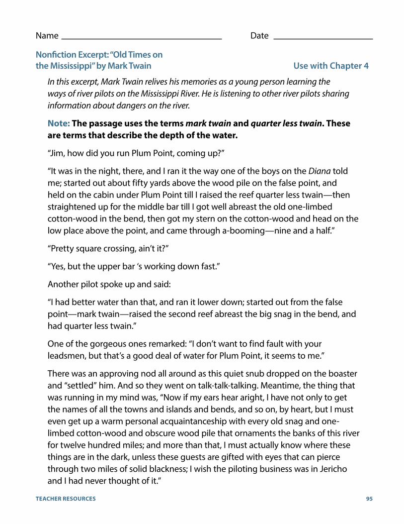
95TEACHER RESOURCES
Name Date
Nonfiction Excerpt: “Old Times on the Mississippi” by Mark Twain Use with Chapter 4
In this excerpt, Mark Twain relives his memories as a young person learning the ways of river pilots on the Mississippi River. He is listening to other river pilots sharing information about dangers on the river.
Note: The passage uses the terms mark twain and quarter less twain. These are terms that describe the depth of the water.
“Jim, how did you run Plum Point, coming up?”
“It was in the night, there, and I ran it the way one of the boys on the Diana told me; started out about fifty yards above the wood pile on the false point, and held on the cabin under Plum Point till I raised the reef quarter less twain—then straightened up for the middle bar till I got well abreast the old one-limbed cotton-wood in the bend, then got my stern on the cotton-wood and head on the low place above the point, and came through a-booming—nine and a half.”
“Pretty square crossing, ain’t it?”
“Yes, but the upper bar ‘s working down fast.”
Another pilot spoke up and said:
“I had better water than that, and ran it lower down; started out from the false point—mark twain—raised the second reef abreast the big snag in the bend, and had quarter less twain.”
One of the gorgeous ones remarked: “I don’t want to find fault with your leadsmen, but that’s a good deal of water for Plum Point, it seems to me.”
There was an approving nod all around as this quiet snub dropped on the boaster and “settled” him. And so they went on talk-talk-talking. Meantime, the thing that was running in my mind was, “Now if my ears hear aright, I have not only to get the names of all the towns and islands and bends, and so on, by heart, but I must even get up a warm personal acquaintanceship with every old snag and one-limbed cotton-wood and obscure wood pile that ornaments the banks of this river for twelve hundred miles; and more than that, I must actually know where these things are in the dark, unless these guests are gifted with eyes that can pierce through two miles of solid blackness; I wish the piloting business was in Jericho and I had never thought of it.”


CKHG™
Core Knowledge HISTORY AND GEOGRAPHY™
Series Editor-In-ChiefE.D. Hirsch, Jr.

Subject Matter ExpertCharles F. “Fritz” Gritzner
Illustration and Photo CreditsAge Fotostock/SuperStock: 37
Agf photo/SuperStock: 38, 39
Amazon River, Brazil, True Colour Satellite Image/Planet Observer/UIG/Bridgeman Images: 53
Biosphoto/SuperStock: 53
Brazil; Parana State; Iguaçu National Park; Foz do Iguaçu; Iguaçu waterfalls/De Agostini Picture Library/G. Dagli Orti/Bridgeman Images: 58
China: A boat leaving the Three Gorges Dam, Sandouping, near Yichang, Hubei Province/Pictures from History/David Henley/Bridgeman Images: 37
Eye Ubiquitous/SuperStock: Cover D, 59
Fotosearch/SuperStock: 29
ImageBROKER/SuperStock: 52
Jean-Marc La-Roque/Ardea.com/Pantheon/SuperStock: Cover C, i, iii, 42, 43, 44
JTB Photo/SuperStock: 30
MIVA Stock/SuperStock: 52
Philip Lee Harvey/Cultura Limited/SuperStock: 54
Race Between Mississippi River Steamships Natchez and Robert E. Lee, June 1870/Private Collection/J. T. Vintage/Bridgeman Images: 47
Robertharding/SuperStock: Cover A, 29, 44, 60
Steve Vidler/SuperStock: 63
The ‘Delta Queen’, Mississippi River/Private Collection/Peter Newark American Pictures/Bridgeman Images: 46–47
Tim Graham/Robertharding/SuperStock: Cover B, 39
Tom, Joe and Huck on the Raft’, illustration from ‘The Adventures of Tom Sawyer’ written by Mark Twain, illustrated by Geoffrey Whittam (1916–1998)/Private Collection/Bridgeman Images: 47
Tuareg man and camels/Insights/UIG/Bridgeman Images: 65
Wolfgang Kaehler/SuperStock: 64
Within this publication, the Core Knowledge Foundation has provided hyperlinks to independently owned and operated sites whose content we have determined to be of possible interest to you. At the time of publication, all links were valid and operational and the content accessed by the links provided additional information that supported the Core Knowledge curricular content and/or lessons. Please note that we do not monitor the links or the content on such sites on an ongoing basis and both may be constantly changing. We have no control over the links, the content or the policies, information-gathering or otherwise, of such linked sites.
By accessing these third-party sites and the content provided therein, you acknowledge and agree that the Core Knowledge Foundation makes no claims, promises, or guarantees about the accuracy, completeness, or adequacy of the content of such third-party websites, and expressly disclaims liability for errors and omissions in the either the links themselves, or the contents of such sites.
If you experience any difficulties when attempting to access one of the linked resources found within these materials, please contact the Core Knowledge Foundation:
Core Knowledge Foundation
801 E. High St.
Charlottesville, VA 22902
Email: [email protected]

CKHG™
Core Knowledge HISTORY AND GEOGRAPHY™
World RiversCore Knowledge Sequence History and Geography 3
What is the Core Knowledge Sequence? The Core Knowledge Sequence is a detailed guide to specific content and skills to be taught in grades K-8 in language arts, history, geography, mathematics, science, and the fine arts. In the domains of world and American history and geography, the Core Knowledge Sequence outlines topics that build chronologically or thematically grade by grade.
For which grade levels is this book intended? In general, the content and presentation are appropriate forreaders in the upper elementary grades. For teachers and schools following the Core Knowledge Sequence, this book is intended for Grade 3 and is part of a series of Core Knowledge HISTORY AND GEOGRAPHY units of study.
For a complete listing of resources in the
Core Knowledge HISTORY AND GEOGRAPHY™ series, visit www.coreknowledge.org.
CORE KNOWLEDGE CURRICULUM SERIES™Series Editor-in-Chief
E. D. Hirsch, Jr.
ISBN
: 978
-1-6
8380
-036
-1
CKHG™
Core Knowledge HISTORY AND GEOGRAPHY™
A comprehensive program in world andAmerican history and geography, integrating topics incivics and the arts, exploring civilizations, cultures, andconcepts specified in the Core Knowledge Sequence
(content and skill guidelines for grades K-8).
Core Knowledge HISTORY AND GEOGRAPHY units at this level include:
World RiversAncient Rome
The VikingsThe Earliest Americans
CanadaExploration of North America
The Thirteen Colonies
www.coreknowledge.org
CORE KNOWLEDGE CURRICULUM SERIES™Series Editor-in-Chief
E. D. Hirsch, Jr.