historical perspectives on u.s. economic geography by ... urban economics, volume 4, edited by...
TRANSCRIPT
Historical Perspectives on U.S. Economic Geography
By
Sukkoo Kim
and
Robert A. Margo
August 2003
We thank Vernon Henderson and participants at the North American Regional Science Association meetings in Puerto Rico for their comments. Prepared for the Handbook of Regional and Urban Economics, Volume 4, edited by Vernon Henderson and Jacques-Francois Thisse.

2
Abstract We review historical patterns of economic geography for the United States from the colonial period to the present day. The analysis is framed in terms of two geographic scales: regions and cities. The compelling reason for studying geographic area of two different scales is that models that explain location of economic activities at one scale may not apply to other scales. We consider the process of settling the frontier; the development of national markets in goods and factors and, more generally, the convergence (and divergence) of regional economies; the growth of cities and the relationship between urbanization and trends in aggregate economic structure, such as industrialization; and changes in the internal structure of cities. JEL No. R0 Key Words: Historical Perspectives on U.S. Economic Geography Index Words: 1. Introduction 2. U.S. Regional Development 2.1 Settlement of the U.S. Continent 2.2 Economic Integration and the Rise of a National Economy 2.3 Divergence and Convergence of U.S. Regional Economies 3. U.S. Urban Development 3.1 Cities in the Colonial Period 3.2 Urbanization and Industrialization 3.3 Urbanization in the Twentieth Century 3.4 Spatial Structures of Cities and Metropolitan Areas 3.5 Size Distribution of Cities 3.6 Urbanization and Inventive Activity 3.7 Urbanization and Productivity 3.8 Urbanization and Health 3.9 Immigration and Urbanization 4. Conclusions References

3
1. Introduction
Economic geography is central to economic development. As economies develop, the
initial allocation of resources across locations rarely remains fixed. New industries develop and,
for technological or other reasons, find it profitable to situate in different locations than old
industries. Transportation networks emerge, linking far-flung markets, within and across
countries, again potentially altering the spatial distribution of resources. Equally as or even more
importantly, the density of economic activity changes with development. In low income
societies, much economic activity is concentrated in low-density activities, such as agriculture or
cottage industries. As per capita income rises, capital and labor migrate to cities, and average
density rises. But within cities, density may also change over time, as people and firms find it to
their advantage to spread out over a wider “metropolitan” area.
We explore the economic geography of the U.S. from a historical perspective in two
geographic scales: regions and urban areas. The most compelling reason for studying geographic
areas of differing scales is that models which explain the location of economic activities at one
scale, such as the region, may not apply to smaller scales such as urban areas, or even finer ones
like financial and industrial districts.1 Further, the examination of these two geographic units of
observation, regions and urban areas, presents a more coherent understanding of the historical
geography of the U.S., than treating each geographic dimension separately.
We have three major goals: to systematically present historical data on U.S. regions and
urban areas, to survey the existing literature on the historical geography of the U.S., and to direct
scholars to promising avenues of research. Because this subject is a vast one that touches on
1 Fujita and Thisse (2002) note that geographers have long known that geographic scale matters. According to Fujita and Thisse, to ascribe what is true at one spatial scale to another is to commit ecological fallacy.
4
many disciplines, our review of the literature is necessarily selective and highly incomplete.
However, even an incomplete review, we believe, can offer important insights on the
fundamental role of geography in American economic development. It is impossible, in our
opinion, to understand long-term development of the U.S. divorced from its geography.
Surprisingly, however, many important areas remain relatively unexplored and we try to
highlight the most significant of these in our review.
2. U.S. Regional Development
One of the most distinctive characteristics of America is space.2 In 1800, the United
States was already one of the largest nations in the world. In the nineteenth century, the U.S.
became a continental nation of enormous proportions from sea to sea. Moreover, the Americans
faced unprecedented challenges in integrating vast unpopulated territories politically and
economically. The Northwest Ordinance provided an orderly procedure for incorporating
unsettled territories into states, but sectional differences over slavery led to divergence and
disunion. However, by the early twentieth century, the states of the union emerged as a unified
nation. This section addresses three of the most significant developments in U.S. economic
geography from a regional perspective: the westward migration of Americans, the rise of a
national economy, and the divergence and convergence of U.S. regional economies.
2.1 Settlement of the U.S. Continent
In the colonial period, most Americans of European and African descent lived along the
eastern seaboard. With the Treaty of Versailles in 1783, Americans gained independence and
2 “North and South, east and west, city and country, from the 1790s to the 1850s, the most powerful influence in shaping of American society was space. The ideas about space, the uses of space, the projects across space, and the accommodations to space, above all else, charted the basic changes that occurred between these years.” Robert H. Wiebe as quoted in Meinig (1993; p.219).

5
vast stretches of land through the mid-western U.S. Between 1783 and 1898, through purchase,
conquest, or treaty, Americans acquired a continental area of 3 million square miles. Moreover,
Americans migrated westward in waves. During the first half of the nineteenth century, people
from the Northeast migrated to the East North Central region, and those from the Southeast
migrated to the East South Central region. In the second half of the nineteenth century, migration
continued westward to the West North Central and, to a lesser extent, the West South Central
region. Finally, in the twentieth century, population migrated further west and south to the
Mountain, Pacific and West South Central regions (See Figure 1).
Most migrants moved west along the latitude. Meinig (1993) documents the geographic
patterns of westward migration and the establishment of western settlements in the nineteenth
century. Since most people involved in the westward migration were farmers, people may have
migrated along the latitude because they acquired latitude-specific skills in agriculture (see
Steckel (1983)). However, the westward migration is not without puzzles. Normally, economists
argue that individuals migrate from low to high per capita income areas, all other things equal. In
the case of the South, this appears to be consistent with the gradient of per capita incomes
(higher in the west than in the east). But in the North, the gradient ran in the opposite direction -
incomes were higher in the east than in the west.
Why did people go west? The most famous explanation is the safety valve hypothesis
proposed by the historian Frederick Jackson Turner; the economically dispossessed easterners
migrated to the west where land was cheap. However, most economic historians dismiss the
safety valve hypothesis on the grounds that migration to the west was costly, both in terms of
opportunity costs and resources. In particular, farm-making on the western frontier was very

6
costly, well beyond the means of unemployed industrial workers in eastern cities. Nevertheless,
using sophisticated econometric methods, Ferrie (1997) finds some evidence that migration was
indeed selective in the sense required by the safety valve hypothesis. In addition, the safety valve
hypothesis is consistent with Fogel and Rutner’s (1972) analysis that the sale of large tracts of
western lands by the federal government induced the westward movement.
The safety valve hypothesis is consistent with the east-west gradient of per capita income
distribution in the North, but many scholars believe that income per capita does not always
accurately measure gains to migration. It is well known that fertility was high on the western
frontier. Adjusting for the higher dependency ratio (children to economically active adults)
narrows the difference in per capita incomes between the Midwest and the Northeast (Fogel
1989). More recently, Margo (1999, 2000) has provided real wage indices that are corrected for
regional differences in cost of living. Margo (1999, 2000) finds considerable evidence for the
hypothesis, initially proposed by Coeholo and Shepherd (1976), that westward migration was
prompted by higher marginal product of labor on the frontier than in the east. According to
Margo’s estimates, real wages of unskilled labor were about 30% higher in the Midwest than in
the Northeast ca. 1830. However, as east-west migration began in earnest, the real wage gap in
the North diminished to about 15% or so on the eve of the Civil War. By the end of the
nineteenth century, a gap remained, but it was smaller (about 10%) than the gap that existed just
prior to the War. Margo also shows that the real wage gap for skilled labor was initially much
higher, but also converged before the Civil War.
Finally, migration to the antebellum frontier may not be explained by current income, but
by future returns - that is, by capital gains. There is evidence that “getting there first” had

7
economic value on the frontier. Early migrants got the best land and, if and when the railroad
came through, got the most capital gains (Galenson and Pope 1992; Craig, Palmquist, and Weiss
1998; Coffman and Gregson 1998).
2.2 Economic Integration and the Rise of a National Economy
In the seventeenth and the eighteenth centuries, the colonial economies were integrated
with Europe and the West Indies. Beginning in the early nineteenth century, greater investments
in internal transportation began to integrate the domestic economy intra-regionally and inter-
regionally. Initially, private construction of turnpike roads increased the mileage of roads in New
England and Middle Atlantic regions from 4,684 to 11,662 miles between 1810 and 1830.3
However, most of these investments were not profitable. In the following decades, the
construction of canals and the use of steamboats on navigable waters lowered the costs of trade
markedly. However, the integration of U.S. regional economies really began in earnest with the
emergence of the railroads in the 1850s. The growth in the mileage of railroads and telegraphs
between the late nineteenth and the turn of the twentieth centuries was spectacular. For example,
between 1860 and 1890, the mileage of operation in railroads increased sharply from 30,626 to
166,703 miles whereas that of telegraphs increased from 50,000 to 19,382,000 miles.4 These
advances in transportation led to dramatic declines in domestic freight rates (see North (1973 )).
Regional convergence in prices suggests that integration occurred at different rates for
goods and factor markets. Goods market integration seems to have been realized by the latter
half of the nineteenth century, capital markets by the early twentieth century, and labor markets
3 See Fishlow (2000) for a summary of developments in internal transportation during the nineteenth and the early twentieth centuries.
4 Despite the growing importance of the railroads, Fogel (1964) argues that the direct benefits
from lower transportation costs due to the railroads were about two percent of GNP in 1890.

8
by the mid-twentieth century. North (1961) and Harley (1980) find rapid convergence in the
prices of goods such as lard, pork, flour, and wheat across regions between 1820 and 1860
(North 1961; Harley 1980). Davis (1965) finds marked convergence in interest rates by the early
1900s.5 Finally, while there is convergence of wages and earnings by the mid-twentieth century,
labor markets seem to have remained segmented for a longer period between the North and the
South (Rosenbloom 1990; Margo and Villaflor 1987; Goldin and Margo 1992; Margo 2003).
Over the past two centuries or so, the United States has become, in effect, a national
market in goods and factors of production. Incomes are now less tied to place than they are to
skills, and regions are more homogenous with respect to economic activity than they once were.
Nonetheless, it would be a mistake to conclude that region no longer “matters” in the United
States. Regions are still subject to economic shocks, and the evidence is that such shocks have
consequences for incomes and employment, at least for the medium run, if not for the very long
run (Blanchard and Katz 1992).
2.3 Divergence and Convergence of U.S. Regional Economies
The most significant long-run trend in U.S. regional economies is the divergence and
convergence of U.S. regional economies. In the colonial period, regional differences in industrial
structures and incomes were relatively slight. The U.S. regional economies diverged between the
nineteenth and the early twentieth centuries. The divergence was first seen in industrial structures
as the Northeast region industrialized during the first half of the nineteenth century. In the late
nineteenth century, industrial divergence deepened with the formation of the manufacturing belt
5 However, Bodenhorn and Rockoff (1992) suggest that the integration of capital markets occurred much earlier. They find that regional interest rates were well integrated in the antebellum period, but that the disruptions of the Civil War caused the dis-integration of capital markets in the postbellum period, especially in the South and the Pacific Coast regions.

9
in the North and the continued specialization of agriculture in the South. The divergence in
income per capita, especially between the North and the South, emerged strongly in the post-
bellum period. Southern income per capita fell relatively and absolutely. However, in the second
half of the twentieth century, regional industrial structures as well as regional income per capita
converged dramatically.
A. Trends in U.S. Regional Economic Structures
The colonial economy was dominated by agriculture, extractive industries and fisheries
and was motivated by trade with Europe and the West Indies. Data on exports constructed by
Shepherd and Walton (1972) suggest that the American colonies were highly specialized in their
export staples.6 The New England colonies were specialized in fish, meat, wood products,
whales, potash and grain; the Middle Colonies in grain, and to a smaller extent in flaxseed,
wood, iron, meat and potash; the Upper South colonies in tobacco, and to a lesser extent in grain,
iron and wood products; the Lower South colonies primarily in rice and indigo as well as
deerskin, naval store, wood, grain and meat products. Most scholars believe that these patterns of
colonial regional economic specialization can be explained by regional comparative advantage
based on soil, climate and geography.
The early industrialization of the U.S. economy led to the first divergence of U.S.
regional economies. Prior to industrialization, domestic manufactured goods were produced by
artisans in urban areas. As the U.S. economy industrialized in the first half of the nineteenth
century, manufacturing moved out of artisan shops into non-mechanized and mechanized
6 The New England colonies consist of Massachusetts, New Hampshire, Connecticut, and Rhode Island; the Middle colonies consist of New York, New Jersey, Pennsylvania, and Delaware; the Upper South colonies consist of Maryland and Virginia; and Lower South consists of North Carolina, South Carolina, Georgia, and Florida.

10
factories. Sokoloff (1984, 1986) documents that the rise of factory production in a variety of
industries such as boots and shoes, coaches and wagons, furniture, hats, paper, leather tanning,
and textiles was associated with significant increases in labor and total factor productivity. The
early industrialization led to regional divergence as manufacturing became increasingly
concentrated in the Northeast region. In 1840, the share of the labor force in New England and
Middle Atlantic regions in non-agricultural activities was 38% and 32% respectively, whereas,
for the remaining regions, the figure ranged from 10% to 18%.
Why did industrialization begin in New England? Historians like Hunter (1979) have
emphasized the abundance of waterpower sites in New England. However, it is also well known
that women and children played an important role in the early industrialization of the U.S.
Goldin and Sokoloff (1982) propose that early industrialization proceeded in New England
because of the opportunity costs of women and children relative to men in farming were lower in
that region than in others. Goldin and Sokoloff find that the relative wages of women and
children compared to men were lower in New England than in other regions. Moreover, the
relative wage of females rose sharply with industrialization.
Sokoloff (1984) documents that the extension of markets due to the construction of
canals led to the re-organization of production from one based on artisanal shops to non-
mechanized and mechanized factories in the Northeast. Sokoloff suggests that initial advantages
of factory production came from firm reorganization. The greater division of labor caused by the
extension of markets in non-mechanized factories led to significant increases in productivity.
However, increased inventive activity caused by extension of markets, also documented by
Sokoloff (1988), may have contributed to the second phase where increases in productivity are

11
associated with mechanized factories that adopted new methods of production, power sources,
and new machinery. Lindstrom (1978) proposes a slightly different hypothesis for the
concentration of manufacturing in the Northeast based on demand. Lindstrom argues that the
increase in intra-regional demand brought on by falling transportation costs in the Northeast led
to the concentration of manufacturing in that region. Overtime, however, supply-side factors may
have become more important.7
The rise of a mature industrial economy in the U.S. between the late nineteenth and the
early twentieth century was accompanied by a significant divergence in U.S. regional economies,
especially between the North and South. Manufacturing spread from the Northeast to the East
North Central region to form the manufacturing belt whereas the South remained entrenched in
agriculture. In the second half of the twentieth century, as manufacturing spread South and West,
U.S. regional economies converged significantly.
The divergence and convergence of U.S. regional economies are documented by Kim
(1995, 1998). Kim finds that the patterns of U.S. regional specialization differed considerably by
sector (see Figure 2). In agriculture, regions continued to become more specialized over time in
various crops such as wheat, barley, corn, oats, rye, cotton, tobacco and vegetables. In
manufacturing, data at the two-digit industry level indicate that regions became more specialized
between the late nineteenth and the early twentieth centuries; however, since the mid-twentieth
century, regions became substantially more similar in industrial structure.8 Regional
7 See Rosenberg (1963).
8 The two-digit industries in manufacturing are food, tobacco, apparel, lumber and wood,
furniture and fixtures, paper, printing and publishing, chemicals, petroleum and coal, rubber and plastics, leather, stone, clay and glass, primary metal, fabricated metal, machinery, electrical machinery, transportation, instruments, and miscellaneous.

12
specialization in the service industries, wholesale trade, retail trade, and other services were low
for the second half of the twentieth century when data were available.9
Kim (1998) finds that regions became more specialized at the 1-digit sectoral level
between 1870 and 1880, fell slightly between 1880 and 1910, and then fell significantly over the
twentieth century.10 However, the data indicate that differences in regional industrial structures
between the North and South were particularly high until the second half of the twentieth
century. Between the late nineteenth and the early twentieth centuries, regional industrial
structures between the North and South differed by more than 50% from that of the overall
average. This difference was caused by the concentration of manufacturing in the North and the
concentration of agriculture in the South. In the twentieth century, regional industrial structures
converged significantly. The convergence was caused by the dispersal of agriculture and the shift
in economic structure into services.
For most regional and urban economists, the emergence of the manufacturing belt during
the second half of the nineteenth century marked a major turning point in the U.S. economic
geography.11 The manufacturing belt, composed mostly of the New England, Middle Atlantic
and East North Central regions, contained the majority of manufacturing employment between
9 The wholesale industries match the two-digit industries in manufacturing; the retail industries consist of food and general stores, general merchandise, apparel, furniture, automotive, filling stations, eating, drug stores, and other; services industries consist of hotel and lodging, personal, business, auto repair, garages, miscellaneous repair, motion pictures, amusement and recreational, health, legal, educational, social, museum and botanical zoological gardens, membership organizations, and miscellaneous.
10 For 1870 and 1950, the one-digit industries consist of agriculture, mining, forestry, fishing,
manufacturing and services. For the years between 1939 and 1987, construction, transportation, wholesale trade, retail trade, and government industries were also included.
11 See Holmes and Stevens (2004) for an informative map of the manufacturing belt and the
location of large manufacturing plants in 1947 and 1999.
13
the late nineteenth and the first half of the twentieth centuries. Krugman (1991) proposes that the
U.S. manufacturing belt emerged when economies of scale in production rose and transportation
costs fell. To minimize transportation costs, firms chose to locate in one region - the
manufacturing belt. The concentration of firms further increased local demand and locked in the
initial advantage. Krugman suggests that the manufacturing belt also benefitted from a denser
population and a transportation network that provided a substantially larger local market.
Meyer (1983, 1989) presents a slightly different interpretation of the rise of the
manufacturing belt. For Meyer, the manufacturing belt arose as series of regional industrial
systems in the antebellum period that merged to form the manufacturing belt in the late
nineteenth century. Meyer, in an analysis similar to that of Lindstrom (1978) for early
industrialization, argues that local regional demand triggered industrialization in a series of
regions stretching from the East to the Midwest over time. Although regions like the Midwest
industrialized later than those in the Northeast, Meyer argues that high interregional
transportation costs enabled Midwestern manufacturers to develop their own manufacturing
sector during the antebellum period. When transportation costs fell in the late nineteenth century,
Midwestern manufacturers were able to effectively compete with Eastern producers.
Kim (1999) presents alternative evidence for the rise of the manufacturing belt based on
natural advantages. Since data on interregional trade are not available to test the Heckscher-
Ohlin model, Kim exploits the Rybczynski theorem that provides a linear relationship between
factor endowments and production. Kim finds that a relatively small number of factor
endowments is able to explain significant variations in U.S. state production for twenty 2-digit
manufacturing industries for 1880 and 1900 as well as later periods in the twentieth century.

14
While these results do not rule out the importance of increasing returns, they suggest that natural
advantages may have played a significant role in the rise of the manufacturing belt.
The emergence and persistence of the manufacturing belt was a significant phenomenon
in U.S. economic history. It justly deserves greater attention by scholars. However, the declining
importance of the manufacturing belt and the rapid convergence of regional industrial structures
during the second half of the twentieth century should receive equal attention. Kim (1995) argues
that the rise and decline of regional specialization, or the divergence and convergence of regional
industrial structures, can be accounted for by changes in the factor mobility of factors and goods.
As transportation costs of final goods relative to inputs fell between the nineteenth and early
twentieth centuries, regions became more specialized in order to exploit their comparative
advantage. During the second half of the twentieth century, as factors became increasingly more
mobile relative to goods, and as new technologies such as electricity reduced the importance of
regional differences in resources, regional industrial structures converged.
An alternative interpretation of the convergence of U.S. regional industrial structures is
the core-periphery reversal (Krugman and Venebles (1995), Puga (1999), Tabuchi (1998),
Helpman (1998)) or the bell-shape relationship discussed in Ottaviano and Thisse (2004).
Assuming labor mobility throughout, as transportation costs fall low enough with any type of
congestion in the core (or with limited mobility throughout), the core-periphery structure will
reverse with industrial diffusion. However, at this point, we do not know of any empirical studies
based on this theory.
B. Trends in U.S. Regional Incomes
In the colonial period, differences in regional income per capita seem to have been slight.

15
While we do not have estimates of regional income per capita, we have estimates of regional
wealth per capita. Using probate records, Jones (1980) finds that differences in wealth per capita
were very small. In 1774, wealth estimates in pounds sterling for New England, Middle
Colonies, and the Southern colonies were £36.4, £40.2 and £35.4 respectively. However, the
wealth per capita for the free population was significantly higher for the Southern colonies.
In the early nineteenth century, regional incomes diverged somewhat. Yet the divergence
was not along North and South. Although income per capita in the Northeast was higher than the
national average, it was highest in the West South Central region in 1840 and 1860 (see Table 1
and Fogel (1989)). In the second half of the nineteenth century, Figure 3 shows that regional
incomes diverged significantly, especially between the North and the South. Income per capita in
the South fell sharply during the Civil War decade, absolutely and relative to other regions.
Although there was some recovery after the initial decline, the pace was slow. By 1900, the
income per capita of the South was barely half of the national average. However, during the
second half of the twentieth century, regional incomes converged substantially (Easterlin (1960,
1961), Mitchener and McLean (1999)). Although there are still regional differences, these are
much smaller than before World War II, particularly in the case of the South.
Barro and Sala-i-Martin (1991) find that the convergence of U.S. regional income per
capita in the twentieth century is consistent with the predictions of the neoclassical growth
model. As predicted by the model, growth in income per capita was inversely correlated with
initial incomes in 1880. However, there is no work in the growth literature that examines the
divergence of U.S. regional income per capita in the late nineteenth century. While this
divergence may be consistent with models of growth based on increasing returns, scholars have

16
not examined regional income per capita between 1860 and 1900 using this framework.
The divergence and convergence of regional industrial structures can potentially cause
divergence and convergence of regional income per capita. To the extent that wages differ across
industries, regional specialization in different industries may cause aggregate incomes to differ.
Using a simple decomposition procedure, Kim (1998) finds that, while the level of importance
varies with regions and time, the divergence and convergence of regional industrial structures are
highly correlated with that of regional income per capita. Caselli and Coleman (2001) report
similar findings with a more sophisticated decomposition procedure. In addition, these studies
also show that differences in regional wages in identical industries also contributed to the
divergence and convergence of regional incomes. However, this latter component is better
explained by models of economic growth rather than economic geography.
For Krugman, the divergence and convergence of regional incomes are accounted for by
transportation costs and increasing returns. When transportation costs fell, increasing returns in
manufacturing led to the rise of the manufacturing belt where high-wage jobs were concentrated.
However, Krugman and Venebles (1995) show that when transportation costs fall even further,
then regions eventually converge even when increasing returns are present. On the other hand,
Kim (1998) and Caselli and Coleman (2001) present explanations for the divergence and
convergence of regional incomes based on comparative advantage.12 Caselli and Coleman
suggest that the shift out of agriculture in the South was aided by the declining costs of acquiring
nonagricultural skills.13
12 Kim’s (1998) argument is outlined above. Caselli and Coleman’s (2001) present an interesting model based on the following assumptions: less than unit income elasticity of farm good demand, faster factor productivity growth in agriculture, and declining costs of acquiring nonfarming skills.
13 Caselli and Coleman (2001) argue that the costs of acquiring education fell as reductions in

17
However, most economic historians argue that the institution of slavery had a major
impact on U.S. regional development over time. Slavery and its dissolution greatly influenced
the productivity of agriculture in the South before and after the Civil War and, consequently on
U.S. regional per capita incomes. The legacy of slavery and the Civil War led to an isolated labor
market in the South and it contributed to poor educational infrastructure. Economic historians
interpret the Civil War as a major negative shock that took many years to work through. Many
economic historians also believe that the federal government played an important role in the
integration of the South into the national economy.
The causes of the decline in per capita incomes in the South have been extensively
studied by economic historians. There is general agreement that the economic dislocation caused
by the Civil War was responsible for at least some of the initial decline. Fogel and Engerman
(1974, 1979) argue that slave labor was relatively efficient compared with free labor in the
South, due to the use of the so-called “gang system” by slave owners. With the end of the War
came emancipation and the end of slavery, and a once-and-for-all loss in productivity in southern
agriculture (Fogel and Engerman 1974, 1979; Moen 1992). Other potential causes of the relative
decline in southern income per capita incomes include a reduction in the rate of growth of the
demand for southern cotton (Temin 1979), as well as the possibility that per capita incomes in
the South in 1860 may have been above their long-run trend (Wright 1979).
Recent work by Margo (2003) has examined this issue from the perspective of regional
wage gaps. Wright (1986) points out that, at the turn of the twentieth century, the South -
particularly the South Atlantic - was a low-wage region in a high-wage country. The South ca.
transportation costs in rural areas allowed schools to exploit economies of scale, as school curricula was transformed in the early twentieth century, as life expectancy rose over time, and as desegregation improved the access to education for blacks.
18
1900 could have been low-wage due to recent economic shocks. Or it could have been low-wage
for some time - that is, predating the Civil War. Margo presents a variety of data on wages in the
South relative to the North, before and after the Civil War. His results show that all three
explanations have merit. Wages in the South Atlantic regions were below those in the North
before the Civil War, although not in the South Central regions. Wages in the South also
declined relative to the North in the 1890s, possibly due to a short-run decline in agricultural
productivity. However, the data clearly show that the war left an imprint on the regional wage
structure - as was true of per capita incomes, wages in the South declined sharply relative to the
North between 1860 and 1870.
Why was convergence delayed so long? Economic historians have suggested several
answers to this question. One answer emphasizes the “flawed” economic institutions of the
South, particularly in agriculture, after the war (Ransom and Sutch 1977). Another explanation,
due to Wright, involves network externalities in labor markets. In the North, according to Wright
(1986), jobs in manufacturing were allocated not by an impersonal labor market, but by one
dominated by personal contacts and references. However, the Southerners, consumed by the
turbulence of reconstruction, failed to develop these employment networks. As a result, the jobs
in the North went to immigrants rather than to Southerners. Only after immigration was abruptly
cut off during and after World War I did northern manufacturers turn to the South for their labor
supply (Collins 1997).
Another explanation of the slow pace of Southern recovery emphasizes the poor quality
of education in the region. Using census data, Margo (1990) establishes that the probability that a
Southern-born individual left the region was a positive function of schooling; that is,

19
interregional migrants were better educated than those that stayed behind. This factor was
particularly important for blacks, who attended racially segregated schools that generally were
inferior in quality to that of schools attended by whites.
3. U.S. Urban Development
The U.S. transformed itself from a rural to an urban society between the nineteenth and
the twentieth centuries. The onset of industrialization and the expansion of domestic markets
significantly increased the number and size of cities. By the turn of the twentieth century,
America became an urban nation. The spatial structures of cities changed markedly over time as
well. Initially, cities were compact and dense. Over time, boundaries of cities increased as firms
and households moved further away from the city center. In this section, we examine the growth
of cities and the changes in the spatial structures of cities over time.
In addition, we examine factors that differentiate urban from rural areas. Unlike rural
places, population sizes of cities varied systematically at any given point in time. While the
relationship has not remained constant over time, the size distribution has been usefully
characterized by the rank size rule or by Zipf’s law. Moreover, urban places have been centers of
inventive activity, culture, entertainment, government and a magnet for immigrants. Urban
places fostered higher productivity and higher nominal wages. Unfortunately, for a time in U.S.
history, urban places were also extremely unhealthy and mortality rates of urban areas far
exceeded those of rural areas.
3.1 Cities in the Colonial Period
The colonial British America was predominantly rural. In 1690, there were only four
cities with populations greater than 2,500. Boston was the largest city with a population of 7,000

20
with Philadelphia and New York trailing behind with populations near 4,000. During the next
one hundred years from 1690 to 1790, the number of cities rose from 4 to 24, yet the share of the
urban population fell from 8.3 to 5.1% (see Table 2). For the only extended time in American
history, the rural population grew faster than the urban population. The rank of cities also shifted
over this period; Philadelphia emerged as the largest city during the mid-eighteenth century but
then gave way to New York towards the end of the century.
The colonial urban occupational structure differed greatly from the rest of the nation.
Whereas the great majority of the general population was engaged in agriculture, most of the
urban population was engaged in mercantile, manufacturing and other service activities.
Historians have constructed occupational structures of various colonial cities using tax records
and directories for the late eighteenth century. According to Price (1974), based on information
for Boston, Philadelphia and New York, an average of 23% of the population was employed in
mercantile or commercial activities, 24% in manufacturing, 50% in services and 4% in
government.14 Thus, despite the reputation of port cities as centers of mercantile activity, the
industrial and service sectors were responsible for the majority of the labor force.
The cities in the colonial period arose along the eastern seaboard. Urban economists
believe that port cities arise because of increasing returns and because geography bestowed on
them lower transport costs.15 However, few mainstream urban economists have examined the
rise of port cities in the colonial period. Most of what is known about cities in this period derives
from the work of historians. While these works are rarely guided by explicit economic theory,
most scholars seem to believe that merchants became concentrated in cities to benefit from
14 Also see Warner (1968).
15 Fujita and Mori (1996) and Konishi (2000).

21
information spillovers. Merchants gathered regularly in coffee shops and exchanges to discuss
market conditions in Europe and the West Indies.16
Most historians believe that port cities arose in places endowed with excellent harbors
and access to a rich hinterland.17 Due to high interregional transportation and communications
costs, the size of the hinterland determined the size of a city’s mercantile activity and the quality
of the port determined the costs of transportation overseas Yet, while this thesis may explain the
rise of cities like New York and Philadelphia in the Middle Colonies or even Boston in New
England, it does not easily explain why there were no major cities in the Upper South, and why
cities in New England were so numerous. The Chesapeake region had excellent navigable waters
and a rich hinterland; on the other hand, New England’s hinterland was relatively small.
Historians have proposed a variety of theories to explain the absence of cities in the
Upper South, but the most attractive theory is based on colonial regulation of trade.18 According
to Price (1974), the lack of cities in the Chesapeake is accounted for by British regulation of
tobacco trade. The Navigation Acts restricted exports of tobacco to England whereas similar
16 See Albion (1939); also see Burrows and Wallace (1999).
17 Boston, the largest port city in the U.S. until the mid-seventeenth century, possessed an
excellent, deep, sheltered harbor, and a hinterland composed of coastal settlements from Cape Cod to Maine; Philadelphia, the premier city between the mid- to the end of the seventeenth century, possessed an excellent agricultural hinterland but a harbor subject to freezing in winter; New York, the foremost city from the early eighteenth century, possessed a harbor unparalleled as well as a rich agricultural hinterland (see Price (1974)).
18 Two of the more prominent explanations for the lack of cities in the Upper South are the
abundance of navigable waters in the Chesapeake and that tobacco required little processing (see Middleton (1953), Carville (1992)). Neither of these explanations seem satisfactory. First, if mercantile activity in tobacco is subject to spillovers, then lower transportation costs should foster rather than deter the concentration of merchants in cities. Second, it is not clear that the processing of wheat or other crops was any more extensive than that of tobacco. In any case, forward linkages associated with wheat processing seems an unlikely explanation for significant agglomeration economies in Philadelphia or New York.

22
restrictions did not apply for fish, wheat, corn, pork, beef, etc. In addition, regulations and high
customs duties greatly restricted entry into the tobacco trade. For both of these reasons, a handful
of merchants coordinated the tobacco trade from London and Glasgow rather than from cities in
the Chesapeake.19 By contrast, merchants in New York or Philadelphia exported their products to
many markets, and entry into the business was relatively open. For these merchants, regular
meetings in coffee houses provided valuable information spillovers on local and overseas market
conditions as well as information on trustworthy contacts and potential partners.20 Thus, when
Baltimore and Alexandria and other cities arose in the Upper South in the mid-eighteenth
century, their activity was based on wheat rather than on tobacco.21
Despite the fact that most scholars believe that port cities arose for mercantile reasons,
the occupation structures of cities indicate that the number of merchants were equaled by artisans
and surpassed by service workers. Urban artisans, working alone or with an apprentice, produced
a wide variety of products such as barrels, kegs, bread, candles, soaps, etc. Why did artisans
locate in cities? Historians and economists seem to rarely ask this question. The most likely
answer is transportation costs. Due to high transportation costs, except for trade in export staples,
most cities produced goods for local consumption. As local demand for manufactures grew,
artisans emerged in cities to satisfy this demand. Services in cities, such as tavern and inn
keeping, can be explained in a similar manner. Thus, the concentration of artisans and service
workers added greatly to an urban economy, but these activities alone did not sustain an urban
area during this period.
19 See Price and Clemens (1987).
20 See Doerflinger (1986).
21 See Klingaman (1969).

23
3.2 Urbanization and Industrialization
In the United States, there was a strong correlation between industrialization and
urbanization. While cities existed in the pre-industrial era, the rapid growth in the number and
size of cities coincided with the development of a manufacturing economy. Moreover, cities
were concentrated in regions where industrialization began. Table 2 and Figure 4 show that in
the early phase of industrialization, urban population grew from 7% in 1820 to 20% in 1860.
Between 1820 and 1860, urban population grew by an average of 57% per decade. Moreover, the
cities became significantly larger. In 1820, there was only one city with a population above
100,000; in 1860, there were 9. Throughout this period, New York remained the largest city with
its population increasing from 123,706 to 805,651. The urban population in the first half of the
nineteenth century was concentrated in the Northeast region where industrialization began. For
these Northeastern cities, Williamson and Swanson (1966) find that manufacturing accounted for
approximately 60% of the labor force during this period.
Did industrialization cause urbanization in the U.S.? The accepted view in the
development literature is that urbanization and industrialization go hand in hand. Labor saving
technological change combined with innovation and development of new manufactured and
service products spur the growth of urban areas where products are most efficiently produced.
However, did industrialization lead urbanization or vice versa?
While few studies examine this question directly, the existing literature hints at the
possibility that industrialization led urbanization. First, the Goldin-Sokoloff hypothesis on U.S.
early industrialization argues that industrialization first began in rural areas where the
opportunity cost of women and children relative to men were low. Although the Goldin-Sokoloff
24
model does not address the issue of industrialization and urbanization, the fact that
industrialization is seen to arise in rural areas suggests that industrialization preceded
urbanization. Thus, in the Northeast rural regions, cities arose as manufacturing developed in
these areas.
Williamson’s (1965) work on urban growth during early industrialization seems to
confirm the view that industrialization led urbanization. If urbanization caused industrialization,
then industrialization should take place in large urban areas which formed prior to
industrialization. Moreover, larger cities rather than smaller cities or rural areas should
industrialize and grow faster over time. However, contrary to expectations, Williamson (1965)
finds that rates of urbanization converged rather than diverged between 1790 and 1890. During
this period, rural areas urbanized more rapidly than the developed urban areas. In addition,
according to Williamson and Swanson, urban growth was consistently unrelated to the initial size
of cities and younger cities grew faster than older cities.
The U.S. became a mature industrial economy between the second half of the nineteenth
and the early twentieth centuries. America also became an urban nation during this period. By
1920, more than half of the population lived in cities. In this period, based on a sample of cities,
Weiss (1974) finds that slightly less than 50% of the labor force was engaged in manufacturing,
50% in services, and a tiny fraction in agriculture. The rise of an industrial economy was
accompanied by the rise of the manufacturing belt as industrialization moved westward but not
southward. Once again, as with early industrialization, there was high geographic correlation
between later industrialization and urbanization as the urban population was highly concentrated
in the industrial belt. In addition, the cities in this region were significantly more oriented toward
25
manufacturing than those in other regions. The cities in the New England, Middle Atlantic and
East North Central regions had twice the labor force allocated to manufacturing than that of
cities in other regions.22
Despite the historical importance of urbanization during this period, the topic has
received limited attention from economists and economic historians in recent years. The most
widely shared interpretation of the rise of cities in this period is based on pecuniary and
Marshallian externalities. Meyer (1983, 1988) emphasizes pecuniary externalities; for Meyer, the
manufacturing belt is really an agglomeration of regional urban city systems. Ades and Glaeser
(1999) find that initial development proxied by urbanization in 1850 was significantly correlated
with later urban development. Thus, increasing returns led to divergent urban development.
However, Ades and Glaeser find openness or the extension of markets was negatively correlated
with urban growth.
Kim (2000) argues that the location of cities was largely driven by superior access to
resources and that cities arose to take advantage of economies in local public goods and in
transportation. A variety of factors suggest that the concentration of manufacturing cities in the
industrial belt resulted from that region’s comparative advantage in resources. First, the cities in
the industrial belt were specialized in manufacturing. They had a significantly higher proportion
of the labor force engaged in manufacturing than cities in other regions. Second, within the
manufacturing sector, the cities were highly specialized in one or two industries and cities within
a region tended to specialize in the same set of industries. City specialization in a few industries
might signal the importance of localization economies, but it cannot explain why cities within
regions tended to specialize in the same set of industries. Third, the rise of the Midwestern cities
22 See Kim (2000).

26
in the industrial belt was correlated with the growing importance of primary metals, machinery,
and transportation industries.
3.3 Urbanization in the Twentieth Century
The pattern of urban development in the second half of the twentieth century differed in
nature and scope from the industrial period (see Table 2 and Figure 4). First, the pace of
urbanization slowed. The share of population in cities rose modestly from 51.2% to 61.6%
between 1920 and 1990. Second, Table 3 and Figure 5 show that the urban population became
increasingly more suburbanized in metropolitan areas; in 1940, there were 138 metropolitan
areas in the U.S. which contained 51% of the U.S. population. However, in 1990, the number of
metropolitan areas in the U.S. rose to 335 as did the share of population in these areas to 77.5%.
In this period, the industrial structure of cities shifted dramatically into services. By the end of
the twentieth century, the percentage of employment in services reached almost three times that
of manufacturing (see Kolko (1999)).
The patterns of urbanization in the second half of the twentieth century exhibited marked
regional convergence. The regional distribution of cities became more even as the shares fell in
the Northeast and the Midwest and rose in the West. While economic structures of cities
continued to differ by size, they converged rapidly across regions. Kim (1995, 2000) suggests
that these trends, like those of regions, are roughly consistent with diminished differences in
regional comparative advantage. During this period, regional input supplies became more similar
as factors became more mobile and as technical advances reduced regional differences in inputs.
The shift in industrial structure toward services further reduced the importance of differences in
resources. Thus, the convergence of geographic differences in resources accounts for the

27
convergence of city industrial structure as well as the convergence of the geographic distribution
of cities across regions.
It is beyond the scope of this section to summarize the literature on modern twentieth
century data. For excellent reviews, we refer the reader to Duranton and Puga (2004) and
Rosenthal and Strange (2004). Since some kind of agglomeration economies are needed to
generate cities, the literature on cities attempts to identify which sources of agglomeration
economies are most important for urban development. Here, we highlight a few papers that
possess long-run historical dimension. Two of these studies emphasize the role of Marshallian
externalities. Simon and Nardinelli (2002) find that cities with higher levels of human capital in
1880 grew faster over the next one hundred years, suggesting the importance of knowledge
spillovers. Beeson, DeJong, and Troesken (2001) find that initial advantages have persistent
results for a much longer period in U.S. history. However, Rappaport and Sachs (2001) argues
that geography, especially access to coasts of both oceans and Great Lakes play an important role
in explaining population distribution and density. Mitchner and McLean find that states with
navigable waterways, large mineral endowment, and no slaves in 1860 had higher labor
productivity levels between 1880 and 1980.
3.4 Spatial Structures of Cities and Metropolitan Areas
The land use patterns of U.S. urban areas have changed dramatically over time. In the
colonial period, cities were small, compact and densely organized near the waterfront. Between
the nineteenth and the mid-twentieth centuries, urban boundaries increased as outlying areas
were annexed. However, cities generally became more dense as population migrated to cities and
building density in downtowns rose. The land-use patterns of urban areas changed dramatically

28
in the second half of the twentieth century. As population moved further away from city centers,
outside traditional municipal boundaries, a new definition of urban areas emerged based on the
metropolitan area. In this period, urban densities declined dramatically as density in city centers
fell and as urban boundaries increased ever more outwards. In this section, we use the density
gradient, which measures changes in density as one moves further away from the city center, and
average density, defined simply as persons per square mile, to study the historical trends in urban
spatial structures.
A. Density Gradients
Due to data limitations, it is difficult to construct data on spatial structures of cities until
the late nineteenth century. However, using federal census documents, tax records and the city
directory for Philadelphia in 1790, Schweitzer (1993) was able to identify the locations of
residence and occupation of a majority of inhabitants in Philadelphia in 1790. Schweitzer finds
that the population density gradient was very steep and population densities were significantly
lower just a few city blocks away from the waterfront on the Delaware River. Schweitzer also
finds that there was significant spatial differentiation by socioeconomic groups. Most merchants
lived near the waterfront, artisans were distributed throughout the city, the wealthy were
clustered in an area known as the New Society Hill, and the poor were found everywhere but
disproportionately present in the outskirts of the city.
One of the most striking empirical regularities in urban economics is the consistent
decline in density gradients of cities over time. Mills (1972) finds that density gradients of four
metropolitan areas, Baltimore, Milwaukee, Philadelphia, and Rochester, declined more or less
monotonically over time between 1880 and 1963.23 Macauley (1985) estimates that, for a sample
23 Mills’ (1972) estimate of Philadelphia’s density gradient for the late nineteenth century is

29
of 18 metropolitan areas, density gradients in population and employment for manufacturing,
retailing, wholesaling and services all tended to decline over the twentieth century. Similar
trends are found by Edmonston (1975) for a larger sample of metropolitan areas as well as for
the same sample of cities as Mills.
The Alonso-Muth-Mills monocentric city model provides a number of possible
explanations as to why urban population or employment might eventually decentralize or why
the density gradient might fall. According to this model, households choose where to reside
within an urban area, given their tastes for housing versus other goods. To make this concrete,
imagine that households maximize a utility function U(h, x, t) where h = housing services, x = a
composite commodity, and t = leisure. The budget constraint is p(r)h + x = A + w(T – cr – t),
where p(r) is the price of housing at distance r from the central business district (CBD), A is non-
labor income, T is the household’s time endowment, w is the wage per unit of time, and c is time
spent commuting per unit of distance r from the CBD. Employment in this model is concentrated
in the CBD but households may choose to live at various points r from the CBD. The model can
readily accommodate fixed or variable monetary costs of commuting but for our purposes it is
not necessary to include these.
In this model the variable r serves as the indicator of “suburbanization” because higher
values of r correspond to distances further from the urban “core” (the CBD). The first order
condition for r is p’h = -wc. This equation will hold at non-zero values of r because the slope of
the pricing function, p’, is negative – housing price declines as distance r from the CBD
increases. In choosing its optimal location, each household trades off a lower price of housing
considerably lower than that of the other three cities. However, Mills believes that the low estimate may have been due to problems with data construction associated with Philadelphia.
30
versus higher commuting costs.
If housing is a normal good – and all empirical studies suggest that it is – it is
straightforward to demonstrate that dr/dA > 0. That is, an increase in non-labor income will
cause the household to live further away from the CBD – to suburbanize. The demand for
housing increases (because A has increased), and the household chooses optimally to locate
further away where housing price is lower. However, an increase in w has off-setting income and
substitution effects. The income effect of an increase in w is the same as the effect of an increase
in A, as long as housing is a normal good. But the substitution effect goes in the opposite
direction because a higher wage means a higher time cost of commuting. If the income effect
outweighs the substitution effect, an increase in w will imply an increase in r, that is, a distance
further from the CBD.
In the Alonso-Muth-Mills model, higher income households choose to suburbanize
because they demand more housing relative to other goods, and the relative price of housing of
land is cheaper at locations that are distant from the CBD than at locations that are close in. Of
course, there may be other reasons why higher income households choose to live in the suburbs.
It is possible, for example, that suburban local governments might be more efficient at providing
local public goods, such as education, and these goods could be income-elastic. Models of
jurisdictional “sorting” – the archetype being the Tiebout model – imply that households sort
across local governments on the basis of their demands for local public goods. Such sorting may
be reinforced by “peer group” effects – the quality of the local public schools, for example, may
be affected by socioeconomic backgrounds of the students that attend them.
The existence of a density gradient for Philadelphia in 1790 presents a puzzle for the
31
monocentric city model. In that model, the density gradient is generated by the commuting
choice of households. However, in this period, very few people commuted to work. Most people
worked where they lived. Thus, it is more likely that the density gradient was caused by the fact
that businesses found it desirable to locate near the waterfront on the Delaware River (see Fujita
and Ogawa (1982), Berliant, Peng and Wang (2002), Lucas and Rossi-Hansberg (2002), and
Rossi-Hansberg (2003) for possible explanations.)
The decline in the density gradient or the decentralization of employment and population,
especially in the second half of the twentieth century, is often attributed to developments in
transportation and rising incomes. Glaeser and Kahn (2004) argue that the adoption of
automobiles and trucks fundamentally transformed how Americans live and work in the latter
half of the twentieth century. Automobiles and trucks lowered transportation costs and, just as
importantly, eliminated fixed costs associated with rail depots and ports. The decline in
agglomeration economies associated with these fixed costs enabled firms and households to
decentralize and organize their activities around a more dispersed environment.
Margo (1992) finds that rising incomes also played an important role in suburbanization.
Margo uses the public use sample of the 1950 census, which provides information on household
and personal characteristics, including whether households living in metropolitan areas reside in
central cities or suburban rings. Margo estimates a cross-sectional logistic regression of the
probability of suburban residence as a function of household characteristics, including household
income, which is instrumented. The model is identified by assuming that education and industry
of employment affect income, but do not otherwise (that is, independently) affect the likelihood
of a suburban residence. The estimated coefficient on income in this regression is positive and

32
highly significant.
Using this coefficient in conjunction with the mean growth of real household income
between 1950 and 1980, Margo predicts that the percent suburbanized should have increased by
7.4 percentage points. The actual increase was 17.5 percentage points (from 42.7 to 60.2
percent). Thus, according to Margo’s calculation, changes in income account for about 43
percent of suburbanization over the 1950 to 1980 period. It is likely that this estimate is biased
upwards, for several reasons. First, education and industry may not be proper instruments. For
example, education may have a direct impact on the likelihood of a suburban residence, if better-
educated parents value their children’s schooling, and suburban schools, as most studies indicate,
are superior in quality to urban schools. Similarly, industry may have a direct effect on the
likelihood of suburban residence, if industries differ in their ability to substitute land for other
inputs. As a result, some industries locate further away from the CBD than others, and their
workers follow suit.
Second, as Margo (1992, p. 308) notes, some central cities expanded their boundaries by
annexing suburban areas after 1950. Had jurisdictional boundaries remained constant between
1950 and 1980, the increase in the proportion suburbanizing after 1950 would have greater than
17.5 percentage points. Third, Margo’s calculation is partial equilibrium. In particular, it does not
take into account induced effects on price of housing in the suburbs relative to central cities.
These effects are positive – house values should (and did, see Collins and Margo 2002) rise in
the suburbs relative to the central cities, dampening the incentive to suburbanize due to rising
incomes.
It is important to recognize that Margo’s calculation does not identify precisely why

33
higher income households suburbanize. This could be because of the causal mechanism
identified by the Alonso-Muth-Mills model, or it could be for some other reason. Glaeser, Kahn,
and Vigdor (2001) argue, in fact, that the reason emphasized in the Alonso-Mills model – land
prices – is not the reason why “[t]he poor live in cities.” Rich people, Glaeser, et. al, agree, do
have a higher demand for land than poor people, but the income elasticity of the demand for land
is not high enough to explain the positive association between income and suburban residence.
Poor people, their argument continues, live in cities because the poor place a high value on
public transportation. In Glaeser, et.al.’s modification of the Alonso-Mill’s model, the marginal
monetary cost of public transportation is cheap, but the fixed and time costs are large relative to
automobile transport.
B. Urban Densities
While the density gradient and other measures of decentralization are informative, we
believe that a study of simple average density of cities provides a fuller picture of urban spatial
structures. Shammas (2000) finds that colonial cities were compact and dense. In 1800, data on
sample of four cities (Philadelphia, New York, Baltimore and Boston) indicate that each city
consisted of less than 2 square miles of area. Population densities of these cities ranged from
Boston’s 20,781 to Philadelphia’s 45,800 persons per square mile. The differences in population
densities in these cities reflected their differences in housing lot sizes. It appears that
Philadelphia’s high density relative to other cities was due to its relatively small house lot sizes.
While Philadelphians averaged 7.1 compared to Boston’s 8.7 persons per dwelling,
Philadelphia’s house lot sizes only averaged 1,392 square feet as compared to Boston’s 3,441.
Unfortunately, systematic information on urban land areas is available only from 1890
34
onwards with the publication of the Social Statistics of Cities. Kim (2002) finds that urban
densities rose and fell between the late nineteenth and the twentieth centuries. Between 1890 and
1950, average population density rose from 7,230 to 8,876 persons per square mile for a
consistent sample of cities whose population was greater than 25,000 (see Table 4 and Figure
6).24 During this period, the cities also annexed considerable amounts of land. In 1890, the cities
averaged approximately 19 square miles of land; by 1950, they averaged 40 square miles. Yet,
despite the significant increases in the boundaries of cities, population density rose as urban
population growth outpaced annexation. However, in the second half of the twentieth century,
the average population density of cities declined substantially. By 1990, average population
density fell to 5,647 persons per square mile. In this period, cities continued to annex nearby
areas, but urban population growth did not keep pace with annexation. For metropolitan areas,
Kim (2002) finds that average density rose between 1940 and 1960 but then fell sharply between
1960 and 1990.
The combined information from urban densities and density gradients presents a more
coherent picture of the changes in urban spatial structures between the late nineteenth and the
twentieth centuries. The average densities of urban areas rose and fell over time; however,
density gradients of urban areas declined monotonically over time. These two trends can be
reconciled accordingly. Between 1890 and 1950, the density gradient curve shifted upward but
its slope fell, causing urban density to rise even as the density gradient declined. However,
between 1950 and 1990, the density gradient curve shifted downward as its slope continued to
fall, causing urban density to decline sharply.
24 Also see Mills (1972) and Macauley (1985) for estimates of population density and gradients for a smaller subset of metropolitan areas.
35
By concentrating most of their empirical analysis on the density gradient, largely
motivated by the monocentric city model, Kim (2002) argues that urban economists have under-
emphasized the location decisions of firms and its impact on urban spatial structures. Although
falling transportation costs and rising incomes tended to disperse households outwards, Kim
suggests that firm agglomeration economies in manufacturing and business services may have
contributed to the rise in urban density during the first half of the twentieth century. Moreover,
advances in skyscraper technologies lowered the costs of dense employment, especially for
sectors that used office space. However, in the second half of the twentieth century, the decline
in the importance of agglomeration economies in employment, re-enforced by household’s
preference for living in larger housing away from the city center, is likely to have contributed to
the decline in average urban density as well as the continuing decline in the density gradient.25
C. Urban Land Rents
With some notable exceptions, twentieth century evidence on land price implications of
the monocentric city model is extremely limited. This is simply because, in most urban areas,
vacant land parcels are relatively few in number and are vacant (rather than developed) for non-
random reasons. Historical studies offer more promise, but until recently, most such studies have
been based on a single data set, that for Chicago originally compiled by Homer Hoyt (1933;
exceptions include Edel and Sclar’s (1979) study of Boston land prices, Gin and Sonstelie’s
25 Kain (1968) argues that the relative and absolute decline of central cities is the result of several important technological changes. First, developments in transportation have made land much more substitutable. With trucks and automobiles, firms no longer need to locate near ports, freight and passenger terminals and rail lines. Second, changes in production methods that require spacious, single-story plants have made it more attractive for firms to build plants in outlying areas where land is cheaper. Finally, technological changes in communications and data processing have reduced the need for armies of white collar workers employed in central city offices. On the other hand, Chatterjee and Carlino (2001) argue that increases in congestion costs due to increases in population have led to the deconcentration of MSA employment in the second half of the twentieth century.

36
(1992) analysis of Philadelphia, and Smith’s (2001) study of land values in Cleveland).
Representative studies based on the Hoyt data include Mills (1969), McDonald and Bowman
(1979), Kau and Sirmans (1979), Kau, Lee, and Sirmans (1986), and McMillan, Jarmin, and
Thorsnes (1992).
A few recent studies, however, have examined archival data for cities other than Chicago.
Using data culled from newspaper advertisements, Margo (1996) studies the relationship
between rental price of housing and distance from the CBD in antebellum New York. Although
Margo’s study is not, strictly speaking, about the price of land, he nevertheless finds a relatively
steep rental price gradient. Atack and Margo (1998) also use newspaper listings to study sale
prices of vacant land in New York City over the period 1835 to 1900. Atack and Margo also find
a steep negative gradient between the price of land and distance, but one which was flattening
over time. The steep rental gradient is consistent with the high cost of intra-urban transport
before the Civil War and the flattening of the vacant land price gradient is also consistent with
what is known about postbellum technological improvements in urban transportation. Atack and
Margo’s other important finding is a marked increase in the value of vacant land in New York
after the Civil War. The increase in value between 1860 and 1870 is well in excess of the general
rise in the price level at the time, and the increase was sustained after the price level began to fall
in the 1870s. This rise in land values coincides, of course, with the economic ascendance of New
York after the Civil War as a premier financial and manufacturing center.
3.5 Size Distribution of Cities
From the earliest period in American history, cities varied considerably in their
populations at any given point in time. Madden (1956) finds that the size distributions of cities
37
for every decade between 1790 and 1950 were remarkably stable and that they can be usefully
summarized by the rank-size rule. Dobkins and Ioannides (2000) and Black and Henderson
(2002) provide estimates for the Pareto distribution or the rank-size rule for metropolitan areas
between 1900 and 1990. We refer the reader to Gabaix and Ioannides (2004) for an extremely
useful summary of the literature on the size distribution of cities.
While there is considerable debate as to what forces are responsible for the size
distribution of cities, most economic historians have emphasized the role of markets and
transportation nodes.26 Weiman (1988) argues that the initial growth of Atlanta was due to its
strategic location at the intersection of three railroads, but that its emergence as a regional
metropolis was accounted for its development as a mercantile and financial center that cleared
regional transactions. Odell and Weiman (1998) suggest that the founding of the Federal Reserve
Banks in Dallas and Atlanta was due to their positions as regional centers of commerce and
finance in the lower South.
Why do cities lower the costs of trade? Every trade must overcome two types of costs:
transportation and information. Since goods are traded over space, they must incur transportation
costs. In addition, specialization reduces the information set of agents. As compared to a more
self-sufficient economy, information on demand and supply are geographically more dispersed.
Specialization also exacerbates the problems of asymmetric information where sellers are more
informed about the quality of their product than the buyers. The concentration of merchants,
exchanges, insurance firms, lawyers, judges, etc. in larger cities lowers the costs of trade by
providing better market information on supply and demand for goods and by solving the
26 See Cain (1985).
38
asymmetric information problem.27 Kim (2000) finds that the size distribution of cities is partly
explained by the concentration of transaction services in the larger cities.
William Cronon’s (1991) Nature’s Metropolis provides an excellent illustration on the
role of markets in causing the rise of Chicago. While Cronon’s work is loosely based on
Christaller’s central place theory, scholars find his distinction between “first nature” (natural
landscape) and “second nature” (human actions) particularly useful. Cronon argues that the
growth of Chicago was due as much to “second nature” than to “first nature.”28 Although
Cronon’s definition of “second nature” is rather all encompassing, many urban scholars like
Krugman (1996) have interpreted “second nature” as indicating the importance of increasing
returns that is often self-reinforcing. Cronon’s various case studies of wheat, lumber, meat,
capital and reapers provide us with a good sense of what he means by “second nature.”
While each case study is somewhat idiosyncratic, the case of wheat is illustrative. There
is no doubt that Chicago was endowed with a rich hinterland west of the Great Lakes for
growing wheat. Without first nature, no wheat would flow to Chicago.29 However, St. Louis, not
27 Ogawa and Fujita (1980) and Imai (1982) provide models of agglomeration based on the exchange of information. In their model, firms own bits of information and due to its public goods nature, the benefits of face to face communications rise with the number of firms. In their model, communication is costly as the exchange of information requires organization and time (see Fujita and Thisse, 2000.)
28 Cronon (1991, 56-57) writes: “A kind of ‘second nature,’ designed by people and ‘improved’
toward human ends, gradually emerged atop the original landscape that nature - ‘first nature’ - had created such an inconvenient jumble. Despite the subtly differing logic that lay behind each, the geography of second nature was in its own way as compelling as the geography of first nature, so boosters and others often forgot the distinction between them. Both seemed quite ‘natural.’ Nowhere was this more true than in the new artificial transportation technologies that changed the ways people and commodities moved back and forth between city and country... Second nature defined the corridors of commerce at least as much as first nature.”
29 Lumber illustrates the primacy of first nature. When the supply of white pines from its
hinterland diminished, Chicago’s wholesale market in lumber declined as well. In addition, unlike grain, Chicago’s advantages in the lumber trade were linked to transporting timber via the Great Lakes rather than railroads.

39
Chicago, was the major destination of wheat when transportation was based on water. The
“second nature” advantages of Chicago were tied to the coming of the railroads. The railroads
and the steam-powered grain elevator fundamentally changed how wheat was transported. Under
the water-based marketing system, wheat was transported as sacks of grain; under the railroad-
based system, grain was shipped freely in carloads. The railroad, as compared to water
transportation, enjoyed significant economies of scale and labor-saving benefits.30
Yet, while the increase in productivity of transportation and storage may explain why
grain was shipped to Chicago rather than to St. Louis, it does not explain why grain was shipped
to these cities in the first place. Why did farmers not simply sell their products to merchants or
consumers in the cities of final destination? Why did wheat move through Chicago or St. Louis?
Cronon’s answer is “second nature.” “By imposing their own order and vocabulary on the world
of first nature, the city’s traders invented a world of second nature in which they could buy and
sell grain as commodity almost independently from grain as crop (Cronon, 1991, 146).” Once
quality was assured with the adoption of a standard grading system by the Chicago Board of
Trade, buyers and sellers across the country could trade grain without sampling it in advance. In
addition, the concentration of grain exchanges in Chicago meant that the posted trading prices
provided instant information on grain market conditions of the entire nation.
3.6 Urbanization and Inventive Activity
The industrialization of the U.S. economy was accompanied by a significant increase in
30 Cronon (1991, 113-114) writes: “The economic benefits of such efficient handling were so great that moving a bushel of grain from railroad car to lake vessel cost only half a cent, giving Chicago a more than tenfold advantage over St. Louis.” According to Cronon, St. Louis did not construct grain elevators until the end of the Civil War because, unlike the railroad owners, river interests faced high coordination costs and because the changing height of the Mississippi River made it impractical to build one on the levee.
40
inventive activity. Sokoloff (1988) finds that the expansion of markets brought on by canals in
the early nineteenth century significantly increased inventive activity. Sokoloff and Kahn (1990)
show that the growth of inventive activity in this period was due to inventions of ordinary
citizens with common skills and knowledge. However, Kahn and Sokoloff and Lamoreaux and
Sokoloff (1999) find that, over time, more and more inventors became career specialists who
produced patents that were sold or leased. Thus, unlike during the second half of the twentieth
century when research and development was mostly done by firms in-house, Lamoreaux and
Sokoloff find that most patented inventions in the late nineteenth and the early twentieth
centuries were traded in the marketplace.
Inventive activity was concentrated in urban areas. In the early nineteenth century, Pred
(1973) finds that the three largest cities, New York, Philadelphia, and Boston were responsible
for over 20% of all patents granted (also see Feller (1971)). However, while Sokoloff (1988) also
finds that per capita patenting rates were significantly higher in urban areas during this period, he
also notes that patenting was concentrated in the Southern New England and New York regions,
and that both urban and rural places in these regions had disproportionately higher rates of
patenting than elsewhere. In the late nineteenth and the early twentieth centuries, Lamoreaux and
Sokoloff (1999) show that patents were concentrated in the New England, Middle Atlantic and
the East North Central regions and that per capita patenting rates were positively correlated with
city size.
The concentration of inventive and innovative activities in urban areas is often interpreted
as providing evidence for the importance of information spillovers in generating new ideas.
Lamoreaux and Sokoloff (1999) write that the concentration of patent agents and attorneys and

41
the availability of a wide array of publications such as the Scientific American promoted the
diffusion of technological knowledge in the Northeast and in urban centers. However, an
alternative explanation is also possible. Patent agents and patent attorneys were intermediaries
who facilitated trade in inventions, and like other intermediaries, it is not surprising that they
were concentrated in urban areas. However, why should inventors reside in cities if not for
information spillovers? Lamoreaux and Sokoloff note that it was not a simple matter for
inventors to obtain property rights to their inventions. Potential ideas had to be shepherded
through the Patent Office application process and then protected in court in cases of
infringement. Thus, inventors may have chosen to locate near patent agents and lawyers because
access to these intermediaries lowered the costs of securing property rights to their inventions as
well as lowering the transactions costs of marketing their inventions.
3.7 Urbanization and Productivity
Direct historical information linking urban locations to productivity are minimal. In his
study of economies of scale in ante-bellum manufacturing, Sokoloff (1984) finds that firms
located in more urbanized counties had higher levels of total factor productivity. Using a sample
of manufacturing firms from the 1880 census, Atack, Bateman and Margo (2003) find that urban
establishments were more productive, all other factors held constant, than rural establishments.
There is a considerable body of evidence showing that, throughout most of U.S. history,
urban wages were higher - sometimes markedly so - in nominal terms than rural wages. Sokoloff
and Villaflor (1992) find that in the New England and Middle Atlantic regions, wages were
higher in urban than rural areas for various years between 1820 and 1860. However, the urban-
rural wage gap declined over this period. In 1820 and 1842, nominal wages were 15-20% higher
42
in urban rather than in rural counties. In 1850, the urban-rural wage gap declined to 10% and, by
1860, the gap was insignificant. Furthermore, Goldin and Sokoloff (1984) find that in the early
nineteenth century male wages were positively correlated with urbanization but that female
wages were negatively correlated. It appears that female workers who were employed in large
textile mills near waterpower sites earned relatively higher wages. For the late nineteenth
century, Atack, Bateman and Margo (2000) find that nominal urban wages, based on data from
samples from the decennial census manuscripts of manufacturing, were significantly higher than
non-urban areas in 1850 and 1880. Moreover, the data indicate that the urban-rural wage gap
increased over this period.
For the twentieth century, using data on a sample of cities from every decade between
1900 and 1990, Dobkins and Ioannides (2000) find that population size was significantly
correlated with nominal wages. More specifically, they find that after controlling for individual,
time and regional effects, a 10% increase in population was associated with a 1% increase in
wages. Glaeser and Mare (2001) find that wages in large cities are 33% higher than outside
metropolitan areas in 1990.
While economic historians have documented the urban-rural wage gap, few have
attempted to explain the causes of this gap for the nineteenth and the early twentieth centuries.
While most scholars believe that the urban wage premium is due to the higher productivity of
urban workers, it is important to establish the sources of these productivity gains. It is also
important to rule out the alternative hypothesis that the urban-rural wage gap is simply caused by
the fact the more able workers choose to live in cities. In the early nineteenth century, Sokoloff
(1984) finds that employees in urban firms may have been more productive because larger

43
markets led to greater division of labor. In the twentieth century, Glaeser and Mare (2001)
suggest that urban workers were more productive because cities enabled workers to accumulate
more human capital.
3.8 Urbanization and Health
The industrialization and urbanization of the U.S. economy between the early nineteenth
and turn of the twentieth centuries were associated with significant increases in productivity and
real wages. Yet, despite the fact that income per capita rose over this period, the average quality
of health for Americans declined markedly over this period. The heights of native-born males, as
well as life expectancy, fell between 1830 and 1890 and recovered to 1830 levels only by 1930.31
Since health is an important component of human welfare, Costa and Steckel (1995) estimate
that the overall welfare of Americans may have stagnated or fallen between 1830 and 1890.
Economic historians suspect that much of the decline in health was associated with
urbanization. Unfortunately, the U.S. economy industrialized and urbanized prior to the
invention of modern medicine and public health. People living in high density areas were subject
to greater exposure to infectious and parasitic diseases, both respiratory (air-borne) and
gastrointestinal (water-borne). Consequently, the health of urban Americans was much worse
than their rural counterparts. In 1900, Haines (2001) finds that life expectancy of urban
Americans was 10 years less than rural Americans. In 1880, Higgs (1979) finds that the urban
mortality rate was 50% higher than rural mortality; in 1890 and 1900, Condran and Crimmins
(1980) finds that the urban-rural differential was 27% and 18% respectively. The urban-rural
mortality differential was even more significant for infants and young children. For infants,
excess urban mortality was 63% and 49% in 1890 and 1900, respectively and for young children
31 See Fogel (1986) and Costa and Steckel (1995).
44
aged one to four, the figures were 107% and 97%, respectively. Furthermore, Costa (2000) finds
that exposure to diseases at early ages may have had long-term health consequences. Costa finds
that Union Army veterans who grew up in large cities faced much higher mortality rates at older
ages.
The urban-rural differentials in health and mortality began to decline and reverse over the
twentieth century. By around 1940, it was sometimes healthier to reside in urban rather than in
rural areas. Scholars attribute the decline and elimination of excess urban mortality to improved
public works such as sewers and water systems and advances in public health and medicine
(Haines (2001)). However, the transition to a healthier urban environment did not occur without
complications. In 1897, half of all municipalities installed lead pipes to deliver water. Troesken
(2003) finds that municipalities which used lead water pipe systems experienced higher rates of
infant mortality and stillbirths by 25% and 50% respectively.
3.9 Immigration and Urbanization
Since the early nineteenth century, immigrants have been concentrated in cities,
especially in the North (Ward (1972)). By 1890, Easterlin (1972) shows that 53% of the urban
population was foreign born and the presence of foreign born seems to be positively correlated
with city sizes (see Thompson and Whelpton (1933)). In contrast, 75% of native whites lived in
rural areas in 1890. Moreover, within cities, immigrants tended to live in close geographic
proximity, forming distinctive ethnic neighborhoods, especially in the larger cities.
Why are the foreign born more attracted to urban areas than natives? Why do immigrants
form ethnic enclaves? Borjas (1995) argues that ethnic neighborhoods in cities arise because of
ethnic specific externalities that are captured by residents who live in close proximity. While the

45
process by which ethnic externalities are transmitted is not well understood, Borjas suggests that
ethnic spillovers foster the accumulation of human capital that raises the productivity of workers.
4. Conclusion
The most important lesson that emerges from this review of U.S. economic geography
from a historical perspective is that economic geography is fundamentally linked to the process
of economic development. While no overwhelming consensus emerges on the causal relationship
between economic geography and development, the review highlights the enormous advances
made on this subject by economic historians in recent decades.
From a regional perspective, while there is continued debate on the exact causes, it is
now widely believed that the westward migration was caused by higher productivity of labor in
the West. Moreover, the work on early industrialization and slavery enhance our understanding
of when and why U.S. regions diverged and converged. It appears that regional divergence began
in the early nineteenth century as the Northeast began to industrialize. Yet, in the antebellum
period, due to the relatively high productivity of Southern agriculture under slavery, the
divergence was not fully reflected in the regional income per capita. In the post-bellum period,
regional divergence was felt even more keenly due to the elimination of slavery in the South.
However, despite the important impact of slavery on regional incomes, the root cause of the
divergence and convergence of U.S. regional economies is likely to be related to the
development of an industrial and post-industrial society.
From an urban perspective, the review indicates that cities have come full circle. In the
colonial period, as is today, urban activities are largely based on services. However, the rise of an
urban society was due to the rise of industrial cities. Urbanization was significantly correlated

46
with industrialization over time and across space. The number and size of cities rose with
industrialization and cities were geographically concentrated in areas where industrialization
began and spread. The spatial structures of cities changed markedly over time. Scholars find that
the changes in land-use patterns are explained by falling commuting costs and rising incomes.
We also have a much better understanding of what factors differentiate urban from rural areas.
Inventive activity, productivity, nominal wages, immigrants, government, and entertainment all
favor urban areas. However, urbanization was not always associated with positive developments.
Because urbanization occurred prior to advances in modern medicine, urbanization was
associated with a significant decline in the health of Americans.
The review also highlights a number of interesting puzzles and many important areas that
remain relatively unexplored. In the colonial period, even prior to industrialization, why were
cities and towns more abundant in New England and relatively absent in the Chesapeake? Why
is there a rent gradient in 1790 Philadelphia when people did not commute to work? If
industrialization and urbanization were associated with a significant deterioration of health, why
did rural Americans migrate to urban areas in significant numbers? What are the causal
relationships between industrialization and urbanization? If industrialization preceded
urbanization, what kinds of agglomeration economies in manufacturing led to urbanization? In
later industrialization, what forces led to the rise of the manufacturing belt and why did its
importance decline in the twentieth century? Additionally, are cities, as argued by Glaeser,
Kolko and Saiz (2001), becoming consumer cities?
Finally, we point to two neglected areas of research. First, few works have systematically
examined the relationship between demography and economic geography (see Costa and Kahn

47
(2000)). The long-run changes in population, fertility, mortality, life expectancy, family size and
income are likely to have major impact on how Americans organize their spatial environment.
Second, the role of political economy on the location of economic activities is not well
understood. Recent work by Holmes (1998) suggests that state policies have an important impact
on the location of industries. However, we know very little how the long-run changes in the
political economy of the federal, state and local governments influenced the evolution of the
economic geography of the United States.

48
References Ades, Alberto and Edward Glaeser. “Evidence on Growth, Increasing Returns, and the Extent of
the Market.” Quarterly Journal of Economics (1999): 1025-1045. Albion, Robert. The Rise of New York Port, 1815-1860. Charles Scribner's Sons, 1939. Alexanderson, G., The Industrial Structure of American Cities. University of Nebraska Press, 1956. Atack, Jeremy and Peter Passell. A New Economic View of American History. 2nd Ed. W.W.
Norton & Co., 1994. Atack, Jeremy and Robert Margo. “’Location, Location, Location!’ The Price Gradient for
Vacant Urban Land: New York, 1835 to 1900.” Journal of Real Estate Finance and Economics 16 (1998): 151-172.
Atack, Jeremy, Fred Bateman and Robert Margo. “Rising Wage Dispersion Across American Manufacturing Establishments, 1850-1880.” NBER working paper #7932, 2000.
Atack, Jeremy, Fred Bateman and Robert Margo. "Productivity in Manufacturing and the Length of the Working Day: Evidence from the 1880 Census of Manufactures." Explorations in Economic History, 2003, forthcoming.
Barro, Robert and Xavier Sala-I-Martin. “Convergence across States and Regions.” Brookings Papers in Economic Activities, no. 1 (1991): 107-182.
Beeson, Patricia, David DeJong, and Werner Troesken. “Population Growth in U.S. Counties, 1840-1990.” Regional Science and Urban Economics 31 (2001): 669-699.
Berry, Brian. Geography of Market Centers and Retail Distribution. Prentice-Hall, 1968. Berliant, Marcus, Shin-Kun Peng, and Ping Wang. "Production Externalities and Urban Configurations." Journal of Economic Theory, 2002, forthcoming. Blanchard, Olivier and Lawrence Katz. “Regional Evolutions.” Brookings Papers on Economic Activity 1 (1992): 1-75. Bodenhorn, Howard and Hugh Rockoff. "Regional Interest Rates in Antebellum America." in Strategic Factors in Nineteenth Century American Economic Growth, edited by Claudia Goldin and Hugh Rockoff, Cambridge University Press, 1992. Bogue, Donald. The Population of the United States. The Free Press, 1985. Borjas, George. "Ethnicity, Neighborhoods, and Human-Capital Externalities," American Economic Review (1995): 365-390. Breen, T.H. Tobacco Culture. Princeton University Press, 1985. Bridenbaugh, Carl. Cities in the Wilderness. The Ronald Press, 1938. _____. Cities in Revolt. Alfred Knopf, 1955. Burrows, Edwin and Mike Wallace. Gotham: A History of New York City to 1898. Oxford University Press, 1999. Cain, Louis, “William Dean’s Theory of Urban Growth: Chicago’s Commerce and Industry,
1854-1871,” Journal of Economic History, 45 (1985). _____. “Historical Perspectives on Infrastructure and U.S. Economic Development,” Regional
Science and Urban Economics 27 (1997): 117-138. Carville, Earle. Geographical Inquiry and American Historical Problems. Stanford University
Press, 1992. Caselli, Francesco and Wilbur J. Coleman. “The U.S. Structural Transformation and Regional
Convergence: A Reinterpretation.” Journal of Political Economy 109 (2001): 584-616.

49
Chatterjee, Satyajit and Gerald A. Carlino. "Aggregate Metropolitan Employment Growth and the Deconcentration of Metropolitan Employment." Journal of Monetary Economics 48 (2001): 549-583. Christaller, W., The Central Places of Southern Germany. Prentice-Hall, 1966. Coehlo, Phillip and James Shepherd. “Regional Differences in Real Wages: The United States, 1851-1880.” Explorations in Economic History 13 (1976): 203-230. Coffman, Chad and Mary E. Gregson. “Railroad Development and Land Values.” The Journal of Real Estate Finance and Economics 16 (1998): 191-204. Condran, Gretchen and Eileen Crimmins. "Mortality Differentials between Rural and Urban Areas of States in Northeastern United States, 1890-1900," Journal of Historical Geography 6 (1980): 179-202. Costa, Dora. "Understanding Mid-life and Older Age Mortality Declines: Evidence From Union Army Veterans," NBER Working Paper #8000, 2000. Costa, Dora and Matthew Kahn. "Power Couples: Changes in the Locational Choice of the College Educated 1940-1990," Quarterly Journal of Economics 115 (2000): 1287-1315. Costa, Dora and Richard Steckel. “Long-Term Trends in Health, Welfare, and Economic Growth
in the United States.” NBER Historical Paper #76, 1995. Craig Lee A., Raymond B. Palmquist, and Thomas Weiss. “Transportation Improvements and Land Values in the Antebellum United States: A Hedonic Approach.” The Journal of Real Estate Finance and Economics 16 (1998): 173-189. Cronon, William. Nature's Metropolis. W.W. Norton & Co., 1991. Crowther, Simeon. “Urban Growth in the Middle Atlantic States, 1785-1850,” Journal of Urban
Economics 36 (1976): 624-643. Cutler, David, Edward Glaeser, and Jacob Vigdor. “The Rise and Decline of the American
Ghetto,” NBER working paper #5881 (1997). Davis, Lance. "The Investment Market, 1870-1914: The Emergence of a National Market,"
Journal of Economic History 25 (1965): 355-393. Dobkins, Linda and Yannis Ioannides. “Dynamic Evolution of the Size Distribution of U.S.
Cities.” In Economics of Cities edited by Jean-Marie Huriot and Jacques-François Thisse. Cambridge University Press, 2000.
Doerflinger, Thomas. A Vigorous Spirit of Enterprise: Merchants and Economic Development in Revolutionary Philadelphia. University of North Carolina Press, 1986.
Duranton, Gilles and Diego Puga. "Micro-foundations of Urban Agglomeration Economies," in Handbook of Regional and Urban Economics, Vol. 4, edited by Vernon Henderson and Jacques-Francois Thisse, North-Holland, 2004. Earle, Carville. The Evolution of a Tidewater Settlement System. University of Chicago
Department of Geography Research Paper No. 170, 1975. _____. Geographical Inquiry and American Historical Problems. Stanford University Press,
1992. Easterlin, Richard. “Interregional Differences in Per Capita Income, Population, and Total
Income, 1840-1950.” In Trends in the American Economy in the Nineteenth Century, edited by William Parker. Princeton University Press, 1960.
_____. “Regional Income Trends, 1840-1950.” In American Economic History, edited by Seymour Harris. McGraw-Hill, 1961.
_____. "Population," in American Economic Growth. edited by Lance Davis et. al., Harper and
50
Row, 1972. Edmonston, Barry. Population Distribution in American Cities. Lexington Books, 1975. Ellison, Glenn and Edward Glaeser. “Geographic Concentration in U.S. Manufacturing
Industries: A Dartboard Approach.” Journal of Political Economy (1997). Feller, Irwin. "The Urban Location of United States Invention, 1860-1910." Explorations in
Economic History 8 (1971): 285-304 Ferrie, Joseph. "Migration to the Frontier in Mid-Nineteenth Century America: A Re-
Examination of Turner's 'Safety-Valve'." Department of Economics, Northwestern University Manuscript, 1997.
Fishlow, Albert. “Internal Transportation in the Nineteenth and Early Twentieth Centuries," in Cambridge Economic History of the United States, Vol. II, edited by Stanley Engerman and Robert Gallman. Cambridge University Press, 2000.
Fogel, Robert. Railroads and American Economic Growth. Johns Hopkins University Press, 1964.
_____. “Nutrition and the Decline in Mortality since 1700: Some Preliminary Findings.” In Long-Term Factors in American Economic Growth edited by Stanley Engerman and Robert Gallman. University of Chicago Press, 1986.
_____. Without Consent or Contract. W.W. Norton, 1989. Fogel, Robert and Stanley Engerman. Time on the Cross. Little, Brown, 1974. Fujita, Masahisa. Urban Economic Theory. Cambridge University Press, 1989. Fujita, Masahisa and H. Ogawa. "Multiple Equilibria and Structural Transition of Non- monocentric Urban Configurations." Regional Science and Urban Economics 12 (1982): 161-196. Fujita, Masahisa and Jacqes-François Thisse. Economics of Agglomeration. Cambridge
University Press, 2002. Fujita, Masahisa, Paul Krugman, and Anthony Venables. The Spatial Economy: Cities, Regions,
and International Trade. MIT Press, 1999. Fujita, Masahisa and Tomoya Mori. “The Role of Port in the Making of Major Cities: Self-
Organization and Hub-effects.” Journal of Development Economics 49 (1996): 93-120. Gabaix, Xavier and Yannis Ioannides. “Evolution of City Size Distribution,” in Handbook of Regional and Urban Economics, Vol. 4, edited by Vernon Henderson and Jacques-Francois Thisse, North-Holland, 2004. Galenson, David W. and Clayne Pope. “Precedence and Wealth: Evidence from Nineteenth- Century Utah.” In C. Goldin and H. Rockoff, eds. Strategic Factors in Nineteenth Century American Economic History. University of Chicago Press, 1992. Galloway, Lowell and Richard Vedder. “The Increasing Urbanization Thesis: Did ‘New
Immigrants’ to the United States have a Particular Fondness for Urban Life?” Explorations in Economic History 8 (1971): 305-320.
Glaeser, Edward, Kallal, J. Scheinkman and A. Shleifer. "Growth in Cities." Journal of Political Economy (1992). Glaeser, Edward and David Maré. “Cities and Skill.” Journal of Labor Economics 19 (2001):
316-342. Glaeser, Edward, Jed Kolko, and Albert Saiz. "Consumer City," Journal of Economic
Geography 1 (2001): 27-50. Glaeser, Edward and Matthew Kahn. "Sprawl and Urban Growth," in Handbook of Regional and

51
Urban Economics, Vol. 4, edited by Vernon Henderson and Jacques-Francois Thisse, North- Holland, 2004. Goldin, Claudia and Kenneth Sokoloff. “The Relative Productivity Hypothesis of
Industrialization: The American Case, 1820-1850.” Quarterly Journal of Economics 99 (1984): 461-488.
Goldin, Claudia and Robert A. Margo. "Wages, Prices, and Labor Markets Before the Civil War," in Strategic Factors in Nineteenth Century American Economic Growth, edited by Claudia Goldin and Hugh Rockoff, Cambridge University Press, 1992.
Haines, Michael. "The Population of the United States, 1790-1920," in Cambridge Economic History of the United States, Vol. II, edited by Stanley Engerman and Robert Gallman. Cambridge University Press, 2000.
Haines, Michael. “The Urban Mortality Transition in the United States, 1800-1940.” NBER Historical Paper #134, 2001.
Harley, C. Knick. "Transportation, the World Wheat Trade, and the Kuznets Cycle 1850-1913," Explorations in Economic History 17 (1980): 218-250.
Helpman, Elhanan. "The Size of Regions," in Topics in Public Economics, edited by D. Pines, E. Sadka and I. Zilcha, Cambridge University Press, 1998.
Henderson, J.Vernon. Urban Development. Oxford University Press, 1988. Higgs, Robert. “Cycles and Trends of Mortality in 18 Large American Cities, 1871-1900.” Explorations in Economic History. 16 (1979): 381-408. Holmes, Thomas. "The Effect of State Policies on the Location of Manufacturing: Evidence from State Borders," Journal of Political Economy 106 (1998): 667-705. Holmes, Thomas and John Stevens. "Spatial Distribution of Economic Activities in North America," in Handbook of Regional and Urban Economics, Vol. 4, edited by Vernon Henderson and Jacques-Francois Thisse, North-Holland, 2004. Hunter, Louis. History of Industrial Power in the United States, 1780-1930, Volume 1: Water Power in the Century of the Steam Engine. University Press of Virginia, 1979. Imai, H. “CBD hypothesis and Economics of Agglomeration.” Journal of Economic Theory 28
(1980): 275-299. Jones, Alice Hanson. Wealth of a Nation to Be. Columbia University Press, 1980. Kain, John. "The Distribution and Movement of Jobs and Industry," in Metropolitan Enigma, edited by James Wilson. Harvard University Press, 1968. Kau, James B. and C. F. Sirmans. “Urban Land Value Functions and the Price Elasticity of Demand for Housing.” Journal of Urban Economics 6 (1979): 112-121. Kau, James B., C. F. Lee, and C. F. Sirmans. “Urban Econometrics.” Research in Urban Economics 6 (1986): 388-406. Kim, Sukkoo. "Expansion of Markets and the Geographic Distribution of Economic Activities:
The Trends in U.S. Regional Manufacturing Structure, 1860-1987." Quarterly Journal of Economics (1995): 881-908.
_____. "Economic Integration and Convergence: U.S. Regions, 1840-1987.” Journal of Economic History, (1998): 659-683.
_____. "Regions, Resources, and Economic Geography: Sources of U.S. Regional Comparative Advantage, 1880-1987." Regional Science and Urban Economics 29 (1999): 1-32.
_____. “Urban Development in the United States.” Southern Economic Journal 66 (2000): 855-880.
52
_____, “The Reconstruction of the American Urban Landscape in the Twentieth Century.” NBER working paper #8857 (2002).
Klingaman, David. “The Significance of Grain in the Development of the Tobacco Colonies.” Journal of Economic History 24 (1969): 268-278. Kolko, Jed. "Can I Get Some Service Here? Information Technology, Service Industries, and the Future of Cities," mimeo, 1999. Konishi, Hideo. “Hub Cities.” Journal of Urban Economics (2000): Krugman, Paul. Geography and Trade. MIT Press, 1991. _____. The Self Organizing Economy. Blackwell Publishers, 1996. Krugman, Paul and Anthony Venables. “Globalization and the Inequality of Nations.” Quarterly
Journal of Economics 110 (1995): 857-880. Lamoreaux, Naomi and Kenneth Sokoloff. “Inventive Activity and the Market for Technology in
the United States, 1840-1920.” NBER working paper #7107, 1999. _____. “Intermediaries in the U.S. Market for Technology, 1870-1920.” NBER working paper
#9017, 2002. Lebergott, Stanley. Manpower in Economic Growth. McGraw-Hill, 1964. Lindstrom, Diane. Economic Development in the Philadelphia Region, 1810-1850. Columbia
University Press, 1978. Lucas, Robert and Esteban Rossi-Hansberg. “On the Internal Structure of Cities.” mimeo, 2002. Macauley, Molly. “Estimation and Recent Behavior of Urban Population and Employment
Density Gradients.” Journal of Urban Economics 18 (1985): 251-260. Madden, C., "On Some Indicators of Stability in the Growth of Cities in the United States," Economic Development and Cultural Change (1956). Majewski, John. A House Dividing. Cambridge University Press, 2000. Margo, Robert A. Race and Schooling in the South, 1880-1950: An Economic History. University of Chicago Press, 1990. ______. “The South as an Economic Problem: Fact or Fiction?” In D. Doyle and L. Griffin, eds. The South as an American Problem. University of Georgia Press, 1975. . "Explaining the Postwar Suburbanization of Population in the United States: The Role of Income." Journal of Urban Economics 31 (1992): 301-310. . “The Rental Price of Housing in New York City, 1830-1860.” Journal of Economic History 56 (1996): 605-625. . “Regional Wage Gaps and the Settlement of the Midwest.” Explorations in Economic History 36 (1999): 128-143. . Wages and Labor Markets in the United States, 1820-1860. University of Chicago Press, 2000. . “The North-South Wage Gap: Before and After the Civil War.” In D. Eltis, F. Lewis, and K. Sokoloff, eds. Slavery in the Development of the Americas. Cambridge University Press, 2003, forthcoming. Margo, Robert A. and Georgia Villaflor. "The Growth of Wages in Antebellum America: New Evidence," Journal of Economic History 47 (1987): 873-896. McDonald, John and H. Woods Bowman. “Land Value Functions: A Re-Evaluation.” Journal of Urban Economics 6 (1979): 25-41. McCusker, John and Russel Menard. The Economy of British America, 1606-1789. University of
North Carolina Press, 1985.
53
McMillan, Daniel P., R. Jarmin, and P. Thorsnes. “Selection Bias and Land Development in the Monocentric Model.” Journal of Urban Economics 22 (1992): 273-284. Meinig, D.W. The Shaping of America, Vol. 2. Yale University Press, 1993. Meyer, David. “Emergence of the American Manufacturing Belt: An Interpretation.” Journal of
Historical Geography 9 (1983): 145-174. _____.“Industrial Retardation of Southern Cities, 1860-1880,” Explorations in Economic
History, 25 (1988): 366-386. _____. “Midwestern Industrialization and the American Manufacturing Belt in the Nineteenth
Century,” Journal of Economic History 49 (1989): 921-937. Middleton, Arthur. Tobacco Coast. Johns Hopkins University Press, 1953. Mills, Edwin. "An Aggregation Model of Resource Allocation in a Metropolitan Area," American Economic Review (1967). _____. “The Value of Urban Land”. In H. Perloff, ed. The Quality of the Urban Environment. Johns Hopkins Press, 1969, pp. 231-253. _____. Studies in the Structure of the Urban Economy. Johns Hopkins Press, 1972. _____. Urban Economics, 2nd Edition. Scott, Foresman and Co., 1980. Mitchener, Kris and Ian McLean. "U.S. Regional Growth and Convergence, 1880-1980,"
Journal of Economic History 59 (1999): 1016-1042. Mitchener, Kris and Ian McLean. "The Productivity of U.S. States Since 1880," NBER Working
Paper #9445, 2003. North, Douglass. The Economic Growth of the United States 1790-1860. Prentice-Hall, 1961. Odell, Kerry and David Weiman. “Metropolitan Development, Regional Financial Centers, and
the Founding of the Fed in the Lower South,” Journal of Economic History 58 (1988): 103-125.
Ogawa, H. And Masahisa Fujita. “Equilibrium Land Use Patterns in a Non-monocentric City. Journal of Regional Science 20 (1980): 455-475. Ottaviano, Gianmarco and Jacques-Francois Thisse. "Agglomeration and Economic Geography," in Handbook of Regional and Urban Economics, Vol. 4, edited by Vernon Henderson and Jacques-Francois Thisse, North-Holland, 2004. Pred, Allan. “Manufacturing in the American Mercantile City, 1800-1840,” Annals of the
American Association of Geographers 56 (1966): 307-325. _____. Urban Growth and the Circulation of Information: The United States System of Cities, 1790-1840. Harvard University Press, 1973. _____. The Spatial Dynamics of U.S. Urban-Industrial Growth, 1800-1914. MIT Press, 1977. Price, Jacob, “Economic Function of the Growth of American Port Towns in the Eighteenth
Century.” Perspectives in American History 8 (1974), 121-186. Price, Jacob and Paul Clemens. “A Revolution of Scale in Overseas Trade: British Firms in the
Chesapeake Trade, 1675-1775.” Journal of Economic History 47 (1987): 1-43. Prude, Jonathan. The Coming of Industrial Order: Town and Factory Life in Rural
Massachusetts 1810-1860. Cambridge University Press, 1983. Puga, Diego. "The Rise and Fall of Regional Inequalities," European Economic Review 43
(1999): 303-334. Ransom, Roger and Richard Sutch. One Kind of Freedom: The Economics of Emancipation. Cambridge University Press, 1975. Rappaport, Jordan and Jeffrey Sachs. "The U.S. As a Coastal Nation," mimeo, 2001.

54
Rosenberg, Nathan. "Technological Change in the Machine Tool Industry, 1840-1910," Journal of Economic History (1963).
Rosenbloom, Joshua. "One Market or Many? Labor Market Integration in the Nineteenth Century United States," Journal of Economic History 50 (1990): 85-108.
Rosenthal, Stuart and William Strange. "Evidence on the Nature and Sources of Agglomeration Economies," in Handbook of Regional and Urban Economics, Vol. 4, edited by Vernon Henderson and Jacques-Francois Thisse, North-Holland, 2004. Rossi-Hansberg, Esteban. "Optimal Urban Land Use and Zoning," mimeo, 2002. Schweitzer, Mary. “The Spatial Organization of Federalist Philadelphia, 1790.” Journal of
Interdisciplinary History 24 (1993): 31-57. Shammas, Carole. “The Space Problem in Early United States Cities,” William and Mary
Quarterly 57 (2000): 505-542. Shepherd, James and Gary Walton. Shipping, Maritime Trade, and the Economic Development
of North America. Cambridge University Press, 1972. Simon, Curtis and Clark Nardinelli. “Human Capital and the Rise of American Cities, 1900-
1990.” Regional Science and Urban Economics (2002): Smith, Frederic Homer. Real Estate Values and the Location of Economic Activity: A Case Study of the Urban Form of Cleveland, 1915-1960. Ph.D. dissertation, Department of Economics, Vanderbilt University, 2001. Smith, Thomas R. The Cotton Textile Industry of Fall River Massachusetts. King’s Crown Press,
1944. Sokoloff, Kenneth. “Was the Transition from the Artisanal Shop to the Non-mechanized Factory
Associated with Gains in Efficiency? Evidence from the U.S. Manufactures Censuses of 1820 and 1850,” Explorations in Economic History 21 (1984): 351-382.
_____. "Productivity Growth in Manufacturing during Early Industrialization: Evidence from the American Northeast, 1820-1860," in Long-Term Factors in American Economic Growth, Studies in Income and Wealth, Vol. 51, NBER, edited by Stanley Engerman and Robert Gallman, University of Chicago Press, 1986.
_____. “Inventive Activity in Early Industrial America: Evidence from Patent Records, 1790-1846.” Journal of Economic History 48 (1988): 813-850.
Sokoloff, Kenneth and Georgia Villaflor. "The Market for Manufacturing Workers during Early Industrialization: The American Northeast, 1820 to 1860," in Strategic Factors in Nineteenth Century American Economic Growth, edited by Claudia Goldin and Hugh Rockoff, Cambridge University Press, 1992.
Sokoloff, Kenneth and Zorina Kahn. “The Democratization of Invention During Early Industrialization: Evidence from the United States, 1790-1846.” Journal of Economic History 50 (1990): 363-378.
Steckel, Richard. "The Economic Foundations of East-West Migration during the Nineteenth Century." Explorations in Economic History 20 (1983): 14-36.
Tabuchi, T. "Agglomeration and Dispersion: A Synthesis of Alonso and Krugman," Journal of Urban Economics 44 (1998): 333-351.
Thompson, Warren and P.K. Whelpton. Population Trends in the United States. McGraw-Hill Book Co., 1933.
Troesken, Werner. "Lead Water Pipes and Infant Mortality in Turn-of-the-Century Massachusetts," NBER Working Paper #9549, 2003.

55
Ward, David. Cities and Immigrants. Oxford University Press, 1971. Ware, Caroline. The Early New England Cotton Manufacture. Boston, 1931. Warner, Sam, Streetcar Suburbs: The Process of Growth in Boston 1870-1900. Harvard
University Press, 1962. _____. The Private City: Philadelphia in Three Periods of its Growth. University of
Pennsylvania, 1968. Weiman, David. “Urban Growth on the Periphery of the Antebellum Cotton Belt: Atlanta, 1847-
1860,” Journal of Economic History 48 (1988): 259-272. Weiss, Thomas. “The Industrial Distribution of the Urban and Rural Workforces: Estimates for
the United States, 1870-1910.” Journal of Economic History 32 (1972): 919-937. _____. “Urbanization and the Growth of the Service Workforce.” Explorations in Economic
History 8 (1971): 241-259. Williamson, Jeffrey. “Antebellum Urbanization in the American Northeast.” Journal of
Economic History (1965): 592-608. Williamson, Jeffrey and J. Swanson, "The Growth of Cities in the American Northeast, 1820-
1870," Explorations in Entrepreneurial History (1966): 3-101. Wright, Gavin. Old South, New South. Basic Books, 1986.
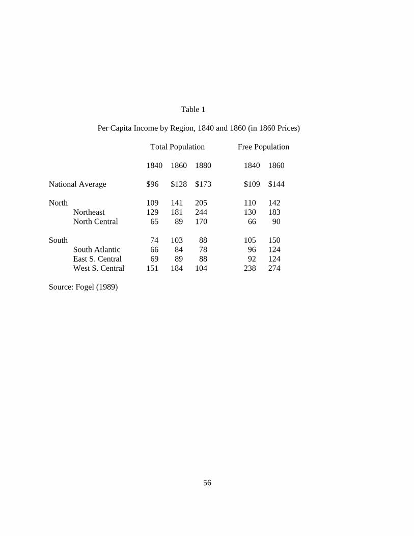
56
Table 1 Per Capita Income by Region, 1840 and 1860 (in 1860 Prices) Total Population Free Population 1840 1860 1880 1840 1860 National Average $96 $128 $173 $109 $144 North 109 141 205 110 142 Northeast 129 181 244 130 183 North Central 65 89 170 66 90 South 74 103 88 105 150 South Atlantic 66 84 78 96 124 East S. Central 69 89 88 92 124 West S. Central 151 184 104 238 274 Source: Fogel (1989)

57
Table 2 Number and Population of Cities in the United States, 1690-1990 Number of Cities 1690 1790 1820 1860 1880 1920 1940 1960 1960* 1990* City Size 2500-5000 3 12 26 163 467 1255 1422 1777 - - 5000-10000 1 7 22 136 249 715 965 1320 16434 16929 10000-25000 3 8 58 146 465 665 1142 978 1290 25000-50000 2 2 19 42 143 213 424 366 567 50000-100000 2 7 15 76 107 203 180 309 100000-250000 1 6 12 43 55 80 79 131 250000-500000 1 4 13 23 29 30 40 500000-1,000,000 2 3 9 9 16 16 15 1,000,000 + 1 3 5 5 5 8 Number 4 24 61 392 939 2722 3464 4996 18088 19289 Distribution of Population (Percent) 1690 1790 1820 1860 1880 1920 1940 1960 1960* 1990* City Size 2500-5000 5.0% 1.1% 1.0% 1.9% 3.2% 4.1% 3.8% 3.5% - - 5000-10000 3.3 1.2 1.6 3.1 3.4 4.7 5.1 5.2 13.9 11.3 10000-25000 0 1.2 1.3 2.8 4.4 6.7 7.6 9.9 8.4 8.2 25000-50000 0 1.6 0.7 2.1 2.9 4.8 5.6 8.2 7.1 8.0 50000-100000 0 0 1.3 1.4 1.9 5.0 5.6 7.8 7.0 8.5 100000-250000 0 0 1.3 3.2 3.6 6.2 5.9 6.5 6.4 7.7 250000-500000 0 0 0 0.8 2.6 4.3 5.9 5.9 6.0 5.7 500000-1,000,000 0 0 0 4.4 3.8 5.9 4.9 6.2 6.2 4.1 1,000,000 + 0 0 0 0 2.4 9.6 12.1 9.8 9.8 8.0 Total Urban 8.3% 5.1% 7.2% 19.8% 28.2% 51.2% 56.5% 63.1% 64.7% 61.6% (millions) Urban Population 0.02 0.2 0.7 6.2 14.1 54.2 74.4 112.5 116.0 153.1 U.S. Population 0.21 3.9 9.6 31.4 50.2 105.7 131.7 178.5 178.5 248.7 * Uses the new urban areas defined by the 1960 Census of Population. Sources: Data for 1690 are from Bridenbaugh (1938) and the Historical Statistics of the United States. All

58
other data are from the Censuses of Population, 1960, Vol. 1, Characteristics of the Population, U.S. Summary, 1-14-15 and the Statistical Abstract, 1992. Table 3 Number and Population of Metropolitan Areas in the United States, 1940-1990 Number of Cities 1940 1960 1990 Size Categories 50,000-100,000 15 24 26 100,000-250,000 69 91 143 250,000-500,000 30 52 75 500,000-1,000,000 13 31 45 1,000,000 + 11 24 46 Number 138 222 335 Distribution of Population (Percent) 1940 1960 1990 Size Categories 50,000-100,000 1.0% 1.1% 0.9% 100,000-250,000 16.9 8.2 9.1 250,000-500,000 8.3 9.7 10.6 500,000-1,000,000 6.9 12.0 13.1 1,000,000 + 26.2 34.3 43.9 Total Metropolitan 51.0% 65.3% 77.5% (millions) Metropolitan Population 67.1 116.6 192.9 U.S. Population 131.7 178.5 248.7 Sources: County Data Book, 1947; Statistical Abstract of the U.S., 1965; Census of Population, 1990. Note: In general, the metropolitan area is a county or a group of contiguous counties (except in New England) which contains at least one central city of 50,000 inhabitants or more or “twin cities” with a combined population of at least 50,000. In New England, towns and cities are used in defining metropolitan areas.

59
Table 4 Population and Employment Densities of Cities, 1890-1990 Number of Average Average Average Cities Population Area Population (sq. miles) Density 1890 122 113835 16.7 7648 1900 160 123243 20.2 7377 1910* 184 148442 23.1 7176 1920* 252 145966 20.9 7597 1930* 310 152890 21.9 7366 1940 412 128051 19.2 6742 1950 481 128811 19.5 6536 1960 673 112400 22.8 5340 1970 835 104785 28.5 4673 1980 944 97756 32.8 3998 1990 1068 98108 34.9 3783 Note: The data, except for years 1910-1930, are for cities with population over 25,000. In 1890, two cities were omitted due to lack of data on land area. Cities in Alaska and Hawaii are excluded. *Data for 1910-1930 are for cities with population over 30,000. Sources: Social Statistics of Cities, 1890; Census of Population, 1900; Financial Statistics of Cities, 1910, 1920, 1930; County and City Data Book, 1949, 1952, 1962, 1972, 1982, 1988, 1994.

60
Figure 1 U.S. Population Distribution, 1790-1990 (Percent)
Figure 2 U.S. Regional Specialization, 1860-1990
Source: Kim (1995, 1998). Index of regional specialization is based on Krugman (1991).
00.2
0.40.6
0.81
1.21.4
1860
1880
1900
1920
1940
1960
1980
2000
agriculture
mfg
wholesale
retail
services
All Activities
0.0
20.0
40.0
60.0
80.0
100.0
1790
1810
1830
1850
1870
1890
1910
1930
1950
1970
1990
All
Pacific
Mountain
West South Central
East South Central
South Atlantic
West North Central
East North Central
Middle Atlantic
New England

61
Figure 3 Regional Income Per Capita, 1840-1990 (U.S. = 100)
0.0
50.0
100.0
150.0
200.0
250.0
1840 1860 1880 1900 1920 1940 1960 1980 1990
ne
m a
enc
wnc
s a
es c
ws c
m t
pc
Sources: Easterlin (1960, 1961), Statistical Abstract of the U.S, various years. Figure 4 U.S. Urban Population by Size, 1690-1990 (Percent)
Sources: See table 2. City size is in thousands.
0
10
20
30
40
50
60
70
1690 1720 1790 1820 1880 1920 1940 1960 1990
1000 +
500-1000
250-500
100-250
50-100
10-50
less 10

62
Figure 5 U.S. Metropolitan Population by Size, 1940-1990 (Percent)
Sources: See table 3. Metropolitan size is in thousands. Figure 6 Population Density of Cities, 1890-1990 (Persons per square mile)
Sources: See Kim (2002)
0
20
40
60
80
100
1940 1960 1990
50-100
100-250
250-500
500-1000
1000 +
Total
0
2000
4000
6000
8000
10000
1890
1910
1930
1950
1970
1990
All Cities
119 Cities