historical earthquakes in the northern territory earliest known earthquake felt in the northern...
TRANSCRIPT
[Published www.aees.org.au] [last updated 30 May 2013] [Kevin McCue CQU] 1
Historical earthquakes in the Northern Territory
Kevin McCue CQU Rockhampton, Queensland
Abstract
I have attempted to fill gaps in the catalogued records of Northern Territory earthquakes during the historical period from 1869, mainly by examining newspapers now available on-line. The earthquakes are very clustered in time, in some years such as 1899 and 1903, as many as five events were felt in Darwin, the longest gap followed the great M8.3 earthquake in 1938 and lasted until 1950. Most but not all of the felt earthquakes investigated in the last 180 years originated offshore on the plate boundary through Indonesia and New Guinea. The Modified Mercalli intensity in Darwin has been assessed during each earthquake. Darwinians can expect minor damage every few decades and serious damage once per century. The published ISC intensities are under-estimates. An unsubstantiated report suggests one death resulted from an earthquake in 1903. A few ‘new’ intraplate earthquakes have been identified including a sequence from 1878 to 1882 near Alice Springs and a magnitude 5 earthquake near Katherine in 1951. A possible Recent fault scarp in the Simpson Desert has been tentatively identified for further on-ground investigation.
Introduction
The Northern Territory and northern parts of Western Australia with Macquarie Island, share a special problem in Australia; their earthquake hazard has two distinct sources, local earthquakes like other states and the ACT, plus great and possibly tsunamigenic earthquakes on the nearby plate boundary.
More earthquakes are felt in Darwin, and more regularly, than in any other Australian city due to its proximity to the Australian/SE Asian Plate boundaries to the north. Submarine landslides cut overseas communications cables on the sea floor after an earthquake in 1890. City buildings suffered minor earthquake damage on nine separate occasions. A megathrust magnitude 9+ earthquake on the plate boundary 500 km north of Darwin is a plausible threat and would cause significant damage.
Large intraplate earthquakes, magnitude 6 or more, occurred near the NT/SA border, in 1941 and 1986, near the NT/WA border in 1970 and at Tennant Creek in 1988 and such earthquakes pose a hazard to the Territories’ built infrastructure, buildings and lifelines. Other smaller intraplate earthquakes near Alice Springs and Katherine have been discovered and tabulated though the location and size uncertainties are significant. A possible Recent fault scarp had been identified on Google Earth maps near the epicentres of the Simpson Desert earthquakes.
The seismicity of the Northern Territory has not previously been studied in isolation, not by the aborigines who settled the area some 40,000-60,000 years ago, nor by European settlers who founded a settlement in 1869 at Port Darwin. The Seismological Committee of the Australasian Association for the Advancement of Science (AAAS) collected reports of earthquakes felt in South Australia (including the Northern Territory) from 1882 until 1891.
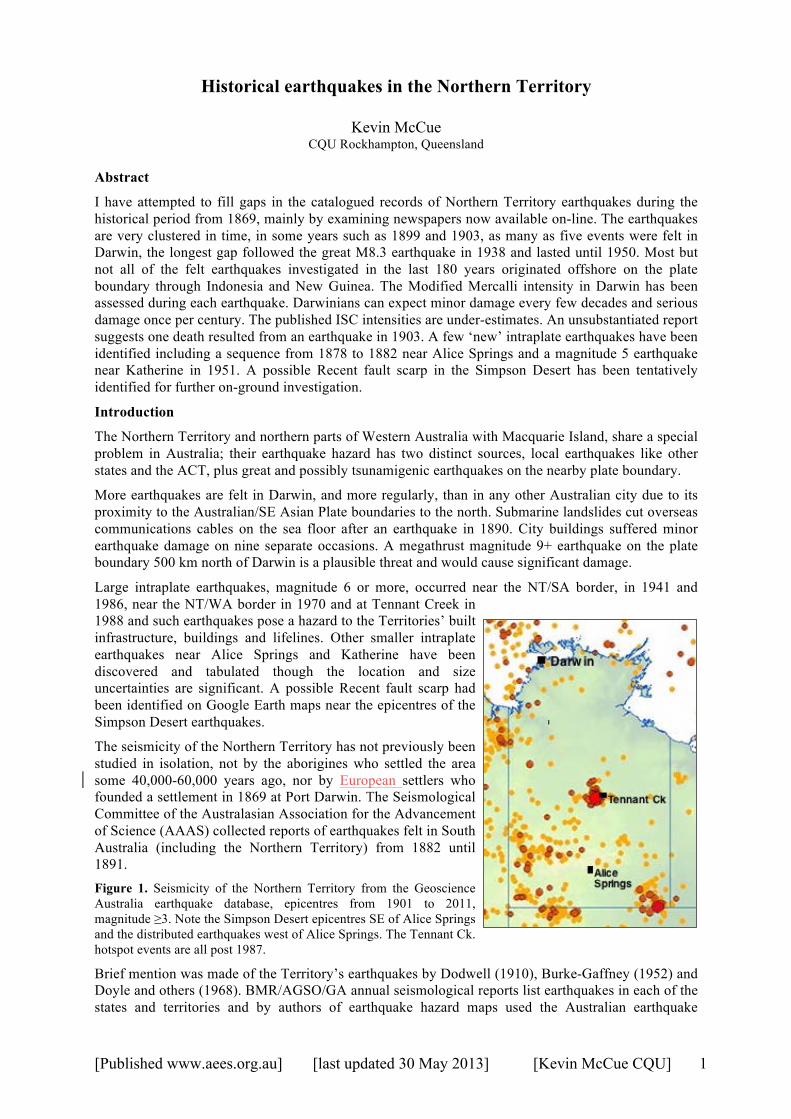
Figure 1. Seismicity of the Northern Territory from the Geoscience Australia earthquake database, epicentres from 1901 to 2011, magnitude ≥3. Note the Simpson Desert epicentres SE of Alice Springs and the distributed earthquakes west of Alice Springs. The Tennant Ck. hotspot events are all post 1987.
Brief mention was made of the Territory’s earthquakes by Dodwell (1910), Burke-Gaffney (1952) and Doyle and others (1968). BMR/AGSO/GA annual seismological reports list earthquakes in each of the states and territories and by authors of earthquake hazard maps used the Australian earthquake
[Published www.aees.org.au] [last updated 30 May 2013] [Kevin McCue CQU] 2
database to develop coarse source zones based on their knowledge of past earthquakes.
The Territory was part of New South Wales from 1825 until 1863 when administration was transferred to South Australia. In 1911 it became a Commonwealth Territory. An important development for our purposes was the construction of the Overland Telegraph from Port Augusta to Darwin between 1870 and 1872, with manned repeater stations every 250km.
The first publicly accessible NT seismograph was finally established at Darwin in 1961 after repeated urging by scientists including Milne, to do so from about 1897 (The Advertiser Wednesday 14 April 1897, page 6; Dodwell, 1910 & 1928). A seismic array, Warramunga, was later installed near Tennant Creek in 1965 immeasurably improving the location and detectability of earthquakes in the Territory.
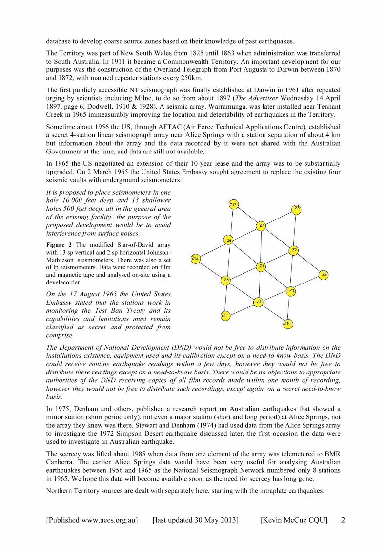
Sometime about 1956 the US, through AFTAC (Air Force Technical Applications Centre), established a secret 4-station linear seismograph array near Alice Springs with a station separation of about 4 km but information about the array and the data recorded by it were not shared with the Australian Government at the time, and data are still not available.
In 1965 the US negotiated an extension of their 10-year lease and the array was to be substantially upgraded. On 2 March 1965 the United States Embassy sought agreement to replace the existing four seismic vaults with underground seismometers:
It is proposed to place seismometers in one hole 10,000 feet deep and 13 shallower holes 500 feet deep, all in the general area of the existing facility...the purpose of the proposed development would be to avoid interference from surface noises. Figure 2 The modified Star-of-David array with 13 sp vertical and 2 sp horizontal Johnson-Mathieson seismometers. There was also a set of lp seismometers. Data were recorded on film and magnetic tape and analysed on-site using a develecorder.
On the 17 August 1965 the United States Embassy stated that the stations work in monitoring the Test Ban Treaty and its capabilities and limitations must remain classified as secret and protected from comprise.
The Department of National Development (DND) would not be free to distribute information on the installations existence, equipment used and its calibration except on a need-to-know basis. The DND could receive routine earthquake readings within a few days, however they would not be free to distribute these readings except on a need-to-know basis. There would be no objections to appropriate authorities of the DND receiving copies of all film records made within one month of recording, however they would not be free to distribute such recordings, except again, on a secret need-to-know basis.
In 1975, Denham and others, published a research report on Australian earthquakes that showed a minor station (short period only), not even a major station (short and long period) at Alice Springs, not the array they knew was there. Stewart and Denham (1974) had used data from the Alice Springs array to investigate the 1972 Simpson Desert earthquake discussed later, the first occasion the data were used to investigate an Australian earthquake.
The secrecy was lifted about 1985 when data from one element of the array was telemetered to BMR Canberra. The earlier Alice Springs data would have been very useful for analysing Australian earthquakes between 1956 and 1965 as the National Seismograph Network numbered only 8 stations in 1965. We hope this data will become available soon, as the need for secrecy has long gone.
Northern Territory sources are dealt with separately here, starting with the intraplate earthquakes.
[Published www.aees.org.au] [last updated 30 May 2013] [Kevin McCue CQU] 3
PART 1 Intraplate (within the Australian plate).
The largest known earthquakes in the Territory were in a remarkable sequence near Tennant Creek that included three large earthquakes of magnitude 6.3, 6.4 and 6.7 in a twelve-hour period on 22nd January 1988. Thousands of aftershocks have since been recorded, and whilst the rate has decreased it has not yet, 25 years later, returned to its pre-1987 level which was just about zero for the previous 20 years apart from a nearly year-long precursory sequence of earthquakes that initiated in January 1987.
Below are details of large recent earthquakes, and historical (pre-1954) earthquakes that have been studied via the ANL TROVE site. Not all Australian newspapers have been digitised yet, so more information may emerge in the future. The earliest known earthquake felt in the Northern Territory, in 1869 (then a part of South Australia), was mentioned in southern newspapers and was felt by surveyors laying out the future city of Darwin but nothing is known about its location or magnitude. Not until 1917 were magnitudes assigned to interplate earthquakes reported felt in Darwin (in the ISS and ISC bulletins).
1878 12 07 02:20 UTC, 14:35 UTC and 1878 12 08 05:00 UTC, Alice Springs region
Reminiscent of the 1987 and 1988 Tennant Creek sequences, these three earthquakes were reported under Meteorological Reports in The Sydney Morning Herald on Friday 13 December 1878, page 4.
Mr. Todd, Postmaster-General of South Australia, sends the following special telegram to-day: " Following telegram received from Alice Springs: Four shocks earthquake were experienced in this neighbourhood on Saturday, and two on Sunday; the most severe occurring at 11.20 a.m. and 11.35 p.m. on Saturday, and 2 p.m., Sunday; direction of wave from west to east; duration of each shock, between 10 and 15 seconds; their effects were very palpable. The walls of building, the iron roof, and every unsecured article oscillating violently. I find that these subterranean disturbances have been local, other stations on line being unaffected."
Todd’s reference to on-line presumably refers to the manned Overland Telegraph Repeater stations along the telegraph line, one every 250 km north and south of Alice Springs.
Judging by the effects in Alice Springs, the epicentral area must have been reasonably close, as Todd said, and the magnitude more than 4 for the larger events (articles oscillating violently) but limited to 5.7 or less by the not-felt reports at the nearest telegraph stations (250 km). We have assigned an epicentre 20km west of Alice Springs (where most of the instrumentally located earthquakes have been) and a magnitude of about 5 ± 0.5 for the three larger events, subject to more information becoming available. Naturally the uncertainty is large but that should not preclude these events being included in earthquake hazard analyses.
The following year another earthquake (aftershock?) was felt at Alice Springs.
1879 01 18 15:50 UTC, Alice Springs
The Border Watch Saturday 25 January 1879, page 3, reports:
The telegraph stationmaster at Alice Springs has reported to the Superintendent of Telegraphs that a very severe shock of an earthquake was felt on Sunday at 12.50 p.m.
The same day the South Australian Chronicle and Weekly Mail also mentions the story on page 7 but with a useful clarification:
The Telegraph Stationmaster at Alice Springs reports that a very severe shock of earthquake was experienced there on Sunday morning, January 19, at ten minutes to 1 o'clock.
I have adopted the Chronicle time of day and, without any evidence, assumed that the location of this event is the same as those of the previous year mentioned above.
1882 07 26 time not given, Alice Springs
Yet another earthquake, rated ‘severe’ in Alice Springs, was the first tabulated by the AAAS there, their rating of intensity a miserable MM3 only – surely it was higher MM4 or MM5. No report of this event could be found in newspapers using Trove.
[Published www.aees.org.au] [last updated 30 May 2013] [Kevin McCue CQU] 4
1900 05 31 23:28 UTC, Felt Darwin MM4
The Advertiser Monday 11 June 1900, page 9 mentions:
A rather severe shock of earthquake was felt in Palmerston on Friday, June 1, but it only lasted a few seconds.
The Border Watch of Saturday 2 June 1900 did report the event and a time.
EARTHQUAKE, ADELAIDE, June 1. A sharp shock of earthquake was experienced at Port Darwin at 8.28 a.m. to-day.
It is impossible to say where this event originated but ‘severe’, ‘sharp’ and ‘lasted only a few seconds’ point to a moderate event of local origin rather than a large distant event. The Saturday Chronicle of 16 June 1900, page 48 described it as rather severe but lasting only a few seconds, similar to the report in the Northern Territory Times and Gazette of Friday 8 June, page 2 which described it as smart, sufficient to set doors and windows rattling but only for a short time. This sounds more like a local earthquake, severe but of short duration, than the ‘normal’ severe, distant Banda Sea type event to the north, lasting a minute or more.
1937 10 28 09:34:43 UTC, Simpson Desert Ms 5.1
Bolt (1959) relocated this earthquake by recognising the similarities in the waveforms at ADE and RIV with those of the later Finke events discussed below. Burke-Gaffney had located it in central South Australia and accorded it magnitude 6.5. It was fortunate that the BRS station was installed at the University of Queensland just weeks before this earthquake occurred. No felt reports have been found in Australian newspapers.
I have adopted magnitudes from Everingham and others, 1987.
1937 12 20 22:35:02, Simpson Desert, magnitude Ms 5.3
A significant atypical earthquake sequence near the NT/SA/Qld border region commenced in 1937 with a magnitude 5.5 earthquake (G&R), the largest event in the sequence occurred in June 1941. The only felt reports found in newspapers were for the two earthquakes in 1941. This Simpson Desert earthquake was large enough that it was widely recorded (six seismographs) and a location could be determined by ISS. Bolt did a relocation. Again no felt reports survive.
Table 1 Formal locations of the Simpson Desert earthquake, 20 December 1937
Date UTC Time UTC Latitude Longitude Depth Author 1937/12/20 22:35:01 -25.8 137.0 - ISS 1937/12/20 22:35:01 -26.0 137.0 35.0 GUTE 1937/12/20 22:35:02 -25.45 136.5 - Bolt
Magnitude MS 5.5 PAS
1938 04 17 08:56:22 UTC, Simpson Desert, Ms 5.5
This earthquake was not reported felt but the two larger events of the sequence in 1941 were felt.
1941 05 04 at 22:07:28, 22:31:50 & 23:23:57 UTC, Simpson Desert
Bolt (1959) relocated the larger events previously located by Gutenberg (in Burke-Gaffney, 1952), ISS and Burke-Gaffney (1952).
A much later event occurred nearby in 1972.
Chronicle Thursday 8 May 1941, page 19 reports:
Three earth tremors, with a centre 623 miles north of Adelaide, were recorded by the seismograph at the Adelaide Observatory between 7.30 and 9 a.m. on Monday. The Government Astronomer (Mr. G. F. Dodwell) said this week that the centre was somewhere

[Published www.aees.org.au] [last updated 30 May 2013] [Kevin McCue CQU] 5
north-east of Oodnadatta, and the shocks may have been felt in that town. The postmaster at Finke had reported a rumbling, and windows in the township had rattled. Mr. Dodwell said that it was probable that windows would have been broken in a station directly over the centre of the earthquake. A series of three severe earth tremors were unusual in Central Australia. The last severe earth shock had been at Matpena, in March, 1939.
Matpena, now known as Motpena (or was this a typo?), and an isoseismal map by Corkery and McCue was published much later for this earthquake in March 1939 (in McCue, 1996).
1941 05 22 22:07, 22:31, 23:23 & 05 23 23:57 Simpson Desert Ms 5.8, 4.9, 5.5
Severe Earth Tremors In Central Australia
Three earth tremors, with a centre 623 miles north of Adelaide were recorded by the seismograph at the Adelaide Observatory between 7.30 and 9 a.m. on Monday. The Government Astronomer (Mr. G. F. Dodwell) said last night that the centre was some- where north-east of Oodnadatta, and the shocks may have been felt in that town. The postmaster at Finke had reported a rumbling and windows in the township had rattled Mr. Dodwell said that it was probable that windows would have been broken in a station directly over the centre of the earth- quake. A series of three severe earth tremors were unusual in Central Australia. The last severe earth shock had been at Matpena in March, 1939.
1941 06 27 at 07:55:49 UTC, Simpson Desert, magnitude Ms6.5
A strong earthquake sequence occurred in the southeast of the Territory between May and June 1941. There were few seismographs running in Australia but the mainshock on 27 June 1941, magnitude 6.5, was well recorded at Riverview NSW, Adelaide SA, the University of Queensland and overseas, damaging some of the insensitive local recorders in the process, such was the amplitude of the ground motion. In this remote part of the continent there were few felt reports; Finke, Mulka Mona Downs and Oorowillania stations reported the shaking but apparently not Alice Springs, Broken Hill or Oodnadatta.
Western Mail Thursday 3 July 1941, page 20S heads its story: the Inland Earthquake
SYDNEY, June 29.—The main shock of an earthquake in Central Australia on Friday was the most violent in Australia during the 32 years of the existence of the Riverview observatory.
The Rev. Father O'Connell, the director of the observatory, said tonight that the centre of the earthquake was about 1,000 miles north-west of Sydney, which would be near Finke, a station on the Alice Springs railway line.
A telegram from Finke to the Sydney Weather Bureau, stated that the earthquake was accompanied by a very loud rumble and all the buildings in the town were shaken severely.
The Barrier Miner Saturday 28 June 1941 page 5 reports:
'QUAKE IN CENTRAL AUSTRALIA
ADELAIDE, Saturday. – Reports of a severe earthquake in the Finke River District, Central Australia, have been received at the Adelaide Observatory. The first tremor was felt at 5.28 p.m. yesterday. The maximum shock occurred a few minutes later when there was a loud rumbling and buildings were shaken.
There was also a report of an earthquake shock at 6 p.m. eastern time, at Mulkamona Downs, about 400 miles north-west of Broken Hill.
The earthquake was large enough to be recorded worldwide and a location was published by Gutenberg and Richter (1949). On Google Earth the epicentre (G&R) is on the NT/SA border near the Qld border at the edge of the sand dunes of the Simpson Desert, here striking about NNW.

[Published www.aees.org.au] [last updated 30 May 2013] [Kevin McCue CQU] 6
The Riverina Herald Tuesday 1 July 1941, had an interesting front page report:
NO EARTHQUAKE DAMAGE YET REPORTED
ADELAIDE, Monday
No reports have been received of any material damage being caused by the earthquake in the Finke River district, Central Australia, on Friday.
The Government Seismologist (Mr Jennison) calculates the centre of the disturbance at 690 miles north of Adelaide. There were three distinct shocks.
A similar series of shocks was recorded from the same district on May 5.
With only two confirmed felt reports and a few not-felts, it is not usually possible to draw an isoseismal map, and imaginative to sketch the felt area though we have attempted to do so in Figure 3.
Figure 3 Felt area centred on the epicentral region, including Finke and Mulka but excluding Alice Springs and Oodnadatta where there were no reports that it was felt.
About 40km west of the G&R epicentre is an interesting, ~20km long N-S arcuate brownish feature with a parallel sand dune as shown in the adjacent image, Figure 4. There is a possibility that this reflects a basement fault scarp, perhaps caused by a disruption to drainage, but ground proofing is needed to find out what this feature is. It is an appropriate length for a scarp produced by a shallow earthquake of magnitude Ms 6.5. Figure 4 The near-epicentre map shows the locations by Gutenberg and Richter (1954) G&R, ISS and Bolt (1959). The red horizontal bar near the ISS epicentre is 40 km long. The possible scarp is the brown vertical smudge above the border at the left hand end of the red scale bar.
The orientation is a bit challenging in Central Australia where previous surface ruptures have been
[Published www.aees.org.au] [last updated 30 May 2013] [Kevin McCue CQU] 7
east-west, if indeed it turns out to be a recent scarp, but the elongated ellipse of the felt area does not contradict a north-south striking thrust fault.
Bolt interpreted phases on RIV seismograms as Rg and Lg, the former a clear indication of very shallow depth or near surface rupture.
1951 04 12 07:05 UTC, strong in Katherine MM2 in Darwin
The West Australian Friday 13 April 1951, page 2.
BUILDINGS SHAKEN Severe Earth Tremor In The North DARWIN, April 12: A severe earth tremor shook buildings at Katherine, Pine Creek and Adelaide River this afternoon. Katherine is 220 miles south of Darwin, Adelaide River 70 miles south. No damage has been reported. The shock was not felt in Darwin and petered out a short distance south of Katherine. A report from Katherine says that patients were shaken in hospital beds and the hospital itself rattled. The tremor lasted about one minute and was described as having made a noise like a train going over a bridge. A resident of Pine Creek said residents were first attracted by a noise which sounded "like a semi-trailer loaded with beer going along the road." Then buildings began to shake.
The Sydney Morning Herald, Friday 13 April 1951 declared that the centre was Katherine:
DARWIN, Thursday.– A severe earth tremor shook townships and a large area of cattle country south of Darwin late to-day.
Women and children ran screaming from their homes at several places on the north-south road. No one was injured and no damage has been reported.
The tremor lasted about two minutes. Its centre was at Katherine, about 200 miles south of Darwin.
Mrs. I. M. Little, of Pine Creek, said to-night: "The town was severely 'rattled.' Many people left their homes. It was really terrifying."
The Northern Standard 13 April 1951, page 1 elaborates:
A mild earth tremor was felt over a wide area of the north end of the Northern Territory yesterday afternoon. No damage was done in any centre, but reports from three stations along the Stuart Highway indicate varying degrees of severity. The tremor was also noticed in Darwin.
"SEVERE"
The shock appears to have been severest in Katherine. About 4.05 p.m., residents felt what is described as a "severe shock" which lasted for a full minute. Buildings shook and furniture moved around the floors. In the hospital patients noticed the tremor more than people outside. Their beds were shaken, but there was no panic.
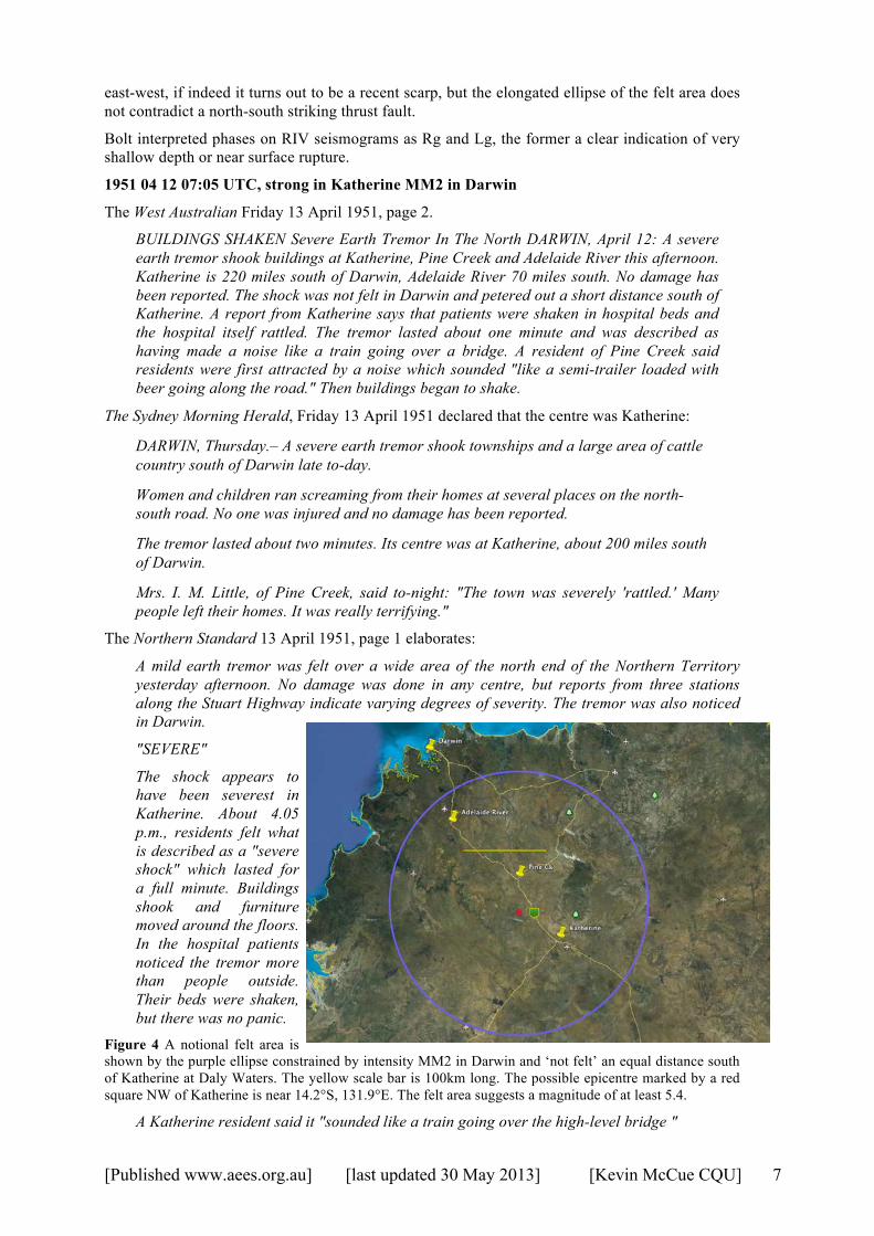
Figure 4 A notional felt area is shown by the purple ellipse constrained by intensity MM2 in Darwin and ‘not felt’ an equal distance south of Katherine at Daly Waters. The yellow scale bar is 100km long. The possible epicentre marked by a red square NW of Katherine is near 14.2°S, 131.9°E. The felt area suggests a magnitude of at least 5.4.
A Katherine resident said it "sounded like a train going over the high-level bridge "
[Published www.aees.org.au] [last updated 30 May 2013] [Kevin McCue CQU] 8
RATTLED
A man outside the cafe at Adelaide River was almost shaken from the form on which he was sitting. Bottles and glasses on the shelves inside rattled for about a minute.
Pine Creek residents left their houses and went into the open when the buildings shook. It may have been wishful thinking, since a resident said "We hadn't had much to drink so we knew it must be an earthquake," but he added that the tremor made a noise "like a big semi-trailer loaded with beer travelling fast up the highway."
NO SHOCK
No shock was felt at Daly Waters, but the Darwin Meteorological Office said this, morning that a reliable report had been received that it had been felt in Fannie Bay. Although it was in a very mild form, a number of people sitting quietly around an afternoon tea table said the rattling of cups and china was unmistakeable.
Another report says that bottles and jars fell off shelves in the milk bar at Adelaide River.
The uncertainty is large, an epicentre nearer Katherine and further east would satisfy the felt reports but at the expense of a larger magnitude. The Riverview Bulletin 1951/2 does not mention the earthquake and RIV seismograms show no sign of an earthquake. If a 1mm amplitude (5µ ground displacement) was the minimum observable signal, then at an epicentral distance of about 26° (Katherine to RIV), the magnitude would be about Ms 4.7 or ML 5.2.
The Bulletin does list 13 phases associated with a magnitude 6.6 event at Sumbawa on the following day the 13th at 10:14 UTC (7:14pm local time) so I think we are justified claiming the earthquake on 12th at 4pm local time as an intraplate event near Katherine, its magnitude ~5.2.
1972 08 28 02 18 51.6 UTC, Simpson Desert, Mb 5.6 (ISC)
This was the first well-recorded earthquake in the Simpson Desert zone with data from both one element of the Alice Springs array (it was still a secret site at the time) and the growing network of seismographs in South Australia. Stewart and Denham (1973, 1974) located only 15 small aftershocks to the end of 1972, the three largest between magnitude 3.0 and 3.7, that is rather unusual but not unprecedented. They rated the magnitude ML 6.2, converted from a measured Mb, and noted that it was not reported felt, unlike the June 1937 earthquake mentioned above. It is puzzling that the aftershocks extend over ~120km, far too long a rupture for this sized event. The computed uncertainties quoted by Stewart and Denham, ~10 km, are probably much smaller than the actual uncertainties given the epicentral distance to the stations of 300 to 1000km, an inter-station gap of more than 250 degrees and the authors’ use of non-local crustal models in the computer locations.
One question is whether the 1937-41 and 1972 earthquakes are essentially co-located or are indeed some 100km apart. The 1972 event has been reviewed by EHB and their location is rather different from the ISC, NEIS and ADE (Stewart and Denham, 1974) ones shown in the table below (from the ISC Bulletin, all four decimal places!). The computed focal depth varies from 7 to 59 km.
Table 2 Locations of the 1972 Simpson Desert earthquake by various authors, sorted by longitude
Date Time Latitude Longitude Depth Author 1972/08/28 02:18:51.60 -24.7400 136.9199 7.0 ADE
02:18:59.43 -25.0081 136.3694 59.0f ISC 02:18:56.07 -24.9930 136.3220 13.1 EHB 02:19:00.50 -24.9250 136.3149 59.0 NEIS 02:18:56 -24.95 136.26 8 GA 02:18:58.00 -24.9000 136.1999 - MOS
The station KNA at Kununurra WA was found by the author during a study of Papua New Guinea earthquakes in the mid-1970s to have reversed polarity, which would slightly change Stewart and Denham’s first-motion focal mechanism.

[Published www.aees.org.au] [last updated 30 May 2013] [Kevin McCue CQU] 9
1986 03 30 08:53 UTC, Marryat Ck SA Ms 5.8
This earthquake and its slightly smaller doublet three months later on 11 July 1986 at 07:17 UTC occurred just south of the SA/NT border causing a 13km long arcuate surface fault, indicative of shallow depth. The shaking from the March event was felt at Uluru and Alice Springs.
1987 and 1988 Tennant Creek sequences
Much has been written about the 1988 earthquake sequence that continues through 2013 in a desultory manner. The 1987 sequence started in January and had all but petered out by the 22 January 1988 when three large earthquakes struck Tennant Creek.
Extracts from a story in The Canberra Times of 24 January 1988, page 3 included the following and note the headline:
Tremors ‘could go on for months’
Owners of more than 40 private homes have reported structural damage, along with most offices and public buildings. But there is very little apparent damage, only a few cracked pavements and the occasional crooked post.
The town is still filled with a sense of expectation. After more than 24 hours of virtually constant tremors many residents arc close to nervous exhaustion.
A miner who was trapped underground during the earthquake says he won't go back down if there are any more big tremors. Mr Trevor Short was stuck 50m underground during after-shocks which followed the largest of four major earthquakes on Friday. He and two other miners were trapped underground for 30 minutes when power failed at the Cuprex TC8 mine, jamming the elevator which takes them to the surface. They had returned down the mine after the first major quake at 10.30am.
Thirty-year-old Mr Short, father of two young children, had ignored an emotional appeal from his wife Jenny, who sped to the mine from Tennant Creek after the first shock. "I didn't care what anyone said — I wanted to make sure my husband was okay," Mrs Short said yesterday. She pleaded with her husband not to go back down, but he decided to follow the mine manager's orders and return to the mine face.
Mr Short, whose job as a driller puts him at the deepest point of the mine, said he was not operating his drilling machine at the time of the second quake. He was able to rush straight to the shaft opening in the mine when the quake began. As he ran, rock and debris was falling deeper in the mine. At the shaft he and fellow-workers waited impatiently for the cage to come down. Above, winder driver Mr Joe Wicks had fled from his post in terror as the platform on which he was sitting began shaking badly. But before the shaking had stopped he was back at his post, telephoning to the men underground to make sure they were okay.
The coincidence in space and time of the two earthquake sequences begs the question of their relationship, and whether or not the second sequence could have been predicted by the first; was the 1987 sequence a precursor? The pattern of the 1987/1988 sequences has features in common with the 1937/41 Simpson Desert sequences where the main series of earthquakes in 1941 followed the smaller 1937/38 sequences by 3 years. The 1970 Lake Mackay and 1986 Marryat Creek earthquake sequences in the NT region lacked such a foreshock sequence so the occurrence of the 1987 sequence could hardly have been used for prediction purposes.
1989 05 28 02:55:21, Uluru ML 5.6
This was an unusual earthquake initiating at a focal depth of 31km, given as the reason for the lack of aftershocks (Michael-Leiba and others, 1994). Minor damage was reported at Yulara near the epicentre. It was not felt at Alice Springs.
1997 08 10 09:20: 35.2 UTC, Collier Bay WA earthquake magnitude Mw6.2, felt Darwin
This earthquake was barely felt at Darwin, MM2, 800km away (isoseismal map by Gregson and Moiler in McCue and others, 2001), but it did trigger both of the accelerographs there.
[Published www.aees.org.au] [last updated 30 May 2013] [Kevin McCue CQU] 10
1999 11 12 07:57 UTC, Beagle Gulf earthquake felt Darwin
This small magnitude ML3.9 earthquake occurred offshore, about 40 km NW of Darwin where it was felt MM4, and where it triggered the DRS accelerograph. It was also felt on Melville and Bathurst Islands.
Discussion
Of great importance is the direction of the principal stress axis in continental Australia; in a rigid plate the stress would be constant but focal mechanisms show that this is not the case so we would like to map those domains with a uniform stress direction.
An unusual feature of local earthquakes in the Northern Territory is their focal-depth range, for example, the earthquake near Manangrida on 30 September 1992 that was felt by a few people in Darwin MM2. Depth phases pP and sP identified on seismograms in southern Australia constrained the focal depth at the independently modelled crust/mantle boundary near 40km depth (McCue and Leiba, 1993). The only other place in Australia with earthquakes at comparable focal depths is southeast South Australia where there are recent volcanoes and where these two phenomena are assumed to be related, but there is no evidence for recent volcanism along the north coast of the Northern Territory. An alternative scenario is that buckling of the crust along the northern plate collision zone prior to subduction causes earthquakes throughout the crust here.
Aftershocks of the 1988 sequence recorded on the local area network installed just days after the mainshock by Gibson and Corke (SRC) with later additions by Jones (BMR) were characterised by upper crust focal depths down to about 14 km.
PART 2 Interplate (Plate Boundary events).
Information about the early felt earthquakes is invaluable in earthquake hazard assessments.
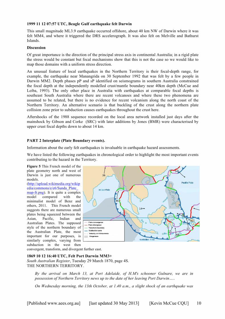
We have listed the following earthquakes in chronological order to highlight the most important events contributing to the hazard in the Territory. Figure 5 This French model of the plate geometry north and west of Darwin is just one of numerous models. (http://upload.wikimedia.org/wikipedia/commons/e/e6/Sunda_Plate_map-fr.png). It is quite a complex model compared with the minimalist model of Benz and others, 2011. This French model suggests there are numerous small plates being squeezed between the Asian, Pacific, Indian and Australian Plates. The supposed style of the northern boundary of the Australian Plate, the most important for our purposes, is similarly complex, varying from subduction in the west then convergent, transform, and divergent further east.
1869 10 12 16:40 UTC, Felt Port Darwin MM3+ South Australian Register, Tuesday 29 March 1870, page 4S. THE NORTHERN TERRITORY.
By the arrival on March 13, at Port Adelaide, of H.M's schooner Gulnare, we are in possession of Northern Territory news up to the date of her leaving Port Darwin…..
On Wednesday morning, the 13th October, at 1.40 a.m., a slight shock of an earthquake was
[Published www.aees.org.au] [last updated 30 May 2013] [Kevin McCue CQU] 11
felt here, the noise resembling thunder, and the vibration awakening several, who were eager in their enquiries of the night guard as to what was the matter.
This brief note is the first documented felt earthquake in the Northern Territory at Port Darwin, at least as far as the author is aware. Where it occurred and how big it was, it is impossible to say but the intensity is rated 3-4 on the Modified Mercalli scale i.e. MM3+.
1874 01 13 02:39 UTC, Felt Darwin MM4
The South Australian Advertiser Wednesday 14 January 1874, page 2, noted the following:
The Superintendent of Telegraphs has courteously favored as with a copy of the following telegram from Mr. Little, the head operator at Port Darwin:—" January 13, 12.39 p.m. S.A. time. Slight shock of earthquake felt here. Direction S.W."
The Northern Territory Times and Gazette Friday 16 January 1874, page 2 ran the following story about the earthquake, the story uncovered later:
PALMERSTON: FRIDAY, JAN. 16, 1874.
On Tuesday morning, about half-past 11 or quarter to 12, a slight shock of an earthquake was felt in Palmerston, and lasted for about 25 seconds. The wave seemed to be from east to west and was very distinct, having that peculiar rocking undulating motion similar to the movement of a hammock slung between two trees. Several people felt the shock and describe it as "a waving rocking motion." It was also distinctly felt in several parts of the town.
We have rated the intensity at Palmerston MM4.
1874 03 11 20:24 UTC, Felt Palmerston MM5
The Gippsland Times of Saturday 14 March 1874 mentions an earthquake felt in Darwin at 5.24 a.m. on Thursday – no date. The Border Watch of Wednesday 18th March, page 3 says it occurred on Thursday morning 12 March – no time. The South Australian Advertiser reports it occurring on March 6 at 5.25 a.m. This date is supported by the South Australian Chronicle and Weekly Mail of Saturday 14 March 1879, page 9 that mentions a heavy shock being felt at Palmerston, Southport and the Adelaide River.
The weather report in the South Australian Register Friday 13 March 1874, page 5 clarifies the date: Thursday March 12 at 5 a.m. Again we have no information to constrain either epicentre or magnitude but, given the remarks below, we rate the intensity MM5.
The Bendigo Advertiser of Monday 16 March 1874, page 3 comments:
The Earthquake at Port Darwin-. — The following fuller details of the earthquake at Port Darwin, referred to in our columns of yesterday, have been telegraphed to the Melbourne Observatory by Mr. Todd, of Adelaide:—"The station master at Port Darwin telegraphs:—' At twenty-four minutes past five a.m. I was awoke by a severe shock of an earthquake, ac- companied by a low rumbling sound like distant thunder; all crockery-ware in the house was rattling so loudly that I thought it was some of the staff knocking at the door to ship the mails per Tararua. The action was a quick shaking one; and not like that of the shock experienced several weeks ago, which more resembled a wave passing under the feet. Shock also felt on board Tararua and Analgista in harbor."
This description and comparison with the earlier earthquake ‘quick shaking one’ vs. ‘a wave passing’ suggest that this later earthquake may well have been an intraplate earthquake though we will never know.
1876 12 06 01:40 UTC, Felt Darwin and local area MM4
A strong shock of earthquake was reported in the print media, felt at Darwin, Southport and Tumbling Waters, both latter locations about 25 km south of Darwin. The Evening News of Tuesday 19 December 1876, page 2 elaborates:
Mr. Todd, the Superintendent of Telegraphs at Adelaide, has supplied the following information to the colonial press:— "A strong shock of earthquake is reported by the

[Published www.aees.org.au] [last updated 30 May 2013] [Kevin McCue CQU] 12
stationmaster at Southport on 6th instant at 10.40. Mr Machel says it was noticed at Port Darwin, Southport, and Tumbling Waters. At Southport the telegraph building shook visibly, and the shock lasted from 10 to 15 seconds, having a motion from east to west.”
We presume this was a large plate boundary event to the north of Darwin though none are reported in international catalogues as it predates instrumental seismology by about a decade. The intensity in Darwin is rated MM4.
1880 earthquakes and the cable
The South Australian Register Tuesday 16 October 1900, page 6 carried this interesting story:
Writing from Bradford, a representative of the "Daily News" remarks:— "The practical use of the scientific man has rarely been so clearly demonstrated to me as it was this morning during a brief conversation I had with Professor John Milne, of earthquake fame. For instance, in 1880 the three cables connecting Australia with the outer world were suddenly interrupted. The Australian scientists knew the very moment it occurred, and by testing could tell the distance of the place where it occurred, but they could not tell the cause, and so for 19 days, at enormous expense, they called out the naval and military reserves. It was then discovered that the breakage of the cables was the result of an earthquake in Java. All this trouble would have been saved had Mr. Milne's instruments been then invented. Thus can the scientific man be of the greatest possible service to our colonies and isolated dependencies, and save a world of anxiety and expense. Therefore it is all important that the English Government should provide him with a suitable building upon a firm foundation, and work it at the modest rate of £300. Otherwise it is quite certain that the seismographic station at Strasbourg, where the machines invented by Milne and his friend, Professor Ewing, of Cambridge, and others, are in full use, will become the centre for the world, in which case, in war time possibly, it would be impossible for our Government to learn the cause— possibly an earthquake— of the delay in the transmission of their messages over the cables.
Now here is a chance for the patriotic millionaire, if the Government won't come to the rescue."
The date mentioned is probably wrong, the cable was broken in 1890 (see later event), not 1880 as the representative of the Daily News ‘remembered’. We still need that millionaire.
1882 03 03 15:28 UTC, Darwin MM4
The Evening News Wednesday 8 March 1882, page 2 headed the story:
Earthquake at Port Darwin.
A distinct shock of an earthquake was experienced at Port Darwin on Saturday, but fortunately no damage was done. No wave or other disturbance was recorded at our Sydney Observatory at or about the time of the occurrence at Port Darwin. Mr. Russell, the Government astronomer, received the following telegram yesterday from Mr. C. Todd, C.M.G., Superintendent of Telegraphs, South Australia, having reference to the phenomena :— " An earthquake, 2.28 local time of the 4th, was felt by the Government Resident and by several other people in Port Darwin. Its direction was west and north-east. The ground, as well as walls of buildings, were shaken. A good record of the vibration was obtained on the tape of the syphon recorder in the Cable Company's office. The operator states that there was at first a sharp noise, and then a wave-like oscillation. The ground and buildings than began to shake, accompanied by a low, rumbling noise. The shaking lasted for about a minute. There was no trace of the earthquake at either Banjoewangie or Singapore. Mr. Brackland, the cable operator, has given me the tape, with oscillation, which I will send you."
What device was in operation at Sydney Observatory in 1882 that could have recorded the earthquake? The intensity in Darwin is assigned MM4.
[Published www.aees.org.au] [last updated 30 May 2013] [Kevin McCue CQU] 13
1884 06 26 11:37 UTC, Yam Creek Meteorite
‘Earthquake in Northern Territory’ was the headline of the Evening News on Saturday 28 June 1884, page 4 (Yam Creek is about half way between Darwin and Katherine):
Yam Creek, Saturday.
On Thursday evening strong shocks of earthquake were felt here with loud reports from the direction of the south-east. The shocks continued for 12 seconds. Many articles in the survey tents were disturbed. A brilliant meteor passed from the north-west an instant previously.
The same story was published in The South Australian Advertiser the same day, page 5 but with the addition of the time ‘last evening at twenty-three minutes to 8’.
It must have been a close meteorite for the shockwave to disturb articles in the survey tent. Another newspaper mentioned it was felt in Darwin.
1884 09 09 20:00 UTC, Port Darwin MM3
The Sydney Morning Herald of Wednesday 10 September 1884, page 10 had a short note datelined Tuesday that at Port Darwin ‘a slight shock of earthquake was felt here about 5 o’clock this morning’ - a second event! MM3 at Port Darwin.
1887 02 14 ~14:00 UTC, Felt Palmerston MM4
The North Australian reported in the Saturday 19 February 1887 edition on page 2 that:
On Monday night, at about 11 o'clock, a smart shock of earthquake was felt by numbers of people in Palmerston. The shaking sensation lasted fully a minute from the time that it was first noticed by us until it passed over.
Could this event have been incorrectly listed as occurring on 14 April at 11.15pm by the AAAS? or were there two events? We have assumed the newspaper date is correct and the intensity was MM4.
1888 04 13 13:00 UTC, Felt Darwin MM5
The Northern Territory Times Saturday 28 April 1888 Page 2 reports:
On Friday evening, 13th inst., about 10 o'clock, the shock of an earthquake was felt through the township. The motion seemed to be travelling from west to east, and lasted several seconds. So great was the movement while it lasted that in several instances it shook movable articles off shelves, but we have not heard of any more serious damage having been done.
On March 23, 1908 the same newspaper reported the same earthquake “Just twenty years ago today at 10 p.m.” There is a strange discrepancy of 3 weeks though we have taken the first date and assigned the intensity in Darwin as MM5.
1888 10 09 13:00 UTC, Felt Port Darwin MM4, Katherine and other places
Both the AAAS and South Australian Register of Thursday 15 October 1888, page 25 mentioned another earthquake:
Port Darwin, October 9. An unmistakable earth tremour occurred at 10 o'clock to-night and lasted several seconds. It appeared to travel from north-west to south-east, and made the houses rattle. It was preceded by a heavy squall accompanied by light wind and rain.
Port Darwin, October 10.
Cable communication with Java is interrupted. The steamer Sherard Osborne is relaying the Java ends of both cables, and therefore probably the interruption will be brief. It is supposed not to have been caused by last night's earthquake.
Another report, from Maude Creek in the North Australian Saturday 20 October 1888 notes:
No earthquake shocks such as reported from the Katherine and other places have been felt here.

[Published www.aees.org.au] [last updated 30 May 2013] [Kevin McCue CQU] 14
1889 09 06 12:00 UTC, Magnitude 8.0, Moluccas - not felt Darwin
This report is from NOAA 2010, National Geophysical Data Center: National Oceanic and Atmospheric Administration, http://www.ngdc.noaa.gov/hazards.)
1889 September 6, after 20:00 [local time]. There was a strong earthquake (1 deg N, 126.25 deg E) and tsunami on the northeast of Indonesia.
A tsunami appeared soon after the earthquake. The sea suddenly rose 2 m (1 fathom) at Manado, 3.5-4 m (2 fathoms) at Kema; the same occurred at Amurang. Thirty residential blocks (districts) were destroyed at Kema.
At Bentenan, one residential district was flooded 15 times in 2 hours. The water rose 0.5 m (2 feet) in the yard of a home on the coast during the first three waves. The Palemba River was dammed and swelled heavily on a 700 m stretch, though adjacent areas were not inundated. The tsunami began during an ebb when the sea level fell 2 m below the mean mark, and the shore was inundated to a height of 2.5 m above this mark. Thus, the amplitude of oscillations can be estimated at 9 m [2 1/4 m?].
The sea was very restless at Ternate Island, now falling, then slowly rising.
On Sangihe Island at Peta, there was a very great flooding. At Tahuna, there was a rise in water level by about 1.5 m. The water rose in about 2 minutes and fell in 3 minutes. The movement of the water, according to an eyewitness, began a minute after the earthquake and was accompanied by a noise like a strong surf. The bridge across the river at Tahuna was lifted by the flood and partially knocked off its piers. The waves recurred throughout the night until morning, at gradually increasing intervals: from 5 minutes to 30 minutes. Most of the residents of Tahuna rushed to the adjacent hills after the earthquake and spent the night there. On the 9th, many dead fish were found on Cape Tahuna. Six proas were loaded full with the fish. It was on this account that the residents thought that the cause of the earthquake was the eruption of an underwater volcano (Banda Wuhu?) in the vicinity of Sangihe Island.
1889, Sept. 9, 1899. 2.2 N, 125.4 E. Eruption of Ruang volcano in progress when tsunami occurred. This is the tsunami, date in Heck is misprinted 1899 Sept 8.
1889, Sept. 6. Indonesia. Waves 1.5 meters (5 feet) high accompanied an eruption of Banua Wuhu (03o08'N., 125o29'E.) were reported from Taroena on Palau Sangihe. The wave washed up many dead fish, (Neeb 1943, Neumann van Padang 1951).
1899, Sept. 8. Indonesia, Ruang Island. A wave was generated by a volcanic eruption, (Heck 1947). (Probably the same as 1889 Sept. 6.).
1899, Sept. 8 Ruang Island. Eruption going on when tsunami occurred. [Probably the same as 1889 Sept 6].
This example was included because the earthquake was apparently not felt in Darwin, at least a Trove search reveled no newspaper report that it was felt. This is unexpected given the magnitude of 8.0 but this does put tangible limits on the extent of the source zones that need to be considered for a hazard analysis of Darwin.
1890 Three earthquakes were reported felt in Darwin or Palmerston during the year
1890 03 05 ~10.00 UTC, Port Darwin
AAAS reports that the earthquake was felt at Port Darwin, Barrundie, Pine Creek, River Katherine and Daly Waters. The Advertiser of Friday 7 March 1890, page 4 mentions a slight earthquake, severe at Katherine, on 5 March.
METEOROLOGICAL NOTES.
Thursday, March 6, 9 a.m.
Slight shock of earthquake between Port Darwin and Daly Waters between 6 35 and 7 9 p m. yesterday, lasting from 30 to 45 seconds.
[Published www.aees.org.au] [last updated 30 May 2013] [Kevin McCue CQU] 15
1890 07 10 20:00 UTC, Java
The Sydney Morning Herald Monday 21 July 1890, page 5 reports the following interesting story.
THE CABLE RESTORED.
THE BREAK CAUSED BY A SHOCK OF EARTHQUAKE.
Cable communication with Europe, which had been interrupted for nine days, was restored at noon on Sunday. All three cables were broken simultaneously at 5 a.m. on the 11th instant. According to information supplied to us by the Electric Telegraph Department, it now appears that the sudden failure of the cables was due to a sharp shock of earthquake, which passed over the southern end of the island of Java. The Eastern Extension Telegraph Company's repairing steamer Sherard Osborn was despatched to the locality of the break, and on arriving on the spot, which was found to be in Bayly Straits, about 80 miles from Banjoewangie, operations were commenced in grappling for the broken ends of the cables. The Banjoewangie end of the duplicate cable was picked up and buoyed at daylight on Friday. On Sunday morning a message was received from Port Darwin to the effect that the repairers on board the Sherard Osborn were engaged in making the final splice in the cable, and at 12.45 p.m. a second message announced the fact that communication by the duplicate cable had been restored. The original cable, which was laid in 1872, and the new cable to Roebuck Bay were still interrupted, the broken ends not having yet been recovered, but one cable having been successfully repaired, through communication with Europe and the East is once more open.
" Electric Telegraph Department, July 20.
"The Adelaide office sends the following memo, from Port Darwin, dated 10th instant:-' For the information of the Australian Governments it is announced that on the morning of the 11th all three cables suddenly failed, apparently about the same place in Bayly Straits, about an hour after a severe shook of earthquake had passed over the Southern end of Java. The Sherard Osborn (repairing steamer) arrived on the position at daylight yesterday, and recovered and buoyed the Banjoewangie end about 30 miles from Banjoewangie. Hope to restore communication tomorrow (Sunday), the 20th.' "
The submarine landslide triggered by the earthquake must have been close to the shallow epicentre and the felt area limited to southern Java gives a magnitude of about 6.5.
1890 12 25 21:00 UTC Palmerston MM5+, earthquake and tsunami Dili
Two stories in the Northern Territory Times and Gazette on Friday 2 January, and 9 January, 1891, page 2 read as follows:
EARTHQUAKE. — Christmas Day brought along another of these portentous visitors, landing it here about 6 o'clock on the morning of the 25th. The shock was a very palpable one, and lasted longer than any earthquake since the Straits of Sunda eruption ; in-fact, not a few of those who felt it remained in a state of unsteadiness throughout the day. Houses rocked in a manner that caused some consternation, and when we remember that we are averaging about one quake a month, and each one seems to be more severe than its immediate predecessor, the future of the Territory— our great beacon of hope during the last decade—has the appearance of being a very risky thing indeed. The probability is that we shall soon hear of another disaster similar to the terrible eruption at Krakatoa.
THE LATE EARTHQUAKE.—Captain Craig, of the s.s. Menmuir, informs us that the earthquake which we experienced on Christmas morning was felt very severely at Timor. At Delhi (Dili? -Ed.) the shock lasted a minute and a half. Several of the houses at this port were cracked, a great commotion was caused in the waters of the bay, and generally much consternation was created amongst the inhabitants of the island.
The Meteorological Notes Synopsis in The Advertiser of Saturday 27 December 1890, page 4 notes a slight shock of earthquake at 6:22 am on (2)5th. AAAS records additional comments that children were

[Published www.aees.org.au] [last updated 30 May 2013] [Kevin McCue CQU] 16
removed to a safe distance from houses and that an unusual series of pulsations was felt. Interestingly they report it was also felt at Banjoewangie, Indonesia.
Quite a lot can be surmised about this pre-seismograph-era earthquake; it was located near Dili where it caused minor damage, it was shallow given it caused a tsunami, and its magnitude was at least 7.5, because it caused a tsunami and and was felt quite strongly in Darwin MM6.
1892 04 19 at 18:12 UTC, Felt Darwin and Katherine
Signs of what was to come in this story from the South Australian Chronicle 23 April 1892, page 10 (most severe ever!):
Port Darwin, April 20.
The most severe shock of earthquake ever recorded here occurred this morning at 12 minutes past 3 o'clock. It travelled from north-west to south-east, and the vibration lasted fully three minutes. It was also distinctly felt at the Katherine.
1894 02 13 19:15 UTC, Port Darwin MM5+
A shock of earthquake, quite severe enough to be startling, was felt in Palmerston at about a quarter past 4. on Wednesday morning. The tremor and rumbling were distinguishable for quite 60 seconds and the passage of the earthquake appeared to be from north to south. So distinct was the oscillation that many persons became alarmed and quitted their houses. It was the severest shock of the kind that we can remember, and it will be interesting to learn where it came from. Most probably from one of the islands in the Malayan Archipelago.
The Northern Territory Times and Gazette Friday 16 February 1894, page 3.
1894 06 17 08:30 UTC, Port Darwin MM5
A second earthquake was felt mid-year at Port Darwin and mentioned in the Advertiser Tuesday 19 June 1894, page 5.
Port Darwin, June 18.
A severe earthquake shock, travelling from south-east to the north-west and lasting one and quarter minutes, was experienced at 5.30 p.m. on Sunday. The shock was accompanied by peculiar rumbling noise, and all the stone buildings were severely shaken.
1895 07 26 ?time Bagot’s Well (Darwin Suburb) MM6
According to the Evening news Saturday 3 August 1895, page 6:
A severe shock of earthquake was felt in several places in the Northern Territory on Friday. The vibration was very pronounced. At Bagot's Well the walls of the railway cottage were cracked and the plaster knocked down.
1895 08 25 16:40 UTC, Darwin MM5+
The Adelaide Advertiser reported on Tuesday 27 August 1895 page 4 that:
The Postmaster-General (Sir Charles Todd) received this report from Port Darwin yesterday:-"Severe shock of earthquake at 1.40 on Monday morning; direction, south-east to northwest, vibration for 30 seconds. Shock also felt at Daly Waters but not in Java as far as is known."
The Northern Territory Times and Gazette of Friday 30 August 1895, page 2 also reports the earthquake:
A very severe shock of earthquake was felt in Palmerston, and, we believe, in many other parts of the colony at about 1.35 on Monday morning. It is generally admitted by those who have had previous experience of such things here that the shock the other night was the most pronounced that they can call to mind. It was, in fact, two shocks. The first caused a gentle rattling motion for half a minute or so and then both the trembling of the earth and the rumbling sound which always accompanies it almost ceased; but the second shock-the
[Published www.aees.org.au] [last updated 30 May 2013] [Kevin McCue CQU] 17
encore verse, as it were, came up, and, to follow out the simile, nearly brought down the house! Buildings were swayed until they creaked ominously, doors and windows and crockery rattled an accompaniment, and the roaring noise as the disturbance was passing was like a heavy surf playing on a beach. Some aver that they even heard sounds uncommonly like an explosion. It was all over in a minute, but while it lasted many persons ran out of the houses to be on the safe side. The earthquake appeared to be travelling south or south-east, and it had its origin most probably on one of the adjacent islands to the north of us.
This earthquake is not listed in the ISC or NOAA catalogues begging the question of whether it had a local origin. If it was felt like an explosion, severe in Darwin and all over in a minute, yet not felt in Java nor at the next telegraph station down the line from Daly Waters, then it could well have had a more regional location like that in 1951 mentioned previously.
1895 10 16 ~21:00 Felt Palmerston MM4
The Northern Territory Times and Gazette Friday 18 October 1895, page 2 mentions briefly that another earthquake was felt at Palmerston just before dawn on Thursday 17th October.
1896 05 17 21:50 UTC, Palmerston MM6
The Advertiser Monday 25 May 1896, page 5 mentions almost in passing:
Port Darwin, May 22.
A severe earthquake shock was experienced here at 10 minutes past 7 o'clock on Monday morning.
The time does not quite accord with the local paper, the Northern Territory Times and Gazette of Friday 22 May 1896 which reports:
PALMERSTON : Friday, May 22.
A very smart shock of earthquake —in fact, one of the smartest ever experienced here—was felt at about ten minutes to 7 on Monday morning. The trembling of the earth could not have lasted much less than a minute, during which time buildings swayed and rattled very ominously, pictures got out of place and banged against the wall, in one or two instances glassware and crockery began to fall from shelves, and more than one person felt a sickening sensation pass through them while old terra firma was shivering.
1897 01 06 14:30 UTC, Tropical Cyclone but not an earthquake!
The Sydney Morning Herald 11 January 1897 report says:
The immediate cause of the disaster was an earthquake shock, followed by a terrific cyclone, lasting four hours. All the Government offices are wrecked, and business is entirely suspended.
This does not accord with the newspaper reports from Darwin itself (Northern Territory Times and Gazette, Monday 25 January 1897, page 2) - no mention of an earthquake. The story was repeated in the Chronicle (Saturday 16 January 1897, page 17).
The cyclone commenced at midnight on the 6th inst., and reached its height at 3 o'clock on the morning of the 7th inst., and continued with full force till 6 a.m. …………. Many felt two distinct shocks of earthquake; but the commotion caused by the raging tempest prevented a correct observation.
The joint probability of an earthquake and tropical cyclone is very small but not zero and is usually ignored for engineering purposes. Damage was considerable according to the Sydney Morning Herald of Monday 11 January 1897.
" Commercial Bank badly damaged, and English and Scottish slightly less. Churches, hotels, and stores, except Jolly's retail place, have been destroyed. Chinatown and the railway buildings have been wrecked. Many luggers are missing, and some Chinese, Japanese, and blacks have been killed. A few Europeans have been injured, and the loss of property is not
[Published www.aees.org.au] [last updated 30 May 2013] [Kevin McCue CQU] 18
less than £100,000 The Overland Telegraph Company's buildings have been badly damaged and flooded.”
This was the worst damage to Darwin until Tropical Cyclone Tracey hit on Christmas Day December 1974. There is no earthquake listed on international databases.
1897 08 12 ?time, Port Darwin
A Port Darwin wire states that the steamer Cygnet, on August 12, steamed through large quantities of dead fish of all descriptions in the Gulf of Carpentaria for a distance of about fifty miles. Earthquake shocks were felt at Port Darwin and Katrine (Katherine) about the same time.
1897 09 04 18:35 UTC, Port Darwin
The telegram reprinted in the Border Watch of Wednesday 8 September 1897 mentions only the date and time when an earthquake was felt. No more. A Perth newspaper says that the earthquake was accompanied by a loud rumbling noise lasting just 5 seconds. The Western Mail of Friday 17 September 1897, page 24, says an earthquake on Wednesday 8 September at 4pm (local time) was felt in Wyndham. Could these be the same earthquake, or an error in the date/time?
1899 - Five earthquakes reported felt in Darwin
1899 01 28 16:00 UTC, Felt Port Darwin MM3 and Port Charles lighthouse
The Advertiser Thursday 2 Feb 1899, page 5.
Sir Charles Todd informs us that Port Darwin reports a shock or earthquake having been felt there, and also at Port Charles lighthouse early in the morning on January 29, and also that a tidal wave of 6 ft. was experienced at Port Charles at 7 p.m. on January 17.
The Northern Territory Times and Gazette of Friday 3 February 1899, page 2 mentions the time:
On Sunday morning last, about three o'clock, Palmerston was visited by a miniature sample of an earthquake. The shock, which was the first of the season, lasted only a few seconds.
The Port Charles lighthouse was the first built in the Territory in 1893, on a headland at the tip of the Cox Peninsula, 21km NW of Port Darwin. It is still operational today, having survived Cyclone Tracy in 1974. There are no events listed in existing earthquake catalogues that may have caused either the ‘tidal wave’ or the felt earthquake two weeks later. It is possible that a volcanic eruption caused the tidal wave but searches through historical sources have not yielded a likely source.
1899 04 02 12:00 UTC Palmerston MM3
According to the Northern Territory Times and Gazette of Friday 7 April 1899, page 3:
A shock of earthquake was felt in Palmerston on Sunday night about ten o'clock. It was of only short duration and was not a severe one.
1899 08 20 15:30 UTC Darwin MM4
A third distinct earthquake was reported felt in Darwin on Monday morning 21 August 1899 at 2.30 a.m. (Morning Bulletin Wednesday 23 August 1899, page 5). No world earthquake database entry coincides with this event either.
1899 10 24 04:30 UTC, Darwin and Wyndham WA MM4+
Yet a fourth earthquake is reported in the Advertiser Tuesday 31 October 1899, page 5, and in the Chronicle of Saturday 4 November 1899, page 30; shock on Tuesday at 1.30 p.m. 24 October lasted about 1½ minutes and causing houses to shake in an alarming manner. Also felt at Wyndham WA (Western Mail Saturday 9 December 1899, page 254).
1899 11 08 00:01 UTC, Darwin MM3
The Chronicle Saturday 18 November 1899 reported that ‘another slight shock of earthquake was felt here last Wednesday morning’. The Northern Territory Times of Friday 10 November 1899, page 2 mentioned the time as ‘a little after 9 o’clock on Wednesday morning’.

[Published www.aees.org.au] [last updated 30 May 2013] [Kevin McCue CQU] 19
1900 07 28 10:00 UTC Palmerston MM3
The Northern Territory Times and Gazette of Friday 3 August 1900, page 2 mentions a very slight shake in Palmerston, rating intensity MM3.
A small shock of earthquake was felt in Palmerston at 7 p.m on Saturday evening last—so slight as not to have been generally noticed.
1901 01 27 afternoon, Felt Palmerston MM3
A brief paragraph in The Advertiser of Monday 4 February 1901, page 5 mentions the earthquake:
AN EARTHQUAKE SHOCK.
A shock of earthquake was felt at Palmerston on Wednesday afternoon. The tremor appeared to travel from east to west, and lasted over 10 seconds.
1901 06 12 05:30 UTC Darwin, possible local earthquake MM4
Brief and smart is how the earthquake was described in the Northern Territory Times and Gazette on Friday 14 June 1901, page 3. This is possibly a local rather than a plate boundary earthquake but more information is needed.
1903 - Five earthquakes felt in Darwin during 1903
1903 02 11 16:37 UTC, Felt Darwin MM 4+, Katherine and Daly Waters
The Register Saturday 14 February 1903, page 4
THE EARTHQUAKE IN THE NORTHERN TERRITORY.
The Deputy Postmaster-General (Sir Charles Todd) received on Friday the following telegram from the stationmaster at Port Darwin:— 'Severe shock of earthquake, accompanied by rumbling noise, occurred at Port Darwin at 1.37 a.m., standard time, to-day, February 12. Shock travelling apparently north-west to south-east. Shock lasted from one to two minutes, according to estimated duration by various people. Shock also experienced at Daly Waters, 400 miles distant. Earthquake also felt at Brock's Creek and River Katherine.
The Advertiser Friday 13 February 1903 page 4.
EARTHQUAKES IN THE NORTHERN TERRITORY.
Sir Charles Todd has received a message from Port Darwin, informing him that earthquake shocks were felt in the Northern Territory at 1.6 a.m. on Thursday. At the River Katherine two distinct shocks were felt, and at Daly Waters there was a severe shock. The shocks are stated to have lasted up to three minutes, but no damage has been reported so far. Sir Charles Todd has telegraphed to the Port Darwin station, asking whether the shocks were felt at Java, or at any place north of Australia. Further particulars about the disturbances are expected this morning.
It is a pity we don’t have the responses to Todd’s telegram. This earthquake is not listed in the ISC Bulletin.
The Port Pirie Recorder and North Western Mail of Saturday 14 February 1903 has a startling anecdote, not supported by other writers who say Barney Flynn died of snakebite or natural causes:
An Earthquake Shock.
IN THE NORTHERN TERRITORY.
A telegram from Port Darwin states that a pronounced earthquake shock occurred on Thursday morning, and resulted in the death of Barney Flynn, a buffalo hunter on the Alligator River.
One earthquake that isn’t mentioned as being felt in Darwin was a magnitude 8.1 earthquake south of Java at 00:43 UTC, -8°S, 106°E on 27 February 1903 (listed in the NOAA catalogue).
[Published www.aees.org.au] [last updated 30 May 2013] [Kevin McCue CQU] 20
1903 03 30 05:15 UTC, Darwin MM3
The Albury and Wodonga Express of Friday 10 April 1903 says that it occurred at 2:15 p.m. on March 30 and was felt at Darwin (slight), River Katherine and Daly Waters (very slight). The NOAA database tabulates a magnitude 6.5, shallow, tsunamigenic earthquake occurring at 3.0°S, 127.5°E on 30 March 1903 in which case the magnitude is probably an underestimate.
1903 08 13 12:30 UTC, Darwin MM3+
This third earthquake occurred at 9:30 p.m. on Thursday evening 13 August, and was felt at Darwin and along the north coast.
1903 10 14 15:47 UTC, Darwin MM4
The fourth was a slight shock felt at both Port Darwin and Katherine. The Chronicle dated Saturday 24 October 1903, page 26 noted the following.
Sir Charles Todd received the following telegram from Mr. Little, the stationmaster at Port Darwin, on Wednesday week. — "12.47 p.m., standard time, slight shock earthquake distinctly felt Port Darwin; direction from north-east to south-west, with rumbling noise; duration, about 15 sec. Shock also felt at River Katherine at same time."
1903 12 04 04:30 UTC, Felt Darwin MM4
This, the fifth earthquake, was not severe but the vibration lasted a minute according to The Advertiser Saturday 5 December 1903, page 8.
The Northern Territory Times and Gazette of 11 December 1903, page 3 had a bit more detail:
A shock of earthquake was experienced in Palmerston at about 1.30 p.m. on Friday last, 4th inst. The vibrations lasted about a minute, and appeared to travel from east to west. The shock was not of a severe character, but was very noticeable in the upper story of the Hotel Victoria. The motion imparted by the vibrations could he plainly discerned in the leaves of some delicate ferns growing upon this verandah long after they had ceased to be perceptible to the sense of feeling. A stark calm prevailed at the time, with intense heat.
1904 03 10 01:00 UTC, Port Darwin MM3
PORT DARWIN, March 11.
The following note was from The Advertiser Saturday 12 March 1904, page 8.
A slight earthquake shock was felt in Port Darwin at 10 o'clock this morning. Its direction was north-east to south-west.
1905 03 19 00:00 UTC Palmerston MM4
The Northern Territory Times and Gazette of Friday 24 March 1905, page 3 notes:
Several people report having felt a distinct shock of earthquake at about 9 a.m. on Sunday morning last. It was particularly noticeable at the Palmerston Hospital.
1905 09 29 12:30 UTC, felt widely, slight damage to Residency MM6
The description in the Northern Territory Times and Gazette Friday 6 October 1905, page 2 mentions two slight foreshocks and that the duration was timed by one observer at more than three minutes with a strong phase, perhaps the shear wave, about half way through the shaking. It was also felt at Daly Waters and at other stations along the telegraph line.
A STARTLING SHOCK.
A WEEK or more ago two very slight shocks of earthquake were experienced in Palmerston, one of these—which occurred about 4 a.m in the morning —being particularly noticeable at Fannie Bay Gaol. A sequel to these comparatively insignificant tremours occurred at 9.30 p.m on Friday evening last, when the whole town was more or less alarmed by a continuous vibration lasting over three minutes, marked by a groaning rumbling accompaniment throughout, comparable more than aught else to the sound of a heavy wagon passing over
[Published www.aees.org.au] [last updated 30 May 2013] [Kevin McCue CQU] 21
wooden planking. The noise, coupled with the quivering motion, caused many people to experience a slight feeling of nausea.
The motion was not so much the undulatory movement which has been associated with some previous severe shocks experienced locally, as a rapid succession of sharp convulsive "quiverings." About half way through, there was a sudden marked increase in the trembling motion, as also in the appalling, deep-toned sound accompanying the visitation, and at this stage a good many people hastily left their houses for the open air, not knowing what was about to happen. Buildings groaned and creaked at the first touch of the shock as though struck by one of the sudden squalls which occur during the wet season, and for the first few moments many supposed the disturbance to be caused by a sudden gust of wind. There are the usual differences of opinion as to the direction in which the disturbance was travelling, but in the majority of cases the impression appears to be that the direction was from west to east. Mr. J. A. G. Little took a note of the time at which the disturbance began and ended, and states that it lasted for more than three minutes. For duration, therefore, this is the most severe shock experienced locally of which there is any record. Within a few minutes of the occurrence of the shock in Palmerston, a message was flashed over the wire from Daly Waters, notifying a similar experience there, and later on, we believe, notices were received from various other stations along the O.T. line of like import, and going to show that the subterranean disturbance extended over a wide area. A message was also received by telephone from Mr. A. G. Strath, keeper of Fannie Bay Gaol, to the effect that the shock had been very noticeable in the Gaol buildings, and that the prisoners locked in their cells had been very frightened. The shock, by the way, would appear to have been more severely felt in all those buildings situated along the line of cliff with a westerly frontage, viz., at Fannie Bay, the Hospital, and the Government Residence—all stone buildings. In some of rooms at the Residency, immediately following the disturbance, the air was thick with the quantity of dust shaken down through the ceilings overhead. No serious damage was occasioned. Cavenagh-street (China Town) is said to have presented quite an animated appearance immediately following the shock, being full of startled gesticulating residents who had hastily rushed into the open air, Several scared blacks are said to have also come running into the town from neighbouring camps. The still and sultry conditions popularly supposed to be the usual accompaniments of subterranean disturbances, were absent. The evening was fine and cool, with a balmy refreshing breeze blowing from about south-west.
Damage in Darwin was limited to plaster falling from ceilings according to the Kalgoorlie Western Argus of Tuesday 3 October 1905, page 34.
THE NORTHERN TERRITORY EARTHQUAKE. PORT DARWIN, Oct. 1. The earthquake of Friday night was experienced at all the stations along the telegraph line. The prisoners in Fannie Bay Gaol were much frightened. The Chinese at Chinatown were considerably scared, and the blacks came running into the town from the neighboring camps in a state of terror. A quantity of plaster was shaken from the ceilings of the Residency.
The actual telegraph stations where it was felt are not listed and earthquake catalogues do not list an event in the Indonesian region on or about the 29th September 1905.
1906 04 13 06:00 UTC, Darwin MM4
The Advertiser, Monday 16 April 1906, page 6 reports an earthquake felt Darwin.
Port Darwin, April 15.
About 3 p.m. on Friday three distinct earthquake shocks in quick succession were experienced here. The earth tremors were not accompanied by any noise.
1906 07 12 06:30 UTC Palmerston MM3
Several people in town allege that they felt a shock of earthquake between 3 and 4 p.m. on Thursday afternoon, the 12th. inst. The vibrations are stated to have been distinctly perceptible for about three minutes. Though prolonged, the vibration was very slight. The local post office should instal a seismograph.

[Published www.aees.org.au] [last updated 30 May 2013] [Kevin McCue CQU] 22
What a pity this advice in the Northern Territory Times and Gazette of Friday 20 July 1909, page 3 to install a seismograph was not heeded at the time.
1906 11 05 20:00 UTC, Palmerston MM3
A slight shock of earthquake was experienced in Palmerston at about 5 a.m. on Tuesday last is how this 2nd earthquake of 1906 was described in the Northern Territory Times and Gazette of Friday 9 November 1906 on page 3.
1907 03 03 16:00 UTC, Felt Darwin MM4
According to the Barrier Miner Wednesday 6 March 1907, page 4:
Port Darwin, Tuesday.
At Port Darwin a sharp shock of earthquake was felt about 3 o'clock yesterday morning.
1908 03 23 12:20 UTC, Felt Darwin MM5, epicentre near Timor, tsunamigenic, magnitude 6.6
According to the Chronicle, Saturday 28 March 1908, page 40 reporting news from Darwin: ‘An acute earthquake shock of considerable duration was experienced here last evening.’ The Sydney Morning Herald added that it was felt at Palmerston at 10pm causing houses to creak and tremble and utensils to rattle. The online NOAA database (it is not in the ISC database) lists it as magnitude 6.6 and tsunamigenic, no focal depth assigned but obviously shallow (since it generated a tsunami), and its location at 10°S, 129°E, less than 350km from Darwin! The actual location may be closer to Timor and further from Darwin or it could have been an outer rise earthquake.
Either way, care should be taken before consigning this event to the subduction zone.
1909 05 30 21:01:18, MM4, epicentre Tanimbar Islands, magnitude 7.2
Three earthquakes were reported felt in 1909 in Port Darwin or Palmerston, the first in May and two in October, the strongest was in May. The Northern Territory Times and Gazette reported in the Friday 11 June edition page 3 that:
The earthquake shock experienced in Darwin at 6.30 a.m. on Monday week last appears to have been fairly general. Correspondents at Pine Creek, Katherine, and other places report a similar subterranean disturbance with the weird accompaniment as of very distant, deep rumbling thunder.
The ISC lists this earthquake, the first of 73 magnitude 7+ events event listed in the period 1901 to 2012 within 10 degrees of Darwin, at (8°S, 131°E), 500km north of Darwin. The source is Gutenberg and Richter (1954). The focal depth was 100km deep, its magnitude Ms 7.2 (PAS). This might be considered a design interplate intermediate-depth earthquake for Darwin, as close as interplate earthquakes get to the city. The amplitude of the seismic waves at Darwin may be expected to be about 100 times larger than this in a maximum credible magnitude 9.2 earthquake on this boundary.
1909 10 04 very early hours of the morning, Felt Darwin MM4
The Northern Miner Thursday 7 October 1909, page 5 ‘Northern Territory News’ states:
PORT DARWIN, October 6
A rather severe shock of earthquake was experienced here in the very early hours of Tuesday morning. The vibration was accompanied by a low rumbling lasting some seconds.
The local version of this story from the Northern Territory Times and Gazette on Friday 8 October 1909, page 3 is:
Several town residents claim to have noticed a very perceptible shock of earthquake on Monday night, or at some time in the small hours of Tuesday morning, severe vibration being distinctly felt.
1909 10 30 10:17 UTC, Felt Darwin MM4+, epicentre Banda Sea, magnitude 6.9
This 250km deep magnitude Ms 6.9 earthquake at 6°S, 131°E was located by Gutenberg and Richter (1954). It was 200km further from Darwin than the earlier earthquake in May 2009, but deeper. According to the Northern Miner of Wednesday 3 November 1909, page 5

[Published www.aees.org.au] [last updated 30 May 2013] [Kevin McCue CQU] 23
A rather severe earthquake shock was experienced at Palmerston shortly before eight o'clock on Saturday evening. The shock was preceded and accompanied by a distant rumbling sound.
The Northern Territory Times and Gazette Friday 5 November 1909, page 3 has a slightly different slant:
A rather severe shock of earthquake was experienced in Palmerston at a little before, 8 p.m on Saturday evening last. The shock is said to have been preceded by a deep rumbling noise—seemingly at a great distance— which lasted for quite a considerable time, on the heels of which came one or two perceptible tremblings of solid mother earth—felt so severely in some buildings as to cause the inmates to rush into the open in scared alarm.
There is no mention of it being felt further south.
1910 six earthquakes reported felt in Darwin
1910 05 15 15:00 and 21:00 UTC MM4 and 05 17 06:00 UTC, MM3
The Northern Territory Times and Gazette of Friday 20 May 1910, page 2 describes three events felt Darwin:
EARTHQUAKE SHOCK.
SEVERAL people in the town claim to have experienced what some describe as a slight, others as a rather severe shock of earthquake at some time during the early hours of Monday morning last. The vibration was preceded and accompanied by a deep low rumbling sound. Some of those who felt the shock are of opinion that it travelled from east to west. It appears to have been particularly noticeable in the Post and Telegraph office, which bears out previous experiences that local shocks of earthquake seem to be always most severely felt in those buildings situate near the cliffs. There is said to have been two distinct shocks, the first occurring a little after 1 a.m, the other some hours later—about 6 a.m. Some persons also aver that they felt a slight shock at about 3 p.m on following Tuesday.
1910 06 01 16:10 and 16:48 UTC, Felt Darwin MM4
The first pair are described in the Northern Miner Friday 3 June 1910, page 6 as follows:
PORT DARWIN. June 2.
Two shocks of earthquake were experienced here at 3.10 and 3.48 this morning. The second shock was the most severe, and was heralded by a deep low roaring resembling the sound of a distant wind storm. This was followed by a distinct rolling wave-like motion lasting several minutes, and apparently travelling from North-West to South-East.
1910 06 23 03:00 UTC. Felt Darwin MM4
The Sydney Morning Herald Monday 27 June 1910, page 7 mentions:
PORT DARWIN, Saturday.
An earthquake shock accompanied by a low rumbling noise was experienced at noon on Friday.
The Argus Saturday 25 June 1910, page 19 had the event occurring on a different day.
PORT DARWIN, Friday. - A smart shock of earthquake, accompanied by a deep rumbling noise, was felt here at noon yesterday.
1916 01 13 08:20 West Papua, magnitude Ms 7.8
The Townsville Daily Bulletin Friday 14 January 1916, page 4 reported a violent earthquake.
Heavy Earthquake Indicated.
NORTH-WEST FROM PORT DARWIN.

[Published www.aees.org.au] [last updated 30 May 2013] [Kevin McCue CQU] 24
(By Telegraph.)
SYDNEY, January 13.
The seismograph at Riverview College was to-night agitated by earthquake disturbances in an entirely unprecedented manner. So violent were the earth movements that the recording needles were rocked off the recording sheet, and the amplitude of the waves cannot be accurately measured. So far as can roughly be estimated the disturbance was centred about 500 miles north-west of Port Darwin.
This earthquake was subsequently located in (now) West Papua, north-east of Darwin and too far to be felt there though the magnitude from Pasadena was Ms7.8. This and the earlier M8.1 earthquake south of Java place some limits on the source zone for Darwin hazard estimates.
1917 08 30 04:07 UTC, Felt Darwin MM6, Banda Sea, magnitude Ms7.8
This year was quite active in the region, starting with a magnitude 6.6 earthquake at Bali on 21st January reportedly killing 1500 people, mostly from landslides. Next was a magnitude 7.6 earthquake on the PNG/West Papua northern border on 29 July, no effects documented by the USGS. Neither of these earthquakes was apparently felt in Darwin.
The third earthquake, magnitude 7.8, occurred about 600km NNW of Darwin in the Banda Sea east of Timor, and at 100 km depth (G&R). The ISS solution puts it in Irian Jaya (6°S, 136°E) but the better G&R solution is at 7.5°S, 128.0°E, nearer to Darwin. The Register, Friday 31 August 1917 had the following news item:
The Deputy Postmaster-General received the following telegram from Darwin —"A violent earthshock occurred at 1.38 p.m. to-day. The duration of the tremor was from 1½ minutes to 2 minutes, and the direction was from north-west to south-east. Plaster was shaken from houses, articles were dislodged from shelves and clocks stopped. During the last 5 seconds the tremor was very severe."
It was reported that trees and other solid objects could be seen visibly swaying in Darwin. The shaking was apparently particularly severe at the Cape Don lighthouse at the tip of the Coburg Peninsula, about 160km NE of Darwin.
Construction of the lighthouse was completed in 1917 and the lantern was installed and ready to be lit when an earthquake hit the tower in August 1917. Though the structure was not damaged, 12 kilograms of mercury were thrown from the bearing pedestal bath. The lighthouse was finally officially inaugurated two weeks later on 15 September 1917.
http://en.wikipedia.org/wiki/Cape_Don_Light.
1918 11 18, 18:41 UTC, Banda Sea Felt Darwin MM 4+, depth 200km, magnitude Ms 7.8
A slight earthquake shock was felt at Darwin yesterday is how the Barrier Miner Monday 25 November 1918, page 4 reported this event – no details. The Register of Wednesday 20 November 1918, page 6 says it was severely felt in Darwin and at Pine Ck., Brock’s Ck., River Katherine and Daly Waters. Interestingly the weight attached to the aneroid barometer at Adelaide Meteorological office swayed causing a displacement of the trace.
Father Pigot described it as a great earthquake in an article published in The Argus Wednesday 20 November 1918, page 9.
GREAT EARTHQUAKE.
North of Port Darwin.
There was received at the Melbourne Observatory yesterday a telegram from the Rev. Father Pigot of Riverview College, near Sydney, stating that the seismograph at the College had recorded a great earthquake that morning, at a quarter to 5 o'clock. The seat of the disturbance was given as 2,150 miles away, and the location as 150 miles north of Port Darwin. The seismograph record at the Melbourne Observatory showed a very large disturbance, which began at 4hrs, 48 min. 24sec. a.m. The surface waves were registered at
[Published www.aees.org.au] [last updated 30 May 2013] [Kevin McCue CQU] 25
4 hrs 56 min. 24 sec. a.m. For several minutes the boom of the seismograph was against the stops, which limits its motion. The distance deduced from the Melbourne records was 2,100 miles, confirming Father Pigot's determination.
The NOAA catalogue rates the earthquake magnitude Ms 8.1, but the ISC uses the Pasadena value of Ms7.8. The computed distance from Darwin varies from 640 to 540km depending on the epicentre being at 7°S, 129°E or 8°S, 129°E (discussion in ISC catalogue).
Another earthquake (aftershock?) was felt in Darwin and recorded on the Adelaide seismograph on Sunday morning 24 November 1918 (Northern Territory Times and Gazette Saturday 30 November 1918, page 24).
1920 05 10 at 18:49 UTC, Felt Darwin MM3, Banda Sea, ~400 km deep, magnitude Ms 6.5
"The earthquake reported from Darwin, has made a splendid record on the seismograph at the Sydney Observatory," said the Government Astronomer, Professor W. E. Cooke, on Thursday.
"The centre of the disturbance," he continued, "was probably amongst the islands to the immediate north of Australia, within a distance of about 250 miles north-west of Darwin. The first waves were recorded in Sydney at 4.56 a.m. The time of the earthquake, as telegraphed from Darwin, was 4.33 a.m., and as the earth-waves would take about 4 minutes to reach us, and our time being half an hour ahead of Northern Territory time, would make the earthquake due at Sydney at 4.57 a.m.—quite close to the time that our instrument began to respond to the earth movement."
This large, deep earthquake, magnitude Ms 6.5 (GUTE), and ~400km deep, occurred in the Banda Sea at about 5°S, 130°E, some 800km N of Darwin, the epicentre location near that of the 1938 earthquake described below.
The Advertiser of Wednesday 12 May 1920, page 7 reported it as slight and comments that ‘Earth tremors have been fairly frequent of late years.’
An earlier earthquake, reported in the Northern Territory Times of Saturday 1 May 1920 page 2, at about 1.30am on 30th April was ‘the second shock felt (in Darwin) during the week’ and caused ‘houses, especially those on on high piles to sway to and fro distinctly’.
1921 March 30 at 15:10 UTC, Felt Darwin MM4
A short article in the Northern Standard of Thursday 31 March 1921 follows:
DARWIN, March 31.
An earthquake shock was felt in Darwin a little after midnight last night, lasting about a minute. A sensation of vibration in very short and rapid motion distinguished the shock and it was just strong enough to cause a pronounced rattling of glass and crockery ware, etc ,.
The Gutenberg and Richter location is in the Banda Sea at a depth of 170km, see table 4.
1923 Three earthquakes were felt at Darwin in 1923, the strongest MM5
1923 03 28 04:59 and 20:59 UTC, Felt Darwin MM5
Two occurred in quick succession; at 1:59pm local time on Wednesday 28 March, and at 5:59am on Thursday 29 March and awoke sleepers according to The Advertiser of 30 March. Both events are listed in the ISC catalogue, Table 4 without magnitudes but their listed epicentres cannot be correct, too far from Darwin so we have co-located them and assigned them a magnitude of 6, below the G&R threshold.
The Sydney Morning Herald of Friday 30 March 1923 has an interesting take on the early morning earthquake, boosting the intensity:
SHOCK AT DARWIN.
DARWIN, Thursday.
[Published www.aees.org.au] [last updated 30 May 2013] [Kevin McCue CQU] 26
Another earthquake was felt early this morning. Houses rattled. Cocoanuts and pawpaws fell to the ground.
1923 10 07 03:29 UTC, Halmahera, magnitude Ms 7.5
Another earthquake was reported later in the year, in the Northern Territory Times and Gazette of Tuesday 9 October 1923, page 2:
Records of a severe earthquake which is apparently 2,500 miles from Sydney in a north westerly direction were obtained on the Riverview Seismograph. The direction indicates the locality to be a little to the north of Timor. It is noted that an earthquake shock was recently felt at Darwin.
The ISC catalogues a magnitude 7.5 (PAS) earthquake at Halmahera on 7th October 1923 at 03:29UTC, 1200km north of Darwin where the intensity was MM3.
1924 03 05 04:25 UTC, Felt Darwin MM4
EARTHQUAKE AT DARWIN
DARWIN, Thursday.—A distinct earthquake shock was felt here yesterday afternoon. Furniture rattled and doors banged, but no damage was done. (Northern Star Friday 7 March 1924, page 5, and the Sydney Morning Herald of the same date, page 10).
The Advertiser of Thursday 6 March 1924, page 9 mentions the time (SA time) as 1:58p.m., but not the date.
1925 01 18 20:45 UTC, Felt Darwin MM4
A distinct shock of earthquake was felt in Darwin at 5.45 a.m. on Monday morning, rattling crockery and other articles in the different houses. The shock or tremor appeared to be travelling in a south easterly direction.
Northern Territory Times and Gazette Tuesday 20 January 1925, page 4. The ISS solution without a magnitude is listed in Table 4.
1927 06 03 07:12 UTC, Felt from Darwin MM4+ to Daly Waters
The Register Monday 6 June 1927, page 13 reports on a Territory earthquake as follows:
SEVERE EARTHQUAKE.
According to reports received by the Department of Home and Territories, an earthquake, which extended from Darwin to the centre of North Australia, occurred on Friday. The reports indicate that the earthquake was severe and lasted for about five minutes but, apparently, there was no damage to property. The earthquake was felt first at a quarter to 5 o'clock in the afternoon. Shocks were experienced at Darwin, Pine Creek (146 miles south), Eumungalan, Katherine River (200 miles south), and Daley Waters (300 miles south of Darwin). The centres affected are on the remote portion of the overland telegraph line. It is not known how far the earthquake extended east or west.
The Sunday Times of Sunday 5 June 1927, page 1 added a rider:
Mr. F. C. Urquhart, formerly Administrator of the Territory, who is visiting Melbourne, said he had experienced earthquakes at Darwin. Usually, they were harmless. On one occasion a stone wall at Government House was shaken down.
Adelaide Observatory said: ‘the centre of the disturbance was probably beneath the sea about 200 miles north of Darwin’ (The Register Tuesday 7 June 1927, page 8).
Gutenberg and Richter located it in the Banda Sea at 07:12:11, 7.0°S, 131.0°E and at a depth of 150km. Their magnitude was Ms7.4.
1927 09 04 19:48 UTC, Darwin MM4+
‘Several distinct earthquake tremors were felt early this morning’ according to the Western Argus, Tuesday 13 September 1927, page 12.
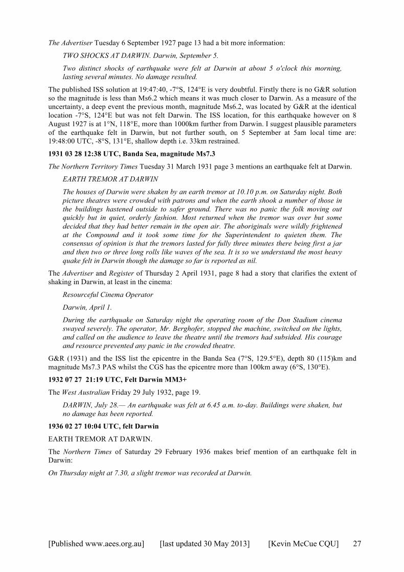
[Published www.aees.org.au] [last updated 30 May 2013] [Kevin McCue CQU] 27
The Advertiser Tuesday 6 September 1927 page 13 had a bit more information:
TWO SHOCKS AT DARWIN. Darwin, September 5.
Two distinct shocks of earthquake were felt at Darwin at about 5 o'clock this morning, lasting several minutes. No damage resulted.
The published ISS solution at 19:47:40, -7°S, 124°E is very doubtful. Firstly there is no G&R solution so the magnitude is less than Ms6.2 which means it was much closer to Darwin. As a measure of the uncertainty, a deep event the previous month, magnitude Ms6.2, was located by G&R at the identical location -7°S, 124°E but was not felt Darwin. The ISS location, for this earthquake however on 8 August 1927 is at 1°N, 118°E, more than 1000km further from Darwin. I suggest plausible parameters of the earthquake felt in Darwin, but not further south, on 5 September at 5am local time are: 19:48:00 UTC, -8°S, 131°E, shallow depth i.e. 33km restrained.
1931 03 28 12:38 UTC, Banda Sea, magnitude Ms7.3
The Northern Territory Times Tuesday 31 March 1931 page 3 mentions an earthquake felt at Darwin.
EARTH TREMOR AT DARWIN
The houses of Darwin were shaken by an earth tremor at 10.10 p.m. on Saturday night. Both picture theatres were crowded with patrons and when the earth shook a number of those in the buildings hastened outside to safer ground. There was no panic the folk moving out quickly but in quiet, orderly fashion. Most returned when the tremor was over but some decided that they had better remain in the open air. The aboriginals were wildly frightened at the Compound and it took some time for the Superintendent to quieten them. The consensus of opinion is that the tremors lasted for fully three minutes there being first a jar and then two or three long rolls like waves of the sea. It is so we understand the most heavy quake felt in Darwin though the damage so far is reported as nil.
The Advertiser and Register of Thursday 2 April 1931, page 8 had a story that clarifies the extent of shaking in Darwin, at least in the cinema:
Resourceful Cinema Operator
Darwin, April 1.
During the earthquake on Saturday night the operating room of the Don Stadium cinema swayed severely. The operator, Mr. Berghofer, stopped the machine, switched on the lights, and called on the audience to leave the theatre until the tremors had subsided. His courage and resource prevented any panic in the crowded theatre.
G&R (1931) and the ISS list the epicentre in the Banda Sea (7°S, 129.5°E), depth 80 (115)km and magnitude Ms7.3 PAS whilst the CGS has the epicentre more than 100km away (6°S, 130°E).
1932 07 27 21:19 UTC, Felt Darwin MM3+
The West Australian Friday 29 July 1932, page 19.
DARWIN, July 28.— An earthquake was felt at 6.45 a.m. to-day. Buildings were shaken, but no damage has been reported.
1936 02 27 10:04 UTC, felt Darwin
EARTH TREMOR AT DARWIN.
The Northern Times of Saturday 29 February 1936 makes brief mention of an earthquake felt in Darwin:
On Thursday night at 7.30, a slight tremor was recorded at Darwin.
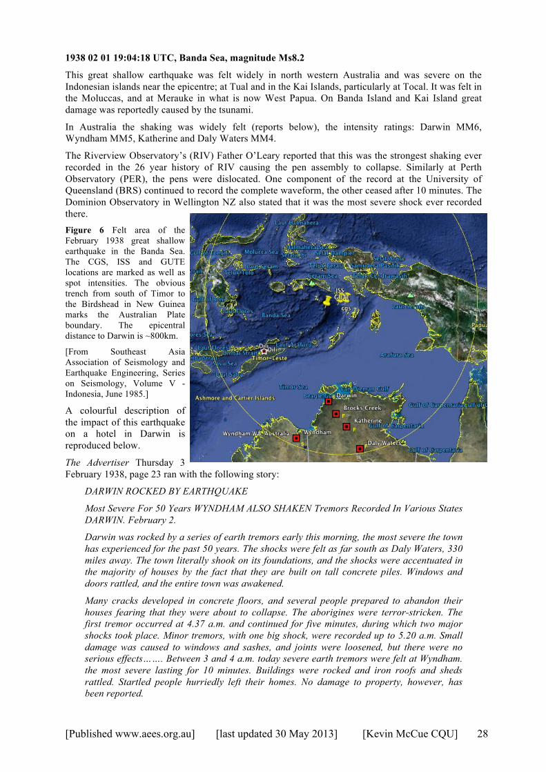
[Published www.aees.org.au] [last updated 30 May 2013] [Kevin McCue CQU] 28
1938 02 01 19:04:18 UTC, Banda Sea, magnitude Ms8.2
This great shallow earthquake was felt widely in north western Australia and was severe on the Indonesian islands near the epicentre; at Tual and in the Kai Islands, particularly at Tocal. It was felt in the Moluccas, and at Merauke in what is now West Papua. On Banda Island and Kai Island great damage was reportedly caused by the tsunami.
In Australia the shaking was widely felt (reports below), the intensity ratings: Darwin MM6, Wyndham MM5, Katherine and Daly Waters MM4.
The Riverview Observatory’s (RIV) Father O’Leary reported that this was the strongest shaking ever recorded in the 26 year history of RIV causing the pen assembly to collapse. Similarly at Perth Observatory (PER), the pens were dislocated. One component of the record at the University of Queensland (BRS) continued to record the complete waveform, the other ceased after 10 minutes. The Dominion Observatory in Wellington NZ also stated that it was the most severe shock ever recorded there. Figure 6 Felt area of the February 1938 great shallow earthquake in the Banda Sea. The CGS, ISS and GUTE locations are marked as well as spot intensities. The obvious trench from south of Timor to the Birdshead in New Guinea marks the Australian Plate boundary. The epicentral distance to Darwin is ~800km.
[From Southeast Asia Association of Seismology and Earthquake Engineering, Series on Seismology, Volume V - Indonesia, June 1985.]
A colourful description of the impact of this earthquake on a hotel in Darwin is reproduced below.
The Advertiser Thursday 3 February 1938, page 23 ran with the following story:
DARWIN ROCKED BY EARTHQUAKE
Most Severe For 50 Years WYNDHAM ALSO SHAKEN Tremors Recorded In Various States DARWIN. February 2.
Darwin was rocked by a series of earth tremors early this morning, the most severe the town has experienced for the past 50 years. The shocks were felt as far south as Daly Waters, 330 miles away. The town literally shook on its foundations, and the shocks were accentuated in the majority of houses by the fact that they are built on tall concrete piles. Windows and doors rattled, and the entire town was awakened.
Many cracks developed in concrete floors, and several people prepared to abandon their houses fearing that they were about to collapse. The aborigines were terror-stricken. The first tremor occurred at 4.37 a.m. and continued for five minutes, during which two major shocks took place. Minor tremors, with one big shock, were recorded up to 5.20 a.m. Small damage was caused to windows and sashes, and joints were loosened, but there were no serious effects……. Between 3 and 4 a.m. today severe earth tremors were felt at Wyndham. the most severe lasting for 10 minutes. Buildings were rocked and iron roofs and sheds rattled. Startled people hurriedly left their homes. No damage to property, however, has been reported.
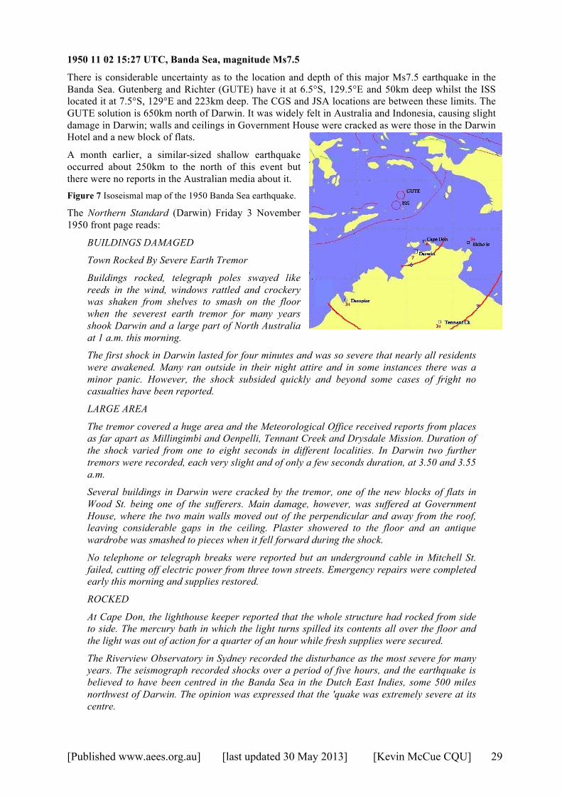
[Published www.aees.org.au] [last updated 30 May 2013] [Kevin McCue CQU] 29
1950 11 02 15:27 UTC, Banda Sea, magnitude Ms7.5
There is considerable uncertainty as to the location and depth of this major Ms7.5 earthquake in the Banda Sea. Gutenberg and Richter (GUTE) have it at 6.5°S, 129.5°E and 50km deep whilst the ISS located it at 7.5°S, 129°E and 223km deep. The CGS and JSA locations are between these limits. The GUTE solution is 650km north of Darwin. It was widely felt in Australia and Indonesia, causing slight damage in Darwin; walls and ceilings in Government House were cracked as were those in the Darwin Hotel and a new block of flats.
A month earlier, a similar-sized shallow earthquake occurred about 250km to the north of this event but there were no reports in the Australian media about it. Figure 7 Isoseismal map of the 1950 Banda Sea earthquake.
The Northern Standard (Darwin) Friday 3 November 1950 front page reads:
BUILDINGS DAMAGED
Town Rocked By Severe Earth Tremor
Buildings rocked, telegraph poles swayed like reeds in the wind, windows rattled and crockery was shaken from shelves to smash on the floor when the severest earth tremor for many years shook Darwin and a large part of North Australia at 1 a.m. this morning.
The first shock in Darwin lasted for four minutes and was so severe that nearly all residents were awakened. Many ran outside in their night attire and in some instances there was a minor panic. However, the shock subsided quickly and beyond some cases of fright no casualties have been reported.
LARGE AREA
The tremor covered a huge area and the Meteorological Office received reports from places as far apart as Millingimbi and Oenpelli, Tennant Creek and Drysdale Mission. Duration of the shock varied from one to eight seconds in different localities. In Darwin two further tremors were recorded, each very slight and of only a few seconds duration, at 3.50 and 3.55 a.m.
Several buildings in Darwin were cracked by the tremor, one of the new blocks of flats in Wood St. being one of the sufferers. Main damage, however, was suffered at Government House, where the two main walls moved out of the perpendicular and away from the roof, leaving considerable gaps in the ceiling. Plaster showered to the floor and an antique wardrobe was smashed to pieces when it fell forward during the shock.
No telephone or telegraph breaks were reported but an underground cable in Mitchell St. failed, cutting off electric power from three town streets. Emergency repairs were completed early this morning and supplies restored.
ROCKED
At Cape Don, the lighthouse keeper reported that the whole structure had rocked from side to side. The mercury bath in which the light turns spilled its contents all over the floor and the light was out of action for a quarter of an hour while fresh supplies were secured.
The Riverview Observatory in Sydney recorded the disturbance as the most severe for many years. The seismograph recorded shocks over a period of five hours, and the earthquake is believed to have been centred in the Banda Sea in the Dutch East Indies, some 500 miles northwest of Darwin. The opinion was expressed that the 'quake was extremely severe at its centre.

[Published www.aees.org.au] [last updated 30 May 2013] [Kevin McCue CQU] 30
Darwin Meteorological Office says that Darwin averages between one and two tremors a year, but most of them occur in the middle of the night and are only very slight. It is a number of years since a shock as severe as last night's has been felt.
The Hobart Mercury of Saturday 4 November 1950, page 2 reported:
DARWIN ROCKED BY 'QUAKE
DARWIN, Fri.-For four minutes about 1 a.m. today Darwin rocked and shook in the worst earthquake tremor felt for nine years.
Despite the intensity of the 'quake, there were no casualties and comparatively slight damage resulted.
Houses built on the ground suffered hardly at all, although crockery and glass were smashed, but those built on concrete piles swayed like trees in a gale.
The tremor extended over a wide area from Derby in W.A. to Elcho Island in Arnhem Land, and from Newcastle Waters to Cape Don.
Domestic animals and birds caused a tremendous din following the shock, and had hardly settled down when two further tremors occurred in quick succession at 3.50 a.m., but these were much less severe than the first.
Part of the Perth (W.A.) observatory's seismograph was knocked from its pivot by an earthquake about 11.34 p.m. last night.
The front page of the West Australian of Saturday 4 November had a long story from which I have extracted the following:
A Wyndham report said that a slight earth tremor was felt at about 11.20 p.m. on Thursday. It lasted for about two minutes and was evidently more severe 40 miles east from the town since truck drivers reported that they had been awakened by the rattling of their trucks. The tremor was also felt at Derby, where there was "much vibration" and several wall clocks were "thrown out of alignment" and stopped. Port Hedland and Broome messages said that there were no reports from those districts. Darwin Scare
In Darwin buildings swayed and rumbled and hundreds of people ran into the streets and gardens. Only superficial damage was reported, but three of Darwin's main streets were without power yesterday morning because a swaying electricity pole damaged a main cable. The effect of the tremor was magnified in many Darwin houses built on 8ft. concrete piles. Houses built on the ground rumbled and shook, but those on piles seemed to be waving in the breeze. The first shock at 1 a.m. lasted for four minutes, according to Meteorological Service officers. It rose gradually in intensity for two minutes, then decreased slightly, rose again and reached a maximum intensity after about three minutes. A second mild shock was recorded at 3.50 a.m. and the third at 3.55 a.m. A report from the lighthouse keeper at Cape Don, about 100 miles north of Darwin, said that the shock had been "very severe." The mercury was shaken out of the rotating beacon and was thrown all over the light tower," forming an amalgam on all metals with which it came in contact.
Walls Cracked
A new block of concrete flats in Wood-street, Darwin shook and trembled, and according to some residents showed signs of cracks yesterday morning. A crack was reported in the walls of the Hotel Darwin. A taxi driver said that he was at the hospital when the first shock came. The roof of the hospital was swaying so badly that it seemed certain that it would fall, he said. As the intensity of the tremors grew many parents woke their children and carried them outside. In the middle of the night the children could not be convinced of what was happening and some cried with fear. When Japanese bombers raided Darwin in February, 1942, they destroyed the office of the then Administrator (Mr. C. L. A. Abbott) in the Government House grounds. Only the concrete floor suspended on piles was left standing. Mr. Abbott, his wife and a number of servants had taken shelter under the floor. Early yesterday morning the floor collapsed. The walls of Government House, built 80 years ago,
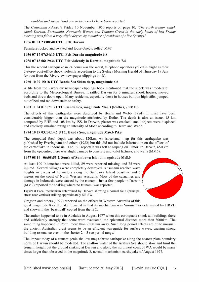
[Published www.aees.org.au] [last updated 30 May 2013] [Kevin McCue CQU] 31
rumbled and swayed and one or two cracks have been reported.
The Centralian Advocate Friday 10 November 1950 reports on page 10; ‘The earth tremor which shook Darwin, Borroloola, Newcastle Waters and Tennant Creek in the early hours of last Friday morning was felt to a very slight degree by a number of residents of Alice Springs.’
1956 01 01 23:08:40 UTC, Felt Darwin
Furniture rocked and swayed and loose objects rolled. MM4
1956 07 17 07:34:13 UTC, Felt Darwin magnitude 6.8
1956 07 18 06:19:34 UTC Felt violently in Darwin, magnitude 7.4
This the second earthquake in 24 hours was the worst, telephone operators yelled in fright as their 2-storey post-office shook violently according to the Sydney Morning Herald of Thursday 19 July (extract from the Riverview newspaper clippings book).
1960 10 07 15:18 UTC Banda Sea 50km deep, magnitude 6.6
A file from the Riverview newspaper clippings book mentioned that the shock was ‘moderate’ according to the Meteorological Bureau. It rattled Darwin for 3 minutes, shook houses, moved beds and threw doors open. Many residents, especially those in houses built on high stilts, jumped out of bed and ran downstairs to safety.
1963 11 04 01:17:13 UTC, Banda Sea, magnitude Ms6.3 (Rothe), 7.5MOS
The effects of this earthquake were described by Hearn and Webb (1984). It must have been considerably bigger than the magnitude attributed by Rothe. The depth is also an issue, 15 km computed by EHB and 108 km by ISS. In Darwin, plaster was cracked, small objects were displaced and crockery smashed rating an intensity of MM5 according to Hearn and Webb.
1974 10 29 03:14:14.6 UTC, Banda Sea, magnitude Ms6.6 PAS
The computed focal depth was about 120km. An isoseismal map for this earthquake was published by Everingham and others (1982) but this did not include information on the effects of the earthquake in Indonesia. The ISC reports it was felt at Kupang on Timor. In Darwin, 650 km from the epicentre, there was slight damage to concrete and toilet fixtures, and walls (MM6).
1977 08 19 06:08:55.2, South of Sumbawa Island, magnitude Ms8.0
At least 100 Indonesians were killed, 89 were reported missing, and 75 were injured. Several villages were completely destroyed. A tsunami reached wave heights in excess of 10 meters along the Sumbawa Island coastline and 6 meters on the coast of North Western Australia. Most of the casualties and damage in Indonesia were caused by the tsunami. Just a few people in Darwin (MM2) reported the shaking where no tsunami was reported. Figure 8 Focal mechanism determined by Harvard showing a normal fault (principal stress near vertical) striking approximately NE-SW.
Gregson and others (1979) reported on the effects in Western Australia of this great magnitude 8 earthquake, unusual in that its mechanism was ‘normal’ as determined by HRVD and shown in the ‘beachball’ copied from the ISC.
The author happened to be in Adelaide in August 1977 when this earthquake shook tall buildings there and sufficiently strongly that some were evacuated, the epicentral distance more than 3000km. The same thing happened in Perth, more than 2300 km away. Such long period effects are quite unusual, the ancient Australian crust seems to be an efficient waveguide for surface waves, causing strong building resonance even in the shorter 2 – 3 sec period range.
The impact today of a tsunamigenic shallow mega-thrust earthquake along the nearest plate boundary north of Darwin should be modelled. The shallow water of the Arafura Sea should slow and limit the tsunami height but the ground shaking at Darwin and along the northwest coast of WA would be many times larger than observed in the magnitude 8, normal-mechanism earthquake of August 1977.
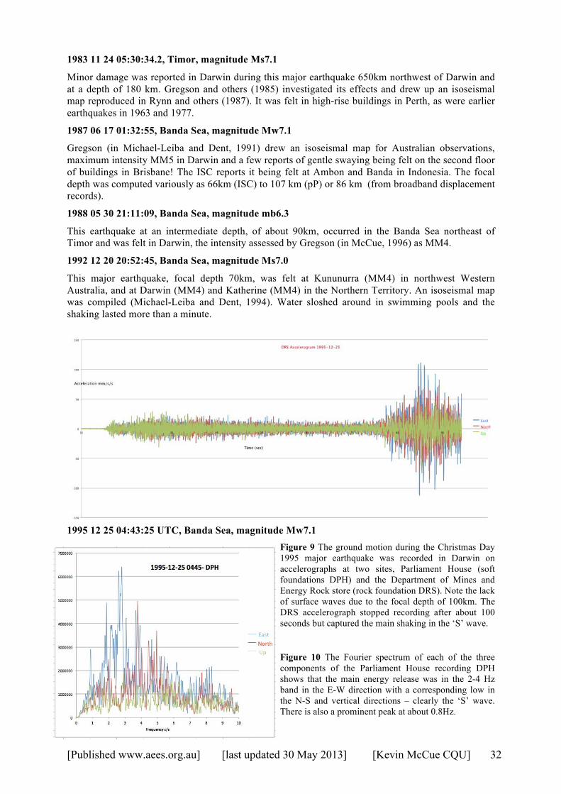
[Published www.aees.org.au] [last updated 30 May 2013] [Kevin McCue CQU] 32
1983 11 24 05:30:34.2, Timor, magnitude Ms7.1
Minor damage was reported in Darwin during this major earthquake 650km northwest of Darwin and at a depth of 180 km. Gregson and others (1985) investigated its effects and drew up an isoseismal map reproduced in Rynn and others (1987). It was felt in high-rise buildings in Perth, as were earlier earthquakes in 1963 and 1977.
1987 06 17 01:32:55, Banda Sea, magnitude Mw7.1
Gregson (in Michael-Leiba and Dent, 1991) drew an isoseismal map for Australian observations, maximum intensity MM5 in Darwin and a few reports of gentle swaying being felt on the second floor of buildings in Brisbane! The ISC reports it being felt at Ambon and Banda in Indonesia. The focal depth was computed variously as 66km (ISC) to 107 km (pP) or 86 km (from broadband displacement records).
1988 05 30 21:11:09, Banda Sea, magnitude mb6.3
This earthquake at an intermediate depth, of about 90km, occurred in the Banda Sea northeast of Timor and was felt in Darwin, the intensity assessed by Gregson (in McCue, 1996) as MM4.
1992 12 20 20:52:45, Banda Sea, magnitude Ms7.0
This major earthquake, focal depth 70km, was felt at Kununurra (MM4) in northwest Western Australia, and at Darwin (MM4) and Katherine (MM4) in the Northern Territory. An isoseismal map was compiled (Michael-Leiba and Dent, 1994). Water sloshed around in swimming pools and the shaking lasted more than a minute.
1995 12 25 04:43:25 UTC, Banda Sea, magnitude Mw7.1 Figure 9 The ground motion during the Christmas Day 1995 major earthquake was recorded in Darwin on accelerographs at two sites, Parliament House (soft foundations DPH) and the Department of Mines and Energy Rock store (rock foundation DRS). Note the lack of surface waves due to the focal depth of 100km. The DRS accelerograph stopped recording after about 100 seconds but captured the main shaking in the ‘S’ wave.
Figure 10 The Fourier spectrum of each of the three components of the Parliament House recording DPH shows that the main energy release was in the 2-4 Hz band in the E-W direction with a corresponding low in the N-S and vertical directions – clearly the ‘S’ wave. There is also a prominent peak at about 0.8Hz.
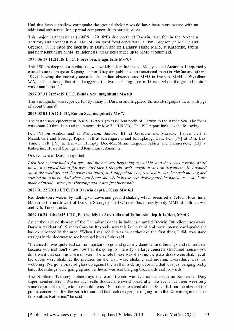
[Published www.aees.org.au] [last updated 30 May 2013] [Kevin McCue CQU] 33
Had this been a shallow earthquake the ground shaking would have been more severe with an additional substantial long-period component from surface waves.
This major earthquake at (6.94°S, 129.18°E) due north of Darwin, was felt in the Northern Territory and northeast WA. The ISC assigned focal depth was 133 km. Gregson (in McCue and Gregson, 1997) rated the intensity in Darwin and on Bathurst Island MM5, at Katherine, Jabiru and near Kununurra MM4. In Indonesia intensities ranged up to MM6 at Saumlaki.
1996 06 17 11:22:18 UTC, Flores Sea, magnitude Mw7.9
This 590 km deep major earthquake was widely felt in Indonesia, Malaysia and Australia. It reportedly caused some damage at Kupang, Timor. Gregson published an isoseismal map (in McCue and others, 1999) showing the intensity accorded Australian observations: MM5 in Darwin, MM4 at Wyndham WA, and mentioned that it had triggered the two accelerographs in Darwin where the ground motion was about 25mm/s2.
1997 07 31 21:54:19 UTC, Banda Sea, magnitude Mw6.0
This earthquake was reported felt by many in Darwin and triggered the accelerographs there with pga of about 8mm/s2.
2005 03 02 10:42 UTC, Banda Sea, magnitude Mw7.1
The earthquake epicentre at (6.6°S, 129.9°E) was 680km north of Darwin in the Banda Sea. The focus was about 200km deep and the magnitude Mw 7.1 (HRVD). The ISC report includes the following:
Felt [V] on Ambon and at Waingapu, Sumba; [III] at Jayapura and Merauke, Papua. Felt at Manokwari and Sorong, Papua. Felt at Karangasem and Klungkung, Bali. Felt [IV] at Dili, East Timor. Felt [IV] at Darwin, Humpty Doo-MacMinns Lagoon, Jabiru and Palmerston; [III] at Katherine, Howard Springs and Kununurra, Australia.
One resident of Darwin reported:
I felt like my car had a flat tyre, and the car was beginning to wobble, and there was a really weird noise, it sounded like a flat tyre. And then I thought, well, maybe it was an aeroplane. So I wound down the windows and the noise continued, so I stopped the car, realised it was the earth moving and carried on to home. And when I got home, the whole house was shaking and the banisters – which are made of metal – were just vibrating and it was just incredible.
2009 01 22 20:16 UTC, Felt Darwin depth 150km Mw 6.1
Residents were woken by rattling windows and ground shaking which occurred at 5:46am local time, 600km to the north-west of Darwin. Strangely the ISC rates this intensity only MM2 at both Darwin and Dili, Timor-Leste.
2009 10 24 14:40:45 UTC, Felt widely in Australia and Indonesia, depth 140km, Mw6.9
An earthquake north-west of the Tanimbar Islands in Indonesia rattled Darwin 700 kilometres away. Darwin resident of 15 years Carolyn Reyonds says this is the third and most intense earthquake she has experienced in the area. "When I realised it was an earthquake the first thing I did, was stand straight in the doorway to see how bad it was," she said.
"I realised it was quite bad so I ran upstairs to go and grab my daughter and the dogs and ran outside, because you just don't know how bad it's going to intensify - a large concrete structured house - you don't want that coming down on you. The whole house was shaking, the glass doors were shaking, all the doors were shaking, the pictures on the wall were shaking and moving. Everything was just wobbling. I've got a piece of glass up against the wall outside my door and that was just banging really hard, the railings were going up and the house was just banging backwards and forwards."
The Northern Territory Police says the earth tremor was felt as far south as Katherine. Duty superintendent Brent Warren says calls flooded the switchboard after the event but there were only some reports of damage to household items. "NT police received about 100 calls from members of the public concerned after the earth tremor and that includes people ringing from the Darwin region and as far south as Katherine," he said.

[Published www.aees.org.au] [last updated 30 May 2013] [Kevin McCue CQU] 34
"I'm based in Katherine police station and our building certainly shook and we got several phone calls from members of the public down here just expressing their concern about the earth tremor. A few people did report having household items fall over and smash but as I say there was no structural damage and no injuries."
The Bureau of Meteorology in Darwin says the tremor lasted up to five minutes with an intense period of about one to two minutes.
The following intensities are reported by the ISC: Felt [V] at Saumlaki; [IV] in the Kepulauan Aru and at Ambon, Fakfak, Sorong and Tual; [III] at Bintuni, Kaimana, Manokwari, Merauke and Nabire; [II] at Serui, Indonesia. Felt [IV] at Nguiu; [III] at Darwin, Howard Springs, Humpty Doo-MacMinns Lagoon, Katherine, Kununurra and Palmerston; [II] at Jabiru and Nhulunbuy, Australia. Also felt at Alyangula, Coonawarra, Maningrida, Milingimbi and as far as Alice Springs. Felt [III] at Dili, Timor-Leste.
This article was extracted from ABC News on-line.
http://www.abc.net.au/news/2009-10-25/indonesian-quake-rattles-darwin/1115840.
Articles falling over and smashing and people evacuating 2-story houses in Darwin is not MM3!
2010 02 15 21:51 UTC, Banda Sea, magnitude Mw6.2
This was another large Mw 6.2 earthquake at an intermediate depth of 130km that was felt widely in Northern Australia and Indonesia. The ISC report mentions:
Felt [III] at Saumlaki. Felt [II] at Darwin, Australia. Also felt at Katherine, Kununurra and Palmerston. Felt [II] at Dili, Timor-Leste. Also felt at Los Palos.
2011 07 12 21:06:13 UTC, Depth 130km, Mw 5.6, Felt Darwin MM3+
Felt Darwin to Katherine, sleepers in Darwin felt their beds shake for several seconds.
2012 12 10 16:30 UTC, Banda Sea, magnitude Mw7.1
According to the USGS, this earthquake at (6.54°S, 129.82°E) was about 650km north of Darwin, magnitude Mw 7.1, its focal depth 160km. Local residents reported this earthquake was the strongest in memory, and the Bureau of Meteorology headquarters was evacuated as a precaution.
It was felt in Darwin and from Katherine to Kununurra. One Darwin resident spoke of her experience of the tremors from a boat on the hardstand. "The whole boat was shaking along with 40 other boats in the yard. It was deadly silent and all I could hear was the sound of anchors and masts shaking. Good thing none of the boats fell."
Figure 11 A shipping container shaken off its stands at Nguiu, Tiwi Islands, about 100km north of Darwin. (photo by NT Police).
The ISC reports are summarised in the table below; it was also felt (IV) at Amahai, Indonesia, and at Sorong West Papua, felt (IV) at Dili, East Timor. Also felt at Manatuto. Felt (IV) at Kununurra;
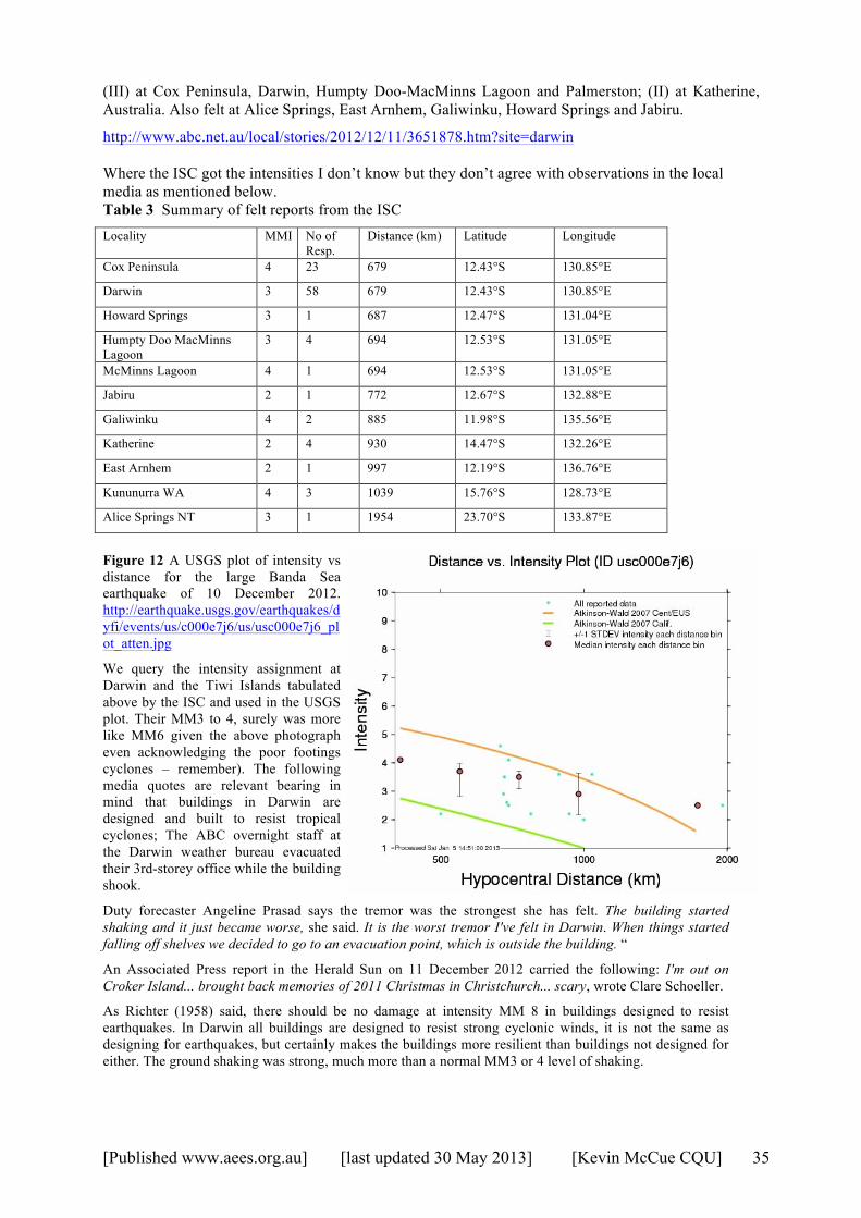
[Published www.aees.org.au] [last updated 30 May 2013] [Kevin McCue CQU] 35
(III) at Cox Peninsula, Darwin, Humpty Doo-MacMinns Lagoon and Palmerston; (II) at Katherine, Australia. Also felt at Alice Springs, East Arnhem, Galiwinku, Howard Springs and Jabiru.
http://www.abc.net.au/local/stories/2012/12/11/3651878.htm?site=darwin Where the ISC got the intensities I don’t know but they don’t agree with observations in the local media as mentioned below. Table 3 Summary of felt reports from the ISC Locality MMI No of
Resp. Distance (km) Latitude Longitude
Cox Peninsula 4 23 679 12.43°S 130.85°E
Darwin 3 58 679 12.43°S 130.85°E
Howard Springs 3 1 687 12.47°S 131.04°E
Humpty Doo MacMinns Lagoon
3 4 694 12.53°S 131.05°E
McMinns Lagoon 4 1 694 12.53°S 131.05°E
Jabiru 2 1 772 12.67°S 132.88°E
Galiwinku 4 2 885 11.98°S 135.56°E
Katherine 2 4 930 14.47°S 132.26°E
East Arnhem 2 1 997 12.19°S 136.76°E
Kununurra WA 4 3 1039 15.76°S 128.73°E
Alice Springs NT 3 1 1954 23.70°S 133.87°E
Figure 12 A USGS plot of intensity vs distance for the large Banda Sea earthquake of 10 December 2012. http://earthquake.usgs.gov/earthquakes/dyfi/events/us/c000e7j6/us/usc000e7j6_plot_atten.jpg
We query the intensity assignment at Darwin and the Tiwi Islands tabulated above by the ISC and used in the USGS plot. Their MM3 to 4, surely was more like MM6 given the above photograph even acknowledging the poor footings cyclones – remember). The following media quotes are relevant bearing in mind that buildings in Darwin are designed and built to resist tropical cyclones; The ABC overnight staff at the Darwin weather bureau evacuated their 3rd-storey office while the building shook.
Duty forecaster Angeline Prasad says the tremor was the strongest she has felt. The building started shaking and it just became worse, she said. It is the worst tremor I've felt in Darwin. When things started falling off shelves we decided to go to an evacuation point, which is outside the building. “
An Associated Press report in the Herald Sun on 11 December 2012 carried the following: I'm out on Croker Island... brought back memories of 2011 Christmas in Christchurch... scary, wrote Clare Schoeller.
As Richter (1958) said, there should be no damage at intensity MM 8 in buildings designed to resist earthquakes. In Darwin all buildings are designed to resist strong cyclonic winds, it is not the same as designing for earthquakes, but certainly makes the buildings more resilient than buildings not designed for either. The ground shaking was strong, much more than a normal MM3 or 4 level of shaking.
[Published www.aees.org.au] [last updated 30 May 2013] [Kevin McCue CQU] 36
Tsunamis in the Northern Territory
During this study I have not found a single reference to a tsunami striking the Northern Territory coast, except for the following unrelated report.
The Advertiser Thursday 2 Feb 1899 page 5, reports:
Sir Charles Todd informs us that Port Darwin reports a shock or earthquake having been felt there, and also at Port Charles lighthouse early in the morning on January 29, and also that a tidal wave of 6 ft. was experienced at Port Charles at 7 p.m. on January 17.
A word of Caution
From the Northern Territory Times of Friday 17 April 1931, page 3 comes the following salutary article to be read by all historians relying on newspaper stories:
A GLORIOUS OPPORTUNITY
Judging by letters and cuttings received by the air mail some of the editors of Southern, papers indulged in most glorious flights of imagination just about Easter time. Local correspondents, wired down news of the Darwin earthquake, of the willy willy at the police paddock and, of the washaways at the Katherine. Then word reached South of the telegraph lines being down, and of Darwin being isolated to a great extent. Here was an opportunity not to be missed especially as no hectic murders nor record breaking aviators were in sight. And so some of the Sydney papers came out with great scarey head lines DARWIN HIT BY WATER SPOUT TORNADO AND TIDAL WAVE and other headings of a like nature. It helped to fill up space and they troubled little whether the news (?) was false or true; it helped to sell their paper. Meanwhile folk in Darwin could not quite understand why their relations in the South were so very eager to know of their well being not realising what a god send the breaking of the lines of communication were to the sensation hungry editors of the Southern press.
Discussion
Interplate earthquakes are not the only source of risk in the Northern Territory as the historical record shows. The pattern of the 1987/1988 sequence was quite different to those of the 1937/41 Simpson Desert, see figures 13(i) and (ii), and the 1970 Lake Mackay and 1986 Marryat Creek earthquake sequences in the region and therefore could hardly have been used for prediction purposes. The lack of seismographs and sparse population limits our knowledge of the earlier spasm since no aftershocks are known but even so the character of the ML5+ events is quite different, limiting our predictive capability after future moderate earthquakes or swarms.
We are still struggling to explain intraplate earthquakes in a way that will improve earthquake hazard assessments over the uniform seismicity model and that will educate the public. The oft-repeated statements by public officials such as that in the Courier-Mail of Thursday 3 February 1938, page 12 have not helped the public perception of earthquake risk in Australia:
We seem to live within a magic circle, for while destructive earthquakes are common enough in the Dutch East Indies, New Guinea, the Solomons, New Zealand, and in other regions just beyond our coasts, not one life has been lost in Australia itself.
It seems, too, that this happy state of affairs should continue indefinitely. It may be that from time to time we shall, as yesterday, find ourselves on the fringe of a major disturbance, and, again, from time to time we may expect a minor disturbance of our own, such as those experienced in south eastern Queensland in 1918 and in 1935. But every scrap of seismological evidence yet collected, and every geological argument yet advanced, points to Australia as one of the most stable parts of the earth's crust. We are as near as may be earthquake-proof.
The two deaths following the 1902 ‘Warooka’ SA earthquake and the major magnitude 7.2 earthquake in 1906 off the central WA coast seem to have been forgotten or discounted by many, including politicians, journalists and even academics.

[Published www.aees.org.au] [last updated 30 May 2013] [Kevin McCue CQU] 37
The West Australian newspaper of Tuesday 31 March 1931, page 6 reports that Aborigines had an alternative explanation of their cause:
'KING GOD' DISTURBED.
Blacks Explain an Earth Tremor.
DARWIN, March 30. — A novel explanation of the earth tremor felt on Saturday night is advanced by Larrakeyah black; Close to the sea, at Casuarina is a large stone, believed by the natives to be the king god — the first aboriginal and the creator of all others. Occasionally at high tide the water reaches to the stone. The aborigines state that this must have happened on Saturday and that a 'big fish been bitum' causing the king god to turn over in his sleep. The tremor, they say, was the result.
• Seismologists need to find better ways to communicate with the public about Australian earthquakes.
I have transcribed the record of felt earthquakes in some detail and in several cases have been able to estimate the location and magnitude of the earthquake that they can now be added to the useable database. More and better estimates of epicentre and magnitude could be obtained with information on their effects in Indonesia and search through early seismograph bulletins. Inspection of the RIV records alone would push the ISS record back from 1917 to 1909.
• A discussed above the ultimate earthquake database, the ISC database, should be corrected in terms of intensities of past events felt in Darwin, and updated with historical research on early Australian earthquakes
The May 1909 earthquake is about as close as interplate earthquakes get to Darwin. A great megathrust earthquake on this section of the plate boundary is plausible so special care should be taken for vulnerable or non-standard structures, and more strong motion instruments should be installed in the area. Recent strong motion data recorded in Darwin could be extrapolated to estimate the ground motion in this maximum credible earthquake. An estimate of the amplitude of ground shaking at Darwin or offshore oil and gas fields could be modelled using the recent strong motion records as Green’s functions. These strong motion records are invaluable.
• There are not sufficient strong motion recorders in northern Australia. More accelerographs need to be installed both in the free field and in some carefully selected buildings, and the data made public.
• A database management system should be developed now to store these data and make them publicly available for industry and research.
Figures 13 (i) and (ii). The distribution in time of magnitude 5+ earthquakes in the Simpson Desert 1937 - 1941 (top) and Tennant Ck 1986 – 1991 (bottom).
• The possibility of a megathrust earthquake, magnitude 9 or more, on the nearest plate boundary and a large intraplate earthquake should be taken into account by politicians, town planners, emergency planners, engineers and architects in the Territory. Installing more accelerographs now would be a start, to

[Published www.aees.org.au] [last updated 30 May 2013] [Kevin McCue CQU] 38
collect more data for modelling both the strong shaking and building response. Buildings such as hospitals, schools, ambulance and police stations, airport and port facilities etc., should be inspected and strengthened if found vulnerable.
At face value this historical information implies that an earthquake would be felt in Darwin twice in every three years, on average, the city might suffer minor damage every few decades and severe damage every 100 years or so. An in-depth hazard assessment is obviously required.
• The epicentral region of the 1941 and 1972 earthquakes in the Simpson Desert should be intensively studied on aerial photographs and on ground to uncover evidence of these past earthquakes.
The frequent earthquakes since 1988 are reminiscent of the pattern before the great 1938 earthquake.
Acknowledgment Much of this new information has come about thanks to the Australian National Library (ANL) making scanned, searchable newspapers (1803-1954) publicly available on the internet. Information about the history of the Alice Springs array was summarised here from a report available on the internet titled Northern Territory Government Heritage Assessment Report on the Spencer Hill Seismic Vault and Array dated 2009, author unknown. Geoscience Australia’s Peter Harrington and Clive Collins are thanked for providing a scanned copy of part of the 1951 Riverview Bulletin and seismograms. Don Beresford and Charles Bubb provided photocopies of the Riverview clipping book to the author back in 1972 or thereabouts. Earthquake information was obtained from the International Seismological Centre, On-line Bulletin, http://www.isc.ac.uk, Internatl. Seis. Cent., Thatcham, United Kingdom, 2011, and from NOAA, National Geophysical Data Center / World Data Service (NGDC/WDS) Significant Earthquake Database, Boulder, CO, USA at http://www.ngdc.noaa.gov/nndc/struts/form?t=101650&s=1&d=1 as well as from the on-line earthquake database and numerous publications of Geoscience Australia and its predecessors.
[Published www.aees.org.au] [last updated 30 May 2013] [Kevin McCue CQU] 39
References AS1170.4-2007. Minimum Design Loads on Structures Part 4: Earthquake Loads. Standards Australia.
64pp. Benz, H.M., Herman, Matthew, Tarr, A.C., Hayes, G.P., Furlong, K.P., Villaseñor, Antonio, Dart,
R.L., and Rhea, Susan, 2011, Seismicity of the Earth 1900–2010 New Guinea and vicinity: U.S. Geological Survey Open-File Report 2010–1083-H, scale 1:8,000,000.
Bolt, B.A., 1959. Seismic travel-times in Australia. J. Proc. Roy. Soc. NSW, 91, pp. 64-72. Bouniot, E., Jones, T., and McCue, K., 1990. The pattern of 1987 sequence at Tennant Creek, NT. in
Recent Intraplate Seismicity Studies Symposium, Perth Western Australia, September 1990. BMR Record 1990/44, Paper 15.
Burke-Gaffney, T.N., 1951. Seismicity of Australia. J and Proc. Roy. Soc., NSW, Vol. LXXXV, pp. 47-52.
Denham, D., Small, G.R., Cleary, J., Gregson, P., Sutton, D.J., and Underwood, R., 1974. Australian earthquakes (1897-1972). Search, Vol. 6 No.1-2, pp. 34-37.
Dodwell, G.F., 1910. South Australian earthquakes. Report of the Australasian Association for the Advancement of Science, 12, 416-423.
Doyle, H.A., Everingham, I.B., and Sutton, D.J., 1968. Seismicity of the Australian Continent. J Geol. Soc. Aust., 15 (2), 295-312.
Engdahl, E.R., van der Hilst R.D., and Buland R., 1998. Global teleseismic earthquake relocation with improved travel times and procedures. Bull. Seis. Soc. Amer., 88, 722-743.
Everingham, I.B., McEwin, A.J., and Denham, D., 1982. Atlas of isoseismal maps of Australian earthquakes. Bureau of Mineral Resources, Australia, Bulletin 214.
Everingham, I.B., Denham, D, Greenhalgh, S.A., 1987. Surface-wave magnitudes of some early Australian earthquakes. BMR Journal of Australian Geology and Geophysics 10(3) 253-259.
Gregson, P., Paull, E.P., Woad, G., and Page B.J., 1985. Mundaring Geophysical Observatory, twenty-fifth year. BMR Record, 1985/37.
Gregson, P., Paull, E.P., and Gaull B.A., 1979. The effects in Western Australia of a major earthquake in Indonesia on 19 August 1977. BMR J. of Australian Geology and Geophysics, 4, pp.135-140.
Gutenberg, B., and Richter, C., 1954. Seismicity of the Earth. Princeton University Press, 2nd Ed. Hearn, S., and Webb, J.P., 1984. Continental-scale effects of the large Banda Sea earthquake of 4
November 1963. Bull. Seism. Soc. Amer., 74(1), 349-351. de Jersey, N.J., 1946. Seismological Evidence Bearing on Crustal Thickness in the South-West
Pacific. University of Queensland, Department of Geology, Vol III, Number 2, 1946. Letz, H., 1985. Seismizität in Irian Jaya (West Neuguinea), Indonesien, und ihre tectonische
Bedeutung. Berlin 1985. McCue, K.F., 1996 (compiler) Atlas of Isoseismal Maps of Australian Earthquakes, Part 3. AGSO
Record 1996/19. McCue, K.F. & Michael-Leiba M.O., 1993 — Australia's deepest known earthquake. Seismology
Research Letters, 64 (3-4), 201-206. McCue K.F., & Gregson, P.J., 1997. Australian Seismological Report, 1995. AGSO Record 1997/62. McCue K.F., Gregson, P.J. Sinadinovski C., & Hodgson, L., 2001. Australian Seismological Report,
1997. AGSO Record 2001/28. McEwin, A.J., Underwood, R., and Denham, D., 1976. Earthquake risk in Australia. BMR Journal of
Australian Geology and Geophysics 1(1), 15-21. Michael-Leiba M.O., & Dent, V., 1991. Australian Seismological Report, 1987. BMR Report
1991/303. Michael-Leiba M.O., & Dent, V., 1994. Australian Seismological Report, 1992. BMR Report 1994/69. NRETAS (2010). Spencer Hill Seismic Vault and Array: Background Historical Information. Prepared
by the Heritage Branch, NT Department of Natural Resources, Environment, the Arts and Sport, Darwin (note this is now, at time of writing, the Department of Lands, Planning and the Environment or DLPE).
Richter, C.F., 1958. Elementary Seismology. Freeman. Rynn, J.M.W., Denham, D., Greenhalgh, S., Jones, T., Gregson, P.J., McCue, K. and Smith, R.S.,
1987. Atlas of isoseismal maps of Australian earthquakes, Part 2. Bureau of Mineral Resources, Australia, Bulletin 222.
[Published www.aees.org.au] [last updated 30 May 2013] [Kevin McCue CQU] 40
Stewart, I.C.F., and Denham, D., 1973. Simpson Desert earthquake Central Australia, August 1972. BMR Record 1973/109.
Stewart, I.C.F., and Denham, D., 1974. Simpson Desert earthquake Central Australia, August 1972. Geophys. J. R. astr Soc., 39, 335-341.
Underwood, R., 1973. Progress Report on Seismic Zoning in Australia. BMR Bulletin 164, 61-66. Youngs, B.C. and Wopfner, H., 1972. Subsurface faults and recent earthquakes in the Simpson Desert.
Quarterly geological notes, Geological Survey of South Australia, 43, 8-11.
Appendix 1 Time in Australia
(abridged from Wikipedia http://en.wikipedia.org/wiki/Time_in_Australia)
The standardisation of time in Australia began in 1892. Prior to that date meridian time was used when Darwin, at longitude 130.8°E, was 8hours 44min ahead of Greenwich. I have used 9hours here i.e. 1 hour behind Sydney Time. The Dominions enacted time zone legislation, adopting Greenwich as the standard Meridian, effective from February 1895. The clocks were set ahead of GMT by nine hours in South Australia (and the Northern Territory, which it then governed); the time zone became known as Central Standard Time.
In May 1899, South Australia advanced Central Standard Time by thirty minutes. When the Northern Territory was separated from South Australia and placed under the jurisdiction of the Federal Government, the Northern Territory kept Central Standard Time.
There seems to be some confusion over the definition of ACST, UTC+9 or UTC+9:30.
1 http://www.timeanddate.com/library/abbreviations/timezones/au/cst.html
ACST – Australian Central Standard Time Time zone offset: UTC + 9:30 hours
ACST is 9 hours and 30 minutes ahead of Coordinated Universal Time (UTC) Note that some places observe daylight saving time/summer time during summer, and are therefore using ACDT instead in the summer. See below for details. Note that CST is used all year in the Northern territory
2 http://australia.gov.au/about-australia/our-country/time
Australian Central Standard Time (ACST)
Covers the state of South Australia, the town of Broken Hill in western New South Wales and the Northern Territory. ACST is equal to Coordinated Universal Time plus 9 hours (UTC +9 ).
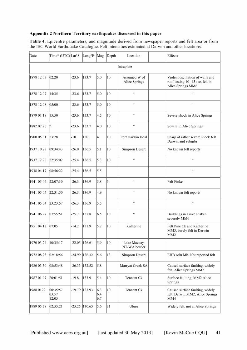
[Published www.aees.org.au] [last updated 30 May 2013] [Kevin McCue CQU] 41
Appendix 2 Northern Territory earthquakes discussed in this paper
Table 4, Epicentre parameters, and magnitude derived from newspaper reports and felt area or from the ISC World Earthquake Catalogue. Felt intensities estimated at Darwin and other locations.
Date Time* (UTC) Lat°S Long°E Mag Depth Location Effects
Intraplate
1878 12 07 02:20 -23.6 133.7 5.0 10 Assumed W of Alice Springs
Violent oscillation of walls and roof lasting 10 -15 sec, felt in Alice Springs MM6
1878 12 07 14:35 -23.6 133.7 5.0 10 “ “
1878 12 08 05:00 -23.6 133.7 5.0 10 “ “
1879 01 18 15:50 -23.6 133.7 4.5 10 “ Severe shock in Alice Springs
1882 07 26 ? -23.6 133.7 4.0 10 “ Severe in Alice Springs
1900 05 31 23:28 -10 130 4 10 Port Darwin local Sharp of rather severe shock felt Darwin and suburbs
1937 10 28 09:34:43 -26.0 136.5 5.1 10 Simpson Desert No known felt reports
1937 12 20 22:35:02 -25.4 136.5 5.3 10 “ “
1938 04 17 08:56:22 -25.4 136.5 5.5 “
1941 05 04 22:07:30 -26.3 136.9 5.8 5 “ Felt Finke
1941 05 04 22:31:50 -26.3 136.9 4.9 “ No known felt reports
1941 05 04 23:23:57 -26.3 136.9 5.5 “ “
1941 06 27 07:55:51 -25.7 137.8 6.5 10 “ Buildings in Finke shaken severely MM6
1951 04 12 07:05 -14.2 131.9 5.2 10 Katherine Felt Pine Ck and Katherine MM5, barely felt in Darwin MM2
1970 03 24 10:35:17 -22.05 126.61 5.9 10 Lake Mackay NT/WA border
1972 08 28 02:18:56 -24.99 136.32 5.6 13 Simpson Desert EHB soln Mb. Not reported felt
1986 03 30 08:53:48 -26.33 132.52 5.8 Marryat Creek SA Caused surface faulting, widely felt, Alice Springs MM2
1987 01 07 20:01:51 -19.8 133.9 5.4 10 Tennant Ck Surface faulting, MM2 Alice Springs
1988 0122 00:35:57 03:57 12:05
-19.79 133.93 6.3 6.4 6.7
10 Tennant Ck Caused surface faulting, widely felt, Darwin MM2, Alice Springs MM4
1989 05 28 02:55:21 -25.25 130.65 5.6 31 Uluru Widely felt, not at Alice Springs
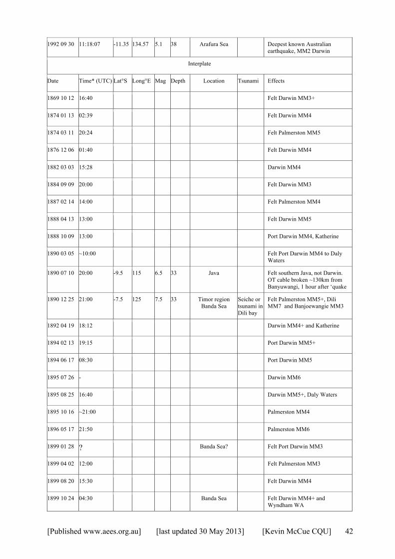
[Published www.aees.org.au] [last updated 30 May 2013] [Kevin McCue CQU] 42
1992 09 30 11:18:07 -11.35 134.57 5.1 38 Arafura Sea Deepest known Australian earthquake, MM2 Darwin
Interplate
Date Time* (UTC) Lat°S Long°E Mag Depth Location Tsunami Effects
1869 10 12 16:40 Felt Darwin MM3+
1874 01 13 02:39 Felt Darwin MM4
1874 03 11 20:24 Felt Palmerston MM5
1876 12 06 01:40 Felt Darwin MM4
1882 03 03 15:28 Darwin MM4
1884 09 09 20:00 Felt Darwin MM3
1887 02 14 14:00 Felt Palmerston MM4
1888 04 13 13:00 Felt Darwin MM5
1888 10 09 13:00 Port Darwin MM4, Katherine
1890 03 05 ~10:00 Felt Port Darwin MM4 to Daly Waters
1890 07 10 20:00 -9.5 115 6.5 33 Java Felt southern Java, not Darwin. OT cable broken ~130km from Banyuwangi, 1 hour after ‘quake
1890 12 25 21:00 -7.5 125 7.5 33 Timor region Banda Sea
Seiche or tsunami in Dili bay
Felt Palmerston MM5+, Dili MM7 and Banjoewangie MM3
1892 04 19 18:12 Darwin MM4+ and Katherine
1894 02 13 19:15 Port Darwin MM5+
1894 06 17 08:30 Port Darwin MM5
1895 07 26 - Darwin MM6
1895 08 25 16:40 Darwin MM5+, Daly Waters
1895 10 16 ~21:00 Palmerston MM4
1896 05 17 21:50 Palmerston MM6
1899 01 28 ? Banda Sea? Felt Port Darwin MM3
1899 04 02 12:00 Felt Palmerston MM3
1899 08 20 15:30 Felt Darwin MM4
1899 10 24 04:30 Banda Sea Felt Darwin MM4+ and Wyndham WA
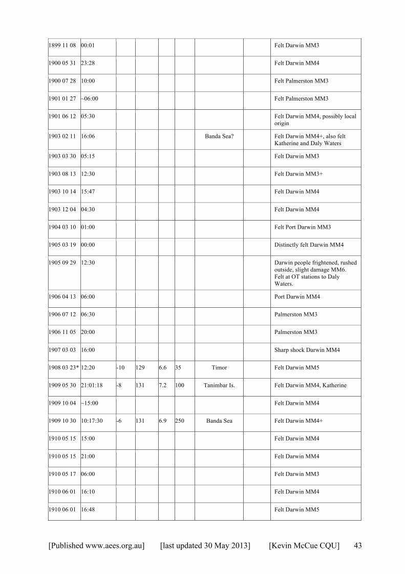
[Published www.aees.org.au] [last updated 30 May 2013] [Kevin McCue CQU] 43
1899 11 08 00:01 Felt Darwin MM3
1900 05 31 23:28 Felt Darwin MM4
1900 07 28 10:00 Felt Palmerston MM3
1901 01 27 ~06:00 Felt Palmerston MM3
1901 06 12 05:30 Felt Darwin MM4, possibly local origin
1903 02 11 16:06 Banda Sea? Felt Darwin MM4+, also felt Katherine and Daly Waters
1903 03 30 05:15 Felt Darwin MM3
1903 08 13 12:30 Felt Darwin MM3+
1903 10 14 15:47 Felt Darwin MM4
1903 12 04 04:30 Felt Darwin MM4
1904 03 10 01:00 Felt Port Darwin MM3
1905 03 19 00:00 Distinctly felt Darwin MM4
1905 09 29 12:30 Darwin people frightened, rushed outside, slight damage MM6. Felt at OT stations to Daly Waters.
1906 04 13 06:00 Port Darwin MM4
1906 07 12 06:30 Palmerston MM3
1906 11 05 20:00 Palmerston MM3
1907 03 03 16:00 Sharp shock Darwin MM4
1908 03 23* 12:20 -10 129 6.6 35 Timor Felt Darwin MM5
1909 05 30 21:01:18 -8 131 7.2 100 Tanimbar Is. Felt Darwin MM4, Katherine
1909 10 04 ~15:00 Felt Darwin MM4
1909 10 30 10:17:30 -6 131 6.9 250 Banda Sea Felt Darwin MM4+
1910 05 15 15:00 Felt Darwin MM4
1910 05 15 21:00 Felt Darwin MM4
1910 05 17 06:00 Felt Darwin MM3
1910 06 01 16:10 Felt Darwin MM4
1910 06 01 16:48 Felt Darwin MM5
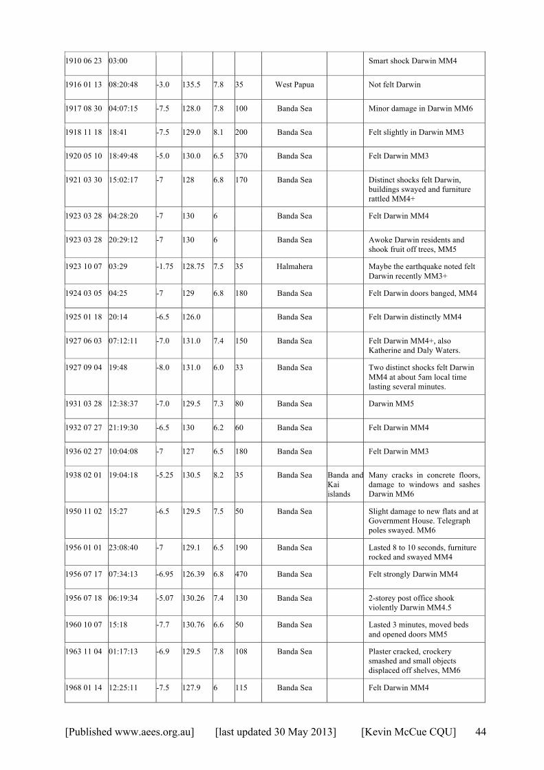
[Published www.aees.org.au] [last updated 30 May 2013] [Kevin McCue CQU] 44
1910 06 23 03:00 Smart shock Darwin MM4
1916 01 13 08:20:48 -3.0 135.5 7.8 35 West Papua Not felt Darwin
1917 08 30 04:07:15 -7.5 128.0 7.8 100 Banda Sea Minor damage in Darwin MM6
1918 11 18 18:41 -7.5 129.0 8.1 200 Banda Sea Felt slightly in Darwin MM3
1920 05 10 18:49:48 -5.0 130.0 6.5 370 Banda Sea Felt Darwin MM3
1921 03 30 15:02:17 -7 128 6.8 170 Banda Sea Distinct shocks felt Darwin, buildings swayed and furniture rattled MM4+
1923 03 28 04:28:20 -7 130 6 Banda Sea Felt Darwin MM4
1923 03 28 20:29:12 -7 130 6 Banda Sea Awoke Darwin residents and shook fruit off trees, MM5
1923 10 07 03:29 -1.75 128.75 7.5 35 Halmahera Maybe the earthquake noted felt Darwin recently MM3+
1924 03 05 04:25 -7 129 6.8 180 Banda Sea Felt Darwin doors banged, MM4
1925 01 18 20:14 -6.5 126.0 Banda Sea Felt Darwin distinctly MM4
1927 06 03 07:12:11 -7.0 131.0 7.4 150 Banda Sea Felt Darwin MM4+, also Katherine and Daly Waters.
1927 09 04 19:48 -8.0 131.0 6.0 33 Banda Sea Two distinct shocks felt Darwin MM4 at about 5am local time lasting several minutes.
1931 03 28 12:38:37 -7.0 129.5 7.3 80 Banda Sea Darwin MM5
1932 07 27 21:19:30 -6.5 130 6.2 60 Banda Sea Felt Darwin MM4
1936 02 27 10:04:08 -7 127 6.5 180 Banda Sea Felt Darwin MM3
1938 02 01 19:04:18 -5.25 130.5 8.2 35 Banda Sea Banda and Kai islands
Many cracks in concrete floors, damage to windows and sashes Darwin MM6
1950 11 02 15:27 -6.5 129.5 7.5 50 Banda Sea Slight damage to new flats and at Government House. Telegraph poles swayed. MM6
1956 01 01 23:08:40 -7 129.1 6.5 190 Banda Sea Lasted 8 to 10 seconds, furniture rocked and swayed MM4
1956 07 17 07:34:13 -6.95 126.39 6.8 470 Banda Sea Felt strongly Darwin MM4
1956 07 18 06:19:34 -5.07 130.26 7.4 130 Banda Sea 2-storey post office shook violently Darwin MM4.5
1960 10 07 15:18 -7.7 130.76 6.6 50 Banda Sea Lasted 3 minutes, moved beds and opened doors MM5
1963 11 04 01:17:13 -6.9 129.5 7.8 108 Banda Sea Plaster cracked, crockery smashed and small objects displaced off shelves, MM6
1968 01 14 12:25:11 -7.5 127.9 6 115 Banda Sea Felt Darwin MM4

[Published www.aees.org.au] [last updated 30 May 2013] [Kevin McCue CQU] 45
1974 10 29 03:14:14.6 -6.9 129.5 6.6 117 Banda Sea Slight damage to concrete and toilet fixtures and walls MM6
1977 08 19 06:08 55.2 -11.16 118.40 8.0 33 S of Sumbawa Is 10m Sumbawa 6m NW WA.
Felt by a few in Darwin MM2 rocked tall buildings in Adelaide, Perth causing their evacuation.
1983 11 24 05:30:34 -7.47 128.2 7.3 180 Banda Sea Felt Darwin MM6 Brisbane and Perth
1988 05 30 21:11:09 -7.49 128.38 6.9 70 Banda Sea Felt Darwin MM4
1992 12 20 20:52:45 -6.56 130.43 7.1 70 Banda Sea Felt Darwin MM4
1995 12 25 04:43: -6.9 129.2 7.1 130 Banda Sea Felt Darwin MM5
1996 06 17 11:22:18 -7.1 122.6 7.9 590 Flores Sea Felt Darwin MM5
1997 07 31 21:54:19 -6.66 130.92 6.0 40 Banda Sea Felt Darwin MM4
2005 03 02 10:42:09.3 -6.57 129.88 7.1 200 Banda Sea Felt West Papua, Timor-Leste and Darwin MM6
2009 01 22 20:16:34.6 -7.32 128.56 6.1 150 Banda Sea Felt Darwin MM4+
2009 10 24 14:40:46.2 -6.12 130.43 6.9 130 Banda Sea Felt widely in Indonesia and North Australia, Darwin MM6
2010 02 15 21:51:48.2 -7.27 128.77 6.2 135 Banda Sea Rattled windows, doors and crockery MM4
2011 07 12 21:06:13 -6.06 130.49 5.6 130 Banda Sea Felt Darwin MM3+
2012 12 10 16:53:08 -6.53 129.83 7.2 155 Banda Sea Things falling off shelves MM5
* Time has been converted to UTC as per Appendix 1 (ACST-9 hours).