historic - south carolina · margaret truesdale brinson, mrs. j. clyburn, di dubose, ed estridge,...
TRANSCRIPT

New South Associates • 6150 East Ponce de Leon Avenue • Stone Mountain • Georgia • 30083
HistoricResourcesSurvey
• Kershaw County, South Carolina •

Figure XKershaw County Historic Resources Survey
- 2 -
PREVIOUSLY SURVEYED
5 4
3
2
13
126
7
1011
14
9
8 601
120
1
521
LIBERTY HILL
CASSATT
CAMDEN
ELGIN
LUGOFF
1
BETHUNE
521
Survey Zones

Kershaw County Geological and Agricultural Map, 1873
- 8 -

Detail from Mouzon Map
- 10 -
North

Mills Atlas, 1825
- 17 -

Walker and Johnson Map, 1854
- 23 -

- 27 -
Burdell Map, 1901

1938 General Highway Map
- 38 -
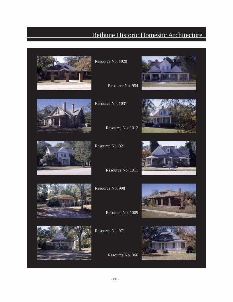
- 60 -
Resource No. 1031
Resource No. 1012
Resource No. 921
Resource No. 1011
Resource No. 908
Resource No. 1009
Resource No. 971
Resource No. 966
Resource No. 1029
Resource No. 954
Bethune Historic Domestic Architecture

- 61 -
Bethune Historic Commercial Architecture
Resource No. 944
Resource No. 929
Resource No. 940
Resource No. 946
Resource No. 931
Resource No. 939

- 64 -
Big Springs Resort and Mineral Springs, Resource No. 432
Hotel Façade
Rear Wing
Artesian Pool
Bath House
Bath House

- 65 -
Elgin Historic Domestic Architecture
Resource No. 1602
Resource No. 1588
Resource No. 1639
Resource No. 1591

- 67 -
Lugoff Historic Architecture
Resource No. 1365
Resource No. 1375
Resource No. 1358
Resource No. 1359
Resource No. 1367
Resource No. 1375
Resource No. 1366

- 68 -
Lugoff Vicinity
Resource No. 1377
Resource No. 1410
Resource No. 1377

- 69 -
Domestic Architectural Styles
Log Construction, Resource No. 1012.01 Vernacular, Single Pen, Resource No. 1316
Vernacular, I-House, Resource No. 1196 Vernacular, Central Hall, Resource No. 1036Log Construction, Resource No. 1319.01
Folk Victorian, Resource No. 1037 Queen Anne, Resource No. 954Greek Revival, Resource No. 1411
Craftsman Bungalow, Resource No. 1404 Tudor, Resource No. 919Colonial Revival, Resource No. 1354
Minimal Traditional, Resource No. 1662 Eclectic, Resource No. 911Ranch, Resource No. 1035

- 72 -
Rock Springs Farm, Resource No. 1412
Gettys House Gettys House Mattie’s House
Mattie’s House Dairy Barn
Unknown Delco Generator
School House Water Tower Graveyard
Silos OutbuildingHorse Lot Barn

- 74 -
Bethune Homestead, Resource No. 1020
House, Oblique View
Outbuilding
House, Rear Entry and Third Door to Loft
House, Back Elevation
Outbuilding
House, Detail of Wood Pier

- 75 -
Branham Farm, Resource No. 1341
Store
Outbuilding
Livestock Barns and Corral
View from the Road
Outbuilding
Chicken Coop
Blacksmith Shop
Oblique View of House

- 76 -
Mamie Brown Farm, Resource No. 1618
Back and Side Elevations
Outbuilding
Oblique View of House
Outbuilding
Outbuilding

- 78 -
Historic Mill Properties
Resource No. 1127
Resource No. 1178
Resource No. 1192
Resource No. 1179

- 82 -
Historic Ecclesiastical Architecture
Resource No. 1416
Resource No. 1212
Resource No. 1185
Resource No. 1372
Resource No. 1065
Resource No. 996
Resource No. 963
Resource No. 1568

- 85 -
Historic School Properties
Resource No. 1317
Resource No. 1293
Resource No. 1220
Resource No. 1295

- 87 -
Wateree Dam and Plant/Southern Aviation School
Plant/Dam, Resource No. 1263
Plant/Dam, Resource No. 1264
Southern Aviation, Resource No. 1716
Plant/Dam, Resource No. 1265
Plant/Dam, Resource No. 1266
Southern Aviation, Resource No. 1715


HISTORICAL AND ARCHITECTURAL SURVEY OF KERSHAW COUNTY NATIONAL REGISTER EVALUATIONS The following determinations are based on evaluations of the Kershaw County Survey by the State Historic Preservation Office (SHPO) of the S.C. Department of Archives and History. It is the opinion of the SHPO that the properties meet the eligibility criteria for inclusion in the National Register of Historic Places. These determinations are based on the present architectural integrity and available historical information for the properties included in the survey area. Properties may be removed from or added to this list if changes are made that affect a property's physical integrity. Historical information that is brought to the attention of the National Register Coordinator/Architectural Historian confirming or denying a property's historic significance may also affect a property's eligibility status. The process of identifying and evaluating historic properties is never complete; therefore, the SHPO encourages readers of this report to alert the National Register Coordinator to properties that may have been overlooked during this evaluation. National Register determinations of eligibility were made during and following a site visit to Kershaw County on August 8, 2002, by SHPO staff Andrew W. Chandler and Bradley S. Sauls, and in consultation with New South Associates. INDIVIDUAL PROPERTIES and COMPLEXES The following properties have been determined individually eligible for listing in the National Register of Historic Places: Site No. Historic Name Criteria 1211 Smyrl House A-Agriculture; C-Architecture 1251 Liberty Hill Community Center A-Community History; C-Architecture 1263-1266 Wateree Dam and Power Plant C-Engineering 1411 Plane Hill A-Social History; C-Architecture 1585 Boykin Tombfield Cemetery A -Funerary 1715-1717 Southern Aviation School Hangars A -Transportation; C-Design
S. C. Department of Archives & History υ 8301 Parklane Road υ Columbia υ South Carolina υ 29223-4905 υ (803) 896-6100 www.state.sc.us/scdah
Historic Resources Survey
Kershaw County, South Carolina (October 2001 through May 2002)
Prepared for: Kershaw County Planning and Zoning Department
Camden, South Carolina and
South Carolina Department of Archives and History Columbia, South Carolina
Prepared by: New South Associates
6150 East Ponce de Leon Avenue Stone Mountain, Georgia 30083
The activity that is the subject of this report has been financed in part with Federal funds from the National Park Service, Department of the Interior, and administered by the South Carolina Department of Archives and History. However, the contents and opinions do not necessarily reflect the views or policies of the Department of Interior, nor does the mention of trade name or commercial products constitute endorsement or recommendations by the Department of the Interior.
Title VI and Age Discrimination
This program receives Federal financial assistance for identification and protection of historic properties. Under Title VI of the Civil Rights Act of 1964 and Section 504 of the Rehabilitation Act of 1973, the U. S. Department of Interior prohibits discrimination on the basis of race, color, national origin, or handicap in its federally assisted programs. If you believe you have been discriminated against in any program, activity, or facility as described above, or if you desire further information, please write to: Office for Equal Opportunity, U.S. Department of the Interior, Washington, D.C. 20240. In addition to the above, the consultant complies with the Age Discrimination Act of 1975, 42 U.S.C. 6101 Et. Seq. which prohibits discrimination on the basis of age.
September 30, 2002

Acknowledgements A survey of the history and architecture of a county as large as Kershaw would not have been possible without the assistance of numerous individuals. The citizens of the county, as well as the officials who endorsed and funded the project, deserve a debt of gratitude. Rollin Reynolds, Director of Planning and Zoning, was our local coordinator and liaison with residents who had questions or concerns about the survey. He also provided tax maps and county road maps, and his assistance is greatly appreciated. Members of the Kershaw County Historical Society have also been closely involved in planning and coordinating the project, as well as steering us toward valuable sources of information and setting up meetings with small local groups. Historical Society members who assisted include the current president Charles Baxley, Frank K. Babbitt, Jr., William Davie Beard, Mary Cunningham, Glen and Joan Inabinet and Louise Steffens. In addition, this organization has assembled a number of historical publications that greatly informed our work. The Inabinets were particularly gracious, sharing their knowledge from their research. Employees of the Camden Archives, especially the director, Agnes Corbett, graciously helped with the historical research efforts. Many private individuals gave us tours of their properties, or special access to certain locations, or provided other historical information. These include Dr. H. Gaffney Blaylock, Dr. John W. Bonner, Alice Boykin, Margaret Truesdale Brinson, Mrs. J. Clyburn, Di DuBose, Ed Estridge, W. W. Hawkins of Woodward Field, Adele Kelly, Carroll Jones, Esther McCaskill, Larry McCollum, Charles McGuirt, Lula Goff Miles, Bebe Myers, Herman Newman, Beverly Sheorn, Lynette Miles Smith, Bill Tolbert, Patsy Watson, employees of Duke Energy at Wateree Dam, Camden Military Academy, and many others too numerous to mention. Dan Vivian and Brad Sauls of the South Carolina Department of Archives and History in Columbia, South Carolina, gave valuable guidance and technical assistance. We would also like to thank Janie Erickson of A Camden Bed and Breakfast for providing the surveyors with cheerful and comfortable accommodations for all the weeks we were away from our homes.

i

Contents Acknowledgements i List of Figures iii List of Tables iii 1. Name of Survey 1 2. Boundaries of Survey Area 1 3. Number of Properties Surveyed 1 4. Number of Square Miles Surveyed 1 5. Surveyors 1 6. Beginning and Ending Dates for Project 1 7. Project Objectives 3 8. Survey Methodology 3 A. Field Methods 3
B. Criteria used in assessing the architectural and historical significance of properties in survey area 5
9. Historic Context 7 A. Environmental Setting 7 B. Native American Settlement during Contact Period 7 C. Frontier to Independence, 1730s to1783 9 D. Antebellum Growth through the Civil War, 1783-1865 14 E. Reconstruction through World War I, 1865-1917 24 F. Depression and World War, 1917-1950 36 10. Bibliography 46 11. Evaluation of Recorded Properties 53 A. National Register Properties 53 B. Evaluation of Properties Recorded During Survey 59
South Carolina State Historic Preservation Office Determination of Eligibility 89
12. Data Gaps 90 13. Recommendations 90

Appendix - Compiled Inventory
ii Figure List
1. Survey Zones 2 2. Kershaw County Geological and Agricultural Map, 1873 8 3. Detail from Mouzon Map 10 4 Mills Atlas, 1825 17 5. Walker and Johnson Map, 1854 23 6. Burdell Map, 1901 27 7. 1938 General Highway Map 38 8. Bethune Historic Domestic Architecture 60 9. Bethune Historic Commercial Architecture 61 10. Big Springs Resort and Mineral Springs 64 11. Elgin Historic Domestic Architecture 65 12. Lugoff Historic Architecture 67 13. Lugoff Vicinity 68 14. Domestic Architectural Styles 69 15. Rock Springs Farm 72 16. Bethune Homestead 74 17. Branham Farm 75 18. Mamie Brown Farm 76 19. Historic Mill Properties 78 20. Historic Ecclesiastical Architecture 82 21 Historic School Properties 85 22. Wateree Dam and Plant/ Southern Aviation School 87
Table List
1. Kershaw County Population, 1800-1860. 15 2. County Population, 1870-1920. 25 3. County Population, 1930-1960. 36 4. Agricultural Statistics by Townships, 1930. 41 5 NRHP and NHL properties in Survey Area 54 6 Contributing Elements, Boykin Mill Complex, 1992. 55 7. Contributing Properties to Liberty Hill District, 1978. 58 8. Religious Properties Inventoried. 79 9. Educational Properties Inventoried. 84

iii


Project Summary 1. Name of Survey
Historic Resources Survey, Kershaw County, South Carolina, 2001-2002 2. Boundaries of Survey Area
The survey area was the limits of Kershaw County, South Carolina, including the incorporated municipalities of Bethune and Elgin, and the unincorporated community of Lugoff. The survey did not include the City of Camden, which was surveyed in 1996. For purposes of organizing the fieldwork, the county was divided into 14 survey areas (Figure 1).
3. Number of Properties Surveyed
A total of 811 properties were surveyed, encompassing approximately 1,165 individual buildings and structures.
4. Number of Square Miles Surveyed
The survey area was approximately 712 square miles which included the entire county, except for the City of Camden.
5. Surveyors and Affiliation
Project Manager: Mary Beth Reed, Historian Surveyors: Denise P. Messick, Architectural Historian Mary Beth Reed, Historian J. Faith Meader, Architectural Historian Melissa Umberger, Associate Surveyor
Clayton Edwards, Associate Surveyor
Affiliation: New South Associates, Inc. 6150 East Ponce de Leon Avenue Stone Mountain, Georgia 30083
6. Beginning and Ending Dates of Survey
The project began with a kick-off and planning meeting on August 21, 2001 at the Kershaw County Courthouse in Camden. Those present included Mary Beth Reed of New South Associates; Dan Vivian and Brad Sauls of the South Carolina Department of Archives and History (State Historic Preservation Office); Rollin Reynolds, Director of Planning and Zoning for Kershaw County; and Glen and Joan Inabinet of the Kershaw County Historical Society.
- 1 -

- 2 -

Fig. 1
- 3 -

Historical research in Columbia and Camden was conducted during the weeks of August 20 and October 15, 2001. The first public hearing was held at the Kershaw County Courthouse on October 21, 2001. This meeting offered general information about the aims of the project, and solicited public input regarding the history and architecture of the county. Architectural fieldwork commenced on October 22, 2001, and was completed on January 18, 2002. During the field phase, two small group meetings were held with residents of the Liberty Hill and Lugoff areas and members of the Historical Society. Data-entry of the survey forms was ongoing during and after the field phase. Following the fieldwork, more historical research was conducted and was completed by January 31, 2002. The writing of the survey report commenced in February 2002. The draft report was submitted in May 2002. A post fieldwork summary of the results was given at the Kershaw County Historical Society's June meeting.
7. Project Objectives
The purpose of the project is to compile a comprehensive inventory of historic architectural resources in Kershaw County outside of the City of Camden. The South Carolina State Historic Preservation Office (SHPO) has awarded the Kershaw County Planning and Zoning Department with a historic preservation matching grant-in-aid. The County is providing an equal amount of matching funds. The data compiled by the project is intended to help identify properties eligible for listing in the National Register of Historic Places, and to provide the Kershaw County Planning and Zoning Department and the SHPO with information needed to conduct preservation planning activities. The survey will also be used for promotion of economic incentives for rehabilitation, education, and local compliance with state and federal preservation and compliance laws.
8. Survey Methodology A. Archival Research and Field Methods
The survey was undertaken by New South Associates in accordance with the Survey Manual of the South Carolina Statewide Survey of Historic Properties. The project began with background historical and archival research in Columbia and Camden. The purpose of this initial research was to develop major historical themes and events that shaped the survey area, as well as to know what physical resources to expect in the county. Research remained ongoing throughout the project, with later research becoming more focused on specific properties encountered during fieldwork. National Register nominations for listed properties in Kershaw County were obtained from the State Historic Preservation Office (SHPO) at the South Carolina Department of Archives and History in Columbia. The researchers also reviewed survey files and obtained a copy of the 1996 Historic Resources Survey of Camden. Demographic statistics and lists of schools, churches, and other community buildings were obtained from the Internet.
- 4 -
Project historians retrieved copies of historic maps from the South Carolina Library and the Thomas Cooper Library at the University of South Carolina in Columbia. Secondary source information included several books and historical pamphlets purchased from the museum at the Historic Camden Revolutionary War Site, as well as at the Kershaw County Historical Society. A wealth of local information was available from the research collections of the Camden Archives and Museum. These included maps, photographs, newspaper clipping files, vertical files on historic buildings, books, pamphlets, periodicals, and other reference materials. Of particular interest were microfilmed W.P.A. files from the late 1930s on local churches. Researchers also searched the vertical files of the Bethune Public Library. Informal interviews with local residents were conducted at various stages of research, as well as during the fieldwork phase. Finally, historians collected Kershaw County federal census data for the years 1790 to 1960 from the government documents section of Emory University library in Atlanta. New South Associates conducted an introductory public hearing at the Kershaw County Courthouse on October 21, 2001, along with the SHPO survey coordinator, the Kershaw County Planning and Zoning Office, and the Kershaw County Historical Society. The purpose of this meeting was to meet residents of the survey area, explain the survey purposes and methodology, and collect oral history and other information that would aid in understanding the project area. New South obtained the names of several possible sources and local contacts, and arranged interviews with them. Due to the large size of the county, a cursory reconnaissance survey was conducted prior to the intensive fieldwork. The SHPO had predicted an estimated number of historic resources at 1,100. New South utilized both current and historic maps, as well as local interviews, to identify likely locations and concentrations of resources. All roads were to be driven, unless maps indicated that no buildings, structures, or cemeteries exist on those roads (usually logging roads). Many portions of the county were very rural, and historic properties were scattered. A few communities had some areas with concentrated resources. Bethune had a large number of potentially historic buildings and structures near its downtown area. Other smaller groupings occurred in the communities of Cassatt, Flat Rock, Westville, Liberty Hill, Elgin, Lugoff, the Boykin’s Mill area, and Knight’s Hill. Surveyors worked in teams of two within designated survey areas. The architectural historian entered data onto the Statewide Survey of Historic Resources Intensive Survey Form, while an assistant took black-and white photographs, filled out a photo log, and recorded UTM coordinates on each property at the front of the building/structure. Color slides were also taken if a property was thought to be significant or a good representative example of a type. Property locations were noted in the field. Surveyors used county road maps,
- 5 -

USGS topographical maps and county tax maps. All locations were plotted on USGS maps; tax map numbers were noted either in the field or later in the office; and UTM coordinates were obtained by utilizing a Garmon hand-held GPS unit at each location. Site numbers were assigned in the field, based on a block of numbers assigned by the SHPO. During the fieldwork phase, two smaller public meetings were held with residents of the Liberty Hill and Lugoff communities in order to elicit information about historic resources in those areas. The surveyors also made every effort to speak with residents of surveyed resources to obtain historical information and to speak with knowledgeable community members with whom we were placed in contact via phone or personal interviews.
B. Criteria Used in Assessing the Architectural and Historical Significance of Properties in Survey Area
The criteria used to determine what properties to survey were taken from the South Carolina Survey Manual. Resources determined eligible for survey were generally those built before 1952 that retained historic integrity in the context of the local area. For a property to have integrity, it must retain some features that enable it to convey its historic identity and character. In the case of a rare or unusual property, or one with important historical associations, it may have been eligible for survey even if its original appearance had been considerably altered. In certain cases, properties less than 50 years of age were also surveyed if they had the potential for exceptional significance. In order to obtain the broadest possible picture of a community, the level of integrity required for survey is usually lower than that required for National Register eligibility. Types of resources included were those representative of a certain architectural style or construction method, those associated with significant events or broad patterns in history or important individuals, those that convey evidence of the community’s historical development, and sites where certain aboveground remnants of significant structures may still exist. The latter category could include millraces, dams, canal beds, abandoned mining sites, etc. Also surveyed were historic cemeteries if they were along the roadway, structures such as railroad or vehicular bridges, institutional and community buildings such as churches, and agricultural properties if they retained sufficient portions of their buildings, structures and/or agricultural landscape. The theme of agriculture was an important part of Kershaw County’s history, along with the more frequently documented themes of the Revolutionary War and the Civil War. One survey goal was to attempt to identify resources that may have been overlooked in other studies. It was found that properties related to early twentieth-century history and African-American history may exist in great numbers, but written information on these resources is more difficult to locate.
- 6 -
After the fieldwork, the surveyors organized the collected data and research materials. They used the field forms to enter data on computer-generated survey forms created within a Microsoft Access database. Photographs were matched to forms using the photo logs generated in the field. The survey report was then prepared in accordance with state guidelines. The report includes a historic overview of the general development of the county, as well as information on several specific communities. It also includes a description and analysis of historic architecture encountered, an evaluation of the recorded properties, a discussion of any data gaps, and recommendations regarding the eligibility of the resource for listing in the National Register of Historic Places. The National Register of Historic Places is maintained by the National Park Service as the nation's official list of significant historic and prehistoric properties. The criteria for evaluation are applied according to the U. S. Department of Interior's National Register Bulletin 15. Generally, properties that have achieved significance within the last 50 years are not eligible for the National Register unless the nomination is able to support a claim of exceptional importance. National Register criteria are described as follows in the Code of Federal Regulations, Title 36, Part 60:
The quality of significance in American history, architecture, archeology, engineering, and culture is present in districts, sites, buildings, structures and objects that possess integrity of location, design, setting, materials, workmanship, feeling, and association, and: A) that are associated with events that have made a significant contribution to the broad patterns of our history; or B) that are associated with the lives of persons significant in our past; or C) that embody the distinctive characteristics of a type, period, or method of construction, or that represent the work of a master, or that possess high artistic values, or that represent a significant and distinguishable entity whose components may lack individual distinction; or D) that has yielded, or may be likely to yield, information important in history or prehistory.
New South applied the National Register criteria in consultation with the SHPO staff at the South Carolina Department of Archives and History. One more public hearing will be scheduled in Kershaw County to discuss the findings and
- 7 -

recommendations of this survey. In addition to this report, the final products of this contract are as follows:
• completed South Carolina Historic Resources Survey Forms • black and white photographs of each surveyed property • negatives of the photographs with photo logs identifying them • a set of CDs with all photographs taken in the field • maps showing the survey areas and locations of all properties • color slides of representative properties • a computer disk and/or CD-ROM with the database and final report.
- 8 -

9. Historical Context
After the environmental setting and a brief discussion of the Contact Period, the following context is broadly arranged in chronological order: frontier to independence, 1740s to 1783; Antebellum Growth through the Civil War, 1783-1865; reconstruction through World War I, 1865-1917; and Depression and World War, 1917-1950. Within each timeframe, thematic discussions of settlement pattern, population growth, community growth, economy (agriculture, industry, and commerce), conflict, transportation, religion and education are treated where applicable. A. Environmental Setting The eastern half of Kershaw County lies on the edge of the Sand Hills, a physiographic region characterized by gently rolling hills of the upper Coastal Plain. The fall line forms the transition to the Piedmont region and the slightly higher, more steeply rising lands of northwestern Kershaw County. County elevations vary from approximately 200 to 500 feet above sea level. Above the fall line the rivers were generally not navigable due to elevation changes. The town of Camden would be located at this dividing point on the Wateree River. The other major rivers are the Lynches and Little Lynches (tributaries of the Pee Dee River), along with numerous smaller streams such as Pine Tree Creek and Little Pine Tree Creek (tributaries of the Wateree). The county is well drained with waterways that proved suitable for water-powered milling. The flatter bottomlands lie to the south of Camden. The wide variety of soil types in Kershaw County caused early geographers such as Robert Mills to contrast the sterility of the sandy uplands with the fertility of the river valleys.1 Geological and agricultural maps showed poor, sandy land in much of the eastern portion of the county and “good” land along the river valleys and in the southern and western sections (Figure 2). Despite the predominately sandy soil, much of the county was eventually subjected to plow agriculture by settlers. The vegetation of Kershaw County consists of several types of temperate mixed forest. The two major forest communities in the Sand Hills are dominated by longleaf pines and loblolly pines, with understories of other types of pines and hardwoods.2 The climate is generally temperate with mild winters and warm to hot summers. Rainfall averages 49.1 inches per year with the dry periods occurring in October and May and the highest rainfall in July.3
B. Native American Settlement during Contact Period The earliest European explorers in what would become Kershaw County were Spaniards,
1 Kenneth E. Lewis, “Camden: A Frontier Town in Eighteenth-Century South Carolina” (Anthropological Studies #2, University of South Carolina, 1976), p. 5. 2 Lewis, “Camden: A Frontier Town,” p. 7. 3 Ibid., p. 9.
- 9 -

and later the French and English. According to the chronicles of Hernando de Soto (1540) and Juan Pardo (1560), this section of the Wateree Valley was known as the
- 10 -

Figure 2
- 11 -

Province of Cofitachequi.4 The two Native American tribes that inhabited the area were the Catawba and the Wateree. Epidemic diseases had already caused great loss of life two years prior to de Soto’s visit. When Englishman John Lawson came through in 1701, he made contact with a populous tribe of tall persons who dwelled in cabins described as “dark, smoky holes.”5 The Catawba Indian trail leading to coastal Charles Town crossed Pine Tree Creek near what is now Camden. A Wateree Indian settlement at the fork of Pine Tree Creek and Little Pine Tree Creek was abandoned by the 1740s. Once great in numbers, the native inhabitants succumbed to smallpox and warfare after contact with Europeans. Evidence of their presence still remains in the form of the Adamson Mound and the Taylor Mound, as well other archaeological sites in Kershaw County. The present-day symbol of Camden is the Catawba chief, King Haigler, whose image cut in metal surmounts the cupola of the old town hall. C. Frontier to Independence, 1730s to 1783 Permanent European settlement did not occur until the 1740s when the area around Camden was originally established as part of the Fredericksburg Township, one of 12 early interior settlements designed to protect the Charleston colony from Indian attack from without, and potential African slave rebellion from within.6 Each township was six miles square containing 20,000 acres.7 Fredericksburg was within the boundaries of Craven County, one of three large political divisions established under the old proprietary government in 1682 (Figure 3). The first occupation of Fredericksburg Township occurred on the east side of the Wateree River, along Pine Tree Creek. The location of the settlement was not accidental. Located on the fall line, in an area soon known as the Sand Hills, Camden was the head of navigation on the Wateree/Santee River, one of the major streams north of Charleston. It was also situated on the Indian trail between Charleston and the Catawba Nation, then located in the Waxhaws region. Camden was established astride this trail, which paralleled the river on the east side.8 What is now Kershaw County9 was settled largely by groups who moved directly from
4 Thomas A. Pluckhan and Chad O. Braley, “An Intensive Cultural Resource Survey of the Haile Gold Mine, Lancaster and Kershaw Counties, South Carolina” (Report prepared for Haile Mining Company by Southeastern Archaeological Services, 1992), p. 13. 5 Thomas J. Kirkland and Robert M. Kennedy, Historic Camden: Part One: Colonial and Revolutionary (Columbia, S.C.: State Company, 1905; reprint, Camden, S.C.: Kershaw County Historical Society, 1994), p. 40 (page reference is to reprint edition). 6 Walter Edgar, South Carolina: A History (Columbia: University of South Carolina Press, 1998), p. 53. 7 George H. Wittkowsky and J.L. Mosely, Jr., Kershaw County: Economic and Social (Columbia: University of South Carolina, 1923), p. 7. 8 Kershaw County Historical Society, A Guide to Selected Historical Sites in Kershaw County/District, South Carolina (Camden, South Carolina: Kershaw County Historical Society, 1992), p. 14. 9 This document uses the term county for clarity's sake and because this developmental context extends into the twentieth century. However the term" district" was used between 1799 and 1868 to describe the geographical entity. Prior to 1799 and after 1868, the term "county" was in use. Kershaw County Historical Society, A Guide to Selected Historical Sites in Kershaw County/District, p.3.
- 12 -

England, Scotland, and Ireland.10 Notably a group of Irish Quakers arrived about 1750 as
10 Lewis, “Camden: A Frontier Town,” p. 19.
- 13 -

Figure 3
- 14 -

well as settlers from other colonies and other parts of South Carolina. Nearly 60 percent of the population in the Camden area were of Celtic ancestry.11 The first township settlers, who were mostly English and Scottish, spread out along the river and its tributaries. This settlement pattern dominated eighteenth-century rural development. Historic maps show households along the Wateree and Little Lynches rivers. Like most of the Sandhills, the area remained sparsely populated during the eighteenth century. In the Camden area, African slavery played a relatively minor role throughout most of the 1700s. Even as late as 1792, what is now Kershaw County had a white population of around 4000, and a slave population of only 1456, a relatively small minority. Prior to the Revolution, Camden and its growth held center stage in terms of Kershaw County's community history. No centralized village developed initially but in 1758 Joseph Kershaw and others established a store at Pine Tree Hill, which was called Camden by 1768.12 Camden is South Carolina’s oldest inland town, and was soon the center of a large judicial district known by the same name. Laid out on a modern grid plan (which was not strictly followed at the beginning), the town had a sawmill, a gristmill, a Quaker meeting house, an Anglican Church, several trading establishments, and Joseph Kershaw’s two-story home. 13 Colonial Camden quickly developed as a trading town and a local milling center, located on the periphery of the South Carolina colony and linking it to the backcountry.14 Unlike the low country economy which was based on rice and indigo, wheat was the main crop initially, and trade was the lifeblood of the community. Its pre-Revolutionary agricultural economy reflects its geography and the need to sustain the region. Camden’s main trade connection to the outside world was the Wateree River. From the first days of the settlement, there were schemes and projects to improve river navigation. There were even plans to cut a canal between the Santee and the Cooper rivers to connect Camden and Charleston more directly.15 Ferries were soon established so that county residents could negotiate the backcountry. While the soil in much of Kershaw County was not as rich as that of the low country, the country had advantages. Camden's location at the edge of the Sand Hills, as well as the Fall Line, provided it relatively large, free-flowing streams that had sufficient head to power gristmills and saw mills. Even in periods of little rain, these streams had an adequate flow due to the porous nature of the sandy soil. One of the most prominent of these streams was Pine Tree Creek. Located immediately east and south of town, this creek quickly became the site for some of the area’s largest mills. As noted, this development began as early as 1760, with the establishment of Joseph Kershaw’s
11 Robert Weir, Colonial South Carolina: A History (Columbia: University of South Carolina Press, 1997), p. 209. 12 Kershaw County Historical Society, A Guide to Selected Historical Sites in Kershaw County/District, South Carolina, (Camden, S.C.: Kershaw County Historical Society, 1992),p. 4. 13 Walter Edgar, South Carolina: A History (Columbia: University of South Carolina Press, 1998), p. 163. 14 Robert M. Weir, Colonial South Carolina: A History (Columbia: University of South Carolina Press, 1997), p.170. 15 Edgar, South Carolina: A History, p. 282.
- 15 -

gristmills and saw mills on Pine Tree Creek.16 While en route between Columbia and Camden in 1791 George Washington called portions of Kershaw County “the most miserable pine barren” he had ever seen. Others saw its potential.17 Camden's prominence as a trading link between Charleston and the interior grew over time, as well as its dominance as a milling center. In the outlying areas, a plantation economy slowly grew along the Wateree. Kershaw County was one of the colony’s first plantation areas in the interior, producing wheat, indigo, tobacco, and corn as its major crops before the Revolution.18 In addition, smaller, more subsistence based farming operations that also relied on livestock raising were also established albeit sparsely in the eastern section of the county. Kershaw County was an important center of military operations for South Carolina during the American Revolution. Due to its prominence within the backcountry, the town and the area around it became an important battleground when the British began their southern campaign against the American colonies. At least fourteen engagements were fought within a 30-mile radius of Camden.19 After the fall of Charleston in 1780, General Henry Clinton returned to British-held New York, leaving Lord Charles Cornwallis in charge of the King’s forces in the South. In June, Cornwallis moved his headquarters north to Camden. After deciding that an invasion of North Carolina should wait until the harvest season, Cornwallis set up outposts in the South Carolina backcountry from the Pee Dee River to the Savannah. The linchpin of this defense system was Camden itself. Certain that there would be no serious activity on this front until fall, Cornwallis returned to Charleston on June 21, leaving the Camden command to Lord Francis Rawdon.20
In the meantime, General Washington in New Jersey sent a contingent of his army to meet the British threat in the South. The Maryland line and the Delaware regiment, a total of around 2000 men, marched south under the command of Major General Baron Johann DeKalb. A German-born French citizen, DeKalb had sailed to America in 1777 with the Marquis de Lafayette and about 10 others, all of whom had volunteered to serve with the rebels in the war against Britain. Landing near Georgetown, South Carolina, to avoid the British blockade, they soon joined with General Washington and served in campaigns in the Middle Atlantic colonies. Already a seasoned commander, DeKalb was returning to where it all began for him three years earlier.21 Traveling south from Philadelphia, DeKalb picked up troops along the way, the most important of which were militia units from both Virginia and North Carolina. The army also picked up a new commander, Major General Horatio Gates, who assumed command of the Southern
16 Thomas J. Kirkland and Robert M. Kennedy, Historic Camden: Part Two, Nineteenth Century (Camden, South Carolina: Kershaw County Historical Society, Anniversary Reprint Edition, 1994; originally published, 1926), pp. 14, 41. 17 Weir, Colonial South Carolina: A History , p. 38. 18 Historic Property Associates, Inc., “Historic Resources Survey of Camden, South Carolina” (City of Camden Landmarks Commission and South Carolina Department of Archives and History, 1996), p. 3. 19 Wittkowsky and Mosely, Kershaw County, p. 8. 20 Landers, The Battle of Camden, pp. 31-32. 21 Kershaw County Historical Society, A Guide to Selected Historical Sites, p. 61; Landers, The Battle of Camden, pp. 4-5; Kirkland and Kennedy, Historic Camden: Part Two, pp. 64-65.
- 16 -
Department as the army passed through North Carolina. It was not considered seemly to have a foreign-born commander of a major American army, and Gates, the victor over Burgoyne at the battle of Saratoga three years earlier, was thought to be the man for the job.22
As Gates approached Camden from the northeast, the British withdrew their outpost on Lynches River for a more secure position on the Little Lynches. Detouring around the British, Gates forded the Little Lynches on August 13, 1780, along Flat Rock Road, at a place still referred to today as “Gates Ford.”23 In the meantime, Thomas Sumter, in coordination with Gates, planned to advance on the west side of the British army. On August 6, Sumter defeated a British encampment at Hanging Rock, along the border between what is now Kershaw and Lancaster counties.24 In coordination with the army, he was to work his way south, along the Wateree River, and draw British attention away from Gates, who was now approaching Camden from the north. As Gates made his way south, the British made their way north, commanded by Lord Cornwallis who had arrived from Charleston. Neither side knew that the other had a full army in the field, and they literally collided eight miles north of Camden in the evening of August 15-16, 1780. The site of this battle is now a National Historic Landmark. Drawing up for battle the following day, the Americans had 3,850 men versus the British total of 2,179.25 The numbers, however, were deceptive. Most of the British were seasoned veterans, while a full two-thirds of Gates’ army was comprised of untested militia troops. At the very onset of the battle, all of the Virginia militia and most of the North Carolina militia fled. The British then wheeled on the rest of Gates’ army, the core of which now consisted of the Maryland and Delaware Continentals. This second phase of the battle pitted 1,000 Continentals against the 1,300 regular British infantry troops. The Second Maryland Brigade, commanded personally by Baron DeKalb, more than held its own, and was the last to leave the field. The others soon broke, and fled toward Charlotte, 65 miles away. Gates and his aides reached that town late that night, leaving behind the entire baggage train. After what was left of the army re-gathered, the retreat continued on to Hillsboro, North Carolina.26
Gates’ reputation was ruined by the disaster, and General Nathanael Greene soon replaced him. DeKalb, mortally wounded on the battlefield, emerged a hero. The British took him back to Camden where he died three days later. His Maryland brigade had done so well that DeKalb found it difficult to believe that the battle had been lost.27 One source comments that the most important result of the Battle of Camden was that Greene, a brilliant tactician, took over Gates' command. He would over the next two years drive
22 Landers, The Battle of Camden, pp. 4-8. 23 Landers, The Battle of Camden, p. 17; Kershaw County Historical Society, A Guide to Selected Historical Sites, p. 85. 24 Kershaw County Historical Society, A Guide to Selected Historical Sites, p. 53. 25 Landers, The Battle of Camden, pp. 40-42. 26 Ibid., pp. 47-49, 52-54. 27 Kershaw County Historical Society, A Guide to Selected Historical Sites, p. 5; Landers, The Battle of Camden, p. 49.
- 17 -

the British from Georgia and the Carolinas.28
Even though Camden was an American defeat, it was a turning point in the war. On October 7, 1780, rebel frontiersmen defeated a loyalist force at Kings Mountain. Very close to the Camden battlefield, a small British garrison at Col. Henry Rugeley’s plantation was forced to surrender to Col. William Washington in December of 1780.29 The British suffered a far greater defeat at Cowpens, on January 17, 1781. None of this deterred Cornwallis from an invasion of North Carolina, but it should have. At Guilford Court House, March 15, 1781, British losses were so great that Cornwallis was forced to give up the interior and retreat to the coast. He then moved north into Virginia. Before the year was out, he was forced to surrender at Yorktown, which effectively brought the war to an end. When Cornwallis moved into Virginia for what would be his final showdown, Greene was freed to attack the British posts left behind in South Carolina. This resulted in the battle of Hobkirk Hill on the road north of Camden (April 25, 1781). Even though Greene was forced from the field, it was a Pyrrhic victory for the British. Less than a month later, Lord Rawdon pulled his troops out of Camden for the greater security of Charleston, thus freeing Camden from British occupation.30 After the Revolution, political reorganization occurred. The large Camden Judicial District was divided into seven counties in 1785. Kershaw County was created by the state legislature in 1791 from parts of four counties around the district capital of Camden. This was to provide better judicial services and more equal political representation under the new federal and state constitutions. The county was named after its major benefactor and patriot of the American Revolution, Joseph Kershaw.31 The original boundaries, enclosing 920 square miles, would not remain intact. Kershaw lost land to neighboring Lancaster and Richland counties in 1792, making it 870 square miles in size.32 In 1902, a portion of the eastern side was taken away to form part of the new Lee County.33 This reduced Kershaw County to 800 square miles in size. Minor exchanges with Lee County also occurred in 1921 and 1925. Lastly, in the mid-1970s, Kershaw County gave up a substantial part of its northern section between Stoneboro and the Little Lynches River, including the town of Kershaw, to Lancaster County. Kershaw County now has an area of approximately 726 square miles, with Camden as the county seat. D. Antebellum Growth through the Civil War, 1783-1865
Kershaw County saw definite growth after the Revolution but retained its overall rural
28 Dillon, James. National Register of Historic Places Inventory - Nomination Form. Prepared by the National Historic Landmarks Program, 1975. 29 Kershaw County Historical Society, A Guide to Selected Historical Sites, p. 60. 30 Kirkland and Kennedy, Historic Camden: Part Two, p. 1; Kershaw County Historical Society, A Guide to Selected Historical Sites, pp. 5-6. 31 Frank K. Babbitt, Jr., ed., “ A Historical Glimpse of Kershaw County on our Bicentennial” (Camden, S.C.: Bicentennial Steering Committee, 1991). 32 Camden Archives and Museum, Vertical files, “Kershaw County Boundaries.” 33 Wittkowsky and Mosely, Kershaw County, p. 7.
- 18 -

character. Camden, the county seat, remained the focal point of the county's urban growth and it enjoyed prosperity in the post revolutionary war period. In 1790, it was reported that it embraced 120 buildings including an Episcopal Church, a courthouse, and a jail. The commercial hub for the state's backcountry districts as well as North Carolina's Cabarrus, Monroe, Mecklenburg, and Union counties, it dominated the interior trade.34 Its commerce centered on wheat, flour, corn, tobacco, indigo and beef. Deerskins were also traded. The Camden Gazette in 1816 noted that Camden's Broad Street contained 120 buildings with shops, stores, as well as churches. A major factor in Camden's successful growth during this period was the region and county adoption of large-scale cotton agriculture. By the 1800s, the focus of the county's agriculture had changed and wheat, a strong staple crop, was dropped from the agricultural round. The invention of the cotton gin in 1796 fueled interest in cotton production in the state. When cotton was introduced to the county as a staple crop around 1800, it led to the rapid growth of the plantation system and an increase in the use of slave labor. Upland cotton predominated in Kershaw County, although long staple cotton was cultivated at a few locations. The adoption of cotton as a cash crop led to population change as well as economic change (see Table 1 below).
Population Growth In 1800, Kershaw County's population, including Camden, was predominantly Euroamerican. By 1860, there was a black majority with enslaved African Americans composing almost 60 percent of the county's population (Table 1). Census statistics indicate that this majority was even greater between 1840-1850. The number of free African Americans also rose in 1840, remained high until 1850, but never constituted more than 2 percent of the county population. It was initially presumed that most free African Americans were Camden residents, preferring urban lifestyles and a diversity of jobs that city life would afford. However, the 1850 census shows that only 100 of the 214 free blacks were Camden residents. Table 1. Kershaw County Population, 1800-1860.
Census Year
Euro-American
County Pop.- %
African-American (Slaves)
County Pop. %
African-American (Free)
County Pop.%
County Pop. Totals
1800 4,706 64.1% 2,530 34.5% †104 1.4% 7,340 1810 4,942 50.1% 4,847 49.1% †78 .01% 9,867 1820 5,777 45.9% 6,692 53.2% 112 .01% 12,581 1830 5,016 37.0% 8,333 61.5% 196 .01% 13,545 1840 3,988 32.5% 8,043 65.5% 250 2.0% 12,281 1850 4,681 32.3% 9,578 66.2% 214 1.5% 14,473 1860 5,048 38.6% 7,841 59.9% 197 1.5% 13,086
Source: U.S. Federal Bureau of the Census, 1800 through 1860
34 Kirkland and Kennedy, Historic Camden: Part Two, pp. 15-16.
- 19 -

Countywide the Euroamerican population remained under 5,000 between 1800 and 1820 then peaked at 5,777 individuals in 1820. While African American population reached a high point in 1840, Euroamerican population reached its low in the same year. Two major forces were at work to produce these figures. First, the successful adoption of cotton agriculture and the entrenchment of a plantation economy explain the increase in enslaved African Americans. This occurred between 1800 and 1810 and the county maintained a black majority from 1820 through the Civil War. After 1830, the county's free black population rose; an unexplained peak of 250 individuals occurred in 1840. The decrease in Euroamerican residents between 1830 and 1840 is attributable to the out-migration of county residents westward as new territories opened for settlement and the Nullification controversy began. About 1825, and continuing on for a period of around 10 years, South Carolina was deeply affected by the Nullification Controversy. The first national tariff designed to protect the fledgling industrial base of the northern states, passed Congress in 1824. Its implementation was bitterly resented by South Carolina, which sold its cotton on the foreign market and received finished goods in return. Almost everyone in South Carolina opposed the tariff, but differed strongly over the best way to defeat it. By around 1830, the entire state was soon divided into two camps, the Unionists and the Nullifiers.35
Even though the Kershaw District was an Unionist stronghold, the Nullifiers gained control of the state government in the early 1830s. This led to the passage of the Ordinance of Nullification in November of 1832, which openly defied the Federal law and precipitated a clash between the state and President Andrew Jackson in early 1833. The situation was defused later that same year, but the controversy poisoned the well of South Carolina politics for years to come.36 In many ways, it was precursor to the secession crisis of 1850, and the final, successful one, in 1860. The Nullification Controversy helped fuel the migration to new cotton lands further west that swept South Carolina, beginning around 1830,37 but this out-migration would have occurred anyway. It was repeated throughout the older Seaboard South at the same time. The move was particularly pronounced in the Kershaw District, with its relatively poor sandy soil, and whole families (and their slaves) packed up for lands in Alabama, Mississippi, Louisiana, and Texas.38
Community Growth A survey completed by John Boykin in 1820 and published in 1825 for Mills' Atlas (Figure 4) shows the county and its settlement pattern at the outset of the antebellum
35 Kirkland and Kennedy, Historic Camden: Part Two, pp. 83-85. 36 Ibid., pp. 83-86. 37 Ibid., p. 114. 38 Edgar, South Carolina: A History, p. 276.
- 20 -

period when its population was greatest. Camden is shown as the only urban center in the county. Outside of Camden, the major focus of settlement was along the Wateree and its tributaries, the Lynches River, Little Lynches and some along the major roads that radiated from Camden. These settlement "corridors," preferred for their soil types, waterpower, and access to navigable water, would prevail until railroads changed the rural settlement pattern. The larger plantations, belonging to the Chesnuts, Boykins, Canteys, McRaes, Brevards, and Watsons, were located along the Wateree River, site of the best soil for cotton agriculture. Beyond, in the poorer soil of the Sand Hills, especially to the east, the scattering of plantation homes was demonstrably thinner. However, this area still had its share of plantations, farms, taverns, churches, and mills. Mills were a defining characteristic of the colonial settlement pattern in 1820. These early agricultural/commercial establishments became established placenames and community hubs over time. Boykin’s Mill is a good example of such a locality.
- 21 -

Figure 4
- 22 -

While the Boykin map does not show any rural communities, some were in the making. Like their low country counterparts, planters along the Wateree shared in the belief that summers on the plantation were to be avoided in favor of higher ground and healthier climates. Resort communities were established to which they retreated. Foremost of these in Kershaw County was Liberty Hill, one of the county's most historic communities. Located on a hilly plateau in the northwestern part of the county, along a former Catawba Indian trail (Rocky Mount Road on the Mills’ Atlas of 1825), the resort was 660 feet above sea level. It was settled by planters as early as 1813, and soon became known for its wealthy residents.39 Much of this wealth came from cotton which was shipped down the Wateree River to Charleston and on to London.40 Peter Garlick’s store was said to be a gathering place by 1813.41 Scots-Irish immigrants named Cunningham were among the first known settlers, acquiring tracts of land that remained in that family for generations.42 Liberty Hill Church, originally a log building, is identified on maps as early as 1820. From the 1830s to the 1850s, farmers and planters established several homes and businesses in the resort community.43 Thirteen homes were built as well as the church, a doctor's office, an academy, and a tannery. Liberty Hill was a wealthy community and its elegant Greek Revival houses, constructed on large tracts of land, were homes to many leaders in the local community and the state. Kirkwood, now in northeast Camden, also developed as a resort community sometime after 1818. Occupied initially as a summer retreat, it evolved into a permanent community. The Knight’s Hill community, located northwest of the Camden City limits, dates to the late eighteenth century. Mentioned in the 1791 diary of Samuel Mathis, who visited a Mrs. Chesnut, Knight’s Hill was the location of the summer home of John Chesnut, who died in 1818. 44 The home is gone, but the family cemetery remains.45 John Chesnut and his brother James were among the earliest settlers in Kershaw County. John was a staunch Whig during the American Revolution, and was imprisoned by the British during their occupation of Camden while his family stayed at Knight’s Hill.46 Early maps, including the Mills’ Atlas of 1825 show at least three Chesnut family homes in the Knight’s Hill area. The nearby Chesnut ferry was an important point for crossing the Wateree River during the nineteenth century. Chesnut descendents played significant roles in Kershaw County throughout the nineteenth century, especially during the Civil
39 Kirkland and Kennedy, Historic Camden: Part Two, p. 21; Louise Johnston, History and Homes of Liberty Hill, South Carolina (Camden, South Carolina: Kershaw County Historical Society, 1992; originally published, Camden, South Carolina: Kershaw County Historical Society, 1969), p. 9. 40 Kershaw County Historical Society, A Guide to Selected Historical Sites, p. 14. 41 Louise Johnston, History and Homes of Liberty Hill, South Carolina. (Camden S.C.: The Camden Chronicle, 1969; reprint, Camden, S.C.: Kershaw County Historical Society and Midlands Printing, 1992), p. 9. 42 Mary Ellen Cunningham, Long Ago at Liberty Hill: An Historical Sketch (Camden S.C.: Midlands Printing, 1997), p. 5. 43 South Carolina Department of Archives and History, “Liberty Hill Historic District” National Register of Historic Places Nomination, 1978. 44 Kirkland and Kennedy, Historic Camden, Part One, p. 401. 45 Kershaw County Historical Society, “A Guide to Selected Historic Sites,” p. 37. 46 Kirkland and Kennedy, Historic Camden, Part One, p. 367.
- 23 -

War. The community of Flat Rock is located on a granite plateau about fifteen miles north of Camden. The area was settled in the colonial period, and Mills’ Atlas (based on an 1820 survey) shows several taverns and mills in the vicinity.47 Flat Rock Road connected Camden to Charlotte, North Carolina. The community received a post office in 1826 that operated into the twentieth century.48
Antebellum Economy
Kershaw County's antebellum economy was mixed with agriculture, industry and commercial pursuits playing varied economic roles. Agriculture was a major component. As noted, large-scale cotton agriculture was in place by 1810 where the soil could sustain that type of land use and a planter elite was established. One source noted that the wealthiest fifth of 185 recorded taxpayers commanded four-fifths of the county's wealth, owned over four-fifths of the county's slaves, and averaged 24 slaves each.49 While these statistics are significant, they should be viewed within the larger picture. For those who remained behind either due to kinship, love of place or because they were financially unable to make the move, the 1830s were difficult. Local cotton prices dropped due to exhausted soil conditions and agricultural societies sprang up to help improve cotton cultivation. One such local organization was the Wateree Agricultural Society,50 but there were others throughout the state. By the 1840s, local cotton prices improved along with the yields, but the cost was a greater reliance on fertilizers and crop rotation. The early years of devil-may-care agriculture were over. In 1840, Kershaw ranked second to the last in the state in cotton gathered with 14,475 pounds.51 Georgetown, which focused on rice agriculture, ranked last with 14,174 and neighboring counties, such as Chesterfield, produced 268,122 pounds while Abbeville, Anderson, and other counties produced in the millions of pounds. By 1860, Kershaw ranked higher; it was twentieth in the state in terms of ginned bales of cotton produced.52 However, the cash value of its farms ranked twenty-fourth in the state, underscoring the poor character of its farms. Large-scale cotton agriculture may have created a post Revolutionary War planter elite but the majority of the county's farmers, particularly
47 Robert Mills, Mills Atlas of the State of South Carolina, 1825 (Greenville, S.C.: Southern Historical Press, 1980 reprint). 48 Kershaw County Historical Society, A Guide to Selected Historical Sites, p.55. 49 Historic Property Associates. Inc. Historic Resources Survey of Camden, South Carolina. Prepared for the City of Camden Landmarks Commission and South Carolina Department of Archives and History, 1996, p. 9. 50 Kirkland and Kennedy, Historic Camden: Part Two, pp. 26-27. 51 Statistics of the United States of America Collected and Returned by the Marshals of the Several Judicial Districts, under The Thirteenth Section of the Act for Taking the Sixth Census; Corrected at the Department of State, June 1,1840. (Washington: Blair and Rives, 1841) pp. 248-249. 52 Joseph C. G. Kennedy. Agriculture of the United States in 1860; Compiled from the Original Returns of the Eighth Census, under the Direction of the Secretary of the Interior. (Washington: Government Printing Office, 1864), pp.129-131.
- 24 -

those in the Sandhills region, likely were subsistence farmers who probably adopted a diversified approach to make do with the poor soils and terrain they farmed. County planters and farmers grew wheat, oats, rye, Indian corn, and potatoes in addition to cotton in 1840. Livestock raising was also an important source of income. Mules and horses, cattle, sheep, swine, and poultry were raised. Notably, Kershaw County ranked first across the state in the number of sheep raised and ranked last for swine. The 1860 census shows similar statistics with farmers growing in addition to the crops cited above the following: rice, Irish potatoes, sweet potatoes, orchard products, market-garden products, butter, sorghum molasses, beeswax, and honey. Castor beans were also cultivated; a crop of 150 gallons of oil per acre were produced in soils considered "barren hilltops" that were rendered arable by manuring and hard work.53 Livestock remained important; the county's livestock ranked twenty-fifth in its value amongst South Carolina counties. In addition to agriculture, milling was a vital part of the county's economy. Around 1791, it was noted that Revolutionary War veterans from Lighthorse Lee's Legion established a few flour mills on Pine Tree Creek. By 1802, there were at least three good flour mills in the vicinity of Camden.54 It is almost certain that these were located along Pine Tree Creek and its tributaries. One of these was the Marengo Mill, established by Duncan McRae in 1801. Named for Napoleon’s victory the year before, the Marengo Mill was later associated with Joseph Kershaw. Now gone, the site of this mill is located within the boundaries of the N. R. Goodale State Park, along Big Pine Tree Creek.55 Another mill was McRae’s Flour and Gristmill, located on Little Pine Tree Creek. Water for this mill was supplemented with a half mile-long canal, dug in 1811, to bring water from McRae’s Pond, on Big Pine Tree Creek.56
Pine Tree Sawmill, located further up the creek, was established by Benjamin Elias Perkins and his wife, Sarah Kershaw, daughter of Col. Joseph Kershaw. Sarah Kershaw had inherited a large tract of land about 10 miles northeast of Camden, and it was here that the couple established their mills and their plantation. In addition to a water-powered sawmill that provided much of the lumber to the town, they also had a gristmill and flour mill.57 There were grist mills in other parts of the county as well, like Minton Mill (now Horton Mill), seven miles northwest of Bethune, on Jumping Gully. The Mangums and the Hortons later owned this mill.58
53 Eugene W. Hilgard, Ph.D. Report on Cotton Production in the United States also Embracing Agricultural and Physico-Geographical Descriptions of the Several Cotton States and of California. Department of the Interior Census Office, Part II Eastern Gulf, Atlantic, and Pacific States. (Washington: Government Printing Office, 1884), pp.33-34. 54 Kirkland and Kennedy, Historic Camden: Part Two, pp. 16-17. 55 Kirkland and Kennedy, Historic Camden: Part Two, p. 11; Kershaw County Historical Society, A Guide to Selected Historical Sites, p. 65. 56 Kirkland and Kennedy, Historic Camden: Part Two, p. 33. 57 Kershaw County Historical Society, A Guide to Selected Historical Sites, pp. 65-66. 58 Ibid., p. 84.
- 25 -

The community known as Boykin centers on the Boykin Mill Pond complex, located nine miles south of Camden. The complex is listed on the National Register, along with a number of former plantations in the vicinity. The area has been settled since the 1780s, when Samuel Boykin allowed Israel Mathis to construct a mill along the Swift Creek.59 A succession of grist, flour, and sawmills have used the same dam and millpond. The area south of the pond became a crossroads and a community-gathering place for local farmers and planters. A store, a post office and a church clustered nearby. Tench Coxe's A Statement of the Arts and Manufactures of the United States of America for the Year 1810 notes that Kershaw County had three wheat mills, 31 blacksmiths, four tanneries, and six distilleries. No gristmills were identified. Conversely, the Mill's Atlas based on 1820 survey data shows a number of mills spread throughout the county with most of the larger mills located on Big Pine Tree Creek and its tributaries. The 1840 census identified 8 flour mills, 34 gristmills, and 10 sawmills that offered employment to 20 men. There were also 4 tanneries that employed 43 men, and a brick factory. With the spread of cotton and slavery, there was a corresponding decline of wheat as a local staple. Even though flour mills and sawmills continued throughout this period, they had to make room for cotton mills.60 These mills, however, were not like the factories in England. Before the Civil War, local cotton mills made yarn, not finished cloth.61 The first of these mills was the DeKalb Factory, established in 1838. The factory initially used enslaved workers, but later switched to a mostly white labor force, since slaves proved difficult to obtain. Located on Town Creek, a tributary of Pine Tree, it had a factory village for some 145 white employees. Destroyed by fire just before the Civil War, the DeKalb Factory was located near the site of the present Wateree Cotton Mill.62
By 1860, the naval stores industry made its entrance. Lumber was noted as the sole "forest product" in 1840. Twenty years later seven turpentine distilleries employed over 100 men. Rosin and turpentine from the long-leaf pine that grew in the Sandhills was harvested aggressively from the 1850s through the 1890s. The naval store industry resulted in the decimation of much of the original pine forest that surrounded Camden and beyond.63
Transportation The age of national expansion was also an era of rapidly improving transportation, both on water and on land. Steamboats greatly improved river transportation, allowing cotton to get to market faster. The first steamboat appeared on the Wateree in 1816 and this mode of transportation became increasingly common in the years that followed. Even so,
59 Ibid., “Boykin Revisited,” December 2, 1994, p. 1B. 60 Ibid., p. 16. 61 Walter B. Edgar, South Carolina in the Modern Age (Columbia: University of South Carolina Press, 1992), p. 30. 62 Kirkland and Kennedy, Historic Camden: Part Two, pp. 31-34. 63 Ibid, p.323.
- 26 -

the older pole-boats remained in use until at least the 1840s.64 The Wateree River Canal was constructed in the 1810s and 1820s in an attempt to get around the falls upstream from Camden. Its use was discontinued around 1848, after the advent of the railroad.65
Local railroads truly revolutionized land transportation, which had previously been both miserable and slow. The first railroad between Charleston and Columbia was constructed in 1842, and this was followed six years later by a spur line that connected to Camden. This spur line was located on the east side of the Wateree and approached the city from the Wateree Junction of the Wilmington and Manchester Railroad, near Manchester. It was part of the South Carolina Railroad, and would be the only rail connection into Kershaw County for the next 40 years.66
On the eve of the Civil War, the Walker and Johnson Map of 1854 (Figure 5) captured the settlement pattern of the Kershaw District. Largely the same since 1820, Camden is shown as the only urban area. Isolated homesteads were strung along the major roads and waterways. The railroad into Camden is shown. A group of large mill properties are shown in the northeast, east of Camden, the DeKalb Factory, Kershaw’s Marengo Mills, Kershaw's Broom Mill, and McRae’s SawMill. The rest of the district contained a small number of communities or settlements some centered around rural post offices: Liberty Hill, Tillersville, Lynchwood, Flat Rock, Red Hill, Bee Tree, Boykins, Granys Quarter, and Hanging Rock. The 1854 Southern Business Directory and General Commercial Advertiser cites, besides Camden, only Liberty Hill, Flat Rock and Lynch Creek as county towns possessing commercial establishments.67
Civil War In the years after the Missouri Compromise of 1820, the nation increasingly saw itself as divided into free states and slave states. With the addition of new lands in the West, compromises were required to determine the status of slavery in the new territories. While the Nullification Controversy was not about slavery, such was not the case with the Compromise of 1850, which admitted California as a free state. In 1850, when South Carolina threatened to secede, it basically acted alone -- the other Southern slave states were not prepared to follow her course. The 1850s, however, saw yet more fraying of the ties that bound the nation. In 1860, when Abraham Lincoln was elected president, South Carolina took the unprecedented step of withdrawing from the Union. This time the other Cotton States of the Deep South followed suit. After the firing on Fort Sumter, the northern states rallied around Lincoln’s call for troops to suppress the rebellion, while the Middle South slave states of Virginia, North Carolina, Tennessee, and Arkansas, seceded to join the Southern Confederacy.
64 Kirkland and Kennedy, Historic Camden: Part Two, pp. 35-40; Kershaw County Historical Society, A Guide to Selected Historical Sites, p. 6. 65 Kershaw County Historical Society, A Guide to Selected Historical Sites, p. 34. 66 Kirkland and Kennedy, Historic Camden: Part Two, pp. 40-41; Kershaw County Historical Society, A Guide to Selected Historical Sites, p. 6. 67 Harvey S. Teal, editor. Kershaw County/District Business Directory, 1854-1900. (Camden, SC: Kershaw County Historical Society, 1999), p.7.
- 27 -

The Kershaw District, like almost every corner of South Carolina, strongly supported the Confederate cause. Six Confederate generals came from the area, among them Joseph Kershaw and James Chesnut, husband of diarist Mary Chesnut.68 In total, Kershaw County contributed approximately 1,363 enlisted men and officers to the Confederate infantry, cavalry, and reserves.69 For almost four years, however, the war never got any closer than Charleston, which was put under siege by Union forces as early as May of 1862. With the collapse of the western front in 1864, and General William T. Sherman’s march through Georgia, it became clear that a vengeful Union army would soon overrun South Carolina. Marching north through the middle of the state, Sherman’s army took Columbia on February 17, 1865 and put it to the torch. Moving north and then northeast,
68 Kirkland and Kennedy, Historic Camden: Part Two, p. 176. 69 Kirkland and Kennedy, Historic Camden: Part Two, Appendix, pp 451-474.
- 28 -

Figure 5
- 29 -

the right wing of Sherman’s army was in Camden by February 24.70 Sherman’s left wing crossed the Wateree River in the area of Liberty Hill, at Peay’s Ferry and at Rocky Mount, eight miles above Liberty Hill. For a number of days in late February, some 30,000 troops camped in the area around Liberty Hill and plundered it extensively.71
Even though Sherman and his army moved into North Carolina in early March, he ordered General Edward Potter to sweep through the area of east central South Carolina to destroy the railroad rolling stock trapped between the path of his army and Wilmington, North Carolina, now in Union hands. Known as Potter’s Raid, this expedition did not leave Union-occupied Georgetown until April 5, 1865, virtually at the end of the war. After scattering a small militia force south of Sumter at Dingle’s Mill (April 9), Potter’s troops advanced as far as Camden, before turning back to the south. On April 18, at Boykin’s Mill, a few miles south of town, the Federals encountered the militia from the Camden area and this force too was scattered.72 Potter was still moving south, when word came of General Robert E. Lee’s surrender and negotiations for General Joseph E. Johnston’s surrender in North Carolina. E. Reconstruction through World War I, 1865-1917 After the collapse of the Confederacy, formal Federal military occupation of Camden and Kershaw District began in mid-June of 1865.73 This ushered in the first period of Reconstruction, as overseen by President Andrew Johnson. Before the end of 1865, a new state constitution was drafted which recognized the emancipation of the slaves, but with voting rights limited to whites. This state of affairs was not acceptable to the Radical Republicans, who returned to Congress after the 1866 elections with a two-thirds majority. The state constitution was redrafted and the vote was given to all adult males, without regard to race, this time with the exception of some former high-ranking Confederate officials. To bring South Carolina more in line with neighboring states, the state districts were designated counties. It was also a period in which white supremacy groups like the Ku Klux Klan thrived in reaction to the Federal occupation and Reconstruction.74
The second phase of Reconstruction, known as “Congressional” Reconstruction, lasted until 1876-77. By this time, war-time tempers in the North had cooled, and the tied presidential election of 1876 led to a deal: the Republican Party candidate would be allowed to win in return for the withdrawal of Federal troops from the South. This
70 Kershaw County Historical Society, A Guide to Selected Historical Sites, p. 6; Kirkland and Kennedy, Historic Camden: Part Two, p. 170. 71 Kershaw County Historical Society, A Guide to Selected Historical Sites, p. 15; Johnston, History and Homes of Liberty Hill, p. 10; Mary Ellen Cunningham, Long Ago at Liberty Hill: An Historical Sketch (Camden, South Carolina: Midlands Printing, 1997), p. 43. 72 Kershaw County Historical Society, A Guide to Selected Historical Sites, pp. 6-7, 42; L. Glen Inabinet and Joan A. Inabinet, eds., Kershaw County Legacy: A Commemorative History (Camden, South Carolina: Kershaw County Historical Society, 1993; originally published, Camden, South Carolina: Kershaw County Bicentennial Commission, 1976), p. 15. 73 Kirkland and Kennedy, Historic Camden: Part Two, p. 196. 74 Ibid., pp. 198-199.
- 30 -

coincided in South Carolina with the rise of the “Red Shirts,” led by Wade Hampton, the former Confederate cavalry commander. Through various forms of intimidation, Hampton and the Red Shirts won a disputed gubernatorial victory with a margin of just over 1000 votes. With the pullback of Federal troops, Hampton took over the state government, putting an end to Reconstruction in South Carolina.75
Population
Population almost doubled in the three decades after the Civil War. While African American population decreased over time and the Euroamerican population increased, blacks remained in the majority through World War I. African Americans were also a majority in the City of Camden during this period.76 According to the 1920 population statistics, most Kershaw County residents were considered rural. Only 13 percent of the county residents were considered urban. The rural population was considered to have a density of 37.8 individuals per square mile in 1920. The county had four townships: Buffalo Township, which included Bethune and part of Kershaw (town), had 5,155 residents; DeKalb, which included Camden, had 12,031 residents; Flat Rock, which included Westville, had 5,197 residents, and Wateree township, which included Blaney [Elgin], had 7,015 residents.77 These numbers indicate that the county’s population was denser in the Camden area as well as the western part of the county. The north and eastern townships were slightly less populated. Table 2. County Population, 1870-1920.
Census Year
Euro-american County Pop. % African American County Pop. % Total Population
1870 3,809 32.4% 7,945 67.6% 11,754 1880 7,892 36.6% 13,646 63.4% 21,538 1890 8,550 38.2% 13,810 61.8% 22,361 1900 10,002 40.5% 14,693 59.5% 24,696 1910 10,648 39.3% 16,444 60.7% 27,094 1920 12,333 42.0% 17,065 58.1% 29,398
Source: U.S. Federal Bureau of the Census, 1870 through 1920
Community Growth and Transportation In the northern reaches of the county, a rural character prevailed where one's affiliation with a specific church congregation may have been the single most important fact in defining a family's geography or sense of place.78 Churches and later schools and school
75 Ibid., pp. 221-223. 76 Historic Property Associates. Inc. Historic Resources Survey of Camden, South Carolina. Prepared for the City of Camden Landmarks Commission and South Carolina Department of Archives and History, 1996, p. 14. 77 Department of Commerce Bureau of the Census. Fourteenth Census of the United States Taken in the Year 1920. Population, 1920 Number and Distribution of Inhabitants, Volume I. (Washington: Government Printing Office, 1921.
78 Personal communication, Charles Baxley, November 16, 2001.
- 31 -

districts seem to have been the major landmarks to develop within the rural landscape. When the railroad came in force at the turn of the century new corridors of development were created changing the county's settlement pattern. Rail lines were placed across the county opening its interior and leading to new community growth or in some cases new identities for older communities. The first railroad into Kershaw County came up from Manchester in 1848, and went no further for almost 40 years. In 1887, this line was finally extended north to Marion, North Carolina, during which time the Charleston, Cincinnati, and Chicago, or the "Three C's", Railroad operated it. This line traversed Kershaw County along a north-south line. The Southern Railway assumed control of this railroad in 1902.79 Another smaller line was built in 1900 to connect Camden and Sumter. Commonly known as the “Wilson Short Cut,’ it was constructed by Col. Thomas Wilson as part of the Northwestern Railroad of South Carolina. By around 1925, this line was owned by the Atlantic Coast Line.80
By far the biggest railroad addition to the county was the Seaboard Airline Railway, completed along a southwest-northeast line in 1899 (Figure 6). With this rail line, Camden at last had a good connection with the large northern cities and with Florida. It also provided a direct rail connection with Columbia, the state capital. All of this brought increased trade and passenger traffic through the area.81 The double camelback truss railroad bridge over the Wateree River was built at this time. It also led to great changes in the development of local communities. Previously oriented around the larger plantations, churches or spread along rural roads, local communities began to gravitate to the railroads by the turn of the twentieth century. Outside of Camden, many of the local communities in existence today owe their origin and growth to the local railroads. This development was encouraged by the railroads themselves. The old engine boilers had to be re-supplied with water every seven miles or so, and this encouraged the growth of depots and supply stations at regular intervals along the lines.82
In the face of this dynamic, it is not surprising that railroad settlements sprang up along the tracks. Commercial establishments were soon followed by residential growth, schools, and churches, many of which branched off from older congregations establishing new identities. The rather amorphous community of Pine Tree, along the upper reaches of Big Pine Tree Creek, appears to have shifted to the new railroad town of Cassatt, which was named for an employee of the Seaboard Railroad.83 Other towns along the Seaboard Airline were (from southwest to northeast) Blaney, Lugoff, Camden, Shepherd, Cassatt, and Bethune. Blaney was named in honor of another railroad man, but is now
79 Daniel Vivian, National Register of Historic Places Registration Form: Seaboard Air Line Railway Depot. (Prepared by Daniel Vivian, Columbia, South Carolina), pp. 7-9; Kirkland and Kennedy, Historic Camden: Part Two, p. 41. 80 Kirkland and Kennedy, Historic Camden: Part Two, p. 41; Thomas Fetters, Logging Railroads of South Carolina (Forest Park, Illinois: Heimburger House Publishing, 1990), p. 134 map. 81 Vivian, National Register Form, Seaboard Air Line Depot, pp. 7-9; Kirkland and Kennedy, Historic Camden: Part Two, p. 41. 82 Inabinet and Inabinet, Kershaw County Legacy, p. 68. 83 Ibid., p. 68.
- 32 -

known as Elgin.84 With the exception of Camden, most of these communities got their start with the Seaboard Airline Railroad. There was a string of settlements along the north-south Southern Railroad as well. These included (from south to north) Boykin, Shamokin, DeKalb, Clyburn, Westville, and Kershaw. Four communities, Bethune, Cassatt, Elgin (Blaney), and Lugoff, that date to this period were surveyed.
84 Ibid., pp. 70-71.
- 33 -

Figure 6
- 34 -

Liberty Hill The final days of the Civil War were particularly tough for the Liberty Hill community. Union forces and foragers crossed the Wateree River in February of 1865, and set up camp at Liberty Hill. Several buildings were burned or plundered and local citizens were hungry and demoralized, but fortunately Liberty Hill was spared the total destruction that fell upon some communities.85 Liberty Hill eventually began the process of recovery. A new Presbyterian Church was built in 1880, and the town experienced another surge of construction between 1895 and 1910.86 A number of stores and a school were also established in the late nineteenth and early twentieth centuries. Liberty Hill is associated with the lives of several outstanding South Carolinians who lived there. These include Governor John G. Richards (1864-1941) and U.S. Congressman James P. Richards (1894). A residence now known as The Columns was the family home of Dr. Patterson Wardlaw, Dean of the University of South Carolinas School of Education and for whom the school was later named.87 Bethune
Bethune, first known as Lynchwood, is located between the Lynches River and the Little Lynches River in eastern Kershaw County northeast of Camden. A post office was established there in 1828 when the community was called Lynchwood.88 Most early settlers within the agricultural locality were Scottish in origin. The "Scotch" Cemetery west of Bethune attests to their presence. The historic burial ground was used by families of pioneer settlers from the Highlands and Hebrides Islands of Scotland associated with the Pine Tree Presbyterian congregation after 1820. The McInnes, McLeod, and McCaskill families are well represented.89
An 1880 business directory described Lynchwood as a small place with "only 20 inhabitants" and having a Presbyterian church, a school and two turpentine stills. Naval stores and cotton were the main exports. Shaw Brothers & Bethune and Smith & Ansley were the turpentine manufacturers. A later edition dating to 1900 noted the presence of two naval store manufacturers as well as the presence of area farmers: D. M. Bethune, N. A. Bethune, T.R.E. Bethune, Wiley Brannon, William L. Clyburn, and J. A. McLaurin.90 The first house of worship was Bethel Methodist Church, founded in 1843.91 The original two-story frame building, which also served as a community center and meetinghouse, no longer exists. The current church dates to 1925. The Bethune Presbyterian congregation, which stemmed from the Pine Tree Church congregation, was organized in 1901. It was named after Daniel Bethune (1799-1883) who was a church
85 Ibid. 86 Ibid. 87 Ibid. 88 Bethune Public Library Vertical Files, “Bethune Smallest of State’s ‘Great Towns’.” 89 Kershaw County Historical Society. A Guide to Selected Historical Sites. 90 Harvey S. Teal Editor. Kershaw County/District Business Directory, 1854-1900. (Camden, SC: Kershaw County Historical Society, 1999).
91 Herman A. Newman, compiler. History Bethel United Methodist Church. Pamphlet prepared in 1998.
- 35 -

leader and town father. The building was completed in 1901 on land donated by N. A. Bethune and J. A. McCaskill.
The town was incorporated in 1901 when the name was changed to Bethune and by 1910 the town was home to 317 individuals and 299 in 1920.92 In 1900, the first railroad (the Seaboard Air Line Railway) was surveyed through the property of Daniel Murdock Bethune.93 His consent for the right-of-way resulted in the town being named for him. The town plan is based on a grid with two primary intersecting streets: Main Street, which runs north south and King Street, which runs in an east-west direction. King Street parallels the railroad. A small commercial area with storefronts developed at the intersection of Main and King streets. Historic residences line Main and King streets outside of the commercial area and along the side streets. The city had an "opera house," a hotel and livery, a cotton gin and an educational complex by the 1930s. A 1912 news report described a three-story hotel that was being planned near the depot as a 32-room edifice with a storeroom, an office, a barber shop, a dining room, a kitchen and 22 guest rooms.94 The hotel (now demolished) which was built by the 1920s was a city landmark. Much of Bethune's historic commercial and residential architecture was rendered in brick. It appears that the brick was manufactured locally. The 1901 map shows the location of a brick factory below Bethune that was a likely source. Suitable clay deposits found in "bottoms" in the northeast section of the county were mined for use in brick manufacturing.95 Nearby Big Springs, on the west bank of the Big Lynches River, attracted recreational bathers in the early part of the century and it was developed as a bathing pool by Colonel James Chesnut. Big Springs, identified as “Joseph Brevard’s Mineral Springs” on the 1825 Mill’s Atlas, really developed as a spa after the completion of the Seaboard Air Line Railroad. Its proximity to Bethune helped spur the town's development. The Big Springs Resort Company, founded in 1914 by the Cheraw Maynard family, featured a hotel with bathing pools, as well as the Big Springs Railway Station.96 The complex included a 38 to 40 room hotel, covered bathing pools, bathhouses and campgrounds. It drew tourists from around the region and the East Coast who traveled to the spa by the Seaboard Railroad. Locals traveled by horse and buggy. The mineral waters were considered curative and many traveled to alleviate a medical condition or to be rejuvenated by the water. It was also an important gathering place for Kershaw
92 Department of Commerce Bureau of the Census. Thirteenth Census of the United States Taken in the Year 1910. Population, 1910 Reports by States, With Statistics for Counties, Cities and other Civil Divisions.. (Washington: Government Printing Office, 1913). U.S. Department of Commerce. Fifteenth Census of the United States:1930. Volume I Population Number and Distribution of Inhabitants. (Washington: Government Printing Office, 1931). 93 The Chronicle-Independent, “Small-town values survive in community of Bethune,” 31 July 1995. 94 Carolyn McNaughton, "Resort Spa Known for Healing," The Kershaw News Era, September 1,1999. Camden Archives, Vertical Files, Camden, SC. 95 Carol McNaughton, "The Pottery at Bethune," Kershaw County Historical Society Newsletter, Volume 12, #3, March 7, 1996. Camden Archives, Vertical Files, Camden, SC. 96 Kershaw County Historical Society, A Guide to Selected Historical Sites, p. 79.
- 36 -
County residents for leisure, holidays and political gatherings. The first hotel was destroyed by fire but a replacement structure with only 10 guestrooms was built circa 1914. The spa was reached from the Chesterfield County side. At one point, separate pools were dedicated for male and female use. The pool in Kershaw County was devoted to the men and a rope walking bridge connected the banks of the river. The hotel and complex remained in business until 1948. Cassatt The community of Cassatt, between Bethune and Camden, was organized near the railroad which arrived just after 1900. The town was purportedly named for Alexander Johnston Cassatt (1839-1906), a civil engineer for the Pennsylvania Railroad.97 Cassatt’s local connection, if any, is unknown. The depot and several stores, once located on the south side of the tracks, are no longer standing. Pine Tree Presbyterian Church, founded to serve Scots Presbyterian families between Camden and the Big Lynches River, was moved to Cassatt in 1905. The Cassatt School and the Pine Tree Presbyterian Church were98 demolished, but a number of residential properties remain extant. The McCaskill and Hough’s cotton gin was built in the 1940s near the tracks. Cotton was grown locally, and John Daniel McCaskill was one of the largest landowners in the early twentieth century. Much of his land was rented to tenants. McCaskill’s family house, said to have been erected during the Civil War, is still standing on Providence Road.99 A twentieth-century African American community is located near Red Hill Church that was built circa 1912. Elgin The town of Elgin, once known as Blaney, is located in the western portion of Kershaw County. The Seaboard Railroad came through Blaney in 1899 or 1900, and the town was chartered and incorporated around 1910.100 Its population in 1910 was enumerated at 116 persons.101 It grew slightly in 1920 to 156 persons.102 J. T. Ross, the first postmaster, served for 47 years. The area was primarily agricultural, with much of the development on and around Main Street occurring in the early twentieth century. The first school was in a log house near the Railroad Depot (both now demolished). A larger brick Blaney School was built in 1912; it was destroyed by fire in the 1950s. Union Baptist and Blaney Baptist were among the first churches organized. 97 Clyde Williams, Jr., “Who was Cassatt?” Camden Archives, Vertical Files, Camden, SC. 98 Ibid., p.70. 99 Glen and Joan Inabinet, ed., Kershaw County Legacy: A Commemorative History (Camden, S.C.: Kershaw County Historical Society, 1993 reprint), p. 68. 100 Camden Archives, Vertical Files, Camden, SC. 101 Department of Commerce Bureau of the Census. Thirteenth Census of the United States Taken in the Year 1910. Population, 1910 Reports by States, With Statistics for Counties, Cities and other Civil Divisions.. (Washington: Government Printing Office, 1913).
102 U.S. Department of Commerce. Fifteenth Census of the United States:1930. Volume I Population Number and Distribution of Inhabitants. (Washington: Government Printing Office, 1931).
- 37 -

Lugoff The Lugoff community is also a product of the early twentieth century and the railroad. Prior to the railroad, the general area was agricultural. A number of plantations –-Ingleside, Green Hill, Stoney Hill, Lang, Truesdell House, and Pindar Hill--were present.103 The town was named for Mr. N. E. Lugoff, Assistant Chief Engineer of the Seaboard Air Line, who served in that position at the time the line was completed from Camden to Cayce. The 1901 map (Figure 6) shows its early layout that was parallel to the railroad with some development to the south and north along intersecting rural roads. Unlike Bethune, no grid was established at Lugoff. Its plan is more amorphous. Located just southwest of Camden and across the Wateree River, it consisted of a depot, churches, small commercial establishments and historic residences early on. Church development included Rowan Presbyterian Church which had a small shingle-style chapel which was built or moved to Lugoff in 1918 and the Lugoff First Baptist Baptist Church. Doctor Sanders, M.D., had a medical office from which he served the Lugoff community. While physically close to Camden in terms of miles, communication with the county seat depended on the Wateree River crossing in place. The river was a formidable barrier for the small town that, in the 1920s, was probably rural in its character. When the bridges would fail due to hard weather or obsolescence, ferries and barges provided access to the county seat. Resolution of this transportation challenge would create service industry opportunities for residents of Lugoff and its surrounds to develop successful businesses in which Camden was the intended market. Dairy operations that served the urban area are one such example of a growth industry in the early twentieth century. The era of railroads was also an era of logging and timbering, with auxiliary rail lines radiating out from the main lines to access stands of timber. Much of Kershaw County was covered with small pine and oak scrub. Even though the Sand Hills were not prime timberlands, the lowlands adjacent to the Wateree were. At least one logging company is known to have operated in Kershaw County. Beam Lumber Company, which worked on the east bank of the Wateree River, had a three-foot gauge line out of Lugoff operating between 1922 and 1932.104 Westville This nineteenth-century community which is located 16 miles north of Camden was first known as the "west section." Damascus Methodist Episcopal Church organized circa 1872, Bethany Baptist which dates to circa 1880, and Bingham Chapel organized in the late 1860s, are some of the early church congregations that area residents. When the railroad was laid from Camden to Marion, North Carolina, John C. West requested of
103 Notes from Mary Louise Guion, ex-wife of Louis Guion, Jr. Carriage House Lane, Camden, SC, 1995. Camden Archives, Vertical Files, Camden, SC.
104 Fetters, Logging Railroads of South Carolina, pp. 134-136.
- 38 -

Washington that a new post office be allotted to the area. 105 The government allowed its establishment. It is shown as a small community on the 1901 map; its population in 1910 was 107. Its population decreased in 1920 to 64 people and it appears to have remained static through the 1930s106
Flat Rock As noted, the community of Flat Rock is located on a granite plateau about fifteen miles north of Camden. The area suffered greatly when homes, barns and livestock were destroyed by Union forces during the Civil War. The Flat Rock Guards (Company G of the South Carolina Volunteers) was formed mostly from men in the local area, many of whose descendents are still in Flat Rock.107 The main industry for at least 150 years has been the quarrying of granite. Historically known by several names, one of the largest operations has been the Flat Rock Quarry on Route 58. Stone for the breakwaters of the Battery in Charleston, as well as many Kershaw County gravestone markers, came from this quarry.108 The quarried stone was once shipped by rail from nearby Westville on a rail line that no longer exists. Several significant historic buildings have survived in the area.
Economy
Postbellum and Early Twentieth-century Agriculture There had never been any substantial break from the cultivation of cotton since the crop first took hold in the very early 1800s. Large-scale cotton agriculture was deeply impacted by the end of slavery. Sharecropping, tenancy, and crop liens became familiar to southern planters and farmers who began the process of rebuilding their agricultural economy using employed labor rather than enslaved labor.109 African Americans were given assistance through the Freedmen's Bureau that was organized to help them transition to their new status. Schools were organized by the Bureau and associated northeastern organizations and land, confiscated from its pre-war landowners, was to be given to the freedmen under an expanded program that was commonly known as "forty acres and a mule." Ultimately, the land was returned to its owners and the freedmen remained bereft of property. However, many sought contracts with landowners that involved crop sharing or direct wages. Historian Harvey Teal notes that between 1866 and 1870, there was a series of poor crop years that worsened an already difficult time. A 105 “Westville a Community Where People Get Along,” The Chronicle-Independent, October 21, 1991. Camden Archives, Vertical Files, Camden, SC. 106 U.S. Department of Commerce. Fifteenth Census of the United States:1930. Volume, I Population Number and Distribution of Inhabitants. (Washington: Government Printing Office, 1931). South Carolina State Highway Department. General Highway and Transportation Map Kershaw County, South Carolina, 1938. On file with the Thomas Cooper Library, University of South Carolina, Columbia, SC. 107 Ibid. 108 Ibid., p.58.
109 Harvey S, Teal, editor. Return of Crops and Other Statistics of Kershaw County, South Carolina, 1868. (Camden, SC: Kershaw County Historical Society, 1998). The discussion on the 1868 agricultural statistics is summarized from this excellent source of agricultural data.
- 39 -

crop lien system was established that allowed rations to be advanced to alleviate the situation. The 1868 Return of Crops and Other Statistics of Kershaw County provides an agricultural profile of the county that had 556 farmers. An average of 54 acres was under cultivation at 554 county farms (No data was given beyond a name for two of the farmers.) The county produced only 2.3 percent of the state's cotton; 36 percent of all cultivated land on the enumerated farms was planted in cotton. Twenty-three farms produced 43 percent of the county's cotton. Conversely, three hundred and eighty four farmers planting an average of less than 25 acres produced 30 percent of the county's cotton. Notably, 82 farmers did not engage in cotton agriculture at all. Kershaw County's largest cotton farmers were as follows: T. H. Clark with 700 acres; John D. Kennedy with 400 acres; H. Baum with 350 acres; Valentine L. Jordan with 325 acres; A.H. Boykin with 255 acres, James Cantey, with 200 acres, L. J. Patterson with 200; Thomas W. Lang with 175; Theodore Lang with 165 acres; and James T. Mickle with 150 acres. Corn was grown across the board for human and livestock consumption. Wheat was produced by 168 of the county farmers and 23 farmers produced rice although only two, the Langs and Eli Parker, produced it as a cash crop. Rye was also grown but in small quantities; no crops of barley or hay were grown. Sorghum molasses, peas and beans, Irish and sweet potatoes, some honey and orchard products were also grown or made. Raising livestock continued to be strong in the county. Milk cows were reported at 423 farms-typically three to a farm. Only five reported owning more than ten cows. This suggests there were no large-scale dairy operations. Hogs were a staple at most farms, with an average of 11 hogs per farm. Sheep were also raised at 95 of the enumerated farm operations and two farmers had good-sized herds of 85 and 47 sheep. Overall, the Kershaw County farmer in the post war period had a strong emphasis on subsistence crops in addition to the cultivation of cotton. The 1870s saw the development of the Kershaw County Agricultural and Mechanical Society. The society, which drew its membership from around the county, had as its mission the improvement of agriculture and to improve the circumstances of the farm owners. James Chesnut was the first president and the communities of Camden, Liberty Hill, Red Hill, Flat Rock, Buffalo, Lyzenbys (future Bethune), Schrock's Mill, and Cureton's Mill were all represented.110
The 1880 agricultural statistics show that in the Sandhills region of Kershaw and Chesterfield counties, 60 percent of its farms were worked by their owners and these counties had fewer renters than elsewhere in the state in 1880. In contrast, farmers within the pine belt and the metamorphic region of these counties and its surrounds, had only 44 percent of their farms worked by owners; renters were in the majority. Referred to as an "independent small proprietary," these Sandhills farmers evidently had a strong impact on the state's agricultural policy, specifically in terms of the fence law. Teal noted that no
110 Ibid, 2.
- 40 -

hay was grown in 1868, suggesting that county farmers still had open range grazing. An 1880 census report on cotton production characterized the majority of Sandhills farmers:
Agriculture is more self sustaining, fewer supplies are purchased, the lien business is very small, less land is rented, and more of it is cultivated by the proprietors of the soil, the field work to a large extent being done by them. The population is simple, frugal, healthy, and industrious, and are more employed in small handicraft than elsewhere. The [sandhills] region although crossing the central portion of the state, is not traversed by any lines of railway, and retains unaltered much of its primitive customs and methods.111
By 1880, the number of farms overall increased to 1,745, with an average size of 180 acres. Owner-operated farms represented 46 percent of this total, with sharecroppers at 35 percent, and the remainder was rented. Total county area described as farmlands equaled 314,711 acres of which only 70,157 acres were improved; 244,554 acres or 77 percent were unimproved. Between 1880 and 1920, the number of county farms increased, in 1920 there were 3,664 farms. The average farm size in 1920 was 71.9 acres, with an average of 34.4 improved acres. The proportion of owner-operated farms to tenant operated changed dramatically; owner-operated farms represented only 32 percent while tenants represented 67 percent. The census notes that 763 farm owners were white and 417 owners were non-whites. The types of tenant scenarios were broken out as follows: share tenants represented 684, croppers 571, share-cash 3, cash tenants 238, standing renters 897, and 67 were involved with an unspecified tenant situation. The majority of tenants were non-whites (1,702); 758 were white tenants.112 The dearth of dairies noted in the nineteenth-century agricultural statistics ended in 1904 when Nicholas P. Gettys established the Rock Springs Creamery to provide butter. The Gettys operation was so successful that in 1924, it provided a milk delivery service to Camden consumers. Forty Guernseys and 106 individuals were employed on the farms that were included in the 1700-acre property.113 Besides Rock Springs, other dairies came into being during this period such as the Camden Dairies, Willowbrook, and Bourbon Dairy. 114
111 Eugene W, Hilgard, Ph.D. Report on Cotton Production in the United States; also Embracing Agricultural and Physico-Geographical Descriptions of the Several Cotton States and of California. Part II, Eastern Gulf, Atlantic, and Pacific States. (Washington: Government Printing Office, 1884), p. 35. 112 Department of Commerce Bureau of the Census. Fourteenth Census of the United States Taken in the Year 1920, Agriculture, Volume VI, Part 2, Report for States, with Statistics for Counties and a Summary for the United States and the North, South, and West. (Washington: Government Printing Office, 1922), pp. 278-279, 284, 288-289. 113 "Rock Springs Dairy Among South's Finest," 48th Anniversary and Progress Edition of the Wateree Messenger, March 8, 1932. Camden Archives, Vertical Files, Camden, SC. 114 Notes from Mary Louise Guion, Carriage House Lane, Camden, SC. Camden Archives, Vertical Files, Camden, SC
- 41 -

In terms of the products grown, the 1920 agricultural products were very similar to those mentioned above in their range, however, hay and forage crops were now cultivated, as well as tobacco, peanuts, strawberries, figs, pecans and grapes. Livestock trends also did not change demonstrably; four mules were present to every horse, cattle, pigs, sheep, goats, chickens and other poultry were all represented. During the First World War, the demand and prices for cotton were high encouraging more cotton to be grown. The boom years of the war were followed by the crash years of the 1920s, as drought and the appearance of the boll weevil decimated the cotton crop for several years in a row. This led to a general collapse of farming throughout South Carolina and Kershaw County was no exception. Rural counties began to lose population, both white and black, as farmers simply gave up and moved to other states for better job opportunities. This process, which had begun as early as the 1890s, reached crisis proportions by the 1920s. It was hardly improved by the Great Depression that followed in the 1930s.115
Grist and Sawmills, Textile Mills and Hydroelectric Power Mills remained an important part of the rural agricultural economy. The 1901 county map shows the following: Boykins Mill, Carison's Mill. White Pond, Jordan's Mill, Rollings Mill, Huckabee's Mill, Ratey Mill, Ford Pond, Adam's Mill, Camden Cotton Mill, and DeKalb Cotton Mill. Cotton was still the principal cash crop. Only now it was not just grown locally, but also processed locally. In 1880, there were 14 textile mills in the entire state. Just 30 years later that number rocketed to 147. By 1910, South Carolina was second only to Massachusetts as the national producer of cotton fabric and finished goods. During this same 30-year period, the cotton factory work force increased from 2,000 to 45,000. In the age of Ben Tillman, it is not surprising that the vast majority of this workforce was white. Segregation was standard at the mills, with the best jobs reserved for the whites, who were recruited off the farm and out of the hill country.116
The first of the two large cotton mills in Kershaw County was the Camden Cotton Mill, later renamed the Hermitage Cotton Mill. Established in 1890, the Camden Cotton Mill was located on the site of Duncan McRae’s flour and gristmill. The cotton milldam, on Little Pine Tree Creek, was 20 feet high, with water supplemented by a mile-long canal to bring water from McRae’s Pond (now Hermitage Millpond). This canal, dug in 1892, replaced the original canal dug back in 1811 for McRae’s flour mill. With the increased volume of water, the mill had access to 150 horsepower.117
The second large mill was the DeKalb Cotton Mill, located on Town Creek at the site of 115 Ibid., pp. 46, 49. 116 Edgar, South Carolina in the Modern Age, p. 29.
117 Kershaw County Historical Society, A Guide to Selected Historical Sites, p. 64; Kirkland and Kennedy, Historic Camden: Part Two, pp. 33, 41.
- 42 -

the pre-war DeKalb Factory. Built in 1900, the DeKalb Cotton Mill had a factory village with around 70 houses. As the mill changed hands over the next few years, it was known as Pine Creek Mill and finally the Wateree Plant. By the 1920s, it was officially known as the Wateree Division of Kendall Mills.118 Both large establishments were in the Camden vicinity. In addition to these large mills, there were smaller establishments that processed cotton. Sam Truesdale, for example, operated a cotton gin for local farmers in the DeKalb Community, nine miles north of Camden along the Southern Railroad.119 Cantey, Flat Rock, and Liberty Hill also had cotton gins in the 1880s and 1890s. Bethune would have a gin in the early 1900s and later gins would be stationed at most of the county's crossroads or older communities. By the 1920s, both the Wateree Plant and the Hermitage Mill had switched from direct waterpower to hydroelectric power.120 The Wateree Hydroelectric Station, located seven miles northwest of Camden on the Wateree River, supplied the electricity. The late 1800s to the early 1900s were the golden age of hydroelectric power, from California and Niagara Falls, to the hills of the Southern Appalachians. During this period, the demand for electric power was still relatively low, and water could compete with coal and oil as a power source. In the case of the Wateree Hydroelectric Station, construction began in February of 1917, with commercial operation starting in October 1919. The concrete dam across the Wateree River is over 3,380 feet long and 78 feet high, creating a reservoir 20 miles long. Five 20,000-horsepower turbines provided electricity, with lines connected to other hydroelectric plants further upstream and to consumers in Camden.121 In 1924, the facility was incorporated into the Duke Power Company system leading to the dam being raised an additional six feet the following year.122
Even though hydroelectric power was more commonly exploited in the mountains and piedmont area, it was also generated below the fall line. The Santee Cooper Project, which impounded the Santee/Wateree River below Kershaw County, was constructed between 1939 and 1941 and provided electricity for the military industries of Charleston during World War II.123
F. Depression and World War, 1917-1950
Population Trends
118 Kirkland and Kennedy, Historic Camden: Part Two, p. 34; Inabinet and Inabinet, Kershaw County Legacy, p. 52. 119 Inabinet and Inabinet, Kershaw County Legacy, p. 69. 120 Kirkland and Kennedy, Historic Camden: Part Two, p. 34; Kershaw County Historical Society, A Guide to Selected Historical Sites, p. 64. 121 Kirkland and Kennedy, Historic Camden: Part Two, p. 42. 122 R. S. Bhatnagar, Senior Engineer, Duke Power Company, General Offices, Charlotte, North Carolina, to Clyde I. Williams, Camden Archivist, Camden, South Carolina, 27 September 1976. Camden Archives, Camden, SC. 123 Edgar, South Carolina in the Modern Age, pp. 72-73.
- 43 -

Camden remained the major county urban center with 5,183 residents in 1930. Bethune was the next largest town with 522 residents; Kershaw (area in Kershaw County) had 332; Blaney, 175; and Westville, 64. The county’s overall population was 32,070 of which 20,710 farmed, 6,177 lived in a rural setting but did not farm, and the remainder was urban. Kershaw County reported having 6,372 families and 6,223 dwellings that were almost all single family homes. Table 3. County Population, 1930-1960.
Census Year
Euroamerican County Pop. %
African American County Pop. % Total Population
1930 14,425 45.0% 17,644 55.0% 32,070 1940 15,234 46.3% 17,584 53.4% 32,913 1950 16,425 51.0% 15,783 48.7% 32,287 1960 20,222 60.2% 13,355 39.8% 33,585
Source: U.S. Federal Bureau of the Census, 1930 through 1960 The single largest change in population between 1920 and 1960 was the loss of African American farmers and residents. Black out-migration occurred steadily throughout the state as farmers abandoned agriculture in the wake of the 1922 agricultural depression. The trend continued over the next decades but was more significant in Kershaw County after World War II. There was also out-migration within other sectors of the population. Edgar notes that 80 percent of the state's male high school and college graduates in 1939 moved out of state, in search of opportunities. The direction of the exodus was northward to cities such as Buffalo, Chicago, Cleveland, Detroit and Pittsburgh.124
In 1950 the rural farm population (14,647) was still the majority, however the rural nonfarming population (10,654) was dramatically increasing as a consequence of post World War II suburbanization. Kershaw’s urban population remained fairly static between 1930 and 1950 when 6,986 urban residents were enumerated. Approximately seven percent of the county’s population had lived elsewhere (county or state) in 1949. Between 1920 and 1960, Kershaw County saw slight growth in its population between 1930 and 1940, a decrease in the next decade, and growth between 1950 and 1960. The latter was probably principally due to the location of DuPont's May Plant in Lugoff as well as other industrial growth that occurred in this decade.
Education The state's Progressive leaders were characterized by historian Walter Edgar as stemming from the grass roots level, many choosing to help their communities become better places to live.125 The push for public education throughout the state was foremost and for the most part it was left to individual communities and the counties. The Kershaw County school district that emerged in the twentieth century followed the organizational strategy set out under Jim Crow. While public school funding in the state in 1880 was fairly equal
124 Ibid. 49-50. 125 Edgar, South Carolina in the Modern Age, p. 34.
- 44 -

for blacks and whites, this situation changed dramatically by 1895, when the state funding rose to three times as much money allotted for each white student than there was for black students. After Plessy vs. Ferguson, the doctrine of "separate but equal" became the law of the land in 1896 and segregated schools were mandated by the state's 1895 constitution. The 1901 Burdell map shows about 28 school locations, but doesn't identify them by name. Reflecting the general settlement pattern, there were more schools in the south and western parts of the counties and many were associated with church congregations. Some may also have descended from plantation schools. On May 17, 1923, a fire at the Cleveland School six miles southeast of Camden, claimed the lives of 77 people. A school play that evening had packed the second story of the frame building with pupils, teachers, and their families. During the play, an oil lamp fell on the stage and ignited the curtains, and in the panic that followed, scores of people were crushed trying to exit the building.126 This turned out to be one of the worst disasters in Kershaw County history leading to the implementation of stricter safety rules and building codes in local schools and other public buildings. The 1938 General highway map (Figure 7) shows 55 school properties stretched out along the county's rural roads. The majority of the schools, denoted as "N" adjacent to the placename on the map, served the African American population. Below current US 1
126 Kirkland and Kennedy, Historic Camden: Part Two, p. 329.
- 45 -

Figure 7
- 46 -

and bounded by the Wateree River on the east there were five schools: Concord (N), Crescent (W), Green Hill (N), Lugoff (N) and Weeping Mary (N). Above US 1 and west of the river were Mt. Joshua (N), Mickle (N), Wateree (N, abandoned), Parker (N), Pine Grove (W), Wood (N), Hopewell (N), Cooke (N), Oak Grove (N), and Johnson (N). East of the Wateree and west of Highway 521 there were: Stonesboro (N), Stonesboro (W), Bethel (N), Liberty Hill (N), Red Hill (N), Kirkland (N), Knight's Hill (N), Zion Hill (N), Good Hope (N), Ebenezer (N), Thorn Hill (W), Pleasant Grove (W), Truesdell School (N, abandoned), Westville (N), and Flat Rock (N). East of US 521 to the county line and north of US 1 there were: Buffalo (abandoned), Buffalo (N), Hardshell Baptist (N, abandoned), Mt. Pisgah (W), Neds Creek School (W), West Branch School (N), Gates Ford School (W), Shamrock (W), Mill Creek (W), Pleasant Grove (W), Lockhart (N), Midway School (W), Baron DeKalb School (W), Witty School (N), and Oak Ridge School (W). Finally, in the area south of US Highway 1 east to the county line and bounded on the west by the Wateree, there were: Central, Black River (N), Cassatt School (N), Mt. Zion (N), Nickmas School (N), Antioch School (W), Antioch School (N), Charlotte Thompson School (W), St. Matthew's School (N), and Boykin (W). Many of these rural schools were no more than open plan, frame, vernacular buildings heated by wood stoves and simply furnished. An interview with two graduates of St. Matthews School suggests that the school year was typically five months long from October through March. Children walked to school where the day began at nine o'clock and ended about two o'clock. St. Matthews offered classes from first grade to seventh grade. Students who wished to pursue a high school education had to travel further which involved a longer day. This was difficult for those who were expected to contribute some labor on their homesteads.127 While Brown vs. Board of Education of Topeka would force South Carolina to integrate its schools, then Governor James Byrnes, marshalling forces against the change, strove to maintain that the separate but equal doctrine was legal. His 3 percent sales tax, the state's first sales tax, benefited schools to the tune of $124 million and about two-thirds of that sum went to improve black schools. Despite the efforts, South Carolina's schools began to desegregate in the 1950s. School district consolidation also played a role in shaping the number and location of future county schools.
Transportation The 1920s and 1930s were the decades of the first comprehensive road improvements across the state. The phenomenal popularity of the automobile was the main impetus behind the push for paved roads. State officials estimated that by 1917 there were 38,322 automobiles owned by residents. By 1960, half of the state's residents had one car and 20 percent had two or more Previously the responsibility of individual counties, road and bridge improvements came increasingly under the authority of the new state highway department who were given the
127 Inabinet and Inabinet, Kershaw County Legacy: A Commemorative History, 1976, p. 47.
- 47 -

responsibility of forming a state highway system.128 The cry for "good roads" had joined educational improvement and industrial development as interrelated avenues for Southern progress in the early twentieth century.129 By the 1930s, when the state highway department was receiving considerable assistance from the Federal government, a comprehensive road system was basically in place in Kershaw County. U.S. 521, SC State 34, SC Road 26, and SC Road 27 were paved as well as U.S. Highway 1 by 1938. These constituted the major north/south, east/west county arteries, all of which, with the exception of SC Road 26, went through Camden. The remaining roads were unimproved, soil-surfaced, or graded and drained. At the close of World War II, more than half of the state's rural highways were considered unimproved dirt roads. Referred to as secondary roads or "farm to market" roads, their improvement became a priority in the decade following the war. While the massive effort involved essentially "cheap construction", in that the existing roads were paved over with few improvements such as straightening curves, banking, etc., it was a definite boon.130 Many county roads were annexed into the state highway system at this time, making them candidates for improvements as secondary highways. Asphalt roads would replace concrete roads in this time period. The interstate system was a product of the second decade after the war when federal legislation created a 13-year program for the completion of a 41,000-mile interstate network. South Carolina would have 750 miles of that network. Interstate-20, which passes through lower Kershaw County, was the state's third interstate. Bridges were a major component of this road development. The history of the bridges spanning the Wateree River is notable. The first bridge with stone piers built by the Camden Bridge Company in the early nineteenth century was destroyed by flood. Ferries handled the river crossing until a replacement bridge could be built. A replacement bridge was washed out in 1854, another destroyed during the Civil War, and subsequent efforts met the same fate. During each bridge hiatus, a ferry was put back into operation. Floods, freshets, and ice damage were all to blame. Salvation came with the Wateree Hydroelectric Dam which, by controlling the flow of the Wateree River, made it easier to maintain a road bridge over the Wateree in the vicinity of Camden.131 The county opened a toll bridge over the Wateree in 1920; the toll was fifty cents.132 The bridge was composed of four steel-through-truss spans some 554 feet in length and timber approach spans. The Seaboard Air Line Rail Way Company prepared the bridge design and an Atlanta firm built it. The State Highway Department built a dirt road, U.S. Route 1, on new location to the bridge, and then paved it in 1928 from the county line to
128 John Hammond Moore, The South Carolina Highway Department, 1917-1987 (Columbia: University of South Carolina Press, 1987). 129 Ibid., 31. 130 Ibid., 200. 131 Rachel Montgomery, “Spanning of Wateree River Came After Many Failures,” Camden Chronicle, July 5, 1963. Camden Archives, Vertical Files, Camden, SC. 132 "Camden Bridges Remembered," Carolina Highways, May 1968, pp. 33, 56. Camden Archives, Vertical Files, Camden, SC.
- 48 -

the Wateree River. The section from the bridge to Camden was completed the next year. The bridge was purchased from the county in 1934 and it was operated as a free bridge until assessed as functionally obsolete. An U.S. World War II Army demolition squad demolished it in 1942 as a training exercise. Construction of the concrete replacement bridge, which features four spans, began in 1941 during the War. A new right-of-way was acquired. This bridge was used for southbound traffic until 1998 when it was demolished and replaced.133 The bridge that carries northbound traffic is a product of the 1960s. Bridges over the county's lesser streams were also constructed along with the road improvements. 1920s highway bridge construction used concrete, timber, and steel or a combination of all three materials. Longer spans typically called for steel with the less expensive materials, timber and concrete, used for the approaches. Concrete bridges, single and multiple spans, became part of the rural landscape from the 1920s onward. Air travel also came into being during this period. The historic airfield in the county is Woodward Field that dates to the late 1920s. Ernest L. Woodward donated land that under the aegis of the Camden and Kershaw County Airport Commission was built out with a runway and hangar in 1929 (Figure 6). Camden's early twentieth-century economy with its focus on seasonal tourism and later as a center for hunt racing in the 1930s could support the small airfield. Woodward Field's transformation into a training facility for World War II pilots is discussed below.
Economy The 1920s and 1930s were extremely hard on county farmers. Agricultural depressions, the over-production of cotton and low market prices, and the boll weevil created a series of challenges that many could not meet. The stock market crash in 1929 further pushed the state's farmers into economic crisis. Cotton dropped to 4.6 cents a pound and annual farm income sank from $735 in 1929 to $216 in 1933.134 The county had 3,067 farms in 1930; each of its townships had roughly the same number farms but DeKalb and Wateree, where better soils were located, experienced more severe crop failure.135 Table 4. Agricultural Statistics by Townships, 1930.
Town-ships
No. of farms April 1930
Land in farms (acres)
Crops harvest-ed
Crop Failure
Idle Pasture Plow-able acres
Pasture Wood-land acres
Pasture other acres
Buffalo 785 68,504 27,984 318 2,895 934 5,981 2,204 DeKalb 781 82,675 35,381 1,543 4,536 2,755 5,634 1,783
133 Shelley Q. Martin, "New bridge brings hope for cooperation," The Chronicle-Independent, February 15, 1998. Camden Archives, Vertical Files, Camden, SC. 134 Edgar, South Carolina in the Modern Age, p. 70.
135 U.S. Department of Commerce Bureau of the Census. Fifteenth Census of the United States:1930 Agriculture, Volumes I and III. (Washington: Government Printing Office, 1931).
- 49 -

Flat Rock
722 47,269 17,676 527 3,745 2,269 6,722 1,648
Wateree 779 59,453 19,579 1,102 4,901 1,891 10,351 814 Source: U.S. Department of Commerce Bureau of the Census. Fifteenth Census of the United States:1930 Agriculture Volume I (Washington: Government Printing Office, 1931). New Deal programs were inaugurated to alleviate the situation. Federal Programs such as the Federal Emergency Relief Administration helped by providing grants. The South Carolina Emergency Relief Administration also played a role, as did the Civilian Conservation Corps (CCC). Young men could sign up for a stint to perform mostly projects that benefited conservation of the country's natural resources. The state's park system would evolve from their efforts.136 Kershaw County had a CCC camp known as Camp Hilton that was located west of Lugoff on State Highway 270 in the vicinity of Twenty-Five Mile Creek at Wildwood Manor. The CCC camp featured barracks, a recreation hall, an infirmary, a mess hall, and a bathhouse. The men employed under the program were probably involved in road improvements. The location of the camp is shown on the 1938 Highway Map where it was noted as "abandoned." The Works Progress Administration program was responsible for many infrastructure projects in the state including bridgework, road improvements and civil improvements. An example of a W.P.A. building in rural Kershaw County is the Liberty Hill Community Center built by members of the Liberty Hill community. This one-story, frame, vernacular temple-front building was completed in 1937. Local workers gathered the rough stone used in its foundation; the construction of the building took a year.137
Government programs such as the New Deal’s Agricultural Adjustment Administration were inaugurated in 1933. The A.A.A. program, which compensated farmers for removing land from cotton and tobacco cultivation, was aimed at increasing cotton prices. Under this program, Kershaw County farmers cut their cotton production by 40 percent. At the close of the decade, Kershaw County's cotton acreage had decreased from 54,445 acres to 29,972 acres.138 Acreage planted in tobacco would later fall under the same program. During World War II, Kershaw County's airport was renovated for use for pilot training. The wartime facility was an economic boost for the county. Woodward Field, created in 1929, was the site of a World War II Southern Aviation School. The aviation school was civilian-operated under contract to the Army Air Forces and the main mission was to train pilots in the PT-17 Stearman, a two-seat open cockpit bi-plane as well as other planes. The existing airport's distance from commercial airports and location on the 37th parallel were factors in its selection. Two new hangars joined an existing hangar on the paved runway and an administration building, a mess hall, a classroom building, an air corps supply building, an engine laboratory, a pilot's room, an operation room and two ancillary runways were added. The training course lasted five weeks and 66 pilots
136 Edgar, South Carolina in the Modern Age, p. 72. 137 Kershaw County Historical Society, A Guide to Selected Historical Sites in Kershaw County/ District, p.26. 138 Historic Property Associates. Historic Resources Survey of Camden, South Carolina, 1996, p. 27.
- 50 -

composed a class. In June of 1942, British pilots arrived for training. The facility was further expanded to accommodate more pilots and a control tower, additional barracks, and the runway were improved. The school was closed in 1944 after it played a substantial role in training men in the Army Air Force pilots for the war effort. Immediately after closing, the facility was used as a prisoner-of-war camp for German soldiers. Vacant until 1949, it was successfully adapted for use as a semi-military boarding school. It is now known as the Camden Military Academy.139
Historian Walter Edgar has stated that the New Deal Programs that were in effect prior to the war stabilized the economy and set future paths but that World War II was the fulcrum that produced a prosperous post war economy.140 This was the case with Kershaw County. After the War, the economy was mixed with less reliance on agriculture. In 1950, only 32.9 percent of the county’s labor force was involved with agriculture.141 The county had 2,704 farms of which 1,502 were commercial and 42.5 were tenanted. Sixty-one percent were electrified and 167 had telephones. Wholesale and retail trade and construction also were strongly represented in the 1950 county statistics that profiled the county and its residents at mid century. The county had 309 retail stores, 16 wholesale concerns, 46 service industries, and 50 manufacturing establishments. By 1959, the number of farms had further decreased to 1,168. The number of commercial farms (522) was reduced by almost two-thirds from 1950. Notably, 435 part-time farms were enumerated, suggesting that many sought to keep their rural roots but also plied a trade on the side. Tenant farms only composed 27 percent of the farms. The average farm size was 176 acres.142 With a decreased emphasis on agriculture, Kershaw County communities sought new industries to anchor their economy (see below). In 1950, 21 percent of the workforce was involved with manufacturing. For Bethune, the Kendall Company became a major employer. Blaney would woo the Elgin Company, and Lugoff and Camden would benefit from the location of the DuPont May Plant. By 1960, 3,986 of the county's work force or 36 percent worked in manufacturing, 1,690 in wholesale/retail, and 1,174 in agriculture. These employment areas were the main sources of livelihood for Kershaw County residents in the post war period.
Residential Growth Census statistics indicate that the average Kershaw resident in 1950 lived in a four-room home that was built before 1940. Only 24 percent of the county’s homes had hot running water, a private toilet and bath; these homes were considered "not dilapidated." Fifty-one percent were owner occupied, 42.6 were rented by “non-whites,” only eight percent had central heating, 48 percent had a refrigerator, and 85 percent had radios. Renter-occupied
139 Inabinet and Inabinet, Kershaw County Legacy A Commemorative History, p. 45. 140 Edgar, South Carolina in the Modern Age, p. 74. 141 U.S. Department of Commerce Bureau of the Census. A Statistical Abstract Supplement County and City Data Book 1952, (Washington: Government Printing Office, 1953), pp. 348, 352-353. 142 U.S. Department of Commerce Bureau of the Census. A Statistical Abstract Supplement County and City Data Book1962, (Washington: Government Printing Office, 1963), pp.330-331.
- 51 -

homes had a median rent of $25 per month. Between 1950 and 1960, the county's domestic building stock grew from 8,335 to 9,737. Forty-six percent of the county's dwellings in 1960 were considered sound and 33.3 were built in 1950 and after.143 The homes were modern with washing machines (61.4 percent), freezers (22 percent), air conditioning (13.4 percent), TV set (72.5 percent), telephone (52.5 percent), car (51.9 percent) and two or more cars (21.6 percent). The growth of subdivisions first occurred within and adjacent to the urban center of Camden from the 1920s onward and in Lugoff above Highway 1 in the Dupont Boulevard area which experienced growth after the establishment of the May Plant in 1950.144 1950s-era housing made inroads into the historic cores of the county's rural towns typically on the approaches to the towns or along parallel side streets to the main town artery within the historic core. Brick ranch houses, split-levels and other minimal traditional house types began to be in-filled between historic homes. Changes occurred on rural properties with secondary homes built in proximity to the older historic home to house extended families. Also farm properties were subdivided among heirs who chose from house types from pattern books then built them out. Clinton Victor Ward, a railroad agent, provided lots for all of his children along Ward Road.145 A string of ranch and minimal traditional homes on Ward Road in Lugoff, some culled from pattern books, represent his desire for his family to remain close.
Community Growth/Demographics No new communities came into being after World War I and the post World War II. The railroad communities that developed early in the century and some earlier communities had mixed success in weathering the Depression, the World Wars and the suburbanization movement that followed. In the twentieth century, Knights Hill evolved into a predominantly African American community. Some local residents claim ancestors who were Chesnut family slaves. Knights Hill once had one of several rural Kershaw County all-black schools. The school was one of hundreds of Rosenwald schools established in the south by Chicago philanthropist Julius Rosenwald. He donated millions of dollars to supplement the education of African-Americans in the 1920s and 1930s. The Knights Hill facility was a wooden building with three classrooms and a stage.146 In later years, the building was used as the Knights Hill Community Center until it was demolished in the late 1990s. Today only a scattered few of the neighborhood residences date from before the 1950s.
143 U.S. Department of Commerce. County and City Data Book 1962 A Statistical Abstract Supplement (Washington: Government printing Office, 1962), pp. 324-324. 144 Historic Property Associates. Inc. Historic Resources Survey of Camden, South Carolina. Prepared for the City of Camden Landmarks Commission and South Carolina Department of Archives and History, 1996, pp.30-31. 145 Personal communication, Mr. and Mrs McCra, November 28,2001. 146 The (Camden) Chronicle-Independent, “Acting role brings back memories of classroom for retired teacher,” September 28 1999, p. 1B.
- 52 -

Bethune remained a fairly strong community through the first half of the century. After World War II it attracted new businesses to anchor its economy. The Kendall Company, which produced surgical dressing and household products, moved to Bethune in the mid-1950s. The commercial district downtown reflects this 1950s era prosperity with its later commercial architecture such as the brick Piggly Wiggly Store and Brinson Drug Store buildings that date to this period. International Paper and Palmetto Sportswear became major employers after Kendall left as well as Dew Fresh (later Cal-Maine Foods), one of the world’s largest producers of fresh eggs. Notably, the Bank of Bethune is one of the state’s last independently owned financial institutions and boasts the first all female staff and bank president, Ms. Emily Best.147 The 1950s brought residential growth to the small town, principally to the south of the historic core. The new elementary school and 1950s and 1960s era residential neighborhoods that feature brick ranches and other minimal traditional house types are clustered in this area on both sides of Main Street. There was also some in-filling on the side streets that parallel Main Street. Bethune was not the only town to attract new business to try and diversify the county’s economic base. When some of the community leaders tried to entice the Elgin Watch Company to move to town in the early 1960s, the name of Blaney was changed to Elgin. Although the decision was controversial, the new name went into effect in 1963, and the company opened a factory which employed a large number of people. However, the watch company left after about three years, eventually replaced by B. F. Goodrich and later by other manufacturing businesses at the same location. The name Blaney is still used on some churches and other institutions in town. Elgin has seen the demolition or abandonment of a number of historic buildings in recent years. Lugoff experienced the most change with the coming of new business interests. Dupont’s May plant established in Lugoff is the county’s largest employer. Designed to manufacture an acrylic fiber known as “orlon,” the plant began construction in 1949, and went into production before the end of 1950. Set on an 800-acre tract between Camden and Lugoff, the facility had its own coal-powered powerhouse, medical facilities, credit union, etc.148 The original steel frame brick faced plant has since been demolished. Later expanded to 1,075 acres, the facility that has a large setback from U.S. Highway 1 has been likened to a city within a city with its internal wildlife habitat.149 It was DuPont’s first textile factory in the South and its coming is attributed to the efforts of then Camden mayor, Henry Savage who wooed the Dupont selection committee. Lugoff and neighboring Camden's rail connections, climate, and labor force were certainly factors in the site selection as well as available water and power. As a result of the DuPont Plant, local residents could find relatively high-paying jobs without leaving the county. The plant engendered new growth in Lugoff but perhaps its largest impact was felt in Camden where new subdivisions such as Kirkover Hills, Cool
147 “Bethune Smallest of State’s ‘Great Towns’ ” not dated. ‘Small-Town Values Survive in Community of Bethune, The Chronicle-Independent, Monday July 31, 1995. News clippings file, Camden Archives, Camden, SC. 148 Charles Rutledge, “DuPont Comes to Camden,” South Carolina Magazine, March 1949, pp. 14-15. 149 Eric Velasco, “DuPont’s Roots Run Deep.” The State Columbia Business Journal, July 3, 2000.
- 53 -

Springs, Sunnhill, and Springdale were created to handle the new work force. DuPont remains the county's largest employer today with an annual payroll of $130 million. The years after World War II brought a cascade of changes that would forever alter the local area. Racial segregation began to crumble in the years after the war, and was officially dismantled in the 1950s and 1960s. The county's roads were improved and the school districts consolidated. Modern industries moved into the area, bringing with them new jobs. This industrial development contributed to the growth of communities such as Lugoff and Bethune and the decline in numbers of county farmers. The continued spread of the highway system, followed by the construction of the interstate system, opened up new areas of development for the county. From the 1960s onward, county growth has occurred with subdivision growth within the Camden vicinity, along Wateree Lake, and around and below the I-20 corridor that crosses the lower part of the county and is poised for development given its proximity to the state capital, Columbia.
- 54 -

10. Bibliography Primary Sources: Bethune Public Library. Vertical Files. Bethune, South Carolina. Bhatnagar, R. S., Senior Engineer, Duke Power Company, General Offices, Charlotte,
North Carolina, to Clyde I. Williams, Camden Archivist, Camden, South Carolina, 27 October 1976.
Burdell, J. T. Map of Kershaw County, South Carolina, 1901. Bureau of the Census. Return of the Whole Number of Persons Within the Several
Districts of the United States. (Second Census). Washington D.C.: Government Printing Office, 1800.
_______. Aggregate Amount of Each Description of Persons within the United States of
America, and the Territories Thereof, agreeably to actual enumeration made according to law in the year 1810. Washington D.C.: Government Printing Office, 1811; reprint, New York: Norman Ross Publishing, 1990.
_______. A Statement of the Arts and Manufactures of the United States of America for
the Year 1810. Philadelphia: A. Cornman, 1814. _______. Census for 1820. Washington D.C.: Gales & Seaton, 1821; reprint, New York:
Norman Ross Publishing, 1990. _______. Abstract of the Returns of the Fifth Census. Washington D.C.: Duff Green,
1832. _______. Fifth Census; or Enumeration of the Inhabitants of the United States, 1830.
Washington D.C.: Duff Green, 1832. _______. Statistics of the United States of America as Collected and Returned by the
Marshals of the Several Jurisdictions Under the Thirteenth Section of the Act for Taking the Sixth Census. Washington D.C.: Blair and Rives, 1841.
_______. Compendium of the Enumeration of the Inhabitants and Statistics of the United
States as Obtained at the Department of State From the Returns of the Sixth Census. Washington D.C.: Thomas Allen, 1841.
_______. The Seventh Census of the United States: 1850. Washington D.C.:
Government Printing Office, 1853. _______. Population of the United States in 1860; Compiled from the Original Returns
of the Eighth Census. Washington D.C.: Government Printing Office, 1864.
- 55 -

_______. Agriculture of the United States in 1860; Compiled from the Original Returns
of the Eighth Census. Washington D.C.: Government Printing Office, 1864. _______. Manufactures of the United States in 1860; Compiled from the Original
Returns of the Eighth Census. Washington D.C.: Government Printing Office, 1865.
_______. Statistics of the United States in 1860; Compiled from the Original Returns
And Being the Final Exhibit of the Eighth Census. Washington D.C.: Government Printing Office, 1866.
_______. Ninth Census-Volume I. The Statistics of the Population of the United States.
Washington D.C.: Government Printing Office, 1872. _______. Ninth Census-Volume III. The Statistics of the Wealth and Industry of the
United States. Washington D.C.: Government Printing Office, 1872. _______. Statistics of the Population of the United States at the Tenth Census (June 1,
1880). Washington D.C.: Government Printing Office, 1883. _______. Report on the Manufactures of the United States as Returned at the Tenth
Census (June 1, 1880). Washington D.C.: Government Printing Office, 1883. _______. Report on the Productions of Agriculture as Returned at the Tenth Census
(June 1, 1880). Washington D.C.: Government Printing Office, 1883. ________. Report on Cotton Production in the United States. Part II. Washington D.C.:
Government Printing Office, 1884. _______. Report on Manufacturing Industries of the United States at the Eleventh
Census: 1890. Washington D.C.: Government Printing Office, 1895. _______. Report on Population of the United States at the Eleventh Census: 1890.
Washington D.C.: Government Printing Office, 1895. _______. Report on the Statistics of Agriculture in the United States at the Eleventh
Census: 1890. Washington D.C.: Government Printing Office, 1895. _______. Twelfth Census of the United States Taken in the Year 1900. Agriculture, Part
I. Washington D.C.: Government Printing Office, 1901. _______. Twelfth Census of the United States Taken in the Year 1900. Manufactures,
Part II. Washington D.C.: Government Printing Office, 1901. _______. Twelfth Census of the United States Taken in the Year 1900. Population, Part
- 56 -

I. Washington D.C.: Government Printing Office, 1901. _______. Thirteenth Census of the United States Taken in the Year 1910. Volume III,
Population. Washington D.C.: Government Printing Office, 1913. _______. Thirteenth Census of the United States Taken in the Year 1910. Volume VII,
Agriculture. Washington D.C.: Government Printing Office, 1913. _______. Fourteenth Census of the United States Taken in the Year 1920. Volume I,
Population. Washington D.C.: Government Printing Office, 1921. _______. Fourteenth Census of the United States Taken in the Year 1920. Volume III,
Population. Washington D.C.: Government Printing Office, 1922. _______. Fourteenth Census of the United States Taken in the Year 1920. Volume VI,
Part 2, Agriculture. Washington D.C.: Government Printing Office, 1922. _______. Fourteenth Census of the United States Taken in the Year 1920. Volume IX,
Manufactures, 1919. Washington D.C.: Government Printing Office, 1923. _______. Fifteenth Census of the United States: 1930. Volume I, Population.
Washington D.C.: Government Printing Office, 1931. _______. Fifteenth Census of the United States: 1930. Agriculture, Volume I.
Washington D.C.: Government Printing Office, 1931. _______. Fifteenth Census of the United States: 1930. Agriculture, Volume II, Part 2-
The Southern States. Washington D.C.: Government Printing Office, 1932. _______. Fifteenth Census of the United States: 1930. Agriculture, Volume III, Type of
Farm, Part 2-The Southern States. Washington D.C.: Government Printing Office, 1932.
_______. Fifteenth Census of the United States: 1930. Population, Volume III, Part 2.
Washington D.C.: Government Printing Office, 1932. _______. Fifteenth Census of the United States: 1930. Population, Volume VI, Families.
Washington D.C.: Government Printing Office, 1933. _______. Fifteenth Census of the United States. Manufactures: 1929, Volume III.
Washington D.C.: Government Printing Office, 1933. _______. Sixteenth Census of the United States: 1940. Agriculture, Volume II, Third
Series State Reports, Part 2, Statistics for Counties. Washington D.C.: Government Printing Office, 1942.
- 57 -

_______. A Statistical Abstract Supplement, County and City Data Book, 1952. Washington D.C.: Government Printing Office, 1953.
_______. County and City Data Book, 1962, A Statistical Abstract Supplement.
Washington D.C.: Government Printing Office, 1962. Camden Archives and Museum. Vertical files. Camden, South Carolina. Camden (South Carolina) Chronicle, and The Chronicle-Independent. 1891-present. Camden (South Carolina) Journal, 1865-1888. Kershaw (South Carolina) News-Era, The. Various dates. Mills, Robert. Mills’ Atlas of the State of South Carolina 1825. Reprint Greenville, S.C.:
Southern Historical Press, 1980. South Carolina State Highway Department. General Highway and Transportation Map
of Kershaw County, South Carolina, 1938. _______General Highway and Transportation Map of Kershaw County, South Carolina,
1950. _______General Highway and Transportation Map of Kershaw County, South Carolina,
1979. South Carolina Historical Society, ed. Works Progress Administration Survey of State
and Local Historical Records: 1936, South Carolina Historical Records Survey, Inventory of Church Archives. Charleston: South Carolina Historical Society Microfische, 1980.
Stoeber, E. M. Kershaw County, State of South Carolina, Geological and Agricultural
Map, 1873. U.S. Department of Agriculture, Bureau of Soils. Kershaw County, South Carolina Soil
Survey Map. Washington D.C.: Government Printing Office, 1919. U.S. Department of Interior, Geological Survey. Camden and Haygood, South Carolina,
Quadrangle Maps, 1938. _______Killian, South Carolina, Quadrangle Map, 1937. _______Camden South, Leesburg, Lugoff, and Rembert, South Carolina, Quadrangle
Maps, 1953. _______Angelus and Mount Pisgah, South Carolina, Quadrangle Maps, 1967.
- 58 -

_______Bethune, Bethune NW, Cassatt, and Lucknow, South Carolina, Quadrangle
Maps, 1970. _______Elgin, Liberty Hill, and Longtown, South Carolina, Quadrangle Maps, 1971. _______Messers Pond, South Carolina, Quadrangle Map, 1972. _______Camden North, Rabon Crossroads, Spring Hill, Westville, and White Oak Creek,
South Carolina, Quadrangle Maps, 1988. Walker, G.E., and J. Johnson. Kershaw County, South Carolina compiled from Rail-
Road, Coast and State Surveys (map), 1854. Secondary Sources: Babbitt, Frank K., Jr., ed. “An Historical Glimpse of Kershaw County On Our
Bicentennial.” Camden, S.C.: Bicentennial Committee, 1991. Buie, T. S. “Two Centuries of Midlands Travel: Stage Coach Days Along the Sand Hills
Trail.” The State and the Columbia Record Magazine. 4 February 1962, 8-9. Cunningham, Mary Ellen. Long Ago at Liberty Hill: An Historical Sketch. Camden,
S.C.: Midlands Printing, 1997. Carolina Highways. “Camden Bridges Remembered.” May 1968, 33. Edgar, Walter. South Carolina in the Modern Age. Columbia: University of South
Carolina Press, 1992. _______. South Carolina: A History. Columbia: University of South Carolina Press,
1998. Fetters, Thomas. Logging Railroads of South Carolina. Forest Park, Ill., Heimburger
Publishing Company, 1990. Historic Property Associates, Inc. “Historic Resources Survey of Camden, South
Carolina,” City of Camden Landmarks Commission and South Carolina Department of Archives and History, 1996.
Inabinet, L. Glen, and Joan Inabinet, eds. Kershaw County Legacy: A Commemorative
History. Camden, S.C.: Kershaw County Bicentennial Commission, 1976; reprint, Camden, S.C.: Kershaw County Historical Society, 1993.
Johnston, Louise. History and Homes of Liberty Hill, South Carolina. Camden S.C.:
- 59 -

The Camden Chronicle, 1969; reprint, Camden, S.C.: Kershaw County Historical Society and Midlands Printing, 1992.
Kershaw County Historical Society. A Guide to Selected Historical Sites in Kershaw
County/District, South Carolina. Camden, S.C.: Kershaw County Historical Society, 1992.
Kirkland, Thomas J., and Robert M. Kennedy. Historic Camden. Part One, Colonial and
Revolutionary. Columbia, S.C.: The State Company, 1905; reprint, Camden, S.C.: Kershaw County Historical Society, and Columbia, S.C.: R.L. Bryan Company, 1994.
_______. Historic Camden. Part Two, Nineteenth Century. Columbia, S.C.: The State
Company, 1926; reprint, Camden, S.C.: Kershaw County Historical Society, and Columbia, S.C.: R.L. Bryan Company, 1994.
Kovacik, Charles F., and John J. Winsberry. South Carolina: A Geography. Boulder,
Colo.: Westview Press, Inc., 1987. Landers, Lt.. Col. H. L. The Battle of Camden, South Carolina. Washington D.C.:
United States Government Printing Office, 1929; reprint, Camden, S.C.: Kershaw County Historical Society, 1997.
Lewis, Kenneth E. “Camden: A Frontier Town in Eighteenth Century South Carolina.”
Anthropological Papers #2. Columbia: University of South Carolina, 1976. Montgomery, Rachel. “Spanning of Wateree River Came After Many Failures,” Camden
Chronicle, 5 July 1963. Moore, John Hammond, ed. South Carolina in the 1880s: A Gazetteer. Orangeburg,
S.C.: Sandlapper Publishing, Inc., 1989. Moore, John Hammond. The South Carolina Highway Department 1917-1987.
Columbia, S.C.: University of South Carolina Press, 1987. Pluckhahn, Thomas, and Chad O. Braley. “An Intensive Cultural Resource Survey of the
Haile Gold Mine, Lancaster and Kershaw Counties, South Carolina.” Report prepared for Haile Mining Company by Southeastern Archeological Services, 1992.
Prince, Richard E. Seaboard Air Line Railway: Steam Boats, Locomotives and History.
Green River, Wyo.: by the author, 1969 Rutledge, Charles. “Dupont Comes to Camden.” South Carolina Magazine, March
1949, 14-16.
- 60 -

Santee-Wateree Regional Planning Council. “Historic Preservation Plan and Inventory.” Report, 1972.
Schulz, Judith Jane. “The Rise and Decline of Camden as South Carolina’s Major Inland
Trading Center.” M.A. thesis, University of South Carolina, 1972. Sublett, Lila Cureton. “Liberty Hills Tour of Historic Homes.” November 17, 1972. Teal, Harvey S., ed. Kershaw County/District Business Directory, 1854-1900. Camden,
S.C.: Kershaw County Historical Society, 1999. _______. Return of Crops and Other Statistics of Kershaw County, South Carolina,
1868. Reprint Camden, S.C.: Kershaw County Historical Society, 1998. Weir, Robert M. Colonial South Carolina: A History. Columbia: University of South
Carolina Press, 1997. Woodward, C.. Vann, ed. Mary Chesnut’s Civil War. New Haven, Conn.,: Yale
University Press, 1981. Wittkowsky, George H., and J.L. Moseley, Jr. Kershaw County: Economic and Social.
Columbia: University of South Carolina, 1923. Writer’s Program of the Works Progress Administration in the State of South Carolina.
South Carolina: The WPA Guide to the Palmetto State. 1941; reprint, Columbia: University of South Carolina Press, 1988.
National Register and National Historic Landmark Nominations: Dalton, Robert E. “Benjamin McCoy House.” National Register of Historic Places
Nomination, 1980. Dillon, James. “The Camden Battlefield.” National Historic Landmark Nomination,
1975. Olauson, Stephen. “Chesnut, James and Mary Boykin, House.” National Historic
Landmark Nomination, 1999. Power, J. Tracey, and Frank Brown III. “Russell-Heath House.” National Register of
Historic Places Nomination, 1989. Richardson, Katherine H. “Boykin Mill Complex.” National Register of Historic Places
Nomination, 1992. _______. “Carter Hill.” National Register of Historic Places Nomination, 1992.
- 61 -

Richardson, Katherine H., and Robert B. Bennett. “Cool Springs.” National Register of
Historic Places Nomination, 1989. South Carolina Department of Archives and History. “Liberty Hill Historic District.”
National Register of Historic Places Nomination, 1978. _______. “Zachariah Cantey House.” National Register of Historic Places Nomination,
1983. Stockton, Bob, and W. Wayne Gray. “Midfield Plantation (Ellerbe House).” National
Register of Historic Places Nomination, 1978. Tolson, Edward B., and Robert B. Lampton. “Murchison House.” National Register of
Historic Places Nomination, 1993. Vivian, Daniel J. “Seaboard Air Line Railway Depot.” National Register of Historic
Places Nomination, 1999.
- 62 -

11. Evaluation of Recorded Properties A, National Register and National Historic Landmark Properties, Kershaw County, 2002
There are currently ten properties listed on the National Register of Historic Places in the survey area. An additional seven properties in the county are in the Camden City limits or are archaeological properties.150 Of the ten within the survey area, two are also National Historic Landmarks (designated NHL on the list below). They are included below alphabetically based on the historic name as shown on the most recent nomination forms. All but Mulberry Plantation was re-surveyed to update NRHP information. Access was denied at that property, however, the data from the recent NHL listing of Mulberry Plantation in 2000 was available to update survey materials on this property. Finally, two of the NRHP listed properties in the survey area have experienced change, one was demolished by Hurricane Hugo in 1989, a second has also had some buildings destroyed by fire (see below, Midfield Plantation and Liberty Hill, respectively). Benjamin McCoy House (Banbury Cross) S.C. Secondary Road 15, Cassatt vicinity One of the earliest houses in Kershaw County, the Benjamin McCoy House, exemplifies the typical residence of a prosperous South Carolina farmer. The house was constructed using hewn heavy timbers on rubble stone piers and wooden shingles for roofing. The main block of the building is a hall-parlor plan with tongue and groove, wide-board walls and original door and window architraves. Double-shouldered brick chimneys can be found at both gable ends of the house. Benjamin McCoy, a local planter, constructed the house around 1820 and lived there until the time of his death in 1861. The property was listed on the NRHP in1980. Evaluation: We recommend no change in this property's NRHP status.
150 Camden and archaeological NRHP listings: Historic Camden Revolutionary War Restoration, listed 1969; Adamson Mounds Site, listed 1970; McDowell Site, listed in 1970; City of Camden Historic District listed ,1971; Betheseda Presbyterian Church listed in 1985 also a NHL property; and Seaboard Air Line Railway Depot, listed 2000.
- 63 -

Table 5. NRHP and NHL Properties in Survey Area Property Location Contributing and
non-contributing resources
Survey No.
Period of Significance
Date Listed USGS
Benjamin McCoy House
SC Sec. Road 15, Cassatt Vicinity
1 Contributing/ 2 Non-contributing
0009 1800-1899 08/07/1980 Cassatt
Boykin Mill Complex
SC Highway 261, Boykin Vicinity
15 Contributing/ 12 Non-contributing
1424 – 1435
1786-1940 08/03/1992 Camden South, Rembert
The Camden Battlefield *
SC Secondary Road 58, Camden Vicinity
1 Contributing 0003 08/16/1980 01/20/1961 Camden North
Carter Hill US Hwy 521, Boykin Vicinity
9 Contributing/ 2 Non-contributing
0017 1840-1900 08/03/1992 Camden South
Chesnut, James and Mary Boykin, House*
US Hwy 521, Camden Vicinity
4 Contributing/ 7 Non-contributing
1134 1840-1873 11/25/1980 Camden South
Cool Springs
726 Kershaw Hwy, Camden Vicinity
8 Contributing/ 2 Non-contributing
0006 1832-1935 09/28/1989 Camden North
English, Thomas House (Murchison House)
SC Secondary Road 92, Camden Vicinity
1 Contributing 0013 c.1800 07/22/1993 Camden South
Liberty Hill Historic District
Liberty Hill 24 Contributing/ 11 Non-contributing
1235-1260
1800-1899 11/08/1978 Liberty Hill
Midfield Plantation
SC Secondary Road 23, Boykin Vicinity
ALL BUILDINGS DESTROYED BY HURRICANE HUGO IN 1989
N/A 1800-1899 04/20/1978 Rembert
Zachariah Cantey House (Buckton)
SC Secondary Road 92, Camden Vicinity
1 Contributing 0005 1700-1899 05/19/83 Camden South
- 64 -

Boykin Mill Complex (Mill Tract Plantation) S.C. Highway 261, Boykin vicinity The Boykin Mill Complex, originally known as Mill Tract Plantation, represents the growth and development of an agricultural community in rural South Carolina. Structures contained within the boundary include the grist mill itself, three mill houses, a general store, the post office, an overseer’s house, the mill pond, a dam and a millrace and the sSwift Creek Church (constructed in 1827). Additionally, the boundary includes the site of the battle of Boykin Mill that was fought between Union and Confederate forces on April 17, 1865. The earliest record relating to the area identifies a millpond at the location prior to 1786. This property was listed on the NRHP in 1992. Table 6. Contributing Elements, Boykin Mill Complex, 1992.
Property Identified by Survey Survey No. Assigned Boykin Store Identified 1425 Boykin Post Office Identified 1426 Boykin Mill Identified 1428 Boykin Mill Dam Identified 1428.01 Mill Housing (1) Identified 1431 Mill Housing (2) Identified 1432 Swift Creek Baptist Church Identified 1433 Millway, House Identified 1434 Millway, Smokehouse Identified 1434.02 The Millrace Identified No Survey No. Assigned Boykin Mill Battlefield Identified No Survey No. Assigned Boykin Road Identified No Survey No. Assigned Mill Housing (3) Not Identified No Survey No. Assigned Boykin Mill Pond Identified No Survey No. Assigned Source: National Register of Historic Places Registration Form, Boykin Mill Complex (Mill Tract Plantation), 1992.
Evaluation: The current owners of the Boykin Mill Complex have been adding buildings to the complex within the NHRP boundary established in 1992. Some structures are historic and have been relocated and others have been recreated using authentic materials from buildings destroyed by Hurricane Hugo in 1989. The additional buildings were identified in the survey (Survey Nos. 1424, 1427.01, 1429, and 1430), but no change in the nomination is recommended because the resources are not considered eligible or contributing. Also, there were several structures identified in the nomination form as non-contributing that were identified during the survey and assigned survey numbers (1427, 1428.02, 1434.01, 1434.03, 1434.04, 1434.05, and 1435). Mill Housing No. 3 was not identified during the survey; it may no longer be standing. We recommend no changes in the NRHP boundary or the addition of contributing resources. The Camden Battlefield S.C. Road Secondary Road 58, Camden vicinity
- 65 -

This approximately 2,000-acre property, designated as a National Historic Landmark in 1975 for its role in the American Revolution, consists of grasslands, forest, and marsh between the two branches of Gum Creek. The Battle of Camden was fought between the British and the American forces on August 16, 1780. General Horatio Gates led the American forces against the seasoned, well-fed British troops of Lord Cornwallis. Most of the 4,100 Americans involved in the battle were either green militia or unfit for duty. At the outset of the battle, all but the 900 Continentals led by Baron de Kalb fled the area, including General Gates who was found that evening 60 miles away in Charlotte, North Carolina. While the battle was won by the British, it was Washington’s replacement of Gates with Nathaniel Greene that helped changed the tide of war in favor of the Americans. The site was originally farmland but has since become reforested. Evaluation: We recommend no change in this property's NRHP status. Carter Hill U.S. Highway 521, Boykin vicinity Once part of the Mill Tract Plantation, Carter Hill is a good example of a South Carolina Midlands plantation complex from the mid 1800s. The main house itself is a combination of the 1840s overseer’s house and the 1875 primary residence. Architectural details include a polygonal bay window, boxed eaves, cornice returns, and a Victorian era wrap-around porch. Additional structures located on the property consist of a gable-front, one story, log structure, a pump house, a smokehouse, a dovecote, a hen house and a gable-front mule barn. The land was acquired by the Boykin family and remained among descendents, although frequently subdivided, until 1937. This property was listed on the NRHP in 1992. Evaluation: We recommend no change in this property's NRHP status. Chesnut, James and Mary Boykin, House (Mulberry Plantation) U.S. Highway 521, Camden vicinity Mulberry Plantation, the home of James and Mary Boykin Chesnut, was built on land that had been acquired by the Chesnut family in the 1760s. In 1820, James Chesnut II hired David Bartling of Philadelphia to construct a large new residence that was befitting of his planter status. There is evidence that the architects William Strickland and Robert Mills were involved with the design of the new house. The structure is Federal in style and square in plan, with five corbel-capped chimneys, fluted pilasters on the dormer windows, and three-and-one-half stories tall. Much of the original interior remains in the same configuration as when it was constructed. While the home and its outbuildings are significant in the area of architecture, it is equally significant for its association with Mary Boykin Chesnut who lived at Mulberry during the writing of most of her famous diary of the Civil War. Originally listed with the National Register in 1980, Mulberry Plantation became a National Historic Landmark in 2000. Evaluation: We recommend no change in this property's NRHP status.
- 66 -

Cool Springs 726 Kershaw Highway, Camden Cool Springs was constructed in 1832 by John Boykin as a summer residence. It is significant as an example of Greek Revival architecture, with a two-tiered portico, a veranda with Doric columns that wraps on three sides, and a second story Palladian entrance. The interior has 16-foot ceilings, pine pocket doors, wooden mantels with battered piers and overhanging lintels, and ceiling medallions in each of the original first floor rooms. Cool Springs was originally part of a small summer community that rose to popularity in the years before the Civil War. The community is no longer in existence and the outbuildings of Cool Springs do not date to the same period of significance as the house. This property was listed on the NRHP in 1989. Evaluation: We recommend no change in this property's NRHP status. English, Thomas, House (Murchison House) S.C. Secondary Road 92, Camden vicinity Built in approximately 1800, the Thomas English House is representative of a simple Federal style farmhouse. The basic form of the house remains unchanged from its original design. The construction method of the house is timber frame with mortise and tenon and pegged joints. The resource currently has a cedar shake roof similar to the original material, and is two stories in height, five bays in width and rectangular in plan. The property was originally entered onto the National Register in June of 1982 as the Murchison House, then removed when the resource was relocated approximately 2 miles away. It was re-entered onto the National Register in July of 1993 for both its architectural style and its association with mill-owner and planter Thomas English. Evaluation: We recommend no change in this property's NRHP status. Liberty Hill Historic District Liberty Hill According to the National Register nomination, Liberty Hill is “a small rural community located upon a plateau in Kershaw County. It consists primarily of mid-nineteenth century and early twentieth-century residences, but also has a post office, small store and a late nineteenth-century church. The majority of the houses are located upon large tracts of land, set back from the road.” The predominant architectural style is Greek Revival, and there are both high style and vernacular cottages within Liberty Hill. Liberty Hill was a wealthy resort community and several state politicians came from the small town. This district was listed on the NRHP in 1978. Evaluation: We recommend no change in boundaries and although nine additional properties were surveyed within the NRHP boundary and in the vicinity (Survey Nos. 1237, 1242, 1244, 1245, 1251, 1253, 1259, 1260, and 1261) none are considered
- 67 -

contributing. However, historic outbuildings and support structures were identified that are associated with two of the contributing properties that should be included as contributing elements. The Charles Cunningham property or Resource No. 1256 has a complement of eight support buildings (Nos. 1256.01-. 08) not mentioned in the NRHP nomination. These range from a well house to a smokehouse and all appear to be late nineteenth to early twentieth century in date. The Joseph Cunningham house or Resource No. 1235 also has a historic saddlebag house, a kitchen, and a smokehouse associated with it.
- 68 -

Table 7. Contributing Properties to Liberty Hill District, 1978.
Property Identified by Survey Survey No. Assigned James Belton Cureton House Not extant N/A Hay House Identified 1236 Joseph Cunningham House Identified 1235 John H. Clements House Identified 1237 Post Office Identified 1248 Joseph Cunningham House/Norman S. Richards
Not Identified N/A
Henry Brown House Identified 1249 Alfred C. Cureton House Not extant N/A John Brown House Identified 1250 Cool Springs Listed individually, 1978
Not in NRHP boundary 0006
William Dixon House (original) Not extant N/A Matheson House Identified 1259 Second Presbyterian Church Identified 1238 First Presbyterian Church Cemetery Identified 1239 First Presbyterian Church Identified 1239 R.J. Wardlaw House Identified 1240 R.J. Wardlaw Store Identified 1241 Robert Charlton Jones House Identified 1254 Presbyterian Manse Identified 1252 Dr. James P. Richards House Identified 1255 Dr. Robert Johnson's Office Identified 1243 C.D. Cunningham Estate Identified 1256 Grange Hall Not extant N/A McDow House Identified 1258 Selwyn Cunningham House Identified 1246 Thompson, James S., The Columns Identified 1257
Source: National Register of Historic Places Registration Form, Liberty Hill Historic District, 1978. Finally, four of the contributing buildings in the district, the Grange Hall, the James Belton Cureton House, the Norman Richards Sr. House, and the original William Dixon House have either burned or have been demolished since the nomination. Cool Springs was originally nominated under this district but was later listed individually in 1989. Midfield Plantation (Ellerbe House; Boineau House) S.C. Secondary Road 23, Boykin District Midfield Plantation was a two-story, frame plantation house constructed circa 1821. Its historical significance was its association with the cultural and social development of Kershaw County, its background role in the enactment of the state's anti-dueling law and for its architecture. It was listed in 1978.
Evaluation: This property was under renovation in 1989, when it was totally destroyed by Hurricane Hugo. No buildings remain within the NRHP boundary. Given this, consideration should be given its removal from the National Register of Historic Places.
- 69 -

The site's significance would be more properly addressed with a state historical marker.
- 70 -

Zachariah Cantey House (Buckton) S.C. Secondary Road 92, Camden vicinity In approximately 1795, Zachariah Cantey, a planter, politician and Revolutionary War general, built the Federal style house later known as Buckton. It is one-and-a-half stories in height, rectangular in shape, and the method of construction is timber frame on a brick pier foundation. The façade is comprised of five bays with a central door and 6/6 double-hung sash windows. There are four exterior stuccoed brick chimneys that are free standing above the shoulders. The interior is a hall-and-parlor plan with paneled wainscoting, plaster walls and decorative molding in the parlor. The house passed out of the Cantey family in 1877 and some time afterwards became commonly known as Buckton. This property was listed on the NRHP in 1983. Evaluation: We recommend no change in this property's NRHP status. B. Evaluation of Properties Recorded during Survey This countywide survey was almost fully focused upon rural vernacular resources that were built between the eighteenth and the twenty-first century within the county area with the exception of Camden and its vicinity. The exceptions were the municipalities of Bethune and Elgin that are treated separately below. The main buildings/property types are domestic architecture, agricultural properties, mills/gins, commercial properties, transportation-related properties, churches, schools, and battlefields. The properties that are considered significant to the county's history are associated with the following themes: agriculture and the county's agricultural economy, rural community growth ranging from the establishment of small railroad towns to the rural churches and schools that created a cultural network, and property types that relate to transportation and the national conflicts from the Revolution to World War II. Bethune The survey recorded 131 properties and 180 individual buildings and structures in Bethune. Bethune's domestic architecture is a mix of turn-of-the-century house types through post World War II architecture. Laid out on a grid, its one and two story frame and brick homes line the main thoroughfares with generous setbacks. I-houses, L-shaped houses, massed plan, central hall homes, and bungalows are well represented and many incorporate elements from Queen Anne, Folk Victorian, and Craftsmen styles. One house type, a hipped roof one-story bungalow with a porte cochere, is repeated throughout Bethune. This house type appears in brick and frame examples and many appear to date to the 1920s and 1930s. Porches are a defining feature where stylistic elements tend to be expressed. Also, much of the town's domestic architecture features decorative brickwork, particularly the use of patterned glazed brick, as well as corbeled chimneys. As noted, a brick factory was
- 71 -

located outside Bethune in 1901, making bricks available to homebuilders. Homes typically have porte cocheres, unattached garages, and sheds. While many of the historic homes have been clad with synthetic siding or have enclosed porches, much of the
- 72 -

Figure 8
- 73 -

Figure 9
- 74 -

residential architecture possesses integrity. The Maxie King House (Resource No. 1029) a brick Craftsmen bungalow with brick porch arches; the Clyburn House (Resource No. 1012) a Craftsman bungalow, a Queen Anne home (Resource No. 954), and a Folk Victorian (Resource No. 971) are significant examples of the dominant architectural styles. Bethune also had an early example of a "environmental vernacular" home built by Angus Elliot McQuage, a Bethune welder, in the late 1950s. The concrete block home with a barrel roof was totally energy efficient with reflecting panels mounted on the curved roof that collected the energy that heated and cooled the building. While this resource is not fifty years of age it is notable as it predates the national environmental movement and is significant for its functional architecture and its use of "green" technologies in its construction. From 1900 through World War II this small town prospered and its architecture reflects its roots as a commercial hub and railroad town for the eastern part of the county and nearby Chesterfield County. The town retains its historic core particularly in terms of residential architecture that may constitute a historic district. Its post World War II homes are concentrated to the south where the modern elementary school is located. Its churches are historic. Bethune Presbyterian and Bethel United Methodist Church are historically significant congregations associated with founding families and have roots in older congregations. Unfortunately, the educational facilities that used to be in the center of town and a large hotel, a focal point, have been lost, creating a void that has been infilled with new buildings. A 1938 brick gymnasium and school cafeteria now used as the Woman's Club of Bethune, are remnants of the city's educational complex. The commercial district that contains 22 buildings appears to have been created in two eras: the 1920s and the 1950s/1960s. Single block commercial buildings with brick facades, plate glass storefront windows, and in some bands of oversized transom windows, are typical. The best preserved is Resource No. 929, "The Petal Pusher Florist." The 1950s/1960s era commercial stock is not notable with the exception of the 1957 Art Moderne Piggly Wiggly, an early example of a "city" supermarket design. It is considered the smallest store within the supermarket chain and it is a great example of an early supermarket designed to fit into a small town urban context. Most of the commercial architecture is otherwise plain with flat fronts and fixed plate glass windows; some of the older buildings have been altered, particularly their rooflines, such as the livery stable/hardware store that is now a car dealership. Isolated commercial buildings were also located along the railroad and along King Street. A cotton gin, a complex of several metal panel buildings in a poor state of preservation, is located to the north of the railroad on Blackmon Street. The Big Springs resort (Resource No. 432) is located in both Kershaw and Chesterfield counties but is locally linked as an important historic place in the Bethune vicinity. Developed by Colonel James Chesnut in the antebellum period as a mineral spring and bath, the property became popular after the turn of the century when the railroad made it possible to develop it more fully as a resort. Today, the mineral spring and resort which is owned privately, consists of a hotel, bathhouses (gender specific), and bathing pools within a landscaped setting on the Chesterfield County side of the Lynches River. The
- 75 -

ten room, L shaped hotel building was constructed in 1914. Set on a rise, it has a five-bay façade and a wraparound, one story porch with columns. A frame two story bathhouse with a shed roof extension (Resource No. 432.01), a second bathhouse also two story (Resource No. 432.02), and a concrete lined artesian pool (Resource No. 432.03) were also identified at the site. The pool on the Kershaw County side was not accessible at the time of survey. This property is significant to the county's history as a place for political gatherings, holidays, and summer events. It was also important economically to eastern Kershaw County as its popularity brought tourists and money into the local economy and helped fuel Bethune's growth. Elgin Thirty-two resources were identified in Elgin which is a small, turn of the century community. Historic and non-historic buildings line its streets, which are not set in a grid. State Highway 1 bisects the small town. Like Bethune, the main domestic building types are also vernacular with central hall plans such as the Carroll Bowen House (Resource No. 1600), bungalows such as the Tom Watson House (Resource No. 1602), and massed plan, hip roof homes such as the Dr. Grisby House (Resource No. 1591) which has been readapted for use as a community center. Elgin possesses the Bowen House (Resource No. 1588), a well-preserved example of a brick veneered foursquare with a hip roof built circa 1910. Other details include a door surround with transom and sidelights, windows with keystones, porte cochere, and chimneys with corbelled caps. Another notable Elgin property is Resource No. 1639, or 1005 Rose Street, that was built circa 1910. This irregularly massed plan home features multiple jerkinhead roofs with its full façade porch details still in place. Two examples of ecclesiastical resources within the county include the Salem United Methodist Church, (Resource No. 1590) featuring a U-shaped plan with community buildings surrounding the older historic sanctuary that dates to the 1940s, and Blaney Baptist Church and cemetery (Resource No. 1611) constructed in 1945 with a brick veneer building. The commercial architecture is fairly plain with single block commercial buildings. Coker's Grocery Store (Resource No. 1595), a brick single block commercial building with a curving parapet suggesting a Spanish Colonial influence, is a notable exception. Many of Elgin's resources have been altered with synthetic siding and alterations that are unsympathetic to the historic fabric of the buildings. In addition, in-filling and the demolition of historic resources within the historic core have also had an impact on the town's historic building stock and its character. The surrounding area has a number of non-historic subdivisions to the northwest (Tupelo Creek and Hills, Highland Farms) and then to the south there are at least eight non-historic subdivisions that extend down to the I-20 corridor. This appears to be a growth area, due to its proximity to I-20 and Columbia. Lugoff
- 76 -

Lugoff 's plan is amorphous with businesses and residences lying between the main thoroughfares that give it structure: State Road 34, and US Highways 1 and 601. There has been substantial commercial growth along the US 1 corridor that leads into Camden and modern subdivisions are located throughout the vicinity. The presence of the Dupont May Plant on U.S. Highway 1 factored into some of the subdivision growth and some has been spurred by the proximity to I-20.
- 77 -

Figure 10
- 78 -

Figure 11
- 79 -

In terms of historic architecture, a group is concentrated on Ward Road where the train depot (Resource No. 1358), Rabon's Grocery (Resource No. 1359), the Feed and Tack Shop (Resource No. 1366), and several historic homes such as the Roseborough House (Resource No. 1365) and the Jones House (Resource No. 1367) are located. The commercial buildings are early twentieth century in date while the residences are late nineteenth. The Roseborough House has Queen Anne elements while the Jones House is a vernacular house type that has been added to over time. This grouping may constitute a small historic district, however, the domestic buildings have been altered. Some of the streets that radiate out from Highway 1 contain historic buildings on large lots such as the Dr. Sanders residence and medical office property which contains a well-preserved example of a Craftsmen bungalow. The medical office that sits on a hill next to the residence is a narrow brick building with a hipped roof and double doors. Two churches were identified. Rowan Presbyterian Church (Resource No. 1372) has a modern church and a shingle style sanctuary building with dual entries that predates it. The latter, originally known as the Rowan Chapel and in service between 1925 and 1958, has been moved to the back of the lot where it serves, in an unaltered state, as a community building used by the Boy Scouts and AA. The rectangular brick veneer Bethlehem Baptist Church's congregation dates back to 1866. The current building was veneered in 1968 and enlarged in the late 1980s according to a cornerstone. Three notable properties within the Lugoff vicinity deserve mention. A circa 1870 property (Resource No. 1377), known as the "hospital" property, is a well-crafted massed plan home with a Greek Revival door surround and a full façade one story porch with chamfered posts and Victorian millwork. The eaves are nicely detailed with molded rafter tips and the rear wing appears to have been an early kitchen. No outbuildings were associated with this resource. To the north lies the Boykin house (Resource No. 1410), a circa 1825 residence located on a rise. This rectangular upright building also has Greek Revival details: a pedimented porch gable, pairs of square post supports, and a wide band of trim under the eaves. No outbuildings were associated with this building. Finally, an early twentieth example of a Colonial Revival residence (Resource No. 1354) is located south of Lugoff facing the marsh. This is a brick two-story home with a portico, formal door surround, and a garage/garden apartment of like materials. Domestic Architecture Seventy-four percent of the inventoried properties were dwellings. Kershaw County's domestic building stock is dominated by vernacular building plans. Eighteenth and nineteenth-century house types such as the I-house, hall and parlor, single pen, central hall and massed plan homes give way to bungalows in the early twentieth century. While much of the rural domestic architecture is discussed below under agricultural properties, examples of all national styles are represented in the inventory. The building stock shows the growth of farms and their diversity in the county depending on location, the addition of secondary houses to host a tenant farmer, the creation or expansion of agricultural hubs such as Bethune and Elgin when the railroad came, the move to part time farming and rural living, and the county's post World War II residential growth.
- 80 -

- 81 -

Figure 12
- 82 -

Figure 13
- 83 -

Figure 14
- 84 -

Agricultural Properties Outside of the developed areas around Camden and the I-20 corridor, rural properties that speak directly to the county's agricultural heritage from large scale cotton plantations to more diversified small farming operations of the early twentieth century are found well preserved within a still discernible agricultural landscape. Agriculture is a significant theme in the county's historical development. Kershaw is fortunate in that the country's bicentennial sparked an interest in its eighteenth-century heritage that resulted in the listing of major plantation homes and properties on the NRHP and that have led to their preservation. The results of this inventory show property types that reflect less on a plantation elite than on a strong independent group of yeoman farmers that maintained an ethic of hard work. If Liberty Hill and the Wateree plantation corridor present one slice of life in Kershaw's agricultural history, the results of this survey even out the picture and provide a more balanced view of the historic built landscape and its development over time. The domestic architecture found on the agricultural properties is vernacular. Outside of Liberty Hill and the historic plantation corridor along the Wateree, the surviving architectural resources tend to be well-made vernacular buildings that contain few nods in their detailing to national architectural styles. Greek Revival door surrounds, Victorian fretwork and turned balusters, and later Craftsmen details were incorporated into vernacular house types such as the I-House, the hall and parlor, or central hall plan but few resources were truly fully elaborated in exterior details and plan. The outbuildings are predominantly frame and simply articulated. Transverse barns, dairy barns, mule barns, silos, well houses, sheds of all sizes, smokehouses, blacksmith shops, and Delco generator houses are represented. Resources associated with the county's agriculture and its change over time are important sources of information about Kershaw County's history. Agriculture has been the county's economic base and resources that possess integrity, have a full complement of outbuildings, and have retained their context are considered to be significant and potentially eligible for National Register listing. The following resource discussions offer highlights of the many resources that were recorded. Agricultural properties that date to the eighteenth-century were few. It is likely that the log construction was used and that single pen and hall and parlor house plans were common. There are some examples of log buildings that have survived from late eighteenth-century contexts. For example, a moved and reconstructed slave quarter (known as the Broom Shop) dating to 1760 is located in the Boykin Mill National Register District. This building is a simple rectangular frame dwelling on piers with no glazing and two front doors. It is considered a non-contributing element to the Boykin Historic District. A log single pen building with half dovetail notching (Resource No. 1683) with a rock chimney and set on piers also dates to the eighteenth century but it was moved and
- 85 -

reconstructed at its current site in the City of Bethune by the Clyburn Family. It originally stood on the Mecklenburg Highway on land owned by Lovic Young until 1838 when it was purchased by John Brannon.151 The hand-hewn logs used are 30' in length and 12' thick. The building now contains two rooms and a loft and originally had no windows. The log building was enclosed at its original site and became the heart of a family home prior to its removal. Properties historically used for agriculture between 1790 and 1860 continued to feature vernacular domestic architecture. I-houses are strongly represented in this group that contains the Gettys' property, the Smyrl House, and the Jesse Truesdale House. Perhaps the most complex of those isthe Gettys' property. This property is significant for its use as an agricultural property from the eighteenth century through the twentieth, performing initially as a cotton plantation/farm and surviving through the early twentieth century as a dairy operation that supplied Camden with milk. The Gettys House at "Rock Springs Farm" (Resource No. 1412) is a well-preserved example of a late eighteenth-century I-house (two-story, single room deep with lateral gable roof). The date of construction is unknown. The Gettys, planters and farmers, acquired the property in 1803 and the house was built prior to their acquisition. Martha Wood married James Team Gettys and they resided in the I-house. The Teams and the Gettys were related and both had a strong presence in the western part of Kershaw County that dated back to the Revolutionary War era.152 A second residence was added in the 1870s to house Martha Team and John Latham Gettys.
Sited on a rise and surrounded by outbuildings, the Getty House is a frame I-house with a historic two-story rear ell and an original end chimney that features glazed and unglazed brick configured in a diamond pattern. It currently has a portico with columns; Hurricane Hugo destroyed the original two-story porch. The exterior walls have been replaced with new weatherboard, cut and sawed at the family's sawmill on the property. The assemblage of outbuildings includes a horse barn, storage sheds, dairy barn, silos, and a Delco generator house. The support structures range in age from the nineteenth to the twentieth centuries. The frame gambrel roof dairy barn is immense; it housed the Rock Springs Creamery established after World War I. Two cemeteries, a family and a slave cemetery, are present as well as the ruins of slave houses. The property is still in family hands. The “Terraces” (Resource No.1441) is located about seven miles southeast of Camden. The massed plan, hip roof two story home with its one-story porches was constructed in 1817 by Starke Hunter. It was home to Governor Stephen D. Miller (1828-1830) prior to his years in office. In 1830, the property was known as “Plane Hill.” Later, it became the home of Alexander Hamilton Boykin, who created the terraced garden for which the whole plantation became known. The place was later transformed into the Charlotte Thompson School.153
151 L.Glen Inabinet and Joan A. Inabinet, Kershaw County Legacy: A Commemorative History. (Camden, S.C.: Kershaw County Historical Society, 1976), 63. 152 Kirkland and Kennedy, Historic Camden: Part Two, pp. 356-357. 153 Kirkland and Kennedy, Historic Camden: Part Two, p. 13.
- 86 -

Two examples of more modest domestic architecture and smaller farmsteads are the Smyrl House and the Jesse Truesdale House. The Smyrl house property (Resource No. 1211) is a frame I-house constructed in 1852 with hewn log sills and wood piers. Robert
- 87 -

Figure 15
- 88 -

Smyrl and his brother-in-law, William Robinson, constructed the plain style but well-built farmhouse. A well house and frame barn are associated with this modest farm. The Smyrl tenant house (Resource No. 1221) is historically associated with the Smyrl House and shows the properties adaptation to early twentieth-century agriculture. The Jesse Truesdale House (Resource No. 1196) is another well preserved example of an I-house. The frame building with a three bay façade and end chimneys stands opposite the Flat Rock Granite Quarry. The Bethune Homestead dates to 1870 when Alexander Neil Bethune, after returning from the Civil War, established his family in the Lynches Creek area. The Bethunes were instrumental in establishing the town of Bethune, and the city's Presbyterian Church. The homestead is now located in Bethune at the west perimeter of the city. The homestead consists of a frame two-story house on wood piers with a central open hall with double doors on both the front and back. There are five rooms on the first floor. Two rooms with only outside access are located on the rear of the house; a third room is located on the front. There are two main rooms. Stairs to the upper story are located in the central hall. The interior finishes, mantles etc. are intact. Two plank outbuildings are also preserved. The homestead is set back far from the street behind a 1910 residence and then a 1950s home that later generations built on Walton Street within the city grid. The Jackson House (Resource No. 1333) in the Lugoff vicinity was built circa 1889. This small agricultural property consists of a frame hall and parlor, a chicken coop, and two outbuildings. Dora and Andrew Jackson, who grew cotton and corn early in the twentieth century, owned this modest house and dependencies. The house has a partially enclosed front porch that was converted into a kitchen. In addition to the main rooms under the gable, two additional rooms were placed on the rear. In scale, they resemble the back rooms on the Bethune homestead; however, they are accessed in the Lugoff example from a central breezeway. This property, which was the focus of a SCTV documentary, retains its context. It does not face the main road but has an offset orientation. The Mitt Roach House (Resource No. 1316) is an example of a single pen home that was built in the late 1800s by an African-American farming family who have remained in possession of the house for several generations. It is a frame building with a rear ell; the building with shiplap exterior walls and a metal gable roof is set on concrete block piers. It is surrounded by a swept yard. An example of an early twentieth-century farm is the John B. Vander Miles House on Porter Cross Road (Resource No. 1339). Still standing amid open fields, this resource has a frame, central hall, hip roof house accompanied by a barn, two outbuildings, and a smokehouse. Mature pecan trees are located directly across the road from the house a pond lies to the east. The James Burrell Branham farm (Resource No.1341) on Kennedy Road is a well-preserved farmstead that retains a wealth of outbuildings. Branham and his wife, Lily Jeffers, worked as tenants on Betty Neck Plantation owned by Alfred Kennedy. In 1928,
- 89 -

they purchased 70 acres of Kennedy land on which they built their farm. The house has an asymmetrical façade and a rear ell. The almost full facade porch has chamfered posts and the house is clad in asbestos shingles. The property contains an intact community
- 90 -

Figure 16
- 91 -

Figure 17
- 92 -

Figure 18
- 93 -
store, a frame narrow building, a blacksmith shop, a mule barn, two other barns, a well house, and a chicken coop. This property is associated with early twentieth-century farming; the Branhams grew cotton and raised livestock including milk cows. It became the residence of Joel Levi Branham, son of James Burrell, who became executive director of what is now the state's Farm Services Program. The Mamie Brown property (Resource No. 1618) in the Elgin vicinity is a twentieth-century agricultural property that has a frame double pen house, a smokehouse, transverse crib barn with extensions, chicken house and shed. It is in excellent condition and contains a fairly full complement of outbuildings that are indicative of early twentieth-century county agriculture on a modest scale. Mill Properties Milling and industrial/commercial pursuits that stemmed from the agricultural economy constitute a second important theme in the county's development. Historic maps clearly indicate that mills such as flour, grist and saw mills were a familiar element within the historic landscape as well as gins. However, only five mill properties and two gins were identified during the survey, suggesting that the majority of historic mills have become archaeological sites. Thus properties associated with milling that include standing buildings are considered significant. Boykins' Mill Complex is perhaps the best-known mill property in the county and it is listed on the NRHP and discussed above. Four mill properties were surveyed. The Payne Mill and the associated mill house (Resource Nos. 1178, 1179) are located in the Westville vicinity on Payne Pond Road. The vernacular frame house on piers is older than the gristmill, which operated early in the twentieth century. The mill house has an intact turbine as other equipment. An unnamed mill (Resource No. 1127) in the Bethune vicinity on Providence Road shares the same building mill design with a foundation of stone piers, concrete block, and wood posts. The dam has stone piers and a walkway extends over the dam into the mill house that is covered by a gable roof. An L-shaped frame building was found in association with the mill house, but its relationship is unclear. Barfield Mill and miller's house (Resource No. 1192) is an example of a small gristmill in the Westville area that dates to the early twentieth century. The miller's house is a modest frame bungalow and the mill house is an upright frame building on the edge of a millpond. The remaining resources are houses associated with a mill that is no longer extant such as the Raley's Mill Cottage (Resource No. 1091). Access was denied to Benjamin Ratcliff's House and Mill (Resource No. 1100) in the Cassatt vicinity. As a consequence the following data is pulled from secondary sources on this important mill site. Benjamin Ratcliff, a planter, and his wife, Mary Elliott, made their home in the frame farmhouse that was the main building on the plantation. The mill and the ancillary buildings constructed in 1860 were burned by Sherman's troops but the Ratcliff Family rebuilt the mill operation that was both a saw and gristmill on a branch of the Big Pine Tree Creek. It is considered to be an excellent example of a late nineteenth-century mill
- 94 -

property; the mill building features mortised and tenon timbers in its framing.
- 95 -

Figure 19
- 96 -

Examples of gins include yhe McCaskill-Hough Cotton Gin (Resource No. 1083.1), a circa 1940s gin, and a gin complex in Bethune (Resource No. 946) that was also related to the McCaskill Family and was probably in operation in the 1920s through World War II. The former is in a rural context and is overgrown with vegetation. The second is a complex of metal panel buildings of varying heights and sizes connected by chutes and in some cases hoppers that sits by the railroad in Bethune. It is not in a good state of preservation and is also covered with vegetation. Nearby residents identified this as a gin that appears to have operated in the first half of the twentieth century. Commercial Properties The majority of commercial properties was located in Bethune and Elgin and has been discussed above. Typically, the rural stores were housed in frame, narrow, end to front gable buildings such as the Rabon's Grocery (Resource No. 1359) in Lugoff or the Carthel Nelson store (Resource No. 1332). Gas stations were incorporated into some stores such as the A.M. Porter Grocery (Resource No. 1334). This hip roof building constructed of concrete and concrete block was constructed circa 1940. Resource No. 1587, located in Elgin, is an example of a circa 1935 gas station which is still in operation. A slightly early example brick example (Resource No. 928) constructed circa 1925 and operated by John Smith is located in Bethune. The Flat Rock Post Office (Resource No. 1194) is a well-preserved example of a frame narrow building "shot gun-like" in its proportions, with a gable roof. This adaptable building type was also used as a medical office in Lugoff. As noted in the discussion of Bethune, the Sanders office is a brick gable roof building with double doors situated on the family lot in Lugoff. Ecclesiastical and Educational Properties Forty-six churches were inventoried, equaling about five percent of the inventoried properties. The types of churches ranged from a simple white frame, one story building to the multi-building religious complex which typically features a sanctuary, community hall, educational building(s), and a pastor's home. One campground was inventoried. Table 8. Religious Properties Inventoried. Survey #
Name Address Town/Vicinity Date of Construction
0963 Bethune Presbyterian Church 206 N Blackmon St Bethune 1905 0996 Bethel United Methodist Church 103 Blackmon St Bethune 1925 1001 Bethune Baptist Church 302 Blackmon St Bethune 1961 1032 Catoe Chapel Church of God in Christ 2297 Hwy 341 S Bethune 1970 1033 Pleasant Hill Baptist Church 2602 Mecklenburg Rd Bethune 1960s 1052 Timrod Baptist Church and Cemetery 4227 Timrod Rd 1925 1126 Providence Baptist Church and 3334 Providence Rd Bethune 1940
- 97 -

Cemetery 1433 Swift Creek Church (contributing
element to listed NRHP district) Boykin Mill Rd Boykin Mill 1827
1145 Parker Baptist Church and Cemetery 1762 Flat Rock Rd Shamokin unknown 1209 Gaines Baptist Church 1026 Gaines Church Rd Camden c.1950 1212 Flint Hill Baptist Church and
Cemetery 2045 Flint Hill Rd Camden 1890
1416 Broom Hill Baptist Church and Cemetery (Green Hill Church)
1165 Boykin Rd Hwy 261
Camden 1877
1478 Mt. Joshua Baptist Church (cemetery only)
532 Pickett Thomas Rd Camden c.1925
1519 House Of Prayer SE corner of the intersection of Hwy 1 and SR 549
Camden c.1940
1568 Beulah Methodist Church and Cemetery
820 Beulah Church Rd Camden 1907
1586 Wesley Chapel Church and Cemetery 851 Sumter Hwy Camden c.1892 1685 Cook Creek Cemetery 1592 Vaughn's Mill
Pond Rd Rabon Crossroads
c.1940
1087 Red Hill Baptist Church and Cemetery 1827 Red Hill Church Rd
Cassatt 1908-12
1131 Mt Zion Baptist Church 1533 Old Stagecoach Rd Cassatt c.1936 1136 Cantey Hill Baptist Church and
Cemetery 2115 Cantey Hill Baptist Church Rd
Cassatt 1949
1397 Ft. Clark Baptist Church 421 Veterans Rd Elgin 1957 1399 Mt. Sinai AME Church and Cemetery 718A Smyrna Rd Elgin c.1960 1590 Salem United Methodist Church 2367 Bowen St Elgin c.1940 1611 Blaney Baptist Church and Cemetery 1400 White Pond Rd Elgin 1945 1065 Mt. Pisgah Baptist Church and
Cemetery 2140 McBee Hwy Mt Pisgah 1928
1224 Rock Spring United Methodist Church and Cemetery
2695 Kirkland Cemetery Rd
White Oak Creek
1945
1159 Bethany Baptist Church and Cemetery 3100 Youngs Park Drive Kershaw 1952-53 1166 Bingham Chapel A.M.E. Church 3116 Kershaw Hwy Kershaw 1942 1185 Damascus United Methodist Church
and Cemetery 4118 Damascus Church Rd
Westville c.1872
1202 Macedonia Baptist Church and Cemetery
2325 Flat Rock Rd White Oak Creek
1944
1219 Scott Hill Baptist Church and Cemetery
2301 Flint Hill Road White Oak Creek
1940s-1970
1228 Mt. Bethel A.M.E. Zion Church and Cemetery
2433 Running Fox Rd White Oak Creek
c.1950
1695 563 Knights Hill Rd Knights Hill c.1940 1239 Liberty Hill Presbyterian Church and
Cemetery (contributing element to listed NRHP district)
24 Meeting Lane Liberty Hill 1880
1279 Springvale Baptist Church 1496 Springvale Rd Lugoff 1930s 1288 Ebenezer United Methodist Church
and Cemetery 1019 Ebenezer Rd Lugoff 1890
1301 Smyrna United Methodist Church and Cemetery
16 Smyrna Rd Lugoff 1915
- 98 -

1312 Rock Hill Baptist Church and Cemetery
1048 Shivers Green Rd Lugoff 1928
1322 Concord Baptism Site 2211 Porter Cross Rd Lugoff c.1930 1340 Weeping Mary Church and Cemetery 1334A Kennedy Rd Lugoff 1935-40 1351 Unity Family Life Center (New
Epheseus Church and Cemetery) 274 Lachicotte Rd Lugoff c.1945
1368 Bethlehem Baptist Church 19 Ward Rd Lugoff 1950? 1369 Lugoff Christian Ministries (St. John
Church) 937 Hwy 1 Lugoff c.1950
1372 Rowan Chapel (Rowan Presbyterian Church
818 Ridgeway Rd Lugoff 1959
1373 Cub Scout Building (Rowan Presbyterian Church Chapel)
818 Ridgeway Rd Lugoff 1918
1444 St. John Baptist Church and Cemetery 1315 Springhill Rd Spring Hill 1900-1930
The Greek Revival Swift Creek Church is the oldest church surveyed. It and Liberty Hill Presbyterian are contributing elements to listed NRHP districts and have been discussed above. Most of Kershaw County's historic churches date to the twentieth century and most are vernacular buildings. Many were replacement structures for earlier buildings while others were frame churches that were later veneered with brick or sided with synthetic siding and enlarged as the congregation grew. The majority of churches possess a rectangular open plan under an end-to-front gable roof and a slightly lower pitched gabled entry that is either enclosed or open and supported by columns. Examples have both ridgeline steeples and towers, either single or double. Some have neither and are plain in their execution. Many of the rural churches that are undistinguished in their architecture or have been altered may be significant for their role in community growth or their association with a cultural group. Further research is needed to identify these parameters and properly assign significance. The following are notable examples for their architecture:
Green Hill Church constructed in 1877 and now known as Broom Hill Baptist Church is a simple rectangular structure with a square central tower that acts as an entry. It has arched windows. Additions include brick veneer on its exterior in 1974 and a side wing . Five frame historic churches that are spartan in character but distinctive are: Damascus United Methodist Church constructed circa 1872; Flint Hill Baptist Church that dates to 1890; the Wesley Chapel Church circa 1892; the Beulah Methodist Church built in 1907, and Smyrna Church built in 1915. Each is a rectangular building (four, five or six bays on sides) covered by an end to front gable roof. The earlier Damasus Church is more diminutive; it has a single entry. The later churches feature two entry doors. Three have steeples and windows are rectangular, arched, and triangular.
- 99 -

The brick Bethune Presbyterian Church constructed in 1905 has a piazza, a formal door surround with a spider web fanlight, and two square crenellated towers that feature circular, arched, and rectangular stained glass windows. The church has a side wing and two adjacent brick minimal traditional buildings associated with it.
- 100 -

Figure 20
- 101 -

This church is associated with the founding fathers of the community, particularly the Bethune Family. Bethel United Methodist Church is a good example of the most common church building type. The rectangular church has a pedimented gable portico supported by columns, multipane arched windows with spider web transoms, and has been substantially enlarged at the rear by two ancillary brick buildings that house the church’s hall and community functions. This church serves a congregation that dates back to the nineteenth century and its founding is associated with individuals who played significant roles in the founding of Bethune and its commerce. Rowan Chapel is a shingle style chapel with dual entries, an arched window on the façade, and an intact interior with altar platform and some church furnishings. Constructed circa 1925 by its congregation and with funds and materials donated, it served the community from 1925 when the church was renamed Rowan Presbyterian Church to 1958. It was moved to its present location to accommodate new church construction in the latter half of the twentieth century but it remains on its original lot. The Gettys, Team, and Roseborough families were instrumental in its founding. Mt. Pisgah Baptist Church is an excellent example of a 1920s era eclectic church which shows some Craftsmen influence in its multiple gabled roofline and its massing, projecting eaves, and the use of triangular brackets under the eaves. The door surround is Colonial Revival and the pedimented gable front is classical in its influence.
Only one campground was identified that had a religious association. This was Bethel Campground (Resource No. 1619) now known as Congregational Holiness Church Elgin Campground. The facility is composed of a main building along with frame and concrete block cabins. This resource does not appear on the 1938 county highway map, suggesting a later date of construction. Inventoried educational facilities ranged from early structures such as Resource No. 1696.01 located on Cantey Farm to rural property types such as the Concord School and the Kirkland School to 1950s era brick, modern pavilion style schools. Twenty-one educational properties were surveyed. The examples of educational facilities in Bethune and Blaney are fairly modern and are representative of post World War II school architecture with a pavilion-style layout. The school cafeteria and gymnasium in Bethune were discussed above but they date to the 1920s and 1938 respectively, a growth period for the town. The survey identified several rural schools that operated in the early twentieth century. Concord, Crescent, Hopewell, Kirkland and Mt Joshua schools educated African Americans students in the outlying areas. Concord School, a bungalow type, which
- 102 -

operated in the southwestern part of the county, has been converted into a private residence. The Hopewell School is also in private hands. The Kirkland School (Resource No. 1220) in the White Oak Creek vicinity in the northern end of the county is a frame structure with a gable roof and an central recessed entry on its gable end that has double doors, a transom and sidelights. It is unfortunately in poor condition. Located in the Warren Crossroads Vicinity, the Mt. Joshua School served African American children. Much like the Kirkland School, but in a better state of preservation, it consists of a frame, rectangular building on a rock foundation. These buildings were like houses in their scale, configuration, and materials. However their fenestration, with multiple windows and entry doors, sets them apart. Table 9. Educational Properties Inventoried. Survey No.
Name Address Town/Vicinity Date of Construction
1295 Mickle School 1264 Wateree Dam Rd
Lugoff 1900
1317 Mt Joshua School 1972 Longtown Rd Warren Cross Roads
1900-20
1240 Liberty Hill School (R.J. Wardlaw, Jr. house)
16 Meeting Lane Liberty Hill 1908
1220 Kirkland School 2289 Flint Hill Rd White Oak Creek
1910-38
1059 Mt Pisgah Elementary School 5160 Mt Pisgah Rd Mt Pisgah 1920s 1345 Crescent School (W.W. Goff
house) 1440 Kennedy Lugoff 1928
1709 Southern Aviation School (Camden Military Academy)
520 Hwy 1 Camden 1940-45
1030 Carver (Charter School?) 2927 Timrod Rd Hwy 346
Bethune 1960
1411 Hopewell School 2005 Ridgeway Rd Lugoff c.1900 1696.01 Cantey Lane Farm (C.P. Dubose
schoolhouse) 1200 Sumter Hwy Camden c.1905
1293 Wateree School 1552 Buck Hill Rd Lugoff c.1910 1331 Concord School 1411 Koon Rd Lugoff c.1930 1711 Camden Military Barracks 520 Hwy 1 Camden c.1940 1712 Camden Military Academy
Apartments 520 Hwy 1 Camden c.1940
1714 Camden Military Academy Classroom Building
520 Hwy 1 Camden c.1940
1610 Blaney School 1230 Rose St Elgin c.1950s 1612 Blaney School cafeteria-
Agricultural Building 2465 Main St Hwy 1 Elgin c.1950s
1402 Johnson School (Herbert Branham house)
513 Smyrna Road Elgin c.1938
1710 Camden Military Academy Ammunition Building
520 Hwy 1 Camden unknown
1713 Camden Military Academy Classroom Building
520 Hwy 1 Camden unknown
- 103 -

998 Bethune Elementary Cafeteria (Woman's Club of Bethune)
200 King Street Bethune 1920s
945 Bethune School Gymnasium 201 Blackmon Street Bethune 1938
- 104 -

Fig 21
- 105 -

The inventory also identified Wateree School, a masonry building with a jerkinhead roof that appears to have been abandoned by 1938. Mt. Pisgah Elementary School, near Kershaw, was also built in brick. It is a rectangular building with a hipped roof clad with pressed metal shingles, a gable roof central entry porch and large multipane steel frame windows. The Mickle School located in the Lugoff area dates to the turn of the century; it is shown on the 1901 Burdell map. It is a well-preserved example of a frame rural schoolhouse. Finally, a group of educational facilities at the Camden Military Academy, located in the Camden, area were also surveyed. Resources Nos. 1710 through 1714, which include brick veneered barracks and classroom buildings of functional design, were built circa 1940 or slightly later. While a few of these buildings may have been associated with the Southern Aviation School, they have been altered to accommodate their new use as an educational facility and have lost their integrity. Transportation Six bridges were inventoried. The oldest is the Seaboard Air Line Bridge (Resource No. 1649) that spans the Wateree River in the Lugoff-Camden area. The circa 1900 bridge is a two span camelback truss railroad bridge; the bridge may be potentially eligible to the NRHP for its engineering. It also derives historical significance from its role within the development of the railroad line/system that opened up the county to larger commercial markets and changed the county' settlement plan which had remained fairly static through the nineteenth century. There are two concrete highway bridges over the Little Lynches River, concrete US Highway 1 bridge over the railroad in the Bethune vicinity, and a railroad bridge over US Highway 1 in Cassatt. None of these bridges (Resource Nos. 1040, 1042, 1043, and 1066), which appear to be of a standardized design, are considered significant for their engineering. The sixth example (Resource No. 1427.01) is a covered wooden bridge over a millpond in the Boykin area that has either been salvaged from a historic context or is new and has been recently added. Miscellaneous Liberty Hill Community Center This resource (No. 1251) is a W.P.A. era building built as a community center for the local community by community members. Its architecture is simple. It is a temple front frame rectangular building with two pairs of entry doors. Four rock columns support the porch. Its foundation and chimney are also stone. This resource, which stills serves the Liberty Hill community as a community center, is considered significant for its association with the Depression era and the federal work programs that were implemented to relieve local workers and their families. Its significance is deepened by the fact that local men were involved in its construction between 1936-1937. Southern Aviation School
- 106 -

Three aircraft hangars at Woodward Field on the flightline were associated with the WWII Southern Aviation School, a facility that was civilian run but under the direction
- 107 -

Fig. 22
- 108 -

of the Army Air Forces. Resource No. 1716 is a hangar with buttressed brick exterior walls, a barrel arch roofline, and curtain end. Its span is unknown. An original Woodward Field building, this hangar predates WWII when it was used as a service facility for airplanes traveling between Florida and New York. It also provided prominent seasonal visitors access by air to Camden that had become a winter resort for many northerners. Two more hangars were added during WWII to accommodate the Southern Aviation School that was established at Woodward Field. Resource Nos. 1717 is a single hangar with a barrel arch roofline while Resource No. 1717 is a double hanger with two barrel arches. Both of the WWII examples have seam metal roofs and metal panel exterior walls. The larger hangar is skirted on its rear and side elevation by a single story shed roof extension that probably provided additional storage and office space. These well preserved buildings possess integrity and may constitute a NRHP eligible district for their association with the war effort and its role in training over 6,000 pilots in a combined effort by civilian and military forces. Pilots were specifically trained to fly the PT-17 Stearman, a two seat open cockpit biplane. Resource No. 1716, the brick hangar, also may be individually eligible for its role in early air transportation in the county. Wateree Dam and Hydroelectric Plant (c. 1919) This resource is historically significant for its role in the county's industrial history as well as its role in flood prevention and transportation. It is a well-preserved example of early twentieth-century engineering. Four resources were identified as components: the powerhouse (Resource No. 1265), a three story masonry structure that contains all its original equipment including five vertical shaft, francis-type, Allis Chalmers single runner turbines; the Wateree Dam Office and Machine Shop (Resource No. 1263), a masonry one story building with a flat roof and steel frame, multipane windows; the dam (Resource No. 1266); and the substation (Resource No. 1264).
- 109 -

SC STATE Determinations
- 110 -

12. Data Gaps The largest data gap is in the history of the local African-American community and the associated historic resources. Easily accessible secondary sources have little information. Due to limitations in the project scope and the time available to the researchers, much of this information is unfortunately lacking in this report. The best sources would probably be through oral interviews with senior citizens and community leaders, searches of individual church and school records, and archival records such as manuscripts and photographs. The process would be labor-intensive, but certainly valuable. Kershaw County has historically had a large African-American population, and their contributions to local history should be documented. The community of Knights Hill is a case in point. Knowledgeable individuals informed surveyors that the early twentieth-century homes (Resource Nos. 1697-1704) in this community were associated with descendants of enslaved African Americans that labored at Mulberry Plantation. Unfortunately, no housing was identified that dated to 1870-1920 that was associated with the post Civil War era through WWI, nor was there any further data gathered that would strengthen a case for NRHP eligibility for a district based on Criteria A. More research is needed to assess the significance of properties like the Knights Hill neighborhood. Also due to the timing of the field survey after September 11, some property owners preferred that their properties not be identified. This hampered our work and resulted in no information gathered on some of the county's historic resources. 13. Recommendations • This study, conducted at the survey level, presents only a snapshot of the county’s
historic resources. More research is needed to better determine the eligibility of the county’s historic resources, particularly its agricultural properties, at the local level of significance. Historic associations with important events, individuals and families, historic patterns need to be explored and presented in conjunction with the architectural data. Current research that is ongoing by the Kershaw County Historical Society in preparation for a county history is well timed and will help fill out the record.
• A multiple property NRHP nomination that thematically honors the county's
agricultural heritage should be considered. Grant funding from the state should be sought to achieve this goal and the Kershaw County Board of Education, the Kershaw Historical Society, and other groups that have an interest in interpreting and education the public about the county's agricultural history could be potential partners in such an endeavor. The county's rural mills, schools, or its many churches may also be similarly treated.
• Kershaw County in partnership with the Kershaw County Historical Society should
actively identify and research properties that speak to their ethnic heritage. Resources that are associated with African-American and Scots-Irish individuals or families should be preserved and interpreted. This goal may be met through further
- 111 -

investigation of the county's significant agricultural properties that have been owned and worked by individuals and families of different cultural groups.
• A marker or plaque program for Kershaw County should be considered due to the
county's important role in multiple eras of American history. With the many historical attractions in Kershaw County particularly related to the Revolutionary War or the plantation era, a substructure of heritage tourism sites could be implemented that would encourage focused sightseeing throughout the county. Additionally, an interpretive center or interpretive materials that represents the role of Kershaw County in local, state and national history would help visitors orient themselves as well as provide information to local residents.
• An archaeological survey could be performed on a countywide basis, focusing
especially on the areas likely to yield a high return of information such as mill sites, homestead sites, battlefields and early travel routes.
• With the advent of suburban sprawl from nearby Columbia, spillover growth into
Kershaw County should be considered and implemented into the local land use plan in order to preserve the character of the county. A growth management plan that recognized the importance of the county’s heritage and implemented smart growth principles that protected both rural and urban areas would be integral to keeping Kershaw County from uncontrolled development.
• Prepare a countywide historic preservation plan for the protection of historic
resources. • Incorporate findings of the survey into on-going planning and development programs
within the city and county. Create systems that will allow the further identification of cultural resources as part of pre-design activities for proposed developments and will result in the preservation of these resources.
- 112 -

APPENDIX - COMPILED INVENTORY
- 113 -

Compiled InventoryQuadrangle Name: Angelus Quad Number: 011
Site Tax No Historic Name Historical Use Date Eligibility Address/Location1052 053-00-3 Timrod Baptist
Church and Cemetery
Religious 1925 4227 Timrod Rd
1112 053-00-2 Commercial 1950? 4291 Timrod Rd
1113 039-00-19 Residential/Domestic early 190 4373 Timrod Rd
1114 039-00-6 Wilson Jones, John, house
Residential/Domestic 1910-20 4406 Timrod Rd
1115 039-00 Residential/Domestic 1920 4010 Timrod Rd
1115.01 039-00 Residential/Domestic 1920 4010 Timrod Rd
1116 038-00-5 Residential/Domestic c.1940 4480 Timrod Rd
Quadrangle Name: Bethune Quad Number: 033
Site Tax No Historic Name Historical Use Date Eligibility Address/Location0432 Big Springs Resort Entertainment/Recreation 1914 Big Springs Rd, .4 mi S of its jct
w/Hwy 1
0432.01 Big Springs Resort Entertainment/Recreation 1914 Big Springs Rd, .4 mi S of its jct w/Hwy 1
0432.02 Big Springs Resort Entertainment/Recreation 1914 Big Springs Rd, .4 mi S of its jct w/Hwy 1
0432.03 Big Springs Resort Entertainment/Recreation 1914 Big Springs Rd, .4 mi S of its jct w/Hwy 1
0900 B141-06-35 Residential/Domestic c.1945 113 W Inwood St
0901 Residential/Domestic c.1930 300 W Inwood St
0901.01 Residential/Domestic 1930s 300 W Inwood St
0901.02 Residential/Domestic 1930s 300 W Inwood St
Page 1 of 64Compiled Inventory

0901.03 Residential/Domestic c.1950 300 W Inwood
0902 B141-06-14 Residential/Domestic c.1930 707 Main St
0903 B141-06-29 Residential/Domestic 1950 703 N Main St
0903.01 B141-06-29 Residential/Domestic 1950 703 N Main St
0904 B141-06-30 Residential/Domestic 1940 701 N Main St
0905 B141-06-41 Residential/Domestic c.1925 603 N Main St
0906 B141-06-43 Residential/Domestic 1920 507 N Main St
0906.01 B141-06-43 Residential/Domestic 1940 507 N Main St
0907 B141-07-51 Residential/Domestic 1940 505 Blackmon St NE
0908 B141-07-53 Residential/Domestic 1956 503 Blackmon St N
0909 B141-07-55 Residential/Domestic 1940 501 Blackmon St N
0910 B141-07-45 Residential/Domestic 1890 201 Hampton St
0911 B141-07-19 Residential/Domestic c.1960 301 E Grey St
0912.01 B124-19-55 Other 1930s 401 N Pickens Rd
0912.02 B124-19-55 Other 1930s 401 N Pickens Rd
0912.03 B124-19-55 Other 1940s 401 N Pickens Rd
0913 B141-07-47 Residential/Domestic 1945 400 N Pickens Rd
0914 B141-07-23 Residential/Domestic 1950 404 N Pickens Rd
0915 B141-07-18 Residential/Domestic 1950 408 N Pickens Rd
Page 2 of 64Compiled Inventory

0916 B141-07-60 Residential/Domestic 1945 406 Blackmon St N
0917 B141-11-13 Residential/Domestic 1925 105 Spring St
0917.01 B141-11-13 Residential/Domestic 1920 105 Spring St
0918 B141-07-48 Residential/Domestic 1900 506 N Main St
0919 B141-07-36 Commercial 1920 512 N Main St
0920 B141-07-27 Residential/Domestic 1945 604 N Main St
0920.01 B141-07-27 Residential/Domestic 1945 604 N Main St
0921 B141-11-3 Residential/Domestic c.1890 501 N Main St
0922 B141-11-69 Commercial 1960 100 N Main St
0923 B141-11-68 Commercial 1910-192 102 N Main St
0924 B141-11-66 Commercial 1950 104 N Main St
0925 B141-11-65 Commercial 1950 106 N Main St
0926 B141-11-64 Commercial 1950 108 N Main St
0927 B141-11-63 Commercial 1940 112 N Main St
0928 B141-11-59 Commercial 1925 118 N Main St
0929 B141-11-57& Commercial 1900 120 and 122 N Main St
0930 B141-11-56 Commercial 1950s 124 N Main St
0931 B141-11-41 "Opera House" or "Town Hall"
Government/Public 1900 200 N Main St
0931.01 B141-11-41 Unknown 1900 200 N Main St
Page 3 of 64Compiled Inventory

0932 B141-11-42 Industrial/Engineering 1930s 105 Chestnut St.
0933 B141-11-40 Commercial 202 N Main St
0934 B141-15-5 Bank of Bethune Commercial 1950 137 N Main St
0935 B141-15-6,7, Commercial 1920 135, 133, and 129 N Main St
0936 B141-15-9 Commercial 1960 127 - 125 N Main St
0938 B141-15-10 Commercial 1920 123 N Main St
0939 B141-15-14 Commercial c. 1920 113 and 115 N Main St
0940 B141-15-16,1 "Piggly Wiggly" and "Mitchell"
Commercial 1957 105, 101, and 103 N Main St
0941 B141-15-27 Commercial 1920 101 S Main St
0942 B141-15-28 Commercial 1920 103 S Main St
0943 B141-15-26 Commercial 1957 107 S Main St
0944 B141-15-37 Commercial 1900 116 S Main St
0945 B141-15-60 Bethune High School Gymnasium
Entertainment/Recreation 1938 201 Blackmon St
0946.01 B141-11-71 Industrial/Engineering 1920 101 Blackmon St
0946.02 B141-11-71 Industrial/Engineering 1920 101 Blackmon St
0946.03 B141-11-71 Industrial/Engineering 1920 101 Blackmon St
0946.04 B141-11-71 Industrial/Engineering 1920 101 Blackmon St
0946.05 B141-11-71 Industrial/Engineering 1920 101Blackmon St
0946.06 B141-11-71 Industrial/Engineering 1920 101 Blackmon St
Page 4 of 64Compiled Inventory

0946.07 B141-11-71 Industrial/Engineering 1920 101 Blackmon St
0947.01 B141-11-89 Commercial 1950 300 Calhoun St
0947.02 B141-11-85 Commercial 1950 300 Calhoun St
0948 B141-11-18 Residential/Domestic 1900 300 N Main St
0949 B141-11-17 Residential/Domestic 1916 304 N Main St
0950 B141-11-11 Residential/Domestic 1925 400 N Main St
0951 B141-11-6 Residential/Domestic 1900 406 N Main St
0952 B141-11-4 Residential/Domestic 1915 407 N Main St
0952.01 B141-11-4 Residential/Domestic 1930 407 N Main St
0952.02 B141-11-4 Residential/Domestic 1930 407 N Main St
0953 B141-11-5 Residential/Domestic 1900 405 N Main St
0954 B141-12 Residential/Domestic 1890 403 N Main St
0954.01 B141-12 Residential/Domestic 403 N Main St
0955 B141-11-15 Residential/Domestic 1954 305 N Main St
0956 B141-11-16 Residential/Domestic 1930 301 N Main St
0956.01 B141-11-16 Residential/Domestic 1930 301 N Main St
0956.02 B141-11-16 Residential/Domestic 1930 301 N Main St
0957 B141-11-38 Residential/Domestic 1925 100 Fair St
0958 B141-11-39 Residential/Domestic 1935 102 Fair St
Page 5 of 64Compiled Inventory

0959 B141-11-21 Residential/Domestic 1900 301 Fair St
0960 B141-11-20 Residential/Domestic 1955 303 N Blackmon St
0961 B141-11-22A Residential/Domestic 1920 304 N Blackmon St
0962 B141-11-23 Residential/Domestic c.1920 300 N Blackmon St
0963 B141-11-46 Bethune Presbyterian Church
Religious 1905 206 N Blackmon St
0964 B141-11-46 Residential/Domestic c.1945 204 N Blackmon St
0965 B141-11-46 Residential/Domestic c.1945 202 N Blackmon St
0966 B141-11-45 Residential/Domestic 1900 109 Chesnut St
0967 B141-11-43 Residential/Domestic 1925 205 N Blackmon St
0968 B141-11-47 Residential/Domestic 1920 206 Fair St
0969 B141-11-74 Residential/Domestic c.1911 200 Chestnut St
0970 B141-11-75 Residential/Domestic 1925 124 N Blackmon St
0971 B141-11-79 Residential/Domestic 1900 300 Chestnut St
0972 B141-11-80 Residential/Domestic 1935 301 Calhoun St
0973 B141-11 Residential/Domestic 1930 304 Calhoun St
0974 B141-11-55 Residential/Domestic 1940 305 Chestnut St
0975 B141-12-3 Residential/Domestic 1940 401 Chestnut St
0976 B141-11-90 Residential/Domestic 1940 306 Calhoun St
0977 B141-11-92 Residential/Domestic 1946 310 Calhoun St
Page 6 of 64Compiled Inventory

0978 B141-11-84 Residential/Domestic 1940 309 Calhoun St
0979 B141-11-80 Residential/Domestic 1945 301 Calhoun St
0980 B141-11-78 Residential/Domestic 1945 207 Calhoun St
0981 B141-12-6 Residential/Domestic 1945 400 Calhoun St
0982 B141-12-14A Residential/Domestic 1925 509 King St
0982.01 B141-12-14A Residential/Domestic 1925 509 King St
0982.02 B141-12-14A Residential/Domestic 1930s 509 King St
0983 B141-12-11 Residential/Domestic 1945 501 King St
0983.01 B141-12-11 Residential/Domestic 1945 501 King St
0984 B141-12-16 Residential/Domestic 1940 307 King St
0985 B141-11-97 Residential/Domestic 1900 209 King St
0986 B141-11-95 Residential/Domestic 1900 205 King St
0986.01 B141-11-95 Residential/Domestic 1900 205 King St
0987 B141-15-64 Residential/Domestic 1910 204 King St
0988 B141-12-18 Residential/Domestic 1910 304 E King St
0989 B141-12-19 Residential/Domestic 1945-195 306 King St
0990 B141-12-20 Residential/Domestic 1950 308 King St
0991 B141-12-21 Residential/Domestic 1920 310 King St
0992 B141-12-26 Commercial 1955 504 King St
Page 7 of 64Compiled Inventory

0993 B141-15-55 Residential/Domestic 1925 103 College St
0994 B141-15-54 Residential/Domestic 1930 105 College St
0995 B141-15-53 Residential/Domestic 1930 202 Walton St
0995.01 B141-15-53 Residential/Domestic 1930 202 Walton St
0996 B141-15-39 Religious 1925 103 Blackmon St
0997 B141-15-37 Residential/Domestic 1930 King St, .01 mi SW of 103 Blackmon St
0998 B141-15-61 Bethune Elementary school cafeteria
Entertainment/Recreation 1920s 200 King St
0999 B141-11-93 Residential/Domestic 1940 102 N Blackmon St
1000 B141-16-1 Residential/Domestic 1901 300 N Blackmon St
1001 B141-16-4 Religious 1961 302 Blackmon St
1002 B141-16-6 Residential/Domestic 1902 400 S. Blackmon St
1002.01 B141-16-6 Residential/Domestic 1902 400 S Blackmon St
1003 B141-16-12 Residential/Domestic 1945 201 E Norwood St
1004 B141-15-84 Residential/Domestic 1900 307 Blackmon St
1004.01 B141-15-84 Residential/Domestic 1900 307 Blackmon St
1005 B141-16-8 Residential/Domestic 1950 402 Peachtree St
1006 B141-15-86 Residential/Domestic 1915 402 Main St
1007 B141-15-85 Residential/Domestic 1950 400 Main St
1008 B141-15-82 Residential/Domestic 1951 304 Main St
Page 8 of 64Compiled Inventory

1009 B141-15-81 Residential/Domestic 1920 302 Main St
1009.01 B141-15-81 Residential/Domestic 1920 302 Main St
1009.02 B141-15-81 Residential/Domestic 1920 302 Main St
1009.03 B141-15-81 Residential/Domestic 1920 302 Main St
1010 B141-15-79 Residential/Domestic 1890-190 300 Main St
1011 B141-15-74 Residential/Domestic 1902 303 Main St
1012 B141-19-5 McLaurin, A. K. House
Residential/Domestic 1916 501 Main St
1012.01 B141-19-5 Residential/Domestic c.1830 501 Main St
1012.02 B141-19-5 Residential/Domestic c.1860 501 Main St
1013.01 B141-15-78 Other 1916 307 S Main St
1013.02 B141-15-78 Agricultural c.1925 307 S Main St
1014 B141-15-70 Residential/Domestic c.1911 104 College St
1015 B141-15-69 Residential/Domestic 1950 401 Walton St
1016 B141-15-68 Residential/Domestic 1920 305 Walton St
1017 B141-15-66 Residential/Domestic 1920 301 Walton St
1018 B141-15-50 Residential/Domestic 1907 201 Walton St
1019 B141-00-29 Residential/Domestic 1911 601 Walton St
1020 B141-00-27 Bethune, Alexander Neil; Bethune Homestead
Residential/Domestic 1870 601B Walton St
1020.01 B141-00-27 Residential/Domestic 1870 601B Walton St
Page 9 of 64Compiled Inventory
1020.02 B141-00-27 Residential/Domestic 1870 601B Walton St
1021 B141-00-32 Residential/Domestic 1955 603 Walton St
1021.01 B141-00-32 Residential/Domestic 1955 603 Walton St
1022 B141-15-47 Residential/Domestic 1895 202 King St
1022.01 B141-15-47 Residential/Domestic 202 King St
1023 B141-15-48 Residential/Domestic 1935 204 King St
1024 B141-15-43 Residential/Domestic 1950 206 King St
1025 B141-15-23 Residential/Domestic 1890 102 Walton St
1026 B141-15-26 Residential/Domestic 1950 105 Main St
1027 B141-15-20 Residential/Domestic 1940 101 Walton St
1028 B141-15-24 Residential/Domestic 1950 106 Walton St
1028.01 B141-15-24 Residential/Domestic 1950 106 Walton St
1029 B141-15-91 King, Maxie, house Residential/Domestic 1911 109 Walton St
1030 124-19-42 Carver School Educational 1960 2927 Timrod Rd Hwy 346
1031 141-00-22 Residential/Domestic 1910 500 King St
1031.01 141-00-22 Residential/Domestic 1960 500 King St
1031.02 141-00-22 Residential/Domestic 1960 500 King St
1031.03 141-00-22 Residential/Domestic 1950 500 King St
1032 174-00-15 Religious 1970 2297 Hwy 341 S
Page 10 of 64Compiled Inventory

1033 158-00-29 Religious 1960s 2602 Mecklenburg Rd
1034 158-00-13 Residential/Domestic 1940 2760 MecklenBurg Rd
1035 141-12-34 Residential/Domestic 1958 512 College
1036 158-00-8 Residential/Domestic 1900 2738 Bethune Rd
1037 157-00-50 Residential/Domestic 1900 2817 Langley Rd Hwy 728
1038 157-00-61? Residential/Domestic 1900 Langley Rd, .4 mi NE of its jct w/ Waters Rd
1038.01 157-00--61? Agricultural 1900 Langley Rd, .4 mi NE of its jct w/ Waters Rd
1038.02 157-00-61 Agricultural 1900 Langley Rd, .4 mi NE of its jct w/ Waters Rd
1039 157-00-49? Residential/Domestic 1930 2698 Waters Rd
1043 157-00 Transportation 1956 US Hwy 1 Bridge over Seaboard RR, .1 mi SW of its jct w/ Waters Rd
1044 124-19-38 Residential/Domestic 1920s 2932 Timrod Rd
1045 124-19-37 Residential/Domestic 1940s 2933 Timrod Rd
1046 124-19-27 Entertainment/Recreation 1940s 2938 Timrod Rd
1047 124-00-6 McCaskill, house Residential/Domestic 1898 3134 Timrod Rd
1047.01 124-00-16 McCaskill, barn Agricultural Unknown 3134 Timrod Rd
1048 106-00-17 Residential/Domestic 1952 3215 Timrod Rd
1048.01 106-00-17 Agricultural 1920s 3215 Timrod Rd
1048.02 106-00-17 Agricultural 1950s or 3215 Timrod Rd
1048.03 106-00-17 Agricultural 1950s and 3215 Timrod Rd
Page 11 of 64Compiled Inventory

1048.04 106-00-17 Agricultural 1950s or 3215 Timrod Rd
1048.05 106-00-17 Agricultural 1950s or 3215 Timrod Rd
1049 106-00-10 Residential/Domestic 1940s 3271 Timrod Rd
1049.01 106-00-10 Residential/Domestic 1940s 3271 Timrod Rd
1049.02 106-00-10 Agricultural 1940s 3271 Timrod Rd
1050 088-00-16 Young, house Residential/Domestic c.1910 3492 Timrod Rd
1050.01 088-00-16 Young, outbuilding Agricultural c.1960 3492 Timrod Rd
1051 088-00-9B Horton, house Residential/Domestic 1920 3571 Timrod Rd
Quadrangle Name: Bethune NW Quad Number: 034
Site Tax No Historic Name Historical Use Date Eligibility Address/Location1041 156-00-10 "Scotch" Cemetery Funerary 1799 3268 US Hwy 1
1042 156-00 Transportation Unknown US Hwy 1/ Little Lynches River, .1 mi NE of its jct w/S.R. 246
1053 104-00-4 Residential/Domestic late 1940s 3507 Bethune Rd. Hy 341
1054 105-00-4 Residential/Domestic 1920s 3470 Bethune Rd Hwy 341
1055 068-00-11 Bethel Hill Baptist Church
Funerary 4007 Bethune Rd Hy 341
1125 153-00-19 Residential/Domestic 1920s 1448 Robinson Tower Rd
1126 102-00-12 Religious 1940s 3334 Providence Rd
1127 102-00-3 Industrial/Engineering early 190 3529 Providence Rd
1128 102-00-3 Commercial early 190 3529 Providence Rd
Page 12 of 64Compiled Inventory

Quadrangle Name: Camden North Quad Number: 071
Site Tax No Historic Name Historical Use Date Eligibility Address/Location0003 181-00 Camden Battlefield Other 1780 Listed Flat Rock Rd, .5mi S of jct with
Sunny Hill Rd intersection
0006 242-00-104 Cool Springs, house Residential/Domestic c.1832 Listed 726 Kershaw Hwy
0006.01 242-00-104 Cool Springs, horse stable
Agricultural unknown Listed 726 Kershaw Hwy
0006.02 242-00-104 Cool Springs, horse stable
Agricultural unknown Listed 726 Kershaw Hwy
1040 200-00 Seaboard Coastline RR Bridge
Transportation 1929 US Hwy 1, .05 mi NE of its jct w/ S.R.549
1137 198-00-5 Residential/Domestic 1930 1571 Kershaw Rd Hwy 521/601
1137.01 198-00-5 Residential/Domestic 1930 1571 Kershaw Hwy 521/601
1137.02 198-00-5 Residential/Domestic 1930 1571 Kershaw Hwy 521/601
1138 198-00-20 Advance Upholstery Commercial 1940s-50s 1448 Flat Rock Rd
1138.01 198-00-20 Advance Upholstery Commercial 1940s-50s 1448 Flat Rock Rd
1139 197-00-8 Residential/Domestic 1940s 1423 Flat Rock Rd
1140 197-00-8 Agricultural early 190 1421 Lorick Horton Rd
1141 197-00-4 Residential/Domestic c.1950 1524 Flat Rock Rd
1142 197-00-2 Residential/Domestic 1900 1483 Flat Rock Rd
1142.01 197-00-2 Agricultural Unknown 1483 Flat Rock Rd
1143.01 181-00 Government/Public 1909 Listed Flat Rock Rd, .5 mi S of jct w/ Sunny Hill Rd intersection
1143.02 181-00 Government/Public 1961 Flat Rock Rd, .5 mile S of jct w/Sunny Hill Rd
Page 13 of 64Compiled Inventory

1144 181-00-4 Residential/Domestic c.1950 1712 Flat Rock Rd
1145 181-00-2 Religious unknown 1762 Flat Rock Rd
1146 212-00-9A Residential/Domestic 1940s 1299 Flat Rock Rd
1147 212-00-8 Commercial 1940s 1351 Flatrock Rd
1148 198-00-14 Residential/Domestic c.1950 1532 Kershaw Hwy
1149 213-00-44 Residential/Domestic 1950 1286 Lockhart Rd
1150 213-00-73 Residential/Domestic 1940s-50s 1289 Whippowill Rd
1476 273-00-27 Residential/Domestic c.1900 2347 McRae Rd
1477 273-00-5 Residential/Domestic c.1915 473 Pickett Thomas Rd
1477.01 273-00-5 Agricultural c.1900 473 Pickett Thomas Rd
1477.02 273-00-5 Agricultural c.1900 473 Pickett Thomas Rd
1478 273-00-6 Religious c.1925 532 Pickett Thomas Rd
1479 245-00-2 Residential/Domestic c.1915 924 Polson Rd
1480 260-00-16 Residential/Domestic c.1910 913 Old Stage Coach Rd
1481 259-20-11 Residential/Domestic c.1900 829 Old Stage Coach Rd
1482 272-00-128 Residential/Domestic c.1930 1901 Bolden St
1483 272-06-12 Residential/Domestic c.1930 1900 Bolden St
1484 272-06-13 Residential/Domestic c.1925 1556 Bradley St
1485 272-06-15 Residential/Domestic c.1930 1565 Bradley Rd
Page 14 of 64Compiled Inventory

1486 272-06-43 Residential/Domestic c.1930 1594 Bradley Rd.
1487 272-10-7 Residential/Domestic c.1940 1907 Lovett Rd
1488 272-00-3 Residential/Domestic c.1900 1858 Lovett Rd
1489 272-10-131 Residential/Domestic c.1920 1875 Summitt Ridge Rd
1490 272-10-139.S Residential/Domestic c.1935 1813 Summit Ridge Rd
1491 272-10-27.S3 Residential/Domestic c.1925 1841 Lovett Rd
1492 272-05-125? Entertainment/Recreation c.1940 539A Old Stage Coach Rd
1493 259-00-2 Residential/Domestic c.1910 NE corner of intersection of Malvern Hill Rd and Goodwin Dr
1494 259-00-2 Residential/Domestic c.1915 SW corner of the intersection of Malvern Hill and Logan Rd
1495 259-00-30 Funerary c.1898 1514 Malvern Hill Dr
1496 259-00-2 Agricultural c.1920 Logan Rd, .3 mi S of its jct w/ Hwy 1
1497 244-00-140 Campbell, house Residential/Domestic c.1860 701 Hwy 1
1497.01 & 244-00-140 Campbell, house Residential/Domestic c.1860 701 Hwy 1
1498 244-00- Residential/Domestic c.1920 Red Fox Rd, .25 mi SW of its junction w/ Hwy 1
1499 244-00-67 Residential/Domestic c.1945 916 Cheraw Rd
1500 244-00-179 Residential/Domestic c.1910 853 Cheraw Rd
1501 244-00-63 Residential/Domestic c.1940 831 Hwy 1
1502 244-00-48B Residential/Domestic c.1940 860 Hwy 1
1503 244-00-56 Residential/Domestic c.1945 875 Hwy 1
Page 15 of 64Compiled Inventory

1504 244-00-29 Residential/Domestic c.1935 899 Hwy 1
1505 244-00-4 Residential/Domestic 1935 999 Hwy 1
1506 244-00-6 Residential/Domestic c.1935 989 Hwy 1
1507 229-00-25? Residential/Domestic c.1935 1054 Hwy 1
1508 229-00-10 Funerary c. 1907 1143 Hwy 1
1508.01 229-00-10 Funerary Unknown 1143 Hwy 1
1509 229-00-8 Residential/Domestic c.1935 1159 Hwy 1
1510 230-00-80 Residential/Domestic c.1940 1115 Cheraw Rd
1511 229-00-2 Residential/Domestic c.1920 1047 Hwy 1 N
1512 229-00-4 Residential/Domestic c.1930 1229 Old Elliott Rd
1512.01 229-00-4 Residential/Domestic c.1930 1229 Old Elliott Rd
1513 214-00-36 Residential/Domestic c.1910 1233 Old Elliott Rd
1514 214-04-20 Commerical c.1925 NW corner of the intersection of Sanders Creek Rd and Old Elliott Rd
1515 214-00-53 Other c.1920 1211 Sanders Creek Rd
1516 214-00-32 Residential/Domestic c.1920 1247 Hwy 1
1517 215-00-41 Residential/Domestic c.1925 1143 Rogers Rd
1518 231-00-3 Agricultural c.1900 1246 Lawnhorn Rd
1519 215-00-34 Religious c.1940 SE corner of the intersection of Hwy 1 and SR 549
1520 200-00-20 Residential/Domestic c.1910 1794 Hwy 1
Page 16 of 64Compiled Inventory

1521 200-00-5 Agricultural c.1910 Ivy Rd, .4 mi S of its jct w/ West Rd
1522 184-00-57 Funerary c.1902 1684 Old Georgetown Rd
1523 184-00-24 Residential/Domestic c.1920 1851 Old Georgetown Rd
1524 200-00-53 Residential/Domestic c.1935 1635 Tidwell town Rd
1525 184-00-43 Residential/Domestic c.1910 Etters Ln, .5 mi S of its jct w/Tidwell Town Rd
1526 184-00-9 Residential/Domestic c.1940 1991 Etters Ln
1527 184-00-65 or Residential/Domestic c.1940 Etters Ln, .5 mi N of its jct w/Tidwell Town Rd
1527.01 184-00-65 or Residential/Domestic Unknown Etters Ln, .5 mi N of its jct w/Tidwell Town Rd
1706 242-00 Residential/Domestic c.1920s 850 Sycamore Rd
1706.01 242-00 Agricultural Unknown 850 Sycamore Rd
1706.02 242-00 Agricultural Unknown 850 Sycamore Rd
1706.03 242-00 Agricultural unknown 850 Sycamore
1707 242-00-57 Residential/Domestic c.1930s 882A Old Railroad Ln
1709 259-00-26 Southern Aviation School
Educational 1940-45 520 Hwy 1
1710 259-00-26 Educational unknown 520 Hwy 1
1711 259-00-26 Educational c.1940 520 Hwy 1
1712 259-00-26 Educational c.1940 520 Hwy 1
1713 259-00-26 Educational unknown 520 Hwy 1
1714 259-00-26 Educational c.1940 520 Hwy 1
Page 17 of 64Compiled Inventory

1715 259-00-1 Southern Aviation School Hangars
Educational c.1940-41 Eligible 2203 Airline Dr
1716 259-00-1 Southern Aviation School Hangars
Transportation 1932 Eligible 2203 Airline Dr
1717 259-00-1 Southern Aviation School Hangars
Other c.1941-44 Eligible 2203 Airline Dr
Quadrangle Name: Camden South Quad Number: 072
Site Tax No Historic Name Historical Use Date Eligibility Address/Location0005 342-00-38 Cantey, Zachariah,
houseResidential/Domestic 1795 Listed 489 Baynard Boykin Rd
0005.01 342-00-38 Cantey, Zachariah, outbuilding
Agricultural unknown Listed 489 Baynard Boykin Rd
0005.02 342-00-38 Cantey, Zachariah, outbuilding
Agricultural unknown Listed 489 Baynard Boykin Rd
0013 342-00-43 Thomas-Murchison, English, house
Residential/Domestic 1800 Listed 461 Cantey Ln
0017 366-00-7 Residential/Domestic 1840-75 Listed 1768 Sumter Hwy
0017.01 366-00-7 Residential/Domestic unknown Listed 1768 Sumter Hwy
0017.03 366-00-7 Agricultural c.1900 Listed 1768 Sumter Hwy
0017.04 366-00-7 Residential/Domestic c.1900 Listed 1768 Sumter Hwy
0017.05 366-00-7 Agricultural Unknown Listed 1768 Sumter Hwy
0017.06 366-00-7 Agricultural Unknown Listed 1768 Sumter Hwy
0017.07 366-00-7 Agricultural Unknown Listed 1768 Sumter Hwy
0017.12 366-00-7 Residential/Domestic Unknown Listed 1768 Sumter Hwy
1134 327-00-1 Chesnut, James and Mary Boykin, house
Residential/Domestic 1820 Listed 559 Sumter Hwy 521
1415 354-00-11 Residential/Domestic 1950s 62 Cantey Lane
Page 18 of 64Compiled Inventory

1416 341-00-4 Green Hill Church Religious 1877 1165 Boykin Rd Hwy 261
1417 365-00-7 Industrial/Engineering before 19 82 Red Bank Rd
1418 365-00-7 Residential/Domestic 1920s 82 Red Bank Rd
1419.01 354-00-16 Agricultural Unknown 599-293 Rose Rd
1419.02 354-00-16 Agricultural Unknown 599-293 Rose Rd
1419.03 354-00-16 Agricultural Unknown 599-293 Rose Rd
1420 354-00-15 Residential/Domestic c.1915 30 Baynard Boykin Rd
1421 355-00-3 Residential/Domestic 1920s 261 Cantey Lane
1421.01 355-00-3 Residential/Domestic Unknown 261 Cantey Lane
1421.02 355-00-3 Residential/Domestic Unknown 261 Cantey Lane
1421.03 355-00-3 Agricultural Unknown 261 Cantey Lane
1421.04 355-00-3 Agricultural unkown 261 Cantey Lane
1421.05 355-00-3 Agricultural unknown 261 Cantey Lane
1421.06 355-00-3 Agricultural Unknown 261 Cantey Lane
1421.07 355-00-3 Agricultural unknown 261 Cantey Lane
1422 355-00-4 Agricultural 1850s 467 Barnard Boykin Rd
1424 365-00-11 Commerical SC Highway 261, Boykin Vicinity
1425 365-00-11 Boykin General Store
Commerical 1905 Contributes to Listed District
SC Highway 261, Boykin Vicinity
1426 365-00-11 Boykin Post Office Commerical 1875 Contributes to Listed District
SC Highway 261, Boykin Vicinity
Page 19 of 64Compiled Inventory

1427 365-00-11 Commerical late 1700s SC Highway 261, Boykin Vicinity
1427.01 365-00-11 Transportation Unknown SC Highway 261, Boykin Vicinity
1428 365-00-11 Industrial/Engineering 1905 Contributes to Listed District
SC Highway 261, Boykin Vicinity
1428.01 365-00-11 Industrial/Engineering 1905 Contributes to Listed District
SC Highway 261, Boykin Vicinity
1428.02 365-00-11 Agricultural Unknown Contributes to Listed District
SC Highway 261, Boykin Vicinity
1429 365-00-11 Commerical 1920s SC Highway 261, Boykin Vicinity
1430 365-00-11 Commerical 1920s SC Highway 261, Boykin Vicinity
1431 365-00-11 Mill Housing, Boykin Mill Complex
Residential/Domestic 1935 Contributes to Listed District
81 Boykin Mill Rd
1432 365-00-11 Mill housing, Boykin Mill Complex
Residential/Domestic 1935 Contributes to Listed District
89 Boykin Mill Rd
1433 Swift Creek Church Religious 1827 Contributes to Listed District
Boykin Mill Rd
1434 374-00-9 Residential/Domestic 1850s Contributes to Listed District
178-180 Boykin Mill Rd
1434.01 374-00-9 Agricultural Unknown Contributes to Listed District
178 & 182 Boykin Mill Rd
1434.02 374-00-9 Agricultural Unknown Contributes to Listed District
178 & 182 Boykin Mill Rd
1434.03 374-00-9 Agricultural unknown Contributes to Listed District
178 & 180 Boykin Mill Rd
1434.04 374-00-9 Agricultural unknown Contributes to Listed District
178 & 180 Boykin Mill Rd
1434.05 374-00-9 Residential/Domestic Unknown Contributes to Listed District
178 & 180 Boykin Mill Rd
1435 374-00-9 Residential/Domestic 1940s 178 Boykin Mill Rd
1436 374-00-6 Residential/Domestic 1920s 1858 Hwy 261
1436.01 374-00-6 Agricultural 1920s 1858 Hwy 261
Page 20 of 64Compiled Inventory

1436.02 374-00-6 Agricultural Unknown 1858 Hwy 261
1438.01 354-00-7 Commerical early 190 97 Cantey Ln
1438.02 354-00-7 Agricultural 97 Cantey Ln
1441 343-00-5 Plane Hill-Charlotte Thompson School
Residential/Domestic 1817 Eligible 691 Cantey Lane
1441.01 343-00-5 "Plane Hil-Charlotte Thompson House"
Residential/Domestic unknown 691 Cantey Ln
1441.02 343-00-5 "Plane Hill-Charlotte Thompson School"
Agricultural unknown 681 Cantey Ln
1442 329-00-63 Boykin, Allen Jane, house
Residential/Domestic 1893 780 Charlotte Thompson School Rd
1445 355-00-12 Residential/Domestic 1900 32 Pine Grove Rd
1445.01 355-00-12 Agricultural Unknown 32 Pine Grove Rd
1445.02 355-00-12 Agricultural Unknown 32 Pine Grove Rd
1445.03 355-00-12 Residential/Domestic Unknown 32 Pine Grove Rd
1551 287-00-5 Residential/Domestic c.1910 954 Hermitage Pond Rd
1551.01 287-00-5 Agricultural c.1910 954 Hermitage Pond Rd
1551.02 287-00-5 Agricultural c.1910 954 Hermitage Pond Rd
1552 286-00-31 Residential/Domestic c.1910 98 Red Rd
1553 286-00-28 Residential/Domestic c.1940 91 Red Rd
1554 287-00 Residential/Domestic c.1920 186 Joy Rd (address is not on the tax map)
1555 287-00-88 Residential/Domestic c.1910 1215 Bishopville Hy
1556 287-00-84 Emmanuel Church Funerary 1902 1163 Bishopville Hy
Page 21 of 64Compiled Inventory

1557 287-00-79 Commerical c.1910 1109 Bishopville Hy
1558 287-00-53 Residential/Domestic c.1945 1112 Bishopville Hy
1559 287-00-51 Residential/Domestic c.1945 1104 Bishopville Hy
1560 301-00- Residential/Domestic c.1930 Brewer Springs Rd, .4 mi SE of its jct w/Cleveland School Rd
1561 301-00-14 Residential/Domestic c.1930 1300 Brewer Springs Rd
1562 301-00-4 Residential/Domestic c.1930 Mt. Oliviet Rd, .4 mi NW of its jct w/Cleveland School Rd
1563 300-00-110 o Residential/Domestic c.1900 Black River Rd, .5 mi E of its jct w/Mt Olivet Rd
1563.01 300-00 110 o Agricultural Black River Rd, .5 mi E of the Mt Olivet Rd
1563.02 300-00-110 o Residential/Domestic Black River Rd, .5mi E of its jct w/Mt Olivet Rd intersection
1563.03 300-00-110 o Agricultural Black River Rd, .5 mi E of its jct w/Mt Olivet Rd
1564 300-00-108 Residential/Domestic c.1935 462 Mt Olivet Rd
1564.01,.0 300-00-108 Agricultural c.1935 462 Mt Olivet Rd
1565 314-00-2 Funerary c.1890 608 Black River Rd
1566 300-00-57 Residential/Domestic c.1910 250 Precipice Rd
1567 300-00-19 Residential/Domestic c.1910 430 Black River Rd
1567.01 300-00-19 Agricultural unknown 430 Black River Rd
1567.02 300-00-19 Agricultural unknown 430 Black River Rd
1567.03 300-00-19 Agricultural unknown 430 Black River Rd
1568 314-00-23 Religious 1907 820 Beulah Church Rd
Page 22 of 64Compiled Inventory

1568.01 314-00-23 Funerary c.1930 820 Beulah Church Rd
1569 314-00-19 Commerical c.1940 713 Beulah Church Rd
1570 314-00-17 Residential/Domestic c.1945 705 Beulah Church Rd
1570.01 314-00-17 Residential/Domestic c.1945 705 Beulah Church Rd
1570.02 314-00-17 Residential/Domestic c.1945 705 Beulah Church Rd
1571 314-00-22 Funerary c.1887 760 Black River Rd
1572 314-00-21 Residential/Domestic c.1900 746 Black River Rd
1573 329-00-43 Residential/Domestic c.1910 Charlotte Thompson School Rd, .3 mi N of its jct w/Tombfield Rd
1573.01 329-00-43 Agricultural Unknown Charlotte Thompson School Rd, .3 mi N of its jct w/Tombfield Rd
1574 329-00-133 Residential/Domestic c.1945 594 Charlotte Thompson School Rd
1575 329-00-1 Smith, Willie Chandler, house
Residential/Domestic c.1900 587 Charlotte Thompson School Rd
1575.01 329-00-1 Smith, Willie Chandler, barn
Agricultural 1930s 587 Charlotte Thompson School Rd
1575.02 329-00-1 Smith, Willie Chandler, barn
Agricultural c.1930s 587 Charlotte Thompson School Rd
1575.03 329-00-1 Smith, Willie Chandler, barn
Agricultural c.1900 587 Charlotte Thompson School Rd
1575.04 329-00-1 Smith, Willie Chandler, shed
Agricultural c.1930s 587 Charlotte Thompson School Rd
1576 315-00-1 West, John C., boyhood house
Residential/Domestic c.1900 575 Cleveland School Rd
1577 315-00-6 Residential/Domestic c.1860 467 Cleveland School Rd
1578 315-00-20 Cleveland School Monument
Other c.1930 Cleveland School Rd
1579 315-00-25 Residential/Domestic c.1900 368 Cleveland School Rd
Page 23 of 64Compiled Inventory

1579.01 315-00-25 Agricultural c.1920 368 Cleveland School Rd
1580 314-00-63 Residential/Domestic c.1910 857 Black River Rd
1581 315-00-58 Residential/Domestic c.1900 931 Black River Rd
1582 329-00-73 Funerary c.1901 1186 Black River Rd
1583 329-00-86 Residential/Domestic c.1900 1193 Black River Rd
1584 342-00-15 Residential/Domestic c.1900 240 Tombfield Rd
1584.01 342-00-15 Agricultural Unknown 240 Tombfield Rd
1585 342-00-8 Boykin Tombfield Cemetery
Funerary 1787 Eligible Tombfield Rd, .1mi NE of its jct w/Hwy 521
1586 327-00-2 Religious c.1892 851 Sumter Hy
1696.01 342-00-26 Educational c.1905 1200 Sumter Hwy
1696.02 342-00-26 Mule Barn Agricultural c.1914 1200 Sumter Hwy
1696.03 342-00-26 Agricultural c.1920s 1200 Sumter Hwy
1696.04 342-00-26 Horse Stable Agricultural c.1960s 1200 Sumter Hwy
1696.05 342-00-26 Residential/Domestic Unknown 1200 Sumter Hwy
1696.06 342-00-26 Agricultural unknown 1200 Sumter Hwy
1696.07 342-00-26 Residential/Domestic Unknown 1200 Sumter Hwy
Quadrangle Name: Cassatt Quad Number: 082
Site Tax No Historic Name Historical Use Date Eligibility Address/Location0009 218-00-10 McCoy, Benjamin,
houseResidential/Domestic 1820 Listed 2359 Old Stage Coach Rd
Page 24 of 64Compiled Inventory

1072 186-00-34 Residential/Domestic c.1890 2269 U.S. Hwy 1 N
1072.01 186-00-34 Residential/Domestic c.1890 2269 U.S. Hwy 1 N
1073 186-00-43A Residential/Domestic c.1910 2507 U.S. Hwy 1 N
1074 187-00-2 Residential/Domestic 1940s 2594 U.S. Hwy 1 N
1075 186-00-32 Residential/Domestic 1940s 2019 Providence Rd
1076 186-00-30 or Residential/Domestic 1940s 2572 U.S. Hwy 1 N
1076.01 186-00-30 or Residential/Domestic 1940s 2572 U.S. Hwy 1 N
1077 186-00-45 Residential/Domestic c.1910 2583 U.S. Hwy 1 N
1078 187-00 Residential/Domestic 1950s 1930 Red Hill Church Rd
1078.01 187-00-16 Residential/Domestic 1950s 1930 Red Hill Church Rd
1079 187-00-13 Residential/Domestic 1910-20 Red Hill Church Rd, .1 mi S of its jct. w/ Hwy 1 N
1080 187-00-23 Residential/Domestic 1940s 1912 Red Hill Church Rd
1080.01 187-00-23 Residential/Domestic 1940s 1912 Red Hill Church Rd
1081 180-00-17 Residential/Domestic late 1940s 1918A Red Hill Church Rd
1081.01 187-00-17 Residential/Domestic 1940s 1918A Red Hill Church Rd
1081.02 187-00-17 Residential/Domestic 1940s 1918A Red Hill Church Rd
1081.03 187-00-17 Residential/Domestic 1940s 1918A Red Hill Church Rd
1082 187-00-14 Residential/Domestic 1940s 1918 Red Hill Church Rd
1083 187-00-5 Industrial/Engineering Unknown Red Hill Church Rd, .05 mi S of jct w/ Hwy 1 N
Page 25 of 64Compiled Inventory

1083.01 187-00-5 McCaskill-Hough, cotton gin
Industrial/Engineering 1940s Red Hill Church Rd, .05 mi S of jct w/ Hwy 1 N
1084 187-00-6 Residential/Domestic 1920s or 2597 U.S. Hwy 1
1085 187-00-7 Residential/Domestic late 1940s 2605 U.S. Hwy 1 N
1086 187-00-33 Residential/Domestic 1930s 1850 Red Hill Church Rd
1087 203-00-2 Red Hill Baptist Church and Cemetery
Religious 1908-12 1827 Red Hill Church Rd
1088 203-00 Industrial/Engineering Unknown Red Hill Church Rd, .1 mi NE of its jct w/Cassatt Rd
1089 186-00-46 McCaskill, John Daniel, house
Residential/Domestic 1860s? 2068 Providence Rd
1089.01 186-00-46 McCaskill, John Daniel, outbuilding
Residential/Domestic late 1800s 2068 Providence Rd
1090 187-00-9 Residential/Domestic 1952 2631 U.S. Hwy 1 N
1090.01 187-00-9 Residential/Domestic 1952 2631 U.S. Hwy 1 N
1098.01 218-00-10 McCoy, Benjamin, horse stable
Agricultural c.1950s Listed 2359 Old Stage Coach Rd
1098.02 218-00-10 McCoy, Benjamin, barn
Agricultural early 190 Listed 2359 Old Stage Coach Rd
1099 218-00-7 Ratcliff-Bleasecroft, house
Residential/Domestic 1910 2500 Old Stage Coach Rd
1099.01 218-00-7 Ratcliff-Bleasecroft, windmill
Agricultural 2500 Old Stage Coach Rd
1099.02 218-00-7 Ratcliff-Bleasecroft, barn
Agricultural 2500 Old Stage Coach Rd
1099.03 218-00-7 Ratcliff-Bleasecroft, outbuilding
Agricultural 2500 Old Stage Coach Rd
1099.04 218-00-7 Ratcliff-Bleasecroft, outbuilding
Agricultural 2500 Old Stage Coach Rd
1099.05 218-00-7 Ratcliff-Bleasecroft, outbuilding
Agricultural 2500 Old Stage Coach Rd
1100 219-00-22 Ratcliff, Benjamin, house & mill
Residential/Domestic c.1860 1627 Ratcliff Ln
Page 26 of 64Compiled Inventory

1101 218-00-16 Residential/Domestic early 190 2725 Old Stage Coach Rd
1102 204-00-15 Civic/Social early 190 1723 Old Georgetown Rd E
1103 172-00-15 Barnes, D.W., house
Residential/Domestic 1877 2239 Old Georgetown Rd E
1103.01 172-00-15 Barnes, D.W., smoke house
Agricultural 2239 Old Georgetown Rd
1103.02 172-00-15 Barnes, D.W., garage
Residential/Domestic 2239 Old Georgetown Rd
1103.03 172-00-15 Barnes, D.W., hog shed
Agricultural 2239 Old Georgetown Rd E
1103.04 172-00-15 Barnes, D.W., barn Agricultural 2239 Old Georgetown Rd E
1104 188-00-5 Residential/Domestic c.1920 2046 Old Georgetown E
1105 188-00-11 Agricultural unknown 2168B Old Georgetown E
1106 219-00-13 Residential/Domestic early 190 1584 Old Georgetown Rd E
1107 219-00-20 Agricultural Unknown 1468 Old Georgetown Rd E
1108 217-00-28 Residential/Domestic 1940s 1916 Winchester Rd
1123 169-00-11 Residential/Domestic 1940s 2136 Porter Rd
1124 169-00-12 Residential/Domestic early 190 2196 Porter Rd
1124.01 169-00-12 Residential/Domestic 2196 Porter Rd
1129 231-00-42 Residential/Domestic early 190 1204 Mt Zion Rd/ Route 549
1129.01 231-00-42 Agricultural Early 190 1204 Mt Zion Rd
1130 246-00-4 Residential/Domestic early 190 1010 Mt Zion Rd
1131 246-00-25 Religious c.1936 1533 Old Stagecoach Rd
Page 27 of 64Compiled Inventory

1132 217-00-13 Residential/Domestic 1910-192 2220 Old Stage Coach Rd
1132.01 217-00-13 Agricultural Unknown 2220 Old Stagecoach Rd
1132.02 217-00-13 Agricultural Unknown 2220 Old Stagecoach Rd
1133 232-00-15 Residential/Domestic 1940s 1359 Yardborough Rd
1133.01 232-00-15 Agricultural Unknown 1359 Yarborough Rd
1133.02 232-00-15 Agricultural unknown 1359 Yarborough Rd
1133.03 232-00-15 Agricultural Unknown 1359 Yarborough Rd
1133.04 232-00-15 Agricultural 1359 Yarborough Rd
1135 232-00-36 Residential/Domestic 1910-20 1266 Cassatt Rd
1135.01 232-00-36 Agricultural Unknown 1266 Cassatt Rd
1135.02 232-00-36 Agricultural Unknown 1266 Cassatt Rd
1135.03 232-00-36 Agricultural Unknown 1266 Cassatt Rd
1136 233-00-2 Religious 1949 2115 Cantey Hill Baptist Church Rd
1456 233-00-12 Residential/Domestic 1930 1166 Cassatt Rd
1457 247-00-10 Residential/Domestic c.1935 1145 Cassatt Rd
1458 247-00-12 Residential/Domestic 1935 2067 Huckleberry Rd
1458.01 247-00-12 Agricultural Unknown 2067 Huckleberry Rd
1459 248-00-11 Residential/Domestic c.1900 Huckleberry Rd, .2 mi W of its jct w/ Cassatt Rd
1460 247-00-7 Residential/Domestic 1900 Huckleberry Rd, .5 mi E of its jct w/ Cassatt Rd
Page 28 of 64Compiled Inventory
1461 247-00-6 Residential/Domestic c. 1920 1829 Huckleberry Rd
1462 247-00-25 Residential/Domestic 1940 1070 Timber Creek Rd
1462.01 247-00-25 Residential/Domestic 1950 1070 Timber Creek Rd
1462.02 247-00-25 Residential/Domestic c.1950 1070 Timber Creek Rd
1463 232-00-23 Residential/Domestic 1910 1943 Old Stage Coach Rd
1464 232-00-13 Residential/Domestic c.1910 2075 Old StageCoach Rd
1465 217-00-19 Residential/Domestic c.1935 1915 Winchester Rd
1465.01 217-00-19 Residential/Domestic c.1935 1915 Winchester Rd
1465.02 217-00-19 Residential/Domestic 1940 1915 Winchester Rd
1466 262-00-3 Residential/Domestic c.1925 700 Timber Creek Rd
1467 262-00-12 Residential/Domestic c.1920 629 Timber Creek Rd
1468 262-00-17 Residential/Domestic c.1930 2177 Lucknow Rd
1469 275-00-9 Residential/Domestic c.1940 608 Stokes Rd
1470 274-00-35 Residential/Domestic c.1940 207 Mt. Zion Rd
1471 261-00-12A Residential/Domestic c.1900 610 Pate Rd
1471.01 261-00-12A Residential/Domestic c. 1940 610 Pate Rd
1472 246-00- Residential/Domestic c.1920 Mt. Zion Rd, .5 mi S of its jct w/Old Stage Coach Rd
1473 261-00-11 Brown, house Residential/Domestic c.1915 731 Pate Rd
1474 274-00-34 Residential/Domestic c.1920 1438 Cassidy Rd
Page 29 of 64Compiled Inventory

1475 274-00-26 Residential/Domestic c.1930 231 Frost Rd
Quadrangle Name: Elgin Quad Number: 146
Site Tax No Historic Name Historical Use Date Eligibility Address/Location1336 369-00-11 Residential/Domestic c.1950 2549 Fort Jackson Rd Hwy 12
1337 369-00-11 Miles, Essie, store Commerical 1950 2549 Fort Jackson Rd Hwy 12
1397 293-00-5 Ft. Clark Baptist Church
Religious 1957 421 Veterans Rd
1398 292-00-14 Residential/Domestic c.1940 451 Veterans Rd
1399 293-00-1 Mt Sinai AME Church and Cemetery
Religious c.1960 718A Smyrna Rd
1400 278-00-46 Residential/Domestic c.1950 522 Smyrna Rd
1401 278-00-30 Residential/Domestic 1939 530 Smryna Rd
1402 278-00-34 Johnson School Residential/Domestic c. 1938 513 Smyrna Rd
1403 278-00-23 Residential/Domestic 1907 432 Barfield Rd
1404 278-00-23 Residential/Domestic 1920 445 Barfield Rd
1405 292-00-21 Residential/Domestic 1890 781 Barfield Rd
1406 292-00-22 Residential/Domestic c.1890 800-804 Barfield Rd
1407 291-00-23 Commerical c.1920 194 Sessions Rd
1407.01 291-00-23 Residential/Domestic Early 190 194 Sessions Rd
1408 292-00 Residential/Domestic c.1940 Swallow Rd, .1 mi S of its jct w/Smyrna Rd
1409 293-00-13 Residential/Domestic c.1900 849A Smyrna Rd
Page 30 of 64Compiled Inventory

1587 E335-18-24 Commerical c.1930s-4 2491 Main St Hwy 1
1588 E335-17-19 Bowen, house Residential/Domestic c.1910 2512 Main St Hwy 1
1589 E348-05-9 Ross, Brown C., house
Residential/Domestic c.1890s 2513 Main St Hwy 1
1589.01 E348-05-9 Ross, Brown C., barn
Agricultural Unknown 2513 Main St Hwy 1
1590 E348-05-7 Salem United Methodist Church
Religious c.1940-41 2367 Bowen St
1591 E335-18-26 Dr. Grisby, house Residential/Domestic c.1910 1205 Church St
1592 E335-18-32 Coope, house Residential/Domestic c.1940s 1202 Church St
1593 E348-05-17 Residential/Domestic c.1950s 1003 Branham St
1593.01 E348-05-17 Residential/Domestic c.1950s 1003 Branham St
1594 E348-05-30 Residential/Domestic c.1949-50 1000 Branham St
1595 E335-18-13 Coker's Grocery Store
Commerical c.1928-30 2470 Main St Hwy 1
1596 E335-18-13 Agricultural c.1900 2470 Main St Hwy 1
1597 E335-18-14 Evans, Butler, house Residential/Domestic c.1900-10 1100 Rose St
1598 E335-18-16 Farmer's Supply Co. Commerical c.1940s 2468 Main St
1599 E335-18-16A Farmers Supply Co. Commerical c.1930-40 2464 Main St
1600 335-17-14 Bowen, Carroll, house
Residential/Domestic c.1900-20 2322 Watson St
1600.01 335-17-14 Bowen, Carroll, smoke house
Agricultural Unknown 2322 Watson St
1600.02 335-17-14 Bowen, Carroll, garage
Residential/Domestic Unknown 2322 Watson St
1601 E335-17-18 Commerical early 190 2524 Main St Hwy 1
Page 31 of 64Compiled Inventory

1602 E335-13-4 Watson, Tom, house
Residential/Domestic c.1910 1791 Smyrna Rd
1603 E335-13-6 Residential/Domestic c.1930s 1800 Smyrna Rd
1604 335-00-24 Residential/Domestic c.1920s-3 2174A Hwy 1
1605 335-00-36 Residential/Domestic 1930s-40s 2274 Hwy 1
1606 E335-18-21 Residential/Domestic c.1940s 2440 Main St
1607 E335-18-41 Residential/Domestic c.1940s 2447 Main St
1608 E335-18-18 Commerical c.1940s-5 2456A Main St
1609 E335-18-19 Residential/Domestic c.1950s 2254 Main St
1610 E335-18-39 Blaney School Educational c.1950s 1230 Rose St
1611 E335-18-63 Religious 1945 1400 White Pond Rd
1612 E335-18-39 Blaney School cafeteria-Agricultural
Educational c.1950s 2465 Main St Hwy 1
1613 348-06-1 Residential/Domestic c.1950 907 Cherry Ln
1614 E348-06-2 Residential/Domestic c.1950s 1258 Church St
1615 E348-06-6 Residential/Domestic c.1950s 1260 Church St
1616 E348-06-7 Residential/Domestic c.1950s 908 Dogwood Ave
1617 E348-06-9 Residential/Domestic c.1950 904 Dogwood Ave
1618 359-00-18 Residential/Domestic early 190 1808 Highway Church Rd
1618.01 359-00-18 Agricultural unknown 1808 Hwy Church Rd
1618.02 359-00-18 Residential/Domestic unknown 1808 Hwy Church Rd
Page 32 of 64Compiled Inventory

1618.03 359-00-18 Agricultural unknown 1808 Hwy Church Rd
1618.04 359-00-18 Agricultural unknown 1808 Highway Church Rd
1619.01 347-00-62 Bethel Campground Religious c.1950 2881 Hwy 1 S
1619.02 347-00-62 Bethel Campground Religious c.1900s 2881 Hwy 1 S
1619.03 347-00-62 Bethel Campground Religious c.1900s 2881 Hwy 1 S
1619.04 347-00-62 Bethel Campground Religious unknown 2881 Hwy 1 S
1619.05 347-00-62 Bethel Campground Religious c.1900s 2881 Hwy 1 S
1620 359-0025 Commercial early 190 2723 Steve Campbell Rd
1621 359-00-102 Moak, house Residential/Domestic c.1850 2266 Larry Jeffers Rd
1622 360-00-22 Residential/Domestic c.1940s-5 2017 Larry Jefferes Rd
1622.01 360-00-22 Residential/Domestic unknown 2017 Larry Jeffers Rd
1623 347-00-51 Ross, Walter, house Residential/Domestic 1939 1553 Ross Rd
1623.01 347-00-51 Ross, Walter, barn Agricultural 1939 1553 Ross Rd
1623.02 347-00-51 Agricultural 1939 1553 Ross Rd
1624 347-00-29 Residential/Domestic c.1920s 150 Golden Pine Trail
1625 347-00-23 Residential/Domestic 1949-50 2615 Watson Rd
1625.01 347-00-23 Agricultural unknown 2615 Watson Rd
1626 333-00-19 Lovett, Rufus and Mattie, house
Residential/Domestic 1940s 3096 Bowen St
1627 Residential/Domestic early 190 Cherokee Boulevard, .1 mi E of its jct w/ Bowen St
Page 33 of 64Compiled Inventory

1628 333-00-97 Residential/Domestic c.1940s 3036 Bowen St
1629 320-00-6 Residential/Domestic early 190 1792 Wildwood Ln
1630 321-00-27 Jackson's Grocery Commerical 1930s-40s 1403 Chestnut Rd
1631 321-00-31 Residential/Domestic c.1940 1425 Chesnut Rd
1632 321-00-52 Residential/Domestic c.1940s 1437 Chestnut
1633 321-00-54D Residential/Domestic c.1940s 1445 Chesnut St
1634 321-00-105 Residential/Domestic c.1920s 1552 Chesnut Rd
1635 308-00-67 Residential/Domestic c.1930s or Wildwood Ln, .05 mi E of jct w/ Watts Hill Rd
1636 308-00-67 Nelson, J.A., house Residential/Domestic mid-1800 873 Wildwood Ln
1637 E335-18-27 Commerical c.1940s 2481 Main St
1638 321-00-43 Residential/Domestic c.1920s 1062 Sessions Rd
1638.01 321-00-43 Residential/Domestic unknown 1062 Sessions Rd
1638.02 321-00-43 Agricultural c.1920s 1062 Sessions Rd
1639 E335-13-5 Residential/Domestic c.1910-20 1005 Rose St
1640 E335-14-34 Residential/Domestic c.1930s-4 1004 Rose St
1641 322-00-72 Unknown Unknown 535 Watts Hill Rd
1642 308-00-71 Funerary early 190 430 Watts Hill Rd
1643 307-00-6 Residential/Domestic early 190 1119 Smyrna Rd
1644 307-00-21 Residential/Domestic c.1930s-4 1237 Smyrna Rd
Page 34 of 64Compiled Inventory

1644.01 307-00-21 Agricultural Unknown 1237 Smyrna Rd
1645 307-00-22 Residential/Domestic early 190 1216 Smyrna Rd
1646 305-00-42 Commerical c.1910 1007 Cherokee Blvd
1647 305-00-27 Residential/Domestic c.1920s 1081 Tookiedoo Ln
1647.01 305-00-27 Agricultural Unknown 1081 Tookiedoo Ln
1648 305-00-31 Residential/Domestic c.1940s 1045 Tookiedoo Ln
Quadrangle Name: Leesburg Quad Number: 296
Site Tax No Historic Name Historical Use Date Eligibility Address/Location1319 387-00-19A Residential/Domestic Unknown 1084 Old English Rd
1319.01 387-00-19A Entertainment/Recreation c.1870 1084 Old English Rd
1320 380-00-13 Residential/Domestic c.1925 1100 McCord Ferry Rd
1321 320-00-5A Mt Prospect U.M. Church and Cemetery
Funerary 1971 1644 Hwy 601
1322 371-00-18 Concord Baptist Church
Religious c.1930 2211 Porter Cross Rd
1323 371-00-9 Residential/Domestic c.1940 2230 Porter Cross Rd
1323.01 371-00-9 Residential/Domestic c.1940 2230 Porter Cross Rd
1323.02 371-00-9 Residential/Domestic c.1940 2230 Porter Cross Rd
1323.03 371-00-9 Agricultural c.1940 2230 Porter Cross Rd
1323.04 371-00-9 Agricultural c.1940 2230 Porter Cross Rd
1324.01 370-00-27 Agricultural c.1940 2107 Porter cross rd
Page 35 of 64Compiled Inventory

1324.02 370-00-27 Agricultural c.1940 2107 Porter Cross Rd
1325 371-00-6 Residential/Domestic c.1945 2072 Porter Cross Rd
1325.01 371-00-6 Residential/Domestic c.1945 2072 Porter Cross Rd
1325.02 371-00-6 Agricultural c.1945 2072 Porter Cross Rd
1326 386-00-96 Funerary c.1862 2007 Fox Hill Rd
1327 386-00-30 Funerary Post 1953 1904 Fox Hill Rd
1328 386-00-74 Residential/Domestic 1900 1516 Koon Rd
1328.01 386-00-74 Agricultural 1920s-30s 1516 Koon Rd
1328.02 386-00-74 Agricultural c.1920s 1516 Koon Rd
1329 386-00-92 Residential/Domestic c.1925 1490 Koon Rd
1329.01 386-00-92 Agricultural c.1925 1490 Koon Rd
1329.02 386-00-92 Agricultural c.1925 1490 Koon Rd
1329.03 386-00-92 Agricultural c.1925 1490 Koon Rd
1329.04 386-00-92 Agricultural c.1925 1490 Koon Rd
1329.05 386-00-92 Agricultural c.1925 1490 Koon Rd
1330 387-00-1 Residential/Domestic 1935-40 1447 Koon Rd
1330.01 387-00-1 Agricultural 1935-40 1447 Koon Rd
1330.02 387-00-1 Agricultural 1935-40 1447 Koon Rd
1330.03 387-00-1 Agricultural 1935-40 1447 Koon Rd
Page 36 of 64Compiled Inventory

1331 387-00-3 Concord School Educational c.1930 1411 Koon Rd
1332 380-00-24B Commerical 1920 1798 Hwy 601
1332.01 380-00-24B Agricultural c.1930 1798 Hwy 601
1332.02 380-00-24B Residential/Domestic c.1930 1798 Hwy 601
1332.03 380-00-24B Agricultural c.1930 1798 Hwy 601
1333 379-00-5 Residential/Domestic c.1889 1732 Baldwin Rd
1333.01 379-00-5 Agricultural c.1925 1732 Baldwin Rd
1333.02 379-00-5 Agricultural c.1925 1732 Baldwin Rd
1333.03 379-00-5 Agricultural c.1925 1732 Baldwin Rd
Quadrangle Name: Liberty Hill Quad Number: 300
Site Tax No Historic Name Historical Use Date Eligibility Address/Location1235 075-00-8 Cunningham,
Joseph, houseResidential/Domestic 1830s Contributes to Listed
District2340 Richards Lane
1235.01 075-00-8 Cunningham, Joseph, house
Residential/Domestic Unknown Contributes to Listed District
2340 Richards Lane
1235.02 075-00-8 Cunningham, Joseph, smoke house
Agricultural Unknown Contributes to Listed District
2340 Richards Lane
1235.03 075-00-8 Cunningham, Joseph, kitchen
Residential/Domestic 1830s Contributes to Listed District
2340 Richards Lane
1236 074-00-42 or Richards, Fred J. and Annie, hay house
Residential/Domestic 1914 Contributes to Listed District
2305 or 2327 Richards Lane
1237 074-00-30 Clements, John H., house
Residential/Domestic 1929 Contributes to Listed District
4063 Hwy 97
1238 074-00-28 Second Presbyterian Church (Cemetery
Funerary Contributes to Listed District
4076 John G. Richards Church Rd
1239 074-00-25 Liberty Hill Presbyterian Church and
Religious 1880 Contributes to Listed District
24 Meeting Lane
Page 37 of 64Compiled Inventory

1240 074-00-25 Liberty Hill School Educational 1908 Contributes to Listed District
16 Meeting Lane
1241 074-00-14 Cunningham, C.P., store
Commerical 1920 Contributes to Listed District
4118 Hwy 97
1242 074-00-10 Government/Public 1932 4139 Hwy 97
1243 074-00-13 Johnson, Dr. Robert, office
Residential/Domestic 1847-48 Contributes to Listed District
4136 Hwy 97
1244 074-00-59 Cunningham, Edward J., house
Residential/Domestic 1941 4182 Hwy 97
1244.01 074-00-59 Cunningham, Edward J., outbuilding
Residential/Domestic Unknown 4182 Hwy 97
1244.02 074-00-59 Cunningham, Edward J., barn
Agricultural Unknown 4182 Hwy 97
1245 075-00-1 Jones, Jimmie Lavern, house
Residential/Domestic 1939 3065 Hwy 522
1246 057-00-15 Jones, John& Sarah, house; Jones-Cunningham, house
Residential/Domestic mid 1800 Contributes to Listed District
3079 Hwy 522
1247 056-00-1 Residential/Domestic 1930s 4478 Hwy 97
1248 074-00-38 Commerical unknown Contributes to Listed District
4049 John G. Richards Rd
1249 074-00-39 Brown, Henry, house
Residential/Domestic 1840-42 Contributes to Listed District
4053 Hwy 97
1250 074-00-29 Brown, John, house Residential/Domestic 1835-42 Contributes to Listed District
4057 John G. Richards Rd
1251 074-00-16 Liberty Hill Community Center
Entertainment/Recreation 1937 Eligible 2386 Peay's Ferry Rd
1252 074-00-19 Presbyterian Manse Residential/Domestic 1850s Contributes to Listed District
2357 Peays Ferry Rd
1253 074-00-9 Residential/Domestic early 190 2364 Peays Ferry Rd
1254 074-00-20 Jones, Robert Charlton, house
Residential/Domestic 1901-02 Contributes to Listed District
2341 Peays Ferry Rd
1255 074-00-80 Richards, Dr. James Prioleau, house
Residential/Domestic 1895 Contributes to Listed District
2340 Peays Ferry Rd
1256 074-00-2 Cunningham, Charles, house
Residential/Domestic 1925 Contributes to Listed District
4197 Hwy 97
Page 38 of 64Compiled Inventory

1256.01 074-00-2 Cunningham, Charles, smoke house
Agricultural Unknown Contributes to Listed District
4197 Hwy 97
1256.02 074-00-2 Cunningham, Charles, outbuilding
Agricultural Unknown Contributes to Listed District
4197 Hwy 97
1256.03 074-00-2 Cunningham, Charles, outbuilding
Agricultural Unknown Contributes to Listed District
4197 Hwy 97
1256.04 074-00-2 Cunningham, Charles, outbuilding
Agricultural Unknown Contributes to Listed District
4197 Hwy 97
1256.05 074-00-2 Cunningham, Charles, outbuilding
Agricultural Unknown Contributes to Listed District
4197 Hwy 97
1256.06 074-00-2 Cunningham, Charles, outbuilding
Agricultural Unknown Contributes to Listed District
4197 Hwy 97
1256.07 074-00-2 Cunningham, Charles, outbuilding
Agricultural Unknown Contributes to Listed District
4197 Hwy 97
1256.08 074-00-2 Cunningham, Charles, carriage house
Agricultural Unknown Contributes to Listed District
4197 Hwy 97
1256.09 074-00-2 Cunningham, Charles, well
Agricultural Unknown Contributes to Listed District
4197 Hwy 97
1257 056-00-11 Thompson, James S., house
Residential/Domestic 1850-54 Contributes to Listed District
4231 Hwy 97
1258 056-00-12 McDow, Dr. Thomas, house
Residential/Domestic 1856 Contributes to Listed District
4212 Hwy 97
1259 074-00-36 Matheson, Alexander, house
Residential/Domestic 1853 Contributes to Listed District
2442 Wildlife Rd
1260 074-00-36 Residential/Domestic Unknown 2442 Wildlife Rd
1261 074-00-62 Residential/Domestic early 190 4197A Hwy 97
1262 076-00-1 Commerical early 190 1824 Hilton Rd
Quadrangle Name: Longtown Quad Number: 311
Site Tax No Historic Name Historical Use Date Eligibility Address/Location1298 265-00-82 Commerical 1940s 2225 Ridgeway Rd Hwy 34
1299 265-00-72 Agricultural unknown 2239 Ridgeway Rd Hwy 34
Page 39 of 64Compiled Inventory

1300 265-00-3 Residential/Domestic early 190 2276 Ridgeway Rd Hwy 34
1301 264-00-6 Religious 1915 16 Smyrna Rd
1302 251-00-43 Residential/Domestic 1930s 2427 Springvale Rd
1303 253-00-1 Residential/Domestic 1890s-19 1783 Springvale Rd
1304 238-00-67 Jackson Cemetery Funerary 1591 Springvale Rd
1305 252-00-86 Residential/Domestic 1940s 139 Shivers Green Rd
1305.01 252-00-86 Agricultural Unknown 139 Shivers Green Rd
1305.02 252-00-86 Agricultural Unknown 139 Shivers Green Rd
1305.03 252-00-86 Agricultural Unknown 139 Shivers Green Rd
1305.04 252-00-86 Agricultural Unknown 139 Shiver Green Rd
1306 252-00-10 Residential/Domestic 1930s 270 Humphries Rd
1307 222-00 Residential/Domestic c.1920s-3 Shivers Green Rd, 2 mi SE of its jct w/Longtown Rd
1308 207-00-16 Residential/Domestic early 190 959 Shivers Green Rd
1309 207-00-15 Residential/Domestic 1930s 967 Shivers Green Rd
1310 207-00-7 Residential/Domestic 1920s 1060 Shivers Green Rd
1311 265-00-32 Industrial/Engineering early 190 1966 Sparrow Ln
1312 207-00-6 Religious 1928 1048 Shivers Green Rd
1313 207-00-1 Residential/Domestic c.1910 2146 Longtown Rd
1314 207-00-19? Residential/Domestic 1930s 1017 Longtown Rd
Page 40 of 64Compiled Inventory

1315 207-00-24 Residential/Domestic early 190 2101 Longtown Rd
1316 222-00-4 Roach, Mitt, house Residential/Domestic late 1800s 980 Robinson Rd
1317 207-00-49 Mt Joshua School Educational 1900-20 1972 Longtown Rd
1318 207-00-50 Residential/Domestic early 190 1962 Longtown Rd
1410 265-00-45 Boykin, house Residential/Domestic c.1825 1998 Three Branches Rd
1411 265-00-48 Hopewell School Educational c.1900 2005 Ridgeway Rd
1411.01 265-00-48 Residential/Domestic unknown 2025 Ridgeway Rd
Quadrangle Name: Lucknow Quad Number: 315
Site Tax No Historic Name Historical Use Date Eligibility Address/Location1109 204-00-7 Residential/Domestic 1950 3162 Old Stagecoach Rd
1110 190-00-9 Commercial 1930s 3856 Old Stage Coach Rd
1111 190-00-9 Residential/Domestic 1951 2037 Bethune Rd
1111.01 190-00-9 Residential/Domestic 1951 2037 Bethune Rd
Quadrangle Name: Lugoff Quad Number: 316
Site Tax No Historic Name Historical Use Date Eligibility Address/Location1334 360-00-84 A.M. Porter
GroceryCommerical c.1940 2214 Old White Pond Rd
1334.01 360-00-84 A.M. Porter, garage Commerical c.1940 2214 Old White Pond Rd
1335 360-00-84 Residential/Domestic 1900 Old White Pond Rd .1 mi NW of intersection
1335.01 266-00-84 Agricultural 1900 Old White Pond Rd NW of the intersection
1338 360-00-88 Residential/Domestic c.1950 1380 Old White Pond Rd
Page 41 of 64Compiled Inventory
1338.01 360-00-88 Residential/Domestic 1950 1380 Old White Pond Rd
1339 369-00-21 Miles, John B. Vander, house
Residential/Domestic c.1915 1526 Porter Cross Rd
1339.01 369-00-21 Miles, John B. Vander, barn
Agricultural 1930s 1526 Porter Cross Rd
1339.02 369-00-21 Miles, John B. Vander, pumphouse
Agricultural 1930s 1526 Porter Cross Rd
1339.03 369-00-21 Miles, John B. Vander, smoke house
Agricultural unknown 1526 Porter Cross Rd
1339.04 369-00-21 Miles, John B. Vander, outbuilding
Agricultural 1930s 1526 Porter Cross Rd
1340 362-00-3 Religious c. 1925 1334A Kennedy Rd
1341 361-00-9 Branham, James Burrell, house
Residential/Domestic c.1930 1622 Kennedy Rd
1341.01 361-00-9 Branham, James Burrell, community store
Commerical c.1930 1622 Kennedy Rd
1341.02 361-00-9 Branham, James Burrell, barn
Agricultural 1910s-19 1622 Kennedy Rd
1341.03 361-00-9 Branham, James Burrell, well
Agricultural c.1900 1622 Kennedy Rd
1341.04 361-00-9 Branham, James Burrell, outbuilding
Agricultural c.1930 1622 Kennedy Rd
1341.05 361-00-9 Branham, James Burrell, chicken coop
Agricultural c.1930 1622 Kennedy Rd
1341.06 361-00-9 Branham, James Burrell, outbuilding
Agricultural 1910-192 1622 Kennedy Rd
1341.07 361-00-9 Branham, James Burrell, barn
Agricultural 1910s-19 1622 Kennedy Rd
1341.08 361-00-9 Branham, James Burrll, barn
Agricultural 1910s-19 1622 Kennedy Rd
1341.09 361-00-9 Branham, James Burrell, mule barn
Agricultural 1910s-20s 1622 Kennedy Rd
1341.10 361-00-9 Branham, James Burrell, blacksmith shop
Agricultural c.1900 1622 Kennedy Rd
1342 361-00-10 Residential/Domestic 1952 1596A Kennedy Rd
Page 42 of 64Compiled Inventory

1343 361-00-26 Residential/Domestic 1935 1640 Porter Crossroads
1344 370-00-6 Residential/Domestic 1945 1793 Porter Crossroads
1344.01 370-00-6 Agricultural 1945 1793 Porter Crossroads
1345 361-00-14 Crescent School Educational 1928 1440 Kennedy
1345.01&. 361-00-14 Crescent School outbuilding
Agricultural unknown 1440 Kennedy Rd
1346 350-00-24 Funerary c.1914 1867 Hwy 12
1347 360-00-55 Funerary c.1907 2182A Fort Jackson Rd Hwy 12
1348 338-00-16 Residential/Domestic 1930 1416 Hwy 12
1349 338-00-6 New Smyrna Cemetery
Funerary unknown 1332 Fort Jackson Rd
1350 297-05-26 Boykin Garage Commerical 1950 759 Hwy 1
1350.01 297-05-26 Boykin Garage, outbuilding
Other c.1950 759 Hwy 1
1351 311-00-10 New Ephesus Church and Cemetery
Religious c.1945 274 Lachicotte Rd
1352 311-00 Residential/Domestic c.1945 Lachicotte Rd, .2 mi S of its jct w/Ward Rd
1353 311-00-11 Residential/Domestic c.1945 422 Lachicotte Rd
1354 324-00-A Residential/Domestic c.1930 Appleton Ln, .1 mi S of its jct w/ Friends Neck Rd
1354.01 324-00-A Residential/Domestic c.1930s Appleton Ln, .1 mi S of its jct w/ Friends Neck Rd
1355 311-00-16 Industrial/Engineering 296 Friends Neck Rd
1356 297-00-22 Residential/Domestic 1940 228 Ward Rd
1357 297-00-14 Residential/Domestic c.1900 135 Ward Rd
Page 43 of 64Compiled Inventory

1357.01 297-00-14 Agricultural c.1900 135 Ward Rd
1358 297-00-14 Lugoff Station Commerical c.1920 131 Ward Rd
1359 296-20-15 Rabon's Grocery Commerical c.1910 124 Ward Rd
1360 296-20-18 Residential/Domestic c.1950 109 Ward Rd
1361 296-20-9 Residential/Domestic 1970? 103 Ward Rd
1362 296-20-8 Residential/Domestic 1950 97 Ward Rd
1363 296-20-6 Residential/Domestic c.1965 91 Ward Rd
1364 296-00-12 Cameron, house Residential/Domestic c.1900 114 Ward Rd
1365 296-16-5 Roseborough, house Residential/Domestic 1890-190 34 Ward Rd
1365.01 296-16-5 Residential/Domestic unknown 34 Ward Rd
1366 296-16-31 Commerical c.1900 45 Ward Rd
1367 296-16-30 Residential/Domestic 1900 41 Ward Rd
1367.01 296-16-30 Agricultural 1900 41 Ward Rd
1367.02 296-16-30 Commerical Unknown 41 Ward Rd
1367.03 296-16-30 Agricultural unknown 41 Ward Rd
1368 296-00-92 Bethlehem Baptist Church
Religious Unknown 19 Ward Rd
1369 296-00-90 St John Church Religious c.1950 937 Hwy 1
1370 296-00-91 Commerical c.1950 911 Hwy 1
1371 297-05-25 Commerical c.1950 32 Raspberry Court
Page 44 of 64Compiled Inventory

1371.01 297-05-25 Commerical c.1950 32 Raspberry Court
1371.02 297-05-25 Commerical c.1950 32 Raspberry Court
1372 296-00-82 Religious 1959 818 Ridgeway Rd
1373 296-00-82 Rowan Presbyterian Chapel
Religious 1918 818 Ridgeway Rd
1374 296-15-15 Residential/Domestic 1910 821 Ridgeway
1374.01 296-15-15 Residential/Domestic 1910 821 Ridgeway
1375 296-00-74 Residential/Domestic 1923 232 Boulware
1375.01 296-00-74 Agricultural 1925 232 Boulware
1375.02 296-00-74 Residential/Domestic unknown 232 Boulware
1375.03 296-00-74 Residential/Domestic c.1923 232 Boulware
1376 281-00-47 Residential/Domestic 1900 1291B Kellytown Rd
1377 295-00 Residential/Domestic 1872 135 Pine Grove Rd
1378 336-00-76 Residential/Domestic 1927 848 Whitehead Rd
1379 296-10-5 Residential/Domestic 1925 906 Ridgeway Rd
1380 296-14-5A Residential/Domestic 1950 945 Ridgeway Rd
1380.01 296-14-5A Residential/Domestic 1950 945 Ridgeway Rd
1381 295-16-5. S3 Residential/Domestic 1935 25 Magnolia
1382 295-16-2.S3 Residential/Domestic 1952 9 Magnolia
1383 295-16-3.S3 Residential/Domestic 1951 15 Magnolia
Page 45 of 64Compiled Inventory
1384 295-16-5S3 Residential/Domestic 1951 25 Magnolia
1384.01 295-16-5S3 Residential/Domestic 1951 25 Magnolia
1385 296-00-64 Residential/Domestic 1923 48 Wild Wood Ln
1386 286-00-006 Residential/Domestic 1945 937 Ridgeway Rd
1386.01 286-00-006 Residential/Domestic unknown 937 Ridgeway Rd
1386.02 286-00-006 Residential/Domestic unknown 937 Ridgeway
1386.03 286-00-006 Residential/Domestic unknown 937 Ridgeway
1387 296-15-1 Residential/Domestic 1950 899 Ridgeway Rd
1388 296-15-2 Residential/Domestic 1948 895 Ridgeway Rd
1389 296-15-3 Residential/Domestic 1948 889 Ridgeway Rd
1390 296-15-4 Residential/Domestic c.1945 883 Ridgeway Rd
1391 296-15-5 Residential/Domestic c.1945 879 Ridgeway Rd
1392 296-15-6 Residential/Domestic c.1950 5 Birch Rd
1393 296-15-7 Residential/Domestic c.1950 6 Birch St
1394 296-15-5 Residential/Domestic c.1945 879 Ridgeway Rd
1395 296-15-13 Residential/Domestic c.1947 837 Ridgeway Dr
1396 296-15-13 Residential/Domestic 1900 Behind 837 Ridgeway rd
1412 280-00-11 Rock Springs Farm Residential/Domestic c 1790 1794 Ridgeway Rd
1412.01 280-00-11 Rock Springs Farm, horse lot
Agricultural c.1890 1794 Ridgeway Rd
Page 46 of 64Compiled Inventory

1412.02 280-00-11 Rock Springs Farm, barn
Agricultural c.1900 1794 Ridgeway Rd
1412.03 280-00-11 Rock Springs Farm, outbuilding
Agricultural c.1900 1794 Ridgeway Rd
1412.04 280-00-11 Rock Springs Farm, windmill
Agricultural c.1900 1794 Ridgeway Rd
1412.05 280-00-11 Rock Springs Farm, outbuilding
Agricultural c.1900 1794 Ridgeway Rd
1412.06 280-00-11 Rock Springs Farm, outbuilding
Agricultural c.1930 1794 Ridgeway Rd
1412.07 280-00-11 Rock Springs Farm, delco house
Agricultural c.1930 1794 Ridgeway Rd
1412.08 280-00-11 Rock Springs Farm, shed
Agricultural c.1940 1794 Ridgeway Rd
1412.09 280-00-11 Rock Springs Farm; Team, Martha, house
Residential/Domestic 1874 1794 Ridgeway Rd
1412.10 280-00-11 Rock Springs Farm, silos
Agricultural 1794 Ridgeway Rd
1412.11 280-00-11 Rock Springs Farm, dairy barn
Agricultural 1910 1793 Ridgeway Rd
1412.12 280-00-11 Gettys, cemetery Funerary 1864 .4 mi on Unimproved Rd, 25 yards E of Kellytown Rd
1413 295-16-6 Methodist Cemetery Funerary 1909- earl 1164 Pine Grove Rd
1414 295-00-14 Residential/Domestic c.1900 1346 Ridgeway Rd
1414.01 295-00-14 Residential/Domestic c.1900 1346 Ridgeway Rd
1649 283-00 Seaboard Air Line Rail Road Bridge
Transportation 1900 Seaboard Rail Road bridge,1 mi NE of its jct with Ward Rd
1650 297-05-15 Residential/Domestic c.1940s 10 Burdell Rd
1651 283-17-77 Residential/Domestic c.1950 151 Dupont Blvd
1652 283-17-71 Residential/Domestic c.1950 148 Dupont Blvd
1653 283-17-76 Residential/Domestic c.1950 147 Dupont Blvd
Page 47 of 64Compiled Inventory

1654 283-17-75 Residential/Domestic c.1950 143 Dupont Blvd
1655 297-05-1A Residential/Domestic c.1950 138 Dupont Blvd
1656 297-05-12 Residential/Domestic c.1950 130 Dupont Blvd
1657 283-17-61 Residential/Domestic c.1950 130 Claytor St
1658 283-17-64 Residential/Domestic c.1950 127 Claytor St
1659 283-17-45 Residential/Domestic c.1950 115 Claytor St
1660 283-17-32 Residential/Domestic late 1940s 70 Longtown Rd
1660.01 283-17-32 Residential/Domestic c.1940s 70 Longtown Rd
1661 283-17-66 Residential/Domestic c.1950 49 Longtown Rd
1662 283-17-48 Residential/Domestic c.1950 60 Longtown Rd
1663 283-17-16 Residential/Domestic c.1950 74 Longtown Rd
1664 283-17-S52 Residential/Domestic c.1950 99 Riverside
1665 283-17-34 Residential/Domestic c.1950 128 Branham Wood Rd
1666 283-17-35 Residential/Domestic c.1950 640 Emerson
1667 283-17-38 Residential/Domestic c.1950 612 Emerson
1668 296-00-36 Residential/Domestic c.1953 41 Burdell Rd
1669 283-17-58 Residential/Domestic c.1953 52 Burdell Rd
1670 283-17-57 Residential/Domestic c.1950 54 Burdell Rd
1671 283-17-40 Residential/Domestic c.1950 72 Burdell Rd
Page 48 of 64Compiled Inventory

1672 283-17-30 Residential/Domestic c.1950 76 Burdell Rd
1673 282-16-40 Residential/Domestic c.1950 106 Longtown Rd
1674 282-16-16 Residential/Domestic c.1940s 261 Park
1675 282-16-15 Residential/Domestic c.1950 265 Park
1676 267-00-4 Residential/Domestic c.1950 705 Longtown Rd
1677 267-00-4 Residential/Domestic c.1950 703 Longtown Rd
Quadrangle Name: Mount Pisgah Quad Number: 347
Site Tax No Historic Name Historical Use Date Eligibility Address/Location1056 018-00-24 Buffalo Baptist
ChurchFunerary late 1800s 6390 Lockhart Rd
1057 013-00-12 Sowell's Grocery Commercial 1940s 1632 Jones Rd
1058 019-00-11 Commercial 1920s or 5161 Mt Pisgah Rd
1059 019-00-12 Mt Pisgah Elementary School
Educational 1920s 5160 Mt Pisgah Rd
1060 019-00-17 Residential/Domestic 1920s 5144 Mt Pisgah
1061 019-00-3 Residential/Domestic 1940s 1680 Jones Rd
1061.01 019-00-13 Residential/Domestic 1940s 1680 Jones Rd
1061.02 019-00-3 Residential/Domestic 1940s 1680 Jones Rd
1062 019-00-14 Residential/Domestic c.1950 1693 Jones Rd
1063 013-00-7 Residential/Domestic c.1945 5211 Mt Pisgah Rd
1064 008-00-14B Residential/Domestic c.1950 1846 McBee Hwy 903
Page 49 of 64Compiled Inventory

1065 008-00-45 Mt Pisgah Baptist Church and Cemetery
Religious 1928 2140 McBee Hwy
1066 015-00 Transportation c.1940 McBee Hw, 2mi SE of its jct w/Hwy 346
1067 015-00-3 Residential/Domestic 1920s 2315 McBee Hwy
1067.01 015-00-3 Agricultural 1920s 2315 McBee Hwy
1067.02 015-00-3 Agricultural 1920s 2315 McBee Hwy
1067.03 015-00-3 Agricultural 1920s 2315 McBee Hwy
1068 009-00-7 Residential/Domestic c.1930 2194 McBee Hwy
1069 014-00-7 Residential/Domestic 1950 5412 Raley's Mill Rd
1070 015-00-6 Residential/Domestic 1940s 5248 Raley's Mill Rd
1071 015-00-11 Residential/Domestic 1920s 2043 John Munn Rd
1091 029-00-11B0 Residential/Domestic c.1920 4633 Timrod Rd
1092 029-00-4 Residential/Domestic 1950 4731 Tlimrod Rd
1092.01 029-00-4 Agricultural 1950 4731 Timrod Rd
1093 021-00-22 Residential/Domestic late 1800s 4855 Munn Rd
1094 021-00-18 Residential/Domestic Early 190 4920 Raley's Mill Rd
1095 021-00-5 Residential/Domestic 1920? 5115 Ralley's Mill Rd
1096 015-00-13 Residential/Domestic 1920s 2087 John Munn Rd
1097 015-00-15 Residential/Domestic early 193 2155 John Munn Rd
1117 018-00-40 Residential/Domestic 1920-30 6248 Lockhart Rd
Page 50 of 64Compiled Inventory

1118 018-00-43 Government/Public c.1935 6202 Lockhart Rd
1119 018-00-61 Residential/Domestic 1930s 6142 Lockhart Rd
1120 026-00-64 Commercial early 190 1253 Charlie Johnson Rd
1121 026-00- Residential/Domestic early 190 5165 Lockhart Rd
1122 035-00-9 Residential/Domestic 1930s 5578 Lockhart Rd
1122.01 035-00-9 Residential/Domestic 5578 Lockhart Rd
1122.02 035-00-9 Residential/Domestic 5578 Lockhart Rd
Quadrangle Name: Rabon Crossroads Quad Number: 415
Site Tax No Historic Name Historical Use Date Eligibility Address/Location1204 211-00-20 Residential/Domestic 1488 Richards Rd Hwy 97
1205 195-00-23 Residential/Domestic 1930s-40s 1777 Richards Rd Hy 97
1206 195-00-24 Residential/Domestic 1930s 1781 Richards Rd Hy 97
1207 195-00-22 Residential/Domestic 1940s 1777A Richards Rd Hy 97
1207.01 195-00-22 Residential/Domestic Unknown 1777A Richards Rd Hwy 97
1208 211-00-2 Funerary 967 Gaines Church Rd
1209 195-00-35 Religious c.1950 1026 Gaines Church Rd
1210 195-00-32 Watts, house Residential/Domestic 1885-87 1111 Gaines Church Rd
1212 179-00-4 Religious 1890 2045 Flint Hill Rd
1213 179-00-12 Residential/Domestic unknown 1955 Flint Hill Rd
Page 51 of 64Compiled Inventory

1214 195-00-16 Residential/Domestic 1940 2014 Richards Rd Hwy 97
1215 226-00-3A Residential/Domestic 1900 44 Saint Rd
1263 128-00-1 Industrial/Engineering 1917-20 Eligible 2236 Sailing Club lane
1264 128-00-1 Industrial/Engineering 1917-20 Eligible 2236 Sailing Club Ln
1265 128-00-1 Industrial/Engineering 1919 Eligible 2236 Sailing Club Ln
1266 128-00-1 Industrial/Engineering 1917-20 Eligible 2236 Sailing Club Ln
1267 268-00-35 Residential/Domestic c.1930s 376 Longtown Rd
1268 268-00-11 Residential/Domestic 1940s 32 Amhurst Rd
1268.01 268-00-11 Agricultural Unknown 32 Amhurst Rd
1269 268-00-9 Residential/Domestic 1940s 44 Amhurst Rd
1270 268-00-17 Agricultural Unknown 530 Longtown Rd
1271 268-00-60 Residential/Domestic 1940s 456 Taylor Rd
1272 267-00-16 Residential/Domestic 1930s-40s 657 Longtown Rd
1273 254-00-31 Residential/Domestic 1940s 885 Longtown Rd
1274 239-00-95 Residential/Domestic 1940s-50s 1012 Longtown Rd
1275 238-00-127 Residential/Domestic 1940s 1369 Springvale Rd
1276 238-00-56 Residential/Domestic 1940s 1387 Springvale Rd
1277 238-00-70 Residential/Domestic 1930s-40s 1184 Pine Grove Rd
1278 238-00-54 Residential/Domestic 1940s 1468 Springvale Rd
Page 52 of 64Compiled Inventory
1279 238-00-53 Religious 1930s-40s 1496 Springvale Rd
1280 238-00-42 Branham, Oscar, store
Commerical c.1900 1379 Longtown Rd
1281 254-00-86 Industrial/Engineering mid 1900 853 Pine Grove Rd
1282 253-00-50A Residential/Domestic 1940's 991 Pine Grove Rd
1283 254-00-5 Residential/Domestic 1900 1547 Horsehead Branch Rd
1284 253-00-4B Residential/Domestic 1930s 1045 Pine Grove Rd
1285 253-00-3 Residential/Domestic 1930s 1515A Downey Circle
1286 238-00-107 Residential/Domestic 1910s-20s 1162 Pine Grove Rd
1286.01 238-00-107 Agricultural Unknown 1162 Pine Grove Rd
1287 238-00-8 Residential/Domestic 1930s 1337 Saddle Club Rd
1288 223-00-25 Religious 1890 1019 Ebenezer Rd
1289 224-00-43 Residential/Domestic 1940s 1451 Saddle Club Rd
1290 224-00-34 Residential/Domestic 1940s 1463 Saddle Club Rd
1291 224-00-15 Residential/Domestic 1940s 1524 Saddle Club Rd
1292 224-00-71 Residential/Domestic 1920s 1624 Saddle Club Rd
1292.01 224-00-71 Agricultural 1920s 1624 Saddle Club Rd
1293 209-00-5 Wateree School Educational c.1910 1552 Buck Hill Rd
1294 193-00-20 Residential/Domestic 1940s 1531 Buck Hill Rd
1295 224-00-9 Mickle School Educational 1900 1264 Wateree Dam Rd
Page 53 of 64Compiled Inventory

1296 254-00-34 Residential/Domestic 1947 1463 Horsehead Rd
1297 267-00-31 Residential/Domestic 1920s 1136 Nick Watts Rd
1678 226-00-36 Residential/Domestic c.1940s 918 St. Paul Ln
1679 241-00-1 Residential/Domestic c.1940s 855 St Paul Rd
1680 226-00-51 Funerary 852 St Paul Rd
1681 241-00-26 Residential/Domestic c.1940s 448 Friendship Rd
1682 242-00-26 Funerary 215 Friendship Rd
1683 242-00-27 Residential/Domestic c.1700s 201 Friendship Rd
1684 242-00-27 Proctor, house Residential/Domestic c.1920s 929 Richards Rd Hwy 97
1684.01 242-00-27 Proctor, barn Agricultural unknown 929 John G. Richards Rd Hwy 97
1684.02 242-00-27 Proctor, horse stable Residential/Domestic unknown 929 John G. Richards Rd Hwy 97
1684.03 242-00-27 Proctor, tenant house
Residential/Domestic unknown 929 John G. Richards Rd Hwy 97
1684.04 242-00-27 Procter, outbuilding Residential/Domestic c.1940s 929 John G. Richards Rd Hwy 97
1685 181-00-16 Cook Church Cemetery AKA Barfield Cemetery
Religious c.1940s-5 1592 Vaughn's Mill Pond Rd
1686 241-00-67 Residential/Domestic early 190 733 St. Paul Rd
1687 241-15-5 Residential/Domestic c.1940s 718 St. Paul Rd
1688 241-15-4 Residential/Domestic c.1920s 720 St. Paul Rd
1689 241-19-30 or Residential/Domestic c.1930s 626 or 616 St. Paul St
1690 256-00-18 Residential/Domestic c.1930s 541 Knights Hill Rd
Page 54 of 64Compiled Inventory

1691 241-00-201 Residential/Domestic c.1940s 573 Knights Hill Rd
1692 241-00-112 Residential/Domestic c.1930s 733 Knights Hill Rd
1693 241-00-134 Residential/Domestic c.1920s-3 885 Knights Hill Rd
1694 241-00-227 Residential/Domestic c.1930s 908 Knights Hill Rd
1695 241-00-201 Religious early 190 563 Knights Hill Rd
1697 256-00-49 Residential/Domestic c.1910-20 410 Knights Hill Rd
1698 256-00-44 Residential/Domestic c.1940s 450A Knights Hill Rd
1699 356-07-31 Residential/Domestic c.1950 524 Pipeline Rd
1700 256-07-30 Residential/Domestic c.1940s 530 Pipeline Rd
1701 256-07-17 Residential/Domestic c.1940s 547 Watts Way
1702 256-07-4 Residential/Domestic c.1940s 519 Watts Ln
1703 241-00-195 Residential/Domestic 1920s 470 Knights Hill Rd
1704 241-00-193 Residential/Domestic c.1920s 478 Knights Hill Rd
1705 256-07-19 Residential/Domestic c.1940s 518 Short Rd
1718 240-00-4 Chesnut Cemetery Funerary early 180 311-133 Savage Rd
Quadrangle Name: Rembert Quad Number: 423
Site Tax No Historic Name Historical Use Date Eligibility Address/Location1446 374-00-13 Funerary 1911 Boykin Rd.
1447 383-00-10 Residential/Domestic 1940s 112 Roland Rd
Page 55 of 64Compiled Inventory

Quadrangle Name: Spring Hill Quad Number: 486
Site Tax No Historic Name Historical Use Date Eligibility Address/Location1443 344-08-77 Residential/Domestic 1920s 1097 Gary Rd
1444 330-00-61 Religious 1900-30 1315 Springhill Rd
1448 344-00-11 Residential/Domestic 1930s-40s 829 Burroughs Rd
1449 330-00-44 Residential/Domestic 1920s 729 Burroughs Rd
1450 330-00-46 Residential/Domestic 1890s 1151 Red Hill Rd
1451 330-00-18 Residential/Domestic 1910 1170 Red Hill Rd
1451.01 330-00-18 Agricultural Unknown 1170 Red Hill Rd
1451.02 330-00-18 Agricultural Unknown 1170 Red Hill Rd
1451.03 330-00-18 Agricultural unknown 1170 Red Hill Rd
1451.04 330-00-18 Residential/Domestic Unknown 1170 Red Hill Rd
1452 330-00-88 Residential/Domestic 1920s 1208 Red Hill Rd
1453 330-00-36 Residential/Domestic 1940s 1283 Red Hill Rd
1454 317-00-31A Residential/Domestic early 190 420 Seegers Mill Rd
1454.01 317-00-31A Agricultural Unknown 420 Seegers Mill Rd
1455 344-00-121 Residential/Domestic 1910-20 1374 Spring Hill Rd
1455.01 344-00-121 Agricultural Unknown 1374 Spring Hill Rd
1528 288-00-71 Residential/Domestic c.1900 1593 Lucknow Rd
Page 56 of 64Compiled Inventory

1529 288-00-16 Residential/Domestic c.1950 1426 Lucknow Rd
1530 288-00-15 Residential/Domestic c.1910 137 Frost Rd
1531 289-00-20 Residential/Domestic c.1900 307 Stokes Rd SR 404
1531.01 289-00-20 Agricultural Unknown 307 Stokes Rd (SR 404)
1532 303-00-27 Residential/Domestic c.1920 1981 Bishopville Hwy
1533 303-00-22 Residential/Domestic c.1935 1961 Bishopville Hwy
1534 289-00-34 Residential/Domestic 1906 1926 Bishopville Hwy
1535 289-00-28 Commerical c.1920 1840 Bishopville Hy
1536 303-00-15 Residential/Domestic c.1930 1902 Bishopville Hy
1537 317-00-1 Residential/Domestic c.1900 249 Williams Rd
1537.01 317-00-1 Agricultural c.1900 249 Williams Rd
1538 317-00-13 Residential/Domestic c.1935 1870 Brewer Springs Rd
1539 303-00-9 Residential/Domestic c.1940 134 Wheeler Rd
1540 316-00-13 Commerical c.1920 SE corner of the intersection of Brewer Springs Rd &Tremble Branch Rd
1541 316-00-10 Residential/Domestic c.1930 1680 Brewer Spring Rd
1542 302-00-35 Residential/Domestic c.1900 1462 Brewer Springs Rd
1542.01 302-00-35 Residential/Domestic c.1940 1462 Brewer Springs Rd
1543 302-00-52 Residential/Domestic c.1925 1433 Brewer Springs Rd
1543.01 302-00-52 Residential/Domestic Unknown 1433 Brewer Springs Rd
Page 57 of 64Compiled Inventory

1544 289-00-12 Funerary c.1850 1875 Antioch Rd S.R. 22
1545 288-00-60 Residential/Domestic c.1915 1688 Bishopville Hy
1546 302-00-27 Residential/Domestic c.1910 Bishopville Hwy, .3 mi W of its jct w/Nursery Dr
1547 288-00-48 Residential/Domestic c.1940 1504 Bishopville Hwy
1547.01 288-00-48 Residential/Domestic c.1950 1504 Bishopville Hy
1548 288-00-46 Residential/Domestic c.1940 1474 Bishopville Hy
1549 302-00-5 Residential/Domestic c.1950 1457 Bishopville Hy
1549.01 302-00-5 Residential/Domestic c.1950 1457 Bishopville Hy
1550 302-00-1 Residential/Domestic c.1935 1441 Bishopville Hy
Quadrangle Name: Westville Quad Number: 349
Site Tax No Historic Name Historical Use Date Eligibility Address/Location1151 135-00-6 Residential/Domestic early 195 2630 Lockhart Rd
1152 118-00-54B Agricultural 2951 Old Georgetown Rd
1153 118-00-75 Residential/Domestic 1950s 3106 Old Georgetown Rd W
1154 081-00-22 Residential/Domestic 1950? 3642 Old Georgetown Rd
1155 063-00 Commerical 1950 Catoe Rd, .3 mi E of its jct w/Jones Rd
1156 063-00-41 Residential/Domestic 1940s 11 Catoe Rd
1156.01 063-00-41 Residential/Domestic Unknown 11 Catoe Rd
1156.02 063-00-41 Residential/Domestic unknown 11 Catoe Rd
Page 58 of 64Compiled Inventory

1157 080-00-9A Residential/Domestic 1920s-30s 3370 Kershaw Hwy
1157.01 080-00-9A Residential/Domestic 1920s? 3370 Kershaw Hwy
1157.02 080-00-9A Agricultural 1920s 3370 Kershaw Hwy
1158 081-00-19 Residential/Domestic 1940s 30 Westville Tower Rd
1159 081-00-23 Religious 1952-53 3100 Youngs Park Drive
1160 081-00-16 Residential/Domestic 1940s 3262 Kershaw Hwy
1161 081-00-16 Residential/Domestic 1940s 3270 Kershaw Hwy
1161.01 081-00-16 Unknown Unknown 3270 Kershaw Hwy
1162 081-00-12 Residential/Domestic 1950 3312 Kershaw Hwy
1163 081-00-11 Residential/Domestic late 1940s 3322 Kershaw Hwy
1164 063-00-24 Residential/Domestic early 190 3516 Kershaw Hwy
1165 062-00-21 Residential/Domestic 1915 294 County Line Rd
1165.01 062-00-21 Residential/Domestic Unknown 294 County Line Rd
1166 099-00-38 Religious 1952 (Reb 3116 Kershaw Hwy
1167 099-00-22 Residential/Domestic early 190 3124 Kershaw Hwy
1167.01 099-00-22 Residential/Domestic Unknown 3124 Kershaw Hwy
1168 099-00-42 Residential/Domestic early 190 3106 Kershaw Hwy
1169 099-00-43 Commerical 1940s 3092 Kershaw Hwy
1170 099-00-11 Commerical c.1950 3148 Kershaw Hwy
Page 59 of 64Compiled Inventory

1170.07 099-00-11 Commerical 1950? 3148 Kershaw Hwy
1171 099-00-11 Residential/Domestic 1920s 3 Payne Pond Rd
1171.01 099-00-11 Residential/Domestic Unknown 3 Payne Pond Rd
1172 098-00-19 Residential/Domestic c.1900 3099 Pine Tree Lane
1173 080-00-22 Jackson, house Residential/Domestic 1915 3209 Pine Tree Lane
1174 098-00-14 Residential/Domestic 1930s 3125 Pinetree Lane
1175 133-00-9 Residential/Domestic c.1830 2631 Knotty Pine Dr
1176 133-00-2 Residential/Domestic 1920s-30s 219 Knotty Pine Rd
1177 099-00 Residential/Domestic c.1950 Payne Pond Rd, .2 mi E of jct w/ Young Brige Rd
1177.01 099-00 Agricultural Unknown Payne Pond Rd, .2 mi E of jct w/ Youngs Bridge Rd
1178 099-00-77 Payne, Ted, mill house
Residential/Domestic late 1800s 247 Payne Pond Rd
1179 099-00-74 Industrial/Engineering c.1900 224 Payne Pond Rd
1180 100-00-1 Residential/Domestic c.1950 482 Payne Pond Rd
1181 099-00-43 Residential/Domestic 1920s-30s 3092 Kershaw Hwy
1182 098-00-48 Commerical 1950 3011 Kershaw Hwy
1183 098-00-45 Residential/Domestic early 190 3021 Kershaw Hwy
1184 099-00-59 Residential/Domestic 1930s-40s 3006B Kershaw Hwy
1184.01 099-00-59 Agricultural Unknown 3006B Kershaw Hwy
1184.02 099-00-59 Agricultural Unknown 3006B Kershaw Hwy
Page 60 of 64Compiled Inventory

1184.03 099-00-59 Residential/Domestic Unknown 3006B Kershaw Hwy
1185 098-00-28 Religious c.1872 4118 Damascus Church Rd
1186 098-00-31 Residential/Domestic c.1910 3988 Dasmacus Church Rd
1187 099-00-56 Residential/Domestic 1920s-30s 122 Fletcher Dr
1188 099-00-62 Funerary 157 Fletcher Dr
1189 063-00-37 Residential/Domestic c.1935 3820 Old Georgetown Rd
1190 063-00-38 Residential/Domestic 1940s 3854 Old Georgetown Rd W
1190.01 063-00-38 Residential/Domestic 1940s 3854 Old Georgetown Rd W
1190.02 063-00-38 Residential/Domestic 1940s 3854 Old Georgetown Rd W
1191 064-00-16 Residential/Domestic 1920s 3402 Love Rd
1192 064-00-16 Industrial/Engineering 1900-20s 3402 Love Rd
1193 080-00-13 Residential/Domestic 1904 3501 Old Flat Rock Rd
Quadrangle Name: White Oak Creek Quad Number: 552
Site Tax No Historic Name Historical Use Date Eligibility Address/Location1194 080-00-3 Government/Public 1900-20 3610 Flat Rock Rd
1195 080-00-1B Residential/Domestic c.1890-19 3627 Flat Rock Rd
1195.01 080-001B Agricultural 3627 Flat Rock Rd
1195.02 080-00-1B Agricultural 3627 Flat Rock Rd
1196 080-00-12 Truesdale, Jesse, house
Residential/Domestic 1830 3559 Flat Rock Rd
Page 61 of 64Compiled Inventory

1196.01 080-00-12 Truesdale, Jesse, outbuilding
Agricultural 3139 Flat Rock Rd
1197 079-00-7 Residential/Domestic 1910-20 3315 Flat Rock Rd
1197.01 079-00-7 Residential/Domestic Unknown 3315 Flat Rock Rd
1198 115-00-18 Residential/Domestic 1890 2886 Flat Rock Rd
1199 132-00-9 Residential/Domestic 1940s 2706 Flat Rock Rd
1200 147-00-5 McKinley-Hornsby, house
Residential/Domestic early 190 2810 Baron Dekalb Rd
1200.01 147-00-5 McKinley-Hornsby, well
Residential/Domestic Unknown 2810 Baron Dekalb Rd
1200.02 147-00-5 McKinley-Hornsby, barn
Agricultural Unknown 2810 Baron Dekalb Rd
1200.03 147-00-5 McKinley-Hornsby, barn
Agricultural Unknown 2810 Baron Dekalb Rd
1201 147-00-4 Hornsby, house Residential/Domestic 1920s 2779 Baron Dekalb Rd
1201.01 147-00-4 Hornsby, well house Residential/Domestic Unknown 2779 Baron Dekalb Rd
1201.02 147-00-4 Hornsby, outbuilding
Residential/Domestic Unknown 2779 Baron Dekalb Rd
1202 149-00-5 Religious 1944 2325 Flat Rock Rd
1203 148-00-22 Commerical early 190 2366 Flat Rock Rd
1211 163-00-41 Smyrl, house Residential/Domestic 1852-3 Eligible 2104 Flint Hill Rd
1211.01 163-00-41 Smyrl, well house Agricultural Unknown 2104 Flint Hill Rd
1211.02 163-00-41 Smyrl, barn Agricultural Unknown 2104 Flint Hill Rd
1216 162-00-32 Residential/Domestic early 190 140 Loy Road
1217 162-00-14 Residential/Domestic 1940s 2264 Baron Dekalb Rd
Page 62 of 64Compiled Inventory
1218 146-00-43 Residential/Domestic 1940s-50s 2410 Baron Dekalb Rd
1219 163-00-3 Religious 1940-70 2301 Flint Hill Road
1220 163-00-4 Kirkland School Educational 1910-38 2289 Flint Hill Rd
1221 163-00-17 Smyrl, tenant house Residential/Domestic 1870-90 2172 Flint Hill Rd
1222 163-00-48 Smyrl, cemetery Funerary 2172A Flint Hill Rd
1223 147-00-55 McDowell, house Residential/Domestic early 180 2525 Baron Dekalb Rd
1224 146-00-18 Religious 1920s 2695 Kirkland Cemetery Rd
1225 146-00-35 Residential/Domestic 1930s 2409 Neal Switch Rd
1226 146-00-30 Residential/Domestic 1940s 2335 Neal Switch Rd
1226.01 146-00-30 Residential/Domestic Unknown 2335 Neal Switch Rd
1226.02 146-00-30 Agricultural Unknown 2335 Neal Switch Rd
1227 129-00-39 Residential/Domestic early 190 2405 Running Fox Rd
1228 129-00-38 Religious mid 1900 2433 Running Fox Rd
1229 129-00-43 Industrial/Engineering early 190 3180 Running Fox Rd
1230 130-00-1A Funerary 2990 Kirkland Cemetery Rd
1231 114-00-12 Residential/Domestic 1940s 2842 Ebenezer Church Rd
1232 078-00-4 Funerary mid 1800 3402 Ebenezer Church Rd
1233 096-00-9 Residential/Domestic early 190 150 May Lane
1233.01 096-00-9 Residential/Domestic early 190 150 May Lane
Page 63 of 64Compiled Inventory

1234 096-00-49 Residential/Domestic 1940s 1140 June Berry Rd
Page 64 of 64Compiled Inventory