historic resources survey - department of city planning historic resources survey was completed by...
TRANSCRIPT

2Historic Resources Survey
Appendix 2

H I S T O R I C R E S O U R C E S S U R V E Y
CORNFIELD ARROYO SECO SPECIFIC PLAN AREA
CITY OF LOS ANGELES
LOS ANGELES COUNTY, CALIFORNIA
Prepared for:
Alex Mitchell Arup North America, Ltd.
560 Mission Street, Suite 700 San Francisco, California 94105
Prepared by:
Tanya Rathbun Sorrell, M.A. LSA Associates, Inc.
1500 Iowa Avenue, Suite 200 Riverside, California 92507
With Contributions from:
Kathryn McGee and Shane Swerdlow Chattel Architecture, Planning, & Preservation, Inc.
LSA Project No. ARU1001
June 3, 2011

L S A A S S O C I A T E S , I N C . H I S T O R I C R E S O U R C E S S U R V E Y J U N E 2 0 1 1 C O R N F I E L D A R R O Y O S E C O S P E C I F I C P L A N A R E A C I T Y O F L O S A N G E L E S
R:\ARU1001\reports\CASP Historic Survey Report.doc (6/2/2011) i
EXECUTIVE SUMMARY
LSA Associates, Inc. (LSA) is under contract to Arup, who is the prime consultant under contract to the City of Los Angeles Department of City Planning (DCP), to conduct a historic resources survey of the Cornfield Arroyo Seco Specific Plan (CASP) Area. The CASP survey area comprises 660 acres and roughly 1,600 assessor’s parcels in an area northeast of downtown just east of Chinatown and comprising portions of Lincoln Heights. The purpose of the survey, completed in cooperation with the City Office of Historic Resources (OHR), was to identify, document, and evaluate, at the intensive level, selected properties for eligibility for the National Register of Historic Places (National Register), California Register of Historical Resources (California Register), and/or for designation as a City of Los Angeles Historic Cultural Monument (HCM) to facilitate future planning considerations. The survey largely followed methodology currently in use for SurveyLA, the City’s first-ever comprehensive historic resources survey. In February 2011, the survey team conducted windshield surveys and limited archival research to identify potentially significant properties, using the contexts, themes, and property types developed for SurveyLA. In March 2011, the survey team conducted an intensive-level survey of the potentially significant properties, using the Field Guide Survey System (FiGSS) developed for SurveyLA as well as the Historic Architecture Inventory (HAI) developed by LSA for field data collection. The FiGSS enabled the survey team to use SurveyLA’s contexts, themes, and property types in the field, while HAI provided the team with the ability to create architectural descriptions and to print Department of Parks and Recreation (DPR 523) forms. The initial windshield surveys resulted in the identification of 50 properties to survey using the FiGSS, including two potential “conservation areas” containing both eligible and ineligible properties related by an overarching theme. Of the 50 properties, 23 met one or more eligibility standards in the FiGSS and were documented on DPR 523 forms and attached to the report. The remaining 27 properties did not ultimately meet any eligibility standards and/or did not retain sufficient integrity. These properties were assigned a 6Z status code and are included in a table in the Results section of this report. The two 6LQ planning areas include the “River Station Historic Landscape” and the “Albion Street Community Planning Area.” Although neither constitutes an eligible historic district, there is distinctive character in each area that warrants consideration in future design and planning processes. All properties assigned a status code of 1–5 are considered to be “historical resources” for CEQA compliance purposes and City’s Cultural Heritage Ordinance. Those properties assigned a status code of 6DQ, 6Z, or 6L do not constitute “historic properties” (Section 106) or “historical resources” (CEQA) and require no further cultural resources considerations. Properties that were not identified for intensive-level survey were assigned a “7RQ” meaning they were identified in a SurveyLA survey, but not evaluated. These properties did not appear to warrant intensive level survey for the CASP planning and review process, but may need to be evaluated in connection with future projects.
R:\ARU1001\reports\CASP Historic Survey Report.doc (6/2/2011) ii
TABLE OF CONTENTS
EXECUTIVE SUMMARY..................................................................................................................... i TABLE OF CONTENTS ....................................................................................................................... ii
FIGURE .......................................................................................................................................... iii TABLES ......................................................................................................................................... iii APPENDICES ................................................................................................................................ iii
INTRODUCTION.................................................................................................................................. 1 PROJECT TEAM ............................................................................................................................ 1 DESCRIPTION OF THE SURVEY AREA.................................................................................... 1
Western Section......................................................................................................................... 1 Central Section .......................................................................................................................... 3 Eastern Section .......................................................................................................................... 3 Northern Section........................................................................................................................ 3
PROJECT METHODOLOGY......................................................................................................... 3 Field Surveys............................................................................................................................. 4 Field Guide Survey System....................................................................................................... 4 Historic Architecture Inventory................................................................................................. 5 Property-Specific Research ....................................................................................................... 5
SIGNIFICANCE CRITERIA................................................................................................................. 6 NATIONAL REGISTER OF HISTORIC PLACES ....................................................................... 6
Criteria Considerations.............................................................................................................. 6 Integrity ..................................................................................................................................... 7
CALIFORNIA REGISTER OF HISTORICAL RESOURCES ...................................................... 7 CITY OF LOS ANGELES HISTORIC CULTURAL MONUMENT (HCM) ............................... 8
Section 22.171.8: Monument Designation Criteria ................................................................... 8 CITY OF LOS ANGELES HISTORIC PRESERVATION OVERLAY ZONE ............................ 9 CALIFORNIA HISTORICAL RESOURCE (CHR) STATUS CODES......................................... 9
SUMMARY OF FINDINGS................................................................................................................ 11 HISTORICAL OVERVIEW ......................................................................................................... 11
Lincoln Heights ....................................................................................................................... 12 Railroads and Industry............................................................................................................. 12
SUMMARY OF RELEVANT HISTORIC CONTEXTS AND THEMES................................... 13 3.0 Context: Residential Development and Suburbanization.................................................. 13 4.0 Context: Commercial Development .................................................................................. 13
L S A A S S O C I A T E S , I N C . H I S T O R I C R E S O U R C E S S U R V E Y A P R I L 2 0 1 1 C O R N F I E L D A R R O Y O S E C O S P E C I F I C P L A N A R E A C I T Y O F L O S A N G E L E S
R:\ARU1001\reports\CASP Historic Survey Report.doc (6/2/2011) iii
5.0 Context: Institutional Development .................................................................................. 14 6.0 Context: Architecture and Engineering ............................................................................. 15 8.0 Context: Cultural Landscapes, 1850–1980........................................................................ 15 9.0 Context: Industrial Development, 1850–1980 .................................................................. 15
RESOURCES IDENTIFIED................................................................................................................ 18 HISTORICAL RESOURCES (3S, 3CS, 5S3)............................................................................... 19 INELIGIBLE PROPERTIES......................................................................................................... 21 NON-ELIGIBLE CONSERVATION AREAS (6LQ) .................................................................. 23
River Station Historic Vernacular Landscape ......................................................................... 23 Albion Street Community Conservation Area ........................................................................ 24
RECOMMENDATIONS ..................................................................................................................... 25 REFERENCES..................................................................................................................................... 26 FIGURE Figure 1: Regional Location Map........................................................................................................... 2 TABLES Table A: Historical Resources in the CASP Area (not including HCMs)............................................ 19 Table B: Ineligible Properties (6Z)....................................................................................................... 21 Table C: Ineligible Properties that Warrant Consideration in the Planning Process (6L).................... 23 APPENDICES A: SUMMARY OF FiGGS B: SURVEY MAPS (to be provided by OHR per scope) C: DEPARTMENT OF PARKS AND RECREATION (DPR 523) FORMS


R:\ARU1001\reports\CASP Historic Survey Report.doc (6/2/2011) 1
INTRODUCTION
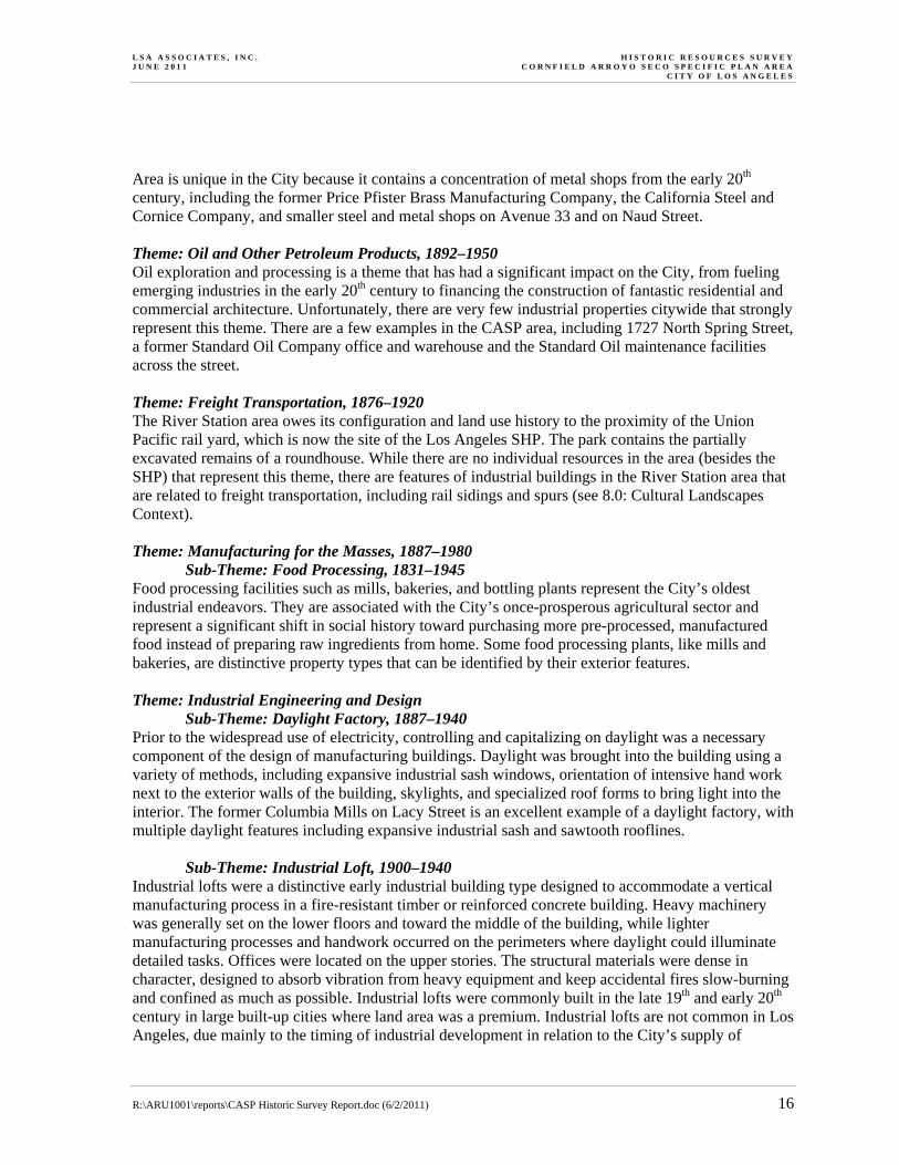
LSA Associates, Inc. (LSA) is under contract to Arup, who is the prime consultant under contract to the City of Los Angeles Department of City Planning (DCP), to conduct an historic resources survey of the Cornfield Arroyo Seco Specific Plan (CASP) Area. PROJECT TEAM The Historic Resources Survey was completed by Tanya Sorrell, M.A. of LSA, Kathryn McGee of Chattel Architecture, Planning & Preservation, Inc. (Chattel), and Shane Swerdlow of Chattel. Ms. Sorrell acted as project manager, leading the reconnaissance survey of the CASP area, preparing the Survey Report, and coordinating with the City Office of Historic Resources (OHR) to identify and apply the relevant contexts developed by SurveyLA. Ms. McGee acted as lead surveyor for the team, participating in reconnaissance surveys, conducting intensive-level surveys on properties identified in the reconnaissance survey, and entering data into the FiGSS and HAI. Mr. Swerdlow acted as survey and research assistant, participating in intensive-level surveys and conducting property-specific research. Ms. Sorrell and Ms. McGee both meet the Secretary of the Interior’s Professional Qualifications Standards in History and Architectural History. DESCRIPTION OF THE SURVEY AREA The CASP survey area comprises 660 acres and roughly 1,600 assessor’s parcels in an area northeast of downtown just east of Chinatown and comprising portions of Lincoln Heights. Spring Street/Broadway, Main Street, San Fernando Road, Avenue 26, and Figueroa Street are arterial streets that traverse the area (Figure 1). The survey area is divided into four sections by Interstate 5 (I-5), Arroyo Seco Parkway (which follows Arroyo Seco Wash), and the Los Angeles River. Western Section The section west of the Los Angeles River is characterized by blocks of industrial buildings constructed throughout the 20th century. The section along Spring Street historically surrounded the Southern Pacific River Station (HCM #82), which is now Los Angeles State Historic Park. In 2005, the State Park was the site of an art project by Lauren Bon called “Not a Cornfield,” which is where the Cornfield Arroyo Seco Specific Plan gets part of its name. One of the more notable industrial buildings in the section is the Raphael Junction Block/NY Suspenders Factory (HCM #872), a flatiron-shaped building adjacent to the State Park. The western section also includes Los Angeles Department of Water and Power (LADWP) generating and maintenance facilities and William Mead Homes Public Housing. A rare extant section of the Zanja Madre, the main irrigation ditch that fed the early Pueblo de Los Angeles, is located just north of the State Park along the Metro Gold Line alignment.

§̈¦5
·|}þ110
BROADWAYPASADENA AVENUE
DALY
STR
EET
AVENUE 26
PASA
DENA
AVE
NUE
FIGUEROA STREET
·|}þ110
§̈¦10§̈¦10
CESAR E CHAVEZ AVENUE
MAIN STREET
ALAM
EDA
STRE
ET
SPRING STREET
BROA
DWAY
§̈¦5
£¤101
Regional and Project LocationSOURCE: AirPhotoUSA, 2008; Thomas Bros., 2009I:\ARU1001\Reports\Cultural\fig1_reg_loc.mxd (03/25/11)
Aä
?l!"̂$
%&o(
!"̀$?q
A»
%&l(
!"̀$%&l(
!"̂$
KË
%&g(
%&g(
AË
A¥
!"̀$KË
Pacific Ocean
Los Angeles County
Orange County
VenturaCounty
SanBernardino
County
The Cornfield Arroyo Seco Specific Plan AreaHistoric Resources Survey
FIGURE 1
0 10 20
Miles
0 1,000 2,000
Feet
S!!N
Regional Location
Project Area
S!!N
Project Location

L S A A S S O C I A T E S , I N C . H I S T O R I C R E S O U R C E S S U R V E Y A P R I L 2 0 1 1 C O R N F I E L D A R R O Y O S E C O S P E C I F I C P L A N A R E A C I T Y O F L O S A N G E L E S
R:\ARU1001\reports\CASP Historic Survey Report.doc (6/2/2011) 3
Central Section The section between the Los Angeles River and I-5, south of Arroyo Seco is mixed in character, containing residential, commercial, and industrial uses, often adjacent to each other. Five or six blocks on the south side of Broadway contain a concentration of late 19th and early 20th century residences, as well as the Albion Elementary School. Albion Cottages and Milagro Market (HCM #442) are located in this small residential area. Broadway and Pasadena Avenue act as commercial corridors through the area. Industrial properties are interspersed throughout the section, but the north half of the section is particularly industrial in character. The Lincoln Heights Jail (HCM #587) is located in this section, as is the old Fuller Paint Company (remodeled into loft housing), and Goodwill Industries. The Brewery Art Colony, housed in the old Pabst Brewery and Edison Steam Power Plant (HCM #388), is just outside the CASP boundaries on the south side of Main Street. Eastern Section Located east of I-5 and south of Arroyo Seco, this section is largely industrial, with the exception of a few old homes left over from the original residential tract that existed before industry expanded into it. The Lincoln Heights Gold Line stop is located in this section, which has spurred apartment and condominium development in recent years. Lacy Street is defined by a mix of historic and new buildings, including the old Columbia Mills (now Lacy Street Studios), Lacy Street Neighborhood Park, the North Central Animal Care Center, and former offices of the Cannon Electric Development Company. Other industries in the area were historically involved in metal work, from the manufacture of brass to general fabrication of metal objects and building materials. Northern Section The section north of Arroyo Seco comprises mainly the properties facing Figueroa Street and Avenue 26, which are largely commercial in character. Properties along Figueroa Street have seen extensive redevelopment and remodeling over the last half of the 20th century, leading to a mix of older one-story commercial buildings, a neighborhood movie theater (converted to a store), gas stations, and a Googie-style IHOP restaurant. The former Los Angeles Railway Huron Substation is located in this section (HCM #404), as is the former Lawry’s California Center (now the Los Angeles River Center and Gardens). PROJECT METHODOLOGY The purpose of the survey, completed in cooperation with the OHR, was to identify, document, and evaluate, at the intensive level, selected properties for eligibility for the National Register of Historic Places (National Register), California Register of Historical Resources (California Register), and/or for designation as a City of Los Angeles Historic Cultural Monument (HCM) to facilitate future planning considerations. The survey largely followed methodology currently in use for SurveyLA, the City’s first-ever comprehensive historic resources survey. The CASP survey area is the home of several designated HCMs and, because the historic importance of these resources has already been recognized by the City, these properties were not resurveyed. Properties that were previously surveyed and determined eligible were included in the survey, but

L S A A S S O C I A T E S , I N C . H I S T O R I C R E S O U R C E S S U R V E Y A P R I L 2 0 1 1 C O R N F I E L D A R R O Y O S E C O S P E C I F I C P L A N A R E A C I T Y O F L O S A N G E L E S
R:\ARU1001\reports\CASP Historic Survey Report.doc (6/2/2011) 4
research and documentation were limited to providing updates on the current conditions of the resources. To streamline survey activities and eliminate redundant efforts with the OHR, the survey team adapted SurveyLA methodology to the extent feasible for compliance with the California Environmental Quality Act (CEQA). The methodology involved the review of contexts and eligibility standards prepared for SurveyLA, developing eligibility standards for the industrial development context (which had not yet been prepared for SurveyLA, but is in preparation by LSA under a separate contract with the City), and application of these eligibility standards in the field using reconnaissance surveys and property-specific research. Properties identified as potentially eligible through review of SurveyLA contexts and themes were then surveyed at the intensive level, with data entered into the OHR’s Field Guide Survey System (FiGSS) and LSA’s custom-designed Historic Architecture Inventory (HAI). Department of Parks and Recreation (DPR 523) forms were generated using HAI for eligible properties. Survey results were summarized in this Survey Report, with recommendations for the treatment of identified properties and future surveys. Specific tasks within the overall project methodology are described in more detail below. Field Surveys The LSA survey team conducted several reconnaissance-level surveys of the CASP to identify properties that could potentially meet eligibility standards created for SurveyLA. Reconnaissance surveys were conducted on foot and driving. In addition to physically surveying the area, the survey team inspected current aerial photographs overlaid with historic Sanborn Fire Insurance Maps to identify historic uses and determine whether properties possessed a basic level of historic integrity. This pre-survey investigation helped the survey team to focus its efforts on properties that had the greatest likelihood of meeting SurveyLA eligibility standards. Following the reconnaissance surveys, LSA prepared a list of properties for intensive survey. The intensive surveys were conducted by the lead surveyor and survey assistant from Chattel, and involved the preparation of a detailed physical description of each property and making an evaluation using SurveyLA eligibility standards. Field Guide Survey System1 The Historic Context Statement (HCS) framework has been used as the basis for developing the FiGSS, a custom mobile application designed for use in the field on tablet PCs. The FiGSS uses Geographic Information System (GIS) mapping software and is preloaded with maps and aerial photographs of survey areas, context statement eligibility standards, and information relating to designated, previously surveyed and potentially significant historic resources. The FiGSS is unique in that it “translates” the components of the Historic Context Statement into data fields so that surveyors can readily place a property within the appropriate context and theme by selecting from drop-down lists. For example, when surveying a neighborhood school (such as the Albion Street School in the survey area), a field surveyor may select the context “Institutional 1 This summary of FiGGS is adapted from a description developed by the OHR for a cover letter that explains SurveyLA
methodology. The entire cover letter is attached to this report as Appendix A.

L S A A S S O C I A T E S , I N C . H I S T O R I C R E S O U R C E S S U R V E Y A P R I L 2 0 1 1 C O R N F I E L D A R R O Y O S E C O S P E C I F I C P L A N A R E A C I T Y O F L O S A N G E L E S
R:\ARU1001\reports\CASP Historic Survey Report.doc (6/2/2011) 5
Development” and then the theme “Education” and the sub-theme “Education and Ethnic-Cultural Associations.” A set of eligibility standards associated with this context/theme selection is then presented as a list of check boxes that the surveyors will select from as appropriate to determine if the property retains the physical and associative qualities needed to be an important example of its type. The FiGSS also allows surveyors to “flag” properties that require additional research or follow up. The overall concept behind the FiGSS is to provide surveyors with the information they need in the field to identify and evaluate resources according to defined contexts and themes and in an efficient and consistent manner. The FiGSS is garnering attention from local, state, and federal agencies and organizations for its potential to change the way historic resources surveys are completed. Historic Architecture Inventory LSA developed the HAI in 2008 to increase staff’s efficiency in conducting large scale historic resources surveys. The HAI is a Microsoft Visual Basic field application and Access/ArcReader database that organizes records using the Assessor’s Parcel Number (APN). The HAI enables surveyors to select each parcel in the field, create a physical description using pre-programmed descriptors, incorporate property-specific research/evaluation criteria, and link photographs. The survey data entered into the HAI allow the survey team to create DPR Primary and BSO records efficiently and to use the data gathered for secondary analysis. Property-Specific Research The survey team researched properties that were included in the intensive-level survey in order to develop a complete understanding of their historic associations and development history. In some cases, research was done prior to the intensive-level survey, and in others, research was done as a follow-up to the survey. Some of the sources consulted as part of the property-specific research are listed below. A complete list of references is provided in footnotes and at the end of this report. • Historic maps, including Sanborn Fire Insurance Maps and United States Geological Survey
(USGS) maps;
• Aerial photographs of the survey area 1948–2010;
• Original subdivision and survey maps 1849–2008;
• Newspaper articles (primarily the Los Angeles Times via Proquest);
• Electronic and physical databases of the Los Angeles Public Library (including the Photographic Collection and the California Index); and
• Los Angeles City Directories

R:\ARU1001\reports\CASP Historic Survey Report.doc (6/2/2011) 6
SIGNIFICANCE CRITERIA
CEQA (PRC Chapter 2.6, Section 21083.2 and CCR Title 145, Chapter 3, Article 5, Section 15064.5) calls for the evaluation and recordation of historic and archaeological resources. The criteria for determining the significance of impacts to cultural resources are based on Section 15064.5 of the CEQA Guidelines and Guidelines for the Nomination of Properties to the California Register. Properties eligible for listing in the California Register and subject to review under CEQA are those meeting the criteria for listing in the California Register, National Register, or designation under a local ordinance. NATIONAL REGISTER OF HISTORIC PLACES The National Register of Historic Places is the Nation’s official list of cultural resources worthy of preservation. According to National Register Bulletin 15, in order to qualify for the National Register, a resource must meet the criteria for evaluation. Properties are significant under the following criteria: a) They are associated with events that have made a significant contribution to the broad patterns of
our history; or
b) They are associated with the lives of persons significant in our past; or
c) They embody the distinctive characteristics of a type, period, or method of construction, or that represent the work of a master, or that possess high artistic values, or that represent a significant and distinguishable entity whose components may lack individual distinction; or
d) They have yielded, or may be likely to yield, information important in prehistory or history. Criteria Considerations Ordinarily, cemeteries, birthplaces, or graves of historical figures, properties owned by religious institutions or used for religious purposes, structures that have been moved from their original locations, reconstructed historic buildings, properties primarily commemorative in nature, and properties that have achieved significance within the past 50 years shall not be considered eligible for the National Register. However, such properties will qualify if they are integral parts of districts that do meet the criteria or if they fall within the following categories: a) A religious property deriving primary significance from architectural or artistic distinction or
historical importance; or
b) A building or structure removed from its original location but which is significant primarily for architectural value, or which is the surviving structure most importantly associated with a historic person or event; or
c) A birthplace or grave of a historical figure of outstanding importance if there is no appropriate site or building directly associated with his or her productive life; or

L S A A S S O C I A T E S , I N C . H I S T O R I C R E S O U R C E S S U R V E Y A P R I L 2 0 1 1 C O R N F I E L D A R R O Y O S E C O S P E C I F I C P L A N A R E A C I T Y O F L O S A N G E L E S
R:\ARU1001\reports\CASP Historic Survey Report.doc (6/2/2011) 7
d) A cemetery which derives its primary significance from graves of persons of transcendent importance, from age, from distinctive design features, or from association with historic events; or
e) A reconstructed building when accurately executed in a suitable environment and presented in a dignified manner as part of a restoration master plan, and when no other building or structure with the same association has survived; or
f) A property primarily commemorative in intent if design, age, tradition, or symbolic value has invested it with its own exceptional significance; or
g) A property achieving significance within the past 50 years if it is of exceptional importance. Integrity Integrity is the ability of a property to convey its significance. To be listed in the National Register, a property must not only be shown to be significant under the National Register criteria, but it also must have integrity. The evaluation of integrity is sometimes a subjective judgment, but it must always be grounded in an understanding of a property’s physical features and how they relate to its significance. Historic properties either retain integrity (this is, convey their significance) or they do not. Within the concept of integrity, the National Register criteria recognize seven aspects or qualities that, in various combinations, define integrity. To retain historic integrity, a property will always possess several, and usually most, of the aspects. The retention of specific aspects of integrity is paramount for a property to convey its significance. Determining which of these aspects is most important to a particular property requires knowing why, where, and when the property is significant. The seven aspects of integrity are locations, design, setting, materials, workmanship, feeling, and association, defined as follows: a) Location is the place where the historic property was constructed or the place where the historic
event occurred.
b) Design is the combination of elements that create the form, plan, space, structure, and style of a property.
c) Setting is the physical environment of a historic property.
d) Materials are the physical elements that were combined or deposited during a particular period of time and in a particular pattern or configuration to form a historic property.
e) Workmanship is the physical evidence of the crafts of a particular culture or people during any given period in history or prehistory.
f) Feeling is a property’s expression of the aesthetic or historic sense of a particular period of time.
g) Association is the direct link between an important historic event or person and a historic property.
CALIFORNIA REGISTER OF HISTORICAL RESOURCES The California Register program encourages public recognition and protection of resources of architectural, historical, archaeological, and cultural significance, identifies historical resources for

L S A A S S O C I A T E S , I N C . H I S T O R I C R E S O U R C E S S U R V E Y A P R I L 2 0 1 1 C O R N F I E L D A R R O Y O S E C O S P E C I F I C P L A N A R E A C I T Y O F L O S A N G E L E S
R:\ARU1001\reports\CASP Historic Survey Report.doc (6/2/2011) 8
State and local planning purposes, determines eligibility for State Historic Preservation grant funding, and affords certain protections under CEQA. According to Technical Assistance Bulletin #3, to become a historic resource, a site must be significant at the local, state, or national level under one or more of the following four criteria: 1. It is associated with events that have made a significant contribution to the broad patterns of local
or regional history, or the cultural heritage of California or the United States; or
2. It is associated with the lives of persons important to local, California, or national history; or
3. It embodies the distinctive characteristics of a type, period, region, or method of construction, or represents the work of a master or possesses high artistic values; or
4. It has yielded, or has the potential to yield, information important to the prehistory or history of the local area, California, or the nation.
In addition to having significance, resources must have integrity for the period of significance. The period of significance is the date or span of time within which significant events transpired, or significant individuals made their important contributions. Integrity is the authenticity of a historical resource’s physical identity as evidenced by the survival of characteristics or historic fabric that existed during the resource’s period of significance. Alterations to a resource or changes in its use over time may have historical, cultural, or architectural significance. Simply, resources must retain enough of their historic character or appearance to be recognizable as historical resources, and to convey the reasons for their significance. CITY OF LOS ANGELES HISTORIC CULTURAL MONUMENT (HCM) Section 22.171.8: Monument Designation Criteria A proposed Monument may be designated by the City Council upon the recommendation of the Commission if it: A) Meets at least one of the following criteria:
1) Is identified with important events in the main currents of national, State, or local history, or exemplifies significant contributions to the broad cultural, political, economic or social history of the nation, state, city, or community; or
2) Is associated with the lives of historic personages important to national, State, City, or local history; or
3) Embodies the distinctive characteristics of a style, type, period, or method of construction; or represents a notable work of a master designer, builder or architect whose genius influenced his or her age; or possesses high artistic values; or
4) Has yielded, or has the potential to yield, information important to the pre-history or history of the nation, State, City, or community; or
5) Reflects or exemplifies the diversity of Los Angeles, including, but not limited to, the significant contributions of people of color, women, and workers; or stimulates and promotes a greater understanding of diversity, democracy, and freedom; and

L S A A S S O C I A T E S , I N C . H I S T O R I C R E S O U R C E S S U R V E Y A P R I L 2 0 1 1 C O R N F I E L D A R R O Y O S E C O S P E C I F I C P L A N A R E A C I T Y O F L O S A N G E L E S
R:\ARU1001\reports\CASP Historic Survey Report.doc (6/2/2011) 9
B) Retains Integrity from its Period of Significance. Proposed Monuments do not need to retain all aspects of Integrity, but should retain a sufficient degree of those aspects of Integrity that relate to why it is significant. Flexibility shall be used in assessing Integrity, particularly when a proposed Monument is significant under designation criteria 1 or 2 above. A proposed Monument’s deferred maintenance, dilapidated condition, or illegal alterations shall not, on their own, be construed to equate to a loss of integrity.
CITY OF LOS ANGELES HISTORIC PRESERVATION OVERLAY ZONE A Historic Preservation Overlay Zone (HPOZ) is a significant concentration, linkage, or continuity of sites, buildings, structures, or objects united historically or aesthetically by plan or physical development. According to Section 12.20.3 of the City of Los Angeles Municipal Code, the criteria for the designation of an HPOZ are: 1) Adds to the historic architectural qualities or historic associations for which a property is
significant because it was present during the period of significance, and possesses historic integrity reflecting its character at that time; or
2) Owing to its unique location or singular physical characteristics, represents an established feature of the neighborhood, community or city; or
3) Retaining the building, structure, landscaping, or natural feature, would contribute to the preservation and protection of a historic place or area of historic interest in the City.
CALIFORNIA HISTORICAL RESOURCE (CHR) STATUS CODES To be significant, a resource must meet at least one of the above-listed criteria and also retain enough integrity to convey its period of significance and association with an important historic context. Once a significance evaluation has been made, the resource is assigned a CHR status code. The CHR status codes are a standardized, shorthand method for identifying the significance level of a resource and include the following general categories: 1. Properties listed in the National Register or the California Register.
2. Properties determined eligible for listing in the National Register or California Register.
3. Properties that appear eligible for National Register or California Register through survey evaluation.
4. Properties that appear eligible for National Register or California Register through other evaluation.
5. Properties recognized as historically significant by local government.
6. Properties not eligible for listing or designation as specified.
7. Properties not evaluated for National Register or California Register or that need re-evaluation.

L S A A S S O C I A T E S , I N C . H I S T O R I C R E S O U R C E S S U R V E Y A P R I L 2 0 1 1 C O R N F I E L D A R R O Y O S E C O S P E C I F I C P L A N A R E A C I T Y O F L O S A N G E L E S
R:\ARU1001\reports\CASP Historic Survey Report.doc (6/2/2011) 10
It should be noted that there are several subcategories within each of these that allow for various nuances, such as whether or not a resource is a contributor to a Historic District. Relevant codes for the CASP historic resources survey are described further in the Results section.

R:\ARU1001\reports\CASP Historic Survey Report.doc (6/2/2011) 11
SUMMARY OF FINDINGS
HISTORICAL OVERVIEW2 The CASP Survey area contains some of the oldest developed areas of Los Angeles. The site where Gaspar de Portola’s 1769 expedition camped in Los Angeles is believed to be along the Los Angeles River just south of where it is joined by the Arroyo Seco Wash. In 1781, settlers from Spain and Mexico founded the Pueblo de Los Angeles about a mile south of the survey area along the river. Agriculture provided the main source of industry for the nascent Pueblo, which grew slowly along the river during most of the 19th century. By 1820, the Pueblo was home to 650 Californio residents. In 1847, the U.S. gained possession of the Pueblo during the Mexican-American War. Under U.S. control, the riverfront began to industrialize. The Southern Pacific Railroad/River Station was completed in the 1870s and triggered a large wave of European and Chinese immigrants. The River Station became a major industrial and commercial center, connecting Los Angeles to major U.S. cities and the East. Much of the early growth of Los Angeles can be attributed to the development of the riverfront industrial center. In the early 20th century, Los Angeles expanded across the river east into Lincoln Heights. In 1910, Henry G. Parker and Hugo Eckardt constructed the first monumental bridge across the Los Angeles River. The classically-styled North Main Street Bridge connected East Los Angeles to Downtown. One year later, in 1911, the Buena Vista Viaduct (now called the North Broadway-Buena Vista Bridge) was completed. At the time, this bridge was the longest and widest concrete arch bridge in California. Designers Homer Hamlin and Alfred P. Rosenheim incorporated Ionic arches and balustrades to complement the North Main Street Bridge. Eighteen years later, the North Spring Street Viaduct was completed. John C. Shaw designed the North Spring Street Viaduct to relieve traffic on the North Broadway Bridge. Shaw’s design continued the classical style of the two earlier bridges, linking the three bridges as a thematic sub-group that connects Lincoln Heights to Downtown. All three bridges were designated as City Historic Cultural Monuments in 2008. Some of the original industrial and commercial buildings still exist along the riverfront. The Standard Oil Company of California buidings on North Spring Street served as sales department and provided industrial facilities for one of the most powerful corporations in the world. Rockefeller’s Standard Oil of California was one of the “seven sisters” that ran the oil industry during the 20th century and later became Chevron Corporation. The Baker Iron Works Site, on North Broadway, was an influential industrial pioneer in Los Angeles. Baker played a major role in stimulating growth in California, particularly through the production of streetcars, water distribution systems, and oil drilling products. In the following years, the area surrounding Baker became the premier steel and iron manufacturing center in California. In addition, Baker was a major supplier to the United States military during World Wars I and II. Located on North Spring Street, Capitol Milling Company was one of Los Angeles’ leading enterprises, specializing in milling grains to produce flour, cereal, and food. The nearby Southern Pacific Railroad allowed Capitol Milling to transport products nationwide. Today,
2 This section is largely adapted from the Background History section of the Cornfield Arroyo Seco Specific Plan, draft
3/9/2010.

L S A A S S O C I A T E S , I N C . H I S T O R I C R E S O U R C E S S U R V E Y J U N E 2 0 1 1 C O R N F I E L D A R R O Y O S E C O S P E C I F I C P L A N A R E A C I T Y O F L O S A N G E L E S
R:\ARU1001\reports\CASP Historic Survey Report.doc (6/2/2011) 12
these buildings provide a window to Los Angeles’ past and serve as symbols of the industries that allowed the city to grow. The concentration of industry near the river fostered the growth of new immigrant communities, including vibrant Italian, Mexican, and Chinese districts. These communities introduced new cultural elements and helped to establish Los Angeles as a global city. In 1917, Santo Cambianica, an Italian immigrant, opened the San Antonio Winery near the Los Angeles River. San Antonio remains the last producing winery in Los Angeles. Lincoln Heights As commercial and industrial activity grew downtown in the late 19th century, new arrivals to Los Angeles looked to adjacent land surrounding downtown as the setting for the City’s first suburbs. Similar subdivisions were recorded concurrently in areas east, south, and north of Downtown. The community of Lincoln Heights was built on the higher plain southeast of the confluence of the river and Arroyo Seco, subdividing the former farmlands. This new community was linked to downtown Los Angeles along Downey Avenue and served by horse-drawn streetcars. The main north-south road, San Fernando Road/Avenue 20, passed through Lincoln Heights and connected it to northern and southern California. Into the 20th century, Lincoln Heights grew into a small town with a classic mix of residential neighborhoods around a small downtown located between Broadway and Five Points. At the same time, owing to its location as the mouth of a pass to the north, the first rail lines linking northern and southern California were built, paralleling the Los Angeles River. Along with the railroads came the first industrial uses, some directly rail-related in the form of rail yards, such as the Cornfield site, and some uses that were served by the rail. The residential small town character of Lincoln Heights began to erode. By the end of World War II, Lincoln Heights transformed into a predominantly working class neighborhood. This transformation accelerated with the construction of the Golden State Freeway (I-5) in the 1950s, replacing the historic north-south Route 99 that used San Fernando Road and Avenue 20, split Lincoln Heights in half at its core and destroyed the neighborhood’s important relationship with downtown, the river, and the historic origins of Los Angeles. Railroads and Industry After the rapid development of the 1920s, more and more industry began to locate in Lincoln Heights along the river banks following the railroad. Early land use districting ordinances had already established industrial use areas along the rail and river corridor, which were hardened further into discrete zones around 1920. The mixed-use character of Lincoln Heights with its residential neighborhoods was “pushed” to the east, with older neighborhoods nearer the river displaced by industrial lands. Meanwhile, plagued by the river’s unpredictability and constant flooding, the U.S. Army Corps of Engineers began to channelize the river in the 1930s. Ever since, the once natural resource has served as a flood control system and carried storm water and other runoff south to San Pedro and the harbor. Only recently has the city begun to return to the concept of transforming the Los Angeles River into an environmental and open space resource.

L S A A S S O C I A T E S , I N C . H I S T O R I C R E S O U R C E S S U R V E Y J U N E 2 0 1 1 C O R N F I E L D A R R O Y O S E C O S P E C I F I C P L A N A R E A C I T Y O F L O S A N G E L E S
R:\ARU1001\reports\CASP Historic Survey Report.doc (6/2/2011) 13
In 1996, one of the largest undeveloped parcels within the area was proposed to be developed as an industrial park but the surrounding neighborhoods resoundingly rejected the concept and instead demanded that the parcel, which was known as “the Cornfield,” be set aside as a park. With the assistance of the Trust for Public Land, the State of California purchased the 33-acre property and is today developing conceptual plans to develop the Los Angeles State Historic Park. With the introduction of the Gold Line only a few short years later, in 2002, and subsequently the interest in the revitalization of the River and the Arroyo Seco, the stage was set for developer speculation and the pressure for residential conversion began. Currently, the area is home to 4,600 residents and approximately 6,000 employees visit the area each weekday to make their livelihood in the light industrial employment sectors, which include everything from the manufacturing of furniture to carpet warehousing and logistics. Six hundred new units have been built in the last three years, which have provided critical affordable housing for low and moderate income seniors and families. Two hundred moderately priced condominiums have been built, 102 units are currently in construction, and another 350 units have been entitled. A 20 unit live-work rental project recently opened to round out the residential offerings. SUMMARY OF RELEVANT HISTORIC CONTEXTS AND THEMES3 The following HCS Context/Theme summaries are provided to place the resources of the CASP survey area into the framework established by SurveyLA. The Contexts and Themes included here represent potentially relevant themes for the CASP survey area, but the survey team did not ultimately find potentially eligible properties for every theme listed. 3.0 Context: Residential Development and Suburbanization Much of the central portion of the CASP area was once part of the City’s oldest suburbs. The Lincoln Heights HPOZ is adjacent to the eastern boundary of CASP, and the residential block in CASP appears to have the same general historical association and architectural character, though the level of historic integrity is not as high and I-5 physically separates it from the Lincoln Heights HPOZ. Sub-Context/Theme: Multifamily Residential Development Sub-Theme: Public and Defense Housing In the CASP area, this subtheme is represented entirely by William Mead Homes, a public housing project that was constructed in 1942 and designed by architects T.A. Elisen, A.R. Walker, Armand Monaco, Marsh Smith & Powell. It has been previously determined eligible for the National Register under Criteria A and C. 4.0 Context: Commercial Development Theme: Neighborhood Theaters, Pre-WWII, 1915–1942 A pre-WWII neighborhood theater is extant at 3232 North Figueroa Street. It was constructed in 1928 and retains some of its historical appearance. Affiliated with Fox West Coast Theaters, this building
3 This outline consists of selections from the SurveyLA Context Outline and has retained that outline’s numbering for
easier cross-reference.

L S A A S S O C I A T E S , I N C . H I S T O R I C R E S O U R C E S S U R V E Y J U N E 2 0 1 1 C O R N F I E L D A R R O Y O S E C O S P E C I F I C P L A N A R E A C I T Y O F L O S A N G E L E S
R:\ARU1001\reports\CASP Historic Survey Report.doc (6/2/2011) 14
was called the Arroyo Theater. A Los Angeles Times 1936 movie listing includes the theater located at 3232 N Figueroa Street. The theater was used until at least 1956, according to 1956 City Directory. Theme: Restaurants, 1880–1980 The former Lawry’s California Center (now the Los Angeles River Center and Gardens) is located in the northernmost section of the CASP survey area. It was originally constructed in 1952 by the Frank and Van De Kamp families as an early example of the “corporate campus,” a collection of commercial office, restaurants, bars, and manufacturing buildings organized around promoting the Lawry’s brand of seasonings. By 1987, the California Center accommodated 600,000 visitors a year. It was determined that while architecturally interesting and generally retaining integrity from 1979, it is not clear that the site rises to the exceptional level of significance necessary for listing. Lawry’s had on-site facilities for manufacturing signature spices at this location as early as the 1950s, as well as a gift shop and restaurant. A portion of a 1950s industrial building may be intact. The rest of the site was designed in 1979 by Calvin Straub of Scottsdale, Arizona as a 150-seat restaurant, garden, courtyard and art exhibition, constructed at a cost of $1.5 million. While a unique property, sufficient time has not passed to gain a historical perspective on the significance of the largely 32-year old campus. 5.0 Context: Institutional Development Sub-Context: Education Theme: Public Schools and the LAUSD, 1876–1980 Sub-Theme: Post-1933 Long Beach Earthquake, 1933–1945 Albion Street School is an excellent example of an elementary school built after the 1933 Long Beach Earthquake, a period in which the widespread quake-caused destruction of unreinforced schools led to the development of stricter standards for school construction. This pressure to rebuild schools coupled with the infusion of federal funding from the Works Progress Administration (WPA) produced an extensive collection of Art Deco, Streamline Moderne, and PWA Moderne schools in the Los Angeles Basin. Albion Street School has retained several key buildings from the 1937 Moderne-styled campus. Sub-Context: Government Infrastructure and Services Theme: Municipal Water and Power Sub-Theme: Distributing and Receiving Stations The Department of Water and Power Main Street Station is a major distributing and receiving station within the Los Angeles power grid. It was previously determined eligible for the National Register. Theme: Public Works Sub-Theme: Bridges The CASP area is home to three landmark bridges across the Los Angeles River: the Main Street Bridge, the North Spring Street Bridge, and the North Broadway Bridge. These three bridges have all been recently designated Los Angeles HCMs. Sub-Context: Civil Rights Movement – Ethnic and Gender Equality, 1942–1980 Theme: Women’s Rights Movements The Woman’s Building and Women’s Graphic Center (Woman’s Building) was an art gallery and communal space developed by artists within the feminist movement. These women started the

L S A A S S O C I A T E S , I N C . H I S T O R I C R E S O U R C E S S U R V E Y J U N E 2 0 1 1 C O R N F I E L D A R R O Y O S E C O S P E C I F I C P L A N A R E A C I T Y O F L O S A N G E L E S
R:\ARU1001\reports\CASP Historic Survey Report.doc (6/2/2011) 15
Feminist Studio Workshop in 1973 in reaction to the lack of access or exposure afforded them and all women by mainstream galleries and art museums. The original Woman’s Building was opened at the former Chouinard Institute near MacArthur Park, but in 1975, Chouinard was closed and the Woman’s Building moved to 1727 North Spring Street in the old Standard Oil Company office and warehouse near the Spring Street Bridge. The Woman’s Building became an internationally recognized icon for women’s creative expression in the 1970s and 1980s. It closed in 1991. The building has retained its historical appearance from the period of significance for the Woman’s Building. 6.0 Context: Architecture and Engineering Theme: Late 19th and Early 20th Century Architecture, 1865–1950 Theme: Arts and Crafts Movement, 1895–1930 Theme: Mediterranean Revival, 1887–1952 Theme: American Colonial Revival, 1895–1960
Sub-Themes: Folk Victorian, Neoclassical, Craftsman, Spanish Colonial Revival, and Early American Colonial Revival Styles
Due to the age of residential development in the CASP area, there are examples of late 19th early 20th century architectural styles, including Folk Victorian, Colonial Revival, Spanish Colonial Revival, Neoclassical, and Craftsman. Theme: Postwar Modernism, 1946–1976 Sub-Theme: Googie 1935–1969 The former Prebles Restaurant (now the International House of Pancakes) at 2227 North Figueroa is a good representative example of the Googie style of architecture, a whimsical and visually arresting style applied to retail buildings in the post-World War II era. It was designed by Armet and Davis, an architecture firm responsible for design of many prominent Googie restaurants throughout Southern California. Googie buildings were designed to attract passing motorists and create a memorable brand for the store, and it was common for casual restaurants and coffee shops in the 1950s and 1960s. 8.0 Context: Cultural Landscapes, 1850–1980 Theme: Historic Vernacular Landscapes Because the CASP survey area contains some of the earliest-developed areas in the City, the survey team investigated the potential for historic vernacular landscapes. Specific areas of focus included the River Station area, where early industry and freight activity left related buildings, street improvements, and spatial relationships from the early 20th century. The residential area surrounding Albion Street School was also investigated due to its Italian heritage. 9.0 Context: Industrial Development, 1850–1980 Theme: Building the City, 1876–1965 The building industry emerged to support the exponential residential and commercial growth in Los Angeles in the late 19th and early 20th centuries, providing the raw materials, carpentry, and furnishings needed to create the City’s extensive built environment. Very few, if any properties are extant that represent this critical component of Los Angeles community development. The CASP
L S A A S S O C I A T E S , I N C . H I S T O R I C R E S O U R C E S S U R V E Y J U N E 2 0 1 1 C O R N F I E L D A R R O Y O S E C O S P E C I F I C P L A N A R E A C I T Y O F L O S A N G E L E S
R:\ARU1001\reports\CASP Historic Survey Report.doc (6/2/2011) 16
Area is unique in the City because it contains a concentration of metal shops from the early 20th century, including the former Price Pfister Brass Manufacturing Company, the California Steel and Cornice Company, and smaller steel and metal shops on Avenue 33 and on Naud Street. Theme: Oil and Other Petroleum Products, 1892–1950 Oil exploration and processing is a theme that has had a significant impact on the City, from fueling emerging industries in the early 20th century to financing the construction of fantastic residential and commercial architecture. Unfortunately, there are very few industrial properties citywide that strongly represent this theme. There are a few examples in the CASP area, including 1727 North Spring Street, a former Standard Oil Company office and warehouse and the Standard Oil maintenance facilities across the street. Theme: Freight Transportation, 1876–1920 The River Station area owes its configuration and land use history to the proximity of the Union Pacific rail yard, which is now the site of the Los Angeles SHP. The park contains the partially excavated remains of a roundhouse. While there are no individual resources in the area (besides the SHP) that represent this theme, there are features of industrial buildings in the River Station area that are related to freight transportation, including rail sidings and spurs (see 8.0: Cultural Landscapes Context). Theme: Manufacturing for the Masses, 1887–1980 Sub-Theme: Food Processing, 1831–1945 Food processing facilities such as mills, bakeries, and bottling plants represent the City’s oldest industrial endeavors. They are associated with the City’s once-prosperous agricultural sector and represent a significant shift in social history toward purchasing more pre-processed, manufactured food instead of preparing raw ingredients from home. Some food processing plants, like mills and bakeries, are distinctive property types that can be identified by their exterior features. Theme: Industrial Engineering and Design Sub-Theme: Daylight Factory, 1887–1940 Prior to the widespread use of electricity, controlling and capitalizing on daylight was a necessary component of the design of manufacturing buildings. Daylight was brought into the building using a variety of methods, including expansive industrial sash windows, orientation of intensive hand work next to the exterior walls of the building, skylights, and specialized roof forms to bring light into the interior. The former Columbia Mills on Lacy Street is an excellent example of a daylight factory, with multiple daylight features including expansive industrial sash and sawtooth rooflines. Sub-Theme: Industrial Loft, 1900–1940 Industrial lofts were a distinctive early industrial building type designed to accommodate a vertical manufacturing process in a fire-resistant timber or reinforced concrete building. Heavy machinery was generally set on the lower floors and toward the middle of the building, while lighter manufacturing processes and handwork occurred on the perimeters where daylight could illuminate detailed tasks. Offices were located on the upper stories. The structural materials were dense in character, designed to absorb vibration from heavy equipment and keep accidental fires slow-burning and confined as much as possible. Industrial lofts were commonly built in the late 19th and early 20th century in large built-up cities where land area was a premium. Industrial lofts are not common in Los Angeles, due mainly to the timing of industrial development in relation to the City’s supply of

L S A A S S O C I A T E S , I N C . H I S T O R I C R E S O U R C E S S U R V E Y J U N E 2 0 1 1 C O R N F I E L D A R R O Y O S E C O S P E C I F I C P L A N A R E A C I T Y O F L O S A N G E L E S
R:\ARU1001\reports\CASP Historic Survey Report.doc (6/2/2011) 17
available land. Because space was available and relatively inexpensive, manufacturers tended to set up a horizontal process in and around Los Angeles, which was easier to expand and reorganize to suit changing technology. The exception in Los Angeles is the garment industry, where the vertical process provided the most efficient workflow for manufacturers and proximity to markets downtown was essential. The KeLite Products plant, located at 1250 N Main, includes a three-story industrial loft building. Sub-Theme: Quonset Hut, 1941–1950 The Quonset hut is a variant of the c. 1916, British-designed Nissen hut. It was named for the Naval Air Station at Quonset Point, Rhode Island, where it was first designed for large-scale production in the United States in 1941. Built to serve as temporary, flexible military facilities for World War II, the Quonset hut bears a distinctive form: a simple half-cylinder typically constructed of a wood or steel rib-framing system with corrugated metal sheathing. It was ideal for wartime because it was both inexpensive and efficient to build, and could be easily moved to accommodate a variety of uses. Following the end of World War II in 1945, there was a nationwide housing shortage as veterans returned from war in large numbers; Quonset huts served as one answer to accommodate the population. Given their flexible interior layout and the low cost to move and erect, it was not uncommon for individual Quonset huts to be purchased and appropriated for a variety of uses, including industrial and commercial facilities. Not all Quonset huts were designed for military activities and then reused; some companies advertised their effectiveness as an efficient, flexible space for a wide variety of home, warehouse, commercial, and other uses, and sold them for those purposes. An important symbol of both the wartime and immediate post-World War II eras, the Quonset hut is a rapidly disappearing property type.

R:\ARU1001\reports\CASP Historic Survey Report.doc (6/2/2011) 18
RESOURCES IDENTIFIED
Of the approximately 1,600 unique parcels within the survey area, 50 were digitally photographed and entered into the FiGSS database. Each of the surveyed properties was assigned a California Historical Resources status code according to level of significance. Of this number, 23 properties appeared to meet SurveyLA eligibility criteria under one or more themes, and were recorded on the appropriate DPR forms. One or more of the following status codes were assigned to resources in the CASP survey area: • 3S: Appears to be eligible for the National Register as an individual property through survey
evaluation. These properties met one or more eligibility standards included in the SurveyLA HCS and have retained the highest degree of integrity. Resources with this code are considered historical resources for the purposes of CEQA.
• 3CS: Appears to be eligible for California Register as an individual property through survey evaluation. This code includes all properties assigned a 3S status code, plus properties that met one or more eligibility standards included in the SurveyLA HCS, but have lost a critical aspect of integrity that precludes eligibility for the National Register. Resources with this code are considered historical resources for the purposes of CEQA.
• 5S3: Appears to be eligible for local listing or designation through survey evaluation. In the CASP survey, this code includes all 3S and 3CS properties. No properties were assigned only a 5S3 code in conjunction with this survey. Resources with this code are considered historical resources for the purposes of CEQA.
• 6L/6LQ: Determined ineligible for local listing or designation through a survey process, but may warrant special consideration for local planning. These resources do not constitute historic resources for the purposes of CEQA. They are identified because, though ineligible, they possess a distinctive character that planning staff may want to take into consideration during the design phase of future projects in the area.
• 6Z: Individual property assessed for significance in accordance with the SurveyLA Multiple Property Documentation approach, but does not meet eligibility standards. This group comprises the 37 properties that were identified in the reconnaissance surveys but when surveyed using FiGSS did not ultimately meet any of the eligibility standards. These resources do not constitute historic resources for the purposes of CEQA.
• 7RQ: Individual Property identified in a SurveyLA Survey; not evaluated. This status code will be assigned to all properties that were not identified for intensive-level survey. These resources do not constitute historic resources for the purposes of CEQA. They did not appear to warrant intensive-level survey for the CASP planning and review process, but may need to be evaluated in connection with future projects.

L S A A S S O C I A T E S , I N C . H I S T O R I C R E S O U R C E S S U R V E Y J U N E 2 0 1 1 C O R N F I E L D A R R O Y O S E C O S P E C I F I C P L A N A R E A C I T Y O F L O S A N G E L E S
R:\ARU1001\reports\CASP Historic Survey Report.doc (6/2/2011) 19
HISTORICAL RESOURCES (3S, 3CS, 5S3) Nearly all of the properties that the survey found eligible (19 of 21) warranted all three status codes. One property was assigned a 3CS and 5S3 status code because it did not retain sufficient integrity to be eligible for the National Register. One property was assigned a 5S3 status code only because it did not retain integrity sufficient for the National or California Registers, but represented a rare neighborhood property type (1920s Movie Theater). Each of the 21 properties was documented on DPR 523 Primary and Building, Structure, Object (BSO) forms, which are attached to the survey report as Appendix C. Table A provides a brief summary of eligible properties. Table A: Historical Resources in the CASP Area (not including HCMs)
Address Name Historical
Property Type Year Built
Status Code Notes
147 N. Avenue 18
— Quonset Hut 1946 3S; 3CS; 5S3
Noted on Sanborn maps as a sheet metal shop.
271 Avenue 18
— Residence 1885 3CS, 5S3
Folk Victorian, vinyl windows (original openings)
267 Avenue 18
— Residence 1885 3S, 3CS, 5S3
Early Hipped-Roof Vernacular residence.
322 S. Avenue 18
Albion Street School, Hayes Street School, 19th Street School
School 1937 3S; 3CS; 5S3
Post-1933 earthquake Moderne School, also identified with the Italian and Mexican immigrant communities.
227, 229, and 231 Avenue 19
— Multifamily Property
1905 3S; 3CS; 5S3
Trio of identical Folk Victorian residences on one lot.
420 W. Avenue 33
Cannon Electric Development Co., Plant #1
Office (related factory demolished)
1926 3S; 3CS; 5S3
Office building for what was once a key factory producing “Cannon Plugs.” Cannon was known as an early innovator and 20th century leader in electronic connections, with applications in civic infrastructure, entertainment, and aviation/aerospace industries.
1300 N. Cardinal Street
William Mead Homes; Ann Street Project
Public Housing Project
1942 2S2; Already formally determined eligible; boundaries updated.
1805 Darwin
— Residence 1910 3S; 3CS; 5S3
Folk Victorian
1837 Darwin
— Residence 1895 3S; 3CS; 5S3
Folk Victorian

L S A A S S O C I A T E S , I N C . H I S T O R I C R E S O U R C E S S U R V E Y J U N E 2 0 1 1 C O R N F I E L D A R R O Y O S E C O S P E C I F I C P L A N A R E A C I T Y O F L O S A N G E L E S
R:\ARU1001\reports\CASP Historic Survey Report.doc (6/2/2011) 20
Table A: Historical Resources in the CASP Area (not including HCMs)
Address Name Historical
Property Type Year Built
Status Code Notes
2227 N. Figueroa Street
Prebles Restaurant
Restaurant 1968 3S; 3CS; 5S3
Googie Architecture, now an IHOP
3232 N. Figueroa Street
Arroyo Theater Movie Theater 1928 5S3 Affiliated with Fox West Coast Theatres. Extensive alterations.
3005 N. Humboldt
Price Pfister Brass Mfg Co.
Metal Shop 1914–1951
3S; 3CS; 5S3
Associated with industrialist, philanthropist, and Jewish leader Isadore Familian and key factory for Price Pfister, an internationally recognized plumbing/fixture brand.
2630 Lacy Street
Columbia Mills; Talbert-Whitmore Co
Factory 1885–ca. 1945
3S; 3CS; 5S3
Excellent example of Daylight Factory.
1250 N. Main Street
Kelite Industrial Loft 1924–1954
3S; 3CS; 5S3
Industrial Loft, former Kelite Chemical Factory
1630 N. Main Street
DWP Facility Municipal Power Plant
1946–2000
2S2 Already formally determined eligible; boundaries updated.
510 Avenue 17; 1801 N. Main Street
Lanza Bros. Market
residence/deli 1898–1926
3S; 3CS; 5S3
Italian Deli and residences historically associated with historical Italian community near Albion Street, Deli run by Italian immigrant family from 1926 through 2000s.
1811 N. Main Street
— Residence 1898 3S; 3CS; 5S3
Folk Victorian
1611 Naud Street
California Steel and Cornice Co.
Metal Shop 1945 3S; 3CS; 5S3
Produced steel for the Case Study Houses, also for Standard Oil
1640 N. Spring Street
— Factory 1925 3S; 3CS; 5S3
Daylight Factory, manufactured paper
1726–1756 N. Spring Street
Standard Oil Maintenance
Maintenance Facilities
1920–1960
3S; 3CS; 5S3
Early office and auto repair/machine shop for Standard Oil.
1727 N. Spring Street
Standard Oil Company; Woman’s Building
Oil Co. Office 1914 3S; 3CS; 5S3
Originally served as Standard Oil sales office, it was the 1973–1991 home of the Woman’s Building, a key institution in Feminist History.

L S A A S S O C I A T E S , I N C . H I S T O R I C R E S O U R C E S S U R V E Y J U N E 2 0 1 1 C O R N F I E L D A R R O Y O S E C O S P E C I F I C P L A N A R E A C I T Y O F L O S A N G E L E S
R:\ARU1001\reports\CASP Historic Survey Report.doc (6/2/2011) 21
INELIGIBLE PROPERTIES The other 30 properties identified in the reconnaissance survey were surveyed but did not ultimately meet the eligibility requirements of any particular SurveyLA theme, either for a lack of significance or extensive alterations. Most of these properties (26 of 30) were assigned a “6Z” status code in the FiGSS and were not documented on DPR 523 forms. These are not considered historical resources for the purposes of CEQA. Table B lists these surveyed but ineligible properties. Table B: Ineligible Properties (6Z)
Address Historical Names Historical
Property Type Year Built Notes
1750 Albion Street Grogan Olive Co. food processing ca 1930
Company does not appear notable and does not visually convey historical use.
351 S. Avenue 17 Certified Chrome Furniture Co; Goldenberg Plywood and Lumber Co.
carpentry/metal shop
1926–1967
Oldest buildings have not retained integrity; associated companies do not appear to be notable.
214 S. Avenue 18 — multifamily ca 1925
Not a significant example of multifamily housing.
216 Avenue 18 — multifamily ca 1925
Too altered for listing.
440 Avenue 19; 405–427 San Fernando Road
Log Cabin Bakery Bread Co
bakery 1916–1944
Too altered for listing.
540 W. Avenue 26 — residence 1908 Intact craftsman bungalow identified in the reconnaissance survey, but did not meet eligibility standards.
220 W. Avenue 33 — duplex 1922 214 W. Avenue 33 — duplex 1922
Told by resident that these properties were associated with Lacy Estate or tract, but no associations were found in research.
153 W. Avenue 34 — metal shop 1929 Does not appear to have significant historical associations.
130 W. Avenue 34 — residence 1924 Not a significant example of type or style; no historical associations.
140½ Avenue 34 — residence ca. 1925
Not a significant example of type or style; no historical associations.
1134 College Lacy Manufacturing Company
metal shop 1891-1960
Too altered for listing.

L S A A S S O C I A T E S , I N C . H I S T O R I C R E S O U R C E S S U R V E Y J U N E 2 0 1 1 C O R N F I E L D A R R O Y O S E C O S P E C I F I C P L A N A R E A C I T Y O F L O S A N G E L E S
R:\ARU1001\reports\CASP Historic Survey Report.doc (6/2/2011) 22
Table B: Ineligible Properties (6Z)
Address Historical Names Historical
Property Type Year Built Notes
1812 Darwin — residence 1924 Not a significant example of type or style; no historical associations.
1902 Darwin — residence 1910 Not a significant example of type or style; no historical associations.
2200 N. Humboldt Fuller & Co Lacquer Paint
Factory 1937 Not a key facility for Fuller Paint Company.
2684 Lacy Street National Battery Company
factory 1911–1970
Too altered for listing.
1100 N. Main Street
former neon sign factory
factory 1924–1955
Too altered for listing.
1667 and 1650 N Main Street (corner of Naud Street and Wilhardt)
— machine shop/factory
1911–1953
No significant historical associations, not sufficiently intact or distinctive example of Daylight Factory.
1718 Albion Street; 1745–55 N. Main Street; 325 Avenue 16
— trailer manufacturing
1912–1937
Too altered overall for listing, does not appear to have significant historical associations.
1615–1625 Naud Street
— metal shop 1942–1949
Too altered for listing, does not appear to have significant historical associations.
1200–1220 N. Spring Street
Allison Coffee Co. food processing plant
1910–1920
Company does not appear notable, no other historical associations.
1400–1426 N. Spring Street
JW MacMillan Electrical Lighting Supply
factory 1910 Too altered for listing.
136 N. San Fernando Road
National Wire and Cable Co.
metal shop 1951 Not a significant example of type or style; no historical associations.
154–162 N. San Fernando Road
— residence and commercial
1915 Not a significant example of type or style; no historical associations.
208 San Fernando Road
Fuller Paint Co. warehouse 1925 Now Alta Lofts. Too altered for listing.
221 San Fernando Road
— commercial 1915 Too altered for listing.
Four of the 30 ineligible properties were assigned a 6L status code to recognize that, although they are not eligible for designation, they warrant consideration in the planning process (see Table C). In

L S A A S S O C I A T E S , I N C . H I S T O R I C R E S O U R C E S S U R V E Y J U N E 2 0 1 1 C O R N F I E L D A R R O Y O S E C O S P E C I F I C P L A N A R E A C I T Y O F L O S A N G E L E S
R:\ARU1001\reports\CASP Historic Survey Report.doc (6/2/2011) 23
three of the four cases, restoration to the period of significance may render these properties eligible for designation. In the case of Lawry’s California Center (now LA River Center and Gardens) sufficient scholarly perspective may develop in the future in support of its eligibility. Table C: Ineligible Properties that Warrant Consideration in the Planning Process (6L)
Address Historical Names Historical
Property Type Year Built Notes
308 Avenue 17
Four Square Gospel, Inc. Mexican Church
church 1938 Has been a Mexican Foursquare church for over 50 years, but significantly altered.
570 W. Avenue 26
Lawry’s CA Center mixed use commercial/industrial park
1954–1979
Remodeled in 1979, not enough time has passed to evaluate.
404 S. Avenue 20
First Baptist Italian Mission
church 1895–1924
Too altered for listing, but associated with the Italian immigrant community.
1711–1719 N. Spring Street
Carnation Co. warehouse 1910–1916
Too altered for listing, not a key facility for Carnation. Part of the River Station Historic Landscape.
NON-ELIGIBLE PLANNING AREAS (6LQ) The survey team identified two non-eligible conservation areas: the River Station Historic Landscape and the Albion Street Community Conservation Area. These areas are each composed of properties and non-parcel features that, when taken together, represent the historical land use and cultural values of the people that lived and worked there. While neither area has retained sufficient integrity to be eligible as a historic district or cultural landscape, the remaining features, spatial relationships, and community character warrant consideration in the planning process for any future projects in the area. River Station Historic Vernacular Landscape This landscape contains remnants of industrial development that followed the establishment of the historic Southern Pacific River Station in 1876. Its centerpiece is Los Angeles SHP (HCM #82). It includes several industrial buildings, including the Raphael Junction Block Building (HCM #872, includes related rail siding), the Standard Oil Company Sales and Maintenance Buildings, the Paper Company Factory on North Spring, and the Carnation Company Warehouse. Non-parcel resources that are part of this landscape include the hoof and wagon wheel imprints in front of 1418 North Spring Street, a granite swale in the median of Naud Street (east of Wilhardt), and a railroad spur alignment that runs behind the buildings facing Naud and Main Streets, opening to Wilhardt. Outside of the CASP survey area, the Capitol Milling Company and the section of the Zanja Madre north of the Cornfields are associated with this landscape as well.

L S A A S S O C I A T E S , I N C . H I S T O R I C R E S O U R C E S S U R V E Y J U N E 2 0 1 1 C O R N F I E L D A R R O Y O S E C O S P E C I F I C P L A N A R E A C I T Y O F L O S A N G E L E S
R:\ARU1001\reports\CASP Historic Survey Report.doc (6/2/2011) 24
Albion Street Community Planning Area The Albion Street Community Conservation Area is part of the core area that historically represented the Italian immigrant community in Los Angeles. This area is a small part of a larger section of Los Angeles which extends to the Plaza, the area now known as Chinatown, and Lincoln Heights formed a nucleus where Italian families settled from the earliest days of the Pueblo through much of the 20th century. Italian and Mexican families worked in nearby rail yards and factories, lived in the residential blocks, and attended neighborhood schools like Albion Street School. The conservation area consists of the Chavez tract and neighboring residential blocks, neighborhood markets such as the Lanza Brothers Market and Garcia Brothers Market, churches such as the First Italian Baptist Church (now Centro Cristiano Internacional) and the Mexican Four Square Gospel (now Gethsemane Iglesia Cristiana Pentecostes), and the Albion Street School. The Albion Cottages and Milagro Market (HCM #442) are also part of this conservation area. The Albion Street Community Conservation Area was considered for inclusion with the Lincoln Heights HPOZ, but the survey team concluded that the physical separation presented by I-5 diminishes the neighborhood’s sense of continuity with Lincoln Heights, and does not on its own represent significant themes in the Residential Development and Suburbanization Context.

R:\ARU1001\reports\CASP Historic Survey Report.doc (6/2/2011) 25
RECOMMENDATIONS
All properties assigned a status code of 1–5 are considered to be “historical resources” for CEQA compliance purposes and City’s Cultural Heritage Ordinance. Those properties assigned a status code of 6DQ, 6Z, or 6L do not constitute “historic properties” (Section 106) or “historical resources” (CEQA) and require no further cultural resources considerations. Properties that were not identified for intensive-level survey were assigned a “7RQ” meaning they were identified in a SurveyLA Survey, but not evaluated. These properties did not appear to warrant intensive-level survey for the CASP planning and review process, but may need to be evaluated in connection with future projects. Planning documents such as the CASP should guide future development toward preserving the area’s historic character through the preservation and/or rehabilitation of eligible resources. The CASP should also promote compatible infill construction that celebrates the historical themes prevalent in the CASP survey area, particularly the industrial character of the River Station and the Italian and Mexican heritage in the Albion Street Community.

R:\ARU1001\reports\CASP Historic Survey Report.doc (6/2/2011) 26
REFERENCES
California Office of Historic Preservation. 1999. California Register and National Register: A Comparison (for purposes of determining eligibility for the California Register), OHP Technical Assistance Series #6. 2001. CEQA and Historical Resources, OHP Technical Assistance Series #1. 2006. CEQA Questions and Answers. Available Online: http://ohp.parks.ca.gov/default.asp?page_id=21721. Accessed 1/5/07. Historic Resources Inventory, 12/11/2006.
Deverell, William, and Tom Sitton. Metropolis in the Making: Los Angeles in the 1920s. Berkeley:
University of California Press, 2001. Fogelson, Robert M. The Fragmented Metropolis: Los Angeles, 1850–1930. Berkeley, California:
University of California Press, 1967/1993. Fulton, William. The Reluctant Metropolis: The Politics of Urban Growth in Los Angeles. Point
Arena, CA: Solano Press Books, 1997. Gebhard, David, and Robert Winter. 1994. Los Angeles: An Architectural Guide. Salt Lake City:
Gibbs-Smith. Hayden, Dolores. The Power of Place: Urban Landscapes as Public History. Cambridge and London:
The MIT Press, 1995. Hise, Greg. 1997. Magnetic Los Angeles: Planning the Twentieth Century Metropolis. Baltimore and
London, The Johns Hopkins University Press. Lee, Antoinette J., and Linda F. McClelland. 1999. How to Complete the National Register Multiple
Property Documentation Form. U.S. Department of the Interior, National Park Service, 1991, revised 1999.
Los Angeles City Directories (multiple years). Available online through Los Angeles Public Library:
http://rescarta.lapl.org:8080/ResCarta-Web/jsp/RcWebBrowse.jsp. Accessed 2011. Los Angeles County Assessor Tract Maps. Available online:
http://assessor.lacounty.gov/extranet/Datamaps/Pais.aspx. Accessed 2011.

L S A A S S O C I A T E S , I N C . H I S T O R I C R E S O U R C E S S U R V E Y A P R I L 2 0 1 1 C O R N F I E L D A R R O Y O S E C O S P E C I F I C P L A N A R E A C I T Y O F L O S A N G E L E S
R:\ARU1001\reports\CASP Historic Survey Report.doc (6/2/2011) 27
Los Angeles Department of Public Works, Bureau of Engineering. Subdivision Maps for the CASP Survey Area. Accessible through the Electronic Vault: http://engvault.lacity.org/apps/vault/ Accessed 2008–2009.
Los Angeles Office of Historic Resources Los Angeles Public Library, Photographs Collection. Los Angeles Public Library, California Regional History Index. Los Angeles Times. Historical Database, 1885–1985. Available through Proquest.com, courtesy of
Los Angeles Public Library. Articles used as cited. Accessed 2011. Map of the City of Los Angeles Showing Railway Systems, 1906. Library of Congress, website,
www.loc.gov/exhibits/LAmapped, 04/23/2008. Mc Williams, Carey. Southern California Country: An Island on the Land. Edited by Erskine
Caldwell. New York: Duell, Sloan & Pearce, n.d. The Paleontological Research Institution, Ithaca, New York, website: The Story of Oil in California,
http://www.priweb.org/ed/pgws/history/signal_hill/signal_hill.html. Sanborn Fire Insurance Maps. Available via LAPL.org U.S. Census Bureau. Available online: http://www.laalmanac.com/population/po02.htm. Accessed
6/05/08. U.S. Department of the Interior, National Park Service. National Register Bulletin: How to Apply the
National Register Criteria for Evaluation. Washington DC: U.S. Department of the Interior, National Park Service, Interagency Resources Division, 1997.

L S A A S S O C I A T E S , I N C . H I S T O R I C R E S O U R C E S S U R V E Y A P R I L 2 0 1 1 C O R N F I E L D A R R O Y O S E C O S P E C I F I C P L A N A R E A C I T Y O F L O S A N G E L E S
R:\ARU1001\reports\CASP Historic Survey Report.doc (6/2/2011)
APPENDIX A
SUMMARY OF FiGGS

1
I. INTRODUCTION TO SURVEYLA In 2005, the City of Los Angeles entered into a multi-year grant agreement with the J. Paul Getty Trust to complete a citywide historic resources survey, a process of systematically identifying and gathering information on properties and neighborhoods that reflect Los Angeles’ architectural, social and cultural history. The project managed by the staff of the Office of Historic Resources (OHR) within the Department of City Planning (DCP), which named this project SurveyLA (www.SurveyLA.com). SurveyLA is first and foremost a planning tool. The information gathered during the surveys help shape decisions by policymakers, developers, urban planners, community organizations, and property owners. Survey findings also provide vast opportunities for public engagement and education in areas relating to curriculum development, heritage tourism, economic development, and marketing historic neighborhoods and properties. The surveys identify and evaluate properties according to standardized criteria for listing in the National Register of Historic Places, California Register of Historical Resources, and for local designation as Historic Cultural Monuments and Historic Preservation Overlay Zones. However, no actual designation results directly from survey activity. Designation by the City of Los Angeles and nominations to the California or National Registers are separate processes which include property owner notification and public hearings. SurveyLA gathers various types of information on potential historic resources throughout Los Angeles including construction and ownership history, architectural styles, reasons for significance, relevant evaluation criteria, and photographs. This information will be organized in a searchable database and made readily accessible to the public via the DCPs SurveyLA and ZIMAS websites. Once the database is launched it will be possible, for example, to search for all buildings designed by a particular architect or all properties associated with an ethnic group in a specific geographic area of Los Angeles. During the Initiation Phase of SurveyLA (2006-2009), the OHR worked with the DCPs Systems and GIS Division, consultant teams, and staff of the California Office of Historic Preservation to develop and test survey tools and methods. SurveyLA methodology meets all accepted federal and state survey guidelines and standards and provides streamlined, cutting-edge approaches to identifying and evaluating historic resources. For these reasons, SurveyLA has gained national attention and is changing the way… II. SURVEYLA FIELD SURVEY PHASING PLAN The field survey phase of SurveLA, the Implementation Phase, began in July 2010. The OHR developed a three-year plan for this phase, which was approved by SurveyLA’s Advisory Committee in January 2009 and by the Cultural Heritage Commission in February 2009. As indicated in the plan (see pages 4-5), the field surveys parallel the DCP’s New Community Plan program, to the extent possible. The 35 Community Plans serve as the Land Use Element of the City’s General Plan, and guide and focus new development and investment in all Los Angeles communities. Coordinating SurveyLA with the New Community Plan program helps promote the OHR’s key goal to integrate historic preservation more fully into the City’s planning processes. It also offers key

2
opportunities to coordinate the SurveyLA public outreach and participation programs with New Community Plan outreach activities. SurveyLA’s outreach to Certified Neighborhood Councils, historical societies, business groups and local residents may often proceed in tandem with the Department of City Planning’s outreach to these same organizations. SurveyLA and public discussions of potential historic resources may be incorporated, wherever feasible, into focus groups and public workshops held in each Community Plan Area. Completing the field surveys within three years requires that SurveyLA cover approximately one-third of Los Angeles each year. The Phasing Plan is designed to schedule the survey work to ensure a balanced and manageable workload for each year. The plan also maintains a balance of neighborhoods expected to have a high concentration of historic resources with neighborhoods expected to yield fewer potential resources.
SURVEYLA PHASING PLAN By Community Plan Area
Approximate parcel counts in each Community Plan area in parentheses Year 1 Total Parcels in Year 1: 282,006 Palms-Mar Vista-Del Rey (22,015) Harbor Gateway (7,790) Wilmington-Harbor City (13,628) South Los Angeles (50,722) Southeast Los Angeles (46,198) Central City North (2,920) West Los Angeles (16,107) Sunland-Tujunga-Shadow Hills-Lakeview Terrace-East La Tuna Canyon (23,945) West Adams-Baldwin Hills-Leimert Park (because other surveys are concentrated in South LA) (37,509) San Pedro (because other surveys are concentrated in Harbor) (17,803) Hollywood (due to significant development pressure and concentration of historic resources) (43,369) Year 2 Total Parcels in Year 2: 237,510 Sherman Oaks-Studio City-Toluca Lake-Cahuenga Pass (26,906) North Hollywood-Valley Village (24,560) Mission Hills-Panorama City-North Hills (20,285) Arleta-Pacoima (17,152) Canoga Park-West Hills-Winnetka-Woodland Hills (45,402) Encino-Tarzana (20,822) Brentwood-Pacific Palisades (21,298) Bel Air-Beverly Crest (18,271) Westchester-Playa del Rey (14,270) Silver Lake-Echo Park-Elysian Valley (19,192) Westlake (9,352)

3
Year 3 Total Parcels in Year 3: 302,515 Venice (11,333) Sun Valley-La Tuna Canyon (17,841) Van Nuys-North Sherman Oaks (26,063) Chatsworth-Porter Ranch (22,853) Northridge (14,166) Northeast Los Angeles (65,578) Westwood (5,279) Reseda-West Van Nuys (22,719) Granada Hills-Knollwood (18,061) Sylmar (14,291) Wilshire (38,056) All Industrial Properties in all Community Plan Areas (46,006) LAX (separate Community Plan – with LAWA) (269) III. SURVEYLA TOOLS SurveyLA tools include a citywide Historic Context Statement and customized mobile Field Guide Survey System. These tools, and the methodology developed for their use, are described briefly below.
A. SurveyLA Historic Context Statement (HCS) A historic context statement is a narrative, technical document that provides a framework for completing historic resources surveys. The SurveyLA HCS uses the Multiple Property Documentation approach developed by the National Park Service. This approach organizes the themes, trends and patterns of history shared by properties into historic contexts, identifies and describes historic resources, or property types that represent the contexts, and provides specific standards to guide the evaluation of significance. The SurveyLA HCS consists of nine broad contexts which cover the period from about 1850 to 1980 and are specific to the City of Los Angeles:
• Spanish and Mexican Colonial Era Settlement • Pre-Annexation Communities of Los Angeles • Residential Development & Suburbanization • Commercial Development • Industrial Development • Institutional Development: Government & Private • Architecture and Engineering • The Entertainment Industry • Cultural Landscapes
Each of the nine contexts is comprised of a number of themes and sub-themes which not only address important movements in Los Angeles architecture or distinct property types, but also focus on important topics in ethnic, social, and cultural history. For example, Institutional Development includes government
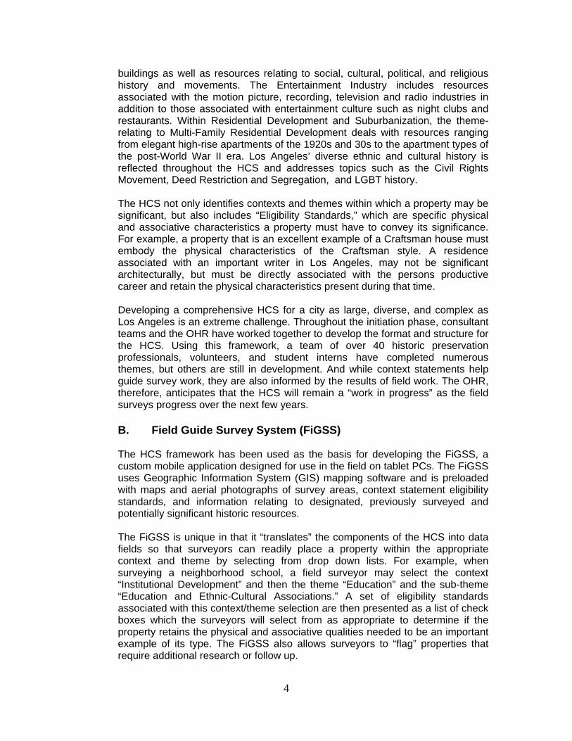
4
buildings as well as resources relating to social, cultural, political, and religious history and movements. The Entertainment Industry includes resources associated with the motion picture, recording, television and radio industries in addition to those associated with entertainment culture such as night clubs and restaurants. Within Residential Development and Suburbanization, the theme-relating to Multi-Family Residential Development deals with resources ranging from elegant high-rise apartments of the 1920s and 30s to the apartment types of the post-World War II era. Los Angeles’ diverse ethnic and cultural history is reflected throughout the HCS and addresses topics such as the Civil Rights Movement, Deed Restriction and Segregation, and LGBT history. The HCS not only identifies contexts and themes within which a property may be significant, but also includes “Eligibility Standards,” which are specific physical and associative characteristics a property must have to convey its significance. For example, a property that is an excellent example of a Craftsman house must embody the physical characteristics of the Craftsman style. A residence associated with an important writer in Los Angeles, may not be significant architecturally, but must be directly associated with the persons productive career and retain the physical characteristics present during that time. Developing a comprehensive HCS for a city as large, diverse, and complex as Los Angeles is an extreme challenge. Throughout the initiation phase, consultant teams and the OHR have worked together to develop the format and structure for the HCS. Using this framework, a team of over 40 historic preservation professionals, volunteers, and student interns have completed numerous themes, but others are still in development. And while context statements help guide survey work, they are also informed by the results of field work. The OHR, therefore, anticipates that the HCS will remain a “work in progress” as the field surveys progress over the next few years.
B. Field Guide Survey System (FiGSS) The HCS framework has been used as the basis for developing the FiGSS, a custom mobile application designed for use in the field on tablet PCs. The FiGSS uses Geographic Information System (GIS) mapping software and is preloaded with maps and aerial photographs of survey areas, context statement eligibility standards, and information relating to designated, previously surveyed and potentially significant historic resources. The FiGSS is unique in that it “translates” the components of the HCS into data fields so that surveyors can readily place a property within the appropriate context and theme by selecting from drop down lists. For example, when surveying a neighborhood school, a field surveyor may select the context “Institutional Development” and then the theme “Education” and the sub-theme “Education and Ethnic-Cultural Associations.” A set of eligibility standards associated with this context/theme selection are then presented as a list of check boxes which the surveyors will select from as appropriate to determine if the property retains the physical and associative qualities needed to be an important example of its type. The FiGSS also allows surveyors to “flag” properties that require additional research or follow up.

5
The overall concept behind the FiGSS is to provide surveyors with the information they need in the field to identify and evaluate resources according to defined contexts and themes and in an efficient and consistent manner. The FiGSS is garnering attention from local, state and federal agencies and organizations for its potential to change the way historic resources surveys are completed.
IV. SURVEYLA METHODOLOGY
A. Survey Teams
The DCP is contracting with pre-qualified consultant firms specializing in historic preservation to complete SurveyLA. • Consultants are deployed in the field in teams of two and multiple teams
may be working in survey areas at any one time. • At least one surveyor from each team of two must meet or exceed
professional qualification standards in the field of historic preservation. Consultants meeting these professional standards are responsible for making historic resource evaluations.
• Consultants may enlist students and other volunteers with training and
interest in the field of historic preservation, or specialized knowledge of geographic areas and contexts, to assist them with the field survey work.
• All consultants and volunteers receive classroom and field training from the
DCP in the use of the FiGSS and SurveyLA methodology.
B. Field Survey Methods Summary • SurveyLA identifies and evaluates properties and districts that are significant
within the contexts developed for the HCS.
• Properties are evaluated in the field using the HCS in accordance with National Register of Historic Places and California Register of Historical Resources criteria as well as for local eligibility as potential City Historic-Cultural Monuments and Historic Preservation Overlay Zones.
• Surveys focus on identifying resources dating from 1850 to 1980. • Information relating to properties of historic, social and cultural significance
is pre-loaded in the FiGSS based on research completed for development of the HCS, pre-field research provided by interns and volunteers, and community input from SurveyLA’s public participation program. This information appears as a GIS data layer on the FiGSS application.

6
• All surveys are completed from the public right-of-way (from vehicles or on foot as needed).
• Digital photographs are be taken of all surveyed properties.
• Field Surveys do not include:
o Individual resources and historic districts (including HPOZs) that are
already designated (federal, state, local). For individual resources, there may be some verification (updating) of existing conditions in the field where appropriate
o Community Redevelopment Area (CRA) surveys conducted within the last five years
o Historic Preservation Overlay Zone (HPOZ) surveys completed within the last five years (submitted to OHR as complete but not designated)
V. CRITERIA FOR EVALUATION
Properties surveyed for SurveyLA are evaluated for eligibility for listing in the National Register of Historic Places, California Register of Historical Resources and for local designation as City Historic-Cultural Monuments (HCM) or Historic Preservation Overlay Zones (HPOZ), commonly known as historic districts. A discussion of the criteria for each of these programs is summarized below.
A. National Register of Historic Places (NR)
The National Register of Historic Places is the Nation's official list of cultural resources worthy of preservation. According to National Register Bulletin 15, in order to qualify for the register, a resource must meet the criteria for evaluation, which are: CRITERIA FOR EVALUATION: The quality of significance in American history, architecture, archeology, engineering, and culture is present in districts, sites, buildings, structures, and objects that possess integrity of location, design, setting, materials, workmanship, feeling, and association, and: a) That are associated with events that have made a significant contribution to
the broad patterns of our history; or b) That are associated with the lives of persons significant in our past; or c) That embody the distinctive characteristics of a type, period, or method of
construction, or that represent the work of a master, or that possess high artistic values, or that represent a significant and distinguishable entity whose components may lack individual distinction; or
d) That have yielded, or may be likely to yield, information important in
prehistory or history.

7
CRITERIA CONSIDERATIONS: Ordinarily cemeteries, birthplaces, or graves of historical figures, properties owned by religious institutions or used for religious purposes, structures that have been moved from their original locations, reconstructed historic buildings, properties primarily commemorative in nature, and properties that have achieved significance within the past 50 years shall not be considered eligible for the National Register. However, such properties will qualify if they are integral parts of districts that do meet the criteria or if they fall within the following categories: a) A religious property deriving primary significance from architectural or artistic
distinction or historical importance; or b) A building or structure removed from its original location but which is
significant primarily for architectural value, or which is the surviving structure most importantly associated with a historic person or event; or
c) A birthplace or grave of a historical figure of outstanding importance if there is
no appropriate site or building directly associated with his or her productive life; or
d) A cemetery which derives its primary significance from graves of persons of
transcendent importance, from age, from distinctive design features, or from association with historic events; or
e) A reconstructed building when accurately executed in a suitable environment
and presented in a dignified manner as part of a restoration master plan, and when no other building or structure with the same association has survived; or
f) A property primarily commemorative in intent if design, age, tradition, or
symbolic value has invested it with its own exceptional significance; or
g) A property achieving significance within the past 50 years if it is of exceptional importance.
INTEGRITY: Integrity is the ability of a property to convey its significance. To be listed in the National Register of Historic Places, a property must not only be shown to be significant under the National Register criteria, but it also must have integrity. The evaluation of integrity is sometimes a subjective judgment, but it must always be grounded in an understanding of a property's physical features and how they relate to its significance. Historic properties either retain integrity (this is, convey their significance) or they do not. Within the concept of integrity, the National Register criteria recognize seven aspects or qualities that, in various combinations, define integrity. To retain historic integrity a property will always possess several, and usually most, of the aspects. The retention of specific aspects of integrity is paramount for a property to convey its significance. Determining which of these aspects are most important to a particular property requires knowing why, where, and when the property is significant. The following

8
sections define the seven aspects and explain how they combine to produce integrity.
The Seven Aspects of Integrity: 1) Location is the place where the historic property was constructed or the
place where the historic event occurred. 2) Design is the combination of elements that create the form, plan, space,
structure, and style of a property.
3) Setting is the physical environment of a historic property.
4) Materials are the physical elements that were combined or deposited during a particular period of time and in a particular pattern or configuration to form a historic property.
5) Workmanship is the physical evidence of the crafts of a particular culture or
people during any given period in history or prehistory.
6) Feeling is a property's expression of the aesthetic or historic sense of a particular period of time.
7) Association is the direct link between an important historic event or person
and a historic property.
B. California Register of Historical Resources (CR) The California Register program encourages public recognition and protection of resources of architectural, historical, archeological and cultural significance, identifies historical resources for state and local planning purposes, determines eligibility for state historic preservation grant funding and affords certain protections under the California Environmental Quality Act. According to the California Office of Historic Preservation’s Technical Assistance Bulletin #3, to become a historic resource, a site must be significant at the local, state, or national level under one or more of the following four criteria:
1) It is associated with events that have made a significant contribution to the
broad patterns of local or regional history, or the cultural heritage of California or the United States; or
2) It is associated with the lives of persons important to local, California, or
national history; or 3) It embodies the distinctive characteristics of a type, period, region, or method
of construction, or represents the work of a master or possesses high artistic values; or
9
4) It has yielded, or has the potential to yield, information important to the prehistory or history of the local area, California, or the nation.
In addition to having significance, resources must have integrity for the period of significance. The period of significance is the date or span of time within which significant events transpired, or significant individuals made their important contributions. Integrity is the authenticity of a historical resource’s physical identity as evidenced by the survival of characteristics or historic fabric that existed during the resource’s period of significance. Alterations to a resource or changes in its use over time may have historical, cultural, or architectural significance. Simply, resources must retain enough of their historic character or appearance to be recognizable as historical resources, and to convey the reasons for their significance.

10
C. City of Los Angeles Historic Cultural Monument (HCM)
Sec. 22.171.8. Monument Designation Criteria A proposed Monument may be designated by the City Council upon the recommendation of the Commission if it: (A) Meets at least one of the following criteria: 1) Is identified with important events in the main currents of national, State or local history, or exemplifies significant contributions to the broad cultural, political, economic or social history of the nation, state, city, or community; or 2) Is associated with the lives of Historic Personages important to national, state, city, or local history; or 3) Embodies the distinctive characteristics of a style, type, period, or method of construction; or represents a notable work of a master designer, builder or architect whose genius influenced his or her age; or possesses high artistic values; or 4) Has yielded, or has the potential to yield, information important to the pre-history or history of the nation, state, city or community; or 5) Reflects or exemplifies the diversity of Los Angeles, including, but not limited to, the significant contributions of people of color, women, and workers; or stimulates and promotes a greater understanding of diversity, democracy, and freedom. and (B) Retains Integrity from its Period of Significance. Proposed Monuments do not need to retain all aspects of Integrity, but should retain a sufficient degree of those aspects of Integrity that relate to why it is significant. Flexibility shall be used in assessing Integrity, particularly when a proposed Monument is significant under designation criteria 1 or 2 above. A proposed Monument’s deferred maintenance, dilapidated condition, or illegal alterations shall not, on their own, be construed to equate to a loss of Integrity.

11
D. Historic Preservation Overlay Zone (HPOZ)
A Historic Preservation Overlay Zone (HPOZ) is a significant concentration, linkage, or continuity of sites, buildings, structures, or objects united historically or aesthetically by plan or physical development. According to Section 12.20.3 of the City of Los Angeles Municipal Code, the criteria for the designation of an HPOZ are: 1) Adds to the Historic architectural qualities or Historic associations for which a
property is significant because it was present during the period of significance, and possesses Historic integrity reflecting its character at that time; or
2) Owing to its unique location or singular physical characteristics, represents
an established feature of the neighborhood, community or city; or 3) Retaining the building, structure, Landscaping, or Natural Feature, would
contribute to the preservation and protection of a Historic place or area of Historic interest in the City.

12
E. SurveyLA Evaluations The California State Office of Historic Preservation has developed California Register Status Codes as a standardized system for classifying historical resources in the State’s Historic Resources Inventory. These Status Codes are used statewide and are assigned to properties and districts by field surveyors as part of the survey process.
Field surveyors will apply the following CHR Status Codes when evaluating properties for SurveyLA. A property may have more than one Status Code:
3S – Appears eligible for National Register as an individual property through survey evaluation 3CS – Appears eligible for California Register as an individual property through survey evaluation 5S3 – Appears to be individually eligible for local listing or designation through survey evaluation 6L – Property identified through the SurveyLA process as ineligible for National Register, California Register or local designation; may warrant special consideration for local planning 6LQ – Determined ineligible for local listing or designation as a historic district through a survey process; neighborhood or area may warrant special consideration for local planning. 6Z – Found ineligible for National Register, California Register or local designation through survey evaluation 7RQ – Individual property identified in a SurveyLA Survey – Not evaluated 7SQ – Individual property assessed for significance in accordance with the SurveyLA Multiple Property Documentation approach, but does not meet eligibility standards.

3224 NLACY ST
3013 NHUMBOLDT ST
1250 NNORTHMAIN ST
227 SAVENUE 19
2626 NLACY ST
1611 NNAUD ST
147 NAVENUE 18
1646 NNORTH
SPRING ST322 SAVENUE 181726 N
NORTHSPRING ST 1805 N
DARWINAVE 1837 E
DARWIN AVE
1811 NNORTHMAIN ST
1727 NNORTH SPRING ST
2227 N.FigueroaStreet
1811 NNORTH
MAIN ST
271 SAVENUE 18
3232 NFIGUEROA ST
265 SAVENUE 18
HUMBOLDT ST
BNSF
RR
RONDOUT ST
BROADWAY
METRO RR
BROADWAY
CHAVEZ ST
17
UP RR
ANN ST
SAINT JOHN ST
BOLERO LN
POWER ST
34
LACY ST
UP RR
SPRING ST
*****
METRO RR
BLOOM STPR
UDEN
T ST
*****
MESNAGER ST
*****
UP RR
UP RR
WEYSE ST
22
ALHAMBRA AV
23
21
ARTE
SIAN P
L
UP RR
BNSF RR
UP RR
UP R R
UP RR
UP RR
*****
*****
UP RR
UP RR
LegendSurveyLA Resources - Eligible
National Register, California Register, HCM (3S,3CS,5S3)California Register, HCM (3CS,5S3)HCM (5S3)
´
CASP Survey AreaCASP Survey Area
1,000FeetCopyright © 2012
City of Los Angeles. All Rights Reserved

L S A A S S O C I A T E S , I N C . H I S T O R I C R E S O U R C E S S U R V E Y
A P R I L 2 0 1 1 C O R N F I E L D A R R O Y O S E C O S P E C I F I C P L A N A R E A
C I T Y O F L O S A N G E L E S
R:\ARU1001\reports\CASP Historic Survey Report.doc (6/2/2011)
APPENDIX C
DEPARTMENT OF PARKS AND RECREATION (DPR 523) FORMS
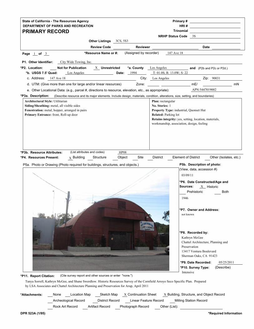
State of California - The Resources Agency
DEPARTMENT OF PARKS AND RECREATION
PRIMARY RECORD
Primary #
HRI #
Trinomial
NRHP Status Code
Other Listings
Review Code Reviewer Date
Page of *Resource Name or #: (Assigned by recorder) 147 Ave 181
3S
3
3CS, 5S3
*P2. Location:
P1. Other Identifier:
Not for Publication Unrestricted *a. County and (P2b and P2c or P2d.)
*b. USGS 7.5' Quad: Date:
c. Address: City: Zip:
d. UTM: (Give more than one for large and/or linear resources) Zone: mE/ mN
e. Other Locational Data: (e.g., parcel #, directions to resource, elevation, etc., as appropriate):
*P3a. Description: (Describe resource and its major elements. Include design, materials, condition, alterations, size, setting, and boundaries)
*P3b. Resource Attributes: (List attributes and codes)
*P4. Resources Present: Building Structure Object Site District Element of District Other (Isolates, etc.)
P5a. Photo or Drawing (Photo required for buildings, structures, and objects.) P5b. Description of photo:
*P6. Date Constructed/Age and
Sources:
(View, data, accession #)
*P7. Owner and Address:
*P8. Recorded by:
*P9. Date Recorded:
*P10. Survey Type: (Describe)
Historic
Prehistoric Both
*P11. Report Citation: (Cite survey report and other sources or enter "none.")
None Location Map Sketch Map Continuation Sheet*Attachments: Building, Structure, and Object Record
Archeological Record District Record Linear Feature Record Milling Station Record
Rock Art Record Artifact Record Photograph Record Other (List):
DPR 523A (1/95) *Required Information
X
City Wide Towing, Inc.
Los Angeles
Los Angeles 1994
147 Ave 18 Los Angeles 90031
APN:5447019002
X
X
not known
Kathryn McGee
Chattel Architecture, Planning and
Preservation
13417 Ventura Boulevard
Sherman Oaks, CA 91423
05/25/2011
1946
HP08
X X
03/09/11
T: 01.0S; R: 13.0W; S: 22
Tanya Sorrell, Kathryn McGee, and Shane Swerdlow. Historic Resources Survey of the Cornfield Arroyo Seco Specific Plan. Prepared
by LSA Associates and Chattel Architecture Planning and Preservation for Arup, April 2011
Intensive
Architectural Style: Utilitarian
Siding/Sheathing: metal, all visible sides
Fenestration: metal, hopper, arranged in pairs
Primary Entrance: front, Roll-up door
Plan: rectangular
No. Stories: 1
Property Type: industrial, Quonset Hut
Related: Parking lot
Retains integrity: yes, setting, location, materials,
workmanship, association, design, feeling

State of California - The Resources Agency
DEPARTMENT OF PARKS AND RECREATION
BUILDING, STRUCTURE, AND OBJECT RECORD
Primary #
HRI #
Page of
*Resource Name or #: (Assigned by recorder)
*NRHP Status Code 3S2 3
147 Ave 18
B1. Historic Name:
*B5. Architectural Style:
*B7. Moved? No
*Required Information
*B6. Construction History: (Construction date, alterations, and data of alterations)
B2. Common Name:
B3. Original Use: B4. Present Use:
Yes Unknown Date: Original Location:
*B8. Related Features:
B9a. Architect: b. Builder:
*B10. Significance: Area:
Period of Significance: Property Type: Applicable Criteria:
(Discuss importance in terms of historical or architectural context as defined by theme, period, and geographic scope. Also address integrity.)
B11. Additional Resource Attributes: (List attributes and codes)
*B12. References:
B13. Remarks:
*B14. Evaluator:
*Date of Evaluation:
DPR 523B (1/95)
(This space reserved for official comments.)
(Sketch Map with north arrow required.)
unknown unknown
Los Angeles
1946 Industrial
Kathryn McGee
05/25/2011
This property appears eligible for the National and California Registers and for designation as an HCM under Criterion C/3/3 as an
excellent example of a Quonset Hut, an increasingly rare property type developed to provide mass temporary workspace and housing
in the World War II era. The 1920-1951 Sanborn map identifies its early use as a "sheet metal shop." The Quonset hut is a variant of the
c. 1916, British-designed Nissen hut. It was named for the Naval Air Station at Quonset Point, Rhode Island, where it was first designed
for large-scale production in the United States in 1941. Built to serve as temporary, flexible military facilities for World War II, the
Quonset hut bears a distinctive form: a simple half-cylinder typically constructed of a wood or steel rib-framing system with corrugated
metal sheathing. It was ideal for wartime because it was both inexpensive and efficient to build, and could be easily moved to
accommodate a variety of uses.
Following the end of...(continued on next page)
Utilitarian
C/3/3
HP08
147 N Ave 18
City Wide Towing, Inc.
Industrial Towing
X
Industrial Engineering/Design 1887-1940
Sanborn Maps
Parking lot
Theme:
Year constructed: 1946

State of California - The Resources Agency
DEPARTMENT OF PARKS AND RECREATION
CONTINUATION SHEET
Primary #
HRI #
Trinomial
Page of Resource Name or #:(Assigned by recorder)
Continuation Update*Recorded By: *Date:
DPR 523L (1/95) *Required Information
B10. Statement of Significance (continued): World War II in 1945, there was a nationwide housing shortage as veterans returned
from war in large numbers; Quonset huts served as one answer to accommodate the population. Given their flexible interior
layout and the low cost to move and erect, it was not uncommon for individual Quonset huts to be purchased and appropriated
for a variety of uses, including industrial and commercial facilities. Not all Quonset huts were designed for military activities
and then reused; some companies advertised their effectiveness as an efficient, flexible space for a wide variety of home,
warehouse, commercial, and other uses, and sold them for those purposes. An important symbol of both the wartime and
postwar eras, the Quonset hut is a rapidly disappearing property type. Despite its simple, utilitarian design, research and
existing cultural resources evaluations support the notion that Quonset huts are of nationwide importance and extant examples
may be eligible for listing in the National Register under Criterion C for their architecture.
05/25/2011 X
33
LSA Associates, Inc.
147 Ave 18

State of California - The Resources Agency
DEPARTMENT OF PARKS AND RECREATION
PRIMARY RECORD
Primary #
HRI #
Trinomial
NRHP Status Code
Other Listings
Review Code Reviewer Date
Page of *Resource Name or #: (Assigned by recorder) 265-267 Ave 181
3S
2
3CS, 5S3
*P2. Location:
P1. Other Identifier:
Not for Publication Unrestricted *a. County and (P2b and P2c or P2d.)
*b. USGS 7.5' Quad: Date:
c. Address: City: Zip:
d. UTM: (Give more than one for large and/or linear resources) Zone: mE/ mN
e. Other Locational Data: (e.g., parcel #, directions to resource, elevation, etc., as appropriate):
*P3a. Description: (Describe resource and its major elements. Include design, materials, condition, alterations, size, setting, and boundaries)
*P3b. Resource Attributes: (List attributes and codes)
*P4. Resources Present: Building Structure Object Site District Element of District Other (Isolates, etc.)
P5a. Photo or Drawing (Photo required for buildings, structures, and objects.) P5b. Description of photo:
*P6. Date Constructed/Age and
Sources:
(View, data, accession #)
*P7. Owner and Address:
*P8. Recorded by:
*P9. Date Recorded:
*P10. Survey Type: (Describe)
Historic
Prehistoric Both
*P11. Report Citation: (Cite survey report and other sources or enter "none.")
None Location Map Sketch Map Continuation Sheet*Attachments: Building, Structure, and Object Record
Archeological Record District Record Linear Feature Record Milling Station Record
Rock Art Record Artifact Record Photograph Record Other (List):
DPR 523A (1/95) *Required Information
X Los Angeles
Los Angeles 1994
267 Ave 18 90031
APN:5447026014
X
X
Kathryn McGee
Chattel Architecture, Planning and
Preservation
13417 Ventura Boulevard
Sherman Oaks, CA 91423
06/02/2011
1885
HP02
X X
06/01/11
T: 01.0S; R: 13.0W; S: 23
Tanya Sorrell, Kathryn McGee, and Shane Swerdlow. Historic Resources Survey of the Cornfield Arroyo Seco Specific Plan. Prepared
by LSA Associates and Chattel Architecture Planning and Preservation for Arup, April 2011
Intensive
Architectural Style: Wood-frame Vernacular Architectural Style: Folk
Victorian, elements of
Siding/Sheathing: wood: clapboard, all visible sides
Roof: hipped, medium, narrow eaves, fascia and brackets, closed eaves
Fenestration: wood, double-hung, front, bars cover windows
Primary Entrance: single door, transom lights, Beneath a pent roof supported
by turned spindles, security door added
Other notable features: symmetrical massing
Plan: rectangular
No. Stories: 1
Porches: Front Stoop
Additions: Compatible, rear
Retains integrity: yes, setting, location, materials,
workmanship, association, design, feeling

State of California - The Resources Agency
DEPARTMENT OF PARKS AND RECREATION
BUILDING, STRUCTURE, AND OBJECT RECORD
Primary #
HRI #
Page of
*Resource Name or #: (Assigned by recorder)
*NRHP Status Code 3S2 2
265-267 Ave 18
B1. Historic Name:
*B5. Architectural Style:
*B7. Moved? No
*Required Information
*B6. Construction History: (Construction date, alterations, and data of alterations)
B2. Common Name:
B3. Original Use: B4. Present Use:
Yes Unknown Date: Original Location:
*B8. Related Features:
B9a. Architect: b. Builder:
*B10. Significance: Area:
Period of Significance: Property Type: Applicable Criteria:
(Discuss importance in terms of historical or architectural context as defined by theme, period, and geographic scope. Also address integrity.)
B11. Additional Resource Attributes: (List attributes and codes)
*B12. References:
B13. Remarks:
*B14. Evaluator:
*Date of Evaluation:
DPR 523B (1/95)
(This space reserved for official comments.)
(Sketch Map with north arrow required.)
unknown unknown
Los Angeles
1885 Single Family Residence
Kathryn McGee
06/02/2011
This property appears eligible for the National and California Registers and for designation as an HCM under Criterion A/1/1.This
hipped-roof Victorian-era residence appears to be one of the oldest residences in the Albion Street neighborhood, and is a rare intact
representative of the early residential development that occured just outside the original Pueblo of Los Angeles.
Wood-frame Vernacular, Folk Victorian
A/1/1
HP02
Single Family Residence Single Family Residence
X
Early Residential Development 1880-1930
None
Theme:
Year constructed: 1885

State of California - The Resources Agency
DEPARTMENT OF PARKS AND RECREATION
PRIMARY RECORD
Primary #
HRI #
Trinomial
NRHP Status Code
Other Listings
Review Code Reviewer Date
Page of *Resource Name or #: (Assigned by recorder) 271 Ave 181
3CS
3
5S3
*P2. Location:
P1. Other Identifier:
Not for Publication Unrestricted *a. County and (P2b and P2c or P2d.)
*b. USGS 7.5' Quad: Date:
c. Address: City: Zip:
d. UTM: (Give more than one for large and/or linear resources) Zone: mE/ mN
e. Other Locational Data: (e.g., parcel #, directions to resource, elevation, etc., as appropriate):
*P3a. Description: (Describe resource and its major elements. Include design, materials, condition, alterations, size, setting, and boundaries)
*P3b. Resource Attributes: (List attributes and codes)
*P4. Resources Present: Building Structure Object Site District Element of District Other (Isolates, etc.)
P5a. Photo or Drawing (Photo required for buildings, structures, and objects.) P5b. Description of photo:
*P6. Date Constructed/Age and
Sources:
(View, data, accession #)
*P7. Owner and Address:
*P8. Recorded by:
*P9. Date Recorded:
*P10. Survey Type: (Describe)
Historic
Prehistoric Both
*P11. Report Citation: (Cite survey report and other sources or enter "none.")
None Location Map Sketch Map Continuation Sheet*Attachments: Building, Structure, and Object Record
Archeological Record District Record Linear Feature Record Milling Station Record
Rock Art Record Artifact Record Photograph Record Other (List):
DPR 523A (1/95) *Required Information
X Los Angeles
Los Angeles 1994
271 Ave 18 Los Angeles 90031
APN:5447026025
X
X
not known
Kathryn McGee
Chattel Architecture, Planning and
Preservation
13417 Ventura Boulevard
Sherman Oaks, CA 91423
05/25/2011
1885
HP02
X X
03/09/11
T: 01.0S; R: 13.0W; S: 23
Tanya Sorrell, Kathryn McGee, and Shane Swerdlow. Historic Resources Survey of the Cornfield Arroyo Seco Specific Plan. Prepared
by LSA Associates and Chattel Architecture Planning and Preservation for Arup, April 2011
Intensive
Architectural Style: Folk Victorian
Construction: wood frame
Siding/Sheathing: wood: clapboard, all visible sides
Roof: front gable, medium, decorative vergeboards/fascia, boxed eaves and
brackets
Fenestration: vinyl, vertical sliding, front, side, arranged in pairs, bay window
in front gable, alteration: yes
Primary Entrance: front, single door
Other notable features: spindles and spandrels
Plan: irregular
No. Stories: 1
Porches: Partial, front, side
Retains integrity: yes, setting, location, materials,
workmanship, association, design, feeling

State of California - The Resources Agency
DEPARTMENT OF PARKS AND RECREATION
BUILDING, STRUCTURE, AND OBJECT RECORD
Primary #
HRI #
Page of
*Resource Name or #: (Assigned by recorder)
*NRHP Status Code 3CS2 3
271 Ave 18
B1. Historic Name:
*B5. Architectural Style:
*B7. Moved? No
*Required Information
*B6. Construction History: (Construction date, alterations, and data of alterations)
B2. Common Name:
B3. Original Use: B4. Present Use:
Yes Unknown Date: Original Location:
*B8. Related Features:
B9a. Architect: b. Builder:
*B10. Significance: Area:
Period of Significance: Property Type: Applicable Criteria:
(Discuss importance in terms of historical or architectural context as defined by theme, period, and geographic scope. Also address integrity.)
B11. Additional Resource Attributes: (List attributes and codes)
*B12. References:
B13. Remarks:
*B14. Evaluator:
*Date of Evaluation:
DPR 523B (1/95)
(This space reserved for official comments.)
(Sketch Map with north arrow required.)
unknown unknown
Los Angeles
1885 Residential
Kathryn McGee
05/25/2011
This property appears eligible for the California Register and for designation as an HCM under Criterion C/3/3 as an excellent example
of Folk Victorian architecture. Due to the replacement of the original wood windows with vinyl (albeit in their original openings) the
residence does not retain sufficient integrity for the National Register. It does, however, still retain sufficient integrity to appear eligible
for the California Register and for designation as an LAHCM. Folk Victorian styled residences were popular in the late 19th and early
20th centuries as an affordable way to decorate otherwise modest homes with the elaborate decorative styles of the Victorian Era.
Generally chosen from pattern books and mass-produced, the ornamentation on Folk Victorian homes demonstrate how
industrialization of the building industry boadened and popularized what would otherwise have been prohibitively expensive design
for most people. Hundreds of these residences were built during the...(continued on next page)
Folk Victorian
3
HP02
Residential Residential
X
Folk Victorian Architecture 1885-1905
Sanborns
None
Theme:
Year constructed: 1885

State of California - The Resources Agency
DEPARTMENT OF PARKS AND RECREATION
CONTINUATION SHEET
Primary #
HRI #
Trinomial
Page of Resource Name or #:(Assigned by recorder)
Continuation Update*Recorded By: *Date:
DPR 523L (1/95) *Required Information
B10. Statement of Significance (continued): residential booms in the 1880s and 1900s, but intact examples have since become
increasingly rare.
05/25/2011 X
33
LSA Associates, Inc.
271 Ave 18

State of California - The Resources Agency
DEPARTMENT OF PARKS AND RECREATION
PRIMARY RECORD
Primary #
HRI #
Trinomial
NRHP Status Code
Other Listings
Review Code Reviewer Date
Page of *Resource Name or #: (Assigned by recorder) 322 S Ave 181
3S
3
3CS, 5S3
*P2. Location:
P1. Other Identifier:
Not for Publication Unrestricted *a. County and (P2b and P2c or P2d.)
*b. USGS 7.5' Quad: Date:
c. Address: City: Zip:
d. UTM: (Give more than one for large and/or linear resources) Zone: mE/ mN
e. Other Locational Data: (e.g., parcel #, directions to resource, elevation, etc., as appropriate):
*P3a. Description: (Describe resource and its major elements. Include design, materials, condition, alterations, size, setting, and boundaries)
*P3b. Resource Attributes: (List attributes and codes)
*P4. Resources Present: Building Structure Object Site District Element of District Other (Isolates, etc.)
P5a. Photo or Drawing (Photo required for buildings, structures, and objects.) P5b. Description of photo:
*P6. Date Constructed/Age and
Sources:
(View, data, accession #)
*P7. Owner and Address:
*P8. Recorded by:
*P9. Date Recorded:
*P10. Survey Type: (Describe)
Historic
Prehistoric Both
*P11. Report Citation: (Cite survey report and other sources or enter "none.")
None Location Map Sketch Map Continuation Sheet*Attachments: Building, Structure, and Object Record
Archeological Record District Record Linear Feature Record Milling Station Record
Rock Art Record Artifact Record Photograph Record Other (List):
DPR 523A (1/95) *Required Information
X
Albion Street School
Los Angeles
Los Angeles 1994
322 S Ave 18 Los Angeles 90031
APN:5447030900
X
X
not known
Kathryn McGee
Chattel Architecture, Planning and
Preservation
13417 Ventura Boulevard
Sherman Oaks, CA 91423
05/25/2011
1937
Sanborn
HP15
X X
03/09/11
T: 01.0S; R: 13.0W; S: 23
Tanya Sorrell, Kathryn McGee, and Shane Swerdlow. Historic Resources Survey of the Cornfield Arroyo Seco Specific Plan. Prepared
by LSA Associates and Chattel Architecture Planning and Preservation for Arup, April 2011
Intensive
Architectural Style: Moderne
Siding/Sheathing: stucco: smooth, all visible sides
Roof: hipped, low, parapet, narrow eaves
Fenestration: metal, vertical sliding, front, side, rear, arranged in pairs
Primary Entrance: front, double doors
Plan: rectangular
No. Stories: 2, 7 buildings
Property Type: institutional, School
Related: Ancillary buildings; paved playground
Retains integrity: yes, setting, location, materials,
workmanship, association, design, feeling

State of California - The Resources Agency
DEPARTMENT OF PARKS AND RECREATION
BUILDING, STRUCTURE, AND OBJECT RECORD
Primary #
HRI #
Page of
*Resource Name or #: (Assigned by recorder)
*NRHP Status Code 3S2 3
322 S Ave 18
B1. Historic Name:
*B5. Architectural Style:
*B7. Moved? No
*Required Information
*B6. Construction History: (Construction date, alterations, and data of alterations)
B2. Common Name:
B3. Original Use: B4. Present Use:
Yes Unknown Date: Original Location:
*B8. Related Features:
B9a. Architect: b. Builder:
*B10. Significance: Area:
Period of Significance: Property Type: Applicable Criteria:
(Discuss importance in terms of historical or architectural context as defined by theme, period, and geographic scope. Also address integrity.)
B11. Additional Resource Attributes: (List attributes and codes)
*B12. References:
B13. Remarks:
*B14. Evaluator:
*Date of Evaluation:
DPR 523B (1/95)
(This space reserved for official comments.)
(Sketch Map with north arrow required.)
unknown unknown
Los Angeles
1937 School
Kathryn McGee
05/25/2011
This property appears eligible for the National and California Registers and for designation as an HCM under Criterion A/1/1 because
it significantly represents the public response to early earthquake awareness within the LAUSD school system. .Albion Street School is
an excellent example of an elementary school built after the 1933 Long Beach Earthquake, a period in which the widespread
quake-caused destruction of unreinforced schools led to the development of stricter standards for school construction. This pressure to
rebuild schools coupled with the infusion of federal funding from the Works Progress Administration (WPA) produced an extensive
collection of Art Deco, Streamline Moderne, and PWA Moderne schools in the Los Angeles Basin. Albion Street School has retained
several key buildings from the 1937 Moderne-styled campus.
Located in the Chavez Tract and known as Hayes Street School until 1903 and then Nineteenth Avenue School (to accompany a change
in street names) until...(continued on next page)
Moderne
A/1/1
HP15
Hayes Street School; Nineteenth Avenue School
Albion Street School
School School
X
Post-1933 Earthquake LAUSD Schools
Sanborn Maps, LA Times Database
Ancillary buildings; paved playground
Theme:
Year constructed: 1937

State of California - The Resources Agency
DEPARTMENT OF PARKS AND RECREATION
CONTINUATION SHEET
Primary #
HRI #
Trinomial
Page of Resource Name or #:(Assigned by recorder)
Continuation Update*Recorded By: *Date:
DPR 523L (1/95) *Required Information
B10. Statement of Significance (continued): 1917, the Albion Street School was one of the earliest school sites in the City of Los
Angeles. Its first structure was a wood building constructed ca. 1891 (demolished 1968). A 1968 LA Times article identifies this
structure as the oldest L.A. school building and a "gleaming wood-frame school building with...hand-carved gingerbread
trimming, big double doors and broad front porch." It had five rooms and was torn down for replacement with a "modern
two-story stucco building--with air conditiong." While the building was in 1968 found to be structurally sound, it had pipe and
wiring issues and had, "gone about as far as it can go" ("Oldest L.A. School Building Scheduled to Be Demolished," LA Times, 26
May 1968, EB). The site served as the center of its neighborhood and, according to the United States Census, originally enrolled
children of Italian and Mexican immigrants who worked in nearby railyards. The existing buildings were constructed in 1937.
According to a brief, undated school history, "The Albion community is identified with the early history of Los Angeles. It is
within the "five minute call zone" of the Southern Pacific shops, where many of the parents are employed. It is a compact
community... Most of the children are American born, but their racial backgrounds are Italian and Mexican. The school is a
neighborhood center..." ("History fo the School," Albion Street School, California Index, Los Angeles Public Library, undated). In
1938, the school was part of a program called American Friends Service Committee wherein college and graduate-level students
would engage in a "volunteer work camp" at the Albion Street School to learn more about the community and "study the
perplexities of American life" ("Seeking Understanding of Industrial Changes," LA Times, 25 Jul 1938, 10).
05/25/2011 X
33
LSA Associates, Inc.
322 S Ave 18

State of California - The Resources Agency
DEPARTMENT OF PARKS AND RECREATION
PRIMARY RECORD
Primary #
HRI #
Trinomial
NRHP Status Code
Other Listings
Review Code Reviewer Date
Page of *Resource Name or #: (Assigned by recorder) 227-229-231 Ave 191
3S
3
3CS, 5S3
*P2. Location:
P1. Other Identifier:
Not for Publication Unrestricted *a. County and (P2b and P2c or P2d.)
*b. USGS 7.5' Quad: Date:
c. Address: City: Zip:
d. UTM: (Give more than one for large and/or linear resources) Zone: mE/ mN
e. Other Locational Data: (e.g., parcel #, directions to resource, elevation, etc., as appropriate):
*P3a. Description: (Describe resource and its major elements. Include design, materials, condition, alterations, size, setting, and boundaries)
*P3b. Resource Attributes: (List attributes and codes)
*P4. Resources Present: Building Structure Object Site District Element of District Other (Isolates, etc.)
P5a. Photo or Drawing (Photo required for buildings, structures, and objects.) P5b. Description of photo:
*P6. Date Constructed/Age and
Sources:
(View, data, accession #)
*P7. Owner and Address:
*P8. Recorded by:
*P9. Date Recorded:
*P10. Survey Type: (Describe)
Historic
Prehistoric Both
*P11. Report Citation: (Cite survey report and other sources or enter "none.")
None Location Map Sketch Map Continuation Sheet*Attachments: Building, Structure, and Object Record
Archeological Record District Record Linear Feature Record Milling Station Record
Rock Art Record Artifact Record Photograph Record Other (List):
DPR 523A (1/95) *Required Information
X Los Angeles
Los Angeles 1994
227 Ave 19 Los Angeles 90031
APN:5447025018
X
X
not known
Kathryn McGee
Chattel Architecture, Planning and
Preservation
13417 Ventura Boulevard
Sherman Oaks, CA 91423
05/25/2011
1907
HP03
X X
03/09/11
T: 01.0S; R: 13.0W; S: 23
Tanya Sorrell, Kathryn McGee, and Shane Swerdlow. Historic Resources Survey of the Cornfield Arroyo Seco Specific Plan. Prepared
by LSA Associates and Chattel Architecture Planning and Preservation for Arup, April 2011
Intensive
Architectural Style: Folk Victorian, modest
Construction: wood frame
Siding/Sheathing: wood: clapboard, all visible sides
Roof: gable-on-hip, medium
Fenestration: wood, double-hung, front, side
Primary Entrance: front, single door
Plan: rectangular
No. Stories: 1, 3 buildings
Porches: Partial, front
Retains integrity: yes, setting, location, materials,
workmanship, association, design, feeling

State of California - The Resources Agency
DEPARTMENT OF PARKS AND RECREATION
BUILDING, STRUCTURE, AND OBJECT RECORD
Primary #
HRI #
Page of
*Resource Name or #: (Assigned by recorder)
*NRHP Status Code 3S2 3
227-229-231 Ave 19
B1. Historic Name:
*B5. Architectural Style:
*B7. Moved? No
*Required Information
*B6. Construction History: (Construction date, alterations, and data of alterations)
B2. Common Name:
B3. Original Use: B4. Present Use:
Yes Unknown Date: Original Location:
*B8. Related Features:
B9a. Architect: b. Builder:
*B10. Significance: Area:
Period of Significance: Property Type: Applicable Criteria:
(Discuss importance in terms of historical or architectural context as defined by theme, period, and geographic scope. Also address integrity.)
B11. Additional Resource Attributes: (List attributes and codes)
*B12. References:
B13. Remarks:
*B14. Evaluator:
*Date of Evaluation:
DPR 523B (1/95)
(This space reserved for official comments.)
(Sketch Map with north arrow required.)
unknown unknown
Los Angeles
1907 Residential
Kathryn McGee
05/25/2011
The grouping of three early residences located on one parcel appears eligible for the National and California Registers and for
designation as an HCM under Criterion C/3/3 as a unique example of Folk Victorian as applied to a multifamily property. Folk
Victorian styled residences were popular in the late 19th and early 20th centuries as an affordable way to decorate otherwise modest
homes with the elaborate decorative styles of the Victorian Era. Generally chosen from pattern books and mass-produced, the
ornamentation on Folk Victorian homes demonstrate how industrialization of the building industry boadened and popularized what
would otherwise have been prohibitively expensive design for most people. Hundreds of these residences were built during the
residential booms in the 1880s and 1900s, but intact examples have since become increasingly rare. While these residences represent a
modest example of the style, together they represent an application of the style to a multifamily...(continued on next page)
Folk Victorian
C/3/3
HP03
Multi-family residential Multi-family residential
X
Folk Victorian Architecture 1885-1905
Sanborn Maps
None
Theme:
Year constructed: 1907

State of California - The Resources Agency
DEPARTMENT OF PARKS AND RECREATION
CONTINUATION SHEET
Primary #
HRI #
Trinomial
Page of Resource Name or #:(Assigned by recorder)
Continuation Update*Recorded By: *Date:
DPR 523L (1/95) *Required Information
B10. Statement of Significance (continued): property, which is distinctive and uncommon in Los Angeles.
05/25/2011 X
33
LSA Associates, Inc.
227-229-231 Ave 19

State of California - The Resources Agency
DEPARTMENT OF PARKS AND RECREATION
PRIMARY RECORD
Primary #
HRI #
Trinomial
NRHP Status Code
Other Listings
Review Code Reviewer Date
Page of *Resource Name or #: (Assigned by recorder) 1300 N Cardinal St1
2S2
2
3CS, 5S3
*P2. Location:
P1. Other Identifier:
Not for Publication Unrestricted *a. County and (P2b and P2c or P2d.)
*b. USGS 7.5' Quad: Date:
c. Address: City: Zip:
d. UTM: (Give more than one for large and/or linear resources) Zone: mE/ mN
e. Other Locational Data: (e.g., parcel #, directions to resource, elevation, etc., as appropriate):
*P3a. Description: (Describe resource and its major elements. Include design, materials, condition, alterations, size, setting, and boundaries)
*P3b. Resource Attributes: (List attributes and codes)
*P4. Resources Present: Building Structure Object Site District Element of District Other (Isolates, etc.)
P5a. Photo or Drawing (Photo required for buildings, structures, and objects.) P5b. Description of photo:
*P6. Date Constructed/Age and
Sources:
(View, data, accession #)
*P7. Owner and Address:
*P8. Recorded by:
*P9. Date Recorded:
*P10. Survey Type: (Describe)
Historic
Prehistoric Both
*P11. Report Citation: (Cite survey report and other sources or enter "none.")
None Location Map Sketch Map Continuation Sheet*Attachments: Building, Structure, and Object Record
Archeological Record District Record Linear Feature Record Milling Station Record
Rock Art Record Artifact Record Photograph Record Other (List):
DPR 523A (1/95) *Required Information
X
William Mead Homes
Los Angeles
Los Angeles 1994
1300 N Cardinal St Los Angeles 90012
APN:5409012902
X X
X
not known
Kathryn McGee
Chattel Architecture, Planning and
Preservation
13417 Ventura Boulevard
Sherman Oaks, CA 91423
04/06/2011
1942
Assessor
HP03
X
03/09/11
T: 01.0S; R: 13.0W; S: 22
Tanya Sorrell, Kathryn McGee, and Shane Swerdlow. Historic Resources Survey of the Cornfield Arroyo Seco Specific Plan. Prepared
by LSA Associates and Chattel Architecture Planning and Preservation for Arup, April 2011
Intensive
Architectural Style: Moderne, elements of Architectural Style: International
Construction: brick
Siding/Sheathing: brick, all visible sides
Siding/Sheathing: poured concrete: painted, all visible sides
Roof: flat, multiple rooflines, narrow eaves
Fenestration: metal, casement, front, side, rear
Fenestration: metal, fixed, front, side, rear
Primary Entrance: front, side, rear, single door
Plan: irregular
No. Stories: 3, 27 buildings
Property Type: residential
Related: Poured concrete walkways, lawns, balconies with
metal banisters, outdoor fixed laundry racks
Retains integrity: yes, setting, location, materials,
workmanship, association, design, feeling

State of California - The Resources Agency
DEPARTMENT OF PARKS AND RECREATION
CONTINUATION SHEET
Primary #
HRI #
Trinomial
Page of *Resource Name or #: (Assigned by recorder) 1300 N Cardinal St2 2
DPR 523L (1/95) *Required Information
*Recorded By: *Date: Continuation UpdateXKathryn McGee 04/06/2011
The William Mead Homes is significant as one fo the first government housing projects in Los Angeles and is also significant for its
Pre-War Modern architecture. Originally known as Ann Street project, William Mead Homes was constructed c. 1942 and partially
occupied by 1943. It is located in the industrial area east of Downtown, situated on 15-acre tract located north of the Union Pacific
Rail Line and bounded by E. Elmyra St and Bolero Ln to the south and west and Leroy St and N. Main St to the east and north. It
includes multiple standardized, rectangular and L-shaped apartment buildings configured around communal and outdoor spaces, a
leasing office and the Ann Street Elementary School. It was designed to accommodate 449 families and its estimated cost of
construction in 1940 was $2,100,000 ("One Housing Project Wins," LA Times, 13 Dec 1940). In 1941, President Roosevelt approved a
$1,862,100 U.S. Housing Authority loan to the City of Los Angeles for construction of the project, covering about 90 percent of the
estimated cost of construction. The land for the project was purchased by the Los Angeles Housing Authority from Consolidated
Steel Corporation for $20,000 an acre. Over 100 dwellings were demolished to make way for the project ("President Approves Loan
for Slum Clearance Here," LA Times, 13 March 1941). The early nickname for the area, "Dog Town," comes from the site's historical
proximity to a dog pound.
Update Status: Retains Integrity

State of California - The Resources Agency
DEPARTMENT OF PARKS AND RECREATION
PRIMARY RECORD
Primary #
HRI #
Trinomial
NRHP Status Code
Other Listings
Review Code Reviewer Date
Page of *Resource Name or #: (Assigned by recorder) 1805 Darwin Ave1
3S
3
3CS, 5S3
*P2. Location:
P1. Other Identifier:
Not for Publication Unrestricted *a. County and (P2b and P2c or P2d.)
*b. USGS 7.5' Quad: Date:
c. Address: City: Zip:
d. UTM: (Give more than one for large and/or linear resources) Zone: mE/ mN
e. Other Locational Data: (e.g., parcel #, directions to resource, elevation, etc., as appropriate):
*P3a. Description: (Describe resource and its major elements. Include design, materials, condition, alterations, size, setting, and boundaries)
*P3b. Resource Attributes: (List attributes and codes)
*P4. Resources Present: Building Structure Object Site District Element of District Other (Isolates, etc.)
P5a. Photo or Drawing (Photo required for buildings, structures, and objects.) P5b. Description of photo:
*P6. Date Constructed/Age and
Sources:
(View, data, accession #)
*P7. Owner and Address:
*P8. Recorded by:
*P9. Date Recorded:
*P10. Survey Type: (Describe)
Historic
Prehistoric Both
*P11. Report Citation: (Cite survey report and other sources or enter "none.")
None Location Map Sketch Map Continuation Sheet*Attachments: Building, Structure, and Object Record
Archeological Record District Record Linear Feature Record Milling Station Record
Rock Art Record Artifact Record Photograph Record Other (List):
DPR 523A (1/95) *Required Information
X Los Angeles
Los Angeles 1994
1805 Darwin Ave Los Angeles 90031
APN:5410019002
X
X
not known
Kathryn McGee
Chattel Architecture, Planning and
Preservation
13417 Ventura Boulevard
Sherman Oaks, CA 91423
05/25/2011
1910
HP02
X X
03/09/11
T: 01.0S; R: 13.0W; S: 23
Tanya Sorrell, Kathryn McGee, and Shane Swerdlow. Historic Resources Survey of the Cornfield Arroyo Seco Specific Plan. Prepared
by LSA Associates and Chattel Architecture Planning and Preservation for Arup, April 2011
Intensive
Architectural Style: Folk Victorian
Construction: wood frame
Siding/Sheathing: wood: clapboard, all visible sides
Siding/Sheathing: brick: patterned veneer, S
Roof: front gable, medium, multiple rooflines, narrow eaves, decorative
vergeboards/fascia
Fenestration: wood, vertical sliding, front, side, alteration: yes
Primary Entrance: front, single door, transom lights, beneath turned spindle
porch
Other notable features: spandrels, boxed eaves,
Plan: rectangular
No. Stories: 1
Porches: Partial, front
Retains integrity: yes, setting, location, workmanship,
association, design, feeling

State of California - The Resources Agency
DEPARTMENT OF PARKS AND RECREATION
BUILDING, STRUCTURE, AND OBJECT RECORD
Primary #
HRI #
Page of
*Resource Name or #: (Assigned by recorder)
*NRHP Status Code 3S2 3
1805 Darwin Ave
B1. Historic Name:
*B5. Architectural Style:
*B7. Moved? No
*Required Information
*B6. Construction History: (Construction date, alterations, and data of alterations)
B2. Common Name:
B3. Original Use: B4. Present Use:
Yes Unknown Date: Original Location:
*B8. Related Features:
B9a. Architect: b. Builder:
*B10. Significance: Area:
Period of Significance: Property Type: Applicable Criteria:
(Discuss importance in terms of historical or architectural context as defined by theme, period, and geographic scope. Also address integrity.)
B11. Additional Resource Attributes: (List attributes and codes)
*B12. References:
B13. Remarks:
*B14. Evaluator:
*Date of Evaluation:
DPR 523B (1/95)
(This space reserved for official comments.)
(Sketch Map with north arrow required.)
unknown unknown
Los Angeles
1910 Single Family Residence
Kathryn McGee
05/25/2011
This property appears eligible for the National and California Registers and for designation as an HCM under Criterion C/3/3 as an
excellent example of Folk Victorian architecture. Folk Victorian styled residences were popular in the late 19th and early 20th centuries
as an affordable way to decorate otherwise modest homes with the elaborate decorative styles of the Victorian Era. Generally chosen
from pattern books and mass-produced, the ornamentation on Folk Victorian homes demonstrate how industrialization of the building
industry boadened and popularized what would otherwise have been prohibitively expensive design for most people. Hundreds of
these residences were built during the residential booms in the 1880s and 1900s, but intact examples have since become increasingly
rare.
This residence has many character-defining features of the style, including an asymmetrical massing with a prominent front gable
containing an angled bay, an entry porch with turned spindles and...(continued on next page)
Folk Victorian
C/3/3
HP02
Residence Residence
X
Folk Victorian Architecture 1885-1905
Sanborn Maps
None
Theme:
Year constructed: 1910

State of California - The Resources Agency
DEPARTMENT OF PARKS AND RECREATION
CONTINUATION SHEET
Primary #
HRI #
Trinomial
Page of Resource Name or #:(Assigned by recorder)
Continuation Update*Recorded By: *Date:
DPR 523L (1/95) *Required Information
B10. Statement of Significance (continued): spandrels, and Colonial Revival ornamentation such as boxed eaves, cornice, and
brackets. While its original windows may have been double-hung, the existing wood single-hung windows are compatible with
the residence and this potential alteration does not impair the overal integrity of materials or workmanship of the residence.
05/25/2011 X
33
LSA Associates, Inc.
1805 Darwin Ave

State of California - The Resources Agency
DEPARTMENT OF PARKS AND RECREATION
PRIMARY RECORD
Primary #
HRI #
Trinomial
NRHP Status Code
Other Listings
Review Code Reviewer Date
Page of *Resource Name or #: (Assigned by recorder) 1837 Darwin Ave1
3S
3
3CS, 5S3
*P2. Location:
P1. Other Identifier:
Not for Publication Unrestricted *a. County and (P2b and P2c or P2d.)
*b. USGS 7.5' Quad: Date:
c. Address: City: Zip:
d. UTM: (Give more than one for large and/or linear resources) Zone: mE/ mN
e. Other Locational Data: (e.g., parcel #, directions to resource, elevation, etc., as appropriate):
*P3a. Description: (Describe resource and its major elements. Include design, materials, condition, alterations, size, setting, and boundaries)
*P3b. Resource Attributes: (List attributes and codes)
*P4. Resources Present: Building Structure Object Site District Element of District Other (Isolates, etc.)
P5a. Photo or Drawing (Photo required for buildings, structures, and objects.) P5b. Description of photo:
*P6. Date Constructed/Age and
Sources:
(View, data, accession #)
*P7. Owner and Address:
*P8. Recorded by:
*P9. Date Recorded:
*P10. Survey Type: (Describe)
Historic
Prehistoric Both
*P11. Report Citation: (Cite survey report and other sources or enter "none.")
None Location Map Sketch Map Continuation Sheet*Attachments: Building, Structure, and Object Record
Archeological Record District Record Linear Feature Record Milling Station Record
Rock Art Record Artifact Record Photograph Record Other (List):
DPR 523A (1/95) *Required Information
X Los Angeles
Los Angeles 1994
1837 Darwin Ave Los Angeles 90031
APN:5410019042
X
X
not known
Kathryn McGee
Chattel Architecture, Planning and
Preservation
13417 Ventura Boulevard
Sherman Oaks, CA 91423
05/25/2011
1895
HP02
X X
03/09/11
T: 01.0S; R: 13.0W; S: 23
Tanya Sorrell, Kathryn McGee, and Shane Swerdlow. Historic Resources Survey of the Cornfield Arroyo Seco Specific Plan. Prepared
by LSA Associates and Chattel Architecture Planning and Preservation for Arup, April 2011
Intensive
Architectural Style: Folk Victorian
Construction: wood frame
Siding/Sheathing: wood: clapboard, all visible sides
Siding/Sheathing: wood: shingles, S
Roof: hipped, medium, decorative vergeboards/fascia, attic story, with decorated
front gable, boxed eaves
Fenestration: wood, vertical sliding, arranged in pairs, alteration: yes
Primary Entrance: front, single door, transom lights
Other notable features: turned spindles and spandrels on porch, brackets
Plan: rectangular
No. Stories: 1
Porches: Partial, front
Retains integrity: yes, setting, location, materials,
workmanship, association, design, feeling

State of California - The Resources Agency
DEPARTMENT OF PARKS AND RECREATION
BUILDING, STRUCTURE, AND OBJECT RECORD
Primary #
HRI #
Page of
*Resource Name or #: (Assigned by recorder)
*NRHP Status Code 3S2 3
1837 Darwin Ave
B1. Historic Name:
*B5. Architectural Style:
*B7. Moved? No
*Required Information
*B6. Construction History: (Construction date, alterations, and data of alterations)
B2. Common Name:
B3. Original Use: B4. Present Use:
Yes Unknown Date: Original Location:
*B8. Related Features:
B9a. Architect: b. Builder:
*B10. Significance: Area:
Period of Significance: Property Type: Applicable Criteria:
(Discuss importance in terms of historical or architectural context as defined by theme, period, and geographic scope. Also address integrity.)
B11. Additional Resource Attributes: (List attributes and codes)
*B12. References:
B13. Remarks:
*B14. Evaluator:
*Date of Evaluation:
DPR 523B (1/95)
(This space reserved for official comments.)
(Sketch Map with north arrow required.)
unknown unknown
Los Angeles
1885-1905 Single Family Residence
Kathryn McGee
05/25/2011
This property appears eligible for the National and California Registers and for designation as an HCM under Criterion C/3/3 as an
excellent example of Folk Victorian architecture. Folk Victorian styled residences were popular in the late 19th and early 20th centuries
as an affordable way to decorate otherwise modest homes with the elaborate decorative styles of the Victorian Era. Generally chosen
from pattern books and mass-produced, the ornamentation on Folk Victorian homes demonstrate how industrialization of the building
industry boadened and popularized what would otherwise have been prohibitively expensive design for most people. Hundreds of
these residences were built during the residential booms in the 1880s and 1900s, but intact examples have since become increasingly
rare. This residence has many character-defining features of the style, including an asymmetrical massing with a prominent front gable
containing an angled bay, a partial-width porch with turned spindles...(continued on next page)
Folk Victorian
C/3/3
HP02
Residence Residence
X
Folk Victorian Architecture 1885-1905
Sanborn Maps
None
Theme:
Constructed Circa 1900

State of California - The Resources Agency
DEPARTMENT OF PARKS AND RECREATION
CONTINUATION SHEET
Primary #
HRI #
Trinomial
Page of Resource Name or #:(Assigned by recorder)
Continuation Update*Recorded By: *Date:
DPR 523L (1/95) *Required Information
B10. Statement of Significance (continued): and spandrels, and Colonial Revival ornamentation such as boxed eaves, cornice, and
brackets.
05/25/2011 X
33
LSA Associates, Inc.
1837 Darwin Ave

State of California - The Resources Agency
DEPARTMENT OF PARKS AND RECREATION
PRIMARY RECORD
Primary #
HRI #
Trinomial
NRHP Status Code
Other Listings
Review Code Reviewer Date
Page of *Resource Name or #: (Assigned by recorder) 2227 N Figueroa St1
3S
3
3CS, 5S3
*P2. Location:
P1. Other Identifier:
Not for Publication Unrestricted *a. County and (P2b and P2c or P2d.)
*b. USGS 7.5' Quad: Date:
c. Address: City: Zip:
d. UTM: (Give more than one for large and/or linear resources) Zone: mE/ mN
e. Other Locational Data: (e.g., parcel #, directions to resource, elevation, etc., as appropriate):
*P3a. Description: (Describe resource and its major elements. Include design, materials, condition, alterations, size, setting, and boundaries)
*P3b. Resource Attributes: (List attributes and codes)
*P4. Resources Present: Building Structure Object Site District Element of District Other (Isolates, etc.)
P5a. Photo or Drawing (Photo required for buildings, structures, and objects.) P5b. Description of photo:
*P6. Date Constructed/Age and
Sources:
(View, data, accession #)
*P7. Owner and Address:
*P8. Recorded by:
*P9. Date Recorded:
*P10. Survey Type: (Describe)
Historic
Prehistoric Both
*P11. Report Citation: (Cite survey report and other sources or enter "none.")
None Location Map Sketch Map Continuation Sheet*Attachments: Building, Structure, and Object Record
Archeological Record District Record Linear Feature Record Milling Station Record
Rock Art Record Artifact Record Photograph Record Other (List):
DPR 523A (1/95) *Required Information
X
Prebles Restaurant, IHOP
Los Angeles
Los Angeles 1994
2227 N Figueroa St Los Angeles 90065
APN:5446013058
X
X
not known
Kathryn McGee
Chattel Architecture, Planning and
Preservation
13417 Ventura Boulevard
Sherman Oaks, CA 91423
05/25/2011
1968
HP06
X X
03/10/11
T: 01.0S; R: 13.0W; S: 15
Tanya Sorrell, Kathryn McGee, and Shane Swerdlow. Historic Resources Survey of the Cornfield Arroyo Seco Specific Plan. Prepared
by LSA Associates and Chattel Architecture Planning and Preservation for Arup, April 2011
Intensive
Architectural Style: Googie
Siding/Sheathing: stucco: textured, all visible sides
Siding/Sheathing: brick: patterned veneer, all visible sides
Siding/Sheathing: wood: shiplap, all visible sides
Roof: side gable, wide eaves, other, rock roofing, wide fascia
Fenestration: wood, fixed, continuous aluminum framed glass
Primary Entrance: storefront, single door
Plan: irregular
No. Stories: 1
Property Type: commercial, Diner
Related: Parking lot
Retains integrity: yes, setting, location, materials,
workmanship, association, design, feeling

State of California - The Resources Agency
DEPARTMENT OF PARKS AND RECREATION
BUILDING, STRUCTURE, AND OBJECT RECORD
Primary #
HRI #
Page of
*Resource Name or #: (Assigned by recorder)
*NRHP Status Code 3S2 3
2227 N Figueroa St
B1. Historic Name:
*B5. Architectural Style:
*B7. Moved? No
*Required Information
*B6. Construction History: (Construction date, alterations, and data of alterations)
B2. Common Name:
B3. Original Use: B4. Present Use:
Yes Unknown Date: Original Location:
*B8. Related Features:
B9a. Architect: b. Builder:
*B10. Significance: Area:
Period of Significance: Property Type: Applicable Criteria:
(Discuss importance in terms of historical or architectural context as defined by theme, period, and geographic scope. Also address integrity.)
B11. Additional Resource Attributes: (List attributes and codes)
*B12. References:
B13. Remarks:
*B14. Evaluator:
*Date of Evaluation:
DPR 523B (1/95)
(This space reserved for official comments.)
(Sketch Map with north arrow required.)
unknown unknown
Los Angeles
1968 Restaurant
Kathryn McGee
05/25/2011
This property appears eligible for the National and California Registers and for designation as an HCM under Criterion C/3/3 as an
excellent example of the Googie style of architecture, a whimsical and visually arresting style applied to retail buildings in the
post-World War II era. It was designed by Armet and Davis, an architecture firm responsible for design of many prominent Googie
restaurants throughout Southern California. Googie buildings were designed to attract passing motorists and create a memorable brand
for the store, and it was common for casual restaurants and coffee shops in the 1950s and 1960s.
The property was constructed in 1968 as part of the chain Prebles Restaurants. Based in Pasadena and owned by Richard S. Preble, the
chain originally included locations in South Pasadena and Alhambra, opened in 1965, comprising 85 seats and 4,100 square feet, both of
which had designs identical to the Figueroa location. (‘Prebles Chain Begins Expansion Program,’ LA Times,...(continued on next page)
Googie
C/3/3
HP06
Prebles Restaurant
IHOP
Restaurant Restaurant
X
Googie 1935-1969
LA Times Database
Parking lot
Theme:
Year constructed: 1968

State of California - The Resources Agency
DEPARTMENT OF PARKS AND RECREATION
CONTINUATION SHEET
Primary #
HRI #
Trinomial
Page of Resource Name or #:(Assigned by recorder)
Continuation Update*Recorded By: *Date:
DPR 523L (1/95) *Required Information
B10. Statement of Significance (continued): 24 May 1968). A major franchising and expansion program in the 1960s included new
Prebles drive-through restaurants and coffee shops in Pasadena, La Crescenta, Anaheim, Cardiff-By-The-Sea, and San Diego
(‘Display Ad 24,’ LA Times, 18 March 1966)
The 2227 N Figueroa location was designed by architecture firm Armet & Davis. Joseph Illig & Sons, Inc. served as developer
and contractor. Formed by Louis Armet and Eldon Davis in 1947, the Arnet & Davis firm was known primarily for designs of
coffee shops in Southern California. Notable works include the Holiday Bowl on Crenshaw Boulevard, Johnie’s Coffee Shop at
Wilshire Boulevard and Fairfax Avenue, Pann’s Restaurant in Inglewood, and the original Norm’s in West Hollywood. Their
restaurant designs were defined by slanted roofs, terrazzo floors, driftstone walls, and exposed stainless steel kitchens, which
were designed to allow for quick delivery of food while keeping patrons entertained. Restaurants like the Figueroa location
frequently featured cantilevered stools, with bases that angled out from counters, which could be swept under while seats were
occupied by customers. To evoke warmth, yellow, red, and orange were frequently used colors on their buildings (‘You Can Still
Get a Cup of Nostalgia at L.A.’s…: Coffee Shops Modern” by Amy Wallace, LA Times, 1 April 1993).
05/25/2011 X
33
LSA Associates, Inc.
2227 N Figueroa St

State of California - The Resources Agency
DEPARTMENT OF PARKS AND RECREATION
PRIMARY RECORD
Primary #
HRI #
Trinomial
NRHP Status Code
Other Listings
Review Code Reviewer Date
Page of *Resource Name or #: (Assigned by recorder) 3232 N Figueroa St1
5S3
3
*P2. Location:
P1. Other Identifier:
Not for Publication Unrestricted *a. County and (P2b and P2c or P2d.)
*b. USGS 7.5' Quad: Date:
c. Address: City: Zip:
d. UTM: (Give more than one for large and/or linear resources) Zone: mE/ mN
e. Other Locational Data: (e.g., parcel #, directions to resource, elevation, etc., as appropriate):
*P3a. Description: (Describe resource and its major elements. Include design, materials, condition, alterations, size, setting, and boundaries)
*P3b. Resource Attributes: (List attributes and codes)
*P4. Resources Present: Building Structure Object Site District Element of District Other (Isolates, etc.)
P5a. Photo or Drawing (Photo required for buildings, structures, and objects.) P5b. Description of photo:
*P6. Date Constructed/Age and
Sources:
(View, data, accession #)
*P7. Owner and Address:
*P8. Recorded by:
*P9. Date Recorded:
*P10. Survey Type: (Describe)
Historic
Prehistoric Both
*P11. Report Citation: (Cite survey report and other sources or enter "none.")
None Location Map Sketch Map Continuation Sheet*Attachments: Building, Structure, and Object Record
Archeological Record District Record Linear Feature Record Milling Station Record
Rock Art Record Artifact Record Photograph Record Other (List):
DPR 523A (1/95) *Required Information
X
Arroyo Theater
Los Angeles
Los Angeles 1994
3232 N Figueroa St Los Angeles 90065
APN:5446018010
X
X
not known
Kathryn McGee
Chattel Architecture, Planning and
Preservation
13417 Ventura Boulevard
Sherman Oaks, CA 91423
05/25/2011
1928
HP10
X X
03/10/11
T: 01.0S; R: 13.0W; S: 14
Tanya Sorrell, Kathryn McGee, and Shane Swerdlow. Historic Resources Survey of the Cornfield Arroyo Seco Specific Plan. Prepared
by LSA Associates and Chattel Architecture Planning and Preservation for Arup, April 2011
Intensive
Architectural Style: Spanish Colonial Revival, elements of
Siding/Sheathing: stucco: modern, NW, altered: yes
Siding/Sheathing: brick, all visible sides
Roof: flat, parapet
Fenestration: metal, casement, front, alteration: yes
Primary Entrance: front, double doors, distinctive entry, alteration: yes
Other notable features: Churrigueresque decoration at center of facade
Plan: rectangular
No. Stories: 2
Property Type: commercial, Neighborhood theater
Retains integrity: no, setting, location, association, feeling

State of California - The Resources Agency
DEPARTMENT OF PARKS AND RECREATION
BUILDING, STRUCTURE, AND OBJECT RECORD
Primary #
HRI #
Page of
*Resource Name or #: (Assigned by recorder)
*NRHP Status Code 5S32 3
3232 N Figueroa St
B1. Historic Name:
*B5. Architectural Style:
*B7. Moved? No
*Required Information
*B6. Construction History: (Construction date, alterations, and data of alterations)
B2. Common Name:
B3. Original Use: B4. Present Use:
Yes Unknown Date: Original Location:
*B8. Related Features:
B9a. Architect: b. Builder:
*B10. Significance: Area:
Period of Significance: Property Type: Applicable Criteria:
(Discuss importance in terms of historical or architectural context as defined by theme, period, and geographic scope. Also address integrity.)
B11. Additional Resource Attributes: (List attributes and codes)
*B12. References:
B13. Remarks:
*B14. Evaluator:
*Date of Evaluation:
DPR 523B (1/95)
(This space reserved for official comments.)
(Sketch Map with north arrow required.)
unknown unknown
Los Angeles
1928 Theater
Kathryn McGee
05/25/2011
The former Arroyo Theater has lost much of its original integrity, but in the context of the neighborhood is a rare property type, a
pre-World War II neighborhood theater. It has retained its attractive Churrigueresque frieze and essential form. For this reason, it
appears eligible for HCM status in spite of appearing ineligible for National and California Registers due to a lack of integrity.
Affiliated with Fox West Coast Theaters, this building was called the Arroyo Theater. In December 1932, the theater collaborated with
the Marcal, Marquis, Larchmont, and Western theaters to host a holiday event during which movie screenings were hosted for children
(Display ad, LA Times, 22 June 1936, A16; "Youngsters Hail Times Film Party," LA Times, 30 Dec 1932, A2). An LA Times 1936 movie
listing includes the theater located at 3232 N Figueroa. There is an advertisement in the LA Times for the Arroyo Theater as late as
1955. The theater was used until at least 1956, according to...(continued on next page)
Spanish Colonial Revival
HCM 1
HP10
Arroyo Theater
Theater Commercial
X
Pre WWII Neighborhood Theaters 1915-1942
Sanborn Maps, LA Time Database
None
Theme:
Year constructed: 1928

State of California - The Resources Agency
DEPARTMENT OF PARKS AND RECREATION
CONTINUATION SHEET
Primary #
HRI #
Trinomial
Page of Resource Name or #:(Assigned by recorder)
Continuation Update*Recorded By: *Date:
DPR 523L (1/95) *Required Information
B10. Statement of Significance (continued): 1956 City Directory. In the 1960 directory, the address associated with the theater was
listed as Halco Corp-Health Foods.
05/25/2011 X
33
LSA Associates, Inc.
3232 N Figueroa St
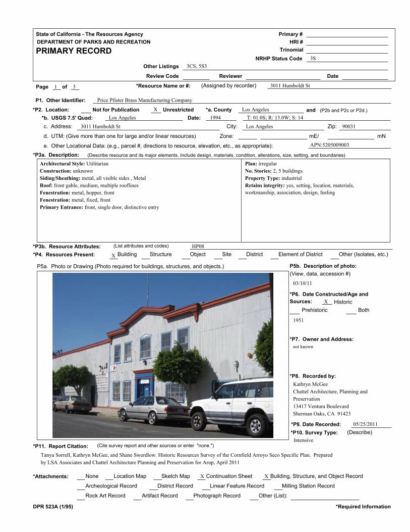
State of California - The Resources Agency
DEPARTMENT OF PARKS AND RECREATION
PRIMARY RECORD
Primary #
HRI #
Trinomial
NRHP Status Code
Other Listings
Review Code Reviewer Date
Page of *Resource Name or #: (Assigned by recorder) 3011 Humboldt St1
3S
3
3CS, 5S3
*P2. Location:
P1. Other Identifier:
Not for Publication Unrestricted *a. County and (P2b and P2c or P2d.)
*b. USGS 7.5' Quad: Date:
c. Address: City: Zip:
d. UTM: (Give more than one for large and/or linear resources) Zone: mE/ mN
e. Other Locational Data: (e.g., parcel #, directions to resource, elevation, etc., as appropriate):
*P3a. Description: (Describe resource and its major elements. Include design, materials, condition, alterations, size, setting, and boundaries)
*P3b. Resource Attributes: (List attributes and codes)
*P4. Resources Present: Building Structure Object Site District Element of District Other (Isolates, etc.)
P5a. Photo or Drawing (Photo required for buildings, structures, and objects.) P5b. Description of photo:
*P6. Date Constructed/Age and
Sources:
(View, data, accession #)
*P7. Owner and Address:
*P8. Recorded by:
*P9. Date Recorded:
*P10. Survey Type: (Describe)
Historic
Prehistoric Both
*P11. Report Citation: (Cite survey report and other sources or enter "none.")
None Location Map Sketch Map Continuation Sheet*Attachments: Building, Structure, and Object Record
Archeological Record District Record Linear Feature Record Milling Station Record
Rock Art Record Artifact Record Photograph Record Other (List):
DPR 523A (1/95) *Required Information
X
Price Pfister Brass Manufacturing Company
Los Angeles
Los Angeles 1994
3011 Humboldt St Los Angeles 90031
APN:5205009003
X
X
not known
Kathryn McGee
Chattel Architecture, Planning and
Preservation
13417 Ventura Boulevard
Sherman Oaks, CA 91423
05/25/2011
1951
HP08
X X
03/10/11
T: 01.0S; R: 13.0W; S: 14
Tanya Sorrell, Kathryn McGee, and Shane Swerdlow. Historic Resources Survey of the Cornfield Arroyo Seco Specific Plan. Prepared
by LSA Associates and Chattel Architecture Planning and Preservation for Arup, April 2011
Intensive
Architectural Style: Utilitarian
Construction: unknown
Siding/Sheathing: metal, all visible sides , Metal
Roof: front gable, medium, multiple rooflines
Fenestration: metal, hopper, front
Fenestration: metal, fixed, front
Primary Entrance: front, single door, distinctive entry
Plan: irregular
No. Stories: 2, 5 buildings
Property Type: industrial
Retains integrity: yes, setting, location, materials,
workmanship, association, design, feeling

State of California - The Resources Agency
DEPARTMENT OF PARKS AND RECREATION
BUILDING, STRUCTURE, AND OBJECT RECORD
Primary #
HRI #
Page of
*Resource Name or #: (Assigned by recorder)
*NRHP Status Code 3S2 3
3011 Humboldt St
B1. Historic Name:
*B5. Architectural Style:
*B7. Moved? No
*Required Information
*B6. Construction History: (Construction date, alterations, and data of alterations)
B2. Common Name:
B3. Original Use: B4. Present Use:
Yes Unknown Date: Original Location:
*B8. Related Features:
B9a. Architect: b. Builder:
*B10. Significance: Area:
Period of Significance: Property Type: Applicable Criteria:
(Discuss importance in terms of historical or architectural context as defined by theme, period, and geographic scope. Also address integrity.)
B11. Additional Resource Attributes: (List attributes and codes)
*B12. References:
B13. Remarks:
*B14. Evaluator:
*Date of Evaluation:
DPR 523B (1/95)
(This space reserved for official comments.)
(Sketch Map with north arrow required.)
unknown unknown
Los Angeles
1951-1965 Industrial
Kathryn McGee
05/25/2011
This property appears eligible for the National and California Registers and for designation as an HCM under Criterion A/1/1 and
B/2/2 for its association with Isadore Familian and Price Pfister Brass Manufacturing Co, an important manufacturer of brass plumbing
fixtures and faucets. Isadore Familian (1911-2002) was an important Los angeles industrialist, philanthropist and Jewish Community
leader. According to his LA Times obiturary, Familian was born in Chicago to Russian immigrant parents and came to Los Angeles in
1913. He became partner in his familiy business in 1941, at which time the business purchased Price Pfister Brass Manufacturing
Company. Under Mr. Familian's leadership, the Price Pfister plant expanded from 50 employees to 1,500 and became one of the largest
manufacturers of brass bath and kitchen hardware in the world. In 1969, Price- Pfister became a subsidiary of Norris Industries and Mr.
Familian continued as chairman of the board. Since the 1947 founding...(continued on next page)
Utilitarian
A/1/1, B/2/2
HP08
Price Pfister Brass Manufacturing Company
Impact International Belle Arte
Industrial Industrial
X
Building the City 1876-1980; Industrialist
Sanborn Maps, Los Angeles Times Database
None
Theme:
Year constructed: 1951

State of California - The Resources Agency
DEPARTMENT OF PARKS AND RECREATION
CONTINUATION SHEET
Primary #
HRI #
Trinomial
Page of Resource Name or #:(Assigned by recorder)
Continuation Update*Recorded By: *Date:
DPR 523L (1/95) *Required Information
B10. Statement of Significance (continued): of the University of Judaism in Hollywood, Mr. Familian served on its board of
directors and various committees. In the 1970s, he spearheaded the fund-raising campaign to build the university's 28-acre
campus, which is named after him and his first wife, Sunny, who died in 1979. Familian also made important contributions to
the City of Hope and served as chairman of the manufacturing committee for the March of Dimes in 1954 ("Familian Heads Polio
Drive Industry Group," LA Times, 17 Dec 1954, 21). Price Pfister moved to an expanded plant in Pacoima in 1965, and remained
there until 1997, when parent company Black and Decker closed the plant and moved operations to Mexico.
The building industry emerged to support the exponential residential and commercial growth in Los Angeles in the late 19th and
early 20th centuries, providing the raw materials, carpentry, and furnishings needed to create the City’s extensive built
environment. Very few, if any properties are extant that represent this critical component of Los Angeles community
development. The CASP Area is unique in the City because it contains a concentration of metal shops from the early 20th
century, including the former Price Pfister Brass Manufacturing Company, the California Steel and Cornice Company, and
smaller steel and metal shops on Avenue 33 and on Naud Street.
05/25/2011 X
33
LSA Associates, Inc.
3011 Humboldt St

State of California - The Resources Agency
DEPARTMENT OF PARKS AND RECREATION
PRIMARY RECORD
Primary #
HRI #
Trinomial
NRHP Status Code
Other Listings
Review Code Reviewer Date
Page of *Resource Name or #: (Assigned by recorder) 2630 Lacy St1
3S
3
3CS, 5S3
*P2. Location:
P1. Other Identifier:
Not for Publication Unrestricted *a. County and (P2b and P2c or P2d.)
*b. USGS 7.5' Quad: Date:
c. Address: City: Zip:
d. UTM: (Give more than one for large and/or linear resources) Zone: mE/ mN
e. Other Locational Data: (e.g., parcel #, directions to resource, elevation, etc., as appropriate):
*P3a. Description: (Describe resource and its major elements. Include design, materials, condition, alterations, size, setting, and boundaries)
*P3b. Resource Attributes: (List attributes and codes)
*P4. Resources Present: Building Structure Object Site District Element of District Other (Isolates, etc.)
P5a. Photo or Drawing (Photo required for buildings, structures, and objects.) P5b. Description of photo:
*P6. Date Constructed/Age and
Sources:
(View, data, accession #)
*P7. Owner and Address:
*P8. Recorded by:
*P9. Date Recorded:
*P10. Survey Type: (Describe)
Historic
Prehistoric Both
*P11. Report Citation: (Cite survey report and other sources or enter "none.")
None Location Map Sketch Map Continuation Sheet*Attachments: Building, Structure, and Object Record
Archeological Record District Record Linear Feature Record Milling Station Record
Rock Art Record Artifact Record Photograph Record Other (List):
DPR 523A (1/95) *Required Information
X
Columbia Mills; Talbert-Whitmore Co., Lacy Street Production Center
Los Angeles
Los Angeles 1994
2630 Lacy St Los Angeles 90031
APN:5205011012
X
X
not known
Kathryn McGee
Chattel Architecture, Planning and
Preservation
13417 Ventura Boulevard
Sherman Oaks, CA 91423
05/25/2011
1908-1948
HP08
X X
03/10/11
T: 01.0S; R: 13.0W; S: 14
Tanya Sorrell, Kathryn McGee, and Shane Swerdlow. Historic Resources Survey of the Cornfield Arroyo Seco Specific Plan. Prepared
by LSA Associates and Chattel Architecture Planning and Preservation for Arup, April 2011
Intensive
Architectural Style: Utilitarian
Construction: wood frame
Siding/Sheathing: brick, all visible sides
Siding/Sheathing: wood: board/batten, all visible sides
Siding/Sheathing: metal, all visible sides
Roof: flat, parapet
Roof: front gable, medium
Fenestration: wood, double-hung, front, side
Fenestration: metal, fixed, front, side
Primary Entrance: side
Other notable features: Multiple industrial buildings of varying styles on site
Plan: rectangular
No. Stories: 2, 4 buildings
Property Type: industrial
Retains integrity: yes, setting, location, materials,
workmanship, association, design, feeling

State of California - The Resources Agency
DEPARTMENT OF PARKS AND RECREATION
BUILDING, STRUCTURE, AND OBJECT RECORD
Primary #
HRI #
Page of
*Resource Name or #: (Assigned by recorder)
*NRHP Status Code 3S2 3
2630 Lacy St
B1. Historic Name:
*B5. Architectural Style:
*B7. Moved? No
*Required Information
*B6. Construction History: (Construction date, alterations, and data of alterations)
B2. Common Name:
B3. Original Use: B4. Present Use:
Yes Unknown Date: Original Location:
*B8. Related Features:
B9a. Architect: b. Builder:
*B10. Significance: Area:
Period of Significance: Property Type: Applicable Criteria:
(Discuss importance in terms of historical or architectural context as defined by theme, period, and geographic scope. Also address integrity.)
B11. Additional Resource Attributes: (List attributes and codes)
*B12. References:
B13. Remarks:
*B14. Evaluator:
*Date of Evaluation:
DPR 523B (1/95)
(This space reserved for official comments.)
(Sketch Map with north arrow required.)
unknown unknown
Los Angeles
1908-1948 Industrial
Kathryn McGee
05/25/2011
This property appears eligible for the National and California Registers and for designation as an HCM under Criterion C/3/3 as an
excellent example of the Daylight Factory within the context of industrial design and engineering. Prior to the widespread use of
electricity, controlling and capitalizing on daylight was a necessary component of the design of manufacturing buildings. Daylight was
brought into the building using a variety of methods, including expansive industrial sash windows, orientation of intensive hand work
next to the exterior walls of the building, skylights, and specialized roof forms to bring light into the interior. This property is an
excellent example of a daylight factory, with multiple daylight features including expansive industrial sash and sawtooth rooflines.
In 1908 Talbert-Whitmroe Co developed a factory at 2360 Lacy St for manufacture of shade cloth and window shades. By 1921, the
factory had become the largest shade cloth producer west of Chicago,...(continued on next page)
Utilitarian
C/3/3
HP08
Columbia Mills; Talbert Whitmore Co. Window Shade Manufacturing
Lacy Street Production Center
Industrial Film production
X
Industrial Engineering/Design 1887-1940
Sanborn Maps, LA Times Database
None
Theme:
Originally Constructed 1908, expanded 1921 and 1948

State of California - The Resources Agency
DEPARTMENT OF PARKS AND RECREATION
CONTINUATION SHEET
Primary #
HRI #
Trinomial
Page of Resource Name or #:(Assigned by recorder)
Continuation Update*Recorded By: *Date:
DPR 523L (1/95) *Required Information
B10. Statement of Significance (continued): manufacturing about 1.25 million yards of cloth annually. By 1950, this company was
renamed Columbia Mills, Inc., but continued to manufacture window shades at the site.
05/25/2011 X
33
LSA Associates, Inc.
2630 Lacy St

State of California - The Resources Agency
DEPARTMENT OF PARKS AND RECREATION
PRIMARY RECORD
Primary #
HRI #
Trinomial
NRHP Status Code
Other Listings
Review Code Reviewer Date
Page of *Resource Name or #: (Assigned by recorder) 3214 Lacy St1
3S
3
3CS, 5S3
*P2. Location:
P1. Other Identifier:
Not for Publication Unrestricted *a. County and (P2b and P2c or P2d.)
*b. USGS 7.5' Quad: Date:
c. Address: City: Zip:
d. UTM: (Give more than one for large and/or linear resources) Zone: mE/ mN
e. Other Locational Data: (e.g., parcel #, directions to resource, elevation, etc., as appropriate):
*P3a. Description: (Describe resource and its major elements. Include design, materials, condition, alterations, size, setting, and boundaries)
*P3b. Resource Attributes: (List attributes and codes)
*P4. Resources Present: Building Structure Object Site District Element of District Other (Isolates, etc.)
P5a. Photo or Drawing (Photo required for buildings, structures, and objects.) P5b. Description of photo:
*P6. Date Constructed/Age and
Sources:
(View, data, accession #)
*P7. Owner and Address:
*P8. Recorded by:
*P9. Date Recorded:
*P10. Survey Type: (Describe)
Historic
Prehistoric Both
*P11. Report Citation: (Cite survey report and other sources or enter "none.")
None Location Map Sketch Map Continuation Sheet*Attachments: Building, Structure, and Object Record
Archeological Record District Record Linear Feature Record Milling Station Record
Rock Art Record Artifact Record Photograph Record Other (List):
DPR 523A (1/95) *Required Information
X
Cannon Electric Development Co.
Los Angeles
Los Angeles 1994
3214 Lacy St Los Angeles 90031
APN:5205011003
X
X
not known
Kathryn McGee
Chattel Architecture, Planning and
Preservation
13417 Ventura Boulevard
Sherman Oaks, CA 91423
03/31/2011
1926
HP08
X X
03/10/11
T: 01.0S; R: 13.0W; S: 14
Tanya Sorrell, Kathryn McGee, and Shane Swerdlow. Historic Resources Survey of the Cornfield Arroyo Seco Specific Plan. Prepared
by LSA Associates and Chattel Architecture Planning and Preservation for Arup, April 2011
Intensive
Architectural Style: Utilitarian Architectural Style: Mediterranean Revival,
elements of
Construction: wood frame
Siding/Sheathing: stucco: textured, all visible sides
Roof: flat, parapet
Fenestration: metal, casement, front, side, rear
Fenestration: metal, fixed, front, side, rear
Primary Entrance: front, single door, distinctive entry, Tile door surround
Plan: irregular
No. Stories: 2
Property Type: industrial
Related: Situated on railway; transformer; telephone poles
Retains integrity: yes, setting, location, materials,
workmanship, association, design, feeling

State of California - The Resources Agency
DEPARTMENT OF PARKS AND RECREATION
BUILDING, STRUCTURE, AND OBJECT RECORD
Primary #
HRI #
Page of
*Resource Name or #: (Assigned by recorder)
*NRHP Status Code 3S2 3
3214 Lacy St
B1. Historic Name:
*B5. Architectural Style:
*B7. Moved? No
*Required Information
*B6. Construction History: (Construction date, alterations, and data of alterations)
B2. Common Name:
B3. Original Use: B4. Present Use:
Yes Unknown Date: Original Location:
*B8. Related Features:
B9a. Architect: b. Builder:
*B10. Significance: Area:
Period of Significance: Property Type: Applicable Criteria:
(Discuss importance in terms of historical or architectural context as defined by theme, period, and geographic scope. Also address integrity.)
B11. Additional Resource Attributes: (List attributes and codes)
*B12. References:
B13. Remarks:
*B14. Evaluator:
*Date of Evaluation:
DPR 523B (1/95)
(This space reserved for official comments.)
(Sketch Map with north arrow required.)
unknown unknown
Los Angeles
1926
Kathryn McGee
03/31/2011
This property appears eligible for the National and California Registers and for designation as an HCM under Criterion A/1/1 because
it is a key factory for the Cannon Electric Company, a significant manufacturer in Los Angeles industrial history. According to a 1941
LA Times article, Cannon was at the time the world's largest exclusive manufacturer of electrical cable connectors (Cannon Plugs) in
1941 and that the company had developed from a 2-man specialty shop into an organization supplying Electrical Signal Systems to such
institutions as the Los Angeles Stock Exchange and Los Angeles County General Hospital, and experimental switchboards to scores of
Southland schools. By 1941, the company was creating the greatest variety of cable connector fittings provided by any manufacturer
("Display Ad 22," LA Times, 2 Jan 1941, A24). Property meets most eligiblity standards for the property sub-type. This property is
signifciant as the last remaining building from a key factory for...(continued on next page)
Utilitarian, Mediterranean Revival
A/1/1
HP08
Cannon Electric Development Co.
Debacle
Factory Industrial
X
Manufacturing for the Masses 1887-1980
Sanborn Maps, Los Angeles Times Database
Situated on railway; transformer; telephone poles
Theme:
Year constructed: 1926

State of California - The Resources Agency
DEPARTMENT OF PARKS AND RECREATION
CONTINUATION SHEET
Primary #
HRI #
Trinomial
Page of Resource Name or #:(Assigned by recorder)
Continuation Update*Recorded By: *Date:
DPR 523L (1/95) *Required Information
B10. Statement of Significance (continued): Cannon Electric Development Co. Cannon became known as early as the 1910s as a
leader in developing electrical connectors, the "Cannon Plug" being the most notable.
03/31/2011 X
33
LSA Associates, Inc.
3214 Lacy St

State of California - The Resources Agency
DEPARTMENT OF PARKS AND RECREATION
PRIMARY RECORD
Primary #
HRI #
Trinomial
NRHP Status Code
Other Listings
Review Code Reviewer Date
Page of *Resource Name or #: (Assigned by recorder) 1250 N Main1
3S
2
3CS, 5S3
*P2. Location:
P1. Other Identifier:
Not for Publication Unrestricted *a. County and (P2b and P2c or P2d.)
*b. USGS 7.5' Quad: Date:
c. Address: City: Zip:
d. UTM: (Give more than one for large and/or linear resources) Zone: mE/ mN
e. Other Locational Data: (e.g., parcel #, directions to resource, elevation, etc., as appropriate):
*P3a. Description: (Describe resource and its major elements. Include design, materials, condition, alterations, size, setting, and boundaries)
*P3b. Resource Attributes: (List attributes and codes)
*P4. Resources Present: Building Structure Object Site District Element of District Other (Isolates, etc.)
P5a. Photo or Drawing (Photo required for buildings, structures, and objects.) P5b. Description of photo:
*P6. Date Constructed/Age and
Sources:
(View, data, accession #)
*P7. Owner and Address:
*P8. Recorded by:
*P9. Date Recorded:
*P10. Survey Type: (Describe)
Historic
Prehistoric Both
*P11. Report Citation: (Cite survey report and other sources or enter "none.")
None Location Map Sketch Map Continuation Sheet*Attachments: Building, Structure, and Object Record
Archeological Record District Record Linear Feature Record Milling Station Record
Rock Art Record Artifact Record Photograph Record Other (List):
DPR 523A (1/95) *Required Information
X
Kelite Factory
Los Angeles
Los Angeles 1994
1250 N Main Los Angeles 90012
APN:5409010032
X X
X
not known
Kathryn McGee
Chattel Architecture, Planning and
Preservation
13417 Ventura Boulevard
Sherman Oaks, CA 91423
05/25/2011
1924
Assessor
HP08
X X
03/09/11
T: 01.0S; R: 13.0W; S: 22
Tanya Sorrell, Kathryn McGee, and Shane Swerdlow. Historic Resources Survey of the Cornfield Arroyo Seco Specific Plan. Prepared
by LSA Associates and Chattel Architecture Planning and Preservation for Arup, April 2011
Intensive
Architectural Style: Art Deco, elements of Architectural Style: Utilitarian
Siding/Sheathing: poured concrete: painted, all visible sides , Brick is used on
all elevations of rear building
Roof: flat, parapet, multiple rooflines
Fenestration: metal, fixed, front, side, rear
Fenestration: metal, vertical sliding, front, side, rear
Primary Entrance: side
Plan: irregular
No. Stories: 3, 3 buildings
Property Type: industrial
Retains integrity: yes, setting, location, workmanship,
association, design, feeling

State of California - The Resources Agency
DEPARTMENT OF PARKS AND RECREATION
BUILDING, STRUCTURE, AND OBJECT RECORD
Primary #
HRI #
Page of
*Resource Name or #: (Assigned by recorder)
*NRHP Status Code 3S2 2
1250 N Main
B1. Historic Name:
*B5. Architectural Style:
*B7. Moved? No
*Required Information
*B6. Construction History: (Construction date, alterations, and data of alterations)
B2. Common Name:
B3. Original Use: B4. Present Use:
Yes Unknown Date: Original Location:
*B8. Related Features:
B9a. Architect: b. Builder:
*B10. Significance: Area:
Period of Significance: Property Type: Applicable Criteria:
(Discuss importance in terms of historical or architectural context as defined by theme, period, and geographic scope. Also address integrity.)
B11. Additional Resource Attributes: (List attributes and codes)
*B12. References:
B13. Remarks:
*B14. Evaluator:
*Date of Evaluation:
DPR 523B (1/95)
(This space reserved for official comments.)
(Sketch Map with north arrow required.)
unknown unknown
Los Angeles
1924-1954 Industrial
Kathryn McGee
05/25/2011
This property appears eligible for the National and California Registers and for designation as an HCM under Criterion C/3/3 as an
excellent example of an industrial loft. Although some glazing and sash is missing, it still retains sufficient integrity to convey its
significance. Shown in Sanborn maps (corrected through 1951) as a site used for Kelite Products, Inc., a manufacturer of specialized
chemical compositions and equipment for industrial cleaning and metal treating, the site contains three buildings: Plant No's 1-3, all of
which are extant. Plant No. 1, located at the corner of E. Elmyra and N. Main Streets, is the primary building, composed in an
industrial/utilitarian style with elements of Art Deco. In 1966, Keylite Products Inc. had plants in L.A., Chicago, and Berkeley Heights,
New Jersey. In the year ended Jan 31, 1966, it had sales of $4.5 million and earnings of $325,000 ("Boards Agree on Acquisition of L.A.
Firm", LA Times, 11 Feb 1966, B16).
Art Deco, Utilitarian
C/3/3
HP08
Kelite Products
Kelite Products
Factory Factory
X
Industrial Engineering/Design 1887-1940
Sanborn Maps, LA Times Database
None
Theme:
Year constructed: 1924, 1946, 1954

State of California - The Resources Agency
DEPARTMENT OF PARKS AND RECREATION
PRIMARY RECORD
Primary #
HRI #
Trinomial
NRHP Status Code
Other Listings
Review Code Reviewer Date
Page of *Resource Name or #: (Assigned by recorder) 1630 N Main1
2S2
2
3CS, 5S3
*P2. Location:
P1. Other Identifier:
Not for Publication Unrestricted *a. County and (P2b and P2c or P2d.)
*b. USGS 7.5' Quad: Date:
c. Address: City: Zip:
d. UTM: (Give more than one for large and/or linear resources) Zone: mE/ mN
e. Other Locational Data: (e.g., parcel #, directions to resource, elevation, etc., as appropriate):
*P3a. Description: (Describe resource and its major elements. Include design, materials, condition, alterations, size, setting, and boundaries)
*P3b. Resource Attributes: (List attributes and codes)
*P4. Resources Present: Building Structure Object Site District Element of District Other (Isolates, etc.)
P5a. Photo or Drawing (Photo required for buildings, structures, and objects.) P5b. Description of photo:
*P6. Date Constructed/Age and
Sources:
(View, data, accession #)
*P7. Owner and Address:
*P8. Recorded by:
*P9. Date Recorded:
*P10. Survey Type: (Describe)
Historic
Prehistoric Both
*P11. Report Citation: (Cite survey report and other sources or enter "none.")
None Location Map Sketch Map Continuation Sheet*Attachments: Building, Structure, and Object Record
Archeological Record District Record Linear Feature Record Milling Station Record
Rock Art Record Artifact Record Photograph Record Other (List):
DPR 523A (1/95) *Required Information
X
DWP Main Street Facility
Los Angeles
Los Angeles 1994
1630 N Main Los Angeles 90012
APN:5409013913
X X X
X
not known
Kathryn McGee
Chattel Architecture, Planning and
Preservation
13417 Ventura Boulevard
Sherman Oaks, CA 91423
05/25/2011
1946
Assessor
HP09
X
03/09/11
T: 01.0S; R: 13.0W; S: 22
Tanya Sorrell, Kathryn McGee, and Shane Swerdlow. Historic Resources Survey of the Cornfield Arroyo Seco Specific Plan. Prepared
by LSA Associates and Chattel Architecture Planning and Preservation for Arup, April 2011
Intensive
Architectural Style: International Architectural Style: Beaux Arts
Architectural Style: Art Deco
Construction: poured concrete
Siding/Sheathing: poured concrete: painted, all visible sides , Sheetmetal siding
wraps machine shop building abutting North Main Street.
Roof: flat, parapet, multiple rooflines
Fenestration: metal, fixed, front, side, rear
Fenestration: metal, horizontal sliding, front, side, rear
Fenestration: metal, hopper, front, side, rear
Primary Entrance: side, Roll-up door
Other notable features: Sunshade eyebrows extend from some southeast
Plan: irregular
No. Stories: 3, 11 buildings
Property Type: Utilities
Retains integrity: yes, setting, location, materials,
workmanship, association, design, feeling

State of California - The Resources Agency
DEPARTMENT OF PARKS AND RECREATION
CONTINUATION SHEET
Primary #
HRI #
Trinomial
Page of *Resource Name or #: (Assigned by recorder) 1630 N Main2 2
DPR 523L (1/95) *Required Information
*Recorded By: *Date: Continuation UpdateXKathryn McGee 05/25/2011
The Department of Water and Power Main Street Facility is significant as an early power station for the Department of Water and
Power that played an important role in support of development of the City of Los Angeles. It is located on a triangular-shaped site
containing multiple buildings and bounded by Main and Leroy Streets to the north and west and the Union Pacific Rail Road to the
east and south. The early DWP site shown in Sanborn maps (corrected through 1951) include such buildings as Transformer House
No 1 (1923 and 1918); Electrical Manintenance building (no date); General Warehouse (1923 and 1940); General Repair Shop (1925);
Test Laboratory (1916); Outdoor Transformers (no date) and other ancillary buildings. Unable to confirm from public right-of-way
whether all buildings listed are extant and if they all retain integrity. Site currently contains large collection of outdoor transformers
at corner of Main St and the UPRR.
Update Status: Retains Integrity

State of California - The Resources Agency
DEPARTMENT OF PARKS AND RECREATION
PRIMARY RECORD
Primary #
HRI #
Trinomial
NRHP Status Code
Other Listings
Review Code Reviewer Date
Page of *Resource Name or #: (Assigned by recorder) 1801 N. Main St1
3S
3
3CS, 5S3
*P2. Location:
P1. Other Identifier:
Not for Publication Unrestricted *a. County and (P2b and P2c or P2d.)
*b. USGS 7.5' Quad: Date:
c. Address: City: Zip:
d. UTM: (Give more than one for large and/or linear resources) Zone: mE/ mN
e. Other Locational Data: (e.g., parcel #, directions to resource, elevation, etc., as appropriate):
*P3a. Description: (Describe resource and its major elements. Include design, materials, condition, alterations, size, setting, and boundaries)
*P3b. Resource Attributes: (List attributes and codes)
*P4. Resources Present: Building Structure Object Site District Element of District Other (Isolates, etc.)
P5a. Photo or Drawing (Photo required for buildings, structures, and objects.) P5b. Description of photo:
*P6. Date Constructed/Age and
Sources:
(View, data, accession #)
*P7. Owner and Address:
*P8. Recorded by:
*P9. Date Recorded:
*P10. Survey Type: (Describe)
Historic
Prehistoric Both
*P11. Report Citation: (Cite survey report and other sources or enter "none.")
None Location Map Sketch Map Continuation Sheet*Attachments: Building, Structure, and Object Record
Archeological Record District Record Linear Feature Record Milling Station Record
Rock Art Record Artifact Record Photograph Record Other (List):
DPR 523A (1/95) *Required Information
X
Lanza Brothers Market
Los Angeles
Los Angeles 1994
1801 N. Main St Los Angeles 90065
APN:541O019005
X
X
not known
Kathryn McGee
Chattel Architecture, Planning and
Preservation
13417 Ventura Boulevard
Sherman Oaks, CA 91423
05/25/2011
1926
HP06, HP02
X X
03/09/11
T: 01.0S; R: 13.0W; S: 15
Tanya Sorrell, Kathryn McGee, and Shane Swerdlow. Historic Resources Survey of the Cornfield Arroyo Seco Specific Plan. Prepared
by LSA Associates and Chattel Architecture Planning and Preservation for Arup, April 2011
Intensive
Architectural Style: Utilitarian
Siding/Sheathing: brick, all visible sides , painted
Roof: flat
Fenestration: aluminum, fixed, storefront, alteration: yes
Primary Entrance: storefront, single door, three storefronts total
Other notable features: metal awning printed with "famous italian sandwiches
since 1926", mural of sandwiches on right side
Plan: rectangular
No. Stories: 1, 2 buildings
Property Type: Market
Related: Modest turn of the century residence behind
market, "Lanza Bros Market" wall sign
Retains integrity: yes

State of California - The Resources Agency
DEPARTMENT OF PARKS AND RECREATION
BUILDING, STRUCTURE, AND OBJECT RECORD
Primary #
HRI #
Page of
*Resource Name or #: (Assigned by recorder)
*NRHP Status Code 3S2 3
1801 N. Main St
B1. Historic Name:
*B5. Architectural Style:
*B7. Moved? No
*Required Information
*B6. Construction History: (Construction date, alterations, and data of alterations)
B2. Common Name:
B3. Original Use: B4. Present Use:
Yes Unknown Date: Original Location:
*B8. Related Features:
B9a. Architect: b. Builder:
*B10. Significance: Area:
Period of Significance: Property Type: Applicable Criteria:
(Discuss importance in terms of historical or architectural context as defined by theme, period, and geographic scope. Also address integrity.)
B11. Additional Resource Attributes: (List attributes and codes)
*B12. References:
B13. Remarks:
*B14. Evaluator:
*Date of Evaluation:
DPR 523B (1/95)
(This space reserved for official comments.)
(Sketch Map with north arrow required.)
unknown unknown
Los Angeles
1926 Commercial
Kathryn McGee
05/25/2011
The Lanza Brothers Market appears eligible for the National and California Registers and for HCM designation under Criterion A/1/1
because it is a rare intact commercial building associated with the Italian immigrant community, which has its roots in the earliest days
of the Pueblo and continues to be active today. The building and associated residence was operated by the Lanza and Bruno families
from the early 1920s through the early 2000s. In addition, the property appears to be eligible for designation as an HCM under
Criterion 5 because it reflects the diversity of Los Angeles history as a physical representative of the City's Italian heritage.
Los Angeles City Directories starting as early as 1923 locate the Lanza Family at 1801 N Main St, listing Frank, a sheet metal worker,
John (no occupation given), Joseph, a sheet metal worker, and Tony A., a sheet metal worker, as residing at 1801 N. Main. According to
the 1930 United States Census, John Lanza was born in Italy to...(continued on next page)
Utilitarian
A/1/1, HCM 5
HP06, HP02
Lanza Bros Market
Market Market
X
; Early Neighborhood Commercial Development 1880-1930
Sanborn Maps, Directories, LA Times Database, Census records
Modest turn of the century residence behind market, "Lanza Bros Market" wall sign
Theme:
Year constructed: 1926

State of California - The Resources Agency
DEPARTMENT OF PARKS AND RECREATION
CONTINUATION SHEET
Primary #
HRI #
Trinomial
Page of Resource Name or #:(Assigned by recorder)
Continuation Update*Recorded By: *Date:
DPR 523L (1/95) *Required Information
B10. Statement of Significance (continued): Italian parents c. 1866 and immigrated to the United States in 1898. He was recorded
in the 1930 U.S. Census as residing at 1801 N Main at the age of 64 where he lived with his wife, Phyllis (age 54; born in Italy),
daughter, Margaret Bruno (age 21; born in Texas), son-in-law Nick Bruno (age 25; born in Italy), and grandchildren Sam, John,
Rosala and Rosie. The 1930 U.S. Census also includes other Lanza family members residing on the property. Head of
household, Frank Lanza (age 29; born in Italy) and his wife Jenny (age 21; born in Italy) resided at 1801 ½ N. Main with their
children Johnny and Phyllis. Frank Lanza was a carpenter in a railroad shop at the time. At 1805 N. Main, head of household
Phillip Lanza (age 28; born in Italy) resided with his wife Elizabeth (age 20; born in Colorado). Phillip Lanza was a builder of
railroad cars at the time. At 1807 N. Main, head of household Anthony Lanza (age 26; born in Alabama) resided with his wife
Cornelia (age 25; born in Italy) and their son, John. Anthony Lanza was a grocery merchant at the time. Census records indicate
that while John and Phyllis Lanza lived in Los Angeles in the 1930s, they lived in southern states, likely including Texas and
Alabama, and possibly also Louisiana, after immigrating to the U.S. and prior to moving to Los Angeles.
The 1927 Los Angeles City Directories also associate the property with Mary Millone, a grocer at 1803 N Main, and John Millone,
who worked as a truck builder; the couple resided at 1706 Pomeroy Ave at the time. In addition, Bruno Pete meats is listed as
tenant of 1803 N Main. The connection between the Lanza and Bruno names likely starts with Margaret Lanza’s marriage to Nick
Bruno (Margaret was the Texas-born daughter of John and Phyllis Lanza). The Millone connection is, however, unclear. It is
possible Mary Millone was simply a worker at that location, or was related to the Lanza or Bruno Families in a manner that has
not been identified; it is also possible the Millone family had a small shop in the building, since the building contains three
storefront entrances (and could have contained three businesses). Anthony Lanza and wife Cornelia are listed as grocers at 1803
N Main and residing at 1801 ½ N Main in the 1942 LA City Directory. The Lanza Bros Grocery is located at 1803 N Main in the
1956 LA City Directory; Anthony Lanza still occupies 1801 ½ N Main; and 1807 N. Main is identified as Jerry G Barroy dry goods
in the same year.
A 2000 Los Angeles Times article written by the son-in-law of Lanza Family member Gloria Worsham, who owned the property
with her brothers Anthony and Louis Lanza for many years, notes that the site housed generations of Lanzas since the 1920s in
the seven houses directly behind the store (not all of which are necessarily on the APN listed above; it is unclear exactly which
houses are associated with the Lanza family). The author also notes, “My wife’s family still owns most of the city block where
the store sits, and her mother was brought up in the family compound that consists of the seven houses directly behind the store.
But the family moved away long ago, Gloria and Anthony heading to the suburbs of San Gabriel a few miles away, Louis a little
closer in Silver Lake. The Lanza Brothers market remained behind, however, and has served the neighborhood for 80 years.”
The author further notes, “When the [store opened] in the 1920s, [it was] a working-class neighborhood. In a time before
supermarkets, it was the place where the Italian immigrants would buy fresh groceries on their way home from the nearby rail
yards and factories. People would come to talk, buy stamps and money orders, and have a feeling of home and community in a
strange new land.” The article concludes that due to frequent break-ins and robberies in recent years, the Lanza family has
vacated some or all of the site (Rick Garcia, ‘Sunset in Lincoln Heights,’ Los Angeles Times, 8 Oct. 2000). Current on-line reviews
of the market indicate that it is being run by Korean immigrants.
05/25/2011 X
33
LSA Associates, Inc.
1801 N. Main St

State of California - The Resources Agency
DEPARTMENT OF PARKS AND RECREATION
PRIMARY RECORD
Primary #
HRI #
Trinomial
NRHP Status Code
Other Listings
Review Code Reviewer Date
Page of *Resource Name or #: (Assigned by recorder) 1811 N Main St1
3S
3
3CS, 5S3
*P2. Location:
P1. Other Identifier:
Not for Publication Unrestricted *a. County and (P2b and P2c or P2d.)
*b. USGS 7.5' Quad: Date:
c. Address: City: Zip:
d. UTM: (Give more than one for large and/or linear resources) Zone: mE/ mN
e. Other Locational Data: (e.g., parcel #, directions to resource, elevation, etc., as appropriate):
*P3a. Description: (Describe resource and its major elements. Include design, materials, condition, alterations, size, setting, and boundaries)
*P3b. Resource Attributes: (List attributes and codes)
*P4. Resources Present: Building Structure Object Site District Element of District Other (Isolates, etc.)
P5a. Photo or Drawing (Photo required for buildings, structures, and objects.) P5b. Description of photo:
*P6. Date Constructed/Age and
Sources:
(View, data, accession #)
*P7. Owner and Address:
*P8. Recorded by:
*P9. Date Recorded:
*P10. Survey Type: (Describe)
Historic
Prehistoric Both
*P11. Report Citation: (Cite survey report and other sources or enter "none.")
None Location Map Sketch Map Continuation Sheet*Attachments: Building, Structure, and Object Record
Archeological Record District Record Linear Feature Record Milling Station Record
Rock Art Record Artifact Record Photograph Record Other (List):
DPR 523A (1/95) *Required Information
X Los Angeles
Los Angeles 1994
1811 N Main St Los Angeles 90031
APN:5410019005
X
X
not known
Kathryn McGee
Chattel Architecture, Planning and
Preservation
13417 Ventura Boulevard
Sherman Oaks, CA 91423
05/25/2011
ca 1900
HP02
X
03/09/11
T: 01.0S; R: 13.0W; S: 23
Tanya Sorrell, Kathryn McGee, and Shane Swerdlow. Historic Resources Survey of the Cornfield Arroyo Seco Specific Plan. Prepared
by LSA Associates and Chattel Architecture Planning and Preservation for Arup, April 2011
Intensive
Architectural Style: Folk Victorian
Construction: wood frame
Siding/Sheathing: wood: clapboard, all visible sides
Roof: hipped, medium, narrow eaves
Fenestration: wood, double-hung, front
Primary Entrance: front, single door
Other notable features: decorative brackets and spandrels
Plan: rectangular
No. Stories: 1
Porches: Full-Width, front
Retains integrity: yes, setting, location, materials,
workmanship, association, design, feeling

State of California - The Resources Agency
DEPARTMENT OF PARKS AND RECREATION
BUILDING, STRUCTURE, AND OBJECT RECORD
Primary #
HRI #
Page of
*Resource Name or #: (Assigned by recorder)
*NRHP Status Code 3S2 3
1811 N Main St
B1. Historic Name:
*B5. Architectural Style:
*B7. Moved? No
*Required Information
*B6. Construction History: (Construction date, alterations, and data of alterations)
B2. Common Name:
B3. Original Use: B4. Present Use:
Yes Unknown Date: Original Location:
*B8. Related Features:
B9a. Architect: b. Builder:
*B10. Significance: Area:
Period of Significance: Property Type: Applicable Criteria:
(Discuss importance in terms of historical or architectural context as defined by theme, period, and geographic scope. Also address integrity.)
B11. Additional Resource Attributes: (List attributes and codes)
*B12. References:
B13. Remarks:
*B14. Evaluator:
*Date of Evaluation:
DPR 523B (1/95)
(This space reserved for official comments.)
(Sketch Map with north arrow required.)
unknown unknown
Los Angeles
ca 1900 Single Family Residence
Kathryn McGee
05/25/2011
This property appears eligible for the National and California Registers and for designation as an HCM under Criterion C/3/3 as an
excellent example of Folk Victorian architecture. Folk Victorian styled residences were popular in the late 19th and early 20th centuries
as an affordable way to decorate otherwise modest homes with the elaborate decorative styles of the Victorian Era. Generally chosen
from pattern books and mass-produced, the ornamentation on Folk Victorian homes demonstrate how industrialization of the building
industry boadened and popularized what would otherwise have been prohibitively expensive design for most people. Hundreds of
these residences were built during the residential booms in the 1880s and 1900s, but intact examples have since become increasingly
rare. This residence has several character-defining features of the style as applied to a hipped-roof cottage, including a full-width front
porch with decorative spindles and spandrels, and boxed eaves. It...(continued on next page)
Folk Victorian
C/3/3
HP02
Residence Residence
X
Folk Victorian Architecture 1885-1905
Sanborn Maps
None
Theme:
Year constructed: ca 1900

State of California - The Resources Agency
DEPARTMENT OF PARKS AND RECREATION
CONTINUATION SHEET
Primary #
HRI #
Trinomial
Page of Resource Name or #:(Assigned by recorder)
Continuation Update*Recorded By: *Date:
DPR 523L (1/95) *Required Information
B10. Statement of Significance (continued): appears that the balustrade has been rebuilt with narrower gaps between rails, but the
building retains integrity in spite of this apparent alteration.
05/25/2011 X
33
LSA Associates, Inc.
1811 N Main St

State of California - The Resources Agency
DEPARTMENT OF PARKS AND RECREATION
PRIMARY RECORD
Primary #
HRI #
Trinomial
NRHP Status Code
Other Listings
Review Code Reviewer Date
Page of *Resource Name or #: (Assigned by recorder) 1611 Naud St1
3S
3
3CS, 5S3
*P2. Location:
P1. Other Identifier:
Not for Publication Unrestricted *a. County and (P2b and P2c or P2d.)
*b. USGS 7.5' Quad: Date:
c. Address: City: Zip:
d. UTM: (Give more than one for large and/or linear resources) Zone: mE/ mN
e. Other Locational Data: (e.g., parcel #, directions to resource, elevation, etc., as appropriate):
*P3a. Description: (Describe resource and its major elements. Include design, materials, condition, alterations, size, setting, and boundaries)
*P3b. Resource Attributes: (List attributes and codes)
*P4. Resources Present: Building Structure Object Site District Element of District Other (Isolates, etc.)
P5a. Photo or Drawing (Photo required for buildings, structures, and objects.) P5b. Description of photo:
*P6. Date Constructed/Age and
Sources:
(View, data, accession #)
*P7. Owner and Address:
*P8. Recorded by:
*P9. Date Recorded:
*P10. Survey Type: (Describe)
Historic
Prehistoric Both
*P11. Report Citation: (Cite survey report and other sources or enter "none.")
None Location Map Sketch Map Continuation Sheet*Attachments: Building, Structure, and Object Record
Archeological Record District Record Linear Feature Record Milling Station Record
Rock Art Record Artifact Record Photograph Record Other (List):
DPR 523A (1/95) *Required Information
X
California Steel and Cornice Co., Stadco Fab Shop; Veolia Transportation
Los Angeles
Los Angeles 1994
1611 Naud St Los Angeles 90012
APN:5409002016
X
X
not known
Kathryn McGee
Chattel Architecture, Planning and
Preservation
13417 Ventura Boulevard
Sherman Oaks, CA 91423
05/25/2011
1945
HP08
X X
03/09/11
T: 01.0S; R: 13.0W; S: 22
Tanya Sorrell, Kathryn McGee, and Shane Swerdlow. Historic Resources Survey of the Cornfield Arroyo Seco Specific Plan. Prepared
by LSA Associates and Chattel Architecture Planning and Preservation for Arup, April 2011
Intensive
Architectural Style: Utilitarian, utilitarian
Construction: wood frame
Siding/Sheathing: metal, all visible sides , Metal
Roof: side gable, medium, other, Sawtooth
Fenestration: metal, fixed, front
Primary Entrance: front, Truck door
Plan: rectangular
No. Stories: 2
Property Type: industrial
Related: Associated with large covered maintenance yard
Retains integrity: yes, setting, location, materials,
workmanship, association, design, feeling

State of California - The Resources Agency
DEPARTMENT OF PARKS AND RECREATION
BUILDING, STRUCTURE, AND OBJECT RECORD
Primary #
HRI #
Page of
*Resource Name or #: (Assigned by recorder)
*NRHP Status Code 3S2 3
1611 Naud St
B1. Historic Name:
*B5. Architectural Style:
*B7. Moved? No
*Required Information
*B6. Construction History: (Construction date, alterations, and data of alterations)
B2. Common Name:
B3. Original Use: B4. Present Use:
Yes Unknown Date: Original Location:
*B8. Related Features:
B9a. Architect: b. Builder:
*B10. Significance: Area:
Period of Significance: Property Type: Applicable Criteria:
(Discuss importance in terms of historical or architectural context as defined by theme, period, and geographic scope. Also address integrity.)
B11. Additional Resource Attributes: (List attributes and codes)
*B12. References:
B13. Remarks:
*B14. Evaluator:
*Date of Evaluation:
DPR 523B (1/95)
(This space reserved for official comments.)
(Sketch Map with north arrow required.)
unknown unknown
Los Angeles
1945 Industrial
Kathryn McGee
05/25/2011
This property appears eligible for the National and California Registers and for designation as an HCM under Criterion A/1/1 as a key
factory of the California Steel and Cornice Co., an important steel fabricator that made steel for the Case Study House program and
Standard Oil Company. A 1939 Los Angeles Times ad also credits the company for providing steel for the I.Magnin & Co. store
constructed at the intersection of Wilshire Boulevard and New Hampshire Avenue.
The building industry emerged to support the exponential residential and commercial growth in Los Angeles in the late 19th and early
20th centuries, providing the raw materials, carpentry, and furnishings needed to create the City’s extensive built environment. Very
few, if any properties are extant that represent this critical component of Los Angeles community development. The CASP Area is
unique in the City because it contains a concentration of metal shops from the early 20th century, including the former Price...(continued
on next page)
Utilitarian
A/1/1
HP08
California Steel and Cornice Co.
Stadco; Veolia
Industrial Industrial
X
Building the City 1876-1980
Sanborn Maps, City Directories, LA Times Database
Associated with large covered maintenance yard
Theme:
Year constructed: 1945

State of California - The Resources Agency
DEPARTMENT OF PARKS AND RECREATION
CONTINUATION SHEET
Primary #
HRI #
Trinomial
Page of Resource Name or #:(Assigned by recorder)
Continuation Update*Recorded By: *Date:
DPR 523L (1/95) *Required Information
B10. Statement of Significance (continued): Pfister Brass Manufacturing Company and smaller steel and metal shops on Avenue
33 and on Naud Street.
05/25/2011 X
33
LSA Associates, Inc.
1611 Naud St

State of California - The Resources Agency
DEPARTMENT OF PARKS AND RECREATION
PRIMARY RECORD
Primary #
HRI #
Trinomial
NRHP Status Code
Other Listings
Review Code Reviewer Date
Page of *Resource Name or #: (Assigned by recorder) 1640 N Spring St1
3S
2
3CS, 5S3
*P2. Location:
P1. Other Identifier:
Not for Publication Unrestricted *a. County and (P2b and P2c or P2d.)
*b. USGS 7.5' Quad: Date:
c. Address: City: Zip:
d. UTM: (Give more than one for large and/or linear resources) Zone: mE/ mN
e. Other Locational Data: (e.g., parcel #, directions to resource, elevation, etc., as appropriate):
*P3a. Description: (Describe resource and its major elements. Include design, materials, condition, alterations, size, setting, and boundaries)
*P3b. Resource Attributes: (List attributes and codes)
*P4. Resources Present: Building Structure Object Site District Element of District Other (Isolates, etc.)
P5a. Photo or Drawing (Photo required for buildings, structures, and objects.) P5b. Description of photo:
*P6. Date Constructed/Age and
Sources:
(View, data, accession #)
*P7. Owner and Address:
*P8. Recorded by:
*P9. Date Recorded:
*P10. Survey Type: (Describe)
Historic
Prehistoric Both
*P11. Report Citation: (Cite survey report and other sources or enter "none.")
None Location Map Sketch Map Continuation Sheet*Attachments: Building, Structure, and Object Record
Archeological Record District Record Linear Feature Record Milling Station Record
Rock Art Record Artifact Record Photograph Record Other (List):
DPR 523A (1/95) *Required Information
X
Paper Products Manufacturing Co., KGB Studios
Los Angeles
Los Angeles 1994
1640 N Spring St Los Angeles 90012
APN:5409002014
X
X
not known
Kathryn McGee
Chattel Architecture, Planning and
Preservation
13417 Ventura Boulevard
Sherman Oaks, CA 91423
05/25/2011
1925
Assessor
HP08
X X
03/09/11
T: 01.0S; R: 13.0W; S: 22
Tanya Sorrell, Kathryn McGee, and Shane Swerdlow. Historic Resources Survey of the Cornfield Arroyo Seco Specific Plan. Prepared
by LSA Associates and Chattel Architecture Planning and Preservation for Arup, April 2011
Intensive
Architectural Style: Utilitarian Architectural Style: Italianate, elements of
Construction: wood frame
Siding/Sheathing: brick, all visible sides
Roof: side gable, medium, other, Sawtooth roof
Fenestration: wood, fixed, front
Primary Entrance: front, single door, transom lights, side lights
Plan: irregular
No. Stories: 1
Property Type: industrial
Retains integrity: yes, setting, location, materials,
workmanship, association, design, feeling

State of California - The Resources Agency
DEPARTMENT OF PARKS AND RECREATION
BUILDING, STRUCTURE, AND OBJECT RECORD
Primary #
HRI #
Page of
*Resource Name or #: (Assigned by recorder)
*NRHP Status Code 3S2 2
1640 N Spring St
B1. Historic Name:
*B5. Architectural Style:
*B7. Moved? No
*Required Information
*B6. Construction History: (Construction date, alterations, and data of alterations)
B2. Common Name:
B3. Original Use: B4. Present Use:
Yes Unknown Date: Original Location:
*B8. Related Features:
B9a. Architect: b. Builder:
*B10. Significance: Area:
Period of Significance: Property Type: Applicable Criteria:
(Discuss importance in terms of historical or architectural context as defined by theme, period, and geographic scope. Also address integrity.)
B11. Additional Resource Attributes: (List attributes and codes)
*B12. References:
B13. Remarks:
*B14. Evaluator:
*Date of Evaluation:
DPR 523B (1/95)
(This space reserved for official comments.)
(Sketch Map with north arrow required.)
unknown unknown
Los Angeles
1925 Industrial
Kathryn McGee
05/25/2011
This property appears eligible for the National and California Registers and for designation as an HCM under Criterion C/3/3 as an
excellent example of a daylight factory because it combines the important elements of a daylight factory with an architecturally distinct
façade. Prior to the widespread use of electricity, controlling and capitalizing on daylight was a necessary component of the design of
manufacturing buildings. Daylight was brought into the building using a variety of methods, including expansive industrial sash
windows, orientation of intensive hand work next to the exterior walls of the building, skylights, and specialized roof forms to bring
light into the interior.
Utilitarian, Italianate
C/3/3
HP08
Paper Products Manufacturing Co.
KGB Studios
Paper products manufacturing light industrial
X
Industrial Engineering/Design 1887-1940
Sanborn Maps
None
Theme:
Year constructed: 1925

State of California - The Resources Agency
DEPARTMENT OF PARKS AND RECREATION
PRIMARY RECORD
Primary #
HRI #
Trinomial
NRHP Status Code
Other Listings
Review Code Reviewer Date
Page of *Resource Name or #: (Assigned by recorder) 1727 N Spring St1
3S
3
3CS, 5S3
*P2. Location:
P1. Other Identifier:
Not for Publication Unrestricted *a. County and (P2b and P2c or P2d.)
*b. USGS 7.5' Quad: Date:
c. Address: City: Zip:
d. UTM: (Give more than one for large and/or linear resources) Zone: mE/ mN
e. Other Locational Data: (e.g., parcel #, directions to resource, elevation, etc., as appropriate):
*P3a. Description: (Describe resource and its major elements. Include design, materials, condition, alterations, size, setting, and boundaries)
*P3b. Resource Attributes: (List attributes and codes)
*P4. Resources Present: Building Structure Object Site District Element of District Other (Isolates, etc.)
P5a. Photo or Drawing (Photo required for buildings, structures, and objects.) P5b. Description of photo:
*P6. Date Constructed/Age and
Sources:
(View, data, accession #)
*P7. Owner and Address:
*P8. Recorded by:
*P9. Date Recorded:
*P10. Survey Type: (Describe)
Historic
Prehistoric Both
*P11. Report Citation: (Cite survey report and other sources or enter "none.")
None Location Map Sketch Map Continuation Sheet*Attachments: Building, Structure, and Object Record
Archeological Record District Record Linear Feature Record Milling Station Record
Rock Art Record Artifact Record Photograph Record Other (List):
DPR 523A (1/95) *Required Information
X
Standard Oil Company Sales Department, The Woman's Building
Los Angeles
Los Angeles 1994
1727 N Spring St Los Angeles 90012
APN:5409002011
X
X
not known
Kathryn McGee
Chattel Architecture, Planning and
Preservation
13417 Ventura Boulevard
Sherman Oaks, CA 91423
03/31/2011
1914
HP06, HP08
X X
03/09/11
T: 01.0S; R: 13.0W; S: 22
Tanya Sorrell, Kathryn McGee, and Shane Swerdlow. Historic Resources Survey of the Cornfield Arroyo Seco Specific Plan. Prepared
by LSA Associates and Chattel Architecture Planning and Preservation for Arup, April 2011
Intensive
Architectural Style: Italianate, elements of
Construction: unknown
Siding/Sheathing: brick, all visible sides
Siding/Sheathing: metal, all visible sides
Roof: flat, parapet
Fenestration: metal, fixed, front, side
Fenestration: metal, casement, front, side
Primary Entrance: front, single door, recessed, distinctive entry
Other notable features: Ornament surrounding entrance and windows above
Plan: irregular
No. Stories: 3
Property Type: commercial
Retains integrity: yes, setting, location, materials,
workmanship, association, design, feeling

State of California - The Resources Agency
DEPARTMENT OF PARKS AND RECREATION
BUILDING, STRUCTURE, AND OBJECT RECORD
Primary #
HRI #
Page of
*Resource Name or #: (Assigned by recorder)
*NRHP Status Code 3S2 3
1727 N Spring St
B1. Historic Name:
*B5. Architectural Style:
*B7. Moved? No
*Required Information
*B6. Construction History: (Construction date, alterations, and data of alterations)
B2. Common Name:
B3. Original Use: B4. Present Use:
Yes Unknown Date: Original Location:
*B8. Related Features:
B9a. Architect: b. Builder:
*B10. Significance: Area:
Period of Significance: Property Type: Applicable Criteria:
(Discuss importance in terms of historical or architectural context as defined by theme, period, and geographic scope. Also address integrity.)
B11. Additional Resource Attributes: (List attributes and codes)
*B12. References:
B13. Remarks:
*B14. Evaluator:
*Date of Evaluation:
DPR 523B (1/95)
(This space reserved for official comments.)
(Sketch Map with north arrow required.)
unknown unknown
Los Angeles
1892-1965 Industrial
Kathryn McGee
03/31/2011
The building located at 1727 N. Spring St appears eligible for the National and California Registers and for designation as an HCM
under Criterion A/1/1 for its association with Standard Oil Company of California, as well as for its association with the Womens
Rights Movement. Originally designed in 1914 as a sales department office and industrial facility for Standard Oil Company of
California, the building retains integrity from its date of construction. Standard Oil Company was founded by John D. Rockafeller and
was broken up in the U.S. Supreme Court antitrust decision in 1911. Standard Oil Company of California was a successor company
resulting from that break up. It played an important role in Citywide development and later became Chevron Corporation.
In 1975 the building reopened by the Feminist Studio Workshop (FSW) organization as "The Woman's Building & Women's Graphic
Center," home of the FSW, Sisterhood Bookstore, Olivia Records, Women's Graphic Center, Women's...(continued on next page)
Italianate
A/1/1
HP06, HP08
Standard Oil Company (the Sales Department); The Woman's Building
Industrial/Office Artist space/Industrial
X
Oil/Petroleum Products 1892-1965
None
Theme:
Year constructed: 1914

State of California - The Resources Agency
DEPARTMENT OF PARKS AND RECREATION
CONTINUATION SHEET
Primary #
HRI #
Trinomial
Page of Resource Name or #:(Assigned by recorder)
Continuation Update*Recorded By: *Date:
DPR 523L (1/95) *Required Information
B10. Statement of Significance (continued): Switchboard, Canis Gallery, a cafe, open gallery and performance spaces and feminist
therapists ("About Women," LA Times, 7 Dec 1975, E4). A center supporting the creative achievements of women, its archives are
currently held at the Smithsonian and Getty, among other locations. The Woman's Building & Women's Graphic Center was at
this location until 1991. It was assessed for significance for its association with Judy Chicago, founder of the Feminist Art
Program at Fresno State College and co-founder of Feminist Art Program at CalArts, and, finally, cofounder of the FSW, the
group that started the first Woman's Building at Choiinard Art Institute (743 S Grandview) in 1973. Chicago left Feminist Studio
Workshop Staff in 1974, prior to FSW's move to the 1727 N Spring St location. Since she left the orgnization prior to its
occupation of 1727 N Spring, the building isn't significant for its association with her. Note that while references to the building
alternate between calling it "Woman's Building" and "Women's Building," a 1980s photo of the building shows that its facade
signage read: "The Woman's Building & Women's Graphic Center."
03/31/2011 X
33
LSA Associates, Inc.
1727 N Spring St

State of California - The Resources Agency
DEPARTMENT OF PARKS AND RECREATION
PRIMARY RECORD
Primary #
HRI #
Trinomial
NRHP Status Code
Other Listings
Review Code Reviewer Date
Page of *Resource Name or #: (Assigned by recorder) 1756 N Spring St1
3S
2
3CS, 5S3
*P2. Location:
P1. Other Identifier:
Not for Publication Unrestricted *a. County and (P2b and P2c or P2d.)
*b. USGS 7.5' Quad: Date:
c. Address: City: Zip:
d. UTM: (Give more than one for large and/or linear resources) Zone: mE/ mN
e. Other Locational Data: (e.g., parcel #, directions to resource, elevation, etc., as appropriate):
*P3a. Description: (Describe resource and its major elements. Include design, materials, condition, alterations, size, setting, and boundaries)
*P3b. Resource Attributes: (List attributes and codes)
*P4. Resources Present: Building Structure Object Site District Element of District Other (Isolates, etc.)
P5a. Photo or Drawing (Photo required for buildings, structures, and objects.) P5b. Description of photo:
*P6. Date Constructed/Age and
Sources:
(View, data, accession #)
*P7. Owner and Address:
*P8. Recorded by:
*P9. Date Recorded:
*P10. Survey Type: (Describe)
Historic
Prehistoric Both
*P11. Report Citation: (Cite survey report and other sources or enter "none.")
None Location Map Sketch Map Continuation Sheet*Attachments: Building, Structure, and Object Record
Archeological Record District Record Linear Feature Record Milling Station Record
Rock Art Record Artifact Record Photograph Record Other (List):
DPR 523A (1/95) *Required Information
X
Standard Oil Company Facilities
Los Angeles
Los Angeles 1994
1756 N Spring St Los Angeles 90012
APN:5409002029
X X
X
not known
Kathryn McGee
Chattel Architecture, Planning and
Preservation
13417 Ventura Boulevard
Sherman Oaks, CA 91423
05/25/2011
1920-1938
Assessor
HP08, HP06
X X
03/09/11
T: 01.0S; R: 13.0W; S: 22
Tanya Sorrell, Kathryn McGee, and Shane Swerdlow. Historic Resources Survey of the Cornfield Arroyo Seco Specific Plan. Prepared
by LSA Associates and Chattel Architecture Planning and Preservation for Arup, April 2011
Intensive
Architectural Style: Utilitarian
Construction: wood frame
Siding/Sheathing: brick, all visible sides
Roof: flat, parapet
Fenestration: metal, fixed, boarded up
Primary Entrance: side, Truck door
Plan: rectangular
No. Stories: 1, 4 buildings
Secondary Entrance: front, side, rear
Property Type: industrial
Retains integrity: yes, setting, location, materials,
workmanship, association, design, feeling

State of California - The Resources Agency
DEPARTMENT OF PARKS AND RECREATION
BUILDING, STRUCTURE, AND OBJECT RECORD
Primary #
HRI #
Page of
*Resource Name or #: (Assigned by recorder)
*NRHP Status Code 3S2 2
1756 N Spring St
B1. Historic Name:
*B5. Architectural Style:
*B7. Moved? No
*Required Information
*B6. Construction History: (Construction date, alterations, and data of alterations)
B2. Common Name:
B3. Original Use: B4. Present Use:
Yes Unknown Date: Original Location:
*B8. Related Features:
B9a. Architect: b. Builder:
*B10. Significance: Area:
Period of Significance: Property Type: Applicable Criteria:
(Discuss importance in terms of historical or architectural context as defined by theme, period, and geographic scope. Also address integrity.)
B11. Additional Resource Attributes: (List attributes and codes)
*B12. References:
B13. Remarks:
*B14. Evaluator:
*Date of Evaluation:
DPR 523B (1/95)
(This space reserved for official comments.)
(Sketch Map with north arrow required.)
unknown unknown
Los Angeles
1920-1938 Industrial
Kathryn McGee
05/25/2011
This property appears eligible for the National and California Registers and for designation as an HCM under Criterion A/1/1 as a key
facility for the Standard Oil Company of California. It was an early office and auto repair/machine shop for Standard Oil Company of
CA, a successor company of Standard Oil that played an important role in citywide development, later becoming Chevron Corp. Note
that this parcel includes the small office building located just below the Spring Street Bridge.
Oil exploration and processing is a theme that has had a significant impact on the City, from fueling emerging industries in the early
20th century to financing the construction of fantastic residential and commercial architecture. Unfortunately, there are very few
industrial properties that strongly represent this theme. There are a few examples in the CASP area, including a former Standard Oil
Company office and warehouse, and Standard Oil maintenance facilities across the street.
Utilitarian
A/1/1
HP08, HP06
Standard Oil Company Facilities
L.A. Lucky Trading Inc.
Industrial Industrial
X
Oil/Petroleum Products 1892-1965
Sanborn Maps, LA Times Database
None
Theme:
Year constructed: 1920, 1934, 1938
