highland park school bike assessment - nj safe routes … noted by nj srts staff and srts...
TRANSCRIPT

Highland Park
School Bike Assessment
February 2017

Keep Middlesex Moving, Inc.
100 Bayard Street, 2nd Floor
New Brunswick, NJ 08901
732-745-4465
NJ Safe Routes to School Resource Center
Alan M. Voorhees Transportation Center
Edward J. Bloustein School of Planning and Public Policy
Rutgers, The State University of NJ
33 Livingston Ave
New Brunswick, NJ 08901
848-932-7901
Highland Park Bike Assessment
February 2017
Prepared by:
Keep Middlesex Moving, Inc.
NJ Safe Routes to School Resource Center at the
Alan M Voorhees Transportation Center,
Edward J. Bloustein School of Planning and Public Policy,
Rutgers, The State University of New Jersey
Sponsored by the New Jersey Department of Transportation with funding from
the Federal Highway Administration

School Bike Assessment Highland Park, NJ
1
Introduction As a dense, pedestrian friendly town with a connected street grid, Highland Park is an ideal place for
New Jersey’s first Safe Routes to School (SRTS) bike assessment. This assessment is intended to help
school officials, parents, students, and community leaders identify barriers that may make it difficult or
dangerous for children to bike to and from school. Assessments evaluate the street, sidewalk, and
neighborhood conditions around the schools, and identify safety improvements that can make cycling a
safer and easier way to get to and from school.
The pilot bike assessment was conducted on August 24 by the New Jersey Department of
Transportation’s Office of Bicycle and Pedestrian Programs, Rutgers University’s NJ Safe Routes to
School Resource Center, Keep Middlesex Moving, and SRTS Coordinators from Transportation
Management Associations across New Jersey. They were joined by Highland Park school officials,
elected officials, and residents. Participants, divided into four groups, rode designated routes in three
school neighborhoods, then reconvened to discuss findings and next steps.
Highland Park is a borough of 14,000 people and 1.8 square miles in Middlesex County, NJ. It is a
bedroom community for nearby Rutgers University and large employers in neighboring New Brunswick,
as well as other regional employers. State Highway 27 (Raritan Avenue) bisects the town and is the main
shopping street. Highland Park Public Schools is a diverse district serving 1,500 students in four schools.
For the purposes of the bike assessment, three schools were considered: Irving Primary School, serving
310 students in PreK-1st grades, Bartle Elementary School, serving 460 students in 2nd-5th grades, and a
Middle School serving 345 students in 6th-8th grades. The Middle School is co-located with the High
School on a single campus.
This bike assessment was completed as a pilot. The main purpose is to complement a School Travel Plan
completed for the district in spring 2016 by adding bicycling-specific information, however, the
assessment also served to train NJ SRTS Coordinators in conducting on-bike assessments and to evaluate
bike assessment procedures. Observations noted by NJ SRTS staff and SRTS Coordinators will aid in
refining the assessment process to collect better data and maximize the contributions of non-expert
participants while maintaining an efficient and comfortable experience for all riders.
The bike assessment may be used as a resource to identify street and school campus improvements that
would make it safer and easier for more children and their families to bicycle to school. Some
improvements can be completed inexpensively by the Borough, County, or State as part of routine
maintenance and repaving, such as filling of pot holes or altering roadway striping to add a bike lane.
Other road changes will require grants and technical assistance form regional and state agencies.
Improvements to school grounds can be provided through District funds or through grants.
Methods Keep Middlesex Moving and the NJ SRTS Resource Center developed four bike routes to be ridden by
four separate groups during the assessment. Since it was impractical to assess all routes that may be
used by students on the way to and from school, the routes were designed to meet the following
criteria:

School Bike Assessment Highland Park, NJ
2
1. Start and end at the Borough Hall meeting location
2. Include at least one of the three target schools
3. Include varying street cross sections and off-road facilities
4. Reach residential neighborhoods of varying building types, densities, resident incomes, and
topographies
5. Cross State Highway 27 and Woodbridge Ave. (County Route 514) at multiple locations
In addition, the Blue Route was designed to link Donaldson and Johnson County Parks, a municipal
objective.
The bike assessment was conducted on August 24, 2017. Participants met at the courtroom in Highland
Park Borough Hall, located at 221 S. 5th Ave. Participants were welcomed by and School Superintendent
Dr. Scott Taylor and Mayor Gayle Brill-Mittler, then NJ SRTS and KMM staff presented an orientation on
Figure 1 - Bike assessment routes
School Bike Assessment Highland Park, NJ
3
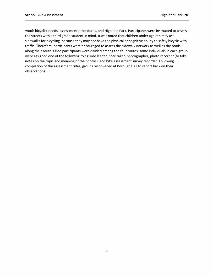
youth bicyclist needs, assessment procedures, and Highland Park. Participants were instructed to assess
the streets with a third grade student in mind. It was noted that children under age ten may use
sidewalks for bicycling, because they may not have the physical or cognitive ability to safely bicycle with
traffic. Therefore, participants were encouraged to assess the sidewalk network as well as the roads
along their route. Once participants were divided among the four routes, some individuals in each group
were assigned one of the following roles: ride leader, note taker, photographer, photo recorder (to take
notes on the topic and meaning of the photos), and bike assessment survey recorder. Following
completion of the assessment rides, groups reconvened at Borough Hall to report back on their
observations.

School Bike Assessment Highland Park, NJ
4
Assessment Observations Blue Route The Blue Route was the longest assessment, totaling approximately four miles. This route was
predominately on residential streets connecting Donaldson and Johnson Parks. See Figure 2 for map and
directions of the blue route. Overall, the route did not feel safe for young bikers.
While sidewalks are present on most streets, there are also frequent missing sidewalk connections along
a block or property frontage. Some sidewalks are obstructed by overgrown vegetation. Sidewalk curb
ramps are missing from several corners, and some crosswalks have faded striping that crosses cracked
or potholed pavement. Streets along the route are residential, with 25 MPH speed limits and on-street
parking permitted. Bicyclists on these streets would share the road with motor vehicle traffic. Most
streets lack specific accommodation for cyclists, such as bike lanes, sharrows1, or bike warning signage.
Speed humps are in place on some streets to slow motor vehicle speeds.
1 A sharrow, or shared lane marking, is a bicycle and chevron symbol painted on the road to indicate to bicyclists that they may ride within the travel lane, and to remind motor vehicle drivers to expect bicyclists.
Figure 2 - Blue Route map and directions
School Bike Assessment Highland Park, NJ
5
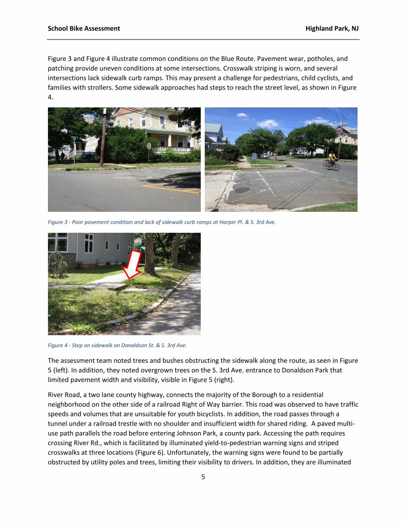
Figure 3 and Figure 4 illustrate common conditions on the Blue Route. Pavement wear, potholes, and
patching provide uneven conditions at some intersections. Crosswalk striping is worn, and several
intersections lack sidewalk curb ramps. This may present a challenge for pedestrians, child cyclists, and
families with strollers. Some sidewalk approaches had steps to reach the street level, as shown in Figure
4.
Figure 3 - Poor pavement condition and lack of sidewalk curb ramps at Harper Pl. & S. 3rd Ave.
Figure 4 - Step on sidewalk on Donaldson St. & S. 3rd Ave.
The assessment team noted trees and bushes obstructing the sidewalk along the route, as seen in Figure
5 (left). In addition, they noted overgrown trees on the S. 3rd Ave. entrance to Donaldson Park that
limited pavement width and visibility, visible in Figure 5 (right).
River Road, a two lane county highway, connects the majority of the Borough to a residential
neighborhood on the other side of a railroad Right of Way barrier. This road was observed to have traffic
speeds and volumes that are unsuitable for youth bicyclists. In addition, the road passes through a
tunnel under a railroad trestle with no shoulder and insufficient width for shared riding. A paved multi-
use path parallels the road before entering Johnson Park, a county park. Accessing the path requires
crossing River Rd., which is facilitated by illuminated yield-to-pedestrian warning signs and striped
crosswalks at three locations (Figure 6). Unfortunately, the warning signs were found to be partially
obstructed by utility poles and trees, limiting their visibility to drivers. In addition, they are illuminated

School Bike Assessment Highland Park, NJ
6
by low-intensity amber lights. Replacement with rapid-flash strobe lights in a less obstructed location
may improve visibility and yield compliance at these crosswalks.
Figure 6 - Flashing crosswalk lights not visible on all sides on Harrison Ave. & River Rd.
Speed humps on North and South 2nd Ave. and Harrison St. may moderate motor vehicle traffic on these
streets.
Figure 5 - Overgrown vegetation obstructs a sidewalk on S. 2nd Ave. (left) and S.3rd Ave. at Valentine St. (right).
Figure 7 - Speed hump on Harrison Ave. (left) and S. 2nd Ave. (right).

School Bike Assessment Highland Park, NJ
7
General observations
Missing or incomplete sidewalks
Vegetation crowding some sidewalks
Intersections lack sidewalk curb ramps
Crosswalk paint is faded
Poor pavement condition in some areas due to potholes and patching
Motor vehicle speeding is a concern
No specific bicycle facilities or signage, such as bike lanes or warning signs
Speed humps are in place to slow motor vehicle traffic
There is interest in a trail or designated bicycling route connecting Donaldson and Johnson Parks
Site-specific observations
The S. 3rd Ave. entrance to Donaldson Park has encroaching vegetation limiting visibility and the
effective roadway width
On River Rd, a tunnel under Amtrak is unsuitable for sharing the road. A parallel multi-use path
exists in Johnson Park. Using this path requires out-of-direction travel. The path is unlit, and the
park is closed at dusk.
There is a multi-use path parallel to River Rd. Some parts of this path have buckled due to tree
roots.
Lighted warning signs are in place at three River Rd. crosswalks. Some of the illuminated
warning signs are obstructed by utility poles and trees.

School Bike Assessment Highland Park, NJ
8
RED ROUTE The Red Route measured 2.9 miles. This route traveled streets in the southwest section of town, not
crossing Raritan Avenue (State Highway 27). Common concerns along the Red Route included frequent
missing sidewalk connections, faded crosswalks, missing curb ramps/truncated domes, and sight
obstructions at intersections, Streets along the Red Route are residential, generally with 25 MPH speed
limits and on-street parking permitted, though restricted to one side in some places. There were no
specific accommodations for bicyclists such as bike lanes, sharrows, or signage observed along the Red
Route.
Several gaps in the sidewalk network were observed along the Red Route. On South 4th Ave., the
sidewalk abruptly ends along one side of the street mid-block between Mansfield St. and Becker St.
Sidewalk starts up again at the Corner of Becker Street, but sidewalk along South 4th Ave. ends on both
sides at Graham Street. There is no sidewalk on either side along Donaldson St. and it is missing along
one side of Valentine St. until just before South 2nd Ave. Continuing along Valentine, sidewalks again end
on one side at South 1st Ave. There are no sidewalks at the end of Cedar Ave. past Donaldson St. One
side of Skyview Ter. has sidewalks, but all sidewalks end at the intersection with South Adelaide Ave.
There are no sidewalks on the end of South Adelaide Ave. until they start midblock after Elbert Ct.
Sidewalks are again missing along South Adelaide Ave. in front of one home located near the
intersection of South Adelaide Ave. and Valley Pl.
Figure 8 - Red Route map and directions

School Bike Assessment Highland Park, NJ
9
Faded crosswalks, missing curb ramps, missing truncated domes, and in some cases missing crosswalks
were observed throughout the Red Route. While the crosswalks were recently repainted in front of
Bartle Elementary on Mansfield St., curb ramps and truncated domes are missing from the crossing
directly in front of the school. To further complicate the crossing, one of the crosswalks leads
pedestrians into a utility pole. A faded crosswalk was also observed at South Adelaide Ave. and Johnson
Street. Though curb ramps are present, truncated domes are missing. At Harper St. and Felton Ave. the
crosswalk that is present is faded. There is no crosswalk across Felton Ave. There are also no curb ramps
and no truncated domes at this location. At S.1st Ave. and Magnolia St. there are two faded crosswalks
crossing South First Ave. with no curb ramps or truncated domes present. Both of the crosswalks
crossing South First Ave. lead pedestrians to bad connections to the sidewalk with one leading directly
into a telephone pole.
The intersections of South 3rd Ave., Harper St., and Harper Pl. present a variety of issues. The crosswalks
on Harper St. and Harper Place are faded and do not have curb ramps or truncated domes. Additionally,
Figure 10 - Discontinuous or absent sidewalk on S. 4th Ave. (left) and S. Adelaide Ave. (right)
Figure 9 - Freshly painted crosswalks at Bartle School entrance, but lack of curbcuts

School Bike Assessment Highland Park, NJ
10
there is an extremely high curb on one side of the crossing of Harper Place. The road surface of both
Harper St. and Harper Place approaching each crossing is rough, creating a hazard for bicyclists. There is
also no crosswalk at this intersection that crosses South 3rd Ave., a busy road connecting to Raritan Ave.
Other issues noted along the Red Route included a problematic sight obstruction and a broken sewer
grate. At the Intersection of Valentine St. and Cedar Ave. overgrown vegetation makes it difficult to see
oncoming traffic. On South Adelaide Ave. in front of the Highlander building, an old sewer grate that sits
below the street surface has shifted and resulted in an open hole in the street surface. It was also noted
that there was no stop sign at the intersection of Donaldson St. and Braun Ave.
Figure 12 - Faded crosswalks and lack of curb ramps at S. 1st Ave. at Magnolia St. (left) and Felton St. at Harper Ave. (right)
Figure 11 - Poor pavement condition and high curb at S. 3rd Ave. at Harper Pl.

School Bike Assessment Highland Park, NJ
11
The Red Route traveled down to parallel streets traveling west to east on the south side of Highland
Park, Magnolia St. and Benner St. Both streets accommodate on street parking and two way traffic but
felt quite narrow when being traveled by bicycle. Riders of the Red Route felt that exploring options to
make these streets each one way in opposite directions could make them more comfortable for
bicycling.
Riders on the Red Route also noted a lot of good infrastructure already in place that helps to make
bicycling easier within Highland Park. Valentine St. was recently repaved, providing a smooth path of
travel for bicyclists. Riders on the Red Route also appreciated that the Stop signs along Valentine St.
stopped north/south traffic, providing a stop free east/west path of travel for a good portion of the
south side of town. Riders also felt more secure noting that many of these stops along Valentine Street
had enhanced stop bars, enhancing visibility and indicating to drivers that there is an upcoming stop.
Riders on the Red Route also enjoyed their ride along South 1st Ave., noting that it was one of the widest
streets in town and provided room for parking, two way vehicle travel, and bicyclists comfortably. The
Figure 14 - Recent paving, striping, and curb ramps on Valentine St.
Figure 13 - Plantings obstruct views at Valentine St. & Cedar Ave. (left), broken sewer grate on S. Adelaide Ave.

School Bike Assessment Highland Park, NJ
12
Riders of the Red Route were also pleased to see new bicycle racks being placed in front of Bartle
Elementary School.
General observations
Missing or incomplete sidewalks
Intersections lack sidewalk curb ramps
Crosswalk paint is faded
No specific bicycle facilities or signage, such as bike lanes or warning signs
Local streets are cut-through routes for drivers avoiding State Highway 27
Site-specific observations
Crosswalks have been repainted on Mansfield St. at Bartle School entrance, but lack curb ramps.
A crosswalk ends at a utility pole.
New bike racks have been installed at the Mansfield St. entrance to Bartle School.
Poor road surface, faded crosswalks, and lack of curb ramps are notable at the intersection of S.
3rd Ave., Harper Ave., and Harper Pl.
Lack of stop control at intersection of Braun Ave. and Donaldson St.
Plantings at corner of Valentine St. and Cedar Ave. limit visibility
A damaged and sunken sewer grate presents a hazard on S. Adelaide Ave. at the Highlander
apartment building
It was suggested that Magnolia St. and Benner St. could better accommodate bicyclists as a one-
way pair
The recent repaving and restriping of Valentine St. provided a favorable riding experience for
the assessment team
Figure 15 - Assessment riders felt uncomfortable sharing the road on Benner St. (left) and Magnolia St. (right)

School Bike Assessment Highland Park, NJ
13
Figure 17 - Freshly painted crosswalks but no curb ramps at the Bartle School entrance on Mansfield St.
Silver Route The silver route, which was 3.2 miles long, began on the south side of Highland Park at Bartle School,
crossed State Highway 27, and continued in a loop through the neighborhoods surrounding the
MIddle/High School.
Beginning with Bartle School, there are freshly painted crosswalks on the corner of Grove St. and
Mansfield St., however there are no curb ramps and one crosswalk is obstructed by a utility pole. The
Borough was in the process of re-painting crosswalks throughout the town in time for school to begin in
September.
Figure 16 - Silver Route map and directions

School Bike Assessment Highland Park, NJ
14
Figure 18 – A utility pole obstructs a crosswalk on Mansfield St. at Grove St.
Figure 19 - Poor pavement condition from potholes and patching.
Throughout the silver route, instances of poor pavement condition due to potholes and patching may
make street riding challenging for young bicyclists.
Sidewalks were generally in good condition on the north side of State Highway 27, except for some
overgrown shrubs, trees, and plants obstructing the sidewalks. Several streets were lacking continuous
sidewalks.

School Bike Assessment Highland Park, NJ
15
Figure 20 – Non-standard path on Madison Ave. (left) and lack of sidewalks on Harrison Ave. (right)
Figure 22 - Intersection of Madison Ave. & N. 4th Ave.
The intersection of Madison and N. 4th Ave. at the Center School (a private school, currently vacant),
within a block of the Middle School, is has a long crosswalk that lacks curb ramps and ends at utility
pole.
Figure 21 - Intersection of Madison Ave. & N. 4th Ave.
School Bike Assessment Highland Park, NJ
16
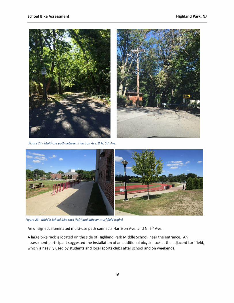
An unsigned, illuminated multi-use path connects Harrison Ave. and N. 5th Ave.
A large bike rack is located on the side of Highland Park Middle School, near the entrance. An
assessment participant suggested the installation of an additional bicycle rack at the adjacent turf field,
which is heavily used by students and local sports clubs after school and on weekends.
Figure 24 - Multi-use path between Harrison Ave. & N. 5th Ave.
Figure 23 - Middle School bike rack (left) and adjacent turf field (right)

School Bike Assessment Highland Park, NJ
17
At the intersection of N. 5th Ave. and Montgomery St., directly in front of the High School and public
library, the Borough has recently restriped crosswalks and added diagonal stripes across the intersection
to warn drivers of frequent pedestrian crossings. A participant noted that students walk diagonally
across the intersection during school arrival and dismissal.
General observations
At the time of the assessment, the Borough was repainting crosswalks
Missing or incomplete sidewalks
Poor pavement condition in some areas due to potholes and patching
Residential streets with parallel parking on both sides made some bicyclists uncomfortable
Site-specific observations
Crosswalks have been repainted on Mansfield St. at Bartle School entrance, but lack curb ramps.
The intersection of N. 4th Ave. and Madison Ave. was noted for wide crossings and a long
crosswalk.
A multi-use path connects N. 5th Ave. and Harrison St., but does not connect with sidewalks at
either end and is unsigned.
A large bike rack was noted by the Middle School entrance. The assessment team suggested an
additional bike rack at the turf field would be well-utilized by sports teams and clubs.
New crosswalk and diagonal striping was noted at the intersection of N. 5th Ave. and
Montgomery St.
Incomplete sidewalks were noted on Madison Ave., Harrison Ave., and S. Park Ave.
Figure 25 - N. 5th Ave. & Montgomery St. crosswalk and
diagonal striping

School Bike Assessment Highland Park, NJ
18
Black Route The 2.8 mile long Black Route travels the southeast section of Highland Park through the Donaldson Park
Apartments, crosses Woodbridge Ave., passes Irving School, and loops through the “triangle”
neighborhood between Woodbridge Ave. and State Highway 27 before returning to Borough Hall.
Assessment participants noted the three-way intersection of Columbia St., Cherry St., and Parker Rd. as
a concern. A sign on Columbia St. warns about the upcoming “dangerous” intersection, and residents
have added their own “slow down” signs. The lack of crosswalks at this intersection may make it
difficult for children and adults to cross.
Figure 26 - Black Route map and directions

School Bike Assessment Highland Park, NJ
19
Participants noted a lack of sidewalks in some neighborhoods. A worn path on Central Ave. at Merilind
Ave. by the Irving School shows the amount of pedestrian activity in the area.
Figure 28 - Intersection of Columbia St., Cherry St., and Parker Rd.
Figure 27 - Official and homemade warning signs on the Columbia St. approach to Cherry St.

School Bike Assessment Highland Park, NJ
20
Other issues noted along the Black Route include a storm sewer grate at Crowell’s Rd. and Aurora St.
with wide slits where a child’s bike wheel could get stuck and potentially cause injury. Irving School has a
traditional comb-style rack near the gymnasium. The rack was recently relocated from the main
entrance because bicycles were obstructing the accessible doors. While it is encouraging that the school
has a bike rack for students to use, the awkward placement limits the rack’s usability.
Where the Black Route crossed Woodbridge Ave., assessment participants noted that some Woodbridge
Ave. businesses have parking lots that extend to the curb, with no sidewalk. In addition, wide driveway
cuts are present. At the corner of Crowells Rd. and Woodbridge Ave. vehicles in the parking lot were
located up to the curb, leaving no space for pedestrians. Across from the Irving School, a business at the
corner of South 11th Ave. and Woodbridge Ave. had wide driveways and a parking lot to the curb.
While cars were parked to leave enough room for pedestrians to walk next to the curb, there is no
delineation or barrier between the parked cars and the pedestrians who cross an open driveway.
Figure 29 - No sidewalk on Columbia Ave. & Central Ave. (left) and dirt path at Central Ave. & Merilind Ave. (right)
Figure 30 -Wide grate on Crowells Rd. & Aurora St. (left) and comb-style bike rack at Irving School (right)

School Bike Assessment Highland Park, NJ
21
Riders on the Black Route noted a multi-use path and access road that connects the base of S. 7th Ave. at
Donaldson St. with the base of S. 5th Ave. at Valentine St. This connection may facilitate a walking or
biking connection from the Donaldson Park Apartments to Bartle Elementary School. This pathway is
illuminated by “cobra head” street lamps. Riders also noted a crushed stone pathway that begins at the
corner of S. 5th Ave. and Valentine St. and connects to Donaldson County Park. Paving of this pathway
would provide a bike and ADA accessible route to the northern end of Donaldson County Park.
General observations
Missing or incomplete sidewalks
Faded or missing painted crosswalks
Lack of bicycle facilities such as bicycle lanes or signage
Figure 31 - Lack of sidewalks and wide driveway cuts on Crowells Rd. (left) and S. 11th Ave. (right)
Figure 32 - Multi-use pathway from S. 5th Ave. (left) and crushed stone path to Donaldson Park (right)

School Bike Assessment Highland Park, NJ
22
Site-specific observations
A multi-use path and access road connects the intersection of S. 7th Ave. and Donaldson St. with
the intersection of S. 5th Ave. and Valentine St. This path may provide a route to Bartle School
for students who live in the Donaldson Park Apartments. The path is lit by overhead “cobra”
street lamps.
A crushed stone path extends from the intersection of S. 5th Ave. and Valentine St. to Donaldson
Park.
Missing sidewalks on Central Ave. in the vicinity of Irving School, with a worn path indicating
frequent use.
A bike rack is present at Irving School, however, it is located away from the main entrance.
Assessment team found the five point intersection at Columbia St., Parker Rd., and Cherry St.
confusing and lacking crosswalks.
Auto repair and used auto businesses on Woodbridge Ave. in the vicinity of Irving School lack
sidewalks and have parking lots up to the curb. Some store vehicles near the curb, while others
leave a space for pedestrians. In addition, wide driveway access cuts may present a challenge for
sidewalk bicyclists.

School Bike Assessment Highland Park, NJ
23
Summary The Highland Park School Bike Assessment was conducted to complement the walk assessment and
School Travel Plan that were completed in spring 2016. Together, the bike and walk assessments
highlight opportunities to improve walking and bicycling conditions throughout the Borough for
students, residents, and visitors.
The bike assessment documented many positive aspects of the Highland Park street network for youth
bicycling, as well as challenges to safe and comfortable cycling. Those opportunities for improvement
are collected in the table below, along with suggested actions and responsible organizations.
Deficiency/Opportunity Potential Action Responsible Org.
Maintenance
Faded crosswalks Restriping Borough
Pavement condition Patching and repaving as budget and grant opportunities allow
Borough
Vegetation Code enforcement of planting maintenance by property owners
Borough
Sewer grates Repair or replace damaged and substandard storm sewer grates
Borough
River Rd. bike path buckling Repair County
Irving bike rack placement Relocate bike rack closer to main entrance
School District
Infrastructure investment
Missing sidewalk curb ramps Install curb ramps as budget and grant opportunities allow
Borough
Missing sidewalk segments Install sidewalks as budget and grant opportunities allow
Borough
Missing sidewalks on Woodbridge Ave.
Install sidewalks as budget and grant opportunities allow
County
River Rd. crosswalk warning signs Investigate replacement/enhancement
Borough/County
N. 4th Ave. and Madison Ave. Investigate alternative crossings Borough
Turf field bike racks Install bike racks as budget and grant opportunities allow
Borough/County
Further Study

School Bike Assessment Highland Park, NJ
24
Magnolia St. and Benner St. Investigate converting to a one-way pair with bike facility
Borough
Bicycle lanes Investigate routing Borough
River Rd. under Amtrak Investigate alternative bicycle routes Borough/County/NJDOT
Columbia St., Cherry St., and Parker Rd.
Investigate traffic engineering changes to improve safety for motor vehicles, bicyclist, and pedestrians
Borough

School Bike Assessment Highland Park, NJ
25
APPENDIX A: Survey Form Insert bike assessment survey form for reference.