high wind fugitive dust mitigation plan - env.nm.gov · background the 3,804 square miles...
TRANSCRIPT
High Wind Fugitive Dust Mitigation Plan

2 | P u b l i c R e v i e w D r a f t 0 5 a p r 2 0 1 8
Purpose
On September 16, 2016, the U.S. Environmental Protection Agency (EPA) finalized revision to the 2007 Exceptional Events Rule, codified in 40 CFR Parts 50 and 51, that provides air quality agencies regulatory relief in situations when exceptional events cause an exceedance of a National Ambient Air Quality Standard (NAAQS). Exceptional events can be caused by human activity unlikely to recur or natural events. In New Mexico, natural events, such as windstorms and wildfires cause exceedances of the particulate matter standards every year. Other exceptional events that may occur in New Mexico include tornadoes, firework displays, and chemical spills.
The revised rule includes requirements for states to prepare mitigation plans (40 CFR 51.930) for areas with recurring events (i.e., three similar events of the same type and pollutant in a three-year period). Luna County and the Anthony, NM PM10 nonattainment area (i.e., Doña Ana County) were identified as areas subject to the mitigation plan requirements due to PM10 exceedances from high winds. This plan has been developed to mitigate PM10 and PM2.5 emissions during high wind events in both Luna and Doña Ana counties.
Background
The 3,804 square miles comprising Doña Ana County are topographically diverse and include mountain ranges, hills, valleys and deserts. The elevation range for the county is 3,730 feet at the valley floor in the south to 9,012 feet at the peak of the Organ Mountains. The Organ Mountains lie in a north-south direction along the eastern border of the county, separating the Mesilla Valley from White Sands Missile Range and White Sands National Monument. The western half of Doña Ana County is formed by an elevated desert plateau that extends west through Luna, Grant, and Hidalgo counties along the international border and into Arizona.
Where New Mexico, Texas and Mexico meet, Mount Cristo Rey lays south of Sunland Park between the Franklin Mountains on the east and the Sierra Juárez Mountains to the southwest. Previous air quality studies in the air shed indicate that this complex topography dictates wind flow patterns carrying air masses from El Paso and Ciudad Juárez into southern Doña Ana County.
Doña Ana County has a mild, semi-arid climate with light precipitation, abundant sunshine, low relative humidity, and a large daily and annual temperature range. Annual precipitation averages 9.35 inches, including 3.7 inches of snowfall in Las Cruces.
Luna County covers 2,965 square miles in southwestern New Mexico sharing 54 miles of international border with Mexico. Luna County is within the northern most part of the Chihuahuan Desert, with desert landscape as its most predominant feature. Several mountain ranges are located within the county, including Cooke’s Range, the Florida Mountains, and the

3 | P u b l i c R e v i e w D r a f t 0 5 a p r 2 0 1 8
Tres Hermanas Mountains. Like Doña Ana County, Luna County has a semi-arid climate with light precipitation and low relative humidity. Annual precipitation averages 9.8 inches, including 1.6 inches of snowfall.
Windstorms are common during the late winter and spring months in both Luna and Doña Ana counties. Due to these high velocity winds, both counties experience the majority of PM10 exceedances in the state. Synoptic scale weather activity, and to a lesser extent, mesoscale weather systems drive most of the frequent high wind events in the region. These periods of high wind may result in average hourly wind speeds exceeding 30 miles per hour for several hours and reach peak speeds of 60 miles per hour or more. Blowing dust and soil erosion originate from the numerous exposed and erodible desert areas. Winds predominately blow from the southeast in summer, from the west in winter, and from the west-southwest in spring.
Air Monitoring Network
The New Mexico Environment Department, Air Quality Bureau (AQB) regulates air quality to protect public health and the environment in the State of New Mexico, excluding Bernalillo County and tribal lands. Air monitoring data are required by regulation and are used to determine compliance with the NAAQS. The AQB operates a State and Local Air Monitoring Stations Network to measure the concentration of criteria pollutants, with six PM10 and three PM2.5 monitoring sites in Doña Ana and Luna counties, that track windblown dust in southern New Mexico (Figure 1). These monitoring sites, except 6CM Anthony, have meteorological monitoring equipment that records wind speed, wind gust, 10 m temperature and 2 m temperature (Table 1).
Site AQS Site ID Latitude Longitude Parameters 6CM Anthony 35-013-0016 32.0033 -106.5992 PM10 and PM2.5 6ZK Chaparral 35-013-0020 32.0409 -106.4095 PM10 and Meteorology 6ZM Desert View 35-013-0021 31.7961 -106.5839 PM10, PM2.5 and Meteorology 6ZL Holman Road 35-013-0019 32.4246 -106.6739 PM10 and Meteorology 6Q Las Cruces 35-013-0025 32.3103 -106.7512 PM2.5 and Meteorology 6WM West Mesa 35-013-0024 32.2781 -106.8649 PM10 and Meteorology 7E Deming Airport 35-029-0003 32.2558 -107.7227 PM10 and Meteorology
Table 1. Particulate Matter monitoring network in Doña Ana and Luna Counties.

4 | P u b l i c R e v i e w D r a f t 0 5 a p r 2 0 1 8
Figure 1: Luna and Doña Ana counties’ PM Monitoring Network.
Public Education and Notification
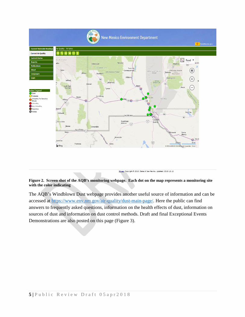
The AQB will provide prompt public notification to and education programs for potentially affected communities whenever PM10 air concentrations exceed or are expected to exceed the NAAQS (40 CFR 51.930(b)(2)(i)). The AQB’s monitoring website provides the public with near real-time air quality conditions at each monitoring site in the state (Figure 2) and can be accessed at www.env.nm.gov/air-quality/air-monitoring-network-2/. Other important uses of the air monitoring data include the production of a daily Air Quality Index, daily air quality forecast reports (e.g., AirNow/EnviroFlash), support of short and long-term health risk assessments, identification of a localized health concerns, and tracking long-term trends in air quality.
5 | P u b l i c R e v i e w D r a f t 0 5 a p r 2 0 1 8
Figure 2. Screen shot of the AQB’s monitoring webpage. Each dot on the map represents a monitoring site with the color indicating
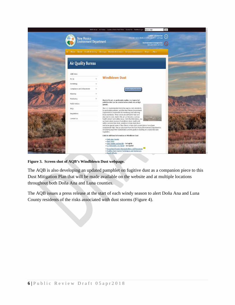
The AQB’s Windblown Dust webpage provides another useful source of information and can be accessed at https://www.env.nm.gov/air-quality/dust-main-page/. Here the public can find answers to frequently asked questions, information on the health effects of dust, information on sources of dust and information on dust control methods. Draft and final Exceptional Events Demonstrations are also posted on this page (Figure 3).
6 | P u b l i c R e v i e w D r a f t 0 5 a p r 2 0 1 8
Figure 3. Screen shot of AQB’s Windblown Dust webpage.
The AQB is also developing an updated pamphlet on fugitive dust as a companion piece to this Dust Mitigation Plan that will be made available on the website and at multiple locations throughout both Doña Ana and Luna counties.
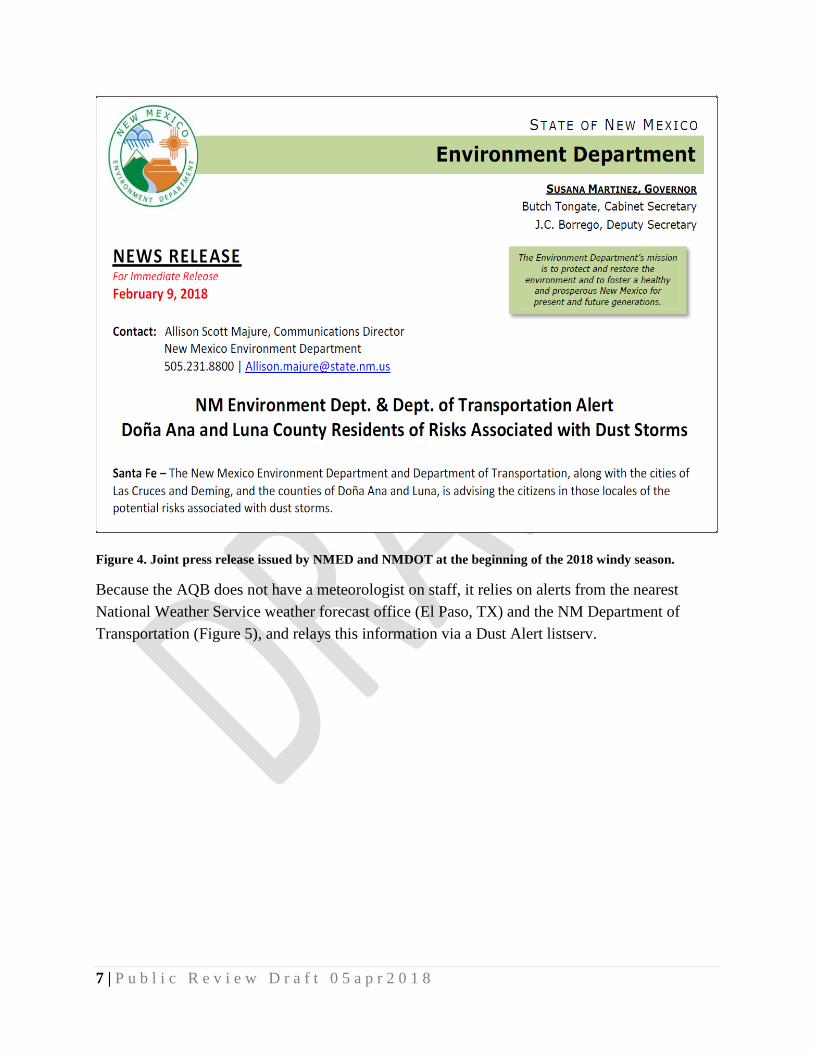
The AQB issues a press release at the start of each windy season to alert Doña Ana and Luna County residents of the risks associated with dust storms (Figure 4).
7 | P u b l i c R e v i e w D r a f t 0 5 a p r 2 0 1 8
Figure 4. Joint press release issued by NMED and NMDOT at the beginning of the 2018 windy season.
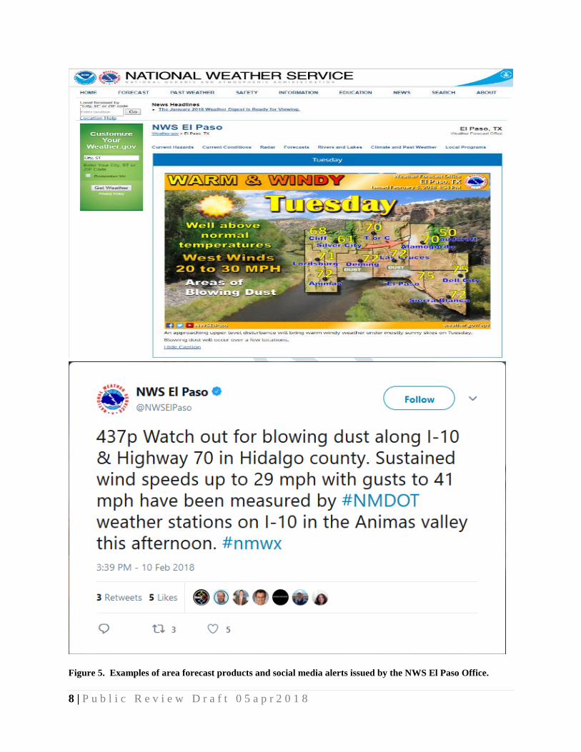
Because the AQB does not have a meteorologist on staff, it relies on alerts from the nearest National Weather Service weather forecast office (El Paso, TX) and the NM Department of Transportation (Figure 5), and relays this information via a Dust Alert listserv.
8 | P u b l i c R e v i e w D r a f t 0 5 a p r 2 0 1 8
Figure 5. Examples of area forecast products and social media alerts issued by the NWS El Paso Office.
9 | P u b l i c R e v i e w D r a f t 0 5 a p r 2 0 1 8
The AQB consults with the NM Department of Health to ensure the listserv alerts include appropriate information regarding health advisories and actions to minimize exposure for sensitive populations (e.g., remain indoors, avoid vigorous outdoor activity, and avoid exposure to respiratory irritants). In addition to the Department of Health, the AQB also regularly consults with the EPA Region 6 Border Office and New Mexico State University (whose staff includes the NM State Climatologist) on educating the public in the border region, including supporting ongoing efforts by these agencies.
Measures to Minimize Contributing Controllable Sources
In developing the mitigation plans, the AQB must take steps to identify, study and implement mitigating measures (40 CFR 51.930(b)(2)(ii)). The AQB recently completed a Fugitive Dust Micro-Inventory of local sources surrounding the PM10 monitoring sites in Doña Ana and Luna Counties. Staff from the AQB used previous emission inventories for Doña Ana County, GIS mapping, satellite imagery and field data to identify sources within a 2-km radius of each site and potential control measures to include in a Fugitive Dust Control rule (see below). These measures are designed to abate or minimize contributing controllable sources of PM (40 CFR 51.930(b)(2)(ii)(A)).
Mandatory Measures
Local Dust Control Ordinances
The City of Las Cruces, Doña Ana County, and Luna County have existing dust ordinances for which the AQB has provided consultation. This Dust Mitigation Plan and associated Fugitive Dust Rule, discussed below, will enhance these ordinances, and provide coverage where there are gaps.
20.2.23 NMAC, Fugitive Dust Control
The AQB is concurrently developing a Fugitive Dust Control rule for adoption into the New Mexico Administrative Code. The rule will apply to certain sources of fugitive dust that are not required to obtain a construction permit from the AQB, and will be applicable in any area of the state that experiences recurring high wind events where the PM10 and/or the PM2.5 NAAQS is exceeded. Sources of fugitive dust to be included in the draft rule include disturbed surface areas equal to or greater than 1.0 acre from construction/demolition activities, earthmoving (including weed abatement activities), and off-road vehicles/all-terrain vehicle (ATV) activities. Control measures will be required to stabilize surfaces to ensure emissions are not crossing the property line or exceeding opacity limits. Commercial and industrial bulk material handling and storage will also require use of control measures. A list of potential sources of emissions and associated

10 | P u b l i c R e v i e w D r a f t 0 5 a p r 2 0 1 8
control measures are included in Table 2 below. A tentative schedule for adoption of the rule has been developed with a hearing date targeted for August 2018.
Source Category Control Measures
Construction/Demolition
Water unpaved surfaces Limit on-site vehicle speed to 15 mph Apply dust suppressant to unpaved areas Prohibit activities during high winds
Materials Handling Implement wet suppression
Wind Erosion (open area and storage piles)
Plant trees or shrubs as a windbreak Erect artificial wind barriers Apply dust suppressant or gravel Water exposed area before high winds Revegetate area with native plants
Table 2. Candidate sources and associated control measures for fugitive dust control.
Voluntary Measures
Agricultural Conservation Measures
The AQB will rely on the conservation measures outlined by the United States Department of Agriculture Natural Resources Conservation Service (NRCS) to mitigate particulate matter emissions from agricultural land management, cropping operations, and livestock/poultry operations. When properly implemented, NRCS-approved conservation systems and activities may achieve levels of control comparable to those required by EPA for marginal PM10 nonattainment areas. Implementation of conservation measures will be coordinated with producers, landowners, operators, state agencies, NRCS, and EPA to determine the most suitable and effective conservation measures for the counties. Control measures to be considered include:
• Maintaining soil surface cover; • In-field pass reductions; • Soil conditioning and timing of
operations modifications; • Wind barriers; • Equipment modifications; • Bulk material handling;
• Unpaved roadway management; • Nutrition and feed management; • Animal confinement; • Manure management; • Land application; • Pasture and range management; and • Mortality management.
Unpaved Travel Surfaces
The AQB will consult with the New Mexico Department of Transportation to develop guidance for dust control best management practices for maintenance of existing unpaved roadways.

11 | P u b l i c R e v i e w D r a f t 0 5 a p r 2 0 1 8
Alternatives to paving will also be explored where material, chemical and administrative treatment methods may be applied for dust control.
Minimize Public Exposure to High Concentrations of PM
Mitigation plans must include methods to minimize public exposure to high concentrations of PM (40 CFR 51.930(b)(2)(ii)(B). The AQB will accomplish this through public notification, outreach education, air quality alerts, Fugitive Dust Control compliance education and inspections, and enforcement actions.
Processes to Collect and Maintain Data Pertinent to the Event
The AQB has established an internal process to collect and maintain data pertinent to exceptional events flagging, which includes close coordination between the Quality Assurance and Control Strategies sections (40 CFR 51.930(b)(2)(ii)(C)). This process is included in the Ambient Air Monitoring Quality Assurance Project Plan, which is reviewed annually. The Quality Assurance Section is currently developing an Exceptional Events Documentation Standard Operating Procedure that will provide detailed procedures for documenting information on possible exceptional events beginning with the monitoring site operator through the quality assurance of monitored data.
For those data that are subsequently determined to have regulatory significance, the Environmental Analyst in the Las Cruces field office will begin the data collection process to support an exceptional events demonstration. This data includes monitored PM concentrations, wind data, weather information, satellite data, and event reports.
Consultation with Other Air Quality Managers
The AQB will develop mechanisms to consult with other air quality management agencies (40 CFR 51.930(b)(2)(ii)(D)), primarily the Texas Commission on Environmental Quality and the Arizona Department of Environmental Quality, to share exceptional event data and coordinate demonstrations for events that may affect the entire region. Often, the same weather systems are responsible for exceedances and road closures in all three states.
Periodic Review and Evaluation
The AQB will review and evaluate this Dust Mitigation Plan and its implementation and effectiveness every two years (40 CFR 51.930(b)(2)(iii)). If additional particulate matter rulemaking occurs within the two-year period, the Dust Mitigation Plan will be updated accordingly and submitted to EPA Region 6 after the consideration of public comment.
Public Comment Documentation

12 | P u b l i c R e v i e w D r a f t 0 5 a p r 2 0 1 8
The draft Dust Mitigation Plan was posted on the AQB website on DATE for a thirty-day comment period (40 CFR 51.930(b)(2)(iii)(A)(1)). Stakeholders were notified via listserv on DATE. Public comments (40 CFR 51.930(b)(2)(iii)(A)(2)) and the AQB’s responses (40 CFR 51.930(b)(2)(iii)(A)(3)) are attached as Appendix A.
Submission of Mitigation Plans
The AQB submitted the Dust Mitigation Plans for Doña Ana and Luna Counties on DATE, meeting the required deadline of September 30, 2018 (40 CFR 51.930(b)(3)(i)). EPA intends to review each plan to ensure required components are included and will notify the AQB upon completion of such review (40 CFR 51.930(b)(3)(ii)). EPA does not intend to formally approve mitigation plans or require them as part of the New Mexico State Implementation Plan.