high speed two phase one information paper h2: birmingham ... · national exhibition centre (nec),...
TRANSCRIPT
1
HIGH SPEED TWO PHASE ONE INFORMATION PAPER
H2: BIRMINGHAM INTERCHANGE STATION
Version 1.5 Last updated 23rd February 2017
This paper outlines the proposals for Birmingham Interchange Station.
It will be of particular interest to those potentially affected by the Government’s proposals for high speed rail.
This paper was prepared in relation to the promotion of the Bill for Phase One of the scheme which is now enacted. Although the contents were maintained and updated as considered appropriate during the passage of the Bill (including shortly prior to the enactment of the Bill in February 2017) the contents are now historic and are no longer maintained.
If you have any queries about this paper or about how it might apply to you, please contact the HS2 Helpdesk in the first instance.
The Helpdesk can be reached at:
High Speed Two (HS2) Limited Two Snowhill, Snow Hill Queensway
Birmingham, B4 6GA
by email: [email protected]
or by phone: 08081 434 434 (lines are open 24 hours)
2
H2: BIRMINGHAM INTERCHANGE STATION
1. Introduction
High Speed Two (HS2) is the Government’s proposal for a new, high speed north-south railway. The proposal is being taken forward in two phases: Phase One will connect London with Birmingham and the West Midlands and Phase Two will extend the route to Manchester, Leeds and beyond.
HS2 Ltd is the non-departmental public body responsible for developing and promoting these proposals. The company works to a Development Agreement made with the Secretary of State for Transport.
In November 2013, HS2 Ltd deposited a hybrid Bill1 with Parliament to seek powers for the construction and operation of Phase One of HS2 (sometimes referred to as ‘the Proposed Scheme’). The Bill is the culmination of nearly six years of work, including an Environmental Impact Assessment (EIA), the results of which were reported in an Environmental Statement (ES) submitted alongside the Bill. The Secretary of State has also published draft Environmental Minimum Requirements (EMRs), which set out the environmental and sustainability commitments that will be observed in the construction of the Proposed Scheme.
The Bill is being promoted through Parliament by the Secretary of State for Transport (the ‘Promoter’). The Secretary of State will also appoint a body responsible for delivering the Proposed Scheme under the powers granted by the Bill.
This body is known as the 'nominated undertaker'. There may well be more than one nominated undertaker – for example, HS2 Ltd could become the nominated undertaker for the main railway works, while Network Rail could become the nominated undertaker for works to an existing station such as Euston. But whoever they are, all nominated undertakers will be bound by the obligations contained in the Bill and the policies established in the EMRs.
These information papers have been produced to explain the commitments made in the Bill and the EMRs and how they will be applied to the design and construction of the Proposed Scheme. They also provide information about the Proposed Scheme itself, the powers contained in the Bill and how particular decisions about the project have been reached.
This paper outlines the proposals for Birmingham Interchange Station.
1 The High Speed Rail (London – West Midlands) Bill, hereafter ‘the Bill’.
3
2. Overview
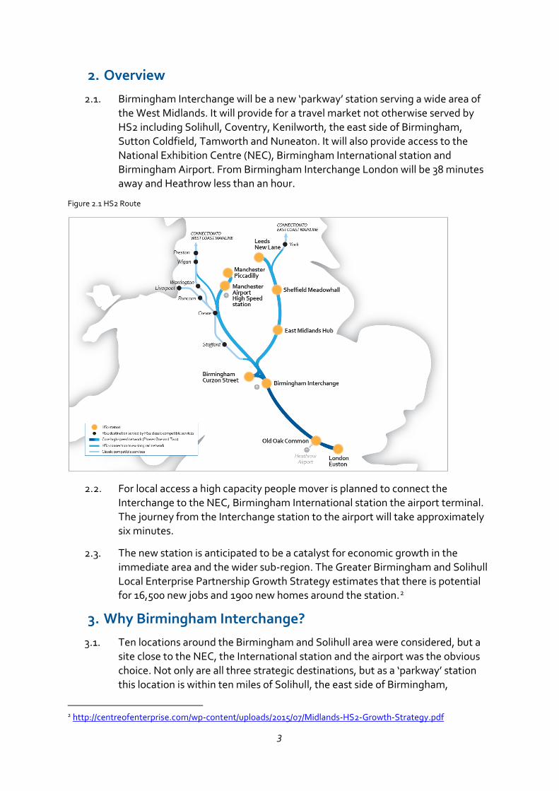
Birmingham Interchange will be a new ‘parkway’ station serving a wide area of the West Midlands. It will provide for a travel market not otherwise served by HS2 including Solihull, Coventry, Kenilworth, the east side of Birmingham, Sutton Coldfield, Tamworth and Nuneaton. It will also provide access to the National Exhibition Centre (NEC), Birmingham International station and Birmingham Airport. From Birmingham Interchange London will be 38 minutes away and Heathrow less than an hour.
Figure 2.1 HS2 Route
For local access a high capacity people mover is planned to connect the Interchange to the NEC, Birmingham International station the airport terminal. The journey from the Interchange station to the airport will take approximately six minutes.
The new station is anticipated to be a catalyst for economic growth in the immediate area and the wider sub-region. The Greater Birmingham and Solihull Local Enterprise Partnership Growth Strategy estimates that there is potential for 16,500 new jobs and 1900 new homes around the station.2
3. Why Birmingham Interchange?
Ten locations around the Birmingham and Solihull area were considered, but a site close to the NEC, the International station and the airport was the obvious choice. Not only are all three strategic destinations, but as a ‘parkway’ station this location is within ten miles of Solihull, the east side of Birmingham,
2 http://centreofenterprise.com/wp-content/uploads/2015/07/Midlands-HS2-Growth-Strategy.pdf
4
Coventry and the towns east of the conurbation. It is estimated that for Phase One of HS2, over 40% of London-West Midlands passengers would use Birmingham Interchange rather than Curzon Street.
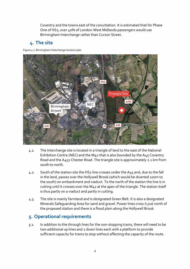
4. The site Figure 4.1: Birmingham Interchange location plan
The Interchange site is located in a triangle of land to the east of the National Exhibition Centre (NEC) and the M42 that is also bounded by the A45 Coventry Road and the A452 Chester Road. The triangle site is approximately 2.1 km from south to north.
South of the station site the HS2 line crosses under the A45 and, due to the fall in the land, passes over the Hollywell Brook (which would be diverted 100m to the south) on embankment and viaduct. To the north of the station the line is in cutting until it crosses over the M42 at the apex of the triangle. The station itself is thus partly on a viaduct and partly in cutting.
The site is mainly farmland and is designated Green Belt. It is also a designated Minerals Safeguarding Area for sand and gravel. Power lines cross it just north of the proposed station and there is a flood plain along the Hollywell Brook.
5. Operational requirements
In addition to the through lines for the non-stopping trains, there will need to be two additional up lines and 2 down lines each with a platform to provide sufficient capacity for trains to stop without affecting the capacity of the route.
5
The station will provide access and circulation space for passengers not only to circulate within the station building but also for pedestrian and vehicular access to the station. It is necessary to ensure that the platforms, escalators, concourses areas have sufficient capacity for maximum passenger flows including predicted future growth.
There will be level access to all public and staff areas, and lifts in addition to stairs and escalators for access to all levels. Provision for access to and from the station must include cars and delivery vehicles, taxis and buses, cycle facilities and storage, and welcoming pedestrian entrances.
Extensive station parking will be needed and efficient and high capacity access to the NEC, Birmingham International station and Birmingham Airport via a people mover.
6. The proposal
Until the hybrid Bill is enacted, the station design is at ‘concept’ stage. The layout has been planned so that it would comply with operational requirements and statutory regulations. It defines the scale and massing of the buildings and structures so that their environmental effects can be assessed. Detailed designs for both the station building and the external areas will be prepared in due course. They will be submitted to the local planning authority for approval before construction.
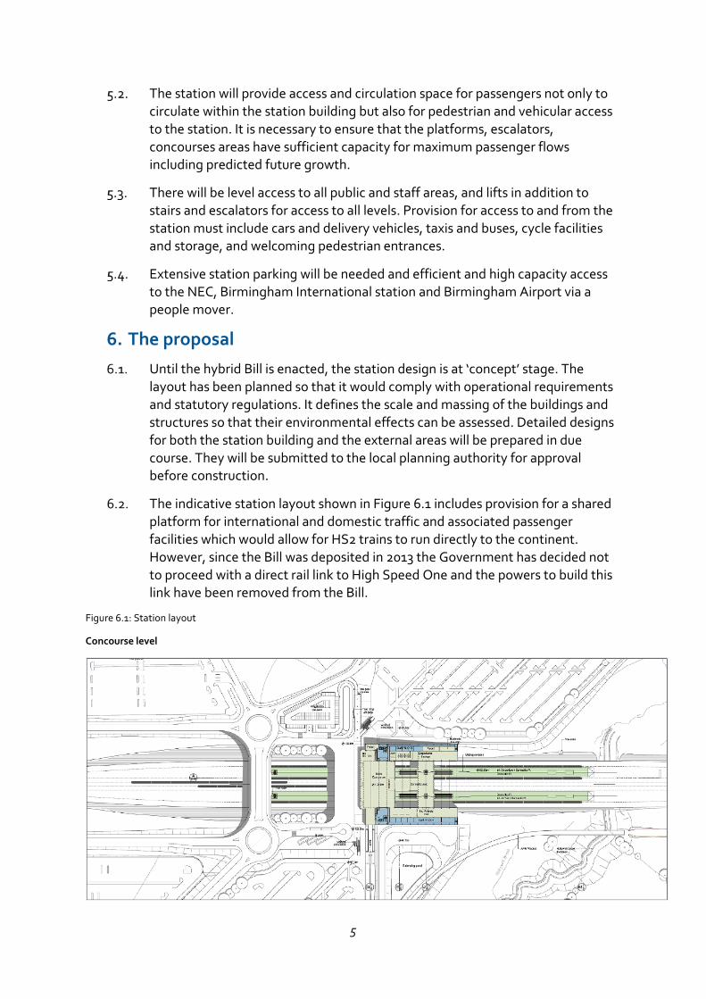
The indicative station layout shown in Figure 6.1 includes provision for a shared platform for international and domestic traffic and associated passenger facilities which would allow for HS2 trains to run directly to the continent. However, since the Bill was deposited in 2013 the Government has decided not to proceed with a direct rail link to High Speed One and the powers to build this link have been removed from the Bill.
Figure 6.1: Station layout
Concourse level
6
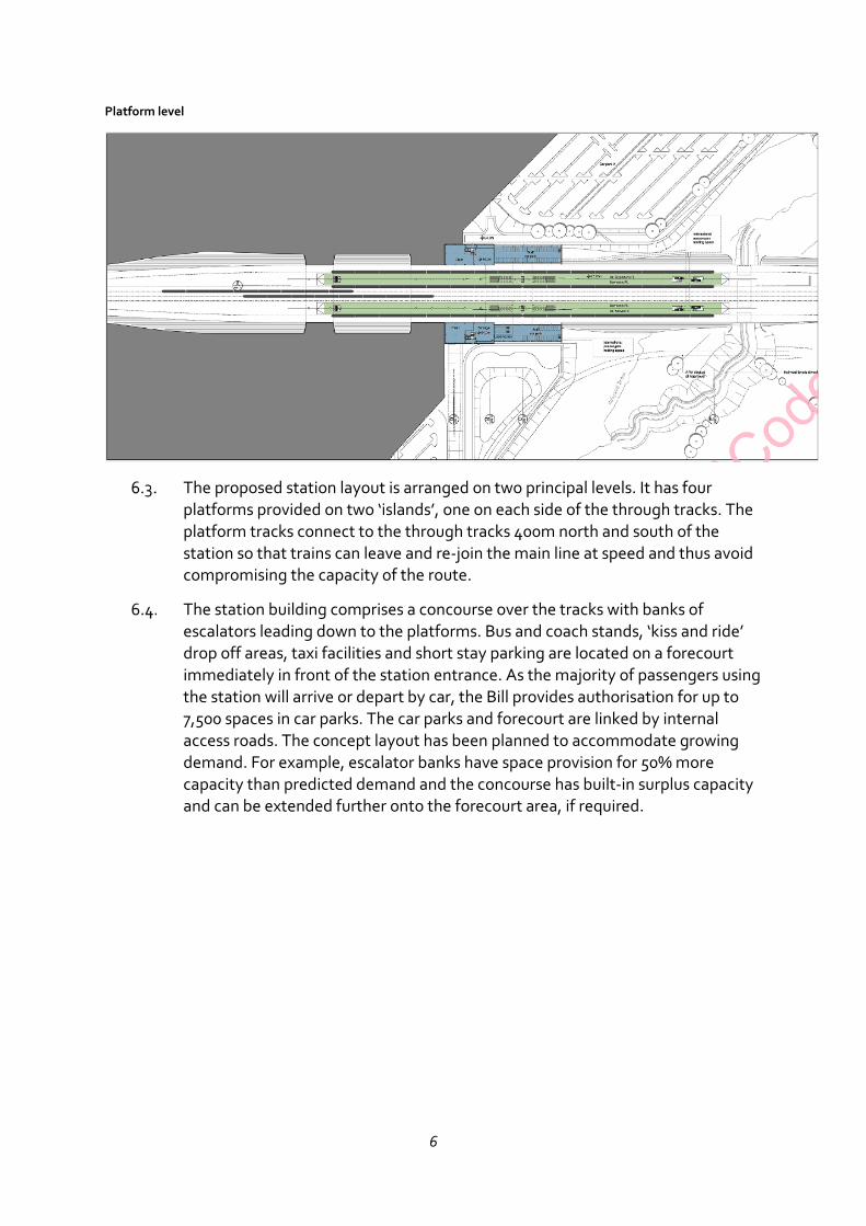
Platform level
The proposed station layout is arranged on two principal levels. It has four platforms provided on two ‘islands’, one on each side of the through tracks. The platform tracks connect to the through tracks 400m north and south of the station so that trains can leave and re-join the main line at speed and thus avoid compromising the capacity of the route.
The station building comprises a concourse over the tracks with banks of escalators leading down to the platforms. Bus and coach stands, ‘kiss and ride’ drop off areas, taxi facilities and short stay parking are located on a forecourt immediately in front of the station entrance. As the majority of passengers using the station will arrive or depart by car, the Bill provides authorisation for up to 7,500 spaces in car parks. The car parks and forecourt are linked by internal access roads. The concept layout has been planned to accommodate growing demand. For example, escalator banks have space provision for 50% more capacity than predicted demand and the concourse has built-in surplus capacity and can be extended further onto the forecourt area, if required.
7
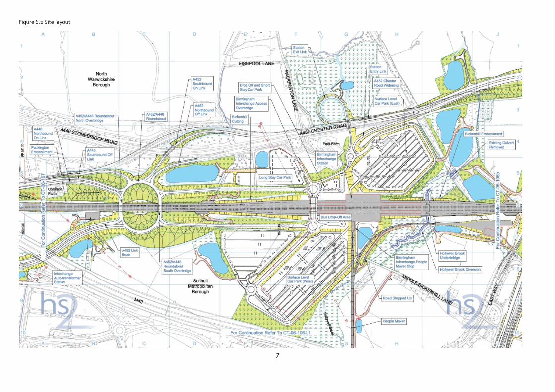
Figure 6.2 Site layout
8
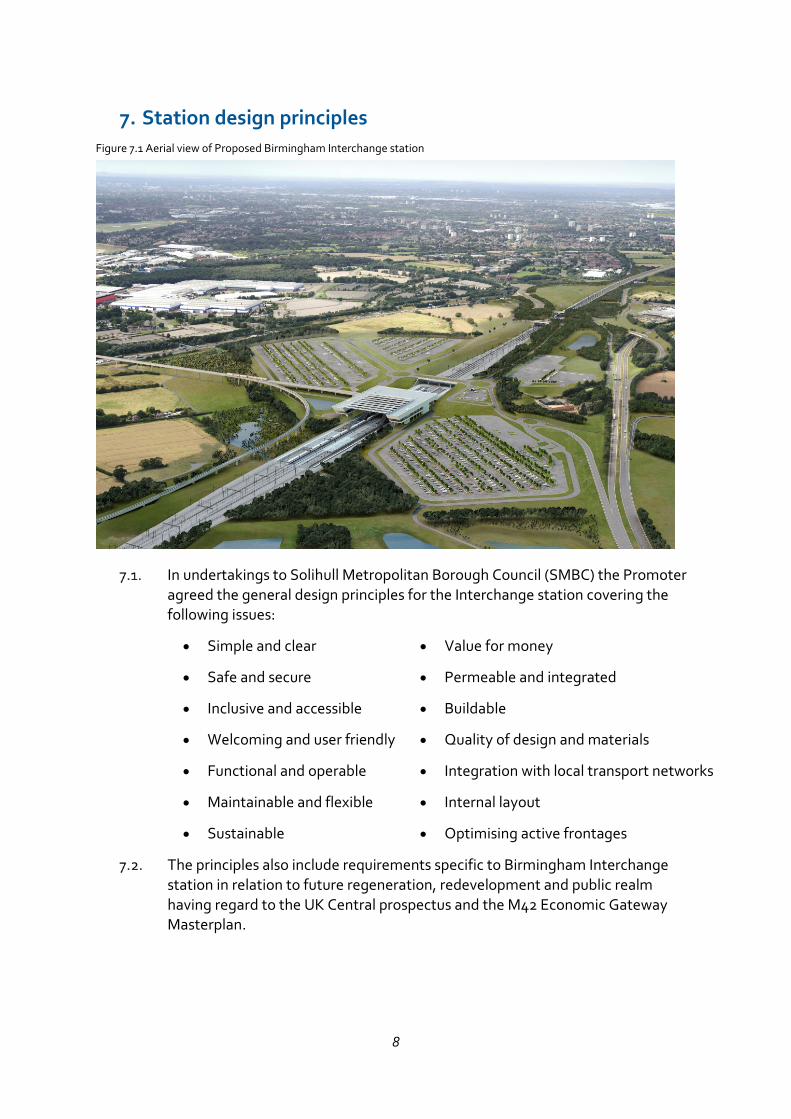
7. Station design principles Figure 7.1 Aerial view of Proposed Birmingham Interchange station
In undertakings to Solihull Metropolitan Borough Council (SMBC) the Promoter agreed the general design principles for the Interchange station covering the following issues:
• Simple and clear
• Safe and secure
• Inclusive and accessible
• Welcoming and user friendly
• Functional and operable
• Maintainable and flexible
• Sustainable
• Value for money
• Permeable and integrated
• Buildable
• Quality of design and materials
• Integration with local transport networks
• Internal layout
• Optimising active frontages
The principles also include requirements specific to Birmingham Interchange station in relation to future regeneration, redevelopment and public realm having regard to the UK Central prospectus and the M42 Economic Gateway Masterplan.
9
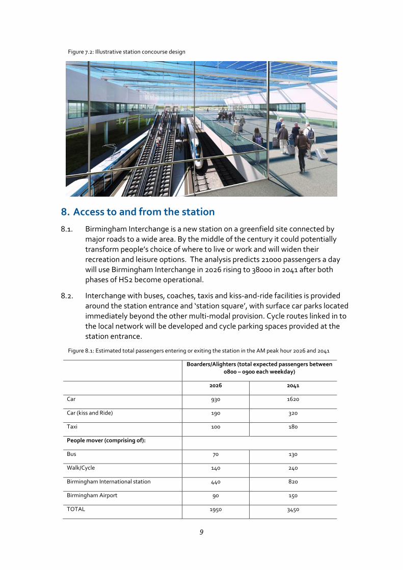
Figure 7.2: Illustrative station concourse design
8. Access to and from the station
Birmingham Interchange is a new station on a greenfield site connected by major roads to a wide area. By the middle of the century it could potentially transform people’s choice of where to live or work and will widen their recreation and leisure options. The analysis predicts 21000 passengers a day will use Birmingham Interchange in 2026 rising to 38000 in 2041 after both phases of HS2 become operational.
Interchange with buses, coaches, taxis and kiss-and-ride facilities is provided around the station entrance and ‘station square’, with surface car parks located immediately beyond the other multi-modal provision. Cycle routes linked in to the local network will be developed and cycle parking spaces provided at the station entrance.
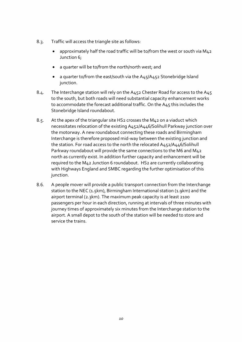
Figure 8.1: Estimated total passengers entering or exiting the station in the AM peak hour 2026 and 2041
Boarders/Alighters (total expected passengers between 0800 – 0900 each weekday)
2026 2041
Car 930 1620
Car (kiss and Ride) 190 320
Taxi 100 180
People mover (comprising of):
Bus 70 130
Walk/Cycle 140 240
Birmingham International station 440 820
Birmingham Airport 90 150
TOTAL 1950 3450
10
Traffic will access the triangle site as follows:
approximately half the road traffic will be to/from the west or south via M42 Junction 6;
a quarter will be to/from the north/north west; and
a quarter to/from the east/south via the A45/A452 Stonebridge Island junction.
The Interchange station will rely on the A452 Chester Road for access to the A45 to the south, but both roads will need substantial capacity enhancement works to accommodate the forecast additional traffic. On the A45 this includes the Stonebridge Island roundabout.
At the apex of the triangular site HS2 crosses the M42 on a viaduct which necessitates relocation of the existing A452/A446/Solihull Parkway junction over the motorway. A new roundabout connecting these roads and Birmingham Interchange is therefore proposed mid-way between the existing junction and the station. For road access to the north the relocated A452/A446/Solihull Parkway roundabout will provide the same connections to the M6 and M42 north as currently exist. In addition further capacity and enhancement will be required to the M42 Junction 6 roundabout. HS2 are currently collaborating with Highways England and SMBC regarding the further optimisation of this junction.
A people mover will provide a public transport connection from the Interchange station to the NEC (1.5km), Birmingham International station (1.9km) and the airport terminal (2.3km). The maximum peak capacity is at least 2100 passengers per hour in each direction, running at intervals of three minutes with journey times of approximately six minutes from the Interchange station to the airport. A small depot to the south of the station will be needed to store and service the trains.
11
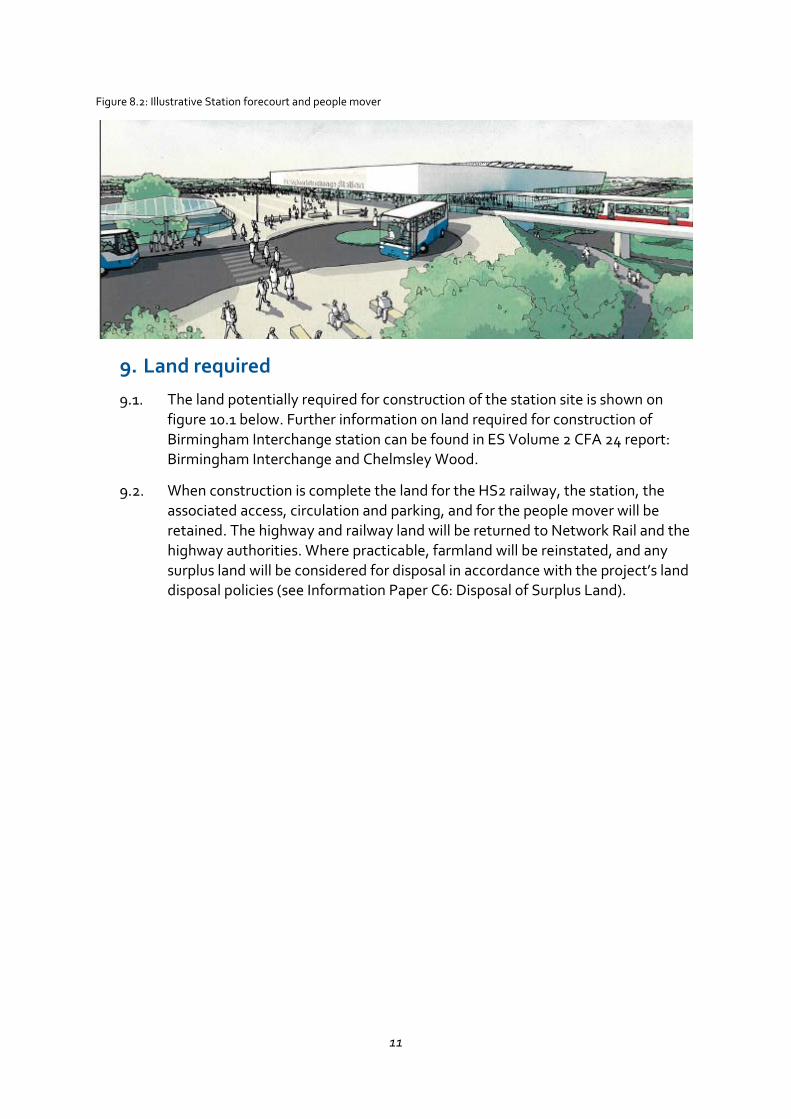
Figure 8.2: Illustrative Station forecourt and people mover
9. Land required
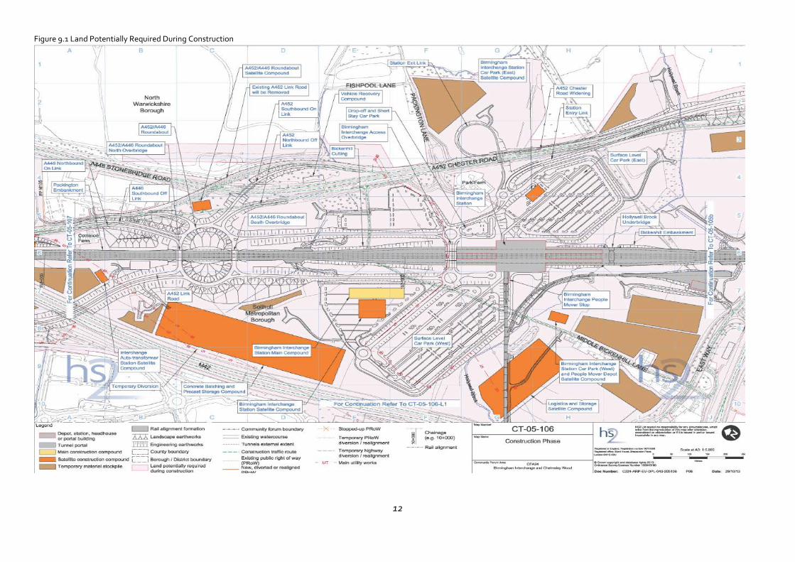
The land potentially required for construction of the station site is shown on figure 10.1 below. Further information on land required for construction of Birmingham Interchange station can be found in ES Volume 2 CFA 24 report: Birmingham Interchange and Chelmsley Wood.
When construction is complete the land for the HS2 railway, the station, the associated access, circulation and parking, and for the people mover will be retained. The highway and railway land will be returned to Network Rail and the highway authorities. Where practicable, farmland will be reinstated, and any surplus land will be considered for disposal in accordance with the project’s land disposal policies (see Information Paper C6: Disposal of Surplus Land).
12
Figure 9.1 Land Potentially Required During Construction
13
10. Construction
The construction site at Birmingham interchange will accommodate not only construction of the railway and station building, but also major works to provide access to the strategic road network, to lay out the car parks, landscape and areas of environmental mitigation. Implementation of the proposed scheme will require major earthworks for the cuttings, embankments, re-profiling and landscaping and to provide ‘balancing ponds’ to collect flood water during periods of heavy rainfall. It will take approximately six years from 2017 to complete all the works.
The main construction compound will be located within the footprint of the station between Middle Bickenhill Lane and the M42. This compound will provide for the civil engineering works predominantly for the station, internal road network, car parks, earthworks and utility diversions; and watercourse realignments.
11. Environmental effects
The Environmental Statement details all the significant environmental effects of building the Interchange station in CFA Report 24. Main effects include:
demolition of one dwelling and the Olympia Motorcycle Track;
temporary loss of 176ha of agricultural land. Of this total, 83ha will be restored and available for agricultural use following construction;
some sand and gravel extraction may be affected by the construction of the station;
the topography of the land and vegetation patterns will be significantly altered as will be the appearance of the local landscape, because the station building, people mover, car parks and road and railway embankments will be highly visible. Over time the visual effects will reduce as the planting matures;
temporary or permanent loss of car parking at the NEC, Birmingham International Station, the airport, the National Motorcycle Museum and the Melbicks Garden and Leisure Centre; and
reduced accessibility for the remaining properties in Middle Bickenhill Lane as it will become a cul-de sac.
During construction, noise, atmospheric emissions and other adverse environmental effects will be controlled in accordance with the ‘Environmental Minimum Requirements’ including the Code of Construction Practice (CoCP), which will include a range of mitigation measures to reduce impacts as far as reasonably practicable. It also makes provision for the preparation of local environmental management plans (LEMPs) to include local environmental and
14
community protection measures. Contractors are required to manage noise, dust, air pollution, odour and exhaust emissions during construction works.
Details of the proposed environmental regime can be found in the HS2 Environmental Statement in Volume 2, CFA4 Report, the Draft Code of Construction Practice and the Environmental Memorandum. The environmental protection regime is described in Information Paper E1: Control of Environmental Impacts. Amongst other things, specific mitigation measures include:
flood risk mitigation including provision of ‘balancing ponds’;
reinstatement of 83ha of agricultural land;
replacement woodland and pasture to compensate for the areas that would be lost; and
extensive landscaping and planting around the station, car parks, access roads and junctions.
12. Regeneration opportunities
The fast connections to Britain’s major conurbations that HS2 will provide potential for major regeneration and development not only in the immediate areas around the station but also in the station catchment area in the wider sub-region. However, the station is within the West Midlands Green Belt. In June 2013 SMBC and the Greater Birmingham Local Enterprise Partnership published an initial UK Central masterplan that describes the potential economic opportunity of the location and how it might be reconciled with environmental considerations.
The masterplan is a ‘vision setting document’ for the creation of 100,000 jobs in Solihull Metropolitan Borough over the next 30 years. For the ‘Hub’ area around the airport, NEC and Interchange station, it envisages commercial and residential development on the triangle site, upgrading the NEC, expansion of the airport and related commercial activities, and expansion of Birmingham Business Park. Together this would add an estimated 30000 jobs.
As the triangle site is currently designated green belt, in November 2014 SMBC consulted on a new Local Area Plan for the interchange station and surrounding area. This consultation indicated the benefits of reviewing the HS2 Interchange area in the context of a wider Borough review and the Council is therefore now undertaking a Local Plan Review. A draft submission plan will be published in 2016-17 following further consultation.
In the meantime the Promoter has been in discussion with SMBC and the landowners on how best to plan the HS2 works to facilitate development in the surrounding area.
15
13. Undertakings and Assurances
During the hybrid Bill process the Promoter has provided a number of undertakings and assurances, including undertakings agreed with SMBC. The Register of Undertakings and Assurances is published online. As the Bill passes through the House of Lords prior to Royal Assent, the Promoter may provide further undertakings and assurances if it is appropriate to do so. The Register will therefore be updated periodically. The latest version of the Register is available at:
https://www.gov.uk/government/publications/high-speed-rail-london-west-midlands-billregister-of-undertakings-and-assurances
In relation to the Interchange Station, the undertakings to SMBC include the design principles summarised in Section 7 and assurance on the following issues:
Joint development of design
The Promoter and the Council will work together with the aim of agreeing a design for the station having regard to the design principles, the UK Central prospectus and the M42 Economic Gateway Masterplan.
A design panel will be set up by the Council and the Promoter to review the station proposals prior to the Promoter seeking formal approval of the design details.
The parties have also agreed to cooperate on implementation and timely completion of the Interchange station.
Development of alternative arrangement at junction 6 of the M42
Cooperation with Highways England to facilitate the development of their alternative arrangement.
Maximisation of development land
Consideration of the proposed car parking, flood mitigation and landscaping arrangements with a view to making the most efficient use of the land and maximising the land available for development.
Connectivity
Consideration of the proposed connectivity across the high-speed rail corridor for pedestrians, cyclists and vehicles in the vicinity of the Birmingham Interchange Station and within the green corridor along Hollywell Brook.
Balancing ponds
Review water attenuation options with a view to using smaller scale ponds, ditches and swales where reasonably practicable.

16
Other issues
Minimisation of loss of mature trees and established woodland, screening at Marsh Farm and hedgerow planting are also to be reviewed. As part of the assurances other issues such as inclusive design and cycle connectivity across the site are to be addressed.
14. More information
More detail on the Bill and related documents can be found at: www.gov.uk/HS2