high speed 2 strategic alternatives study … baselining report.doc high speed 2 strategic...
TRANSCRIPT
5087288/Final Baselining Report.doc
High Speed 2 Strategic Alternatives Study
Baseline Report
March 2010 Notice This report was produced by Atkins on behalf of the DfT for the High Speed 2 Strategic Alternatives Study.
This report may not be used by any person other than DfT without their express permission. In any event, Atkins accepts no liability for any costs, liabilities or losses arising as a result of the use of or reliance upon the contents of this report by any person other than DfT.
Document History
JOB NUMBER: 5087288 DOCUMENT REF: Baselining Report_001 v5.doc
3 FINAL JA JF JT JT 04-03-10
2 FINAL DRAFT JA JF JT JT 08-12-09
1 DRAFT JA/ JF JF JT JT 24-9-09
Revision Purpose Description Originated Checked Reviewed Authorised Date

HS2 Strategic Alternatives Study: Baseline Report
/Final Baselining Report.doc 2
Contents Section Page 1. Introduction 3 1.1 Structure of this Report 3 2. Do Minimum Assumptions 4 2.1 Introduction 4 2.2 Rail Supply 5 2.3 Rail Demand 8 2.4 Road Supply 9 2.5 2031 Road Network 14 2.6 Road Demand 17 3. Future Travel Conditions 18 3.1 Introduction 18 3.2 Rail 18 3.3 Highway 23 4. Conclusions 28 List of Tables
Table 2.1 – Future Year Do Minimum Rail Schemes along London – Birmingham Corridor 6 Table 2.2 – Do Minimum Rail Forecast Demand 8 Table 2.3 – 2021 Do Minimum Road Schemes within HS2 Strategic Alternatives Study Area 11 Table 2.4 - 2031 Do Minimum Road Schemes within HS2 Strategic Alternatives Study Area (in addition to
the 2021 schemes) 14 Table 2.5 – HS2 Forecast Strategic Highway Demand Matrices 17 Table 3.1 – Do Minimum Forecast Rail Demand 18 Table 3.2 – Forecast Highway Demand Matrices 23
List of Figures
Figure 2.1 – 2021 & 2031 Do Minimum Committed Rail Schemes 7 Figure 2.2 – 2008 Existing Motorway Network London – Birmingham Corridor 10 Figure 2.3 – 2021 Do Minimum Committed Motorway Schemes in the London – Birmingham Corridor 12 Figure 2.4 – 2021 Do Minimum Motorway Network London – Birmingham Corridor 13 Figure 2.5 – 2031 Do Minimum Committed Motorway Schemes in London – Birmingham Corridor 15 Figure 2.6 – 2031 Do Minimum Motorway Network London – Birmingham Corridor 16 Figure 3.1 – PLANET WCML & Chiltern Line Long Distance Rail Passenger Volumes (two way) 20 Figure 3.2 – PLD Rail Seated Capacity (16 hour 2 way) on WCML & Chiltern Long Distance Services 21 Figure 3.3 - PLANET WCML & Chiltern Line Long Distance Rail Passenger Crowding 22 Figure 3.4 – Forecast Average Hourly Two-Way Traffic Volumes (Observed Flows) 25 Figure 3.5 – Forecast Peak Hour Volume over Capacity Southbound and Eastbound (Observed Flows) 26 Figure 3.6 – Forecast Peak Hour Volume over Capacity Northbound and Westbound (Observed Flows) 27
HS2 Strategic Alternatives Study: Baseline Report
/Final Baselining Report.doc 3
1. Introduction At the start of 2009, HS2 Ltd was established to investigate the case for a new high speed railway between London, the West Midlands and potentially beyond. Subsequently, Atkins was appointed by the Department for Transport (DfT), to consider, at a high level, potential road and rail improvement options as potential strategic alternatives to a high speed rail proposition. This study therefore looks at a range of road and rail interventions between London and the West Midlands, which could effectively increase capacity in line with forecast demand.
This Baseline Report is a summary of the first stage of identifying such interventions. In this first stage it is essential to understand the planned and committed rail and road infrastructure that are likely to be constructed in a given future year scenario, in conjunction with future year demand.
This report summarises the forecast future year network and the assumptions behind their development. It discusses the future year demand and how this interacts with the transport network in terms of the future year travel conditions. By clearly outlining the forecast base case ‘Do Minimum’ travel conditions, options can be appropriately developed that address these issues.
The modelling framework developed for use by HS2 Ltd. study is used in this study. All the baseline assumptions that have been documented in this report are taken from the HS2 Ltd. baseline as of late November 2009. This ensures that the strategic alternative improvements are examined on the same basis as the HS2 Ltd. scheme.
1.1 Structure of this Report The remainder of this report is structured as follows:
• Chapter 2 outlines the assumptions that were adopted in the HS2 Ltd. Do Minimum scenario. In order to ensure consistency between the two studies, these assumptions will be adopted in this study;
• Chapter 3 summarises the forecast Do Minimum travel conditions in both 2021 and 2031. Understanding these conditions is essential prior to developing options aimed at improving travel conditions in the future;
• Chapter 4 summarises the findings and draws conclusions from this report.
HS2 Strategic Alternatives Study: Baseline Report
/Final Baselining Report.doc 4
2. Do Minimum Assumptions 2.1 Introduction
For HS2 Ltd., Atkins developed an integrated framework of PLANET models to assess the interaction of long-distance WCML services with local demand on the important Coventry – New Street and Milton Keynes – Euston corridors, as well as take into account the potentially multi-modal effects. The modelling framework also includes a Heathrow Access Model, to allow explicit consideration of improvements to rail access to Heathrow Airport whether by conventional or high speed rail.
The PLANET modelling framework comprises the following models:
• PLANET Long Distance – a strategic multi-modal model covering all day demand (16 hours), including rail, road and air modes.
• PLANET Midlands – an AM peak rail only model focussing on services into Birmingham; and
• PLANET South – an AM peak rail only model focussing on services into London.
• Airport access model (spreadsheet based).
Within this framework, a Base Year 2007/ 08 Model was developed, along with two future year ‘Do Minimum’, or Reference Case scenarios, 2021 and 2031. It is noted that the Base Year 2007/ 08 Model does not include the December 2008 timetable changes on the WCML.
The same future year scenarios and assumptions have been adopted in this study, in order to ensure consistency with HS2 Ltd. These assumptions conform to the recently published DfT forecasting guidance, as summarised in webTAG unit 3.15.5. This allows direct comparisons to be made between the options developed in this study, and HS2.
The HS2 Strategic Alternatives Study area is broadly defined as between the West Midlands and London, as follows:
• On the highway side, this includes the M1/M6 and the M40 between London and the West Midlands. The effective limit of the study area to the north is the Birmingham Motorway Box, including the M6 as far as J12 and the M42 as far as J9. However, the adjacent highway network will be assessed in the event of forecast substantial impacts. At the London end the focus will be on links onto the M25, and into Heathrow Airport. It is noted that any enhancements to central London access should be provided primarily by enhanced or new public transport, potentially by the provision of a ‘parkway’ near the M25.
• On the rail side, this broadly includes the West Coast Main Line between London Euston and the West Midlands (and Trent Valley) and the Chiltern Line between London Marylebone and the West Midlands.
The following sections outline the road and rail schemes that are assumed to be implemented between 2008 and the forecast future years being considered. These schemes, together with their associated demand, form the basis of the future year Do Minimum networks.
HS2 Strategic Alternatives Study: Baseline Report
/Final Baselining Report.doc 5
2.2 Rail Supply In developing the HS2 Ltd. future year Do Minimum scenarios, rail schemes up to 2019 were identified , using the following sources:
• The Network Rail Strategic Business Plan (to 2014);
• The TfL Business Plan (to 2019); and
• Timetable/ capacity enhancements included within the DfT Network Modelling Framework (NMF), to 2019. The NMF is a strategic model the DfT use to assist policy formulation. The most recent version was developed earlier this year and is documented in a report dated May 2009.
No additional schemes were appropriate to incorporate into the models beyond 2019, such that the future year rail networks are assumed to be consistent between 2021 and 2031.
Depending on the type of proposed rail upgrade and its geographical location, the scheme was incorporated into the appropriate models Future Year Do Minimum scenario.
The DfT provided the actual timetables from the NMF for both the base year and future years. Since the base year 2007/ 08 rail transit lines were developed directly from these timetables, in order to ensure consistency with wider government policy, the future year timetables were also converted into emme2 format, for direct use in the model.
It is noted that some of the schemes in CP4, including Access for All, Network Rail Discretionary Fund, and National Stations Improvement Programme do not impact on the PLANET modelling and for this reason were not incorporated into the modelling process.
In addition, although the PLANET Long Distance model includes representative London Underground links between key national rail stations, these are for the purpose of allowing interchange between key rail services. Since this is represented in more detail in PLANET South, Underground improvements were not incorporated into the PLANET Long Distance model.
For the HS2 Ltd. study, strategic rail schemes across Great Britain were identified for inclusion in the future year Do Minimum scenarios. Whilst these schemes are included in the Do Minimum scenarios, for the purposes of this study, only those which affect the West Coast Main Line between London Euston and the West Midlands (and Trent Valley) and the Chiltern Line between London Marylebone and the West Midlands have been highlighted.
2.2.1 Future Year Do Minimum Rail Network The 2021 and 2031 Do Minimum rail networks are considered to be identical for modelling purposes within the PLANET framework. Although only the proposals which broadly affect the West Coast Main Line between London Euston and the West Midlands (and Trent Valley) and the Chiltern Line between London Marylebone and the West Midlands have been highlighted, other wider schemes are considered appropriate to be included, such as Crossrail, which will provide a significant link when open.
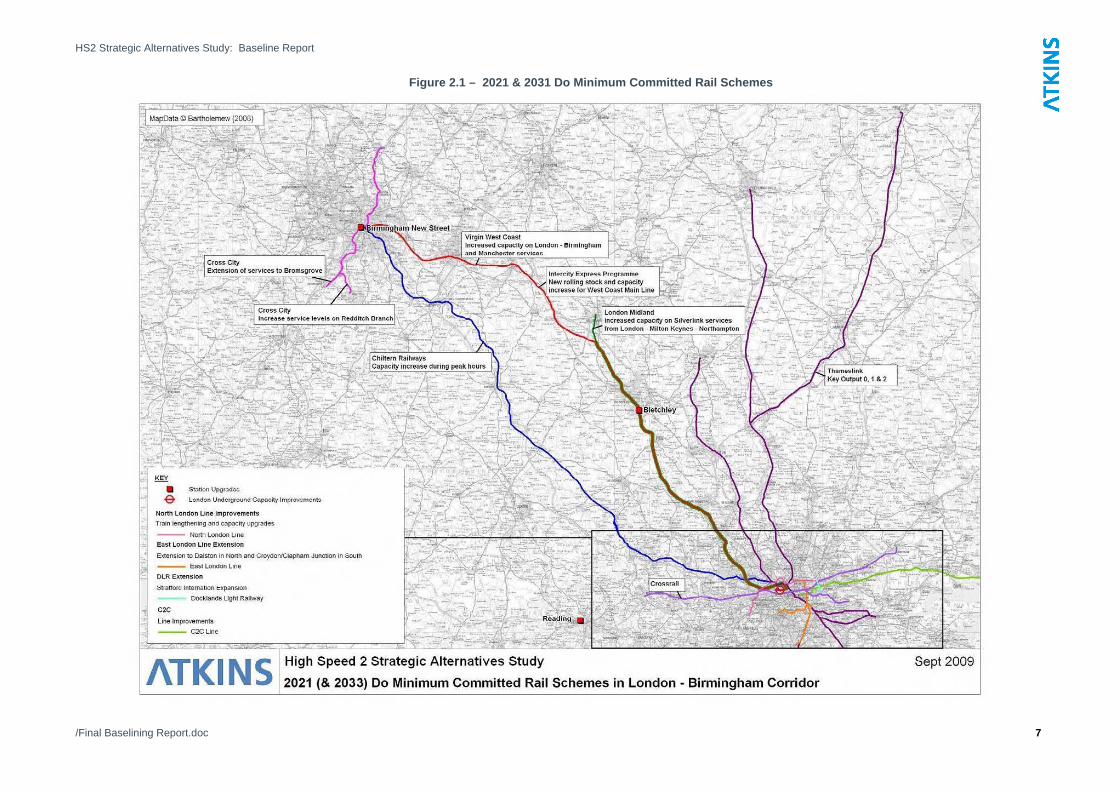
The following table summarises the future year Do Minimum rail schemes within the study area. In addition, these are summarised graphically on Figure 2.1.

HS2 Strategic Alternatives Study: Baseline Report
/Final Baselining Report.doc 6
Table 2.1 – Future Year Do Minimum Rail Schemes along London – Birmingham Corridor
Scheme Control Period\
Completion Date
Scheme Classification (for model inclusion) Source
Strategic Midlands South
Thameslink Key Output 0 2009 NMF\ Network Rail
Intercity Express Programme (IEP) – new rolling stock enabling capacity increase and associated timetable changes as per IEP business case. This includes IEP replacement services running on the East Coast Main Line, the Great Western Main Line and the West Coast Main Line
CP4 - 2014 NMF\ Network Rail
Reading Station Area Redevelopment CP4 - 2014 Network Rail
Birmingham New Street Rebuild CP4 - 2014 Network Rail Bletchley – Milton Keynes Station Upgrade CP4 - 2014 Network Rail Extension of (Birmingham) cross city services to Bromsgrove CP4 - 2014 Network Rail Increase Service levels - Redditch Branch CP4 - 2014 Network Rail London Midland HLOS – improved capacity on London Euston-Milton Keynes-Northampton services;
2014 NMF
Thameslink Key Output 1- including four Brighton to Bedford trains per direction, per peak. Thameslink services are diverted from London Bridge
2014 NMF\ Network Rail
Virgin West coast – including increased capacity on Birmingham and Manchester to London Euston services
2014 NMF
Chiltern Railway Chiltern Peak Strengthening – based on HLOS option subfolder LSE Chiltern Option v1
2014 NMF
London Underground Improvements: -Piccadilly Line - District Line - Circle Line - Hammersmith Line - Metropolitan Line - Jubilee Line - 3 car operations on Docklands Light Rail
2012 - 2020 TfL
Thameslink Key Output 2 – new timetable specification and increased capacity for Thameslink and Great Northern services
2019 NMF
Crossrail – including service amendments between Reading and Paddington and Liverpool St and Shenfield
2019 NMF\TfL
Stratford International Extension 2010 TfL
East London Line- Extension to Dalston in the north and Croydon/Clapham junction in the south
2012 TfL
North London Line train lengthening & capacity upgrades 2012 TfL/|NR
C2C – the HLOS option subfolder LSE c2c Option v1 2014 NMF
HS2 Strategic Alternatives Study: Baseline Report
/Final Baselining Report.doc 7
Figure 2.1 – 2021 & 2031 Do Minimum Committed Rail Schemes

HS2 Strategic Alternatives Study: Baseline Report
/Final Baselining Report.doc 8
Of particular interest to this study are the following:
• WCML – station upgrade at Birmingham New Street and Bletchley remodelling;
• WCML - nine-car Class 390 units assumed to be lengthened to eleven-cars;
• WCML – IEP capacity increases via new rolling stock; and
• Chiltern Line – capacity increase through train lengthening in the peaks.
2.3 Rail Demand Demand modelling for this study used the same approach as that of HS2 Ltd. The rail demand assumptions used within the HS2 Ltd. model framework were consistent with the assumptions underpinning the NMF modelling undertaken by DfT. Passenger Demand Forecast Handbook (PDFH 4.1) guidance was applied within the framework of “EDGE” (Exogenous Demand Growth Estimation).
The EDGE assignment used the 2004 NMF base data for demand and revenue. All demand drivers except for fares, GVA, employment and population were supplied by the DfT. Fares were assumed to rise at a rate of RPI +1% for all ticket types while employment and population drivers we obtained from TEMPRO 5.4.
GDP forecasts were used which take account of the recession with capped long distance elasticities. Demand growth is capped at the level forecast to occur in 2031 before the recession although under the new GDP scenario this will be reached at a later date (2033).
Initial forecast demand matrices were produced for the three PLANET models, with the overall growth in demand indicated.
Table 2.2 – Do Minimum Rail Forecast Demand
Model 2008 Demand 2021 Demand % Growth (2008 to 2021)
2033 Demand % Growth (2008 to 2033)
PLANET South 1,549,812 1,973,585 27% 2,269,642 46%
PLANET Midlands 34,436 40,507 18% 49,384 43%
PLANET Strategic 974,804 1,249,825 28% 1,583,300 62%
This shows that strategic demand is forecast to increase significantly, by over 60% between 2008 and 2033. Local demand increases are still noteworthy, with growth in PLANET Midlands and PLANET South forecast to be in excess of 40% between 2008 and 2033.

HS2 Strategic Alternatives Study: Baseline Report
/Final Baselining Report.doc 9
2.4 Road Supply Only PLANET Long Distance includes a highway element. Due to the strategic representation of the highway network within the PLANET Long Distance model, only schemes on sections of the strategic highway network were incorporated into the Do Minimum Scenarios. No junction improvement schemes were included as the model functionality does not include this level of detail.
In developing its future year Do Minimum road network, the HS2 Ltd. study used two key sources of data as follows:
• The Highways Agency Business Plan 2009-10. This contains the Highways Agency forward workload, through to 2015; and
• Beyond 2015, in order to ensure the inclusion of the ‘most likely given published plans’ schemes, the DfT provided a list of road schemes that were included within the National Transport Model (NTM), broadly ensuring consistency with the Motorways and Major Trunk Roads Paper, January 2009.
For the HS2 Ltd. study, strategic highway infrastructure schemes across Great Britain were identified for inclusion in the future year Do Minimum scenarios. Whilst these schemes are included in the Do Minimum scenarios, for the purposes of this study, only those which broadly fall along the M1/ M6 and the M40 between London and the West Midlands have been highlighted.
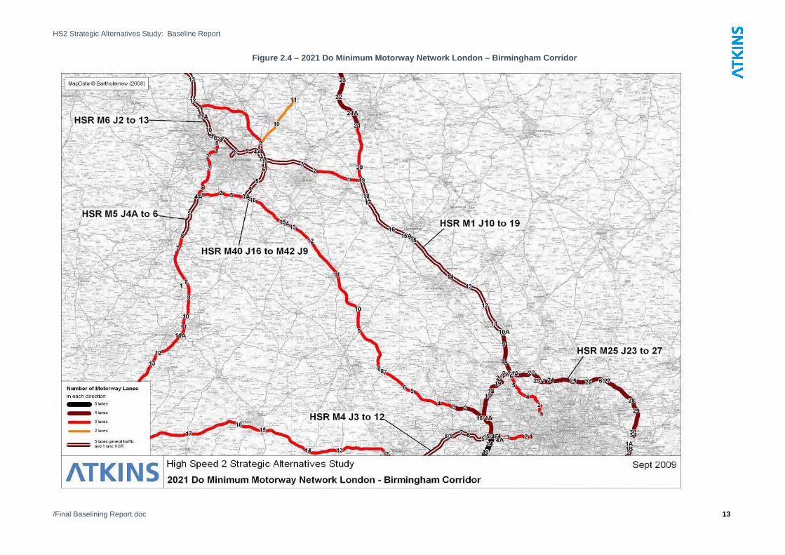
The existing 2008 Do Minimum highway network within our study area is indicated in Figure 2.2.

HS2 Strategic Alternatives Study: Baseline Report
/Final Baselining Report.doc 10
Figure 2.2 – 2008 Existing Motorway Network London – Birmingham Corridor
HS2 Strategic Alternatives Study: Baseline Report
/Final Baselining Report.doc 11
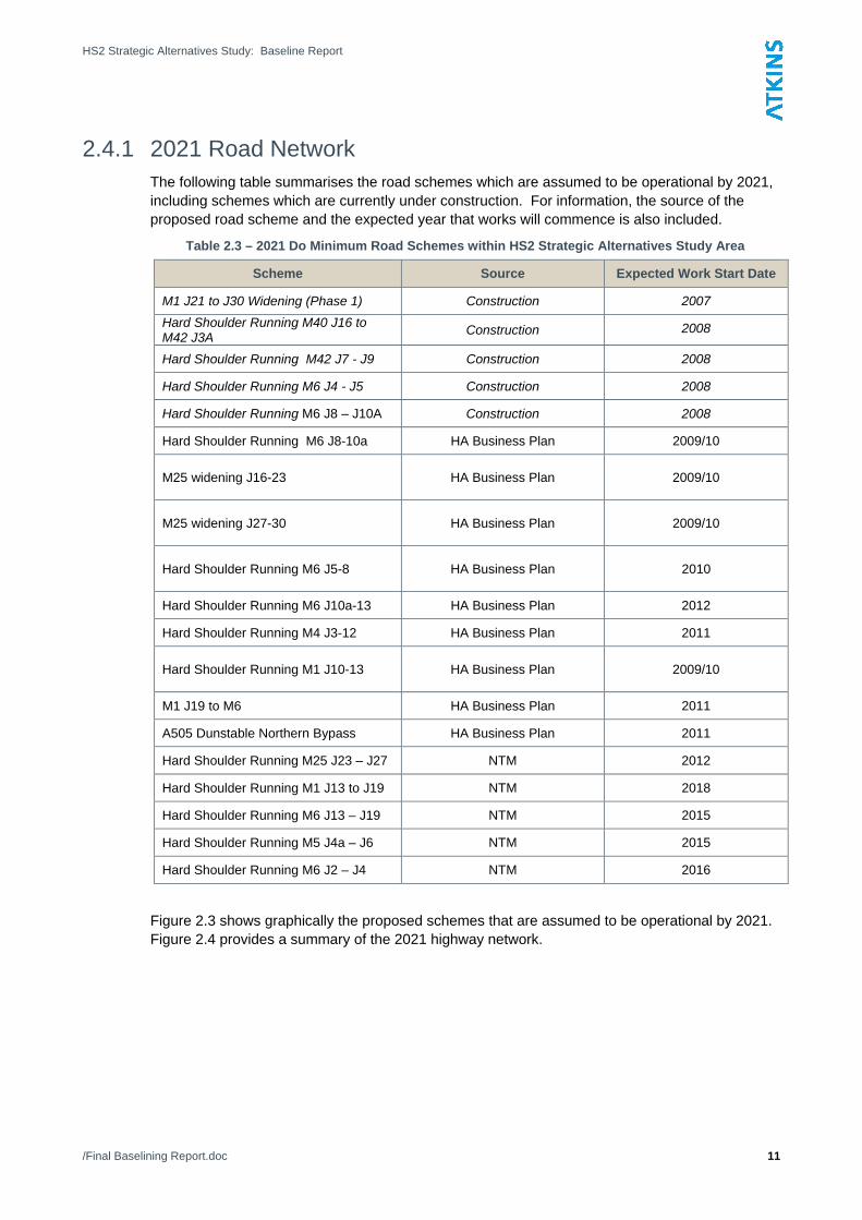
2.4.1 2021 Road Network The following table summarises the road schemes which are assumed to be operational by 2021, including schemes which are currently under construction. For information, the source of the proposed road scheme and the expected year that works will commence is also included.
Table 2.3 – 2021 Do Minimum Road Schemes within HS2 Strategic Alternatives Study Area
Scheme Source Expected Work Start Date
M1 J21 to J30 Widening (Phase 1) Construction 2007 Hard Shoulder Running M40 J16 to M42 J3A Construction 2008
Hard Shoulder Running M42 J7 - J9 Construction 2008
Hard Shoulder Running M6 J4 - J5 Construction 2008
Hard Shoulder Running M6 J8 – J10A Construction 2008
Hard Shoulder Running M6 J8-10a HA Business Plan 2009/10 M25 widening J16-23
HA Business Plan 2009/10
M25 widening J27-30
HA Business Plan 2009/10
Hard Shoulder Running M6 J5-8
HA Business Plan 2010
Hard Shoulder Running M6 J10a-13 HA Business Plan 2012
Hard Shoulder Running M4 J3-12 HA Business Plan 2011 Hard Shoulder Running M1 J10-13
HA Business Plan 2009/10
M1 J19 to M6 HA Business Plan 2011
A505 Dunstable Northern Bypass HA Business Plan 2011
Hard Shoulder Running M25 J23 – J27 NTM 2012
Hard Shoulder Running M1 J13 to J19 NTM 2018
Hard Shoulder Running M6 J13 – J19 NTM 2015
Hard Shoulder Running M5 J4a – J6 NTM 2015
Hard Shoulder Running M6 J2 – J4 NTM 2016
Figure 2.3 shows graphically the proposed schemes that are assumed to be operational by 2021. Figure 2.4 provides a summary of the 2021 highway network.

HS2 Strategic Alternatives Study: Baseline Report
/Final Baselining Report.doc 12
Figure 2.3 – 2021 Do Minimum Committed Motorway Schemes in the London – Birmingham Corridor
HS2 Strategic Alternatives Study: Baseline Report
/Final Baselining Report.doc 13
Figure 2.4 – 2021 Do Minimum Motorway Network London – Birmingham Corridor

HS2 Strategic Alternatives Study: Baseline Report
/Final Baselining Report.doc 14
2.5 2031 Road Network Beyond 2021, the National Transport Model (NTM) included two additional road schemes which are within the study area. These are indicated in the following table, and summarised in Figures 2.5 & 2.6.
Table 2.4 - 2031 Do Minimum Road Schemes within HS2 Strategic Alternatives Study Area (in addition to the 2021 schemes)
Scheme Source Expected Work Start Date Hard Shoulder Running M6 J8 – M5 J2 NTM 2019
Hard Shoulder Running M5 J2 – J4 NTM 2019
By 2031 the key implications for the motorway network are as follows:
• M40 J3 – J16 remains at 3 lanes and J1A to J3 4 lanes;
• M1 from M25 to M6 effectively 4 lanes with HSR operating between M1 J10-19;
• M6 from M1 to J2 3 lanes;
• M6 HSR operating between J2 – J13; and
• M5 HSR operating between J4 to M6 J8.

HS2 Strategic Alternatives Study: Baseline Report
/Final Baselining Report.doc 15
Figure 2.5 – 2031 Do Minimum Committed Motorway Schemes in London – Birmingham Corridor

HS2 Strategic Alternatives Study: Baseline Report
/Final Baselining Report.doc 16
Figure 2.6 – 2031 Do Minimum Motorway Network London – Birmingham Corridor

HS2 Strategic Alternatives Study: Baseline Report
/Final Baselining Report.doc 17
2.6 Road Demand In order to ensure consistency with DfT guidance, this study and that of HS2 Ltd adopted the approach outlined in webTAG unit 3.15.2 when developing the future year road demand forecasts. This included using TEMPRO 5.4 to calculate growth factors by purpose (business, commuting and other). Growth at Heathrow airport was based on the forecasts from the SKM Surface Access Model, which was developed on behalf of the DfT.
Only PLANET Long Distance includes a highway element, therefore demand matrices were only developed for this model. Furthermore, the highway matrices exclude trips that are less than 50 miles in length, as it is assumed that these will not transfer to the strategic rail network. To ensure that appropriate flows are represented on the highway network within the modelling process, the local trips are assigned via a pre-load.
The ‘strategic’ highway demand matrices are summarised in Table 2.5.
Table 2.5 – HS2 Forecast Strategic Highway Demand Matrices
Sector 2007/08 Matrix Total
2021 Matrix Total
2008 -2021 % Increase
2031 Matrix Total
2021 -2031 % Increase
2008- 2031 % Increase
Business 1,340,083 1,655,263 24% 1,902,849 15% 42%
Other 2,103,305 2,739,340 30% 3,139,585 15% 49%
Commuter 1,335,254 1,612,916 21% 1,825,618 13% 37%
Total 4,780,650 6,009,540 26% 6,870,083 14% 44%
This indicates that highway usage between 2008 and 2021 is forecast to grow by approximately 26%. Further growth of 14% is forecast between 2021 and 2031, giving a total increase in strategic highway trips of 44% between 2008 and 2031.
HS2 Strategic Alternatives Study: Baseline Report
/Final Baselining Report.doc 18
3. Future Travel Conditions 3.1 Introduction
Chapter 2 outlined the key assumptions that were adopted in developing the HS2 Ltd. Do Minimum scenarios. This section summarises the likely magnitude of demand and its associated pressures on the rail and road network within the study area, in both 2021 and 2031.
3.2 Rail 3.2.1 Rail Demand
The forecast rail demand and its associated growth was discussed in more detail in Section 2.3, is summarised in Table 3.1.
Table 3.1 – Do Minimum Forecast Rail Demand
Model 2008 Demand 2021 Demand % Growth (2008 to 2021)
2033 Demand % Growth (2008 to 2033)
PLANET South 1,549,812 1,973,585 27% 2,269,642 46%
PLANET Midlands 34,436 40,507 18% 49,384 43%
PLANET Long Distance 974,804 1,249,825 28% 1,583,300 62%
This indicates that long distance trips, as represented in the PLANET Long Distance are forecast to have the highest growth rate, with demand increasing by over 60% between now and 2031. Demand in the local models, PLANET Midlands and PLANET South is forecast to increase by over 40%. This represents a considerable increase in demand from today’s levels.
3.2.2 Forecast Implications for Travel on the Rail Network In order to determine the forecast implications for both passenger volumes and crowding in the London to Birmingham corridor, analysis was initially undertaken in the PLANET Long Distance model. Crowding is defined as a proportion of the total passenger numbers to seated capacity.
The PLD model is an all day (16 hour) model. Outputs from the model, showing only WCML long distance services currently operated by Virgin trains are included, while the long distance Chiltern services, ie those going to Banbury or beyond in a northbound direction, or High Wycombe and beyond in a southbound direction, are summarised in Figures 3.1, 3.2 & 3.3.
The following key observations were noted:
• Demand on the WCML long distance services is likely to increase by almost 140% up to 2033, with forecast (two-way) daily passenger volumes increasing from approximately 44,500 to 105,700. This is considerably larger than the average rail growth of 62%. However, it is noted that the PLD 2007/8 demand on the WCML does not include the effect of the higher service frequencies on some routes in the December 2008 timetable. This has led to a significant increase in trips such that the base year modelled flows on this line are lower than current patronage figures;
• The capacity of WCML long distance services, north of Milton Keynes is forecast to increase by 54% between 2007/ 08 and 2021;

HS2 Strategic Alternatives Study: Baseline Report
/Final Baselining Report.doc 19
• Demand on the WCML is forecast to increase by almost 60% between 2021 and 2033, a period of substantial growth, when no additional capacity measures are planned;
• The forecast demand increase on the WCML is significant and the crowding plots suggest that the growth in demand is likely to be greater than the capacity increases, as crowding levels are likely to increase from approximately 50% to almost 80%;
• Passenger demand on the Chiltern line is highest south of Oxford and is forecast to increase by approximately 35% between 2008 and 2033 from 7,950 to 10,600 two way passenger trips;
• The capacity of the long distance Chiltern line services is forecast to increase by 40% by 2021; and
• Passenger crowding levels along the Chiltern line are much lower than the WCML, with existing crowding levels at approximately 35% in both 2008 and 2033.

HS2 Strategic Alternatives Study: Baseline Report
/Final Baselining Report.doc 20
Figure 3.1 – PLANET WCML & Chiltern Line Long Distance Rail Passenger Volumes (two way)

HS2 Strategic Alternatives Study: Baseline Report
/Final Baselining Report.doc 21
Figure 3.2 – PLD Rail Seated Capacity (16 hour 2 way) on WCML & Chiltern Long Distance Services

HS2 Strategic Alternatives Study: Baseline Report
/Final Baselining Report.doc 22
Figure 3.3 - PLANET WCML & Chiltern Line Long Distance Rail Passenger Crowding

HS2 Strategic Alternatives Study: Baseline Report
/Final Baselining Report.doc
3.3 Highway 3.3.1 Highway Demand
The strategic highway demand (ie excluding local trips of less than 50 miles) is summarised in Section 2.6. As summarised in Table 3.2, demand increases by over 25% up to 2021 and over 40% to 2031. As per the rail demand, this represents a significant increase in demand.
Table 3.2 – Forecast Highway Demand Matrices
Sector 2007/08 Matrix Total
2021 Matrix Total
2008 -2021 % Increase
2031 Matrix Total
2021 -2031 % Increase
2008- 2031 % Increase
Business 1,340,083 1,655,263 24% 1,902,849 15% 42%
Other 2,103,305 2,739,340 30% 3,139,585 15% 49%
Commuter 1,335,254 1,612,916 21% 1,825,618 13% 37%
Total 4,780,650 6,009,540 26% 6,870,083 14% 44%
3.3.2 Forecast Implications for Travel on Highway Network Whilst the PLANET model caters for strategic highway movements, incorporating the forecast future years demand and supply networks into PLD as described above, the main focus of the model is on rail flows. Upon examining the assigned highway flows from the PLD model it was considered that there were some routing anomalies between the M1\/M6 and M40 corridors. Furthermore initial runs indicated that the model was not sensitive to enough to undertake the detailed testing of highway packages, consequently the highway packages have been assessed using the DfT’s NTM (National Transport Model).
Whilst the above issues are not significant in the PLD Model, as the highway assignment is used essentially to generate costs for the mode split model, they are of more importance in identifying and designing potential highway interventions. Consequently in deriving the forecast base case ‘Do Minimum’ traffic conditions, for these purposes, traffic flows have been considered directly from traffic counts, for 2008, extracted from the Highways Agency TRADS database.
In considering the future year demand, the growth factors from the Road Transport Forecasts 2008 (RTF 08) were applied to the observed 2008 traffic flows, producing forecasts for 2021 and 2031. RTF08 gives similar growth forecasts to those in presented in Table 3.2 above, with increases of approximately 25% to 2021 and of 44% to 2031. Flows have been considered for the annual average hour mean traffic flow and for the highest peak hour.
In considering the capacity of the road network, the maximum realistic flow (QC), based on advice from the Highways Agency and considering the COBA manual speed flow curves, has been set at 2,000 vehicles per hour per lane for the purposes of this study. The same schemes identified in Section 2.4 have been considered when forecasting future year volume over capacity ratios.
Using the above methodology, Figure 3.4 summarises the forecast average hourly, two way traffic volumes on the highway network between Birmingham and London. Figures 3.5 and 3.6 show the peak hour volume over capacity ratio for southbound and northbound traffic flows respectively.
With relation to the peak hour volume over capacity Figures 3.5 and 3.6 show that by 2031:
• The western sections of the M25 are forecast to be operating at over 90% during the peak hour;
• The M40 between Oxford and London is forecast to be operating at over 100% capacity in the peak hour, reaching similar levels immediately to the north of Oxford;

HS2 Strategic Alternatives Study: Baseline Report
/Final Baselining Report.doc
• The M40 is forecast to have a volume over capacity of over 90% between Warwick and the Birmingham motorway box.
• The M42, both to the east and west of the M40, is forecast to be one of the most congested points on the network with a peak hour volume over capacity of up to 134% and generally are close to 100%.
• The M1 north of London is likely to be operating at over 100% capacity.
A comparison with results from PLD suggests that generally the same areas of the network are identified as being congested in the observed future years.

HS2 Strategic Alternatives Study: Baseline Report
/Final Baselining Report.doc 25
Figure 3.4 – Forecast Average Hourly Two-Way Traffic Volumes (Observed Flows)

HS2 Strategic Alternatives Study: Baseline Report
/Final Baselining Report.doc 26
Figure 3.5 – Forecast Peak Hour Volume over Capacity Southbound and Eastbound (Observed Flows)

HS2 Strategic Alternatives Study: Baseline Report
/Final Baselining Report.doc 27
Figure 3.6 – Forecast Peak Hour Volume over Capacity Northbound and Westbound (Observed Flows)

HS2 Strategic Alternatives Study: Baseline Report
/Final Baselining Report.doc 28
4. Conclusions In order to ensure consistency with the approach used by HS2 Ltd., the modelling framework developed for use by HS2 Ltd. is used in this study. This enables a comparison to be made between the options assessed in this study and the analysis undertaken by HS2 Ltd.
All the baseline assumptions documented in this report are consistent with the HS2 Ltd. baseline as of late November 2009.
Within the PLANET modelling framework, a Base Year 2007/ 08 Model was developed, along with two future year ‘Do Minimum’, or Reference Case scenarios, 2021 and 2031. The road and rail schemes that are assumed to be implemented within the study area – broadly defined as the West Midlands to London corridor – along with their associated demand, form the basis of the future year Do Minimum networks.
On the rail side the future year schemes that are assumed to be delivered by 2021/ 31 include:
• WCML – station upgrade at Birmingham New Street and Bletchley remodelling;
• WCML - nine-car Class 390 units assumed to be lengthened to eleven-cars;
• WCML – IEP capacity increases via new rolling stock; and
• Chiltern Line – capacity increase through train lengthening in the peaks.
Strategic rail demand in PLANET Long Distance is forecast to increase significantly, by over 60% between 2008 and 2033.
On the highway side, the key motorway schemes that are likely to be constructed mean the 2031 motorway network will operate as follows:
• M40 J3 – J16 remains at 3 lanes and J1A to J3 4 lanes;
• M1 from M25 to M6 effectively 4 lanes with HSR operating between M1 J10-19;
• M6 from M1 to J2 3 lanes, with HSR operating between M6 J2 – J13; and
• M5 HSR operating between J4 to M6 J8.
Strategic highway demand is forecast to increase by 44% between 2008 and 2031.
The future year ‘Do Minimum’ scenarios and their associated demand were used to forecast the likely pressures on the rail and road network within the study area, in both 2021 and 2033. Key forecast strategic rail implications include:
• Demand on the WCML long distance services is likely to increase by almost 140% up to 2033, a higher increase than the average rail growth of 62%. However, it is noted that the PLD 2007/8 demand on the WCML does not include the effect of the higher service frequencies on some routes in the December 2008 timetable. This has led to a significant increase in trips such that the base year modelled flows on this line are lower than current patronage figures;
• The capacity of WCML long distance services, north of Milton Keynes is forecast to increase by 54% between 2007/ 08 and 2021;
• Demand on the WCML is forecast to increase by almost 60% between 2021 and 2033, a period of substantial growth, when no additional capacity measures are planned;
• The forecast demand increase on the WCML is significant and the crowding model suggests that the growth in demand is likely to be greater than the capacity increases, resulting in crowding levels increasing from approximately 50% to around 80%;

HS2 Strategic Alternatives Study: Baseline Report
/Final Baselining Report.doc 29
• Passenger demand on the Chiltern line is highest south of Oxford and is forecast to increase by approximately 35% between 2008 and 2033 from 7,950 to 10,600 two way passenger trips;
• The capacity of the long distance Chiltern line services is forecast to increase by 40% by 2021; and
• Passenger crowding levels along the Chiltern line are much lower than the WCML, with existing crowding levels at approximately 35% in both 2008 and 2033.
On the strategic highway network, flows are forecast to increase by approximately 44% between 2008 and 2031. By 2031 the impacts of this growth on the highway network between London and Birmingham include:
• The western sections of the M25 are forecast to be operating at over 90% capacity during the peak hour;
• The M40 between Oxford and London is forecast to be operating at over 100% capacity in the peak hour, reaching similar levels immediately to the north of Oxford;
• The M40 is forecast to be at over 90% volume over capacity between Warwick and the Birmingham motorway box.
• The M42, both to the east and west of the M40, is forecast to be one of the most congested points on the network with a peak hour volume over capacity of up to 134% and generally close to 100%.
• The M1 north of London is likely to be operating at over 100% capacity.
These significant increases in traffic volumes are likely to result in the key motorways operating at over 90% of capacity in the annual average peak hour and are likely to result in significant delays. The forecasts from PLD generally highlight the same areas of the network as the key areas of future year congestion.