high resolution correlation between … resolution correlation between high latitude climate events...
TRANSCRIPT

HIGH RESOLUTION CORRELATION BETWEEN HIGHLATITUDE CLIMATE EVENTS AND ARABIAN SEABIOGEOCHEMISTRY OVER THE LAST GLACIAL CYCLE
M.A Altabet1, M.J. Higginson1, ,and D.W. Murray2,
1School of Marine Science and Technology, U. Massachusetts Dartmouth, 706 S.Rodney French Blvd., New Bedford, MA 02744-1221 United States.
2Center for Environmental Studies, Brown University Box 1943, Providence, RI02912-1943 United States.
It is now well known that suborbital-scale climate events recorded in Greenland ice-cores also have manifestations in low latitude marine records. In the Arabian Sea, thislinkage has appeared as productivity variations recorded by sediment organic carboncontent. Plausible forcing is likely via the intensity of the southwest monsoon andresulting upwelling of nutrient-rich water. We have examined high accumulation ratecores from the Oman Margin for productivity proxies and nitrogen isotopic ratio whichrecords denitrification intensity within the oxygen minimum zone (OMZ). Denitrificationrequires suboxic intermediate waters, which can arise from intense local productivity.With temporal resolution approaching 50 yr, nitrogen isotopic ratio was found to varywith remarkable similarity (duration and morphology) to the oxygen isotopic record fromthe GISP2 ice-core. Given a general temporal framework known from foraminiferalisotope measurements, a series of tie points were used to correlate the Arabian Seanitrogen isotope and ice-core records. The resulting correspondence is striking andstatistical comparison shows a very high index of similarity. Chronology for the first c.20 kyr is confirmed by radiocarbon dating. Warm interstadial D-O events are marked bydenitrification as intense as found at present. In contrast, Heinrich Events correspond tointervals of little or no denitrification. Transition to intense denitrification often occursover only a few data points, indicating a response time on the order of a century or less.Arabian Sea denitrification is evidently very closely coupled to high latitude climate at thedecadal/centennial time-scale and is amongst the best comparisons between ice-core andmarine records. The high quality of the nitrogen isotopic record holds much potential forrefining our understanding of high- and low-latitude linkages. A poorer comparison withproductivity indices may result from their extrinsic nature, influenced by sedimentaccumulation rate and possible diagenetic alteration. Changing denitrification intensitymay produce a global feedback through variations in global ocean nitrate inventory andproductivity in non-HNLC regions. Such feedbacks would occur, though, on time scalessimilar to the residence time of marine nitrate, about 3 kyr at present. Filtering thenitrogen isotopic record to examine variability on time scales of 3 kyr and greaterproduces a series of oscillations between 20 and 70 kyr that are well correlated with arecent high-resolution atmospheric CO2 record from Taylor Dome, Antarctica. A possiblemechanism relating high frequency N. Hemisphere climate change to lower frequencyglobal change is suggested.

REGIONAL TECTONIC AND CLIMATIC EVENTS RECORDEDIN THE STRATIGRAPHY OF THE MALDIVES CARBONATEPLATFORM
Andrei V. Belopolsky* and André W. Droxler**
*BP America Inc., Houston, Texas, USA** Rice University, Houston, TX, USA
Interpretation of the extensive 2-D seismic dataset and well data from the Inner Seaof Maldives, equatorial Indian Ocean, showed that the evolution of this isolated Tertiaryplatform was controlled by a combination of tectonic, eustatic and climatic factors. Thevolcanic basement of the Maldives is thought to be created by the hot spot activity. Thelate Paleocene basement is dissected by two deep and narrow graben that havenortheast-southwest orientation. The origin of the extension that created the graben isnot clear but must be related to the collision between India and Asia. Neritic carbonateproduction was established in the early Eocene on top of volcanic basement highs whilegraben served as deeper seaways. The movement along the graben faults continueduntil the early Oligocene.
Evolution of the carbonate platform was controlled by the variations inaccommodation space and sediment supply. Climate played major role in controlling theformation of carbonate material. The middle Miocene time in the Maldives is marked bya pronounced bi-directional progradation of bank margins. Bank margins progradedfrom both east and west towards the central trough. It has been shown previously in theBahamas that the difference between the leeward and windward margins was related todominating wind patterns. The, the leeward margin prograded while windward marginaggraded. The apparent symmetry of prograding margins in the Maldives allows tospeculate that a seasonal switch in the wind patterns was responsible for the bi-directional progradation. Such switch occurs presently in South East Asia due to themonsoons. The origin of monsoons is attributed to the elevation of the Tibet Plateauand the timing of monsoon initiation is not well constrained at this time. If symmetricalprogradation in the Maldives was indeed driven by the monsoons it would place theirinitiation in the early Middle Miocene time.
GASEOUS HYDROCARBONS IN SEDIMENTS AND OCEANWATERS OF THE NE ARABIAN SEA
Ulrich Berner1, Jürgen Poggenburg1, Ulrich von Rad1, Bodo Harazim1, HartmutSchulz2, Tim Jennerjahn3, Peter Dietrich4, Peter Linke5 and Nico von Mirbach5
1 Federal Institute for Geosciences and Natural Resources, Stilleweg 2, D-30631Hannover, Germany
2 Institute of Baltic Sea Research, University of Rostock, Seestrasse 15, D-18119Rostock-Warnemünde, Germany
3 Institute of Biogeochemistry and Marine Chemistry, University of Hamburg,Grabenstrasse 27, D-20357 Hamburg, Germany
4 Geological Institute, Technical University and Mining Academy of Freiberg, G.-Zeuner-Strasse 12, D-09596 Freiberg, Germany
5 GEOMAR, Wischhofstrasse 1-3, D-24148 Kiel, Germany
During cruise SO90 (Sept. 1993) and SO130 (April 1998) of the German researchvessel "SONNE", we detected areas of active gas seeps at the front of the Makranaccretionary complex using TV-sled observations. The carbon and hydrogen isotopes ofmethane from sediments and seeps at Makran point to bacterial generation via CO2-reduction. Associated higher hydrocarbons suggest a mixture between bacterial andthermal gases. The cold seeps discharge into the ocean waters and large plumes ofmethane were observed in the deep water and may extent horizontally over more than20km from the Makran accretion into the open ocean. We suggest that these plumes arerelated to fluids emanating from the accretionary prism, rather than resemble in situgeneration of methane from decay of organic particles. However, no significant verticalflux of methane across the salinity unconformity between surface water and "NorthIndian Intermediate Water" was detected. Carbon isotope ratios of methane suggest thatmethane is generated from microbial methanogenesis in the oxygen-rich surface water ofthe Arabian Sea. Low to moderate rates of sea-air flux of methane are observed at sites ofthe NE Arabian Sea. We suggest that differences of methane-flux of the different areas isrelated to differences in primary biological production of the surface water of the ArabianSea. However, the estimates of methane fluxes are highly variable and are largelydependent on wind speed and observed concentration changes in the surface waters.

THE AGE AND ORIGIN OF THE INDUS FAN
Peter Clift1, Christoph Gaedicke2, Nobumichi Shimizu1, Jae Il Lee1, ShahidAmjad3 and Hans-Ulrich Schlüter2
1 Dept. of Geology and Geophysics, Woods Hole Oceanographic Institution, WoodsHole, MA 02543, USA2 Federal Institute for Geosciences and Natural Resources (BGR), Stilleweg-2, D-3095Hannover, Germany3 National Institute of Oceanography, St-47, Block-1, Clifton, Karachi, Pakistan. E-mail:[email protected]
The Indus is one of the world’s largest river systems, with a discharge equivalent tothe Mississippi. It currently rises in western Tibet and flows through the Indus SutureZone before cutting orthogonally through the Himalaya on its way to the Arabian Sea.Although much smaller than the Bengal Fan the Indus Fan is still >9 km thick under thePakistani Shelf. Moreover, age control derived from petroleum wells on the PakistaniShelf and from ties to the Murray Ridge, whose uplift is considered to be principallyEarly Miocene, ~20 Ma, demonstrate that around 1/3 of the total fan volume is Paleogene,i.e., the fan pre-dates unroofing of the High Himalaya. There is a significant increase inthe rates of sedimentation during the Middle Miocene, manifest as the start of majorchannel-levee structures on the upper mid fan. These pre-date the apparent strengtheningof the SW Monsoon at 8.5 Ma, but postdate the rapid exhumation of the High Himalayaat ~23 Ma. This mis-match between the sedimentation patterns and major tectonic andclimatic events probably reflects the drainage area of the Indus River. Calculations basedon Neogene unroofing rates, and map areas suggest that only ~40% of the sedimentreaching the Arabian Sea now is derived from Indian Plate sources, compared with >85%in the Bengal Fan. This estimate is corroborated by bulk Nd isotopic data fromPleistocene Indus Fan mud. Instead much of the sediment comes from the Hindu Kush,Karakoram and western Tibet. This is because the High Himalaya are less elevated in thewestern Himalaya compared to the east and moreover the Indus cuts orthogonally throughthese ranges, reducing the potential for them to significantly contribute to the bed load ofthe river. This contrasts with the range-parallel course of the Ganges. If the HighHimalayas are not eroded much by the Indus it is not surprising that their tectonicunroofing did not cause a major flux of sediment into the Arabian Sea. Since the HinduKush, Karakoram and western Tibet are not as strongly affected by Monsoonal rains asthe Himalaya it might be expected that the strengthening of this climatic system during theLate Miocene would have a minor effect on the erosion record of the fan. Instead the fluxof sediment may reflect uplift of the Karakoram at this time, or even in western Tibet.
The Indus Fan is now constrained to the east of the Murray Ridge that appears to havebeen uplifted during the Early Miocene, at the same time as uplift of the Owen Ridge.Prior to the uplift ~50% of the Indus River sediments were sedimented to the west of theridge and are now accreted into the Makran Accretionary Complex. The Indus Fan datesfrom at least the middle Eocene. Mid Eocene sandstone recovered from the Murray Ridgecontain K-feldspar grains whose Pb isotopic composition require derivation fromophiolitic and arc units within the Indus Suture Zone. This means that a major river wasalready draining the Indus Suture at this time. Since several of the grains are also clearlynot Indian Plate in origin this requires that India-Asia collision had occurred by that time.Significant thicknesses of seismically similar deposits underlie those drilled at DSDP Site224 and ODP Site 731 suggesting that the fan may have initiated somewhat earlier, maybesynchronous with the start of deltaic sedimentation in the Katawaz Basin of Pakistanclose to the Paleocene-Eocene boundary.
The Indus Molasse Group of Ladakh within the Indus Suture Zone of northern Indiacomprises sediments than record the start of flow of the Indus River through the suturezone. The oldest fluvial sediments (Chogdo Fmn.) that onlap both sides of the suture
(i.e., Indian and Asian) show derivation from the south and have a provenance indicatingerosion of the platform and its overlying ophiolites. These sediments are overlain byuppermost Paleocene Nummulitic Limestone before the end of all marine sedimentation.The following fluvial sequences of Eocene-Oligocene age (Choksti and Nurla Fmns.)show a west-directed flow and the appearance of K-feldspar grains whose Pb isotopiccomposition is consistent with the influx of material of Tibet. The Nd isotopiccomposition of the interbedded shales also indicate a change of flow that suggests thestart of a river draining western Tibet shortly after India-Asia collision in the latestPaleocene. The river and its associated fan appear to be a direct reaction to the initial upliftof southern Tibet.
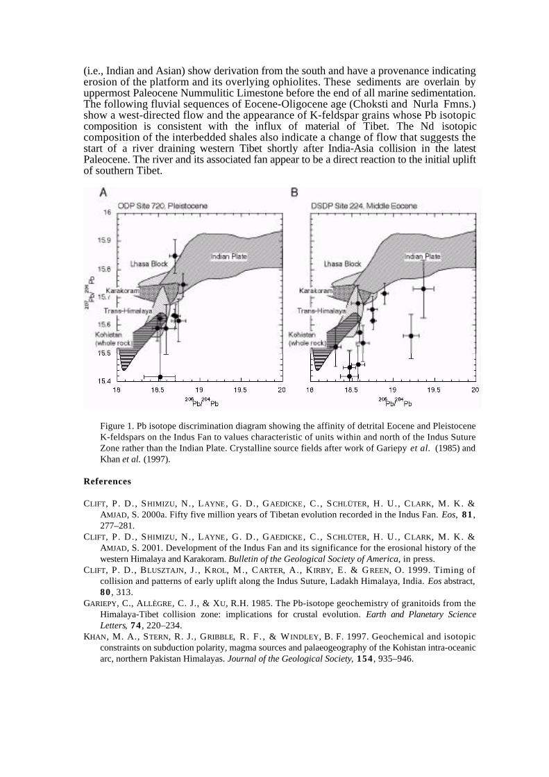
Figure 1. Pb isotope discrimination diagram showing the affinity of detrital Eocene and PleistoceneK-feldspars on the Indus Fan to values characteristic of units within and north of the Indus SutureZone rather than the Indian Plate. Crystalline source fields after work of Gariepy et al. (1985) andKhan et al. (1997).
References
CLIFT, P. D., SHIMIZU, N., LAYNE , G. D., GAEDICKE , C. , SCHLÜTER, H. U., CLARK, M. K. &AMJAD, S. 2000a. Fifty five million years of Tibetan evolution recorded in the Indus Fan. Eos, 81 ,277–281.
CLIFT, P. D., SHIMIZU, N., LAYNE , G. D., GAEDICKE , C. , SCHLÜTER, H. U., CLARK, M. K. &AMJAD, S. 2001. Development of the Indus Fan and its significance for the erosional history of thewestern Himalaya and Karakoram. Bulletin of the Geological Society of America, in press.
CLIFT, P. D., BLUSZTAJN, J . , KROL, M. , CARTER, A., K IRBY, E . & GREEN, O. 1999. Timing ofcollision and patterns of early uplift along the Indus Suture, Ladakh Himalaya, India. Eos abstract,80 , 313.
GARIEPY, C., ALLÈGRE, C. J., & XU, R.H. 1985. The Pb-isotope geochemistry of granitoids from theHimalaya-Tibet collision zone: implications for crustal evolution. Earth and Planetary ScienceLetters, 74 , 220–234.
KHAN, M. A., STERN, R. J., GRIBBLE, R. F . , & W INDLEY, B. F. 1997. Geochemical and isotopicconstraints on subduction polarity, magma sources and palaeogeography of the Kohistan intra-oceanicarc, northern Pakistan Himalayas. Journal of the Geological Society, 154 , 935–946.

SEISMIC STRATIGRAPHY OF THE OFFSHORE INDUS BASIN
T. Daley, N. Simons, S. Beswetherick
LASMO Oil Pakistan Ltd
In 1997 Lasmo Oil Pakistan Ltd gained a significant acreage position in theOffshore Indus Basin with the award of the Indus A and B Blocks offshore south ofKarachi. The hydrocarbon play considered to have the most potential is Miocene shelf-delta sands interbedded with intraformational shale seals and sourced by presumed gas-prone offshore equivalents.
As a result of this acreage position, Lasmo gained access to approximately 14,000km of 2D seismic data across the region. This was enhanced by reprocessing 5000kmof the existing data and acquiring 3660 km of new proprietary data. Only four wellshave tested the preferred play type to date and no core or rock data were available fromthese to provide insights into facies or age dating. The Oligo-Miocene succession hasconventionally been grouped stratigraphically as ‘Gaj Formation’, but for a unit inexcess of 4 km, this did not provide a sufficient basis for play fairway analysis.
Seismic sequence analysis has now provided the key to defining the internalstratigraphy of the previously undifferentiated Gaj Formation and to understanding thehydrocarbon prospectivity of the region.
Log data from two key wells in the offshore Indus area record the initial in-fill ofthe basin by shale dominated basinal or outer shelf sediments, followed by stacked thin-bedded sandstone-shale sequences of a shelf-delta nature. The transition between thetwo is marked by a zone of progradational sequences but no other workable divisionsare apparent. Regional seismic correlations quickly established the diachronous natureof the prograding shelf package and these were matched by distinct bands of seismicprogrades. A series of simple palaeogeographies of the prograding shelf margin weredeveloped showing initial sediment input from the north and rapid progradation towardsthe south and west.
The most obvious seismic features are canyons. These can be dated relative to oneanother on the basis of their stratigraphic position. Two main phases of canyondevelopment are apparent. The earlier phase is interpreted to be Lower Miocene in age.These early canyons originated in the north and became more widespread. Downcutting at this time rarely exceeded 300 m. A second phase of canyon developmentoccurred during the Plio-Pleistocene These later canyons dominate much of the shallowsection, often show down cutting of up to 600m and are characterised by at least 8phases of cut and fill. Seismic progrades occur along the canyon axes and slumps areobserved along their margins. Where drilled, canyons of both ages are shale prone.This is probably because they are located on the slope in a zone of erosion and sedimentby-pass and were subsequent filled by fine-grained deposits after abandonment. Thetwo phases of canyoning are considered to relate to co-eval phases of tectonic activity inthe collision zone between the India-Pakistan and Eurasian plates. The size andprevalence of the canyons probably reflects either the magnitude of inversion and upliftin the hinterland, or the proximity of the tectonic activity to the palaeo-shelf.
The implications for the prospectivity of the offshore Indus Basin and for the tectonicevolution of the Kirthir fold-belt and the Indus hinterland will be discussed in the lightof these new observations.

EVOLUTION AND PROPERTIES OF ON- AND OFFSHORE MUDVOLCANOES OF THE MAKRAN DESERT
G. Delisle1, U. von Rad1, A. Tabrez2, and A. Inam2
1 Bundesanstalt für Geowissenschaften und Rohstoffe (BGR), Stilleweg 2, D-30655Hannover, Germany
2 National Institute of Oceanography (NIO), St. 47 Clifton Block 1, Karachi, Pakistan
We present results of reconnaissance surveys of two active onshore mud volcanofields (Chandragup and Jebel-u-Gurab) and of the newly born (March 1999) offshoremud volcano (Malan Island). The mud volcanoes on land vary in height from a few to100 m. Malan Island rose in March 1999 for about three months above the water line atthe same location, where in November of 1945 an island had emerged, only to be washedaway by wave action within months. All visited on- and offshore mud volcanoes line upalong one southwest- northeast trending structural lineament (main axis of Dhak-anticline).
Isotopic data for gas components of the muds, temperature of the rising muds anddischarge rates of gas and mud were measured. In addition, we have searched theliterature for historic descriptions of the locations in an attempt to establish the longtimechanges in shape or activity of these complexes.
Onshore mud volcanoes: The Chandragup volcano complex is the largest knownstructure along the coast of the Makran desert. He has existed at least since 1840 withoutexperiencing any significant modification in shape or mud discharge activity. Ourrepeated temperature measurements in 1998 and 1999 point to slight variations in mudflow discharge, which is in line with the report by locals of a dependence of muddischarge on the periodicity of monsoon activity. Gas analyses from the Chandragupcomplex as well as from the Jebel-u-Gurab volcano field about 6 km to the west yieldedinvariably methane of bacterial origin with only traces of higher hydrocarbon compounds.Offshore mud volcanoes: We have obtained echo-sounder profiles across the location offormer Malan Island. In place of the former island we have identified a 2 m deepdepression of the sea floor, on which remnants of the former island rest. The compositionof the gas emanating vigorously from the sea floor is identical to the gas of the onshoremud volcanoes.
We conclude that mud volcanoes on land and in the sea are emplaced during short violentepisodes, followed by long periods of subdued gas and mud discharge activity. Mudvolcanoes in the sea are quickly washed away, while mud volcanoes on land can maintainlow level discharge activity for centuries.

GAS HYDRATES ACTING AS CAP ROCK TO FLUID AND GASDISCHARGE IN THE MAKRAN ACCRETIONARY PRISM?
G. Delisle, and U. Berner
Bundesanstalt für Geowissenschaften und Rohstoffe, Stilleweg 2, D-30655 Hannover,Germany.
A thick and extensive gas hydrate layer caps the Makran accretionary wedge at waterdepths of > 800 m. Its presence allows us to estimate heat flow density values from thedepth of observed bottom simulation reflectors (BSR) along reflection seismic transectsfrom the abyssal plain to near the coast of the Makran desert. These estimated values anddata from in-situ measurements, available from the literature, were compiled andcompared with the results of numerical modeling of the geothermal effect of thesubduction of oceanic crust under the Makran accretionary prism. A comparison ofmodel-derived with BSR-derived and measured heat flow values suggest a predominanceof conductive heat transport within the accretionary complex. Little evidence is foundwhich suggests fluid flow across the gas hydrate layer to modify the observed geothermalfield to any great extent. We further studied the geothermal field associated with the decayof the gas hydrate layer as the accretionary prism and the capping gas hydrates aretectonically uplifted out of the gas hydrate stability field into shallower and warmer seawater. Theoretical considerations suggest a complete disappearance of gas hydrates at awater depth of about 760 m. Extensive sampling of the water column (13 stations) alongthree N-S transects across the accretionary prism has revealed the presence of gas plumesof bacterial methane. They emerge from the sea floor at water depths of less than 800 mand drift laterally for several km seawards, before they disintegrate due to dilution andbacterial consumption of the methane. The gas seeps are thus concentrated in the zone ofshallow waters and outside the stability field of gas hydrates. This suggests that gashydrate layers in the Makran accretionary prism act as a very effective cap rock. The flowof fluids containing high amounts of dissolved gas from the deep parts of the prism(below the BSR) is redirected to the near coastal regions of the accretion, where gashydrates of low permeability do not exist.
CRUSTAL STRUCTURE OF THE DALRYMPLE TROUGH ANDMURRAY RIDGE - IMPLICATIONS FOR THE LOCATION OFTHE OCEAN-CONTINENT TRANSITION WEST OF INDIA.
R. A. Edwards1, T. A. Minshull2, C. Kopp3, and E. R. Flueh3
1. Bullard Laboratories, Department of Earth Sciences, University of Cambridge,Madingley Road, Cambridge, CB3 0EZ, UK;2. School of Ocean and Earth Sciences, Southampton Oceanography Centre, EuropeanWay, Southampton, UK;3. GEOMAR, Wischhofstrasse 1-3, D-24148, Kiel, Germany.
The Dalrymple Trough and Murray Ridge represent the northernmost extension of theIndian-Arabian plate boundary in the Arabian Sea. Seismic reflection profiles and swathbathymetric data show a significant component of present-day extension across thepredominantly strike-slip plate boundary. The 150 km-long Dalrymple Trough isbounded by normal faults divided into a series of en-echelon segments, the lengths ofwhich vary between 30-50 km on the northwestern flank and up to 90 km on thesoutheastern flank. The Murray Ridge represents a topographic high immediately to thesoutheast of the Dalrymple Trough. Along the crest of the ridge rough acoustic basementis observed at the sea-floor on reflection profiles. Any magnetic anomalies associatedwith the ridge are very weak.
Wide-angle seismic data were collected along a series of four lines in the DalrympleTrough and Murray Ridge region as part of FS Sonne cruise 123. Lines 5 and 7 cross thetrough and ridge, line 4 is located along the axis of the trough, while line 6 is parallel to,and northwest of, the trough. Up to 10 OBH/S (Ocean Bottom Hydrophones-Seismographs) were deployed along each line. Travel-time picks from the OBH/S havebeen modelled using 2-D ray-tracing to produce velocity models of the crustal structurealong the four lines.
Line 6 and the northwestern end of line 5 show a velocity structure typical of oceaniccrust; with a 6 km-thick two-layer crust. However, line 4 along the axis of the trough,and the southeastern part of line 5 show a very different structure. Here the crust has athickness of 12–14†km and velocities indicative of oceanic layer three are absent. Theincreased crustal thickness and relatively low lower crustal velocities suggest that theDalrymple Trough is underlain by thinned continental crust.
The Dalrymple Trough therefore forms the northwest boundary of a region of thinnedcontinental crust which may extend beneath much of the Indus Fan and over 400 km fromthe continental shelf of India. Oceanic crust lies immediately northwest of the DalrympleTrough and the ocean-continent transition occurs over a less than 10 km-wide region ofactive oblique extension along the northwestern flank of the trough. The Moho under thenorthwestern flank of the Dalrymple Trough has a very steep dip of 45∞, comparable tothe steep Moho dips observed along transform (or sheared) margins.

TECTONIC STYLE OF THE MAKRAN ACCRETIONARY PRISM
Nadine Ellouz
Institut Français du Pétrole (IFP), 1-4 av. de Bois-Préau, 92852 Rueil-MalmaisonCedex-France
The Makran accretionary prism in Pakistan, has developed in the vicinity of the triplejunction between the Arabian, Eurasian, and Indian plate. This junction fits the connectionbetween the E-W Makran tectonic accretionary prism, a N-S transform fault system(Chaman–Ornachnal) and, finally, a WSW-ENE Ridge (Murray Ridge). The western partof the prism is developed in a frontal convergence setting, accommodating the low-angleoceanic subduction of Cretaceous oceanic crust. The eastern part of the prism has beenstrongly under the control of the left lateral transform motion related to the Northwardmovement of India since Paleogene time. Consequently, deformation has adapted tostrain-partitioning processes here. Also, the oblique Murray Ridge, which is a prominentpoly-phased transtensive/transpressive structure linked to the Owen Fracture zone,introduces a strong heterogeneity in the plunging panel.
All over the prism, the tectonic style as well as the sedimentary filling have registeredstrong lateral variations through time. The periodicity, the orientation and the tectonic styleof the structures are guided by the sedimentary thickness variation as well as by the relateddepth to decollement levels. Close to Pasni, total sedimentary thickness, deduced fromseismic data is 3.5 twt up to basal detachment. When close to the triple junction, it is morethan 4.5 twt up to the first more shallow regional detachment (depth of the basaldetachment is unknown).
To the west of the prism, deformation propagates along a basal detachment level closeto the top of the oceanic crust (free border), but laterally some oblique ridges (such asvolcanic Little Murray Ridge or Murray Ridge itself) act as rigid blocks. Secondarydecollement levels are inferred, particularly onshore, justifying the imbricate structure typeclearly expressed on satellite images. To the east, offshore, the northern flank of theMurray Ridge is starting to be incorporated in the prism itself. Onshore, close to the LasBela depression, the development of “en échelon” folds, often associated with mudextrusive processes, gives evidence of deep overpressure regime. These structures seemto have extended offshore, as expressed on seismic data and by the emergence of the newMalan island in 1999. The overpressure shales have probably originated from one of thedeep decollement level.
The age of the offshore basal sedimentary layers (inferred from well correlation acrossthe Murray Ridge, but not yet defined), may introduce uncertainties in the chronology ofthe sedimentary distribution and the deformation. These limitations should be raised eitherby drilling or by new constraints on dating and analyses of the mud ejected at the surface(or sea bottom), giving new ideas about nature and age of the deepest part of thesedimentary pile. However, the oldest sediments incorporated in the inner prism itself areLate Cretaceous/Paleogene in age. The sedimentary pattern has been driven by thearchitecture of the Paleo-Indus input through time, ever since its initiation duringPaleogene. On the offshore part of the prism, the sedimentary nature and thickness variesfrom east (channel-levees) to west (distal sands and mudstones), suggesting thatsedimentary transfer (channel pattern) and deposits (sedimentary lobes) have a rough east-west spatial distribution. The relationship between the compressive episodes, Eocene toPresent along the W Indian paleo-margin, and the Paleogene to Middle Miocenesedimentary distribution west of the Chaman Fault is the important key point to bedefined, in order to estimate the migration of the Paleo-Indus drainage area. Especially

during Oligocene time, restoration of the W. Indian (Kirthar and Sulaiman Ranges) intheir Eocene and Oligocene position is crucial.
STRUCTURE AND DYNAMIC EVOLUTION OF THE INDIAN-ARABIAN PLATE BOUNDARY OFF PAKISTAN: NEWEVIDENCES FROM CORRELATION OF KEY HORIZONS
C. Gaedicke, H.-U. Schlüter, H. Roeser, A. Prexl, H. Meyer and C. Reichert
Federal Institute for Geosciences and Natural Resources (BGR), Hannover, Germany
Multi-channel seismic (MCS) profiles with a total length of about 2900 km wererecorded during RV Sonne cruise 122 in the northern Arabian Sea. The MCS grid coversparts the Makran accretionary wedge, the Oman Abyssal Plain, the Murray Ridge Systemand the northern Indus Fan off Pakistan. Industrial wells from offshore Pakistan enableus to extrapolate stratigraphic key reflections in our MCS data. Interpretation was donewith Schlumberger's GeoQuest( software system.
The ocean-continent transition is imaged by a sequence of seaward dipping reflectors(SDR) below the Indus Fan sediments. A sedimentary ridge above the acoustic basementnorth of the SDR sequence consists of Mesozoic sediments deposited prior to theseparation of India from Madagascar and Africa. A Paleogene, hemipelagic syn-driftsequence onlaps the ridge and covers the entire acoustic basement. Rapid uplift of thehigh Himalayas, followed by erosion and subsequent transport of terrigenous sedimentinto the northern Arabian Sea is documented in the Lower Miocene by the onset ofchannel-levee sedimentation of the Indus Fan. Correlation of the channel-levee sequenceinto troughs and onto ridges of the Murray Ridge System indicates that the Murray Ridgewas uplifted later on. Phases of rapid subsidence of the Dalrymple Trough and its north-eastern prolongation in the post-Middle Miocene are evident by a sequence of up to 3 s(TWT) thick sediments. The paleo-Indian continental margin is marked by northwarddipping basement reflectors along the northern flank of the Murray Ridge System. Wecorrelate this sequence with early Palaeocene basalt flows drilled on the shelf off Karachi.
The sedimentary pile of the Oman Abyssal Plain shares the sedimentary history of theIndus Fan: two major sequences above the acoustic basement exhibit a similar internalreflection pattern. The lower sequence is correlated with the syn-drift sediments and theupper sequence exhibit distal channel-levee pattern. Both sequences and the acousticbasement below are tilted toward the Makran accretionary wedge while they areoutcropping on the northern ridge of the Murray Ridge System. The sedimentarysequences are separated by the pronounced unconformity M(akran). Unconformity Munequivocally could be identified from the Straits of Hormuz to offshore easternPakistan. The compilation and re-interpretation of published data with our MCS incombination with estimated sedimentation rates of extrapolated well results hint to a LateMiocene to Early Pliocene age for the M-unconformity. It separates the tilted lowersedimentary unit from the flat lying upper sequence. Tilting of the basement causes awedge shape of this upper sequence. The thickness reaches 2.5 s (TWT) at the toe of theMakran wedge but is about zero along the northwestern flank of the Murray RidgeSystem indicating a hiatus on this part of the Murray Ridge System.
We speculate, that the M-unconformity developed in the frame of the Upper Mioceneuplift of the Makran-Zagros belt which in turn is due to changes in the movement vectorof the Arabian Plate. This event effected the entire Arabian Plate and led to an adjustmentand steepening of the subducting plate.
A COMPARATIVE STUDY OF THE GLACIAL-INTERGLACIALAND MILLENNIAL-SCALE OSCILLATIONS IN UPWELLINGRECORDS FROM THE EASTERN (SOMALIAN) AND WESTERN(INDIAN) ARABIAN SEA MARGINS
R.S. Ganeshram1, Geert-Jan Brummer4 , S. E. Calvert2, Gerald Ganssen3
and D. Kroon1
1University of Edinburgh, Geology and Geophysics Dept., Edinburgh, UK, EH9 3JW,[email protected];2University of British Columbia, Department of Earth and Ocean Sciences, Vancouver,Canada V6T 1Z43Free University of Amsterdam, The Netherlands; 4Netherlands Institute for Sea Research, Texel, The Netherlands.
Recent studies report rapid oscillations in productivity, oxygenation/denitrification ofsubsurface waters and aragonite preservation in the northern Arabian Sea during the LateQuaternary periods (Schulz et al., 1998; Reichard et al., 1998). These oscillationsexpressed as changes in organic carbon and aragonite contents, in the presence or absenceof laminations, and fluctuations in ∂15N values of sediments have occurred on both glacial-interglacial and sub-Milankovich frequencies. Interglacial and warm interstadial (of GISP2) periods are marked by high organic carbon content and poorly-oxygenated/denitrifyingupper-intermediate waters which are attributed to the strong summer (southwest) monsoonwinds and resulting high upwelling-induced primary production prevalent during theseperiods. However, very little is known about the history of the winter (northeast) monsoonand its phase relationship with the summer monsoon. In this study, we will compareproductivity and denitrification records from the Somalian margin influenced mainly bythe summer monsoon with those from the Indian margin where winter monsoon alsodrives upwelling-induced productivity (Ganeshram et al., 2000). These records will beused to delineate the late Quaternary histories of South Asian monsoons and their forcingmechanisms.
References
GANESHRAM, R. S. , PEDERSEN, T. F., CALVERT, S. E., MCNEILL, G.W. & FONTUGNE,M.R., Glacial-interglacial variability in denitrification in the World's Ocean: Causes andconsequences.Paleoceanography,15 ,361-376, 2000.
REICHARD, G. J., L. J. LOURENS, & W. J. ZACHARIASSE, Temporal Variability in thenorthern Arabian Sea Oxygen Minimum Zone (OMZ) during the last 225,000 years,Paleoceanography, 13 , 607-621, 1998.
SCHULTZ, H., U. VON RAD & H. ERLENKEUSER, Correlations between Arabian Sea andGreenland climate oscillations of the past 110,000 years, Nature, 393 , 54-57, 1998.
MINERALOGY AND PETROGRAPHY OF MODERN COASTALSEDIMENTS, GULF OF OMAN AND ARABIAN SEA (OMAN)
Eduardo Garzanti, Giovanni Vezzoli, Sergio Andu, Giovanna Castiglioni &Daniela Dellí
Era Universite di Milano-Bicocca, Dipartimento di Scienze Geologiche e Geotecnologie,Piazza della Scienza 4, 20126 Milano (Italy).
Along the continental margins of south-eastern Arabia, for some 2000 km from theGulf of Aden proto-oceanic rift to the Persian Gulf foreland basin, composition ofmodern widyan, eolian dune, and beach sands allow recognition of 15mineralogical/petrographic onshore provinces - several subdivided further in sub-provinces allowing identification of main provenance types and sediment dispersal paths.In this vast area with long and complex geological history, tropical arid climate withnegligible chemical weathering and anthropic modifications allow quantitative assessmentof primary detrital signatures in two main contrasting geodynamic settings: the multistagerifted-margin of the Arabian Sea and the orogenic obducted belt bordering the Gulf ofOman.
Rifted-margin detritus changes from pure sedimentaclastic to plutoniclastic withdeepening of erosion level within the rift shoulder (“undissected” to “dissected rift-shoulder” stages). Finally, older peneplaned rift reliefs allow long-distance transport oflargely polycyclic detritus from the continental interiors (“continental interiorprovenance”). In arid climates, due to scarce rainfall and lack of vegetation, winds aremuch more efficient sediment-transporting agents than streams, and polycyclic sands areonly moderately enriched in stable quartz and chert grains.
Orogenic provenance is more complex, including detritus from oceanic allochthonsoccupying the structurally highest positions of the obduction range, mixed in variousproportions with detritus from underlying sedimentary to metasedimentary nappes.Where associated with orogenic belts of great topographic relief as the Samail ophiolite ofthe Oman mountains, obducted ophiolitic sequences largely consist of serpentinizedmantle harzburgites shedding dominant serpentinite grains and enstatite (“dissectedophiolite provenance”). Where instead, as in Masirah Island, relief and erosion rates aremodest, detritus is dispersed only locally and mostly derives from rocks of the oceaniccrust (“undissected ophiolite provenance”).
Provenance from accreted continental-margin successions is reflected by sedimentaryand locally metasedimentary detritus, with dominant recrystallized carbonate grains.Three sub-types are recognized. Stable-platform successions (Musandam peninsula, JabalAkhdar dome) chiefly provide limestone and dolostone grains, with little recycledsiliciclastics. Deep-water successions mostly supply limestone and chert with a fewterrigenous grains. Metasedimentary to metavolcanic sequences, including subductedplatform successions (Sifah Province) or pelagic deposits incorporated in themetamorphic sole of the Samail ophiolite (Diba Province), supply additionalpolycrystalline quartz and metapelite, metafelsite and metabasite including blueschistlithics.
Detailed petrographic and mineralogical information obtained in actualistic provenancestudies provides a suitable basis to understand coastal dynamics, and to assess dispersalpathways of detritus and entry points of deep-sea sediments. The recognized rifted-margin to orogenic provenance signatures may represent a powerful tool to unraveling theevolution of ancient thrust belts and associated sedimentary basins.

QUATERNARY CLIMATIC CHANGES OVER SOUTHERNARABIA AND THE THAR DESERT, INDIA
K. W. Glennie1, A. K. Singh2, N. Lancaster3 & J. T. Teller4
1 Dept. of Geology and Petroleum Geology, University of Aberdeen, Aberdeen ,UK.
2 Earth Science Division, Physical Research Laboratory, Ahmedabad, 380 009, India
3 Desert Research Institute, Reno, Nevada 89512, USA
4 University of Manitoba, Winnipeg, Manitoba R3T2N2, Canada
Expansion and contraction of deserts and their relationship with changes in theclimate, changes in the albedo and changes in the atmospheric circulation patterns, havelong been investigated. Conventionally the expansion episodes have been associated withglacial (arid) epochs and the contraction episodes with more humid phases. Asynchronous response of different desert systems to climate change has been implicitlyassumed. However, more recent luminescence dating studies indicate that aeolianaccretion occurs over specific time windows. The window of opportunity for aeolianaccretion depends on a variety of factors that regulate the sediment production, supply,transport and preservation. Consequently, both the local and global factors participate inaeolian accretion, implying that the event chronology in deserts need not be in phase,sensu-stricto. The Arabian Desert is influenced by two wind systems, the Shamal and theSW Monsoon, and the Thar Desert (NW India) by the NE and SW Monsoons. Thecontrasting wind regimes consequently provide a good opportunity to examine some ofthe key issues in desert paleoclimatology. These range from, the effect of asynchronousfluctuations in the two wind systems on the style of aeolian activity, limitations imposedby sea level changes, changes in sediment supply and changes in preservation potentialsin these regions. Both Arabia and Thar, possess excellent sedimentary records thatindicate a large range of depositional facies including aeolian sand and carbonate dunes,fluvial gravels and sabkhas together with pedogenic and ground-water carbonates. In thisstudy we collate and present a synthesis of the published literature and our own researchon the interpretation and chronometry of these landforms. Arabia. The presentdistribution of dune sands over the southern half of Arabia conforms to the influence oftwo different wind systems: 1) The major Shamal system, which was controlled bywinds that blew to the SSE down the Arabian Gulf and then swung to the SW towardsN. Yemen, and 2) The SW Monsoon system, which was responsible for forming theWahiba Sands, of much lesser extent, north of the Arabian Sea coast in SE Oman.Optically stimulated luminescence (OSL) dating of dune sands in the Emirates and Omanhas enabled an event stratigraphy to be constructed. This indicates that during the laterQuaternary, repeated dune-sand transport and deposition in the opposing Shamal and SWMonsoon dune systems were probably affected by the presence (or absence) of the northpolar ice cap, and the influence it had on atmospheric circulation including monsoonwinds. During the last glaciation, the dry Arabian Gulf area allowed deflation of quartzsands (together with carbonate grains that had been deposited under marine conditionsduring the previous interglacial) and their transport south to the Emirates. Only the quartzfraction survived the abrasion and moved into the Rub al Khali basin in Saudi Arabia,some of it spilling southward to the exposed continental shelf of SE Oman. The SWmonsoon was inactive over that same continental shelf. As the late-glacial polar icecapsdeclined, the arid Shamal wind system weakened and its southern limit shranknorthward. This enabled the more humid SW monsoon to blow across Arabia's SEmargin, deflating quartz and carbonate grains from the narrow continental shelf anddepositing them in the S-N aligned Wahiba dune system. As discussed below, the SWMonsoon was also responsible for the initiation and northward shift of dune activity inthe Thar Desert of India by some 300 km. The northern end of the Wahiba Sands seem tohave been truncated early in the Holocene by the flooding of Wadi-Batha, although

marine evidence of that flood may have been dispersed by along-shore currents driven bythe monsoon winds. Thar Desert. The presence of numerous dune-forms within itslimited areal spread perhaps makes Thar an ideal laboratory to understand factorsdetermining dune morphologies and the role of local versus global factors. The presenceof fossil sands in regions with several times higher precipitation as compared to thepresent day limit (for dune activity) of 250 mm/a suggests large amplitude changes indune accretion climate in the region. It is now generally accepted that both fluvial andaeolian processes in the region are largely controlled by winds and precipitationassociated with the SW Monsoon. The near absence of regionally extant fluvial or aeolianaggradation during the last glacial epoch reflects this. Despite aridity and abundant sandsupply, dune accretion did not occur during the glacial epochs on account of weakerwinds. Luminescence chronometry of closely spaced samples suggests that the windowof opportunity for aeolian aggradation occurred only for a limited duration that peaked attimes of transition from glacial to interglacial epochs and during the time the monsoonwas re-establishing itself in the region. Chronometry of aeolian aggradation also indicatesa spatial variability within Thar, suggesting changes in the monsoon gradients during theHolocene. Isotopic studies on pedogenic carbonates within aeolian areas indicate a morehumid phase (with normal monsoon-like conditions) during marine isotopic stage 3. Thisis seen as a red soil horizon in fluvial deposits. On the Holocene time scale, a large-amplitude change is seen in lake hydrology. Saline lakes had fresh water during the early-mid Holocene followed by a period of desiccation; the lakes and dunes appear to present a1500 year cyclicity with a phase lag of a few centuries. Published data on the Quaternarymarine sequences of the NW Arabian Sea give general support to the varying influence ofthe Shamal & SW Monsoon wind systems. Chronometry of desert sequences indicatesignificant differences between records from Oman and Thar as compared to the Arabianrecords, and together these permit reconstruction of past changes in circulation patterns inthe region.
EARLY HOLOCENE SUB-CENTENNIAL MONSOONVARIATIONS IN THE ARABIAN SEA
S.J.A. Jung, G.R. Davies, G.M. Ganssen
(1) Institute of Earth Sciences, Free University Amsterdam, De Boelelaan 10851081 HV Amsterdam, The Netherlands. e-mail.:[email protected], tel. 0031-20-4447424
The Asian monsoon system belongs to the most dynamic parts of the Earth climatesystem. Strength variations of either the summer (SW-) monsoon or the winter (NE-)monsoon in the Arabian Sea may not only reflect local climate variations but may haveimplications for the global climate system.
Based on Dansgaard-Oeschger type of strength variations of the monsoon off Somaliaoccurring over the last 35 ka a ultra-high resolution study of the early Holocene section(11-6.5 ka) of core 905 off Somalia was used to trace monsoon variations down todecadal time scales. At a sedimentation rate of up to 30 cm/ka sampling at 0.5 cm resultedin a time resolution around 20 years. In a multiproxy study O-/C-stable isotope data weredetermined on planktonic foraminifera that are today indicative for either of the monsoonseasons. Radiogenic isotope analysis (87Sr/86Sr, 143Nd/144Nd and Pb-isotopes) of thelithic - dust borne sediment fraction are used as a dust provenance tool. Both sets ofparameters clearly show significant early Holocene monsoon variations on multi- down tosub-centennial frequencies. Moreover, these data indicate a succession coupled SW- andNE-monsoon variations with periods of decoupled seasonal monsoon variations.
Using the epibenthic foraminifera C. kullenbergi, known as a reliable recorder ofambient water mass properties, a detailed early Holocene mid-depth water record wasestablished. Following a 10 ∂18O-lowering along with Termination I a general furtherdecrease of 0.2 0 until 8.2 kyr was observed. Unexpectedly, subsequent to the wellknown 8.2 kyr cold event, clearly depicted in the ∂18O-record of the planktonicforaminifera G. Ruber from the same core, a rapid additional decrease of 0.2-0.3 0occurred. Even more important, prior and subsequent to the 8.2 kyr event centennial scale∂18O-variations were found. Prior to 8.2 kyr their amplitude is 0.2-0.3 0, hence close tothe detection limit, whereas thereafter their amplitudes are 0.5-0.7 0. These changespossibly reflect variations in the composition of mid-depth water masses resulting fromearly Holocene Red Sea Water (RSW) with a significantly higher salinity than today.Accordingly this RSW may have settled deeper in the water column and bathed site 905.Around 6.5 kyr BP RSW approached modern day salinity and temperature propertiesleading to a lower density. RSW subsequently shoaled not affecting the benthicforaminifera at site 905 anymore.

PALEOCLIMATE VARIABILITY DOCUMENTED IN UPPERHOLOCENE VARVED SEDIMENTS OFF PAKISTAN.
Athar Ali Khan 1, Ulrich von Rad 2 and Andreas Lockge 2
1 National Institute of Oceanography, St-47, Block-1, Clifton, Karachi. Pakistan.
2 Federal Institute for Geosciences and Natural Resources (BGR), Stilleweg-2, D-3095Hannover, Germany
The northeastern Arabian Sea is characterized by an exceptionally stable mid-wateroxygen minimum zone (OMZ) and a strong seasonal monsoon-controlled variability ofprimary productivity. OMZ cores from the slope off Karachi and Ormara (640 - 700mwater depth) have a thick upper Holocene section (0-5000 cal. yr. BP) of continuouslylaminated sediments.
Our age model is based on varve stratigraphy (counting about 5600 varve couplets inboth cores) and 36 AMS-14C ages for both cores. Average linear sedimentation rate is130 cm/ka (1.3 mm/a) off Karachi and 220 cm/ka (2.2 mm/a) off Ormara, where about40% of the total thickness consists of turbidites and event deposits. We studied the fabricand composition of the varve-type laminations by photography, X-radiography, thin-sections, digital sediment color analysis, and by the digital recording of lamina thickness.Our main independent proxies for terrigenous input and river runoff are varve thicknessand inorganic geochemical composition (Ti/Al, Zr/Al, K/Al, Sr, Ca), as well as oxygenisotopic data of planktonic foraminifera.
The hemipelagic sediments contain alternating 0.5-2 mm-thick dark and light coloredlaminae. The light-gray laminae consist of well-sorted, terrigenous, unfossiliferous siltyclay. The dark olive gray laminae are relatively thicker and consist of poorly sorted siltyclay, rich in organic carbon coccoliths and foraminifera . Turbidites (> 5 mm thick) werederived from the continent, mainly by re-suspension of material deposited by episodicand perennial rivers and consist of medium to dark-gray, homogeneous clayey silt. Thickturbidites are commonly graded. These are based on the varve chronology the variationsin turbidites frequency and turbidity thickness suggest times a marked decrease inturbidite frequency and thickness around 500, 3000 and 5200 years BP
Subtle changes of geochemical proxies (normalized to Al) and 18O values make itpossible to differentiate three climatic periods: I: 4700-3,500 yr. BP; II: 3,500-1,200 yr.BP; III: 1,200 yr. BP - Present). From 4,700-3,500 yr. BP we note a general increase invarve thickness and element/Al ratios. Similar trends of varve thickness and Si/Al, Ti/Al,Zr/Al, and Mg/Al ratios suggest that the climate was relatively humid. Increased varvethickness and higher lithogenic element /Al ratios are probably due to increasedprecipitation and enhanced fluvial input. During period II (3,500-1,200 yr. BP) varvethicknesses decrease up-core, whereas Si/Al, Ti/Al, Zr/Al, Mg/Al ratios are still high.Increased lithogenic element /Al ratios and reduced varve thicknesses during period II(3,500-1,200 yr. BP) suggest slightly more arid conditions in the source area. In asimilar way as during period III, the climate became more humid from 1,200 yr. BP onclimate became more humid again as evidenced by the increased varve thickness andelement/al ratios.
Spectral analysis of the varve thickness values documents the presence of cycles around1490 yr., 460 yr., 288 yr. 180 yr., 103-107 yr., between 94-95 yr., as well as peaksaround 74 yr., 42-43 yr., 30-32 yr., 29-32 yr., and 25-yr., whereas so far nounambiguous 11-yr. sunspot or ENSO signal was discovered (cf. Poster Abstract by vonRad and Berger). These cycles are not present during the whole 5000-yr. period, butchange with time, i.e., the power seems to jump from longer to shorter cycles with time.

A SUMMARY OF THE GROUND-TRUTH GEOLOGY OF THEMAKRAN
G. J. H. McCall
44 Robert Franklin Way, South Cerney. Glos., U.K.,GL7 5UDE-mail: [email protected]: Fax: 44 1285 862449
The Iranian Makran has been entirely mapped geologically on a scale of 1:250,000,except for a narrow coastal strip, which exposes the very youngest Cenozoic sedimentsof the main Makran accretionary prism. The geology of the Makran is less widely knownthan the geology of Oman, facing it across the Oman Sea, because it has been publishedonly in detail in reports of the Geological Survey. It has little in common with theGeology of Oman, the only representatives of Oman Geology in Iran being ophiolites atNeyriz and Kermanshahr, many kilometres to the northwest of the Makran. Thissummary of the geology of a region the size of England is based on on-the-groundmapping, photo-interpretation only being used to connect up traverse lines.
The oldest rocks in the Makran are metamorphic rocks which form the basement tothe Bajgan/Dur-kan microcontinental ìsliverî, a narrow block which extends hundreds ofkilometres from the Bitlis massif in Turkey through the Sanandaj/Sirjan block of theZagros to north of Nikshahr in the east of the Makran. Other metamorphic rocks form theDeyader Complex near Fannuj on the southern margin of the Jaz Murian Depression(desert): these include blueschists, and are thought to form the tip of the Tabasmicrocontinental block, largely exposed to the north of that desert. There is also a smallmicrocontinental block to the east, the Birk block, which exposes only Cretaceousplatform limestones and peripheral Permian sediments. The Bajgan metamorphics areoverlain by highly deformed and disrupted platform carbonates of early Cretaceous toEarly Paleocene age (Dur-kan Complex), containing tectonic inliers of Carboniferous,Permian and, rarely, Jurassic age.
Ophiolites occur in two structural positions. South of the Bajgan/Dur-kan bloc, theColoured Mélange of the Zagros, a tectonic mélange, continues eastwards immediatelyinland of the Bashakerd Fault; this includes two layered ultramafic complexes, one withchromitites, also radiolarites and limestones of Jurassic to early Paleocene age. Ophiolitesdeveloped north of the microcontinental block form three distinct complexes, two layeredand one with intermediate sheeted dykes. There are small developments of Cretaceoussediments carrying rudists in the extreme northwest of the inner ophiolite tract. In theextreme northeast, there is another ophiolite development, the Talkhab mélange. All theseophiolite developments represent former, essentially Mesozoic, tracts of deep ocean.
The Cenozoic rocks form two immense accretionary prisms. The main Makran prismincludes Eocene-Oligocene and Oligocene-Miocene flysch turbidite sequences, estimatedas individually more than 10,000 m thick.. There is an abrupt passage up, through reef-like Burdigalian limestones, and locally a harzburgite conglomerate development, intoneritic sequences with minor turbidites, extending just into the Pliocene. The Saravanaccretionary prism to the east repeats tectonically three immensely thick flysch turbiditesequences of Eocene-Oligocene age, but younger sediments are restricted here to meagerdevelopments of Oligocene-Miocene intramontane conglomerates. There is a line ofOligocene (?) granodiorite bodies within the Saravan accretionary prism.
Intense folding and development of schuppen structure, dislocation and melanging ofthe sediments affected the entire region in the late Miocene-early Pliocene. Post-tectonicuplift was followed by scattered developments of fanglomerates beneath the fault scarps.The main tectonic deformation in the Neogene has obscured earlier deformations. There isunconformity beneath Eocene sediments representing a mid-Paleocene disturbance. There

is evidence of a discontinuity in the mid-Eocene and at least local unconformity. ThePliocene-Pleistocene fanglomerates are unconformable on the folded rocks.
There are discontinuous developments of Eocene-Oligocene neritic sedimentsunconformably above the older rocks (Ophiolites, Platform Limestones, Metamorphics)and to the north of the southern edge of the Jaz Murian Depression, the limit of theMakran, there is evidence of the survival here of a very shallow sea through the Neogeneand the deposition in it near Jiroft to the west of Oligocene-Miocene reef-like limestones;and near Karvandar to the east of Pliocene shallow water sediments. .
The offshore evidence indicates that the region is now being subjected to shallowly-inclined subduction on a NNE-wards vector, the movement emanating mainly from theSheba Ridge. There is a 150 km wide tract separating the coast from the active front, thetotal Cenozoic accretionary prism fronting the Iranian Makran being 500 km wide.Spreading from the Murray Ridge affects the extreme east of the region and there isreason to think it may have a northwestwards vector. The Saravan accretionary prism, itis suggested, fronted onto a gulf, comparable with the gulf now separating Iran andOman, and this Saravan Gulf filled up and closed up by the early Oligocene.Seismological evidence suggests that there is active continental collision continuing alongthis suture.

NEW CONSTRAINTS ON THE AGE AND TECTONIC HISTORYOF THE LITHOSPHERE AT MURRAY RIDGE AND DALRYMPLETROUGH
T. A. Minshull1, R. A. Edwards2, E. Flueh3 and C. Kopp3
1 SOES, Southampton Oceanography Centre, SO14 3ZH, UK2 Bullard Laboratories, Madingley Road, Cambridge CB3 0EZ, UK3 Geomar Research Centre, 24148 Kiel, Germany
The Dalrymple Trough forms a 150 km long and 25 km wide SW-NE trendingdepression along the India-Arabia plate boundary, with a water depth of about 4 km. It isbounded to the southwest by the southern part of the Murray Ridge, a bathymetric highwhich locally approaches the sea surface. Results from a recent wide-angle seismicexperiment aboard the Sonne suggest that the Murray Ridge and part of DalrympleTrough are composed of continental crust, juxtaposed by the oblique-slip plate boundaryagainst oceanic crust to the NW. This continental fragment is separated from an area ofshallow basement to the SE which is also interpreted as continental crust by a region ofdeep (up to 10 km depth) basement overlain by thick Indus Fan sediments. In this region,data from the Sonne cruise suggest that mantle velocities are reached within 3-4 km ofbasement; the velocity structure is consistent with the presence of highly extendedcontinental crust, or possibly of an ocean-transition zone. Basement fault fabrics to theSE of Murray Ridge suggest that this region of deep basement was formed by extensionin a NW-SE direction, almost perpendicular to the Paleocene episode of extension whichled to the separation of the Seychelles from India. Plate reconstructions for this part of theIndian Ocean are broadly consistent are broadly consistent to M0 time, but reconstructedrelative positions of India and Madagascar in the Jurassic vary widely. Somereconstructions are consistent with the possibility that the lithosphere currently lyingbeneath the Murray Ridge became separated from Africa and India during the initialopening phase of the West Somali Basin in the early Upper Jurassic. Long-wavelengthgravity anomalies, which show a consistent gravity increase from NW to SE across theDalrymple Trough, are consistent with such a model, with older, colder lithosphere to theSE of the Trough than to the NW.

SEDIMENTATION AND TECTONIC HISTORY ALONG THEWESTERN CONTINENTAL MARGIN OF INDIA
D. Gopala Rao
National Institute of Oceanography, Dona Paula, Goa - 403 004, India.
Sedimentary, tectonic and volcanic records are crucial to know the earth systemchanges that have taken place in the geological past. They are interpreted from marinegeophysical investigations of the western continental margin of India and eastern ArabianSea in confirmation with litho-stratigraphy of the industry drill wells and DSDP Site 219.The most important findings are the 1) the regional seismic sequences, H1 to H6stratigraphy of the late Cretaceous / Paleocene to Recent sediments, seaward migration (8-60 km) of mid-Miocene paleo-shelf edge, mid-Miocene to present prograded andOligocene to mid-Miocene aggraded shelf sedimentation, 2) Neogene turbidites overliethe Paleogene pelagic sediments in the area seaward of the Laccadive-Laxmi Ridges, 3)rifted / tilted half graben centred by linear igneous intrusive structures of the shelf marginbasin paralleling the shelf edge, and 4) rift graben carpeted by pre, syn and post-riftsediments, seaward dipping reflectors and linear igneous intrusives along the westernflank of the Laccadive-Laxmi Ridges.
Whether initiation of seafloor spreading in the Arabian Sea pre -dates Deccanvolcanism on the western margin or volcanism associates with the initiation of spreadingduring the Cretaceous-Tertiary boundary is still an unresolved question. Active seafloorspreading in two periods from 65 (chron 28) to 50 Ma (chron 21) and 30 Ma (chron 11)to Recent had largely contributed to the evolution of the eastern Arabian Sea. A hiatus inseafloor spreading from 50 (chron 21) to 30 Ma (chron 11) is known to occur especiallyafter formation of 48 Ma age oceanic crust and record pause in seafloor spreading. Theindustry drill wells of the margin have noted presence of extrusive volcanics around 93(CH-1-1 and St. Mary Islands etc.), 65-55 (BH-1, K-1-1 etc.) and 42 (MT-3 etc.) Ma.The abrupt termination of seafloor spreading process at 50 Ma and change in spreadingdirection mark post India-Asia collision event. The early volcanism denotes time ofseparation of the greater India from Madagascar. The later volcanic events coincide withthe Reunion plume interaction and subsequent active seafloor spreading. The majorfaulting along the paleo-shelf edge is proximal to the second stage of evolution of theeastern Arabian Basin. It is necessary to investigate the ages of volcanism, tectonism andactive seafloor spreading episodes in the Arabian Sea to understand their inter-relationships.
In the eastern Arabian Sea more than 2.0 s (TWT) thick turbidites are noted in thenorth and they gradually reduce to about 0.3 s to the south, 8∞N. The thick turbiditesreaching the distal parts of the Indus Fan, 8˚N are to be viewed transported for longerduration. A prominent, continuous doublet of intermediate frequency at around 15˚Nlatitude is noticed bifurcating the turbidites. Such a reflector chronology is crucial toknow the past and constrain age of the earliest turbidites reaching the area. The Paleogenecarbonate section of the margin does contain more than 200 m thick Eocene Chertreflectors, silica layer which is likely to occur as biogenic by-product while the Indianplate is in temperate latitudes, i.e. in the vicinity of equator during its northward motion.While an erosional unconformity of the shelf region mark lowered sea-levels occurred inOligocene concurrent with global scenario. The steep-scarp associated with theOligocene-mid-Miocene shelf edge mark major tectonism / rift related subsidence andeventually leading to evolution of the sedimentary basin of the shelf margin. Aggradedlate Oligocene / early Miocene sediments imply less supply to the stable shelf. TheNeogene siliciclastic rapid sediment pulsations into the Arabian Sea during the post mid-Miocene, Pliocene and upper Pleistocene have contributed to the shelf pro-gradation. Theincreased siliciclastic sediments input to the margin suggests intensified erosional activitythat may be related to climate, sea-level, and / or tectonic events.

The structural configuration of the shelf margin basin indicates stretched continentalcrust intruded by igneous crust. The basins evolutionary processes result in changes inocean circulation, material exchange between volcanism, hydrosphere and atmosphereand decisively effects climates during those periods. The change in deposition ofcarbonate to siliciclastics on the shelf, faulting of the paleo-shelf edge, hiatus in seafloorspreading, and reorientation of spreading centre directions in the eastern Arabian Sea,volcanism prior to Miocene suggest that early Neogene is most likely the time forresetting of the changes.
Email: [email protected] : 00-91-832-223340/229102

THE PERIODICAL BREAKDOWN OF THE ARABIAN SEAOXYGEN MINIMUM ZONE
Gert Jan Reichart and Willem Jan Zachariasse
The northern Arabian Sea is presently characterized by a pronounced oxygenminimum zone (OMZ) with oxygen concentrations reaching values as low as 2 (Mbetween 150 and 1250 m). This intense mid-water OMZ results from high annual organicparticle fluxes and a moderate rate of thermocline ventilation. Sediment studies haveshown that the intensity of the northern Arabian Sea OMZ has fluctuated on Milankovitchand sub-Milankovitch time scales, either in conjunction with changes in surface waterproductivity or by changes in thermocline ventilation. Oscillations in thermoclineventilation may be connected with changes in the inflow of southern ocean source wateror by changes in the depth of local convective winter mixing.
To quantify the role of convective winter mixing in the periodic breakdown of theOMZ we reconstructed SST’s and SSS’s for the last 70 kyrs based on alkenonethermometry and (18O analyses on planktonic and benthic foraminifers. We will showthat for the studied time span thermocline ventilation by local sinking of surface water is aviable mechanism to explain the periodical breakdown of the OMZ. We postulate that thenecessary increase in surface water density resulted from intensified winter monsoonalwinds.
SOME PRELIMINARY DATA ON THE ALPINE MAGMATISMAND RELATED MINERALIZATION IN SISTAN-BALUCHESTAN,MIDDLE EAST
Alexander Romanko, and Eugene Romanko
Institute of the Lithosphere of Marginal Seas, RAS, Moscow, Russia.E-mail: [email protected]
Sistan and Baluchestan, Middle East and Alpine/Himalayan conjunction, arecharacterized by a complex tectonics and interesting mineralization despite the poor dataavailable. New field and post-field materials were received by a group led by well knownregional geologists: Drs. E. Romanko, A. Hushmandzadeh and M.A.A. Nogole Sadat.Several specific preliminary results and peculiarities could be noted as: 1) one vast calc-alkaline Cretaceous / Paleocene - Quaternary volcanism-plutonism in this region insteadof previous several independent events and two independent calc-alkaline and sub-alkaline magmas, 2) almost all metallogeny relates to magmatism here, 3) Cretaceous-Paleocene flysch is not quite sedimentary being really injected by many mineralizedmagmatic bodies, 4) Paleogene-Miocene Lar and Assagie fluid-rich sub-alkaline plutonsare more metallogenically important (by Cu, Pb, Au, even Ag) comparing to calc-alkalineones; Lar pluton is a deeper than Assagie one by formational, petrographic, geophysicaland metallogenical data (as a school's example); Hormak trachybasalt massif is acogenetic possibly to Lar and Assagie plutons mentioned, 5) traces of an eastwardmagmatic migration in the Eastern Iran/Western Pakistan sometimes due to regionalsubduction, 6) regional Cu-mineralization is a traditional one while other interestingcomponents are: FeCr2O4, Cu-Ni-Co, Mn, magnesite-huntite (ophiolite-related); Au-Mo-Pb-Cu-poor Zn (Paleogene magmatism-related); Fe, Mn, U (mainly hydrothermalprocesses) etc., 7) dominantly southward mass moving in a compressive and Hi-seismicconditions (more than 5-6 points by Richter's scale).
PLATE TECTONIC EVOLUTION OF THE ARABIAN SEA ANDEASTERN SOMALI BASIN: FROM SIMPLE TO COMPLEXMODELS
Jean-Yves Royer 1, A. K. Chaubey 2, J. Dyment 1, G. C. Bhattacharya 2, and K.Srinivas 2
1 Domaines Océaniques, Institut Universitaire Européen de la Mer, Place Copernic,29280 Plouzané - France ([email protected]; [email protected])
2 Geological Oceanography Division, National Institute of Oceanography, Dona Paula,Goa 403 004, India ([email protected], [email protected],[email protected])
The opening of the western Indian Ocean resulted from the break-up and dispersal ofthe African, Madagascar and Indian continental blocks. Commonly agreed broadevolutionary model proposes that seafloor spreading initiated in the western Somali Basinbetween Africa and a Madagascar-Seychelles-India block in the Early Cretaceous. In asecond stage that started in the mid-Cretaceous, Seychelles and India separated fromMadagascar, leading to the opening of the Mascarene Basin. During the Paleocene,seafloor spreading progressively stopped in the Mascarene Basin while resuming north ofthe Seychelles-Mascarene Plateau, creating the eastern Somali and Arabian basins.Although this general evolution of the area appears to be fairly understood, the detailedchronology and tectonic development of all the ocean basins of this area have not yet beenfully unravelled. In this paper, we present a review of the different models that have beenproposed as new data were collected, and the preliminary results of a model that wederived from a new data compilation in this area.
The first conjugate magnetic anomalies in the Arabian and eastern Somali basins wereobserved in the late sixties. From additional shipboard data, McKenzie and Sclater (1971)identified Paleogene magnetic anomalies 28 to 23. Deep-Sea Drilling Project in theArabian Sea helped dating the seafloor and defining the structural trends of the basin(Whitmarsh 1974). The E-W oriented magnetic lineations 28 to 18 were considered to beoffset by four N-S oriented fracture zones. A two-stage evolution was proposed with fastspreading stage between chron 28 and 20 followed by a very slow spreading stage untilpresent-day. The change in spreading rate and direction was supposed to becontemporaneous with similar changes in the Indian Ocean between chron 18 and 20,related to the collision of India with Eurasia. Identifications of conjugate 27 to 23sequences and of additional fracture zones in the eastern Somali Basin further refined thepicture (Norton & Sclater 1979; Schlich 1982). Extensive surveys by Russian vessels, inthe early eighties, lead to a detailed tectonic chart of the Arabian Sea, which suggested aninitiation of spreading at anomaly 29, or possibly 31, and a major change in rate anddirection at about anomaly 11-12, thus much later than in the rest of the Indian Ocean(Karasik et al. 1986). Various studies suggests that an episode of fast spreading (~ 6cm/a, chrons 27-23) decreased at chron 18 (40 Ma) when they became ultra-slow (< 0.6cm/a) as the spreading direction changed by more than 30 degrees. The latest phase ofspreading started around anomaly 7 (~25 Ma) after a smaller change in spreadingdirection (~15 deg.), and is continuing at present at about 1.2 cm/a (Chaubey et al., 1993;Mercuriev et al. 1996).
The fracture zone pattern, mostly inferred from discontinuities in the magneticlineations, was still not consistent in the two conjugate basins. Satellite-derived gravitycharts progressively unveiled, with increasing details, the structural grain of the region:the old fast-spreading basins are fairly smooth with some structural trends oblique to themagnetic lineations; the young slow-spreading basins display a rough topography and, to
the east, a series of well-defined and closely-spaced fracture zones. Contour mapsderived from the dense magnetic surveys in the eastern Somali and Arabian basins(Karasik et al. 1986; Mercuriev & Sochevanova 1990) showed incompatibility to most ofthe sub-meridional fracture zones inferred in earlier studies. Subsequent detailedreinterpretation of the Paleogene magnetic lineations revealed evidence of oblique pseudo-faults associated with systematic ridge propagation in both the basins (Miles & Roest,1993; Chaubey et al. 1998; Dyment 1998). Ridge propagation explains the largespreading asymmetry between the Arabian and Eastern Somali basins. Between chrons26 to 25, ~65% of the crust formed at the Carlsberg Ridge was accreted to the Africanplate, and after a change in the direction of ridge propagation at chron 24r more than 75%of the crust was accreted to the Indian plate between chrons 24 to 20 (Dyment, 1998).
The early break-up between the Madagascar, Seychelles and Indian continental blocksis still a matter of debate. The break-up between Madagascar and India occurred duringthe mid-Cretaceous, according to the anomaly 34 (83 Ma) observed in the MascareneBasin. Evidence of early spreading (pre-chron 28) between the Seychelles block andIndia are found in the Laxmi Basin and its adjacent areas (Bhattacharya et al. 1994; Malodet al. 1997; Talwani & Reif, 1998). The oldest confidently identified magnetic lineationsin the Arabian and Eastern Somali basins is chron 27, however, chron 28 is considered tobe present in the Arabian Sea immediately south of Laxmi Ridge (Naini and Talwani,1983; Chaubey et al., 1998).
Because of the complex ridge jumps from the Mascarene Basin to the eastern Somaliand Arabian basins, plate motions of the Indian plate relative to the Madagascar, Africanand Arabian plates have mainly been determined through a plate circuit passing byAntarctica. Reconstructions of the eastern Somali and Arabian basins are also moredifficult due to the numerous propagators. Using a new compilation of magneticanomalies in this region, we attempt direct determination of these plate motions.
Bhattacharya, G. C., Chaubey, A. K., Murty, G. P. S., Srinivas, K., Sarma, K. V. L. N. S.,Subrahmanyam, V. & Krishna, K. S., 1994. Evidence for seafloor spreading in the Laxmi Basin,northeastern Arabian Sea, Earth Planet. Sci. Lett., 125 , 211-220.
Chaubey, A. K., Bhattacharya, G. C., Murty, G. P. S. & Desa, M., 1993. Spreading history of theArabian Sea: some new constraints, Mar. Geol., 112 , 343-352.
Chaubey, A. K., Bhattacharya, G. C., Murty, G. P. S., Srinivas, K., Ramprasad, T. & Gopala Rao, D.,1998. Early Tertiary seafloor spreading magnetic anomalies and paleo-propagators in the northern ArabianSea, Earth Planet. Sci. Lett., 154 , 41-52.
Dyment, J., 1998. Evolution of the Carlsberg ridge between 60 and 45 Ma: ridge propagation, spreadingasymmetry, and the Deccan - Réunion hot spot, J. Geophys. Res., 103 , 24067-24084.
Karasik, A. M., Mercuriev, S. A., Mitin, L. I., Sochevanova, N. A. & Yanovsky, V. N., 1986.Peculiarities in the history of opening of the Arabian Sea from systematic magnetic survey data (inRussian), Documents of the Academy of Sciences of USSR, 286 , 933-938.
Malod, J. A., Droz, L., Mustafa Kemal, B. & Patriat, P., 1997. Early spreading and continental tooceanic basement transition beneath the Indus deep-sea fan: northeastern Arabian Sea, Mar. Geol., 141 ,221-235.
McKenzie, D. P. & Sclater, J. G., 1971. The evolution of the Indian Ocean since the Late Cretaceous,Geophysical Journal of Royal astronomy Society, 25 , 437-528.
Mercuriev, S., Patriat, P. & Sochevanova, N., 1996. Evolution de la dorsale de carlsberg: évidence pourune phase d'expansion très lete entre 40 et 25 Ma (A18 à A7), Oceanol. Acta, 19 , 1-13.
Mercuriev, S. A. & Sochevanova, N. A., 1990. Complex patterns of the magnetic field as a consequenceof an ancient triple junction on the Carlsberg Ridge ? (in Russian), in Electromagnetic induction in theWorld Ocean, ed. Jdanov, M., pp. 48-56, USSR Acad. Sci., Moscow.

Miles, P. R. & Roest, W. R., 1993. Earliest seafloor spreading magnetic anomalies in the north ArabianSea and the ocean-continent transition, Geophys. J. Int., 115 , 1025-1031.
Naini, B.R. & Talwani., M., 1983. Structural framework and the evolutionary history of the continentalmargin of western India, in Studies in Continental Margin Geology, eds Watkins, J.S. & Drake, C.L.,AAPG Memoir, 34 , pp. 167-191.
Norton, I. O. & Sclater, J. G., 1979. A model for the evolution of the Indian Ocean and the break-up ofGondwanaland, J. Geophys. Res., 84 , 6803-6830.
Schlich, R., 1982. The Indian Ocean: aseismic ridges, spreading centers and ocean basins, in The IndianOcean, eds Nairn, A. E. M. & Stheli, F. G., The Ocean Basins and Margins, 6 , pp. 51-147, PlenumPress, New-York, NY.
Talwani, M. & Reif, C., 1998. Laxmi Ridge-a continental sliver in the Arabian Sea, Mar. Geophys.Res., 20 , 259-271.
Whitmarsh, R. B., 1974. Some aspects of plate tectonics in the Arabian Sea, in Leg XXIII, InitialReports of the Deep Sea Drilling Program, eds Whitmarsh, R. B., Weser, O. E., Ross, D. A. et al., 23 ,pp. 527-535, U.S. Government Printing Office, Washington DC.

THE EASTERNMOST MURRAY RIDGE-MAKRANACCRETIONARY WEDGE: EVIDENCE FOR A CONTINENT-CONTINENT COLLISION?
H. U. Schlüter, Ch. Gaedicke, H. A. Roeser, A. Prexl, Ch. Reichert, and H. Meyer
Bundesanstalt für Geowissenschaften und Rohstoffe, Hannover, Germany
The Murray Ridge extends about 750 km from the northernmost Owen Ridge in thesouthwest to the triple junction off Karachi in the northeast, where the Arabian, Indianand Eurasian Plates interfere. According to marine multi-channel seismic (MCS) data theentire structural fabric of the Murray Ridge basement is interpreted to be composed offaulted and tilted blocks of continental origin overlain by a thick volcanic rockassemblage. This is supported by wide angle and refraction seismic measurements (Fluehet al., 1997; Minshull et al., 1999) indicating thinned, 14 km to 20 km thick continentalcrust below the southern Murray Ridge and the Dalrymple Trough. Below the northernMurray Ridge the basement is characterized by divergent to subparallel reflections whichdip toward the Little Murray Ridge and the eastward narrowing Oman Abyssal Plain inthe north. This seismic pattern is interpreted as seaward dipping basalt flows, indicatingthe continent-ocean transition from the Murray Ridge to the Oman Abyssal Plain.
Continuous positive gravity anomalies associated with ridge-like structures indicate acontinuation of the Murray Ridge to the northeast. There, the Murray Ridge is buriedbelow thick shelf and slope sediments. Even here the basement shows a seismic pattern

as it is known from basalt flows. This divergent pattern extends from the Murray Ridgetoward the Makran accretionary wedge, and is underlain by reflection elements with lowfrequencies which form faulted block structures. Arrangement and shape of the wholeacoustic basement can be best described as downfaulted along listric faults toward thenorth with block rotation to the southeast overlain by a thick sequence of north-dippingbasalt flows. This composite crustal type stretches below the easternmost thrustedMakran wedge, terminating there along the eastern continuation of the Little MurrayRidge. In consequence, the easternmost Makran accretionary wedge is thrust to the south,on the volcanic Little Murray Ridge as well as on transitional crust, indicating the onset ofcontinent-continent collision.
SUBMERGED CONTINENTAL CRUST AND VOLCANISM IN THEINDUS FAN AND MURRAY RIDGE AREA: IMPLICATIONSFROM GRAVITY AND MAGNETIC MODELING
B. Schreckenberger, C. Gaedicke, H.-U. Schlüter and H.A. Roeser
Federal Institute for Geosciences and Natural Resources (BGR), Stilleweg 2, 30655Hannover, Germany
The Murray Ridge/Dalrymple Trough system, that separates the Indus Fan from theOman Abyssal Plain, is a key area in the delimitation of plate boundaries in the NorthArabian Sea. We have indications from reflection seismic data, acquired during ageophysical survey with the German research vessel SONNE, that the Murray Ridge isunderlain by continental crust. On a seismic line about 200 km southeast of the MurrayRidge we observed reflectors that are inclined to the southeast and that resemble seaward-dipping reflector sequences (SDRS) known from volcanic passive continental margins.We infer that they mark a continental margin that belongs to a piece of submergedcontinental crust between this location and the Murray Ridge. North of the DalrympleTrough there are also weak indications for northward dipping reflections that may markanother continental margin, the boundary to the oceanic crust of the Oman Abyssal Plain.
We compiled a magnetic map for the North Arabian Sea from the data of two R/VSonne and two H.M.S. Dalrymple cruises and from other available ship track data. Themap shows distinct areas of different magnetic character that can be correlated with thecrustal types deduced from reflection and refraction seismics. Crust that has been inferredto be of continental origin shows a smooth magnetic field. In the MurrayRidge/Dalrymple Trough area it is overprinted by anomalies that seem to be caused byvolcanism possibly related to one or more extensional events that led to the developmentof the Dalrymple Trough.
From several seismic profiles that cross all relevant structural elements from theMakran accretionary wedge to the inferred continental margin in the south we constructeda 500 km long transect for detailed gravity and magnetic model calculations. The gravitymodel reveals that the inferred continental crust below the Indus Fan between the SDRSin the south and the Murray Ridge in the north shows two distinct levels in Moho depthor crustal thickness that we relate to different amounts of extension. The most distinctfeature that was revealed by the gravity model is a deep crustal root of the Little MurrayRidge (LMR) in the Oman Abyssal Plain. Obviously, this ridge that seems to be thesource of a linear long-wavelength magnetic anomaly has a continuation below theMakran accretionary wedge. The nature of the LMR and its relation to the ocean-continentboundary will be discussed.
Extrapolation of the modeling results using a gravity map from satellite altimetry andthe magnetic map enables us to draw conclusions about the deep crustal structure in areaswhere reflection seismic sections reveal the upper crustal structure but where no refractionseismic measurements are available.
LATE QUATERNARY EVOLUTION OF MONSOONALCONDITIONS IN THE ARABIAN SEA: CONSTRAINTS ONPALEOPRODUCTIVITY AND RELATED OXYGEN-MINIMUMCONDITIONS OFFSHORE PAKISTAN DURING THE PAST200,000 YEARS
Hartmut Schulz*#, Kay-Christian Emeis#, Helmut Erlenkeuser+, and Ulrich vonRad*
* Bundesanstalt für Geowissenschaften und Rohstoffe, PF 510153, D-30631 Hannover,Germany, now at: Institut für Ostseeforschung Warnemünde, PF 301161, D-18112Rostock-Warnemünde, Germany; email: [email protected]
# Institut für Ostseeforschung, PF 301161, D-18112 Rostock-Warnemünde, Germany
+ Leibniz-Labor für Altersbestimmung und Isotopenforschung, Universität Kiel, Max-Eyth-Str. 11-18, D-24118 Kiel, Germany
Recent evidence from piston coring in the northeastern Arabian Sea shows that theintensity of the oxygen-minimum zone and hence, surface water productivity linked to themonsoonal circulation have been extremely variable during the last glacial/interglacialcycles, depicting a distinct pattern of fluctuations well correlatable to the record oftemperature fluctuations found in the Greenland ice cores. The possible synchronybetween the two climatic systems is strongly supported by the presence of the Tobavolcanic ash (~70,000 years before present), matching the paleoclimatic records of thenorthern Arabian Sea and of Greenland directly and precisely.
New records of planktonic foraminiferal species abundances, of alkenonepaleotemperature, and of magnetic dust proxies investigated for the time interval from~65,000 to ~75,000 years BP show that the warm North Atlantic interstadials correlate invery detail to equivalent periods of warm sea surface temperatures (SST), enhancedsurface water productivity and lowered dust flux in the Arabian Sea. We estimate that thecooling from interglacial to glacial, and from interstadial to stadial periods in the openArabian Sea were in the range of 4.5-3∞C and 3-1.5∞, respectively. These SST-amplitudes may have been even more pronounced in the coastal waters, due to strongerinfluence of terrestrial temperatures and processes of local upwelling and mixing. Almostsimilar to the Greenland record, warming and the establishment of high-productivityconditions in the Arabian Sea occurred abruptly, within a few centuries or even decades,followed by a more gradual cooling towards full stadial climate.
New planktonic foraminiferal data from sediment traps and from about 250 sedimentsurface counts were used to localize the key areas of the Arabian sea productivity systemand to better constrain the seasonal cycle of fluxes. These data show that two majorprocesses are important: (1) coastal and open ocean upwelling of fertile subsurface watersduring summer, linked to the strong SW-monsoonal winds (2) deep winter mixing andrelated injection of nutrients from greater depth due to surface water cooling by the NE-monsoon. These processes are corroborated by distinct planktonic foraminiferalassemblages in the sediment, integrating information from a much larger part of the watercolumn than estimates from remote sensing which are bound to the uppermost surfacewaters only. For the Western Indian Ocean, five different assemblages can be mapped offthe (a) East African (b) Somali (c) Oman and south Indian (d) Pakistan and (e) thenortheast Indian coasts. It can be assumed that both, the SW-monsoon and the NEmonsoon have a large impact on the productivity in most parts of the Arabian Sea. Basedon the sediment trap observations, the Oman and northeast Indian assemblages mayrepresent best the summer SW- and winter NE-monsoonal productivity regime,respectively, as the Pakistan assemblage may be an ecotone in between. From this model,a qualitative estimate of the seasonal intensity of the both monsoons in the past can be

given. Together with the climatic implications from the alkenone SSTs, these data willhelp to decipher the complex pattern of the relative intensity of the NE and SW monsoonsduring the millennial scale events.
Our longest piston cores from the Pakistan Margin clearly show that the scale-scaleevents persisted throughout the past 200,000 years, with variable frequencies andamplitudes. However, little is known about this kind of climatic variability in the geologicpast, for instance beyond the reach of the ice core records. A recent comparison of thetiming of these events from Greenland and Antarctica suggests that there was a stronginterhemispheric asynchrony of the millennial-scale climatic fluctuations, which leads usto consider that the strong variability of the Arabian monsoon system may be externallyforced by the temperature contrasts between the both hemispheres. Only deep-sea drillingwill considerably extend our knowledge about the millennial-scale climatic variability intothe past, and help to test our present assumptions under changing boundary conditions,invoking different mechanisms of climatic change, from sub-Milankovitch to tectonic timescales.

HIGH-RESOLUTION RECORDS OF MONSOONAL RUN-OFF INTHE EASTERN ARABIAN SEA.
A.D. Singh1, Raja S. Ganeshram2 & Dick Kroon2
1Department Marine Geology and Geophysics, Cochin University of Science andTechnology, Cochin, India.
2Departmenbt of Geology and Geophysics, University of Edinburgh, Edinburgh, UK.
The southwest monsoon is an important source of moisture to India, southern Chinaand southeast Asia. Monsoonal precipitation is orographically amplified in some localitiesresulting in heavy rainfall in some regions. Thus, these areas record sensitivelyperturbations in monsoonal systems. One such example is the interception of thesouthwest Monsoon by Western Ghats which results in heavy precipitation along thesouthwest coast of India (>4000 mm in some locations). Most of the moisture drainsrapidly into the Arabian Sea establishing a seasonal low-salinity lid on the eastern ArabianSea. We have constructed two high-resolution records of salinity changes from sedimentcores collected in the eastern Arabian Sea (off Goa; 324 & 840 m water depths) using∂18O of planktonic foraminifera Globigerinoides Ruber covering the Holocene and LastGlacial Maximum. These records show large millennial-scale excursions in ∂18O(exceeding 1.5 0 in some intervals) all through the Holocene. We interpret these cyclicchanges to be related to the intensity of monsoonal precipitation and runoff from theWestern Ghats. The isotope salinity records will be compared with other geochemicalproxy records of upwelling (foraminiferal proxies), productivity (organic carbon, opal),intensity of the OMZ, ∂15N) and aragonite preservation in these cores.

SEQUENCE STRATIGRAPHY OF THE SOUTHERN KIRTHARFOLD BELT AND MIDDLE INDUS BASIN, PAKISTAN
John Smewing1, John Warburton2, and Tim Daley3,
1 Earth Resources Ltd2 Lasmo Oil Pakistan Ltd3 Lasmo Oil Venezuela Ltd
The Jurassic to Recent stratigraphy of the southern Kirthar Fold Belt and MiddleIndus Basin has been divided into 19 depositional sequences and 11 sub-sequences onthe basis of regionally extensive key surfaces. The resulting sequence stratigraphictemplate provides a basis for rationalisation of stratigraphic nomenclature and thepotential to extend this scheme more widely on the Indo-Pakistan Plate.
The interval examined traces the evolution of this part of the Indo-Pakistan Platefrom an integral part of Gondwana through its rift-drift phase to final collision withEurasia. Many of the key surfaces and system tracts can be convincingly tied to platemargin and intra-plate tectonic events taking place during this period. Significantamongst these are the following:
• Erosion of Middle Jurassic limestones prior to rifting of the Indo-Pakistan platefrom Somalia.
• Late Early Cretaceous uplift of the Indian Shield sourcing progradational deltaicclastics in the Lower Goru and Sembar of the Middle Indus Basin and their equivalentshelf overspill sands in the Sembar of the western Kirthar Fold Belt.
• Uplift and erosion of at least 1km of pre-Santonian strata in the western KirtharFold Belt as a consequence of the emplacement of Late Cretaceous ophiolites onto thewestern margin of the Indo-Pakistan Plate.
• The generation of Campanian and Maastrichtian low-stand fans as a result of earlyDeccan thermal uplift.
• The development of a major transgressive surface at the K-T boundary as a result ofemplacement of the Bela ophiolites to the west.
• The sudden influx of northerly derived clastics in the western Kirthar Fold Beltfrom the Himalayan mountain front in the late Middle Eocene.
• Differential uplift related to inversion of Mesozoic extensional faults in the LateEocene.
SURFACE AND THERMOCLINE PALEOCEANOGRAPHY OFTHE ARABIAN SEA DURING EARLY AND MID HOLOCENE
Michael Staubwasser1,2, Frank Sirocko3, Pieter. M. Grootes4, and HelmutErlenkeuser4
1 GeoForschungs Zentrum Potsdam, Telegrafenberg, 14473 Potsdam, Germany.
2 University of Oxford, Dept. of Earth Sciences, Parks Road, Oxford, OX1 3PR,England. [email protected], fax: +44 1865 272072
3 Institut für Geowissenschaften, Universität Mainz, Johann-Joachim-Becher-Weg 21,55099 Mainz, Germany.
4 Leibniz-Labor für Altersbestimmung und Isotopenforschung, Universität Kiel , Max-Eyth-Str. 11-13, 24118 Kiel, Germany .
A high-resolution radiocarbon record of planktonic foraminifera (Globigerinoidessacculifer, stable oxygen isotope distribution in planktonic foraminifera Globigerinoidesruber, and a bulk sedimentary Uranium record from two laminated sediment cores SO90-63KA and SO90-41KL from the same site on the upper continental margin off Pakistanallow for a reconstruction of upper ocean hydrography in the Arabian Sea and climatechange within the Indian monsoon system from the Younger Dryas to the mid-Holocene.
The chronology of the cores was derived by least squares fitting of radiocarbonplateaux observed in the sediment cores to those of the atmospheric radiocarbon.Reservoir ages for the Arabian Sea surface resulting from this approach are not constantand range from 765 to 1260 14C years compared to a pre bomb value of 640 years. Highsedimentary Uranium content indicates low thermocline ventilation during the earlyHolocene, which is linked to enhanced upwelling in the western Arabian Sea.Nevertheless, upwelling alone is not sufficient to sustain surface reservoir ages wellabove 1000 years, which at present is found at roughly 1 km water depth A significant(95 % level) non-stationary centennial scale quasi-oscillation with a period of 227 yearswas found in an oxygen isotope record of planktonic foraminifera Globigerinoides ruberbetween 10200 cal. years BP and 8400 cal. years BP. It resembles both in frequency andamplitude variation an early Holocene oscillation observed in the (cosmic ray produced)atmospheric radiocarbon record, which is generally interpreted as being caused by solarirradiance variability. Climate events observed elsewhere within the Asian-East Africanmonsoon system during the early Holocene around 10800 cal. years BP and 8150-8400cal. years BP are again found in our record. The maximum intensity of the Indiansummer monsoon (SW monsoon) in the Northwest of the Indian subcontinent occurredbetween 9300 and 8400 cal. years BP.

RECENT SEDIMENTATION ON THE MAKRAN MARGIN:TURBIDITY CURRENT-HEMIPELAGIC INTERACTION IN ANACTIVE SLOPE-APRON SYSTEM
Dorrik A V Stow1 and Ali R Tabrez2
1 SOES-SOC, University of Southampton, Southampton SO14 3ZH, UK
2 National institute of Oceanography, Karachi, Pakistan
The Makran slope-apron system is a stepped convergent margin across an activesubduction complex. Shallow penetration piston cores have been recovered from theupper slope region, three mid-slope basins and the abyssal plain. At most sites the upper5-14 m of cored section is dominated by fine-grained, very thin to thin-bedded turbidites,averaging 5-10 turbidite events per metre of section. Oxygen isotope stratigraphy yieldsmean sedimentation rates of 50-95 cm/ky and a turbidite frequency of one event per 200-300 y. The upper slope site has fewer turbidites and a greater proportion of hemipelagicmud. Stow turbidite sequences are common, with top-cut-out and base-cut-out sequencesmost evident. Markov chain analysis of the transition between turbidite divisionsconfirms the normal T0-T8 order. In some cases there is an upward gradation into ahemiturbidite facies. Small-scale vertical variations of turbidite bed thickness can beinterpreted as the result of compensation cycles. The lateral distribution of both turbiditesand hemipelagites is influenced by sediment focusing along pathways between individualslope basins. At a larger scale, climate, sea-level and tectonic effects have all played animportant role in shaping margin sedimentation.
School of Ocean and Earth ScienceSouthampton Oceanography CentreUniversity of SouthamptonWaterfront CampusSouthampton SO14 3ZH, UKTel: 44 (0)23 80593049*Fax: 44 (0)23 80593052*Email: [email protected] also: [email protected]
PALAEOMAGNETIC EXCURSIONS IN THE MAKRAN MARGINSEDIMENTS
Ali Rashid Tabrez*, Dorrik A. V. Stow1, Norman Hamilton1, Maarten A. Prins2
and George Postma3
* National Institute of Oceanography, St-47, Block-1, Clifton, Karachi, Pakistan. E-mail:[email protected]
1 School of Ocean and Earth Science, Southampton Oceanography Centre, University ofSouthampton, Southampton SO 14 3ZH, UK. E-mail: [email protected]
2 Faculty of Earth Sciences, Vreije Universitait Amsterdam, De Boelelaan 1085, 1081HV Amsterdam, The Netherlands, E-mail: [email protected]
3 Utrecht University, Institute of Earth Sciences, Department of Geology, Budapestlaan 4P.O. Box 80.021, 3508 TA Utrecht, The Netherlands. E-mail: [email protected]
Shallow piston cores were recovered from N-S slope transect across the MakranContinental Margin during the joint research programme under Netherlands Indian Oceanprogramme (NIOP) in 1992. This was a collaborative programme between(NIO),Pakistan and the University of Utrecht, Netherlands. Cores from mid-slope basinof Makran (Water Depth 2482m : 14 m length), and abyssal plain (Water Depth 3274 m :10.5 m length) reveal the climatic change that perhaps is leading to a more dominantmonsoonal condition in the early Holocene and hence an increased supply of terrigenousmaterial including magnetic grains.
Short duration palaeomagnetic excursions observed (6000-8000 yr. BP and 26000yr. BP) noted in both cores reflect true geomagnetics field behaviors on the Makranmargin. These short excursion observed were based on the oxygen isotope stratigraphyestablished (Tabrez, 1995). Early Holocene excursion (6000-8000 yr.. BP) in the abyssalplain core is apparently younger than previously reported excursion events such as theGulf of Mexico, event (12500-17000 yr.. BP) Imuruk Lake, Alaska (17000-18000 yr.BP) and Baffin Bay (around 18000 yr. BP). An older possible reversal (26000 yr. BP)apparently occurs in the mid-slope core. It is suggested that this could be assigned to atime prior to the last glacial maximum and may therefore correlate with the Mono Lakeevent between 24000 yr. and 29000 yr.. BP, if sedimentation was continuous.
NEOTECTONICS ON THE ARABIAN SEA COASTS
Claudio Vita-Finzi
Department of Geological Sciences, University College, London, UK
The Holocene record on the coasts of the Arabian Sea provides useful information onthe nature and rate of deformation generated by interaction between the Indian, Arabianand Eurasian plates. Holocene marine terraces show that the southern Makran (AR/EU)has been subject to the infrequent but vigorous coseismic uplift that characterises othersubduction settings and they indicate landward rotation of the imbricate faults amongwhich shortening is distributed. The modest deformation recorded on the SE coast of theArabian peninsula is consistent with its position parallel to a transform (AR/IN) with theexception of the southwestern extremity, where there is discontinuous uplift linked to RedSea spreading (AF/AR), and on the Straits of Hormuz in the northeast where, in theabsence of subduction, convergence (AR/EU) leads to rapid vertical movements on bothcoasts. On the southwestern coast of India there is geomorphological and tide-gaugeevidence for localised uplift which may represent compressional buckling associated withthe Himalayan collision (IN/EU). Advances in bathymetry and geodesy are beginning tobridge these sequences and thus enhance their value for quantifying plate rheology anddynamics.

Poster Abstract
DECADAL TO MILLENNIAL CYCLICITY IN VARVED ARABIANSEA SEDIMENTS: HYPOTHESIS OF TIDAL ORIGIN
Ulrich von Rad1 and W. H. Berger2
1 Bundesanstalt für Geowissenschaften und Rohstoffe, PF 510153, D-30631 Hannover,GERMANY ([email protected])2 Scripps Institution of Oceanography, La Jolla, Calif. 92093-0215, USA([email protected])
Varved sediments occur in lakes and in the ocean, especially in fjords and restricted,silled basins (e.g., Cariaco Basin, Santa Barbara Basin, Saanich Inlet), but also in open-marine settings, where the oxygen minimum zone (OMZ) impinges onto the uppercontinental slope and hence lack of oxygen prevents burrowing. Year-by-yearinformation is preserved in such circumstances, potentially over thousands of years. Anumber of varved records have been analysed for thickness variability and for otherproperties. Although such time series analyses indicate that sedimentation is cyclic, it isnot clear whether the observed cycles have more than local significance and how they aregenerated. Already in 1890 the Austrian meteorologist Eduard Brueckner detected climatecycles with a typical period around 35 years (“Brueckner cycle”). Here we document thepresence, at the margin off Pakistan, of cycles that may have regional or even globalsignificance. We also propose a possible mechanism, linking many of the cycles found tointerference patterns generated by tidal action.
Using autocorrelation and Fourier decomposition analysis in various combinations,we studied three, up to 5000-yr long, Late Holocene and Last Glacial Maximum recordsof annually dated, varved sediments deposited in the OMZ off Pakistan. Prominent high-frequency cycles were found in the varve thickness around 12.2 yr., 14 yr., 18.7 yr., 23yr., 29 yr., 37 yr. (“Brueckner cycle”), and around 56 yr. (the sedimentary gray-valuealso shows strong variability in the 55-yr. band, which might be of solunar origin) Low-frequency cycles center around and 95-96 yr., 125 yr. (7 * 17.7 = 123.9), 250 yr., 280yr. (8 * 35.4 = 283.2), 366 yr. (10 * 35.4 = 354) and 460 yr. (13 * 35.4 = 460.2). The1470-yr. cycle, well known from the Greenland ice core record, is also present in ourvarves. Some cycles of varve thickness match the cyclicity of turbidite frequency (25-27yr., 30 yr., 43 yr (5*8.85=44.25)., 54 yr. (3*17.7 =53.1), 64 yr., 95 yr., 115 yr., 248yr.). The match can be explained by the fact that precipitation in the hinterland and riverrunoff control varve thickness and turbidite frequency .
We found evidence for cyclicity in the band studied by Brueckner and of a variety ofother cycles that form a staircase arrangement of various harmonics of the lunar tidalspectra of 4.25 yr., 8.85 yr., 17.7 yr. and 35.4 yr. Similar cycles were found in varvesfrom the Santa Barbara Basin and in other high-resolution records. In some records, thecycles emerge especially when analysis is in terms of unusual excursions frombackground fluctuations (agitation cycles).
Although up to now mainly solar and ENSO forcing have been proposed to explainthe annual to centennial variability of marine palaeoclimate records, we suggest that thereis evidence for lunar forcing. Lunar tidal activity may be of modest importance as adeterminant of climate change. However, it may be useful in gauging the responsivenessof the system to weak outside forcing by variable tidal action on ocean mixing, either byinfluencing vapour transport to the continent (leading to changes in precipitation andfluvial input) or by increasing the re-suspension of fine-grained sediment on the shelfresulting in increased varve thickness or turbidite frequency in the upper slopeenvironment.
THE KIRTHAR FOLDBELT, PAKISTAN; AN EMERGINGMAJOR PETROLEUM PROVINCE
J. Warburton*, M. Ali*, S. Beswetherick*, J. Craig**, J. Fowler**, R.Graham**, S. F. Habib , N. Haq*, R. Hedley*, J. Smewing# & J. Watts***
* LASMO Oil Pakistan Ltd** LASMO plc London(\# Earth Resources Ltd*** Late
The Kirthar Fold-belt formed during Late Eocene to Recent times in the Himalayancollision zone between the Indo-Pakistan and Eurasian Plates. The fold belt ischaracterized by broad buckle folds separated by narrow synclines previouslyinterpreted as the result of thin-skinned tectonics terminating abruptly eastwards in amajor passive backthrust. The current interpretation is of thick-skinned inversion onpre-existing extensional faults developed on the Indo-Pakistan Plate passive margin.
The Kirthar Fold-belt was established as a major petroleum province in 1997 whencommercial gas reserves were discovered in Late Cretaceous sandstones within the BhitAnticline. The depositional environments for source, reservoir and seal play elements inthe fold belt have been evaluated within a revised sequence stratigraphic frameworkusing regional data extending from the western Kirthar Fold-belt to the Middle IndusBasin in the east.
Further gas discoveries were made in 1998-99 at Zamzama and Badhra and manypetroleum exploration companies are now actively exploring in the Kirthar Fold-belt foradditional gas reserves. It is estimated that approximately 3 TCF of gas reserves havebeen found in the Kirthar Fold-belt to date and that an additional 10 to 15 TCF remainstill to be discovered.
We continue to improve our understanding of the relationships between structuralgeology and depositional environments in the Kirthar Fold-belt as new explorationwells, outcrop and seismic data are evaluated. Delivering new gas reserves will requirerigorous multi-disciplined understanding of the subtle stratigraphic variations caused byextensional faults that existed prior to compressional deformation. Breakthroughs insubsurface seismic imaging and 3D modelling and visualization of compressional foldbelt traps are required to improve our capacity to identify, constrain and explore evermore complex and hidden exploration targets.
A useful analogue for the Kirthar Fold-belt is the Papuan Fold-belt of Papua NewGuinea. Observations from petroleum exploration and production in PNG provideimportant clues for generating new and exciting play concepts for the Kirthar Fold-belt.

THE INFLUENCE OF BOTTOM WATER OXYGEN ON CALCITEPRESERVATION IN THE ARABIAN SEA
Ines Wendler, Karin A.F. Zonneveld, Helmut Willems
FB Geowissenschaften, Universität Bremen, 28334 Bremen, Germany. E-mail:[email protected]
High productive oceanic areas such as the Arabian Sea are suitable sites for detailedstudies aiming at the reconstruction of paleoceanographic and -climatic conditions.However, as a consequence of the large amounts of produced organic matter, mostproxies used for such reconstructions (e.g. calcareous microfossils) are affected byprocesses of early diagenetic alteration, driven by oxic decay of organic matter. For thegood calibration of a proxy, it is necessary to understand and assess the impact of earlydiagenetic processes on its primary signal first. The different oxygen concentrations in thebottom waters within and below the intense permanent mid-water Oxygen Minimum Zone(OMZ) in the Arabian Sea provide an excellent opportunity to study these processes invarious diagenetic settings. We use the calcareous cysts of dinoflagellates (unicellular,primary producers living in the photic zone of the oceans) to examine (1) whether there isconsiderable calcite dissolution at the sediment - water interface above the lysocline; (2) ifthis is the case, whether dissolution is stronger in the Corg-rich sediments from withinthe OMZ or in those from below this zone, where much less organic matter accumulates;and (3) whether there is species selective preservation.
The distribution of absolute cyst abundances in the studied surface sediments of theNE Arabian Sea, where the OMZ has its greatest thickness and intensity, reveal a closerelation to the relative bottom water oxygen concentrations: much higher cystaccumulation rates are found at stations where the OMZ impinges on the continental slopeor on the Murray Ridge than at deeper stations. This indicates better preservation ofcalcite within the Corg-rich sediments of the OMZ and strong calcite dissolution at thesediment - water interface below the oxygen depleted zone but in water depths above thelysocline. The latter is most probably caused by oxic degradation of organic matter andassociated production of metabolic CO2, which lowers the pH of the pore waters. Moreoffshore, increasing oxygen exposure times due to decreasing sedimentation rates wouldenhance dissolution, as would bioturbation (in which particles pass through gutenvironments and become fragmented). Less corrosive pore waters can be expectedwithin the OMZ, caused by (1) reduced organic matter degradation; and (2) enhancedsulphate reduction which can increase pore water alkalinity. That there is indication ofdifferent dissolution sensitivity among the individual cyst species can be inferred from thecomparison of nearby samples bracketing the lower boundary of the OMZ. Thiscomparison shows (1) shifts in the relative abundances; (2) a different degree of decreasein absolute abundance of the individual species; and (3) differences in the percentage ofcyst fragmentation.
Whereas the primary signals of calcareous microfossils in the NE Arabian Sea seemto be strongly altered by diagenetic overprinting, a relation between cyst distribution andthe OMZ is not notable in a profile off Somalia (SW Arabian Sea). It is likely that thestrong seasonal upwelling in this region leads to fast sedimentation of particles and to thepreservation of a signal which mainly contains ecological information, except for samplesfrom water depths greater than 3000 m which are affected by calcite dissolution due todeep water undersaturation. These results show that the signals preserved in thesediments in two different parts of the Arabian Sea - although both characterised by highprimary production and the presence of a permanent OMZ - can either represent primarysignals of production in the surface waters or be dominated by early diagenetic alteration.

EVOLUTION OF DEPOSITIONAL ENVIRONMENTS IN THEMIOCENE TO RECENT INDUS DELTA: EVIDENCE FROMINTERPRETATION OF 3D SEISMIC, OFFSHORE INDUS BLOCKC HYDROCARBON CONCESSION.
M. Wilkes1, S. Henderson1, J. Swallow1, Waheed A2 and Z. Zafar2
1 BG group, Middle East Team, 100 Thames Valley Park Drive, Reading, Berks, RG61PT, UK2 BG Pakistan, House 18, Street 18, Sector F-6/2, P.O. Box 2333, Islamabad, Pakistan
The Offshore Indus Block C Hydrocarbon Concession lies at the margin of thepresent day shelf break. It is approximately 100 km southeast of Karachi, just to the westof the Swatch, the modern day canyon incision into the shelf, and 80 km from the mouthof the Indus river. A 1090 km2 3D seismic survey was acquired in the south of theconcession during 2000. Most of the survey covers shallow water depths 80 to 250m andthe edge of the shelf .
The survey covers a large complex of crosscutting canyons that formed in theMiocene. Each canyon has a similar geometry to the Swatch, a modern incision into theshelf, and are stacked together to form an erosional feature up to 40 km wide and 1 kmdeep. Analysis of 3D seismic data in cross-section and horizontal slices has identifiedgeomorphological features that can be related to their depositional environments. Seismicfacies analysis has also been used to buildmodels of deposition environments both on the shelf and within the canyon fill.
On the basis of these geomorphological features, the sediments in the survey area may bedivided into four “systems” with distinct depositional style.1. System 1 is comprised of the Miocene host rock into which the canyons have incised.This contains low sinuosity, shallow channels that are aligned perpendicular to the shelfbreak, and crosscut major growth faults.2. System 2 comprises the canyon fill. Seismic facies analysis of this system hasidentified, low-stand channels, channel and levee facies and background pelagicsediments.3. System 3 comprises prograding deltas that infill an embayment created by the latestages of canyon filling.4. System 4 is comprised of delta and shelf systems in the Pliocene to recent Indus delta.
Analysis of these systems and the differences between them illustrates changes in thedepositional style of the Indus Delta throughout the Miocene to recent within the surveyarea.

LATE QUATERNARY SEA-LEVEL HIGHSTANDS IN THESOUTHERN ARABIAN GULF
Alun Williams
Oolithica Geoscience Ltd, 489 Union Street, Aberdeen AB11 6DB, Scotland, UK
The Arabian Gulf is a shallow sea with a gentle northwards-sloping floor, connectedto the Arabian Sea at the Straits of Hormuz. This area is presently the site of abundantcarbonate deposition, as was the case during late Quaternary interglacial high-stands.During glacial low-stands much of the sea floor was exposed, leading to the deposition ofextensive carbonate aeolianites composed of remobilised marine-derived sediment.Pleistocene sediments are preserved onshore in scattered outcrops in Abu Dhabi, Qatar,Saudi Arabia and Kuwait. It is proposed that these deposits are largely unaffected bytectonism, and can be taken as a proxy for late Quaternary sea levels in the region.
Pleistocene deposits in the southern Arabian Gulf belong to the Ghayathi Formation,the Aradah Formation, and the Fuwayrit Formation. The Ghayathi Formation forms themost voluminous Pleistocene unit in the region. It consists of predominantly marine-derived aeolianites, preserved as lithified paleodunes. Inland, these are overlain in placesby continental sabkha-type deposits of the Aradah Formation. In coastal areas, theGhayathi Formation has been truncated by the Fuwayrit Formation, a thin unit ofshallow-marine and aeolianite deposits. Three members have been recognized within theFuwayrit Formation, separated by subaerial exposure surfaces. These include twoshallow marine units: the basal Futaisi Member, reaching 1.5m above present sea level,and the Dabb'iya Member, which reaches 6m above sea level. In Qatar the Dabb'iyaMember is overlain by carbonate aeolianites of the Al Wusayl Member. The FuwayritFormation is interpreted as representing deposition during the peak of the last interglacial,recording two high-stands within substage 5e. This assumption is thought to be valid as1) they represent the youngest pre-Holocene marine deposits preserved onshore, and 2)they are found at an elevation correlative with substage 5e deposits from other parts of theglobe.
In addition, there is widespread evidence for a Holocene sea level higher than presentin the southern Arabian Gulf. This suggests that present sea level was attainedapproximately 6000 years B.P., and had reached a peak of 1-2m higher than present by5800 years B.P. The sea did not return to its present level until after 2300 years B.P..