high-grade maiden lithium resource exceeds … · 3/12/2020 · reported maiden resource estimate...
TRANSCRIPT

__________________________________________________________________________________ Level 2, 38 Richardson Street, West Perth, WA 6005 PO Box 396, West Perth, WA, 6872
Ph. +61 8 9322 6283 Fax. +61 8 9322 6398 www.galanlithium.com.au ABN: 87 149 349 646
ASX ANNOUNCEMENT 12 March 2020
HIGH-GRADE MAIDEN LITHIUM RESOURCE EXCEEDS EXPECTATIONS
1.08Mt LCE @ 946Mg/L Li FROM HOMBRE MUERTO WEST (HMW)
LITHIUM BRINE PROJECT
______________________________________________________________
Highlights:
• Maiden Inferred mineral resource for Pata Pila and Rana de Sal of 1.08Mt of contained lithium carbonate equivalent (LCE) @ 946mg/l Li (no cut off) at the HMW project.
• Resource estimate significantly exceeds Galan’s expectations of grade, impurities and size
• Galan’s total combined mineral resource increased by 158% from 685kt LCE @ 672mg/l Li to 1.77Mt LCE @ 837mg/l Li
• Potential for further resource estimates from Portofino option concessions to be assessed
• Exploration upside exists for the remaining HMW concessions
• Results strongly complement the Candelas Scoping and Pre-Feasibility Study with project synergies now being reviewed and upgraded
• The Galan projects represent one of the highest grade/lowest impurity resources within Argentina
Galan Lithium Limited (ASX: GLN) (Galan or the Company) is very pleased to announce the maiden JORC (2012) reported Mineral Resource estimate for the Hombre Muerto West lithium brine project located in Catamarca province, Argentina. The resource estimate was completed by the Company’s consultants SRK Consulting (Australasia) and was conducted by their Australian based team. The Inferred mineral resource estimate for Pata Pila and Rana de Sal is 1,080,775 tonnes of contained lithium carbonate equivalent (LCE) product grading at 946mg/l Li (with no Li cut off). A summary of the HMW mineral resource, is provided in the Mineral Resource Statement (Table 2). Galan’s Managing Director Juan Pablo (JP) Vargas de la Vega said: “We are delighted to deliver a JORC reported maiden Resource estimate resulting in an approximate 1.1Mt tonnes of LCE product within the HMW project area. This Inferred resource helps to consolidate Galan’s Scoping and Pre-Feasibility Study and has exceeded the Company’s expectations significantly, further validating the high-grade, low impurity nature of the HMW and Candelas projects. With the new combined resource of 1.8Mt of LCE and flexibility of two solid projects, our strategy is now stronger to advance towards commercial development and to demonstrate the economic product viability. I look forward to updating investors on the progress of our Scoping and Pre-Feasibility study.”
For
per
sona
l use
onl
y

Summary of Resource Estimate and Reporting Criteria The mineral resource estimation was undertaken by SRK Consulting (Australasia) (SRK) and was based upon results from drill holes within the Pata Pila and Rana de Sal tenement holding at Hombre Muerto West for a total of 1,054 metres. See Table 1 for the assay summaries (PP-01-19 and RS-01-19) and Figure 1 for location of drill holes in the Western Basin tenements. The location of holes was mainly guided on the results of resistivity (Controlled Source Audio Magneto-Tellurics (CSMAT)) data.
Table 1: Previously reported laboratory and field test results, Pata Pila & Rana del Sal
Drillhole Sample No.
From (m)
To (m)
S.G. (mg/l)
Cond. (mS/Cm2)
Li mg/l
Mg mg/l
Mg/Li
PP-01-19 607 99 121 1.220 >200 938 1,338 1.43
PP-01-19 609 254 301.5 1.222 >200 902 1,570 1.74
PP-01-19 610 493 541 1.219 >200 902 1,440 1.60
PP-01-19 611 544 580 1.221 >200 909 1,388 1.53
PP-01-19 612 582 647 1.200 >200 948 1,546 1.63
PP-01-19 613 651 718 1.200 >200 933 1,465 1.57
PP-01-19 632 40 718.5 1.22 >200 946 1,412 1.49
RS-01-19 614 32 80 1.100 >200 441 883 2.00
RS-01-19 615 83 122 1.210 >200 1,043 1,833 1.76
RS-01-19 624 100 433 1.22 >200 1,010 1,712 1.70
The mineral resource estimates undertaken by SRK were determined for lithium and potassium. Lithium is reported as lithium carbonate (Li2CO3) equivalent, and potassium as potassium chloride (KCI). Table 2 below provides a summary of the resource reported in accordance with the JORC Code guidelines:
Table 2: Mineral Resource Statement for Hombre Muerto West and Candelas North (March 2020)
Resource Category
Brine Vol. (m3) In situ Li (t) Avg.
Li (mg/l)
LCE (t)
Avg. K In situ K (t)
KCI Equiv. (t) (mg/l)
Pata Pila
Inferred 173, 548,541 164,160 946 873,788 8,922 1,548,443 2,952,880
Rana de Sal
Inferred 40,977,566 38,887 949 206,986 8,109 332,299 633,695
HMW Total 214,526,107 203,046 946 1,080,775 8,767 1,880,742 3,586,574
Candelas North (*)
Indicated 195,660,000 166,834 672 684,850 5,193 1,734,090 3,306,900
Galan’s Resource Inventory
Grand Total 410,186,107 369,880 837 1,765,627 6,980 3,614,832 6,893,474
NB.; no cut-off grade for HMW, Li: 500mg/l cut off for Candelas North. These results refer to the drainable porosity, the specific yield (SY)
values used are as follows: Sand – 10%, Gravel – 4% and Halite – 3%. There may be minor discrepancies in the above table due to rounding.
The conversion for LCE = Li x 5.3228, KCl = K x 1.907.
(*) The Candelas North Mineral Resource Statement was originally announced by Galan on 1 October 2019.
According to SRK, the maiden Hombre Muerto West Mineral Resource represents geologically well-defined zones of high-grade lithium mineralisation. It comprises of significant mineralised hydrogeologic domains. The units within the domains show some variation in thickness along strike and depth, see figure 2.
For
per
sona
l use
onl
y
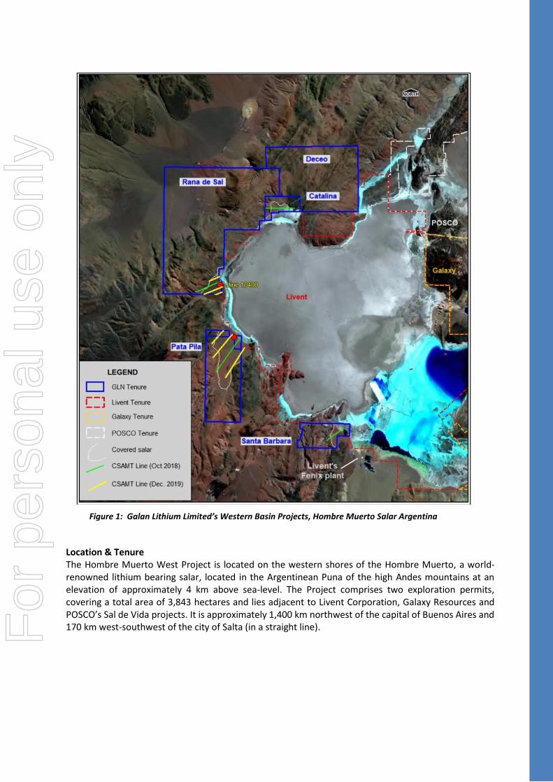
Location & Tenure The Hombre Muerto West Project is located on the western shores of the Hombre Muerto, a world-renowned lithium bearing salar, located in the Argentinean Puna of the high Andes mountains at an elevation of approximately 4 km above sea-level. The Project comprises two exploration permits, covering a total area of 3,843 hectares and lies adjacent to Livent Corporation, Galaxy Resources and POSCO’s Sal de Vida projects. It is approximately 1,400 km northwest of the capital of Buenos Aires and 170 km west-southwest of the city of Salta (in a straight line).
Figure 1: Galan Lithium Limited’s Western Basin Projects, Hombre Muerto Salar Argentina
For
per
sona
l use
onl
y

Figure 2: The geological model for Pata Pila and Rana de Sal produced by SRK. Note specific yields are: Sand
(10%), Halite (3%) and Gravels (4%)
Geological Model As part of the mineral resource estimation process, SRK conducted geological modelling (figure 2) of Pata Pila and Rana de Sal using the software packages GoCADTM (Paradigm, geological modelling) and GEMSTM (Geovia, geological modelling and section interpretation). The modelling used the following datasets:
• Resistivity and Conductivity profiles (CSMAT);
• Downhole geophysics (particularly gamma);
• Assays obtained from Alex Stewart International laboratory;
• Zelandez downhole data including total porosity and specific yield; and
• Lithological logs. Hombre Muerto West project areas are located along the western shores of the Salar. The Salar is a closed drainage basin, structurally controlled and bounded by normal faults. The drill holes were located upon alluvial fans that have prograded out onto the Salar. The younger alluvial fan deposits rest conformably upon the salar. All borehole drilling was by the diamond drill method, with an internal triple tube for core recovery. Core was sampled in 1.5m lengths and logged by a geologist. Water/brine samples were taken from multiple target intervals using packer, bailer and airlift tests (see table 1 for more details). Downhole geophysics were employed e.g. downhole geophysical profiling and borehole magnetic resonance. Geochemical analyses of brine were undertaken by ICP-MS in two independent accredited laboratories (see table 1 for more details).
For
per
sona
l use
onl
y

The resource boundaries of the hydrogeologic wireframes were determined as follows:
• Vertical limits are constrained between top of basement and top of sand / base of alluvial cover
• The western boundary is limited where the sand unit pinches out against basement
• The eastern margin is constrained by the tenement boundary
• The northern margin is constrained by a northeast-southwest very steeply dipping to the southeast fault, and
• The southern margin is constrained where the sand unit pinches out on shallow basement In general, the style of geology has been assumed to be relatively flat to gentle basinward dipping stratigraphy with no preferred direction of mineralisation continuity. A block model was created to cover the extents of both licence areas and was confined by a wireframe model based upon the various lithologies. When choosing appropriate model cell dimensions of 250 (easting) by 250 (northing) by 5m (elevation), consideration was given to drill spacing, sample interval, the interpreted geometry and thickness of the hydrogeologic domains and the style of mineralisation. The main assay intervals for both holes are based on 72-hour airlift samples. As a result, no useful variography is possible from two averaged air lift samples. For Pata Pila, the air lift sample was obtained from interval 40 to 718.5m, and for Rana de Sal, the sample was obtained from 100 to 433m. Two simple packer samples were also obtained from the Rana de Sal drillhole over 32 to 122m. A simple Inverse Distance weighted (to the power value of 2) extrapolation was carried out, using an isotropic search that allowed all blocks coded with Sand, Gravel or Halite to be interpolated. The maximum extrapolated distance for Pata Pila is 2.57 km with an average distance of 1.3 km. For Rana de Sal, the maximum extrapolated distance is 1.1 km with an average distance of 0.6 km. A study by Houston et al., (2011)(#) showed that drill spacing of between 7 and 10km should be sufficient for Inferred resource definition. Therefore, the distance of 4.5 km between the two holes and maximum extrapolation distances of around 2.6 km are considered reasonable. # - “The Evaluation of Brine Prospects and the Requirement for Modifications to Filing Standards” by John Houston, Andrew Butcher, Peter Ehren, Keith Evans and Linda Godfrey (October 2011)
Resource Classification The mineral resource estimate for the Pata Pila and Rana de Sal licence areas has been classified in accordance with the JORC Code, 2012 edition. This classification also conforms to the AMEC “Guidelines for Resource and Reserve Estimation for Brines”. Numerous factors were taken into consideration when assigning the classification applied to the Mineral Resource estimate. Of these factors, it is considered that the classification has been primarily influenced by the drill coverage, geological complexity and data quality as described below: Data quality: The datasets comprise a mix of sample data which were provided to SRK in numerous separate editable files. QAQC for Galan’s data was acceptable for brine chemistry. Chemical results from Alex Stewart International laboratory were preferred for resource estimation. The brine occurrence and chemistry, the relative consistency of the data and confidence in the drilling and sampling results is good. Geological complexity: The general orientation of the major defined domains / horizons appears to be consistent and predictable. Thickness is variable for each hydrogeologic domain. The lower boundary of Sand and Gravels needs to be better constrained due to some basement topography as indicated by basement encountered at 710m in Pata Pila and at 189m at Rana de Sal. The geophysical resistivity lines
For
per
sona
l use
onl
y

also show this irregularity and were used to help guide the model. Structures can be clearly observed and mapped from surface. However, it is not clear at present as to their affect at depth. Overall, there is reasonable understanding of the stratigraphy of the basin with excellent correlation of units between most areas. Brines will migrate from unit to unit throughout the basin during production pumping. Therefore, at this stage, much of the resource is categorised as Inferred, but with more precise interpretation of the hydrogeologic domains, this would result in potential upgrade of the category to Indicated. At this stage, SRK does not deem it necessary to understand the local variations to that level of detail. Data coverage: The data coverage reflects the 2019 drilling and geophysical surveys. The drillhole spacing is 4.5 km and both holes are vertical. All estimated blocks within the defined extents and hydrogeologic domains were assigned a classification of Inferred Resource. Validation results: The model validation checks show a reasonable match between the input data and estimated grades, indicating that the estimation procedures have performed as intended. Potential economic viability: The deposit is located in a well-known area of brine lithium with good existing infrastructure and nearby mills available for ore processing. When assessing the criteria described above, SRK considers the greatest source of uncertainty to be the large drillhole spacing and large sample intervals which has resulted in data aggregation. The large intervals have also resulted in some degree of smearing of high grades within the modelled domains. The minimum interpolated grade is around 950 Li mg/l, which is very high grade, and above what has been deemed in similar projects as an economic cut off grade. For example, a 500 Li mg/l cut off was used for 1NRG Metals Inc’s Hombre Muerto North project that has a combined Measured/Indicated resource. 1NRG Metals, NI 43-101 Preliminary Economic Assessment Report for the Hombre Muerto Norte Project Salta Province, Argentina. Effective Date 3rd June 2019
Next Steps Further work planned to better define the synergies of the mineral resources from Candelas and HMW will include additional drilling within the HMW and the Candelas North project areas to provide better geological definition and mineralisation potential of the aquifers. Additionally, complementary works will include the new HMW resource for inclusion in the Scoping and Pre-Feasibility Study which will include base hydrogeological modelling and the investigation of various processing technologies with a focus on traditional evaporation ponds as a precursor to processing. Galan has recently acquired the option to purchase strategic projects (Del Condor and Pucara de Salar) at HMW from Portofino Resources Inc (Galan Announcement dated 26 February 2020). These concessions are shown in figure 3.
Figure 3: Map of Hombre Muerto West Showing Portofino’s Del Condor and Pucara del
Salar concessions (in red) and Galan’s concessions (in black)
For
per
sona
l use
onl
y

The Galan Board authorises the release of this announcement.
For further information contact:
Juan Pablo (“JP”) Vargas de la Vega Terry Gardiner Managing Director Non-Executive Director Email: [email protected] +61 400 900 377 Tel: +61 8 9322 6283
For
per
sona
l use
onl
y

About Galan
Galan is an ASX listed company exploring for lithium brines within South America’s Lithium Triangle on the Hombre Muerto salar in Argentina. Hombre Muerto is proven to host the highest grade and lowest impurity levels within Argentina and is home to Livent Corporation’s El Fenix operation and Galaxy Resources and POSCO’s Sal de Vida projects.
Galan has two projects:
Candelas: a ~15km long by 3-5km wide valley filled channel which project geophysics and drilling have indicated the potential to host a substantial volume of brine and over which a maiden resource estimated 685kt LCE (Oct 2019). Furthermore, Candelas has the potential to provide a substantial amount of processing water by treating its low-grade brines with reverse osmosis, this is without using surface river water from Los Patos River.
Hombre Muerto West (HMW): a ~14km by 1-5km wide of the west coast of Hombre Muerto salar neighbouring Livent Corp to the east. HMW is currently comprised of four concessions and an additional two concessions under an option agreement from Portofino Resources Inc (TSX-V). Geophysics and drilling at HMW demonstrated a significant potential of a deep basin. In March 2020, a maiden resource estimate delivered 1.1Mt of LCE for two of the largest concessions (Pata Pila and Rana de Sal) with exploration upside remaining for the rest of the concessions.
Competent Persons Statements Competent Persons Statement 1 The information contained herein that relates to exploration results and geology is based on information compiled or reviewed by Dr Luke Milan, who has consulted to the Company. Dr Milan is a Member of the Australasian Institute of Mining and Metallurgy and has sufficient experience which is relevant to the style of mineralisation and types of deposit under consideration and to the activity which they are undertaking to qualify as a Competent Persons as defined in the 2012 Edition of the ‘Australasian Code for Reporting of Exploration Results, Mineral Resources and Ore Reserves’. Dr Milan consents to the inclusion of his name in the matters based on the information in the form and context in which it appears. Competent Persons Statement 2 The information relating to the Exploration Results and integrity of the database was compiled by Mr Francisco Lopez (Geology). Mr Lopez is a full-time employee of Galan Lithium Limited and has been engaged by Galan as their Geology Manager. The integrity of the database and site inspection was done by Dr Michael Cunningham, GradDip, (Geostatistics) BSc honours (Geoscience), PhD, MAusIMM, MAIG, MGSA, FGSL. Dr Cunningham is a Principal Consultant and full-time employee of SRK Consulting (Australasia) Pty Ltd. The information in this report that relates to the Mineral Resources estimation approach at Candelas and Hombre Muerto West was compiled by Dr Cunningham. He has sufficient experience relevant to the assessment and of this style of mineralisation to qualify as a Competent Person as defined by the “Australasian Code for Reporting of Exploration Results, Mineral Resources and Ore Reserves – The JORC Code (2012)”. Dr Cunningham consents to the inclusion in this report of the matters based on his information in the form and context in which it appears.
The Company confirms that it is not aware of any new information or data that materially affects the information included in the original market announcements, and that all material assumptions and technical parameters have not materially changed. The Company also confirms that the form and context in which the Competent Person’s findings are presented have not been materially modified from the original market announcements.
For
per
sona
l use
onl
y
JORC Code, 2012 Edition – Table 1 Section 1 Sampling Techniques and Data (Criteria in this section apply to all succeeding sections.)
Criteria JORC Code explanation Commentary
Sampling techniques
• Nature and quality of sampling (e.g. cut channels, random chips, or specific specialised industry standard measurement tools appropriate to the minerals under investigation, such as downhole gamma sondes, or handheld XRF instruments, etc.). These examples should not be taken as limiting the broad meaning of sampling.
• Include reference to measures taken to ensure sample representivity and the appropriate calibration of any measurement tools or systems used.
• Aspects of the determination of mineralisation that are Material to the Public Report.
• In cases where ‘industry standard’ work has been done, this would be relatively simple (e.g. ‘reverse circulation drilling was used to obtain 1 m samples from which 3 kg was pulverised to produce a 30 g charge for fire assay’). In other cases, more explanation may be required, such as where there is coarse gold that has inherent sampling problems. Unusual commodities or mineralisation types (e.g. submarine nodules) may warrant disclosure of detailed information.
• Drill core was recovered in 1.5 m length core runs in core split tubes to minimize sample disturbance. Core recovery was carefully measured by comparing the measured core to the core runs.
• Drill core was undertaken along the entire length of the holes to obtain representative samples of the stratigraphy and sediments that host brine.
• Water/brine samples from target intervals were collected by either the Packer or Bailer tests. Bailer tests; purge isolated sections of the hole of all fluid a total of five times to minimise the possibility of contamination by drilling fluid (fresh water), although some contamination (5-15%) may occur. The hole is then allowed time to refill with ground water. On the fifth purge the sample for lab analysis is collected. The casing lining the hole ensures contamination with water from higher levels in the borehole is likely prevented. Packer tests utilise a straddle packer device which isolates a discrete interval and allows for sampling purely from this interval. Samples were taken from the relevant section based upon geological logging and conductivity testing of water.
• Water/brine samples were collected from multiple intervals as listed in tables 1 and 2.
• Conductivity tests are taken on site with a field portable Hanna Ph/EC/DO multiparameter.
• Density measurements were undertaken on site with a field
For
per
sona
l use
onl
y

Criteria JORC Code explanation Commentary
portable Atmospheric Mud Balance, made by OFI testing equipment.
• Downhole geophysical profiling was conducted using a Ponti Electronics MPX-14Multiplex Well Logger.
• Downhole Borehole Magnetic Resonance (BMR) profiling, adapted to high salinity, was conducted by Zelandez Argentina to log continuous specific yield. This is a common geophysical method for continuous measurements of porosity downhole. The geophysical method is based on the ability of water to absorb and emit electromagnetic energy of a certain frequency, and provides a lithology independent measurement of the porosity. Total porosity is then split into its fractional components by applying cut-offs within the pore size distribution. The specific retention and specific yield can then be calculated.
• Specific yield logs obtained by this method were then compared and validated with similar projects of the Punta region.
Drilling techniques • Drill type (e.g. core, reverse circulation, open-hole hammer, rotary air blast, auger, Bangka, sonic, etc.) and details (e.g. core diameter, triple or standard tube, depth of diamond tails, face-sampling bit or other type, whether core is oriented and if so, by what method, etc.).
• Diamond drilling with internal (triple) tube was used for drilling. The drilling produced core with variable core recovery, associated with unconsolidated material. Recovery of the more friable sediments was difficult, however core recovery by industry standards was very good.
• Fresh water is used as drilling fluid for lubrication during drilling.
For
per
sona
l use
onl
y
Criteria JORC Code explanation Commentary
Drill sample recovery
• Method of recording and assessing core and chip sample recoveries and results assessed.
• Measures taken to maximise sample recovery and ensure representative nature of the samples.
• Whether a relationship exists between sample recovery and grade and whether sample bias may have occurred due to preferential loss/gain of fine/coarse material.
• Diamond drill core was recovered in 1.5m length intervals in triple (split) tubes. Appropriate additives were used for hole stability to maximise core recovery. The core recoveries were measured from the core and compared to the length of each run to calculate the recovery.
• Brine samples were collected over relevant sections based upon the geology encountered and ground water representation.
• Brine quality is not directly related to core recovery and is largely independent of the quality of core samples. However, the porosity and permeability of the lithologies where samples are taken is related to the rate of brine inflow.
Logging • Whether core and chip samples have been geologically and geotechnically logged to a level of detail to support appropriate Mineral Resource estimation, mining studies and metallurgical studies.
• Whether logging is qualitative or quantitative in nature. Core (or costean, channel, etc.) photography.
• The total length and percentage of the relevant intersections logged.
• The core is logged by a senior geologist and contract geologists who are overseen by the senior geologist who also supervised the taking of samples for laboratory analysis.
• Logging is both qualitative and quantitative in nature. The relative proportions of different lithologies which have a direct bearing on the overall porosity, contained and potentially extractable brine are noted, as are more qualitative characteristics such as the sedimentary facies. Cores are split for sampling and are photographed.
• All core was logged by a geologist
Sub-sampling techniques and sample preparation
• If core, whether cut or sawn and whether quarter, half or all core taken.
• If non-core, whether riffled, tube sampled, rotary split, etc. and whether sampled wet or dry.
Bailer sampling:
• Utilises a stainless steel hollow 3m-long tube with a check valve at the bottom. The hole was first purged by extracting a calculated volume of liquid
For
per
sona
l use
onl
y
Criteria JORC Code explanation Commentary
• For all sample types, the nature, quality and appropriateness of the sample preparation technique.
• Quality control procedures adopted for all sub-sampling stages to maximise representivity of samples.
• Measures taken to ensure that the sampling is representative of the in-situ material collected, including for instance results for field duplicate/second-half sampling.
• Whether sample sizes are appropriate to the grain size of the material being sampled.
(brine and drilling mud) to ensure that sampled brine corresponds to the sampled depth. Once the calculated volume was extracted and brine was clear, samples were collected in plastic bottles and delivered to the laboratories. The lower part of the sampling hole section was temporarily sealed during purging and sampling. A total of 1 Bailer samples were obtained.
Simple packer sampling:
• Packer sampling was performed during drilling of each hole and after well casing and development using both simple and double packer system. Water/brine samples were collected by purging isolated sections of the hole of all fluid in the hole, to minimise the possibility of contamination by drilling fluid, then allowing the hole to re-fill with ground waters. Samples were then taken form the relevant section. A total of 10 samples were obtained and an additional 5 duplicate samples were obtained for quality control purposes.
Airlift sampling:
• Utilises an airline that delivers compressed air to the end of the drill string (drill bit) within the drill hole. The compressed air is pumped into the air line and this lifts the water/brine sample up the rod string and is subsequently captured at the surface.
• Airlift sampling was carried out at each drill hole with 72-hour pumping. For Pata Pila (PP-01-19), a total of 5 samples were taken at 2, 24, 36, 44 and 64 hours. For Rana de Sal, a total of 4 samples were taken at 5, 30, 54 and 74 hours. For every
For
per
sona
l use
onl
y
Criteria JORC Code explanation Commentary
sample sent to the primary laboratory, a duplicate was sent to a second laboratory for check analysis.
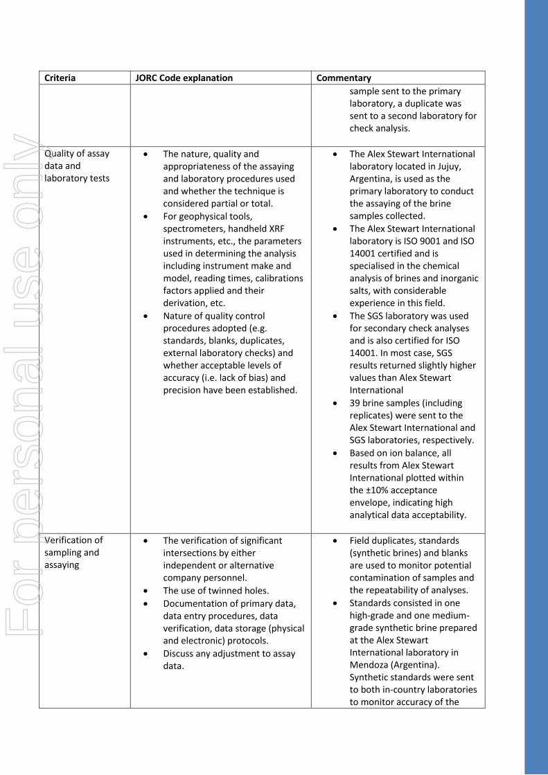
Quality of assay data and laboratory tests
• The nature, quality and appropriateness of the assaying and laboratory procedures used and whether the technique is considered partial or total.
• For geophysical tools, spectrometers, handheld XRF instruments, etc., the parameters used in determining the analysis including instrument make and model, reading times, calibrations factors applied and their derivation, etc.
• Nature of quality control procedures adopted (e.g. standards, blanks, duplicates, external laboratory checks) and whether acceptable levels of accuracy (i.e. lack of bias) and precision have been established.
• The Alex Stewart International laboratory located in Jujuy, Argentina, is used as the primary laboratory to conduct the assaying of the brine samples collected.
• The Alex Stewart International laboratory is ISO 9001 and ISO 14001 certified and is specialised in the chemical analysis of brines and inorganic salts, with considerable experience in this field.
• The SGS laboratory was used for secondary check analyses and is also certified for ISO 14001. In most case, SGS results returned slightly higher values than Alex Stewart International
• 39 brine samples (including replicates) were sent to the Alex Stewart International and SGS laboratories, respectively.
• Based on ion balance, all results from Alex Stewart International plotted within the ±10% acceptance envelope, indicating high analytical data acceptability.
Verification of sampling and assaying
• The verification of significant intersections by either independent or alternative company personnel.
• The use of twinned holes.
• Documentation of primary data, data entry procedures, data verification, data storage (physical and electronic) protocols.
• Discuss any adjustment to assay data.
• Field duplicates, standards (synthetic brines) and blanks are used to monitor potential contamination of samples and the repeatability of analyses.
• Standards consisted in one high-grade and one medium-grade synthetic brine prepared at the Alex Stewart International laboratory in Mendoza (Argentina). Synthetic standards were sent to both in-country laboratories to monitor accuracy of the
For
per
sona
l use
onl
y
Criteria JORC Code explanation Commentary
latest batch of samples (long-term airlift sampling).
• One blank was analysed at Rana De Sal.
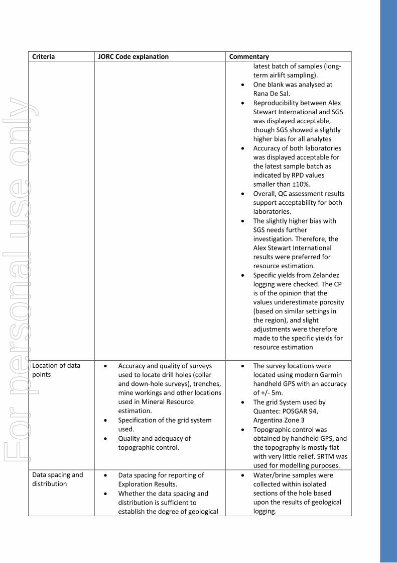
• Reproducibility between Alex Stewart International and SGS was displayed acceptable, though SGS showed a slightly higher bias for all analytes
• Accuracy of both laboratories was displayed acceptable for the latest sample batch as indicated by RPD values smaller than ±10%.
• Overall, QC assessment results support acceptability for both laboratories.
• The slightly higher bias with SGS needs further investigation. Therefore, the Alex Stewart International results were preferred for resource estimation.
• Specific yields from Zelandez logging were checked. The CP is of the opinion that the values underestimate porosity (based on similar settings in the region), and slight adjustments were therefore made to the specific yields for resource estimation
Location of data points
• Accuracy and quality of surveys used to locate drill holes (collar and down-hole surveys), trenches, mine workings and other locations used in Mineral Resource estimation.
• Specification of the grid system used.
• Quality and adequacy of topographic control.
• The survey locations were located using modern Garmin handheld GPS with an accuracy of +/- 5m.
• The grid System used by Quantec: POSGAR 94, Argentina Zone 3
• Topographic control was obtained by handheld GPS, and the topography is mostly flat with very little relief. SRTM was used for modelling purposes.
Data spacing and distribution
• Data spacing for reporting of Exploration Results.
• Whether the data spacing and distribution is sufficient to establish the degree of geological
• Water/brine samples were collected within isolated sections of the hole based upon the results of geological logging.
For
per
sona
l use
onl
y

Criteria JORC Code explanation Commentary
and grade continuity appropriate for the Mineral Resource and Ore Reserve estimation procedure(s) and classifications applied.
• Whether sample compositing has been applied.
Orientation of data in relation to geological structure
• Whether the orientation of sampling achieves unbiased sampling of possible structures and the extent to which this is known, considering the deposit type.
• If the relationship between the drilling orientation and the orientation of key mineralised structures is considered to have introduced a sampling bias, this should be assessed and reported if material.
• The brine concentrations being explored for generally occur as sub-horizontal layers and lenses hosted by sand, silt, clay, gravels and some conglomerate. Vertical diamond drilling is ideal for understanding this horizontal stratigraphy and the nature of the sub-surface brine bearing aquifers.
Sample security • The measures taken to ensure sample security.
• Data was recorded and processed by trusted employees, consultants and contractors to the Company and overseen by senior management ensuring the data was not manipulated or altered.
• Samples are transported from the drill site to secure storage at the camp on a daily basis.
Audits or reviews • The results of any audits or reviews of sampling techniques and data.
• No audits or reviews have been conducted to date. The drilling is at a very early stage however the Company’s independent consultants and CP have approved the procedures to date.
Section 2 Reporting of Exploration Results (Criteria listed in section 1 also apply to this section.)
Criteria JORC Code explanation Commentary
Mineral tenement and land tenure status
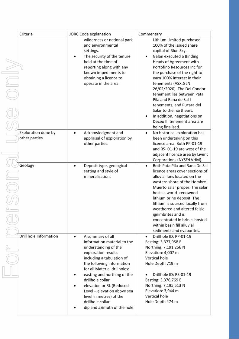
• Type, reference name/number, location and ownership including agreements or material issues with third parties such as joint ventures, partnerships, overriding royalties, native title interests, historical sites,
• The Candelas West Lithium Project consists of numerous licences located in Catamarca Province, Argentina. The tenements are owned by Blue Sky Lithium Pty Ltd (‘Blue Sky’). The Company and Blue Sky executed a Share Sale Agreement whereby Galan
For
per
sona
l use
onl
y
Criteria JORC Code explanation Commentary
wilderness or national park and environmental settings.
• The security of the tenure held at the time of reporting along with any known impediments to obtaining a licence to operate in the area.
Lithium Limited purchased 100% of the issued share capital of Blue Sky.
• Galan executed a Binding Heads of Agreement with Portofino Resources Inc for the purchase of the right to earn 100% interest in their tenements (ASX:GLN 26/02/2020). The Del Condor tenement lies between Pata Pila and Rana de Sal I tenements, and Pucara del Salar to the northeast.
• In addition, negotiations on Deceo III tenement area are being finalised.
Exploration done by other parties
• Acknowledgment and appraisal of exploration by other parties.
• No historical exploration has been undertaking on this licence area. Both PP-01-19 and RS- 01-19 are west of the adjacent licence area by Livent Corporations (NYSE:LVHM).
Geology • Deposit type, geological setting and style of mineralisation.
• Both Pata Pila and Rana De Sal licence areas cover sections of alluvial fans located on the western shore of the Hombre Muerto salar proper. The salar hosts a world- renowned lithium brine deposit. The lithium is sourced locally from weathered and altered felsic ignimbrites and is concentrated in brines hosted within basin fill alluvial sediments and evaporites.
Drill hole Information • A summary of all information material to the understanding of the exploration results including a tabulation of the following information for all Material drillholes:
• easting and northing of the drillhole collar
• elevation or RL (Reduced Level – elevation above sea level in metres) of the drillhole collar
• dip and azimuth of the hole
• Drillhole ID: PP-01-19 Easting: 3,377,958 E Northing: 7,191,256 N Elevation: 4,007 m Vertical hole Hole Depth 719 m
• Drillhole ID: RS-01-19 Easting: 3,376,769 E Northing: 7,195,513 N Elevation: 3,944 m Vertical hole Hole Depth 474 m
For
per
sona
l use
onl
y

Criteria JORC Code explanation Commentary
• downhole length and interception depth
• hole length.
• If the exclusion of this information is justified on the basis that the information is not Material and this exclusion does not detract from the understanding of the report, the Competent Person should clearly explain why this is the case.
Data aggregation methods
• In reporting Exploration Results, weighting averaging techniques, maximum and/or minimum grade truncations (e.g. cutting of high grades) and cut-off grades are usually Material and should be stated.
• Where aggregate intercepts incorporate short lengths of high-grade results and longer lengths of low-grade results, the procedure used for such aggregation should be stated and some typical examples of such aggregations should be shown in detail.
• The assumptions used for any reporting of metal equivalent values should be clearly stated.
• No weighting or cut off grades have been applied
• Pumping tests continue to be carried out at Candelas West to ensure quality control
• All new assay results received to date are included in this report.
Relationship between mineralisation widths and intercept lengths
• These relationships are particularly important in the reporting of Exploration Results.
• If the geometry of the mineralisation with respect to the drillhole angle is known, its nature should be reported.
• If it is not known and only the downhole lengths are reported, there should be a clear statement to this effect (e.g. ‘down hole
• It is fairly assumed that the brine layers lie sub horizontal and, given that drillholes are vertical, the intercepted thicknesses of brine layers would be of true thickness. F
or p
erso
nal u
se o
nly

Criteria JORC Code explanation Commentary
length, true width not known’).
Diagrams • Appropriate maps and sections (with scales) and tabulations of intercepts should be included for any significant discovery being reported These should include, but not be limited to a plan view of drillhole collar locations and appropriate sectional views.
• Refer to maps, figures and tables in the Report
Balanced reporting • Where comprehensive reporting of all Exploration Results is not practicable, representative reporting of both low and high grades and/or widths should be practiced in order to avoid misleading reporting of Exploration Results.
• These results are from one drillhole at Rana de Sal and one drillhole from Pata Pila
Other substantive exploration data
• Other exploration data, if meaningful and material, should be reported including (but not limited to): geological observations; geophysical survey results; geochemical survey results; bulk samples – size and method of treatment; metallurgical test results; bulk density, groundwater, geotechnical and rock characteristics; potential deleterious or contaminating substances.
• All meaningful and material information is reported
• Refer to previous ASX Company releases:
ASX:GLN - 11 September, 2019 ASX:GLN - 9 October, 2019 ASX:GLN - 19 December, 2019 ASX:GLN - 13 January, 2020 ASX:GLN - 15 January, 2020
Further work • The nature and scale of planned further work (e.g. tests for lateral extensions or depth extensions or large-scale step-out drilling).
• Diagrams clearly highlighting the areas of possible extensions, including the main geological interpretations and future drilling areas, provided this information is not commercially sensitive.
• A Scoping and Pre-Feasibility study has commenced for the Candelas East project (to the east of the current project). With two separate projects now being delivered, project synergies will be updated and investigated. Additional drilling is being planned for HMW and Candelas North.
For
per
sona
l use
onl
y

Section 3 Estimation and Reporting of Mineral Resources (Criteria listed in section 1, and where relevant in section 2, also apply to this section.)
Criteria JORC Code explanation Commentary
Database integrity • Measures taken to ensure that data has not been corrupted by, for example, transcription or keying errors, between its initial collection and its use for Mineral Resource estimation purposes.
• Data validation procedures used.
• All logs provided to SRK were imported and validated in Postgres SQL database server.
• Boreholes are plotted in ArcGIS for plan generation
• All data is checked for accuracy
Site visits • Comment on any site visits undertaken by the Competent Person and the outcome of those visits.
• If no site visits have been undertaken indicate why this is the case.
• The CP visited the site from 22 to 26 July 2019 which included Candelas West.
• The CP reviewed core and cuttings for Candelas East. The CP consulted with exploration manager regarding details of the descriptions and lithologies, and the same methods and procedures have been applied to Candelas West.
• The CP reviewed locations and drilling and sampling practices whilst at site for Candelas East and visited the sites to be drilled for Candelas West (i.e. PP-01-19 and RS-01-19).
Geological interpretation
• Confidence in (or conversely, the uncertainty of) the geological interpretation of the mineral deposit.
• Nature of the data used and of any assumptions made.
• The effect, if any, of alternative interpretations on Mineral Resource estimation.
• The use of geology in guiding and controlling Mineral Resource estimation.
• The factors affecting continuity both of grade and geology.
• The spacing of both drillholes (~4.5 km) coupled with extensive coverage of conductivity surveys, gives a moderate degree of confidence in the geological model
• The brine level is horizontal and physical parameters of density, temperature and pH along with time and depth were recorded during drilling to identify any variation and assist in sampling.
• No samples were obtained from basement or alluvials, and therefore only the Sand, Gravels and Halite are estimated as potential economical resources
For
per
sona
l use
onl
y

Criteria JORC Code explanation Commentary
Dimensions • The extent and variability of the Mineral Resource expressed as length (along strike or otherwise), plan width, and depth below surface to the upper and lower limits of the Mineral Resource.
• The extents of the resource are approximately 2.75 km (easting) by 7.750 km (northing) by 1.2 m (vertical), giving a total volume of interest of ~25.5 km3.
• Downhole geophysics and depth-specific data (i.e. specific yield and brine chemistry) were used to estimate the resource. Priority was given to 72-hour airlift samples.
• Grades are relatively uniform with depth and lateral extent
Estimation and modelling techniques
• The nature and appropriateness of the estimation technique(s) applied and key assumptions, including treatment of extreme grade values, domaining, interpolation parameters and maximum distance of extrapolation from data points. If a computer assisted estimation method was chosen, include a description of computer software and parameters used.
• The availability of check estimates, previous estimates and/or mine production records and whether the Mineral Resource estimate takes appropriate account of such data.
• The assumptions made regarding recovery of by-products.
• Estimation of deleterious elements or other non-grade variables of economic significance (e.g. sulphur for acid mine drainage characterisation).
• In the case of block model interpolation, the block size in relation to the average sample spacing and the search employed.
• Due to the nature of the mineralisation style, the long sample intervals, and the need for some averaging of overlapping samples, an Inverse Distance interpolation (with power value of 2) was deemed most appropriate at this stage.
• The search ellipse was spheroidal. The search distances were at a distance to ensure all blocks within the hydrogeologic domains were estimated, up to a maximum of 2.7 km.
• Downhole measurements of specific yield (SY) (drainable porosity) were obtained by Zelandez Services Argentina using Borehole Magnetic Resonance technology. The technique uses a unique measurement that responds to volumes of fluids present in the sequences and the distribution of those fluids as a function of pore geometry. Thus, the technique is used to measure pore network fluids allowing determination of specific yield, Specific Retention and permeability i.e. hydraulic conductivity.
• Given no other independent method was used for
For
per
sona
l use
onl
y

Criteria JORC Code explanation Commentary
• Any assumptions behind modelling of selective mining units.
• Any assumptions about correlation between variables.
• Description of how the geological interpretation was used to control the resource estimates.
• Discussion of basis for using or not using grade cutting or capping.
• The process of validation, the checking process used, the comparison of model data to drillhole data, and use of reconciliation data if available.
measuring SY, the CP did a comparison of SY for other similar deposits and used conservative values for SY. The values assigned to each hydrogeologic unit (which includes both Pata Pila and Rana de Sal) are as follows:
• Sand – 10%
• Gravel – 4%
• Halite – 3%
• Total volumes of the hydrogeologic domains used for flagging the resource model (combined Pata Pila and Rana de Sal) are:
• Sand – 2.17 km3
• Gravel – 0.1 km3
• Halite – 0.02 km3
• Lithium and potassium content were estimated into a proportional block model based on 5m composites for each domain using soft boundaries. The composite length was chosen to account for the lenses of halite and gravel.
• The block model dimensions are: Easting (250m), Northing (250m), Elevation (5m)
Moisture • Whether the tonnages are estimated on a dry basis or with natural moisture, and the method of determination of the moisture content.
• Lithium brine is a liquid resource, moisture content is not relevant to resource calculations
Cut-off parameters • The basis of the adopted cut-off grade(s) or quality parameters applied.
• The minimum interpolated grade is around 950 mg/l Li, which is very high grade and above what has been deemed in similar projects as an economic cut off grade. For example, a 500 mg/l Li cut off was used for NRG Metals Inc’s Hombre Muerto North project that has a combined Measured/Indicated resource.
• Hence, no cut-off grade was applied but the upper fresh
For
per
sona
l use
onl
y

Criteria JORC Code explanation Commentary
and brackish water units were assumed to be zero.
• Based on observations that the brine density and chemistry is relatively consistent below a depth of about 80 metres, it was assumed that with depth, all parts of the salar between this depth and base of RS-01-19 at 713m, will have saturated brine. The geophysics has shown that the basement topography is irregular and may result in some parts of the system being shallower than this depth, particularly towards the western margins of the resource. This has been taken into account in the Resource classification.
Mining factors or assumptions
• Assumptions made regarding possible mining methods, minimum mining dimensions and internal (or, if applicable, external) mining dilution. It is always necessary as part of the process of determining reasonable prospects for eventual economic extraction to consider potential mining methods, but the assumptions made regarding mining methods and parameters when estimating Mineral Resources may not always be rigorous. Where this is the case, this should be reported with an explanation of the basis of the mining assumptions made.
• Potential brine abstraction is considered to involve pumping via a series of production wells
• The thick and mostly unconsolidated sand units dominate the drainable brine resource. The CP believes that the transmissivity of future wells completed in these units would be favourable for extracting brine because of the assumed favourable aquifer conditions associated with these clastic units
Metallurgical factors or assumptions
• The basis for assumptions or predictions regarding metallurgical amenability. It is always necessary as part of the process of determining reasonable prospects for eventual economic extraction to consider potential metallurgical methods, but the assumptions regarding
• The production of Lithium Carbonate (Li2CO3) from lithium brine has been demonstrated by a number of companies with projects in Argentina in close proximity to Candelas West, for example Livent Corporation’s El Fenix, and Galaxy’s Hombre de Muerto. It is assumed Galan
For
per
sona
l use
onl
y

Criteria JORC Code explanation Commentary
metallurgical treatment processes and parameters made when reporting Mineral Resources may not always be rigorous. Where this is the case, this should be reported with an explanation of the basis of the metallurgical assumptions made.
would use similar methods to enrich brine to 99.6% lithium and produce Lithium Carbonate (Li2CO3)
• Further pilot testing work is planned, but as yet not undertaken, to test production of Lithium Carbonate (Li2CO3) from the brine
Environmental factors or assumptions
• Assumptions made regarding possible waste and process residue disposal options. It is always necessary as part of the process of determining reasonable prospects for eventual economic extraction to consider the potential environmental impacts of the mining and processing operation. While at this stage the determination of potential environmental impacts, particularly for a greenfields project, may not always be well advanced, the status of early consideration of these potential environmental impacts should be reported. Where these aspects have not been considered this should be reported with an explanation of the environmental assumptions made.
• No factors or assumptions are made at this time. However, an environmental report has been accepted by the mining court for the tenement grant
Bulk density • Whether assumed or determined. If assumed, the basis for the assumptions. If determined, the method used, whether wet or dry, the frequency of the measurements, the nature, size and representativeness of the samples.
• The bulk density for bulk material must have been measured by methods that adequately account for void spaces (vugs, porosity, etc.), moisture and differences
• Bulk density determination is not relevant for brine resource calculations as the drainable porosity or specific yield of the hydrogeologic units is the relevant factor for brine resource calculations
• Synthetic values of drainable porosity and specific yield values are obtained from downhole geophysics downhole geophysics (Zelandez) and includes all aquifer material. The CP did a comparison of similar aquifer material from other nearby
For
per
sona
l use
onl
y

Criteria JORC Code explanation Commentary
between rock and alteration zones within the deposit.
• Discuss assumptions for bulk density estimates used in the evaluation process of the different materials.
projects as a check on the results, and where necessary modified accordingly.
• A summary of samples including specific yield and modifications to the synthetic measurements per hydrogeological domain is provided in the main body of the report:
Classification • The basis for the classification of the Mineral Resources into varying confidence categories.
• Whether appropriate account has been taken of all relevant factors (i.e. relative confidence in tonnage/grade estimations, reliability of input data, confidence in continuity of geology and metal values, quality, quantity and distribution of the data).
• Whether the result appropriately reflects the Competent Person’s view of the deposit.
• All the estimated Resource was assigned as Inferred. This is consistent with recommendations by Houston et al. (2011) (#) where they suggest that well spacing required to estimate a Measured Resource be no farther than 3-4 kilometres apart from each other. The high quality of geophysical survey data also demonstrates the continuity, and geometry of the brine acquirers at depth. # - “The Evaluation of Brine Prospects and the Requirement for Modifications to Filing Standards” by John Houston, Andrew Butcher, Peter Ehren, Keith Evans and Linda Godfrey (October 2011)
• Given the relatively small size of the alluvial fan system, the uniformity of the brine chemistry, the relatively good stratigraphic understanding of the hydrogeologic units, and 2 exploration drillholes at 4.5 km apart, but SY only being obtained from one method, it is considered to be of Inferred Category.
Audits or reviews • The results of any audits or reviews of Mineral Resource estimates.
• The Resource estimate was subject to internal peer review by SRK Consulting (Australasia) and Galan Lithium.
Discussion of relative accuracy/ confidence
• Where appropriate, a statement of the relative accuracy and confidence level in the Mineral Resource estimate using an approach or
• Samples were analysed by two separate laboratories and included duplicate brine samples submitted to both laboratories to confirm
For
per
sona
l use
onl
y

Criteria JORC Code explanation Commentary
procedure deemed appropriate by the Competent Person. For example, the application of statistical or geostatistical procedures to quantify the relative accuracy of the resource within stated confidence limits, or, if such an approach is not deemed appropriate, a qualitative discussion of the factors that could affect the relative accuracy and confidence of the estimate.
• The statement should specify whether it relates to global or local estimates, and, if local, state the relevant tonnages, which should be relevant to technical and economic evaluation. Documentation should include assumptions made and the procedures used.
• These statements of relative accuracy and confidence of the estimate should be compared with production data, where available.
repeatability as part of the Quality Assurance and Quality Control (QA/QC) procedure. To date, a total of 11 bailer/packer tests (including 5 duplicate samples) and a total of 15 airlift samples (including 8 duplicates, 2 blanks and 4 synthetic brines) were submitted were submitted to Alex Stewart International and SGS. A high and a low certified synthetic brine were also used to check accuracy. Based on the results of the duplicate and standard samples, the CP concluded that the laboratory results are reliable.
• The Mineral Resource estimate statement is based on two drillholes, given the relatively small size of the project and the domains, the uniformity of the brine chemistry, the extensive coverage of conductivity profiles and the relatively good stratigraphic understanding of the hydrogeologic units, the CP believes that an Inferred category is justified
• The sandy units which dominate the drainable brine resource are believed by the CP to suggest that the transmissivity of future wells completed in these units would be favourable for extracting brine because of the assumed favourable aquifer conditions associated with these clastic units
For
per
sona
l use
onl
y