high conservation value assessment of pt … kms hcv assessment...2.0 scope of hcv assessment...
TRANSCRIPT

High Conservation Value Assessment of PT KutaiMitra Sejahtera
Summary (Section 4b)
MAY 2011 Contents. 1. Executive Summary.
As is mentioned in the document on “RSPO Detailed Process Flow for New Plantings Procedures” the summary must include reporting of the identification of
All primary forest. Any area required to maintain or enhance one of more High Conservation Values (HCVs) All areas of peat soils. Local peoples’ lands.
2. Scope of the SEIA and HCV Assessments:
Organisational information and contact persons. List of Legal documents, regulatory permits and property deeds related to the areas
assessed. Location maps – both at landscape level and property level. Area of new plantings and time-plan for new plantings.
3. Assessment process and procedures
Assessors and their credentials Assessment methods (Data sources, data collection, dates, programme, places visited ) Stakeholder consultation (stakeholders contacted, consultation notices and dates) List of Legal, regulatory and other guidance referenced.
4. Summary of assessment findings (for SEI assessments)
Summary of key findings in respect of socio-economic impacts to country, region and local communities.
Summary of key findings in respect of socio-economic impact in respect of emergent communities (workers, suppliers, etc.).
Issues raised by stakeholders and assessors comments on each issue.
5. Summary of assessment findings (For HCV assessments) Overall HCV identification and proposed measures to maintain and enhance those identified Documentation showing the Obtained Free, Prior and Informed Consent of any indigenous peoplesaffected by the development of the concession (part of RSPO requirements)
Data sources and quality. Which HCV toolkits employed. Decisions on HCV status and related mapping.
6. Internal responsibility
Formal signing off by assessors and company Statement of acceptance of responsibility for assessments.
High Conservation Value Assessment of PT KutaiMitra Sejahtera
1.0 Executive Summary
A HCV assessment was undertaken on the HGU area of PT KutaiMitra Sejahtera. The area is approximately 7,420 hectares and it is located in Kecamatan (Sub-district) of MuaraAncalong, Kabupaten (district) KutaiTimur, Propinsi (Province) Kalimantan Timur, Indonesia.
The parent company (PT REA Kaltim Plantations) is a RSPO member. In line with the requirements of RSPO’s New Planting Procedures (NPP) an independent High Conservation Value assessment is required among other things.
The area has been logged repeatedly and has been subjected to fire between 1998 and 2008. It is
dominated by secondary forests and there is no primary forest on site. However, there is a small patch of relatively undisturbed forest adjoining the riverine forest which has Eusideroxylonzwageri. For conservation purposes, it has been classified as primary having HCV status. There are no peat areas found onsite. The site is remote and does not have any local community settlements within or adjacent to its boundaries.
Approximately 5,393 ha is available for planting, the remaining 2,027 ha is classified as having potential HCV. The presence of HCV 1, 2, 3 and 4 is recorded. There were no areas having HCV 4 and 5 values.
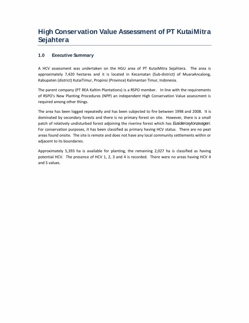
2.0 Scope of HCV assessment
Organizational structure.
Role Responsibility Entity Director Budget approval, corporate affairs PT Kutai Mitra Sejahtera Estate Advisor Planning of various estates
operations PT Kutai Mitra Sejahtera
Estate Manager Implementation of daily operations
PT Kutai Mitra Sejahtera
Office Administrator Administrative work PT Kutai Mitra Sejahtera Askep Main Division Overseeing the assistance in the
daily operations of their respective divisions
PT Kutai Mitra Sejahtera
Askep Sub Division Overseeing the assistance in the daily operations of their respective divisions
PT Kutai Mitra Sejahtera
Assistant Implementing and monitoring various estates operations
PT Kutai Mitra Sejahtera
Askep
Sub Division
Director
Estate Advisor
Estate Manager Office
Administrator
Askep
Main
Asst.0 Asst.0 Asst.0 Asst.0Asst.0 Asst.0 Asst.0 Asst.0 Asst.0

List of Legal Documents and regulatory permits related to the areas assessed Name of Legal Document
1. Deed of Establishment/Articles of Association of PT Kutai Mitra Sejahtera No. 26 dated 22 March 2007 made before Soetati Mochtar, SH, Notary in Jakarta as approved by the Ministry of Law and Human Rights through Decree No. W7- 073210 HT.01.01-TH.2007 dated 2 July 2007 as amended from time to time and the latest is by the Deed of Statement of Shareholders’ Decision No. 5 dated 5 March 2008 made before Soetati Mochtar, SH as approved by the Ministry of Law and Human Rights No. AHU-30743.AH.01.02.Tahun 2008 dated 6 June 2008.
2. Tax-payer Identification Number No. 02.661.391.9-722.000
3. Company Registration No. 17.01.1.01.03122 dated 6 November 2008.
4. Decree of the Regent of Kutai Timur No. 500/197/Eko.2-II/2008 dated 28 February
2008 concerning Plantation Business Permit of PT Kutai Mitra Sejahtera
5. Decree No. 1160/660.1/2/1/LH/XI/2008 dated 27 November 2008 concerning
Environmental Impact Analysis of PT Kutai Mitra Sejahtera.
6. Decree of the Head of National Land Affairs Agency No. 6/HGU/BPN.RI/2011 dated
18 February 2011 concerning Granting of Right to Cultivate (HGU) to PT Kutai
Mitra Sejahtera for a total area of 7,321.15Ha.
The scope of HCV assessment is as follows:
i. Landscape assessment of KutaiTimur and Kalimantan Timur Province. (See Map 1)
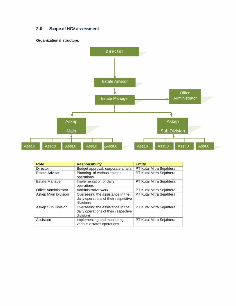
ii. The PT KMS site, approximately 7,420 ha in KecamatanMuaraAncalong, KabupatenKutaiTimur. (See Map 2).
iii. DesaSenyiur in MuaraAncalong.
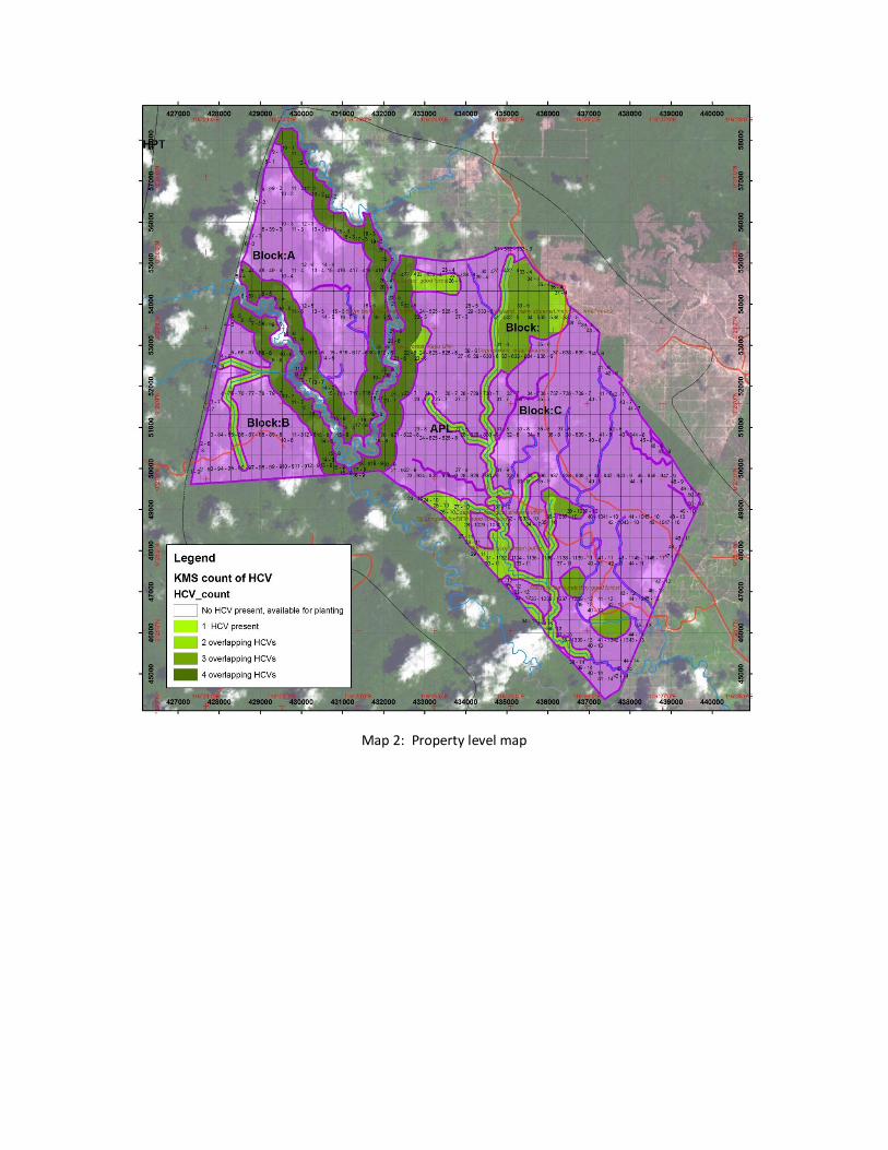
Areas for new planting are presented in Map 3.

Map 1: Landscape level map
Map 2: Property level map
Map 3: Block map (Planting)
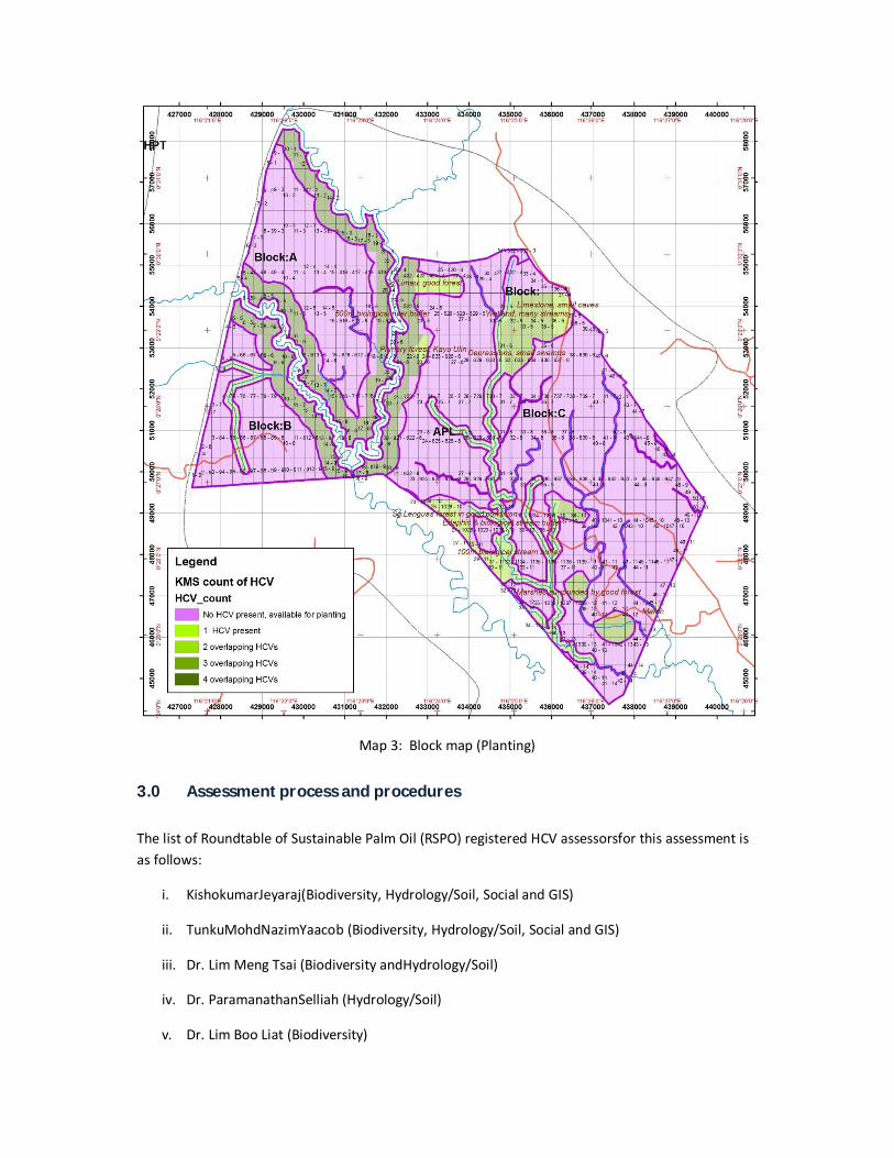
3.0 Assessment process and procedures
The list of Roundtable of Sustainable Palm Oil (RSPO) registered HCV assessorsfor this assessment is as follows:
i. KishokumarJeyaraj(Biodiversity, Hydrology/Soil, Social and GIS)
ii. TunkuMohdNazimYaacob (Biodiversity, Hydrology/Soil, Social and GIS)
iii. Dr. Lim Meng Tsai (Biodiversity andHydrology/Soil)
iv. Dr. ParamanathanSelliah (Hydrology/Soil)
v. Dr. Lim Boo Liat (Biodiversity)
vi. Sulhani (Social)
vii. OiSoo Chin (Biodiversity, Hydrology/Soil and Social)
Assessment procedures for the assessment is as listed below.
I. Undertake desk top review using available map and remote sensing data,
II. Build landscape GIS map models of the land use and resources of the project site ,
III. From the GIS map models, identify potential sites for field survey,
IV. Ecological and social field survey
V. Review field data to revise the map model and describe the current state of the environment,
VI. Compile working lists and maps to identify potential HCV areas with biodiversity, environmental and social considerations.
VII. Make recommendations for management that would conserve high conservation values.
Data sources for the assessment are as below.
i. Regional Physical Planning Project for Transmigration
ii. Identifikasilanskapkawasanhutanbernilaikonservasitinggi di dalamdansekitarHeart of Borneo, Kalimantan Timur (WWF)
iii. Eco-regional Assessment of Biological Diversity Conservation in East Kalimantan, Indonesia, The Nature Conservancy Asia/Pacific Region: Indonesia Program East Kalimantan Portfolio Office.
iv. Soil Survey report of PT KMS
v. The IUCN Red List of Threatened Species. http://www.iucnredlist.org/
vi. Peraturanpemerintahrepublikindonesia. Nomor 7 tahun 1999. Tanggal 27 januari 1999. Jenis-jenistumbuhandansatwa yang dilindungi.
Details of assessment schedule are presented below.
i. Preliminary conservation assessment by other consultants (August and December 2010)
ii. HCV assessment (1st phase) was undertaken between 23rd and 29th April 2011. The public consultation was held on the 12th of May 2011 in Samarinda.

iii. The verification of HCV findings was carried out between 14th and 18th May 2011.
Map of areas visited is presented in Map 4below.
Map 4: Map of sites visited
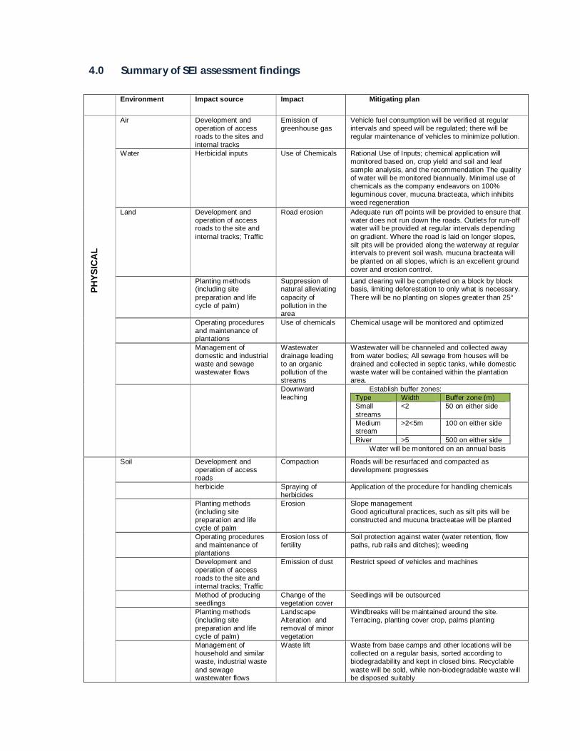
4.0 Summary of SEI assessment findings
Environment Impact source Impact Mitigating plan
PH
YSIC
AL
Air Development and
operation of access roads to the sites and internal tracks
Emission of greenhouse gas
Vehicle fuel consumption will be verified at regular intervals and speed will be regulated; there will be regular maintenance of vehicles to minimize pollution.
Water Herbicidal inputs Use of Chemicals Rational Use of Inputs; chemical application will monitored based on, crop yield and soil and leaf sample analysis, and the recommendation The quality of water will be monitored biannually. Minimal use of chemicals as the company endeavors on 100% leguminous cover, mucuna bracteata, which inhibits weed regeneration
Land Development and operation of access roads to the site and internal tracks; Traffic
Road erosion Adequate run off points will be provided to ensure that water does not run down the roads. Outlets for run-off water will be provided at regular intervals depending on gradient. Where the road is laid on longer slopes, silt pits will be provided along the waterway at regular intervals to prevent soil wash. mucuna bracteata will be planted on all slopes, which is an excellent ground cover and erosion control.
Planting methods (including site preparation and life cycle of palm)
Suppression of natural alleviating capacity of pollution in the area
Land clearing will be completed on a block by block basis, limiting deforestation to only what is necessary. There will be no planting on slopes greater than 25°
Operating procedures and maintenance of plantations
Use of chemicals Chemical usage will be monitored and optimized
Management of domestic and industrial waste and sewage wastewater flows
Wastewater drainage leading to an organic pollution of the streams
Wastewater will be channeled and collected away from water bodies; All sewage from houses will be drained and collected in septic tanks, while domestic waste water will be contained within the plantation area.
Downward leaching
Establish buffer zones: Type Width Buffer zone (m) Small streams
<2 50 on either side
Medium stream
>2<5m 100 on either side
River >5 500 on either side Water will be monitored on an annual basis
Soil Development and operation of access roads
Compaction Roads will be resurfaced and compacted as development progresses
herbicide Spraying of herbicides
Application of the procedure for handling chemicals
Planting methods (including site preparation and life cycle of palm
Erosion Slope management Good agricultural practices, such as silt pits will be constructed and mucuna bracteatae will be planted
Operating procedures and maintenance of plantations
Erosion loss of fertility
Soil protection against water (water retention, flow paths, rub rails and ditches); weeding
Development and operation of access roads to the site and internal tracks; Traffic
Emission of dust Restrict speed of vehicles and machines
Method of producing seedlings
Change of the vegetation cover
Seedlings will be outsourced
Planting methods (including site preparation and life cycle of palm)
Landscape Alteration and removal of minor vegetation
Windbreaks will be maintained around the site. Terracing, planting cover crop, palms planting
Management of household and similar waste, industrial waste and sewage wastewater flows
Waste lift Waste from base camps and other locations will be collected on a regular basis, sorted according to biodegradability and kept in closed bins. Recyclable waste will be sold, while non-biodegradable waste will be disposed suitably

B
IOLO
GIC
AL
Terrestrial plant formations
Method of producing seedlings
No nursery Mainly manual weeding .Rational use of chemicals. Seedling will be outsourced
Operating procedures and maintenance of plantations
Protection of the crops
Integrated pest management against parasites and mammals may be introduced as the project progresses.
Fish and wildlife Establishment and
operation of base camps
Fishery and hunting pressure
Barriers will be put up at the entry points into the project area to control movement of people hunting. Sign boards will be put up at strategic points indicating prohibition of hunting. People will be educated on conserving animals and the existing laws on hunting.
Operating procedures and maintenance of plantations
Pollutions due to the storage of hydrocarbons and machine maintenance
Oils and fuel have to be stored in aboveground tanks with containment wall of more than equal capacity.
A contingency plan will be established in the case of incidents
Maintenance of equipment at appropriate places on impermeable ground, waste oil management and all waste oil will be disposed to licensed schedule waste collectors. All waste will be recorded and disposed as scheduled
Establishment of collection facilities Management of
household and similar waste, industrial waste and wastewater
Environment pollution by the leachates
Through proper drainage system
Dispatch of waste through an adequate treatment process
HU
MA
N
Employment and local economic development
Planting methods (including site preparation and life cycle of palm
Loss of wood resources
Conservation zones for villages or compensation in the case of relinquishment through the process of Free, Prior and Informed Consent and setting up of 20% of total planted area as smallholder project for the local community
Reduction of rural activity zones
Employment policy in favor of local community
Operating procedures and maintenance of plantations
Creation of jobs Employment opportunities increase with the growth of the project. All permanent employees will be provided with basic accommodation with electricity and water supply. Clinic, school, religious and recreational facilities will be provided.
Establishment and operation of base camps
Increase in economic dynamism with better communication
Increase efficiency with continuous progress
Use of the soil Planting methods (including site preparation and life cycle of palm)
Land tenure
Villagers will be compensated based on data collected during the agriculture and forest inventory, as well as during the social participatory mapping process.
Loss of cultures, ancient villages and cultural places
Employees will have access to healthcare provided by the clinic. Nearby villages will also have access to medical consultancy, but will have to pay for any prescribed medication
Security / health
Establishment and operation of base camps
Setting up of healthcare facilities in the base camps
Use of individual protective equipment (IPE) will be compulsory, and employees will be trained in the use of chemicals. MSDS will be clearly displayed in the storage area, and labels will remain on chemical contains.
Operating procedures and maintenance of plantations
Use of chemicals and handling of hydro-carbon
Employees will be properly trained in health and safety prior to the use of machinery as per Standard Operating Procedures.
Body injury risks related to the use of machines, vehicles, insects and snake bite
Clinic equipped with sufficient medical supplies including Anti-venom serum
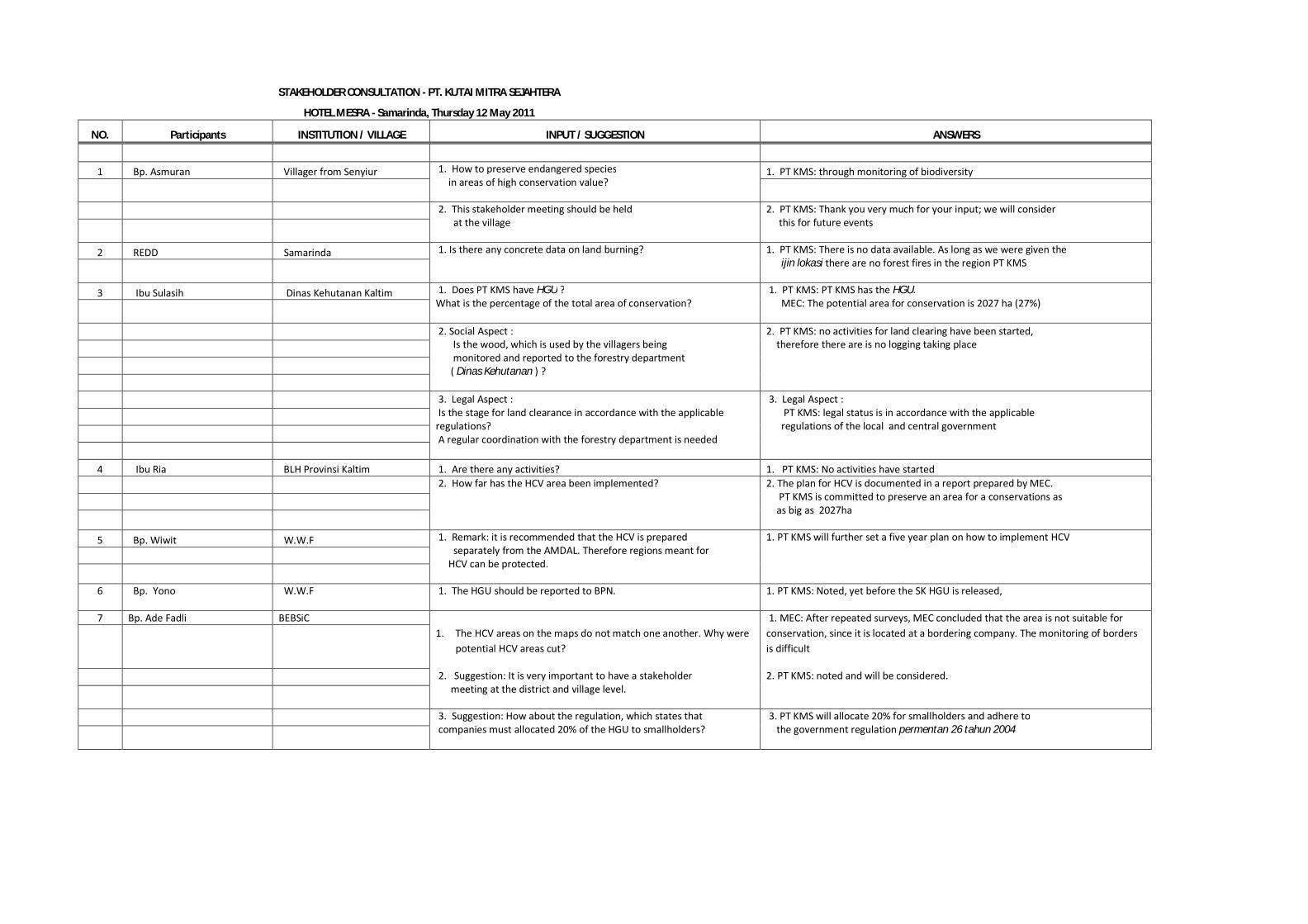
STAKEHOLDER CONSULTATION - PT. KUTAI MITRA SEJAHTERA
HOTEL MESRA - Samarinda, Thursday 12 May 2011
NO. Participants INSTITUTION / VILLAGE INPUT / SUGGESTION ANSWERS
1 Bp. Asmuran Villager from Senyiur 1. How to preserve endangered species in areas of high conservation value?
1. PT KMS: through monitoring of biodiversity
2. This stakeholder meeting should be held at the village
2. PT KMS: Thank you very much for your input; we will consider this for future events
2 REDD Samarinda 1. Is there any concrete data on land burning?
1. PT KMS: There is no data available. As long as we were given the ijin lokasi there are no forest fires in the region PT KMS
3 Ibu Sulasih Dinas Kehutanan Kaltim 1. Does PT KMS have HGU ? What is the percentage of the total area of conservation?
1. PT KMS: PT KMS has the HGU. MEC: The potential area for conservation is 2027 ha (27%)
2. Social Aspect : Is the wood, which is used by the villagers being monitored and reported to the forestry department ( Dinas Kehutanan ) ?
2. PT KMS: no activities for land clearing have been started, therefore there are is no logging taking place
3. Legal Aspect : Is the stage for land clearance in accordance with the applicable regulations? A regular coordination with the forestry department is needed
3. Legal Aspect : PT KMS: legal status is in accordance with the applicable regulations of the local and central government
4 Ibu Ria BLH Provinsi Kaltim 1. Are there any activities? 1. PT KMS: No activities have started
2. How far has the HCV area been implemented?
2. The plan for HCV is documented in a report prepared by MEC. PT KMS is committed to preserve an area for a conservations as as big as 2027ha
5 Bp. Wiwit W.W.F 1. Remark: it is recommended that the HCV is prepared separately from the AMDAL. Therefore regions meant for HCV can be protected.
1. PT KMS will further set a five year plan on how to implement HCV
6 Bp. Yono W.W.F 1. The HGU should be reported to BPN. 1. PT KMS: Noted, yet before the SK HGU is released,
7 Bp. Ade Fadli BEBSiC 1. The HCV areas on the maps do not match one another. Why were
potential HCV areas cut?
1. MEC: After repeated surveys, MEC concluded that the area is not suitable for conservation, since it is located at a bordering company. The monitoring of borders is difficult
2. Suggestion: It is very important to have a stakeholder meeting at the district and village level.
2. PT KMS: noted and will be considered.
3. Suggestion: How about the regulation, which states that companies must allocated 20% of the HGU to smallholders?
3. PT KMS will allocate 20% for smallholders and adhere to the government regulation permentan 26 tahun 2004

5.0 Overall HCV identification and proposed measures
5.1 Summary of identified HCV
Table 1 below gives a tabulated summary of the assessment of HCV in the KMS site. This table is extended into management guidance in Table 2. The components of Table 1 are summarized below.
The columns in Table 1 contain the following items:
a) HCV Criteria
HCV criteria as defined in the Toolkit for Identification of High Conservation Values In Indonesia compiled by the Consortium to Revise the HCV Toolkit for Indonesia, 2008. (HCV 2008).
b) issues
The site issues for KMS arise from a review of the HCV concerns at the landscape level, and information on the site obtained from the supporting field visits.
c) study activity
The tasks undertaken for this study. These included a review of desk-top materials, building GIS map models as well as field investigation to look at biodiversity, the physical environment and social and economic issues in the region.
d) evidence
Resulting from the study activities, the evidence found is summarized in this column.

e) potential threats
This looks at the HCV item at the KMS and looks at the existing and future activities, from neighbouring land users as well as KMS plantation development activities, which would reduce the quality of that HCV. Quality could be reduced by resource take, land occupation, or changes to the physical and ecological environment.
f) HCV present
This is a statement whether the HCV as defined is present or not at KMS. It should be noted that an HCV as defined by the IHCV2008 may not be present at this time. But because HCVs are stakeholder driven, changes could arise in the future. KMS would still be expected to follow good management practices that could support stakeholder-driven changes to HCV.
g) stakeholders
Essentially, the HCV only exists if there is a stakeholder who has expressed a position on the subject or has an interest. It is assumed that those stakeholders would be willing to support their positions and interest. Only Indonesian stakeholders are considered in this study, with the Government of the Republic of Indonesia (GORI) representing external stakeholders through it international treaties and obligations. Stakeholders will need to be kept informed of the HCV management that KMS will undertake on their behalf.

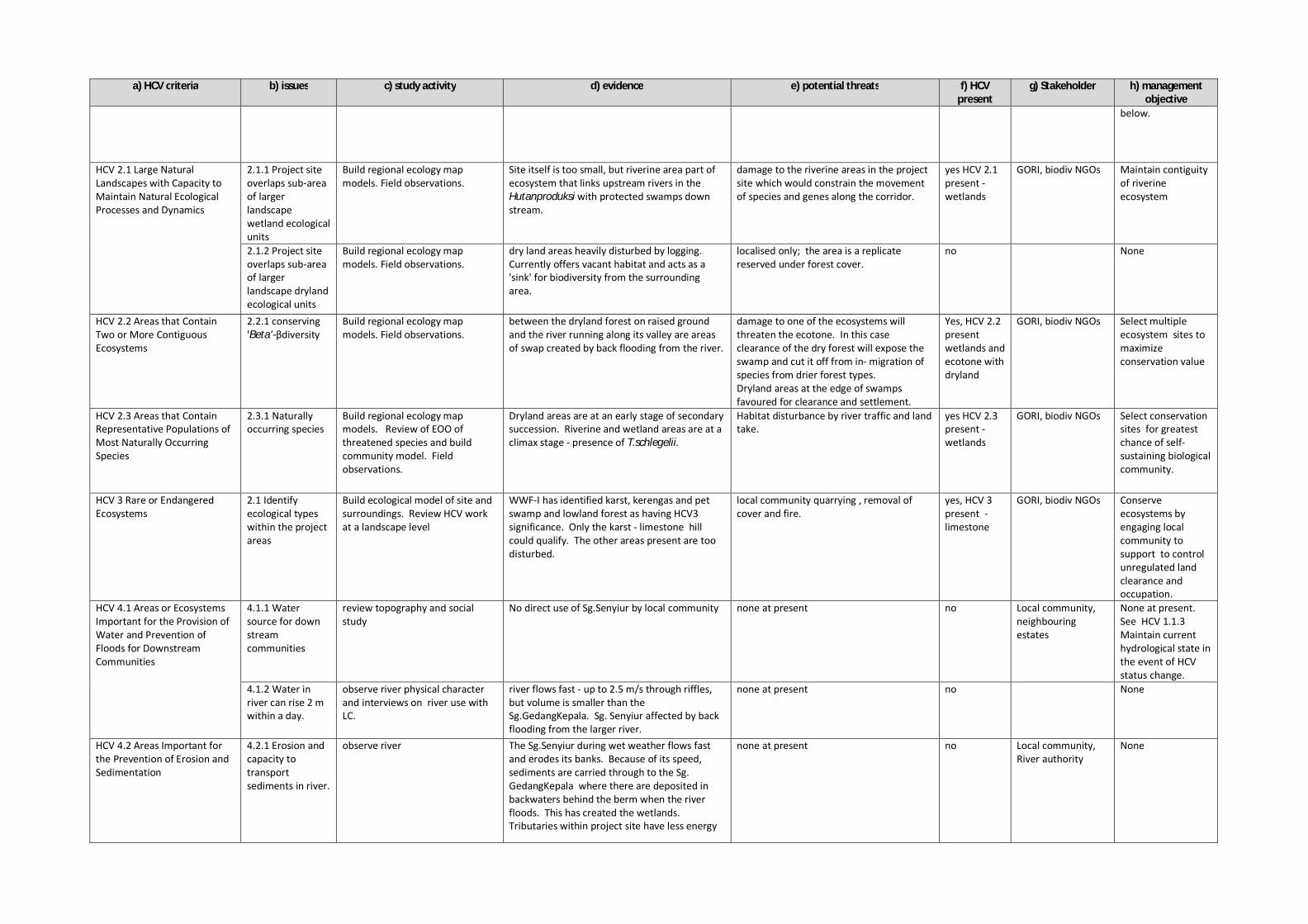
Table 1: HCV assessment summary
a) HCV criteria b) issues c) study activity d) evidence e) potential threats f) HCV present
g) Stakeholder h) management objective
HCV 1.1 Areas that Contain or Provide Biodiversity Support Function to Protection or Conservation Areas
1.1.1 protected areas
GIS data sourced from stakeholders. Build ecological map models.
Not adjacent, have minimal ecological interaction and common species populations. CagarAlam Kaman Sedulang - peat down stream on Sg. GedangKepala. And Taman Negara Kutai - dry lowland forest. Separate catchments.
Constraint of the movement for species and genetic material between PA and the rest of the ecosystem not significant from KMS Eutrophication of common drainage basin minimal.
no GORI (Government of the Republic of Indonesia)
None at present.
1.1.2 peat Refer to site soil study. small pockets of organic soils, possibly shallow peat in flooded valleys.
Vegetation cover damage, drainage and fire from poor land clearance control.
no GORI See under HCV 3 and 4
1.1.3 watersheds Refer to topographical maps and social study
local use for estate diminish local storage capacity, and eutrophication by over draining fields..
No for external stakeholders.
Local community, Estate &neighbouring estates
See HCV 4 Maintain current hydrological state.
1.1.4 local conservation areas
Data from social study None. no GORI, local community, biodiv NGOs
None at present.,
HCV 1.2 Critically Endangered Species
1.2.1 Individual specimens of critically threatened species
refer to IUCN redlist& GIS distribution maps on extent of occurrence (EOO). Review biophysical characteristic of site and surrounding region, and build ecology/habitat map model. Field observations during site sampling exercise to confirm ecological model and species presence.
No critical species confirmed; but crocodiles observed on site and the possibility remains that unidentified crocodiles could include Crocodylussiamensis/ranius- a critical endangered species.
targeted hunting pressure, local disturbance and habitat loss of protected species.
possible - wetlands
GOIR, sectoral experts and biodiv NGOs
Conserve threatened and protected species present on site..
HCV 1.3 Areas that Contain Habitat for Viable Populations of Endangered, Restricted Range or Protected Species
1.3.1 Dryland animals
Small nests of Pongopygmaeus observed suggest breeding thus potentially viablepopulation, but not the animal itself.
yes HCV 1.3 present -wetlands
GORI, sectoral experts and biodiv NGOs
Conserve habitats for threatened species are protected and free from disturbance.
1.3.2 Wet land species
Nasalislarvatusobserved with young. Tomistomaschlegelii observed guarding a nest. Breeding suggest viable population.
yes HCV 1.3 present -wetlands
GORI, sectoral experts and biodiv NGOs
HCV 1.4 Areas that Contain Habitat of Temporary Use by Species or Congregations of Species
1.4.1 riverine breeding sites
Filed observations river lacks extensive sand banks for mass breeding. Ponds too small for mass water bird use.
disturbance from river traffic. Potential target for hunting.
no GORI, sectoral experts and biodiv NGOs
None at present.
1.4.2 Salt licks and feeding sites
Field observations No large concentrations of fruiting trees, or salt licks to attract and support populations from outside the site.
local trapping of deer reported; this usually takes place around areas of congregation.
no GORI, sectoral experts and biodiv NGOs
None at present
1.4.3 limestone area reported, potential bat roost and breeding site
Field visit earlier field work identified karst areas which was being quarried. The limestone site appears to have been eliminated and replace with lalang.
local community quarry for other limestone sites.
no GORI, sectoral experts and biodiv NGOs
None at present – eliminated; but If other sites found, conserve limestone as habitat-see 1.3. above and for environmental services – see 4.1
a) HCV criteria b) issues c) study activity d) evidence e) potential threats f) HCV present
g) Stakeholder h) management objective
below.
HCV 2.1 Large Natural Landscapes with Capacity to Maintain Natural Ecological Processes and Dynamics
2.1.1 Project site overlaps sub-area of larger landscape wetland ecological units
Build regional ecology map models. Field observations.
Site itself is too small, but riverine area part of ecosystem that links upstream rivers in the Hutanproduksi with protected swamps down stream.
damage to the riverine areas in the project site which would constrain the movement of species and genes along the corridor.
yes HCV 2.1 present -wetlands
GORI, biodiv NGOs Maintain contiguity of riverine ecosystem
2.1.2 Project site overlaps sub-area of larger landscape dryland ecological units
Build regional ecology map models. Field observations.
dry land areas heavily disturbed by logging. Currently offers vacant habitat and acts as a 'sink' for biodiversity from the surrounding area.
localised only; the area is a replicate reserved under forest cover.
no None
HCV 2.2 Areas that Contain Two or More Contiguous Ecosystems
2.2.1 conserving 'Beta'-βdiversity
Build regional ecology map models. Field observations.
between the dryland forest on raised ground and the river running along its valley are areas of swap created by back flooding from the river.
damage to one of the ecosystems will threaten the ecotone. In this case clearance of the dry forest will expose the swamp and cut it off from in- migration of species from drier forest types. Dryland areas at the edge of swamps favoured for clearance and settlement.
Yes, HCV 2.2 present wetlands and ecotone with dryland
GORI, biodiv NGOs Select multiple ecosystem sites to maximize conservation value
HCV 2.3 Areas that Contain Representative Populations of Most Naturally Occurring Species
2.3.1 Naturally occurring species
Build regional ecology map models. Review of EOO of threatened species and build community model. Field observations.
Dryland areas are at an early stage of secondary succession. Riverine and wetland areas are at a climax stage - presence of T.schlegelii.
Habitat disturbance by river traffic and land take.
yes HCV 2.3 present -wetlands
GORI, biodiv NGOs Select conservation sites for greatest chance of self-sustaining biological community.
HCV 3 Rare or Endangered Ecosystems
2.1 Identify ecological types within the project areas
Build ecological model of site and surroundings. Review HCV work at a landscape level
WWF-I has identified karst, kerengas and pet swamp and lowland forest as having HCV3 significance. Only the karst - limestone hill could qualify. The other areas present are too disturbed.
local community quarrying , removal of cover and fire.
yes, HCV 3 present - limestone
GORI, biodiv NGOs Conserve ecosystems by engaging local community to support to control unregulated land clearance and occupation.
HCV 4.1 Areas or Ecosystems Important for the Provision of Water and Prevention of Floods for Downstream Communities
4.1.1 Water source for down stream communities
review topography and social study
No direct use of Sg.Senyiur by local community none at present no Local community, neighbouring estates
None at present. See HCV 1.1.3 Maintain current hydrological state in the event of HCV status change.
4.1.2 Water in river can rise 2 m within a day.
observe river physical character and interviews on river use with LC.
river flows fast - up to 2.5 m/s through riffles, but volume is smaller than the Sg.GedangKepala. Sg. Senyiur affected by back flooding from the larger river.
none at present no None
HCV 4.2 Areas Important for the Prevention of Erosion and Sedimentation
4.2.1 Erosion and capacity to transport sediments in river.
observe river The Sg.Senyiur during wet weather flows fast and erodes its banks. Because of its speed, sediments are carried through to the Sg. GedangKepala where there are deposited in backwaters behind the berm when the river floods. This has created the wetlands. Tributaries within project site have less energy
none at present no Local community, River authority
None

a) HCV criteria b) issues c) study activity d) evidence e) potential threats f) HCV present
g) Stakeholder h) management objective
and are more clear.
4.2.2 Steep sections within site prone to erosion. As a HGU, the site would have to be returned to the GORI, in which case it should be with minimal soil loss.
field observations No high elevation areas, but adjacent estate (SSS) has elevated ground - 60m asl, with steep, friable slopes, prone to gulley erosion.
poor development practices damage fragile slopes.
potential HCV4.2
GORI, Conserve fragile slopes as part of integrated erosion management.
HCV 4.3 Areas that Function as Natural Barriers to the Spread of Forest or Ground Fire
4.3.1 uncontrolled fires destroying peat soils and vegetation cover.
review historical map data for fires, field observations.
no historical significant fires in the area. low at present HCV 4 Local community, neighbouring estates
Conserve vegetation in high risk fire areas as part of integrated fire risk control
HCV 5. Natural Areas Critical for Meeting the Basic Needs of Local People
No Issues Village and site survey Community consensus that HCV 5 sites are non-existent.
No Threats Local community None
HCV 6. Areas Critical for Maintaining the Cultural Identity of Local Communities
No Issues Village and site survey Community consensus that HCV 6 sites are non-existent.
No Threats Local community None
5.2 Summary of proposed management actions
The key to subsequent management of identified potential HCV sites in KMS is the identification of issues relating management actions and monitoring implementation. This Chapter provides a concise table recording the necessary actions needed to promote the preservation and enhancement of the potential HCV sites in KMS. A summary of the management actions for specific issues is presented in Table 2.
5.2.1 Specific Management actions
Actions are divided into two parts: 1) planning and development, and 2) operations. For planning, this column gives an outline of the steps to be taken which would include:
block layout and estate planning,
ground marking and clearing,
road making drainage and planting.
These are then followed by a review of operations which would include:
communications and consensus building with stakeholders,
review of KMS SOPs and capacity building among staff and contractors
monitoring and reporting procedures
publications and communications of HCV management performance with stakeholders.
Though good planning and ground is essential for the HCV, much of the success for management actions will depend on support by the local community. This will require a set of transparent
protocols for communications. This will ensure that in the event of misunderstandings and conflict on other issues, HCV co-management is not compromised.
5.2.2 Monitoring and indicators
All HCV management actions would need to be monitored against stated indicators. As mentioned in f) above, changes in laws, or to stakeholder positions would need to be monitored for items such as new protected areas (1.1.1, and 1.1.4). For HCV sites already identified, indicators would need to be selected to assess their quality and a programme for monitoring initiated to ensure the KMS
management is able to control threats to the HCV quality. This could include consultation with local community, security patrols, monitoring water chemistry and surface levels, presence of ERT species, etc. For habitat and ecosystems areas, sectoral experts will need to identify sites for rapid sampling of plant and animal species that could be used to assess site ecological health.
5.2.3 Reporting and publications
Records need to be kept on HCV management input. These would include:
reports from security patrols,
communications with stakeholders
records from monitoring water chemistry and water levels.
Results from updated census work on ERT
Records from rapid assessment of ecological sites.
5.2.4 Follow up
HCV management is iterative. Once sites have been identified and marked, management activities are prescribed. At its simplest, site management can be limited to external security. However, if the results of monitoring indicators indicates that the is a declining trend in HCV quality, KMS management together with the stakeholders interested would need to identify if and what new actions need to be undertaken to reverse negative trends, and sustain the HCV.
5.2.5 Recommendations
The information presented in this report serves to guide not only both the management and all associated contractors involved in the development of the site. It serves as a general guidance document helping the company to translate information provided here into Standard Operating Procedures (SOP) where land clearing and subsequent management is concerned. Boundaries of HCVs have been adjusted to follow road boundaries to avoid multiple fragmentations. It is stressed that the company does not excessively fragment the identified HCV sites when constructing block roads. A survey has to be undertaken before land clearing and HCV boundaries clearly demarcated to prevent infringement. Small and intermittent streams need to be surveyed, marked and buffered. The company has to undertake a socialization programme especially with the local community in DesaSenyiur informing them of their commitment to conserve approximately 27% of the KMS HakGuna Usaha (HGU). The relevant local land authorities need to be informed regarding
the HCV areas set aside. If this is not done, the land might considered fallow and declassify as HGU.
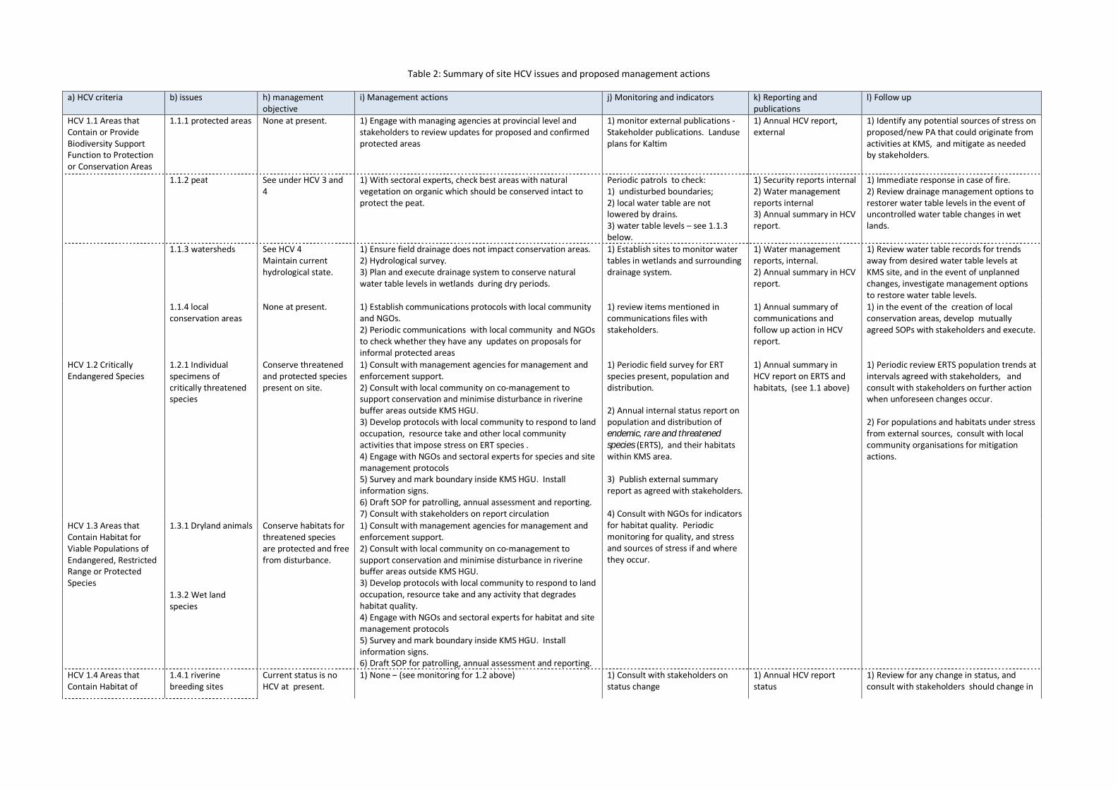
Table 2: Summary of site HCV issues and proposed management actions
a) HCV criteria b) issues h) management objective
i) Management actions j) Monitoring and indicators k) Reporting and publications
l) Follow up
HCV 1.1 Areas that Contain or Provide Biodiversity Support Function to Protection or Conservation Areas
1.1.1 protected areas None at present.
1) Engage with managing agencies at provincial level and stakeholders to review updates for proposed and confirmed protected areas
1) monitor external publications - Stakeholder publications. Landuse plans for Kaltim
1) Annual HCV report, external
1) Identify any potential sources of stress on proposed/new PA that could originate from activities at KMS, and mitigate as needed by stakeholders.
1.1.2 peat See under HCV 3 and 4
1) With sectoral experts, check best areas with natural vegetation on organic which should be conserved intact to protect the peat.
Periodic patrols to check: 1) undisturbed boundaries; 2) local water table are not lowered by drains. 3) water table levels – see 1.1.3 below.
1) Security reports internal 2) Water management reports internal 3) Annual summary in HCV report.
1) Immediate response in case of fire. 2) Review drainage management options to restorer water table levels in the event of uncontrolled water table changes in wet lands.
1.1.3 watersheds See HCV 4 Maintain current hydrological state.
1) Ensure field drainage does not impact conservation areas. 2) Hydrological survey. 3) Plan and execute drainage system to conserve natural water table levels in wetlands during dry periods.
1) Establish sites to monitor water tables in wetlands and surrounding drainage system.
1) Water management reports, internal. 2) Annual summary in HCV report.
1) Review water table records for trends away from desired water table levels at KMS site, and in the event of unplanned changes, investigate management options to restore water table levels.
1.1.4 local conservation areas
None at present. 1) Establish communications protocols with local community and NGOs. 2) Periodic communications with local community and NGOs to check whether they have any updates on proposals for informal protected areas
1) review items mentioned in communications files with stakeholders.
1) Annual summary of communications and follow up action in HCV report.
1) in the event of the creation of local conservation areas, develop mutually agreed SOPs with stakeholders and execute.
HCV 1.2 Critically Endangered Species
1.2.1 Individual specimens of critically threatened species
Conserve threatened and protected species present on site.
1) Consult with management agencies for management and enforcement support. 2) Consult with local community on co-management to support conservation and minimise disturbance in riverine buffer areas outside KMS HGU. 3) Develop protocols with local community to respond to land occupation, resource take and other local community activities that impose stress on ERT species . 4) Engage with NGOs and sectoral experts for species and site management protocols 5) Survey and mark boundary inside KMS HGU. Install information signs. 6) Draft SOP for patrolling, annual assessment and reporting. 7) Consult with stakeholders on report circulation
1) Periodic field survey for ERT species present, population and distribution. 2) Annual internal status report on population and distribution of endemic, rare and threatened species (ERTS), and their habitats within KMS area. 3) Publish external summary report as agreed with stakeholders. 4) Consult with NGOs for indicators for habitat quality. Periodic monitoring for quality, and stress and sources of stress if and where they occur.
1) Annual summary in HCV report on ERTS and habitats, (see 1.1 above)
1) Periodic review ERTS population trends at intervals agreed with stakeholders, and consult with stakeholders on further action when unforeseen changes occur. 2) For populations and habitats under stress from external sources, consult with local community organisations for mitigation actions.
HCV 1.3 Areas that Contain Habitat for Viable Populations of Endangered, Restricted Range or Protected Species
1.3.1 Dryland animals Conserve habitats for threatened species are protected and free from disturbance.
1) Consult with management agencies for management and enforcement support. 2) Consult with local community on co-management to support conservation and minimise disturbance in riverine buffer areas outside KMS HGU. 3) Develop protocols with local community to respond to land occupation, resource take and any activity that degrades habitat quality. 4) Engage with NGOs and sectoral experts for habitat and site management protocols 5) Survey and mark boundary inside KMS HGU. Install information signs. 6) Draft SOP for patrolling, annual assessment and reporting.
1.3.2 Wet land species
HCV 1.4 Areas that Contain Habitat of
1.4.1 riverine breeding sites
Current status is no HCV at present.
1) None – (see monitoring for 1.2 above)
1) Consult with stakeholders on status change
1) Annual HCV report status
1) Review for any change in status, and consult with stakeholders should change in
a) HCV criteria b) issues h) management objective
i) Management actions j) Monitoring and indicators k) Reporting and publications
l) Follow up
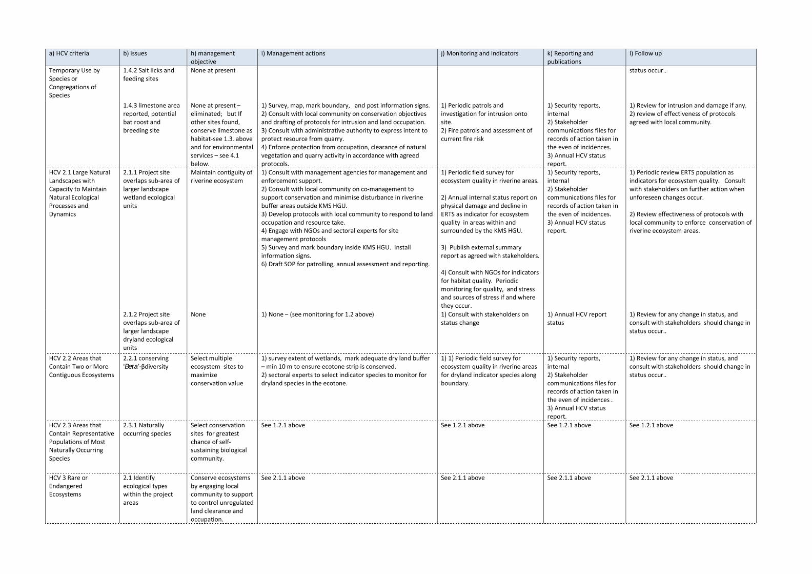
Temporary Use by Species or Congregations of Species
1.4.2 Salt licks and feeding sites
None at present status occur..
1.4.3 limestone area reported, potential bat roost and breeding site
None at present – eliminated; but If other sites found, conserve limestone as habitat-see 1.3. above and for environmental services – see 4.1 below.
1) Survey, map, mark boundary, and post information signs. 2) Consult with local community on conservation objectives and drafting of protocols for intrusion and land occupation. 3) Consult with administrative authority to express intent to protect resource from quarry. 4) Enforce protection from occupation, clearance of natural vegetation and quarry activity in accordance with agreed protocols.
1) Periodic patrols and investigation for intrusion onto site. 2) Fire patrols and assessment of current fire risk
1) Security reports, internal 2) Stakeholder communications files for records of action taken in the even of incidences. 3) Annual HCV status report.
1) Review for intrusion and damage if any. 2) review of effectiveness of protocols agreed with local community.
HCV 2.1 Large Natural Landscapes with Capacity to Maintain Natural Ecological Processes and Dynamics
2.1.1 Project site overlaps sub-area of larger landscape wetland ecological units
Maintain contiguity of riverine ecosystem
1) Consult with management agencies for management and enforcement support. 2) Consult with local community on co-management to support conservation and minimise disturbance in riverine buffer areas outside KMS HGU. 3) Develop protocols with local community to respond to land occupation and resource take. 4) Engage with NGOs and sectoral experts for site management protocols 5) Survey and mark boundary inside KMS HGU. Install information signs. 6) Draft SOP for patrolling, annual assessment and reporting.
1) Periodic field survey for ecosystem quality in riverine areas. 2) Annual internal status report on physical damage and decline in ERTS as indicator for ecosystem quality in areas within and surrounded by the KMS HGU. 3) Publish external summary report as agreed with stakeholders. 4) Consult with NGOs for indicators for habitat quality. Periodic monitoring for quality, and stress and sources of stress if and where they occur.
1) Security reports, internal 2) Stakeholder communications files for records of action taken in the even of incidences. 3) Annual HCV status report.
1) Periodic review ERTS population as indicators for ecosystem quality. Consult with stakeholders on further action when unforeseen changes occur. 2) Review effectiveness of protocols with local community to enforce conservation of riverine ecosystem areas.
2.1.2 Project site overlaps sub-area of larger landscape dryland ecological units
None 1) None – (see monitoring for 1.2 above)
1) Consult with stakeholders on status change
1) Annual HCV report status
1) Review for any change in status, and consult with stakeholders should change in status occur..
HCV 2.2 Areas that Contain Two or More Contiguous Ecosystems
2.2.1 conserving 'Beta'-βdiversity
Select multiple ecosystem sites to maximize conservation value
1) survey extent of wetlands, mark adequate dry land buffer – min 10 m to ensure ecotone strip is conserved. 2) sectoral experts to select indicator species to monitor for dryland species in the ecotone.
1) 1) Periodic field survey for ecosystem quality in riverine areas for dryland indicator species along boundary.
1) Security reports, internal 2) Stakeholder communications files for records of action taken in the even of incidences . 3) Annual HCV status report.
1) Review for any change in status, and consult with stakeholders should change in status occur..
HCV 2.3 Areas that Contain Representative Populations of Most Naturally Occurring Species
2.3.1 Naturally occurring species
Select conservation sites for greatest chance of self-sustaining biological community.
See 1.2.1 above
See 1.2.1 above
See 1.2.1 above
See 1.2.1 above
HCV 3 Rare or Endangered Ecosystems
2.1 Identify ecological types within the project areas
Conserve ecosystems by engaging local community to support to control unregulated land clearance and occupation.
See 2.1.1 above
See 2.1.1 above
See 2.1.1 above
See 2.1.1 above

a) HCV criteria b) issues h) management objective
i) Management actions j) Monitoring and indicators k) Reporting and publications
l) Follow up
HCV 4.1 Areas or Ecosystems Important for the Provision of Water and Prevention of Floods for Downstream Communities
4.1.1 Water source for downstream communities
None at present. See HCV 1.1.3 Maintain current hydrological state in the event of HCV status change.
1) Ensure field drainage does not impact conservation areas. 2) Hydrological survey. 3) Plan and execute drainage system to conserve natural water table levels in wetlands during dry periods. 4) select monitoring sites and establish protocols to monitor river water quality at upstream entry and downstream exit from estate
1) Establish sites to monitor water tables in wetlands and surrounding drainage system. 2) undertake periodic river quality monitoring
1) Water management reports, internal. 2) River quality monitoring records. 3) Annual summary in HCV report.
1) Review water table records for trends away from desired water table levels at KMS site, and in the event of unplanned changes, investigate management options to restore water table levels. 2) review trends in water quality monitoring indicators, and consult with stakeholders in the event of unforeseen changes..
4.1.2 Water in river can rise 2 m within a day.
None at present 1) select site to monitor river levels 1) monitor daily river levels as part of integrated drainage management.
1) Water management report, internal. 2) annual summary in HCV report.
1) review annual cycles and trends 2) consult with stakeholders in the event of unforeseen events.
HCV 4.2 Areas Important for the Prevention of Erosion and Sedimentation
4.2.1 Erosion and capacity to transport sediments in river.
None at present 1) Select protocols to monitor for suspended solids in river at entry point and exit point from KMS estate.
1) Periodic monitoring of suspended solids
1) Water management report, internal. 2) annual summary in HCV report.
1) compare to rainfall and river level monitoring. 2) review annual cycles and trends 3) consult with stakeholders in the event of unforeseen events.
4.2.2 Steep sections within site prone to erosion. As a HGU, the site would have to be returned to the GORI, in which case it should be with minimal soil loss.
Conserve fragile slopes as part of integrated erosion management.
1) topographical survey and plan at appropriate intervals 2) detailed soil survey to identify mechanically fragile soils, their location and extent. 3) review of current REAKaltim SOP for erosion control and identification of limitations. 4) identification of sites for conservation where current SOP would not be able to guarantees successful soil erosion control. 5) mark boundary of conservation areas for slopes with fragile soils. 6) Develop SOP to monitor for soil movement in the field 7) Development of protocols to respond to slope failure.
1) periodic monitoring soil damage and slope failure. 2) monitor effectiveness of SOP for mitigation measures
1) Plantation reports 2) annual summary in HCV report.
1) review trends in soil movement. 2) review events outside expected rates of soil movement, investigate options, and select for implementation best options for mitigation.
HCV 4.3 Areas that Function as Natural Barriers to the Spread of Forest or Ground Fire
4.3.1 uncontrolled fires destroying peat soils and vegetation cover.
Conserve vegetation in high risk fire areas as part of integrated fire risk control
1) identify and map fire risk areas, and natural fire breaks in the area, 2) mark boundaries on the ground, and post information signs. 3) in consultation with local community and neighbouring estates, develop protocols to minimise fire risk, communications and emergency response. 4) identify qualities of fire break areas that are required to maintain this function, and investigate protocols to ensure quality is maintained – e.g. timber felling, change in water table, accumulation of dry leaf litter, etc. 5) undertake daily fire assessment post updated results.
1) Patrolling of fire barrier areas. 2) Daily fire risk assessment
1) Security patrol reports. 2) Fire risk assessment records, 3) fire incident reports and records of response. 4) Annual HCV summary
1) review effectiveness of fire barriers 2) in the event of failure, restore fire barrier quality.
HCV 5. Natural Areas Critical for Meeting the Basic Needs of Local People
No Issues None at present None Not Applicable Not Applicable Not Applicable
HCV 6. Areas Critical for Maintaining the Cultural Identity of Local Communities
No Issues None at Present None Not Applicable Not Applicable Not Applicable
5.3 Documentation on obtained free, prior and informed consent
(Any form of information regarding FPIC to be filled in by company.)
No form of FPIC consultation was required as the local community has no high conservation value interest in the area. The local community looks upon the area as a source of income from logging. Logging in this area is classified as illegal and considered unsustainable. The issue of logging in this area was raised by the DinasKehutanan, where the representative reiterated that logging in this area would require permits from relevant authorities. Even land clearing for development would require permits. The nearest village is DesaSenyiur which is approximately 30 km southwest (linear distance). The site is accessible by river which would take approximately 4-5 hours.

5.4 Methodology
5.4.1 Data sources, quality and HCV toolkit applied
Using “The High Conservation Value Forest Toolkit” for Indonesia, Edition 1 December 2003, and the Toolkit for Identification of High Conservation Values in Indonesian, June 2008 as the general guidelines to identify the six High Conservation Values (HCV), the following activities were undertaken to assess the project site to determine the occurrence of potential HCV areas.
The earlier document was specifically for forestry but still merits use and the later document is seen to better accommodate development of commercial oil palm plantations. The sequence of work that followed was to:
I. Undertake desk top review using available map and remote sensing data,
II. Build landscape GIS map models of the land use and resources of the project site ,
III. From the GIS map models, identify potential sites for field survey,
IV. Ecological and social field survey
V. Review field data to revise the map model and describe the current state of the environment,
VI. Compile working lists and maps to identify potential HCV areas with biodiversity, environmental and social considerations.
VII. Make recommendations for management that would conserve high conservation values.
This assessment for High Conservation Values (HCV) has been undertaken using the Toolkits for Identification of High Conservation Values – 2003/2008.
HCV is a stakeholder driven process, so we can begin by reviewing some published stakeholder documents. The World Wide Fund for Nature-Indonesia (WWF-I), Samarinda Office published the Identifikasilanskapkawasanhutanbernilaikonservasitinggi di dalamdansekitarHeart of Borneo, Kalimantan Timur (WWF-I HCV), in 2008. This reviewed the areas of High Conservation Value (HCV), in the province at the time. Map 5 gives an outline map of the KMS project site together with each HCV area in the surrounding region.
This freshwater swamp HCV area has been logged and cleared, and the former HCV areas on site and to the east have been drained and planted with oil palm. The HCV 2 and 4 areas on the project site are now remnant swamp patches, which would be conserved within HCV 4 riverine buffers.
A second source for stakeholder view comes from The Nature Conservancy Asia/Pacific Region: Indonesia Program East Kalimantan Portfolio Office which published an ‘Eco-regional Assessment of

Biological Diversity Conservation in East Kalimantan, Indonesia’ (TNC-EAK). This report describes the ecological types in the area of concern; locate sites where conservation for each ecological type would be most effective; identify threats to those sites and discuss the conservation issues. The ecological types found in the KMS project site include: Lowland rain forest – mostly disturbed by logging; freshwater swamps – some disturbance, but in good condition; and limestone karst forest – disturbed small hill. Target animal species are also identified to lead conservation effort. For Kalimantan Timur (East Kalimantan) these included the highly threatened Mahakam Dolphin found in the lakes to the downstream in an ecological area not associated with the project site. The TNC target species present on the KMS site were: Orang utan – nests located; and Proboscis monkey -observed.
Though TNC is not concerned with HCV principles and criteria, their ecological approach covers HCV principles 1, 2 and 3. Among the threats the TNC identified are: fragmentation of ecological types;
increased access to new areas followed by land and resource take; and ecologically destructive fires.
Map 6 shows the location of the project site with the location of TNC ‘portfolio’ ecological sites and known location of ‘TNC ‘target’ species. The KMS project site does not overlap or is adjacent to any of the TNC sites. The Sg. Senyiur was not included among its ‘portfolio’ of sites for conservation. Orang utan has been located in the KMS project area, but not the Proboscis monkey. These species would be of HCV concern. Map 6 also shows the KMS project site is located on APL and borders permanent forest on HP land to the south and west.
All data is from reliable sources such as national and international NGOs such as WWF-Indonesia, IUCN, TNC, etc. All resource maps are sourced from projects sanction or undertaken by the government of Indonesia. Field data was collected using sound methodology by acknowledged Indonesian and Malaysian experts.
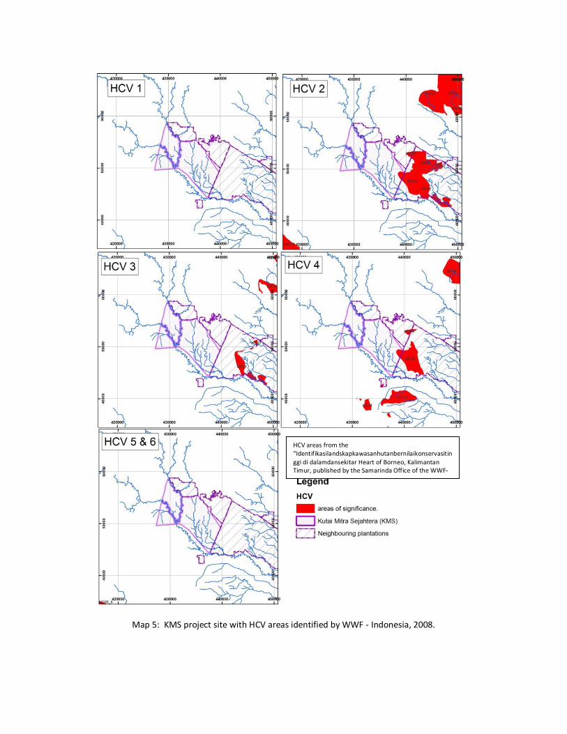
Map 5: KMS project site with HCV areas identified by WWF - Indonesia, 2008.
HCV areas from the “Identifikasilandskapkawasanhutanbernilaikonservasitinggi di dalamdansekitar Heart of Borneo, Kalimantan Timur, published by the Samarinda Office of the WWF-Indonesia in 2008”.

Map 6: TNC sites for conservation and known location of target species.

5.5 HCV status and maps
The field assessment has provided data that is translated into information allowing mapping of the presence of HCV in the KMS site. A precautionary approach has been taken and thus the extent of HCV is thought to be maximal. At time of clearing, variation of the extent of the HCV areas might in this case be smaller as the second round of field verification has shown extensive areas of Imperata grass and destruction of the limestone outcrop. In any case, the precautions taken at the time of land clearing should include a total survey and demarcation of HCV boundaries. A summary of the areal extent of the potential HCV identified in the KMS area are presented in Table 3. In Table 3, approximately 5,393 ha is available for planting, the remaining 2,027 ha is classified as having potential HCV. The HCV overlaps are also presented for the three land parcels, A, B and C. The HCV presence is further categorized by ecological function and type. The table is concise and does not require further elaboration.
The extent of the potential HCV is presented in Map 7. The map records the potential extent of HCV 1-4 and HCV 5&6 are absent. Overlaying of these individual HCV maps has resulted in Map 8. This map denotes areas which have HCV 1-4 overlaps. The higher the count, the greater of number of HCV overlaps. There is a maximum of HCV overlaps in this site and thus these sites are relatively more important.
To make the HCV area design more practical for implementation on the ground, the boundary of the HCVs has been locally adjusted to better conform with the model block design. The model plan follows the usual practice for estates on flat land in Indonesia with north/south oriented blocks of 100 by 250 m giving an area of 25 ha each. This is illustrated in Map 8. Out of a total area of 7420.5 ha, as measured on the GIS map model, the area without HCV and thus available for palm cultivation is 5,393.2 ha, with 2,027.3 ha being set aside for HCV management.
Note: The HCV count map was modified after the second phase of verification. The original extent of the site has been reduced as the site has been highly disturbed and the small limestone outcrop destroyed (illegally quarried for road building material).
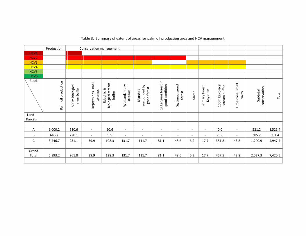
Table 3: Summary of extent of areas for palm oil production area and HCV management
Production Conservation management HCV1 HCV2 HCV3 HCV4 HCV5 HCV6 Block
Palm
oil
prod
ucti
on
500m
bio
logi
cal
rive
r bu
ffer
Dep
ress
ions
, sm
all
swam
ps
Edap
hic
&
biol
ogic
al s
trea
m
buff
er
Wet
land
, man
y st
ream
s
Mar
shes
su
rrou
nded
by
good
fore
st
Sg.L
engu
as fo
rest
in
good
con
ditio
n
Sg.L
imau
; goo
d fo
rest
Mar
sh
Prim
ary
fore
st;
Kayu
Ulin
100m
bio
logi
cal
stre
am b
uffe
r
Lim
esto
ne; s
mal
l ca
ves
Subt
otal
co
nser
vatio
n.
Tota
l
Land Parcels
A 1,000.2 510.6 - 10.6 - - - - - - 0.0 - 521.2 1,521.4
B 646.2 220.1 - 9.5 - - - - - - 75.6 - 305.2 951.4
C 3,746.7 231.1 39.9 108.3 131.7 111.7 81.1 48.6 5.2 17.7 381.8 43.8 1,200.9 4,947.7
Grand Total 5,393.2 961.8 39.9 128.3 131.7 111.7 81.1 48.6 5.2 17.7 457.5 43.8 2,027.3 7,420.5

Map 7: HCV maps for KSM
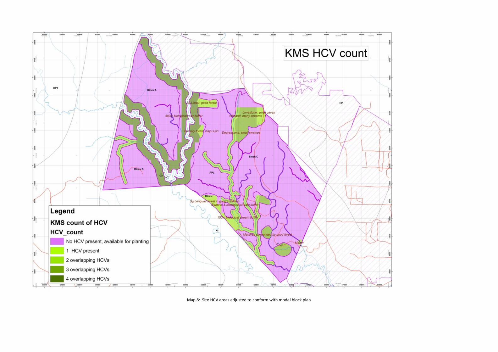
Map 8: Site HCV areas adjusted to conform with model block plan
