hieliminary repcrt ieon deposits of running wolt district ... · hieliminary repcrt ieon deposits...
TRANSCRIPT
HIELIMINARY REPCRT
IEON DEPOSITS OF RUNNING WOLT DISTRICT JTJDIffi BASIN COUNTY, MONTANA
by
G. S. Goodspeed
CONTENTS
Page
Abstract ........................ 1Introduction ...................... 1Geology in relation to the iron deposits ........ 4Ihe iron ore deposits of the Running Wolf-Willow
Creek area ............ 7Character of the ores ............... 8Mode of formation of the iron ore deposits on
the Giroux, Iron Crown and Iron Cross claims .................. 9
Reserves on Giroux, Iron Crown and Iron Crossclaims .... 4 ............. 10
Logs of diamond drill holes ............ IELog of diamond drill hole No. 1 ....... 12Log of diamond drill hole No. 2 ....... 13Log of diamond drill hole No. 4 ....... 14Log of diamond drill hole No. 5 ....... 15
Bureau of Mines and other analyses of RunningWolf iron ore .............. 16
Bureau of Mines analyses of trench samples Giroux, Iron Crown, Iron Cross claims . . 16
Bureau of Mines analyses of drill holesamples Giroux, Iron Crown, Iron Crossclaims .................. 18
Other analyses from the Running Wolf district. 19 Le Roi (Iroquois) and Iron King claims ......... 20Albright claims .................... 22Claims east of Republican Creek ............ 22Miscellaneous deposits ................. 23
Sage Creek .................... 23Wolf Butte .................... 24
Conclusions and recommendations ............ 24Summary of tonnage estimates .............. 26
ILLUSTRATIONS
Figure Pafe
1 Index map,
2 Claim map from U. S. Geological SurveyBulletin 715-F .
3 Geologic map from U. S. Geological SurveyBulletin 715-F . . ,
4 Sketch of contact of igneous rock and limestone showing crushed zone and banded ore replacing limestone, Le Roi claim .... 20
Plate 1 Geologic and topographic map, Running Wbif irondeposit, Judith Basin County, Montana . . In pocket
Plate 2 Cross-sections, longitudinal projections, and longitudinal vertical projections, Running Wolf iron deposit, Judith Basin County, Montana ............. In pocket

2.
yr ^ v^. \-.
£f ' "**"* - _r.jji..?j
/ / S _*x-^_ i
1: Iridex nap showing general location of Running »'olf Ir-n deposits, rectangular lined area below "1", from 17. S. ~. S. Bull. 715-F, p. 85.
Figure 2: Claim map of Running Wolf Iron deposits, from U. S. G. S. Bull. 715-F, p-. 88, by Lewis C. Westgate.

readily accessible By county or farm x'beds, but others are accessible only by trail.
Mr. R» ft. EL 1 son of Great Falls, Montana is the owner of moat of the mining claims in the Punning Wolf district. Ihe list of patented claims furnished by him in July 1943 is as follows:
R. W. Wilson Mining Claims:
Willow Creek Tunnel Site Hill Side Rainbow Honestake Bonanza Black Eagle
DeweyCrystal Spring Red Mammoth Big Tails Big Ben North Star Snow Storm Ho. 2
Snow Storm HoDorothySnowbirdRepublicanCopper KingCopper QueenSteamboat
Mountain View Marjorie Boiler Placer Iron Mountain Lookout Lafioi
R. VT. Wilson and Frank Whitaker, c/o R. M« Armour, First National Building, Great Falls, Montana, undiTided one-half interest:
Ruby No. 1Ruby No. 2Ruby No. 3
Claim
Ironclad ) Iron King)
Other Owners of Patented Claims
Owner
Alice Albright Shadoan, 206 S. TelIowatone, Livingston, Mor
Joseph M. Girouz - Dewey 1fcitaker» c/o £. J. Stomaes, Montana Bank Bldg.,Great Falls, Mont.
Iron Crown) Iron Cross) ^ t company, Cfceat Jmlls, Mont^ * ' '
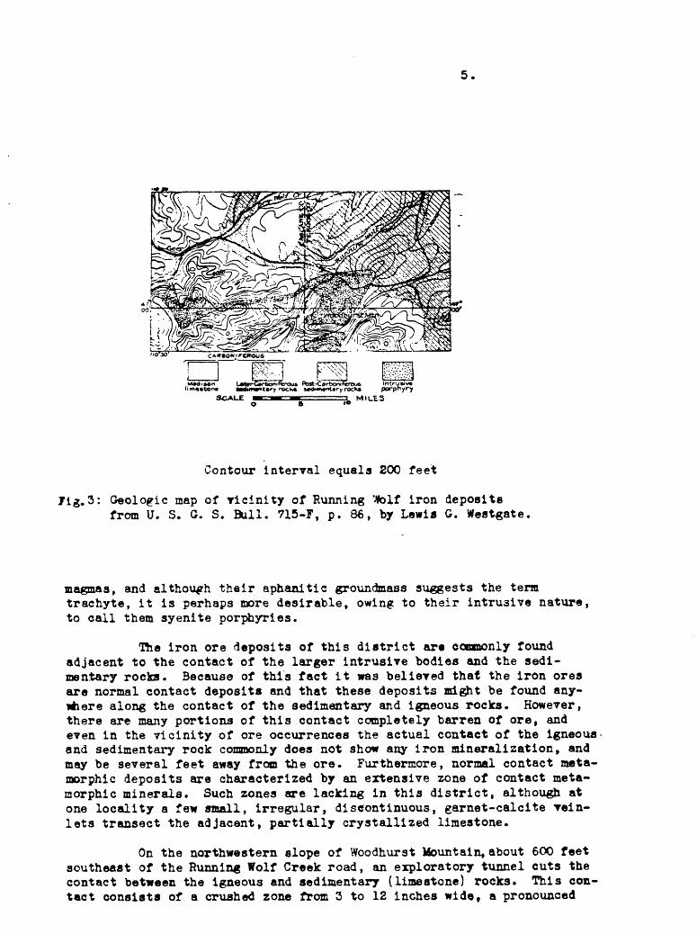
4.
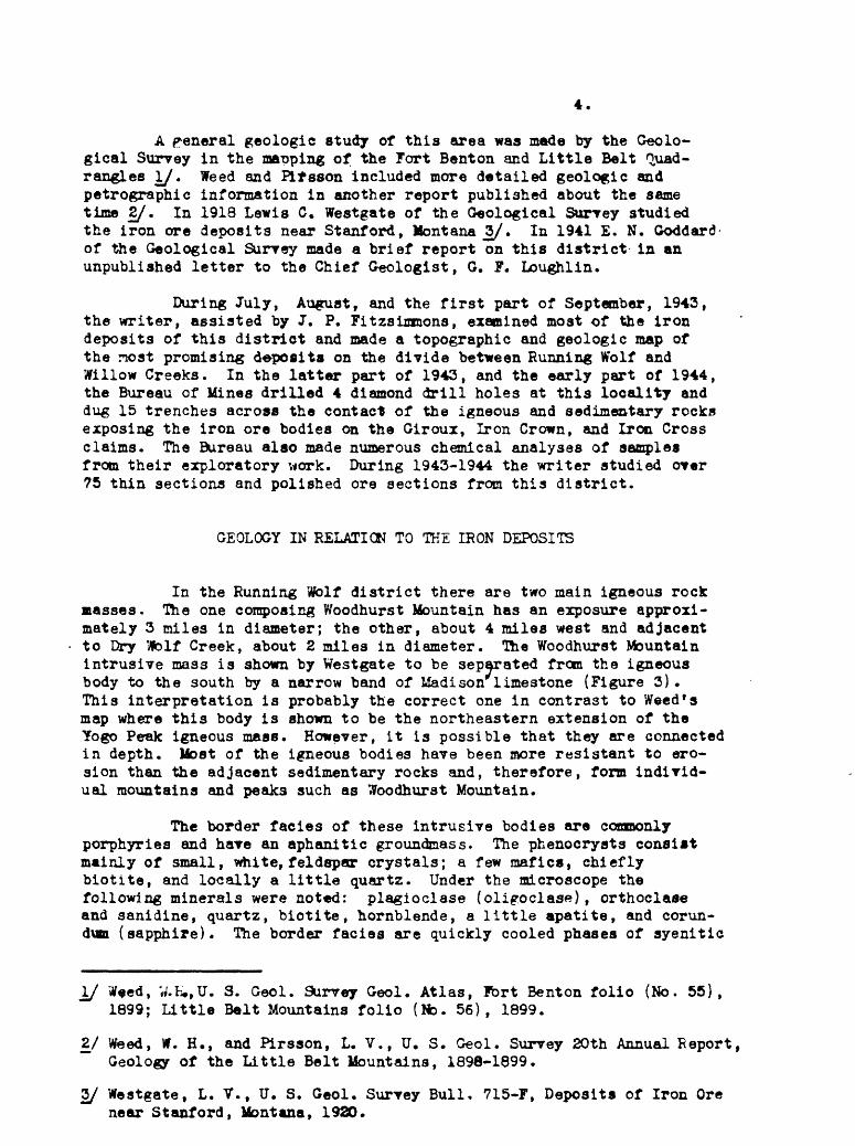
A general geologic study of this area was made by the Geolo gical Survey in the ma-oping of the Fort Benton and Little Belt Quad rangles I/. Weed and Pifsson included more detailed geologic and petrographic information in another report published about the same time 2/. In 1918 Lewis C. Westgate of the Geological Survey studied the iron ore deposits near Stanford, Montana Z/. In 1941 E. N. Goddard of the Geological Survey made a brief report on this district in an unpublished letter to the Chief Geologist, G. F. Loughlin.
During July, August, and the first part of September, 1943, the writer, assisted by J. P. Fitzsimmons, examined most of the iron deposits of this district and made a topographic and geologic map of the most promising deposits on the divide between Running Wolf and Willow Creeks. In the latter part of 1943, and the early part of 1944, the Bureau of Mines drilled 4 diamond drill holes at this locality and dug 15 trenches across the contact of the igneous and sedimentary rocks exposing the iron ore bodies on the Giroux, Iron Crown, and Iron Cross claims. The Bureau also made numerous chemical analyses of samples from their exploratory work. During 1943-1944 the writer studied over 75 thin sections and polished ore sections from this district.
GEOLOGY IN RELATION TO THE IRON DEPOSITS
In the Running Wolf district there are two main igneous rock masses. The one composing Woodhurst Mountain has an exposure approxi mately 3 miles in diameter; the other, about 4 miles west and adjacent to Dry TJblf Creek, about 2 miles in diameter. The Woodhurst Mountain intrusive mass is shown by Westgate to be separated from the igneous body to the south by a narrow band of Madison limestone (Figure 3). This interpretation is probably the correct one in contrast to Weed's map where this body is shown to be the northeastern extension of the Yogo Peak igneous mass. However, it is possible that they are connected in depth. Most of the igneous bodies have been more resistant to ero sion than the adjacent sedimentary rocks and, therefore, form individ ual mountains and peaks such as Woodhurst Mountain.
The border facies of these intrusive bodies are commonly porphyries and have an aphanitic groundmass. The phenocrysts consist mainly of small, white, feldspar crystals; a few mafics, chiefly biotite, and locally a little quartz. Under the microscope the following minerals were noted: plagioclase (oligoclase), orthoclase and sanidine, quartz, biotite, hornblende, a little apatite, and corun dum (sapphire). The border facies are quickly cooled phases of syenitic
\J Weed, W.fc.,U. S. Geol. Survey Geol. Atlas, Port Benton folio (No. 55), 1899; Little Belt Mountains folio (No. 56), 1899.
2/ Weed, W. H., and Pirsson, L. V., U. S. Geol. Survey 20th Annual Report, Geology of the Little Belt Mountains, 1898-1899.
3/ Westgate, L. V., U. S. Geol. Survey Bull, 715-F, Deposits of Iron Ore near Stanford, Montana, 1920.
5.
Contour interval equals 200 feet
Jig.3: Geologic map of vicinity of Running Mfolf iron depositsfrom U. S. G. S. Bull. 715-F, p. 86, by Lewis G. Westgate
magmas, and although their aphanitic groundmass suggests the term trachyte, it is perhaps more desirable, owing to their intrusive nature, to call them syenite porphyries.
The iron ore deposits of this district ar« commonly found adjacent to the contact of the larger intrusive bodies and the sedi mentary rocks. Because of this fact it was believed that the iron ores are normal contact deposits and that these deposits might be found any where along the contact of the sedimentary and igneous rocks. However, there are many portions of this contact completely barren of ore, and even in the vicinity of ore occurrences the actual contact of the igneous and sedimentary rock commonly does not show any iron mineralization, and may be several feet away from the ore. Furthermore, normal contact meta- morphic deposits are characterized by an extensive zone of contact meta- morphic minerals. Such zones are lacking in this district, although at one locality a few small, irregular, discontinuous, garnet-calcite vein- lets transect the adjacent, partially crystallized limestone.
On the northwestern slope of Woodhurst Mountain, about 600 feet southeast of the Running Wolf Creek road, an exploratory tunnel cuts the contact between the igneous and sedimentary (limestone) rocks. This con tact consists of a crushed zone from 3 to 12 inches wide, a pronounced

6.
zone of flow banding in the igneous rock 4 to 5 inches wide, and a fine grained chilled border zone several feet wide. Thin sections show protu- clastic structure in the banded zone, and some alteration in the chilled border. Near this contact the limestone is a compact, banded, gray rock, and the microscope shows it to be partially recrystallized. There are several small veinlets of calcite and garnet transecting the bedding planes* ,
Thig particular contact of the Woodhurst Mountain laccolith definitely shows that the syenite porphyry was injected in a partially crystallized state, and that the immediate contact was affected by con tinuing magmatic pressure which produced the protoclastic border. The alteration of the igneous rock adjacent to the contact shows the effect of deuteric alteration, i. e., the volatiles contained in the magma were released in the late stages of crystallization, and in migrating outward from the main intrusive body they altered the chilled zone*
Some of the volatiles may have penetrated this zone and formed a few garnet-calcite veinlets in the limestone. The small amount of con tact metamorphism does not seem to be compatible with the size of the intrusive masses. This may be due to a relatively small volatile content of the magma, and perhaps by the confining effect of the chilled border.
The limestone is only partially recrystallized and contains only small garnet veinlets. In the shale there is a slight indication of meta morphism in the development of authigenic feldspar, i. e., feldspars which have formed in place after the deposition of the sediment. This slight metamorphism of the sedimentary rock suggests that no large amount of h* or volatiles escaped rapidly from the magma.
As previously stated, the actual contact of the porphyry and limestone is a crushed zone from 3 to 12 inches wide. This is not only indicative of post-intrusive deformation, but also suggests a possible mechanism by which later hydrothermal solutions rose along this zone and formed the iron deposits. More conclusive data concerning the post- intrusive deformation were seen at a contact near the head of Sage Creek
Here the contact is exposed in the workings of a prospect belong ing to J. E. Maeder of Stanford, Montana. It is near the head of £«ge Creek just north of Bear Park Hill, and about 1 mile south of the divide between Willow Creek and Running Wolf Creek. This contact strikes east- west and dips steeply to the north with igneous rock on the hanging wall and gently, southerly-dipping limestone on the footwall. A distinct fault breccia is exposed on the north side of a small, 15-foot shaft. This br-ecciated zone is about 5 feet wide and consists of angular fragments of limestone and igneous rock up to 2 feet in diameter, in a matrix of bluish, clay-like material containing some magnetite, hematite, and sulphides. Fragments of the igneous rock which are surrounded by magnetite are much altered. The light brown of the igneous fragments and the bluish-white of the limestone fragments contrast strikingly with the black magnetite. It is, therefore, clear that the magnetite was formed after the intrusive, and was structurally controlled by post-intrusive deformation.
On the Giroux claim near the eastern end of the iron ore outcrop, the contact between the igneous and sedimentary rocks strikes approximately
8.
trenches and 4 diamond drill holes (Plates I and II). lfce chemical analyses made by the Bureau of Mines of samples from the trenches and core are given on pages 16-17 of this report. The holes were logged byF. C. -Armstrong of the Northwest Regional Office of the Geological Survey t and these records are given on page 18 of this report.
Character of the Ores
Although in raost of the exposures the boundaries of the ore are well-defined, in two trenches, 17 and 19, they are said to have the appear ance of replaced limestone. In general, limestone forms the hanging wall of the ore, and altered prophyry the footwall, but the diamond drill holee (see logs) show from 3 to 6 feet of altered limestone below and between the ore and the porphyry. The cores show brecciated limestone in the vicinity of the ore, and the lack of core indicates the probable shattered condition of the rock. The presence of gougey material and altered rock indicates hydrothermal action, as does the common occurrence of jasperoid veinlets. If the alteration were due to weathering, more widespread effects would be expected from the surface downward, and the pyrite which is present in the altered Igneous rock would not be expected.
In general, the iron ore is compact, fine-grained, and fracture^ The fine-grained ore fractures somewhat like matte; the coarser-grained ore, like cast iron. Local porous structures in the ore are apparently caused by the leaching of included remnants of limestone. Most of the ore is magnetic, although some of it shows a reddish color on grinding. In polished sections it is seen that magnetite is the predominant ore mineral, commonly accompanied by varying amounts of specular hematite and limonitic material, some of which appears to be hypogene, and some supergene in origin. Many of the sections exhibit small, irregular inclusions of limestone in the iron ore aggregate, projections of the iron ore into the carbonate, and well-developed crystal edges of magnet ite against the carbonate. Most of the sections show the presence of chalcedony or jasperoid, which appears to be both contemporaneous with and later than the magnetite. A little pyrite seen in many of the sec tions was earlier than the magnetite. A very little chalcopyrit* and green-staining by malachite were observed in one of the cuts.
A specimen of the iron from diamond drill hole No. 4 is brownish- black and contains numerous, irregular cavities which are partially filled with limonite, chalcedony, and carbonate. Some are completely filled with chalcedony. Ihe black iron ore has a hackly fracture. Some has a platy structure resembling specular hematite but has a black streak and is mag netic. A polished section of this specimen when examined by reflected light shows predominantly a very fine-grained aggregate of magnetite with a few specks of specular hematite. Associated with the fine-grained mag netite is very finely granular, reddish, crystalline, limonitio material and a few small irregular masses of chalcedony. The magnetite shows well-formed crystal edges in juxtaposition with the chalcedonic quartz indicating a contemporaneity of formation. A few, mall, irregular relics of carbonate are present. Minute, later, roughly parallel vein- lets of limonite transect both the magnetite and the chalcedony.

7.
N. 70° w. Portions of it ere fairly straight for two or three hundred feet; near the eastern edge of the claim the trace of the contact is wary, the waves having an amplitude of 25 to 50 feet in a north-south direction. Near the west end of the Iron Crown claim the contact veers to the north. About 150 feet east of the east end of the iron ore out crop on the Giroux claim, the contact is exposed in Bureau of Mines trench 13; about 300 feet northeast of this point it is exposed in Bureau trench 14. This abrupt change in direction might be explained by a fault, although there is no surface expression of such a feature, or by a locally discordant portion of the contact.
Owing to the paucity of continuous limestone outcrops, it ia not possible to determine accurately the attitude of the limestone strata in this area. About 85 feet east of the iron ore outcrop on the Giroux claim the limestone is nearly vertical with an east-west strike; about 250 feet farther to the northeast it has a strike of N. 80° 2. and dips 50° S. Approximately 150 feet to the west of the west end of the Giroux outcrop, the limestone strikes N. 70° E. and dips 70° S.; farther west, on the Iron Crown claim, it has a strike of N. 80° W. and dips 37° S. On the Iron Crown claim to the west, readings of similar strike were recorded for the limestone outcrops with more gentle southerly dips, 50° and 37°. It seems evident that the limestone strata dip away from the intrusive mass of Woodhurst Mountain, and that the dips are more steep closer to some portions of the contact. Syenite porphyry outcrops on the hill to the south, but there is no indication of iron ore alcnf the probable contact.
Lithologically the limestone, which presumably belongs tc the Madison, ranges from a very compact, although locally finely joints, bluish-gray rock to a more crystalline, white rock. The wMt« linest is distinctly more coarsely crystalline than the blue-pray limestone, and individual calcite grains are discernible with a hrnd lens. Tfce outcrops of limestone west of the old shaft on the Gircux claim stow lenticular, cherty bands, some of which are about 5 irches *ide. bands are apparently parallel to the bedding.
THE UtON CUE DEPOSITS OF T5& RUNNING WQLF-'VILLOW "KEKK j&EA
Most of the iron ore deposits of this area ^re in the form of narrow, steeply dipping lenses which occur along about 4,200 feet of the contact between the limestone and the igneous rock. Although actually exposed in but a few places this contact, as indicated by float anl ty old prospect trenches, has a total length of about 6 miles. The 4,200 feet of the contact, which has been systematically explored, has adjacent to it iron ore lenses having a total length of approximately 1,600 feet, and it is believed that this sector contains more iron ore than the aver age for the total length of 6 miles. This indicates that iron ore lent>es are adjacent to less than 36 percent of the contact.
Two of these ore lenses are shown on the accompanying topo graphic and geologic map, Plate 1. They are located on the Giroux and the Iron Crown and Iron Cross claims. The exploratory work done ty th* Bureau of Mines during the winter of 1943-1944 consisted of numerous

9.
Another specimen of iron from 126 fe«$ below the collar of diamond drill hole No. 4 Is fine-grained, purplish-black, Intersected by Irregular, discontinuous retnletj of calcite, and contains numerous, small, irregular., carbonate inclusions. A polished section of this specimen shows irregular patches of very fine-grained hematite with finely granular, limonitic material included in slightly darker magnetite, and numerous inclusions of carbonate. A thin section from the same speci men shows that most of the irregular, carbonate masses are probably relics of the -limestone which has been replaced by magnetite and hematite. Pro jections of the iron ore into the carbonate and well-developed crystal edges of the magnetite against the carbonate are common. A little chal- cedonic quartz Is associated with the carbonate.
Although the previously described core specimens suggest replace ment of limestone by the iron ore, the next foot of core is even more suggestive of this process. It has a blotchy appearance with irregular, purplish-black masses of iron ore fading into yellowish-white, altered limestone* Under the microscope the altered limestone is seen to be a fibrous aggregate of anthophylite and tremolite with carbonate, zoisite, a little kaolinitic material, and grains of magnetite and red, limonitic material. There is present a roughly parallel structure formed by minute, anastomosing, turbid carbonate veinlets. A polished section of the iron ore associated with the altered limestone shows a fine-grained aggregate of magnetite and a little hematite which is in gradational contact with finely granular, iron-stained limestone. Relics of the limestone are included in the iron ore, and the iron ore projects into the limestone. The iron ore is transected by minute, carbonate veinlets, and contains several, small, irregular inclusions of a soft, greenish-white, amorphous- app^aring material.
Ifode of Formation of the Iron Ore Deposits on the Glroux, Iron Crown and Iron Qjrcas. Claims
Although the position of these deposits adjacent to a contact between porphyry and limestone suggests that they are genetically contact deposits, the lack of zones of high-temperature, lime silicates, as well as the presence of a few feet of limestone between sections of ore and the syenite porphyry, are indicative of the inadequacy of this interpre tation. However, the alteration and the intimate association of jasperoid quartz with the ore, an association to be seen under the microscope in the very fine-textured ore from the surface and at depth, strongly suggest that the ore was formed by ascending hydrothermal solutions.
The fracturing observed in some of the surfact exposures, the considerable amount of deformation indicated in the drill holes, as well as the brecciation of nearby localities previously described, suggest that the hydrothermal solutions were controlled by a fracture system which approximately paralleled only portions of the contact between the igneous and sedimentary rocks.
These fracture systems provided the channel ways for the ascend ing hypothermal solutions and, although some filling took place, it is probable that replacement played the dominant role in the formation of

10.
these deposits. Many features, including numerous relics of limestone in the ore, are indicative of replacement.
The shape of these iron ore deposits and the dominance of magnetite as an ore mineral seens to place them in the hypothermal Tein zone. However, the presence of chalcedony and jasperoid, as well as apparently hypogene limonitic minerals and the lack of high-temperature lime silicates, would indicate a not too elevated temperature of forma tion. It is possible that the iron-rich hydrothermal solutions which formed the ore came as the later products of a basic magma crystallizing at depth. It appears very doubtful that these solutions came from the adjacent Woodhurst Mountain laccolith.
Two important economic deductions may be based upon the data and interpretations as outlined above. First, that the fracture system and not the intrusive contact is the controlling structure; therefore, the ore cannot be expected to continue uninterruptedly along the contact, Secondly, it appears unlikely that the ore body at depth would show any greater tonnage per vertical foot than is shown on and near the surface. Moreover, the presence of earlier pyrite in cor* of the deepest drill hole may indicate a radical change in the mineral character of the ore at greater depth. However, on the Iron Cross claim the presence of pyrite in the surface exposures and not at depth is of interest because since pyrite is the earlier mineral, greater concentrations might be expected at depth. The available data with regard to this deposit are too few to furnish accurate interpretations as to the cause of this seeming anomaly. It is possible, of course, that pyrite was not origi nally evenly distributed, either vertically or laterally.
Reserves on Giroux, Iron Crown and Iron Cross Claims
Because the Running Wolf iron ores are largely replacement deposits, an estimate of the reserves based on the small amount of data available is liable to be in error. There are insufficient data to warrant an estimate of measured ore on these claims. However, it is believed that the figures given below are of the correct order of magni tude and that it can be positively stated that the deposits are small too snail to be considered a source of iron under existing economic conditions.
Specific gravity determinations were made on several specimens of the Running Vfolf iron ores and an average of these proved that a factor of 8 cubic feet of ore per ton was accurate for tonnage estimates,
On the Iron Cross and Iron Crown claims it is estimated that the ore body shown in vertical lonfitudinal projection E-E f (Plate 2) is 16.1 feet wide and contains 550,000 tons of indicated ore and 200,000 tons of inferred ore which averages 59.96 percent Fe, 0.018 percent P, 0.104 percent S, 6.77 percent Insoluble, 0.023 percent Cu, and 0.01 par- cent TlOji. Because of the inclusion of sample No. 125 (See Page 16) in the estimate, the width and tonnage may be slightly high and the grade slightly low. Trenching baa shown that neither end of the ore body is open at surface, and it ia assumed that the ends of the ore down dip are the same as those indicated by surface trenching. Indicated ore is
11.
assumed to extend 50 feet down dip below the diamond drill hole inter sections. Inferred ore is assumed to extend 100 feet down dip below the lower limit of the indicated ore.
On the Giroux claim it is estimated that the ore body shown in Tertical longitudinal projection F-F f (Elate 2) is 5.9 feet wide and contains 80,000 tons of indicated ore and 40,000 tons of inferred ore which averages 55.37 percent Je, 0.025 percent P, 0.1S4 percent S, 15.27 percent Insoluble, 0.006 percent Cu, and 0.01 percent TiOg. These tonnage figures are based on a down dip projection of 50 feet below dia mond drill hole No. 2 for indicated ore, and an additional 100-foot pro jection for inferred ore. The presence of only 1.4 feet of ore in dianom drill hole No. 1 may indicate a rake of the ore to the west as shown on Plate 2. However, if this means that the ore body is the bottom portion of a lens as shown by the dashed line on Plate 2, then the above tonnage estimate must be revised. In this case there are only 60,000 tons of indicated ore and no inferred ore.
12.
Logs of Diamond Drill Holes
Log of Diamond Drill Hole No. 1
Elev. of Depth CoordinatesCollar Inclination Bearing in Feet North____East
6,151 -43° N. 22° 30' E. Ill 19817 17929
Size: AX 0 to 101 feet; EX 101 to 111 feet.
Footage Description and Remarks
0-26 No core.
26-48 Light gray to white, massive, limestone. 26 - 35 Slightly iron stained. 38 - 40 Darker gray, denser.45-48 Darker gray, slightly sheared (30° to core).
17 feet recovered.
48-68 Decomposed, brecciated limestone, moderately iron stainedand some green coloration in gougey material. Few chip: solid limestone in decomposed material. 4 feet recover*
68 - 78 White to light gray, finely crystalline limestone, locallyslightly iron stained.
68 - 71 Moderately iron stained and decomposed. Core in chips. Some mud. 6-inch dense gray bed near 74 fe«t. 6-foot core recovered. Probably most lost 68-7
78 - 91.5 Limestone similar to 68 - 78. 3-foot core recovered.Probably most lost near 78 feet and 91.5 feet.
91.5 - 93 Iron^formation. Some bands of heavily iron stained lime stone at start, then magnetite, liinonite, and probably some hematite in chips. Less than 1 foot recovered. Representative sample at 92.5 feet.
93 - 99 Decomposed limestone and syenite. Effervesces near start,gradually decreasing and disappearing near end. Moder ately iron stained. 93 - 96. ij- feet recovered.
99 - 111 Syenite, white, moderately coarse. Little scattered pyrittRepresentative sample at 108 feet.
96 - 101 ij- feet recovered. 101 - 111 2 feet recovered.

Ix?g of Diamond Drill Hole No. 2
Elev. of Depth Coordinates Collar Inclination Bearing in Feet North _____last
6150 -49° N, 22° 30' E. 134 19828 17664
Size: AX 0 to 112.5 feet; EX 112.5 to 134 feet.
Footage Description and Remarks
0-48 Limestone, v&ite to light gray, finely crystalline. Locally, moderately iron stained. 19 - 20 Darker, denser bed.)22 - 27 Darker, denser bed.) Distances only approximate 30-32 Darker, denser bed.) because of lost core 46 - 48 Darker, denser bed.) between runa. 37 - 41 Decomposed, slightly iron stained limestone;
somewhat gougey. 40-45 Fairly well banded (bedding?), 60° to core.
0-20 Lost core 12'.20-33 Lost core 5'.33 - 37 Lost core 2*.37 - 48 Lost core 3' .
48 - 101.5 Limestone. Similar to above.48-65 Moderately iron stained. 6" dark gray bed
near 61'.65 - 72 Medium gray, denser bed. 72 - 92 Predominantly white limestone, little gray near
80'. Slightly iron stained after 85'. 4"quartz after 90'.
92 - 96 Light gray, slightly iron stained. 96 -101.5 Similar to 48 - 65.
48-65 9 f lost core. 65 - 85 II 1 lost core. 85 -101.5 10' lost core.
101.5 - 112,5 Brecciated, gray and white, slightly iron stainedlimestone. Bedding (?) at 65 to core.
111.5 - 112.5 Quartz. 7 1 lost core.
112.5 - 118 First foot of recovered core dark gray limestone, fine grained, massive. Next foot of recovered core iron formation. 3j' lost core. Representative sample near 117'.
118 - 126.5 IronA formation. Magnetite, limonite and probably somehematite. 4^' lost core. Representative sample neap 120*?
126.5 - 134 Syenite, decomposed, with some limestone present to 130'then less decomposed to near 134'. Last few inches of hole in fresh syenite. 50 percent lost core.

14.
Log of Diamond Drill Hole No. 4
Elev. of Depth Coordinates Collar Inclination Bearing in Feet North East
5995 -50° N. 19° E. 141 20277 16228
Size: AX 0 to 141 feet.
Footage Description and Remarks
0-24 Limestone, light gray to white, nedium- to fine-grained. Locally slightly iron stained. 22' recovered.
24 - 2b Limestone, white, slightly iron stained.
28 - 35 Predominantly light brown (iron stained) limestone.
35 - 50 Brecciated. gray and light brown limestone. Mostly gray after 48'.
50 - 56 Light gray and brown,fine-grained, banded limestone. Gougey and brecciated portion near 55' fault (?).
56 - 86 Limestone, predominantly fine-grainpd, white, slightly iron stained. More staining toward 80-86' and scci <? gray sections. Bedding (?) at 58' at 65° to core.
86 - 106 Limestone, white to light gray, fins-grained, massive. Locally slightly brecciated with slight iron staining along fractures. 99 percent recovery.
106 - 126 Magnetite and hematite. Numerous solution cavities. Central portion more predominantly hematite. Near 126 feet small remnants of limestone.
1?6 - 129 Limestone, fine-grained, medium gray, altered. Somemagnetite and hematite in irrefular patches replacing limestone? 98 percent recovery.
129 - 136 Syenite porphyry. Decomposed. Locally little decompose I limestone. Few short sections of undecomposed syenite. 71 percent recovery.
136 - 141 Syenite porphyry. Fresh. 80 percent recovery.

15.
Log of Diamond Drill Hole No, 5
Elev. of Depth Coordinates Collar Inclination Bearing in Feet North_____East
6010 -50° N. 50° E. 214 20503 15586
Size: AX 0 to 188.5 feet; EX 138.5 to 214 feet.
Footage Description and Remarks
0 - 54.5 Limestone, light gray, fine-grained, massive. Locally iron stained. Fe\, snail vugs. 67 percent recovery.
54.5 - 93.5 Highly brecciated and decomposed material. Slightlyiron stained.
54.5 - 72 Predominantly decomposed syenite with few limestone fragments. 57 percent recovery.
72 - 33.5 60 percent decomposed limestone fragmentsand 40 percent decomposed syenite. 88 per cent recovery.
93.5 - 133 Limestone similar to 0 - 54.5. 50 percent recovery.
133 - 164 Limestone, greatly decomposed with short sections oflimestone similar to 0 - 54.5 feet. Slightly iron stained in decomposed sections. 58 percent recovery.
164 - 138 Limestone similar to 0 - 54.5 feet. 42 percent recovery.
188 - 2C3.5 Magnetite and hematite iron formation. Numerous smallcavities with some quartz in them. Scne square corners in cavities pyrite? R. S. at 190 feet. Water lost in iron formation. Badly broken. Difficult drilling. 14 percent core recovered by weight. Approximately 4 feet of core recovered. 26 percent recovery esti mated from amount of core in the box.
203.5 - 206.5 Decomposed material. Approximately 80 percent syenite,20 percent limestone. 50 percent recovered.
206.5 - 214 Syenite porphyry. 13 percent recovery.
Note: Total depth of hole, 214 feet.Total footage cemented, 287 feet.
BU
RSA
lf O
F M
IKES
AND
OTH
Z3 A
iiALY
SSS
OF
.Httr
JIN
O W
OLF
IJftO
M O
RB
Bur
eau
of
Min
es A
naly
oec
of
Tre
nch
Sam
ple
s th
e O
irou
x,
Iron
Cro
wn,
Ir
on C
ron
C
laim
s
Sam
ple
. H
o.
117
118
119
120
121
122
123
Tre
nch
126
127*
Tre
nch
i pf
lJL
cO 129 130 131 ,,*
13*
135
Tre
nch
124
125
Tre
nch
Tre
nch
Tru
eH
o,
Thi
ckne
ss
1 2 i 4Q
-iro
ux D
iico
ver
y
15 15
Av.
17 17A
v.
18 18
18 18
18 18 18 18A
v.
16 16
Av.
5.4 b.2 8.5
4.6
4.2 8.6
iH 8.
6 14 876
2.6 2.3 3.7
h
"i
h
TI
h
74*
33*t
5
29 '.3
h
»
4. "5
87
6
Per
cent
Iro
n
55.6
5 4.2
3^6
.71
57.8
153
.79
65. 8
4
53.6
061
.01
5573
9
59.1
110
.^9
59.1
1
58.0
055
.11
64.7
265
.03
64.6
665
.99
66.8
044
.18
6T7T
O
53-1
027
.11
40.1
1
Per
cent
Pho
spho
rous
0.0
18
0.0
16
0.0
14
0.07
30.
011
0.01
6
0.01
60.0
12
0.0
15
o.ou
0.0
11
o.o4
60.
045
0.02
60.
036
0.0
24
O.O
POo.
oi4
0,02
10.
027
0.02
9
0.02
9
Per
cent
Sul
phur
0.08
0 0.
180
0.07
00.
110
0.03
00.
110
o.o6
4
0.05
3
0.07
00.
076
0.07
0
0.02
00.0
22
0.7
66
S:8
0.1
48
0.03
40.0
18
0.2
54
0.1
24
o!o8
b
Per
cent
Inso
luble
16.2
1 16
.70
25.9
013
.08
18.1
8
20.4
811
.80
17.2
1
13.2
8:rT
_ _
__
13.2
8
8.0
62.
35 2*09
3.36
3.2
80.9
01.
821.
6627
7*
4.73
5773
Per
cent
Cop
per
0.0
02
0.01
0O
.Q1S
0.
013
0.02
10
T008
0.02
1
0.00
5O
.OO
J 0.
021
0.0
14
0
.01
6C
.011
0.0
02
0,0
02
0.01
0
0.09
00.
019
0.0
54
cr\
(Con
tinu
ed)
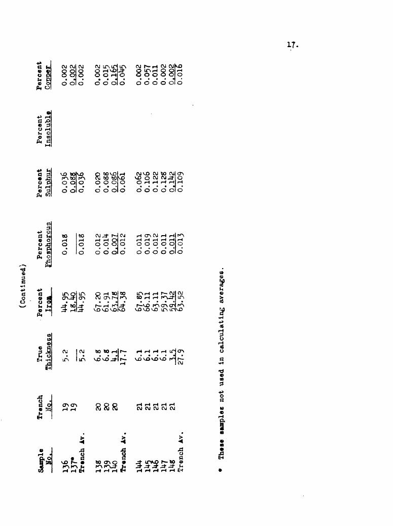
(Continued)
Sample
Ho.
136
137*
Trench A
v.
139
lUo
Tren
ch A
v.
XI
Trench
Ho.
19 19 20 20 20 21 21 21 21 21
True
Thickn
ess
5.2
5.2 6.8
6.5
!L1
17-7 6.1
6.1
6.1
6.1
Per
cent
Iro
n
67.2
061
.91
Trench A
v.27
.9
6^.3
8
67.8
566
.11
63.1
159
.37
63^5
2
Per
cent
Phos
-pho
rcm
o
0.0
18
0.0
18
0.0
12
O.O
lU
0.00
7 0.0
12
Percen
t Sulphur
0.0
36
0.0
88
0.03
6
0.02
00.0
88
0.08
60.
061
Perc
ent
Inso
lubl
ePercent
0.00
20.
002
0.002
0.002
0.05
70.
011
0.002
0.00
20.016
These
samples
not us
ed in c
alcu
lati
ng a
vera
ges.

Bureau of
Mines Analyses of
Dr
ill
Hole Sa
mple
s Gl
roxu
c, Ir
on Crown, Ir
on Cross
Claims
footage
and
Type
Sample
Core 92
-93
Core
116.5-12
2 Co
re 122-126
AT.
for Ho
le
Core
10
6-11
1Core 111-115
Core 11
5-12
0 Co
re 12
0-12
5 Co
re 125-128
Slud
ge 107-11
2*
Slud
ge 112-11
7*
Slud
ge 117-12
2*
Slud
ge 122-12
7*
Slud
ge 127-12
9*
J^.
1 2 2 4 4 4 4 4 4 4 4 4
Ar.
for
Hole (c
ore
only)
Core 18
8-19
5 Co
re 19
5-20
3.5
5 5
Hole Ho.
I 1 IMI
!
1 2 2 4 4 4 4 4 4 4 4 4 4
True
Thic
kness
1.0*
5-2
1*1
9.ob
4.7
?'*
4.8
4.8
2.9
Perc
ent
Iron
52.9
8
56.8
858.
"S8
57-51
67.2
667
.42
57.3
059-52
41.7
2
58.8
858
.80
56.9
062
.00
^2.2
2
Percent
Phosphorous
0.019
0.01
10.
016
0.013
0.010
0.006
0.01
20.009
0.03
2
0.017
0.01
10.
012
0.015
0.041
Perc
ent
Sulr
>hur
0.032
0.32
00.
0*58
0.21
0
0.018
o.oi
4O.
o46
0.020
0.02
4
0.064
o.o4
60.
052
0.060
0.07
6
Percent
Inso
lubl
e
20.3
8
15.06
12.26
13.8
8
2.07
1.82
11.67
7.97
13.9
2
3.18
8.39
8.87 3.96
1.7-
55
Percent
Copper
0.012
0.010
0.00
2
0.00
6
0.010
0.01
20.186
0.00
20.
002
0.00
20.212
0.002
0.010
0,00g
Perc
ent
TjQa
0.01
0.01
Q.01
0.01
0.01
0.01
0.01
0.01
0.01
0.06
0.02
0.01
0.01
0,p2
21. Oc
59.7
20.013
0.02
5
Slud
ge 18
9.5-
195
Av.
for
Hole
(core
only
)
*The
re samples
not us
ed in calculating averages.
a.
In e
stim
ates
of tonnage
and
grad
e, 1.4
1 us
ed a
s tr
ue th
ickn
ess.
to.
In e
stim
ates of
tonnage
and
grad
e, 11
.9f us
ed a
s tr
ue thickness,
c.
In estima
tes
of to
nnag
e and
grad
e, 18.8*
used
as
true th
ickn
ess,
d.
In e
stim
ator
s of t
onnagtra&d >rade
, 14.6'
used
as
true th
ickn
ess.
7.20
0.048
0.01
5 5 5 only
)
5-9
7.1
13. o
d
65
.84
66
.25
53^1
66.0
6
0.0
24
0.0
21
0.0
49
0.0
22
0.0
52
0.0
54
0,12
ft
0.05
3
1.85
2.
19
9. $
4
2.04
0.0
02
0
.00
2
0.0
02
0.0
02
0.0
1
0.0
1
0.0
1
0.0
1
19
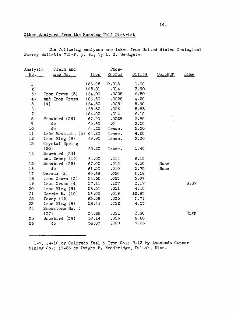
Other Analyses from the Running Vfolf District
The following analyses are taken from United States Geological Surrey Bulletin 715-F, p. 91, by L. G. Westgate:
Analysis Claim andNo.
1)2)3)4)5)6)7)a9
10111213
map No.
Iron Crown (3)and Iron Cross(4)
Snowbird (39)dodo
Iron Mountain (5)Iron King (9)Crystal Spring
Iron
(66.05(65.01(64.00(66.50(64.30(65.30(64.0067.90-5.60rt .20£4.20ee.90
Phos-Dhorus
0.015.014.0028.0028.005.006.014.0028.0
Trace.Trace.Trace.
Silica
1.903.906.504.205.905.536.102.802. 502.204.202.00
(20)14 Snowbird (39)
and Dewey (19)15 Snowbird (39)16 do17 Geroux (2)18 Iron Crown (3)19 Iron Cross (4)20 Iron King (9)21 Carrie M. (10)22 Dewey (19)23 Iron King (9)24 Snowstorm No. 1
(37)25 Snowbird (39)26 do
63.20 Trace .40
64.0067.0061.5063.6956.5237.4156.5156.0063.0958.44
34.8850.1458.03
.014
.010
.010
.020
.025
.107
.021
.019
.035
.C22
.021.026.020
6.104.505.706.185.073.174.10
12.95f .714.55
3.906.607.86
Sulphur Lime
None None
8.87
High
1-7, 14-16 by Colorado Fuel &. Iron Co.; 8-13 by Anaconda Copper Mining Co.; 17-26 by Dwight E. Woodbridge, Duluth, Minn.

20.
LE ROI (UtOQUOIS) AND IRON KING CLAIMS
The Le Rol (Iroquois) and Iron King claims are located on ^h« northwestern slope of Vfoodhurst Mountain in the south-central portion of Sec. 6, T. 14 N., R. 11 E. The principal workings are about 600 feet southeast of Running Wblf Creek road. A few piece* of iron ore float may be seen in the road, and a few small pits are nearby. The workings consist of a tunnel 65 feet long. About the first half of it is driven in a southeasterly direction (S. 37° E.), and the remainder in a south westerly direction. Uxsre is a short tunnel and a few cuts just above and to the southeast of the longer tunnel.
The best exposure of iron ore is seen in the long tunnel and raise above it, about 23 to 30 feet from the portal. The ore occurs chiefly as bands of magnetite and subordinate pyrite, parallel to the original bedding of the limestone which dips about 30 degrees to the southwest; the same direction, but not so steeply as the contact between the igneous rock and the limestone. The actual contact, which is a crushed zone from 3 to 12 inches wide, strikes N. 70° W. and dips 41 SW. The contact, which probably is in nearly the same position as the original intrusive contact, is not perfectly conformable to the bedding planes of the limestone but transects them at a small angle.
Figure 4: Sketch of contact of igneous rock (4) and limestoneshowing crushed zone (stippled) and banded ore (black) replacing limestone. Approximate size of section 1C by 12 feet. Ercn tunnel and raise on Le Roi claia.

21.
The bands of ore range from a fraction of an inch to about 2 feet wide and, as exposed in the tunnel and in the short raise, there appears to be an aggregate stratigraphic thickness of approximately 20 feet. It exhibits all gradations from massive magnetite with considerable amounts of pyrite to nearly pure limestone with snail vein-like bands of ore. In addition to pyrite, there are local occurrences of specular hematite. Although the ore is exposed for several feet in the tunnel and raise, there is no direct evidence as to its extent down the dip of the limestone. *Bie dip needle gave evidence of attraction for about 50 feet east and 50 feet west of the tunnel.
Polished sections about 2 inches square of this ore show nearly solid bands of finely granular magnetite over half an inch wide, separated by bands of grayish-green limestone. The bands of magnetite are, in general, parallel to the bedding with fairly well-defined borders, but locally are lenticular. They show considerable variation in width, and may break into parallel, lenticular veinlets connected by very narrow veinlets. Some of the wider bands of ore contain tabular, elongated, lenticular inclusions of limestone.
Minute, rounded protrusions of the magnetite into the limestone, as well as minute, irregular veinlets of magnetite surrounding calcite grains in the limestone, are seen in the thin and polished sections. The polished sections also show numerous, irregular grains and well- formed crystals of early pyrite in the limestone. Magnetite is clearly later than this pyrite as it surrounds and transects the latter. lher« are, however, a few, minute, transecting veinlets of pyrite and associ ated carbonate which are apparently later than the magnetite. There are also minute, irregular cavities which have apparently resulted from the solution of included limestone; some of these are stained with limonite suggesting the former presence of pyrite. Locally there are conspicuous plates of specular hematite in joint cracks in the altered limestone and in the igneous rock adjacent to the contact. Platy crystals of specular hematite are also noticeable in a few of the finer grained bands of ore. Polished sections from one of these bands show the hematite plates extend ing into the very fine-grained portions and including minute grains of magnetite. There also appears to be an intricate network of hematite, recognizable by its slightly lighter color in polished section, surround ing grains of magnetite.
The evidence seen in this deposit indicates that replacement was the dominant mechanism of formation. It is probable that hydro- thermal solutions rich in iron rose through fracture or fault zones adjacent to the igneous contact, replacing the limestone and penetrating it along bedding planes and fractures. There is no definite evidence as to either the stratigraphic extent or the extent along the bedding planes of such penetration. The dip needle, however, does not indicate a large body of ore. Although the iron ore minerals are high grade, the amount of pyrite, 10 percent, in the ore makes this deposit unattractive as an iron deposit. There is no evidence to indicate whether the amount of pyrite might be expected to increase or decrease with depth.
There is insufficient exploratory work and sampling to make an estimate of measured ore for this deposit. The exposures on the ore body show a atratigraphic thickness of 20 feet. Assuming, on the basis

22.
of exposures and a dip needle traverse, that the ore extends over an area approximately 100 by 100 feet and is 20 feet thick, it is estimated that there are 25,000 tons of indicated ore on the property. As much again, or another 25,000 tons, is estimated as inferred ore.
ALBRIGHT CLAIMS
The Albright claims are in Sec. 2, T. 14 N., R. 10 E., approxi mately 3 miles southwest of Dry Wolf Creek, and lese than 1 mile north east of Running Wolf Creek. They are located on the northern slope of the ridge separating Running Wolf and Dry Wolf Creeks and can be reached by wood road and trail from the Dry Wolf Creek road.
Many of the cuts on these claims, as examined in July 1943, were filled with debris due to slumping; and geologic relationships were further obscured by the tree growth and thick cover. In one cut the iron ore is from 8 to 10 feet wide with an approximately east-west strike and a nearly vertical dip. Blue and white limestone rubble were present in this cut. The iron ore is similar to that which has been previously described in the Running Wolf-Willow Creek area.
The ore from the central portion of this cut is brownish-black and fine-grained, with roughly parallel, coarser grained bands which are in rough alignment with partially filled veinlets of limonite-stained chalcedony. There are several, small (1/8 to 1/4 inch), irregular, and rounded masses of chalcedony included in the iron ore. The ore in the coarser bands has a distinctly platy character, and might easily be mistaken for specular hematite. However, it is highly magnetic. A polished section shows irregular and rounded areas of very finely gran ular, dark magnetite and a little hematite, surrounded and traversed by veinletfi of a very fine-grained aggregate consisting of black magnetite, gray, anisotropic hematita, and a reddish anisotropic mineral, perhaps lepidocrocite. The relative proportions of these minerals vary consid erably in different portions of the section. Later veinlets of chal cedony transect the fine-grained magnetite and exhibit cup-like projec tions into the magnetite, thus indicating a replacement of the iron ore by chalcedony. Along the borders of some of these veinlets are narrow rims of red lepidocrocite, and portions of the veinlets are also stained with yellow limonite.
Since the iron ore on the Al bright claim has a mineralogy similar to the Running Wolf-Willow Creek deposits, an assumption of a strike length of 200 feet, a dip length of 100 feet, and a width of 10 feet raay be inferred. An ore body of these dimensions contains 25,000 tons of inferred ore.
CLAIMS EAST OF REPUBLICAN CREEK
The claims east of Republican Creek are located along the summit of a ridge east of the creek at elevations between 6,750 and 7,100 feet. They nay b« reached by trail from Republican Creek, a

23.
tributary of Dry Wolf Creek. The old workings include trenches and shafts, most of which are slumped or inaccessible. A soil cover obscures the bedrock geology. However, it is probable that the occurrence of the iron deposits on these claims is similar to the other deposits of the Running Wolf district.
At an elevation of 7,100 feet about 5 feet of ore is exposed in an inclined shaft. This does not represent the full width of the ore. It strikes approximately north-south and dips 68° W. Fine-grained por phyry forms the hanging wall on the west; limestone, the footwall on the east. In this particular deposit, as well as in the other deposits in the near vicinity, the ore appears to be chiefly a fine-grained, somewhat banded magnetite with a few, platy crystals of specular hematite. The gangue, which is chiefly jasperoid containing vugs lined with small quartz crystals, and some banded ore in altered limestone, is indicative of replacement. One specimen shows a few, subhedral, greenish, garnet crystals disseminated in a silicified limestone. A thin section of this specimen shows later calcite and quartz veinlets transecting the garnet and silicified limestone.
Many of the old workings in this vicinity have iron ore on their dumps. However, because of the inaccessibility of most .of the workings, actual measurements of widths were possible in only a few cases. One working showed banded iron ore and altered limestone over a thickness of approximately 20 feet.
Ihe lack of exposures renders it impossible to make an estima tion of indicated ore. On the assumption that two of the ore bodies have widths of 10 feet, strike lengths of 200 feet, and dip lengths of 100 feet, it is estimated that each contains 25,000 tons of inferred ore.
MISCELLANEOUS DEPOSITS
During the summer of 1943 numerous deposits were examined in the Running Wolf district, in addition to those which have be«n previ ously described in this report. Several of these were gossans formed by the weathering of sulphides ifcich replaced limestone. Many of those which were primarily iron ore deposits did not have sufficient exposures, either natural or artificial, on which to base tonnage estimates or any accurate statement as to lateral or vertical extent.
Sage Creek
The geology of one deposit situated near the head of Sage Creek is briefly discussed on Page 6 of this report. At this locality the iron ore appears to be limited to the matrix of a crushed zone about 5 feet wide, and is associated with a considerable amount of gouge and sulphides. Two to three miles east of this deposit are several old trenches which have iron ore on their dumps but not exposed in place. The ore is predominantly magnetite similar to the Running Wolf-Willow Creek ore. Geologic relations also appear to be similar in that the ore
24.
ia bounded on the northwest by the igneous mass of Woodhurst Mountain, and on the south and east by limestone.
Wolf Butte
About 8 miles to the northwest of the principal Running lolf deposits and about half a mile east of Wolf Butte, there ara seTaral trenches which have locally exposed impure limonitic and manganifaroua material ., They are in carbonaceous shales presumably belonging to the
* format ion. Owing to the condition of the cuts, no measurementsof widths could be made. Some of the carbonaceous shale contains numer ous veins of gypsum from 1 to 2 inches wide. The prevailing dip of the shales is to the east, but in one cut it is to the west.
Wolf Butte is a partially eroded laccolith, the igneous rock of which is exposed for 4 miles in a northeast direction and ij- miles in a northwest direction. The igneous rock, Wolf porphyry, is strikingly porphyritic, with numerous phenocrysts of feldspar (20 mm,} and rounded quartz phenocrysts (5 on. ) in an aphanitic groundmass containing a few flakes of biotite and a few prisms of hornblende. Under the microscope the feldspar phenocrysts are seen to be plagioclase (oligoclase) and sanidine. The sanidine resembles orthoclase, but differs optically in that 2 V is nearly 0. The hornblende is altered to chloritic material. Although the contact between the granite porphyry and the sediments to the east is not exposed, there is a fine-grained, chilled zone several feet In width. It is thought that this zone is not far from the contact- In the zone are a few limonitic veinlets up to an inch in width, on whiov there are a few prospect pits.
CONCLUSIONS AND RECOMMENDATIONS
The field and laboratory data recorded in this report on the Running Wolf iron deposits suggest that:
1. The deposits are too small to be considered a possible source of iron under existing economic conditions.
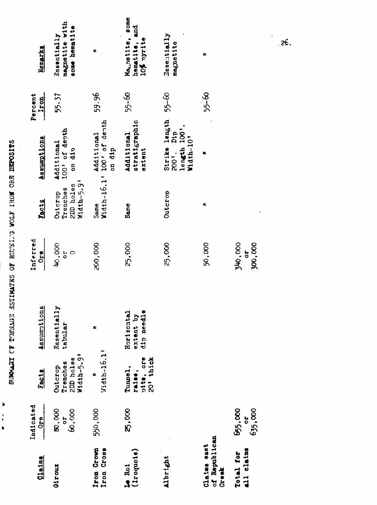
2. For the principal deposits which were examined during the summer of 1943, the estimated total of indicated ore is 655,000 (635,000) tons; of inferred ore, 340,000 (300,000) tons. (See detailed summary on Page 26.)
3. Future prospecting may be expected to find iron ore along less than 38 percent of the contact between the limestone and syenite porphyry.
4. The deposits are of hydrothermal origin and probably should be classed in the hypothermal vein zone, due to the preponderance of magnetite, and their lenticular form. However, the widespread occur rence of chalcedony is indicative of a relatively low temperature of formation.

25.
5. The prevailing mechanism of formation is the replacement of limestone by magnetite from iron-rich hydrothermal «olutions.
6. The structural controls are local fracture systems adjacent and parallel to contacts between igneous intrusive bodies and sedimentary rocks.
7. The tabular, lenticular, steeply-dipping ore bodies are not continuous along particular contacts, but occur discontinuously along these contacts.
8. In most of the deposits the ore is high grade and would probably average close to 60 percent iron.
9. The shape and size of the deposits would necessitate under ground mining methods.
If at some future date, because of changed economic conditions, it becomes adviiable to do additional exploratory work, it is recommended that systematic magnetometer surveys be made on traverses normal to the probable contacts between the igneous and sedimentary rocks, in order to locate possible lenses of ore larger than those already explored.
CT
TOH
HA
G3
3STI
M1T
SS
OF
HlE
IKIl'
O-
WOL
F IR
OI
ORB
EGCP
OSI
TS
Cla
ims
Oir
oux
I*
Hoi
(I
roq
uois
)
Albright
Indi
cate
d Ore
80,000
or
60,000
Iron
Crown
550,000
Iron
Cro
ss
25,000
Clai
ms east
of Rep
ubli
can
Creek
Totm
l for
655,
000
all
claims
or63
5,00
0
Fact
sAssump
tion
s
Outc
rop
Essentially
Tren
ches
tabu
lar
2DD ho
les
Wldth-5.9
1
Uidth-16.1
1
Tunn
el,
Horizontal
raise,
extent
by
?jits, or
e dip
need
le
20
thick
Inferred
Ore
Uo.ooo
or 0
200,000
25,000
25,0
00
50,000
or
300,
000
Facts
Assu
mpti
ons
Outcrop
Addi
tion
al
Trenches
100' of
depth
2DD
holen
on
Width-5.9'
Perc
ent
Iron
55-3
7
Same
Ad
diti
onal
59-96
Vidth-l6.1'
100' of
de~>th
on di
p
Same
Outcrot)
Additional
55-6
0stratigraphic
extent
Stri
ke length
55-60
200'.
Dip
length 100'.
Width-10'
* 55
-60
Rema
rks
Essentially
magnetite
with
so
me h
emat
ite
Magn
etit
e, so
me
hema
tite
, and
nyrite
Essentially
magn
etit
e