hexagon brazil supports cbmerj during the … study hexagon brazil supports cbmerj during the...
TRANSCRIPT

CASE STUDY
Hexagon Brazil supports CBMERJ during the
Olympic Games in Rio de Janeiro
CBMERJ operations for the Olympic Games involved more than 2,500
employees and 76 advanced tactile units, and the Technologies
provided by Hexagon Brazil were essential to optimise the planning of
our resources on the ground. These solutions also helped to allocate
tasks from the planning and to monitor the execution on this huge and
complex project”.
Major Military Firefi ghter Marco Basques, operational command and control general director at CBMERJ

In August and September 2016, the city of Rio de Janeiro,
Brazil, hosted the Games of XXXI Olympiad as well as the
XV Paralympic Games, gathering more than 10.5 thousand
athletes and 1.4 million tourists from all around the world,
making these Olympic Games the biggest event ever
hosted by a Brazilian city.
Different public agencies and civil society worked
together to make this the best Olympic Games ever. As
resources are always limited, investments need to be done
accurately and keeping in mind the goal of leaving a legacy
to the city of Rio. In this scenario, Hexagon Brazil invited
CBMERJ (Military Fire Department of the State of Rio de
Janeiro) to deploy additional solutions to help them face
this challenge.
CBMERJ has been using I/CAD since 2014, relying on this
platform for their daily operations. At the beginning of 2016,
CBMERJ implemented Intergraph Planning & Response
(IPR) for large-scale event management and a situational
awareness and reporting tool called S|Portal, which is a
GeoMedia WebMap and Geospatial Portal customization.
These technologies were deployed in time for the
preparation for their operation during the Olympic Games.
HEXAGON BRAZIL’S INITIATIVES
Hexagon took a step further and extended their already
existing technology platform with some of its latest
technologies in advanced incident analytics and 3D
mapping that can be split in up to four fronts:
• Operational promptness with I/CAD (Intergraph Computer-
Aided Dispatch) as basis for the whole operation;
• Operational planning creation and execution with IPR
(Intergraph Planning & Response);
• Creation of realistic 3D models of the venues;
• Operation monitoring and surveillance with Incident
Analyzer.
OPERATIONAL PROMPTNESS WITH I/CAD – INTERGRAPH
COMPUTER-AIDED DISPATCH
The starting point for Hexagon to support CBMERJ is on
the call and dispatch control and monitoring. CBMERJ’s
coverage take the entire State of Rio de Janeiro and a great
amount of its crew is dedicated to the operations in the
capital city, with more than 7,000 daily calls taken by 54
positions in its operation center.
All events registered using I/CAD and the calls history
are stored and available for a prompt service using a few
clicks, including activities to support decision making
related to type of vehicle to certain incidents and which
ones are closer to the event:
I/CAD brings agility to respond to events by allocating the
available resources closer to the event and by remote
monitoring of this call.
OPERATIONAL PLANNING CREATION AND EXECUTION
WITH IPR - INTERGRAPH PLANNING & RESPONSE
Faced to the complexity of an event like the Olympic
Games, planning is mandatory. It aims not only to assist
ordinary operation, but also to plan the answer to urgent
and unexpected events from many different types. IPR is
responsible for that.
The entire event schedule was programmed using IPR, from
the arrival of delegations in Rio to a specifi c organizational
chart for the event, followed by a dedicated timeline for
battalions that would be responsible for specifi c venues
and type of vehicle to be used as well as how, where
and when. Different types of vehicles and offi cials were
specially allocated to perform strategic monitoring and
surveillance tasks:
CBMERJ combines Hexagon’s solutions for its
operation during the Olympic Games

The possibility to have control of the entire organizational
chart of operations in IPR enabled CBMERJ to have
immediate access to information like name, phone
number, radio alias about the people on the fi eld, other
centers, other fellow institutions, immediately, as needed:
The timeline functionality from IPR also helped to estimate
the demand for work shifts accordingly to the several
events and competitions during the Olympic Games. This
way, CBMERJ knew in advance, where and when they
would need work shifts and how to arrange it accordingly.
CREATION OF REALISTIC 3D MODEL OF THE VENUES
Another great benefi t Hexagon provided to CBMERJ was a
detailed 3D map of the Olympic Venues. Under the overall
coordination of Hexagon Brazil, Leica Geosystems Brazil
used its Pegasus:Two Mobile Sensor to survey selected
streets surrounding the Maracanã Stadium, Sambadrome,
cycling event courses and others. In the end of 2015, Leica’s
professionals also surveyed the interior of key buildings
like the Arenas Cariocas using a P40 ScanStation.
In the beginning of 2016, Leica Geosystems collaborated
with a local surveying company called ESTEIO, which
already uses Leica’s technologies such as ALS50-II MPiA
LiDAR systems and an ADS40/52 digital sensor, to help
surveying the Olympic Village and Olympic Park with the
new Leica’s RCD30 Oblique Camera.
This huge amount of data, point clouds and oblique
imagery were then processed by multiple teams from
Hexagon companies, including Hexagon Geospatial, North
West Group and myVR Software, and by long-term partner,
called Skyline Software Systems, which is powering
Hexagon Geospatial’s GeoMedia 3D Add-On since 2012.
Besides helping to process this data, Skyline delivered a high
detailed 3D mesh created after the RCD30 Oblique Camera
data collection and published the 3DML fi le to the Web.
This model would help for monitoring, surveillance and
response planning activities, and many 3D analysis tools
were provided, with the possibility to run horizontal and
vertical measurements, lines of sight and threat domes.
This way, TerraExplorer and GeoMedia 3D would enable
much more than just a 3D visualization. Using these
technologies, CBMERJ would be ready to run analyses to
check, for example, if a given vehicle would be able to reach
a certain place based on the gate’s height. In a similar
way, while in the 2D map this truck is represented by a
simple point icon, using this 3D model an actual model of
this vehicle can be loaded and then scaled and rotated to
ensure if it is in the best location possible given parking
constrains like driving maneuvers.
The image below shows how this 3D mapping capabilities
helped to reconstruct an event responded during the
Olympic Games, where a crew had to split and walk to a
nearby simultaneous fi re incident after dispatched to
respond to a fi rst incident involving an unroofed area hit
by strong wind.
Address: Av. Brigadeiro Faria Lima, 4300, 5th fl oor, cep 04538 132, São Paulo, SP E-mail: [email protected]
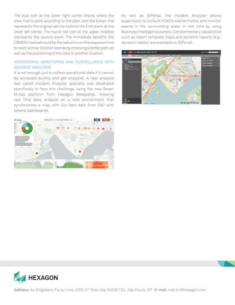
The blue icon at the lower right corner shows where the
crew had to park according to the plan, and the brown line
represents the original vehicle route to the fi rst event at the
lower left corner. The round red icon at the upper middles
represents the second event. The immediate benefi ts the
CBMERJ noticed could be the reduction on the response time
to reach similar location scenes by choosing a better path, as
well as the positioning of the crew in another location.
OPERATIONAL MONITORING AND SURVEILLANCE WITH
INCIDENT ANALYSER
It is not enough just to collect operational data if it cannot
be accessed quickly and get analyzed. A new analysis
tool called Incident Analyzer specially was developed
specifi cally to face this challenge, using the new Smart
M.App platform from Hexagon Geospatial. Allowing
real time data analysis on a web environment that
synchronizes a map with live feed data from CAD with
several dashboards.
As well as S|Portal, the Incident Analyzer allows
supervisors to consult I/CAD’s events history and monitor
events in the surrounding areas in real time by using
Business Intelligence panels. Complementary capabilities
such as report template maps and dynamic reports (e.g.:
dynamic tables) are available on S|Portal.