hereford relief road study of options environmental
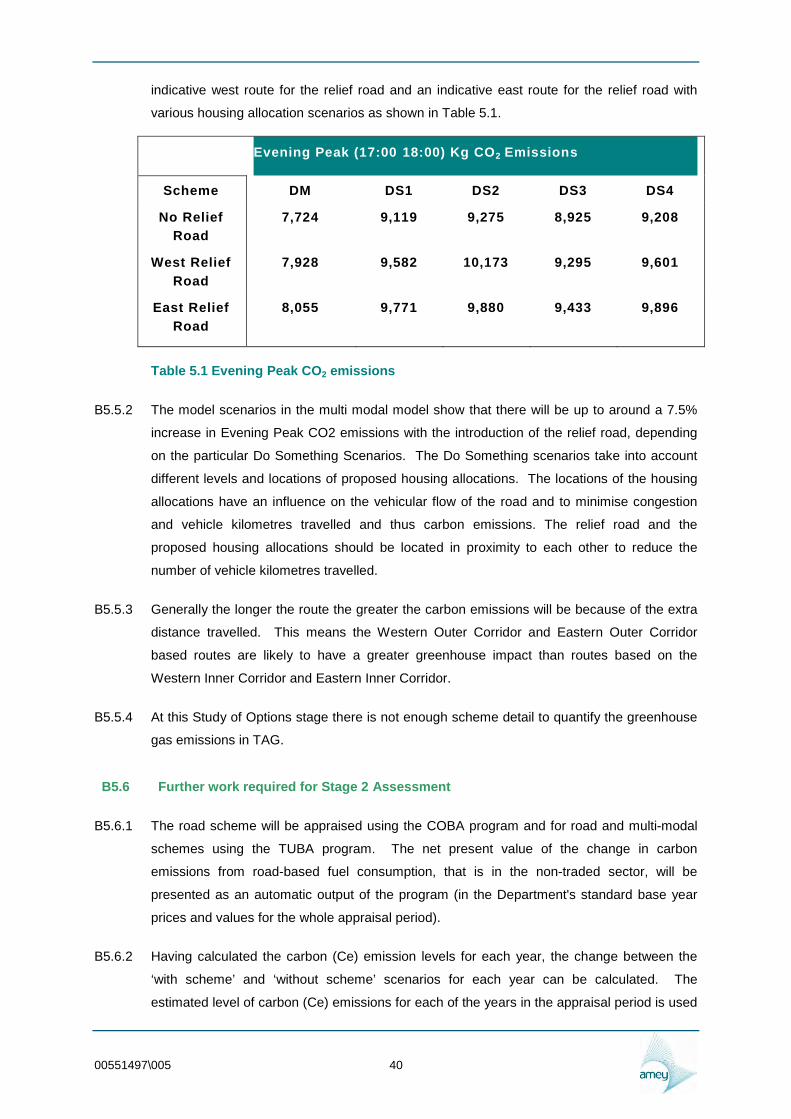
TRANSCRIPT

Study of Options Environmental Assessment Report Hereford Relief Road 005 August 2010
Job No 00551497 Study of Options Environmental
Assessment Report
Hereford Relief Road
Report No 005
Revision No 01
Date of issue August 2010
Amey Herefordshire Council
Caburn House Franklin House
Brooks Road 4 Commercial Road
Lewes Hereford
East Sussex Herefordshire
BN7 2BY HR1 2BB
00551497005 i
Document Control Sheet
Project Name Hereford Relief Road
Project Number 00551497
Document Report Title
Study of Options Environmental Assessment Report
Document Report Number
005
Issue StatusAmendment Prepared Reviewed Approved
Issue 0 Name Adam Glass Name Gavin Sams Name Gavin Sams
Signature A Glass Signature G Sams Signature G Sams
Date 09072010 Date 09072010 Date 09072010
Issue 1 Locations of Name Adam Glass Name Gavin Sams Name Gavin Sams Badger Setts removed
Signature A Glass
Date 13082010
Signature G Sams
Date 16082010
Signature G Sams
Date 16082010
(Enter Details of Name Name Name Amendment)
(print)
Signature
Date
(print)
Signature
Date
(print)
Signature
Date
(Enter Details of Name Name Name Amendment)
(print)
Signature
Date
(print)
Signature
Date
(print)
Signature
Date
00551497005 ii
List of Contents Page
Chapters and Appendices
B1 Introduction 1
B11 PURPOSE OF STUDY 1
B12 BACKGROUND AND STUDY CONTEXT 1
B13 STUDY METHODOLOGY 3
B14 TRANSPORT IMPROVEMENTS 3
B15 SCHEME OBJECTIVES 4
B16 CURRENT PROBLEM IDENTIFICATION 4
B17 HIGHWAY INFRASTRUCTURE DEVELOPMENT 5
B18 SOURCES OF OPTIONS 6
B2 Methodology 10
B22 APPRAISAL PURPOSE AND STRUCTURE 11
B23 PURPOSE OF THE STUDY OF OPTIONS ENVIRONMENTAL
ASSESSMENT REPORT 12
B24 DESIGN MANUAL FOR ROADS AND BRIDGES ENVIRONMENTAL
ASSESSMENT 13
B25 TAG APPRAISAL ENVIRONMENT OBJECTIVE 17
B26 TAG APPRAISAL ENVIRONMENT SUB-OBJECTIVES 17
B27 CONSULTATIONS 17
B3 The Noise Sub-Objective 19
B31 INTRODUCTION 19
B32 METHODOLOGY 19
B33 SCREENING 19
B34 SCOPING 20
B35 BASELINE CONDITIONS 21
B36 CONSULTATION AND CONSTRAINTS 21
B37 SENSITIVE RECEPTORS 23
B38 NOISE IMPACTS 24
B39 NOISE AND VIBRATION EFFECTS DURING CONSTRUCTION 25
00551497005 iii
B310 MITIGATION 25
B311 FURTHER WORK 25
B312 CONCLUSIONS 26
B4 The Air Quality Sub-Objective 27
B41 INTRODUCTION 27
B42 METHODOLOGY 27
B43 PROPERTY COUNTS SENSITIVE RECEPTORS AND DESIGNATED
SITES 28
B44 CONSULTATION WITH HEREFORDSHIRE COUNCIL 28
B45 AIR QUALITY POLICES AND PLANS 28
B46 BASELINE AIR QUALITY MONITORING 31
B47 BRIEF FOR FURTHER MONITORING 33
B48 CALCULATION OF LEVELS OF POLLUTION 33
B49 AIR QUALITY EFFECTS DURING CONSTRUCTION 33
B410 IMPACT ON HEREFORD AIR QUALITY MANAGEMENT AREA 34
B411 FURTHER WORK 34
B412 REGIONAL IMPACT ASSESSMENT 35
B413 MITIGATION 36
B414 CONCLUSIONS AND RECOMMENDATIONS 36
B5 The Greenhouse Gases Sub-Objective 37
B51 INTRODUCTION 37
B52 Study Area 37
B53 Proposed Level and Scope of Assessment 37
B54 REGULATORYPOLICY FRAMEWORK 38
B55 GREENHOUSE GAS ASSESSMENT 39
B56 Further work required for Stage 2 Assessment 40
B57 MITIGATION 41
B6 The Landscape Sub-Objective 42
B61 INTRODUCTION 42
B62 METHODOLOGY 42
00551497005 iv
B63 LANDSCAPE CHARACTER 43
B64 LANDSCAPE QUALITY SENSITIVITY AND VALUE 46
B65 THE ROUTE CORRIDORS 49
B66 LANDSCAPE AND VISUAL EFFECTS 51
B7 The Townscape Sub-Objective 69
B71 INTRODUCTION 69
B72 METHODOLOGY 69
B73 TOWNSCAPE CHARACTER 69
B74 TOWNSCAPE QUALITY SENSITIVITY AND VALUE 70
B75 TOWNSCAPE EFFECTS 71
B8 The Heritage of Historic Resources Sub-Objective 72
B81 INTRODUCTION 72
B82 NATIONAL LEGISLATION AND GUIDANCE 74
B83 LOCAL PLANNING POLICY 75
B84 GENERAL METHODOLOGY 77
Importance of the Assets 78
B85 BASELINE DATA 86
B86 STAGE 2 DMRB ASSESSMENT 104
B87 FURTHER WORK REQUIRED FOR STAGE 2 ASSESSMENT 106
B9 The Biodiversity Sub-Objective 107
B91 INTRODUCTION 107
B92 LEGISLATIVE BACKGROUND 107
B93 DESK STUDY 111
B94 CONSULTATION 113
B95 BASELINE CONDITIONS 114
B96 POTENTIAL IMPACTS 117
B97 MITIGATION MEASURES 126
B98 Further work for full Stage 2 Assessment 126
B99 GEODIVERSITY 127
00551497005 v
B10 The Water Environment Sub-Objective 129
B101 INTRODUCTION 129
B102 LEGISLATIVE BACKGROUND 129
B103 METHODOLOGY 130
B104 THE STUDY AREA 131
B105 BASELINE CONDITIONS 131
B106 CONSULTATION 140
B107 POTENTIAL IMPACTS 140
B108 MITIGATION MEASURES 146
B109 ASSESSMENT METHODOLOGY 148
B1010 SUMMARY 150
B11 The Physical Fitness Sub-Objective 152
B111 INTRODUCTION 152
B112 METHODOLOGY 152
B113 RELEVANT POLICY 153
B114 IMPACT ASSESSMENT 154
B115 FURTHER WORK REQUIRED FOR STAGE 2 ASSESSMENT 163
B12 The Journey Ambience Sub-Objective 164
B121 INTRODUCTION 164
B122 METHODOLOGY 164
B123 ASSESSMENT OF IMPACTS 166
B124 CUMULATIVE EFFECTS 170
B125 RECOMMENDATIONS 171
B126 CONCLUSIONS 171
B13 Summary and Recommendations 172
B131 KEY ENVIRONMENTAL ISSUES 172
B132 ROUTES TO ASSESS AT STAGE 2 173
B133 CUMULATIVE EFFECTS 173
B134 MITIGATION 174
B135 SIGNIFICANCE OF ENVIRONMENTAL EFFECTS 174
00551497005 vi
B136 FURTHER WORK FOR STAGE 2 ASSESSMENT 174
00551497005 vii
B1 Introduction
B11 PURPOSE OF STUDY
B111 There are advantages and disadvantages of the broadly defined transport infrastructure
improvements identified in the public participation and modelling exercises undertaken by
Herefordshire Council to date A number of broad corridors have been identified for
consideration of a relief road
B112 The purpose of this study is to Identify environmental and engineering advantages and
disadvantages associated specifically with the introduction of a Relief Road to Hereford
along these corridors
B12 BACKGROUND AND STUDY CONTEXT
B121 Herefordshire covers a predominantly rural area of 842 square miles Hereford is the main
service centre and largest urban area with a population of 54850 The A49 strategic
highway passes through the City from north to south and crosses the River Wye at
Greyfriars Bridge close to the historic City Centre The pattern of main roads in the County is
focussed on Hereford itself and peak hour congestion is frequently experienced on the Cityrsquos
highway network and river crossing
B122 Hereford is identified as a lsquoSettlement of Significant Developmentrsquo in the West Midlands
Regional Spatial Strategy (WMRSS) with an allocation of 8500 houses for the period 2006
to 2026 This allocation is supported by Herefordshire Council however adequate
infrastructure must be provided to support it as this level of growth represents an increase in
size of over 30 for the City
B123 Herefordshire Councilrsquos Development Plan is currently the Unitary Development Plan (UDP)
with a plan period to 2011 The Council is now preparing the Local Development Framework
(LDF) Core Strategy to cover the same plan period as the WMRSS ie 2006 to 2026
B124 The Core Strategy has been the subject of three formal rounds of public participation an
ldquoIssues Paperrdquo in 2007 and the ldquoDeveloping Optionsrdquo Paper in 2008 indicated broad public
support for transport infrastructure improvements a ldquoPlace Shaping Paperrdquo consultation was
completed in March 2010 to establish the preferred options for the Core Strategy
B125 To inform the Core Strategy the Hereford Multi Modal Study has been completed to assess
the broadly defined transport and development strategies and identifying the need for a relief
road However consideration of a relief road to the east or west of Hereford has a long
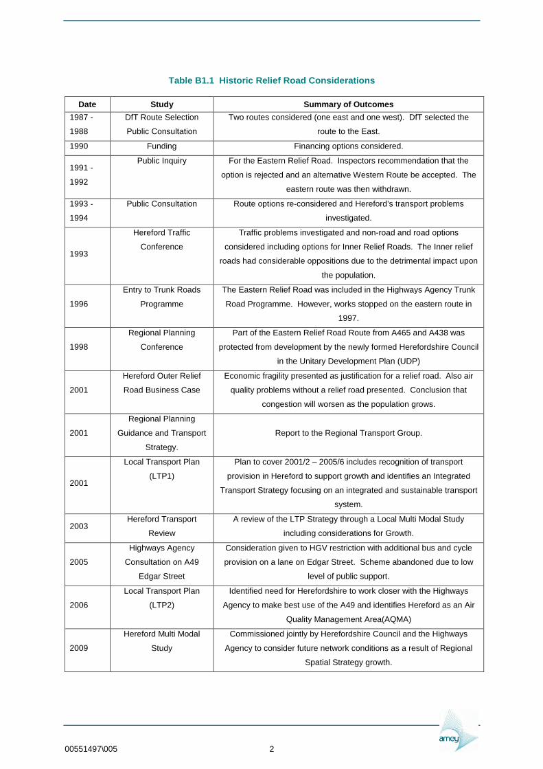
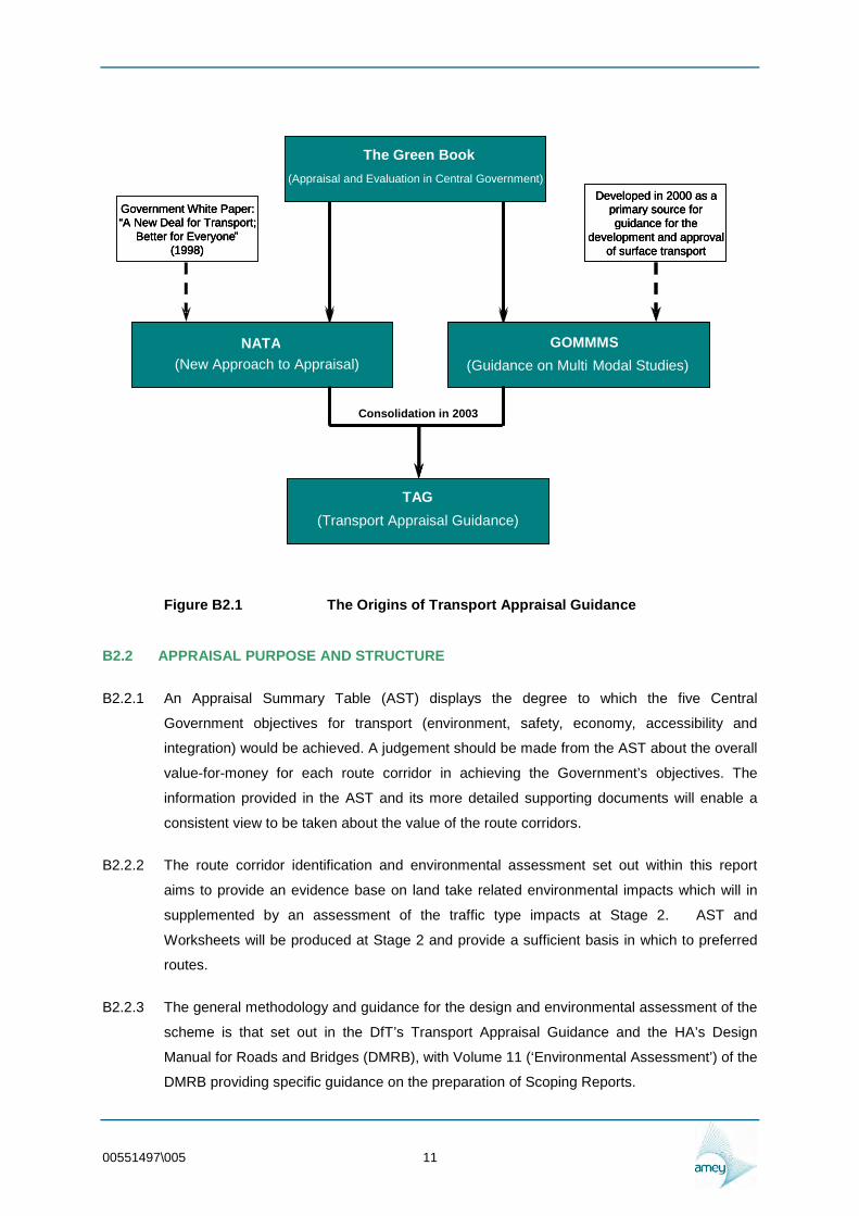
history presented on Table B11
00551497005 1
Table B11 Historic Relief Road Considerations
Date Study Summary of Outcomes
1987 shy
1988
DfT Route Selection
Public Consultation
Two routes considered (one east and one west) DfT selected the
route to the East
1990 Funding Financing options considered
1991 shy
1992
Public Inquiry For the Eastern Relief Road Inspectors recommendation that the
option is rejected and an alternative Western Route be accepted The
eastern route was then withdrawn
1993 shy
1994
Public Consultation Route options re-considered and Herefordrsquos transport problems
investigated
1993
Hereford Traffic
Conference
Traffic problems investigated and non-road and road options
considered including options for Inner Relief Roads The Inner relief
roads had considerable oppositions due to the detrimental impact upon
the population
1996
Entry to Trunk Roads
Programme
The Eastern Relief Road was included in the Highways Agency Trunk
Road Programme However works stopped on the eastern route in
1997
1998
Regional Planning
Conference
Part of the Eastern Relief Road Route from A465 and A438 was
protected from development by the newly formed Herefordshire Council
in the Unitary Development Plan (UDP)
2001
Hereford Outer Relief
Road Business Case
Economic fragility presented as justification for a relief road Also air
quality problems without a relief road presented Conclusion that
congestion will worsen as the population grows
2001
Regional Planning
Guidance and Transport
Strategy
Report to the Regional Transport Group
2001
Local Transport Plan
(LTP1)
Plan to cover 20012 ndash 20056 includes recognition of transport
provision in Hereford to support growth and identifies an Integrated
Transport Strategy focusing on an integrated and sustainable transport
system
2003 Hereford Transport
Review
A review of the LTP Strategy through a Local Multi Modal Study
including considerations for Growth
2005
Highways Agency
Consultation on A49
Edgar Street
Consideration given to HGV restriction with additional bus and cycle
provision on a lane on Edgar Street Scheme abandoned due to low
level of public support
2006
Local Transport Plan
(LTP2)
Identified need for Herefordshire to work closer with the Highways
Agency to make best use of the A49 and identifies Hereford as an Air
Quality Management Area(AQMA)
2009
Hereford Multi Modal
Study
Commissioned jointly by Herefordshire Council and the Highways
Agency to consider future network conditions as a result of Regional
Spatial Strategy growth
00551497005 2
B13 STUDY METHODOLOGY
B131 It is assumed that the ultimate purpose of the study process is to take the scheme towards
having a fully assessed preferred route with a supporting Major Scheme Business Case All
studies therefore need to be carried out to follow the Department for Transport (DfT)
Transport Analysis Guidance (WebTAG)
B132 WebTAG provides guidance on conducting transport studies and on how to
o set objectives and identify problems
o develop potential solutions
o create a transport model for the appraisal of the alternative solutions
o conduct an appraisal which meets the Departmentrsquos requirements
B133 The overall study delivery stages in chronological order are
o Stage 0 ndash Preliminary Investigatory Works (Complete ndash Historic Studies Issue Paper
and Developing Options Paper)
o Stage 1 ndash Identify environmental engineering economic and traffic advantages and
disadvantages associated with broadly defined strategies (Complete ndash Multi Modal Study
and Stage 1 Engineering and Environmental Assessments (Complete)
o Study of Options for the Hereford Relief Road (This Study) ndash Identify engineering
and environmental advantages and disadvantages of proposed route corridors to inform
the planning strategy (This Study)
o Stage 2 ndash Further inform a decision on preferred route selection through additional
environmental engineering and traffic and economic assessment (Future Study)
o Stage 3 ndash Clearly identify advantages and disadvantage in environmental engineering
economic and traffic terms of the preferred route or scheme including a full
environmental statement (Future Study)
o Major Scheme Business Case ndash Presentation to the Government or funding body
encapsulating the evidence of the previous stages
B14 TRANSPORT IMPROVEMENTS
B141 A transport hub is planned as part of a regeneration project at Hereford Railway Station
providing a more integrated transport service facility for rail and bus passengers pedestrians
and cyclists taxis and car parking An option has been set out in the Core Strategy as a
preferred proposal providing a sustainable transport link facility to the city centre and the
surrounding urban area
B142 Consultation on the existing transport constraints for Hereford has also been undertaken via
the lsquoDeveloping Optionsrsquo consultation with a view to support the production of
00551497005 3
both the Hereford Transport Plan 3 (2011-2026) and the Hereford Area Plan Whilst the need
for a second river crossing at the River Wye has been established through various studies
including the Hereford Multi-Modal Model Forecasting Report (MMM) to relieve the traffic
congestion at Hereford Various options upon which the proposed linkage and other
associated sustainable transport solutions will impact on transport usage and demand have
also been identified These options primarily focus on a range of initiatives to increase
investment for the promotion of alternatives to car use including improved facilities for
pedestrian access and an improved and extended cycle network The introduction of
permanent Park and Ride sites and proposals for Bus Priority measures have all been
identified as features of demand management measures which seeks to initiate a significant
modal shift within the urban landscape
B143 The Hereford Relief Road has been identified as a key strategic transport proposal to both
relieve the city of its current congestion levels and to ensure the proposed housing growth
can be accommodated
B15 SCHEME OBJECTIVES
B151 Hereford City serves as the main centre for an extensive rural area providing access to
employment retailing health and leisure facilities It also plays an important role in the
context of the wider West Midlands Region as it has been identified as one of five subshy
regional areas for longer-term development meaning that it will accommodate the majority of
the future housing and employment development within the County
B152 To facilitate this proposed spatial development and the associated pressures exerted on
existing land use and transport facilities this document will help to establish the
Herefordshire Councilrsquos Local Development Framework Core Strategy whilst aiming to reflect
national and local priorities including the five key national transport goals
bull Support economic growth
bull Reduce carbon emissions
bull Promote equality of opportunity
bull Contribute to better safety security and health
bull Improve quality of life and a healthy natural environment
B16 CURRENT PROBLEM IDENTIFICATION
B161 Hereford Cityrsquos transport problems are largely urban in nature These are principally
congestion poor air quality and severance caused by traffic resulting in poor access and
safety issues for vulnerable road users These are to some extent compounded
00551497005 4
by the high levels of car dependence in the surrounding rural areas due to the high spatial
concentration and self-containment of employment 70 of residents travel less than 5km to
work The problems identified through the Hereford Transport Review can be summarised as
follows
bull Congestion particularly affecting roads around the city centre
bull Poor access to industrial areas which constrain economic development
bull Intrusion of traffic into residential areas
bull Need for improved road safety for vulnerable road users
bull Poor pedestrian facilities in parts of the city centre
bull Lack of facilities for cyclists and
bull Too many journeys to school by car
B162 Hereford Transport Strategy retains significant traffic overloading in the city centre
specifically on the A49(Trunk) Greyfriars Bridge and on the A438 inner relief road of
Blueschool Street Newmarket Street This overload would become increasingly difficult to
accommodate and would reduce public acceptability of sustainable measures which would
further reduce capacity such as bus priority pedestrianisation and on road cycle provision
B17 HIGHWAY INFRASTRUCTURE DEVELOPMENT
B171 The delivery of the Rotherwas Access Road provided a key component of the overall
strategy to tackle congestion and enable the economic development of the County in line
with regional and local policy The development of an extended highway infrastructure is one
of Herefordrsquos strategic transport policies with the aim of reducing the cityrsquos congestion
problems and to provide the necessary highway infrastructure to cater for the proposed
regional lsquoGrowth Pointrsquo
B172 The proposed relief road serves to strengthen this strategy where the development of route
corridors provide a key component of Herefordrsquos longer-term transport strategy for the
County and will help the City meet its role as a sub-regional centre In pursuing this
objective Herefordshire Council have identified the need to further assess identified strategic
route corridors to ensure a full assessment of its longer-term potential is established The
appraisal of these route corridors will include full consideration of potential environmental
and engineering impacts of each route Their impacts will largely be measured against a set
of shared regional priorities with predominant outcomes such as
00551497005 5
bull Reducing congestion
bull Better access to jobs and services
bull Opportunities to increase use of sustainable modes of transport
bull Improving safety for all road and non-road users
bull Support and enable economic development including proposed housing growth
bull Safeguarding the environment by improving air quality
B173 Herefordshire Council have confirmed that the final preferred route once constructed may
be adopted by the Highways Agency and form part of the existing A49 Trunk Road In light of
this it is essential that both the proposed engineering design standards and the
environmental assessment methodology are fully complied with to ensure health and safety
is not compromised and that the preferred corridor results in a good value for money
proposal
B18 SOURCES OF OPTIONS
B181 Wide and broadly defined route corridors were set at the beginning of the Stage 1
Assessment to reflect the work undertaken to date on the Hereford Multi Modal Study As
recommended by the study brief both East and West corridors were considered To ensure
that the Stage 1 2 and 3 scheme assessment process identifies the optimum route corridor
and then alignment a wide study area was set for the Stage 1 assessment Therefore East
and West and inner and outer options were considered The inner options were corridors as
close as is reasonable to the existing developed city limits The outer options were corridors
further away from the existing city but limited by what is considered to be economically
sensible A corridor too far outside of the city would not provide a short enough route to
attract traffic use from through traffic or local trips
B182 Historically a number of options for a relief road around Hereford have been considered
These options and the outcomes of assessments have been considered during this
assessment However care was taken to ensure that the assessment took an independent
view of options to meet the scheme objectives without being distracted by what has gone
before
B183 The Stage 1 routes E1 E2 E3 and E4 on the east of the city and W1 W2 W3 and W4 to
the west were assessed creating the broad corridors for assessment Note these were not
designed alignments but the lines shown were for the purposes of defining broad corridors
only Also many sections assessed are common to several routes for example E3 was an
extended version of E2 As such in the detailed assessments there was a certain amount of
repetition with each route being assessed independently
00551497005 6
B184 At the end of the Stage 1 Assessment the routes and corridors were redefined as shown on
Figure B11 To avoid the repetition in this assessment the links are described and
assessed individually
00551497005 7
Figure B11 Routes and Corridors Assessed in the Study into Options
00551497005 8
00551497005 9
B2 Methodology
B211 The purpose of the study is to take the scheme towards having a preferred and fully
assessed route to support a Major Scheme Business Case and as such it is important that
all studies including this particular assessment leading to the selection of a preferred
option will result in a scheme delivered in accordance with the Department for Transportrsquos
Transport Appraisal Guidance (TAG) or WebTAG The origins of WebTAG can be traced
back to ldquoThe Green Book Appraisal and Evaluation in Central Governmentrdquo The Green
Book places appraisal in the context of policy development discussing the whole process
B212 The lsquoGreen Bookrsquo aims to make the appraisal process throughout Government more
consistent and transparent ensuring that no course of action is adopted without a full
assessment based on a coherent set of objectives and sub-objectives Although the lsquoGreen
Bookrsquo is used as an appraisal process throughout Government transport appraisal is always
likely to be complex with interactions at many levels with other policy areas The
Government produced a White Paper ldquoA New Deal for Transport Better for Everyonerdquo
(DETR 1998) which set in place the policy context for dealing with transport and highlights
the complexity of transport problems and the interaction with other policy areas
B213 The White Paper frames the move away from lsquopredict and providersquo solutions to transport
problems and puts at its core an integrated transport policy Appraisal of problems is key to
the efficient delivery of this policy The decisions made as part of the delivery need to be
based on a full range of options and a comprehensive analysis of the impacts using a
consistent approach To this end the White Paper introduces the New Approach to
Appraisal (NATA) to appraise and inform the prioritisation of transport investment proposals
B214 Two years after NATArsquos original launch in 1998 Guidance on the Methodology for Multi-
Modal Studies (GOMMMS) was produced as a primary source of guidance for the
development and approval of surface transport
B215 The aim of Multi-Modal Studies (MMS) is to investigate problems on or with all modes of
transport and to seek solutions to those problems The output from the Hereford MMS
provides a number of different options aimed at addressing the problems within the study
area The results of the Hereford MMS have been and will be used by the Herefordshire
Council in developing and reviewing the Local Transport Strategies for Hereford which
includes the provision for a relief road
B216 In 2003 the advice originally set out in GOMMMS NATA and their key supporting documents
was fully incorporated into the Transport Analysis Guidance website ndash WebTAG
00551497005 10
The Green Book(Appraisal and Evaluation in Central Government)
NATA GOMMMS(Guidance on Multi
TAG
The Green Book(Appraisal and Evaluation in Central Government)
NATA GOMMMSNATA GOMMMS
TAG
--
Developed in 2000 as aprimary source forguidance for the
development and approvalof surface transport
The Green Book
(Appraisal and Evaluation in Central Government)
-
NATA (New Approach to Appraisal) -
GOMMMS
TAG
Developed in 2000 as aprimary source forguidance for the
development and approvalof surface transport
Developed in 2000 as a primary source for guidance for the
development and approval of surface transport
(Guidance on Multi Modal Studies)
(Transport Appraisal Guidance)
GGGooovvveeerrrnnnmmmeeennnttt WWWhhhiiittteee PPPaaapppeeerrr ldquoldquoldquoAAA NNNeeewww DDDeeeaaalll fffooorrr TTTrrraaannnssspppooorrrttt
BBBeeetttttteeerrr fffooorrr EEEvvveeerrryyyooonnneeerdquordquordquo (((111999999888)))
Consolidation in 2003
Figure B21 The Origins of Transport Appraisal Guidance
B22 APPRAISAL PURPOSE AND STRUCTURE
B221 An Appraisal Summary Table (AST) displays the degree to which the five Central
Government objectives for transport (environment safety economy accessibility and
integration) would be achieved A judgement should be made from the AST about the overall
value-for-money for each route corridor in achieving the Governmentrsquos objectives The
information provided in the AST and its more detailed supporting documents will enable a
consistent view to be taken about the value of the route corridors
B222 The route corridor identification and environmental assessment set out within this report
aims to provide an evidence base on land take related environmental impacts which will in
supplemented by an assessment of the traffic type impacts at Stage 2 AST and
Worksheets will be produced at Stage 2 and provide a sufficient basis in which to preferred
routes
B223 The general methodology and guidance for the design and environmental assessment of the
scheme is that set out in the DfTrsquos Transport Appraisal Guidance and the HArsquos Design
Manual for Roads and Bridges (DMRB) with Volume 11 (lsquoEnvironmental Assessmentrsquo) of the
DMRB providing specific guidance on the preparation of Scoping Reports
00551497005 11
B23 PURPOSE OF THE STUDY OF OPTIONS ENVIRONMENTAL ASSESSMENT REPORT
B231 The purpose of this report is therefore to provide the appropriate level of environmental
assessment for the scheme which at the Study of Options stage is sufficient assessment to
identify the land take related impacts related to the proposed links
B232 Stage 2 is sufficient assessment to identify the factors and effects to be taken into account
in choosing the route options and to identify the environmental advantages disadvantages
and constraints associated with those routes This report identifies the significant
environmental constraints with the route corridor and alignment options identified during a
desk-based study allowing a comparison of the proposed route corridor options and the
evaluation of alignments The assessment at Stage 2 includes Scoping of route changes
and Simple or Detailed Assessment as required following selection of preferred routes and
route alignment changes
B233 The aim of the Stage 2 Scheme Assessment Report is to safeguard a route for the LDF
This requires submission of the report in time to meet the LDF consultation timeframe It
was evident that the traffic modelling work would not be available in time to meet the
constraint of the LDF consultation It was therefore decided that a Study of Options report
would be produced to provide the evidence base for land take related impacts for the
safeguarding of a route corridor for the LDF The Stage 2 report would then be completed
when the traffic modelling was available Production of LTP3 projects in the summer will
also allow elements of sustainable transport projects to be incorporated into the design of the
proposed relief road For the Study of Options report not all the chapters are complete as
generally only land take type impacts are known but will be revised with the traffic type
impacts when the final Stage 2 Report is produced
Table B21 Broad Categories of Environmental Impact
Environmental Objective Land take Type Impact Traffic Type Impact
Noise -
Local Air Quality -
Greenhouse Gases -
Landscape
Townscape
Biodiversity
Heritage
Water Environment
Physical Fitness -
Journey Ambience -
00551497005 12
B24 DESIGN MANUAL FOR ROADS AND BRIDGES ENVIRONMENTAL ASSESSMENT
B241 The ldquoDesign Manual for Roads and Bridgesrdquo (DMRB) was introduced in 1992 in England and
Wales and subsequently in Scotland and Northern Ireland and is updated by the Highways
Agency It provides a comprehensive manual system which accommodates within a set of
loose-leaf volumes current Standards Advice Notes and other published documents relating
to all works associated with Trunk Roads including assessment design construction
operation maintenance and demolition gathered together in a consistent series of volumes
within the DMRB to help in meeting the requirements of quality assurance procedures To
this effect the DMRB shall be used as the basis for the environmental assessment for the
Hereford Relief Road
B242 The appraisal against the webTAG environmental objectives is informed by environmental
assessment methodology in DMRB Volume 11 DMRB Volume 11 specifies a three-stage
approach to the selection of route options as follows
bull Stage 1 ndash Sufficient assessment to identify the environmental advantages
disadvantages and constraints associated with broadly defined route corridors
bull Stage 2 ndash sufficient assessment to identify the factors and effects to be taken into
account in choosing the route options and to identify the environmental advantages
disadvantages and constraints associated with those routes
bull Stage 3 ndash Detailed assessment on the environmental effects of the selected route
option
00551497005 13
Figure B2-2 The design and environmental assessment process
B243 For environmental assessment this overall approach has been modified with the publication
of HA20108 The three levels are lsquoScopingrsquo lsquoSimplersquo and lsquoDetailedrsquo The level of
environmental assessment at each stage of the project is determined according to what is
appropriate and necessary in order to establish the likely level of environmental effects which
may inform a project decision and that this level of assessment may vary between topics
Volume 11 now uses the terms Simple and Detailed assessments each of which can take
place at various stages of the project For example if it is established at an early Stage that
a given project will have no effects in terms of ecology it may not be necessary to carry out
further more detailed assessment as the project proceeds or conversely if it is evident from
the outset that significant effects in terms of water quality are likely to occur then a Detailed
Assessment may be appropriate at Stage 2 of the design process At Stage 2 of
assessment Scoping consists of identification of the baseline conditions within the study
area then each corridor is assessed in turn and preferred corridors should emerge based
on environmental and other considerations The Scoping exercise at the start of Stage 2
identifies further assessment to be conducted This can either be Simple or Detailed
dependent on the predicted significance of environmental effects
B244 The scheme design is currently at the Study of Options stage which is the assessment of
route options At both the Study of Options stage and Stage 2 an important objective of the
environmental assessment is to provide information on likely environmental effects and feed
it back into the scheme design such that adverse effects can (as far as possible) be
designed out in an iterative process
00551497005 14
B245 Environment assessment at Stage 2 identifies the constraints associated with each of the
route corridor options It also identifies potential impacts associated with the corridors and
alignments For the purpose of this Stage 2 assessment the corridors are considered to be
100 m from the outer alignment in a particular route corridor Once detailed alignments have
been chosen a Stage 3 assessment will be conducted on the preferred route alignments
B246 The following sections of Volume 11 are of particular relevance
bull Section 2 Part 4 Scoping of Environmental Impact Assessments (HA 20408) This
guidance sets out the process for determining the appropriate scope for
environmental assessment based on the scale and nature of the project and the
sensitivity of the receiving environment
bull Section 2 Part 6 Reporting of Environmental Impact Assessments (HD 4808) This
guidance is concerned with reporting and contains a section on the methodology for
and presentation of Scoping Reports
B247 Volume 11 (HD4808 Reporting of Environmental Impact Assessments) sets out the
coverage for a Scoping Report and states that for each environmental topic the report
should include coverage of
bull The study area
bull Existing and baseline knowledge
bull Value of environmental resources and receptors
bull Potential effects
bull Proposed level and scope of assessment
bull Proposed methodology including significance
B248 A Scoping Report therefore sets out the above information for each topic in turn For each
topic the appropriate level of further assessment (none Simple or Detailed) is set out
Effects during the construction period (formerly considered in Volume 11 under the heading
of lsquoDisruption Due to Constructionrsquo) are considered individually for each topic
B249 The assessment will focus on the likely significant effects on the environment While it is
necessary to assess all potential effects to some degree in order to determine which of them
may be significant the assessment will identify which of the effects assessed should be
regarded as of enough significance to be taken into account in the decision making process
Each of the following sections therefore sets out the criteria under which the significance of
the effects for that topic has been assessed Where possible this is by reference to published
00551497005 15
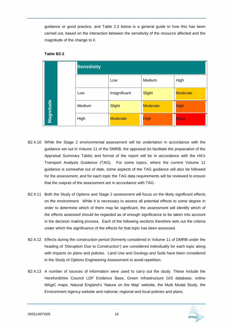
guidance or good practice and Table 22 below is a general guide to how this has been
carried out based on the interaction between the sensitivity of the resource affected and the
magnitude of the change to it
Table B2-2 M
agn
itu
de
Sensitivity
Low Medium High
Low Insignificant Slight Moderate
Medium Slight Moderate High
High Moderate High Major
B2410 While the Stage 2 environmental assessment will be undertaken in accordance with the
guidance set out in Volume 11 of the DMRB the appraisal (to facilitate the preparation of the
Appraisal Summary Table) and format of the report will be in accordance with the HArsquos
Transport Analysis Guidance (TAG) For some topics where the current Volume 11
guidance is somewhat out of date some aspects of the TAG guidance will also be followed
for the assessment and for each topic the TAG data requirements will be reviewed to ensure
that the outputs of the assessment are in accordance with TAG
B2411 Both the Study of Options and Stage 2 assessment will focus on the likely significant effects
on the environment While it is necessary to assess all potential effects to some degree in
order to determine which of them may be significant the assessment will identify which of
the effects assessed should be regarded as of enough significance to be taken into account
in the decision making process Each of the following sections therefore sets out the criteria
under which the significance of the effects for that topic has been assessed
B2412 Effects during the construction period (formerly considered in Volume 11 of DMRB under the
heading of lsquoDisruption Due to Constructionrsquo) are considered individually for each topic along
with impacts on plans and policies Land Use and Geology and Soils have been considered
in the Study of Options Engineering Assessment to avoid repetition
B2413 A number of sources of information were used to carry out the study These include the
Herefordshire Council LDF Evidence Base Green Infrastructure GIS database online
MAgiC maps Natural Englandrsquos lsquoNature on the Maprsquo website the Multi Modal Study the
Environment Agency website and national regional and local policies and plans
00551497005 16
B25 TAG APPRAISAL ENVIRONMENT OBJECTIVE
B251 The Environment Objective 33 aims to protect the built and natural environment This
includes reducing the direct and indirect impacts of transport facilities and their use on the
environment of both users and non-users The environment impacts of concern include
noise atmospheric pollution of differing kinds vibration formal intrusion severance and
impacts on the countryside and wildlife ancient monuments and historic buildings and so on
While some of these can be readily quantified others such as severance are much more
difficult to define and analyse More recently the Environment Objective has been defined
more widely to include reduction of the impact of transport on the global environment
particularly through emission of carbon dioxide but also by consumption of scarce and nonshy
renewable resources
B26 TAG APPRAISAL ENVIRONMENT SUB-OBJECTIVES
B261 The Environment Objective has 10 sub-objectives that reflect the various impacts of concern
bull to reduce noise The Noise Sub-Objective
bull to improve local air quality The Air Quality Sub-Objective
bull to reduce greenhouse gases The Greenhouse Gases Sub-Objective
bull to protect and enhance the landscape The Landscape Sub-Objective
bull to protect and enhance the townscape The Townscape Sub-Objective
bull to protect the heritage of historic resources The Heritage of Historic Resources Sub-
Objective
bull to support biodiversity and geodiversity The Biodiversity Sub-Objective
bull to protect the water environment The Water Environment Sub-Objective
bull to encourage physical fitness The Physical Fitness Sub-Objective
bull to improve journey ambience The Journey Ambience Sub-Objective
B27 CONSULTATIONS
B271 The following will be consulted for information and potential issues associated with the
proposed route corridor options following completion of the Study of Options Environmental
Assessment Report
bull The Environment Agency (EA)
00551497005 17
bull Natural England
bull English Heritage
bull The Herefordshire Biodiversity Recording and Monitoring Centre (BRMC)
bull The National Monuments Record (NMR)
bull The Herefordshire County Council Historic Environment Record (HER)
bull Herefordshire County Councilrsquos Archaeology Team
bull Herefordshire County Councilrsquos Ecology Team
bull Herefordshire County Councilrsquos Landscape Team
bull Herefordshire County Councilrsquos Environmental Health Team
B272 Further consultation during Stage 2 of the scheme design and assessment will take place
based on the Stage 1 reports Study of Options report and Scoping reports for the Stage 2
Assessment Report
B273 Once the Study of Options has been approved by Herefordshire Council it will be circulated
to the statutory environmental bodies (The Environment Agency Natural England and
English Heritage) for information and comment on the proposed scope of assessment ndash The
comments will be incorporated into the final Stage 2 report
00551497005 18
-B3 The Noise Sub Objective
B31 INTRODUCTION
B311 This chapter assesses the potential impacts of the route options on noise and vibration
DMRB HA21308 and TAG unit 332 The Noise Sub-Objective set out the procedure for
assessing impact of noise and vibration from highway schemes
B32 METHODOLOGY
B321 DMRB requires an assessment at Stage 2 which is decided on the result of the Scoping
Assessment HA21308 states that where significant impacts are likely to occur at any
sensitive receptor as a result of the project then it may be appropriate to recommend a
move directly to a Detailed Assessment However caution should be applied to such an
approach as at the scoping stage sufficient data may not always be available to make this
decision Hence guidance should always be sought from the Overseeing Organisation
before making such a recommendation The objective of a Simple Assessment is to
undertake sufficient assessment to identify the noise and vibration impacts associated with
the project Both Simple and Detailed Assessments require traffic data and detailed
alignments that are not available for this Study of Options The Study of Options is
assessing links and corridors in order to develop routes to be assessed at Stage 2
B33 SCREENING
B331 A Screening Assessment has been conducted in order to determine whether the project has
the potential to cause a change to the receiving environment which could result in noise and
vibration impacts The Screening Criteria are
i) Does the project change the line or level of the carriageway
ii) Will the project cause a change in traffic flow
iii) Will the project cause a change in traffic speed
iv) Are there other changes to infrastructure that may cause a change in noise level
B332 If any of these criteria are met a Scoping Assessment will need to be conducted These
criteria are met by the proposed scheme so a Scoping Assessment was conducted
00551497005 19
B34 SCOPING
B341 Study Area
B342 The initial study area for a Scoping assessment as set out in the DMRB is within 2km of a
road scheme to determine whether there are any noise sensitive receptors which could be
subject to an adverse or beneficial change in noise or vibration For a Simple Assessment
the DMRB recommends quantitative assessment of noise changes for each dwelling and
other sensitive receptor (such as community facilities or public rights of way) within 600m of
the centre line of an affected route using CRTN methodology Affected routes are defined as
those existing or new roads where noise levels are predicted to change by more than 1
db(A) as a result of the scheme on opening or where traffic volumes are predicted to
increase by 25 or decrease by 20 A Detailed Assessment is primarily concerned with
the impact at dwellings with the assessment from the simple stage for other sensitive
receptors being updated if necessary If a project has moved directly from scoping to
detailed an assessment of the noise impact at other sensitive receptors will need to be
undertaken This should now be undertaken to the level required for a Simple Assessment
but included in the report for a Detailed Assessment
B343 The Study of Options is assessing links in order to produce routes for assessment Scoping
Assessment of the links only would not conform to DMRB guidance The 2 km noise buffer
would mean that there would invariably be a large amount of double counting of receptors
leading to the erroneous assessment that the route of the proposed scheme would
potentially affect more receptors than there are people in Hereford It was therefore decided
that Scoping would be conducted at Stage 2 when the full routes for assessment are
available and when the traffic modelling is available as this would allow for affected roads to
be scoped
B344 In practice noise effects would tend to be limited to the houses closest to the scheme and
noise changes would not be felt by houses which are further away where they are shielded
by intervening properties in particular in the Hereford urban area It should also be noted
that the outer corridor routes though having a lesser impact on dwellings as there are fewer
would have a greater impact on the tranquillity of the countryside around Hereford as the
proposal would introduce noise into an otherwise quiet and tranquil area The Stage 1
Assessment identified that there would be residential properties schools community
facilities and designated sites within 2 km of the links
B345 Scoping requires the identification of sensitive receptors consultation with the Environmental
Health Officer and identification of the likelihood of significant effects It is appropriate to
assess the noise and vibration impacts of construction at a later date when more detailed
construction methodologies and detailed route alignments are known
00551497005 20
B35 BASELINE CONDITIONS
B351 The study area currently experiences low levels of background noise being dominated by
agricultural land and villages around the outskirts of Hereford
B36 CONSULTATION AND CONSTRAINTS
B361 Herefordshire County Councilrsquos Environmental Health department will be consulted for their
comments and information on constraints in the area relating to noise including sensitive
land uses at Stage 2 The consultation on the Stage 1 assessment stated that they are not
aware of any existing sources of noise or complaints about traffic noise in the area of the
proposed route corridors The reply also considered that there will be numerous noise
sensitive receptors and that a full assessment will need to be carried out prior to
development
Herefordshire Council UDP- Policy DR13 Noise
B362 Development with the potential for generating significant levels of noise or for exposing a
noise sensitive use to an existing noise source will be required to include appropriate
measures within the proposal to mitigate the noise impact to an acceptable level
Development which after taking account of mitigation measures proposed would still have
an unacceptable noise impact or result in unacceptable exposure to noise will not be
permitted Development which would adversely affect the quiet enjoyment or the special
interest of designated areas will not be permitted The quiet enjoyment and tranquillity of the
wider countryside landscape and wildlife areas and historic features will also be considered
The UDP also states that noisy development near a SSSI will need special consideration
DMRB Volume 11 Section 3 HA 21308
B363 HA 21308 provides the procedure for assessing the impact of noise from road schemes
HA21308 states lsquoIn recent years evidence has also been accumulating from surveys before
and after sudden changes in noise exposure It indicates that people are more sensitive to
abrupt changes in traffic noise associated with new road schemes than would be predicted
from the steady state evidence In the period following a change in traffic flow people may
find benefits or disbenefits when the noise changes are as small as 1 dB(A) - equivalent to
an increase in traffic flow of 25 or a decrease in traffic flow of 20 These effects last over
a number of yearsrsquo
Planning Policy Guidance 24 ndash Planning and Noise
B364 PPG 24 gives guidance to local authorities in England on the use of planning powers to
minimise the impact of noise PPG 24 states that a change of 3dB(A) is the minimum
perceptible under normal conditions and a change of 10dB(A) corresponds roughly to the
halving or doubling the loudness of a sound From this it can be considered that the
00551497005 21
perceived benefit or disbenefit arising from a 1dB(A) change is dependent on non-acoustic
factors such as a visible change in traffic flow Paragraph 10 states ldquoMuch of the
development which is necessary for the creation of jobs and the construction and
improvement of essential infrastructure will generate noise The planning system should not
place unjustifiable obstacles in the way of such development Nevertheless local planning
authorities must ensure that development does not cause an unacceptable degree of
disturbance They should also bear in mind that a subsequent intensification or change of
use may result in greater intrusion and they may wish to consider the use of appropriate
conditionsrdquo
World Health Organisation Guidelines
B365 WHO guidelines state ldquogeneral daytime outdoor noise levels of less than LAeq 55dB are
desirable to prevent any significant community annoyancerdquo An aspirational target was also
set for dwellings of LAeq 50dB for day and LAeq 45dB for night
Land Compensation Act 1973
B366 Part I of the Land Compensation Act provides a means by which compensation can be paid
to owners of land or property which has experienced a loss in value caused by the use of
public works such as new or improved roads Noise and vibration are two of the factors
which would be considered in any claims for compensation but the claim must consider all
changes and effects including betterment Claims can be made under Part I of the Act from
1 to 7 years after the opening of a road project However consideration of the likely extent
of claims may be made during detailed design following the completion of statutory
processes
The Noise Insulation Regulations 1975 (as amended 1988)
B367 The Noise Insulation Regulations were made under Part II of the Land Compensation Act
1973 Regulation 3 imposes a duty on authorities to provide or make a grant towards the
installation of noise insulation at eligible buildings This is subject to meeting certain criteria
given in the relevant Regulations Regulation 4 provides authorities with discretionary
powers to provide noise insulation at other buildings in situations where existing
carriageways are altered such as additional lanes provided Advice on the use of this
discretionary power should be sought from the Overseeing Organisation
The Highways Noise Payments and Movable Homes (England) Regulations 2000
B368 These regulations provide highway authorities with a discretionary power to provide a noise
payment where new roads are to be constructed or existing ones altered The relevant
regulations set out the criteria which should be applied in assessing eligibility for making
such payments Advice on the use of this discretionary power should be sought from the
Overseeing Organisation
00551497005 22
The Control of Pollution Act 1974
B369 Sections 60 and 61 of the Control of Pollution Act generally relate to construction and
demolition work road works and maintenance works and are often used in conjunction with
other standards such as BS 5228 (see below) These sections relate to control of noise on
construction sites and prior consent for work on construction sites respectively
Environmental Protection Act 1990
B3610 Under Part III of the Environmental Protection Act 1990 local authorities have a duty to
investigate noise complaints from premises (land and buildings) and vehicles machinery or
equipment in the street It does not apply to road traffic noise but may be applicable to some
construction activities The Noise and Statutory Nuisance Act 1993 amended Part III of the
Environmental Protection Act 1990 by placing additional definitions in the list of statutory
nuisances in Section 79 of the Environmental Protection Act The definitions relate to
nuisance caused by vehicles machinery and equipment in the road If a local authorityrsquos
Environmental Health Officer is satisfied that a complaint amounts to a statutory nuisance
then the authority must serve an abatement notice on the person responsible or in certain
cases the owner or occupier of the property The notice could require that the noise or
nuisance must be stopped altogether or limited to certain times of the day
B3611 BS 52282009 Code of practice for noise and vibration control on construction and
open sites (Part 1 Noise Part 2 Vibration and Part 4 Code of practice for noise and
vibration control applicable to piling operations) BS52282009 describes a method for
predicting noise levels from construction activities It provides typical source noise levels and
takes account of the different types of activity that can occur in predicting the consequential
noise level The method takes account of the distance between sources and receptors the
durations of activities and the effect of natural or purpose-built barriers and screens
B37 SENSITIVE RECEPTORS
B371 The Scoping assessment calls for the number of residential and other sensitive receptors
located within two km of each route that may be subject to an adverse or beneficial change
in noise or vibration to be identified Sensitive receptors will be counted using OS mapping
and GIS analysis in line with DMRB Volume HA21308 Building counts and the assumption
of residential use are based on OS mapping and may be subject to revision when site visits
are carried out at a later date At Stage 2 a full assessment of the noise impacts will be
conducted using CRTN methodology to establish entitlement to noise insulation treatment
under the Noise Insulation Regulations 1975 and 1988 amendment The largest noise
impacts will be within 300 m and at further stages quantitative assessment can only be
conducted up to 600 m beyond this qualitative assessment will be conducted The majority
of the properties within the 2 km buffer are within Hereford itself and the noise from the
proposed relief road is unlikely to be heard over current road and urban noise in the city
00551497005 23
B372 Other noise sensitive receptors identified within 2 km include schools hospitals nursing
homes youth centres doctors surgeries educational accommodation village halls libraries
places of worship graveyards day nurseries for children listed buildings and ancient
monuments These will be investigated further at Stage 2 Other sensitive receptors such as
community facilities and Rights of Way were identified for the Physical Fitness Sub-Objective
and will be investigated further at Stage 2
B373 In terms of designated sites the Wye Valley SSSI and SAC is crossed by all the potential
routes the Lugg SSSI and SAC by all the easterly routes (with the exception of routes using
EL1) the Lugg Meadows SSSI is skirted by route EL1 and the Cage Brook Valley SSSI is
within 2000 m of the outer western corridor The impact of noise on these ecological sites is
investigated under the Biodiversity Sub-Objective chapter at Stage 2 There are Scheduled
Ancient Monuments within 2000 m of the proposed route corridors and the impact of noise
on these sites will be considered further at Stage 2
B374 Vibration sensitive receptors are likely to be within 40 m of the route options and vibration
sensitive receptors will be considered further with the refinement of route options Heritage
sites archaeological sites and ecological sites can be adversely affected by vibration and
particular attention will need to given to the location of the route Ideally no sites that can be
adversely affected by vibration should be within 40 m of the relief road options At Stage 2
when detailed route alignments are produced the potential impact of vibration will be
investigated
B38 NOISE IMPACTS
B381 Both the corridors and route options within them mainly go through an area where currently
background noise levels are low At the Study of Options Stage AAWT18hr and annual
average speed data is not available and the routes are indicative so no calculations of noise
levels at sensitive receptors can be undertaken but qualitative assessment can be made
Consequently lsquolarge adversersquo impacts for noise and vibration may be expected for properties
within the corridors Large adverse impacts would be expected for the proposed new
housing estates situated near to the route corridors However noise and vibration are likely
to reduce slightly in Hereford City Centre due to the diversion of a proportion of traffic along
the new route
B382 However as discussed in the Air Quality chapter new areas of housing are proposed in
Hereford but these have not been quantitatively assessed for the Study of Options as the
exact location of the housing is not known The potential noise and vibration effects on
residential properties within 2km of the route options will therefore require further
assessment as the project progresses at Stage 2 and preferred routes are identified
00551497005 24
B39 NOISE AND VIBRATION EFFECTS DURING CONSTRUCTION
B391 The effects of construction activities and related traffic on noise and vibration cannot be
assessed in detail at this stage as the route layout has not yet been designed in detail or
construction methods chosen However noise and vibration is likely to affect the local
community during construction for example due to earthworks and vehicle movements This
may be reduced through noise reduction measures and designated construction traffic
routes which avoid residential areas Construction noise will be assessed using HA21308
and BS5228 methodology
B310 MITIGATION
B3101 The following mitigation techniques can be used to minimise the noise and vibration impact
bull Horizontal Alignment of the proposed route away from residential areas and other
sensitive receptors
bull Vertical Alignment of the proposed route keeping low within the natural topography to
exploit any natural screening and enhancing this by the use of cuttings
bull Environmental barriers including earth mounding and acoustic fencing can be used
to limit the level of noise The visual impact of any environmental barriers used
needs to be considered in the landscape assessment
bull Low noise surfaces reduce the mid and high frequency noise and offer other benefits
such as durability and skid resistance
bull Speed and volume restrictions can reduce noise and vibration Above 40kmh-1 noise
level increases with the speed of the vehicle Limiting of the speed limit can reduce
the level of noise
B311 FURTHER WORK
B3111 DMRB HA21308 requires either a Simple or a Detailed Assessment of noise and vibration
effects following the Scoping Assessment If it is not clear whether the scheme will result in
significant noise and vibration impacts the assessment process proceeds to the Simple
Assessment However where lsquoit is clearly evident that the project will result in significant
noise and vibration impactsrsquo the process proceeds straight to the Detailed Assessment If
the Simple Assessment were to be undertaken initially it would lead to a requirement for a
Detailed Assessment for all options still being considered if (amongst other matters) the
project is found to cause either an increase in noise level of 1 dB(A) or more at any dwelling
in the baseline year or an increase of 3 dB(A) or more during the 15 year design period
00551497005 25
B3112 When the scheme enters Stage 2 and route options are chosen for assessment the potential
routes will undergo a Scoping Assessment based on these routes and since the current
indications are that significant noise effects are likely and that they will cause noise
increases greater than 1 dB(A) in the baseline year with the scheme The Stage 2
assessments should be undertaken in accordance with the DMRB requirements for Detailed
Assessments which are summarised below Many of those matters covered by the Detailed
Assessment are also required in any event by a Simple Assessment and the principal
differences relate to the assessment yearscomparisons and the reporting of the noise
effects The information produced by the Detailed Assessment for noise and vibration can
be used to form the basis for mitigation methods and establish entitlement to noise insulation
under the Noise Insulation Regulations (1975)
B312 CONCLUSIONS
B3121 The community near to the proposed corridors is likely to be adversely affected local to the
scheme due to noise and vibration created by vehicles using the new route however noise
and vibration may reduce slightly in other areas of Hereford particularly along the A49 and in
Hereford City Centre due to the diversion of a proportion of traffic along the new route On
balance the proposal is likely to be large adverse owing to the current low noise levels in the
rural and suburban areas of the route corridors
B3122 The inner corridors are likely to have the largest adverse effect as they have the greatest
number of properties within 300 m Further assessment will be required as the project
progresses and routes are identified for assessment at Stage 2
00551497005 26
B4 The Air Quality Sub-Objective
B41 INTRODUCTION
B411 This chapter assesses the potential impacts of the route corridor options on air quality
Effects on air quality can be either negative or beneficial Negative effects are likely to occur
if a new road takes traffic closer to properties andor an existing road is subject to increased
traffic flows Beneficial effects can occur if a new road takes traffic away from properties
andor reduces traffic along an existing road or reduces existing congestion The pollutants
of key concern are NO2 NOx and particular matter less than 10 microns (PM10)
B42 METHODOLOGY
B421 A scoping exercise for air quality will be carried out on the selected route options for Stage 2
in line with the requirements of DMRB Volume 11 Section 3 HA20707 At the scoping
stage this assessment involves identifying properties and designated sites within 200m of
roads affected by the project Affected roads are those for which any of the following criteria
will apply
bull Road alignment will change by 5m or more
bull Daily traffic flows will change by 1000 AADT or more
bull Heavy duty vehicle flows will change by 200 AADT or more
bull Daily average speed will change by 10kmhour or more
bull Peak hour speed will change by 20kmhour or more
B422 In terms of properties particular attention is paid to locations of the young the elderly or
other susceptible populations such as schools and hospitals Areas likely to experience
higher than average air pollution concentrations such as roundabouts and junctions should
be identified The designated sites that should be considered for this assessment are those
which are sensitive to air pollution Sites designated for geological purposes need not be
assessed
B423 Air quality is likely to be adversely affected local to the scheme due to vehicle emissions the
pollutants of concern from road sources are nitrogen oxides (NOx in particular NO2) and
particulate matter less than 10 microns (micro) At the Study of Options Stage detailed routes
are not defined and the traffic modelling is not developed enough to allow identification of
affected roads Affected roads will be identified at Stage 2 when there will be a detailed
traffic model and it is likely that there will be an improvement in air quality in the city centre
and AQMA and a deterioration of air quality along the route of the Hereford Relief Road
DMRB HA20707 requires the identification of possible locations alongside affected roads
and new roads where there may be exceedances of the Air Quality Strategy objectives or
limit values
00551497005 27
B424 The proposed routes are not likely to cause exceedance of the air quality objectives at any
location along the route When the affected roads are established in Stage 2 there may be a
reduction in the area of exceedance of the nitrogen dioxide objective along the roads in
Hereford in particular the A49 and this could lead to a reduction in the area of the AQMA
This is in part a result of diversion of vehicles from the A49 to the relief road Reduced
congestion also allows vehicles to operate more efficiently so improving air quality further At
Stage 2 when AADT and more developed route options are available a Simple Assessment
will be carried out using the DMRB air quality screening spreadsheet at a wide range of
properties including those likely to have the highest concentrations the largest changes in
concentration those that are representative of large populations and those that house the
young elderly and other sensitive receptors To establish the extent of the likely beneficial
impact on the AQMA Detailed Assessment will be necessary and this is likely to be carried
out using dispersion modelling at Stage 3 of the scheme assessment process
B43 PROPERTY COUNTS SENSITIVE RECEPTORS AND DESIGNATED SITES
B431 The number of residential properties located within 200m of each of the Stage 2 detailed
routes will counted using OS mapping in line with DMRB Volume 11 (Section 3 HA20707)
The property counts will be conducted using MapInfo Herefordshire Council will identify
areas of proposed housing The location of Air Quality Management Areas (AQMAs) in the
area was confirmed with Herefordshire County Council The AQMA is in the process of
being extended along the A438 as a result of continuing exceedances The proposed areas
of housing are shown in the Landscape constraints maps in Engineering Assessment
Appendix A-A Booklet Building counts and the assumption of residential use will be based
on mapping and may be subject to revision when site visits are carried out at a later date
B432 The hay meadow habitats at Lugg Meadows SSSI are sensitive to nitrogen deposition and
therefore will need to be assessed further at Stage 2 The impact on other Designated Sites
will also be investigated at Stage 2 Dust soiling from construction will be considered further
under construction effects at Stage 3
B44 CONSULTATION WITH HEREFORDSHIRE COUNCIL
B441 Herefordshire Council state the key area of concern is the AQMA Herefordshire Council
reported that the AQMA will be extended in the near future
B45 AIR QUALITY POLICES AND PLANS
B451 EU Air Quality Directive (Directive 200850EC) - came into force in June 2008 which will
be transposed into legislation in England Wales Scotland and Northern Ireland by June
2010 This consolidates existing air quality legislation (apart from the 4th Daughter
Directive13) and provides a new regulatory framework for PM25 It also makes provision for
00551497005 28
Member States to postpone attainment deadlines The obligation to meet the requirements
of the Directive falls primarily upon the Secretary of State for the Environment in England
and appropriate Ministers in the Devolved Administrations who are designated as the
appropriate ldquocompetent authorityrdquo
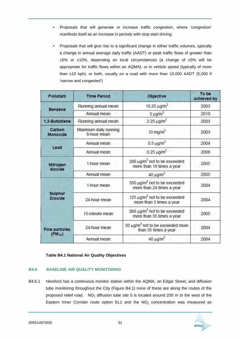
B452 National Air Quality Strategy - The first National Air Quality Strategy was published in
1997 The Strategy was last updated in 2007 and continues to provide the framework for
local government to assess ambient air quality in their locality against specific health-based
standards for nine pollutants (nitrogen dioxide PM10 sulphur dioxide benzene lead 13shy
butadiene carbon monoxide PAH and ozone) Seven of which (excluding ozone and PAH)
are regulated through the Air Quality Regulations 1997 (HM Government 1998) 2000 (HM
Government 2000) Air Quality (England) (Amendment) Regulations 2002 (HM Government
2002) and 2007 (OPSI 2007) The National Objectives are shown in Table B41
B453 Local Air Quality Management Technical Guidance 09 (LAQMTG09) is designed to
support local authorities in carrying out their duties under the Environment Act 1995 These
duties require local authorities to review and assess air quality in their area These Review
and Assessments form the cornerstone of the system of Local Air Quality Management
(LAQM) LAQM itself forms a key part in the UK Governmentrsquos strategies to achieve the air
quality objectives TG09 states
B454 Where the DMRB assessment indicates that exceedances of the objectives are likely a
more detailed study may then be required This may include the use of more complex
dispersion models andor the use of local monitoring However where a good agreement
between the DMRB model results and monitoring (at relevant locations) is demonstrated
then the results of the DMRB model should in many instances be sufficient to determine the
area of exceedance of the objective In circumstances where complex road layouts such as
large junctions or complex street canyons are being assessed then more detailed modelling
is recommended
B455 Herefordshire and Worcestershire Air Quality Planning Protocol- Ensuring that air
quality is considered as a material planning consideration within development control
planning processes of the Councils through the implementation of the Supplementary
Planning Document for Herefordshire and Worcestershire Where deteriorations in air quality
due to a development (or developments) are predicted to ensure measures to mitigate the
effects are put in place
bull Require modelling and or monitoring to be undertaken to accurately assess the
impacts of proposed development on local air quality
bull Ensuring that air quality is properly considered within planning policy processes in
particular within the LDF process with the inclusion of a specific air quality policy
where applicable
00551497005 29
B456 Herefordshire and Worcestershire Air Quality Strategy 2009 - supports the achievement
of air quality objectives and aims to raise air quality as an issue for consideration within a
wide range of local government and regional planning frameworks
B457 PPS 23 and Annex 1 of PPS23 ndash PPS 23 Annex 1 states that any air quality consideration
that relates to land-use and its development is capable of being a material planning
consideration The impact on ambient air quality is likely to be particularly important
bull Where the development is proposed inside or adjacent to an Air Quality
Management Area (AQMA) designated under Part IV of the Environment Act 1995
bull Where the development could in itself result in the designation of an AQMA and
bull Where to grant planning permission would conflict with or render unworkable
elements of a local authorityrsquos air quality action plan
B458 Herefordshire Air Quality Action Plan - Hereford City Air Quality was released at the
beginning of 2008 and proposes and models 15 actions which are designed to improve air
quality in the city Action numbers 4 and 5 of the AQAP relate to the provision of a relief
road around Hereford
B459 Herefordshire Local Transport Plan- Air Quality target (LTP8) is to reduce concentrations
within AQMAs to below 40 microgm3 by 201011
B4510 UDP Policy DR9- Development proposals which could contribute to the deterioration of air
quality below acceptable levels either locally or on a more widespread basis will not be
permitted unless adequate air quality enhancements or mitigation measures can be
accommodated and demonstrated as part of the development In assessing schemes regard
will be had to both their operational impacts and to associated traffic generation Where
developments are sensitive to air quality are proposed regard will be had to local air quality
as a material consideration
B4511 Development Control Planning for Air Quality EPUK 2010 ndash This guidance aims to
ensure that air quality is properly accounted for in the Development Control and Local
Development Framework processes The guidance clarifies when an air quality assessment
is required and what it should contain It sets out how impacts should be described and
assessed Importantly it sets out a recommended approach that can be used to assess the
significance of the air quality impacts taking account of the advice issued by the Institute of
Air Quality Management An important focus of this guidance is on minimising the air quality
impacts of all developments
B4512 This guidance defines a number of criteria that can trigger the requirement for an air quality
assessment
00551497005 30
bull Proposals that will generate or increase traffic congestion where lsquocongestionrsquo
manifests itself as an increase in periods with stop start driving
bull Proposals that will give rise to a significant change in either traffic volumes typically
a change in annual average daily traffic (AADT) or peak traffic flows of greater than
plusmn5 or plusmn10 depending on local circumstances (a change of plusmn5 will be
appropriate for traffic flows within an AQMA) or in vehicle speed (typically of more
than plusmn10 kph) or both usually on a road with more than 10000 AADT (5000 if
lsquonarrow and congestedrsquo)
Table B41 National Air Quality Objectives
B46 BASELINE AIR QUALITY MONITORING
B461 Hereford has a continuous monitor station within the AQMA on Edgar Street and diffusion
tube monitoring throughout the City (Figure B41) none of these are along the routes of the
proposed relief road NO2 diffusion tube site 5 is located around 200 m to the west of the
Eastern Inner Corridor route option EL1 and the NO2 concentration was measured as
00551497005 31
139microgm-3 in 2008 The Air Quality Archive shows background NO2 concentrations to be
between 5 and 15 microgm-3 over the extent of the corridors
Figure B41 Nitrogen Dioxide Monitoring Points in Hereford
B462 Additional monitoring is planned by Herefordshire in the near future along the proposed route
options when detailed alignments are established and chosen corridors have been put
forward for Stage 2 assessment In order to establish an accurate baseline and verify the
00551497005 32
predictions of the air pollution models produced later in the assessment process measured
concentrations of pollutants are needed
B47 BRIEF FOR FURTHER MONITORING
B471 DMRB HA20707 recommends that NO2 diffusion tube monitoring is conducted as a
minimum Given that there is insufficient monitoring for the establishment of a baseline
along the route and for verification of modelling NO2 diffusion tube surveys are proposed
The NO2 diffusion tube surveys should take place once the route options have been refined
at Stage 2 in order to validate the modelling for Stage 3 NO2 diffusion tubes should be sited
at a background site along affected roads and near the junctions of proposed links identified
at the end of Stage 2 Triplicate exposure against the continuous monitoring site will be
required The diffusion tube survey will need to conform to guidance in TG09
B48 CALCULATION OF LEVELS OF POLLUTION
B481 No AADT or vehicular speed data for the proposed route options is available at the Study of
Options stage so no calculations of the levels of local air pollutants or greenhouse gases can
be made at this stage The potential air quality effects on residential properties within 200m
of the route options will therefore require further assessment as the project progresses at
Stage 2 Given the low background levels of pollution along the route corridors it is
considered unlikely that exceedance of National Objectives will occur along any of the
proposed route corridors and there is likely to be a reduction of levels of pollution within the
city centre area along the route of the A49 through the city Particular attention will need to
be paid to junctions and roundabouts as this is where exceedances of the NO2 annual mean
objective would be most likely to occur
B49 AIR QUALITY EFFECTS DURING CONSTRUCTION
B491 The effects of construction activities and related traffic on air quality cannot be accurately
assessed in the Study of Options stage as the detailed route options for assessment have
not yet been put forward or construction methods proposed Air quality will be adversely
affected during construction due to dust created by earthworks and emissions caused by
vehicle movements This may be reduced through dust prevention measures and designated
construction traffic routes which avoid residential areas Particular attention will need to be
paid to where construction takes place near designated sites and agricultural land as soiling
of leaves by dust can affect plant health and productivity It is envisaged that during
construction there will be an adverse effect on air quality near to the construction sites This
can be reduced through dust prevention measures and designated construction traffic routes
which avoid residential areas The construction will use methods recommended in The GLA
Air Quality Best Practice Guidance - The Control of Dust amp Emissions from Construction and
Demolition
00551497005 33
B410 IMPACT ON HEREFORD AIR QUALITY MANAGEMENT AREA
B4101 No air quality management areas have been designated within any of the route corridors
However Hereford City AQMA has been designated within the City of Hereford covering the
A49 from Blackmarstone to Widemarsh and part of the A438 joining the A49 The AQMA is
linked to road traffic emissions and is for exceedance of the annual mean NO2 objective
The area of the AQMA is shown in Figure B42 though Herefordshire Council report that the
AQMA is likely to be extended soon as a result of diffusion tube monitoring showing
exceedance of the annual mean NO2 objective along the A438 The A49 is likely to be an
affected road when the affected roads are identified at Stage 2 The AQMA has been
designated as an area likely to exceed the National Air Quality Standards and Objectives for
Nitrogen Dioxide (NO2) of an annual average limit of 40microgm-3 The AQMA is located
approximately 3000 m west of the Eastern Inner Corridor route options and 2500 m east of
the Western Inner Corridor route options An Air Quality Action Plan has been produced
and measures in the plan include actions for the relief road to help alleviate congestion and
air pollution along the A49 in the city centre Hereford has only one road crossing of the
River Wye and this causes congestion from through traffic
B4102 The proposed route options are unlikely to adversely affect air quality in the AQMA due to
their distance from the designated area They are instead likely to improve air quality in the
AQMA due to the diversion of a proportion of the traffic currently using this route to the new
route This will improve air quality in Hereford city centre through reduced traffic emissions in
areas of high population density which in turn will contribute to improved health of the
population from a reduction of the area of exceedance and the number of people living
within the area of exceedance Detailed Assessment at a later stage of assessment can
establish the effect of the proposed scheme on the area and level of exceedance within the
AQMA
B411 FURTHER WORK
B4111 DMRB HA20707 requires a Simple Assessment of air quality effects following the Scoping
Assessment if there are relevant properties of Designated Sites nearby unless calculations
show the air quality objectives are likely to be exceeded and then a Detailed Assessment is
required The scheme will under go a Scoping Assessment based on the route options
proposed for Stage 2 Since there are relevant properties and designated sites but
exceedance of the National Objectives is not predicted it is likely a Simple Assessment will
be required and calculations of air pollution levels will be made using the DMRB air quality
spreadsheet At Stage 3 a Detailed Assessment of the air quality can be made using
dispersion modelling to show the impact of the scheme which is likely to be beneficial of the
proposed route on the AQMA
00551497005 34
Figure B42 Hereford AQMA (OS Licence Number 100024168 (2008))
B412 REGIONAL IMPACT ASSESSMENT
B4121 Affected roads have not yet been identified and will be identified and assessed at Stage 2
when the traffic model is available Qualitative assessment indicates that the scheme could
cause a marginal deterioration as a result of the extra distance travelled resulting in extra
emissions though this may be more than offset by the reduction in congestion and idling
00551497005 35
B413 MITIGATION
B4131 The properties within 200 m of the proposed route would experience an increase in levels of
air pollution but concentrations are expected to remain well below objective levels Therefore
no specific mitigation measures would be required Nevertheless subject to safe road
engineering design criteria the proposed relief road would be aligned away from properties
as far as possible and junctions will be designed to avoid changes in speed and queuing
Simple Assessment at Stage 2 could potentially identify exceedances and mitigation will be
considered further at that stage The relief road itself is a mitigation measure outlined in the
AQAP to reduce NO2 concentrations within the AQMA
B414 CONCLUSIONS AND RECOMMENDATIONS
B4141 Air quality is likely to be adversely affected local to the scheme due to vehicle emissions
However it is likely to improve in other areas of Hereford particularly along the A49 and in
the AQMA due to the diversion of a proportion of traffic along the new route Some adverse
impacts on air quality from construction dust and disruption are envisaged during the
construction phase
B4142 The outer corridors are likely to have the lowest air quality impacts on the population as the
routes have the least number of nearby sensitive receptors Link EL1 is less than 50 m from
the Lugg Meadows SSSI Lugg Meadows is lowland hay meadow which is now a
particularly rare habitat type (Lowland Meadow is a Priority Habitat in the UKBAP) and the
Lugg Meadows are one of the most significant areas of this habitat in the West Midlands
region Lowland hay meadows are nitrogen sensitive so this option will need an
investigation of nitrogen deposition on ecology grounds Although only part of the wider
Lugg Meadows site has been designated a SSSI much of the remainder of the site has
been designated as a Special Wildlife Site by Herefordshire Council and the habitats are
contiguous The air quality assessment at Stage 2 will include an assessment on the impact
on designated sites using the assessment method of Annex F of HA20707
B4143 Air pollutant levels would be expected to rise at properties along the potential routes
however all traffic-related pollutants would be expected to remain well within air quality
objectives for all years Pollution levels would be expected to decline in the Hereford City
area and in particular in the AQMA as a result of the diversion of traffic
00551497005 36
-B5 The Greenhouse Gases Sub Objective
B51 INTRODUCTION
B511 The Climate Change Act 2008 creates a new approach to managing and responding to
climate change in the UK At the heart of the Act is a legally binding target to reduce the
UKrsquos greenhouse gas emissions to at least 80 per cent below 1990 levels by 2050 to be
achieved through action at home and abroad To drive progress towards this target the Act
introduces five year ldquocarbon budgetsrdquo which define the emissions pathway to the 2050
target by limiting the total greenhouse gas emissions allowed in each five year period
beginning in 2008 The first three carbon budgets were announced in April 2009 covering
the periods 2008ndash12 2013ndash17 and 2018ndash22 They require emissions reductions of just over
22 per cent 28 per cent and 34 per cent respectively below 1990 levels and are in line with
the recommendations of the Committee on Climate Change The impact of a proposed road
scheme needs to be incorporated within the cost benefit analysis of the greenhouse gas
emissions in a consistent and transparent way through the WebTAG assessment
B52 Study Area
B521 Greenhouse gases are a transboundary pollutant The study is confined to the emissions of
the roads modelled in the Multi-Modal Model and the traffic model that will be produced for
the Stage 2 assessment
B53 Proposed Level and Scope of Assessment
B531 The approach adopted for the consideration of climate change issues of the Study of Options
assessment work has followed the relevant aspects of the methodology set out under DMRB
Volume 11 (Section 3 Part 1 HA 20707) Air Quality for regional impacts and climate
change impacts through webTAG unit 334) With the absence of a traffic model for the
routes the information is based on the Multi-Modal Model
B532 The approach adopted for the consideration of greenhouse gases involved a desktop
qualitative review of the Multi-Modal Model and analysis of relevant local and national policy
and guidance on climate change The magnitude of the greenhouse gas impact of each
corridor will be broadly similar as vehicular demand is expected to be relatively consistent for
all the corridors under consideration but dependent on the length of the route as the
greenhouse gas emissions are dependent on vehicle kilometres travelled and therefore the
greater the length of a route the greater the greenhouse gas emissions It is also possible
that there could be a reduction in greenhouse gas emissions as a result of the scheme
proposals due to vehicles travelling at optimum speeds and reduced congestion The
location of developments satisfying Herefordshire housing allocation requirements will have
an impact on the levels of greenhouse gas emitted by the proposed routes The levels of
00551497005 37
greenhouse gas emission resulting from the transport associated with the housing allocation
will be minimised with the corridor option nearest the housing allocation
B54 REGULATORYPOLICY FRAMEWORK
Herefordshire Local Area Agreement
B541 Herefordshire and Worcestershire include in their current Local Area Agreements a reduction
in climate change gas emissions however there are no targets relating to air quality directly
In Worcestershire the target is to reduce Climate Change gas emissions across the County
by a minimum of 10 from 2005 levels by 2011 and 20 by 2020 In Herefordshire the
Change Strategy includes a target to reduce greenhouse gas emissions in line with the UKrsquos
Energy White Paper a 60 reduction in CO2 emissions from 1990 levels by 2050 These
are also used as indicators for this strategy in the two counties
Herefordshire Council Carbon Management Action Plan 20056 to 201112
B542 The aim of this document is to define the steps that Herefordshire Council will take to secure
its contribution to the carbon dioxide reduction targets as part of the Herefordshire
Partnership Climate Change Strategy This document commits Herefordshire Council to
achieve a 125 reduction in the 2002 carbon dioxide equivalent emissions by 2012 with a
commitment to reduce emissions by 20 by 2020
Climate Change Background Paper
B543 This background paper was developed to assist the consideration of climate change in the
Core Strategy of the LDF
Herefordshire Community Strategy
B544 The Herefordshire Community Strategy sets out aspirations for the County for 2020 and how
they might be achieved The Herefordshire Community Strategy also acts as
Herefordshirersquos Local Agenda 21 Plan and Regeneration Strategy and is closely integrated
with the emerging LDF Guiding principles include ldquointegrate sustainability into all actionsrdquo
and ldquoProtect and improve Herefordshirersquos distinct environmentrdquo Actions relevant to both the
air quality and climate change objectives include actions to ldquoReduce traffic congestion
through access to better integrated transport provisionrdquo and ldquoprotecting the environmentrdquo
Planning and Climate Change PPS 1 Supplement Planning and Climate Change
B545 Planning and Climate Change (ODPM 2008) sets out how spatial planning should contribute
to reducing emissions and stabilising climate change (mitigation) and take into account the
unavoidable consequences (adaptation)
00551497005 38
Climate Change Act (2008)
B546 Through the Department of Energy and Climate Change (DECC) - responsible for all aspects
of UK energy policy and for tackling global climate change - the UK passed legislation on
the 26th of November 2008 which introduces the worldrsquos first long term legally binding
framework to tackle the dangers of climate change It includes provision for a legally binding
emissions reduction of between 26 and 32 against a 1990 baseline by 2020 5-year
rolling targets and the establishment of a new independent body to oversee progress
Councils will now be able to legally impose obligations for energy use and efficiency in local
plans with the approval of the Planning and Energy Act (2008) and this means that councils
can set requirements in development plan documents for a quota of energy used in their
area to be renewably sourced or low carbon
Local Government White Paper - Strong and Prosperous Communities
B547 The White Paper highlights the important role of local authorities in coordinating reductions
in CO2 emissions in their communities and calls for Local Area Agreements to set out
climate change targets - supported by Sustainable Community Strategies In 2008 a set of
198 national performance indicators were included which for the first time included several
on climate change
NI 185 - CO2 reduction from local authority operations
NI 186 - Per capita CO2 reduction in the local authority area
NI 187 - Tackling fuel poverty
NI 188 - Adaptation to climate change
NI 189 - Flood and coastal erosion risk management
NI 194 - Level of air quality reduction in NOx and primary PM10 emissions in local
authority estate and operations
NI 197 - Improved Biodiversity - active management of local sites
B548 NI 186 is included as a priority in Herefordshirersquos Local Area Agreement where a target to
reduce CO2 emissions in the county by 131 per capita by 201011 has been set
B55 GREENHOUSE GAS ASSESSMENT
B551 The Multi-Modal Model uses morning and evening peak 1 hour traffic to assess flow
congestion and green house gas emissions for different scenarios based around an
00551497005 39
-
indicative west route for the relief road and an indicative east route for the relief road with
various housing allocation scenarios as shown in Table 51
Evening Peak (1700 1800) Kg CO2 Emissions
Scheme DM DS1 DS2 DS3 DS4
No Relief Road
7724 9119 9275 8925 9208
West Relief Road
7928 9582 10173 9295 9601
East Relief Road
8055 9771 9880 9433 9896
Table 51 Evening Peak CO2 emissions
B552 The model scenarios in the multi modal model show that there will be up to around a 75
increase in Evening Peak CO2 emissions with the introduction of the relief road depending
on the particular Do Something Scenarios The Do Something scenarios take into account
different levels and locations of proposed housing allocations The locations of the housing
allocations have an influence on the vehicular flow of the road and to minimise congestion
and vehicle kilometres travelled and thus carbon emissions The relief road and the
proposed housing allocations should be located in proximity to each other to reduce the
number of vehicle kilometres travelled
B553 Generally the longer the route the greater the carbon emissions will be because of the extra
distance travelled This means the Western Outer Corridor and Eastern Outer Corridor
based routes are likely to have a greater greenhouse impact than routes based on the
Western Inner Corridor and Eastern Inner Corridor
B554 At this Study of Options stage there is not enough scheme detail to quantify the greenhouse
gas emissions in TAG
B56 Further work required for Stage 2 Assessment
B561 The road scheme will be appraised using the COBA program and for road and multi-modal
schemes using the TUBA program The net present value of the change in carbon
emissions from road-based fuel consumption that is in the non-traded sector will be
presented as an automatic output of the program (in the Departments standard base year
prices and values for the whole appraisal period)
B562 Having calculated the carbon (Ce) emission levels for each year the change between the
lsquowith schemersquo and lsquowithout schemersquo scenarios for each year can be calculated The
estimated level of carbon (Ce) emissions for each of the years in the appraisal period is used
00551497005 40
for the monetary valuation exercise where a net present value (NPV) of the change in
carbon (Ce) emissions over the appraisal period is derived This process of deriving the NPV
from carbon emissions will be described in the following section
B563 Stage 2 an estimate of the greenhouse gases will be made from the output of the traffic
model and at Stage 3 the full greenhouse gas assessment will be conducted based on the
traffic model TUBA For the most part transport fuel is currently in the non-traded sector As
the carbon emission impacts would affect the UKrsquos net carbon account there is a
requirement for the carbon impact to be reported The monetary assessment of the carbon
impact will be conducted as part of the TAG assessment at Stage 3 of the route assessment
procedure
B57 MITIGATION
B571 Mitigation can be through encouraging more sustainable modes of transport and through
alleviation of congestion and idling the carbon impact of the proposed routes may be
mitigated Mitigation will be considered further at Stage 2 when estimates of emissions of
greenhouse gas will be made
00551497005 41
B6 The Landscape Sub-Objective
B61 INTRODUCTION
B611 This chapter has been prepared by Jon Etchells Consulting (JEC) for Amey on behalf of
Herefordshire Council in connection with the proposed Hereford Relief Road JEC is a
practice registered with the Landscape Institute with extensive experience of the landscape
assessment of highways schemes
B612 A number of corridors with indicative links are under consideration for the proposed route of
the Hereford Relief Road to both the east and west of the city as well as different options
for links within those corridors The various links and corridors can be combined in a variety
of ways to make up actual route options for the relief road as a whole and the links are not
at this stage fixed or designed in detail and the traffic model is not yet available It is
therefore not possible to carry out a full and detailed Stage 2 Assessment for all of the links
and potential combinations of links at this time Instead this chapter sets out the results of a
Study of Options assessment of the likely landscape effects of the potential route which are
based on land take type impacts Traffic related impacts will need to be considered further
at Stage 2
B613 This chapter also highlights the principal landscape constraints associated with the various
route corridors so that the routes can be refined and adapted so as to avoid (or minimise
effects upon) those constraints wherever possible
B62 METHODOLOGY
B621 The assessment for this report has been based on the methodology set out in the Highways
Agencyrsquos Design Manual for Roads and Bridges (DMRB) Volume 11 Environmental
Assessment The DMRB landscape chapter has not been updated since 1994 and has in
some respects been superseded by the Department for Transportrsquos lsquoTransport Analysis
Guidancersquo (TAG) also referred to as WebTAG as it is available via its own web site The
TAG landscape assessment guidance (lsquoThe Landscape Sub-Objective TAG Unit 337) was
updated in December 2004 and provides guidance on the completion of a TAG worksheet
which in turn provides the inputs for the landscape section of the overall project Appraisal
Summary Table (AST)
B622 The more general methodology set out in the lsquoGuidelines for Landscape and Visual Impact
Assessmentrsquo produced jointly by the Institute of Environmental Management and
Assessment and the Landscape Institute (lsquothe GLVIArsquo 1995 revised 2002) was also
followed where appropriate The document lsquoLandscape Character Assessment Guidance
for England and Scotland 2002rsquo (The Countryside Agency and Scottish Natural Heritage) is
00551497005 42
also relevant and stresses the need for a holistic assessment of landscape character
including physical biological and social factors
B623 Although the assessment set out in this report does not constitute a full or detailed
landscape and visual impact assessment the relevant parts of the detailed methodology set
out in Appendix B-C were followed where appropriate
B624 The site visits for the assessment were undertaken in February May and June 2010 and it
has therefore been possible to make a judgement about how the landscape and visual
effects of the route options may vary between summer and winter
B63 LANDSCAPE CHARACTER
National Landscape Character
B631 In terms of wider landscape character Hereford lies within an area identified as the
lsquoHerefordshire Lowlandsrsquo in the Countryside Agencyrsquos (now Natural England) lsquoCountryside
Character Volume 5 West Midlandsrsquo (this is a national assessment of landscape character
published as a series of regional volumes) This is an extensive area stretching from
Ludlow in the north to Hereford in the south Key characteristics are noted as including the
wide river valleys steep wooded hills frequent orchards and hop yards and large farmsteads
and frequent hamlets
B632 A further character area lsquoSouth Herefordshire and Over Severnrsquo lies just to the south of
Hereford and the existing Rotherwas Access Road runs along the edge of this area
County Landscape Character
B633 The Herefordshire Landscape Character Assessment (2004 updated in 2009) was prepared
by Herefordshire Council (HC) and forms Supplementary Planning Guidance (SPG) to the
Unitary Development Plan (UDP) It categorises the landscape into different Landscape
Types (which can be found at different locations) and also Sub-regional Character Areas
which are individual and unique areas with their own distinct character
B634 The route options fall within the lsquoCentral Herefordshirersquo Sub-regional Character Area which
has a similar extent to the Herefordshire Lowlands national character area noted above
Landscape Types around Hereford in the areas traversed by the various routes are
bull Principal Settled Farmlands - this type extends around much of the area to the east and
north of the city other than within the river valleys of the Wye and Lugg The
Herefordshire Landscape Character Assessment (HLCA) describes this Landscape Type
as
00551497005 43
lsquoThe rolling lowland area of Central Herefordshire is dominated by this Landscape Type These are
settled agricultural landscapes of dispersed scattered farms relic commons and small villages and
hamlets The mixed farming land use reflects the good soils on which they are typically found
Networks of small winding lanes nestling within a matrix of hedged fields are characteristic Tree
cover is largely restricted to thinly scattered hedgerow trees groups of trees around dwellings and
trees along stream sides and other watercourses The composition of the hedgerow tree cover
differs from that of Timbered Farmlands in its lower density and lack of oak dominance This is a
landscape with a notably domestic character defined chiefly by the scale of its field pattern the
nature and density of its settlement and its traditional land uses Hop fields orchards grazed
pastures and arable fields together make up the rich patchwork which is typical of Principal Settled
Farmlandsrsquo
bull Riverside Meadows - this type runs alongside the rivers noted above Flat seasonally
waterlogged meadows running alongside the rivers are characteristic of the Wye and the
Lugg often (especially for the Wye) bounded by steeper sometimes wooded river cliffs
The HLCA describes this Landscape Type as
lsquoThese are linear riverine landscapes associated with a flat generally well defined alluvial
floodplain in places framed by steeply rising ground They are secluded pastoral landscapes
characterised by meandering tree lined rivers flanked by riverside meadows which are defined by
hedge and ditch boundaries Settlement is typically absent Throughout these landscapes the
presence of extensive areas of seasonally grazed waterside meadows has in the past provided a
strong sense of visual and ecological unity These are landscapes that accommodate a degree of
annual flooding a factor which has been reflected in the traditional patterns of land use the lack of
settlement and development (except for the occasional water mill) and the representation of
species and habitats tolerant of such waterlogged conditions The natural fertility of Riverside
Meadows has often been maximised by employing devices such as sluices to control and direct the
silt laden flood waters The unique Lammas Meadows bordering the River Lugg at Hereford are an
excellent example of traditionally managed riverside meadows where the historic pattern of cutting
and grazing has been continued for centuries Tree cover is a notable element of Riverside
Meadows usually in a linear pattern along the hedge and ditch lines and to the banks of
watercoursesrsquo
bull Wooded Estate-lands - a broad swathe of this type extends around the city to the south
and west This Landscape Type is described in the HLCA as follows
lsquoThese are wooded agricultural landscapes of isolated farmsteads clusters of wayside dwellings
and occasional small estate villages Mixed farming is the dominant land use with woodland
comprising about 30-40 of the land cover This Landscape Type relies heavily upon its woodland
component as the critical element in defining its character The size shape and composition of the
woodlands are all important being generally large discrete woods of ancient semi-natural
character and irregular or semi-regular outline They frame the views and are often prominently
situated on low crests The prominent hedgerows are also important in defining the scale and
providing the structure to the landscape Ornamental grounds and parkland associated with large
00551497005 44
estates can be a noticeable feature in these landscapes Groups of mature ornamental trees
planted in parks or gardens are often significant visual landmarksrsquo
bull Principal Timbered Farmlands - the western route options cross a narrow band of this
type around Breinton The HLCA describes this Landscape Type as
lsquoPrincipal Timbered Farmlands are rolling lowland landscapes with occasional steep sided hills and
low escarpments They have a small scale wooded agricultural appearance characterised by
filtered views through densely scattered hedgerow trees These are complex in places intimate
landscapes made up of a mosaic of small to medium sized fields irregularly shaped woodlands
and winding lanes The key element of these landscapes is the strong unifying presence of tree
cover in the guise of woodlands hedgerow trees and linear tree cover associated with streams
and watercourses The combined presence of these tree cover components creates the
fundamental sense of scale and enclosure together with the filtered views that are distinctive in this
landscapersquo
bull Wet Pasture Meadows - there is a narrow band of this type to the north east of Stretton
Sugwas The HLCA describes this Landscape Type as
lsquoThese are flat low lying and largely uninhabited landscapes They are found where the land form
has naturally created poorly drained low lying basins collecting water from the surrounding low hills
or scarps These are landscapes which in the past have been protected from change by the
difficulty of cultivating soils with such poor drainage They have consequently been avoided as
sites for settlement and roads and have often not been considered economically viable for
agricultural improvement This together with the widespread pastoral land use and associated
traditional methods of management has favoured the retention of wetland habitats of considerable
wildlife interest and a certain wilderness quality These are secluded pastoral landscapes
characterised by a regular pattern of hedged fields and ditches fringed by lines of willow and alder
Pollarded willows are often a distinctive featurersquo
Existing Light Sources
B635 The main light sources within the wider area around the city are the existing street lighting
within the urban area and also lights on and within the buildings which together make up the
city Most areas beyond the built up area are generally unlit with low key rural street lighting
only in the villages and also lighting of some road junctions (such as the roundabout at the
junction of the A49 with the B4399 Rotherwas Access Road) The main roads into the city
are unlit other than where (as for the A438 west of the city as far to the west as Swainshill)
development extends alongside them
00551497005 45
B64 LANDSCAPE QUALITY SENSITIVITY AND VALUE
Landscape Quality
B641 There are no national designations for landscape quality in the area around the city though
the Wye Valley Area of Outstanding Natural Beauty (AONB) extends to within around 3km of
the eastern route options near Holme Lacey
B642 The Herefordshire Unitary Development Plan (UDP) also contains no local designations for
landscape quality - in line with more recent Government policy and guidance on the
landscape the emphasis in the UDP is on protection of the landscape as an overall
resource based on landscape character rather than on the use of local designations for
landscape quality However the UDP does note (in section 948) that the county has lsquoa
quality of landscape that is nationally acclaimedrsquo and also that it lsquoencompasses an
exceptional diversity of landscape beautyrsquo
B643 Although there are no extant local designations for landscape quality it is evident from the
assessment carried out for this study that the majority of the landscape around the city is of
medium or high quality and that some local areas (especially alongside the River Wye) are
of very high quality However it should also be noted that while the landscape is of
generally high quality this quality is in part due to its undulating and partially wooded nature
which makes the landscape quite dense and intricate and potentially capable of absorbing
some types of new development to a greater extent than would be possible in a flatter more
open landscape
Landscape Sensitivity
B644 Landscape sensitivity (see Appendix B-C for a full definition and explanation) relates to the
ability of the landscape to accommodate change of the type and scale proposed without
adverse effects on its character Sensitivity therefore varies to some degree with the nature
of development proposed and is defined in the glossary of the GLVIA as
lsquoThe extent to which a landscape can accept change of a particular type and scale
without unacceptable adverse effects on its characterrsquo
B645 As part of the preparation for the Local Development Framework (LDF) HC have produced
an assessment of the sensitivity of the landscape around Hereford and other towns in the
lsquoUrban Fringe Sensitivity Analysis Hereford and the Market Townsrsquo (January 2010) The
assessment of sensitivity was intended to inform the Strategic Housing Land Availability
Assessment (SHLAA) and is therefore of the sensitivity of the landscape to housing
development rather than a potential new road but nevertheless still has some relevance to
the Hereford Relief Road assessment
00551497005 46
B646 The Urban Fringe Sensitivity Analysis notes the presence within and around the city of
relevant designations such as Conservation Areas Historic Parks and Gardens and
Scheduled Ancient Monuments (SAMs)
B647 It also contains a figure (Map 31) showing the landscape sensitivity of the urban fringe on a
5 point scale from high to low The usefulness of this categorisation to the current
assessment is limited by the purpose for which it was drawn up - as the original assessment
was for potential housing development the majority of the river valleys are not graded for
sensitivity and are simply coloured blue (presumably on the basis that they are prone to
flooding and therefore unsuitable in any case for housing development) However the text of
the document does refer to the lsquoRiver Wye Corridorrsquo as being of high landscape sensitivity
A further limitation is that the categorisation of sensitivity does not extend to the far side of
the Lugg valley so the land around Lugwardine is uncategorised
B648 Based on Map 31 of the Urban Fringe Sensitivity Analysis it can be seen that the western
route corridors pass through areas of medium to low sensitivity between the A4103 and the
A438 and then high to medium or high sensitivity for the remainder of the corridors to the
south of the A438 The North Core corridor passes through the edge of an area of high
sensitivity between Holmer and Shelwick then crosses an area of medium to low sensitivity
to the north of the A4103 The Lugg Meadows are uncategorised for the reasons noted
above and the eastern corridors then cross a narrow band of high or high to medium
sensitivity landscape to the north of the River Wye
B649 It may be that the sensitivity of some of these areas to a new road will be different to that of
their sensitivity to potential new housing developments - while a road is in some ways
potentially more intrusive (on account of its moving traffic noise possible lighting etc) as a
relatively narrow linear feature it may be more capable of being effectively screened and
integrated
B6410 HC have produced a consultation draft of a lsquoPlace Shaping Paperrsquo which sets out a
preferred strategy and further options for the emerging Core Strategy as part of the LDF
process This paper notes the need for a relief road for Hereford and summarises the broad
environmental sensitivities to the west and east of the city on pages 33 and 34 In broad
terms this summary states that western options would pass through areas of higher
landscape quality than those to the east of the city but that the eastern options would pass
though areas with a greater number and level of importance of ecological constraints
Landscape Value
B6411 The concept of landscape value is also relevant to this assessment - this should be
considered in association with landscape character in order to avoid consideration only of
00551497005 47
how scenically attractive an area may be and thus to avoid undervaluing areas of strong
character and perhaps significant local importance but limited scenic beauty It is defined in
the glossary of the GLVIA as
lsquoThe relative value or importance attached to a landscape (often as a basis for designation or recognition) which
expresses national or local consensus because of its quality special qualities including perceptual aspects such
as scenic beauty tranquillity or wildness cultural associations or other conservation issuesrsquo
B6412 A landscape may have a high value if it is well used and appreciated by local people if it has
a network of rights of way permitting access if it has other attributes such as heritage or
biodiversity value or (and perhaps especially) if it has a combination of many or all of these
Historic Landscape Character
B6413 An assessment of potential effects on cultural heritage assets is made in the heritage
chapter of the EAR and potential effects on the settings of designated assets are also noted
in this landscape chapter However there is some overlap between heritage and landscape
matters in terms of historic landscape character A historic landscape character assessment
has been carried out by HC and this identifies a series of Historic Landscape Character
Types which are based on the pattern of field enclosures There are also some extensive
historic landscape features such as the Roman Road to the north of the city (now partially
followed by the A4103) A detailed assessment of potential effects on historic landscape
character is beyond the scope of this landscape chapter and is perhaps not appropriate for
the broad-brush assessment of a large number of alternative route links and corridors which
is currently being undertaken No attempt has therefore been made in this chapter to
differentiate between the route links or corridors in terms of their potential effects on historic
landscape character
Landscape Constraints
B6414 Drawing Numbers HA551497-H-P-01 through 16 (found in the Study of Options Engineering
Assessment Report) are long sections that show the main landscape constraints in the areas
around the route corridors These are
bull The River Wye and riverside meadows - parts of the river corridor especially to the
west of the city where it flows through a tranquil pastoral landscape of meadows
enclosed by steeply sloping wooded ground are of very high landscape quality and
the river as a whole is designated as a Special Area of Conservation (SAC) and a
Site of Special Scientific Interest (SSSI) The long distance Wye Valley Walk follows
the course of the river
00551497005 48
bull The River Lugg and associated meadows are of slightly lower landscape quality than
the River Wye to the west of the city as the landscape around them is flatter and
more open but the river and meadows are of significant historical and nature
conservation interest and are a valuable recreational resource as well as being
important to the eastern setting of the city UDP Policy LA3 covers the setting of
settlements and states that lsquoimportant visual approaches into settlements and
surrounding valued open countryside will be particularly protectedrsquo Parts of the
Meadows are an SSSI and also a Special Wildlife Site (SWS) and the river (as for
the Wye) is a SAC and SSSI The Lugg Meadows are the largest surviving example
of Lammas Meadows areas of common grazing dating back to medieval times
bull Related heritage based designations such as Conservation Areas Historic Parks
and Gardens and Scheduled Ancient Monuments UDP Policy LA4 notes that
registered parks and gardens will be protected from harmful development and also
that lsquoUnregistered parks and gardens recognised and identified by the Council as
currently of local importance will be afforded similar protectionrsquo Figures 1 and 2
show the locations of such unregistered parks and gardens
bull National landscape character areas and local Landscape Character Types
bull Related biodiversity designations such as SSSIs and SWSs
bull Distinctive or relevant land uses such as golf courses or nurseries
bull Public rights of way and in particular long distance routes such as the Wye Valley
Walk
bull Woodland especially where locally designated as a Special Wildlife Site (SWS) or
Ancient Woodland
B65 THE ROUTE CORRIDORS
Highway Design
B651 Some broad principles of highway design are discussed below as they will have significant
effects on the eventual detailed design of the road and hence on its visibility within the
landscape
B652 The relief road is proposed as a dual carriageway all purpose road (D2AP) This will
generate greater adverse landscape effects than the previous proposal for a single
carriageway road assessed at Stage 1 and there will be significant earthworks where the
new road passes over or beneath minor roads
00551497005 49
B653 There will be constraints on the vertical alignment of the new road which will vary to some
extent with the design speed of the section of the new road in question In simple terms the
gradients will need to be quite shallow and steep slopes will need to be avoided This is of
particular relevance where the western route corridors cross the River Wye in an area where
the low lying riverside meadows are bounded by steep wooded slopes It will not be
possible for the road to run down these short steep slopes at grade so it is likely that the
new road will need to run through the slopes in a potentially deep cutting and also pass
across the river and its adjoining flood plain on a long relatively high level structure While
being inevitably prominent such a high level structure would have some advantages in
terms of leaving the immediate riverside corridor open and not obstructing views alongside
the river
B654 The other main situation in which vertical alignment will be important will be in the crossing of
the river floodplains where the road will need to be elevated (either on a solid embankment
or possibly - in order to permit the passage of flood flows - on a long structure) above
maximum flood levels and may therefore be prominent in the generally flat riverside
landscapes
B655 It is currently proposed that the junctions would be lit for reasons of safety but that the links
between them would not be lit However highway design requirements dictate that the
approaches to a junction should also be lit with the distance over which the lighting should
extend away from the junction varying with the design speed of the road The design
guidance also states that short unlit sections between areas with lighting should be avoided
It may therefore be that sections of the relief road with frequent junctions or where a new
junction is close to an existing lit junction will need a greater extent of continuous lighting
Screening
B656 The generally undulating landscape around the city is as noted above of mostly high
landscape quality and also relatively high landscape sensitivity However the undulating
and partly wooded nature of the landscape does mean that it will in places have a higher
capacity to absorb and screen the new road than would (for example) a much more open
flat landscape with less vegetation within it The enclosed folded nature of much of the local
landscape means that in principle the new road may appear locally prominent and
potentially discordant but that expansive views over long lengths of the road are unlikely
B657 Sensitive design of the horizontal and vertical alignment of the road coupled with
appropriate new planting should be able to achieve a reasonably good degree of integration
of the new road with the surrounding landscape over time
Design of Structures
B658 It will not be possible to screen the bridge over the River Wye (which will be required for
either the western or eastern corridors) and the potential bridge(s) over the River Lugg for
00551497005 50
the eastern corridors so it will be important for the bridge designs to be attractive and
appropriate to the sensitivity of their surroundings
Route Corridors
B659 The six route corridors are described in section B66 below in terms of their alignment and
also their landscape character and sensitivity together with an assessment of the likely
landscape and (where appropriate) visual effects within them
B66 LANDSCAPE AND VISUAL EFFECTS
General
B661 The following assessment are in the form of broad in-principle levels of landscape effects
which would be likely to result from each of the route corridors with notes where relevant on
whether any specific links within the corridors may lead to greater or lesser effects
B662 The main assessment in each case is of landscape effects and no attempt is made to
predict visual effects for individual receptors such as houses or public rights of way
However where it seems likely that especially sensitive receptors (such as long distance
routes) or groups of receptors (rows or groups of houses with clear views to the route
corridor) may be affected a note is made to that effect
B663 It should be noted that the effects considered are those on the landscape - effects on
biodiversity or the local heritage resource are considered elsewhere but where such factors
contribute to landscape value or character then they become relevant to the assessment of
landscape effects For example a buried archaeological site or the presence of a rare bat
would probably have little relevance to landscape value or landscape effects but a listed
church on a hilltop or a species-rich riverside meadow would contribute to local landscape
value and character and effects upon them would be included within this assessment
B664 The assessment in each case is based on the existing situation - HC are at the moment
considering potential options for areas for housing and employment growth around the city
some of which are close to the areas traversed by the route options If some of those
potential housing and employment allocations were to go ahead then the local landscape
character could be altered and the in-principle effects of one or more of the route options
may change
South Core Corridor
B665 The South Core Corridor runs from the existing roundabout on the A49 at the western end
of the Rotherwas Access Road to the A465 to the south west of Belmont Abbey It would
run across attractive rolling countryside from the A49 to cross the railway line near
Haywood Lodge with a section of high embankment to either side (see Photograph 61) and
00551497005 51
would then pass beneath the existing minor road leading south from the A465 in a deep
cutting
B666 There are two variations at the western end of the corridor - Link SC2 runs to the south of
Hayleasow Wood (an area of Ancient Woodland and a SWS) Link SC1 crosses a narrow
neck of the woodland and also the Newton Brook on a long structure which would be
visually intrusive but which would enable greater continuity of woodland habitat beneath it
(see Photograph 62)
The most significant landscape effects for the South Core Corridor would arise from the
railway line crossing and also from the structure across the woodland for Link SC1
Photograph 61 View south west from just to the south of Grafton - Links SC1 and SC2 pass through the high ground in the distance in cutting and then cross the railway line towards the left of the view (Taken February 2010)
00551497005 52
Photograph 62 View east from the A465 - Link SC1 runs through the narrow part of the woodland in the centre of the view (Taken February 2010)
Western Inner Corridor
B667 The Western Inner Corridor runs northwards from the A465 to the south west of Belmont
Abbey crossing the River Wye and continuing via a signalised junction with the A438 to a
roundabout on the A4103 Roman Road (See photographs 63-65)
B668 There are a number of variations within the corridor - Links WL1 and WL2 run closer to
Belmont Abbey crossing first the playing fields to the school and then the attractive valley to
the north west of the abbey on a high embankment with an underbridge crossing of the
minor road (see Photograph 63) Immediately to the south of the river corridor the routes
cross an area of parkland with scattered mature trees - this is shown in the HC Urban Fringe
Sensitivity Analysis as the unregistered historic park and garden of Belmont House They
then cross the River Wye just to the east of the Belmont Golf Course on a high level bridge
which spans the river itself and also the low lying flood meadows to either side This is a
high value landscape and there would be adverse visual effects for users of the long
distance Wye Valley Walk which runs along the north bank of the river at this point (see
Photograph 64) The links then continue to the north with a length of embankment and an
underbridge (ie the new road passing over the side road) crossing of the minor road just to
the west of Warham Farm
00551497005 53
Photograph 63 View south west from the golf course access towards Belmont Abbey - Links WL12 and WL35 cross the minor road on embankment roughly at the dip in the road and continue across the parkland to the left of the view (Taken June 2010)
00551497005 54
Photograph 64 View east to the point at which Link WL12 crosses the River Wye - the road would pass through the trees on the right of the view across the river to the near side of the small pumping station building and across the flood meadows (Taken June 2010)
B669 Links WL3 and WL5 are similar as far as the minor road to the north west of the abbey from
which point they take a more direct line across the area of parkland noted above through the
golf course to cross the river at a point where the immediate river corridor is wider and where
the structure required to cross it would be longer (see Photograph 65) At this point the flat
riverside meadows are enclosed by steep wooded slopes to both north and south The
woodlands on these slopes are SWSs and the river itself is an SSSI and a SAC (as is the
case for the alternative crossing point to the east) The Wye Valley Walk runs along the
north bank of the river at this point and part of the Belmont Golf Course is on the south
bank between the river and the steeper wooded river cliffs This is a high value landscape
and there would again be adverse visual effects for users of the Wye Valley Walk and the
golf course The links then continue to the north with an overbridge crossing (ie the new
road passing beneath the side road) of the minor road to the west of Warham Farm
B6610 Links WL4 and WL6 run from a roundabout further to the west on the A465 avoiding the
school playing fields and running further away from the abbey to cross the river at the same
point as Links WL3 and WL5
00551497005 55
Photograph 65 View south to the point at which Link WL35 crosses the River Wye - the road would pass through the trees on the far side of the river across the river on a high level bridge and pass just to the right of the viewpoint (Taken February 2010)
B6611 All of the links would pass beneath the minor road to the south of the A438 in cutting and
Links WL1 WL3 and WL4 then continue directly towards the A438 and a signalised junction
at a point where it seems likely that some houses would need to be removed on the south
side of the road (there is an existing agricultural access but this may not be wide enough for
the new road) There is also one isolated property on the north side of the A438 at this point
Links WL2 WL5 and WL6 diverge to the west to meet the A438 at the same point as the
Western Outer Corridor There would be adverse visual effects for the properties along the
A438
B6612 North of the A438 Link WL7 runs just to the east of Huntington This is a Conservation
Area and there are also a number of mature trees alongside the Yazor Brook which is
crossed by this link
The most significant landscape effects for the Western Inner corridor would arise from the
crossing of the attractive valley which forms part of the setting for Belmont Abbey and from
the River Wye crossing (with effects greater for Links WL3 and WL5 that for WL1 and WL2)
00551497005 56
Western Outer Corridor
B6613 The Western Outer Corridor (links WL9 WL10 WL13 and WL14) runs from the same
roundabout on the A465 as Links WL4 and WL6 and then runs across a broad shallow
valley on embankment before entering a deep cutting through Perry Hill It runs to the west
of the Belmont Golf Course and crosses the River Wye and the adjoining flood meadows
between Upper and Lower Breinton on a long structure At this point the landscape is
enclosed and tranquil but there is no woodland on the south side of the river and the
riverside slopes are less steep than for the alternative crossing points to the east (see
Photograph 66) There is an area of (undesignated) riverside woodland on the north side of
the river and also an area shown in the HC Urban Fringe Sensitivity Analysis as the
unregistered historic park and garden of Wyecliffe The Wye Valley Walk runs just to the
north of the river at this point and there would be adverse visual effects for users of this
route at the point where it is crossed by the corridor
Photograph 66 View north west to the point at which Link WL10 crosses the River Wye - the road would pass across the view from left to right crossing the river and running through the trees on the far side of the river (Taken May 2010)
00551497005 57
B6614 From this point the links diverge with WL9 running directly towards the A438 across an area
of orchards to the east of Upper Breinton and Link WL10 running to the west to cross the
A438 to the west of Swainshill and continue as WL12 to connect with the A4103 at the
existing Stretton Sugwas roundabout WL12 runs across attractive relatively tranquil area of
landscape and would affect the setting of the listed church of St Mary Magdalene with its
distinctive half-timbered tower (see Photograph 67) It would also lead to adverse visual
effects on properties in Stretton Sugwas to the west of the existing roundabout Between
the A438 and the A4103 Link WL8 runs to the east partially through an area of nurseries
and garden centres to the A438 while Link WL11 is an online improvement to the existing
A480 Links WL13 and WL14 are online improvements to the A4103 as far as the starting
point of the North Core Corridor
Photograph 67 View north west to Stretton Sugwas church from the A438 - Link WL12 runs between the viewpoint and the church and curves around to the right of the view (Taken May 2010)
The most significant landscape effects for the Western Outer corridor would arise from the
River Wye crossing which is in a very tranquil location but where relatively little riverside
woodland would be affected and from effects on the setting of the listed church at Stretton
Sugwas (for Link WL12)
00551497005 58
North Core Corridor
B6615 The North Core Corridor passes through the open rolling landscape to the north of the city
from the A4103 just to the west of the Bovington Caravan Park passing over Tillington Road
on an embankment across an enclosed attractive valley (see photograph 68) and under
the A4110 Canon Pyon Road just to the north of a row of houses on the east side of the
road to a roundabout on the A49 To the east of the A49 the corridor runs to the south
east passing between the small settlements of Holmer and Munstone with an underbridge
crossing of the minor road and a section of high embankment (see photograph 69) This is
a small scale partially settled landscape with some higher quality elements around the
settlement of Holmer and the river valley extending to the east but also some urban fringe
lower quality elements (and also an area allocated for housing development in the UDP)
closer to the A4103 Roman Road The corridor crosses the railway line to the east of
Munstone with a railway underbridge and ends at the existing A4103A465 roundabout
Photograph 68 View north along Tillington Road towards Burghill Hospital - Links NC1 and NC2 cross the road on embankment roughly at the dip in the road (NC2 slightly further away) (Taken June 2010)
B6616 There are some variations within the corridor - Link NC2 runs slightly further to the north
crossing an area shown in the HC Urban Fringe Sensitivity Analysis as the unregistered
historic park and garden of Burghill Hospital To the east of the A49 Link NC4 runs further
to the north while NC3 runs to the south with a short on line section along the A4103
00551497005 59
There would be adverse visual effects for properties along the A4110 and in Holmer and
Munstone
Photograph 69 View south from the minor road between Holmer and Munstone - Links NC3 and NC4 cross the road to the right of the view and run across the foreground of the view on embankment from right to left (Taken February 2010)
The most significant landscape effects for the North Core corridor would arise from the
crossing of Tillington Road the minor road between Holmer and Munstone and also the
railway line
Eastern Inner Corridor
B6617 The Eastern Inner Corridor runs to the south east from the A4103 between the edge of the
Lugg Meadows and the higher ground which marks the edge of the city (see Photograph
610) The northern and southern parts of the corridor would be on embankment with the
central section cut into the hillside with a cutting slope to the west and an embankment slope
to the east Parts of the meadows are an SSSI or SWS and parts are managed as a nature
reserve by the Herefordshire Nature Trust Public access is possible to much of the
meadows and they form an important part of the eastern setting of the city and are a
00551497005 60
generally high value landscape (see Photograph 611) The route crosses the A438 at
Tupsley Bridge and turns to the south to run through an area of orchards before crossing
the B4224 and then the River Wye The river at this point is less sensitive in landscape
terms than at the crossing points for the western route corridors with flat farmland on the
north bank (see Photograph 612) and a sewage treatment works and the Rotherwas
Industrial Estate on the south side of the river (though both of these are reasonably well
screened from the river) The river is again at this point both a SAC and SSSI and the Wye
Valley Walk runs along its northern bank with a public footpath along the south bank - there
would be adverse visual effects for users of these routes South of the river the route runs
just to the west of Rotherwas House and Chapel - this area is a SAM and the chapel is a
Grade II listed building (see Photograph 613) There would be no direct effects on the
designated areas but there would be some effects on the setting of the SAM and listed
building though that setting has already been compromised to some extent by industrial
development The corridor connects with the existing Rotherwas Access Road at the
roundabout on the B4399
Photograph 610 View west towards the urban edge from the A438 just to the west of the existing River Lugg crossing - Link EL1 runs along the foot of the slope between the city and the Lugg Meadows which can be seen in the foreground (Taken February 2010)
00551497005 61
Photograph 611 View north west along the line of Link EL1 - the new road would run just to the right of the woodland along the foot of the slope (Taken June 2010)
00551497005 62
Photograph 612 View south east along the north bank of the River Wye to the crossing point for Link EL3 - the new road would run across the middle ground of the view (Taken February 2010)
00551497005 63
Photograph 613 View north to Rotherwas House and Chapel - Link EL3 passes to the left of the buildings in this view and Link EL12 just to the right (Taken February 2010)
The most significant landscape effects for the Eastern Inner corridor would arise from the
severance of the historic link between the city and the Lugg Meadows the effects on the
eastern setting of the city and from the River Wye crossing (though effects of the river
crossing would be less than those for the western corridors) There would also be some
effects on the setting of the Rotherwas Chapel SAM
Eastern Outer Corridor
B6618 The Eastern Outer Corridor takes a wider line around the city with an initial online section
along the A4103 as far as the existing River Lugg crossing and then runs to the east of the
River Lugg as far as the A438 where the corridor crosses the river again (see Photograph
614) and runs to the south across the southern part of the Lugg Meadows to a roundabout
on the B4224 From the B4224 it runs across open riverside fields to a crossing point of the
River Wye further east than that for the Eastern Inner Corridor (see photograph 615) and
passes to the east of Rotherwas House and Chapel where there would again be some
effects on the setting of the SAM and listed building
00551497005 64
Photograph 614 View west along the River Lugg from the existing A438 bridge - Links EL678 would involve new crossings of the river with that for Link EL6 being in the middle ground of this view (Taken June 2010)
00551497005 65
Photograph 615 View north west along the north side of the River Wye towards the point at which Link EL12 crosses the river (Taken May 2010)
B6619 There is some variation within the corridor with Link EL6 running furthest to the west along
the edge of the Lugg Meadows and the other links running further east across an undulating
landscape to the south western edge of Lugwardine and Lugwardine Bridge where the links
run very close together Here there are three options for roundabout locations on the A438 shy
one on the existing alignment of the A438 (for EL7EL9) and two to the south (see
photograph 616) Any of these locations would have some adverse effects on the open flat
landscape alongside the A438 which is relatively unspoilt and tranquil despite the presence
of the existing road There would also be some adverse visual effects for properties on the
western edge of Lugwardine
00551497005 66
Photograph 616 View south west from the south side of the A438 - Links EL91011 run across the meadows from the A438 (behind the hedge on the right of the view) Links EL10 and 11 would involve a roundabout within the meadows to the left of the view (Taken June 2010)
The most significant landscape effects for the Eastern Outer corridor would arise from the two
crossing points of the River Lugg the crossing of the Lugg Meadows and from the River Wye
crossing (though effects of the river crossing would be less than those for the western
corridors) There would also be some effects on the setting of the Rotherwas Chapel SAM
Overall Summary of Significant Effects
B6620 The South Core and North Core Corridors will generate some adverse effects but with no
especially sensitive areas affected and in any case these corridors are common to the
options
B6621 The main differences are between the Western and Eastern corridors and in particular the
crossing of the River Wye which is probably the single most sensitive landscape feature
around the city
00551497005 67
B6622 The Western Outer Corridor crosses the river at a tranquil rural location where it would
create significant adverse effects The Western Inner Corridor would have even greater
effects due to the local topography and the need to bridge the river at a high level and also
cut into the steep slopes bordering the river with losses of woodland The WL3WL6 Link
runs through the Belmont Golf Course The new WL12 link crosses the river to the east of
the golf course at a point where the riverside meadows are narrower and which is also closer
to the existing urban edge but would still lead to significant adverse effects The Western
Inner Corridor would also have significant effects on the attractive parkland landscape to the
north west of Belmont Abbey
B6623 The Eastern corridor options are significantly better in terms of the River Wye crossing as
the topography here is flatter and the landscape is far less attractive and tranquil being
already affected by the industrial area to the south of the river There is therefore a strong
case to be made in landscape terms for adopting an Eastern corridor on this basis alone
B6624 However away from the River Wye the Eastern Inner Corridor would create significant
effects in terms of severing the city from the River Lugg meadows and the Eastern Outer
Corridor would have direct effects on the meadows and involve crossings of the River Lugg
The roundabouts would also be intrusive in the flat relatively tranquil landscape and there
would be some effects on the setting of the SAM and listed building at Rotherwas
B6625 It is important to note that all of the above effects could be mitigated to some extent by
careful design - the detailed horizontal and vertical alignment of the new road should be
designed to integrate it with the existing landscape as far as possible the side road
crossings (and the new road itself) could be screened and integrated by new planting and
by use of false cuttings and other earthworks methods where appropriate the severance
effects of the Eastern Inner Corridor could be reduced by careful design and provision of
crossing points and structures which cannot be screened such as the new bridge over the
River Wye could be individually designed to be attractive features in their own right
B6626 However the landscape around Hereford is of such high quality and sensitivity and contains
so many valued and sensitive features that whichever route is finally adopted would
inevitably lead to some significant adverse landscape effects These adverse effects would
then need to be balanced against the beneficial townscape effects within the city as a result
of traffic reductions and also the economic and other benefits of reduced congestion
00551497005 68
B7 The Townscape Sub-Objective
B71 INTRODUCTION
B711 This report has been prepared by Jon Etchells Consulting (JEC) for Amey on behalf of
Herefordshire Council in connection with the proposed Hereford Relief Road JEC is a
practice registered with the Landscape Institute with extensive experience of the landscape
and townscape assessment of highways schemes
B712 A number of corridors are under consideration for the Hereford Relief Road to both the east
and west of the city as well as different options for links within those corridors The various
links and corridors can be combined in a variety of ways to make up actual route options for
the relief road as a whole and the links are not at this stage fixed or designed in detail
However whichever corridor is adopted for the new road its principal purpose would be to
relieve traffic flows and congestion in the city centre and this would in principle lead to some
townscape benefits in the areas relieved of traffic
B72 METHODOLOGY
B721 The assessment for this report has been based on the methodology for landscape
assessment set out in the Highways Agencyrsquos Design Manual for Roads and Bridges
(DMRB) Volume 11 Environmental Assessment this can also be applied to townscape
assessment The DMRB landscape chapter has not been updated since 1994 and has in
some respects been superseded by the Department for Transportrsquos lsquoTransport Analysis
Guidancersquo (TAG) also referred to as WebTAG as it is available via its own web site The
TAG townscape assessment guidance (lsquoThe Townscape Sub-Objective TAG Unit 338)
was updated in December 2004 and provides guidance on the completion of a TAG
worksheet which in turn provides the inputs for the townscape section of the overall project
Appraisal Summary Table (AST)
B73 TOWNSCAPE CHARACTER
B731 The historic core of the city is contained within the inner ring road (the A49 as it crosses the
River Wye and the loop around to the north of the cathedral) which in turn follows the line of
the city walls parts of which can still be seen An assessment of townscape character has
been made in the publication lsquoA Characterisation of the Historic Townscape of Central
Herefordrsquo produced in February 2010 by English Heritage and HC The summary to this
publication states
lsquoIt is a commonplace of writing on historic towns to claim an exceptional state of preservation and
significance for the place in question However Hereford is exceptionally well preserved and it is a historic town of
00551497005 69
exceptional significance - and both assertions can be justified and shown to be based on quantifiable evidence
much of which is contained in or implicit in this characterisation
The plan-form of the city has been compromised by Victorian and 20th-century development to a smaller degree
than any of the neighbouring cathedral cities or shire towns No city street - bar one - has been inserted into the
city all originate in the medieval period or earlier
The fine detail of the city plan - the townscape grain - remains almost as uncompromised as the street plan with a
clear differentiation between the city and the extramural suburbs and subtle variations in the character of the
townscape grain still evident that can be traced back to the initial urbanisation process or even to the underlying
agricultural landscape Distinct medieval neighbourhoods can still be traced within the city walls
The Cathedral Close retains its integrity as an enclosed sacred space and its immediate surroundings retain an
exceptionally rare early medieval settlement pattern associated with it
The present land-use geography of the city and the fundamental distinction between the Cathedral City and the
Commercial City can be shown to be rooted in the remote past much of it derived from the years following the
Norman Conquest aspects of it even earlier
Excavations particularly the pioneering digs of the late 1960s and 70s on the west side of the city revealed that
Hereford possesses one of the earliest continuously built-up areas in the country
Much concern is currently expressed about the superficial appearance of the city its viability as a business centre
its ability to compete with neighbouring cities and its long-term future The long view of this is that the city centre is
in fact structurally very sound and extraordinarily resilient in terms of its urban functions - as a place of business
culture daily life and administrationrsquo
B74 TOWNSCAPE QUALITY SENSITIVITY AND VALUE
B741 The quality value and sensitivity of the city centre townscape are reflected in the range of
designations which apply to the area within the ring road - the city walls are a Scheduled
Ancient Monument (SAM) the entire city centre is a Conservation Area and there are many
individual listed buildings In overall terms the city centre is of very high townscape quality
and value and is highly sensitive
B742 However it should be noted that the more attractive and historic elements of the city centre
tend to be set back from the main through routes (some of them are pedestrianised) and
would therefore not be directly affected by relief of traffic flows and congestion (Photograph
71)
00551497005 70
B75 TOWNSCAPE EFFECTS
B751 A detailed assessment of the likely townscape benefits in the parts of the city which would
experience relief from traffic congestion cannot be made at this stage As the proposals
proceed and as detailed predictions of future traffic flows within the city centre are made it
should be possible to make an assessment of the level of benefits which would be likely to
result from the opening of the relief road This would depend in detail on the relief road
option adopted and whether any traffic calming measures are proposed within the city to limit
through traffic after the opening of the relief road
B752 There may also be some indirect beneficial effects in that the relief road would assist with the
proposed redevelopment of parts of the city centre which should again lead to long term
beneficial townscape effects
B753 For the purposes of the current Study of Options assessment a general statement can be
made to the effect that the opening of the relief road would be likely to have beneficial
townscape effects on the city centre parts of which are of very high townscape quality and
value
Photograph 71 View of the cathedral within the historic core of the city - through traffic is directed around the historic core and the areas around the cathedral have relatively low levels of traffic (Taken February 2010)
00551497005 71
-B8 The Heritage of Historic Resources Sub Objective
B81 INTRODUCTION
B811 This report has been prepared by RPS Planning and Development on behalf of Amey It
presents the results of a cultural heritage assessment of a number of route options for the
proposed Hereford Relief Road
B812 Guidelines for the treatment of environmental issues in the preparation of new road schemes
are presented in Volume 11 of the Design Manual for Roads and Bridges (DMRB) This was
initially produced in 1993 by the Department of Transport and is now owned and maintained
by the Highways Agency
B813 DMRB outlined a staged approach with regard to the assessment of route options
Stage 1 Sufficient assessment to identify the environmental advantages disadvantages
and constraints associated with broadly defined route corridors
Stage 2 Sufficient assessment to identify the factors and effects to be taken into account
in choosing the route options and to identify the environmental advantages
disadvantages and constraints associated with those routes
Stage 3 Detailed assessment on the environmental effects of the selected route option
B814 For each environmental topic DMRB provides guidelines on the work that should be
undertaken at each stage of the assessment and on the outputs that should result from that
work The Stage 1 assessment of cultural heritage issues was included within the Hereford
Relief Road Stage 1 Environmental Assessment Report produced by Amey in April 2010
B815 More recent updating of DMRB Volume 11 on a topic by topic basis has moved away from
the staged approach towards a less prescriptive process of Simple Assessments and
Detailed Assessments Cultural heritage is one of the revised DMRB topics and the current
guidance was produced in 2007 as DMRB Volume 11 Section 3 Part 2 - Highways Agency
Advice Note 20807
B816 This report constitutes a Study of Options assessment which is broadly similar to a Stage 2
Simple Assessment of the cultural heritage issues associated with the route options The
work undertaken is in line with that required for Stage 2 as defined in DMRB 1993 but
incorporating methodologies of the Simple Assessment described in the 2007 update
Further elements need to be completed for the Stage 2 assessment such as the walkovers
and consideration of traffic related impact such as noise
B817 The DMRB Cultural Heritage Topic encompasses three defined sub-topics Archaeological
Remains Historic Buildings and Historic Landscapes Each of these sub-topics should be
00551497005 72
examined separately even though it is acknowledged that there will be considerable overlap
between each of them (and possibly with other DMRB topics such as Townscape) and then
the results should be combined into an overall Cultural Heritage Assessment
B818 The preparation of this report has required the examination of data from a number of sources
in order to provide a summary of known historic environment resources in the vicinity It is
accompanied by a gazetteer of non-designated historic environment resources (Appendix Bshy
A) and supporting graphical data (Figures B81-6)
Route Options
B819 Following the publication of the Stage 1 Environmental Assessment Report (AMEC 2010) a
number of route options are to be appraised at the Study of Options Stage For ease of
reference these have been placed into a total of six route lsquocorridorsrsquo (Figure B81) Any
preferred route would require the use of at least two of these corridors The DMRB Stage 2
reporting will address those six route corridors rather than any more specific options
Southern Corridor
B8110 This corridor connects to the A49 (Ross Road) within the valley of the Norton Brook at the
junction with the new B4399 Rotherwas Road At this point the land is at about 70m above
Ordnance Datum (aOD) The corridor then extends westwards across land that is gradually
rising to cross the railway line at almost 90m aOD
B8111 The corridor then turns to the north-west and the land continues to rise more steeply to a
high point of just over 100m aOD before falling gently into a shallow valley within which a
stream flows to the north-east From the base of the valley the land within the corridor rises
gently to about 90m aOD as the corridor ends at the A465 (Belmont Road) close to its
junction with the B4349
Western Inner Corridor
B8112 This corridor runs north from the A465 where the land is at about 90m aOD The land falls
away slightly and then rises gently to a low ridge overlooking the river Wye
B8113 The land then dips down steeply as the corridor crosses the river Wye and then rises
steadily to a low ridge at c 90m aOD As the corridor continues north to Kingrsquos Acre the land
gradually falls away with the final section between the A438 (Kingrsquos Acre Road) and the
A4103 (Roman Road) being fairly level
Western Outer Corridor
B8114 This corridor runs north-west from the A465 at about 90m aOD The land falls away slightly
before the corridor turns to the north and the land gradually rises to over 100m aOD at Perry
Hill
00551497005 73
B8115 From here the land descends an increasingly steeper slope before the corridor crosses the
River Wye North of the river the corridor crosses a small valley within which a stream flows
south-east into the river
B8116 The land within the corridor then rises slightly before falling away gently to the level ground
between the A438 (Kingrsquos Acre Road) and the A4103 (Roman Road) The western edge of
the corridor in this area crosses land that is more undulating The final part of the corridor
follows the A4103 (Roman Road) eastwards across level ground
Northern Corridor
B8117 This corridor leaves the A438 (Kingrsquos Acre Road) to the west of Lower Burlton Farm and
then turns eastwards to cross the A4110 (Canon Pyon Road) Within this section the land
rises from about 65m aOD to just over 90m aOD
B8118 The corridor continues eastwards across the higher ground crossing the A49 (Holmer
Road) before turning to the south-east and descending from more than 90m aOD to about
50m aOD before connecting with the A4103 (Roman Road) close to the roundabout junction
with the A465
Eastern Inner Corridor
B8119 This corridor extends south from the A4103 (Roman Road) and remains in the western
floodplain west of the River Lugg at c 50-60m aOD It crosses the A438 (Ledbury Road)
and the land then rises slightly to the east of Hampton Park
B8120 The corridor then crosses the B4224 (Hampton Park Road) and the River Wye before joining
with the new B4399 Rotherwas Road at Rotherwas
Eastern Outer Corridor
B8121 This corridor extends along the A4103 (Roman Road) to cross the River Lugg at Lugg Bridge
and then extend to the south-east to cross a shallow valley at New Court It then turns south
and remains within the eastern floodplain of the River Lugg before crossing the river and the
A438 (Ledbury Road) to the west of Lugwardine Bridge
B8122 The corridor is then within the wide floodplain south of the River Lugg at less than 50m aOD
before the land rises over a low ridge and descends into the valley of the River Wye Here it
crosses the B4224 (Hampton Park Road) and the River Wye before joining with the new
B4399 Rotherwas Road at Rotherwas
B82 NATIONAL LEGISLATION AND GUIDANCE
B821 Legislative frameworks provide protection to the historic environment while planning policy
guidance provides advice concerning how the historic environment should be addressed
within the planning process
00551497005 74
B822 Statutory protection for archaeology is principally enshrined in the Ancient Monuments and
Archaeological Areas Act (1979) amended by the National Heritage Act (1983) and National
Heritage Act (2002) Nationally important archaeological sites are listed in a Schedule of
Monuments and are accorded statutory protection The city of Hereford is one of only five
cities in England in which an Area of Archaeological Importance has been designated under
the terms of the 1979 Act
B823 For other components of the historic environment the Planning (Listed Buildings and
Conservation Areas) Act (1990) and the Town and County Planning Act (1971) provide
statutory protection to listed buildings and their settings and present measures to designate
and preserve the character and appearance of Conservation Areas
B824 The Hedgerow Regulations (1997) includes guidelines that aim to protect hedgerows that
have been assessed as important in terms of criteria that incorporate historical components
One of the criteria relates to the documented date of a hedgerow A hedgerow can be
deemed important if it can be shown to be of pre-enclosure date which for the purposes of
the Regulations is currently taken (by case law precedent) to mean pre-AD 1845 (the earliest
Act of Inclosure recorded in the Small Titles Act (1896))
B825 Proposed amendments to the Regulations (DEFRA 2003) stated that hedgerows should be
regarded as important if they mark a boundary of pre-1850 historic administrative unit
(parish township hundred wapentake cantref or maerdref) or pre-1600 manorial estate
ecclesiastical estate or the outer limits of a field system park wood or common land
However these amendments have not yet been agreed as statute law
B826 Planning Policy Statement 5 Planning for the Historic Environment (PPS5 March 2010)
provides advice concerning the safeguarding of the historic environment within the planning
process It states that those parts of the historic environment that have significance because
of their historic archaeological architectural or artistic interest should be called heritage
assets and goes on to recognise that heritage assets are a non-renewable resource
B827 Policy HE61 of PPS5 directs local planning authorities to require applicants to provide a
description of the significance of the heritage assets affected and the contribution of their
setting to that significancehelliphellipWhere an application site includes or is considered to have
the potential to include heritage assets with archaeological interest local planning
authorities should require developers to submit an appropriate desk-based assessment and
where desk-based research is insufficient to properly assess the interest a field evaluation
B83 LOCAL PLANNING POLICY
B831 The following policies are laid out in the Herefordshire Unitary Development Plan (adopted
March 2007) and may be relevant
00551497005 75
LA2 Landscape character and areas least resilient to change
Proposals for new development that would adversely affect either the overall character of
the landscape as defined by the Landscape Character Assessment and the Historic
Landscape Characterisation or its key attributes or features will not be permitted
Proposals should demonstrate that landscape character has influenced their design scale
nature and site selection Where appropriate developers will be encouraged to restore
degraded or despoiled landscapes to their inherent character
LA4 Protection of historic parks and gardens
Development which would destroy damage or otherwise adversely affect the historic
structure character appearance features or setting (including the designed visual
envelope) of a registered park or garden will not be permitted
Development proposals that would affect an historic park or garden should be accompanied
by an historic landscape appraisal report and a restoration scheme which may include or
comprise a management plan commensurate to the scale of the proposal that affects them
Unregistered parks and gardens recognised and identified by the Council as currently of
local importance will be afforded similar protection
HBA4 Setting of listed buildings
Development proposals which would adversely affect the setting of a listed building will not
be permitted The impact of the proposal will be judged in terms of scale massing location
detailed design and the effects of its uses and operations
HBA8 Locally important buildings
Development proposals which would adversely affect the appearance or setting of locally
important buildings of architectural or historic interest or buildings that make a valuable
contribution to the character and appearance of the area will not be permitted
ARCH1 Archaeological assessments and field evaluations
Prior to the determination of applications for development on sites where there is reason to
believe there are remains of archaeological importance an archaeological field evaluation
may be required In addition where proposals are put forward within Archaeologically
Important Urban Areas that may affect the integrity of the historic character of such
settlements a historic landscape appraisal will be expected
ARCH3 Scheduled Ancient Monuments
Development proposals and works which may adversely affect the integrity character or
setting of Scheduled Ancient Monuments will not be permitted
00551497005 76
ARCH4 Other Sites of National or Regional Importance
Planning permission for development which would destroy or seriously damage
unscheduled nationally important remains or sites of regional importance or their character
or setting will not be permitted
ARCH5 Sites of Lesser Regional or Local Importance
Development proposals which adversely affect a site of lesser regional or local importance
that is unlikely to merit full preservation in situ will be permitted where the impact on the
archaeological interest of the site can be shown to have been adequately mitigated
ARCH6 Recording of archaeological remains
Where preservation in situ is not feasible conditions on planning permissions will be
imposed to ensure that where appropriate sites of archaeological interest including
standing structures are excavated andor recorded before alteration demolition site
clearance or development commences or are alternatively subject to a limited recording
action project during development The results of any recording project or excavation should
be made available to the public
ARCH8 Enhancement and improved access to archaeological sites
Proposals affecting sites of archaeological interest will be required to show how the interest
will be protected and where feasible can be enhanced Favourable consideration will be
given to development schemes which emphasise the original form and function of the sites
and where appropriate improve public access to them Such measures will be secured by
use of conditions planning agreements and management plans
B832 A draft Supplementary Planning Document on Archaeology and Development was published
in June 2008 but has not yet been approved
B84 GENERAL METHODOLOGY
B841 The methodology for the assessment of potential impacts on the known and potential cultural
heritage assets has been to collate all available information for the six corridors in order to
examine the extent of the potential effects of each option The importance of each identified
asset has been assessed and the degree of impact upon them has been considered using
recognised methodologies where such exist An assessment of resources has been
prepared for each scheme option showing the known and potential cultural heritage assets
and the effects upon them
00551497005 77
Importance of the Assets
B842 The methodologies that have been used for assessing the importance of cultural heritage
assets and hence the scale of potential impacts on these assets that may result from the
implementation of each of the scheme options are based on the procedures set out in the
Design Manual for Roads and Bridges Volume 11 Environmental Assessment (DMRB DoT
June 1993 as updated) and Guidance on the New Approach to Appraisal (NATA DETR
July 1998)
Assessment of Resource Importance (Value) - Archaeological Remains
B843 There are no national government guidelines for evaluating the importance or significance
(and hence the value) of all types of heritage asset For archaeological remains English
Heritage has proposed a series of recommended (ie non-statutory) criteria for use in the
determination of national importance when scheduling ancient monuments and these are
expressed in Scheduled Monuments - Identifying protecting conserving and investigating
nationally important archaeological sites under the Ancient Monuments and Archaeological
Areas Act 1979 (DCMS March 2010) The criteria include period rarity documentation
group value survival condition fragility vulnerability diversity and potential and can be
used as a basis for the assessment of the importance of historic remains and archaeological
sites However the document also states that these criteria should not be regarded as
definitive helliphellip rather they are indicators which contribute to a wider judgement based on the
individual circumstances of a case
B844 The criteria described above could be used as a basis for the assessment of the importance
of archaeological remains of less than national significance However the categories of
regional and district local importance are less clearly established than that of national and
implicitly relate to local district and regional priorities which themselves will be varied within
and between regions Local district and regional research agenda may be available and
local or structure plans may also help
B845 Clearly a high degree of professional judgement is necessary guided by acknowledged
standards designations and priorities It is also important to understand that buried
archaeological remains may not be well-understood at the time of assessment and can
therefore be of uncertain value
B846 For archaeological remains the DMRB Vol 11 (Section 3 Part 2 HA 20807 Table 51)
identifies six levels of value shown in Table B81
00551497005 78
Table B81 Guide for establishing the value of archaeological assets
Very High bull World Heritage Sites
bull Assets of acknowledged international importance
bull Assets that can contribute significantly to acknowledged international
research objectives
High bull Scheduled Monuments
bull Undesignated assets of schedulable quality and importance
bull Assets that can contribute significantly to acknowledged national
research objectives
Medium bull Designated or undesignated assets that contribute to regional
research objectives
Low bull Undesignated assets of local importance
bull Assets compromised by poor preservation andor poor survival of
contextual associations
bull Assets of limited value but with potential to contribute to local
research objectives
Negligible bull Assets with very little or no surviving archaeological interest
Unknown bull The importance of the resource cannot be ascertained
Assessment of Resource Importance (Value) - Historic Buildings
B847 For historic buildings assessment of importance is usually based on the designations used in
the Listed Building process However where historic buildings are not listed or where the
listing grade may be in need of updating professional judgement will be required
B848 The criteria used in establishing the value of historic buildings within the listing procedure are
set out in lsquoPrinciples of Selection for Listing Buildings - General principles applied by the
Secretary of State when deciding whether a building is of special architectural or historic
interest and should be added to the list of buildings compiled under the Planning (Listed
Buildings and Conservation Areas) Act 1990 (DCMS March 2010) They include
architectural interest historic interest close historic association (with nationally important
people or events) and group value Age and rarity are also taken into account in general
(where surviving in original or near-original condition) all buildings of pre-1700 date are
listed most of 1700-1840 date are listed those of 1840-1914 date are more selectively
listed and thereafter even more selectively Specific criteria have been developed for
buildings of 20th century date
B849 At a local level buildings may be valued for their association with local events and people or
for their role in the community Guidance Note 20807 provides the following table as a
guide for evaluating the value of historic buildings
00551497005 79
Table B82 Guide for establishing the value of historic buildings
Very High bull Standing buildings inscribed as of universal importance as World Heritage
Sites
bull Other buildings of recognised international importance
High bull Scheduled Monuments with standing remains
bull Grade I and II Listed buildings
bull Other listed buildings that can be shown to have exceptional qualities in
their fabric or historical association not adequately reflected in the listing
grade
bull Conservation Areas containing very important buildings
bull Undesignated structures of clear national importance
Medium bull Grade II Listed Buildings
bull Historic (unlisted) buildings that can be shown to have exceptional qualities
in their fabric or historical association
bull Conservation Areas containing important buildings
bull Historic Townscape or built-up areas with historic integrity in their buildings
or built settings (eg including street furniture and other structures)
Low bull Locally listed buildings
bull Historic (unlisted) buildings of modest quality in their fabric or historical
association
bull Historic Townscape or built-up areas of limited historic integrity in their
buildings or built settings (eg including street furniture and other
structures)
Negligible bull Buildings of no architectural or historic note buildings of an intrusive
character
Unknown bull Buildings with some hidden (ie inaccessible) potential for historic
significance
Assessment of Resource Importance (Value) - Historic Landscapes
B8410 The sub-topic of Historic Landscape is recognised as having significant overlaps with other
topics such as Landscape and Townscape and a multi-disciplinary approach to assessment
is required This is partially to avoid double-counting and also to avoid duplication of effort
There are also significant overlaps with the other Cultural Heritage sub-topics
Archaeological Remains and Historic Buildings The elements that are considered within
those two sub-topics can make significant contributions to the historic landscape and this
latter subtopic should concentrate on the overall historic landscape character and its value
rather than the individual elements within it
00551497005 80
B8411 All landscapes have some level of historic significance as all of the present appearance of
the urban and rural parts of England is the result of human or human-influenced activities
overlain on the physical parameters of climate geography and geology
B8412 There are number of designations that can apply to historic landscapes including World
Heritage Sites (inscribed for their historic landscape value) Registered Parks and Gardens
of Special Historic Interest Registered Historic Battlefields and Conservation Areas Some
local plans include locally designated Historic Landscape Areas and Historic Parks and
Gardens (or similar)
B8413 A model has been produced by the Council for British Archaeology whereby the historic
landscape can be divided up into units that are scaled from smallest to largest as follows
Elements shy
Parcels shy
Components shy
individual features such as earthworks structures hedges woods etc
elements combined to produce for example farmsteads or fields
larger agglomerations of parcels such as dispersed settlements or
Types shy
straight-sided field systems
distinctive and repeated combinations of components defining generic
historic landscapes such as ancient woodlands or parliamentary
enclosure
Zones shy characteristic combinations of types such as Anciently Enclosed Land
Sub-regions shy
or Moorland and Rough Grazing
distinguished on the basis of their unique combination of interrelated
Regions shy
components types and zones
areas sharing an overall consistency over large geographical tracts
B8414 The model described above can be used as the principal part of the overall assessment
usually known as Historic Landscape Characterisation (HLC) However although HLC has
been undertaken for much of England there is no significant guidance or advice regarding
the attribution of significance or value to identified historic landscape units
B8415 Guidance Note 20807 provides the following table (Table B83) as a guide for evaluating the
value of historic landscape units
Table B83 Guide for evaluating Historic Landscape Character Units
Very High bull World Heritage Sites inscribed for their historic landscape qualities
bull Historic landscape of international sensitivity whether designated or not
bull Extremely well-preserved historic landscapes with exceptional coherence
time-depth or other critical factor(s)
00551497005 81
High bull Designated historic landscapes of outstanding interest
bull Undesignated landscapes of outstanding interest
bull Undesignated landscapes of high quality and importance and of
demonstrable national sensitivity
bull Well-preserved historic landscapes exhibiting exceptional coherence time-
depth or other critical factor(s)
Medium bull Designated special historic landscapes
bull Undesignated historic landscapes that would justify special historic
landscape designation landscapes of regional sensitivity
bull Averagely well-preserved historic landscapes with reasonable coherence
time-depth or other critical factor(s)
Low bull Robust undesignated historic landscapes
bull Historic landscapes with specific and substantial importance to local
interest groups but with limited sensitivity
bull Historic landscapes whose sensitivity is limited by poor preservation andor
poor survival of contextual associations
Negligible bull Landscapes with little or no significant historical interest
B8416 None of the links and corridor options considered in this report would impact on any World
Heritage Sites parks and gardens registered on English Heritages Register of Parks and
Gardens of Special Historic Interest or battlefields registered on English Heritages Register
of Historic Battlefields
B8417 There is no national historic landscape designation in England and no formal government
policy advice available to assist in assessing the importance of historic landscapes
Additional guidance specifically regarding the potential affects of highway design on the
historic landscape is provided in Assessing the Effect of Road Schemes on Historic
Landscape Character (Highways Agency 2007) This document was prepared as
supplementary guidance to support the approach set out in the revised DMRB Guidance
Note 20807 on cultural heritage
B8418 General methodologies have been developed for characterising historic landscapes and
Herefordshire has been fully surveyed as part of the national Historic Landscape
Characterisation (HLC) project
B8419 The Herefordshire Unitary Development Plan (adopted March 2007) identifies historic parks
and gardens that are not included on English Heritages Register of Parks and Gardens of
Special Historic Interest as Unregistered Parks and Gardens
00551497005 82
B8420 Impacts
B8421 The methodologies that have been used for assessing the magnitude of impacts on cultural
heritage assets are based on the procedures set out in the Design Manual for Roads and
Bridges Volume 11 Environmental Assessment (DMRB DoT June 1993 as updated
HA20807)
Assessment of Impact Magnitude ndash Archaeological Remains
B8422 The magnitude of impact is assessed without regard to the value of the heritage asset In
terms of the judgement of the magnitude of impact this is based on the principle
(established in PPS5) that preservation of the asset and its setting is preferred and that total
physical loss of the asset andor comprehensive changes to its setting is the least preferred
B8423 It is not always possible to assess the physical impact in terms of percentage loss and
therefore it can be important in such cases to try to assess the capacity of the heritage asset
to retain its character following any impact
B8424 Impact scales are defined thus
Major Change to most or all key archaeological elements such that the asset is
totally altered
Comprehensive changes to setting
Moderate Changes to many key archaeological elements such that the asset is clearly
modified
Considerable changes to setting
Minor Changes to key archaeological elements such that the asset is slightly
altered
Slight changes to setting
Negligible Very minor changes to elements or setting
No change No change
Assessment of Impact Magnitude ndash Historic Buildings
B8425 The magnitude of impact is assessed without regard to the value of the asset so the total
destruction of an insignificant building has the same degree of impact magnitude as the total
loss of a high value building In terms of the judgement of the magnitude of impact this is
based on the principle that preservation of the asset and its setting is preferred and that total
physical loss of the asset andor total change to its setting is the least preferred
B8426 Impacts on the setting of historic buildings may include vibration noise and lighting issues as
well as visual impacts and may be reversible
B8427 Impact scales are defined thus
Major Change to key historic building elements such that the asset is totally altered
00551497005 83
Total change to the setting
Moderate Change to many key historic building elements such that the asset is
significantly modified
Changes to the setting of an historic building such that it is significantly
modified
Minor Changes to key historic building elements such that the asset is slightly
different
Change to setting of an historic building such that it is noticeably changed
Negligible Slight changes to historic buildings elements or setting that hardly affect it
No change No change to fabric or setting
Assessment of Impact Magnitude ndash Historic Landscapes
B8428 Historic landscapes cannot be destroyed or damaged but impacts on them can change their
character Impacts should be assessed using evaluated historic landscape character units
not the elementsparcelscomponents that contribute towards the character (see above)
There may be impacts on the setting of identified units especially with regard to designated
historic landscapes
B8429 Impact scales are defined thus
Major Change to most or all key historic landscape elements parcels or
components extreme visual effects gross change of noise or change to
sound quality fundamental changes to use or access resulting in total
change to historic landscape character unit
Moderate Changes to many key historic landscape elements parcels or components
visual change to many key aspects of the historic landscape noticeable
differences in noise or sound quality considerable changes to use or access
resulting in moderate changes to historic landscape character
Minor Changes to few key historic landscape elements parcels or components
slight visual changes to few key aspects of historic landscape limited changes
to noise levels or sound quality slight changes to use or access resulting in
limited changes to historic landscape character
Negligible Very minor changes to key historic landscape elements parcels or
components virtually unchanged visual effects very slight changes in noise
levels or sound quality very slight changes to use or access resulting in a
very small change to historic landscape character
No change No change to elements parcels or components no visual or audible changes
no changes arising from amenity or community factors
00551497005 84
B8430 Level of Effects
B8431 The level of effects is a combination of the value of the heritage asset and the magnitude of
impact on that asset Effects can be adverse or beneficial Beneficial effects are those that
mitigate existing impacts and help to restore or enhance heritage assets therefore allowing
for greater understanding and appreciation In line with Guidance Note 20807 the following
matrix is used for all three sub-topics
Table B84 Cultural Heritage Level of Effects Matrix
VALUE SENSITIVITY
Very High Neutral Minor Moderate Large
Large or Very Large
Very Large
High Neutral Minor Moderate Minor
Moderate Large
LargeVery Large
Medium Neutral Neutral Minor
Minor Moderate Moderate Large
Low Neutral Neutral Minor
Neutral Minor
Minor Minor Moderate
Negligible Neutral Neutral Neutral Minor
Neutral Minor
Minor
No Change
Negligible Minor Moderate Major
MAGNITUDE OF IMPACT
B8432 Where the matrix provides a split in the level of effects eg ModerateMinor the assessor
will exercise professional judgement in determining which of the levels is more appropriate
B8433 Moderate or greater effects are generally considered to be significant in EIA terms
B8434 Summary of General Methodology
B8435 The cultural heritage assets within the study areas for each of the corridor options are in line
with the criteria established in the DMRB Each corridor option is assessed separately and
these detailed assessments are then used to produce WebTAG worksheets for each corridor
option
B8436 The impact assessment takes into account the value of the cultural heritage receptors
(where known) and the likely impact upon them to arrive at a judgement of the effect of
each option For non-designated receptors and or receptor groups the application of the
defined terms of value and impact magnitude result from judgements made by the
assessment team
00551497005 85
B85 BASELINE DATA
Stage 1 data sources
B851 The Stage 1 Environmental Assessment Report (Amey 2010) describes the extent of data
collection for the route options under consideration at that time The primary data source
was the Herefordshire Sites and Monuments Record (HSMR)
Additional data obtained for Study of Options
B852 The study area for each of the corridor options was defined as being the corridor and land
immediately adjacent Each corridor is itself a buffer zone established around a number of
actual road options Data relating to designated heritage assets of High value (eg
Scheduled Monuments Grade I and II listed buildings) was obtained for a greater area
around each corridor if it was considered that significant effects on the settings of such
assets could result from the proposed link
B853 Within the defined study areas the following additional data were obtained
bull World Heritage Sites Registered Parks and Gardens of Special Historic Interest
Registered Battlefields and Scheduled Monuments ndash locational information was retrieved
from the Multi-Agency Geographic Information for the Countryside (MAGIC) website
bull Scheduled Monuments ndash the detailed descriptions of all relevant Scheduled Monuments
was obtained from the National Monuments Record
bull Listed Buildings ndash the full short listing information for all relevant listed buildings was
obtained from English Heritagersquos Images of England database
bull Conservation Areas ndash location plans for each of the relevant Conservation Areas was
obtained from the Herefordshire County Council website
bull Historic Landscape Characterisation (HLC) information was provided by Herefordshire
County Council including the appendices that describe the numbers of each area type
within the county and the total percentage of the county covered by those areas
bull Sites and Monuments Record - the Herefordshire Sites and Monuments Record (HSMR)
provided an up to date GIS plot of data so that and entries subsequent to the Stage 1
data search could be added and assessed and
bull Unpublished information ndash a number of unpublished documents relating to previous
archaeological and historical studies were examined
Preliminary Walkover Survey
B854 A preliminary walkover survey has yet to be undertaken A walkover will be undertaken for
the Stage 2 Assessment
00551497005 86
Limitations and Assumptions
B855 With regard to the potential effects of the scheme on the settings of designated heritage
assets of High Value located beyond the defined study areas this will need to be assessed
during the walkover survey
B856 With regard to listed buildings the following limitations and assumptions apply
bull The grades and descriptions recorded on English Heritagersquos Images of England database
are correct
B857 With regard to the information on buried archaeological remains the following limitations and
assumptions apply
bull The available information is skewed as it is primarily the result of previous investigations
targeted at specific sites and linear corridors The resulting distribution extent and nature
of known archaeological remains cannot be taken as a direct and accurate representation
of the location and or total amount of buried archaeological remains within any of the
route corridors Further archaeological sites are likely to be identified as a result of
further data collection and fieldwork
General Comment
B858 Examination of the data acquired for the Study of Options Stage indicated that there are no
World Heritage Sites Registered Parks and Gardens of Special Historic Interest or
Registered Battlefields within or directly adjacent to any of the route corridors
B859 Southern Core Corridor
Designated Cultural Heritage Features
Listed Buildings
B8510 The western part of this corridor in particular link SC1 passes just to the south of the Grade
II listed Merryhill Farmhouse and the adjacent stables which are listed separately at Grade II
In the same area the corridor in particular link SC2 passes just to the north of a small group
of listed buildings centred around the Grade II listed Heywood Lodge The other listed
buildings here comprise the gates railings and garden wall east of the Lodge (Grade II) the
cider house stable and hopkiln west of the Lodge (Grade II) and the pig sties to the northshy
west of the Lodge (Grade II) Just to the south of the corridor at the junction with the A465
(Belmont Road) is a Grade II listed milestone of late 18th or 19th century date The Grade II
listed Haywood Lodge is of high value whereas all of the Grade II listed structures are of
medium value See Figure B83 in Appendix B-A and Appendix B-D for Sites and
Monuments Gazetteer
00551497005 87
Unregistered Historic Park and Gardens
B8511 The corridor (link SC1) passes through the southern end of the Unregistered Historic Park
and Garden of Belmont House which also contains Belmont Abbey This Unregistered
Historic Park and Garden is of low value
Non-Designated Cultural Heritage Features
B8512 Pieces of worked flint have been found at four locations within or adjacent to the corridor At
two locations (MHE3716 MHE4088) single pieces were identified during archaeological
work (fieldwalking) undertaken in 1990 with regard to a previous study for a road scheme A
flint knife had previously been found near to Haywood Lodge (MHE2348) At a fourth
location adjacent to the A49 (Ross Road) a proposed development site was close to an area
where worked flints had previously been found (MHE8397)
B8513 These limited findings may indicate a general low level of prehistoric activity in this area but
it could also be the result of the lack of any more detailed archaeological survey here For
example an archaeological investigation evaluation of a proposed development site at
Bullinghope (to the east of the A49) found ten pieces of worked flint as well as pottery of
Roman medieval and post-medieval date A large enclosure of probable prehistoric date
has been identified at Portway not very far to the south of the corridor An overall unknown
value should be applied to archaeological remains of prehistoric date
B8514 The fieldwalking undertaken in 1990 also identified single sherds of Roman pottery in two
locations (MHE3722 MHE4104) As with the prehistoric material described above the
paucity of evidence for activity along this corridor during the Roman period may reflect a
genuine absence of any remains from this period but it could also be the result of the lack of
detailed archaeological survey here An overall unknown value should be applied to
archaeological remains of Roman date
B8515 Single sherds of medieval pottery was also found in the same locations as the Roman
material during the fieldwalking in 1990 (MHE4105 MHE4089) whilst the HSMR entry
regarding the proposed development adjacent to the A49 (Ross Road) also refers to areas of
possible medieval and post-medieval activity (MHE8397) Given the absence of any
documentary evidence for settlement along this corridor an overall negligible value should
be assigned to archaeological remains of the medieval period
B8516 Other HSMR entries relate to features recorded on earlier mapping of the area These
include the location of former brickworks (MHE13890) (adjacent to both SC1 and SC2) and
the sites of two small quarries (MHE7765 MHE12657) There is a documentary reference to
a landscape park at Merry Hill (MHE8611) (link SC1) but its exact location and extent are not
known The corridor also crosses the line of the former Hereford to Abergavenny tramway
(MHE7905) ndash this section was completed in 1829 but was subsequently replaced by the
00551497005 88
Newport Abergavenny and Hereford railway An overall negligible value has been
assigned to archaeological remains of the post-medieval period
Historic Landscape Character
B8517 A short part of the eastern section of this corridor is in a block of H13 ndash this represents a
landscape where the historic character has been eroded by recent total boundary loss To
the west the corridor passes into a block of D22 ndash former common fields that were
subsequently enclosed and are characterised by the presence of small regular broad closes
The whole of the western part of the corridor is within a block of G23 ndash this represents small
compass enclosure of the landscape involving multiple entity planned areas established
through the reconfiguration of former common arable fields An overall low value has been
assigned to the historic landscape along this corridor See figure B82 in Appendix B-A
B8518 Western Inner Corridor
Designated Cultural Heritage Features
Scheduled Monuments
B8519 The corridor passes to the east of the earthwork remains of a Norman ringwork (HE60) that
is located to the south-west of the Church of St Michael at Lower Breinton Excavations here
in 1922 and subsequently in 1959-62 found a main building set within a walled embanked
enclosure that dates from c AD 1150 and probably went out of use in the 13th century A
hollow way immediately to the west of the ringwork leads down to a former crossing of the
River Wye This Scheduled Monument is of high value See figure B84 in Appendix B-A
and Appendix B-D for Sites and Monuments Gazetteer
Listed Buildings
B8520 Just to the south of the corridor (near links WL1 WL2 WL3 WL5) at the junction with the
A465 (Belmont Road) is a Grade II listed milestone of late 18th or 19th century date Just to
the west ( near links WL4 and WL6) of the crossing of the B4349 is Clehonger Court where a
barn and granary are separately listed at Grade II Just to the east of the corridor in this area
is Belmont Abbey ndash here the Abbey Church of St Michael and All Angels is a Grade II listed
building and in addition the monastery buildings are listed as a single Grade II unit as are
the school chapel and house The gates and gate piers at the church and a statue of St
Michael represent two other Grade II listed buildings
B8521 To the south of the point at which the corridor crosses the River Wye immediately to the
west of the corridor (links WL3 WL4 WL5 and WL6) is Belmont House ndash a Grade II listed
building that is now a golf clubhouse To the west of the house is a stable block that is
separately listed at Grade II as is a nearby planting plaque
B8522 The corridor passes to the east of Lower Breinton where the Church of St Michael is a
Grade II listed building and a memorial and a tomb in the churchyard are also listed
00551497005 89
separately at the same grade Breinton House is Grade II listed as is a pair of adjoining
barns to the north of the church
B8523 At the northern end of this corridor link WL7 passes just to the west of the Grade II listed
Huntington Court Farm and attached granary and the Grade II listed Huntington House
Just to the east of these is the Grade II listed Huntington Court and the Grade II listed
Church of St Mary Magdalene
B8524 The two Grade II listed buildings are of high value whereas the Grade II listed buildings are
of medium value
Conservation Areas
B8525 The corridor passes just to the west of the Huntington Conservation Area This is
considered to be of medium value
Unregistered Historic Park and Gardens
B8526 The corridor (links WL1 WL2 WL3 WL4 WL5 and WL6) passes through the Unregistered
Historic Park and Garden of Belmont House which also contains Belmont Abbey An earlier
property here was known as Old Hill Farm but following the purchase of this farm in 1788 the
new house was constructed to a design by James Wyatt The landscaping was advised by
Humphrey Repton and included a long terrace above the river and a grotto looking towards
Hereford The estate was substantially enlarged in 1809 following the purchase of the
Haywood Estate although much of it is now a golf course
B8527 The Unregistered Historic Park and Garden of Warham House lies wholly within this corridor
though is not crossed by any of the links An older house here was replaced c 1886 by a
Jacobean-style mansion (MHE1707) and early 19th century mapping shows a walled garden
surrounded by orchards The present landscaping is late 19th or early 20th century although
some indications of the walled enclosure still survive An entry in the Domesday Book
suggests that there was a small village at Warham at that time (MHE8327) and is close to
links WL3 WL4 and WL5
B8528 Both of these Unregistered Historic Parks and Gardens are considered to be of low value
Non-Designated Cultural Heritage Features
B8529 No features or material of prehistoric date have been identified from within or adjacent to this
corridor There is an entry on the HSMR (MHE22459) that records the discovery of a
Roman coin but this is a metal detectorist find and the location is only placed generally at the
south-west corner of a 1 km grid square The A4103 road at the northern end of the corridor
follows the line of the Roman road running east from Kenchester (Magnis)
B8530 Although records of prehistoric and Roman material along this corridor are very limited this
may well be the result of the absence of any detailed archaeological survey in this area
00551497005 90
Given the nearby presence of a promontory fort of probable Iron Age date at Eaton Camp to
the west and also the Roman town at Kenchester with the road leading eastwards along the
route of the modern A4103 an overall unknown value should be assigned to archaeological
remains of the prehistoric and Roman periods
B8531 Metal objects of medieval (and post-medieval) date have been found by metal detectorists at
several locations within or adjacent to this corridor (MHE22441 MHE22450 MHE22440)
but again the location is only placed generally at the south-west corner of a 1 km grid
square To the north-west of the church at Lower Breinton are the earthwork remains of a
possible deserted medieval village An overall negligible value has been assigned to
archaeological remains of the medieval period
B8532 The corridor (links WL4 and WL6) passes to the east of Clehonger (MHE16249) The manor
here was owned by the Aubrey family from the late 16th century to the early 19th century Its
original focus was opposite All Saints parish church where there was a large pond which
may have been the manors moat The mansion was destroyed by fire in January 1794 but
archaeological evidence for its garden could survive The present Clehonger Court is an
early 19th century replacement for the mansion The area within and around Clehonger
Court is considered to be of low value
B8533 The northern part of this corridor (link WL7) passes just to the west of Huntington As
described above there is a Conservation Area here that contains a number of listed
buildings Additional HSMR entries here include a fishpond (MHE6786) that may have once
been a formal canal and the possible site of a mill (MHE2371) and documentary evidence
indicates that there was a village here until at least the 13th century (MHE2370) The area
within and around Huntington is considered to be of medium value
B8534 There are several HSMR entries that relate to the sites of former properties (usually
cottages) that are present on historic maps of the area These include a number alongside
the A4103 Roman Road (MHE6784 MHE6785 MHE6788) as well as further to the south
(MHE6789 MHE6790) Other features recorded on the earlier mapping include boundary
stones (MHE7736) a pond (MHE988) and a canalised stream (MHE7751) which is close to
an area of ridge and furrow earthworks All of these features are considered to be of low
value
B8535 Some undated features are also present within or adjacent to this corridor These include
some minor earthworks (MHE7726) to the east of Belmont House that may actually be
associated with the golf course also a track or boundary feature south of Kingrsquos Acre that
was recorded as a cropmark on an aerial photograph (MHE7728) Another area of possible
cropmarks (MHE7729) is located just to the south of the A4103 (Roman Road) These are
all of unknown value
00551497005 91
Historic Landscape Character
B8536 A short part of the southern section of this corridor is in a block of G23 ndash this represents
small compass enclosure of the landscape involving multiple entity planned areas
established through the reconfiguration of former common arable fields It then passes into
a block of H12 ndash a landscape where the historic character has been eroded by recent
boundary loss although some sinuous boundaries have survived See figure B82 in
Appendix B-A
B8537 To the north of the River Wye the corridor passes into a block of L33 ndash a landscape where
an earlier enclosure system has subsequently been adapted by more than one historic
process although elements of an underlying axial or coaxial alignment are still present A
small part in the eastern edge of the corridor here passes through a block of L21 where the
former common arable fields were enclosed and subsequently adapted through boundary
definition and insertion An overall low value has been assigned to the historic landscape
along this corridor
B8538 However the northern part of the corridor is within a block of G22 ndash an area of small
compass enclosure involving multiple planned entities established through the rationalisation
of an existing grid system There are only three such areas in the county and therefore this
has been assigned a medium value
B8539 Western Outer Corridor
Designated Cultural Heritage Features
Scheduled Monuments
B8540 The corridor passes to the west of the earthwork remains of a Norman ringwork (HE60) that
is located to the south-west of the Church of St Michael at Lower Breinton Excavations here
in 1922 and subsequently in 1959-62 found a main building set within a walled embanked
enclosure that dates from c AD 1150 and probably went out of use in the 13th century A
hollow way immediately to the west of the ringwork leads down to a former crossing of the
River Wye
B8541 To the west of the corridor and on the south side of the River Wye is Eaton Camp (HE10)
This is a promontory fort probably of Iron Age date with natural defences on the north and
south-east sides
B8542 Both of these Scheduled Monuments are of high value See figure B84 in Appendix B-A
and Appendix B-D for Sites and Monuments Gazetteer
Listed Buildings
B8543 Just to the south of the corridor (link WL9 and WL10) at the junction with the A465 (Belmont
Road) is a Grade II listed milestone of late 18th or 19th century date Just to the west of the
00551497005 92
crossing of the B4349 is Clehonger Court where a barn and granary are separately listed at
Grade II To the west of the corridor at Clehonger is the Grade I listed Church of All Saints
also the base of a churchyard cross and a cottage that are separately listed at Grade II
B8544 After crossing the River Wye the corridor passes to the west of Lower Breinton where the
Church of St Michael is a Grade II listed building and a memorial and a tomb in the
churchyard are also listed separately at the same grade Breinton House is Grade II listed
as is a pair of adjoining barns to the north of the church
B8545 In the same area the corridor passes to the east of a Grade II listed house that is subdivided
into two properties ndash South View and 3 Manor Cottages After the corridor crosses the A438
(Kingrsquos Acre Road) it passes to the east of the Grade II listed Church of St Mary Magdalene
at Stretton Sugwas
B8546 The Grade I and Grade II listed churches are of high value whereas the Grade II listed
buildings are of medium value
Unregistered Historic Park and Gardens
B8547 The corridor (links WL9 and WL10) passes to the west of the Unregistered Historic Park and
Garden of Belmont House which also contains Belmont Abbey An earlier property here
was known as Old Hill Farm but following the purchase of this farm in 1788 the new house
was constructed to a design by James Wyatt The landscaping was advised by Humphrey
Repton and included a long terrace above the river and a grotto looking towards Hereford
The estate was substantially enlarged in 1809 following the purchase of the Haywood Estate
although much of it is now a golf course
B8548 The corridor (links WL9 and WL10) passes through the central part of the Unregistered
Historic Park and Garden of Wyecliffe Court which is on the northern bank of the River Wye
This incorporates the grounds of Breinton Court which is close to Breinton House and is an
older building first appearing on a map of 1796 It may have been a farm until the
picturesque location was appreciated in the early 19th century at which time there was park-
style planting with gardens and shrubberies Wyecliffe Court was built some time before
1885 and has park-style planting with riverside woodland and extensive orchards
B8549 The corridor (link WL10) also passes to the east of the Unregistered Historic Park and
Garden of Sugwas Court The principal building here was formerly a manor house of the
Bishops of Hereford and was entirely rebuilt in 1792
B8550 All of the Unregistered Historic Park and Gardens described above are considered to be of
low value
Non-Designated Cultural Heritage Features
00551497005 93
B8551 The HSMR records the finding of a flint blade and scraper (MHE3481) and a flint arrowhead
(MHE3482) at a location just to the east of this corridor However this location is the southshy
west corner of a 1 km grid square which indicates that the findspots are known to any
greater degree of accuracy A wide linear feature of possible prehistoric date was found
during the investigation of the new livestock market site (MHE22911) to the south of the
A4103 (Roman Road)
B8552 The A4103 (links WL13 and WL14) follows the line of the road leading east from the Roman
town at Kenchester (Magnis) only c 25 km to the west of Stretton Sugwas Metal
detectorists have found a small number of Roman items within and adjacent to this corridor
including three coins of 3rd century AD date (MHE22479) and a copper alloy finger ring
(MHE22373) all found to the south-west of Stretton Sugwas A denarius of Hadrian was also
recovered from a location at Kingrsquos Acre (MHE2366) and a pit of Roman or prehistoric date
was observed in a service trench adjacent to the A4103 (MHE17221)
B8553 Although records of prehistoric and Roman material along this corridor are fairly limited this
is probably due to the low level of any detailed archaeological survey in this area Where
such survey has been undertaken significant buried remains have been identified eg at the
site of the new livestock market Given the nearby presence of a promontory fort of probable
Iron Age date at Eaton Camp to the west and also the Roman town at Kenchester with the
road leading eastwards along the route of the modern A4103 an overall unknown value
has been assigned to archaeological remains of the prehistoric and Roman periods
B8554 Other material found by detectorists includes a medieval scabbard made of copper alloy
(MHE22373) found just to the south of the A4103 a post-medieval mount made of silver
and copper alloy (MHE22737) (near to link WL10) found to the east of Stretton Sugwas and
a post-medieval bracelet and bell (MHE22479) found to the south-west of the same village
To the north-west of the church at Lower Breinton are the earthwork remains of a possible
deserted medieval village An overall negligible value has been assigned to archaeological
remains of the medieval period
B8555 At Lower Burlton and close to the A4103 (link WL14) road is a sluice gate and leat
(MHE13123) leading to the mill at Huntington described above Just to the south of the
River Wye the corridor passes to the east of an earthwork that represents the remains of a
17th century gun emplacement (MHE2840) (link WL9 and WL10) An overall low value has
been assigned to archaeological remains of the post-medieval period although the gun
emplacement could be considered to be of medium value
B8556 The corridor passes to the east of Clehonger (MHE16249) (link WL9 and WL10) The manor
here was owned by the Aubrey family from the late 16th century to the early 19th century
Its original focus was opposite All Saints parish church where there was a large pond which
may have been the manors moat The mansion was destroyed by fire in January 1794 but
00551497005 94
archaeological evidence for its garden could survive The present Clehonger Court is an
early 19th century replacement for the mansion The area within and around Clehonger
Court is considered to be of low value
B8557 Undated features recorded on the HSMR include a boundary stone at Sandston
(MHE13310) and an area of cropmarks including rectangular enclosures that is recorded on
an aerial photograph of Swainshill (MHE2953) The boundary stone is of negligible value
but the area of cropmarks is of unknown value
Historic Landscape Character
B8558 A short part of the southern section of this corridor is in a block of G23 ndash this represents
small compass enclosure of the landscape involving multiple entity planned areas
established through the reconfiguration of former common arable fields It then passes into
a block of H12 ndash a landscape where the historic character has been eroded by recent
boundary loss although some sinuous boundaries have survived See figure B82 in
Appendix B-A
B8559 Just to the south of the River Wye the corridor passes through a block of G212 ndash an area of
small compass enclosure involving multiple axial planned elements To the north of the
River Wye the corridor passes into a block of L33 ndash a landscape where an earlier enclosure
system has subsequently been adapted by more than one historic process although
elements of an underlying axial or coaxial alignment are still present This may be
associated with possible medieval settlement in the vicinity of Breinton
B8560 The northern part of the corridor is almost wholly within a block of G22 ndash an area of small
compass enclosure involving multiple planned entities established through the rationalisation
of an existing grid system The very western edge of the corridor here is within another
block of H12 - a landscape where the historic character has been eroded by recent
boundary loss although some sinuous boundaries have survived whilst a tiny part of the
corridor passes through the edge of a block of D22 - former common fields that were
subsequently enclosed and are characterised by the presence of small regular broad closes
B8561 An overall low value has been assigned to the historic landscape along this corridor
However the block of G22 is one of only three such areas in the county and therefore this
has been assigned a medium value
B8562 Northern Corridor
Designated Cultural Heritage Features
Listed Buildings
B8563 As it crosses the A49 (Holmer Road) this corridor passes to the north of the Grade II listed
Holmer Hall This is of medium value See figure B85 in Appendix B-A and Appendix B-D
for Sites and Monuments Gazetteer
00551497005 95
Unregistered Historic Park and Gardens
B8564 The corridor (link NC1) passes through the Unregistered Historic Park and Garden of
Burghill Hospital This was built in 1868-72 as the Hereford County and City Lunatic Asylum
The grounds of the hospital were enclosed by walls beyond which was a 100 acre estate
farmed by the patients Maps of the later 19th century show orchards and parkland around
the hospital The main site has recently been developed and a number of new houses have
been built but the main section of parkland to the south of the built development has been
retained as open space Link NC2 avoids the Unregistered Historic Park and Garden This
Unregistered Historic Park and Garden is of low value
Non-Designated Cultural Heritage Features
B8565 Single pieces of worked flint have been found at two locations within or adjacent to the
corridor during archaeological work (fieldwalking) undertaken in 1990 with regard to a
previous study for a road scheme (MHE4115 MHE4118) Finds made by metal detectorists
include two coins that may be of Late Iron Age date (MHE22519) but the location is only
placed generally at the south-west corner of a 1 km grid square
B8566 Findspots and sites of prehistoric date are therefore rare However given the presence
within this corridor of areas containing cropmarks that remain undated but are potentially of
prehistoric date (see below) an overall unknown value has been assigned to archaeological
remains of this period
B8567 Other finds made by metal detectorists include two Roman coins a Roman brooch two
medieval harness pendants and two spindle whorls but again the location is only placed
generally at the south-west corner of a 1 km grid square (MHE23390) Single sherds of
Roman pottery were found at two locations within or adjacent to the corridor during the
fieldwalking undertaken in 1990 (MHE4119 MHE4116) An overall unknown value has
been assigned to archaeological remains of the Roman period
B8568 Single sherds of medieval pottery were found at three locations during the same programme
of fieldwalking (MHE4114 MHE4117 MHE4120) The corridor passes just to the south of a
deserted medieval settlement at Lyde Arundel (MHE2372) This includes house platforms
and boundary banks also some ridge and furrow indicating former arable cultivation of the
land At the western end of the corridor is a possible lynchet that would again suggest
former arable land use (MHE7731) An overall low value has been assigned to
archaeological remains of the medieval period however the deserted medieval village at
Lyde Arundel is considered to be of medium value
B8569 There are several entries on the HSMR that relate to cropmarks recorded on aerial
photographs ndash this is almost certainly due to an extensive programme of aerial photographic
assessment that has been undertaken by a specialist (the Lower Lugg Valley Archaeology
and Aggregates Project) Just to the north of Holmer an area of cropmarks was identified
00551497005 96
during the 1990 evaluation work (MHE3321) To the east of here and just to the north of the
A4103 (Roman Road) is a cropmark indicating the presence of a large sub-square
enclosure also a smaller enclosure and possibly a ring ditch (MHE2944) Just to the west of
the railway another set of cropmarks (MHE2186) could be related to an earlier field system
or possibly to a group of enclosures These continue on the eastern side of the railway
(MHE2185) To the south of the A4103 is a curvilinear ditch that might indicate the presence
of a ring ditch (MHE4471) although this site has subsequently been developed All of these
areas of undated cropmarks are considered to be of unknown value
B8570 There are several HSMR entries that relate to the sites of former properties (usually
cottages) that are present on historic maps of the area These include two houses adjacent
to the A4103 (MHE6767 MHE6768) and two former brickworks (MHE13944 MHE13947)
All of these are considered to be of negligible value
B8571 The corridor crosses the line of the former Hereford-Gloucester canal This was built
between 1793 and 1845 but was replaced by the Gloucester-Ledbury railway in 1881 At
the point where the A4103 road crosses over the canal it does so on the original canal
bridge (MHE10766) In this area the railway was to the west of the canal and therefore the
bridge was not replaced This bridge is considered to be of low value
Historic Landscape Character
B8572 The western part of this corridor is in a block of G22 ndash an area of small compass enclosure
involving multiple planned entities established through the rationalisation of an existing grid
system It then passes into a block of G11 ndash again an area of small compass enclosure but
one within which the enclosure was regularly planned as a single entity See figure B82 in
Appendix B-A
B8573 A very small part of the corridor then passes through a block of L11 ndash a landscape where
the former common arable fields were enclosed but this has subsequently been adapted
through boundary reconfiguration with only minimal insertion of boundaries Most of the
corridor in this area also passes through a block of F11 ndash this represents large compass
enclosure with the establishment of a single farm It then passes into a block of L33 - a
landscape where an earlier enclosure system has subsequently been adapted by more than
one historic process although elements of an underlying axial or coaxial alignment are still
present
B8574 To the east of the A49 (Holmer Road) the corridor (Links NC3 and NC4) passes briefly
through a block of L21 ndash where the former common arable fields have been enclosed and
subsequently adapted through boundary redefinition and insertion It then passes through a
block of D21 ndash a landscape where the former common arable fields have subsequently been
enclosed and where the closes have a high frequency of dog-leg boundaries
00551497005 97
B8575 The eastern end of the corridor is within a block of D31 - where the former common arable
fields have subsequently been enclosed through the minimal insertion of boundaries along
major headlands
B8576 An overall low value has been assigned to the historic landscape along this corridor
although the block of D21 is comparatively rare (there are only six such areas in the county)
B8577 Eastern Inner Corridor
Designated Cultural Heritage Features
Scheduled Monuments
B8578 Just to the east of the corridor (link EL2) is a scheduled monument comprising ring ditches
and rectilinear features (HE190) See figure B86 in Appendix B-A and Appendix B-D for
Sites and Monuments Gazetteer
B8579 To the south of the River Wye is the site of Rotherwas House (27543) The scheduled area
includes the earthwork and buried remains of the 16th century Rotherwas House and the
18th century house that succeeded it also the earthwork and buried remains of its formal
gardens and the standing remains of the Roman Catholic Chapel of Our Lady of
Assumption There are documentary references to a chapel at Rotherwas from 1304
although this may not have been in exactly the same location The 18th century house was
demolished in 1926
B8580 Both of the Scheduled Monuments described above are of high value
Listed Buildings
B8581 Just to the north of the A438 (Ledbury Road) the Grade II listed Lower House Farmhouse
lies within the corridor but not the link (EL1) ndash a barn here was separately listed but was
destroyed by fire c 1988 A mid 19th century cast iron milepost just to the east of the
corridor here is also Grade II listed After crossing the River Wye a group of listed buildings
is located immediately east of the corridor These include Rotherwas Chapel (Grade II)
along with a former stable block (Grade II) and a barn (Grade II) The chapel is of high
value whereas the Grade II listed buildings are of medium value
Conservation Areas
B8582 The northern edge of the Aylestone Hill Conservation Area is just within this corridor but is
not cut by the link EL1 and also the eastern edge of the Hampton Park Conservation Area
but not the link EL2 These Conservation Areas are of low value
00551497005 98
Unregistered Historic Park and Gardens
B8583 The corridor (link EL2) passes just to the east of the Unregistered Historic Park and Garden
of Hampton Dene This is a large suburban house still within its grounds Early 19th century
mapping shows the house surrounded by orchards and pasture
B8584 Just to the south of the River Wye the corridor (link EL3) passes through the Unregistered
Historic Park and Garden at Rotherwas House The original park associated with the house
extended to the northern end of Dinedor Hill and elements of the park pale are still present in
that area When the new house was built in 1732 the park was abandoned and smaller
pleasure gardens were established around the house A new garden was created c 1800
towards the River Wye featuring a sunken lawn and a walled garden and it is this area that
falls within the Unregistered Historic Park and Garden
B8585 Both of these Unregistered Historic Parks and Gardens are considered to be of low value
Non-Designated Cultural Heritage Features
B8586 Just to the north of Hampton Park are two findspots relating to prehistoric material
(MHE2558 MHE2559) The material includes two fragments of polished stone axe one
reused as a scraper as well as flint scrapers and chips of flint Just to the east of this
location the fieldwalking undertaken as part of the evaluation of the previous road scheme in
1990 found four flint flakes and one core (MHE4344) An overall unknown value has been
assigned to remains of the prehistoric period within this corridor
B8587 The fieldwalking finds described above were found within an extensive area of cropmarks
seen on aerial photographs (MHE103) This includes the Scheduled Monument (HE190)
and overall comprises a series of agglomerated ditched enclosures which either underlies or
overlies at least five ring ditches ndash probably the remains of a Bronze Age barrow cemetery
Given the presence here of the Scheduled Monument a high value has been assigned to this
area of cropmarks
B8588 The corridor (link EL1) passes close to Walney Farm (MHE8778) ndash this is possibly the site of
a medieval settlement known from documentary records as far back as 1166 Small areas of
ridge and furrow earthworks were noted just to the north of here (MHE4461) and to the south
(MHE7752 MHE7753 MHE4455) during the 1990 evaluation of the previous road scheme
A low value has been assigned to the Walney Farm area
B8589 To the south-west of Walney Farm aerial photography has located three parallel north-facing
lynchets on the slope overlooking Lugg Meadows (MHE19022) ndash these are likely to be part
of the medieval field system and are of negligible value
B8590 Just to the east of or even within the corridor and Link EL2 are the surviving common
meadows of the parishes of Lugwardine Hampton Bishop and Holmer (MHE4156) These
are occupied in severalty for half the year and on common for the other half The owners
00551497005 99
hold their land in strips with boundaries marked by stones The grass is grown for hay and
each owner crops their own strip The Lugg Meadows are unique within the county and are
of high value
B8591 A bridge carrying the A438 road over a side channel of the River Lugg at Tupsley was
constructed in 1807 (MHE16922) At the northern end of this corridor is the route of a toll
road leading from Hereford towards Bodenham Moor (MHE15356) possibly on the line of
the current A465 All of these are of negligible value
B8592 Examination of early mapping has located several small former quarries to the north of
Tupsley (MHE11956 11976 MHE11999) These are all of negligible value
B8593 At Rotherwas there are a number of other features of historic importance in addition to the
scheduled monument listed buildings and the Undesignated Historic Park and Garden
described above Earthworks to the west of the chapel here could be related to the
documented medieval settlement of Rotherwas (MHE4336) and a fishpond is indicated on
the tithe map for the area (MHE1631 MHE4337) A gravel pit was noted on the 1st edition
Ordnance Survey map (MHE12906) whilst a set of cropmarks probably relates to the Royal
Ordnance Factory that was located here during the First World War (MHE4009) Taken
together as a group these features have been assigned a medium value although the
chapel and the house are of high value through their level of designation
Historic Landscape Character
B8594 The northern part of this corridor is within a block of U11 ndash unenclosed meadow These are
the Lugg Meadows they are unique within the county and considered to be of high value
See figure B82 in Appendix B-A
B8595 The corridor then passes into a block of L11 ndash a landscape where an earlier enclosure
system has subsequently been adapted but which is characterised by boundary
reconfiguration with only minimal insertion of boundaries
B8596 To the north of the River Wye the corridor passes through a block of G27 ndash this represents
small compass enclosure involving multiple planned entities created through the
reconfiguration and drainage of early meadow enclosures To the south of the River Wye
the corridor is within a block of Z1 ndash urbanisation
B8597 With the exception of the Lugg Meadows (which is of high value) an overall low value has
been assigned to the historic landscape along this corridor
00551497005 100
B8598 Eastern Outer Corridor
Designated Cultural Heritage Features
Scheduled Monuments
B8599 At the junction with the A4103 (Roman Road) is Lugg Bridge - this carries the A4103 over
the River Lugg and is a Scheduled Monument (HE32) as well as a Grade II listed structure
It was probably built in the 14th century and repairs are documented in 1409 and 1464
Links EL4 and EL5 would need to use the bridge See figure B86 in Appendix B-A and
Appendix B-D for Sites and Monuments Gazetteer
B85100 Just to the west of the corridor is a Scheduled Monument comprising an area of cropmarks
recorded on aerial photographs and including ring ditches and rectilinear features (HE190)
The site of Rotherwas House is also a Scheduled Monument (27543) ndash this is described in
more detail above All of these Scheduled Monuments are of high value
Listed Buildings
B85101 To the east of the Grade II listed Lugg Bridge is the Grade II listed Lugg Farmhouse ndash both
of these are within the corridor and adjacent to link EL5 To the south-east the Grade II
listed New Court is within the corridor (close to links EL7 and EL8) as is the Grade II listed
Lugwardine Bridge (close to links EL6 EL8 and EL11) which is probably of early 17th
century date Just to the north of this bridge is the Grade II listed Lower Lodge
B85102 To the west of the corridor (links EL9 EL10 and EL11) at the point where it crosses the
B4224 (Hampton Park Road) is a Grade II listed house known as Whistle Field House
After crossing the River Wye a group of listed buildings is located within the corridor These
include Rotherwas Chapel (Grade II) along with a former stable block (Grade II) and a barn
(Grade II)
B85103 The two Grade II listed buildings are of high value whereas the Grade II listed buildings
are of medium value
Conservation Areas
B85104 The northern edge of the Aylestone Hill Conservation Area is just within this corridor which
also passes to the west of the Hampton Bishop Conservation Area Both of these
Conservation Areas are of medium value
Unregistered Historic Park and Gardens
B85105 The corridor (links EL6 EL7 and EL8) passes through the Unregistered Historic Park and
Garden of New Court The house may well have its origins in the 16th century but the park
is first shown on an Ordnance Survey map of 1831 when it included all of the land south of
the house as far as the River Lugg The park was extended to the north in the 19th century
00551497005 101
B85106 The corridor also passes just to the west of the Unregistered Historic Park and Garden of
Lugwardine Court The existing house here dates from c 1810 but almost certainly replaced
an earlier one Early 19th century mapping shows some parkland and a walled garden The
grounds are now mostly filled with new houses and a school
B85107 Just to the south of the River Wye the corridor passes to the east of the Unregistered
Historic Park and Garden at Rotherwas House The original park associated with the house
extended to the northern end of Dinedor Hill and elements of the park pale are still present in
that area When the new house was built in 1732 the park was abandoned and smaller
pleasure gardens were established around the house A new garden was created c 1800
towards the River Wye featuring a sunken lawn and a walled garden and it is this area that
falls within the Undesignated Historic Park and Garden
B85108 All of the Unregistered Historic Parks and Gardens are of low value
Non-Designated Cultural Heritage Features
B85109 A ring ditch is clearly visible as a cropmark on aerial photographs of land just to the southshy
west of Lugg Bridge (MHE3807) It is likely to represent the remains of a Bronze Age
barrow An overall unknown value has been assigned to remains of the prehistoric period
within this corridor
B85110 To the north of the A4103 at Lugg Bridge is an extensive area of land that has been subject
to recent gravel extraction (MHE7792) Various programmes of archaeological work have
been undertaken at this location in connection with the extraction The work has recovered
palaeo-environmental information and has also identified a probable medieval mill and a
series of features associated with post-medieval water management There is no further
archaeological value in areas that have already been subject to extraction
B85111 A Saxon spearhead was found in 1973 during an inspection of the submerged riverbank
adjacent to Lugg Bridge (MHE14860) A single sherd of medieval pottery was found during
the fieldwalking undertaken in 1990 (MHE3317) An overall unknown value has been
assigned to remains of the prehistoric period within this corridor
B85112 The corridor includes the southern edge of a large area of water meadow located to the
north of the A4103 (MHE18935) This is on the floodplain of the river Lugg and is
represented as an interlocking series of ditches Traces of ridge and furrow earthworks are
also visible and it is possible that these earthworks were subsequently remodelled to
establish the water meadows
B85113 Ridge and furrow earthworks are also known at several other locations within or adjacent to
this corridor (MHE3682 MHE7740 MHE7741 MHE7742 MHE2939) The water meadows
and the ridge and furrow earthworks are of negligible value
00551497005 102
B85114 At the northern end of this corridor is the route of a toll road leading from Hereford towards
Bodenham Moor (MHE15356) possibly on the line of the current A465 Documentary and
cartographic evidence suggests the presence of a toll house to the east of Lugg Bridge
(MHE16000) The toll road and the site of the toll house are of negligible value
B85115 Examination of early mapping has located several sites or features including the former
location of a building to the north of New Court (MHE6440) a pound (MHE13174) a
boundary stone and possible relict stream channels (MHE7738) and a clay pit (MHE12907)
All of these are of negligible value
B85116 Adjacent to Lugg Bridge is Lugg Mill (MHE5263) - a large complex here extended across the
river until the 1930s incorporating at least two wheels Although there had been a mill at
Lugg Bridge for several centuries a large new mill was built in 1811 In 1925 the River Lugg
Drainage Board bought the mill and then demolished the weir and some of the buildings
Those buildings that were retained gradually deteriorated until they were renovated into
residences in the 1990s It is likely that prior to the 18th century the mill was above the
bridge When the river is low remains of the weir and lock walls are evident to the south
from the bridge The remains of the mill are of negligible value
B85117 The corridor (link EL6) passes through an area where assessment of aerial photographs has
identified a rectilinear single ditched enclosure with a possible entrance and adjacent pits
(MHE21877) This may be the same enclosure that was noted on a previous assessment of
a road scheme in 1990 (MHE7744) Just to the south-east is another area where the aerial
photographs show a complex of archaeological features (MHE2184) and is traversed by link
EL6 These include a group of enclosures that are likely to be the remains of an Iron Age
settlement along with a possible ring ditch a possible hollow-way and some elements of
ridge and furrow Further to the east a possible trackway has been identified from an aerial
photograph (MHE7743) An overall unknown value has been assigned to undated
cropmarks within this corridor
B85118 To the south of the A438 road the corridor (links EL9 EL10 and EL11) passes through an
extensive area within which there is considerable evidence for post-medieval water
management in the form of water meadows and herringbone pattern drainage (MHE21885)
There features are of negligible value
B85119 In the area of land between the River Wye and the B4224 road is a substantial linear
earthwork flood defence that was constructed in the 1960s (MHE9104) This is of negligible
value
B85120 At Rotherwas there are a number of other features of historic importance in addition to the
scheduled monument listed buildings and the Undesignated Historic Park and Garden
described above Earthworks to the west of the chapel here could be related to the
documented medieval settlement of Rotherwas (MHE4336) and a fishpond is indicated on
00551497005 103
the tithe map for the area (MHE1631 MHE4337) A gravel pit was noted on the 1st edition
Ordnance Survey map (MHE12906) whilst a set of cropmarks probably relates to the Royal
Ordnance Factory that was located here during the First World War (MHE4009) Taken
together as a group these features have been assigned a medium value although the
chapel and the house are of high value through their level of designation
Historic Landscape Character
B85121 The northern part of this corridor is within a block of block of L11 ndash a landscape where the
former common arable fields have subsequently been adapted but which is characterised by
boundary reconfiguration with only minimal insertion of boundaries See figure B82 in
Appendix B-A
B85122 It then passes briefly through a block of U11 ndash unenclosed meadows before passing back
into another block of L11 The unenclosed meadows are the Lugg Meadows they are
unique within the county and considered to be of high value
B85123 To the north of the River Wye the corridor passes through a block of G27 ndash this represents
small compass enclosure involving multiple planned entities created through the
reconfiguration and drainage of early meadow enclosures To the south of the River Wye
the corridor is within a block of Z1 ndash urbanisation
B85124 With the exception of the Lugg Meadows (high value) an overall low value has been
assigned to the historic landscape along this corridor
B86 STUDY OF OPTIONS DMRB ASSESSMENT
B861 The categories of Slight Beneficial Moderate Beneficial and Large Beneficial are not
relevant to the assessments in this case It is likely that a relief road of the type proposed
here has the potential to bring about improvements (ie benefits) to the general historic
environment within the city of Hereford as a result of an overall reduction in the amount of
traffic using the current road network (particularly heavy goods vehicles) However these
benefits cannot be fully quantified or assessed until more detailed traffic figures are
available though the benefits are likely to be slight to negligible as the majority of the historic
environment in Hereford city centre is not on the major road network
B862 The following text summarises the impact assessments for each of the corridor options The
information is presented in more detail in the WebTAG worksheets (Appendix 2)
Southern Core Corridor
B863 The WebTAG assessment for this corridor has identified a potential for uncertain effects on
buried archaeological remains a minor adverse effect on a Grade II listed building minor
adverse effects on six Grade II listed buildings or groups of buildings a minor adverse
00551497005 104
effect on an Unregistered Historic Park and Garden and minor adverse effects on the
overall historic landscape
B864 Overall this is assessed as a minor adverse effect
Western Inner Corridor
B865 The WebTAG assessment for this corridor has identified a potential for uncertain effects on
buried archaeological remains a minor adverse effect on a Scheduled Monument minor
adverse effects on two Grade II listed buildings minor adverse effects on eighteen Grade
II listed buildings a minor adverse effect on the Huntingdon Conservation Area a
moderate adverse effect on an Unregistered Historic Park and Garden a minor adverse
effect on another Unregistered Historic Park and Garden and a moderate adverse effect on
a block of historic landscape
B866 Overall this is assessed as a moderate adverse effect
Western Outer Corridor
B867 The WebTAG assessment for this corridor has identified a potential for uncertain effects on
buried archaeological remains minor adverse effects on two Scheduled Monuments minor
adverse effects on one Grade I listed building and one Grade II listed building minor
adverse effects on eleven Grade II listed buildings a moderate adverse effect on an
Unregistered Historic Park and Garden minor adverse effects on two other Unregistered
Historic Parks and Gardens and a moderate adverse effect on a block of historic landscape
B868 Overall this is assessed as a moderate adverse effect
Northern Core Corridor
B869 The WebTAG assessment for this corridor has identified a potential for uncertain effects on
buried archaeological remains a minor adverse effect on a Grade II listed building a minor
adverse effect on an Unregistered Historic Park and Garden and minor adverse effects on
the overall historic landscape
B8610 Overall this is assessed as a minor adverse effect
Eastern Inner Corridor
B8611 The WebTAG assessment for this corridor has identified a potential for uncertain effects on
buried archaeological remains minor adverse effects on two Scheduled Monuments a
minor adverse effect on one Grade II listed building minor adverse effects on four Grade
II listed buildings minor adverse effects on two Conservation Areas a moderate adverse
effect on an Unregistered Historic Park and Garden a minor adverse effect on another
Unregistered Historic Park and Garden and a moderate adverse effect on a block of historic
landscape
00551497005 105
B8612 Overall this is assessed as a moderate adverse effect
Eastern Outer Corridor
B8613 The WebTAG assessment for this corridor has identified a potential for uncertain effects on
buried archaeological remains minor adverse effects on three Scheduled Monuments
minor adverse effects on two Grade II listed buildings minor adverse effects on five
Grade II listed buildings minor adverse effects on two Conservation Areas minor adverse
effects on three Unregistered Historic Park and Garden and a moderate adverse effect on a
block of historic landscape
B8614 Overall this is assessed as a moderate adverse effect
B87 FURTHER WORK REQUIRED FOR STAGE 2 ASSESSMENT
B871 The Study of Options assessment will need the walkover assessment to update the
assessment to Stage 2 and further work may occur as a result of the walkover The traffic
type impacts will also need to be assessed once the traffic data is available This will include
consideration of the noise and pollution impacts of the scheme on the historic environment
00551497005 106
-B9 The Biodiversity Sub Objective
B91 INTRODUCTION
B911 This assessment has been produced to identify and evaluate the ecological constraints
present along a series of possible alignments for the proposed Hereford Relief Road A
series of 200m wide route corridor links with indicative centre-line alignments within them
have been developed These are also shown on Figures B91 through 14 in Appendix B-A
Options that have been considered for this interim Stage 2 Assessment include routes both
east and west of Hereford
B912 The links currently being considered have been modified from an initial set of options that
were considered during the Stage 1 Assessment (see Hereford Relief Road Stage 1 Report
Amey 2010) The route corridor options under consideration for the Stage 1 Assessment
were necessarily highly indicative and have been modified considerably following the Stage
1 work in order to produce a series of more achievable route corridor options
B913 The Stage 1 assessment also allowed the location and extent of the majority of key
ecological constraints for corridor selection (ie designated sites and important habitats) to
be identified It was then possible for the Study of Options route corridor options to be
developed taking into account the location of these key ecological and other environmental
constraints Whilst it was not possible for the Study of Options links to completely avoid all
of the ecological constraints within the Study Area early identification of constraints has
allowed impacts to be avoided or minimised wherever possible Consideration has also
been given in this Study of Options EAR to the presence or potential presence of protected
species and species of conservation concern where data was available
B914 This assessment has been produced in accordance with the guidance presented in TAG Unit
3310 lsquoThe Biodiversity Sub-Objectiversquo and taking into account the guidance presented in
DMRB Volume 11 Section 3 Part 4
B92 LEGISLATIVE BACKGROUND
B921 European Legislation
B922 The Habitats Directive (9243EEC) on the conservation of natural habitats and of wild fauna
and flora exists to promote the maintenance of biodiversity in Europe The Directive
provides for the creation of a network of protected areas across the continent and the
annexes to the document list habitats and species of importance in a Europe-wide context
B923 The Conservation of Habitats and Species Regulations 2010 constitute the UK governmentrsquos
implementation of the Habitats Directive in England and Wales The Regulations provide for
00551497005 107
the designation of both Special Protection Areas (SPAs) (first established under the Birds
Directive 1979) and Special Areas for Conservation (SACs) as part of the Natura 2000
network of protected areas across the European Union
B924 For European Protected Species (EPS) the 2010 Conservation of Habitats and Species
Regulations gives protection from the deliberate capture killing or disturbance (such that the
disturbance affects the ability of the EPS to survive breed or reproduce to rear or nurture
their young or to hibernate or migrate or the disturbance affects significantly the local
distribution or abundance of the EPS) It is also an absolute offence to destroy or damage
the resting site or breeding site of an EPS
B925 National Legislation
B926 The Wildlife and Countryside Act (1981) and subsequent amendments as amended and
strengthened by the Countryside and Rights of Way Act (2000) is the principle mechanism
for the legislative protection of wildlife in Great Britain The Act established a statutory
framework for the protection of wildlife The Act provides for the designation of Sites of
Special Scientific Interest (SSSI) which are selected as the best national examples of
habitat types sites with notable species and sites of geological importance
B927 Schedules 1-4 of the Wildlife and Countryside Act (and amendments) deal with the
protection of wild birds Schedule 5 of the Act details protection of other animal species
Full protection is given under Section 9 of the Act to certain animals listed on Schedule 5
including great crested newts water voles and all species of bats Partial protection under
Section 9 is given to certain other species including all common species of reptile including
common lizard Badgers are listed on Schedule 6 of the Act which outlaws certain methods
of taking or killing animals where necessary Schedule 8 of the Wildlife and Countryside Act
details protection for plants and fungi
B928 The Countryside Rights of Way Act (2000) gives greater protection to SSSIs and strengthens
wildlife enforcement legislation by the introduction of the offence of lsquoreckless disturbancersquo
The Act also required Government Departments to have regard to biodiversity and
conservation Section 74 of the Act required lists of habitats and species of principal
importance to be produced for which conservation steps should be taken or promoted The
requirement to prepare such lists of habitats and species has recently been extended by the
Natural Environment and Rural Communities (NERC) Act 2006 (see below)
B929 The National Environment and Rural Communities Act (2006) places a duty upon public
bodies to consider enhancement of biodiversity within all of their actions In addition this Act
provides for those species identified within the UK Biodiversity Action Plan (UKBAP) and the
relevant Local Biodiversity Action Plans (LBAPs) to be considered as biodiversity
conservation priorities (see below)
00551497005 108
B9210 National Planning Policy
B9211 The statutory planning process requires that full account is taken of biodiversity in
accordance with international and national law These requirements are set out in PPS9
Biological and Geological Conservation which is summarised below
B9212 PPS9 states that Local Authorities should maintain up to date information on the
environmental characteristics of their area including identifying areas of ancient woodland
and other important habitats that are not already designated
B9213 Plans and policies should aim to maintain enhance restore or add to biodiversity interests
They should also promote opportunities for the incorporation of beneficial biodiversity in and
around new developments
B9214 Under PPS9 Planning decisions should aim to prevent harm to biodiversity Where
significant harm cannot be prevented adequately mitigated against or compensated for then
planning permission should be refused
B9215 Statutory Development Plans and Local Plans have a vital role to play in the protection and
safeguard of important habitats and species
United Kingdom Biodiversity Action Plan (UKBAP)
B9216 The UKBAP is the UK Governments response to the Convention on Biological Diversity
(CBD) signed in 1992 It describes the UKs biological resources and sets out a detailed
plan for the protection of these resources (JNCC 2007) Habitat types and species are
listed within the UKBAP with specific targets for their conservation The UKBAP now
includes 1149 priority species and 65 priority habitats Species Action Plans (SAPs) and
Habitat Action Plans (HAPs) have been produced for a number of these species
B9217 Regional Planning Policy
Biodiversity Action Plans (BAPs)
B9218 Biodiversity Action Plans (BAPs) are strategies to conserve protect and enhance habitats
and species The UKBAP sets out a national strategy for the conservation of biodiversity in
Britain Regional BAPs and Local BAPs (LBAPs) have also been produced to address
biodiversity issues specific to particular areas in the UK
Herefordshire Biodiversity Action Plan
B9219 Herefordshire Biodiversity Action Plan describes habitats and species considered to be of
particular importance for the County and sets out existing information and targets for
00551497005 109
conservation action for these in SAPs and HAPs The Herefordshire BAP includes Action
Plans for 14 species and 16 broad habitat types
Herefordshire Unitary Development Plan
B9220 A number of policies relating to biodiversity are relevant to the proposed HRR
B9221 Guiding principle P7 of the UDP recognises the need to protect and restore environmental
assets and the need to protect resources including biodiversity by ensuring that activities
such as development are carefully carried out It seeks to
bull ensure no net loss of either the quality or quantity of biodiversity in the County and
bull encourage the provision of features of value to wildlife in all development schemes
B9222 Policy NC1 lsquoBiodiversity and Developmentrsquo states that ldquoIn determining all development
proposals the effects upon biodiversity and features of geological interest will be taken fully
into considerationhelliprdquo
B9223 Policy NC2 lsquoSites of International Importancersquo states that ldquoDevelopment which may affect a
European Site a proposed or candidate European Site or a Ramsar site will be subject to
the most rigorous examinationhelliprdquo
B9224 Policy NC3 lsquoSites of National importancersquo states that ldquoDevelopment in or likely to affect
Sites of Special Scientific Interest or National Nature Reserves will be subject to special
scrutinyhelliprdquo
B9225 Policy NC4 lsquoSites of Local Importancersquo states that ldquoDevelopment proposals which could
directly or indirectly affect a Special Wildlife Site Site of Importance to Nature Conservation
Local Nature Reserve a Regionally Important Geological Geomorphological Site or a site
subject to an agreement under section 39 of the Wildlife and Countryside Act will not be
permitted unless it can be demonstrated that there would be no harm to the substantive
nature conservation value of the siterdquo
B9226 Policy NC5 lsquoEuropean and Nationally Protected Speciesrsquo states that ldquoDevelopment
proposals which would have an adverse impact on badgers or species protected by
Schedules 1 5 or 8 of the Wildlife and Countryside Act as amended will not be permitted
Where an over-riding need for the development is demonstrated conditions on the planning
permission will be imposed or a planning obligation entered into to
bull Facilitate the survival of individual members of the species
bull Reduce disturbance to a minimum and
00551497005 110
bull Provide adequate alternative habitats to sustain at least the current levels of population
of the speciesrdquo
B9227 Policy NC6 lsquoBiodiversity Action Plan priority habitats and speciesrsquo states that
ldquoDevelopments should have regard to those habitats and species listed in the UK and
Herefordshire Biodiversity Action Plans in order to protect manage and enhance priority
species and habitats Proposals that might result in a threat to such priority species or
habitats will not be permitted unless the reasons for the development clearly outweigh the
need to safeguard the habitat or speciesrdquo
B9228 Policy NC7 lsquoCompensation for loss of biodiversityrsquo states that ldquoWhere development is
permitted the use of conditions andor planning obligations will be considered in order to
provide appropriate mitigation and compensatory measures to avoid minimise or offset the
loss of or damage to any biodiversity feature covered by policies NC2 to NC6 Such
measures will be at least proportionate to the scale of the loss or impactrdquo
B9229 Policy NC8 lsquoHabitat creation restoration and enhancementrsquo states that ldquoThe design of new
development and the restoration and reclamation of derelict and degraded sites and
landscapes should wherever possible enhance existing wildlife habitats and provide new
habitats for wildlife as opportunities ariserdquo
Herefordshire Green Infrastructure Strategy (2010)
B9230 The Herefordshire GI Strategy seeks to identify GI assets within Herefordshire and to
identify targets for the sustainable management and use of GI within the county It identifies
key areas for enhancement of GI within Herefordshire including a number of defined zones
around Hereford
Building Biodiversity into the Local Development Framework
B9231 In 2009 Herefordshire council produced lsquoBuilding Biodiversity into the Local Development
Frameworkrsquo (2010) This document sets out the ecology and nature conservation assets
within Herefordshire and a number of associated targets for the retention and enhancement
of biodiversity during the development process This includes mapping of nature
conservation resources around Hereford with the intention that this information is used to
inform future development proposals around the city particularly any proposals set out in the
LDF (currently under development)
B93 DESK STUDY
B931 In order to identify the ecological constraints along each of the proposed route corridors a
search for designated sites was undertaken Data was obtained from the Multi-Agency
Geographic Information for the Countryside (MAGIC) website and from the Herefordshire
00551497005 111
Biological Records Centre Data was collected for the entire Study Area which included the
city of Hereford and up to 30km from each route corridor Data were collected for Natura
2000 sites (Special Protection Areas Special Areas of Conservation and Sites of Community
Importance) for up to 30km from each proposed route corridor for nationally designated
sites (including National Nature Reserves and Sites of Special Scientific Interest) for up to
5km from each proposed route corridor and for statutorily designated local sites (Local
Nature Reserves) for up to 2km from each proposed route corridor
B932 Data on non-statutory designated local sites were also collected for up to 2km from each
proposed route corridor These include Herefordshire Nature Trust Reserves and sites
identified by the Local Authority as being of particular importance for nature conservation at
a localcounty level In Herefordshire these comprise Special Wildlife Sites in rural areas of
the county with Sites of Importance for Nature Conservation in and around Hereford City A
data request was sent to Herefordshire Nature Trust regarding the reasons for the
designation of the Herefordshire Nature Trust Reserves located within 1km of each proposed
route corridor and for any other relevant ecological information they may hold from within the
Study Area
B933 A review of the UK and Herefordshire Biodiversity Action Plan was also undertaken in order
to identify habitats of importance to nature conservation for up to 1km from each proposed
route corridor Natural England habitat inventories including the ancient woodland
inventory were obtained from the MAGIC website for up to 1km from each proposed route
corridor
B934 Protected species and species of conservation concern
B935 Records of protected species and species of conservation concern were collected from
Herefordshire Biological Records Centre and the National Biodiversity Network (NBN
website) for up to 5km from each proposed route corridor A review of the UK and
Herefordshire Biodiversity Action Plan was also undertaken in order to identify species of
importance to nature conservation for up to 1km from each proposed route corridor
B936 Herefordshire Councilrsquos Green Infrastructure Report (February 2010) and Building
Biodiversity into Herefordshirersquos Local Development Framework report (December 2009)
were consulted when undertaking the Study of Options Assessment
B937 Field surveys
B938 Surveys of each of the route corridor options were undertaken between the 1st to 3rd and
24th to 25th of June in order to gather additional ecological information for the study area
00551497005 112
B939 Access to privately-owned land was not available at the time the surveys were undertaken
Instead surveys were undertaken from public rights of way and existing roads in order to
gather as much ecological information as possible Whilst it was possible to undertake
surveys from vantage points across many of the route links in this way it was rarely possible
to inspect the entirety of each link
B9310 Where access was available the broad habitats present within each 200m corridor were
mapped following Phase 1 Habitat Survey mapping codes and conventions (JNCC 1993)
wherever possible Additional information on habitats considered to be of particular
importance to nature conservation was recorded as Target Notes where applicable
Although plant species indicative of the habitats present were recorded for sites or features
considered to be of importance for nature conservation exhaustive species lists were not
compiled
B9311 In parallel with recording information relating to the habitats present within each link an
assessment of the potential for protected species and species of conservation concern to be
present was undertaken This was particularly focussed on those species where key
habitats within the wider countryside could be of particular importance ndash for example ponds
potentially suitable for great crested newts woodlands that were suitable for use by dormice
and features that could be suitable for use by roosting commuting and foraging bats Desk
study information on the importance and distribution of protected species obtained from the
Herefordshire Biological Records Centre and the lsquoBuilding Biodiversity into the Local
Development Frameworkrsquo document (Herefordshire Council December 2009) was also
taken into consideration during the field-based assessment
B9312 A large amount of data was collected during the field surveys which was still being analysed
at the time of this report production and will be reported on fully in the final Stage 2
Assessment Key findings likely to be of significance for corridor selection have been
reported in this Study of Options assessment where applicable
B94 CONSULTATION
B941 Initial consultation has been undertaken with Bridgit Symons Herefordshire Councilrsquos
Planning Ecologist Hayley Pankhurst Natural Englandrsquos Environmental Planning Officer for
Herefordshire and Worcestershire and Gill Walters Biodiversity Officer with the
Environment Agency Although detailed responses to consultation letters have not yet been
received initial meetings have been held with Natural England and Herefordshire Council in
relation to the potential ecological impacts of the Scheme and an initial consultation
response has been received from the EA
B942 The results of desk study and field-based surveys have been discussed in detail with Natural
England and Herefordshire council as have the reasons for the preferred route corridors set
00551497005 113
out in this report The consultees are in broad agreement with the corridors identified as
preferred in the ecological assessment so far Consultation with the statutory consultees will
be continued for the full Stage 2 assessment It is also recommended that consultation with
the non-statutory consultees be undertaken in advance of production of the completed Stage
2 assessment In summary the Statutory Consultees are broadly in agreement that the
western route corridors under consideration would be preferable to the eastern options due
to reduced impacts on the River Lugg SACSSSI and the Lugg Meadows SSSISWSHNTR
and associated areas of lowland floodplain meadow
B95 BASELINE CONDITIONS
B951 Designated Sites
Natura 2000 Sites
B952 The River Wye SAC is the only European protected site that would be affected by the
scheme All of the proposed route corridor options would require a new bridge crossing the
River Wye SAC which is also designated as a SSSI The site is important for the riverine
habitats and species it supports Annex 1 Habitats included as primary reasons for selection
of the SAC include Watercourses of plain to montane levels with Ranunculion fluitantis and
Callitricho-Batrachion vegetation A number of Annex 2 species are also listed as primary
reasons for site selection these include white-clawed crayfish sea lamprey brook lamprey
river lamprey Twaite shad Allis shad Atlantic salmon Bullhead and Otter The SAC and
SSSI citations for the site are provided in Appendix B-B to this report these describe the
qualifying interests for which the site has been designated in more detail
B953 The River Lugg is a tributary of the River Wye and also forms part of the designated SAC
The Lugg is situated in the east of the Study Area and flows in a southerly direction joining
the Wye south-east of Hereford The Lugg is also separately designated as a SSSI See
figures B91 to B914 in Appendix B-A
B954 Sites of Special Scientific Interest
B955 Both the Rivers Wye and Lugg are designated individually as SSSIs in addition to their SAC
designation Within the Study Area the areas covered by the SACSSSI designations largely
overlap thus the features for which the SSSI have been designated are similar to the
qualifying interests of the SAC As such anticipated impacts on the SSSI sites are the same
as those for the SAC The River Lugg forms the eastern boundary of the Lugg Meadows
SSSI Special Wildlife Site and Herefordshire Nature Trust Reserve (HNTR)
B956 The Lugg Meadows SSSI forms part of a larger area of lowland hay meadow adjacent to the
River Lugg east of Hereford Lowland hay meadow is now a particularly rare habitat type
00551497005 114
(Lowland Meadow is a Priority Habitat in the UKBAP) and the Lugg Meadows are one of the
most significant areas of this habitat in the West Midlands region Although only part of the
wider Lugg Meadows site has been designated a SSSI much of the remainder of the site
has been designated as a Special Wildlife Site by Herefordshire Council and the habitats
are contiguous The site is also a Herefordshire Nature Trust Reserve and is managed by
the organisation The habitats immediately south of the A438 south of the site also
appeared to comprise lowland hay meadow but could not be closely inspected during the
surveys due to a lack of access and a lack of safe stopping points on the A438 See figure
B910 in Appendix B-A
B957 Local Nature Reserves
B958 Three Local Nature Reserves are situated within 1km of the route corridor options currently
under consideration Belmont Meadows Local Nature Reserve (LNR) lies on the southern
margins of Hereford south of Blackmarstone Tupsley Common LNR is located within the
city of Hereford and is considered highly unlikely to be affected by any of the proposed route
corridor options Broadlands Wood LNR is located west of the Lugg Meadows SWSHNTR
and is also a HNTR
B959 Local Nature Reserves are statutorily designated under Section 21 of the National Parks and
Access to the Countryside Act 1949 by principal local authorities although the power to
designate a LNR can also be delegated to town or parish councils See figures B93 B910
and B912 in Appendix B-A
B9510 Special Wildlife SitesSites of Importance for Nature ConservationHerefordshire Nature
Trust Reserves
B9511 A number of locally designated sites are present within the Study Area More detailed
information on each of the sites potentially affected is provided in the description of each link
under consideration All of the route corridors currently under consideration could result in
impacts on a number of SWSSINC sites Based on the information gathered so far it is
considered likely that the most significant of these will be the Lugg Meadows part of which is
also designated as a SSSI as described above In a meeting with Hayley Pankhurst
Natural Englandrsquos Environmental Planner for Herefordshire it was indicated that Natural
England considered the integrity of the entire Lugg Meadows site to be of importance for the
ecological functioning of the SSSI In light of the consultation response from Natural
England and the importance of the lowland meadow habitats present (also a UK Biodiversity
Action Plan Priority Habitat) the wider Lugg Meadows are therefore considered to be of
National importance for nature conservation See figure B910 in Appendix B-A
B9512 Other non-statutorily designated sites within the Study Area are considered to be of up to
County Importance for nature conservation
00551497005 115
B9513 Non-designated sites amp semi-natural habitats
B9514 Herefordshire Councilrsquos report lsquoBuilding Biodiversity into the Local Development Frameworkrsquo
(2009) describes a number of semi-natural habitats many of which are UK or Herefordshire
BAP priority habitats as being important features of the biodiversity resource around
Hereford A number of these have been recorded within the Study Area although
comprehensive data on their distribution within the Study Area has not yet been gathered
this information will be obtained when full access for surveys is available in advance of the
full Stage 2 assessment
B9515 A number of areas of semi-natural ancient woodland (some replanted) are present within the
Study Area Ancient woodland is a UKBAP Priority habitat and the Herefordshire
Biodiversity Action Plan includes a target to restore 22 of plantation forestry on ancient
woodland sites by 2015
B9516 Much of the land through which the route corridor options pass is agricultural comprising
either arable or pasture farmland An extensive hedgerow network is present across much
of this land which would be severed by the Scheme for any of the route options This would
fragment habitats either side of the road which could have implications for the movement of
wildlife through the wider landscape within the Study Area (see also protected species
below) A moderate adverse impact is predicted for each of the route corridor options in the
absence of detailed survey information allowing differences between the routes to be
identified
B9517 A number of other habitats of importance for nature conservation are present throughout the
Study Area including habitats listed on the UK andor Herefordshire Biodiversity Action
Plans or in the Building Biodiversity into the LDF document for example ponds and other
standing waterbodies smaller rivers and streams other areas of woodland semi-improved
grassland and orchards These will be investigated and reported upon further with more
detailed information gathered on their distribution as part of the full Stage 2 assessment
B9518 Protected species
B9519 A number of protected species and species of conservation concern will be present within
the Study Area Detailed information on the distribution of protected species and species of
conservation concern has been obtained from Herefordshire Biological Records Centre
although it is recognised that this information does not represent a complete picture of the
distribution of these species throughout the Study Area The speciesgroups that have been
identified as likely to be most significant through the later stages of the route corridor
selection process include great crested newts dormice and bats These European
Protected species are likely to make use of habitats within the Study Area and also require
habitats with good connectivity in order to thrive As such severance of the hedgerow
00551497005 116
network and other habitats by the Scheme could be particularly significant for these species
where present
B9520 Particular consideration has also been given to legally protected species and species of
conservation concern identified within the Herefordshire BAP andor the lsquoBuilding
Biodiversity into the Local Development Frameworkrsquo (2009) report
B9521 The locations of protected species in relation to the route corridor options currently under
consideration are shown on Figures B92-14 Protected species badger sett locations have
been researched but are omitted from the drawings due to the sensitivity of this information
B9522 It will be necessary for any final Scheme to avoid having an adverse effect on the favourable
conservation status of any European Protected Species present within the study area In
addition to dormice bats and great crested newts this will also include those European
Protected Species associated with the River Wye SAC and all practicable steps to avoid
adverse impacts should be incorporated into the Scheme design as new information on the
distribution of these (including areas away from the SAC) becomes available Whilst it is not
practical to undertake detailed surveys for these (and other protected species) during the
Stage 2 assessments they will require further consideration
B9523 More detailed consideration of potential impacts on significant species will be undertaken
when the full Stage 2 Assessment is completed
B96 POTENTIAL IMPACTS
B961 An overview of potential impacts of each link on nature conservation and ecology impacts
are described below Each link is discussed in reference to its 200m wide corridor
B962 Southern Core Corridors
B963 Southern Core Link SC1 and Southern Core Link SC2 follow the same alignment until ch
1900 Up until this point both routes have the potential to directly impact an area of parkland
habitat with mature deciduous trees although this could be avoided by positioning the
alignment of the road at the northern extent of the corridor There are records of dormice to
the north-east of SC1 and SC2 around the alignment of the Abergavenny to Hereford
railway line It should be noted that the species is likely to be under-recorded around
Hereford and may well be present within the route corridors See figures B92 and B93 in
Appendix B-A See also Engineering Assessment Drawing Numbers A301 and A302 in
Appendix A-A
B964 After ch 1900 SC1 passes through Hayleaseow Wood Newton Coppice and Spring Grove
SWS and Ancient Woodland This woodland also contains a number of pools suitable for
use by great crested newts and contained habitats suitable for roosting and foraging bats
00551497005 117
and for dormice The Newton Brook within the woodland has records of white-clawed
crayfish associated with it
B965 After ch 1900 SC2 runs west of Hayleaseow Wood Newton Coppice and Spring Grove
SWS although the site is within the 100m buffer around the Link If link SC2 is used it would
be appropriate to locate the alignment of the road south east of the SWS preferably at least
50m away
B966 Western Inner Corridors
B967 Western Link WL1 and Western Link WL2 follow the same alignment up to ch 2000 Up until
this point both routes cross the River Wye SAC and SSSI between ch 1020 and ch 1240
The River Wye is considered to be of International Importance for Nature Conservation due
to its designation as a SAC A proposed viaduct will span the river and the 220m extent of
the floodplain for both links The Scheme has the potential to impact on the species and
habitats associated with the River Wye designation and with the habitats and species on
either bank of the river However in common with the other western options a crossing
some height above the river is likely to be required due to existing ground levels either side
of the river This contrasts with the eastern options where the ground either side of the river
is largely at grade
B968 Given this it is considered that western options for crossing the Wye will result in reduced
ecological impacts relative to options east of Hereford See figures B93 to B97 in Appendix
B-A See Engineering Assessment Drawing Numbers A303 to A310 A313 A315 and
A316 in Appendix A-A
B969 WL1 and WL2 would both also result in direct impacts upon the Belmont Wood and
Hunterdon Rough SWS although direct impacts on Breinton Wood SWS located north of
the River Wye and likely to be directly affected by links WL3 to WL6 would be avoided
B9610 WL2 could potentially result in direct impacts on Kings Acre SWS and HNTR although it
may be possible to avoid these if the alignment of the road within the corridor can be aligned
at the northern extent of the 200m corridor
B9611 Semi-improved grassland and parkland habitats at Belmont Park Golf Course may also be
affected by these links
B9612 Desk study data indicates a bat roost is present within the 200m corridor for WL1 and WL2
north of the River Wye A further bat roost is present within the 200m corridor of WL2 at
Upper Breinton These should be investigated further at Stage 2 and 3 and avoided by any
final alignment if at all possible
00551497005 118
B9613 WL3 and WL5 follow the same alignment up to ch 2000 Both routes cross the River Wye
SAC and SSSI and associated flood plain between ch 950 and ch 1270 The River Wye is
considered to be of International Importance for Nature Conservation due to its designation
as a SAC A proposed viaduct will span the river and the 220m extent of the floodplain for
both links The Scheme has the potential to impact on the species and habitats associated
with the River Wye designation and with the habitats and species on either bank of the river
However in common with the other western options a crossing some height above the river
probably a viaduct structure is likely to be required due to existing ground levels either side
of the river This contrasts with the eastern options where the ground either side of the river
is largely at grade
B9614 Given this it is considered that western options for crossing the Wye will result in reduced
ecological impacts relative to options east of Hereford
B9615 Links WL3 and WL5 would likely use Link SC1 which would impact directly on Hayleaseow
Wood Newton Coppice and Spring Grove SWS and Ancient Woodland as described in
B961 Southern Core Corridors SC2 is therefore preferred from an ecological perspective
B9616 WL3 and WL5 would both also result in direct impacts upon the Belmont Wood and
Hinderton Rough SWS Direct impacts on Breinton Wood SWS north of the Wye are also
likely although it may be possible to minimise direct impacts by aligning the road at the
eastern extent of the corridor
B9617 WL5 could potentially result in direct impacts on Kings Acre SWS and HNTR although it
may be possible to avoid these if the alignment of the road within the corridor can be aligned
at the northern extent of the 200m corridor
B9618 Semi-improved grassland and parkland habitats at Belmont Park Golf Course may also be
affected by these links
B9619 There is a record for great crested newts at Lower Breinton within approximately 250m of
the centreline of both WL3 and WL5 If these alignments are used maintaining the
centreline of the road in its present position or relocating it further east should ensure any
impacts are minimal
B9620 WL4 and WL6 follow the same alignment up to ch 2500 Up until this point both routes cross
the River Wye SAC and SSSI and associated flood plain between ch 1500 and ch 1800
The River Wye is considered to be of International Importance for Nature Conservation due
to its designation as a SAC A proposed viaduct will span the river and the 220m extent of
the floodplain for both links The Scheme has the potential to impact on the species and
habitats associated with the River Wye designation and with the habitats and species on
either bank of the river However in common with the other western options a crossing
some height above the river probably a viaduct structure is likely to be required due to
00551497005 119
existing ground levels either side of the river This contrasts with the eastern options where
the ground either side of the river is largely at grade
B9621 Given this it is considered that western options for crossing the Wye will result in reduced
ecological impacts relative to options east of Hereford
B9622 WL4 and WL6 would both also result in direct impacts upon the Belmont Wood and
Hinderton Rough SWS Direct impacts on Breinton Wood SWS north of the Wye are also
likely although it may be possible to minimise direct impacts by aligning the road at the
eastern extent of the corridor
B9623 WL6 could potentially result in direct impacts on Kings Acre SWS and HNTR although it
may be possible to avoid these if the alignment of the road within the corridor can be aligned
at the northern extent of the 200m corridor
B9624 Semi-improved grassland and parkland habitats at Belmont Park Golf Course may also be
affected by these links
B9625 WL7 crosses the Yazor Brook at ch 1000 with the remainder of the habitats present across
this link comprising predominantly arable fields Yazor Brook is designated as a SWSSINC
with the Pond at Huntington Court SINC approximately 400m downstream
B9626 Western Outer Corridors
B9627 WL8 crosses the Railway Line near Green Farm SINC east of the Wyevale Nurseries
resulting in direct impacts and potential severance of the site See figures B93 to B97 in
Appendix B-A See also Engineering Assessment Drawing Numbers A310 to A314 in
Appendix A-A
B9628 Ecological works undertaken as part of the Hereford Livestock Market development
(currently under construction) has revealed that great crested newts are present in a
number of waterbodies to the west of WL8 Given the constraints on the alignment of this
link (the livestock Market will be located in the field to the east meaning there will be limited
options to relocate the road in this direction) significant impacts upon the local great crested
newt population could occur These would require further investigations during Stage 2 and
3 Any significant adverse impacts would require mitigation andor compensation measures
B9629 WL9 and WL10 follow the same alignment up to ch 2750 passing through predominantly
arable fields Up until this point both routes cross the River Wye SAC and SSSI ch 2245
and ch 2495 crossing the Wye between ch 2440 and ch 2479 The River Wye is considered
to be of international importance for nature conservation due to its designation as a SAC A
proposed bridge will span the river and the 220m extent of the floodplain for both links The
Scheme has the potential to impact on the species and habitats associated with the River
00551497005 120
Wye designation and with the habitats and species on either bank of the river However in
common with the other western options a crossing some height above the river is likely to
be required due to existing ground levels either side of the river This contrasts with the
eastern options where the ground either side of the river is largely at grade
B9630 Both options avoid Belmont Wood and Hunterdon Rough SWS and Breinton Wood SWS
which are affected by the majority of the Inner Western corridors Impacts on Hayleaseow
Wood Newton Coppice and Spring Grove SWS and Ancient Woodland are also likely to be
minimised as WL8 and WL9 tie-in to SC2 rather than SC1
B9631 Both options do however directly impact on an area of semi-natural broadleaved woodland
north of the River Wye Although not formally designated the habitats are considered to be
of intrinsic importance for nature conservation and of value for protected species including
bats and potentially dormice The site is also continuous with the River Wye SAC and may
be of importance for some of the species associated with the SAC particularly otters
B9632 North of the River Wye both options pass through habitats dominated by arable farmland
and improved grassland with the exception of an area of commercial orchard at Breinton
B9633 WL11 does not pass within 200m of any designated sites If this link was used it would
involve an on-line widening of an existing road encroaching into plantation woodland
amenity grassland and arable farmland
B9634 WL12 passes through predominantly arable farmland and does not pass within 200m of any
designated sites
B9635 A4103 Roman Road
B9636 Western Link L13 is an existing road A4103 Roman Road to be realigned and widened
under these proposals WL13 passes through predominantly arable farmland and improved
grassland habitats either side of the existing A4103 No significant ecological impacts are
anticipated with this Link See Engineering Assessment Drawing Numbers A315 and
A316 in Appendix A-A
B9637 WL14 is the eastern section of the existing A4103 Roman Road proposed for realignment
and widening Yazor Brook is culverted under the existing road at ch300 and it is proposed
to extend this culvert Yazor Brook is designated as a SINC downstream of the A4103 and
comprises a semi-natural watercourse running through a tree-lined corridor with many
mature Crack Willows present A number of the trees along the watercourse are suitable for
use by roosting bats The corridor of the Brook is likely to be of value to commuting and
foraging bats and for the movement of otters Habitat suitable for use by white-clawed
crayfish was present in the watercourse If this option is used consideration should be given
00551497005 121
to using a wide-span crossing in order to maintain or enhance the habitat corridor provided
by the brook
B9638 There are desk study records for water vole at the waterbody north of the A4103 at Lower
Burton Farm
B9639 Northern Core Corridors
B9640 NC1 and NC2 follow very similar alignments and ecological impacts are anticipated to be
similar for each route A desk study record for great crested newts exists approximately
200m north of the current centreline of both routes The Local Authority Ecologist (B
Symons pers Comm) stated that the population here had been recently surveyed by
Herefordshire Amphibian and Reptile Team and that the surveys indicated the population
was the second largest known in Herefordshire This population is therefore likely to be of at
least County Importance for nature conservation It would be appropriate for the alignment
of NC1NC2 to be moved as far south as possible in order to minimise impacts upon the
great crested newt population See figures B98 and B99 in Appendix B-A See also
Engineering Assessment Drawing Numbers A317 to A320 in Appendix A-A
B9641 NC3 passes through predominantly species-poor semi-improved and improved grassland
and areas of arable farmland Towards the eastern end of the route three SINCs are located
within the 200m corridor of the Link Land West of Staniers Way SINC Hereford to
Gloucester Canal and Lugg Rhea SINC NC3 also crosses the Old Canal at Burcot SWS
B9642 There is a great crested newt record towards the northern extent of the corridor adjacent to
the Canal SWS which may indicate the canal is used as a breeding site by the species
B9643 Northern Core NC4 follows a similar alignment to NC3 in the west The eastern portion of
NC4 has a more northern alignment than NC3 which means direct impacts on the SWS and
SINC sites affected likely to be affected by NC3 are avoided and indirect effects are likely to
be reduced At present NC4 is therefore considered to be preferable to NC3
B9644 Eastern Inner Corridors
B9645 EL1 passes in close proximity to the Lugg Meadows SSSI (within 50m with the present
alignment) and runs adjacent to the wider Lugg Meadows site for most of its length The
alignment of the link also follows the current alignment of the Lugg Rhea SINC which is also
a tributary of the River Lugg Indirect effects on the nationally important Lugg Meadows
complex could be significant See figures B910 to B914 in Appendix B-A See also
Engineering Assessment Drawing Numbers A321 to A323 in Appendix A-A
B9646 The southern portion of Link EL1 would also result in direct and indirect impacts on the
Broadlands Local Nature Reserve and the Lower House Farm HNTR
00551497005 122
B9647 A large number of otter records are associated with the Lugg Rhea SINC The alignment of
link EL1 would likely result in the extensive culverting of this watercourse and in combination
with increased disturbance from the road would be likely to reduce the suitability of the
habitats in this location for otters substantially The Lugg Meadows and surrounding habitats
are also likely to be of particular importance for bats
B9648 EL2 runs south from the A438 to the B4224 passing through predominantly arable farmland
Immediately north of the B4224 an area of commercial orchard is present
B9649 EL3 runs south from the B4224 through predominantly arable farmland to cross the River
Wye This would require a new bridge crossing of the River Wye The Scheme has the
potential to impact on the species and habitats associated with the River Wye designation
with Ranunculus beds noted either side of the river at the proposed crossing location
Habitat suitable for nesting kingfishers was also recorded along the width of the 200m
corridor The surrounding land is largely at grade meaning the elevation above the river is
likely to be minimal compared to the western options It is therefore considered that the
eastern options have greater potential to result in impacts on the River Wye SAC than the
western options which would be elevated some height above the river
B9650 Eastern Outer Corridors
B9651 EL4 would involve the online widening of the A4103 which could result on impacts on the
Lugg Meadows SSSISWSHNTR to the south and on other areas of lowland floodplain
meadow to the north It is likely a new bridge would need to be constructed as the existing
bridge is only two carriages and is also a Scheduled Ancient Monument There is the
potential for direct and indirect impacts on the River Lugg and associated Little Lugg in the
course of junction works at the eastern end of this alignment See figures B910 to B912 in
Appendix B-A See also Engineering Assessment Drawing Numbers A324 to A332 in
Appendix A-A
B9652 The first 730m of EL5 is the same as EL4 as discussed above with an additional 515m of
route proposed to the east as part of EL5 Impacts would therefore be similar to those
outlined for EL4 above although there would be additional landtake for the on-line widening
of the eastern section
B9653 EL6 passes through predominantly arable farmland in the north The southern section of
EL6 passes through parkland with mature deciduous trees associated with New Court
There is a bat roost located in the vicinity of New Court and the habitats in this area were
considered to comprise particularly suitable habitat for use by foraging bats
B9654 A small watercourse that is a tributary of the River Lugg would be crossed by this link The
watercourse was potentially suitable for use by foraging otters with the potential for lying up
sites or holts to be present The watercourse was tree-lined with areas of riparian
00551497005 123
vegetation and was considered to comprise a good flightline for foraging and commuting
bats
B9655 At its southern extent this link would cross the River Lugg SACSSSI and part of the Lugg
Meadows complex resulting in potentially significant direct and indirect impacts on these
sensitive sites
B9656 EL7 passes through similar habitats to EL6 described above and the impacts associated
with this route are therefore likely to be similar However the more eastern alignment of this
corridor at present would result in direct impacts on the bat roost in the vicinity of New Court
Further investigation of any roosts present would be needed for the Stage 2 and 3
Assessment Should a significant bat roost be present it would be appropriate to avoid this
if an eastern alignment is taken forward
B9657 As with link EL6 there would be potentially significant direct and indirect impacts on the
Lugg Meadows complex and the River Lugg SACSSSI if this corridor was used
B9658 EL8 passes through similar habitats to EL6 and EL7 as described above and the impacts
associated with this route are therefore likely to be similar to those Links However the
more eastern alignment of this corridor could result in direct impacts on the bat roost in the
vicinity of New Court This is common to option EL7 but not EL6 Further investigation of
any roosts present would be needed for the Stage 2 and 3 Assessment Should a significant
bat roost be present it would be appropriate to avoid this if an eastern alignment is taken
forward
B9659 As with Option EL67 there would be potentially significant direct and indirect impacts on the
Lugg Meadows complex and the River Lugg SACSSSI if this corridor was used as part of
the Lugg Meadows complex is crossed and a new bridge crossing of the River Lugg would
be needed
B9660 Careful consideration of the protected species associated with the River Lugg would be
needed if any of Options EL6 to EL8 were taken forward All of these links have the potential
to impact significantly on the movement of otters and bats along the river corridor if used
B9661 EL9 EL10 and EL11 all follow similar alignments and with the information available to date
are anticipated to have similar ecological impacts South of the A436 all of the links pass
through lowland floodplain meadow habitats along the western bank of the River Lugg
Consultation responses from Hayley Pankhurst and Mark July of Natural England and Bridgit
Symons of Herefordshire Council (meeting date 30th June) indicate that this area of meadow
should be considered as part of the overall Lugg Meadows complex and therefore an
integral part of that nationally important site
00551497005 124
B9662 Each of these links also crosses the Lugg Rhea a tributary of the River Lugg SSSISAC at
the southern extent of the lowland floodplain meadow habitats described above South of
this watercourse the links converge to form one route corridor passing through arable
farmland and commercial orchard before reaching the B4224
B9663 EL12 runs south from the B4224 through predominantly arable farmland to cross the River
Wye This would require a new bridge crossing of the River Wye The Scheme has the
potential to impact on the species and habitats associated with the River Wye designation
with Ranunculus beds noted either side of the river at the proposed crossing location
Habitat suitable for nesting kingfishers was also recorded along the width of the 200m
corridor and Swifts were noted to be nesting in the southern bank at the location of the
proposed crossing point An island was also present immediately upstream of the proposed
crossing point and may provide lying up sites for otters The river corridor is also likely to be
of value to foraging bats The surrounding land is largely at grade meaning the elevation
above the river is likely to be minimal compared to the western options It is therefore
considered that the eastern options have greater potential to result in impacts on the River
Wye SAC than the western options which would be elevated some height above the river
B9664 Rotherwas Access Road
B9665 It is proposed that Rotherwas Access Road (RAR) will be widened There are records of
roosting bats including lesser horseshoe bats around the northern section of this link and a
maternity colony of lesser horseshoe bats is believed to be present in the building in one of
these locations See figures B913 to B914 and B92 in Appendix B-A
B9666 As lesser horseshoe bats are considered to be at particular risk of mortality from road traffic
due to their habit of flying very close to ground level particular consideration to the species
is likely to be required when reviewing options for the design of the road in this location
B9667 Great crested newts are also known to be present in ponds to the west of the RAR at
Rotherwas Industrial Estate and further surveys and mitigation are likely to be required for
the species in this location
B9668 The Scheme crosses both the Norton Brook and the Red Brook Both these watercourses
are used by otters The Red Brook also contains habitat suitable for use by white-clawed
crayfish The Red Brook sits within a tree-lined corridor where crossed by the RAR and is
likely to be of some value as a flightline for foraging and commuting bats
B9669 The habitats that would be affected by the widening of the RAR are largely within the existing
verges of the RAR and comprise a mix of immature landscape planting semi-improved
species poor and improved grassland with small areas of arable farmland and improved
grassland
00551497005 125
B97 MITIGATION MEASURES
B971 Recommendations for avoiding or minimising ecological impacts have been provided in the
text for each of the Links above At this stage it is also possible to provide broad
recommendations for measures to minimise the ecological impacts of any route corridor
options taken forward these are identified below
B972 Minimise the number of new bridge crossings across the Rivers Wye and Lugg Where new
bridges are required wide span structures should be used and construction methodologies
should avoid direct working in the watercourse Options west of Hereford are likely to result
in less significant impacts compared to those east of the City
B973 Avoid direct impacts on the Lugg Meadows SSSISWS and associated floodplain grazing
meadow Seek to avoid if at all possible a route in close proximity to the Lugg Meadows
SSSISWS and other areas of lowland grazing meadow adjacent to the River Lugg The
habitats present will be sensitive to nitrogen deposition and other air pollution thus even if
direct impacts are avoided a new route in close proximity to the site could negatively affect
the habitats present Drainage and wider hydrological considerations could also be
significant
B974 Continue to align any route corridor options taken forward to avoid direct impacts on the
locally designated sites present across the Scheme wherever possible Where designated
sites andor sensitive habitats fall within the 200m corridors currently under consideration
the proposed alignment within these corridors should avoid the features of interest wherever
possible
B98 Further work for full Stage 2 Assessment
B981 In order to build upon the work completed for the interim Stage 2 Assessment and confirm
the preferred route corridor option(s) it will be necessary for further work to be undertaken
as highlighted below
B982 Consultation
B983 The consultation process is already underway with Natural England the Environment
Agency and Herefordshire Councilrsquos Planning Ecologist For the full Stage 2 assessment
further desk study research and consultation is recommended with the following
organisations
bull Herefordshire Nature Trust
bull The Royal Society for The Protection of Birds
00551497005 126
bull The British Trust For Ornithology
bull The Badger Trust
bull The Woodland Trust
bull Hereford Amphibian and Reptile Trust
bull Herefordshire Bat Group
bull Herefordshire Action for Mammals
bull Herefordshire Ornithological Club
bull Herefordshire Council Tree Officer
B984 Completion of field surveys and reporting will be conducted for Stage 2 when access has
been arranged
B985 Access is required to survey each route link fully as not all areas can be covered from public
rights of way An assessment of the broad habitats along each of the links under
consideration would be made once access is available for surveys to be undertaken Full
access for surveys would also allow a more complete assessment of the potential for
protected species and species of conservation concern likely to be present along each route
link to be made
B986 This would also include identification of veteran trees and species rich hedgerows wherever
possible and a search for otter lying up sites and holts at each of the proposed bridge
crossings over the main rivers crossed by the corridors
B987 For the routes within 200m of the Lugg Meadows lowland hay meadow habitat an air quality
assessment for nitrogen deposition based Annex F ldquoAssessment of designated sitesrdquo of
HA20707 will be conducted at Stage 2
B99 GEODIVERSITY
B991 For this study a 1 km buffer zone has been set around each of the route corridor options
Designated sites that fall within this buffer zone are described below
B992 Geological Conservation Review (GCRs)
B993 The Lugg Meanders SSSI is designated by the Geological Conservation Review in part for
the fluvial geomorphology EL6 EL7 EL8 EL9 EL10 and EL11 cross the SSSI but are not
expected to have a significant impact on the geodiversity
00551497005 127
B994 Local Geological Sites (LGSs)
B995 The closest Local Geological Site to the scheme is Upper Lyde Pit at NGR 349200244700
This falls outside the 1 km buffer zone and lies approximately 19km north of links NC1 and
NC2 of the Northern Core corridor
B996 Upper Lyde Pit has been designated due to the occurrence of the Older Drift which is limited
to hill cappings benches and spurs This is a glacial deposit of till and outwash gravel from a
single pre-Devensian glaciation The strata at Upper Lyde Pit include well stratified
sometimes imbricated cobbles and gravels The clasts are typically derived from the Old
Red Sandstone and have variable sizes and degrees of sorting Larger cobbles and gravels
tend to be sandstone whilst the fine gravels tend to be calcrete
B997 Geological and Geomorphological Sites of Special Scientific Importance (SSSIs)
B998 The Western Inner Corridor (WL1 WL2 WL3 WL4 WL5 and WL6) and Western Outer
Corridor (WL9 and WL10) and Eastern Inner Corridor (EL3) and Eastern Outer Corridor
(EL12) cross the River Wye (Lower Wye) SSSI Although not specifically a Geological SSSI
geomorphology is cited as part of the reason for its designation In particular the complex
pattern of meanders along the length of the river has remained free from man-made
straightening widening and deepening
B999 The Eastern Outer Corridor EL6 EL7 EL8 EL9 EL10 and EL11 cross the River Lugg SSSI
GCR number 2865 Although not specifically a Geological SSSI geology (principally the Old
Red Sandstone Group) is cited as a reason for its designation Together with flow and
substrate variations in geology are cited as a contributory factor to the aquatic plant
communities for which the site has also been designated
00551497005 128
-B10 The Water Environment Sub Objective
B101 INTRODUCTION
B1011 This chapter assesses the potential impacts of the route options on the water environment
including consideration of surface water groundwater and flood risk
B1012 Publicly available information from Herefordshire Council and the Environment Agency
website were used to identify surface water features flood risk groundwater vulnerability
and source protection zones (SPZs) Consultation undertaken with the Environment Agency
during the Stage 1 assessment is also included which provides some general comments on
the route proposals
B1013 Water constraints mapping is available in Figures B101 through to 4
B102 LEGISLATIVE BACKGROUND
B1021 European Planning Policy
B1022 In terms of the water environment the Water Framework Directive (WFD) is the over-riding
piece of legislation in place The WFD is transposed to English law through the
implementation of The Water Environment (Water Framework Directive) (England and
Wales) Regulations 2003
B1023 National Planning Policy
B1024 At a national level the central government strategy document lsquoA Better Quality of Life ndash A
Strategy for Sustainable Development for the United Kingdomrsquo recognises the fundamental
importance of good water quality to health and the environment It identifies the major
challenges to water quality which it states are growing demand for water supplies pollution
pressures from new development diffuse pollution inputs changed weather patterns and
loss of habitats
B1025 In addition to the national planning policy the route options are liable for consideration by the
Environment Agency (EA) under the Land Drainage Act (1991) and the Water Resources Act
(1991) Consent from the EA is required for any proposed discharges to controlled waters
Consent would also be required for any development within 8m of a watercourse under the
Land Drainage Act A Flood Defence Consent is also required from the EA for any
permanent or temporary works within the flood plain such as temporary permanent
culverting
00551497005 129
B1026 Other important legislation this chapter refers to includes the Water Act 2003 and the
Groundwater (England and Wales) Regulations 2009 and relevant planning policy
documents include Planning Policy Statement (PPS) 25 (Development and Flood Risk
2010) and PPS23 (Planning and Pollution Control 2004)
B1027 PPS25 Development and Flood Risk (2010) explains how flood risk should be considered at
all stages of the planning and development process in order to reduce future damage to
property and loss of life It states the importance the Government attaches to the
management and reduction of flood risk in the land-use planning process acting on a
precautionary basis and taking account of climate change
B1028 The overall aim of PPS23 (Planning and Pollution Control 2004) is to ensure the sustainable
and beneficial use of land in particular encouraging use of previously developed land over
greenfield
B1029 Regional Planning Policy
B10210 Regional policies relating to hydrology include
bull Regional Spatial Strategy for the West Midlands 2004 (Ref 101) and
bull Herefordshire Unitary Development Plan 2007 ndash Policies S1 DR4 DR6 DR7 (Ref 102)
bull Local Development Framework ndash Draft Water Cycle Study (Ref 103) and
bull Herefordshire Councilrsquos Core Strategy Place Shaping (Ref 104)
B103 METHODOLOGY
B1031 Review of publicly available information and information provided by Herefordshire Council
has been made in order to provide a description of the baseline environment The baseline
environment has been described in terms of its physical environment and the nature of the
catchment into which it drains
B1032 The comparison of the route options have been assessed in terms of
bull The length of each proposed route option crossing areas of high groundwater
vulnerability
bull The length of the route options which cross flood plains and the probability of flooding in
these areas
bull The number of surface water and groundwater abstractions that could potentially be
affected by the route options and
00551497005 130
bull The proximity of the route options to water courses classified in accordance with the
requirements of the Water Framework Directive (WFD) and the length of any crossings
B1033 The following sources were used to gain an appreciation of existing conditions in terms of
the water environment
bull Local Development Framework ndash Strategic Flood Risk Assessment for Herefordshire
bull Local Development Framework ndash Draft Water Cycle Study
bull GroundSure EnviroInsight Report for Hereford Relief Road Route (Report Reference
HMD-404-826563)
bull GroundSure FloodInsight Report for Hereford Relief Road Route (Report Reference
HMD-404-828218)
bull EA website
bull British Geological Survey website
bull Draft Severn River Basin Management Plan
bull Wye and Usk Catchment Flood Management Plan
bull National Rivers Authority Groundwater Vulnerability of Worcestershire Sheet 29 Scale
1100000
bull Institute of Geological Sciences Hydrogeological Map of England and Wales (1977)
Scale 1625000 and
bull Ordnance Survey mapping
B104 THE STUDY AREA
B1041 The Study Area of this assessment is taken as 500m from the extent of the Scheme link
footprint
B105 BASELINE CONDITIONS
B1051 Surface Watercourses
B1052 The Study Area falls within the Wye catchment located within the Severn River Basin
District the third largest river basin district in England and Wales which covers an area of
21590 km2 As well as the River Severn and its main tributaries the Avon and the Teme
00551497005 131
this district includes rivers in southeast Wales including the Wye the Usk and the Taff and
others which discharge to the Severn Estuary
B1053 The principle water courses within the Study Area are illustrated in Figures B101-4 and
listed below
bull River Wye
bull River Lugg
bull River Frome
bull Little Lugg
bull Yazor Brook
bull Eign Brook
bull Norton Brook
bull Red Brook
bull Newtown Brook
bull Cage Brook and
bull Widemarsh Brook
B1054 The River Wye is the only European designated site within the Study Area designated as a
Special Area of Conservation (SAC) and a Site of Special Scientific Interest (SSSI) The
River Wye is important for its riverine habitats and the species they support The headwaters
of the River Wye (Afon Gwy) originate in the Cambrian Mountains Wales and discharges to
the River Severn to the south
B1055 The River Lugg an important tributary of the River Wye is included within the River Wye
SAC designation and is also a SSSI A flood relief channel runs parallel to the River Lugg
between Hampton Bishop and Aylestone Hill More detail on the qualifying interests of the
River Wye and Lugg is provided in Chapter B9 Biodiversity
B1056 Other significant rivers which converge with the River Lugg within the Study Area include the
Little Lugg and River Frome Reference to OS maps indicates the Little Lugg flows overland
in a general southerly direction before converging with the River Lugg north of Lugg
Meadows SSSI The River Frome converges with Little Lugg north of Hampton Bishop
southeast of Hereford
00551497005 132
B1057 Smaller tributaries of the River Wye include Norton Brook Red Brook Newtown Brook and
Cage Brook to the south and Yazor Brook Widemarsh Brook and Eign Brook to the north
Norton Brook and Red Brook appear to start at the higher ground near Aconbury Hill south
of Hereford and run parallel to each other before joining the River Wye upstream of the
sewage works
B1058 Reference to OS maps show Newtown Brook starting in woodland near Belmont Abbey
southwest of Hereford It flows in a general northerly direction before joining the River Wye
on the western outskirts of Hereford Cage Brook starts in rural land west of Hereford near
the village of Madley and flows in a general northeast direction before joining the River Wye
immediately upstream of Tuck Mill
B1059 Yazor Brook commences in the high ground near Yazor village northwest of Hereford
before flowing overground to just after the confluence with the Widemarsh Brook Yazor
Brook appears to be culverted through Hereford town before joining the River Wye
Reference to OS maps show Eign Brook starting within Hereford town west of Eign Hill
before joining the River Wye immediately downstream of the railway bridge
B10510 The River Wye Lugg Frome and Little Lugg are all Main Riverrsquos as designated by the
Environment Agency There are no other designated water courses within the Study Area
B10511 Water Quality
B10512 The Environment Agency undertake water quality sampling at regular intervals to monitor
chemistry biology and nutrient levels Chemistry and biology samples are classified between
the range of Class A lsquoVery Goodrsquo to Class F lsquoBadrsquo
B10513 Water quality monitoring data between 2004 ndash 2008 was reviewed within the Study Area and
generally shown to vary between Class A lsquoVery Goodrsquo and Class E lsquoVery Poorrsquo (Ref 1x
Groundsure report) Very poor water quality was recorded at the confluence of the River
Lugg and the Widemarsh Brook in this monitoring period and poor water quality was noted in
the Yazor Brook upstream of Hereford city limits
B10514 Water quality of the River Wye between the confluence with the Cage Brook and Eign
Brook was noted as very good in the same monitoring period (Ref 1x EA website) The
River Lugg is sampled upstream of Hereford city and is noted as at least good water quality
over the same monitoring period
B10515 Water quality of the River Frome immediately upstream of the confluence with the River
Lugg obtained Very Good status over the same monitoring period
B10516 Under the WFD the status of water is assessed using a range of parameters including
chemical ecological physical morphological and hydrological measures to give a holistic
00551497005 133
assessment of aquatic ecological health In terms of the WFD Table B101 summarises the
current status and predicted 2015 level of achievement for ecological and chemical water
quality
Table B101 Water Quality Classification under the Water Framework Directive
Watercourse Current WFD Ecological
Quality
Current WFD Chemical Quality
2015 Predicted Ecological
Quality
2015 Predicted Chemical Quality
River Wye Good Good Good Good
Eign Brook Good Good Good Good
Norton Brook Moderate Does not require
assessment
Moderate Does not require
assessment
Yazor Brook Moderate Does not
require
assessment
Moderate Does not require
assessment
Cage Brook Poor Does not
require
assessment
Poor Does not require
assessment
Frome River Poor Good Poor Good
River Lugg Poor Does not
require
assessment
Poor Good
Little Lugg Poor Moderate Does not
require
assessment
Poor Does not require
assessment
B10517 Fisheries
B10518 Records from the Department for Environment Food and Rural Affairs indicate that none of
the water courses within the Study Area are classed as Cyprinid Waters under the EC
Freshwater Fisheries Directive The River Wye and Lugg are designated as Salmonid
Waters under this Directive which means these waters are identified as having water quality
suitable for sustaining fish populations and therefore requiring protection
B10519 There are no known fisheries within the Study Area The River Wye fishery is located
approximately 20km downstream of the Study Area between Ross-on-Wye and Monmouth
00551497005 134
B10520 Groundwater
B10521 The Groundwater Body in the Hereford area is classed as Wye Minor and currently has
Good status under the WFD monitoring regime The Hereford area is designated as a
drinking water protected area water abstraction management area and is also protected
under the Nitrates Directive
B10522 A review of the Hydrogeological Map of England and Wales scale 1625 000 indicates that
the Raglan Mudstone Formation underlying all of the route options is a minor aquifer of
limited potential where the bedrock is generally impermeable and without groundwater
except at shallow depth
B10523 The recent deposits located along the course of the banks of the River Wye and Lugg are
classed as a concealed aquifer with limited or local potential
B10524 The Groundwater Vulnerability Map of Worcestershire (Sheet 29 1100 000) and
Groundwater Vulnerability Map of Powys (Sheet 28 1100 000) were reviewed to ascertain
the groundwater vulnerability below the scheme options These indicate that the drift
deposits which overlie the Raglan Mudstone Formation are either of high or intermediate
leaching potential
B10525 The recent deposits located along the course of the banks of the River Wye and Lugg have a
high leaching potential
B10526 A groundwater Source Protection Zone (SPZ) is located to the northwest of Hereford with
zones I II and III located within the Study Area The Total Catchment (zone III) is equivalent
to the total area needed to support the discharge from the protected groundwater resource
The Outer Zone (zone II) covers an area where pollution takes up to 400 days to travel to the
borehole or 25 of the total catchment area ndash whichever area is the biggest The Inner
Zone (zone I) is defined as the 50 day travel time from any point below the water table to the
source
B10527 All of the route options lay within a Nitrate Vulnerable Zone (NVZ) These are areas which
have been designated to protect drinking water supplies from nitrate pollution where water is
being polluted or is at risk of being polluted by nitrates
B10528 Abstractions
B10529 Reference to the Groundsure EnviroInsight report indicates there are a number of
groundwater and surface water abstractions recorded within the Study Area as shown on
Figures 551497-Stage2-ENV-10-03 and 551497-Stage2-ENV-10-04
00551497005 135
B10530 Discharge Consents
B10531 Reference to the Groundsure EnviroInsight report indicates there are records of ninety-four
authorised industrial discharges consents thirteen Environment Agency List 1 and one List 2
Recorded Pollution Incidents within the Study Area
B10532 Strategic Flood Risk Assessment
B10533 Reference is made to the Herefordshire Councilrsquos Strategic Flood Risk Assessment and the
Outline Water Cycle Study The SFRA is based on the principle that floods do not originate
from rivers and rivers present a pathway for flooding It addresses fluvial risk but focuses on
catchment dynamics and the importance of catchment hydrology in an appreciation of flood
risk management
B10534 The widespread flooding of July 2007 in Herefordshire confirmed that up to 40 of flooding
within Herefordshire arises from sources other than major fluvial floodplains The sub-
catchment with the greatest fluvial flood risk (determined by hazard times consequence) is the
Lower Wye sub-catchment extending along the River Wye between Belmont and Monmouth
including Hereford It has been determined that within this sub-catchment 1253 properties
are at risk in a 1 Annual Equivalent Probability (AEP) flood event According to the SFRA
the greatest development pressures fall within the Hereford and Leominster environs
B10535 Hereford has a significant history of flooding therefore any future development proposals
need to take particular reference with regard to avoidance of increased flood risk In 2007
Herefordshire Council prepared a major database of potential development sites and the
SFRA concludes that there is significant scope to allocate housing outside Flood Zone 2 and
3 in compliance with PPS 25 Development and Flood Risk
B10536 The SFRA developed a set of catchment flood hazard and risk indexes As a general guide
only a single composite index known as the Catchment Flood Hazard Index has been
derived for each sub-catchment based on the average ranking of the following parameters
bull Proportion of time that Soil Moisture Deficit (SMD) was less than 6mm
bull Standard Percentage Runoff (SPR)
bull Time to Peak (Tp(t)) of the FEH Unit Hydrograph and
bull Number of Recorded Flood Reports Divided by Catchment Area
B10537 The catchments within the Study Area ranked according to the Catchment Flood Hazard
Index are listed
bull Little Lugg ranked 6th
00551497005 136
bull Yazor Brook ranked 9th
bull Cage Brook ranked 15th
bull Lower Lugg ranked 30th
bull Middle Wye ranked 33rd and
bull Lower Wye ranked 44th
B10538 The SFRA identified three categories of catchment scale flood risk namely general surface
water flooding fluvial flooding by floodplains and historical flooding Fluvial flooding from
adjacent floodplains is prevalent for properties adjacent to the Wye Red Brook Yazor Brook
and Withy Brook in Hereford Pinsley Brook and River Lugg in Leominster Eardisland on the
River Arrow and the River Lugg at Bodenham Mordiford and Hampton Bishop In terms of
the fluvial flood risk the SFRA ranked the River Wye and Yazor Brook as the top two highest
fluvial flood risk catchments with both affecting Hereford
B10539 Historically Hereford Lower Bullingham and Hampton Bishop report the greater number of
repeatedly flooded properties
B10540 In summary the SFRA has recommended Herefordshire Council prepare a Surface Water
Management Plan for areas where the risk from surface water drainage is significant for
example in Hereford
B10541 Outline Water Cycle Study
B10542 The Outline Water Cycle Study should be regarded as a sister document to the SFRA The
Study outlines the requirements of a sustainable water environment for Herefordshire by
assessing the countyrsquos capacity for water resources and supply sewage disposal and
treatment and surface water drainage and flood risk management
B10543 The Study highlights the Lugg as being principally adversely affected by current discharges
from mainly wastewater treatment works It also states that the Lower Lugg and Lower Wye
catchments are principally affected by adverse water resource impacts
B10544 There are five EA defined Water Resource Management Units (WRMUs) in Herefordshire
four in the Wye and one in the Teme Under the Catchment Abstraction Management
Strategy (CAMS) process each of the five WRMUs is assessed as at lsquoNo Water Availablersquo
status This would mean that at the fully licensed uptake scenario the ecological river flow
objective would be compromised It also implies that any increases to licensed flows are
unlikely to be available in the future and new abstraction licenses are unlikely to be granted
in any WRMU according to EA
00551497005 137
B10545 The Regional Spatial Strategy lsquoSpatial Optionsrsquo requires Herefordshire Council to provide in
the order of 16600 dwellings from 2006-2026 and of these 8300 dwellings will be in and
around Hereford In view of the intense housing pressure in and around Hereford combined
with the extensive historical flood risk the Study has also recommended that a Surface
Water Management Plan is urgently required for northwest and southeast Hereford
B10546 Flood Zone Map
B10547 The Environment Agency Flood Zone Map illustrates the worst-case scenario as it does not
include the effect of any flood defence structures The Study Area contains major flood
defence structures at the Belmont area in Southern Hereford and Hampton Bishop to the
east of Hereford therefore the EA Flood Zone Map provides an extreme indication of actual
flood risk areas Figures B101 and 2 provide a detailed illustration of the Study Area in
relation to EA flood risk areas
B10548 Historical Flooding
B10549 Review of the FloodInsight report indicates the extent of flood events recorded by the
Environment Agency and previous bodies This data does not take into account of flood
management schemes or improved flood defences such as Belmont and Hampton Bishop
Extent of historic flooding is illustrated on Figures B101 and 2 and an overview of any site
within the Study Area which has been subject to historic flooding is provided in Table B102
00551497005 138
Table B102 Historical Flooding events recorded by the Environment Agency (Source FloodInsight report)
Event Name Date of Flood
Flood Source
Flood Cause
Type of Flood
Environment Agency Comments
Historical records do not indicate dateyear of flood or include a
HamptonBishop 01 April 1947
Start01shy04-1947
End01-04shy1947
River
Lugg
Channel capacity
exceeded (no raised defences)
Fluvial
detailed key showing which line was the extreme flood outline Records assumed to be that of the April 1947 flood Polygon includes the Lugg Rhea amp Back Brook - HBishop
Historical records do not indicate dateyear of flood or include a
Lugwardine 01 April 1947
Start01shy04-1947
End01-04shy1947
River
Lugg
Channel capacity
exceeded (no raised defences)
Fluvial
detailed key showing which line was the extreme flood outline Records assumed to be that of the April 1947 flood Polygon also includes flooding from the Lugg Rhea amp Little Lugg
Hereford 01 December
1960
Start04shy12-1960
End04-12shy1960
River
Wye
Channel capacity
exceeded (no raised defences)
Fluvial
Peak flow measured at Belmont occurred on 4thDecember 1960 No start or end date of flood recorded
Fluvial
Historical records do not indicate dateyear of flood or include a
LuggBridge 01 April
1947
Start01shy04-1947
End01-04shy1947
River
Lugg
Channel capacity
exceeded (no raised defences)
detailed key showing which line was the extreme flood outline Records assumed to be that of the April 1947 flood Polygon also includes the Sutton Rhea
Historical records do not
Breinton Common to BroomyHill
01 April 1947
Start01shy04-1947
End01-04shy1947
River
Wye
Channel capacity
exceeded (no raised defences)
Fluvial indicate dateyear of flood or include a detailed key showing which line was the extreme flood outline Records assumed to be that of the April 1947 flood
Historical records do not
HamptonBishop 02 April
1947
Start01shy04-1947
End01-04shy1947
River
Lugg
Channel capacity
exceeded (no raised defences)
Fluvial indicate dateyear of flood or include a detailed key showing which line was the extreme flood outline Records assumed to be that of the April 1947 flood
00551497005 139
B106 CONSULTATION
B1061 Consultation was undertaken with the Environment Agency (Email from Graeme Irwin
Senior Planning Officer dated 060410) during the Stage 1 assessment however at the time
of writing the Stage 1 report no response had been received
B1062 For the Study of Options report a response based on the current routes has been received
the EA conclude that the western options have less ecological constraints and significantly
less high risk flood plain than the east The option on the east with the least impact on the
River Lugg floodplain would be the most preferable to the other eastern options
B107 POTENTIAL IMPACTS
B1071 An overview of potential impacts of each link on the water environment is provided below
Each link is discussed in reference to its corridor
B1072 Southern Core Corridors
B1073 Southern Core Link SC1 and Southern Core Link SC2 follow the same alignment until ch
1900 Up until this point both routes cross a tributary of Norton Brook at ch 850 which is
already culverted under Grafton Lane It is proposed that this culvert will be extended for
either proposed route Both SC1 and SC2 do not cross any Water Framework Directive
(WFD) designated water bodies however the start of both routes are within 200m of Norton
Brook designated moderate ecological potential in terms of the WFD Both route options
SC1 and SC2 do not cross any flood plains See Engineering Assessment Drawing numbers
A301 and A302 in Appendix A-A
B1074 After ch 1900 SC1 crosses Newton Brook between ch 2750 ndash 2950 and it is proposed to
cross this watercourse with a 200m wide bridge at Haywood Forest Park Route SC1 is
located within 200m of six groundwater abstractions and no surface water abstractions
B1075 After ch 1900 SC2 does not cross any significant water courses SC2 is located within 200m
of eight groundwater abstractions and no surface water abstractions
B1076 Western Inner Corridors
B1077 W L1 and WL2 follow the same alignment up to ch 2000 Up until this point both routes cross
the River Wye SAC and SSSI and associated flood plain between ch 1020 and ch 1240
The River Wye is designated as good ecological potential at this crossing in terms of the
WFD A proposed viaduct will span the 220m extent of the floodplain for both links
Construction of a viaduct and or road within the floodplain would result in loss in flood
storage capacity See Engineering Assessment Drawing numbers A303 to A310 A313 in
Appendix A-A
00551497005 140
B1078 WL1 crosses SPZ 3 (total catchment) between ch 3180 and 3240 and encroaches into SPZ
2 (outer zone) between ch 3240 and ch 3573 Route option WL1 is located within 200m of
five groundwater abstractions and no surface water abstractions
B1079 WL2 crosses Source Protection Zone 3 (total catchment) between ch 4040 and ch 4346
Route option WL2 is located within 200m of eight groundwater abstractions and no surface
water abstractions
B10710 WL3 and WL5 follow the same alignment up to ch 2000 Both routes cross the River Wye
SAC and SSSI and associated flood plain between ch 950 and ch 1270 The River Wye is
designated as good ecological potential at this crossing point in terms of the WFD It is
proposed for either route that a viaduct is built to span part of the floodplain Construction of
a viaduct and or road within the floodplain would result in loss in flood storage capacity
B10711 WL3 crosses Source Protection Zone 3 (total catchment) between ch 2950 and ch 3010 and
SPZ 2 (outer zone) between ch 3010 and ch 3353 WL3 is located within 200m of three
groundwater abstractions and no surface water abstractions
B10712 WL5 crosses Source Protection Zone 3 (total catchment) between ch 3770 and ch 4058
WL5 is located within 200m of seven groundwater abstractions and no surface water
abstractions
B10713 WL4 and WL6 follow the same alignment up to ch 2500 Up until this point both routes cross
the River Wye SAC and SSSI and associated flood plain between ch 1500 and ch 1800
The River Wye is designated as good ecological potential at this crossing point in terms of
the WFD It is proposed for either route that a viaduct is built to span part of the floodplain
Construction of a viaduct and or road within the floodplain would result in loss in flood
storage capacity
B10714 WL4 crosses Source Protection Zone 3 (total catchment) between ch 3500 and ch 3550 and
SPZ 2 (outer zone) between ch 3550 and ch 3887 WL4 is located within 200m of five
groundwater abstractions and no surface water abstractions
B10715 WL6 crosses Source Protection Zone 3 (total catchment) between ch 4220 and ch 4596
WL6 is located within 200m of seven groundwater abstractions and no surface water
abstractions
B10716 WL7 crosses the Yazor Brook at ch 1000 crossing floodplain between ch 750 and ch 1100
It is proposed to culvert the Yazor Brook at this crossing Construction of a new road within
the floodplain and culverting of an existing water course would likely result in increased flood
risk downstream Yazor Brook is designated as moderate ecological potential in terms of the
WFD The route option crosses Source Protection Zone 2 (outer zone) between ch 0 and ch
00551497005 141
1190 and SPZ 3 (total catchment) between ch 1190 and ch 1234 WL7 is located within
200m of four groundwater abstractions and no surface water abstractions
B10717 Western Outer Corridors
B10718 WL8 does not cross any significant watercourses The route option crosses Source
Protection Zone 3 (total catchment) between ch 0 and ch 1093 WL8 is located within 200m
of seven groundwater abstractions and one surface water abstraction See Engineering
Assessment Drawing numbers A310 to A314 in Appendix A-A
B10719 Western Link L9 and Western Link L10 follow the same alignment up to ch 2750 Up until
this point both routes cross the River Wye SAC and SSSI and associated flood plain
between ch 2245 and ch 2495 crossing the Wye between ch 2440 and ch 2479 The River
Wye is designated as good ecological potential at this crossing point in terms of the WFD It
crosses a small tributary of the River Wye between ch 2600 and ch 2610 and crosses the
flood plain of this tributary mapped as Flood Zone III between ch 2600 and ch 2664 In
total approximately 315m of flood plain is crossed by both routes and it is proposed that a
bridge will be built to cross the floodplain for either route Construction of a bridge and or
road within the floodplain would result in loss in flood storage capacity
B10720 WL9 crosses Source Protection Zone 3 (total catchment) between ch 4035 and ch 4360
WL9 is located within 200m of thirteen groundwater abstractions and no surface water
abstractions
B10721 WL10 crosses Source Protection Zone 3 (total catchment) between ch 4735 and ch 4900
WL10 is located within 200m of twelve groundwater abstractions and no surface water
abstractions
B10722 WL11 does not cross any significant watercourses The full length of the route option all
735m is located within Source Protection Zone 3 (total catchment) WL11 is located within
200m of six groundwater abstractions and no surface water abstractions
B10723 WL12 does not cross any significant watercourses The full length of the route option all
755m is located within Source Protection Zone 3 (total catchment) WL12 is located within
200m of two groundwater abstractions and no surface water abstractions
B10724 A4103 Roman Road
B10725 WL13 is an existing road A4103 Roman Road to be realigned and widened under these
proposals WL13 does not cross any significant watercourses The full length of the route
option all 867m is located within Source Protection Zone 3 (total catchment) WL13 is
located within 200m of two groundwater abstractions and one surface water abstraction
See Engineering Assessment Drawing numbers A315 and A316 in Appendix A-A
00551497005 142
B10726 WL14 is the eastern section of the existing A4103 Roman Road proposed for realignment
and widening Yazor Brook is culverted under the existing road at ch300 and it is proposed
to extend this culvert WL14 crosses approximately 500m of flood plain The proposed
widening will require culverting of Yazor Brook between ch 400 and ch 700 Construction of
a new road within the floodplain and culverting of an existing water course would likely result
in increased flood risk downstream Yazor Brook is designated as moderate ecological
potential in terms of the WFD The full length of the route option all 758m is located within
Source Protection Zone 3 (total catchment) WL14 is located within 200m of one
groundwater abstraction and one surface water abstraction
B10727 Northern Core Corridors
B10728 Northern Core NC1 does not cross any significant watercourses The first 200m of the route
is located within Source Protection Zone 3 (total catchment) NC1 is located within 200m of
two groundwater abstractions and no surface water abstractions See Engineering
Assessment Drawing number A317 to A320 in Appendix A-A
B10729 Northern Core NC2 does not cross any significant watercourses The first 200m of the route
is located within Source Protection Zone 3 (total catchment) NC2 is located within 200m of
two groundwater abstractions and no surface water abstractions
B10730 Northern Core NC3 does not cross any significant watercourses The end of the route
crosses 30m of River Lugg floodplain between ch 2200 to ch 2230 NC3 is located within
200m of five groundwater abstractions and no surface water abstractions
B10731 Northern Core NC4 does not cross any significant watercourses The end of the route
crosses 280m of River Lugg floodplain between ch 2050 to ch 2330 NC4 is located within
200m of six groundwater abstractions and no surface water abstractions
B10732 Eastern Inner Corridors
B10733 EL1 crosses the River Lugg flood relief channel at ch 240 and crosses or encroaches into
approximately 1550m of floodplain It is proposed to culvert this channel as part of the
construction of this route Construction of a new road within the floodplain and culverting of
an existing water course would likely result in increased flood risk from blocakage of the
culvert and run off from the road Parts of the route are within 50m of the Lugg Meadows
Site of Special Scientific Interest (SSSI) EL1 is located within 200m of no groundwater
abstractions and one surface water abstraction See Engineering Assessment Drawing
numbers A321 to A323 in Appendix A-A
00551497005 143
B10734 EL2 does not cross any significant water courses The start of this route passes within 50m
of the flood plain however none of this route crosses or encroaches into any flood plain EL2
is located within 200m of one groundwater abstraction and two surface water abstractions
B10735 EL3 crosses approximately 1200m of flood plain The route crosses the River Wye SAC and
SSSI at ch400 within the flood plain between ch 100 and ch 1293 The River Wye is classed
as good ecological potential at this crossing It is proposed to build a bridge in order to span
the River Wye Construction of a bridge and or road within the floodplain would result in loss
in flood storage capacity EL3 is located within 200m of one groundwater abstraction and
one surface water abstraction
B10736 Eastern Outer Corridors
B10737 The full 730m length of EL4 is located within flood plain EL4 crosses the River Lugg SSSI
designated also as part of the River Wye SAC at ch 690 and the Little Lugg at the end of the
route The River Lugg and Little Lugg at this route crossing are both classed as moderate
ecological potential in terms of the WFD It is proposed to utilise the existing bridge over the
River Lugg and to culvert the Little Lugg under the proposed junction Widening of the
existing road within the floodplain and culverting of an existing water course would likely
result in increased flood risk downstream EL4 is located within 200m of no groundwater
abstractions and one surface water abstraction See Engineering Assessment Drawing
numbers A324 to A332 in Appendix A-A
B10738 The first 730m of EL5 is the same as EL4 as discussed above with an additional 515m of
route proposed to the east as part of EL5 As outlined EL5 crosses the Little Lugg at ch 730
and encroaches it again at ch 880 It is proposed to utilise the existing bridge over the River
Lugg and to culvert the Little Lugg Widening of an existing road within the floodplain and
culverting of an existing water course would likely result in increased flood risk downstream
EL5 is located within 200m of no groundwater abstractions and one surface water
abstraction
B10739 EL6 crosses approximately 420m of flood plain between ch 980 - ch 1100 and ch 1640 ndash ch
1940 EL6 crosses the River Lugg SSSI designated also as part of the River Wye SAC at
ch 1895 near the end of the 1940m long route and crosses the Little Lugg at the start At this
proposed crossing the River Lugg is designated as moderate ecological potential in terms of
the WFD It is proposed to culvert the Little Lugg and to build a bridge to span the River
Lugg Construction of a new road within the floodplain and culverting of an existing water
course would likely result in increased flood risk downstream EL6 is located within 200m of
one groundwater abstraction and two surface water abstractions
B10740 EL7 crosses approximately 370m of flood plain between ch 630 ndash ch 700 and ch 1150 ndash ch
1452 EL7 crosses a tributary of the River Lugg at ch 670 and crosses the River Lugg SSSI
00551497005 144
itself at ch 1380 which is also designated as part of the River Wye SAC within this stretch
At the proposed crossing of the River Lugg the river is designated as moderate ecological
potential in terms of the WFD It is proposed that the tributary will be culverted and the River
Lugg will be crossed through the construction of a bridge Construction of a new road within
the floodplain and culverting of an existing water course would likely result in increased flood
risk downstream EL7 is located within 200m of one groundwater abstraction and no surface
water abstractions
B10741 EL8 follows the same alignment as EL7 up until ch 740 as discussed above From ch 740
until the end of the route at ch 1580 the route crosses approximately 400m of floodplain It
crosses the River Lugg SSSI at ch 1475 designated also as part of the River Wye SAC and
classed as moderate ecological potential in terms of the WFD at this proposed crossing It is
proposed that the River Lugg will be crossed through the construction of a bridge
Construction of a new road within the floodplain would likely result in loss of flood storage
capacity EL8 is located within 200m of one groundwater abstraction and no surface water
abstractions
B10742 The first 1350m of the Eastern Link L9 and the last 212m cross floodplain totalling 1562m
EL9 crosses the River Lugg flood relief channel at ch 590 and it is proposed to cross this
channel with a bridge Construction of a new road within the floodplain would likely result in
loss of flood storage capacity The route is located within 200m of two groundwater
abstractions and no surface water abstractions From ch 1400 until the end of the route at ch
1982 EL9 is the same as routes EL10 and EL11
B10743 EL10 crosses 1470m of floodplain from the start of the route to ch 1250 and between ch
1670 and ch 1887 EL10 crosses the River Lugg flood relief channel at ch 500 and it is
proposed to cross this channel with a bridge Construction of a new road within the floodplain
would likely result in loss of flood storage capacity The route is located within 200m of two
groundwater abstractions and no surface water abstractions
B10744 EL11 crosses 1300m of floodplain at the start of the route and 312m of flood plain at the end
of the route EL11 crosses the River Lugg flood relief channel at ch 530 and it is proposed to
cross this channel with a bridge Construction of a new road within the floodplain would likely
result in loss of flood storage capacity The route is located within 200m of two groundwater
abstractions and no surface water abstractions
B10745 The full 1381m length of EL12 is located within floodplain The route crosses the River Wye
SAC and SSSI at ch 490 and the river is designated as good ecological potential in terms of
the WFD at this crossing It is proposed that the River Wye SAC will be crossed with a bridge
as part of this route Construction of a new road and bridge within the floodplain would likely
result in loss of flood storage capacity The route is located within 200m of one groundwater
abstraction and no surface water abstractions
00551497005 145
B10746 Rotherwas Access Road
B10747 It is proposed that Rotherwas Access Road will be widened if an eastern relief road option is
chosen The road crosses up to 1000m of floodplain and any widening would result in a loss
of flood storage capacity The proposal would require extending existing culverts where the
road crosses Norton Brook at ch 3000 and Red Brook at ch 1950 Widening of the road
within the floodplain would likely result in loss of flood storage capacity Rotherwas Access
Road is located within 200m of one groundwater abstraction and no surface water
abstractions
B108 MITIGATION MEASURES
B1081 Construction
B1082 A Construction Environmental Management Plan (CEMP) should be developed for the
construction process The CEMP is an active document which should be updated regularly
during construction by the contractor It will list best practise measures which the contractor
will adhere to as a minimum including
B1083 Pollution Prevention Guidance (PPG) 1 ndash General guide to the prevention of pollution
bull PPG 5 ndash Works and maintenance in or near water
bull PPG 6 ndash Working at construction and demolition sites
bull PPG 18 ndash Managing fire water and major spillages
bull PPG 21 ndash Pollution incident response planning
bull PPG 22 ndash Dealing with spillages on highways and
bull Construction Industry Research and Information Association (CIRIA) Control of water
from construction sites
B1084 In order to mitigate the potential adverse effects to surface and groundwaters during the
construction phase the following measures are recommended
bull Management of construction works so as to comply with the necessary standards and
consent conditions as identified by the EA
bull All construction workers will be briefed on the importance of the water quality location
of the surface water features and the location and use of the accidental spill kits as
part of the site induction
00551497005 146
bull The construction drainage network will incorporate measures (eg potentially an
interceptor) to prevent the discharge of hydrocarbons to surface or ground water
systems
B1085 Any areas where there is increased risk of hydrocarbonchemical spillage and hazardous
substance stores additional precautions will be taken These will include bunding (in
accordance with EA PPG 8 Safe storage and disposal of used oil) impermeable bases
suitable drainage systems and suited away from any open drainage channels
bull Any stockpiled materials will be stored within enclosed areas to enable the runoff to
be stored and treated where required
bull Any concrete works will be carefully controlled and where required any concrete
tankers will be washed out in controlled areas
bull All plant and machinery will be maintained in a good condition and any maintenance
required will be undertaken within safe areas
bull A Pollution Prevention and Spill Response Procedure should be developed by the
Contractor and a site kit and clean up equipment maintained onsite and
bull Wheel washers and dust suppression measures will be used to prevent the migration
of pollutants
B1086 Given that some of the route options entail construction over a Main River as designated by
the Environment Agency there is a need to obtain a Flood Defence Consent for works in
over or under a Main River under the Water Resources Act (1991) and Land Drainage Act
(1991) The Flood Defence Consent is required prior to any construction work taking place
and is applied for from the Environment Agency as part of the detailed design stage In
addition the Environment Agency must be given 7 days written notice of any intention to
temporarily divert the flow of any watercourse carry out works within the river channel or
commence any operations in the river channel so that the appropriate arrangements can be
made concerning aquatic life
B1087 In order to reduce the risk of flooding during construction it is recommended that the
contractor keeps up to date with Environment Agency flood risk forecasts for the Hereford
area Detailed forecasts are available through the EA Floodline
B1088 Operation
B1089 Details of the drainage for the route options is not known at this stage however it is
envisaged that road runoff will be controlled and managed by a surface water drainage
00551497005 147
system The EA will provide discharge consent limits as part of the consent process to
ensure the quantity and quality of the discharge is maintained within threshold levels
B10810 Hydraulic assessment of the route should be undertaken to enable suitable mitigation
measures to be put in place Measures such as flood relief culverts flood walls and
compensatory flood storage need to be fully considered and investigated before
implementation in order to refrain from moving the flooding problem elsewhere Ideally
compensatory storage should be created immediately adjacent to the location of the new
road however upstream sites may also be effective
B109 ASSESSMENT METHODOLOGY
B1091 It is envisaged that the next stage of this assessment will be mainly desk-based and consist
of a number of separate assessment methods The next stage is the update and completion
of the Stage 2 Scheme Assessment Report which will determine if there is a potential for
impact from routine runoff spillage and flooding on the water environment
B1092 This assessment will be consistent with the methods set out in the Design Manual for Roads
and Bridges Volume 11 Section 3 Part 10 HA4509 An outline of the tasks for the next
stage with appropriate methodology is provided below
B1093 Surface Water
B1094 In order to identify the potential impact of routine runoff on surface waters a simple
assessment using the Highways Agency Water Risk Assessment Tool (HAWRAT) will be
used (Method A Simple Assessment DMRB HA4509) This will assess the level of pollution
risk of road runoff from the proposed route options on receiving surface watercourses within
the Study Area
B1095 Parameters required for input to HAWRAT include number and location of proposed outfalls
presence of downstream confluences river structures Annual Average Daily Traffic (AADT)
for each road segment of the proposed route options Q95 surface water flow for affected
watercourses and width of watercourse The majority of the parameters can be sourced
through desk-study research through the Environment Agency website Centre for Ecology
and Hydrology (1999) Flood Estimation Handbook and the Multi-Agency Geographic
Information System (MAGIC) website
B1096 In addition a simple assessment using HAWRAT will be undertaken to identify the potential
risk of spillage causing a pollution impact on receiving surface watercourses within the Study
Area (Method D Assessment of Pollution Impacts from Spillages DMRB HA4509) The risk
is defined as the probability of a pollution spillage affecting a watercourse to such an extent
as defined as a serious pollution incident Similar to the pollution risk assessment the
00551497005 148
following data are required for each watercourse reach length and category of road to be
assessed AADT for each road link and percentage Heavy Goods Vehicles
B1097 Ground Water
B1098 To assess the groundwater vulnerability and potential pollution pathways a simple
assessment in line with Method C Assessment of Pollution Impacts from Routine Runoff on
Groundwaters DMRB HA4509 will be undertaken This method will determine the potential
impact on groundwater quality from routine runoff discharges to the ground by assessing the
overall risk to groundwater and identifying high risk sites
B1099 Parameters required for the risk assessment which influence the pollutant loading properties
of road runoff include road traffic rainfall volume and intensity and lithology of the aquifer A
number of the route options cross a Source Protection Zone (Outer Zone and Total
Catchment areas) to the northwest of Hereford Professional judgement will be used in the
assessment of the level of risk to groundwater from development within these areas
B10910 Flood Risk
B10911 It is proposed that as part of the update of the Study of Options to Stage 2 a review of the
following hydraulic models will be undertaken
bull 1998 Local Study of the River Wye at Hereford part of the Environment Agencyrsquos
Section 105 Local Flood Mapping
bull 2003 update of the 1998 Local Study of the Wye updated as part of the design for the
Flood Alleviation Scheme
bull 2006 update of the 2003 model specifically to study the effects of varying return
periods at the Wye Lugg confluence downstream of Hereford and
bull 2006-07 Study of Hereford Ordinary Watercourses model of the Yazor Brook Eign
Brook and Widemarsh Brook
B10912 Consultation with the Environment Agency Flood Risk Data and mapping team will be
undertaken to obtain the relevant information and to determine if any further hydraulic
models are available
B10913 Consultation with the Environment Agency will be undertaken in order to scope out the level
of assessment needed for flood risk It is envisaged that hydraulic modelling will not be
undertaken as part of the Stage 2 assessment until the development of the preferred option
at Stage 3 An Environmental Statement will be prepared as part of Stage 3
00551497005 149
B10914 Scoping discussions will be undertaken with the Environment Agency in order to confirm the
level of assessment at Stage 3 namely
bull extent and type of hydraulic modelling required for the preferred option
bull requirement of hydrological flow assessment and validation of the preferred
hydrological technique and
bull requirement of a Surface Water Drainage Strategy
B10915 The assessment at Stage 3 will take form of a Flood Risk Assessment (FRA) which will be
included as a Technical Appendix to the Environmental Statement It is likely the preferred
option will cross a number of surface watercourses within the Wye catchment therefore the
FRA will be developed on a catchment wide basis and not on individual watercourses The
FRA will comply with Appendix C of Planning Policy Statement 25 Development and Flood
Risk
B10916 Significance Criteria
B10917 The importance (or value) of each element of the water environment will be identified using
the criteria set out in Chapter 2 Tables 21-24 which are consistent with DMRB Volume 11
Section 3 Part 2
B10918 Consultations
B10919 Consultation with the Environment Agency will be required at several stages including
completion of this Study of Options report and then again on completion of the final Stage 2
report
B10920 Prior to undertaking the Flood Risk Assessment of the preferred option at Stage 3
discussions should be undertaken
B1010 SUMMARY
B10101 Hereford has a significant history of flooding therefore any future development proposals
need to take particular reference with regard to avoidance of increased flood risk The Study
Area contains a number of surface water courses and associated Flood Zone 2 and 3 flood
plains
B10102 In terms of fluvial flood risk the River Wye and Yazor Brook are ranked as the top two
highest fluvial flood risk catchments within the county with both affecting Hereford
Historically Hereford Lower Bullingham and Hampton Bishop report the greater number of
repeatedly flooded properties
00551497005 150
B10103 It is envisaged that the next stage of this assessment will be mainly desk-based and consist
of a number of separate assessment methods The next stage is the update and completion
of the Stage 2 Scheme Assessment Report which will determine if there is a potential for
impact from routine runoff spillage and flooding on the water environment
B10104 It is proposed that a Simple assessment is required to identify the level of pollution risk of
road runoff and the potential risk of spillage from the proposed route options on receiving
surface watercourses within the Study Area
B10105 It is recommended that a Simple assessment is required to assess groundwater vulnerability
and potential pollution pathways
B10106 Consultation with the Environment Agency Flood Risk Data and mapping team will be
undertaken to obtain the relevant information in terms of existing hydraulic models for the
Study Area A review of available hydraulic models will be undertaken to assess the level of
flood risk
B10107 The assessment at Stage 3 will take form of a Flood Risk Assessment which will be included
as a Technical Appendix to the Environmental Statement The FRA will comply with
Appendix C of Planning Policy Statement 25 Development and Flood Risk
00551497005 151
-B11 The Physical Fitness Sub Objective
B111 INTRODUCTION
B1111 The function of this chapter of the Study of Options is to identify the impacts of the proposed
route alignments of the relief road on the journeys made within a locality by pedestrians
cyclists and equestrians (non-motorised users - NMUs) and to determine whether
communities within the proposed alignment and surrounding area are likely to experience
increased severance from community facilities and services as a result of the proposed new
routes The assessment will also consider the knock on effect of these changes on Physical
Fitness
B1112 The assessment will also determine if the amenity value of public rights of way (PROW)
within the vicinity of the new routes will be diminished as a result of the proposals PROW
comprise minor public routes primarily for NMUs that serve they provide a transport network
to the benefit of the community They consist of the following
bull Footpaths
bull Bridleways
bull Byways open to all traffic (BOATs)
bull Restricted byways
bull Cycleways
B1113 Impacts to PROW are perceived if a proposed link acts as a barrier to community facilities
which might ultimately deter people from using the features This might for example occur as
a result of the new route crossing an existing footpath Impacts to the amenity of PROW may
occur as a result of the decrease in quality of the experience of the route as a result of the
presence of traffic Conversely positive impacts may occur as a result of a new road
diverting traffic and improving crossing and safety on other lesser roads in the area Where
possible the assessment will also identify potential mitigation measures that could be put in
place to prevent reduce or compensate for any detrimental effects to the PROW network
The relief road can also be used as an opportunity to create footpaths and cycleways
alongside the carriageway
B112 METHODOLOGY
B1121 At the time of writing a total of six potential route corridors are still under consideration
These are Northern Core Southern Core Western Inner Western Outer Eastern Inner and
Eastern Outer Corridors These routes are derived from a combination of thirty three links
The links interchange to provide singular route options thus many of the links are integral
00551497005 152
parts of several route options In the absence of more detailed route alignments and owing to
such a large number of constituent links the Study of Options focuses on the main
conceivable route options within the corridors
B1122 The high number of routes at this stage places constraints on the assessment process
Many of the different constituent links are clustered within close proximity to each other and
provide a negligible difference in terms of the Physical Fitness assessment As such a
methodology has been adapted which uses guidance provided by the Design Manual for
Roads and Bridges (DMRB) and assesses each of the potential route options Where
necessary constituent links are assessed independently
B1123 The assessment comprised a desk based study of readily available information including OS
mapping aerial and street view photography and review of previous reporting
B1124 Consultation has not yet been undertaken during the production of the Study of Options
Assessment and will be undertaken on the completed Study of Options and for the Stage 2
assessment
B1125 Where possible the assessment is designed to attribute a +- numerical score to each link
This is intended to provide an indicative score and enable a cursory assessment of which
route options represent the most favourable conditions with regards to NMUs and for
determining the extent of community severance and increased journey times
B113 RELEVANT POLICY
B1131 A review of relevant Policies and Plans has been undertaken in order to ascertain central
and local governments intentions for non-vehicular transport in Hereford A hierarchy has
been established as listed below ranging from National policy through to local policy
bull Planning Policy Guidance Planning Policy Statements (PPGPPS)
bull Regional Spatial Strategy for the West Midlands (RSS)
bull Herefordshire Unitary Development Plan (UDP)
bull Herefordshire Local Transport Plan (LTP)
bull Herefordshire Rights of Way Improvement Plan (RoWIP)
B1132 The Herefordshire Unitary Development Plan (UDP) was adopted on 23rd March 2007 and
guides development within the county ensuring consistency with national and regional policy
However the UDP is nearing expiry and is to be replaced in stages by the Core Strategy of
the Local Development Framework (LDF) Until such time as the Local Development
Framework takes over the policies in the UDP which have been ldquoSavedrdquo by the direction of
00551497005 153
the Secretary of State will remain in effect A review of these policies has found the following
to be of primary importance to the scheme
bull S6 Transport
bull T6 Walking
bull T7 Cycling
bull T8 Road hierarchy promotion of sustainable and integrated transport including
access to development by means other than the private car
bull RST6 Countryside access good connections are made to the local public rights of
way network and any promoted recreational routes and that access is promoted by
other means than private car
bull E8 Design standards for employment sites should provide include measures for
improving access by employees by alternative means of transport including travel
plans
bull H13 Sustainable residential design should give priority to pedestrians and cyclists in
accordance with the transport user hierarchy
bull S11 Community facilities and services provision for the retention of existing
community facilities
bull CF5 New community facilities incorporate safe and convenient pedestrian access
together with appropriate provision of car and cycle parking and operational space
B1133 In addition to the policies saved for the pending LDF Herefordshire Council has also
published a draft Rights of Way Improvement Plan for the period 2007-2011 The plan
assesses the current level of demand and the current extent of the ROW network in
Herefordshire and sets out an improvement plan with following principle headings
bull Ensure the Definitive map and statement is an accurate record of all public rights of
way
bull Maintain the public rights of way network so it is easy to use and clear of obstructions
bull Seek to improve access to the network wherever possible
bull Encourage the use responsible of the public rights of way network through proactive
promotion
B114 IMPACT ASSESSMENT
B1141 The six main corridors and routes are shown in Figure B81 in Appendix B-A
00551497005 154
B1142 Northern Core Corridor
B1143 The Northern Core Corridor comprises links NC2 and NC1 west of the A49 and links NC3
and NC4 east of the A49 All the links join with the A49 by a proposed roundabout on the
A49 Very little variation is apparent between links NC2 and NC1 Links NC3 and NC4 show
only a minor deviation towards their eastern extent east of Holmer As such all routes will
be assessed as one from west to east comprising a singular northern route
Links NC1 amp NC2
B1144 The links start at the A4103 Roman Road in the north west of Hereford The Roman Road
has existing NMU provision in the form of shared use footcycleway and footpaths HER1 and
HER55 join the main road from the south either side of the proposed roundabout on the
A4103 which ties the new links into the network An increase in traffic crossing the Roman
Road at this point could have a Slight new severance impact for NMUs crossing the A4103
new roundabout and using footpaths in the vicinity but design is considered likely to negate
any potential impacts Stretton Sugwas Vc School is located east of the roundabout and is
considered a key community facility that will be affected by the proposal
B1145 The links extend north east through Lower Burlton Farm rising on an embankment before
crossing Tillington Road using a new bridge Both links sever HC footpath BX11 although
new severance impacts may be avoided if the proposed embankment can accommodate an
NMU tunnel The proximity of the new road could decrease the amenity value of the path if
not sever the route (-1) An elevated alignment over Tillington Road would alleviate
detrimental impacts to an existing pedestrian footway between Burghill north of Hereford and
the A4103 whilst not creating new severance or increasing existing journey times (+1)
B1146 The presence of a new road with improved NMU provision could positively impact journeys
between communities north of Hereford and southern and eastern areas of Hereford by
avoiding voyages through the town centre thus decreasing journey times and improving
route choice and safety (+1) Further east both links cross under the A4110 Canon Pyon
Road by means of new cuttings also avoiding impacts to the footway aligning the south
bound lane of this road (+1) although this footway is not considered likely to provide
significant contribution to NMU movements
B1147 The links then share the same footprint and both cross HC footpath PL9 This is considered
to be a significant route for countryside access from northwest Hereford Initial route
alignments indicate the links to rise on an embankment towards the A49 and it may be
possible to avoid new severance by tunnelling the footpath although the presence of the
road will diminish the tranquillity of the route
B1148 Further east the route crosses the A49 north of Holmer which will be facilitated by an at
grade roundabout The A49 is the main arteriole route north of the city East of the
roundabout the route is comprised of links NC3 and NC4 Community features align the A49
00551497005 155
including Holmer Church and Church Centre south of the new route and Pipe and Lyde north
of the route A footway is not present on the A49 north of Holmer The addition of NMU
provision in this area would represent a Moderate relief from existing severance in this area
(+1)
B1149 East of the A49 the links cross footpath H04 This footpath extends north from the district of
Holmer and is of a semi ruralrural location considered to be of high amenity value A route
corridor in this location is at this stage indicated to be on embankment and again the
footpath could possibly be channelled within the earthworks The presence of the existing
A49 would infer that impacts to the amenity of the routes would be neutral East of the
footpath the routes head south crossing Coldwells Road via a new bridge Community
features in Holmer include the Rose Garden Inn East of the corridor lies the village of
Munstone The presence of an elevated crossing over Coldwells Road would negate
severance issues (+1)
B11410 South of Coldwells Road the two links cross footpath HO8A which provides an NMU link
between Holmer and the Rose Garden Public house and Munstone and footpath HO6 The
links are elevated on embankment in the vicinity of HO8A which may provide tunnelling
opportunity for the footpath avoiding new severance of the Holmer district from the public
house The road will however decrease the amenity value of the footpath (-1) East of
Holmer the links cross Munstone Road The presence of the new road may provide
improved NMU accessibility and a decrease in journey times for residents of Munstone
towards the city centre and community features south of the A4103 via the A465 and
improve linkage for HO6 which currently uses the road in this area (+1)
B11411 From Munstone Road links NC3 and NC4 separate Link NC4 crosses footpath HO14
before crossing the railway line and meeting its conclusion at a proposed new roundabout
with the A465 Initial vertical alignments for both NC3 and NC4 indicate embankments for
crossing of the Hereford to Birmingham railway line It is advised that earth works for this
crossing incorporate a pedestrian tunnel for footpath HO14 should NC4 be progressed The
presence of a road in either of the corridors will have detrimental impacts to the amenity of
HO14 Therefore incorporating a facilitating structure to avoid severance of the footpath for
NC4 is considered beneficial to the routes selection
B11412 There are no further impacts to Pedestrians and others for the conclusion of link NC3
B11413 Southern corridor Links SC1 amp SC2
Link SC1
B11414 Both southern core links SC1 and SC2 share the same footprint for approximately two thirds
of their route The two divide shortly after crossing the Hereford and Abergavenny railway
00551497005 156
line south west of Grafton using a proposed new bridge Both begin at the new roundabout
on the A49 where the B4399 Rotherwas Access Road also meets the A49
B11415 The routes are in a rural setting predominantly at grade with very few settlements in the
surrounding area Occasional residential properties are present although are predominantly
isolated farmsteads Access is restricted to rural minor lanes with no pedestrian provision
such as Grafton lane (east) which is to be closed up It is anticipated that such lanes will be
utilised for recreation frequently by cyclists and equestrians The presence of the road in this
area could therefore improve the safety for these modes by further relieving the minor rural
lanes of traffic volumes (+1) There is an absence of community features and obvious direct
routes towards the city throughout the Southern Core Corridor As such no significant
severance issues are anticipated (+1)
B11416 West of the A49 roundabout the links pass through a small area of woodland through which
runs HC footpath GF3 which is bisected by the routes with no indication of opportunity for
amelioration (-1) Both links then cross the proposed closed Grafton Lane (west) before
rising on an embankment and crossing the railway line Immediately after the railway line
both links then cross footpath HA7 It is anticipated that owing to the elevated alignment
severance of the footpath may not occur as the earthworks should provide opportunity for
the alignment of the link to cross over the path
B11417 Slightly further west the routes split The vertical alignment decreases for both routes and
both pass under Grafton Lane in cut avoiding severance of this still open section of the lane
SC1 bears north via Merry Hill Farm immediately after crossing under Grafton Lane while
SC2 continues on a more westerly course SC1 intersects HC footpath HA3 at Merry Hill
Farm which provides a lateral non-motorised route between Grafton and Clehonger
Link SC2
B11418 After departing from the shared chainage of SC1 SC2 skirts south of the grounds of Merry
Hill Farm crossing bridleway HA7 (-1) and passing within close proximity to HC bridleway
HA6 and HA3 The vertical alignment of the corridor is shown to be in cut at this location
Therefore breakage of the footpath can be avoided by provision of bridge crossings for HA7
and HA3 (+1) The sunken alignment will also reduce impacts to the amenity of other
footpaths in the vicinity (+1)
B11419 SC1 bears north after crossing the railway line and crosses footpath HA3 Similarly the
sunken alignment will be easily negotiated by a footpath bridge and so no further severance
issues are foreseen Both links terminate at a proposed new roundabout with the A465 south
west of Hereford
00551497005 157
B11420 Western Inner corridors
Links WL1 to WL8
B11421 There are 8 constituent links within the Western inner corridor within which broadly lie two
main route options For ease of assessment the links are divided into northern and southern
clusters Some of the links will extend throughout the entire scheme length These will be
referred to where necessary The southern links comprise WL1 2 3 4 5 and 6 The
northern links will comprise WL5 6 7 and 8 Of the links in the south of the Western Inner
corridor area links WL4 and WL6 are separated to the west from the remaining links
B11422 Detailed route alignments have not been provided for links WL4 and 6 at the time of writing
However it is anticipated both after exiting the proposed roundabout on the A465 south of
Clehonger Court will immediately ascend an embankment in order to cross the B4349 via a
new bridge The B4349 links Clehonger in the west with the A465 towards Hereford and has
adjoining pedestrian footway to the east bound lane and is considered an important
community link although no new severance is anticipated owing to the new bridge The links
then bear north east rejoining the remaining links
B11423 Links WL1 5 and 6 leave a roundabout with the A465 and SC1 and bear north ascending an
embankment and crossing a minor rural lane suspected of being favourable for cyclists and
equestrians before immediately intersecting HC footpath CH7 (-1) The presence of the new
bridge and constituent earthworks should enable the opportunity for tunnelling footpath CH7
thus avoiding potential severance
B11424 This footpath is an east west route between Clehonger and Hereford and is expected to be
an important non-motorised community route of high amenity value As such the presence of
the road in this location is anticipated to adversely impact the amenity value All routes
crossing the River Wye are indicated to be in cutting to the south of the river before crossing
via new bridges The vertical alignments are level with the river cliffs north of the river
B11425 In crossing the river the routes also cross the Wye Valley Walk National Trail (BT1) The
presence of a major infrastructure feature in the vicinity of this trail is expected to have major
significant adverse effects to the scenery tranquillity and overall enjoyment for users of this
path although a road will not result in direct breakage (-2) Immediately north of the new
bridge links WL3 and 5 bisect HC footpath BT2 in Warnham The routes are in cutting at this
location and severance is therefore avoidable by provision of a footpath bridge (+1) All
routes then cross minor rural roads as they progress through Lower Breinton which are all
considered likely to support recreational cyclist and equestrian usage Lower Breinton also
has a community hall
B11426 Links WL3 and WL5 will be in cut below Breinton Road (west) Two instances of severance
occur for links WL1 and WL2 where they traverse rural lanes at Warnham This may
represent an instance of new severance between Warnham and Lower Breinton and
00551497005 158
community features in the White Cross district of western Hereford via Breinton Road and
Broomy Hill Severances in this area could increase journey times for communities west of
Hereford by forcing diversions toward the A465 White Cross Road in the north (-1)
B11427 North of Breinton Lane the western links form their northern alignments Links WL2 5 and 6
bear west toward a confluence with the Western Outer Corridor to potentially join with links
WL8 or WL11 These links are predominantly indicated as being at grade or in shallow cut
and as such could potentially cause severance of footpaths HER25 BT9 and BT2A These
footpaths are considered likely to provide an important amenity network for the Kings Acre
area and their loss would be considered a significant adverse impact whilst the presence of
the road will impact the amenity value of the paths (-3)
B11428 Links WL1 WL3 and WL4 potentially bisect footpaths HER25 and BT3 although it may be
possible to accommodate a foot bridge over HER25 owing to the links being in cut at this
location The links are however at grade as they cross BT3 and as such severance of this
NMU route is anticipated (-1) The presence of the road will also decrease the amenity value
of the paths in this area owing to the predominant vertical alignment (-1) The Western Inner
Corridor links are all tied in to the network by signalised junctions with the A438 No loss of
NMU provision or new severance for residents west of kings Acre is anticipated owing to
design incorporating suitable mitigation measures
B11429 North of the A438 Link WL7 between Kings Acre and the A4103 Roman Road skirts the
western perimeter of Huntington The Link is predominantly at grade with a slight increase in
vertical alignment in the north Before meeting the proposed roundabout at the A4103 the
Link bisects footpath HER1 north of Huntington and is anticipated to result in loss of the path
(-1)
B11430 Western Outer Corridors
Links WL8 to WL14
B11431 The Western Outer corridors are comprised of links WL8 to WL14 and incorporate two
sections of the A4103 Roman Road for Links WL13 and WL14 at Stretton Sugwas The
routes extend north from a new roundabout at the A465 south east of Clehonger Court and
immediately create severance of the B4349 Severance of such an important local route for
residents of Clehonger is considered to be untenable and likely not to be considered for
progression Scheme drawings indicate that an earthwork assisted change in vertical
alignment has not been considered to accommodate a cutting or embankment and as such
the severance is unavoidable In addition to the loss of vehicle carriageway the B4349 has
adjoining pedestrian footway and would represent a considerable loss of NMU routes and
creation of Severe new severance for the Clehonger community and community features in
south west Hereford (-2)
00551497005 159
B11432 The route corridor also falls within close proximity to footpath CH8 at Clehonger Court which
is considered of high amenity value The presence of a road in the vicinity of the heritage
feature and walking route would be detrimental to the tranquillity of the route (-1) Shortly
further north the link crosses footpath CH7 Although an embankment is indicated at the
location it is not considered likely that earth works will be of a scale to accommodate a
footpath tunnel in this location (-1)
B11433 The links then cross the River Wye south of Upper Breinton Immediately north of the Wye
links WL9 and WL10 split with WL10 bearing north east and WL9 continuing due north All
links cross footpath BT10 in this area Severance may be avoided providing the River Wye
bridge crossing can accommodate an underpass Both corridors then cross minor rural roads
in Upper Breinton all for which have been attributed bridge crossings of the new road
avoiding community severance North of Upper Breinton Link WL9 runs parallel to footpath
BT2 and BT2A The presence of the road within such close proximity to the footpath is
considered likely to represent a considerable detrimental impact to the amenity of the NMU
route
B11434 Link WL10 crosses footpath BT7 west of Upper Breinton and is likely to result in severance
of the route (-1) North of the A438 the Western Outer routes comprise 3 links between the
A438 and the 4103 Roman Road Links WL12 WL11 and WL8 Link WL12 connects to
WL10 and is the most easterly of the routes It ends in Stretton Sugwas at an existing
roundabout and does not result in any instances of severance and could potentially decrease
journey times for NMUrsquos towards community features in Stretton Sugwas including local
schools from south of the a4103 Links WL11 and WL8 are at grade and diverge around the
nursery Between them the links account for multiple severances and impingements of
footpaths including severance of footpath BT11 SS5 HER 33 and HE35 The severances
and presence of the road is not considered viable at this location by account of the
significant impacts to movements of NMUs and reduction in amenity value of routes in the
area and for moderate new severance for settlements west of Kings Acre with the
community features of White Cross
B11435 The most northerly sections of the Western Outer Corridor Links WL13 and WL14 use the
existing A4103 Therefore although the corridors are within close proximity to footpaths S38
BT11 SS2 and HER35 adverse impacts are not anticipated compared with the existing
situation as design should seek to enhance the existing NMU network provision in this area
B11436 Eastern Inner Corridor
Links E1 to E3
B11437 The Eastern Inner corridor comprises a single linear route between the Rotherwas Industrial
estate in the south and the A4103 Roman Road in the north skirting the eastern outskirts of
Hereford and consisting of the constituent links EL1 EL2 and EL3 Link EL1 lies between
00551497005 160
the A4103 in the north and the A438 in the south Many NMU routes are present within the
corridor and are considered likely to provide highly used access to the Lugg Meadows Local
Nature Reserve and River Lugg for recreational NMU visitors Many footpaths in the area
extend east from residential areas of eastern Hereford including Aylestone Hill and Tupsley
These routes include HER42
B11438 HER42A HER43 HER44 and HER45 and bridleways HER43A LU25 and HB14 Despite
an elevated alignment for most of EC1 and the possibility of incorporating design features to
reduce the severance experienced it is considered that severance of many of these
footpaths will be unavoidable The high amenity value of these paths including exceptional
views across the River Lugg floodplain will also undoubtedly be diminished by the presence
of the road in this location It is therefore considered that a road would be detrimental to the
amenity value of the local NMU network and could adversely impact physical fitness of
nearby residents
B11439 EL2 extends south from EL1 at a proposed roundabout with the A438 Ledbury Road
Ledbury Road has a footway to the eastbound carriageway between the district of Tupsley
and the village of Lugwardine and is expected to be an important community link Pedestrian
and cycling movements should not be inhibited by a road in this location and opportunity for
enhancement of this NMU route should be considered New severance is not anticipated
between rural communities and eastern Hereford as the scheme has the potential to
enhance connections providing more NMU routes and decreasing journey times
B11440 Link EL2 does not contribute to any further reduction in usage of NMU network although
bridleway HER47 lies within the corridor running parallel between the edge of Hampton Park
and Link EL1 A road will decrease the amenity value of the bridleway (-1) Link EL3 crosses
the River Wye south of its start point at the B4224 Hampton Park Road Hampton Park Road
has a very narrow footway to the eastbound lane as far as Franchise Stone The B4224 in
this location is considered to potentially provide an important link between Hampton Bishop
and east Hereford and the presence of the new road and associated NMU provision could
provide an improvement to the NMU network in the area (+1)
B11441 South of the B4224 the vertical alignment rises in order to cross the River Wye In doing so
the crossing passes over the Wye Valley Walk National Trail footpaths HER16 and DD1A
north and south of the river respectively and the presence of a road in this location is
considered likely to decrease the amenity value and tranquillity for users of this important
trail (-1)
00551497005 161
B11442 Eastern Outer Corridor
Links EL4 to EL12
B11443 The Eastern Outer Corridor lies in a rural setting between eastern Hereford and the village of
Lugwardine The corridor comprises Links EL4 to EL12 and provides a number of route
options Owing to the absence of designated footpaths and bridleways within the corridors
the assessment need only focus on the most northerly sections including EL4 and EL5
where the corridors cross the A438 the B4224 and where the corridor crosses the River
Wye
B11444 Links EL4 and EL5 follow the existing A4103 Ayelstone Hill road between north east
Hereford and Withington At present a footway or cycleway are not present on this route
Despite an absence of footway the area is considered likely to be well used by walkers as
many footpaths cross or begin from the main road including HO17 and bridleway HO18
adjacent to the River Lugg and HR42 and HR43A which extend south from the road toward
the Lugg Meadows
B11445 Should a new road lie within this corridor an opportunity would arise to provide relief from
exiting severance with provision of pedestrian footway and cycle way connecting rural areas
north east of Hereford with the city improving opportunity for modal shift and improved
physical fitness (+1) This will also increase safety for people using footpaths extending from
the road (+1) Similarly the footway on the A438 Ledbury Road could be improved between
Tupsley and Lugwardine despite the need for an at grade roundabout as crossing issues for
NMUs could be designed out and no new severance of rural settlements and the community
facilities in the east of the city need occur (+1) In addition no designated footpaths or
bridleways lie within EL10 or EL11 (+1) The route could also provide highly desirable NMU
routes between rural areas north east of Hereford and the employment area of the
Rotherwas Industrial estate (+1)
B11446 South of the B4224 the route crosses the River Wye Although more eastern than the Inner
Eastern routes the assessment considers the same outcome as for the inner Links in that
impacts will be experienced by users of footpaths aligning the River Wye (-1) However a
river crossing with NMU provision in this location as with the Inner Links could have a large
beneficial impact on modal shift and traffic volume as it would relieve existing severance
caused by the river and encourage trips between eastern Hereford and the Rotherwas
Industrial estate employment area (+1)
00551497005 162
B115 FURTHER WORK REQUIRED FOR STAGE 2 ASSESSMENT
B1151 Whereas the Study of Options assessment has been undertaken using a combination of
DMRB Stage 1 and Stage 2 guidance for Pedestrians and Others the final Stage 2 report
should develop the non-motorised user element of the study into an assessment of Physical
Fitness This should reflect an amalgamation of the Stage 2 DMRB guidance with that
defined for the governments Major Scheme Appraisal methodology WebTAG unit 3312
The Physical Fitness Sub-Objective The key objective of the WebTAG assessment will be
the identification of the contribution of the adoption of a relief road route in the Local
Development Framework to overall health levels by changing levels of physical activity in
order to secure government funding for the scheme
B1152 This has not been undertaken at the Study of Options assessment level owing to an absence
of traffic and pedestrian count data at the time of writing It is recommended that the Stage 2
assessment is progressed with the inclusion of this data in order to fulfil the requirements of
the DMRB and WebTAG objectives
00551497005 163
-B12 The Journey Ambience Sub Objective
B121 INTRODUCTION
B1211 This chapter assesses the six corridor options for the scheme with regards to vehicle
travellers The assessment has been undertaken in line with guidance provided by the
DMRB Volume 11 and TAG unit 3313
B1212 The new road scheme has the potential to impact a wide array of proponents These include
vehicle travellers and can be manifest in both positive and negative impacts Vehicle travel
consumes a significant amount of time for most people for both work and leisure purposes
The quality and duration of this time spent travelling can have a defining influence on many
components related to human health and quality of life The two aspects of the quality of
travelling experience identified by the DMRB are
bull Travellers stress - those factors detrimental to the experience of a user of a road
network and
bull Travellers view from the road - the extent to which travellers are exposed to different
types of scenery through which a route option passes
B1213 Within each corridor option consideration has also been given to features associated with
the existing road network that may influence stress levels experienced by users of the new
road and draws upon the findings of the landscape and visual impact assessment for
consideration of travellers views
B122 METHODOLOGY
B1221 Travellers Stress
B1222 As defined in the DMRB driver stress is the adverse mental and psychological effect
experienced by travellers traversing a road network The factors principally identified as
influencing stress levels include
bull Road layout and geometry
bull Surface riding characteristics
bull Junction frequency and
bull Speed and flow per lane
00551497005 164
B1223 Alone or in combination these can inflict discomfort annoyance frustration or fear on
travellers that collectively can result in physical and emotional tension ultimately decreasing
the quality and potentially the safety of the journey
B1224 The three main components of driver stress are
bull Frustration
bull Fear of accidents and
bull Uncertainty relating to the route being followed
B1225 The DMRB defines frustration as being caused by a drivers inability to drive at a speed
consistent with his or her own wishes in relation to the general standard of the road The
level of frustration experienced is considered to rise proportionately with a decrease in
speed Journey speed is influenced by many factors such as traffic volume road works or
unavoidable slow moving traffic
B1226 Driver fear can be created by a number of external factors These can be related to
interaction with others such as the presence of other vehicles particularly heavy vehicles and
their behaviour and the likelihood of pedestrians particularly children stepping into the road
Physical characteristics such as inadequate lighting narrow roads road works a
characteristics of the road can also heighten fear
B1227 Route uncertainty
B1228 Route uncertainty can arise from inadequate signing that does not conform to the
expectations or purpose of the user for a given route This factor is not considered likely to
be a contributing factor to driver stress for a new road scheme and is more likely to be
attributed to existing road networks
B1229 An assessment of driver stress is undertaken by collation and review of the data for average
journey cruise speeds average peak hourly flows and review of the existing situation with
regards to the contributing factors towards fear frustration and stress Once these have
been obtained comparison to the three point scale - low medium or high as in DMRB
guidance can be made
B12210 View from the road
B12211 The assessment of view from the road takes into account the variations in the scenery
between the different corridor options and makes a judgement as to whether the corridor
provides a beneficial or detrimental visual experience for the traveller The study assesses
the types of scenery taking into account the landscape baseline assessment (Chapter B6)
00551497005 165
the expected profile of the alignments in relation to Ordnance Survey (OS) mapping
(Engineering Assessment Drawings Appendix A-A) the expected ability of the traveller to
view the surrounding area for each of the route corridors and any features of interest of
prominence in views within the corridors
B12212 The assessment for vehicle travellers has been undertaken at a corridor scale owing to the
high number of potential route options the close proximity of the differing route options
within the corridors and the similarity of layout within each corridor in relation to proposed
signalised junctions and roundabouts The corridors to be assessed are as follows
bull Southern Core Corridor
bull Western Inner Corridor
bull Western Outer Corridor
bull Northern Core Corridor
bull Eastern Inner Corridor and
bull Eastern Outer Corridor
B123 ASSESSMENT OF IMPACTS
B1231 Travellers stress
B1232 The Study of Options assessment intends to inform the design process of the stress inducing
factors associated with the different options where the options are significantly different
Regardless of layout all of the route corridor proposals will lead to a net reduction in driver
stress as all of the options would relieve congestion in the city centre In addition all of the
route options will experience similar peak hourly flows
B1233 Assessment for driver stress at Stage 2 is according to the DMRB to include quantitative
analysis in order to measure the change in stress between the do-minimum and do-
something scenario However traffic data has not been made available at the time of writing
of the Study of Options report and as such quantitative assessment has not been possible
Therefore the quantitative analysis will be undertaken for the Stage 2 assessment
B1234 In the absence of traffic data a cursory assessment taking into consideration proposed
junction tie-in methods and speed limits (Engineering Assessment Report) would suggest
that the Eastern Outer Corridor would provide the least stressful option for vehicle travellers
given the proposed speed limits not decreasing below 60 mph for all of the constituent links
and the use of roundabouts to traverse the existing road network at the B4224 and A438
The majority of the constituent links for the western corridors have a speed limit of 40 mph
00551497005 166
and all are hindered by signalised junctions The characteristics of the northern and southern
corridors are comparatively evenly balanced The southern routes are both uninterrupted
however whereas the northern routes are both subject to a proposed at-grade roundabout
necessary to traverse the A49 As such the southern routes are considered to be marginally
less stressful to the traveller
B1235 Views from the road
B1236 Assessment of travellers view form the road will be described with reference to the four
criteria listed below and are based on observations of OS mapping and reference to the
Landscape and Visual Impact assessment in chapter B6 At this stage detailed route
alignments have not yet been designed Therefore the assessment is based on corridor
analysis Each corridor has been assessed as a single entity where possible but includes
direction specific description where necessary Beneficial effects and their significance are
shown in brackets eg (slight) The indicative criteria are
bull Landscape character baseline
bull The extent to which travellers will be able to see the scenery
bull Landscape quality and
bull Features of interest
Northern Core Corridor
B1237 The landscape character baseline within which the Northern corridor is located is identified in
chapter B6 as comprising mostly Principal Settled Farmlands and Wet Pasture Meadows in
the west northeast of Stretton Sugwas The corridor traverses a gently undulating landscape
ascending from 70 mAOD in the west rising to 80 mAOD in the east resulting in ascending
views for eastbound travellerrsquos and descending views for westbound See Engineering
Assessment Drawing Numbers A317 to A320 in Appendix A-A
B1238 The landscape character descriptions describe a lowland environment of settled farmlands
separated by thinly scattered hedgerows with occasional groups of trees Visibility for
travellers of the surrounding area is considered to be good (large beneficial) The corridor
does not lie in an area of designated landscape quality but all areas surrounding Hereford
are recognised as being of a medium or high landscape value and this is expected to be
reflected in a moderate positive impact to travellersrsquo views
Southern Core Corridor
B1239 The landscape character baseline identifies the South Corridor between the A49 south of
Hereford and the A465 south west of Hereford to lie within the landscape character type of
00551497005 167
Wooded Estatelands The southern corridor runs approximately east-west rising from
approximately 70 mAOD in the east at the A49 roundabout to 100 mAOD in the west at the
A465 As a result the gradual descending profile of the corridor would provide extensive
panoramic clear open views for eastbound travellers across mixed farmland towards the high
landscape quality feature of Dinedor Hill and southern Hereford This is expected to provide
a high value (large beneficial) travelling experience See Engineering Assessment Drawing
Number A301 and A302 in Appendix A-A
B12310 The landscape character description for Wooded Estatelands describes a wooded
agricultural landscape of isolated farmsteads The landscape relies heavily on its large
discrete irregular shaped outline semi-ancient woodlands which combine to frame views in
the area while hedgerows define the scale and provide a structure to the landscape As a
result although the corridor does not lie within a landscape designated for its quality the
views experienced by travellers including ascending eastbound journeys are expected to be
high (large beneficial) In addition the views for westbound travellers toward the ornamental
grounds and parklands of estates including Belmont Abbey and Clehonger Court are
expected to be of high quality (large beneficial)
Western Inner Corridor
B12311 The landscape character baseline within which the corridor is located is mostly Wooded
Estatelands as described above However the route also penetrates Principal Timbered
Farmlands around Breinton and River Meadows flanking the River Wye The Western Inner
Corridor is orientated north-south and stretches between Belmont Abbey on the A465 in the
south crosses the River Wye via a proposed new bridge crossing traverses the A438 via a
new signalised junction and meets the A4103 at Kings Acre The profile of the corridor is
gradually undulating with higher areas of between 95 and 110 mAOD in the south falling
steadily to the River Wye flood plain at 55 mAOD See Engineering Assessment Drawing
Numbers A303 to A310 and A313 A315 A316 in Appendix A-A
B12312 North of the River Wye the profile ascends sharply to 85 m east of Breinton before falling to
75 m in the far north of the corridor The descending views towards the River Wye valley
from both north and southbound approaches is expected to provide a high quality visual
experience for travellers with panoramic views northbound from Belmont in particular
towards the Wye with Breinton beyond particularly interesting (large beneficial)
B12313 Principal Timbered farmlands are rolling lowland landscapes with occasional steep sided
hills and low escarpments They allow glimpsed views through dense scattered hedgerow
trees and small scale and linear woodlands associated with streams This area is considered
likely to represent a high value landscape but subject to enclosed and contained views in
places An area of Lower Breinton adjacent to the corridor is identified as National Trust
land
00551497005 168
B12314 The River Wye section of the corridor is expected to be as described in the landscape
character description following analysis of OS mapping ie flat seasonally waterlogged
meadows running alongside the rivers are characteristic of the Wye and the Lugg often
(especially for the Wye) bounded by steeper sometimes wooded river cliffs The flood plain
lies approximately 20 m below more elevated areas a short distance north and south This
would infer that a bridge crossing in this area would provide spectacular views east and west
out across the River Wye (large beneficial) and its floodplain
B12315 Views in the north of the corridor for both southbound and northbound users are expected to
be pleasant uninterrupted views across a wooded agricultural landscape of isolated
farmsteads towards Hereford in the east and to settlements west of Hereford including
Swainshill Huntington and Kings Acre
Western Outer Corridor
B12316 The Western Outer Corridor follows much the same profile as the inner traversing the same
landscape character areas One key difference is present south west of Kings Acre where
the corridor passes through a larger tract of orchard which is likely to contain both north and
south bound travellersrsquo views in this area In addition northbound users may be provided with
enhanced distant glimpses of Credenhill Park Wood northwest of the corridor (slight) No
other significant differences are anticipated between the Western Inner Corridor and
Western Outer Corridor See Engineering Assessment Drawing Numbers A310 to A316 in
Appendix A-A
Eastern Inner Corridor
B12317 The landscape character baseline within which the corridor is located is mostly Principle
Settled Farmlands This type extends around much of the area to the east and north of the
city other than within the river valleys of the Wye and Lugg In the far north the corridor
overlies the River Meadows landscape character area of the upper section of the Lugg
meadows The profile of the Eastern Inner Corridor resides mostly around the level of the
River Wye and Lugg flood plain at around 50 mAOD with a rise to around 65 mAOD north of
the B4224 at an isolated peak called Highfield See Engineering Assessment Drawing
Numbers A321 to A323 in Appendix A-A
B12318 The corridor clings tightly to elevated land which marks the eastern boundary of Hereford
North of the River Wye this area comprises mostly residential properties and south of the
River Wye the Rotherwas Industrial Estate imparting a relatively low quality view in the west
for both northbound and southbound users In the northern stretch of the corridor views to
the east over the River Lugg and its flood plain are expected to comprise the features
common to Principle Settled Farmland including settled agricultural landscapes of dispersed
scattered farms relic commons and small villages and hamlets and River Meadows
combining to create an extensive high quality vista for all users (large beneficial) For
00551497005 169
southbound users that have ascended the summit of an elevated orchard east of Hampton
Park views across the Rotherwas area towards Dinedor hill and east towards the
meandering rivers are also expected to be of high value (large beneficial) whilst a new river
crossing could provide much enhanced views towards the city in the west and rural
settlement of Lugwardine in the east (large beneficial)
Eastern Outer Corridor
B12319 Similar to the Eastern Inner Corridor the Eastern Outer Corridor lies mostly within the
landscape character area Principle Settled Farmlands with a section of the corridor in the
vicinity of the A438 lying within the Lower Lugg Meadows River Meadow character area The
corridor lies almost entirely within the floodplains of the Rivers Lugg and Wye at
approximately 48 mAOD with the exception of a small area of orchard towards the south
where the land ascends to 64 mAOD east of Hampton Park before falling to 48 m again at
the Wye floodplain and Rotherwas district It is anticipated that the flood plain location of any
road within this corridor will have to be designed with an elevated vertical alignment either on
an embankment or raised structure to alleviate flood risk This elevated position would give
rise to excellent views for all travellers (large beneficial) over the surrounding meadows
farmlands meandering rivers and rural settlements See Engineering Assessment Drawing
Numbers A324 to A332 in Appendix A-A
B12320 The corridor overlies a large area of the Lugg Meadows River Meadow landscape character
area Although the presence of a road within this proposed corridor is likely to incur great
loss of landscape resource and habitat area it is considered that any views from the road
are likely to be of extremely high value (large beneficial) Similarly to the Eastern Inner
Corridor the elevated section in the south would give rise to enhanced views towards
Dinedor Hill (large beneficial) for south bound users and a new crossing of the River Wye
would provide enhanced rural views east and west towards the city (large beneficial)
B124 CUMULATIVE EFFECTS
B1241 Construction of the scheme and the unavoidable disruption to the existing road network this
would entail will have temporary significant adverse effects to vehicle travellersrsquo stress owing
to disruption of traffic flows and impacts to views experienced by travellers
B1242 The scheme will result in a long-term cumulative beneficial impact during operation for all
vehicle travellers due to a reduction driver stress owing to reduces congestion in Hereford
City centre and an improvement in journey experience for travellers using the relief road
owing to a significant improvement in views
B1243 Traffic data has not been available for the Study of Options assessment and detailed route
alignments have not yet been decided Using available scheme information it is considered
that all of the proposed corridors will be beneficial in terms of vehicle travellers with little
00551497005 170
discernable difference but that the Eastern Outer Corridor is the most beneficial when
considering cumulative effects
B125 RECOMMENDATIONS
B1251 Following selection of specified routes for assessment at Stage 2 a quantitative assessment
should be undertaken for drivers stress This should include analysis of traffic data and site
reconnaissance to appraise the existing route network with regards to signage Sufficient
detail should also be provided at Stage 2 of the likely road profile so as to better assess the
expected view from the road
B126 CONCLUSIONS
B1261 With regards to traveller stress it is perceived that there will be a negligible difference
between the northern and southern corridors Owing to the presence of signalised junctions
and reduced speed limits in all western corridors lower driver stress is expected in the
eastern routes However all route options identified at this stage would relieve congestion
from Hereford city centre and would be designed to current standards
B1262 None of the corridors result in a detrimental impact to travellersrsquo views All of the options
represent a significant improvement to the existing urban situation with little discernable
difference between the corridor options
00551497005 171
-
B13 Summary and Recommendations
B131 KEY ENVIRONMENTAL ISSUES
B1311 All of the Sub-Objectives of TAG are key environmental issues though the Landscape
Biodiversity Noise Water Environment and Heritage of Historic Resources Objectives will
be environmental issues of particular concern Landscape and ecological constraints are
likely to be very significant for both the western and eastern options The ecological
assessment shows that a western corridor should be used because of the potential impact
on habitats associated with the Lugg in the eastern corridor This is contrast with the
landscape assessment which identifies that the eastern corridor options will have a lower
impact on the landscape than the western corridor options
B1312 Detailed analysis cannot be given at Study of Options Stage as the route corridors contain a
variety of links that could be used and the assessment of impacts is limited to ldquoland take type
impactsrdquo as traffic data is not yet available to conduct the assessments related to ldquotraffic type
impactsrdquo The traffic type impacts will be assessed at Stage 2
SUB OBJECTIVE PREFERRED OPTIONS LEAST FAVOURED
OPTIONS
Noise Outer Corridors SC2 NC2 NC4 Eastern Inner Corridor
Local Air Quality Outer Corridors SC2 NC2 NC4 Eastern Inner Corridor
Greenhouse Gases Inner Corridors Outer Corridors
Landscape Eastern Corridors SC2 WL9 WL11
NC1 NC4 Western Corridors
Townscape Do-Something Do-Nothing
Heritage of Historic
Resources SC2 WL4 WL9 WL11 NC1 NC4 No Least Favoured Option
Biodiversity Western Outer Corridor SC2 NC4
WL9 WL11 Eastern Inner Corridor
Water Environment Western Outer Corridor NC3 SC2 Eastern Inner and Outer
Corridors
Physical Fitness Eastern Outer Corridor SC2 NC1
NC3
Western Outer Corridor (WL9shy
WL11)
Journey Ambience Do-Something Do-Nothing
Table B131 Preferred and least favoured route options based on TAG Sub-Objectives
00551497005 172
B1313 From the data collected for the Study of Options it appears there is no clear best
environmental option as each of the route corridor options performs differently to the different
Sub-Objectives The environmental impact of the proposed relief road options is generally
adverse for Noise Greenhouse Gases Landscape Biodiversity Water Environment and
Physical Fitness and beneficial for Townscape Journey Ambience and Local Air Quality
Table B131 is a synthesis of the assessment for the environmental sub-objectives and on
balance the western routes are preferred because of the impact of an eastern route on the
Lugg Lugg Meadows Lugg floodplain and associated habitats and species This has been
established in consultation with Natural England and the Environment Agency On this basis
it has been decided not to procede with assessment of the eastern routes Though the
Western Inner Corridor is likely to be preferred from a Greenhouse Gas and Journey
Ambience view as they provide a shorter route the Western Outer Corridor is likely to be
preferable for Biodiversity Water Environment Landscape Heritage of Historic Resources
Air Quality and Noise Objectives The links around Stretton Sugwas (in particular WL11 and
WL12) are likely to create severe severance and an inner route (WL1-WL7) may be
preferable because of the community effects of severance
B1314 We recommend that the environmental assessment is taken forward to Stage 2 which will
consist of Scoping of focused route options rather than the large number of links assessed
for the Study of Options and Simple or Detailed Assessment for the topics as required
B132 ROUTES TO ASSESS AT STAGE 2
B1321 The Stage 1 and Study of Options assessments have indicated that the routes to be
assessed at Stage 2 should be routes on the western side of Hereford An inner and outer
western route should be assessed along with the two inner city routes and sustainable
transport alternatives identified by Herefordshirersquos Local Transport Plan 3 The Western
Inner Corridor should be based on SC2 ndash WL1 ndash WL7 ndash NC1 ndash NC4 and the Western Outer
Corridor on the routes SC2 ndash WL9 ndash W11ndash NC1 ndash NC4 Nevertheless it should be
considered that the Study of Options has focused on land take type impacts and so does not
fully consider traffic type impacts such as air quality and noise through use of these links
B133 CUMULATIVE EFFECTS
B1331 The cumulative effects of the proposal are indicated to be large adverse along the chosen
route corridor with combined noise visual impact severance and pollution Intrinsic to the
relief road proposal is the increase in traffic and land take from the Hereford housing
allocation Nevertheless the traffic modelling will take into account the increase in traffic
from the housing and employment allocation as part of the use of the proposed road
00551497005 173
B1332 The Environmental Statement produced at Stage 3 will consider the cumulative effects of
other developments The effects in central Hereford will largely be beneficial as traffic is
alleviated from this area
B134 MITIGATION
B1341 Mitigation at the Study of Options stage consists of identifying environmental constraints and
choosing alignments and design features that minimise environmental harm Mitigation at
later stages will be required for the chosen route option including landscaping and visual
and acoustic screening compensation for lost vegetation and habitats pollution prevention
measures for surface runoff consideration of SUDS tunnels and green bridges for wildlife
and non-vehicular traffic amongst other mitigation Best environmental practice will be
considered in the design The route options could be promoted to include opportunities for
habitat creation and sustainable transport through provision of an associated foot and cycle
way These measures would greatly help to mitigate the environmental impact of the
proposed scheme and reduce the adverse impact or create a beneficial impact The Relief
Road scheme mitigation can also provide a valuable opportunity to enhance Green
Infrastructure around Hereford
B135 SIGNIFICANCE OF ENVIRONMENTAL EFFECTS
B1351 The environmental effects are likely to be High and the sensitivity of the receptors is High so
the impact will be Major Adverse for all route options prior to mitigation After mitigation the
impacts are likely to be Negligible to High Adverse
B136 FURTHER WORK FOR STAGE 2 ASSESSMENT
B1361 This Options Study is a step towards the Stage 2 Assessment and much of the work done
for this study will follow through directly into the final Stage 2 Report However a number of
additional activities are necessary to ensure the route selection process undertaken within
the Stage 2 Report is robust and compliant with the Department for Transport (DfT)
guidance These activities are summarised below
a Traffic modelling of the routes including the Do-Minimum and Sustainable Transport
Packages requires completion for the routes assessed within this report so that they
can further inform the recommendation made to date
00551497005 174
b The location of major junctions has been identified within this study However the
junction type and the design of the junctions has not been considered within this
study Therefore for the Stage 2 Assessment junctions require feasibility designs
including a strategy for connecting the proposed development sites into the network
These proposals will need to be included within the traffic model if different from the
assumptions made to date
c If the recommendations from this report to not progress with options on the east side
of the city are adopted then more detailed route lsquoalignmentrsquo assessments will be
conducted on the western routes at Stage 2 This will avoid abortive environmental
survey and traffic modelling costs of full assessment of the eastern options
d Arrangements for site access should be made to allow for full environmental surveys
of proposed routes to be undertaken to inform the final selection of an alignment
e Assessment of traffic type based environmental impacts (Noise Air Quality
Greenhouse Gases Physical Fitness Journey Ambience) and updating of land take
type impacts with traffic type environmental impacts (Biodiversity Landscape
Townscape Water Environment Heritage)
f A wider consultation to include non-statutory consultees should be considered to
inform the final alignment selection
g It is recommended that the final Stage 2 assessment report includes clear lsquoscheme
specificrsquo objectives set by Herefordshire Council and their delivery partners (in addition
to the National DfT Objectives These objectives will define the requirements of the
relief road but also the wider aspirations of the city encompassing growth and
sustainable transport objectives
00551497005 175

Job No 00551497 Study of Options Environmental
Assessment Report
Hereford Relief Road
Report No 005
Revision No 01
Date of issue August 2010
Amey Herefordshire Council
Caburn House Franklin House
Brooks Road 4 Commercial Road
Lewes Hereford
East Sussex Herefordshire
BN7 2BY HR1 2BB
00551497005 i
Document Control Sheet
Project Name Hereford Relief Road
Project Number 00551497
Document Report Title
Study of Options Environmental Assessment Report
Document Report Number
005
Issue StatusAmendment Prepared Reviewed Approved
Issue 0 Name Adam Glass Name Gavin Sams Name Gavin Sams
Signature A Glass Signature G Sams Signature G Sams
Date 09072010 Date 09072010 Date 09072010
Issue 1 Locations of Name Adam Glass Name Gavin Sams Name Gavin Sams Badger Setts removed
Signature A Glass
Date 13082010
Signature G Sams
Date 16082010
Signature G Sams
Date 16082010
(Enter Details of Name Name Name Amendment)
(print)
Signature
Date
(print)
Signature
Date
(print)
Signature
Date
(Enter Details of Name Name Name Amendment)
(print)
Signature
Date
(print)
Signature
Date
(print)
Signature
Date
00551497005 ii
List of Contents Page
Chapters and Appendices
B1 Introduction 1
B11 PURPOSE OF STUDY 1
B12 BACKGROUND AND STUDY CONTEXT 1
B13 STUDY METHODOLOGY 3
B14 TRANSPORT IMPROVEMENTS 3
B15 SCHEME OBJECTIVES 4
B16 CURRENT PROBLEM IDENTIFICATION 4
B17 HIGHWAY INFRASTRUCTURE DEVELOPMENT 5
B18 SOURCES OF OPTIONS 6
B2 Methodology 10
B22 APPRAISAL PURPOSE AND STRUCTURE 11
B23 PURPOSE OF THE STUDY OF OPTIONS ENVIRONMENTAL
ASSESSMENT REPORT 12
B24 DESIGN MANUAL FOR ROADS AND BRIDGES ENVIRONMENTAL
ASSESSMENT 13
B25 TAG APPRAISAL ENVIRONMENT OBJECTIVE 17
B26 TAG APPRAISAL ENVIRONMENT SUB-OBJECTIVES 17
B27 CONSULTATIONS 17
B3 The Noise Sub-Objective 19
B31 INTRODUCTION 19
B32 METHODOLOGY 19
B33 SCREENING 19
B34 SCOPING 20
B35 BASELINE CONDITIONS 21
B36 CONSULTATION AND CONSTRAINTS 21
B37 SENSITIVE RECEPTORS 23
B38 NOISE IMPACTS 24
B39 NOISE AND VIBRATION EFFECTS DURING CONSTRUCTION 25
00551497005 iii
B310 MITIGATION 25
B311 FURTHER WORK 25
B312 CONCLUSIONS 26
B4 The Air Quality Sub-Objective 27
B41 INTRODUCTION 27
B42 METHODOLOGY 27
B43 PROPERTY COUNTS SENSITIVE RECEPTORS AND DESIGNATED
SITES 28
B44 CONSULTATION WITH HEREFORDSHIRE COUNCIL 28
B45 AIR QUALITY POLICES AND PLANS 28
B46 BASELINE AIR QUALITY MONITORING 31
B47 BRIEF FOR FURTHER MONITORING 33
B48 CALCULATION OF LEVELS OF POLLUTION 33
B49 AIR QUALITY EFFECTS DURING CONSTRUCTION 33
B410 IMPACT ON HEREFORD AIR QUALITY MANAGEMENT AREA 34
B411 FURTHER WORK 34
B412 REGIONAL IMPACT ASSESSMENT 35
B413 MITIGATION 36
B414 CONCLUSIONS AND RECOMMENDATIONS 36
B5 The Greenhouse Gases Sub-Objective 37
B51 INTRODUCTION 37
B52 Study Area 37
B53 Proposed Level and Scope of Assessment 37
B54 REGULATORYPOLICY FRAMEWORK 38
B55 GREENHOUSE GAS ASSESSMENT 39
B56 Further work required for Stage 2 Assessment 40
B57 MITIGATION 41
B6 The Landscape Sub-Objective 42
B61 INTRODUCTION 42
B62 METHODOLOGY 42
00551497005 iv
B63 LANDSCAPE CHARACTER 43
B64 LANDSCAPE QUALITY SENSITIVITY AND VALUE 46
B65 THE ROUTE CORRIDORS 49
B66 LANDSCAPE AND VISUAL EFFECTS 51
B7 The Townscape Sub-Objective 69
B71 INTRODUCTION 69
B72 METHODOLOGY 69
B73 TOWNSCAPE CHARACTER 69
B74 TOWNSCAPE QUALITY SENSITIVITY AND VALUE 70
B75 TOWNSCAPE EFFECTS 71
B8 The Heritage of Historic Resources Sub-Objective 72
B81 INTRODUCTION 72
B82 NATIONAL LEGISLATION AND GUIDANCE 74
B83 LOCAL PLANNING POLICY 75
B84 GENERAL METHODOLOGY 77
Importance of the Assets 78
B85 BASELINE DATA 86
B86 STAGE 2 DMRB ASSESSMENT 104
B87 FURTHER WORK REQUIRED FOR STAGE 2 ASSESSMENT 106
B9 The Biodiversity Sub-Objective 107
B91 INTRODUCTION 107
B92 LEGISLATIVE BACKGROUND 107
B93 DESK STUDY 111
B94 CONSULTATION 113
B95 BASELINE CONDITIONS 114
B96 POTENTIAL IMPACTS 117
B97 MITIGATION MEASURES 126
B98 Further work for full Stage 2 Assessment 126
B99 GEODIVERSITY 127
00551497005 v
B10 The Water Environment Sub-Objective 129
B101 INTRODUCTION 129
B102 LEGISLATIVE BACKGROUND 129
B103 METHODOLOGY 130
B104 THE STUDY AREA 131
B105 BASELINE CONDITIONS 131
B106 CONSULTATION 140
B107 POTENTIAL IMPACTS 140
B108 MITIGATION MEASURES 146
B109 ASSESSMENT METHODOLOGY 148
B1010 SUMMARY 150
B11 The Physical Fitness Sub-Objective 152
B111 INTRODUCTION 152
B112 METHODOLOGY 152
B113 RELEVANT POLICY 153
B114 IMPACT ASSESSMENT 154
B115 FURTHER WORK REQUIRED FOR STAGE 2 ASSESSMENT 163
B12 The Journey Ambience Sub-Objective 164
B121 INTRODUCTION 164
B122 METHODOLOGY 164
B123 ASSESSMENT OF IMPACTS 166
B124 CUMULATIVE EFFECTS 170
B125 RECOMMENDATIONS 171
B126 CONCLUSIONS 171
B13 Summary and Recommendations 172
B131 KEY ENVIRONMENTAL ISSUES 172
B132 ROUTES TO ASSESS AT STAGE 2 173
B133 CUMULATIVE EFFECTS 173
B134 MITIGATION 174
B135 SIGNIFICANCE OF ENVIRONMENTAL EFFECTS 174
00551497005 vi
B136 FURTHER WORK FOR STAGE 2 ASSESSMENT 174
00551497005 vii
B1 Introduction
B11 PURPOSE OF STUDY
B111 There are advantages and disadvantages of the broadly defined transport infrastructure
improvements identified in the public participation and modelling exercises undertaken by
Herefordshire Council to date A number of broad corridors have been identified for
consideration of a relief road
B112 The purpose of this study is to Identify environmental and engineering advantages and
disadvantages associated specifically with the introduction of a Relief Road to Hereford
along these corridors
B12 BACKGROUND AND STUDY CONTEXT
B121 Herefordshire covers a predominantly rural area of 842 square miles Hereford is the main
service centre and largest urban area with a population of 54850 The A49 strategic
highway passes through the City from north to south and crosses the River Wye at
Greyfriars Bridge close to the historic City Centre The pattern of main roads in the County is
focussed on Hereford itself and peak hour congestion is frequently experienced on the Cityrsquos
highway network and river crossing
B122 Hereford is identified as a lsquoSettlement of Significant Developmentrsquo in the West Midlands
Regional Spatial Strategy (WMRSS) with an allocation of 8500 houses for the period 2006
to 2026 This allocation is supported by Herefordshire Council however adequate
infrastructure must be provided to support it as this level of growth represents an increase in
size of over 30 for the City
B123 Herefordshire Councilrsquos Development Plan is currently the Unitary Development Plan (UDP)
with a plan period to 2011 The Council is now preparing the Local Development Framework
(LDF) Core Strategy to cover the same plan period as the WMRSS ie 2006 to 2026
B124 The Core Strategy has been the subject of three formal rounds of public participation an
ldquoIssues Paperrdquo in 2007 and the ldquoDeveloping Optionsrdquo Paper in 2008 indicated broad public
support for transport infrastructure improvements a ldquoPlace Shaping Paperrdquo consultation was
completed in March 2010 to establish the preferred options for the Core Strategy
B125 To inform the Core Strategy the Hereford Multi Modal Study has been completed to assess
the broadly defined transport and development strategies and identifying the need for a relief
road However consideration of a relief road to the east or west of Hereford has a long
history presented on Table B11
00551497005 1
Table B11 Historic Relief Road Considerations
Date Study Summary of Outcomes
1987 shy
1988
DfT Route Selection
Public Consultation
Two routes considered (one east and one west) DfT selected the
route to the East
1990 Funding Financing options considered
1991 shy
1992
Public Inquiry For the Eastern Relief Road Inspectors recommendation that the
option is rejected and an alternative Western Route be accepted The
eastern route was then withdrawn
1993 shy
1994
Public Consultation Route options re-considered and Herefordrsquos transport problems
investigated
1993
Hereford Traffic
Conference
Traffic problems investigated and non-road and road options
considered including options for Inner Relief Roads The Inner relief
roads had considerable oppositions due to the detrimental impact upon
the population
1996
Entry to Trunk Roads
Programme
The Eastern Relief Road was included in the Highways Agency Trunk
Road Programme However works stopped on the eastern route in
1997
1998
Regional Planning
Conference
Part of the Eastern Relief Road Route from A465 and A438 was
protected from development by the newly formed Herefordshire Council
in the Unitary Development Plan (UDP)
2001
Hereford Outer Relief
Road Business Case
Economic fragility presented as justification for a relief road Also air
quality problems without a relief road presented Conclusion that
congestion will worsen as the population grows
2001
Regional Planning
Guidance and Transport
Strategy
Report to the Regional Transport Group
2001
Local Transport Plan
(LTP1)
Plan to cover 20012 ndash 20056 includes recognition of transport
provision in Hereford to support growth and identifies an Integrated
Transport Strategy focusing on an integrated and sustainable transport
system
2003 Hereford Transport
Review
A review of the LTP Strategy through a Local Multi Modal Study
including considerations for Growth
2005
Highways Agency
Consultation on A49
Edgar Street
Consideration given to HGV restriction with additional bus and cycle
provision on a lane on Edgar Street Scheme abandoned due to low
level of public support
2006
Local Transport Plan
(LTP2)
Identified need for Herefordshire to work closer with the Highways
Agency to make best use of the A49 and identifies Hereford as an Air
Quality Management Area(AQMA)
2009
Hereford Multi Modal
Study
Commissioned jointly by Herefordshire Council and the Highways
Agency to consider future network conditions as a result of Regional
Spatial Strategy growth
00551497005 2
B13 STUDY METHODOLOGY
B131 It is assumed that the ultimate purpose of the study process is to take the scheme towards
having a fully assessed preferred route with a supporting Major Scheme Business Case All
studies therefore need to be carried out to follow the Department for Transport (DfT)
Transport Analysis Guidance (WebTAG)
B132 WebTAG provides guidance on conducting transport studies and on how to
o set objectives and identify problems
o develop potential solutions
o create a transport model for the appraisal of the alternative solutions
o conduct an appraisal which meets the Departmentrsquos requirements
B133 The overall study delivery stages in chronological order are
o Stage 0 ndash Preliminary Investigatory Works (Complete ndash Historic Studies Issue Paper
and Developing Options Paper)
o Stage 1 ndash Identify environmental engineering economic and traffic advantages and
disadvantages associated with broadly defined strategies (Complete ndash Multi Modal Study
and Stage 1 Engineering and Environmental Assessments (Complete)
o Study of Options for the Hereford Relief Road (This Study) ndash Identify engineering
and environmental advantages and disadvantages of proposed route corridors to inform
the planning strategy (This Study)
o Stage 2 ndash Further inform a decision on preferred route selection through additional
environmental engineering and traffic and economic assessment (Future Study)
o Stage 3 ndash Clearly identify advantages and disadvantage in environmental engineering
economic and traffic terms of the preferred route or scheme including a full
environmental statement (Future Study)
o Major Scheme Business Case ndash Presentation to the Government or funding body
encapsulating the evidence of the previous stages
B14 TRANSPORT IMPROVEMENTS
B141 A transport hub is planned as part of a regeneration project at Hereford Railway Station
providing a more integrated transport service facility for rail and bus passengers pedestrians
and cyclists taxis and car parking An option has been set out in the Core Strategy as a
preferred proposal providing a sustainable transport link facility to the city centre and the
surrounding urban area
B142 Consultation on the existing transport constraints for Hereford has also been undertaken via
the lsquoDeveloping Optionsrsquo consultation with a view to support the production of
00551497005 3
both the Hereford Transport Plan 3 (2011-2026) and the Hereford Area Plan Whilst the need
for a second river crossing at the River Wye has been established through various studies
including the Hereford Multi-Modal Model Forecasting Report (MMM) to relieve the traffic
congestion at Hereford Various options upon which the proposed linkage and other
associated sustainable transport solutions will impact on transport usage and demand have
also been identified These options primarily focus on a range of initiatives to increase
investment for the promotion of alternatives to car use including improved facilities for
pedestrian access and an improved and extended cycle network The introduction of
permanent Park and Ride sites and proposals for Bus Priority measures have all been
identified as features of demand management measures which seeks to initiate a significant
modal shift within the urban landscape
B143 The Hereford Relief Road has been identified as a key strategic transport proposal to both
relieve the city of its current congestion levels and to ensure the proposed housing growth
can be accommodated
B15 SCHEME OBJECTIVES
B151 Hereford City serves as the main centre for an extensive rural area providing access to
employment retailing health and leisure facilities It also plays an important role in the
context of the wider West Midlands Region as it has been identified as one of five subshy
regional areas for longer-term development meaning that it will accommodate the majority of
the future housing and employment development within the County
B152 To facilitate this proposed spatial development and the associated pressures exerted on
existing land use and transport facilities this document will help to establish the
Herefordshire Councilrsquos Local Development Framework Core Strategy whilst aiming to reflect
national and local priorities including the five key national transport goals
bull Support economic growth
bull Reduce carbon emissions
bull Promote equality of opportunity
bull Contribute to better safety security and health
bull Improve quality of life and a healthy natural environment
B16 CURRENT PROBLEM IDENTIFICATION
B161 Hereford Cityrsquos transport problems are largely urban in nature These are principally
congestion poor air quality and severance caused by traffic resulting in poor access and
safety issues for vulnerable road users These are to some extent compounded
00551497005 4
by the high levels of car dependence in the surrounding rural areas due to the high spatial
concentration and self-containment of employment 70 of residents travel less than 5km to
work The problems identified through the Hereford Transport Review can be summarised as
follows
bull Congestion particularly affecting roads around the city centre
bull Poor access to industrial areas which constrain economic development
bull Intrusion of traffic into residential areas
bull Need for improved road safety for vulnerable road users
bull Poor pedestrian facilities in parts of the city centre
bull Lack of facilities for cyclists and
bull Too many journeys to school by car
B162 Hereford Transport Strategy retains significant traffic overloading in the city centre
specifically on the A49(Trunk) Greyfriars Bridge and on the A438 inner relief road of
Blueschool Street Newmarket Street This overload would become increasingly difficult to
accommodate and would reduce public acceptability of sustainable measures which would
further reduce capacity such as bus priority pedestrianisation and on road cycle provision
B17 HIGHWAY INFRASTRUCTURE DEVELOPMENT
B171 The delivery of the Rotherwas Access Road provided a key component of the overall
strategy to tackle congestion and enable the economic development of the County in line
with regional and local policy The development of an extended highway infrastructure is one
of Herefordrsquos strategic transport policies with the aim of reducing the cityrsquos congestion
problems and to provide the necessary highway infrastructure to cater for the proposed
regional lsquoGrowth Pointrsquo
B172 The proposed relief road serves to strengthen this strategy where the development of route
corridors provide a key component of Herefordrsquos longer-term transport strategy for the
County and will help the City meet its role as a sub-regional centre In pursuing this
objective Herefordshire Council have identified the need to further assess identified strategic
route corridors to ensure a full assessment of its longer-term potential is established The
appraisal of these route corridors will include full consideration of potential environmental
and engineering impacts of each route Their impacts will largely be measured against a set
of shared regional priorities with predominant outcomes such as
00551497005 5
bull Reducing congestion
bull Better access to jobs and services
bull Opportunities to increase use of sustainable modes of transport
bull Improving safety for all road and non-road users
bull Support and enable economic development including proposed housing growth
bull Safeguarding the environment by improving air quality
B173 Herefordshire Council have confirmed that the final preferred route once constructed may
be adopted by the Highways Agency and form part of the existing A49 Trunk Road In light of
this it is essential that both the proposed engineering design standards and the
environmental assessment methodology are fully complied with to ensure health and safety
is not compromised and that the preferred corridor results in a good value for money
proposal
B18 SOURCES OF OPTIONS
B181 Wide and broadly defined route corridors were set at the beginning of the Stage 1
Assessment to reflect the work undertaken to date on the Hereford Multi Modal Study As
recommended by the study brief both East and West corridors were considered To ensure
that the Stage 1 2 and 3 scheme assessment process identifies the optimum route corridor
and then alignment a wide study area was set for the Stage 1 assessment Therefore East
and West and inner and outer options were considered The inner options were corridors as
close as is reasonable to the existing developed city limits The outer options were corridors
further away from the existing city but limited by what is considered to be economically
sensible A corridor too far outside of the city would not provide a short enough route to
attract traffic use from through traffic or local trips
B182 Historically a number of options for a relief road around Hereford have been considered
These options and the outcomes of assessments have been considered during this
assessment However care was taken to ensure that the assessment took an independent
view of options to meet the scheme objectives without being distracted by what has gone
before
B183 The Stage 1 routes E1 E2 E3 and E4 on the east of the city and W1 W2 W3 and W4 to
the west were assessed creating the broad corridors for assessment Note these were not
designed alignments but the lines shown were for the purposes of defining broad corridors
only Also many sections assessed are common to several routes for example E3 was an
extended version of E2 As such in the detailed assessments there was a certain amount of
repetition with each route being assessed independently
00551497005 6
B184 At the end of the Stage 1 Assessment the routes and corridors were redefined as shown on
Figure B11 To avoid the repetition in this assessment the links are described and
assessed individually
00551497005 7
Figure B11 Routes and Corridors Assessed in the Study into Options
00551497005 8
00551497005 9
B2 Methodology
B211 The purpose of the study is to take the scheme towards having a preferred and fully
assessed route to support a Major Scheme Business Case and as such it is important that
all studies including this particular assessment leading to the selection of a preferred
option will result in a scheme delivered in accordance with the Department for Transportrsquos
Transport Appraisal Guidance (TAG) or WebTAG The origins of WebTAG can be traced
back to ldquoThe Green Book Appraisal and Evaluation in Central Governmentrdquo The Green
Book places appraisal in the context of policy development discussing the whole process
B212 The lsquoGreen Bookrsquo aims to make the appraisal process throughout Government more
consistent and transparent ensuring that no course of action is adopted without a full
assessment based on a coherent set of objectives and sub-objectives Although the lsquoGreen
Bookrsquo is used as an appraisal process throughout Government transport appraisal is always
likely to be complex with interactions at many levels with other policy areas The
Government produced a White Paper ldquoA New Deal for Transport Better for Everyonerdquo
(DETR 1998) which set in place the policy context for dealing with transport and highlights
the complexity of transport problems and the interaction with other policy areas
B213 The White Paper frames the move away from lsquopredict and providersquo solutions to transport
problems and puts at its core an integrated transport policy Appraisal of problems is key to
the efficient delivery of this policy The decisions made as part of the delivery need to be
based on a full range of options and a comprehensive analysis of the impacts using a
consistent approach To this end the White Paper introduces the New Approach to
Appraisal (NATA) to appraise and inform the prioritisation of transport investment proposals
B214 Two years after NATArsquos original launch in 1998 Guidance on the Methodology for Multi-
Modal Studies (GOMMMS) was produced as a primary source of guidance for the
development and approval of surface transport
B215 The aim of Multi-Modal Studies (MMS) is to investigate problems on or with all modes of
transport and to seek solutions to those problems The output from the Hereford MMS
provides a number of different options aimed at addressing the problems within the study
area The results of the Hereford MMS have been and will be used by the Herefordshire
Council in developing and reviewing the Local Transport Strategies for Hereford which
includes the provision for a relief road
B216 In 2003 the advice originally set out in GOMMMS NATA and their key supporting documents
was fully incorporated into the Transport Analysis Guidance website ndash WebTAG
00551497005 10
The Green Book(Appraisal and Evaluation in Central Government)
NATA GOMMMS(Guidance on Multi
TAG
The Green Book(Appraisal and Evaluation in Central Government)
NATA GOMMMSNATA GOMMMS
TAG
--
Developed in 2000 as aprimary source forguidance for the
development and approvalof surface transport
The Green Book
(Appraisal and Evaluation in Central Government)
-
NATA (New Approach to Appraisal) -
GOMMMS
TAG
Developed in 2000 as aprimary source forguidance for the
development and approvalof surface transport
Developed in 2000 as a primary source for guidance for the
development and approval of surface transport
(Guidance on Multi Modal Studies)
(Transport Appraisal Guidance)
GGGooovvveeerrrnnnmmmeeennnttt WWWhhhiiittteee PPPaaapppeeerrr ldquoldquoldquoAAA NNNeeewww DDDeeeaaalll fffooorrr TTTrrraaannnssspppooorrrttt
BBBeeetttttteeerrr fffooorrr EEEvvveeerrryyyooonnneeerdquordquordquo (((111999999888)))
Consolidation in 2003
Figure B21 The Origins of Transport Appraisal Guidance
B22 APPRAISAL PURPOSE AND STRUCTURE
B221 An Appraisal Summary Table (AST) displays the degree to which the five Central
Government objectives for transport (environment safety economy accessibility and
integration) would be achieved A judgement should be made from the AST about the overall
value-for-money for each route corridor in achieving the Governmentrsquos objectives The
information provided in the AST and its more detailed supporting documents will enable a
consistent view to be taken about the value of the route corridors
B222 The route corridor identification and environmental assessment set out within this report
aims to provide an evidence base on land take related environmental impacts which will in
supplemented by an assessment of the traffic type impacts at Stage 2 AST and
Worksheets will be produced at Stage 2 and provide a sufficient basis in which to preferred
routes
B223 The general methodology and guidance for the design and environmental assessment of the
scheme is that set out in the DfTrsquos Transport Appraisal Guidance and the HArsquos Design
Manual for Roads and Bridges (DMRB) with Volume 11 (lsquoEnvironmental Assessmentrsquo) of the
DMRB providing specific guidance on the preparation of Scoping Reports
00551497005 11
B23 PURPOSE OF THE STUDY OF OPTIONS ENVIRONMENTAL ASSESSMENT REPORT
B231 The purpose of this report is therefore to provide the appropriate level of environmental
assessment for the scheme which at the Study of Options stage is sufficient assessment to
identify the land take related impacts related to the proposed links
B232 Stage 2 is sufficient assessment to identify the factors and effects to be taken into account
in choosing the route options and to identify the environmental advantages disadvantages
and constraints associated with those routes This report identifies the significant
environmental constraints with the route corridor and alignment options identified during a
desk-based study allowing a comparison of the proposed route corridor options and the
evaluation of alignments The assessment at Stage 2 includes Scoping of route changes
and Simple or Detailed Assessment as required following selection of preferred routes and
route alignment changes
B233 The aim of the Stage 2 Scheme Assessment Report is to safeguard a route for the LDF
This requires submission of the report in time to meet the LDF consultation timeframe It
was evident that the traffic modelling work would not be available in time to meet the
constraint of the LDF consultation It was therefore decided that a Study of Options report
would be produced to provide the evidence base for land take related impacts for the
safeguarding of a route corridor for the LDF The Stage 2 report would then be completed
when the traffic modelling was available Production of LTP3 projects in the summer will
also allow elements of sustainable transport projects to be incorporated into the design of the
proposed relief road For the Study of Options report not all the chapters are complete as
generally only land take type impacts are known but will be revised with the traffic type
impacts when the final Stage 2 Report is produced
Table B21 Broad Categories of Environmental Impact
Environmental Objective Land take Type Impact Traffic Type Impact
Noise -
Local Air Quality -
Greenhouse Gases -
Landscape
Townscape
Biodiversity
Heritage
Water Environment
Physical Fitness -
Journey Ambience -
00551497005 12
B24 DESIGN MANUAL FOR ROADS AND BRIDGES ENVIRONMENTAL ASSESSMENT
B241 The ldquoDesign Manual for Roads and Bridgesrdquo (DMRB) was introduced in 1992 in England and
Wales and subsequently in Scotland and Northern Ireland and is updated by the Highways
Agency It provides a comprehensive manual system which accommodates within a set of
loose-leaf volumes current Standards Advice Notes and other published documents relating
to all works associated with Trunk Roads including assessment design construction
operation maintenance and demolition gathered together in a consistent series of volumes
within the DMRB to help in meeting the requirements of quality assurance procedures To
this effect the DMRB shall be used as the basis for the environmental assessment for the
Hereford Relief Road
B242 The appraisal against the webTAG environmental objectives is informed by environmental
assessment methodology in DMRB Volume 11 DMRB Volume 11 specifies a three-stage
approach to the selection of route options as follows
bull Stage 1 ndash Sufficient assessment to identify the environmental advantages
disadvantages and constraints associated with broadly defined route corridors
bull Stage 2 ndash sufficient assessment to identify the factors and effects to be taken into
account in choosing the route options and to identify the environmental advantages
disadvantages and constraints associated with those routes
bull Stage 3 ndash Detailed assessment on the environmental effects of the selected route
option
00551497005 13
Figure B2-2 The design and environmental assessment process
B243 For environmental assessment this overall approach has been modified with the publication
of HA20108 The three levels are lsquoScopingrsquo lsquoSimplersquo and lsquoDetailedrsquo The level of
environmental assessment at each stage of the project is determined according to what is
appropriate and necessary in order to establish the likely level of environmental effects which
may inform a project decision and that this level of assessment may vary between topics
Volume 11 now uses the terms Simple and Detailed assessments each of which can take
place at various stages of the project For example if it is established at an early Stage that
a given project will have no effects in terms of ecology it may not be necessary to carry out
further more detailed assessment as the project proceeds or conversely if it is evident from
the outset that significant effects in terms of water quality are likely to occur then a Detailed
Assessment may be appropriate at Stage 2 of the design process At Stage 2 of
assessment Scoping consists of identification of the baseline conditions within the study
area then each corridor is assessed in turn and preferred corridors should emerge based
on environmental and other considerations The Scoping exercise at the start of Stage 2
identifies further assessment to be conducted This can either be Simple or Detailed
dependent on the predicted significance of environmental effects
B244 The scheme design is currently at the Study of Options stage which is the assessment of
route options At both the Study of Options stage and Stage 2 an important objective of the
environmental assessment is to provide information on likely environmental effects and feed
it back into the scheme design such that adverse effects can (as far as possible) be
designed out in an iterative process
00551497005 14
B245 Environment assessment at Stage 2 identifies the constraints associated with each of the
route corridor options It also identifies potential impacts associated with the corridors and
alignments For the purpose of this Stage 2 assessment the corridors are considered to be
100 m from the outer alignment in a particular route corridor Once detailed alignments have
been chosen a Stage 3 assessment will be conducted on the preferred route alignments
B246 The following sections of Volume 11 are of particular relevance
bull Section 2 Part 4 Scoping of Environmental Impact Assessments (HA 20408) This
guidance sets out the process for determining the appropriate scope for
environmental assessment based on the scale and nature of the project and the
sensitivity of the receiving environment
bull Section 2 Part 6 Reporting of Environmental Impact Assessments (HD 4808) This
guidance is concerned with reporting and contains a section on the methodology for
and presentation of Scoping Reports
B247 Volume 11 (HD4808 Reporting of Environmental Impact Assessments) sets out the
coverage for a Scoping Report and states that for each environmental topic the report
should include coverage of
bull The study area
bull Existing and baseline knowledge
bull Value of environmental resources and receptors
bull Potential effects
bull Proposed level and scope of assessment
bull Proposed methodology including significance
B248 A Scoping Report therefore sets out the above information for each topic in turn For each
topic the appropriate level of further assessment (none Simple or Detailed) is set out
Effects during the construction period (formerly considered in Volume 11 under the heading
of lsquoDisruption Due to Constructionrsquo) are considered individually for each topic
B249 The assessment will focus on the likely significant effects on the environment While it is
necessary to assess all potential effects to some degree in order to determine which of them
may be significant the assessment will identify which of the effects assessed should be
regarded as of enough significance to be taken into account in the decision making process
Each of the following sections therefore sets out the criteria under which the significance of
the effects for that topic has been assessed Where possible this is by reference to published
00551497005 15
guidance or good practice and Table 22 below is a general guide to how this has been
carried out based on the interaction between the sensitivity of the resource affected and the
magnitude of the change to it
Table B2-2 M
agn
itu
de
Sensitivity
Low Medium High
Low Insignificant Slight Moderate
Medium Slight Moderate High
High Moderate High Major
B2410 While the Stage 2 environmental assessment will be undertaken in accordance with the
guidance set out in Volume 11 of the DMRB the appraisal (to facilitate the preparation of the
Appraisal Summary Table) and format of the report will be in accordance with the HArsquos
Transport Analysis Guidance (TAG) For some topics where the current Volume 11
guidance is somewhat out of date some aspects of the TAG guidance will also be followed
for the assessment and for each topic the TAG data requirements will be reviewed to ensure
that the outputs of the assessment are in accordance with TAG
B2411 Both the Study of Options and Stage 2 assessment will focus on the likely significant effects
on the environment While it is necessary to assess all potential effects to some degree in
order to determine which of them may be significant the assessment will identify which of
the effects assessed should be regarded as of enough significance to be taken into account
in the decision making process Each of the following sections therefore sets out the criteria
under which the significance of the effects for that topic has been assessed
B2412 Effects during the construction period (formerly considered in Volume 11 of DMRB under the
heading of lsquoDisruption Due to Constructionrsquo) are considered individually for each topic along
with impacts on plans and policies Land Use and Geology and Soils have been considered
in the Study of Options Engineering Assessment to avoid repetition
B2413 A number of sources of information were used to carry out the study These include the
Herefordshire Council LDF Evidence Base Green Infrastructure GIS database online
MAgiC maps Natural Englandrsquos lsquoNature on the Maprsquo website the Multi Modal Study the
Environment Agency website and national regional and local policies and plans
00551497005 16
B25 TAG APPRAISAL ENVIRONMENT OBJECTIVE
B251 The Environment Objective 33 aims to protect the built and natural environment This
includes reducing the direct and indirect impacts of transport facilities and their use on the
environment of both users and non-users The environment impacts of concern include
noise atmospheric pollution of differing kinds vibration formal intrusion severance and
impacts on the countryside and wildlife ancient monuments and historic buildings and so on
While some of these can be readily quantified others such as severance are much more
difficult to define and analyse More recently the Environment Objective has been defined
more widely to include reduction of the impact of transport on the global environment
particularly through emission of carbon dioxide but also by consumption of scarce and nonshy
renewable resources
B26 TAG APPRAISAL ENVIRONMENT SUB-OBJECTIVES
B261 The Environment Objective has 10 sub-objectives that reflect the various impacts of concern
bull to reduce noise The Noise Sub-Objective
bull to improve local air quality The Air Quality Sub-Objective
bull to reduce greenhouse gases The Greenhouse Gases Sub-Objective
bull to protect and enhance the landscape The Landscape Sub-Objective
bull to protect and enhance the townscape The Townscape Sub-Objective
bull to protect the heritage of historic resources The Heritage of Historic Resources Sub-
Objective
bull to support biodiversity and geodiversity The Biodiversity Sub-Objective
bull to protect the water environment The Water Environment Sub-Objective
bull to encourage physical fitness The Physical Fitness Sub-Objective
bull to improve journey ambience The Journey Ambience Sub-Objective
B27 CONSULTATIONS
B271 The following will be consulted for information and potential issues associated with the
proposed route corridor options following completion of the Study of Options Environmental
Assessment Report
bull The Environment Agency (EA)
00551497005 17
bull Natural England
bull English Heritage
bull The Herefordshire Biodiversity Recording and Monitoring Centre (BRMC)
bull The National Monuments Record (NMR)
bull The Herefordshire County Council Historic Environment Record (HER)
bull Herefordshire County Councilrsquos Archaeology Team
bull Herefordshire County Councilrsquos Ecology Team
bull Herefordshire County Councilrsquos Landscape Team
bull Herefordshire County Councilrsquos Environmental Health Team
B272 Further consultation during Stage 2 of the scheme design and assessment will take place
based on the Stage 1 reports Study of Options report and Scoping reports for the Stage 2
Assessment Report
B273 Once the Study of Options has been approved by Herefordshire Council it will be circulated
to the statutory environmental bodies (The Environment Agency Natural England and
English Heritage) for information and comment on the proposed scope of assessment ndash The
comments will be incorporated into the final Stage 2 report
00551497005 18
-B3 The Noise Sub Objective
B31 INTRODUCTION
B311 This chapter assesses the potential impacts of the route options on noise and vibration
DMRB HA21308 and TAG unit 332 The Noise Sub-Objective set out the procedure for
assessing impact of noise and vibration from highway schemes
B32 METHODOLOGY
B321 DMRB requires an assessment at Stage 2 which is decided on the result of the Scoping
Assessment HA21308 states that where significant impacts are likely to occur at any
sensitive receptor as a result of the project then it may be appropriate to recommend a
move directly to a Detailed Assessment However caution should be applied to such an
approach as at the scoping stage sufficient data may not always be available to make this
decision Hence guidance should always be sought from the Overseeing Organisation
before making such a recommendation The objective of a Simple Assessment is to
undertake sufficient assessment to identify the noise and vibration impacts associated with
the project Both Simple and Detailed Assessments require traffic data and detailed
alignments that are not available for this Study of Options The Study of Options is
assessing links and corridors in order to develop routes to be assessed at Stage 2
B33 SCREENING
B331 A Screening Assessment has been conducted in order to determine whether the project has
the potential to cause a change to the receiving environment which could result in noise and
vibration impacts The Screening Criteria are
i) Does the project change the line or level of the carriageway
ii) Will the project cause a change in traffic flow
iii) Will the project cause a change in traffic speed
iv) Are there other changes to infrastructure that may cause a change in noise level
B332 If any of these criteria are met a Scoping Assessment will need to be conducted These
criteria are met by the proposed scheme so a Scoping Assessment was conducted
00551497005 19
B34 SCOPING
B341 Study Area
B342 The initial study area for a Scoping assessment as set out in the DMRB is within 2km of a
road scheme to determine whether there are any noise sensitive receptors which could be
subject to an adverse or beneficial change in noise or vibration For a Simple Assessment
the DMRB recommends quantitative assessment of noise changes for each dwelling and
other sensitive receptor (such as community facilities or public rights of way) within 600m of
the centre line of an affected route using CRTN methodology Affected routes are defined as
those existing or new roads where noise levels are predicted to change by more than 1
db(A) as a result of the scheme on opening or where traffic volumes are predicted to
increase by 25 or decrease by 20 A Detailed Assessment is primarily concerned with
the impact at dwellings with the assessment from the simple stage for other sensitive
receptors being updated if necessary If a project has moved directly from scoping to
detailed an assessment of the noise impact at other sensitive receptors will need to be
undertaken This should now be undertaken to the level required for a Simple Assessment
but included in the report for a Detailed Assessment
B343 The Study of Options is assessing links in order to produce routes for assessment Scoping
Assessment of the links only would not conform to DMRB guidance The 2 km noise buffer
would mean that there would invariably be a large amount of double counting of receptors
leading to the erroneous assessment that the route of the proposed scheme would
potentially affect more receptors than there are people in Hereford It was therefore decided
that Scoping would be conducted at Stage 2 when the full routes for assessment are
available and when the traffic modelling is available as this would allow for affected roads to
be scoped
B344 In practice noise effects would tend to be limited to the houses closest to the scheme and
noise changes would not be felt by houses which are further away where they are shielded
by intervening properties in particular in the Hereford urban area It should also be noted
that the outer corridor routes though having a lesser impact on dwellings as there are fewer
would have a greater impact on the tranquillity of the countryside around Hereford as the
proposal would introduce noise into an otherwise quiet and tranquil area The Stage 1
Assessment identified that there would be residential properties schools community
facilities and designated sites within 2 km of the links
B345 Scoping requires the identification of sensitive receptors consultation with the Environmental
Health Officer and identification of the likelihood of significant effects It is appropriate to
assess the noise and vibration impacts of construction at a later date when more detailed
construction methodologies and detailed route alignments are known
00551497005 20
B35 BASELINE CONDITIONS
B351 The study area currently experiences low levels of background noise being dominated by
agricultural land and villages around the outskirts of Hereford
B36 CONSULTATION AND CONSTRAINTS
B361 Herefordshire County Councilrsquos Environmental Health department will be consulted for their
comments and information on constraints in the area relating to noise including sensitive
land uses at Stage 2 The consultation on the Stage 1 assessment stated that they are not
aware of any existing sources of noise or complaints about traffic noise in the area of the
proposed route corridors The reply also considered that there will be numerous noise
sensitive receptors and that a full assessment will need to be carried out prior to
development
Herefordshire Council UDP- Policy DR13 Noise
B362 Development with the potential for generating significant levels of noise or for exposing a
noise sensitive use to an existing noise source will be required to include appropriate
measures within the proposal to mitigate the noise impact to an acceptable level
Development which after taking account of mitigation measures proposed would still have
an unacceptable noise impact or result in unacceptable exposure to noise will not be
permitted Development which would adversely affect the quiet enjoyment or the special
interest of designated areas will not be permitted The quiet enjoyment and tranquillity of the
wider countryside landscape and wildlife areas and historic features will also be considered
The UDP also states that noisy development near a SSSI will need special consideration
DMRB Volume 11 Section 3 HA 21308
B363 HA 21308 provides the procedure for assessing the impact of noise from road schemes
HA21308 states lsquoIn recent years evidence has also been accumulating from surveys before
and after sudden changes in noise exposure It indicates that people are more sensitive to
abrupt changes in traffic noise associated with new road schemes than would be predicted
from the steady state evidence In the period following a change in traffic flow people may
find benefits or disbenefits when the noise changes are as small as 1 dB(A) - equivalent to
an increase in traffic flow of 25 or a decrease in traffic flow of 20 These effects last over
a number of yearsrsquo
Planning Policy Guidance 24 ndash Planning and Noise
B364 PPG 24 gives guidance to local authorities in England on the use of planning powers to
minimise the impact of noise PPG 24 states that a change of 3dB(A) is the minimum
perceptible under normal conditions and a change of 10dB(A) corresponds roughly to the
halving or doubling the loudness of a sound From this it can be considered that the
00551497005 21
perceived benefit or disbenefit arising from a 1dB(A) change is dependent on non-acoustic
factors such as a visible change in traffic flow Paragraph 10 states ldquoMuch of the
development which is necessary for the creation of jobs and the construction and
improvement of essential infrastructure will generate noise The planning system should not
place unjustifiable obstacles in the way of such development Nevertheless local planning
authorities must ensure that development does not cause an unacceptable degree of
disturbance They should also bear in mind that a subsequent intensification or change of
use may result in greater intrusion and they may wish to consider the use of appropriate
conditionsrdquo
World Health Organisation Guidelines
B365 WHO guidelines state ldquogeneral daytime outdoor noise levels of less than LAeq 55dB are
desirable to prevent any significant community annoyancerdquo An aspirational target was also
set for dwellings of LAeq 50dB for day and LAeq 45dB for night
Land Compensation Act 1973
B366 Part I of the Land Compensation Act provides a means by which compensation can be paid
to owners of land or property which has experienced a loss in value caused by the use of
public works such as new or improved roads Noise and vibration are two of the factors
which would be considered in any claims for compensation but the claim must consider all
changes and effects including betterment Claims can be made under Part I of the Act from
1 to 7 years after the opening of a road project However consideration of the likely extent
of claims may be made during detailed design following the completion of statutory
processes
The Noise Insulation Regulations 1975 (as amended 1988)
B367 The Noise Insulation Regulations were made under Part II of the Land Compensation Act
1973 Regulation 3 imposes a duty on authorities to provide or make a grant towards the
installation of noise insulation at eligible buildings This is subject to meeting certain criteria
given in the relevant Regulations Regulation 4 provides authorities with discretionary
powers to provide noise insulation at other buildings in situations where existing
carriageways are altered such as additional lanes provided Advice on the use of this
discretionary power should be sought from the Overseeing Organisation
The Highways Noise Payments and Movable Homes (England) Regulations 2000
B368 These regulations provide highway authorities with a discretionary power to provide a noise
payment where new roads are to be constructed or existing ones altered The relevant
regulations set out the criteria which should be applied in assessing eligibility for making
such payments Advice on the use of this discretionary power should be sought from the
Overseeing Organisation
00551497005 22
The Control of Pollution Act 1974
B369 Sections 60 and 61 of the Control of Pollution Act generally relate to construction and
demolition work road works and maintenance works and are often used in conjunction with
other standards such as BS 5228 (see below) These sections relate to control of noise on
construction sites and prior consent for work on construction sites respectively
Environmental Protection Act 1990
B3610 Under Part III of the Environmental Protection Act 1990 local authorities have a duty to
investigate noise complaints from premises (land and buildings) and vehicles machinery or
equipment in the street It does not apply to road traffic noise but may be applicable to some
construction activities The Noise and Statutory Nuisance Act 1993 amended Part III of the
Environmental Protection Act 1990 by placing additional definitions in the list of statutory
nuisances in Section 79 of the Environmental Protection Act The definitions relate to
nuisance caused by vehicles machinery and equipment in the road If a local authorityrsquos
Environmental Health Officer is satisfied that a complaint amounts to a statutory nuisance
then the authority must serve an abatement notice on the person responsible or in certain
cases the owner or occupier of the property The notice could require that the noise or
nuisance must be stopped altogether or limited to certain times of the day
B3611 BS 52282009 Code of practice for noise and vibration control on construction and
open sites (Part 1 Noise Part 2 Vibration and Part 4 Code of practice for noise and
vibration control applicable to piling operations) BS52282009 describes a method for
predicting noise levels from construction activities It provides typical source noise levels and
takes account of the different types of activity that can occur in predicting the consequential
noise level The method takes account of the distance between sources and receptors the
durations of activities and the effect of natural or purpose-built barriers and screens
B37 SENSITIVE RECEPTORS
B371 The Scoping assessment calls for the number of residential and other sensitive receptors
located within two km of each route that may be subject to an adverse or beneficial change
in noise or vibration to be identified Sensitive receptors will be counted using OS mapping
and GIS analysis in line with DMRB Volume HA21308 Building counts and the assumption
of residential use are based on OS mapping and may be subject to revision when site visits
are carried out at a later date At Stage 2 a full assessment of the noise impacts will be
conducted using CRTN methodology to establish entitlement to noise insulation treatment
under the Noise Insulation Regulations 1975 and 1988 amendment The largest noise
impacts will be within 300 m and at further stages quantitative assessment can only be
conducted up to 600 m beyond this qualitative assessment will be conducted The majority
of the properties within the 2 km buffer are within Hereford itself and the noise from the
proposed relief road is unlikely to be heard over current road and urban noise in the city
00551497005 23
B372 Other noise sensitive receptors identified within 2 km include schools hospitals nursing
homes youth centres doctors surgeries educational accommodation village halls libraries
places of worship graveyards day nurseries for children listed buildings and ancient
monuments These will be investigated further at Stage 2 Other sensitive receptors such as
community facilities and Rights of Way were identified for the Physical Fitness Sub-Objective
and will be investigated further at Stage 2
B373 In terms of designated sites the Wye Valley SSSI and SAC is crossed by all the potential
routes the Lugg SSSI and SAC by all the easterly routes (with the exception of routes using
EL1) the Lugg Meadows SSSI is skirted by route EL1 and the Cage Brook Valley SSSI is
within 2000 m of the outer western corridor The impact of noise on these ecological sites is
investigated under the Biodiversity Sub-Objective chapter at Stage 2 There are Scheduled
Ancient Monuments within 2000 m of the proposed route corridors and the impact of noise
on these sites will be considered further at Stage 2
B374 Vibration sensitive receptors are likely to be within 40 m of the route options and vibration
sensitive receptors will be considered further with the refinement of route options Heritage
sites archaeological sites and ecological sites can be adversely affected by vibration and
particular attention will need to given to the location of the route Ideally no sites that can be
adversely affected by vibration should be within 40 m of the relief road options At Stage 2
when detailed route alignments are produced the potential impact of vibration will be
investigated
B38 NOISE IMPACTS
B381 Both the corridors and route options within them mainly go through an area where currently
background noise levels are low At the Study of Options Stage AAWT18hr and annual
average speed data is not available and the routes are indicative so no calculations of noise
levels at sensitive receptors can be undertaken but qualitative assessment can be made
Consequently lsquolarge adversersquo impacts for noise and vibration may be expected for properties
within the corridors Large adverse impacts would be expected for the proposed new
housing estates situated near to the route corridors However noise and vibration are likely
to reduce slightly in Hereford City Centre due to the diversion of a proportion of traffic along
the new route
B382 However as discussed in the Air Quality chapter new areas of housing are proposed in
Hereford but these have not been quantitatively assessed for the Study of Options as the
exact location of the housing is not known The potential noise and vibration effects on
residential properties within 2km of the route options will therefore require further
assessment as the project progresses at Stage 2 and preferred routes are identified
00551497005 24
B39 NOISE AND VIBRATION EFFECTS DURING CONSTRUCTION
B391 The effects of construction activities and related traffic on noise and vibration cannot be
assessed in detail at this stage as the route layout has not yet been designed in detail or
construction methods chosen However noise and vibration is likely to affect the local
community during construction for example due to earthworks and vehicle movements This
may be reduced through noise reduction measures and designated construction traffic
routes which avoid residential areas Construction noise will be assessed using HA21308
and BS5228 methodology
B310 MITIGATION
B3101 The following mitigation techniques can be used to minimise the noise and vibration impact
bull Horizontal Alignment of the proposed route away from residential areas and other
sensitive receptors
bull Vertical Alignment of the proposed route keeping low within the natural topography to
exploit any natural screening and enhancing this by the use of cuttings
bull Environmental barriers including earth mounding and acoustic fencing can be used
to limit the level of noise The visual impact of any environmental barriers used
needs to be considered in the landscape assessment
bull Low noise surfaces reduce the mid and high frequency noise and offer other benefits
such as durability and skid resistance
bull Speed and volume restrictions can reduce noise and vibration Above 40kmh-1 noise
level increases with the speed of the vehicle Limiting of the speed limit can reduce
the level of noise
B311 FURTHER WORK
B3111 DMRB HA21308 requires either a Simple or a Detailed Assessment of noise and vibration
effects following the Scoping Assessment If it is not clear whether the scheme will result in
significant noise and vibration impacts the assessment process proceeds to the Simple
Assessment However where lsquoit is clearly evident that the project will result in significant
noise and vibration impactsrsquo the process proceeds straight to the Detailed Assessment If
the Simple Assessment were to be undertaken initially it would lead to a requirement for a
Detailed Assessment for all options still being considered if (amongst other matters) the
project is found to cause either an increase in noise level of 1 dB(A) or more at any dwelling
in the baseline year or an increase of 3 dB(A) or more during the 15 year design period
00551497005 25
B3112 When the scheme enters Stage 2 and route options are chosen for assessment the potential
routes will undergo a Scoping Assessment based on these routes and since the current
indications are that significant noise effects are likely and that they will cause noise
increases greater than 1 dB(A) in the baseline year with the scheme The Stage 2
assessments should be undertaken in accordance with the DMRB requirements for Detailed
Assessments which are summarised below Many of those matters covered by the Detailed
Assessment are also required in any event by a Simple Assessment and the principal
differences relate to the assessment yearscomparisons and the reporting of the noise
effects The information produced by the Detailed Assessment for noise and vibration can
be used to form the basis for mitigation methods and establish entitlement to noise insulation
under the Noise Insulation Regulations (1975)
B312 CONCLUSIONS
B3121 The community near to the proposed corridors is likely to be adversely affected local to the
scheme due to noise and vibration created by vehicles using the new route however noise
and vibration may reduce slightly in other areas of Hereford particularly along the A49 and in
Hereford City Centre due to the diversion of a proportion of traffic along the new route On
balance the proposal is likely to be large adverse owing to the current low noise levels in the
rural and suburban areas of the route corridors
B3122 The inner corridors are likely to have the largest adverse effect as they have the greatest
number of properties within 300 m Further assessment will be required as the project
progresses and routes are identified for assessment at Stage 2
00551497005 26
B4 The Air Quality Sub-Objective
B41 INTRODUCTION
B411 This chapter assesses the potential impacts of the route corridor options on air quality
Effects on air quality can be either negative or beneficial Negative effects are likely to occur
if a new road takes traffic closer to properties andor an existing road is subject to increased
traffic flows Beneficial effects can occur if a new road takes traffic away from properties
andor reduces traffic along an existing road or reduces existing congestion The pollutants
of key concern are NO2 NOx and particular matter less than 10 microns (PM10)
B42 METHODOLOGY
B421 A scoping exercise for air quality will be carried out on the selected route options for Stage 2
in line with the requirements of DMRB Volume 11 Section 3 HA20707 At the scoping
stage this assessment involves identifying properties and designated sites within 200m of
roads affected by the project Affected roads are those for which any of the following criteria
will apply
bull Road alignment will change by 5m or more
bull Daily traffic flows will change by 1000 AADT or more
bull Heavy duty vehicle flows will change by 200 AADT or more
bull Daily average speed will change by 10kmhour or more
bull Peak hour speed will change by 20kmhour or more
B422 In terms of properties particular attention is paid to locations of the young the elderly or
other susceptible populations such as schools and hospitals Areas likely to experience
higher than average air pollution concentrations such as roundabouts and junctions should
be identified The designated sites that should be considered for this assessment are those
which are sensitive to air pollution Sites designated for geological purposes need not be
assessed
B423 Air quality is likely to be adversely affected local to the scheme due to vehicle emissions the
pollutants of concern from road sources are nitrogen oxides (NOx in particular NO2) and
particulate matter less than 10 microns (micro) At the Study of Options Stage detailed routes
are not defined and the traffic modelling is not developed enough to allow identification of
affected roads Affected roads will be identified at Stage 2 when there will be a detailed
traffic model and it is likely that there will be an improvement in air quality in the city centre
and AQMA and a deterioration of air quality along the route of the Hereford Relief Road
DMRB HA20707 requires the identification of possible locations alongside affected roads
and new roads where there may be exceedances of the Air Quality Strategy objectives or
limit values
00551497005 27
B424 The proposed routes are not likely to cause exceedance of the air quality objectives at any
location along the route When the affected roads are established in Stage 2 there may be a
reduction in the area of exceedance of the nitrogen dioxide objective along the roads in
Hereford in particular the A49 and this could lead to a reduction in the area of the AQMA
This is in part a result of diversion of vehicles from the A49 to the relief road Reduced
congestion also allows vehicles to operate more efficiently so improving air quality further At
Stage 2 when AADT and more developed route options are available a Simple Assessment
will be carried out using the DMRB air quality screening spreadsheet at a wide range of
properties including those likely to have the highest concentrations the largest changes in
concentration those that are representative of large populations and those that house the
young elderly and other sensitive receptors To establish the extent of the likely beneficial
impact on the AQMA Detailed Assessment will be necessary and this is likely to be carried
out using dispersion modelling at Stage 3 of the scheme assessment process
B43 PROPERTY COUNTS SENSITIVE RECEPTORS AND DESIGNATED SITES
B431 The number of residential properties located within 200m of each of the Stage 2 detailed
routes will counted using OS mapping in line with DMRB Volume 11 (Section 3 HA20707)
The property counts will be conducted using MapInfo Herefordshire Council will identify
areas of proposed housing The location of Air Quality Management Areas (AQMAs) in the
area was confirmed with Herefordshire County Council The AQMA is in the process of
being extended along the A438 as a result of continuing exceedances The proposed areas
of housing are shown in the Landscape constraints maps in Engineering Assessment
Appendix A-A Booklet Building counts and the assumption of residential use will be based
on mapping and may be subject to revision when site visits are carried out at a later date
B432 The hay meadow habitats at Lugg Meadows SSSI are sensitive to nitrogen deposition and
therefore will need to be assessed further at Stage 2 The impact on other Designated Sites
will also be investigated at Stage 2 Dust soiling from construction will be considered further
under construction effects at Stage 3
B44 CONSULTATION WITH HEREFORDSHIRE COUNCIL
B441 Herefordshire Council state the key area of concern is the AQMA Herefordshire Council
reported that the AQMA will be extended in the near future
B45 AIR QUALITY POLICES AND PLANS
B451 EU Air Quality Directive (Directive 200850EC) - came into force in June 2008 which will
be transposed into legislation in England Wales Scotland and Northern Ireland by June
2010 This consolidates existing air quality legislation (apart from the 4th Daughter
Directive13) and provides a new regulatory framework for PM25 It also makes provision for
00551497005 28
Member States to postpone attainment deadlines The obligation to meet the requirements
of the Directive falls primarily upon the Secretary of State for the Environment in England
and appropriate Ministers in the Devolved Administrations who are designated as the
appropriate ldquocompetent authorityrdquo
B452 National Air Quality Strategy - The first National Air Quality Strategy was published in
1997 The Strategy was last updated in 2007 and continues to provide the framework for
local government to assess ambient air quality in their locality against specific health-based
standards for nine pollutants (nitrogen dioxide PM10 sulphur dioxide benzene lead 13shy
butadiene carbon monoxide PAH and ozone) Seven of which (excluding ozone and PAH)
are regulated through the Air Quality Regulations 1997 (HM Government 1998) 2000 (HM
Government 2000) Air Quality (England) (Amendment) Regulations 2002 (HM Government
2002) and 2007 (OPSI 2007) The National Objectives are shown in Table B41
B453 Local Air Quality Management Technical Guidance 09 (LAQMTG09) is designed to
support local authorities in carrying out their duties under the Environment Act 1995 These
duties require local authorities to review and assess air quality in their area These Review
and Assessments form the cornerstone of the system of Local Air Quality Management
(LAQM) LAQM itself forms a key part in the UK Governmentrsquos strategies to achieve the air
quality objectives TG09 states
B454 Where the DMRB assessment indicates that exceedances of the objectives are likely a
more detailed study may then be required This may include the use of more complex
dispersion models andor the use of local monitoring However where a good agreement
between the DMRB model results and monitoring (at relevant locations) is demonstrated
then the results of the DMRB model should in many instances be sufficient to determine the
area of exceedance of the objective In circumstances where complex road layouts such as
large junctions or complex street canyons are being assessed then more detailed modelling
is recommended
B455 Herefordshire and Worcestershire Air Quality Planning Protocol- Ensuring that air
quality is considered as a material planning consideration within development control
planning processes of the Councils through the implementation of the Supplementary
Planning Document for Herefordshire and Worcestershire Where deteriorations in air quality
due to a development (or developments) are predicted to ensure measures to mitigate the
effects are put in place
bull Require modelling and or monitoring to be undertaken to accurately assess the
impacts of proposed development on local air quality
bull Ensuring that air quality is properly considered within planning policy processes in
particular within the LDF process with the inclusion of a specific air quality policy
where applicable
00551497005 29
B456 Herefordshire and Worcestershire Air Quality Strategy 2009 - supports the achievement
of air quality objectives and aims to raise air quality as an issue for consideration within a
wide range of local government and regional planning frameworks
B457 PPS 23 and Annex 1 of PPS23 ndash PPS 23 Annex 1 states that any air quality consideration
that relates to land-use and its development is capable of being a material planning
consideration The impact on ambient air quality is likely to be particularly important
bull Where the development is proposed inside or adjacent to an Air Quality
Management Area (AQMA) designated under Part IV of the Environment Act 1995
bull Where the development could in itself result in the designation of an AQMA and
bull Where to grant planning permission would conflict with or render unworkable
elements of a local authorityrsquos air quality action plan
B458 Herefordshire Air Quality Action Plan - Hereford City Air Quality was released at the
beginning of 2008 and proposes and models 15 actions which are designed to improve air
quality in the city Action numbers 4 and 5 of the AQAP relate to the provision of a relief
road around Hereford
B459 Herefordshire Local Transport Plan- Air Quality target (LTP8) is to reduce concentrations
within AQMAs to below 40 microgm3 by 201011
B4510 UDP Policy DR9- Development proposals which could contribute to the deterioration of air
quality below acceptable levels either locally or on a more widespread basis will not be
permitted unless adequate air quality enhancements or mitigation measures can be
accommodated and demonstrated as part of the development In assessing schemes regard
will be had to both their operational impacts and to associated traffic generation Where
developments are sensitive to air quality are proposed regard will be had to local air quality
as a material consideration
B4511 Development Control Planning for Air Quality EPUK 2010 ndash This guidance aims to
ensure that air quality is properly accounted for in the Development Control and Local
Development Framework processes The guidance clarifies when an air quality assessment
is required and what it should contain It sets out how impacts should be described and
assessed Importantly it sets out a recommended approach that can be used to assess the
significance of the air quality impacts taking account of the advice issued by the Institute of
Air Quality Management An important focus of this guidance is on minimising the air quality
impacts of all developments
B4512 This guidance defines a number of criteria that can trigger the requirement for an air quality
assessment
00551497005 30
bull Proposals that will generate or increase traffic congestion where lsquocongestionrsquo
manifests itself as an increase in periods with stop start driving
bull Proposals that will give rise to a significant change in either traffic volumes typically
a change in annual average daily traffic (AADT) or peak traffic flows of greater than
plusmn5 or plusmn10 depending on local circumstances (a change of plusmn5 will be
appropriate for traffic flows within an AQMA) or in vehicle speed (typically of more
than plusmn10 kph) or both usually on a road with more than 10000 AADT (5000 if
lsquonarrow and congestedrsquo)
Table B41 National Air Quality Objectives
B46 BASELINE AIR QUALITY MONITORING
B461 Hereford has a continuous monitor station within the AQMA on Edgar Street and diffusion
tube monitoring throughout the City (Figure B41) none of these are along the routes of the
proposed relief road NO2 diffusion tube site 5 is located around 200 m to the west of the
Eastern Inner Corridor route option EL1 and the NO2 concentration was measured as
00551497005 31
139microgm-3 in 2008 The Air Quality Archive shows background NO2 concentrations to be
between 5 and 15 microgm-3 over the extent of the corridors
Figure B41 Nitrogen Dioxide Monitoring Points in Hereford
B462 Additional monitoring is planned by Herefordshire in the near future along the proposed route
options when detailed alignments are established and chosen corridors have been put
forward for Stage 2 assessment In order to establish an accurate baseline and verify the
00551497005 32
predictions of the air pollution models produced later in the assessment process measured
concentrations of pollutants are needed
B47 BRIEF FOR FURTHER MONITORING
B471 DMRB HA20707 recommends that NO2 diffusion tube monitoring is conducted as a
minimum Given that there is insufficient monitoring for the establishment of a baseline
along the route and for verification of modelling NO2 diffusion tube surveys are proposed
The NO2 diffusion tube surveys should take place once the route options have been refined
at Stage 2 in order to validate the modelling for Stage 3 NO2 diffusion tubes should be sited
at a background site along affected roads and near the junctions of proposed links identified
at the end of Stage 2 Triplicate exposure against the continuous monitoring site will be
required The diffusion tube survey will need to conform to guidance in TG09
B48 CALCULATION OF LEVELS OF POLLUTION
B481 No AADT or vehicular speed data for the proposed route options is available at the Study of
Options stage so no calculations of the levels of local air pollutants or greenhouse gases can
be made at this stage The potential air quality effects on residential properties within 200m
of the route options will therefore require further assessment as the project progresses at
Stage 2 Given the low background levels of pollution along the route corridors it is
considered unlikely that exceedance of National Objectives will occur along any of the
proposed route corridors and there is likely to be a reduction of levels of pollution within the
city centre area along the route of the A49 through the city Particular attention will need to
be paid to junctions and roundabouts as this is where exceedances of the NO2 annual mean
objective would be most likely to occur
B49 AIR QUALITY EFFECTS DURING CONSTRUCTION
B491 The effects of construction activities and related traffic on air quality cannot be accurately
assessed in the Study of Options stage as the detailed route options for assessment have
not yet been put forward or construction methods proposed Air quality will be adversely
affected during construction due to dust created by earthworks and emissions caused by
vehicle movements This may be reduced through dust prevention measures and designated
construction traffic routes which avoid residential areas Particular attention will need to be
paid to where construction takes place near designated sites and agricultural land as soiling
of leaves by dust can affect plant health and productivity It is envisaged that during
construction there will be an adverse effect on air quality near to the construction sites This
can be reduced through dust prevention measures and designated construction traffic routes
which avoid residential areas The construction will use methods recommended in The GLA
Air Quality Best Practice Guidance - The Control of Dust amp Emissions from Construction and
Demolition
00551497005 33
B410 IMPACT ON HEREFORD AIR QUALITY MANAGEMENT AREA
B4101 No air quality management areas have been designated within any of the route corridors
However Hereford City AQMA has been designated within the City of Hereford covering the
A49 from Blackmarstone to Widemarsh and part of the A438 joining the A49 The AQMA is
linked to road traffic emissions and is for exceedance of the annual mean NO2 objective
The area of the AQMA is shown in Figure B42 though Herefordshire Council report that the
AQMA is likely to be extended soon as a result of diffusion tube monitoring showing
exceedance of the annual mean NO2 objective along the A438 The A49 is likely to be an
affected road when the affected roads are identified at Stage 2 The AQMA has been
designated as an area likely to exceed the National Air Quality Standards and Objectives for
Nitrogen Dioxide (NO2) of an annual average limit of 40microgm-3 The AQMA is located
approximately 3000 m west of the Eastern Inner Corridor route options and 2500 m east of
the Western Inner Corridor route options An Air Quality Action Plan has been produced
and measures in the plan include actions for the relief road to help alleviate congestion and
air pollution along the A49 in the city centre Hereford has only one road crossing of the
River Wye and this causes congestion from through traffic
B4102 The proposed route options are unlikely to adversely affect air quality in the AQMA due to
their distance from the designated area They are instead likely to improve air quality in the
AQMA due to the diversion of a proportion of the traffic currently using this route to the new
route This will improve air quality in Hereford city centre through reduced traffic emissions in
areas of high population density which in turn will contribute to improved health of the
population from a reduction of the area of exceedance and the number of people living
within the area of exceedance Detailed Assessment at a later stage of assessment can
establish the effect of the proposed scheme on the area and level of exceedance within the
AQMA
B411 FURTHER WORK
B4111 DMRB HA20707 requires a Simple Assessment of air quality effects following the Scoping
Assessment if there are relevant properties of Designated Sites nearby unless calculations
show the air quality objectives are likely to be exceeded and then a Detailed Assessment is
required The scheme will under go a Scoping Assessment based on the route options
proposed for Stage 2 Since there are relevant properties and designated sites but
exceedance of the National Objectives is not predicted it is likely a Simple Assessment will
be required and calculations of air pollution levels will be made using the DMRB air quality
spreadsheet At Stage 3 a Detailed Assessment of the air quality can be made using
dispersion modelling to show the impact of the scheme which is likely to be beneficial of the
proposed route on the AQMA
00551497005 34
Figure B42 Hereford AQMA (OS Licence Number 100024168 (2008))
B412 REGIONAL IMPACT ASSESSMENT
B4121 Affected roads have not yet been identified and will be identified and assessed at Stage 2
when the traffic model is available Qualitative assessment indicates that the scheme could
cause a marginal deterioration as a result of the extra distance travelled resulting in extra
emissions though this may be more than offset by the reduction in congestion and idling
00551497005 35
B413 MITIGATION
B4131 The properties within 200 m of the proposed route would experience an increase in levels of
air pollution but concentrations are expected to remain well below objective levels Therefore
no specific mitigation measures would be required Nevertheless subject to safe road
engineering design criteria the proposed relief road would be aligned away from properties
as far as possible and junctions will be designed to avoid changes in speed and queuing
Simple Assessment at Stage 2 could potentially identify exceedances and mitigation will be
considered further at that stage The relief road itself is a mitigation measure outlined in the
AQAP to reduce NO2 concentrations within the AQMA
B414 CONCLUSIONS AND RECOMMENDATIONS
B4141 Air quality is likely to be adversely affected local to the scheme due to vehicle emissions
However it is likely to improve in other areas of Hereford particularly along the A49 and in
the AQMA due to the diversion of a proportion of traffic along the new route Some adverse
impacts on air quality from construction dust and disruption are envisaged during the
construction phase
B4142 The outer corridors are likely to have the lowest air quality impacts on the population as the
routes have the least number of nearby sensitive receptors Link EL1 is less than 50 m from
the Lugg Meadows SSSI Lugg Meadows is lowland hay meadow which is now a
particularly rare habitat type (Lowland Meadow is a Priority Habitat in the UKBAP) and the
Lugg Meadows are one of the most significant areas of this habitat in the West Midlands
region Lowland hay meadows are nitrogen sensitive so this option will need an
investigation of nitrogen deposition on ecology grounds Although only part of the wider
Lugg Meadows site has been designated a SSSI much of the remainder of the site has
been designated as a Special Wildlife Site by Herefordshire Council and the habitats are
contiguous The air quality assessment at Stage 2 will include an assessment on the impact
on designated sites using the assessment method of Annex F of HA20707
B4143 Air pollutant levels would be expected to rise at properties along the potential routes
however all traffic-related pollutants would be expected to remain well within air quality
objectives for all years Pollution levels would be expected to decline in the Hereford City
area and in particular in the AQMA as a result of the diversion of traffic
00551497005 36
-B5 The Greenhouse Gases Sub Objective
B51 INTRODUCTION
B511 The Climate Change Act 2008 creates a new approach to managing and responding to
climate change in the UK At the heart of the Act is a legally binding target to reduce the
UKrsquos greenhouse gas emissions to at least 80 per cent below 1990 levels by 2050 to be
achieved through action at home and abroad To drive progress towards this target the Act
introduces five year ldquocarbon budgetsrdquo which define the emissions pathway to the 2050
target by limiting the total greenhouse gas emissions allowed in each five year period
beginning in 2008 The first three carbon budgets were announced in April 2009 covering
the periods 2008ndash12 2013ndash17 and 2018ndash22 They require emissions reductions of just over
22 per cent 28 per cent and 34 per cent respectively below 1990 levels and are in line with
the recommendations of the Committee on Climate Change The impact of a proposed road
scheme needs to be incorporated within the cost benefit analysis of the greenhouse gas
emissions in a consistent and transparent way through the WebTAG assessment
B52 Study Area
B521 Greenhouse gases are a transboundary pollutant The study is confined to the emissions of
the roads modelled in the Multi-Modal Model and the traffic model that will be produced for
the Stage 2 assessment
B53 Proposed Level and Scope of Assessment
B531 The approach adopted for the consideration of climate change issues of the Study of Options
assessment work has followed the relevant aspects of the methodology set out under DMRB
Volume 11 (Section 3 Part 1 HA 20707) Air Quality for regional impacts and climate
change impacts through webTAG unit 334) With the absence of a traffic model for the
routes the information is based on the Multi-Modal Model
B532 The approach adopted for the consideration of greenhouse gases involved a desktop
qualitative review of the Multi-Modal Model and analysis of relevant local and national policy
and guidance on climate change The magnitude of the greenhouse gas impact of each
corridor will be broadly similar as vehicular demand is expected to be relatively consistent for
all the corridors under consideration but dependent on the length of the route as the
greenhouse gas emissions are dependent on vehicle kilometres travelled and therefore the
greater the length of a route the greater the greenhouse gas emissions It is also possible
that there could be a reduction in greenhouse gas emissions as a result of the scheme
proposals due to vehicles travelling at optimum speeds and reduced congestion The
location of developments satisfying Herefordshire housing allocation requirements will have
an impact on the levels of greenhouse gas emitted by the proposed routes The levels of
00551497005 37
greenhouse gas emission resulting from the transport associated with the housing allocation
will be minimised with the corridor option nearest the housing allocation
B54 REGULATORYPOLICY FRAMEWORK
Herefordshire Local Area Agreement
B541 Herefordshire and Worcestershire include in their current Local Area Agreements a reduction
in climate change gas emissions however there are no targets relating to air quality directly
In Worcestershire the target is to reduce Climate Change gas emissions across the County
by a minimum of 10 from 2005 levels by 2011 and 20 by 2020 In Herefordshire the
Change Strategy includes a target to reduce greenhouse gas emissions in line with the UKrsquos
Energy White Paper a 60 reduction in CO2 emissions from 1990 levels by 2050 These
are also used as indicators for this strategy in the two counties
Herefordshire Council Carbon Management Action Plan 20056 to 201112
B542 The aim of this document is to define the steps that Herefordshire Council will take to secure
its contribution to the carbon dioxide reduction targets as part of the Herefordshire
Partnership Climate Change Strategy This document commits Herefordshire Council to
achieve a 125 reduction in the 2002 carbon dioxide equivalent emissions by 2012 with a
commitment to reduce emissions by 20 by 2020
Climate Change Background Paper
B543 This background paper was developed to assist the consideration of climate change in the
Core Strategy of the LDF
Herefordshire Community Strategy
B544 The Herefordshire Community Strategy sets out aspirations for the County for 2020 and how
they might be achieved The Herefordshire Community Strategy also acts as
Herefordshirersquos Local Agenda 21 Plan and Regeneration Strategy and is closely integrated
with the emerging LDF Guiding principles include ldquointegrate sustainability into all actionsrdquo
and ldquoProtect and improve Herefordshirersquos distinct environmentrdquo Actions relevant to both the
air quality and climate change objectives include actions to ldquoReduce traffic congestion
through access to better integrated transport provisionrdquo and ldquoprotecting the environmentrdquo
Planning and Climate Change PPS 1 Supplement Planning and Climate Change
B545 Planning and Climate Change (ODPM 2008) sets out how spatial planning should contribute
to reducing emissions and stabilising climate change (mitigation) and take into account the
unavoidable consequences (adaptation)
00551497005 38
Climate Change Act (2008)
B546 Through the Department of Energy and Climate Change (DECC) - responsible for all aspects
of UK energy policy and for tackling global climate change - the UK passed legislation on
the 26th of November 2008 which introduces the worldrsquos first long term legally binding
framework to tackle the dangers of climate change It includes provision for a legally binding
emissions reduction of between 26 and 32 against a 1990 baseline by 2020 5-year
rolling targets and the establishment of a new independent body to oversee progress
Councils will now be able to legally impose obligations for energy use and efficiency in local
plans with the approval of the Planning and Energy Act (2008) and this means that councils
can set requirements in development plan documents for a quota of energy used in their
area to be renewably sourced or low carbon
Local Government White Paper - Strong and Prosperous Communities
B547 The White Paper highlights the important role of local authorities in coordinating reductions
in CO2 emissions in their communities and calls for Local Area Agreements to set out
climate change targets - supported by Sustainable Community Strategies In 2008 a set of
198 national performance indicators were included which for the first time included several
on climate change
NI 185 - CO2 reduction from local authority operations
NI 186 - Per capita CO2 reduction in the local authority area
NI 187 - Tackling fuel poverty
NI 188 - Adaptation to climate change
NI 189 - Flood and coastal erosion risk management
NI 194 - Level of air quality reduction in NOx and primary PM10 emissions in local
authority estate and operations
NI 197 - Improved Biodiversity - active management of local sites
B548 NI 186 is included as a priority in Herefordshirersquos Local Area Agreement where a target to
reduce CO2 emissions in the county by 131 per capita by 201011 has been set
B55 GREENHOUSE GAS ASSESSMENT
B551 The Multi-Modal Model uses morning and evening peak 1 hour traffic to assess flow
congestion and green house gas emissions for different scenarios based around an
00551497005 39
-
indicative west route for the relief road and an indicative east route for the relief road with
various housing allocation scenarios as shown in Table 51
Evening Peak (1700 1800) Kg CO2 Emissions
Scheme DM DS1 DS2 DS3 DS4
No Relief Road
7724 9119 9275 8925 9208
West Relief Road
7928 9582 10173 9295 9601
East Relief Road
8055 9771 9880 9433 9896
Table 51 Evening Peak CO2 emissions
B552 The model scenarios in the multi modal model show that there will be up to around a 75
increase in Evening Peak CO2 emissions with the introduction of the relief road depending
on the particular Do Something Scenarios The Do Something scenarios take into account
different levels and locations of proposed housing allocations The locations of the housing
allocations have an influence on the vehicular flow of the road and to minimise congestion
and vehicle kilometres travelled and thus carbon emissions The relief road and the
proposed housing allocations should be located in proximity to each other to reduce the
number of vehicle kilometres travelled
B553 Generally the longer the route the greater the carbon emissions will be because of the extra
distance travelled This means the Western Outer Corridor and Eastern Outer Corridor
based routes are likely to have a greater greenhouse impact than routes based on the
Western Inner Corridor and Eastern Inner Corridor
B554 At this Study of Options stage there is not enough scheme detail to quantify the greenhouse
gas emissions in TAG
B56 Further work required for Stage 2 Assessment
B561 The road scheme will be appraised using the COBA program and for road and multi-modal
schemes using the TUBA program The net present value of the change in carbon
emissions from road-based fuel consumption that is in the non-traded sector will be
presented as an automatic output of the program (in the Departments standard base year
prices and values for the whole appraisal period)
B562 Having calculated the carbon (Ce) emission levels for each year the change between the
lsquowith schemersquo and lsquowithout schemersquo scenarios for each year can be calculated The
estimated level of carbon (Ce) emissions for each of the years in the appraisal period is used
00551497005 40
for the monetary valuation exercise where a net present value (NPV) of the change in
carbon (Ce) emissions over the appraisal period is derived This process of deriving the NPV
from carbon emissions will be described in the following section
B563 Stage 2 an estimate of the greenhouse gases will be made from the output of the traffic
model and at Stage 3 the full greenhouse gas assessment will be conducted based on the
traffic model TUBA For the most part transport fuel is currently in the non-traded sector As
the carbon emission impacts would affect the UKrsquos net carbon account there is a
requirement for the carbon impact to be reported The monetary assessment of the carbon
impact will be conducted as part of the TAG assessment at Stage 3 of the route assessment
procedure
B57 MITIGATION
B571 Mitigation can be through encouraging more sustainable modes of transport and through
alleviation of congestion and idling the carbon impact of the proposed routes may be
mitigated Mitigation will be considered further at Stage 2 when estimates of emissions of
greenhouse gas will be made
00551497005 41
B6 The Landscape Sub-Objective
B61 INTRODUCTION
B611 This chapter has been prepared by Jon Etchells Consulting (JEC) for Amey on behalf of
Herefordshire Council in connection with the proposed Hereford Relief Road JEC is a
practice registered with the Landscape Institute with extensive experience of the landscape
assessment of highways schemes
B612 A number of corridors with indicative links are under consideration for the proposed route of
the Hereford Relief Road to both the east and west of the city as well as different options
for links within those corridors The various links and corridors can be combined in a variety
of ways to make up actual route options for the relief road as a whole and the links are not
at this stage fixed or designed in detail and the traffic model is not yet available It is
therefore not possible to carry out a full and detailed Stage 2 Assessment for all of the links
and potential combinations of links at this time Instead this chapter sets out the results of a
Study of Options assessment of the likely landscape effects of the potential route which are
based on land take type impacts Traffic related impacts will need to be considered further
at Stage 2
B613 This chapter also highlights the principal landscape constraints associated with the various
route corridors so that the routes can be refined and adapted so as to avoid (or minimise
effects upon) those constraints wherever possible
B62 METHODOLOGY
B621 The assessment for this report has been based on the methodology set out in the Highways
Agencyrsquos Design Manual for Roads and Bridges (DMRB) Volume 11 Environmental
Assessment The DMRB landscape chapter has not been updated since 1994 and has in
some respects been superseded by the Department for Transportrsquos lsquoTransport Analysis
Guidancersquo (TAG) also referred to as WebTAG as it is available via its own web site The
TAG landscape assessment guidance (lsquoThe Landscape Sub-Objective TAG Unit 337) was
updated in December 2004 and provides guidance on the completion of a TAG worksheet
which in turn provides the inputs for the landscape section of the overall project Appraisal
Summary Table (AST)
B622 The more general methodology set out in the lsquoGuidelines for Landscape and Visual Impact
Assessmentrsquo produced jointly by the Institute of Environmental Management and
Assessment and the Landscape Institute (lsquothe GLVIArsquo 1995 revised 2002) was also
followed where appropriate The document lsquoLandscape Character Assessment Guidance
for England and Scotland 2002rsquo (The Countryside Agency and Scottish Natural Heritage) is
00551497005 42
also relevant and stresses the need for a holistic assessment of landscape character
including physical biological and social factors
B623 Although the assessment set out in this report does not constitute a full or detailed
landscape and visual impact assessment the relevant parts of the detailed methodology set
out in Appendix B-C were followed where appropriate
B624 The site visits for the assessment were undertaken in February May and June 2010 and it
has therefore been possible to make a judgement about how the landscape and visual
effects of the route options may vary between summer and winter
B63 LANDSCAPE CHARACTER
National Landscape Character
B631 In terms of wider landscape character Hereford lies within an area identified as the
lsquoHerefordshire Lowlandsrsquo in the Countryside Agencyrsquos (now Natural England) lsquoCountryside
Character Volume 5 West Midlandsrsquo (this is a national assessment of landscape character
published as a series of regional volumes) This is an extensive area stretching from
Ludlow in the north to Hereford in the south Key characteristics are noted as including the
wide river valleys steep wooded hills frequent orchards and hop yards and large farmsteads
and frequent hamlets
B632 A further character area lsquoSouth Herefordshire and Over Severnrsquo lies just to the south of
Hereford and the existing Rotherwas Access Road runs along the edge of this area
County Landscape Character
B633 The Herefordshire Landscape Character Assessment (2004 updated in 2009) was prepared
by Herefordshire Council (HC) and forms Supplementary Planning Guidance (SPG) to the
Unitary Development Plan (UDP) It categorises the landscape into different Landscape
Types (which can be found at different locations) and also Sub-regional Character Areas
which are individual and unique areas with their own distinct character
B634 The route options fall within the lsquoCentral Herefordshirersquo Sub-regional Character Area which
has a similar extent to the Herefordshire Lowlands national character area noted above
Landscape Types around Hereford in the areas traversed by the various routes are
bull Principal Settled Farmlands - this type extends around much of the area to the east and
north of the city other than within the river valleys of the Wye and Lugg The
Herefordshire Landscape Character Assessment (HLCA) describes this Landscape Type
as
00551497005 43
lsquoThe rolling lowland area of Central Herefordshire is dominated by this Landscape Type These are
settled agricultural landscapes of dispersed scattered farms relic commons and small villages and
hamlets The mixed farming land use reflects the good soils on which they are typically found
Networks of small winding lanes nestling within a matrix of hedged fields are characteristic Tree
cover is largely restricted to thinly scattered hedgerow trees groups of trees around dwellings and
trees along stream sides and other watercourses The composition of the hedgerow tree cover
differs from that of Timbered Farmlands in its lower density and lack of oak dominance This is a
landscape with a notably domestic character defined chiefly by the scale of its field pattern the
nature and density of its settlement and its traditional land uses Hop fields orchards grazed
pastures and arable fields together make up the rich patchwork which is typical of Principal Settled
Farmlandsrsquo
bull Riverside Meadows - this type runs alongside the rivers noted above Flat seasonally
waterlogged meadows running alongside the rivers are characteristic of the Wye and the
Lugg often (especially for the Wye) bounded by steeper sometimes wooded river cliffs
The HLCA describes this Landscape Type as
lsquoThese are linear riverine landscapes associated with a flat generally well defined alluvial
floodplain in places framed by steeply rising ground They are secluded pastoral landscapes
characterised by meandering tree lined rivers flanked by riverside meadows which are defined by
hedge and ditch boundaries Settlement is typically absent Throughout these landscapes the
presence of extensive areas of seasonally grazed waterside meadows has in the past provided a
strong sense of visual and ecological unity These are landscapes that accommodate a degree of
annual flooding a factor which has been reflected in the traditional patterns of land use the lack of
settlement and development (except for the occasional water mill) and the representation of
species and habitats tolerant of such waterlogged conditions The natural fertility of Riverside
Meadows has often been maximised by employing devices such as sluices to control and direct the
silt laden flood waters The unique Lammas Meadows bordering the River Lugg at Hereford are an
excellent example of traditionally managed riverside meadows where the historic pattern of cutting
and grazing has been continued for centuries Tree cover is a notable element of Riverside
Meadows usually in a linear pattern along the hedge and ditch lines and to the banks of
watercoursesrsquo
bull Wooded Estate-lands - a broad swathe of this type extends around the city to the south
and west This Landscape Type is described in the HLCA as follows
lsquoThese are wooded agricultural landscapes of isolated farmsteads clusters of wayside dwellings
and occasional small estate villages Mixed farming is the dominant land use with woodland
comprising about 30-40 of the land cover This Landscape Type relies heavily upon its woodland
component as the critical element in defining its character The size shape and composition of the
woodlands are all important being generally large discrete woods of ancient semi-natural
character and irregular or semi-regular outline They frame the views and are often prominently
situated on low crests The prominent hedgerows are also important in defining the scale and
providing the structure to the landscape Ornamental grounds and parkland associated with large
00551497005 44
estates can be a noticeable feature in these landscapes Groups of mature ornamental trees
planted in parks or gardens are often significant visual landmarksrsquo
bull Principal Timbered Farmlands - the western route options cross a narrow band of this
type around Breinton The HLCA describes this Landscape Type as
lsquoPrincipal Timbered Farmlands are rolling lowland landscapes with occasional steep sided hills and
low escarpments They have a small scale wooded agricultural appearance characterised by
filtered views through densely scattered hedgerow trees These are complex in places intimate
landscapes made up of a mosaic of small to medium sized fields irregularly shaped woodlands
and winding lanes The key element of these landscapes is the strong unifying presence of tree
cover in the guise of woodlands hedgerow trees and linear tree cover associated with streams
and watercourses The combined presence of these tree cover components creates the
fundamental sense of scale and enclosure together with the filtered views that are distinctive in this
landscapersquo
bull Wet Pasture Meadows - there is a narrow band of this type to the north east of Stretton
Sugwas The HLCA describes this Landscape Type as
lsquoThese are flat low lying and largely uninhabited landscapes They are found where the land form
has naturally created poorly drained low lying basins collecting water from the surrounding low hills
or scarps These are landscapes which in the past have been protected from change by the
difficulty of cultivating soils with such poor drainage They have consequently been avoided as
sites for settlement and roads and have often not been considered economically viable for
agricultural improvement This together with the widespread pastoral land use and associated
traditional methods of management has favoured the retention of wetland habitats of considerable
wildlife interest and a certain wilderness quality These are secluded pastoral landscapes
characterised by a regular pattern of hedged fields and ditches fringed by lines of willow and alder
Pollarded willows are often a distinctive featurersquo
Existing Light Sources
B635 The main light sources within the wider area around the city are the existing street lighting
within the urban area and also lights on and within the buildings which together make up the
city Most areas beyond the built up area are generally unlit with low key rural street lighting
only in the villages and also lighting of some road junctions (such as the roundabout at the
junction of the A49 with the B4399 Rotherwas Access Road) The main roads into the city
are unlit other than where (as for the A438 west of the city as far to the west as Swainshill)
development extends alongside them
00551497005 45
B64 LANDSCAPE QUALITY SENSITIVITY AND VALUE
Landscape Quality
B641 There are no national designations for landscape quality in the area around the city though
the Wye Valley Area of Outstanding Natural Beauty (AONB) extends to within around 3km of
the eastern route options near Holme Lacey
B642 The Herefordshire Unitary Development Plan (UDP) also contains no local designations for
landscape quality - in line with more recent Government policy and guidance on the
landscape the emphasis in the UDP is on protection of the landscape as an overall
resource based on landscape character rather than on the use of local designations for
landscape quality However the UDP does note (in section 948) that the county has lsquoa
quality of landscape that is nationally acclaimedrsquo and also that it lsquoencompasses an
exceptional diversity of landscape beautyrsquo
B643 Although there are no extant local designations for landscape quality it is evident from the
assessment carried out for this study that the majority of the landscape around the city is of
medium or high quality and that some local areas (especially alongside the River Wye) are
of very high quality However it should also be noted that while the landscape is of
generally high quality this quality is in part due to its undulating and partially wooded nature
which makes the landscape quite dense and intricate and potentially capable of absorbing
some types of new development to a greater extent than would be possible in a flatter more
open landscape
Landscape Sensitivity
B644 Landscape sensitivity (see Appendix B-C for a full definition and explanation) relates to the
ability of the landscape to accommodate change of the type and scale proposed without
adverse effects on its character Sensitivity therefore varies to some degree with the nature
of development proposed and is defined in the glossary of the GLVIA as
lsquoThe extent to which a landscape can accept change of a particular type and scale
without unacceptable adverse effects on its characterrsquo
B645 As part of the preparation for the Local Development Framework (LDF) HC have produced
an assessment of the sensitivity of the landscape around Hereford and other towns in the
lsquoUrban Fringe Sensitivity Analysis Hereford and the Market Townsrsquo (January 2010) The
assessment of sensitivity was intended to inform the Strategic Housing Land Availability
Assessment (SHLAA) and is therefore of the sensitivity of the landscape to housing
development rather than a potential new road but nevertheless still has some relevance to
the Hereford Relief Road assessment
00551497005 46
B646 The Urban Fringe Sensitivity Analysis notes the presence within and around the city of
relevant designations such as Conservation Areas Historic Parks and Gardens and
Scheduled Ancient Monuments (SAMs)
B647 It also contains a figure (Map 31) showing the landscape sensitivity of the urban fringe on a
5 point scale from high to low The usefulness of this categorisation to the current
assessment is limited by the purpose for which it was drawn up - as the original assessment
was for potential housing development the majority of the river valleys are not graded for
sensitivity and are simply coloured blue (presumably on the basis that they are prone to
flooding and therefore unsuitable in any case for housing development) However the text of
the document does refer to the lsquoRiver Wye Corridorrsquo as being of high landscape sensitivity
A further limitation is that the categorisation of sensitivity does not extend to the far side of
the Lugg valley so the land around Lugwardine is uncategorised
B648 Based on Map 31 of the Urban Fringe Sensitivity Analysis it can be seen that the western
route corridors pass through areas of medium to low sensitivity between the A4103 and the
A438 and then high to medium or high sensitivity for the remainder of the corridors to the
south of the A438 The North Core corridor passes through the edge of an area of high
sensitivity between Holmer and Shelwick then crosses an area of medium to low sensitivity
to the north of the A4103 The Lugg Meadows are uncategorised for the reasons noted
above and the eastern corridors then cross a narrow band of high or high to medium
sensitivity landscape to the north of the River Wye
B649 It may be that the sensitivity of some of these areas to a new road will be different to that of
their sensitivity to potential new housing developments - while a road is in some ways
potentially more intrusive (on account of its moving traffic noise possible lighting etc) as a
relatively narrow linear feature it may be more capable of being effectively screened and
integrated
B6410 HC have produced a consultation draft of a lsquoPlace Shaping Paperrsquo which sets out a
preferred strategy and further options for the emerging Core Strategy as part of the LDF
process This paper notes the need for a relief road for Hereford and summarises the broad
environmental sensitivities to the west and east of the city on pages 33 and 34 In broad
terms this summary states that western options would pass through areas of higher
landscape quality than those to the east of the city but that the eastern options would pass
though areas with a greater number and level of importance of ecological constraints
Landscape Value
B6411 The concept of landscape value is also relevant to this assessment - this should be
considered in association with landscape character in order to avoid consideration only of
00551497005 47
how scenically attractive an area may be and thus to avoid undervaluing areas of strong
character and perhaps significant local importance but limited scenic beauty It is defined in
the glossary of the GLVIA as
lsquoThe relative value or importance attached to a landscape (often as a basis for designation or recognition) which
expresses national or local consensus because of its quality special qualities including perceptual aspects such
as scenic beauty tranquillity or wildness cultural associations or other conservation issuesrsquo
B6412 A landscape may have a high value if it is well used and appreciated by local people if it has
a network of rights of way permitting access if it has other attributes such as heritage or
biodiversity value or (and perhaps especially) if it has a combination of many or all of these
Historic Landscape Character
B6413 An assessment of potential effects on cultural heritage assets is made in the heritage
chapter of the EAR and potential effects on the settings of designated assets are also noted
in this landscape chapter However there is some overlap between heritage and landscape
matters in terms of historic landscape character A historic landscape character assessment
has been carried out by HC and this identifies a series of Historic Landscape Character
Types which are based on the pattern of field enclosures There are also some extensive
historic landscape features such as the Roman Road to the north of the city (now partially
followed by the A4103) A detailed assessment of potential effects on historic landscape
character is beyond the scope of this landscape chapter and is perhaps not appropriate for
the broad-brush assessment of a large number of alternative route links and corridors which
is currently being undertaken No attempt has therefore been made in this chapter to
differentiate between the route links or corridors in terms of their potential effects on historic
landscape character
Landscape Constraints
B6414 Drawing Numbers HA551497-H-P-01 through 16 (found in the Study of Options Engineering
Assessment Report) are long sections that show the main landscape constraints in the areas
around the route corridors These are
bull The River Wye and riverside meadows - parts of the river corridor especially to the
west of the city where it flows through a tranquil pastoral landscape of meadows
enclosed by steeply sloping wooded ground are of very high landscape quality and
the river as a whole is designated as a Special Area of Conservation (SAC) and a
Site of Special Scientific Interest (SSSI) The long distance Wye Valley Walk follows
the course of the river
00551497005 48
bull The River Lugg and associated meadows are of slightly lower landscape quality than
the River Wye to the west of the city as the landscape around them is flatter and
more open but the river and meadows are of significant historical and nature
conservation interest and are a valuable recreational resource as well as being
important to the eastern setting of the city UDP Policy LA3 covers the setting of
settlements and states that lsquoimportant visual approaches into settlements and
surrounding valued open countryside will be particularly protectedrsquo Parts of the
Meadows are an SSSI and also a Special Wildlife Site (SWS) and the river (as for
the Wye) is a SAC and SSSI The Lugg Meadows are the largest surviving example
of Lammas Meadows areas of common grazing dating back to medieval times
bull Related heritage based designations such as Conservation Areas Historic Parks
and Gardens and Scheduled Ancient Monuments UDP Policy LA4 notes that
registered parks and gardens will be protected from harmful development and also
that lsquoUnregistered parks and gardens recognised and identified by the Council as
currently of local importance will be afforded similar protectionrsquo Figures 1 and 2
show the locations of such unregistered parks and gardens
bull National landscape character areas and local Landscape Character Types
bull Related biodiversity designations such as SSSIs and SWSs
bull Distinctive or relevant land uses such as golf courses or nurseries
bull Public rights of way and in particular long distance routes such as the Wye Valley
Walk
bull Woodland especially where locally designated as a Special Wildlife Site (SWS) or
Ancient Woodland
B65 THE ROUTE CORRIDORS
Highway Design
B651 Some broad principles of highway design are discussed below as they will have significant
effects on the eventual detailed design of the road and hence on its visibility within the
landscape
B652 The relief road is proposed as a dual carriageway all purpose road (D2AP) This will
generate greater adverse landscape effects than the previous proposal for a single
carriageway road assessed at Stage 1 and there will be significant earthworks where the
new road passes over or beneath minor roads
00551497005 49
B653 There will be constraints on the vertical alignment of the new road which will vary to some
extent with the design speed of the section of the new road in question In simple terms the
gradients will need to be quite shallow and steep slopes will need to be avoided This is of
particular relevance where the western route corridors cross the River Wye in an area where
the low lying riverside meadows are bounded by steep wooded slopes It will not be
possible for the road to run down these short steep slopes at grade so it is likely that the
new road will need to run through the slopes in a potentially deep cutting and also pass
across the river and its adjoining flood plain on a long relatively high level structure While
being inevitably prominent such a high level structure would have some advantages in
terms of leaving the immediate riverside corridor open and not obstructing views alongside
the river
B654 The other main situation in which vertical alignment will be important will be in the crossing of
the river floodplains where the road will need to be elevated (either on a solid embankment
or possibly - in order to permit the passage of flood flows - on a long structure) above
maximum flood levels and may therefore be prominent in the generally flat riverside
landscapes
B655 It is currently proposed that the junctions would be lit for reasons of safety but that the links
between them would not be lit However highway design requirements dictate that the
approaches to a junction should also be lit with the distance over which the lighting should
extend away from the junction varying with the design speed of the road The design
guidance also states that short unlit sections between areas with lighting should be avoided
It may therefore be that sections of the relief road with frequent junctions or where a new
junction is close to an existing lit junction will need a greater extent of continuous lighting
Screening
B656 The generally undulating landscape around the city is as noted above of mostly high
landscape quality and also relatively high landscape sensitivity However the undulating
and partly wooded nature of the landscape does mean that it will in places have a higher
capacity to absorb and screen the new road than would (for example) a much more open
flat landscape with less vegetation within it The enclosed folded nature of much of the local
landscape means that in principle the new road may appear locally prominent and
potentially discordant but that expansive views over long lengths of the road are unlikely
B657 Sensitive design of the horizontal and vertical alignment of the road coupled with
appropriate new planting should be able to achieve a reasonably good degree of integration
of the new road with the surrounding landscape over time
Design of Structures
B658 It will not be possible to screen the bridge over the River Wye (which will be required for
either the western or eastern corridors) and the potential bridge(s) over the River Lugg for
00551497005 50
the eastern corridors so it will be important for the bridge designs to be attractive and
appropriate to the sensitivity of their surroundings
Route Corridors
B659 The six route corridors are described in section B66 below in terms of their alignment and
also their landscape character and sensitivity together with an assessment of the likely
landscape and (where appropriate) visual effects within them
B66 LANDSCAPE AND VISUAL EFFECTS
General
B661 The following assessment are in the form of broad in-principle levels of landscape effects
which would be likely to result from each of the route corridors with notes where relevant on
whether any specific links within the corridors may lead to greater or lesser effects
B662 The main assessment in each case is of landscape effects and no attempt is made to
predict visual effects for individual receptors such as houses or public rights of way
However where it seems likely that especially sensitive receptors (such as long distance
routes) or groups of receptors (rows or groups of houses with clear views to the route
corridor) may be affected a note is made to that effect
B663 It should be noted that the effects considered are those on the landscape - effects on
biodiversity or the local heritage resource are considered elsewhere but where such factors
contribute to landscape value or character then they become relevant to the assessment of
landscape effects For example a buried archaeological site or the presence of a rare bat
would probably have little relevance to landscape value or landscape effects but a listed
church on a hilltop or a species-rich riverside meadow would contribute to local landscape
value and character and effects upon them would be included within this assessment
B664 The assessment in each case is based on the existing situation - HC are at the moment
considering potential options for areas for housing and employment growth around the city
some of which are close to the areas traversed by the route options If some of those
potential housing and employment allocations were to go ahead then the local landscape
character could be altered and the in-principle effects of one or more of the route options
may change
South Core Corridor
B665 The South Core Corridor runs from the existing roundabout on the A49 at the western end
of the Rotherwas Access Road to the A465 to the south west of Belmont Abbey It would
run across attractive rolling countryside from the A49 to cross the railway line near
Haywood Lodge with a section of high embankment to either side (see Photograph 61) and
00551497005 51
would then pass beneath the existing minor road leading south from the A465 in a deep
cutting
B666 There are two variations at the western end of the corridor - Link SC2 runs to the south of
Hayleasow Wood (an area of Ancient Woodland and a SWS) Link SC1 crosses a narrow
neck of the woodland and also the Newton Brook on a long structure which would be
visually intrusive but which would enable greater continuity of woodland habitat beneath it
(see Photograph 62)
The most significant landscape effects for the South Core Corridor would arise from the
railway line crossing and also from the structure across the woodland for Link SC1
Photograph 61 View south west from just to the south of Grafton - Links SC1 and SC2 pass through the high ground in the distance in cutting and then cross the railway line towards the left of the view (Taken February 2010)
00551497005 52
Photograph 62 View east from the A465 - Link SC1 runs through the narrow part of the woodland in the centre of the view (Taken February 2010)
Western Inner Corridor
B667 The Western Inner Corridor runs northwards from the A465 to the south west of Belmont
Abbey crossing the River Wye and continuing via a signalised junction with the A438 to a
roundabout on the A4103 Roman Road (See photographs 63-65)
B668 There are a number of variations within the corridor - Links WL1 and WL2 run closer to
Belmont Abbey crossing first the playing fields to the school and then the attractive valley to
the north west of the abbey on a high embankment with an underbridge crossing of the
minor road (see Photograph 63) Immediately to the south of the river corridor the routes
cross an area of parkland with scattered mature trees - this is shown in the HC Urban Fringe
Sensitivity Analysis as the unregistered historic park and garden of Belmont House They
then cross the River Wye just to the east of the Belmont Golf Course on a high level bridge
which spans the river itself and also the low lying flood meadows to either side This is a
high value landscape and there would be adverse visual effects for users of the long
distance Wye Valley Walk which runs along the north bank of the river at this point (see
Photograph 64) The links then continue to the north with a length of embankment and an
underbridge (ie the new road passing over the side road) crossing of the minor road just to
the west of Warham Farm
00551497005 53
Photograph 63 View south west from the golf course access towards Belmont Abbey - Links WL12 and WL35 cross the minor road on embankment roughly at the dip in the road and continue across the parkland to the left of the view (Taken June 2010)
00551497005 54
Photograph 64 View east to the point at which Link WL12 crosses the River Wye - the road would pass through the trees on the right of the view across the river to the near side of the small pumping station building and across the flood meadows (Taken June 2010)
B669 Links WL3 and WL5 are similar as far as the minor road to the north west of the abbey from
which point they take a more direct line across the area of parkland noted above through the
golf course to cross the river at a point where the immediate river corridor is wider and where
the structure required to cross it would be longer (see Photograph 65) At this point the flat
riverside meadows are enclosed by steep wooded slopes to both north and south The
woodlands on these slopes are SWSs and the river itself is an SSSI and a SAC (as is the
case for the alternative crossing point to the east) The Wye Valley Walk runs along the
north bank of the river at this point and part of the Belmont Golf Course is on the south
bank between the river and the steeper wooded river cliffs This is a high value landscape
and there would again be adverse visual effects for users of the Wye Valley Walk and the
golf course The links then continue to the north with an overbridge crossing (ie the new
road passing beneath the side road) of the minor road to the west of Warham Farm
B6610 Links WL4 and WL6 run from a roundabout further to the west on the A465 avoiding the
school playing fields and running further away from the abbey to cross the river at the same
point as Links WL3 and WL5
00551497005 55
Photograph 65 View south to the point at which Link WL35 crosses the River Wye - the road would pass through the trees on the far side of the river across the river on a high level bridge and pass just to the right of the viewpoint (Taken February 2010)
B6611 All of the links would pass beneath the minor road to the south of the A438 in cutting and
Links WL1 WL3 and WL4 then continue directly towards the A438 and a signalised junction
at a point where it seems likely that some houses would need to be removed on the south
side of the road (there is an existing agricultural access but this may not be wide enough for
the new road) There is also one isolated property on the north side of the A438 at this point
Links WL2 WL5 and WL6 diverge to the west to meet the A438 at the same point as the
Western Outer Corridor There would be adverse visual effects for the properties along the
A438
B6612 North of the A438 Link WL7 runs just to the east of Huntington This is a Conservation
Area and there are also a number of mature trees alongside the Yazor Brook which is
crossed by this link
The most significant landscape effects for the Western Inner corridor would arise from the
crossing of the attractive valley which forms part of the setting for Belmont Abbey and from
the River Wye crossing (with effects greater for Links WL3 and WL5 that for WL1 and WL2)
00551497005 56
Western Outer Corridor
B6613 The Western Outer Corridor (links WL9 WL10 WL13 and WL14) runs from the same
roundabout on the A465 as Links WL4 and WL6 and then runs across a broad shallow
valley on embankment before entering a deep cutting through Perry Hill It runs to the west
of the Belmont Golf Course and crosses the River Wye and the adjoining flood meadows
between Upper and Lower Breinton on a long structure At this point the landscape is
enclosed and tranquil but there is no woodland on the south side of the river and the
riverside slopes are less steep than for the alternative crossing points to the east (see
Photograph 66) There is an area of (undesignated) riverside woodland on the north side of
the river and also an area shown in the HC Urban Fringe Sensitivity Analysis as the
unregistered historic park and garden of Wyecliffe The Wye Valley Walk runs just to the
north of the river at this point and there would be adverse visual effects for users of this
route at the point where it is crossed by the corridor
Photograph 66 View north west to the point at which Link WL10 crosses the River Wye - the road would pass across the view from left to right crossing the river and running through the trees on the far side of the river (Taken May 2010)
00551497005 57
B6614 From this point the links diverge with WL9 running directly towards the A438 across an area
of orchards to the east of Upper Breinton and Link WL10 running to the west to cross the
A438 to the west of Swainshill and continue as WL12 to connect with the A4103 at the
existing Stretton Sugwas roundabout WL12 runs across attractive relatively tranquil area of
landscape and would affect the setting of the listed church of St Mary Magdalene with its
distinctive half-timbered tower (see Photograph 67) It would also lead to adverse visual
effects on properties in Stretton Sugwas to the west of the existing roundabout Between
the A438 and the A4103 Link WL8 runs to the east partially through an area of nurseries
and garden centres to the A438 while Link WL11 is an online improvement to the existing
A480 Links WL13 and WL14 are online improvements to the A4103 as far as the starting
point of the North Core Corridor
Photograph 67 View north west to Stretton Sugwas church from the A438 - Link WL12 runs between the viewpoint and the church and curves around to the right of the view (Taken May 2010)
The most significant landscape effects for the Western Outer corridor would arise from the
River Wye crossing which is in a very tranquil location but where relatively little riverside
woodland would be affected and from effects on the setting of the listed church at Stretton
Sugwas (for Link WL12)
00551497005 58
North Core Corridor
B6615 The North Core Corridor passes through the open rolling landscape to the north of the city
from the A4103 just to the west of the Bovington Caravan Park passing over Tillington Road
on an embankment across an enclosed attractive valley (see photograph 68) and under
the A4110 Canon Pyon Road just to the north of a row of houses on the east side of the
road to a roundabout on the A49 To the east of the A49 the corridor runs to the south
east passing between the small settlements of Holmer and Munstone with an underbridge
crossing of the minor road and a section of high embankment (see photograph 69) This is
a small scale partially settled landscape with some higher quality elements around the
settlement of Holmer and the river valley extending to the east but also some urban fringe
lower quality elements (and also an area allocated for housing development in the UDP)
closer to the A4103 Roman Road The corridor crosses the railway line to the east of
Munstone with a railway underbridge and ends at the existing A4103A465 roundabout
Photograph 68 View north along Tillington Road towards Burghill Hospital - Links NC1 and NC2 cross the road on embankment roughly at the dip in the road (NC2 slightly further away) (Taken June 2010)
B6616 There are some variations within the corridor - Link NC2 runs slightly further to the north
crossing an area shown in the HC Urban Fringe Sensitivity Analysis as the unregistered
historic park and garden of Burghill Hospital To the east of the A49 Link NC4 runs further
to the north while NC3 runs to the south with a short on line section along the A4103
00551497005 59
There would be adverse visual effects for properties along the A4110 and in Holmer and
Munstone
Photograph 69 View south from the minor road between Holmer and Munstone - Links NC3 and NC4 cross the road to the right of the view and run across the foreground of the view on embankment from right to left (Taken February 2010)
The most significant landscape effects for the North Core corridor would arise from the
crossing of Tillington Road the minor road between Holmer and Munstone and also the
railway line
Eastern Inner Corridor
B6617 The Eastern Inner Corridor runs to the south east from the A4103 between the edge of the
Lugg Meadows and the higher ground which marks the edge of the city (see Photograph
610) The northern and southern parts of the corridor would be on embankment with the
central section cut into the hillside with a cutting slope to the west and an embankment slope
to the east Parts of the meadows are an SSSI or SWS and parts are managed as a nature
reserve by the Herefordshire Nature Trust Public access is possible to much of the
meadows and they form an important part of the eastern setting of the city and are a
00551497005 60
generally high value landscape (see Photograph 611) The route crosses the A438 at
Tupsley Bridge and turns to the south to run through an area of orchards before crossing
the B4224 and then the River Wye The river at this point is less sensitive in landscape
terms than at the crossing points for the western route corridors with flat farmland on the
north bank (see Photograph 612) and a sewage treatment works and the Rotherwas
Industrial Estate on the south side of the river (though both of these are reasonably well
screened from the river) The river is again at this point both a SAC and SSSI and the Wye
Valley Walk runs along its northern bank with a public footpath along the south bank - there
would be adverse visual effects for users of these routes South of the river the route runs
just to the west of Rotherwas House and Chapel - this area is a SAM and the chapel is a
Grade II listed building (see Photograph 613) There would be no direct effects on the
designated areas but there would be some effects on the setting of the SAM and listed
building though that setting has already been compromised to some extent by industrial
development The corridor connects with the existing Rotherwas Access Road at the
roundabout on the B4399
Photograph 610 View west towards the urban edge from the A438 just to the west of the existing River Lugg crossing - Link EL1 runs along the foot of the slope between the city and the Lugg Meadows which can be seen in the foreground (Taken February 2010)
00551497005 61
Photograph 611 View north west along the line of Link EL1 - the new road would run just to the right of the woodland along the foot of the slope (Taken June 2010)
00551497005 62
Photograph 612 View south east along the north bank of the River Wye to the crossing point for Link EL3 - the new road would run across the middle ground of the view (Taken February 2010)
00551497005 63
Photograph 613 View north to Rotherwas House and Chapel - Link EL3 passes to the left of the buildings in this view and Link EL12 just to the right (Taken February 2010)
The most significant landscape effects for the Eastern Inner corridor would arise from the
severance of the historic link between the city and the Lugg Meadows the effects on the
eastern setting of the city and from the River Wye crossing (though effects of the river
crossing would be less than those for the western corridors) There would also be some
effects on the setting of the Rotherwas Chapel SAM
Eastern Outer Corridor
B6618 The Eastern Outer Corridor takes a wider line around the city with an initial online section
along the A4103 as far as the existing River Lugg crossing and then runs to the east of the
River Lugg as far as the A438 where the corridor crosses the river again (see Photograph
614) and runs to the south across the southern part of the Lugg Meadows to a roundabout
on the B4224 From the B4224 it runs across open riverside fields to a crossing point of the
River Wye further east than that for the Eastern Inner Corridor (see photograph 615) and
passes to the east of Rotherwas House and Chapel where there would again be some
effects on the setting of the SAM and listed building
00551497005 64
Photograph 614 View west along the River Lugg from the existing A438 bridge - Links EL678 would involve new crossings of the river with that for Link EL6 being in the middle ground of this view (Taken June 2010)
00551497005 65
Photograph 615 View north west along the north side of the River Wye towards the point at which Link EL12 crosses the river (Taken May 2010)
B6619 There is some variation within the corridor with Link EL6 running furthest to the west along
the edge of the Lugg Meadows and the other links running further east across an undulating
landscape to the south western edge of Lugwardine and Lugwardine Bridge where the links
run very close together Here there are three options for roundabout locations on the A438 shy
one on the existing alignment of the A438 (for EL7EL9) and two to the south (see
photograph 616) Any of these locations would have some adverse effects on the open flat
landscape alongside the A438 which is relatively unspoilt and tranquil despite the presence
of the existing road There would also be some adverse visual effects for properties on the
western edge of Lugwardine
00551497005 66
Photograph 616 View south west from the south side of the A438 - Links EL91011 run across the meadows from the A438 (behind the hedge on the right of the view) Links EL10 and 11 would involve a roundabout within the meadows to the left of the view (Taken June 2010)
The most significant landscape effects for the Eastern Outer corridor would arise from the two
crossing points of the River Lugg the crossing of the Lugg Meadows and from the River Wye
crossing (though effects of the river crossing would be less than those for the western
corridors) There would also be some effects on the setting of the Rotherwas Chapel SAM
Overall Summary of Significant Effects
B6620 The South Core and North Core Corridors will generate some adverse effects but with no
especially sensitive areas affected and in any case these corridors are common to the
options
B6621 The main differences are between the Western and Eastern corridors and in particular the
crossing of the River Wye which is probably the single most sensitive landscape feature
around the city
00551497005 67
B6622 The Western Outer Corridor crosses the river at a tranquil rural location where it would
create significant adverse effects The Western Inner Corridor would have even greater
effects due to the local topography and the need to bridge the river at a high level and also
cut into the steep slopes bordering the river with losses of woodland The WL3WL6 Link
runs through the Belmont Golf Course The new WL12 link crosses the river to the east of
the golf course at a point where the riverside meadows are narrower and which is also closer
to the existing urban edge but would still lead to significant adverse effects The Western
Inner Corridor would also have significant effects on the attractive parkland landscape to the
north west of Belmont Abbey
B6623 The Eastern corridor options are significantly better in terms of the River Wye crossing as
the topography here is flatter and the landscape is far less attractive and tranquil being
already affected by the industrial area to the south of the river There is therefore a strong
case to be made in landscape terms for adopting an Eastern corridor on this basis alone
B6624 However away from the River Wye the Eastern Inner Corridor would create significant
effects in terms of severing the city from the River Lugg meadows and the Eastern Outer
Corridor would have direct effects on the meadows and involve crossings of the River Lugg
The roundabouts would also be intrusive in the flat relatively tranquil landscape and there
would be some effects on the setting of the SAM and listed building at Rotherwas
B6625 It is important to note that all of the above effects could be mitigated to some extent by
careful design - the detailed horizontal and vertical alignment of the new road should be
designed to integrate it with the existing landscape as far as possible the side road
crossings (and the new road itself) could be screened and integrated by new planting and
by use of false cuttings and other earthworks methods where appropriate the severance
effects of the Eastern Inner Corridor could be reduced by careful design and provision of
crossing points and structures which cannot be screened such as the new bridge over the
River Wye could be individually designed to be attractive features in their own right
B6626 However the landscape around Hereford is of such high quality and sensitivity and contains
so many valued and sensitive features that whichever route is finally adopted would
inevitably lead to some significant adverse landscape effects These adverse effects would
then need to be balanced against the beneficial townscape effects within the city as a result
of traffic reductions and also the economic and other benefits of reduced congestion
00551497005 68
B7 The Townscape Sub-Objective
B71 INTRODUCTION
B711 This report has been prepared by Jon Etchells Consulting (JEC) for Amey on behalf of
Herefordshire Council in connection with the proposed Hereford Relief Road JEC is a
practice registered with the Landscape Institute with extensive experience of the landscape
and townscape assessment of highways schemes
B712 A number of corridors are under consideration for the Hereford Relief Road to both the east
and west of the city as well as different options for links within those corridors The various
links and corridors can be combined in a variety of ways to make up actual route options for
the relief road as a whole and the links are not at this stage fixed or designed in detail
However whichever corridor is adopted for the new road its principal purpose would be to
relieve traffic flows and congestion in the city centre and this would in principle lead to some
townscape benefits in the areas relieved of traffic
B72 METHODOLOGY
B721 The assessment for this report has been based on the methodology for landscape
assessment set out in the Highways Agencyrsquos Design Manual for Roads and Bridges
(DMRB) Volume 11 Environmental Assessment this can also be applied to townscape
assessment The DMRB landscape chapter has not been updated since 1994 and has in
some respects been superseded by the Department for Transportrsquos lsquoTransport Analysis
Guidancersquo (TAG) also referred to as WebTAG as it is available via its own web site The
TAG townscape assessment guidance (lsquoThe Townscape Sub-Objective TAG Unit 338)
was updated in December 2004 and provides guidance on the completion of a TAG
worksheet which in turn provides the inputs for the townscape section of the overall project
Appraisal Summary Table (AST)
B73 TOWNSCAPE CHARACTER
B731 The historic core of the city is contained within the inner ring road (the A49 as it crosses the
River Wye and the loop around to the north of the cathedral) which in turn follows the line of
the city walls parts of which can still be seen An assessment of townscape character has
been made in the publication lsquoA Characterisation of the Historic Townscape of Central
Herefordrsquo produced in February 2010 by English Heritage and HC The summary to this
publication states
lsquoIt is a commonplace of writing on historic towns to claim an exceptional state of preservation and
significance for the place in question However Hereford is exceptionally well preserved and it is a historic town of
00551497005 69
exceptional significance - and both assertions can be justified and shown to be based on quantifiable evidence
much of which is contained in or implicit in this characterisation
The plan-form of the city has been compromised by Victorian and 20th-century development to a smaller degree
than any of the neighbouring cathedral cities or shire towns No city street - bar one - has been inserted into the
city all originate in the medieval period or earlier
The fine detail of the city plan - the townscape grain - remains almost as uncompromised as the street plan with a
clear differentiation between the city and the extramural suburbs and subtle variations in the character of the
townscape grain still evident that can be traced back to the initial urbanisation process or even to the underlying
agricultural landscape Distinct medieval neighbourhoods can still be traced within the city walls
The Cathedral Close retains its integrity as an enclosed sacred space and its immediate surroundings retain an
exceptionally rare early medieval settlement pattern associated with it
The present land-use geography of the city and the fundamental distinction between the Cathedral City and the
Commercial City can be shown to be rooted in the remote past much of it derived from the years following the
Norman Conquest aspects of it even earlier
Excavations particularly the pioneering digs of the late 1960s and 70s on the west side of the city revealed that
Hereford possesses one of the earliest continuously built-up areas in the country
Much concern is currently expressed about the superficial appearance of the city its viability as a business centre
its ability to compete with neighbouring cities and its long-term future The long view of this is that the city centre is
in fact structurally very sound and extraordinarily resilient in terms of its urban functions - as a place of business
culture daily life and administrationrsquo
B74 TOWNSCAPE QUALITY SENSITIVITY AND VALUE
B741 The quality value and sensitivity of the city centre townscape are reflected in the range of
designations which apply to the area within the ring road - the city walls are a Scheduled
Ancient Monument (SAM) the entire city centre is a Conservation Area and there are many
individual listed buildings In overall terms the city centre is of very high townscape quality
and value and is highly sensitive
B742 However it should be noted that the more attractive and historic elements of the city centre
tend to be set back from the main through routes (some of them are pedestrianised) and
would therefore not be directly affected by relief of traffic flows and congestion (Photograph
71)
00551497005 70
B75 TOWNSCAPE EFFECTS
B751 A detailed assessment of the likely townscape benefits in the parts of the city which would
experience relief from traffic congestion cannot be made at this stage As the proposals
proceed and as detailed predictions of future traffic flows within the city centre are made it
should be possible to make an assessment of the level of benefits which would be likely to
result from the opening of the relief road This would depend in detail on the relief road
option adopted and whether any traffic calming measures are proposed within the city to limit
through traffic after the opening of the relief road
B752 There may also be some indirect beneficial effects in that the relief road would assist with the
proposed redevelopment of parts of the city centre which should again lead to long term
beneficial townscape effects
B753 For the purposes of the current Study of Options assessment a general statement can be
made to the effect that the opening of the relief road would be likely to have beneficial
townscape effects on the city centre parts of which are of very high townscape quality and
value
Photograph 71 View of the cathedral within the historic core of the city - through traffic is directed around the historic core and the areas around the cathedral have relatively low levels of traffic (Taken February 2010)
00551497005 71
-B8 The Heritage of Historic Resources Sub Objective
B81 INTRODUCTION
B811 This report has been prepared by RPS Planning and Development on behalf of Amey It
presents the results of a cultural heritage assessment of a number of route options for the
proposed Hereford Relief Road
B812 Guidelines for the treatment of environmental issues in the preparation of new road schemes
are presented in Volume 11 of the Design Manual for Roads and Bridges (DMRB) This was
initially produced in 1993 by the Department of Transport and is now owned and maintained
by the Highways Agency
B813 DMRB outlined a staged approach with regard to the assessment of route options
Stage 1 Sufficient assessment to identify the environmental advantages disadvantages
and constraints associated with broadly defined route corridors
Stage 2 Sufficient assessment to identify the factors and effects to be taken into account
in choosing the route options and to identify the environmental advantages
disadvantages and constraints associated with those routes
Stage 3 Detailed assessment on the environmental effects of the selected route option
B814 For each environmental topic DMRB provides guidelines on the work that should be
undertaken at each stage of the assessment and on the outputs that should result from that
work The Stage 1 assessment of cultural heritage issues was included within the Hereford
Relief Road Stage 1 Environmental Assessment Report produced by Amey in April 2010
B815 More recent updating of DMRB Volume 11 on a topic by topic basis has moved away from
the staged approach towards a less prescriptive process of Simple Assessments and
Detailed Assessments Cultural heritage is one of the revised DMRB topics and the current
guidance was produced in 2007 as DMRB Volume 11 Section 3 Part 2 - Highways Agency
Advice Note 20807
B816 This report constitutes a Study of Options assessment which is broadly similar to a Stage 2
Simple Assessment of the cultural heritage issues associated with the route options The
work undertaken is in line with that required for Stage 2 as defined in DMRB 1993 but
incorporating methodologies of the Simple Assessment described in the 2007 update
Further elements need to be completed for the Stage 2 assessment such as the walkovers
and consideration of traffic related impact such as noise
B817 The DMRB Cultural Heritage Topic encompasses three defined sub-topics Archaeological
Remains Historic Buildings and Historic Landscapes Each of these sub-topics should be
00551497005 72
examined separately even though it is acknowledged that there will be considerable overlap
between each of them (and possibly with other DMRB topics such as Townscape) and then
the results should be combined into an overall Cultural Heritage Assessment
B818 The preparation of this report has required the examination of data from a number of sources
in order to provide a summary of known historic environment resources in the vicinity It is
accompanied by a gazetteer of non-designated historic environment resources (Appendix Bshy
A) and supporting graphical data (Figures B81-6)
Route Options
B819 Following the publication of the Stage 1 Environmental Assessment Report (AMEC 2010) a
number of route options are to be appraised at the Study of Options Stage For ease of
reference these have been placed into a total of six route lsquocorridorsrsquo (Figure B81) Any
preferred route would require the use of at least two of these corridors The DMRB Stage 2
reporting will address those six route corridors rather than any more specific options
Southern Corridor
B8110 This corridor connects to the A49 (Ross Road) within the valley of the Norton Brook at the
junction with the new B4399 Rotherwas Road At this point the land is at about 70m above
Ordnance Datum (aOD) The corridor then extends westwards across land that is gradually
rising to cross the railway line at almost 90m aOD
B8111 The corridor then turns to the north-west and the land continues to rise more steeply to a
high point of just over 100m aOD before falling gently into a shallow valley within which a
stream flows to the north-east From the base of the valley the land within the corridor rises
gently to about 90m aOD as the corridor ends at the A465 (Belmont Road) close to its
junction with the B4349
Western Inner Corridor
B8112 This corridor runs north from the A465 where the land is at about 90m aOD The land falls
away slightly and then rises gently to a low ridge overlooking the river Wye
B8113 The land then dips down steeply as the corridor crosses the river Wye and then rises
steadily to a low ridge at c 90m aOD As the corridor continues north to Kingrsquos Acre the land
gradually falls away with the final section between the A438 (Kingrsquos Acre Road) and the
A4103 (Roman Road) being fairly level
Western Outer Corridor
B8114 This corridor runs north-west from the A465 at about 90m aOD The land falls away slightly
before the corridor turns to the north and the land gradually rises to over 100m aOD at Perry
Hill
00551497005 73
B8115 From here the land descends an increasingly steeper slope before the corridor crosses the
River Wye North of the river the corridor crosses a small valley within which a stream flows
south-east into the river
B8116 The land within the corridor then rises slightly before falling away gently to the level ground
between the A438 (Kingrsquos Acre Road) and the A4103 (Roman Road) The western edge of
the corridor in this area crosses land that is more undulating The final part of the corridor
follows the A4103 (Roman Road) eastwards across level ground
Northern Corridor
B8117 This corridor leaves the A438 (Kingrsquos Acre Road) to the west of Lower Burlton Farm and
then turns eastwards to cross the A4110 (Canon Pyon Road) Within this section the land
rises from about 65m aOD to just over 90m aOD
B8118 The corridor continues eastwards across the higher ground crossing the A49 (Holmer
Road) before turning to the south-east and descending from more than 90m aOD to about
50m aOD before connecting with the A4103 (Roman Road) close to the roundabout junction
with the A465
Eastern Inner Corridor
B8119 This corridor extends south from the A4103 (Roman Road) and remains in the western
floodplain west of the River Lugg at c 50-60m aOD It crosses the A438 (Ledbury Road)
and the land then rises slightly to the east of Hampton Park
B8120 The corridor then crosses the B4224 (Hampton Park Road) and the River Wye before joining
with the new B4399 Rotherwas Road at Rotherwas
Eastern Outer Corridor
B8121 This corridor extends along the A4103 (Roman Road) to cross the River Lugg at Lugg Bridge
and then extend to the south-east to cross a shallow valley at New Court It then turns south
and remains within the eastern floodplain of the River Lugg before crossing the river and the
A438 (Ledbury Road) to the west of Lugwardine Bridge
B8122 The corridor is then within the wide floodplain south of the River Lugg at less than 50m aOD
before the land rises over a low ridge and descends into the valley of the River Wye Here it
crosses the B4224 (Hampton Park Road) and the River Wye before joining with the new
B4399 Rotherwas Road at Rotherwas
B82 NATIONAL LEGISLATION AND GUIDANCE
B821 Legislative frameworks provide protection to the historic environment while planning policy
guidance provides advice concerning how the historic environment should be addressed
within the planning process
00551497005 74
B822 Statutory protection for archaeology is principally enshrined in the Ancient Monuments and
Archaeological Areas Act (1979) amended by the National Heritage Act (1983) and National
Heritage Act (2002) Nationally important archaeological sites are listed in a Schedule of
Monuments and are accorded statutory protection The city of Hereford is one of only five
cities in England in which an Area of Archaeological Importance has been designated under
the terms of the 1979 Act
B823 For other components of the historic environment the Planning (Listed Buildings and
Conservation Areas) Act (1990) and the Town and County Planning Act (1971) provide
statutory protection to listed buildings and their settings and present measures to designate
and preserve the character and appearance of Conservation Areas
B824 The Hedgerow Regulations (1997) includes guidelines that aim to protect hedgerows that
have been assessed as important in terms of criteria that incorporate historical components
One of the criteria relates to the documented date of a hedgerow A hedgerow can be
deemed important if it can be shown to be of pre-enclosure date which for the purposes of
the Regulations is currently taken (by case law precedent) to mean pre-AD 1845 (the earliest
Act of Inclosure recorded in the Small Titles Act (1896))
B825 Proposed amendments to the Regulations (DEFRA 2003) stated that hedgerows should be
regarded as important if they mark a boundary of pre-1850 historic administrative unit
(parish township hundred wapentake cantref or maerdref) or pre-1600 manorial estate
ecclesiastical estate or the outer limits of a field system park wood or common land
However these amendments have not yet been agreed as statute law
B826 Planning Policy Statement 5 Planning for the Historic Environment (PPS5 March 2010)
provides advice concerning the safeguarding of the historic environment within the planning
process It states that those parts of the historic environment that have significance because
of their historic archaeological architectural or artistic interest should be called heritage
assets and goes on to recognise that heritage assets are a non-renewable resource
B827 Policy HE61 of PPS5 directs local planning authorities to require applicants to provide a
description of the significance of the heritage assets affected and the contribution of their
setting to that significancehelliphellipWhere an application site includes or is considered to have
the potential to include heritage assets with archaeological interest local planning
authorities should require developers to submit an appropriate desk-based assessment and
where desk-based research is insufficient to properly assess the interest a field evaluation
B83 LOCAL PLANNING POLICY
B831 The following policies are laid out in the Herefordshire Unitary Development Plan (adopted
March 2007) and may be relevant
00551497005 75
LA2 Landscape character and areas least resilient to change
Proposals for new development that would adversely affect either the overall character of
the landscape as defined by the Landscape Character Assessment and the Historic
Landscape Characterisation or its key attributes or features will not be permitted
Proposals should demonstrate that landscape character has influenced their design scale
nature and site selection Where appropriate developers will be encouraged to restore
degraded or despoiled landscapes to their inherent character
LA4 Protection of historic parks and gardens
Development which would destroy damage or otherwise adversely affect the historic
structure character appearance features or setting (including the designed visual
envelope) of a registered park or garden will not be permitted
Development proposals that would affect an historic park or garden should be accompanied
by an historic landscape appraisal report and a restoration scheme which may include or
comprise a management plan commensurate to the scale of the proposal that affects them
Unregistered parks and gardens recognised and identified by the Council as currently of
local importance will be afforded similar protection
HBA4 Setting of listed buildings
Development proposals which would adversely affect the setting of a listed building will not
be permitted The impact of the proposal will be judged in terms of scale massing location
detailed design and the effects of its uses and operations
HBA8 Locally important buildings
Development proposals which would adversely affect the appearance or setting of locally
important buildings of architectural or historic interest or buildings that make a valuable
contribution to the character and appearance of the area will not be permitted
ARCH1 Archaeological assessments and field evaluations
Prior to the determination of applications for development on sites where there is reason to
believe there are remains of archaeological importance an archaeological field evaluation
may be required In addition where proposals are put forward within Archaeologically
Important Urban Areas that may affect the integrity of the historic character of such
settlements a historic landscape appraisal will be expected
ARCH3 Scheduled Ancient Monuments
Development proposals and works which may adversely affect the integrity character or
setting of Scheduled Ancient Monuments will not be permitted
00551497005 76
ARCH4 Other Sites of National or Regional Importance
Planning permission for development which would destroy or seriously damage
unscheduled nationally important remains or sites of regional importance or their character
or setting will not be permitted
ARCH5 Sites of Lesser Regional or Local Importance
Development proposals which adversely affect a site of lesser regional or local importance
that is unlikely to merit full preservation in situ will be permitted where the impact on the
archaeological interest of the site can be shown to have been adequately mitigated
ARCH6 Recording of archaeological remains
Where preservation in situ is not feasible conditions on planning permissions will be
imposed to ensure that where appropriate sites of archaeological interest including
standing structures are excavated andor recorded before alteration demolition site
clearance or development commences or are alternatively subject to a limited recording
action project during development The results of any recording project or excavation should
be made available to the public
ARCH8 Enhancement and improved access to archaeological sites
Proposals affecting sites of archaeological interest will be required to show how the interest
will be protected and where feasible can be enhanced Favourable consideration will be
given to development schemes which emphasise the original form and function of the sites
and where appropriate improve public access to them Such measures will be secured by
use of conditions planning agreements and management plans
B832 A draft Supplementary Planning Document on Archaeology and Development was published
in June 2008 but has not yet been approved
B84 GENERAL METHODOLOGY
B841 The methodology for the assessment of potential impacts on the known and potential cultural
heritage assets has been to collate all available information for the six corridors in order to
examine the extent of the potential effects of each option The importance of each identified
asset has been assessed and the degree of impact upon them has been considered using
recognised methodologies where such exist An assessment of resources has been
prepared for each scheme option showing the known and potential cultural heritage assets
and the effects upon them
00551497005 77
Importance of the Assets
B842 The methodologies that have been used for assessing the importance of cultural heritage
assets and hence the scale of potential impacts on these assets that may result from the
implementation of each of the scheme options are based on the procedures set out in the
Design Manual for Roads and Bridges Volume 11 Environmental Assessment (DMRB DoT
June 1993 as updated) and Guidance on the New Approach to Appraisal (NATA DETR
July 1998)
Assessment of Resource Importance (Value) - Archaeological Remains
B843 There are no national government guidelines for evaluating the importance or significance
(and hence the value) of all types of heritage asset For archaeological remains English
Heritage has proposed a series of recommended (ie non-statutory) criteria for use in the
determination of national importance when scheduling ancient monuments and these are
expressed in Scheduled Monuments - Identifying protecting conserving and investigating
nationally important archaeological sites under the Ancient Monuments and Archaeological
Areas Act 1979 (DCMS March 2010) The criteria include period rarity documentation
group value survival condition fragility vulnerability diversity and potential and can be
used as a basis for the assessment of the importance of historic remains and archaeological
sites However the document also states that these criteria should not be regarded as
definitive helliphellip rather they are indicators which contribute to a wider judgement based on the
individual circumstances of a case
B844 The criteria described above could be used as a basis for the assessment of the importance
of archaeological remains of less than national significance However the categories of
regional and district local importance are less clearly established than that of national and
implicitly relate to local district and regional priorities which themselves will be varied within
and between regions Local district and regional research agenda may be available and
local or structure plans may also help
B845 Clearly a high degree of professional judgement is necessary guided by acknowledged
standards designations and priorities It is also important to understand that buried
archaeological remains may not be well-understood at the time of assessment and can
therefore be of uncertain value
B846 For archaeological remains the DMRB Vol 11 (Section 3 Part 2 HA 20807 Table 51)
identifies six levels of value shown in Table B81
00551497005 78
Table B81 Guide for establishing the value of archaeological assets
Very High bull World Heritage Sites
bull Assets of acknowledged international importance
bull Assets that can contribute significantly to acknowledged international
research objectives
High bull Scheduled Monuments
bull Undesignated assets of schedulable quality and importance
bull Assets that can contribute significantly to acknowledged national
research objectives
Medium bull Designated or undesignated assets that contribute to regional
research objectives
Low bull Undesignated assets of local importance
bull Assets compromised by poor preservation andor poor survival of
contextual associations
bull Assets of limited value but with potential to contribute to local
research objectives
Negligible bull Assets with very little or no surviving archaeological interest
Unknown bull The importance of the resource cannot be ascertained
Assessment of Resource Importance (Value) - Historic Buildings
B847 For historic buildings assessment of importance is usually based on the designations used in
the Listed Building process However where historic buildings are not listed or where the
listing grade may be in need of updating professional judgement will be required
B848 The criteria used in establishing the value of historic buildings within the listing procedure are
set out in lsquoPrinciples of Selection for Listing Buildings - General principles applied by the
Secretary of State when deciding whether a building is of special architectural or historic
interest and should be added to the list of buildings compiled under the Planning (Listed
Buildings and Conservation Areas) Act 1990 (DCMS March 2010) They include
architectural interest historic interest close historic association (with nationally important
people or events) and group value Age and rarity are also taken into account in general
(where surviving in original or near-original condition) all buildings of pre-1700 date are
listed most of 1700-1840 date are listed those of 1840-1914 date are more selectively
listed and thereafter even more selectively Specific criteria have been developed for
buildings of 20th century date
B849 At a local level buildings may be valued for their association with local events and people or
for their role in the community Guidance Note 20807 provides the following table as a
guide for evaluating the value of historic buildings
00551497005 79
Table B82 Guide for establishing the value of historic buildings
Very High bull Standing buildings inscribed as of universal importance as World Heritage
Sites
bull Other buildings of recognised international importance
High bull Scheduled Monuments with standing remains
bull Grade I and II Listed buildings
bull Other listed buildings that can be shown to have exceptional qualities in
their fabric or historical association not adequately reflected in the listing
grade
bull Conservation Areas containing very important buildings
bull Undesignated structures of clear national importance
Medium bull Grade II Listed Buildings
bull Historic (unlisted) buildings that can be shown to have exceptional qualities
in their fabric or historical association
bull Conservation Areas containing important buildings
bull Historic Townscape or built-up areas with historic integrity in their buildings
or built settings (eg including street furniture and other structures)
Low bull Locally listed buildings
bull Historic (unlisted) buildings of modest quality in their fabric or historical
association
bull Historic Townscape or built-up areas of limited historic integrity in their
buildings or built settings (eg including street furniture and other
structures)
Negligible bull Buildings of no architectural or historic note buildings of an intrusive
character
Unknown bull Buildings with some hidden (ie inaccessible) potential for historic
significance
Assessment of Resource Importance (Value) - Historic Landscapes
B8410 The sub-topic of Historic Landscape is recognised as having significant overlaps with other
topics such as Landscape and Townscape and a multi-disciplinary approach to assessment
is required This is partially to avoid double-counting and also to avoid duplication of effort
There are also significant overlaps with the other Cultural Heritage sub-topics
Archaeological Remains and Historic Buildings The elements that are considered within
those two sub-topics can make significant contributions to the historic landscape and this
latter subtopic should concentrate on the overall historic landscape character and its value
rather than the individual elements within it
00551497005 80
B8411 All landscapes have some level of historic significance as all of the present appearance of
the urban and rural parts of England is the result of human or human-influenced activities
overlain on the physical parameters of climate geography and geology
B8412 There are number of designations that can apply to historic landscapes including World
Heritage Sites (inscribed for their historic landscape value) Registered Parks and Gardens
of Special Historic Interest Registered Historic Battlefields and Conservation Areas Some
local plans include locally designated Historic Landscape Areas and Historic Parks and
Gardens (or similar)
B8413 A model has been produced by the Council for British Archaeology whereby the historic
landscape can be divided up into units that are scaled from smallest to largest as follows
Elements shy
Parcels shy
Components shy
individual features such as earthworks structures hedges woods etc
elements combined to produce for example farmsteads or fields
larger agglomerations of parcels such as dispersed settlements or
Types shy
straight-sided field systems
distinctive and repeated combinations of components defining generic
historic landscapes such as ancient woodlands or parliamentary
enclosure
Zones shy characteristic combinations of types such as Anciently Enclosed Land
Sub-regions shy
or Moorland and Rough Grazing
distinguished on the basis of their unique combination of interrelated
Regions shy
components types and zones
areas sharing an overall consistency over large geographical tracts
B8414 The model described above can be used as the principal part of the overall assessment
usually known as Historic Landscape Characterisation (HLC) However although HLC has
been undertaken for much of England there is no significant guidance or advice regarding
the attribution of significance or value to identified historic landscape units
B8415 Guidance Note 20807 provides the following table (Table B83) as a guide for evaluating the
value of historic landscape units
Table B83 Guide for evaluating Historic Landscape Character Units
Very High bull World Heritage Sites inscribed for their historic landscape qualities
bull Historic landscape of international sensitivity whether designated or not
bull Extremely well-preserved historic landscapes with exceptional coherence
time-depth or other critical factor(s)
00551497005 81
High bull Designated historic landscapes of outstanding interest
bull Undesignated landscapes of outstanding interest
bull Undesignated landscapes of high quality and importance and of
demonstrable national sensitivity
bull Well-preserved historic landscapes exhibiting exceptional coherence time-
depth or other critical factor(s)
Medium bull Designated special historic landscapes
bull Undesignated historic landscapes that would justify special historic
landscape designation landscapes of regional sensitivity
bull Averagely well-preserved historic landscapes with reasonable coherence
time-depth or other critical factor(s)
Low bull Robust undesignated historic landscapes
bull Historic landscapes with specific and substantial importance to local
interest groups but with limited sensitivity
bull Historic landscapes whose sensitivity is limited by poor preservation andor
poor survival of contextual associations
Negligible bull Landscapes with little or no significant historical interest
B8416 None of the links and corridor options considered in this report would impact on any World
Heritage Sites parks and gardens registered on English Heritages Register of Parks and
Gardens of Special Historic Interest or battlefields registered on English Heritages Register
of Historic Battlefields
B8417 There is no national historic landscape designation in England and no formal government
policy advice available to assist in assessing the importance of historic landscapes
Additional guidance specifically regarding the potential affects of highway design on the
historic landscape is provided in Assessing the Effect of Road Schemes on Historic
Landscape Character (Highways Agency 2007) This document was prepared as
supplementary guidance to support the approach set out in the revised DMRB Guidance
Note 20807 on cultural heritage
B8418 General methodologies have been developed for characterising historic landscapes and
Herefordshire has been fully surveyed as part of the national Historic Landscape
Characterisation (HLC) project
B8419 The Herefordshire Unitary Development Plan (adopted March 2007) identifies historic parks
and gardens that are not included on English Heritages Register of Parks and Gardens of
Special Historic Interest as Unregistered Parks and Gardens
00551497005 82
B8420 Impacts
B8421 The methodologies that have been used for assessing the magnitude of impacts on cultural
heritage assets are based on the procedures set out in the Design Manual for Roads and
Bridges Volume 11 Environmental Assessment (DMRB DoT June 1993 as updated
HA20807)
Assessment of Impact Magnitude ndash Archaeological Remains
B8422 The magnitude of impact is assessed without regard to the value of the heritage asset In
terms of the judgement of the magnitude of impact this is based on the principle
(established in PPS5) that preservation of the asset and its setting is preferred and that total
physical loss of the asset andor comprehensive changes to its setting is the least preferred
B8423 It is not always possible to assess the physical impact in terms of percentage loss and
therefore it can be important in such cases to try to assess the capacity of the heritage asset
to retain its character following any impact
B8424 Impact scales are defined thus
Major Change to most or all key archaeological elements such that the asset is
totally altered
Comprehensive changes to setting
Moderate Changes to many key archaeological elements such that the asset is clearly
modified
Considerable changes to setting
Minor Changes to key archaeological elements such that the asset is slightly
altered
Slight changes to setting
Negligible Very minor changes to elements or setting
No change No change
Assessment of Impact Magnitude ndash Historic Buildings
B8425 The magnitude of impact is assessed without regard to the value of the asset so the total
destruction of an insignificant building has the same degree of impact magnitude as the total
loss of a high value building In terms of the judgement of the magnitude of impact this is
based on the principle that preservation of the asset and its setting is preferred and that total
physical loss of the asset andor total change to its setting is the least preferred
B8426 Impacts on the setting of historic buildings may include vibration noise and lighting issues as
well as visual impacts and may be reversible
B8427 Impact scales are defined thus
Major Change to key historic building elements such that the asset is totally altered
00551497005 83
Total change to the setting
Moderate Change to many key historic building elements such that the asset is
significantly modified
Changes to the setting of an historic building such that it is significantly
modified
Minor Changes to key historic building elements such that the asset is slightly
different
Change to setting of an historic building such that it is noticeably changed
Negligible Slight changes to historic buildings elements or setting that hardly affect it
No change No change to fabric or setting
Assessment of Impact Magnitude ndash Historic Landscapes
B8428 Historic landscapes cannot be destroyed or damaged but impacts on them can change their
character Impacts should be assessed using evaluated historic landscape character units
not the elementsparcelscomponents that contribute towards the character (see above)
There may be impacts on the setting of identified units especially with regard to designated
historic landscapes
B8429 Impact scales are defined thus
Major Change to most or all key historic landscape elements parcels or
components extreme visual effects gross change of noise or change to
sound quality fundamental changes to use or access resulting in total
change to historic landscape character unit
Moderate Changes to many key historic landscape elements parcels or components
visual change to many key aspects of the historic landscape noticeable
differences in noise or sound quality considerable changes to use or access
resulting in moderate changes to historic landscape character
Minor Changes to few key historic landscape elements parcels or components
slight visual changes to few key aspects of historic landscape limited changes
to noise levels or sound quality slight changes to use or access resulting in
limited changes to historic landscape character
Negligible Very minor changes to key historic landscape elements parcels or
components virtually unchanged visual effects very slight changes in noise
levels or sound quality very slight changes to use or access resulting in a
very small change to historic landscape character
No change No change to elements parcels or components no visual or audible changes
no changes arising from amenity or community factors
00551497005 84
B8430 Level of Effects
B8431 The level of effects is a combination of the value of the heritage asset and the magnitude of
impact on that asset Effects can be adverse or beneficial Beneficial effects are those that
mitigate existing impacts and help to restore or enhance heritage assets therefore allowing
for greater understanding and appreciation In line with Guidance Note 20807 the following
matrix is used for all three sub-topics
Table B84 Cultural Heritage Level of Effects Matrix
VALUE SENSITIVITY
Very High Neutral Minor Moderate Large
Large or Very Large
Very Large
High Neutral Minor Moderate Minor
Moderate Large
LargeVery Large
Medium Neutral Neutral Minor
Minor Moderate Moderate Large
Low Neutral Neutral Minor
Neutral Minor
Minor Minor Moderate
Negligible Neutral Neutral Neutral Minor
Neutral Minor
Minor
No Change
Negligible Minor Moderate Major
MAGNITUDE OF IMPACT
B8432 Where the matrix provides a split in the level of effects eg ModerateMinor the assessor
will exercise professional judgement in determining which of the levels is more appropriate
B8433 Moderate or greater effects are generally considered to be significant in EIA terms
B8434 Summary of General Methodology
B8435 The cultural heritage assets within the study areas for each of the corridor options are in line
with the criteria established in the DMRB Each corridor option is assessed separately and
these detailed assessments are then used to produce WebTAG worksheets for each corridor
option
B8436 The impact assessment takes into account the value of the cultural heritage receptors
(where known) and the likely impact upon them to arrive at a judgement of the effect of
each option For non-designated receptors and or receptor groups the application of the
defined terms of value and impact magnitude result from judgements made by the
assessment team
00551497005 85
B85 BASELINE DATA
Stage 1 data sources
B851 The Stage 1 Environmental Assessment Report (Amey 2010) describes the extent of data
collection for the route options under consideration at that time The primary data source
was the Herefordshire Sites and Monuments Record (HSMR)
Additional data obtained for Study of Options
B852 The study area for each of the corridor options was defined as being the corridor and land
immediately adjacent Each corridor is itself a buffer zone established around a number of
actual road options Data relating to designated heritage assets of High value (eg
Scheduled Monuments Grade I and II listed buildings) was obtained for a greater area
around each corridor if it was considered that significant effects on the settings of such
assets could result from the proposed link
B853 Within the defined study areas the following additional data were obtained
bull World Heritage Sites Registered Parks and Gardens of Special Historic Interest
Registered Battlefields and Scheduled Monuments ndash locational information was retrieved
from the Multi-Agency Geographic Information for the Countryside (MAGIC) website
bull Scheduled Monuments ndash the detailed descriptions of all relevant Scheduled Monuments
was obtained from the National Monuments Record
bull Listed Buildings ndash the full short listing information for all relevant listed buildings was
obtained from English Heritagersquos Images of England database
bull Conservation Areas ndash location plans for each of the relevant Conservation Areas was
obtained from the Herefordshire County Council website
bull Historic Landscape Characterisation (HLC) information was provided by Herefordshire
County Council including the appendices that describe the numbers of each area type
within the county and the total percentage of the county covered by those areas
bull Sites and Monuments Record - the Herefordshire Sites and Monuments Record (HSMR)
provided an up to date GIS plot of data so that and entries subsequent to the Stage 1
data search could be added and assessed and
bull Unpublished information ndash a number of unpublished documents relating to previous
archaeological and historical studies were examined
Preliminary Walkover Survey
B854 A preliminary walkover survey has yet to be undertaken A walkover will be undertaken for
the Stage 2 Assessment
00551497005 86
Limitations and Assumptions
B855 With regard to the potential effects of the scheme on the settings of designated heritage
assets of High Value located beyond the defined study areas this will need to be assessed
during the walkover survey
B856 With regard to listed buildings the following limitations and assumptions apply
bull The grades and descriptions recorded on English Heritagersquos Images of England database
are correct
B857 With regard to the information on buried archaeological remains the following limitations and
assumptions apply
bull The available information is skewed as it is primarily the result of previous investigations
targeted at specific sites and linear corridors The resulting distribution extent and nature
of known archaeological remains cannot be taken as a direct and accurate representation
of the location and or total amount of buried archaeological remains within any of the
route corridors Further archaeological sites are likely to be identified as a result of
further data collection and fieldwork
General Comment
B858 Examination of the data acquired for the Study of Options Stage indicated that there are no
World Heritage Sites Registered Parks and Gardens of Special Historic Interest or
Registered Battlefields within or directly adjacent to any of the route corridors
B859 Southern Core Corridor
Designated Cultural Heritage Features
Listed Buildings
B8510 The western part of this corridor in particular link SC1 passes just to the south of the Grade
II listed Merryhill Farmhouse and the adjacent stables which are listed separately at Grade II
In the same area the corridor in particular link SC2 passes just to the north of a small group
of listed buildings centred around the Grade II listed Heywood Lodge The other listed
buildings here comprise the gates railings and garden wall east of the Lodge (Grade II) the
cider house stable and hopkiln west of the Lodge (Grade II) and the pig sties to the northshy
west of the Lodge (Grade II) Just to the south of the corridor at the junction with the A465
(Belmont Road) is a Grade II listed milestone of late 18th or 19th century date The Grade II
listed Haywood Lodge is of high value whereas all of the Grade II listed structures are of
medium value See Figure B83 in Appendix B-A and Appendix B-D for Sites and
Monuments Gazetteer
00551497005 87
Unregistered Historic Park and Gardens
B8511 The corridor (link SC1) passes through the southern end of the Unregistered Historic Park
and Garden of Belmont House which also contains Belmont Abbey This Unregistered
Historic Park and Garden is of low value
Non-Designated Cultural Heritage Features
B8512 Pieces of worked flint have been found at four locations within or adjacent to the corridor At
two locations (MHE3716 MHE4088) single pieces were identified during archaeological
work (fieldwalking) undertaken in 1990 with regard to a previous study for a road scheme A
flint knife had previously been found near to Haywood Lodge (MHE2348) At a fourth
location adjacent to the A49 (Ross Road) a proposed development site was close to an area
where worked flints had previously been found (MHE8397)
B8513 These limited findings may indicate a general low level of prehistoric activity in this area but
it could also be the result of the lack of any more detailed archaeological survey here For
example an archaeological investigation evaluation of a proposed development site at
Bullinghope (to the east of the A49) found ten pieces of worked flint as well as pottery of
Roman medieval and post-medieval date A large enclosure of probable prehistoric date
has been identified at Portway not very far to the south of the corridor An overall unknown
value should be applied to archaeological remains of prehistoric date
B8514 The fieldwalking undertaken in 1990 also identified single sherds of Roman pottery in two
locations (MHE3722 MHE4104) As with the prehistoric material described above the
paucity of evidence for activity along this corridor during the Roman period may reflect a
genuine absence of any remains from this period but it could also be the result of the lack of
detailed archaeological survey here An overall unknown value should be applied to
archaeological remains of Roman date
B8515 Single sherds of medieval pottery was also found in the same locations as the Roman
material during the fieldwalking in 1990 (MHE4105 MHE4089) whilst the HSMR entry
regarding the proposed development adjacent to the A49 (Ross Road) also refers to areas of
possible medieval and post-medieval activity (MHE8397) Given the absence of any
documentary evidence for settlement along this corridor an overall negligible value should
be assigned to archaeological remains of the medieval period
B8516 Other HSMR entries relate to features recorded on earlier mapping of the area These
include the location of former brickworks (MHE13890) (adjacent to both SC1 and SC2) and
the sites of two small quarries (MHE7765 MHE12657) There is a documentary reference to
a landscape park at Merry Hill (MHE8611) (link SC1) but its exact location and extent are not
known The corridor also crosses the line of the former Hereford to Abergavenny tramway
(MHE7905) ndash this section was completed in 1829 but was subsequently replaced by the
00551497005 88
Newport Abergavenny and Hereford railway An overall negligible value has been
assigned to archaeological remains of the post-medieval period
Historic Landscape Character
B8517 A short part of the eastern section of this corridor is in a block of H13 ndash this represents a
landscape where the historic character has been eroded by recent total boundary loss To
the west the corridor passes into a block of D22 ndash former common fields that were
subsequently enclosed and are characterised by the presence of small regular broad closes
The whole of the western part of the corridor is within a block of G23 ndash this represents small
compass enclosure of the landscape involving multiple entity planned areas established
through the reconfiguration of former common arable fields An overall low value has been
assigned to the historic landscape along this corridor See figure B82 in Appendix B-A
B8518 Western Inner Corridor
Designated Cultural Heritage Features
Scheduled Monuments
B8519 The corridor passes to the east of the earthwork remains of a Norman ringwork (HE60) that
is located to the south-west of the Church of St Michael at Lower Breinton Excavations here
in 1922 and subsequently in 1959-62 found a main building set within a walled embanked
enclosure that dates from c AD 1150 and probably went out of use in the 13th century A
hollow way immediately to the west of the ringwork leads down to a former crossing of the
River Wye This Scheduled Monument is of high value See figure B84 in Appendix B-A
and Appendix B-D for Sites and Monuments Gazetteer
Listed Buildings
B8520 Just to the south of the corridor (near links WL1 WL2 WL3 WL5) at the junction with the
A465 (Belmont Road) is a Grade II listed milestone of late 18th or 19th century date Just to
the west ( near links WL4 and WL6) of the crossing of the B4349 is Clehonger Court where a
barn and granary are separately listed at Grade II Just to the east of the corridor in this area
is Belmont Abbey ndash here the Abbey Church of St Michael and All Angels is a Grade II listed
building and in addition the monastery buildings are listed as a single Grade II unit as are
the school chapel and house The gates and gate piers at the church and a statue of St
Michael represent two other Grade II listed buildings
B8521 To the south of the point at which the corridor crosses the River Wye immediately to the
west of the corridor (links WL3 WL4 WL5 and WL6) is Belmont House ndash a Grade II listed
building that is now a golf clubhouse To the west of the house is a stable block that is
separately listed at Grade II as is a nearby planting plaque
B8522 The corridor passes to the east of Lower Breinton where the Church of St Michael is a
Grade II listed building and a memorial and a tomb in the churchyard are also listed
00551497005 89
separately at the same grade Breinton House is Grade II listed as is a pair of adjoining
barns to the north of the church
B8523 At the northern end of this corridor link WL7 passes just to the west of the Grade II listed
Huntington Court Farm and attached granary and the Grade II listed Huntington House
Just to the east of these is the Grade II listed Huntington Court and the Grade II listed
Church of St Mary Magdalene
B8524 The two Grade II listed buildings are of high value whereas the Grade II listed buildings are
of medium value
Conservation Areas
B8525 The corridor passes just to the west of the Huntington Conservation Area This is
considered to be of medium value
Unregistered Historic Park and Gardens
B8526 The corridor (links WL1 WL2 WL3 WL4 WL5 and WL6) passes through the Unregistered
Historic Park and Garden of Belmont House which also contains Belmont Abbey An earlier
property here was known as Old Hill Farm but following the purchase of this farm in 1788 the
new house was constructed to a design by James Wyatt The landscaping was advised by
Humphrey Repton and included a long terrace above the river and a grotto looking towards
Hereford The estate was substantially enlarged in 1809 following the purchase of the
Haywood Estate although much of it is now a golf course
B8527 The Unregistered Historic Park and Garden of Warham House lies wholly within this corridor
though is not crossed by any of the links An older house here was replaced c 1886 by a
Jacobean-style mansion (MHE1707) and early 19th century mapping shows a walled garden
surrounded by orchards The present landscaping is late 19th or early 20th century although
some indications of the walled enclosure still survive An entry in the Domesday Book
suggests that there was a small village at Warham at that time (MHE8327) and is close to
links WL3 WL4 and WL5
B8528 Both of these Unregistered Historic Parks and Gardens are considered to be of low value
Non-Designated Cultural Heritage Features
B8529 No features or material of prehistoric date have been identified from within or adjacent to this
corridor There is an entry on the HSMR (MHE22459) that records the discovery of a
Roman coin but this is a metal detectorist find and the location is only placed generally at the
south-west corner of a 1 km grid square The A4103 road at the northern end of the corridor
follows the line of the Roman road running east from Kenchester (Magnis)
B8530 Although records of prehistoric and Roman material along this corridor are very limited this
may well be the result of the absence of any detailed archaeological survey in this area
00551497005 90
Given the nearby presence of a promontory fort of probable Iron Age date at Eaton Camp to
the west and also the Roman town at Kenchester with the road leading eastwards along the
route of the modern A4103 an overall unknown value should be assigned to archaeological
remains of the prehistoric and Roman periods
B8531 Metal objects of medieval (and post-medieval) date have been found by metal detectorists at
several locations within or adjacent to this corridor (MHE22441 MHE22450 MHE22440)
but again the location is only placed generally at the south-west corner of a 1 km grid
square To the north-west of the church at Lower Breinton are the earthwork remains of a
possible deserted medieval village An overall negligible value has been assigned to
archaeological remains of the medieval period
B8532 The corridor (links WL4 and WL6) passes to the east of Clehonger (MHE16249) The manor
here was owned by the Aubrey family from the late 16th century to the early 19th century Its
original focus was opposite All Saints parish church where there was a large pond which
may have been the manors moat The mansion was destroyed by fire in January 1794 but
archaeological evidence for its garden could survive The present Clehonger Court is an
early 19th century replacement for the mansion The area within and around Clehonger
Court is considered to be of low value
B8533 The northern part of this corridor (link WL7) passes just to the west of Huntington As
described above there is a Conservation Area here that contains a number of listed
buildings Additional HSMR entries here include a fishpond (MHE6786) that may have once
been a formal canal and the possible site of a mill (MHE2371) and documentary evidence
indicates that there was a village here until at least the 13th century (MHE2370) The area
within and around Huntington is considered to be of medium value
B8534 There are several HSMR entries that relate to the sites of former properties (usually
cottages) that are present on historic maps of the area These include a number alongside
the A4103 Roman Road (MHE6784 MHE6785 MHE6788) as well as further to the south
(MHE6789 MHE6790) Other features recorded on the earlier mapping include boundary
stones (MHE7736) a pond (MHE988) and a canalised stream (MHE7751) which is close to
an area of ridge and furrow earthworks All of these features are considered to be of low
value
B8535 Some undated features are also present within or adjacent to this corridor These include
some minor earthworks (MHE7726) to the east of Belmont House that may actually be
associated with the golf course also a track or boundary feature south of Kingrsquos Acre that
was recorded as a cropmark on an aerial photograph (MHE7728) Another area of possible
cropmarks (MHE7729) is located just to the south of the A4103 (Roman Road) These are
all of unknown value
00551497005 91
Historic Landscape Character
B8536 A short part of the southern section of this corridor is in a block of G23 ndash this represents
small compass enclosure of the landscape involving multiple entity planned areas
established through the reconfiguration of former common arable fields It then passes into
a block of H12 ndash a landscape where the historic character has been eroded by recent
boundary loss although some sinuous boundaries have survived See figure B82 in
Appendix B-A
B8537 To the north of the River Wye the corridor passes into a block of L33 ndash a landscape where
an earlier enclosure system has subsequently been adapted by more than one historic
process although elements of an underlying axial or coaxial alignment are still present A
small part in the eastern edge of the corridor here passes through a block of L21 where the
former common arable fields were enclosed and subsequently adapted through boundary
definition and insertion An overall low value has been assigned to the historic landscape
along this corridor
B8538 However the northern part of the corridor is within a block of G22 ndash an area of small
compass enclosure involving multiple planned entities established through the rationalisation
of an existing grid system There are only three such areas in the county and therefore this
has been assigned a medium value
B8539 Western Outer Corridor
Designated Cultural Heritage Features
Scheduled Monuments
B8540 The corridor passes to the west of the earthwork remains of a Norman ringwork (HE60) that
is located to the south-west of the Church of St Michael at Lower Breinton Excavations here
in 1922 and subsequently in 1959-62 found a main building set within a walled embanked
enclosure that dates from c AD 1150 and probably went out of use in the 13th century A
hollow way immediately to the west of the ringwork leads down to a former crossing of the
River Wye
B8541 To the west of the corridor and on the south side of the River Wye is Eaton Camp (HE10)
This is a promontory fort probably of Iron Age date with natural defences on the north and
south-east sides
B8542 Both of these Scheduled Monuments are of high value See figure B84 in Appendix B-A
and Appendix B-D for Sites and Monuments Gazetteer
Listed Buildings
B8543 Just to the south of the corridor (link WL9 and WL10) at the junction with the A465 (Belmont
Road) is a Grade II listed milestone of late 18th or 19th century date Just to the west of the
00551497005 92
crossing of the B4349 is Clehonger Court where a barn and granary are separately listed at
Grade II To the west of the corridor at Clehonger is the Grade I listed Church of All Saints
also the base of a churchyard cross and a cottage that are separately listed at Grade II
B8544 After crossing the River Wye the corridor passes to the west of Lower Breinton where the
Church of St Michael is a Grade II listed building and a memorial and a tomb in the
churchyard are also listed separately at the same grade Breinton House is Grade II listed
as is a pair of adjoining barns to the north of the church
B8545 In the same area the corridor passes to the east of a Grade II listed house that is subdivided
into two properties ndash South View and 3 Manor Cottages After the corridor crosses the A438
(Kingrsquos Acre Road) it passes to the east of the Grade II listed Church of St Mary Magdalene
at Stretton Sugwas
B8546 The Grade I and Grade II listed churches are of high value whereas the Grade II listed
buildings are of medium value
Unregistered Historic Park and Gardens
B8547 The corridor (links WL9 and WL10) passes to the west of the Unregistered Historic Park and
Garden of Belmont House which also contains Belmont Abbey An earlier property here
was known as Old Hill Farm but following the purchase of this farm in 1788 the new house
was constructed to a design by James Wyatt The landscaping was advised by Humphrey
Repton and included a long terrace above the river and a grotto looking towards Hereford
The estate was substantially enlarged in 1809 following the purchase of the Haywood Estate
although much of it is now a golf course
B8548 The corridor (links WL9 and WL10) passes through the central part of the Unregistered
Historic Park and Garden of Wyecliffe Court which is on the northern bank of the River Wye
This incorporates the grounds of Breinton Court which is close to Breinton House and is an
older building first appearing on a map of 1796 It may have been a farm until the
picturesque location was appreciated in the early 19th century at which time there was park-
style planting with gardens and shrubberies Wyecliffe Court was built some time before
1885 and has park-style planting with riverside woodland and extensive orchards
B8549 The corridor (link WL10) also passes to the east of the Unregistered Historic Park and
Garden of Sugwas Court The principal building here was formerly a manor house of the
Bishops of Hereford and was entirely rebuilt in 1792
B8550 All of the Unregistered Historic Park and Gardens described above are considered to be of
low value
Non-Designated Cultural Heritage Features
00551497005 93
B8551 The HSMR records the finding of a flint blade and scraper (MHE3481) and a flint arrowhead
(MHE3482) at a location just to the east of this corridor However this location is the southshy
west corner of a 1 km grid square which indicates that the findspots are known to any
greater degree of accuracy A wide linear feature of possible prehistoric date was found
during the investigation of the new livestock market site (MHE22911) to the south of the
A4103 (Roman Road)
B8552 The A4103 (links WL13 and WL14) follows the line of the road leading east from the Roman
town at Kenchester (Magnis) only c 25 km to the west of Stretton Sugwas Metal
detectorists have found a small number of Roman items within and adjacent to this corridor
including three coins of 3rd century AD date (MHE22479) and a copper alloy finger ring
(MHE22373) all found to the south-west of Stretton Sugwas A denarius of Hadrian was also
recovered from a location at Kingrsquos Acre (MHE2366) and a pit of Roman or prehistoric date
was observed in a service trench adjacent to the A4103 (MHE17221)
B8553 Although records of prehistoric and Roman material along this corridor are fairly limited this
is probably due to the low level of any detailed archaeological survey in this area Where
such survey has been undertaken significant buried remains have been identified eg at the
site of the new livestock market Given the nearby presence of a promontory fort of probable
Iron Age date at Eaton Camp to the west and also the Roman town at Kenchester with the
road leading eastwards along the route of the modern A4103 an overall unknown value
has been assigned to archaeological remains of the prehistoric and Roman periods
B8554 Other material found by detectorists includes a medieval scabbard made of copper alloy
(MHE22373) found just to the south of the A4103 a post-medieval mount made of silver
and copper alloy (MHE22737) (near to link WL10) found to the east of Stretton Sugwas and
a post-medieval bracelet and bell (MHE22479) found to the south-west of the same village
To the north-west of the church at Lower Breinton are the earthwork remains of a possible
deserted medieval village An overall negligible value has been assigned to archaeological
remains of the medieval period
B8555 At Lower Burlton and close to the A4103 (link WL14) road is a sluice gate and leat
(MHE13123) leading to the mill at Huntington described above Just to the south of the
River Wye the corridor passes to the east of an earthwork that represents the remains of a
17th century gun emplacement (MHE2840) (link WL9 and WL10) An overall low value has
been assigned to archaeological remains of the post-medieval period although the gun
emplacement could be considered to be of medium value
B8556 The corridor passes to the east of Clehonger (MHE16249) (link WL9 and WL10) The manor
here was owned by the Aubrey family from the late 16th century to the early 19th century
Its original focus was opposite All Saints parish church where there was a large pond which
may have been the manors moat The mansion was destroyed by fire in January 1794 but
00551497005 94
archaeological evidence for its garden could survive The present Clehonger Court is an
early 19th century replacement for the mansion The area within and around Clehonger
Court is considered to be of low value
B8557 Undated features recorded on the HSMR include a boundary stone at Sandston
(MHE13310) and an area of cropmarks including rectangular enclosures that is recorded on
an aerial photograph of Swainshill (MHE2953) The boundary stone is of negligible value
but the area of cropmarks is of unknown value
Historic Landscape Character
B8558 A short part of the southern section of this corridor is in a block of G23 ndash this represents
small compass enclosure of the landscape involving multiple entity planned areas
established through the reconfiguration of former common arable fields It then passes into
a block of H12 ndash a landscape where the historic character has been eroded by recent
boundary loss although some sinuous boundaries have survived See figure B82 in
Appendix B-A
B8559 Just to the south of the River Wye the corridor passes through a block of G212 ndash an area of
small compass enclosure involving multiple axial planned elements To the north of the
River Wye the corridor passes into a block of L33 ndash a landscape where an earlier enclosure
system has subsequently been adapted by more than one historic process although
elements of an underlying axial or coaxial alignment are still present This may be
associated with possible medieval settlement in the vicinity of Breinton
B8560 The northern part of the corridor is almost wholly within a block of G22 ndash an area of small
compass enclosure involving multiple planned entities established through the rationalisation
of an existing grid system The very western edge of the corridor here is within another
block of H12 - a landscape where the historic character has been eroded by recent
boundary loss although some sinuous boundaries have survived whilst a tiny part of the
corridor passes through the edge of a block of D22 - former common fields that were
subsequently enclosed and are characterised by the presence of small regular broad closes
B8561 An overall low value has been assigned to the historic landscape along this corridor
However the block of G22 is one of only three such areas in the county and therefore this
has been assigned a medium value
B8562 Northern Corridor
Designated Cultural Heritage Features
Listed Buildings
B8563 As it crosses the A49 (Holmer Road) this corridor passes to the north of the Grade II listed
Holmer Hall This is of medium value See figure B85 in Appendix B-A and Appendix B-D
for Sites and Monuments Gazetteer
00551497005 95
Unregistered Historic Park and Gardens
B8564 The corridor (link NC1) passes through the Unregistered Historic Park and Garden of
Burghill Hospital This was built in 1868-72 as the Hereford County and City Lunatic Asylum
The grounds of the hospital were enclosed by walls beyond which was a 100 acre estate
farmed by the patients Maps of the later 19th century show orchards and parkland around
the hospital The main site has recently been developed and a number of new houses have
been built but the main section of parkland to the south of the built development has been
retained as open space Link NC2 avoids the Unregistered Historic Park and Garden This
Unregistered Historic Park and Garden is of low value
Non-Designated Cultural Heritage Features
B8565 Single pieces of worked flint have been found at two locations within or adjacent to the
corridor during archaeological work (fieldwalking) undertaken in 1990 with regard to a
previous study for a road scheme (MHE4115 MHE4118) Finds made by metal detectorists
include two coins that may be of Late Iron Age date (MHE22519) but the location is only
placed generally at the south-west corner of a 1 km grid square
B8566 Findspots and sites of prehistoric date are therefore rare However given the presence
within this corridor of areas containing cropmarks that remain undated but are potentially of
prehistoric date (see below) an overall unknown value has been assigned to archaeological
remains of this period
B8567 Other finds made by metal detectorists include two Roman coins a Roman brooch two
medieval harness pendants and two spindle whorls but again the location is only placed
generally at the south-west corner of a 1 km grid square (MHE23390) Single sherds of
Roman pottery were found at two locations within or adjacent to the corridor during the
fieldwalking undertaken in 1990 (MHE4119 MHE4116) An overall unknown value has
been assigned to archaeological remains of the Roman period
B8568 Single sherds of medieval pottery were found at three locations during the same programme
of fieldwalking (MHE4114 MHE4117 MHE4120) The corridor passes just to the south of a
deserted medieval settlement at Lyde Arundel (MHE2372) This includes house platforms
and boundary banks also some ridge and furrow indicating former arable cultivation of the
land At the western end of the corridor is a possible lynchet that would again suggest
former arable land use (MHE7731) An overall low value has been assigned to
archaeological remains of the medieval period however the deserted medieval village at
Lyde Arundel is considered to be of medium value
B8569 There are several entries on the HSMR that relate to cropmarks recorded on aerial
photographs ndash this is almost certainly due to an extensive programme of aerial photographic
assessment that has been undertaken by a specialist (the Lower Lugg Valley Archaeology
and Aggregates Project) Just to the north of Holmer an area of cropmarks was identified
00551497005 96
during the 1990 evaluation work (MHE3321) To the east of here and just to the north of the
A4103 (Roman Road) is a cropmark indicating the presence of a large sub-square
enclosure also a smaller enclosure and possibly a ring ditch (MHE2944) Just to the west of
the railway another set of cropmarks (MHE2186) could be related to an earlier field system
or possibly to a group of enclosures These continue on the eastern side of the railway
(MHE2185) To the south of the A4103 is a curvilinear ditch that might indicate the presence
of a ring ditch (MHE4471) although this site has subsequently been developed All of these
areas of undated cropmarks are considered to be of unknown value
B8570 There are several HSMR entries that relate to the sites of former properties (usually
cottages) that are present on historic maps of the area These include two houses adjacent
to the A4103 (MHE6767 MHE6768) and two former brickworks (MHE13944 MHE13947)
All of these are considered to be of negligible value
B8571 The corridor crosses the line of the former Hereford-Gloucester canal This was built
between 1793 and 1845 but was replaced by the Gloucester-Ledbury railway in 1881 At
the point where the A4103 road crosses over the canal it does so on the original canal
bridge (MHE10766) In this area the railway was to the west of the canal and therefore the
bridge was not replaced This bridge is considered to be of low value
Historic Landscape Character
B8572 The western part of this corridor is in a block of G22 ndash an area of small compass enclosure
involving multiple planned entities established through the rationalisation of an existing grid
system It then passes into a block of G11 ndash again an area of small compass enclosure but
one within which the enclosure was regularly planned as a single entity See figure B82 in
Appendix B-A
B8573 A very small part of the corridor then passes through a block of L11 ndash a landscape where
the former common arable fields were enclosed but this has subsequently been adapted
through boundary reconfiguration with only minimal insertion of boundaries Most of the
corridor in this area also passes through a block of F11 ndash this represents large compass
enclosure with the establishment of a single farm It then passes into a block of L33 - a
landscape where an earlier enclosure system has subsequently been adapted by more than
one historic process although elements of an underlying axial or coaxial alignment are still
present
B8574 To the east of the A49 (Holmer Road) the corridor (Links NC3 and NC4) passes briefly
through a block of L21 ndash where the former common arable fields have been enclosed and
subsequently adapted through boundary redefinition and insertion It then passes through a
block of D21 ndash a landscape where the former common arable fields have subsequently been
enclosed and where the closes have a high frequency of dog-leg boundaries
00551497005 97
B8575 The eastern end of the corridor is within a block of D31 - where the former common arable
fields have subsequently been enclosed through the minimal insertion of boundaries along
major headlands
B8576 An overall low value has been assigned to the historic landscape along this corridor
although the block of D21 is comparatively rare (there are only six such areas in the county)
B8577 Eastern Inner Corridor
Designated Cultural Heritage Features
Scheduled Monuments
B8578 Just to the east of the corridor (link EL2) is a scheduled monument comprising ring ditches
and rectilinear features (HE190) See figure B86 in Appendix B-A and Appendix B-D for
Sites and Monuments Gazetteer
B8579 To the south of the River Wye is the site of Rotherwas House (27543) The scheduled area
includes the earthwork and buried remains of the 16th century Rotherwas House and the
18th century house that succeeded it also the earthwork and buried remains of its formal
gardens and the standing remains of the Roman Catholic Chapel of Our Lady of
Assumption There are documentary references to a chapel at Rotherwas from 1304
although this may not have been in exactly the same location The 18th century house was
demolished in 1926
B8580 Both of the Scheduled Monuments described above are of high value
Listed Buildings
B8581 Just to the north of the A438 (Ledbury Road) the Grade II listed Lower House Farmhouse
lies within the corridor but not the link (EL1) ndash a barn here was separately listed but was
destroyed by fire c 1988 A mid 19th century cast iron milepost just to the east of the
corridor here is also Grade II listed After crossing the River Wye a group of listed buildings
is located immediately east of the corridor These include Rotherwas Chapel (Grade II)
along with a former stable block (Grade II) and a barn (Grade II) The chapel is of high
value whereas the Grade II listed buildings are of medium value
Conservation Areas
B8582 The northern edge of the Aylestone Hill Conservation Area is just within this corridor but is
not cut by the link EL1 and also the eastern edge of the Hampton Park Conservation Area
but not the link EL2 These Conservation Areas are of low value
00551497005 98
Unregistered Historic Park and Gardens
B8583 The corridor (link EL2) passes just to the east of the Unregistered Historic Park and Garden
of Hampton Dene This is a large suburban house still within its grounds Early 19th century
mapping shows the house surrounded by orchards and pasture
B8584 Just to the south of the River Wye the corridor (link EL3) passes through the Unregistered
Historic Park and Garden at Rotherwas House The original park associated with the house
extended to the northern end of Dinedor Hill and elements of the park pale are still present in
that area When the new house was built in 1732 the park was abandoned and smaller
pleasure gardens were established around the house A new garden was created c 1800
towards the River Wye featuring a sunken lawn and a walled garden and it is this area that
falls within the Unregistered Historic Park and Garden
B8585 Both of these Unregistered Historic Parks and Gardens are considered to be of low value
Non-Designated Cultural Heritage Features
B8586 Just to the north of Hampton Park are two findspots relating to prehistoric material
(MHE2558 MHE2559) The material includes two fragments of polished stone axe one
reused as a scraper as well as flint scrapers and chips of flint Just to the east of this
location the fieldwalking undertaken as part of the evaluation of the previous road scheme in
1990 found four flint flakes and one core (MHE4344) An overall unknown value has been
assigned to remains of the prehistoric period within this corridor
B8587 The fieldwalking finds described above were found within an extensive area of cropmarks
seen on aerial photographs (MHE103) This includes the Scheduled Monument (HE190)
and overall comprises a series of agglomerated ditched enclosures which either underlies or
overlies at least five ring ditches ndash probably the remains of a Bronze Age barrow cemetery
Given the presence here of the Scheduled Monument a high value has been assigned to this
area of cropmarks
B8588 The corridor (link EL1) passes close to Walney Farm (MHE8778) ndash this is possibly the site of
a medieval settlement known from documentary records as far back as 1166 Small areas of
ridge and furrow earthworks were noted just to the north of here (MHE4461) and to the south
(MHE7752 MHE7753 MHE4455) during the 1990 evaluation of the previous road scheme
A low value has been assigned to the Walney Farm area
B8589 To the south-west of Walney Farm aerial photography has located three parallel north-facing
lynchets on the slope overlooking Lugg Meadows (MHE19022) ndash these are likely to be part
of the medieval field system and are of negligible value
B8590 Just to the east of or even within the corridor and Link EL2 are the surviving common
meadows of the parishes of Lugwardine Hampton Bishop and Holmer (MHE4156) These
are occupied in severalty for half the year and on common for the other half The owners
00551497005 99
hold their land in strips with boundaries marked by stones The grass is grown for hay and
each owner crops their own strip The Lugg Meadows are unique within the county and are
of high value
B8591 A bridge carrying the A438 road over a side channel of the River Lugg at Tupsley was
constructed in 1807 (MHE16922) At the northern end of this corridor is the route of a toll
road leading from Hereford towards Bodenham Moor (MHE15356) possibly on the line of
the current A465 All of these are of negligible value
B8592 Examination of early mapping has located several small former quarries to the north of
Tupsley (MHE11956 11976 MHE11999) These are all of negligible value
B8593 At Rotherwas there are a number of other features of historic importance in addition to the
scheduled monument listed buildings and the Undesignated Historic Park and Garden
described above Earthworks to the west of the chapel here could be related to the
documented medieval settlement of Rotherwas (MHE4336) and a fishpond is indicated on
the tithe map for the area (MHE1631 MHE4337) A gravel pit was noted on the 1st edition
Ordnance Survey map (MHE12906) whilst a set of cropmarks probably relates to the Royal
Ordnance Factory that was located here during the First World War (MHE4009) Taken
together as a group these features have been assigned a medium value although the
chapel and the house are of high value through their level of designation
Historic Landscape Character
B8594 The northern part of this corridor is within a block of U11 ndash unenclosed meadow These are
the Lugg Meadows they are unique within the county and considered to be of high value
See figure B82 in Appendix B-A
B8595 The corridor then passes into a block of L11 ndash a landscape where an earlier enclosure
system has subsequently been adapted but which is characterised by boundary
reconfiguration with only minimal insertion of boundaries
B8596 To the north of the River Wye the corridor passes through a block of G27 ndash this represents
small compass enclosure involving multiple planned entities created through the
reconfiguration and drainage of early meadow enclosures To the south of the River Wye
the corridor is within a block of Z1 ndash urbanisation
B8597 With the exception of the Lugg Meadows (which is of high value) an overall low value has
been assigned to the historic landscape along this corridor
00551497005 100
B8598 Eastern Outer Corridor
Designated Cultural Heritage Features
Scheduled Monuments
B8599 At the junction with the A4103 (Roman Road) is Lugg Bridge - this carries the A4103 over
the River Lugg and is a Scheduled Monument (HE32) as well as a Grade II listed structure
It was probably built in the 14th century and repairs are documented in 1409 and 1464
Links EL4 and EL5 would need to use the bridge See figure B86 in Appendix B-A and
Appendix B-D for Sites and Monuments Gazetteer
B85100 Just to the west of the corridor is a Scheduled Monument comprising an area of cropmarks
recorded on aerial photographs and including ring ditches and rectilinear features (HE190)
The site of Rotherwas House is also a Scheduled Monument (27543) ndash this is described in
more detail above All of these Scheduled Monuments are of high value
Listed Buildings
B85101 To the east of the Grade II listed Lugg Bridge is the Grade II listed Lugg Farmhouse ndash both
of these are within the corridor and adjacent to link EL5 To the south-east the Grade II
listed New Court is within the corridor (close to links EL7 and EL8) as is the Grade II listed
Lugwardine Bridge (close to links EL6 EL8 and EL11) which is probably of early 17th
century date Just to the north of this bridge is the Grade II listed Lower Lodge
B85102 To the west of the corridor (links EL9 EL10 and EL11) at the point where it crosses the
B4224 (Hampton Park Road) is a Grade II listed house known as Whistle Field House
After crossing the River Wye a group of listed buildings is located within the corridor These
include Rotherwas Chapel (Grade II) along with a former stable block (Grade II) and a barn
(Grade II)
B85103 The two Grade II listed buildings are of high value whereas the Grade II listed buildings
are of medium value
Conservation Areas
B85104 The northern edge of the Aylestone Hill Conservation Area is just within this corridor which
also passes to the west of the Hampton Bishop Conservation Area Both of these
Conservation Areas are of medium value
Unregistered Historic Park and Gardens
B85105 The corridor (links EL6 EL7 and EL8) passes through the Unregistered Historic Park and
Garden of New Court The house may well have its origins in the 16th century but the park
is first shown on an Ordnance Survey map of 1831 when it included all of the land south of
the house as far as the River Lugg The park was extended to the north in the 19th century
00551497005 101
B85106 The corridor also passes just to the west of the Unregistered Historic Park and Garden of
Lugwardine Court The existing house here dates from c 1810 but almost certainly replaced
an earlier one Early 19th century mapping shows some parkland and a walled garden The
grounds are now mostly filled with new houses and a school
B85107 Just to the south of the River Wye the corridor passes to the east of the Unregistered
Historic Park and Garden at Rotherwas House The original park associated with the house
extended to the northern end of Dinedor Hill and elements of the park pale are still present in
that area When the new house was built in 1732 the park was abandoned and smaller
pleasure gardens were established around the house A new garden was created c 1800
towards the River Wye featuring a sunken lawn and a walled garden and it is this area that
falls within the Undesignated Historic Park and Garden
B85108 All of the Unregistered Historic Parks and Gardens are of low value
Non-Designated Cultural Heritage Features
B85109 A ring ditch is clearly visible as a cropmark on aerial photographs of land just to the southshy
west of Lugg Bridge (MHE3807) It is likely to represent the remains of a Bronze Age
barrow An overall unknown value has been assigned to remains of the prehistoric period
within this corridor
B85110 To the north of the A4103 at Lugg Bridge is an extensive area of land that has been subject
to recent gravel extraction (MHE7792) Various programmes of archaeological work have
been undertaken at this location in connection with the extraction The work has recovered
palaeo-environmental information and has also identified a probable medieval mill and a
series of features associated with post-medieval water management There is no further
archaeological value in areas that have already been subject to extraction
B85111 A Saxon spearhead was found in 1973 during an inspection of the submerged riverbank
adjacent to Lugg Bridge (MHE14860) A single sherd of medieval pottery was found during
the fieldwalking undertaken in 1990 (MHE3317) An overall unknown value has been
assigned to remains of the prehistoric period within this corridor
B85112 The corridor includes the southern edge of a large area of water meadow located to the
north of the A4103 (MHE18935) This is on the floodplain of the river Lugg and is
represented as an interlocking series of ditches Traces of ridge and furrow earthworks are
also visible and it is possible that these earthworks were subsequently remodelled to
establish the water meadows
B85113 Ridge and furrow earthworks are also known at several other locations within or adjacent to
this corridor (MHE3682 MHE7740 MHE7741 MHE7742 MHE2939) The water meadows
and the ridge and furrow earthworks are of negligible value
00551497005 102
B85114 At the northern end of this corridor is the route of a toll road leading from Hereford towards
Bodenham Moor (MHE15356) possibly on the line of the current A465 Documentary and
cartographic evidence suggests the presence of a toll house to the east of Lugg Bridge
(MHE16000) The toll road and the site of the toll house are of negligible value
B85115 Examination of early mapping has located several sites or features including the former
location of a building to the north of New Court (MHE6440) a pound (MHE13174) a
boundary stone and possible relict stream channels (MHE7738) and a clay pit (MHE12907)
All of these are of negligible value
B85116 Adjacent to Lugg Bridge is Lugg Mill (MHE5263) - a large complex here extended across the
river until the 1930s incorporating at least two wheels Although there had been a mill at
Lugg Bridge for several centuries a large new mill was built in 1811 In 1925 the River Lugg
Drainage Board bought the mill and then demolished the weir and some of the buildings
Those buildings that were retained gradually deteriorated until they were renovated into
residences in the 1990s It is likely that prior to the 18th century the mill was above the
bridge When the river is low remains of the weir and lock walls are evident to the south
from the bridge The remains of the mill are of negligible value
B85117 The corridor (link EL6) passes through an area where assessment of aerial photographs has
identified a rectilinear single ditched enclosure with a possible entrance and adjacent pits
(MHE21877) This may be the same enclosure that was noted on a previous assessment of
a road scheme in 1990 (MHE7744) Just to the south-east is another area where the aerial
photographs show a complex of archaeological features (MHE2184) and is traversed by link
EL6 These include a group of enclosures that are likely to be the remains of an Iron Age
settlement along with a possible ring ditch a possible hollow-way and some elements of
ridge and furrow Further to the east a possible trackway has been identified from an aerial
photograph (MHE7743) An overall unknown value has been assigned to undated
cropmarks within this corridor
B85118 To the south of the A438 road the corridor (links EL9 EL10 and EL11) passes through an
extensive area within which there is considerable evidence for post-medieval water
management in the form of water meadows and herringbone pattern drainage (MHE21885)
There features are of negligible value
B85119 In the area of land between the River Wye and the B4224 road is a substantial linear
earthwork flood defence that was constructed in the 1960s (MHE9104) This is of negligible
value
B85120 At Rotherwas there are a number of other features of historic importance in addition to the
scheduled monument listed buildings and the Undesignated Historic Park and Garden
described above Earthworks to the west of the chapel here could be related to the
documented medieval settlement of Rotherwas (MHE4336) and a fishpond is indicated on
00551497005 103
the tithe map for the area (MHE1631 MHE4337) A gravel pit was noted on the 1st edition
Ordnance Survey map (MHE12906) whilst a set of cropmarks probably relates to the Royal
Ordnance Factory that was located here during the First World War (MHE4009) Taken
together as a group these features have been assigned a medium value although the
chapel and the house are of high value through their level of designation
Historic Landscape Character
B85121 The northern part of this corridor is within a block of block of L11 ndash a landscape where the
former common arable fields have subsequently been adapted but which is characterised by
boundary reconfiguration with only minimal insertion of boundaries See figure B82 in
Appendix B-A
B85122 It then passes briefly through a block of U11 ndash unenclosed meadows before passing back
into another block of L11 The unenclosed meadows are the Lugg Meadows they are
unique within the county and considered to be of high value
B85123 To the north of the River Wye the corridor passes through a block of G27 ndash this represents
small compass enclosure involving multiple planned entities created through the
reconfiguration and drainage of early meadow enclosures To the south of the River Wye
the corridor is within a block of Z1 ndash urbanisation
B85124 With the exception of the Lugg Meadows (high value) an overall low value has been
assigned to the historic landscape along this corridor
B86 STUDY OF OPTIONS DMRB ASSESSMENT
B861 The categories of Slight Beneficial Moderate Beneficial and Large Beneficial are not
relevant to the assessments in this case It is likely that a relief road of the type proposed
here has the potential to bring about improvements (ie benefits) to the general historic
environment within the city of Hereford as a result of an overall reduction in the amount of
traffic using the current road network (particularly heavy goods vehicles) However these
benefits cannot be fully quantified or assessed until more detailed traffic figures are
available though the benefits are likely to be slight to negligible as the majority of the historic
environment in Hereford city centre is not on the major road network
B862 The following text summarises the impact assessments for each of the corridor options The
information is presented in more detail in the WebTAG worksheets (Appendix 2)
Southern Core Corridor
B863 The WebTAG assessment for this corridor has identified a potential for uncertain effects on
buried archaeological remains a minor adverse effect on a Grade II listed building minor
adverse effects on six Grade II listed buildings or groups of buildings a minor adverse
00551497005 104
effect on an Unregistered Historic Park and Garden and minor adverse effects on the
overall historic landscape
B864 Overall this is assessed as a minor adverse effect
Western Inner Corridor
B865 The WebTAG assessment for this corridor has identified a potential for uncertain effects on
buried archaeological remains a minor adverse effect on a Scheduled Monument minor
adverse effects on two Grade II listed buildings minor adverse effects on eighteen Grade
II listed buildings a minor adverse effect on the Huntingdon Conservation Area a
moderate adverse effect on an Unregistered Historic Park and Garden a minor adverse
effect on another Unregistered Historic Park and Garden and a moderate adverse effect on
a block of historic landscape
B866 Overall this is assessed as a moderate adverse effect
Western Outer Corridor
B867 The WebTAG assessment for this corridor has identified a potential for uncertain effects on
buried archaeological remains minor adverse effects on two Scheduled Monuments minor
adverse effects on one Grade I listed building and one Grade II listed building minor
adverse effects on eleven Grade II listed buildings a moderate adverse effect on an
Unregistered Historic Park and Garden minor adverse effects on two other Unregistered
Historic Parks and Gardens and a moderate adverse effect on a block of historic landscape
B868 Overall this is assessed as a moderate adverse effect
Northern Core Corridor
B869 The WebTAG assessment for this corridor has identified a potential for uncertain effects on
buried archaeological remains a minor adverse effect on a Grade II listed building a minor
adverse effect on an Unregistered Historic Park and Garden and minor adverse effects on
the overall historic landscape
B8610 Overall this is assessed as a minor adverse effect
Eastern Inner Corridor
B8611 The WebTAG assessment for this corridor has identified a potential for uncertain effects on
buried archaeological remains minor adverse effects on two Scheduled Monuments a
minor adverse effect on one Grade II listed building minor adverse effects on four Grade
II listed buildings minor adverse effects on two Conservation Areas a moderate adverse
effect on an Unregistered Historic Park and Garden a minor adverse effect on another
Unregistered Historic Park and Garden and a moderate adverse effect on a block of historic
landscape
00551497005 105
B8612 Overall this is assessed as a moderate adverse effect
Eastern Outer Corridor
B8613 The WebTAG assessment for this corridor has identified a potential for uncertain effects on
buried archaeological remains minor adverse effects on three Scheduled Monuments
minor adverse effects on two Grade II listed buildings minor adverse effects on five
Grade II listed buildings minor adverse effects on two Conservation Areas minor adverse
effects on three Unregistered Historic Park and Garden and a moderate adverse effect on a
block of historic landscape
B8614 Overall this is assessed as a moderate adverse effect
B87 FURTHER WORK REQUIRED FOR STAGE 2 ASSESSMENT
B871 The Study of Options assessment will need the walkover assessment to update the
assessment to Stage 2 and further work may occur as a result of the walkover The traffic
type impacts will also need to be assessed once the traffic data is available This will include
consideration of the noise and pollution impacts of the scheme on the historic environment
00551497005 106
-B9 The Biodiversity Sub Objective
B91 INTRODUCTION
B911 This assessment has been produced to identify and evaluate the ecological constraints
present along a series of possible alignments for the proposed Hereford Relief Road A
series of 200m wide route corridor links with indicative centre-line alignments within them
have been developed These are also shown on Figures B91 through 14 in Appendix B-A
Options that have been considered for this interim Stage 2 Assessment include routes both
east and west of Hereford
B912 The links currently being considered have been modified from an initial set of options that
were considered during the Stage 1 Assessment (see Hereford Relief Road Stage 1 Report
Amey 2010) The route corridor options under consideration for the Stage 1 Assessment
were necessarily highly indicative and have been modified considerably following the Stage
1 work in order to produce a series of more achievable route corridor options
B913 The Stage 1 assessment also allowed the location and extent of the majority of key
ecological constraints for corridor selection (ie designated sites and important habitats) to
be identified It was then possible for the Study of Options route corridor options to be
developed taking into account the location of these key ecological and other environmental
constraints Whilst it was not possible for the Study of Options links to completely avoid all
of the ecological constraints within the Study Area early identification of constraints has
allowed impacts to be avoided or minimised wherever possible Consideration has also
been given in this Study of Options EAR to the presence or potential presence of protected
species and species of conservation concern where data was available
B914 This assessment has been produced in accordance with the guidance presented in TAG Unit
3310 lsquoThe Biodiversity Sub-Objectiversquo and taking into account the guidance presented in
DMRB Volume 11 Section 3 Part 4
B92 LEGISLATIVE BACKGROUND
B921 European Legislation
B922 The Habitats Directive (9243EEC) on the conservation of natural habitats and of wild fauna
and flora exists to promote the maintenance of biodiversity in Europe The Directive
provides for the creation of a network of protected areas across the continent and the
annexes to the document list habitats and species of importance in a Europe-wide context
B923 The Conservation of Habitats and Species Regulations 2010 constitute the UK governmentrsquos
implementation of the Habitats Directive in England and Wales The Regulations provide for
00551497005 107
the designation of both Special Protection Areas (SPAs) (first established under the Birds
Directive 1979) and Special Areas for Conservation (SACs) as part of the Natura 2000
network of protected areas across the European Union
B924 For European Protected Species (EPS) the 2010 Conservation of Habitats and Species
Regulations gives protection from the deliberate capture killing or disturbance (such that the
disturbance affects the ability of the EPS to survive breed or reproduce to rear or nurture
their young or to hibernate or migrate or the disturbance affects significantly the local
distribution or abundance of the EPS) It is also an absolute offence to destroy or damage
the resting site or breeding site of an EPS
B925 National Legislation
B926 The Wildlife and Countryside Act (1981) and subsequent amendments as amended and
strengthened by the Countryside and Rights of Way Act (2000) is the principle mechanism
for the legislative protection of wildlife in Great Britain The Act established a statutory
framework for the protection of wildlife The Act provides for the designation of Sites of
Special Scientific Interest (SSSI) which are selected as the best national examples of
habitat types sites with notable species and sites of geological importance
B927 Schedules 1-4 of the Wildlife and Countryside Act (and amendments) deal with the
protection of wild birds Schedule 5 of the Act details protection of other animal species
Full protection is given under Section 9 of the Act to certain animals listed on Schedule 5
including great crested newts water voles and all species of bats Partial protection under
Section 9 is given to certain other species including all common species of reptile including
common lizard Badgers are listed on Schedule 6 of the Act which outlaws certain methods
of taking or killing animals where necessary Schedule 8 of the Wildlife and Countryside Act
details protection for plants and fungi
B928 The Countryside Rights of Way Act (2000) gives greater protection to SSSIs and strengthens
wildlife enforcement legislation by the introduction of the offence of lsquoreckless disturbancersquo
The Act also required Government Departments to have regard to biodiversity and
conservation Section 74 of the Act required lists of habitats and species of principal
importance to be produced for which conservation steps should be taken or promoted The
requirement to prepare such lists of habitats and species has recently been extended by the
Natural Environment and Rural Communities (NERC) Act 2006 (see below)
B929 The National Environment and Rural Communities Act (2006) places a duty upon public
bodies to consider enhancement of biodiversity within all of their actions In addition this Act
provides for those species identified within the UK Biodiversity Action Plan (UKBAP) and the
relevant Local Biodiversity Action Plans (LBAPs) to be considered as biodiversity
conservation priorities (see below)
00551497005 108
B9210 National Planning Policy
B9211 The statutory planning process requires that full account is taken of biodiversity in
accordance with international and national law These requirements are set out in PPS9
Biological and Geological Conservation which is summarised below
B9212 PPS9 states that Local Authorities should maintain up to date information on the
environmental characteristics of their area including identifying areas of ancient woodland
and other important habitats that are not already designated
B9213 Plans and policies should aim to maintain enhance restore or add to biodiversity interests
They should also promote opportunities for the incorporation of beneficial biodiversity in and
around new developments
B9214 Under PPS9 Planning decisions should aim to prevent harm to biodiversity Where
significant harm cannot be prevented adequately mitigated against or compensated for then
planning permission should be refused
B9215 Statutory Development Plans and Local Plans have a vital role to play in the protection and
safeguard of important habitats and species
United Kingdom Biodiversity Action Plan (UKBAP)
B9216 The UKBAP is the UK Governments response to the Convention on Biological Diversity
(CBD) signed in 1992 It describes the UKs biological resources and sets out a detailed
plan for the protection of these resources (JNCC 2007) Habitat types and species are
listed within the UKBAP with specific targets for their conservation The UKBAP now
includes 1149 priority species and 65 priority habitats Species Action Plans (SAPs) and
Habitat Action Plans (HAPs) have been produced for a number of these species
B9217 Regional Planning Policy
Biodiversity Action Plans (BAPs)
B9218 Biodiversity Action Plans (BAPs) are strategies to conserve protect and enhance habitats
and species The UKBAP sets out a national strategy for the conservation of biodiversity in
Britain Regional BAPs and Local BAPs (LBAPs) have also been produced to address
biodiversity issues specific to particular areas in the UK
Herefordshire Biodiversity Action Plan
B9219 Herefordshire Biodiversity Action Plan describes habitats and species considered to be of
particular importance for the County and sets out existing information and targets for
00551497005 109
conservation action for these in SAPs and HAPs The Herefordshire BAP includes Action
Plans for 14 species and 16 broad habitat types
Herefordshire Unitary Development Plan
B9220 A number of policies relating to biodiversity are relevant to the proposed HRR
B9221 Guiding principle P7 of the UDP recognises the need to protect and restore environmental
assets and the need to protect resources including biodiversity by ensuring that activities
such as development are carefully carried out It seeks to
bull ensure no net loss of either the quality or quantity of biodiversity in the County and
bull encourage the provision of features of value to wildlife in all development schemes
B9222 Policy NC1 lsquoBiodiversity and Developmentrsquo states that ldquoIn determining all development
proposals the effects upon biodiversity and features of geological interest will be taken fully
into considerationhelliprdquo
B9223 Policy NC2 lsquoSites of International Importancersquo states that ldquoDevelopment which may affect a
European Site a proposed or candidate European Site or a Ramsar site will be subject to
the most rigorous examinationhelliprdquo
B9224 Policy NC3 lsquoSites of National importancersquo states that ldquoDevelopment in or likely to affect
Sites of Special Scientific Interest or National Nature Reserves will be subject to special
scrutinyhelliprdquo
B9225 Policy NC4 lsquoSites of Local Importancersquo states that ldquoDevelopment proposals which could
directly or indirectly affect a Special Wildlife Site Site of Importance to Nature Conservation
Local Nature Reserve a Regionally Important Geological Geomorphological Site or a site
subject to an agreement under section 39 of the Wildlife and Countryside Act will not be
permitted unless it can be demonstrated that there would be no harm to the substantive
nature conservation value of the siterdquo
B9226 Policy NC5 lsquoEuropean and Nationally Protected Speciesrsquo states that ldquoDevelopment
proposals which would have an adverse impact on badgers or species protected by
Schedules 1 5 or 8 of the Wildlife and Countryside Act as amended will not be permitted
Where an over-riding need for the development is demonstrated conditions on the planning
permission will be imposed or a planning obligation entered into to
bull Facilitate the survival of individual members of the species
bull Reduce disturbance to a minimum and
00551497005 110
bull Provide adequate alternative habitats to sustain at least the current levels of population
of the speciesrdquo
B9227 Policy NC6 lsquoBiodiversity Action Plan priority habitats and speciesrsquo states that
ldquoDevelopments should have regard to those habitats and species listed in the UK and
Herefordshire Biodiversity Action Plans in order to protect manage and enhance priority
species and habitats Proposals that might result in a threat to such priority species or
habitats will not be permitted unless the reasons for the development clearly outweigh the
need to safeguard the habitat or speciesrdquo
B9228 Policy NC7 lsquoCompensation for loss of biodiversityrsquo states that ldquoWhere development is
permitted the use of conditions andor planning obligations will be considered in order to
provide appropriate mitigation and compensatory measures to avoid minimise or offset the
loss of or damage to any biodiversity feature covered by policies NC2 to NC6 Such
measures will be at least proportionate to the scale of the loss or impactrdquo
B9229 Policy NC8 lsquoHabitat creation restoration and enhancementrsquo states that ldquoThe design of new
development and the restoration and reclamation of derelict and degraded sites and
landscapes should wherever possible enhance existing wildlife habitats and provide new
habitats for wildlife as opportunities ariserdquo
Herefordshire Green Infrastructure Strategy (2010)
B9230 The Herefordshire GI Strategy seeks to identify GI assets within Herefordshire and to
identify targets for the sustainable management and use of GI within the county It identifies
key areas for enhancement of GI within Herefordshire including a number of defined zones
around Hereford
Building Biodiversity into the Local Development Framework
B9231 In 2009 Herefordshire council produced lsquoBuilding Biodiversity into the Local Development
Frameworkrsquo (2010) This document sets out the ecology and nature conservation assets
within Herefordshire and a number of associated targets for the retention and enhancement
of biodiversity during the development process This includes mapping of nature
conservation resources around Hereford with the intention that this information is used to
inform future development proposals around the city particularly any proposals set out in the
LDF (currently under development)
B93 DESK STUDY
B931 In order to identify the ecological constraints along each of the proposed route corridors a
search for designated sites was undertaken Data was obtained from the Multi-Agency
Geographic Information for the Countryside (MAGIC) website and from the Herefordshire
00551497005 111
Biological Records Centre Data was collected for the entire Study Area which included the
city of Hereford and up to 30km from each route corridor Data were collected for Natura
2000 sites (Special Protection Areas Special Areas of Conservation and Sites of Community
Importance) for up to 30km from each proposed route corridor for nationally designated
sites (including National Nature Reserves and Sites of Special Scientific Interest) for up to
5km from each proposed route corridor and for statutorily designated local sites (Local
Nature Reserves) for up to 2km from each proposed route corridor
B932 Data on non-statutory designated local sites were also collected for up to 2km from each
proposed route corridor These include Herefordshire Nature Trust Reserves and sites
identified by the Local Authority as being of particular importance for nature conservation at
a localcounty level In Herefordshire these comprise Special Wildlife Sites in rural areas of
the county with Sites of Importance for Nature Conservation in and around Hereford City A
data request was sent to Herefordshire Nature Trust regarding the reasons for the
designation of the Herefordshire Nature Trust Reserves located within 1km of each proposed
route corridor and for any other relevant ecological information they may hold from within the
Study Area
B933 A review of the UK and Herefordshire Biodiversity Action Plan was also undertaken in order
to identify habitats of importance to nature conservation for up to 1km from each proposed
route corridor Natural England habitat inventories including the ancient woodland
inventory were obtained from the MAGIC website for up to 1km from each proposed route
corridor
B934 Protected species and species of conservation concern
B935 Records of protected species and species of conservation concern were collected from
Herefordshire Biological Records Centre and the National Biodiversity Network (NBN
website) for up to 5km from each proposed route corridor A review of the UK and
Herefordshire Biodiversity Action Plan was also undertaken in order to identify species of
importance to nature conservation for up to 1km from each proposed route corridor
B936 Herefordshire Councilrsquos Green Infrastructure Report (February 2010) and Building
Biodiversity into Herefordshirersquos Local Development Framework report (December 2009)
were consulted when undertaking the Study of Options Assessment
B937 Field surveys
B938 Surveys of each of the route corridor options were undertaken between the 1st to 3rd and
24th to 25th of June in order to gather additional ecological information for the study area
00551497005 112
B939 Access to privately-owned land was not available at the time the surveys were undertaken
Instead surveys were undertaken from public rights of way and existing roads in order to
gather as much ecological information as possible Whilst it was possible to undertake
surveys from vantage points across many of the route links in this way it was rarely possible
to inspect the entirety of each link
B9310 Where access was available the broad habitats present within each 200m corridor were
mapped following Phase 1 Habitat Survey mapping codes and conventions (JNCC 1993)
wherever possible Additional information on habitats considered to be of particular
importance to nature conservation was recorded as Target Notes where applicable
Although plant species indicative of the habitats present were recorded for sites or features
considered to be of importance for nature conservation exhaustive species lists were not
compiled
B9311 In parallel with recording information relating to the habitats present within each link an
assessment of the potential for protected species and species of conservation concern to be
present was undertaken This was particularly focussed on those species where key
habitats within the wider countryside could be of particular importance ndash for example ponds
potentially suitable for great crested newts woodlands that were suitable for use by dormice
and features that could be suitable for use by roosting commuting and foraging bats Desk
study information on the importance and distribution of protected species obtained from the
Herefordshire Biological Records Centre and the lsquoBuilding Biodiversity into the Local
Development Frameworkrsquo document (Herefordshire Council December 2009) was also
taken into consideration during the field-based assessment
B9312 A large amount of data was collected during the field surveys which was still being analysed
at the time of this report production and will be reported on fully in the final Stage 2
Assessment Key findings likely to be of significance for corridor selection have been
reported in this Study of Options assessment where applicable
B94 CONSULTATION
B941 Initial consultation has been undertaken with Bridgit Symons Herefordshire Councilrsquos
Planning Ecologist Hayley Pankhurst Natural Englandrsquos Environmental Planning Officer for
Herefordshire and Worcestershire and Gill Walters Biodiversity Officer with the
Environment Agency Although detailed responses to consultation letters have not yet been
received initial meetings have been held with Natural England and Herefordshire Council in
relation to the potential ecological impacts of the Scheme and an initial consultation
response has been received from the EA
B942 The results of desk study and field-based surveys have been discussed in detail with Natural
England and Herefordshire council as have the reasons for the preferred route corridors set
00551497005 113
out in this report The consultees are in broad agreement with the corridors identified as
preferred in the ecological assessment so far Consultation with the statutory consultees will
be continued for the full Stage 2 assessment It is also recommended that consultation with
the non-statutory consultees be undertaken in advance of production of the completed Stage
2 assessment In summary the Statutory Consultees are broadly in agreement that the
western route corridors under consideration would be preferable to the eastern options due
to reduced impacts on the River Lugg SACSSSI and the Lugg Meadows SSSISWSHNTR
and associated areas of lowland floodplain meadow
B95 BASELINE CONDITIONS
B951 Designated Sites
Natura 2000 Sites
B952 The River Wye SAC is the only European protected site that would be affected by the
scheme All of the proposed route corridor options would require a new bridge crossing the
River Wye SAC which is also designated as a SSSI The site is important for the riverine
habitats and species it supports Annex 1 Habitats included as primary reasons for selection
of the SAC include Watercourses of plain to montane levels with Ranunculion fluitantis and
Callitricho-Batrachion vegetation A number of Annex 2 species are also listed as primary
reasons for site selection these include white-clawed crayfish sea lamprey brook lamprey
river lamprey Twaite shad Allis shad Atlantic salmon Bullhead and Otter The SAC and
SSSI citations for the site are provided in Appendix B-B to this report these describe the
qualifying interests for which the site has been designated in more detail
B953 The River Lugg is a tributary of the River Wye and also forms part of the designated SAC
The Lugg is situated in the east of the Study Area and flows in a southerly direction joining
the Wye south-east of Hereford The Lugg is also separately designated as a SSSI See
figures B91 to B914 in Appendix B-A
B954 Sites of Special Scientific Interest
B955 Both the Rivers Wye and Lugg are designated individually as SSSIs in addition to their SAC
designation Within the Study Area the areas covered by the SACSSSI designations largely
overlap thus the features for which the SSSI have been designated are similar to the
qualifying interests of the SAC As such anticipated impacts on the SSSI sites are the same
as those for the SAC The River Lugg forms the eastern boundary of the Lugg Meadows
SSSI Special Wildlife Site and Herefordshire Nature Trust Reserve (HNTR)
B956 The Lugg Meadows SSSI forms part of a larger area of lowland hay meadow adjacent to the
River Lugg east of Hereford Lowland hay meadow is now a particularly rare habitat type
00551497005 114
(Lowland Meadow is a Priority Habitat in the UKBAP) and the Lugg Meadows are one of the
most significant areas of this habitat in the West Midlands region Although only part of the
wider Lugg Meadows site has been designated a SSSI much of the remainder of the site
has been designated as a Special Wildlife Site by Herefordshire Council and the habitats
are contiguous The site is also a Herefordshire Nature Trust Reserve and is managed by
the organisation The habitats immediately south of the A438 south of the site also
appeared to comprise lowland hay meadow but could not be closely inspected during the
surveys due to a lack of access and a lack of safe stopping points on the A438 See figure
B910 in Appendix B-A
B957 Local Nature Reserves
B958 Three Local Nature Reserves are situated within 1km of the route corridor options currently
under consideration Belmont Meadows Local Nature Reserve (LNR) lies on the southern
margins of Hereford south of Blackmarstone Tupsley Common LNR is located within the
city of Hereford and is considered highly unlikely to be affected by any of the proposed route
corridor options Broadlands Wood LNR is located west of the Lugg Meadows SWSHNTR
and is also a HNTR
B959 Local Nature Reserves are statutorily designated under Section 21 of the National Parks and
Access to the Countryside Act 1949 by principal local authorities although the power to
designate a LNR can also be delegated to town or parish councils See figures B93 B910
and B912 in Appendix B-A
B9510 Special Wildlife SitesSites of Importance for Nature ConservationHerefordshire Nature
Trust Reserves
B9511 A number of locally designated sites are present within the Study Area More detailed
information on each of the sites potentially affected is provided in the description of each link
under consideration All of the route corridors currently under consideration could result in
impacts on a number of SWSSINC sites Based on the information gathered so far it is
considered likely that the most significant of these will be the Lugg Meadows part of which is
also designated as a SSSI as described above In a meeting with Hayley Pankhurst
Natural Englandrsquos Environmental Planner for Herefordshire it was indicated that Natural
England considered the integrity of the entire Lugg Meadows site to be of importance for the
ecological functioning of the SSSI In light of the consultation response from Natural
England and the importance of the lowland meadow habitats present (also a UK Biodiversity
Action Plan Priority Habitat) the wider Lugg Meadows are therefore considered to be of
National importance for nature conservation See figure B910 in Appendix B-A
B9512 Other non-statutorily designated sites within the Study Area are considered to be of up to
County Importance for nature conservation
00551497005 115
B9513 Non-designated sites amp semi-natural habitats
B9514 Herefordshire Councilrsquos report lsquoBuilding Biodiversity into the Local Development Frameworkrsquo
(2009) describes a number of semi-natural habitats many of which are UK or Herefordshire
BAP priority habitats as being important features of the biodiversity resource around
Hereford A number of these have been recorded within the Study Area although
comprehensive data on their distribution within the Study Area has not yet been gathered
this information will be obtained when full access for surveys is available in advance of the
full Stage 2 assessment
B9515 A number of areas of semi-natural ancient woodland (some replanted) are present within the
Study Area Ancient woodland is a UKBAP Priority habitat and the Herefordshire
Biodiversity Action Plan includes a target to restore 22 of plantation forestry on ancient
woodland sites by 2015
B9516 Much of the land through which the route corridor options pass is agricultural comprising
either arable or pasture farmland An extensive hedgerow network is present across much
of this land which would be severed by the Scheme for any of the route options This would
fragment habitats either side of the road which could have implications for the movement of
wildlife through the wider landscape within the Study Area (see also protected species
below) A moderate adverse impact is predicted for each of the route corridor options in the
absence of detailed survey information allowing differences between the routes to be
identified
B9517 A number of other habitats of importance for nature conservation are present throughout the
Study Area including habitats listed on the UK andor Herefordshire Biodiversity Action
Plans or in the Building Biodiversity into the LDF document for example ponds and other
standing waterbodies smaller rivers and streams other areas of woodland semi-improved
grassland and orchards These will be investigated and reported upon further with more
detailed information gathered on their distribution as part of the full Stage 2 assessment
B9518 Protected species
B9519 A number of protected species and species of conservation concern will be present within
the Study Area Detailed information on the distribution of protected species and species of
conservation concern has been obtained from Herefordshire Biological Records Centre
although it is recognised that this information does not represent a complete picture of the
distribution of these species throughout the Study Area The speciesgroups that have been
identified as likely to be most significant through the later stages of the route corridor
selection process include great crested newts dormice and bats These European
Protected species are likely to make use of habitats within the Study Area and also require
habitats with good connectivity in order to thrive As such severance of the hedgerow
00551497005 116
network and other habitats by the Scheme could be particularly significant for these species
where present
B9520 Particular consideration has also been given to legally protected species and species of
conservation concern identified within the Herefordshire BAP andor the lsquoBuilding
Biodiversity into the Local Development Frameworkrsquo (2009) report
B9521 The locations of protected species in relation to the route corridor options currently under
consideration are shown on Figures B92-14 Protected species badger sett locations have
been researched but are omitted from the drawings due to the sensitivity of this information
B9522 It will be necessary for any final Scheme to avoid having an adverse effect on the favourable
conservation status of any European Protected Species present within the study area In
addition to dormice bats and great crested newts this will also include those European
Protected Species associated with the River Wye SAC and all practicable steps to avoid
adverse impacts should be incorporated into the Scheme design as new information on the
distribution of these (including areas away from the SAC) becomes available Whilst it is not
practical to undertake detailed surveys for these (and other protected species) during the
Stage 2 assessments they will require further consideration
B9523 More detailed consideration of potential impacts on significant species will be undertaken
when the full Stage 2 Assessment is completed
B96 POTENTIAL IMPACTS
B961 An overview of potential impacts of each link on nature conservation and ecology impacts
are described below Each link is discussed in reference to its 200m wide corridor
B962 Southern Core Corridors
B963 Southern Core Link SC1 and Southern Core Link SC2 follow the same alignment until ch
1900 Up until this point both routes have the potential to directly impact an area of parkland
habitat with mature deciduous trees although this could be avoided by positioning the
alignment of the road at the northern extent of the corridor There are records of dormice to
the north-east of SC1 and SC2 around the alignment of the Abergavenny to Hereford
railway line It should be noted that the species is likely to be under-recorded around
Hereford and may well be present within the route corridors See figures B92 and B93 in
Appendix B-A See also Engineering Assessment Drawing Numbers A301 and A302 in
Appendix A-A
B964 After ch 1900 SC1 passes through Hayleaseow Wood Newton Coppice and Spring Grove
SWS and Ancient Woodland This woodland also contains a number of pools suitable for
use by great crested newts and contained habitats suitable for roosting and foraging bats
00551497005 117
and for dormice The Newton Brook within the woodland has records of white-clawed
crayfish associated with it
B965 After ch 1900 SC2 runs west of Hayleaseow Wood Newton Coppice and Spring Grove
SWS although the site is within the 100m buffer around the Link If link SC2 is used it would
be appropriate to locate the alignment of the road south east of the SWS preferably at least
50m away
B966 Western Inner Corridors
B967 Western Link WL1 and Western Link WL2 follow the same alignment up to ch 2000 Up until
this point both routes cross the River Wye SAC and SSSI between ch 1020 and ch 1240
The River Wye is considered to be of International Importance for Nature Conservation due
to its designation as a SAC A proposed viaduct will span the river and the 220m extent of
the floodplain for both links The Scheme has the potential to impact on the species and
habitats associated with the River Wye designation and with the habitats and species on
either bank of the river However in common with the other western options a crossing
some height above the river is likely to be required due to existing ground levels either side
of the river This contrasts with the eastern options where the ground either side of the river
is largely at grade
B968 Given this it is considered that western options for crossing the Wye will result in reduced
ecological impacts relative to options east of Hereford See figures B93 to B97 in Appendix
B-A See Engineering Assessment Drawing Numbers A303 to A310 A313 A315 and
A316 in Appendix A-A
B969 WL1 and WL2 would both also result in direct impacts upon the Belmont Wood and
Hunterdon Rough SWS although direct impacts on Breinton Wood SWS located north of
the River Wye and likely to be directly affected by links WL3 to WL6 would be avoided
B9610 WL2 could potentially result in direct impacts on Kings Acre SWS and HNTR although it
may be possible to avoid these if the alignment of the road within the corridor can be aligned
at the northern extent of the 200m corridor
B9611 Semi-improved grassland and parkland habitats at Belmont Park Golf Course may also be
affected by these links
B9612 Desk study data indicates a bat roost is present within the 200m corridor for WL1 and WL2
north of the River Wye A further bat roost is present within the 200m corridor of WL2 at
Upper Breinton These should be investigated further at Stage 2 and 3 and avoided by any
final alignment if at all possible
00551497005 118
B9613 WL3 and WL5 follow the same alignment up to ch 2000 Both routes cross the River Wye
SAC and SSSI and associated flood plain between ch 950 and ch 1270 The River Wye is
considered to be of International Importance for Nature Conservation due to its designation
as a SAC A proposed viaduct will span the river and the 220m extent of the floodplain for
both links The Scheme has the potential to impact on the species and habitats associated
with the River Wye designation and with the habitats and species on either bank of the river
However in common with the other western options a crossing some height above the river
probably a viaduct structure is likely to be required due to existing ground levels either side
of the river This contrasts with the eastern options where the ground either side of the river
is largely at grade
B9614 Given this it is considered that western options for crossing the Wye will result in reduced
ecological impacts relative to options east of Hereford
B9615 Links WL3 and WL5 would likely use Link SC1 which would impact directly on Hayleaseow
Wood Newton Coppice and Spring Grove SWS and Ancient Woodland as described in
B961 Southern Core Corridors SC2 is therefore preferred from an ecological perspective
B9616 WL3 and WL5 would both also result in direct impacts upon the Belmont Wood and
Hinderton Rough SWS Direct impacts on Breinton Wood SWS north of the Wye are also
likely although it may be possible to minimise direct impacts by aligning the road at the
eastern extent of the corridor
B9617 WL5 could potentially result in direct impacts on Kings Acre SWS and HNTR although it
may be possible to avoid these if the alignment of the road within the corridor can be aligned
at the northern extent of the 200m corridor
B9618 Semi-improved grassland and parkland habitats at Belmont Park Golf Course may also be
affected by these links
B9619 There is a record for great crested newts at Lower Breinton within approximately 250m of
the centreline of both WL3 and WL5 If these alignments are used maintaining the
centreline of the road in its present position or relocating it further east should ensure any
impacts are minimal
B9620 WL4 and WL6 follow the same alignment up to ch 2500 Up until this point both routes cross
the River Wye SAC and SSSI and associated flood plain between ch 1500 and ch 1800
The River Wye is considered to be of International Importance for Nature Conservation due
to its designation as a SAC A proposed viaduct will span the river and the 220m extent of
the floodplain for both links The Scheme has the potential to impact on the species and
habitats associated with the River Wye designation and with the habitats and species on
either bank of the river However in common with the other western options a crossing
some height above the river probably a viaduct structure is likely to be required due to
00551497005 119
existing ground levels either side of the river This contrasts with the eastern options where
the ground either side of the river is largely at grade
B9621 Given this it is considered that western options for crossing the Wye will result in reduced
ecological impacts relative to options east of Hereford
B9622 WL4 and WL6 would both also result in direct impacts upon the Belmont Wood and
Hinderton Rough SWS Direct impacts on Breinton Wood SWS north of the Wye are also
likely although it may be possible to minimise direct impacts by aligning the road at the
eastern extent of the corridor
B9623 WL6 could potentially result in direct impacts on Kings Acre SWS and HNTR although it
may be possible to avoid these if the alignment of the road within the corridor can be aligned
at the northern extent of the 200m corridor
B9624 Semi-improved grassland and parkland habitats at Belmont Park Golf Course may also be
affected by these links
B9625 WL7 crosses the Yazor Brook at ch 1000 with the remainder of the habitats present across
this link comprising predominantly arable fields Yazor Brook is designated as a SWSSINC
with the Pond at Huntington Court SINC approximately 400m downstream
B9626 Western Outer Corridors
B9627 WL8 crosses the Railway Line near Green Farm SINC east of the Wyevale Nurseries
resulting in direct impacts and potential severance of the site See figures B93 to B97 in
Appendix B-A See also Engineering Assessment Drawing Numbers A310 to A314 in
Appendix A-A
B9628 Ecological works undertaken as part of the Hereford Livestock Market development
(currently under construction) has revealed that great crested newts are present in a
number of waterbodies to the west of WL8 Given the constraints on the alignment of this
link (the livestock Market will be located in the field to the east meaning there will be limited
options to relocate the road in this direction) significant impacts upon the local great crested
newt population could occur These would require further investigations during Stage 2 and
3 Any significant adverse impacts would require mitigation andor compensation measures
B9629 WL9 and WL10 follow the same alignment up to ch 2750 passing through predominantly
arable fields Up until this point both routes cross the River Wye SAC and SSSI ch 2245
and ch 2495 crossing the Wye between ch 2440 and ch 2479 The River Wye is considered
to be of international importance for nature conservation due to its designation as a SAC A
proposed bridge will span the river and the 220m extent of the floodplain for both links The
Scheme has the potential to impact on the species and habitats associated with the River
00551497005 120
Wye designation and with the habitats and species on either bank of the river However in
common with the other western options a crossing some height above the river is likely to
be required due to existing ground levels either side of the river This contrasts with the
eastern options where the ground either side of the river is largely at grade
B9630 Both options avoid Belmont Wood and Hunterdon Rough SWS and Breinton Wood SWS
which are affected by the majority of the Inner Western corridors Impacts on Hayleaseow
Wood Newton Coppice and Spring Grove SWS and Ancient Woodland are also likely to be
minimised as WL8 and WL9 tie-in to SC2 rather than SC1
B9631 Both options do however directly impact on an area of semi-natural broadleaved woodland
north of the River Wye Although not formally designated the habitats are considered to be
of intrinsic importance for nature conservation and of value for protected species including
bats and potentially dormice The site is also continuous with the River Wye SAC and may
be of importance for some of the species associated with the SAC particularly otters
B9632 North of the River Wye both options pass through habitats dominated by arable farmland
and improved grassland with the exception of an area of commercial orchard at Breinton
B9633 WL11 does not pass within 200m of any designated sites If this link was used it would
involve an on-line widening of an existing road encroaching into plantation woodland
amenity grassland and arable farmland
B9634 WL12 passes through predominantly arable farmland and does not pass within 200m of any
designated sites
B9635 A4103 Roman Road
B9636 Western Link L13 is an existing road A4103 Roman Road to be realigned and widened
under these proposals WL13 passes through predominantly arable farmland and improved
grassland habitats either side of the existing A4103 No significant ecological impacts are
anticipated with this Link See Engineering Assessment Drawing Numbers A315 and
A316 in Appendix A-A
B9637 WL14 is the eastern section of the existing A4103 Roman Road proposed for realignment
and widening Yazor Brook is culverted under the existing road at ch300 and it is proposed
to extend this culvert Yazor Brook is designated as a SINC downstream of the A4103 and
comprises a semi-natural watercourse running through a tree-lined corridor with many
mature Crack Willows present A number of the trees along the watercourse are suitable for
use by roosting bats The corridor of the Brook is likely to be of value to commuting and
foraging bats and for the movement of otters Habitat suitable for use by white-clawed
crayfish was present in the watercourse If this option is used consideration should be given
00551497005 121
to using a wide-span crossing in order to maintain or enhance the habitat corridor provided
by the brook
B9638 There are desk study records for water vole at the waterbody north of the A4103 at Lower
Burton Farm
B9639 Northern Core Corridors
B9640 NC1 and NC2 follow very similar alignments and ecological impacts are anticipated to be
similar for each route A desk study record for great crested newts exists approximately
200m north of the current centreline of both routes The Local Authority Ecologist (B
Symons pers Comm) stated that the population here had been recently surveyed by
Herefordshire Amphibian and Reptile Team and that the surveys indicated the population
was the second largest known in Herefordshire This population is therefore likely to be of at
least County Importance for nature conservation It would be appropriate for the alignment
of NC1NC2 to be moved as far south as possible in order to minimise impacts upon the
great crested newt population See figures B98 and B99 in Appendix B-A See also
Engineering Assessment Drawing Numbers A317 to A320 in Appendix A-A
B9641 NC3 passes through predominantly species-poor semi-improved and improved grassland
and areas of arable farmland Towards the eastern end of the route three SINCs are located
within the 200m corridor of the Link Land West of Staniers Way SINC Hereford to
Gloucester Canal and Lugg Rhea SINC NC3 also crosses the Old Canal at Burcot SWS
B9642 There is a great crested newt record towards the northern extent of the corridor adjacent to
the Canal SWS which may indicate the canal is used as a breeding site by the species
B9643 Northern Core NC4 follows a similar alignment to NC3 in the west The eastern portion of
NC4 has a more northern alignment than NC3 which means direct impacts on the SWS and
SINC sites affected likely to be affected by NC3 are avoided and indirect effects are likely to
be reduced At present NC4 is therefore considered to be preferable to NC3
B9644 Eastern Inner Corridors
B9645 EL1 passes in close proximity to the Lugg Meadows SSSI (within 50m with the present
alignment) and runs adjacent to the wider Lugg Meadows site for most of its length The
alignment of the link also follows the current alignment of the Lugg Rhea SINC which is also
a tributary of the River Lugg Indirect effects on the nationally important Lugg Meadows
complex could be significant See figures B910 to B914 in Appendix B-A See also
Engineering Assessment Drawing Numbers A321 to A323 in Appendix A-A
B9646 The southern portion of Link EL1 would also result in direct and indirect impacts on the
Broadlands Local Nature Reserve and the Lower House Farm HNTR
00551497005 122
B9647 A large number of otter records are associated with the Lugg Rhea SINC The alignment of
link EL1 would likely result in the extensive culverting of this watercourse and in combination
with increased disturbance from the road would be likely to reduce the suitability of the
habitats in this location for otters substantially The Lugg Meadows and surrounding habitats
are also likely to be of particular importance for bats
B9648 EL2 runs south from the A438 to the B4224 passing through predominantly arable farmland
Immediately north of the B4224 an area of commercial orchard is present
B9649 EL3 runs south from the B4224 through predominantly arable farmland to cross the River
Wye This would require a new bridge crossing of the River Wye The Scheme has the
potential to impact on the species and habitats associated with the River Wye designation
with Ranunculus beds noted either side of the river at the proposed crossing location
Habitat suitable for nesting kingfishers was also recorded along the width of the 200m
corridor The surrounding land is largely at grade meaning the elevation above the river is
likely to be minimal compared to the western options It is therefore considered that the
eastern options have greater potential to result in impacts on the River Wye SAC than the
western options which would be elevated some height above the river
B9650 Eastern Outer Corridors
B9651 EL4 would involve the online widening of the A4103 which could result on impacts on the
Lugg Meadows SSSISWSHNTR to the south and on other areas of lowland floodplain
meadow to the north It is likely a new bridge would need to be constructed as the existing
bridge is only two carriages and is also a Scheduled Ancient Monument There is the
potential for direct and indirect impacts on the River Lugg and associated Little Lugg in the
course of junction works at the eastern end of this alignment See figures B910 to B912 in
Appendix B-A See also Engineering Assessment Drawing Numbers A324 to A332 in
Appendix A-A
B9652 The first 730m of EL5 is the same as EL4 as discussed above with an additional 515m of
route proposed to the east as part of EL5 Impacts would therefore be similar to those
outlined for EL4 above although there would be additional landtake for the on-line widening
of the eastern section
B9653 EL6 passes through predominantly arable farmland in the north The southern section of
EL6 passes through parkland with mature deciduous trees associated with New Court
There is a bat roost located in the vicinity of New Court and the habitats in this area were
considered to comprise particularly suitable habitat for use by foraging bats
B9654 A small watercourse that is a tributary of the River Lugg would be crossed by this link The
watercourse was potentially suitable for use by foraging otters with the potential for lying up
sites or holts to be present The watercourse was tree-lined with areas of riparian
00551497005 123
vegetation and was considered to comprise a good flightline for foraging and commuting
bats
B9655 At its southern extent this link would cross the River Lugg SACSSSI and part of the Lugg
Meadows complex resulting in potentially significant direct and indirect impacts on these
sensitive sites
B9656 EL7 passes through similar habitats to EL6 described above and the impacts associated
with this route are therefore likely to be similar However the more eastern alignment of this
corridor at present would result in direct impacts on the bat roost in the vicinity of New Court
Further investigation of any roosts present would be needed for the Stage 2 and 3
Assessment Should a significant bat roost be present it would be appropriate to avoid this
if an eastern alignment is taken forward
B9657 As with link EL6 there would be potentially significant direct and indirect impacts on the
Lugg Meadows complex and the River Lugg SACSSSI if this corridor was used
B9658 EL8 passes through similar habitats to EL6 and EL7 as described above and the impacts
associated with this route are therefore likely to be similar to those Links However the
more eastern alignment of this corridor could result in direct impacts on the bat roost in the
vicinity of New Court This is common to option EL7 but not EL6 Further investigation of
any roosts present would be needed for the Stage 2 and 3 Assessment Should a significant
bat roost be present it would be appropriate to avoid this if an eastern alignment is taken
forward
B9659 As with Option EL67 there would be potentially significant direct and indirect impacts on the
Lugg Meadows complex and the River Lugg SACSSSI if this corridor was used as part of
the Lugg Meadows complex is crossed and a new bridge crossing of the River Lugg would
be needed
B9660 Careful consideration of the protected species associated with the River Lugg would be
needed if any of Options EL6 to EL8 were taken forward All of these links have the potential
to impact significantly on the movement of otters and bats along the river corridor if used
B9661 EL9 EL10 and EL11 all follow similar alignments and with the information available to date
are anticipated to have similar ecological impacts South of the A436 all of the links pass
through lowland floodplain meadow habitats along the western bank of the River Lugg
Consultation responses from Hayley Pankhurst and Mark July of Natural England and Bridgit
Symons of Herefordshire Council (meeting date 30th June) indicate that this area of meadow
should be considered as part of the overall Lugg Meadows complex and therefore an
integral part of that nationally important site
00551497005 124
B9662 Each of these links also crosses the Lugg Rhea a tributary of the River Lugg SSSISAC at
the southern extent of the lowland floodplain meadow habitats described above South of
this watercourse the links converge to form one route corridor passing through arable
farmland and commercial orchard before reaching the B4224
B9663 EL12 runs south from the B4224 through predominantly arable farmland to cross the River
Wye This would require a new bridge crossing of the River Wye The Scheme has the
potential to impact on the species and habitats associated with the River Wye designation
with Ranunculus beds noted either side of the river at the proposed crossing location
Habitat suitable for nesting kingfishers was also recorded along the width of the 200m
corridor and Swifts were noted to be nesting in the southern bank at the location of the
proposed crossing point An island was also present immediately upstream of the proposed
crossing point and may provide lying up sites for otters The river corridor is also likely to be
of value to foraging bats The surrounding land is largely at grade meaning the elevation
above the river is likely to be minimal compared to the western options It is therefore
considered that the eastern options have greater potential to result in impacts on the River
Wye SAC than the western options which would be elevated some height above the river
B9664 Rotherwas Access Road
B9665 It is proposed that Rotherwas Access Road (RAR) will be widened There are records of
roosting bats including lesser horseshoe bats around the northern section of this link and a
maternity colony of lesser horseshoe bats is believed to be present in the building in one of
these locations See figures B913 to B914 and B92 in Appendix B-A
B9666 As lesser horseshoe bats are considered to be at particular risk of mortality from road traffic
due to their habit of flying very close to ground level particular consideration to the species
is likely to be required when reviewing options for the design of the road in this location
B9667 Great crested newts are also known to be present in ponds to the west of the RAR at
Rotherwas Industrial Estate and further surveys and mitigation are likely to be required for
the species in this location
B9668 The Scheme crosses both the Norton Brook and the Red Brook Both these watercourses
are used by otters The Red Brook also contains habitat suitable for use by white-clawed
crayfish The Red Brook sits within a tree-lined corridor where crossed by the RAR and is
likely to be of some value as a flightline for foraging and commuting bats
B9669 The habitats that would be affected by the widening of the RAR are largely within the existing
verges of the RAR and comprise a mix of immature landscape planting semi-improved
species poor and improved grassland with small areas of arable farmland and improved
grassland
00551497005 125
B97 MITIGATION MEASURES
B971 Recommendations for avoiding or minimising ecological impacts have been provided in the
text for each of the Links above At this stage it is also possible to provide broad
recommendations for measures to minimise the ecological impacts of any route corridor
options taken forward these are identified below
B972 Minimise the number of new bridge crossings across the Rivers Wye and Lugg Where new
bridges are required wide span structures should be used and construction methodologies
should avoid direct working in the watercourse Options west of Hereford are likely to result
in less significant impacts compared to those east of the City
B973 Avoid direct impacts on the Lugg Meadows SSSISWS and associated floodplain grazing
meadow Seek to avoid if at all possible a route in close proximity to the Lugg Meadows
SSSISWS and other areas of lowland grazing meadow adjacent to the River Lugg The
habitats present will be sensitive to nitrogen deposition and other air pollution thus even if
direct impacts are avoided a new route in close proximity to the site could negatively affect
the habitats present Drainage and wider hydrological considerations could also be
significant
B974 Continue to align any route corridor options taken forward to avoid direct impacts on the
locally designated sites present across the Scheme wherever possible Where designated
sites andor sensitive habitats fall within the 200m corridors currently under consideration
the proposed alignment within these corridors should avoid the features of interest wherever
possible
B98 Further work for full Stage 2 Assessment
B981 In order to build upon the work completed for the interim Stage 2 Assessment and confirm
the preferred route corridor option(s) it will be necessary for further work to be undertaken
as highlighted below
B982 Consultation
B983 The consultation process is already underway with Natural England the Environment
Agency and Herefordshire Councilrsquos Planning Ecologist For the full Stage 2 assessment
further desk study research and consultation is recommended with the following
organisations
bull Herefordshire Nature Trust
bull The Royal Society for The Protection of Birds
00551497005 126
bull The British Trust For Ornithology
bull The Badger Trust
bull The Woodland Trust
bull Hereford Amphibian and Reptile Trust
bull Herefordshire Bat Group
bull Herefordshire Action for Mammals
bull Herefordshire Ornithological Club
bull Herefordshire Council Tree Officer
B984 Completion of field surveys and reporting will be conducted for Stage 2 when access has
been arranged
B985 Access is required to survey each route link fully as not all areas can be covered from public
rights of way An assessment of the broad habitats along each of the links under
consideration would be made once access is available for surveys to be undertaken Full
access for surveys would also allow a more complete assessment of the potential for
protected species and species of conservation concern likely to be present along each route
link to be made
B986 This would also include identification of veteran trees and species rich hedgerows wherever
possible and a search for otter lying up sites and holts at each of the proposed bridge
crossings over the main rivers crossed by the corridors
B987 For the routes within 200m of the Lugg Meadows lowland hay meadow habitat an air quality
assessment for nitrogen deposition based Annex F ldquoAssessment of designated sitesrdquo of
HA20707 will be conducted at Stage 2
B99 GEODIVERSITY
B991 For this study a 1 km buffer zone has been set around each of the route corridor options
Designated sites that fall within this buffer zone are described below
B992 Geological Conservation Review (GCRs)
B993 The Lugg Meanders SSSI is designated by the Geological Conservation Review in part for
the fluvial geomorphology EL6 EL7 EL8 EL9 EL10 and EL11 cross the SSSI but are not
expected to have a significant impact on the geodiversity
00551497005 127
B994 Local Geological Sites (LGSs)
B995 The closest Local Geological Site to the scheme is Upper Lyde Pit at NGR 349200244700
This falls outside the 1 km buffer zone and lies approximately 19km north of links NC1 and
NC2 of the Northern Core corridor
B996 Upper Lyde Pit has been designated due to the occurrence of the Older Drift which is limited
to hill cappings benches and spurs This is a glacial deposit of till and outwash gravel from a
single pre-Devensian glaciation The strata at Upper Lyde Pit include well stratified
sometimes imbricated cobbles and gravels The clasts are typically derived from the Old
Red Sandstone and have variable sizes and degrees of sorting Larger cobbles and gravels
tend to be sandstone whilst the fine gravels tend to be calcrete
B997 Geological and Geomorphological Sites of Special Scientific Importance (SSSIs)
B998 The Western Inner Corridor (WL1 WL2 WL3 WL4 WL5 and WL6) and Western Outer
Corridor (WL9 and WL10) and Eastern Inner Corridor (EL3) and Eastern Outer Corridor
(EL12) cross the River Wye (Lower Wye) SSSI Although not specifically a Geological SSSI
geomorphology is cited as part of the reason for its designation In particular the complex
pattern of meanders along the length of the river has remained free from man-made
straightening widening and deepening
B999 The Eastern Outer Corridor EL6 EL7 EL8 EL9 EL10 and EL11 cross the River Lugg SSSI
GCR number 2865 Although not specifically a Geological SSSI geology (principally the Old
Red Sandstone Group) is cited as a reason for its designation Together with flow and
substrate variations in geology are cited as a contributory factor to the aquatic plant
communities for which the site has also been designated
00551497005 128
-B10 The Water Environment Sub Objective
B101 INTRODUCTION
B1011 This chapter assesses the potential impacts of the route options on the water environment
including consideration of surface water groundwater and flood risk
B1012 Publicly available information from Herefordshire Council and the Environment Agency
website were used to identify surface water features flood risk groundwater vulnerability
and source protection zones (SPZs) Consultation undertaken with the Environment Agency
during the Stage 1 assessment is also included which provides some general comments on
the route proposals
B1013 Water constraints mapping is available in Figures B101 through to 4
B102 LEGISLATIVE BACKGROUND
B1021 European Planning Policy
B1022 In terms of the water environment the Water Framework Directive (WFD) is the over-riding
piece of legislation in place The WFD is transposed to English law through the
implementation of The Water Environment (Water Framework Directive) (England and
Wales) Regulations 2003
B1023 National Planning Policy
B1024 At a national level the central government strategy document lsquoA Better Quality of Life ndash A
Strategy for Sustainable Development for the United Kingdomrsquo recognises the fundamental
importance of good water quality to health and the environment It identifies the major
challenges to water quality which it states are growing demand for water supplies pollution
pressures from new development diffuse pollution inputs changed weather patterns and
loss of habitats
B1025 In addition to the national planning policy the route options are liable for consideration by the
Environment Agency (EA) under the Land Drainage Act (1991) and the Water Resources Act
(1991) Consent from the EA is required for any proposed discharges to controlled waters
Consent would also be required for any development within 8m of a watercourse under the
Land Drainage Act A Flood Defence Consent is also required from the EA for any
permanent or temporary works within the flood plain such as temporary permanent
culverting
00551497005 129
B1026 Other important legislation this chapter refers to includes the Water Act 2003 and the
Groundwater (England and Wales) Regulations 2009 and relevant planning policy
documents include Planning Policy Statement (PPS) 25 (Development and Flood Risk
2010) and PPS23 (Planning and Pollution Control 2004)
B1027 PPS25 Development and Flood Risk (2010) explains how flood risk should be considered at
all stages of the planning and development process in order to reduce future damage to
property and loss of life It states the importance the Government attaches to the
management and reduction of flood risk in the land-use planning process acting on a
precautionary basis and taking account of climate change
B1028 The overall aim of PPS23 (Planning and Pollution Control 2004) is to ensure the sustainable
and beneficial use of land in particular encouraging use of previously developed land over
greenfield
B1029 Regional Planning Policy
B10210 Regional policies relating to hydrology include
bull Regional Spatial Strategy for the West Midlands 2004 (Ref 101) and
bull Herefordshire Unitary Development Plan 2007 ndash Policies S1 DR4 DR6 DR7 (Ref 102)
bull Local Development Framework ndash Draft Water Cycle Study (Ref 103) and
bull Herefordshire Councilrsquos Core Strategy Place Shaping (Ref 104)
B103 METHODOLOGY
B1031 Review of publicly available information and information provided by Herefordshire Council
has been made in order to provide a description of the baseline environment The baseline
environment has been described in terms of its physical environment and the nature of the
catchment into which it drains
B1032 The comparison of the route options have been assessed in terms of
bull The length of each proposed route option crossing areas of high groundwater
vulnerability
bull The length of the route options which cross flood plains and the probability of flooding in
these areas
bull The number of surface water and groundwater abstractions that could potentially be
affected by the route options and
00551497005 130
bull The proximity of the route options to water courses classified in accordance with the
requirements of the Water Framework Directive (WFD) and the length of any crossings
B1033 The following sources were used to gain an appreciation of existing conditions in terms of
the water environment
bull Local Development Framework ndash Strategic Flood Risk Assessment for Herefordshire
bull Local Development Framework ndash Draft Water Cycle Study
bull GroundSure EnviroInsight Report for Hereford Relief Road Route (Report Reference
HMD-404-826563)
bull GroundSure FloodInsight Report for Hereford Relief Road Route (Report Reference
HMD-404-828218)
bull EA website
bull British Geological Survey website
bull Draft Severn River Basin Management Plan
bull Wye and Usk Catchment Flood Management Plan
bull National Rivers Authority Groundwater Vulnerability of Worcestershire Sheet 29 Scale
1100000
bull Institute of Geological Sciences Hydrogeological Map of England and Wales (1977)
Scale 1625000 and
bull Ordnance Survey mapping
B104 THE STUDY AREA
B1041 The Study Area of this assessment is taken as 500m from the extent of the Scheme link
footprint
B105 BASELINE CONDITIONS
B1051 Surface Watercourses
B1052 The Study Area falls within the Wye catchment located within the Severn River Basin
District the third largest river basin district in England and Wales which covers an area of
21590 km2 As well as the River Severn and its main tributaries the Avon and the Teme
00551497005 131
this district includes rivers in southeast Wales including the Wye the Usk and the Taff and
others which discharge to the Severn Estuary
B1053 The principle water courses within the Study Area are illustrated in Figures B101-4 and
listed below
bull River Wye
bull River Lugg
bull River Frome
bull Little Lugg
bull Yazor Brook
bull Eign Brook
bull Norton Brook
bull Red Brook
bull Newtown Brook
bull Cage Brook and
bull Widemarsh Brook
B1054 The River Wye is the only European designated site within the Study Area designated as a
Special Area of Conservation (SAC) and a Site of Special Scientific Interest (SSSI) The
River Wye is important for its riverine habitats and the species they support The headwaters
of the River Wye (Afon Gwy) originate in the Cambrian Mountains Wales and discharges to
the River Severn to the south
B1055 The River Lugg an important tributary of the River Wye is included within the River Wye
SAC designation and is also a SSSI A flood relief channel runs parallel to the River Lugg
between Hampton Bishop and Aylestone Hill More detail on the qualifying interests of the
River Wye and Lugg is provided in Chapter B9 Biodiversity
B1056 Other significant rivers which converge with the River Lugg within the Study Area include the
Little Lugg and River Frome Reference to OS maps indicates the Little Lugg flows overland
in a general southerly direction before converging with the River Lugg north of Lugg
Meadows SSSI The River Frome converges with Little Lugg north of Hampton Bishop
southeast of Hereford
00551497005 132
B1057 Smaller tributaries of the River Wye include Norton Brook Red Brook Newtown Brook and
Cage Brook to the south and Yazor Brook Widemarsh Brook and Eign Brook to the north
Norton Brook and Red Brook appear to start at the higher ground near Aconbury Hill south
of Hereford and run parallel to each other before joining the River Wye upstream of the
sewage works
B1058 Reference to OS maps show Newtown Brook starting in woodland near Belmont Abbey
southwest of Hereford It flows in a general northerly direction before joining the River Wye
on the western outskirts of Hereford Cage Brook starts in rural land west of Hereford near
the village of Madley and flows in a general northeast direction before joining the River Wye
immediately upstream of Tuck Mill
B1059 Yazor Brook commences in the high ground near Yazor village northwest of Hereford
before flowing overground to just after the confluence with the Widemarsh Brook Yazor
Brook appears to be culverted through Hereford town before joining the River Wye
Reference to OS maps show Eign Brook starting within Hereford town west of Eign Hill
before joining the River Wye immediately downstream of the railway bridge
B10510 The River Wye Lugg Frome and Little Lugg are all Main Riverrsquos as designated by the
Environment Agency There are no other designated water courses within the Study Area
B10511 Water Quality
B10512 The Environment Agency undertake water quality sampling at regular intervals to monitor
chemistry biology and nutrient levels Chemistry and biology samples are classified between
the range of Class A lsquoVery Goodrsquo to Class F lsquoBadrsquo
B10513 Water quality monitoring data between 2004 ndash 2008 was reviewed within the Study Area and
generally shown to vary between Class A lsquoVery Goodrsquo and Class E lsquoVery Poorrsquo (Ref 1x
Groundsure report) Very poor water quality was recorded at the confluence of the River
Lugg and the Widemarsh Brook in this monitoring period and poor water quality was noted in
the Yazor Brook upstream of Hereford city limits
B10514 Water quality of the River Wye between the confluence with the Cage Brook and Eign
Brook was noted as very good in the same monitoring period (Ref 1x EA website) The
River Lugg is sampled upstream of Hereford city and is noted as at least good water quality
over the same monitoring period
B10515 Water quality of the River Frome immediately upstream of the confluence with the River
Lugg obtained Very Good status over the same monitoring period
B10516 Under the WFD the status of water is assessed using a range of parameters including
chemical ecological physical morphological and hydrological measures to give a holistic
00551497005 133
assessment of aquatic ecological health In terms of the WFD Table B101 summarises the
current status and predicted 2015 level of achievement for ecological and chemical water
quality
Table B101 Water Quality Classification under the Water Framework Directive
Watercourse Current WFD Ecological
Quality
Current WFD Chemical Quality
2015 Predicted Ecological
Quality
2015 Predicted Chemical Quality
River Wye Good Good Good Good
Eign Brook Good Good Good Good
Norton Brook Moderate Does not require
assessment
Moderate Does not require
assessment
Yazor Brook Moderate Does not
require
assessment
Moderate Does not require
assessment
Cage Brook Poor Does not
require
assessment
Poor Does not require
assessment
Frome River Poor Good Poor Good
River Lugg Poor Does not
require
assessment
Poor Good
Little Lugg Poor Moderate Does not
require
assessment
Poor Does not require
assessment
B10517 Fisheries
B10518 Records from the Department for Environment Food and Rural Affairs indicate that none of
the water courses within the Study Area are classed as Cyprinid Waters under the EC
Freshwater Fisheries Directive The River Wye and Lugg are designated as Salmonid
Waters under this Directive which means these waters are identified as having water quality
suitable for sustaining fish populations and therefore requiring protection
B10519 There are no known fisheries within the Study Area The River Wye fishery is located
approximately 20km downstream of the Study Area between Ross-on-Wye and Monmouth
00551497005 134
B10520 Groundwater
B10521 The Groundwater Body in the Hereford area is classed as Wye Minor and currently has
Good status under the WFD monitoring regime The Hereford area is designated as a
drinking water protected area water abstraction management area and is also protected
under the Nitrates Directive
B10522 A review of the Hydrogeological Map of England and Wales scale 1625 000 indicates that
the Raglan Mudstone Formation underlying all of the route options is a minor aquifer of
limited potential where the bedrock is generally impermeable and without groundwater
except at shallow depth
B10523 The recent deposits located along the course of the banks of the River Wye and Lugg are
classed as a concealed aquifer with limited or local potential
B10524 The Groundwater Vulnerability Map of Worcestershire (Sheet 29 1100 000) and
Groundwater Vulnerability Map of Powys (Sheet 28 1100 000) were reviewed to ascertain
the groundwater vulnerability below the scheme options These indicate that the drift
deposits which overlie the Raglan Mudstone Formation are either of high or intermediate
leaching potential
B10525 The recent deposits located along the course of the banks of the River Wye and Lugg have a
high leaching potential
B10526 A groundwater Source Protection Zone (SPZ) is located to the northwest of Hereford with
zones I II and III located within the Study Area The Total Catchment (zone III) is equivalent
to the total area needed to support the discharge from the protected groundwater resource
The Outer Zone (zone II) covers an area where pollution takes up to 400 days to travel to the
borehole or 25 of the total catchment area ndash whichever area is the biggest The Inner
Zone (zone I) is defined as the 50 day travel time from any point below the water table to the
source
B10527 All of the route options lay within a Nitrate Vulnerable Zone (NVZ) These are areas which
have been designated to protect drinking water supplies from nitrate pollution where water is
being polluted or is at risk of being polluted by nitrates
B10528 Abstractions
B10529 Reference to the Groundsure EnviroInsight report indicates there are a number of
groundwater and surface water abstractions recorded within the Study Area as shown on
Figures 551497-Stage2-ENV-10-03 and 551497-Stage2-ENV-10-04
00551497005 135
B10530 Discharge Consents
B10531 Reference to the Groundsure EnviroInsight report indicates there are records of ninety-four
authorised industrial discharges consents thirteen Environment Agency List 1 and one List 2
Recorded Pollution Incidents within the Study Area
B10532 Strategic Flood Risk Assessment
B10533 Reference is made to the Herefordshire Councilrsquos Strategic Flood Risk Assessment and the
Outline Water Cycle Study The SFRA is based on the principle that floods do not originate
from rivers and rivers present a pathway for flooding It addresses fluvial risk but focuses on
catchment dynamics and the importance of catchment hydrology in an appreciation of flood
risk management
B10534 The widespread flooding of July 2007 in Herefordshire confirmed that up to 40 of flooding
within Herefordshire arises from sources other than major fluvial floodplains The sub-
catchment with the greatest fluvial flood risk (determined by hazard times consequence) is the
Lower Wye sub-catchment extending along the River Wye between Belmont and Monmouth
including Hereford It has been determined that within this sub-catchment 1253 properties
are at risk in a 1 Annual Equivalent Probability (AEP) flood event According to the SFRA
the greatest development pressures fall within the Hereford and Leominster environs
B10535 Hereford has a significant history of flooding therefore any future development proposals
need to take particular reference with regard to avoidance of increased flood risk In 2007
Herefordshire Council prepared a major database of potential development sites and the
SFRA concludes that there is significant scope to allocate housing outside Flood Zone 2 and
3 in compliance with PPS 25 Development and Flood Risk
B10536 The SFRA developed a set of catchment flood hazard and risk indexes As a general guide
only a single composite index known as the Catchment Flood Hazard Index has been
derived for each sub-catchment based on the average ranking of the following parameters
bull Proportion of time that Soil Moisture Deficit (SMD) was less than 6mm
bull Standard Percentage Runoff (SPR)
bull Time to Peak (Tp(t)) of the FEH Unit Hydrograph and
bull Number of Recorded Flood Reports Divided by Catchment Area
B10537 The catchments within the Study Area ranked according to the Catchment Flood Hazard
Index are listed
bull Little Lugg ranked 6th
00551497005 136
bull Yazor Brook ranked 9th
bull Cage Brook ranked 15th
bull Lower Lugg ranked 30th
bull Middle Wye ranked 33rd and
bull Lower Wye ranked 44th
B10538 The SFRA identified three categories of catchment scale flood risk namely general surface
water flooding fluvial flooding by floodplains and historical flooding Fluvial flooding from
adjacent floodplains is prevalent for properties adjacent to the Wye Red Brook Yazor Brook
and Withy Brook in Hereford Pinsley Brook and River Lugg in Leominster Eardisland on the
River Arrow and the River Lugg at Bodenham Mordiford and Hampton Bishop In terms of
the fluvial flood risk the SFRA ranked the River Wye and Yazor Brook as the top two highest
fluvial flood risk catchments with both affecting Hereford
B10539 Historically Hereford Lower Bullingham and Hampton Bishop report the greater number of
repeatedly flooded properties
B10540 In summary the SFRA has recommended Herefordshire Council prepare a Surface Water
Management Plan for areas where the risk from surface water drainage is significant for
example in Hereford
B10541 Outline Water Cycle Study
B10542 The Outline Water Cycle Study should be regarded as a sister document to the SFRA The
Study outlines the requirements of a sustainable water environment for Herefordshire by
assessing the countyrsquos capacity for water resources and supply sewage disposal and
treatment and surface water drainage and flood risk management
B10543 The Study highlights the Lugg as being principally adversely affected by current discharges
from mainly wastewater treatment works It also states that the Lower Lugg and Lower Wye
catchments are principally affected by adverse water resource impacts
B10544 There are five EA defined Water Resource Management Units (WRMUs) in Herefordshire
four in the Wye and one in the Teme Under the Catchment Abstraction Management
Strategy (CAMS) process each of the five WRMUs is assessed as at lsquoNo Water Availablersquo
status This would mean that at the fully licensed uptake scenario the ecological river flow
objective would be compromised It also implies that any increases to licensed flows are
unlikely to be available in the future and new abstraction licenses are unlikely to be granted
in any WRMU according to EA
00551497005 137
B10545 The Regional Spatial Strategy lsquoSpatial Optionsrsquo requires Herefordshire Council to provide in
the order of 16600 dwellings from 2006-2026 and of these 8300 dwellings will be in and
around Hereford In view of the intense housing pressure in and around Hereford combined
with the extensive historical flood risk the Study has also recommended that a Surface
Water Management Plan is urgently required for northwest and southeast Hereford
B10546 Flood Zone Map
B10547 The Environment Agency Flood Zone Map illustrates the worst-case scenario as it does not
include the effect of any flood defence structures The Study Area contains major flood
defence structures at the Belmont area in Southern Hereford and Hampton Bishop to the
east of Hereford therefore the EA Flood Zone Map provides an extreme indication of actual
flood risk areas Figures B101 and 2 provide a detailed illustration of the Study Area in
relation to EA flood risk areas
B10548 Historical Flooding
B10549 Review of the FloodInsight report indicates the extent of flood events recorded by the
Environment Agency and previous bodies This data does not take into account of flood
management schemes or improved flood defences such as Belmont and Hampton Bishop
Extent of historic flooding is illustrated on Figures B101 and 2 and an overview of any site
within the Study Area which has been subject to historic flooding is provided in Table B102
00551497005 138
Table B102 Historical Flooding events recorded by the Environment Agency (Source FloodInsight report)
Event Name Date of Flood
Flood Source
Flood Cause
Type of Flood
Environment Agency Comments
Historical records do not indicate dateyear of flood or include a
HamptonBishop 01 April 1947
Start01shy04-1947
End01-04shy1947
River
Lugg
Channel capacity
exceeded (no raised defences)
Fluvial
detailed key showing which line was the extreme flood outline Records assumed to be that of the April 1947 flood Polygon includes the Lugg Rhea amp Back Brook - HBishop
Historical records do not indicate dateyear of flood or include a
Lugwardine 01 April 1947
Start01shy04-1947
End01-04shy1947
River
Lugg
Channel capacity
exceeded (no raised defences)
Fluvial
detailed key showing which line was the extreme flood outline Records assumed to be that of the April 1947 flood Polygon also includes flooding from the Lugg Rhea amp Little Lugg
Hereford 01 December
1960
Start04shy12-1960
End04-12shy1960
River
Wye
Channel capacity
exceeded (no raised defences)
Fluvial
Peak flow measured at Belmont occurred on 4thDecember 1960 No start or end date of flood recorded
Fluvial
Historical records do not indicate dateyear of flood or include a
LuggBridge 01 April
1947
Start01shy04-1947
End01-04shy1947
River
Lugg
Channel capacity
exceeded (no raised defences)
detailed key showing which line was the extreme flood outline Records assumed to be that of the April 1947 flood Polygon also includes the Sutton Rhea
Historical records do not
Breinton Common to BroomyHill
01 April 1947
Start01shy04-1947
End01-04shy1947
River
Wye
Channel capacity
exceeded (no raised defences)
Fluvial indicate dateyear of flood or include a detailed key showing which line was the extreme flood outline Records assumed to be that of the April 1947 flood
Historical records do not
HamptonBishop 02 April
1947
Start01shy04-1947
End01-04shy1947
River
Lugg
Channel capacity
exceeded (no raised defences)
Fluvial indicate dateyear of flood or include a detailed key showing which line was the extreme flood outline Records assumed to be that of the April 1947 flood
00551497005 139
B106 CONSULTATION
B1061 Consultation was undertaken with the Environment Agency (Email from Graeme Irwin
Senior Planning Officer dated 060410) during the Stage 1 assessment however at the time
of writing the Stage 1 report no response had been received
B1062 For the Study of Options report a response based on the current routes has been received
the EA conclude that the western options have less ecological constraints and significantly
less high risk flood plain than the east The option on the east with the least impact on the
River Lugg floodplain would be the most preferable to the other eastern options
B107 POTENTIAL IMPACTS
B1071 An overview of potential impacts of each link on the water environment is provided below
Each link is discussed in reference to its corridor
B1072 Southern Core Corridors
B1073 Southern Core Link SC1 and Southern Core Link SC2 follow the same alignment until ch
1900 Up until this point both routes cross a tributary of Norton Brook at ch 850 which is
already culverted under Grafton Lane It is proposed that this culvert will be extended for
either proposed route Both SC1 and SC2 do not cross any Water Framework Directive
(WFD) designated water bodies however the start of both routes are within 200m of Norton
Brook designated moderate ecological potential in terms of the WFD Both route options
SC1 and SC2 do not cross any flood plains See Engineering Assessment Drawing numbers
A301 and A302 in Appendix A-A
B1074 After ch 1900 SC1 crosses Newton Brook between ch 2750 ndash 2950 and it is proposed to
cross this watercourse with a 200m wide bridge at Haywood Forest Park Route SC1 is
located within 200m of six groundwater abstractions and no surface water abstractions
B1075 After ch 1900 SC2 does not cross any significant water courses SC2 is located within 200m
of eight groundwater abstractions and no surface water abstractions
B1076 Western Inner Corridors
B1077 W L1 and WL2 follow the same alignment up to ch 2000 Up until this point both routes cross
the River Wye SAC and SSSI and associated flood plain between ch 1020 and ch 1240
The River Wye is designated as good ecological potential at this crossing in terms of the
WFD A proposed viaduct will span the 220m extent of the floodplain for both links
Construction of a viaduct and or road within the floodplain would result in loss in flood
storage capacity See Engineering Assessment Drawing numbers A303 to A310 A313 in
Appendix A-A
00551497005 140
B1078 WL1 crosses SPZ 3 (total catchment) between ch 3180 and 3240 and encroaches into SPZ
2 (outer zone) between ch 3240 and ch 3573 Route option WL1 is located within 200m of
five groundwater abstractions and no surface water abstractions
B1079 WL2 crosses Source Protection Zone 3 (total catchment) between ch 4040 and ch 4346
Route option WL2 is located within 200m of eight groundwater abstractions and no surface
water abstractions
B10710 WL3 and WL5 follow the same alignment up to ch 2000 Both routes cross the River Wye
SAC and SSSI and associated flood plain between ch 950 and ch 1270 The River Wye is
designated as good ecological potential at this crossing point in terms of the WFD It is
proposed for either route that a viaduct is built to span part of the floodplain Construction of
a viaduct and or road within the floodplain would result in loss in flood storage capacity
B10711 WL3 crosses Source Protection Zone 3 (total catchment) between ch 2950 and ch 3010 and
SPZ 2 (outer zone) between ch 3010 and ch 3353 WL3 is located within 200m of three
groundwater abstractions and no surface water abstractions
B10712 WL5 crosses Source Protection Zone 3 (total catchment) between ch 3770 and ch 4058
WL5 is located within 200m of seven groundwater abstractions and no surface water
abstractions
B10713 WL4 and WL6 follow the same alignment up to ch 2500 Up until this point both routes cross
the River Wye SAC and SSSI and associated flood plain between ch 1500 and ch 1800
The River Wye is designated as good ecological potential at this crossing point in terms of
the WFD It is proposed for either route that a viaduct is built to span part of the floodplain
Construction of a viaduct and or road within the floodplain would result in loss in flood
storage capacity
B10714 WL4 crosses Source Protection Zone 3 (total catchment) between ch 3500 and ch 3550 and
SPZ 2 (outer zone) between ch 3550 and ch 3887 WL4 is located within 200m of five
groundwater abstractions and no surface water abstractions
B10715 WL6 crosses Source Protection Zone 3 (total catchment) between ch 4220 and ch 4596
WL6 is located within 200m of seven groundwater abstractions and no surface water
abstractions
B10716 WL7 crosses the Yazor Brook at ch 1000 crossing floodplain between ch 750 and ch 1100
It is proposed to culvert the Yazor Brook at this crossing Construction of a new road within
the floodplain and culverting of an existing water course would likely result in increased flood
risk downstream Yazor Brook is designated as moderate ecological potential in terms of the
WFD The route option crosses Source Protection Zone 2 (outer zone) between ch 0 and ch
00551497005 141
1190 and SPZ 3 (total catchment) between ch 1190 and ch 1234 WL7 is located within
200m of four groundwater abstractions and no surface water abstractions
B10717 Western Outer Corridors
B10718 WL8 does not cross any significant watercourses The route option crosses Source
Protection Zone 3 (total catchment) between ch 0 and ch 1093 WL8 is located within 200m
of seven groundwater abstractions and one surface water abstraction See Engineering
Assessment Drawing numbers A310 to A314 in Appendix A-A
B10719 Western Link L9 and Western Link L10 follow the same alignment up to ch 2750 Up until
this point both routes cross the River Wye SAC and SSSI and associated flood plain
between ch 2245 and ch 2495 crossing the Wye between ch 2440 and ch 2479 The River
Wye is designated as good ecological potential at this crossing point in terms of the WFD It
crosses a small tributary of the River Wye between ch 2600 and ch 2610 and crosses the
flood plain of this tributary mapped as Flood Zone III between ch 2600 and ch 2664 In
total approximately 315m of flood plain is crossed by both routes and it is proposed that a
bridge will be built to cross the floodplain for either route Construction of a bridge and or
road within the floodplain would result in loss in flood storage capacity
B10720 WL9 crosses Source Protection Zone 3 (total catchment) between ch 4035 and ch 4360
WL9 is located within 200m of thirteen groundwater abstractions and no surface water
abstractions
B10721 WL10 crosses Source Protection Zone 3 (total catchment) between ch 4735 and ch 4900
WL10 is located within 200m of twelve groundwater abstractions and no surface water
abstractions
B10722 WL11 does not cross any significant watercourses The full length of the route option all
735m is located within Source Protection Zone 3 (total catchment) WL11 is located within
200m of six groundwater abstractions and no surface water abstractions
B10723 WL12 does not cross any significant watercourses The full length of the route option all
755m is located within Source Protection Zone 3 (total catchment) WL12 is located within
200m of two groundwater abstractions and no surface water abstractions
B10724 A4103 Roman Road
B10725 WL13 is an existing road A4103 Roman Road to be realigned and widened under these
proposals WL13 does not cross any significant watercourses The full length of the route
option all 867m is located within Source Protection Zone 3 (total catchment) WL13 is
located within 200m of two groundwater abstractions and one surface water abstraction
See Engineering Assessment Drawing numbers A315 and A316 in Appendix A-A
00551497005 142
B10726 WL14 is the eastern section of the existing A4103 Roman Road proposed for realignment
and widening Yazor Brook is culverted under the existing road at ch300 and it is proposed
to extend this culvert WL14 crosses approximately 500m of flood plain The proposed
widening will require culverting of Yazor Brook between ch 400 and ch 700 Construction of
a new road within the floodplain and culverting of an existing water course would likely result
in increased flood risk downstream Yazor Brook is designated as moderate ecological
potential in terms of the WFD The full length of the route option all 758m is located within
Source Protection Zone 3 (total catchment) WL14 is located within 200m of one
groundwater abstraction and one surface water abstraction
B10727 Northern Core Corridors
B10728 Northern Core NC1 does not cross any significant watercourses The first 200m of the route
is located within Source Protection Zone 3 (total catchment) NC1 is located within 200m of
two groundwater abstractions and no surface water abstractions See Engineering
Assessment Drawing number A317 to A320 in Appendix A-A
B10729 Northern Core NC2 does not cross any significant watercourses The first 200m of the route
is located within Source Protection Zone 3 (total catchment) NC2 is located within 200m of
two groundwater abstractions and no surface water abstractions
B10730 Northern Core NC3 does not cross any significant watercourses The end of the route
crosses 30m of River Lugg floodplain between ch 2200 to ch 2230 NC3 is located within
200m of five groundwater abstractions and no surface water abstractions
B10731 Northern Core NC4 does not cross any significant watercourses The end of the route
crosses 280m of River Lugg floodplain between ch 2050 to ch 2330 NC4 is located within
200m of six groundwater abstractions and no surface water abstractions
B10732 Eastern Inner Corridors
B10733 EL1 crosses the River Lugg flood relief channel at ch 240 and crosses or encroaches into
approximately 1550m of floodplain It is proposed to culvert this channel as part of the
construction of this route Construction of a new road within the floodplain and culverting of
an existing water course would likely result in increased flood risk from blocakage of the
culvert and run off from the road Parts of the route are within 50m of the Lugg Meadows
Site of Special Scientific Interest (SSSI) EL1 is located within 200m of no groundwater
abstractions and one surface water abstraction See Engineering Assessment Drawing
numbers A321 to A323 in Appendix A-A
00551497005 143
B10734 EL2 does not cross any significant water courses The start of this route passes within 50m
of the flood plain however none of this route crosses or encroaches into any flood plain EL2
is located within 200m of one groundwater abstraction and two surface water abstractions
B10735 EL3 crosses approximately 1200m of flood plain The route crosses the River Wye SAC and
SSSI at ch400 within the flood plain between ch 100 and ch 1293 The River Wye is classed
as good ecological potential at this crossing It is proposed to build a bridge in order to span
the River Wye Construction of a bridge and or road within the floodplain would result in loss
in flood storage capacity EL3 is located within 200m of one groundwater abstraction and
one surface water abstraction
B10736 Eastern Outer Corridors
B10737 The full 730m length of EL4 is located within flood plain EL4 crosses the River Lugg SSSI
designated also as part of the River Wye SAC at ch 690 and the Little Lugg at the end of the
route The River Lugg and Little Lugg at this route crossing are both classed as moderate
ecological potential in terms of the WFD It is proposed to utilise the existing bridge over the
River Lugg and to culvert the Little Lugg under the proposed junction Widening of the
existing road within the floodplain and culverting of an existing water course would likely
result in increased flood risk downstream EL4 is located within 200m of no groundwater
abstractions and one surface water abstraction See Engineering Assessment Drawing
numbers A324 to A332 in Appendix A-A
B10738 The first 730m of EL5 is the same as EL4 as discussed above with an additional 515m of
route proposed to the east as part of EL5 As outlined EL5 crosses the Little Lugg at ch 730
and encroaches it again at ch 880 It is proposed to utilise the existing bridge over the River
Lugg and to culvert the Little Lugg Widening of an existing road within the floodplain and
culverting of an existing water course would likely result in increased flood risk downstream
EL5 is located within 200m of no groundwater abstractions and one surface water
abstraction
B10739 EL6 crosses approximately 420m of flood plain between ch 980 - ch 1100 and ch 1640 ndash ch
1940 EL6 crosses the River Lugg SSSI designated also as part of the River Wye SAC at
ch 1895 near the end of the 1940m long route and crosses the Little Lugg at the start At this
proposed crossing the River Lugg is designated as moderate ecological potential in terms of
the WFD It is proposed to culvert the Little Lugg and to build a bridge to span the River
Lugg Construction of a new road within the floodplain and culverting of an existing water
course would likely result in increased flood risk downstream EL6 is located within 200m of
one groundwater abstraction and two surface water abstractions
B10740 EL7 crosses approximately 370m of flood plain between ch 630 ndash ch 700 and ch 1150 ndash ch
1452 EL7 crosses a tributary of the River Lugg at ch 670 and crosses the River Lugg SSSI
00551497005 144
itself at ch 1380 which is also designated as part of the River Wye SAC within this stretch
At the proposed crossing of the River Lugg the river is designated as moderate ecological
potential in terms of the WFD It is proposed that the tributary will be culverted and the River
Lugg will be crossed through the construction of a bridge Construction of a new road within
the floodplain and culverting of an existing water course would likely result in increased flood
risk downstream EL7 is located within 200m of one groundwater abstraction and no surface
water abstractions
B10741 EL8 follows the same alignment as EL7 up until ch 740 as discussed above From ch 740
until the end of the route at ch 1580 the route crosses approximately 400m of floodplain It
crosses the River Lugg SSSI at ch 1475 designated also as part of the River Wye SAC and
classed as moderate ecological potential in terms of the WFD at this proposed crossing It is
proposed that the River Lugg will be crossed through the construction of a bridge
Construction of a new road within the floodplain would likely result in loss of flood storage
capacity EL8 is located within 200m of one groundwater abstraction and no surface water
abstractions
B10742 The first 1350m of the Eastern Link L9 and the last 212m cross floodplain totalling 1562m
EL9 crosses the River Lugg flood relief channel at ch 590 and it is proposed to cross this
channel with a bridge Construction of a new road within the floodplain would likely result in
loss of flood storage capacity The route is located within 200m of two groundwater
abstractions and no surface water abstractions From ch 1400 until the end of the route at ch
1982 EL9 is the same as routes EL10 and EL11
B10743 EL10 crosses 1470m of floodplain from the start of the route to ch 1250 and between ch
1670 and ch 1887 EL10 crosses the River Lugg flood relief channel at ch 500 and it is
proposed to cross this channel with a bridge Construction of a new road within the floodplain
would likely result in loss of flood storage capacity The route is located within 200m of two
groundwater abstractions and no surface water abstractions
B10744 EL11 crosses 1300m of floodplain at the start of the route and 312m of flood plain at the end
of the route EL11 crosses the River Lugg flood relief channel at ch 530 and it is proposed to
cross this channel with a bridge Construction of a new road within the floodplain would likely
result in loss of flood storage capacity The route is located within 200m of two groundwater
abstractions and no surface water abstractions
B10745 The full 1381m length of EL12 is located within floodplain The route crosses the River Wye
SAC and SSSI at ch 490 and the river is designated as good ecological potential in terms of
the WFD at this crossing It is proposed that the River Wye SAC will be crossed with a bridge
as part of this route Construction of a new road and bridge within the floodplain would likely
result in loss of flood storage capacity The route is located within 200m of one groundwater
abstraction and no surface water abstractions
00551497005 145
B10746 Rotherwas Access Road
B10747 It is proposed that Rotherwas Access Road will be widened if an eastern relief road option is
chosen The road crosses up to 1000m of floodplain and any widening would result in a loss
of flood storage capacity The proposal would require extending existing culverts where the
road crosses Norton Brook at ch 3000 and Red Brook at ch 1950 Widening of the road
within the floodplain would likely result in loss of flood storage capacity Rotherwas Access
Road is located within 200m of one groundwater abstraction and no surface water
abstractions
B108 MITIGATION MEASURES
B1081 Construction
B1082 A Construction Environmental Management Plan (CEMP) should be developed for the
construction process The CEMP is an active document which should be updated regularly
during construction by the contractor It will list best practise measures which the contractor
will adhere to as a minimum including
B1083 Pollution Prevention Guidance (PPG) 1 ndash General guide to the prevention of pollution
bull PPG 5 ndash Works and maintenance in or near water
bull PPG 6 ndash Working at construction and demolition sites
bull PPG 18 ndash Managing fire water and major spillages
bull PPG 21 ndash Pollution incident response planning
bull PPG 22 ndash Dealing with spillages on highways and
bull Construction Industry Research and Information Association (CIRIA) Control of water
from construction sites
B1084 In order to mitigate the potential adverse effects to surface and groundwaters during the
construction phase the following measures are recommended
bull Management of construction works so as to comply with the necessary standards and
consent conditions as identified by the EA
bull All construction workers will be briefed on the importance of the water quality location
of the surface water features and the location and use of the accidental spill kits as
part of the site induction
00551497005 146
bull The construction drainage network will incorporate measures (eg potentially an
interceptor) to prevent the discharge of hydrocarbons to surface or ground water
systems
B1085 Any areas where there is increased risk of hydrocarbonchemical spillage and hazardous
substance stores additional precautions will be taken These will include bunding (in
accordance with EA PPG 8 Safe storage and disposal of used oil) impermeable bases
suitable drainage systems and suited away from any open drainage channels
bull Any stockpiled materials will be stored within enclosed areas to enable the runoff to
be stored and treated where required
bull Any concrete works will be carefully controlled and where required any concrete
tankers will be washed out in controlled areas
bull All plant and machinery will be maintained in a good condition and any maintenance
required will be undertaken within safe areas
bull A Pollution Prevention and Spill Response Procedure should be developed by the
Contractor and a site kit and clean up equipment maintained onsite and
bull Wheel washers and dust suppression measures will be used to prevent the migration
of pollutants
B1086 Given that some of the route options entail construction over a Main River as designated by
the Environment Agency there is a need to obtain a Flood Defence Consent for works in
over or under a Main River under the Water Resources Act (1991) and Land Drainage Act
(1991) The Flood Defence Consent is required prior to any construction work taking place
and is applied for from the Environment Agency as part of the detailed design stage In
addition the Environment Agency must be given 7 days written notice of any intention to
temporarily divert the flow of any watercourse carry out works within the river channel or
commence any operations in the river channel so that the appropriate arrangements can be
made concerning aquatic life
B1087 In order to reduce the risk of flooding during construction it is recommended that the
contractor keeps up to date with Environment Agency flood risk forecasts for the Hereford
area Detailed forecasts are available through the EA Floodline
B1088 Operation
B1089 Details of the drainage for the route options is not known at this stage however it is
envisaged that road runoff will be controlled and managed by a surface water drainage
00551497005 147
system The EA will provide discharge consent limits as part of the consent process to
ensure the quantity and quality of the discharge is maintained within threshold levels
B10810 Hydraulic assessment of the route should be undertaken to enable suitable mitigation
measures to be put in place Measures such as flood relief culverts flood walls and
compensatory flood storage need to be fully considered and investigated before
implementation in order to refrain from moving the flooding problem elsewhere Ideally
compensatory storage should be created immediately adjacent to the location of the new
road however upstream sites may also be effective
B109 ASSESSMENT METHODOLOGY
B1091 It is envisaged that the next stage of this assessment will be mainly desk-based and consist
of a number of separate assessment methods The next stage is the update and completion
of the Stage 2 Scheme Assessment Report which will determine if there is a potential for
impact from routine runoff spillage and flooding on the water environment
B1092 This assessment will be consistent with the methods set out in the Design Manual for Roads
and Bridges Volume 11 Section 3 Part 10 HA4509 An outline of the tasks for the next
stage with appropriate methodology is provided below
B1093 Surface Water
B1094 In order to identify the potential impact of routine runoff on surface waters a simple
assessment using the Highways Agency Water Risk Assessment Tool (HAWRAT) will be
used (Method A Simple Assessment DMRB HA4509) This will assess the level of pollution
risk of road runoff from the proposed route options on receiving surface watercourses within
the Study Area
B1095 Parameters required for input to HAWRAT include number and location of proposed outfalls
presence of downstream confluences river structures Annual Average Daily Traffic (AADT)
for each road segment of the proposed route options Q95 surface water flow for affected
watercourses and width of watercourse The majority of the parameters can be sourced
through desk-study research through the Environment Agency website Centre for Ecology
and Hydrology (1999) Flood Estimation Handbook and the Multi-Agency Geographic
Information System (MAGIC) website
B1096 In addition a simple assessment using HAWRAT will be undertaken to identify the potential
risk of spillage causing a pollution impact on receiving surface watercourses within the Study
Area (Method D Assessment of Pollution Impacts from Spillages DMRB HA4509) The risk
is defined as the probability of a pollution spillage affecting a watercourse to such an extent
as defined as a serious pollution incident Similar to the pollution risk assessment the
00551497005 148
following data are required for each watercourse reach length and category of road to be
assessed AADT for each road link and percentage Heavy Goods Vehicles
B1097 Ground Water
B1098 To assess the groundwater vulnerability and potential pollution pathways a simple
assessment in line with Method C Assessment of Pollution Impacts from Routine Runoff on
Groundwaters DMRB HA4509 will be undertaken This method will determine the potential
impact on groundwater quality from routine runoff discharges to the ground by assessing the
overall risk to groundwater and identifying high risk sites
B1099 Parameters required for the risk assessment which influence the pollutant loading properties
of road runoff include road traffic rainfall volume and intensity and lithology of the aquifer A
number of the route options cross a Source Protection Zone (Outer Zone and Total
Catchment areas) to the northwest of Hereford Professional judgement will be used in the
assessment of the level of risk to groundwater from development within these areas
B10910 Flood Risk
B10911 It is proposed that as part of the update of the Study of Options to Stage 2 a review of the
following hydraulic models will be undertaken
bull 1998 Local Study of the River Wye at Hereford part of the Environment Agencyrsquos
Section 105 Local Flood Mapping
bull 2003 update of the 1998 Local Study of the Wye updated as part of the design for the
Flood Alleviation Scheme
bull 2006 update of the 2003 model specifically to study the effects of varying return
periods at the Wye Lugg confluence downstream of Hereford and
bull 2006-07 Study of Hereford Ordinary Watercourses model of the Yazor Brook Eign
Brook and Widemarsh Brook
B10912 Consultation with the Environment Agency Flood Risk Data and mapping team will be
undertaken to obtain the relevant information and to determine if any further hydraulic
models are available
B10913 Consultation with the Environment Agency will be undertaken in order to scope out the level
of assessment needed for flood risk It is envisaged that hydraulic modelling will not be
undertaken as part of the Stage 2 assessment until the development of the preferred option
at Stage 3 An Environmental Statement will be prepared as part of Stage 3
00551497005 149
B10914 Scoping discussions will be undertaken with the Environment Agency in order to confirm the
level of assessment at Stage 3 namely
bull extent and type of hydraulic modelling required for the preferred option
bull requirement of hydrological flow assessment and validation of the preferred
hydrological technique and
bull requirement of a Surface Water Drainage Strategy
B10915 The assessment at Stage 3 will take form of a Flood Risk Assessment (FRA) which will be
included as a Technical Appendix to the Environmental Statement It is likely the preferred
option will cross a number of surface watercourses within the Wye catchment therefore the
FRA will be developed on a catchment wide basis and not on individual watercourses The
FRA will comply with Appendix C of Planning Policy Statement 25 Development and Flood
Risk
B10916 Significance Criteria
B10917 The importance (or value) of each element of the water environment will be identified using
the criteria set out in Chapter 2 Tables 21-24 which are consistent with DMRB Volume 11
Section 3 Part 2
B10918 Consultations
B10919 Consultation with the Environment Agency will be required at several stages including
completion of this Study of Options report and then again on completion of the final Stage 2
report
B10920 Prior to undertaking the Flood Risk Assessment of the preferred option at Stage 3
discussions should be undertaken
B1010 SUMMARY
B10101 Hereford has a significant history of flooding therefore any future development proposals
need to take particular reference with regard to avoidance of increased flood risk The Study
Area contains a number of surface water courses and associated Flood Zone 2 and 3 flood
plains
B10102 In terms of fluvial flood risk the River Wye and Yazor Brook are ranked as the top two
highest fluvial flood risk catchments within the county with both affecting Hereford
Historically Hereford Lower Bullingham and Hampton Bishop report the greater number of
repeatedly flooded properties
00551497005 150
B10103 It is envisaged that the next stage of this assessment will be mainly desk-based and consist
of a number of separate assessment methods The next stage is the update and completion
of the Stage 2 Scheme Assessment Report which will determine if there is a potential for
impact from routine runoff spillage and flooding on the water environment
B10104 It is proposed that a Simple assessment is required to identify the level of pollution risk of
road runoff and the potential risk of spillage from the proposed route options on receiving
surface watercourses within the Study Area
B10105 It is recommended that a Simple assessment is required to assess groundwater vulnerability
and potential pollution pathways
B10106 Consultation with the Environment Agency Flood Risk Data and mapping team will be
undertaken to obtain the relevant information in terms of existing hydraulic models for the
Study Area A review of available hydraulic models will be undertaken to assess the level of
flood risk
B10107 The assessment at Stage 3 will take form of a Flood Risk Assessment which will be included
as a Technical Appendix to the Environmental Statement The FRA will comply with
Appendix C of Planning Policy Statement 25 Development and Flood Risk
00551497005 151
-B11 The Physical Fitness Sub Objective
B111 INTRODUCTION
B1111 The function of this chapter of the Study of Options is to identify the impacts of the proposed
route alignments of the relief road on the journeys made within a locality by pedestrians
cyclists and equestrians (non-motorised users - NMUs) and to determine whether
communities within the proposed alignment and surrounding area are likely to experience
increased severance from community facilities and services as a result of the proposed new
routes The assessment will also consider the knock on effect of these changes on Physical
Fitness
B1112 The assessment will also determine if the amenity value of public rights of way (PROW)
within the vicinity of the new routes will be diminished as a result of the proposals PROW
comprise minor public routes primarily for NMUs that serve they provide a transport network
to the benefit of the community They consist of the following
bull Footpaths
bull Bridleways
bull Byways open to all traffic (BOATs)
bull Restricted byways
bull Cycleways
B1113 Impacts to PROW are perceived if a proposed link acts as a barrier to community facilities
which might ultimately deter people from using the features This might for example occur as
a result of the new route crossing an existing footpath Impacts to the amenity of PROW may
occur as a result of the decrease in quality of the experience of the route as a result of the
presence of traffic Conversely positive impacts may occur as a result of a new road
diverting traffic and improving crossing and safety on other lesser roads in the area Where
possible the assessment will also identify potential mitigation measures that could be put in
place to prevent reduce or compensate for any detrimental effects to the PROW network
The relief road can also be used as an opportunity to create footpaths and cycleways
alongside the carriageway
B112 METHODOLOGY
B1121 At the time of writing a total of six potential route corridors are still under consideration
These are Northern Core Southern Core Western Inner Western Outer Eastern Inner and
Eastern Outer Corridors These routes are derived from a combination of thirty three links
The links interchange to provide singular route options thus many of the links are integral
00551497005 152
parts of several route options In the absence of more detailed route alignments and owing to
such a large number of constituent links the Study of Options focuses on the main
conceivable route options within the corridors
B1122 The high number of routes at this stage places constraints on the assessment process
Many of the different constituent links are clustered within close proximity to each other and
provide a negligible difference in terms of the Physical Fitness assessment As such a
methodology has been adapted which uses guidance provided by the Design Manual for
Roads and Bridges (DMRB) and assesses each of the potential route options Where
necessary constituent links are assessed independently
B1123 The assessment comprised a desk based study of readily available information including OS
mapping aerial and street view photography and review of previous reporting
B1124 Consultation has not yet been undertaken during the production of the Study of Options
Assessment and will be undertaken on the completed Study of Options and for the Stage 2
assessment
B1125 Where possible the assessment is designed to attribute a +- numerical score to each link
This is intended to provide an indicative score and enable a cursory assessment of which
route options represent the most favourable conditions with regards to NMUs and for
determining the extent of community severance and increased journey times
B113 RELEVANT POLICY
B1131 A review of relevant Policies and Plans has been undertaken in order to ascertain central
and local governments intentions for non-vehicular transport in Hereford A hierarchy has
been established as listed below ranging from National policy through to local policy
bull Planning Policy Guidance Planning Policy Statements (PPGPPS)
bull Regional Spatial Strategy for the West Midlands (RSS)
bull Herefordshire Unitary Development Plan (UDP)
bull Herefordshire Local Transport Plan (LTP)
bull Herefordshire Rights of Way Improvement Plan (RoWIP)
B1132 The Herefordshire Unitary Development Plan (UDP) was adopted on 23rd March 2007 and
guides development within the county ensuring consistency with national and regional policy
However the UDP is nearing expiry and is to be replaced in stages by the Core Strategy of
the Local Development Framework (LDF) Until such time as the Local Development
Framework takes over the policies in the UDP which have been ldquoSavedrdquo by the direction of
00551497005 153
the Secretary of State will remain in effect A review of these policies has found the following
to be of primary importance to the scheme
bull S6 Transport
bull T6 Walking
bull T7 Cycling
bull T8 Road hierarchy promotion of sustainable and integrated transport including
access to development by means other than the private car
bull RST6 Countryside access good connections are made to the local public rights of
way network and any promoted recreational routes and that access is promoted by
other means than private car
bull E8 Design standards for employment sites should provide include measures for
improving access by employees by alternative means of transport including travel
plans
bull H13 Sustainable residential design should give priority to pedestrians and cyclists in
accordance with the transport user hierarchy
bull S11 Community facilities and services provision for the retention of existing
community facilities
bull CF5 New community facilities incorporate safe and convenient pedestrian access
together with appropriate provision of car and cycle parking and operational space
B1133 In addition to the policies saved for the pending LDF Herefordshire Council has also
published a draft Rights of Way Improvement Plan for the period 2007-2011 The plan
assesses the current level of demand and the current extent of the ROW network in
Herefordshire and sets out an improvement plan with following principle headings
bull Ensure the Definitive map and statement is an accurate record of all public rights of
way
bull Maintain the public rights of way network so it is easy to use and clear of obstructions
bull Seek to improve access to the network wherever possible
bull Encourage the use responsible of the public rights of way network through proactive
promotion
B114 IMPACT ASSESSMENT
B1141 The six main corridors and routes are shown in Figure B81 in Appendix B-A
00551497005 154
B1142 Northern Core Corridor
B1143 The Northern Core Corridor comprises links NC2 and NC1 west of the A49 and links NC3
and NC4 east of the A49 All the links join with the A49 by a proposed roundabout on the
A49 Very little variation is apparent between links NC2 and NC1 Links NC3 and NC4 show
only a minor deviation towards their eastern extent east of Holmer As such all routes will
be assessed as one from west to east comprising a singular northern route
Links NC1 amp NC2
B1144 The links start at the A4103 Roman Road in the north west of Hereford The Roman Road
has existing NMU provision in the form of shared use footcycleway and footpaths HER1 and
HER55 join the main road from the south either side of the proposed roundabout on the
A4103 which ties the new links into the network An increase in traffic crossing the Roman
Road at this point could have a Slight new severance impact for NMUs crossing the A4103
new roundabout and using footpaths in the vicinity but design is considered likely to negate
any potential impacts Stretton Sugwas Vc School is located east of the roundabout and is
considered a key community facility that will be affected by the proposal
B1145 The links extend north east through Lower Burlton Farm rising on an embankment before
crossing Tillington Road using a new bridge Both links sever HC footpath BX11 although
new severance impacts may be avoided if the proposed embankment can accommodate an
NMU tunnel The proximity of the new road could decrease the amenity value of the path if
not sever the route (-1) An elevated alignment over Tillington Road would alleviate
detrimental impacts to an existing pedestrian footway between Burghill north of Hereford and
the A4103 whilst not creating new severance or increasing existing journey times (+1)
B1146 The presence of a new road with improved NMU provision could positively impact journeys
between communities north of Hereford and southern and eastern areas of Hereford by
avoiding voyages through the town centre thus decreasing journey times and improving
route choice and safety (+1) Further east both links cross under the A4110 Canon Pyon
Road by means of new cuttings also avoiding impacts to the footway aligning the south
bound lane of this road (+1) although this footway is not considered likely to provide
significant contribution to NMU movements
B1147 The links then share the same footprint and both cross HC footpath PL9 This is considered
to be a significant route for countryside access from northwest Hereford Initial route
alignments indicate the links to rise on an embankment towards the A49 and it may be
possible to avoid new severance by tunnelling the footpath although the presence of the
road will diminish the tranquillity of the route
B1148 Further east the route crosses the A49 north of Holmer which will be facilitated by an at
grade roundabout The A49 is the main arteriole route north of the city East of the
roundabout the route is comprised of links NC3 and NC4 Community features align the A49
00551497005 155
including Holmer Church and Church Centre south of the new route and Pipe and Lyde north
of the route A footway is not present on the A49 north of Holmer The addition of NMU
provision in this area would represent a Moderate relief from existing severance in this area
(+1)
B1149 East of the A49 the links cross footpath H04 This footpath extends north from the district of
Holmer and is of a semi ruralrural location considered to be of high amenity value A route
corridor in this location is at this stage indicated to be on embankment and again the
footpath could possibly be channelled within the earthworks The presence of the existing
A49 would infer that impacts to the amenity of the routes would be neutral East of the
footpath the routes head south crossing Coldwells Road via a new bridge Community
features in Holmer include the Rose Garden Inn East of the corridor lies the village of
Munstone The presence of an elevated crossing over Coldwells Road would negate
severance issues (+1)
B11410 South of Coldwells Road the two links cross footpath HO8A which provides an NMU link
between Holmer and the Rose Garden Public house and Munstone and footpath HO6 The
links are elevated on embankment in the vicinity of HO8A which may provide tunnelling
opportunity for the footpath avoiding new severance of the Holmer district from the public
house The road will however decrease the amenity value of the footpath (-1) East of
Holmer the links cross Munstone Road The presence of the new road may provide
improved NMU accessibility and a decrease in journey times for residents of Munstone
towards the city centre and community features south of the A4103 via the A465 and
improve linkage for HO6 which currently uses the road in this area (+1)
B11411 From Munstone Road links NC3 and NC4 separate Link NC4 crosses footpath HO14
before crossing the railway line and meeting its conclusion at a proposed new roundabout
with the A465 Initial vertical alignments for both NC3 and NC4 indicate embankments for
crossing of the Hereford to Birmingham railway line It is advised that earth works for this
crossing incorporate a pedestrian tunnel for footpath HO14 should NC4 be progressed The
presence of a road in either of the corridors will have detrimental impacts to the amenity of
HO14 Therefore incorporating a facilitating structure to avoid severance of the footpath for
NC4 is considered beneficial to the routes selection
B11412 There are no further impacts to Pedestrians and others for the conclusion of link NC3
B11413 Southern corridor Links SC1 amp SC2
Link SC1
B11414 Both southern core links SC1 and SC2 share the same footprint for approximately two thirds
of their route The two divide shortly after crossing the Hereford and Abergavenny railway
00551497005 156
line south west of Grafton using a proposed new bridge Both begin at the new roundabout
on the A49 where the B4399 Rotherwas Access Road also meets the A49
B11415 The routes are in a rural setting predominantly at grade with very few settlements in the
surrounding area Occasional residential properties are present although are predominantly
isolated farmsteads Access is restricted to rural minor lanes with no pedestrian provision
such as Grafton lane (east) which is to be closed up It is anticipated that such lanes will be
utilised for recreation frequently by cyclists and equestrians The presence of the road in this
area could therefore improve the safety for these modes by further relieving the minor rural
lanes of traffic volumes (+1) There is an absence of community features and obvious direct
routes towards the city throughout the Southern Core Corridor As such no significant
severance issues are anticipated (+1)
B11416 West of the A49 roundabout the links pass through a small area of woodland through which
runs HC footpath GF3 which is bisected by the routes with no indication of opportunity for
amelioration (-1) Both links then cross the proposed closed Grafton Lane (west) before
rising on an embankment and crossing the railway line Immediately after the railway line
both links then cross footpath HA7 It is anticipated that owing to the elevated alignment
severance of the footpath may not occur as the earthworks should provide opportunity for
the alignment of the link to cross over the path
B11417 Slightly further west the routes split The vertical alignment decreases for both routes and
both pass under Grafton Lane in cut avoiding severance of this still open section of the lane
SC1 bears north via Merry Hill Farm immediately after crossing under Grafton Lane while
SC2 continues on a more westerly course SC1 intersects HC footpath HA3 at Merry Hill
Farm which provides a lateral non-motorised route between Grafton and Clehonger
Link SC2
B11418 After departing from the shared chainage of SC1 SC2 skirts south of the grounds of Merry
Hill Farm crossing bridleway HA7 (-1) and passing within close proximity to HC bridleway
HA6 and HA3 The vertical alignment of the corridor is shown to be in cut at this location
Therefore breakage of the footpath can be avoided by provision of bridge crossings for HA7
and HA3 (+1) The sunken alignment will also reduce impacts to the amenity of other
footpaths in the vicinity (+1)
B11419 SC1 bears north after crossing the railway line and crosses footpath HA3 Similarly the
sunken alignment will be easily negotiated by a footpath bridge and so no further severance
issues are foreseen Both links terminate at a proposed new roundabout with the A465 south
west of Hereford
00551497005 157
B11420 Western Inner corridors
Links WL1 to WL8
B11421 There are 8 constituent links within the Western inner corridor within which broadly lie two
main route options For ease of assessment the links are divided into northern and southern
clusters Some of the links will extend throughout the entire scheme length These will be
referred to where necessary The southern links comprise WL1 2 3 4 5 and 6 The
northern links will comprise WL5 6 7 and 8 Of the links in the south of the Western Inner
corridor area links WL4 and WL6 are separated to the west from the remaining links
B11422 Detailed route alignments have not been provided for links WL4 and 6 at the time of writing
However it is anticipated both after exiting the proposed roundabout on the A465 south of
Clehonger Court will immediately ascend an embankment in order to cross the B4349 via a
new bridge The B4349 links Clehonger in the west with the A465 towards Hereford and has
adjoining pedestrian footway to the east bound lane and is considered an important
community link although no new severance is anticipated owing to the new bridge The links
then bear north east rejoining the remaining links
B11423 Links WL1 5 and 6 leave a roundabout with the A465 and SC1 and bear north ascending an
embankment and crossing a minor rural lane suspected of being favourable for cyclists and
equestrians before immediately intersecting HC footpath CH7 (-1) The presence of the new
bridge and constituent earthworks should enable the opportunity for tunnelling footpath CH7
thus avoiding potential severance
B11424 This footpath is an east west route between Clehonger and Hereford and is expected to be
an important non-motorised community route of high amenity value As such the presence of
the road in this location is anticipated to adversely impact the amenity value All routes
crossing the River Wye are indicated to be in cutting to the south of the river before crossing
via new bridges The vertical alignments are level with the river cliffs north of the river
B11425 In crossing the river the routes also cross the Wye Valley Walk National Trail (BT1) The
presence of a major infrastructure feature in the vicinity of this trail is expected to have major
significant adverse effects to the scenery tranquillity and overall enjoyment for users of this
path although a road will not result in direct breakage (-2) Immediately north of the new
bridge links WL3 and 5 bisect HC footpath BT2 in Warnham The routes are in cutting at this
location and severance is therefore avoidable by provision of a footpath bridge (+1) All
routes then cross minor rural roads as they progress through Lower Breinton which are all
considered likely to support recreational cyclist and equestrian usage Lower Breinton also
has a community hall
B11426 Links WL3 and WL5 will be in cut below Breinton Road (west) Two instances of severance
occur for links WL1 and WL2 where they traverse rural lanes at Warnham This may
represent an instance of new severance between Warnham and Lower Breinton and
00551497005 158
community features in the White Cross district of western Hereford via Breinton Road and
Broomy Hill Severances in this area could increase journey times for communities west of
Hereford by forcing diversions toward the A465 White Cross Road in the north (-1)
B11427 North of Breinton Lane the western links form their northern alignments Links WL2 5 and 6
bear west toward a confluence with the Western Outer Corridor to potentially join with links
WL8 or WL11 These links are predominantly indicated as being at grade or in shallow cut
and as such could potentially cause severance of footpaths HER25 BT9 and BT2A These
footpaths are considered likely to provide an important amenity network for the Kings Acre
area and their loss would be considered a significant adverse impact whilst the presence of
the road will impact the amenity value of the paths (-3)
B11428 Links WL1 WL3 and WL4 potentially bisect footpaths HER25 and BT3 although it may be
possible to accommodate a foot bridge over HER25 owing to the links being in cut at this
location The links are however at grade as they cross BT3 and as such severance of this
NMU route is anticipated (-1) The presence of the road will also decrease the amenity value
of the paths in this area owing to the predominant vertical alignment (-1) The Western Inner
Corridor links are all tied in to the network by signalised junctions with the A438 No loss of
NMU provision or new severance for residents west of kings Acre is anticipated owing to
design incorporating suitable mitigation measures
B11429 North of the A438 Link WL7 between Kings Acre and the A4103 Roman Road skirts the
western perimeter of Huntington The Link is predominantly at grade with a slight increase in
vertical alignment in the north Before meeting the proposed roundabout at the A4103 the
Link bisects footpath HER1 north of Huntington and is anticipated to result in loss of the path
(-1)
B11430 Western Outer Corridors
Links WL8 to WL14
B11431 The Western Outer corridors are comprised of links WL8 to WL14 and incorporate two
sections of the A4103 Roman Road for Links WL13 and WL14 at Stretton Sugwas The
routes extend north from a new roundabout at the A465 south east of Clehonger Court and
immediately create severance of the B4349 Severance of such an important local route for
residents of Clehonger is considered to be untenable and likely not to be considered for
progression Scheme drawings indicate that an earthwork assisted change in vertical
alignment has not been considered to accommodate a cutting or embankment and as such
the severance is unavoidable In addition to the loss of vehicle carriageway the B4349 has
adjoining pedestrian footway and would represent a considerable loss of NMU routes and
creation of Severe new severance for the Clehonger community and community features in
south west Hereford (-2)
00551497005 159
B11432 The route corridor also falls within close proximity to footpath CH8 at Clehonger Court which
is considered of high amenity value The presence of a road in the vicinity of the heritage
feature and walking route would be detrimental to the tranquillity of the route (-1) Shortly
further north the link crosses footpath CH7 Although an embankment is indicated at the
location it is not considered likely that earth works will be of a scale to accommodate a
footpath tunnel in this location (-1)
B11433 The links then cross the River Wye south of Upper Breinton Immediately north of the Wye
links WL9 and WL10 split with WL10 bearing north east and WL9 continuing due north All
links cross footpath BT10 in this area Severance may be avoided providing the River Wye
bridge crossing can accommodate an underpass Both corridors then cross minor rural roads
in Upper Breinton all for which have been attributed bridge crossings of the new road
avoiding community severance North of Upper Breinton Link WL9 runs parallel to footpath
BT2 and BT2A The presence of the road within such close proximity to the footpath is
considered likely to represent a considerable detrimental impact to the amenity of the NMU
route
B11434 Link WL10 crosses footpath BT7 west of Upper Breinton and is likely to result in severance
of the route (-1) North of the A438 the Western Outer routes comprise 3 links between the
A438 and the 4103 Roman Road Links WL12 WL11 and WL8 Link WL12 connects to
WL10 and is the most easterly of the routes It ends in Stretton Sugwas at an existing
roundabout and does not result in any instances of severance and could potentially decrease
journey times for NMUrsquos towards community features in Stretton Sugwas including local
schools from south of the a4103 Links WL11 and WL8 are at grade and diverge around the
nursery Between them the links account for multiple severances and impingements of
footpaths including severance of footpath BT11 SS5 HER 33 and HE35 The severances
and presence of the road is not considered viable at this location by account of the
significant impacts to movements of NMUs and reduction in amenity value of routes in the
area and for moderate new severance for settlements west of Kings Acre with the
community features of White Cross
B11435 The most northerly sections of the Western Outer Corridor Links WL13 and WL14 use the
existing A4103 Therefore although the corridors are within close proximity to footpaths S38
BT11 SS2 and HER35 adverse impacts are not anticipated compared with the existing
situation as design should seek to enhance the existing NMU network provision in this area
B11436 Eastern Inner Corridor
Links E1 to E3
B11437 The Eastern Inner corridor comprises a single linear route between the Rotherwas Industrial
estate in the south and the A4103 Roman Road in the north skirting the eastern outskirts of
Hereford and consisting of the constituent links EL1 EL2 and EL3 Link EL1 lies between
00551497005 160
the A4103 in the north and the A438 in the south Many NMU routes are present within the
corridor and are considered likely to provide highly used access to the Lugg Meadows Local
Nature Reserve and River Lugg for recreational NMU visitors Many footpaths in the area
extend east from residential areas of eastern Hereford including Aylestone Hill and Tupsley
These routes include HER42
B11438 HER42A HER43 HER44 and HER45 and bridleways HER43A LU25 and HB14 Despite
an elevated alignment for most of EC1 and the possibility of incorporating design features to
reduce the severance experienced it is considered that severance of many of these
footpaths will be unavoidable The high amenity value of these paths including exceptional
views across the River Lugg floodplain will also undoubtedly be diminished by the presence
of the road in this location It is therefore considered that a road would be detrimental to the
amenity value of the local NMU network and could adversely impact physical fitness of
nearby residents
B11439 EL2 extends south from EL1 at a proposed roundabout with the A438 Ledbury Road
Ledbury Road has a footway to the eastbound carriageway between the district of Tupsley
and the village of Lugwardine and is expected to be an important community link Pedestrian
and cycling movements should not be inhibited by a road in this location and opportunity for
enhancement of this NMU route should be considered New severance is not anticipated
between rural communities and eastern Hereford as the scheme has the potential to
enhance connections providing more NMU routes and decreasing journey times
B11440 Link EL2 does not contribute to any further reduction in usage of NMU network although
bridleway HER47 lies within the corridor running parallel between the edge of Hampton Park
and Link EL1 A road will decrease the amenity value of the bridleway (-1) Link EL3 crosses
the River Wye south of its start point at the B4224 Hampton Park Road Hampton Park Road
has a very narrow footway to the eastbound lane as far as Franchise Stone The B4224 in
this location is considered to potentially provide an important link between Hampton Bishop
and east Hereford and the presence of the new road and associated NMU provision could
provide an improvement to the NMU network in the area (+1)
B11441 South of the B4224 the vertical alignment rises in order to cross the River Wye In doing so
the crossing passes over the Wye Valley Walk National Trail footpaths HER16 and DD1A
north and south of the river respectively and the presence of a road in this location is
considered likely to decrease the amenity value and tranquillity for users of this important
trail (-1)
00551497005 161
B11442 Eastern Outer Corridor
Links EL4 to EL12
B11443 The Eastern Outer Corridor lies in a rural setting between eastern Hereford and the village of
Lugwardine The corridor comprises Links EL4 to EL12 and provides a number of route
options Owing to the absence of designated footpaths and bridleways within the corridors
the assessment need only focus on the most northerly sections including EL4 and EL5
where the corridors cross the A438 the B4224 and where the corridor crosses the River
Wye
B11444 Links EL4 and EL5 follow the existing A4103 Ayelstone Hill road between north east
Hereford and Withington At present a footway or cycleway are not present on this route
Despite an absence of footway the area is considered likely to be well used by walkers as
many footpaths cross or begin from the main road including HO17 and bridleway HO18
adjacent to the River Lugg and HR42 and HR43A which extend south from the road toward
the Lugg Meadows
B11445 Should a new road lie within this corridor an opportunity would arise to provide relief from
exiting severance with provision of pedestrian footway and cycle way connecting rural areas
north east of Hereford with the city improving opportunity for modal shift and improved
physical fitness (+1) This will also increase safety for people using footpaths extending from
the road (+1) Similarly the footway on the A438 Ledbury Road could be improved between
Tupsley and Lugwardine despite the need for an at grade roundabout as crossing issues for
NMUs could be designed out and no new severance of rural settlements and the community
facilities in the east of the city need occur (+1) In addition no designated footpaths or
bridleways lie within EL10 or EL11 (+1) The route could also provide highly desirable NMU
routes between rural areas north east of Hereford and the employment area of the
Rotherwas Industrial estate (+1)
B11446 South of the B4224 the route crosses the River Wye Although more eastern than the Inner
Eastern routes the assessment considers the same outcome as for the inner Links in that
impacts will be experienced by users of footpaths aligning the River Wye (-1) However a
river crossing with NMU provision in this location as with the Inner Links could have a large
beneficial impact on modal shift and traffic volume as it would relieve existing severance
caused by the river and encourage trips between eastern Hereford and the Rotherwas
Industrial estate employment area (+1)
00551497005 162
B115 FURTHER WORK REQUIRED FOR STAGE 2 ASSESSMENT
B1151 Whereas the Study of Options assessment has been undertaken using a combination of
DMRB Stage 1 and Stage 2 guidance for Pedestrians and Others the final Stage 2 report
should develop the non-motorised user element of the study into an assessment of Physical
Fitness This should reflect an amalgamation of the Stage 2 DMRB guidance with that
defined for the governments Major Scheme Appraisal methodology WebTAG unit 3312
The Physical Fitness Sub-Objective The key objective of the WebTAG assessment will be
the identification of the contribution of the adoption of a relief road route in the Local
Development Framework to overall health levels by changing levels of physical activity in
order to secure government funding for the scheme
B1152 This has not been undertaken at the Study of Options assessment level owing to an absence
of traffic and pedestrian count data at the time of writing It is recommended that the Stage 2
assessment is progressed with the inclusion of this data in order to fulfil the requirements of
the DMRB and WebTAG objectives
00551497005 163
-B12 The Journey Ambience Sub Objective
B121 INTRODUCTION
B1211 This chapter assesses the six corridor options for the scheme with regards to vehicle
travellers The assessment has been undertaken in line with guidance provided by the
DMRB Volume 11 and TAG unit 3313
B1212 The new road scheme has the potential to impact a wide array of proponents These include
vehicle travellers and can be manifest in both positive and negative impacts Vehicle travel
consumes a significant amount of time for most people for both work and leisure purposes
The quality and duration of this time spent travelling can have a defining influence on many
components related to human health and quality of life The two aspects of the quality of
travelling experience identified by the DMRB are
bull Travellers stress - those factors detrimental to the experience of a user of a road
network and
bull Travellers view from the road - the extent to which travellers are exposed to different
types of scenery through which a route option passes
B1213 Within each corridor option consideration has also been given to features associated with
the existing road network that may influence stress levels experienced by users of the new
road and draws upon the findings of the landscape and visual impact assessment for
consideration of travellers views
B122 METHODOLOGY
B1221 Travellers Stress
B1222 As defined in the DMRB driver stress is the adverse mental and psychological effect
experienced by travellers traversing a road network The factors principally identified as
influencing stress levels include
bull Road layout and geometry
bull Surface riding characteristics
bull Junction frequency and
bull Speed and flow per lane
00551497005 164
B1223 Alone or in combination these can inflict discomfort annoyance frustration or fear on
travellers that collectively can result in physical and emotional tension ultimately decreasing
the quality and potentially the safety of the journey
B1224 The three main components of driver stress are
bull Frustration
bull Fear of accidents and
bull Uncertainty relating to the route being followed
B1225 The DMRB defines frustration as being caused by a drivers inability to drive at a speed
consistent with his or her own wishes in relation to the general standard of the road The
level of frustration experienced is considered to rise proportionately with a decrease in
speed Journey speed is influenced by many factors such as traffic volume road works or
unavoidable slow moving traffic
B1226 Driver fear can be created by a number of external factors These can be related to
interaction with others such as the presence of other vehicles particularly heavy vehicles and
their behaviour and the likelihood of pedestrians particularly children stepping into the road
Physical characteristics such as inadequate lighting narrow roads road works a
characteristics of the road can also heighten fear
B1227 Route uncertainty
B1228 Route uncertainty can arise from inadequate signing that does not conform to the
expectations or purpose of the user for a given route This factor is not considered likely to
be a contributing factor to driver stress for a new road scheme and is more likely to be
attributed to existing road networks
B1229 An assessment of driver stress is undertaken by collation and review of the data for average
journey cruise speeds average peak hourly flows and review of the existing situation with
regards to the contributing factors towards fear frustration and stress Once these have
been obtained comparison to the three point scale - low medium or high as in DMRB
guidance can be made
B12210 View from the road
B12211 The assessment of view from the road takes into account the variations in the scenery
between the different corridor options and makes a judgement as to whether the corridor
provides a beneficial or detrimental visual experience for the traveller The study assesses
the types of scenery taking into account the landscape baseline assessment (Chapter B6)
00551497005 165
the expected profile of the alignments in relation to Ordnance Survey (OS) mapping
(Engineering Assessment Drawings Appendix A-A) the expected ability of the traveller to
view the surrounding area for each of the route corridors and any features of interest of
prominence in views within the corridors
B12212 The assessment for vehicle travellers has been undertaken at a corridor scale owing to the
high number of potential route options the close proximity of the differing route options
within the corridors and the similarity of layout within each corridor in relation to proposed
signalised junctions and roundabouts The corridors to be assessed are as follows
bull Southern Core Corridor
bull Western Inner Corridor
bull Western Outer Corridor
bull Northern Core Corridor
bull Eastern Inner Corridor and
bull Eastern Outer Corridor
B123 ASSESSMENT OF IMPACTS
B1231 Travellers stress
B1232 The Study of Options assessment intends to inform the design process of the stress inducing
factors associated with the different options where the options are significantly different
Regardless of layout all of the route corridor proposals will lead to a net reduction in driver
stress as all of the options would relieve congestion in the city centre In addition all of the
route options will experience similar peak hourly flows
B1233 Assessment for driver stress at Stage 2 is according to the DMRB to include quantitative
analysis in order to measure the change in stress between the do-minimum and do-
something scenario However traffic data has not been made available at the time of writing
of the Study of Options report and as such quantitative assessment has not been possible
Therefore the quantitative analysis will be undertaken for the Stage 2 assessment
B1234 In the absence of traffic data a cursory assessment taking into consideration proposed
junction tie-in methods and speed limits (Engineering Assessment Report) would suggest
that the Eastern Outer Corridor would provide the least stressful option for vehicle travellers
given the proposed speed limits not decreasing below 60 mph for all of the constituent links
and the use of roundabouts to traverse the existing road network at the B4224 and A438
The majority of the constituent links for the western corridors have a speed limit of 40 mph
00551497005 166
and all are hindered by signalised junctions The characteristics of the northern and southern
corridors are comparatively evenly balanced The southern routes are both uninterrupted
however whereas the northern routes are both subject to a proposed at-grade roundabout
necessary to traverse the A49 As such the southern routes are considered to be marginally
less stressful to the traveller
B1235 Views from the road
B1236 Assessment of travellers view form the road will be described with reference to the four
criteria listed below and are based on observations of OS mapping and reference to the
Landscape and Visual Impact assessment in chapter B6 At this stage detailed route
alignments have not yet been designed Therefore the assessment is based on corridor
analysis Each corridor has been assessed as a single entity where possible but includes
direction specific description where necessary Beneficial effects and their significance are
shown in brackets eg (slight) The indicative criteria are
bull Landscape character baseline
bull The extent to which travellers will be able to see the scenery
bull Landscape quality and
bull Features of interest
Northern Core Corridor
B1237 The landscape character baseline within which the Northern corridor is located is identified in
chapter B6 as comprising mostly Principal Settled Farmlands and Wet Pasture Meadows in
the west northeast of Stretton Sugwas The corridor traverses a gently undulating landscape
ascending from 70 mAOD in the west rising to 80 mAOD in the east resulting in ascending
views for eastbound travellerrsquos and descending views for westbound See Engineering
Assessment Drawing Numbers A317 to A320 in Appendix A-A
B1238 The landscape character descriptions describe a lowland environment of settled farmlands
separated by thinly scattered hedgerows with occasional groups of trees Visibility for
travellers of the surrounding area is considered to be good (large beneficial) The corridor
does not lie in an area of designated landscape quality but all areas surrounding Hereford
are recognised as being of a medium or high landscape value and this is expected to be
reflected in a moderate positive impact to travellersrsquo views
Southern Core Corridor
B1239 The landscape character baseline identifies the South Corridor between the A49 south of
Hereford and the A465 south west of Hereford to lie within the landscape character type of
00551497005 167
Wooded Estatelands The southern corridor runs approximately east-west rising from
approximately 70 mAOD in the east at the A49 roundabout to 100 mAOD in the west at the
A465 As a result the gradual descending profile of the corridor would provide extensive
panoramic clear open views for eastbound travellers across mixed farmland towards the high
landscape quality feature of Dinedor Hill and southern Hereford This is expected to provide
a high value (large beneficial) travelling experience See Engineering Assessment Drawing
Number A301 and A302 in Appendix A-A
B12310 The landscape character description for Wooded Estatelands describes a wooded
agricultural landscape of isolated farmsteads The landscape relies heavily on its large
discrete irregular shaped outline semi-ancient woodlands which combine to frame views in
the area while hedgerows define the scale and provide a structure to the landscape As a
result although the corridor does not lie within a landscape designated for its quality the
views experienced by travellers including ascending eastbound journeys are expected to be
high (large beneficial) In addition the views for westbound travellers toward the ornamental
grounds and parklands of estates including Belmont Abbey and Clehonger Court are
expected to be of high quality (large beneficial)
Western Inner Corridor
B12311 The landscape character baseline within which the corridor is located is mostly Wooded
Estatelands as described above However the route also penetrates Principal Timbered
Farmlands around Breinton and River Meadows flanking the River Wye The Western Inner
Corridor is orientated north-south and stretches between Belmont Abbey on the A465 in the
south crosses the River Wye via a proposed new bridge crossing traverses the A438 via a
new signalised junction and meets the A4103 at Kings Acre The profile of the corridor is
gradually undulating with higher areas of between 95 and 110 mAOD in the south falling
steadily to the River Wye flood plain at 55 mAOD See Engineering Assessment Drawing
Numbers A303 to A310 and A313 A315 A316 in Appendix A-A
B12312 North of the River Wye the profile ascends sharply to 85 m east of Breinton before falling to
75 m in the far north of the corridor The descending views towards the River Wye valley
from both north and southbound approaches is expected to provide a high quality visual
experience for travellers with panoramic views northbound from Belmont in particular
towards the Wye with Breinton beyond particularly interesting (large beneficial)
B12313 Principal Timbered farmlands are rolling lowland landscapes with occasional steep sided
hills and low escarpments They allow glimpsed views through dense scattered hedgerow
trees and small scale and linear woodlands associated with streams This area is considered
likely to represent a high value landscape but subject to enclosed and contained views in
places An area of Lower Breinton adjacent to the corridor is identified as National Trust
land
00551497005 168
B12314 The River Wye section of the corridor is expected to be as described in the landscape
character description following analysis of OS mapping ie flat seasonally waterlogged
meadows running alongside the rivers are characteristic of the Wye and the Lugg often
(especially for the Wye) bounded by steeper sometimes wooded river cliffs The flood plain
lies approximately 20 m below more elevated areas a short distance north and south This
would infer that a bridge crossing in this area would provide spectacular views east and west
out across the River Wye (large beneficial) and its floodplain
B12315 Views in the north of the corridor for both southbound and northbound users are expected to
be pleasant uninterrupted views across a wooded agricultural landscape of isolated
farmsteads towards Hereford in the east and to settlements west of Hereford including
Swainshill Huntington and Kings Acre
Western Outer Corridor
B12316 The Western Outer Corridor follows much the same profile as the inner traversing the same
landscape character areas One key difference is present south west of Kings Acre where
the corridor passes through a larger tract of orchard which is likely to contain both north and
south bound travellersrsquo views in this area In addition northbound users may be provided with
enhanced distant glimpses of Credenhill Park Wood northwest of the corridor (slight) No
other significant differences are anticipated between the Western Inner Corridor and
Western Outer Corridor See Engineering Assessment Drawing Numbers A310 to A316 in
Appendix A-A
Eastern Inner Corridor
B12317 The landscape character baseline within which the corridor is located is mostly Principle
Settled Farmlands This type extends around much of the area to the east and north of the
city other than within the river valleys of the Wye and Lugg In the far north the corridor
overlies the River Meadows landscape character area of the upper section of the Lugg
meadows The profile of the Eastern Inner Corridor resides mostly around the level of the
River Wye and Lugg flood plain at around 50 mAOD with a rise to around 65 mAOD north of
the B4224 at an isolated peak called Highfield See Engineering Assessment Drawing
Numbers A321 to A323 in Appendix A-A
B12318 The corridor clings tightly to elevated land which marks the eastern boundary of Hereford
North of the River Wye this area comprises mostly residential properties and south of the
River Wye the Rotherwas Industrial Estate imparting a relatively low quality view in the west
for both northbound and southbound users In the northern stretch of the corridor views to
the east over the River Lugg and its flood plain are expected to comprise the features
common to Principle Settled Farmland including settled agricultural landscapes of dispersed
scattered farms relic commons and small villages and hamlets and River Meadows
combining to create an extensive high quality vista for all users (large beneficial) For
00551497005 169
southbound users that have ascended the summit of an elevated orchard east of Hampton
Park views across the Rotherwas area towards Dinedor hill and east towards the
meandering rivers are also expected to be of high value (large beneficial) whilst a new river
crossing could provide much enhanced views towards the city in the west and rural
settlement of Lugwardine in the east (large beneficial)
Eastern Outer Corridor
B12319 Similar to the Eastern Inner Corridor the Eastern Outer Corridor lies mostly within the
landscape character area Principle Settled Farmlands with a section of the corridor in the
vicinity of the A438 lying within the Lower Lugg Meadows River Meadow character area The
corridor lies almost entirely within the floodplains of the Rivers Lugg and Wye at
approximately 48 mAOD with the exception of a small area of orchard towards the south
where the land ascends to 64 mAOD east of Hampton Park before falling to 48 m again at
the Wye floodplain and Rotherwas district It is anticipated that the flood plain location of any
road within this corridor will have to be designed with an elevated vertical alignment either on
an embankment or raised structure to alleviate flood risk This elevated position would give
rise to excellent views for all travellers (large beneficial) over the surrounding meadows
farmlands meandering rivers and rural settlements See Engineering Assessment Drawing
Numbers A324 to A332 in Appendix A-A
B12320 The corridor overlies a large area of the Lugg Meadows River Meadow landscape character
area Although the presence of a road within this proposed corridor is likely to incur great
loss of landscape resource and habitat area it is considered that any views from the road
are likely to be of extremely high value (large beneficial) Similarly to the Eastern Inner
Corridor the elevated section in the south would give rise to enhanced views towards
Dinedor Hill (large beneficial) for south bound users and a new crossing of the River Wye
would provide enhanced rural views east and west towards the city (large beneficial)
B124 CUMULATIVE EFFECTS
B1241 Construction of the scheme and the unavoidable disruption to the existing road network this
would entail will have temporary significant adverse effects to vehicle travellersrsquo stress owing
to disruption of traffic flows and impacts to views experienced by travellers
B1242 The scheme will result in a long-term cumulative beneficial impact during operation for all
vehicle travellers due to a reduction driver stress owing to reduces congestion in Hereford
City centre and an improvement in journey experience for travellers using the relief road
owing to a significant improvement in views
B1243 Traffic data has not been available for the Study of Options assessment and detailed route
alignments have not yet been decided Using available scheme information it is considered
that all of the proposed corridors will be beneficial in terms of vehicle travellers with little
00551497005 170
discernable difference but that the Eastern Outer Corridor is the most beneficial when
considering cumulative effects
B125 RECOMMENDATIONS
B1251 Following selection of specified routes for assessment at Stage 2 a quantitative assessment
should be undertaken for drivers stress This should include analysis of traffic data and site
reconnaissance to appraise the existing route network with regards to signage Sufficient
detail should also be provided at Stage 2 of the likely road profile so as to better assess the
expected view from the road
B126 CONCLUSIONS
B1261 With regards to traveller stress it is perceived that there will be a negligible difference
between the northern and southern corridors Owing to the presence of signalised junctions
and reduced speed limits in all western corridors lower driver stress is expected in the
eastern routes However all route options identified at this stage would relieve congestion
from Hereford city centre and would be designed to current standards
B1262 None of the corridors result in a detrimental impact to travellersrsquo views All of the options
represent a significant improvement to the existing urban situation with little discernable
difference between the corridor options
00551497005 171
-
B13 Summary and Recommendations
B131 KEY ENVIRONMENTAL ISSUES
B1311 All of the Sub-Objectives of TAG are key environmental issues though the Landscape
Biodiversity Noise Water Environment and Heritage of Historic Resources Objectives will
be environmental issues of particular concern Landscape and ecological constraints are
likely to be very significant for both the western and eastern options The ecological
assessment shows that a western corridor should be used because of the potential impact
on habitats associated with the Lugg in the eastern corridor This is contrast with the
landscape assessment which identifies that the eastern corridor options will have a lower
impact on the landscape than the western corridor options
B1312 Detailed analysis cannot be given at Study of Options Stage as the route corridors contain a
variety of links that could be used and the assessment of impacts is limited to ldquoland take type
impactsrdquo as traffic data is not yet available to conduct the assessments related to ldquotraffic type
impactsrdquo The traffic type impacts will be assessed at Stage 2
SUB OBJECTIVE PREFERRED OPTIONS LEAST FAVOURED
OPTIONS
Noise Outer Corridors SC2 NC2 NC4 Eastern Inner Corridor
Local Air Quality Outer Corridors SC2 NC2 NC4 Eastern Inner Corridor
Greenhouse Gases Inner Corridors Outer Corridors
Landscape Eastern Corridors SC2 WL9 WL11
NC1 NC4 Western Corridors
Townscape Do-Something Do-Nothing
Heritage of Historic
Resources SC2 WL4 WL9 WL11 NC1 NC4 No Least Favoured Option
Biodiversity Western Outer Corridor SC2 NC4
WL9 WL11 Eastern Inner Corridor
Water Environment Western Outer Corridor NC3 SC2 Eastern Inner and Outer
Corridors
Physical Fitness Eastern Outer Corridor SC2 NC1
NC3
Western Outer Corridor (WL9shy
WL11)
Journey Ambience Do-Something Do-Nothing
Table B131 Preferred and least favoured route options based on TAG Sub-Objectives
00551497005 172
B1313 From the data collected for the Study of Options it appears there is no clear best
environmental option as each of the route corridor options performs differently to the different
Sub-Objectives The environmental impact of the proposed relief road options is generally
adverse for Noise Greenhouse Gases Landscape Biodiversity Water Environment and
Physical Fitness and beneficial for Townscape Journey Ambience and Local Air Quality
Table B131 is a synthesis of the assessment for the environmental sub-objectives and on
balance the western routes are preferred because of the impact of an eastern route on the
Lugg Lugg Meadows Lugg floodplain and associated habitats and species This has been
established in consultation with Natural England and the Environment Agency On this basis
it has been decided not to procede with assessment of the eastern routes Though the
Western Inner Corridor is likely to be preferred from a Greenhouse Gas and Journey
Ambience view as they provide a shorter route the Western Outer Corridor is likely to be
preferable for Biodiversity Water Environment Landscape Heritage of Historic Resources
Air Quality and Noise Objectives The links around Stretton Sugwas (in particular WL11 and
WL12) are likely to create severe severance and an inner route (WL1-WL7) may be
preferable because of the community effects of severance
B1314 We recommend that the environmental assessment is taken forward to Stage 2 which will
consist of Scoping of focused route options rather than the large number of links assessed
for the Study of Options and Simple or Detailed Assessment for the topics as required
B132 ROUTES TO ASSESS AT STAGE 2
B1321 The Stage 1 and Study of Options assessments have indicated that the routes to be
assessed at Stage 2 should be routes on the western side of Hereford An inner and outer
western route should be assessed along with the two inner city routes and sustainable
transport alternatives identified by Herefordshirersquos Local Transport Plan 3 The Western
Inner Corridor should be based on SC2 ndash WL1 ndash WL7 ndash NC1 ndash NC4 and the Western Outer
Corridor on the routes SC2 ndash WL9 ndash W11ndash NC1 ndash NC4 Nevertheless it should be
considered that the Study of Options has focused on land take type impacts and so does not
fully consider traffic type impacts such as air quality and noise through use of these links
B133 CUMULATIVE EFFECTS
B1331 The cumulative effects of the proposal are indicated to be large adverse along the chosen
route corridor with combined noise visual impact severance and pollution Intrinsic to the
relief road proposal is the increase in traffic and land take from the Hereford housing
allocation Nevertheless the traffic modelling will take into account the increase in traffic
from the housing and employment allocation as part of the use of the proposed road
00551497005 173
B1332 The Environmental Statement produced at Stage 3 will consider the cumulative effects of
other developments The effects in central Hereford will largely be beneficial as traffic is
alleviated from this area
B134 MITIGATION
B1341 Mitigation at the Study of Options stage consists of identifying environmental constraints and
choosing alignments and design features that minimise environmental harm Mitigation at
later stages will be required for the chosen route option including landscaping and visual
and acoustic screening compensation for lost vegetation and habitats pollution prevention
measures for surface runoff consideration of SUDS tunnels and green bridges for wildlife
and non-vehicular traffic amongst other mitigation Best environmental practice will be
considered in the design The route options could be promoted to include opportunities for
habitat creation and sustainable transport through provision of an associated foot and cycle
way These measures would greatly help to mitigate the environmental impact of the
proposed scheme and reduce the adverse impact or create a beneficial impact The Relief
Road scheme mitigation can also provide a valuable opportunity to enhance Green
Infrastructure around Hereford
B135 SIGNIFICANCE OF ENVIRONMENTAL EFFECTS
B1351 The environmental effects are likely to be High and the sensitivity of the receptors is High so
the impact will be Major Adverse for all route options prior to mitigation After mitigation the
impacts are likely to be Negligible to High Adverse
B136 FURTHER WORK FOR STAGE 2 ASSESSMENT
B1361 This Options Study is a step towards the Stage 2 Assessment and much of the work done
for this study will follow through directly into the final Stage 2 Report However a number of
additional activities are necessary to ensure the route selection process undertaken within
the Stage 2 Report is robust and compliant with the Department for Transport (DfT)
guidance These activities are summarised below
a Traffic modelling of the routes including the Do-Minimum and Sustainable Transport
Packages requires completion for the routes assessed within this report so that they
can further inform the recommendation made to date
00551497005 174
b The location of major junctions has been identified within this study However the
junction type and the design of the junctions has not been considered within this
study Therefore for the Stage 2 Assessment junctions require feasibility designs
including a strategy for connecting the proposed development sites into the network
These proposals will need to be included within the traffic model if different from the
assumptions made to date
c If the recommendations from this report to not progress with options on the east side
of the city are adopted then more detailed route lsquoalignmentrsquo assessments will be
conducted on the western routes at Stage 2 This will avoid abortive environmental
survey and traffic modelling costs of full assessment of the eastern options
d Arrangements for site access should be made to allow for full environmental surveys
of proposed routes to be undertaken to inform the final selection of an alignment
e Assessment of traffic type based environmental impacts (Noise Air Quality
Greenhouse Gases Physical Fitness Journey Ambience) and updating of land take
type impacts with traffic type environmental impacts (Biodiversity Landscape
Townscape Water Environment Heritage)
f A wider consultation to include non-statutory consultees should be considered to
inform the final alignment selection
g It is recommended that the final Stage 2 assessment report includes clear lsquoscheme
specificrsquo objectives set by Herefordshire Council and their delivery partners (in addition
to the National DfT Objectives These objectives will define the requirements of the
relief road but also the wider aspirations of the city encompassing growth and
sustainable transport objectives
00551497005 175