heraklion and chania:a study of the evolution of their spatial
TRANSCRIPT
19.1
Proceedings . 4th International Space Syntax Symposium London 2003
19Heraklion and Chania:A study of the evolution of their spatial and functional patterns
AbstractThis paper takes a comparative approach to the evolution of spatial and functionalpatterns of two Cretan cities: Heraklion and Chania. It originates from a puzzle,related to the function of these two settlements as they are today. The paper aims atexploring the reasons for this difference. In this framework, it reveals a problem asto whether these different contemporary functional patterns are the product of purechance, historical accident or of spatial factors such as the location of particularfacilities or attractions. The study is based on the conjecture that the morphology oftheir grid differs, and this is reflected in their different functional patterns. Thispaper therefore explores the interrelation between space and function in the twocases. The spatio-analytical method employed is “space syntax”. The spatial analy-sis suggested syntactic differences during their evolution process may account fortheir different functional patterns. In the light of its research question, consideringthe limited data, the paper shows that syntactic analysis especially the radius-radiusanalysis related to the land use pattern, is a promising line for further research withmore complete data.
The paper begins by establishing the puzzle. Concepts like “centrality” andultimately “live centrality” are developed, both strongly influenced by movementaccording to the theories of “natural movement” and “movement economy” (Hillier,1993, 1996). Next, the paper describes the methodology and the data used. Then thetwo cases are reviewed and the paper ends with a discussion in the light of researchfindings related to the initial question and to concepts developed in the theoreticalframework.
1. Introduction: the puzzle and its approach
Heraklion and Chania are historical cities, both located on the north coast of Crete,
on its east-west main axis, which relates all the large settlements of the island. There-
fore, they both seem to have undergone similar historical processes. However, to-
day these two urban systems appear to function differently. Both cities comprise an
historical centre, encircled by the rest of the urban system. Heraklion’s historical
core functions as the core of its urban tissue, housing all its central activities despite
Irini PerdikogianniUniversity College London, UK
KeywordsEvolution process,urban grid, spatial andfunctional pattern
Heraklion and Chania: A study of the evolution of their spatial and function patterns
19.2
the fact that the core appears to be almost separated from the surrounding new city.
In Chania, the old historical core, although is better connected with the rest of the
settlement, functions as a tourist attraction, and thus its “urban buzz” seems to have
been displaced outside of the historic centre. It is suggested that configurational
factors may account for this difference between the two cases
In the light of its main conjecture, the methodology of this study is based on
an analysis of the evolution process in both cities. This requires the analysis of their
historical records and maps. However, the limited historical sources make this re-
search akin to detective work on the basis of imperfect data. Considering these dif-
ficulties in terms of the research question the study has reviewed the historical de-
velopment and growth of each city in an attempt to find out if there are any specific
historical clues that can account for the difference between the two contemporary
urban systems. This historical review has also included socio-economical details of
each settlement throughout their evolution process. The analysis of the historic spa-
tial evolution of the two cities (emerges, as powerful methodological implement).
The spatial analysis, which expresses the urban grid1 as an axial map2 and analyses
it configurationally, is based on old historical maps and others, provided by the local
authorities. For Heraklion the axial maps refer to the following years: 1668-69,
1936, 1960 and 1990, while for Chania the axial maps refer to the years: 1660,
1905, 1947, 1963,1990. As far as Heraklion in 1668-69 is concerned, the axial map
is based on an original plan designed by Hans Rudolf Werdmuller3 . Similarly, for
Chania in 1660 and 1905, the axial maps are based on a map designed by Fr. Collignon
and a map surveyed by W. Chapman4 . The study has considered the comparative
scale of all the maps for both cities. The findings of the spatial analysis have been
correlated with Heraklion’s and Chania’s functional patterns throughout their evo-
lution process, whenever the appropriate data have been available. Hence, for
Heraklion the study has plotted the distribution of land uses during the years 1666-
68, 1960 and 1990. As for Chania, the distribution of land uses has been mapped
during 1905 and 1990.
2. “ Live centrality”: a spatio-functional process
The analysis of every urban settlement is usually concentrated on its centre, which
expresses the essence of its function as a system. In the light of “space syntax”, the
term “centre” comprises both functional and spatial elements. Thus, functionally
entails a concentration and mix of activities in a particular area, while spatially
refers to accessibility considered relative as the settlement as a whole. However,
what seems to remain ambiguous is whether this centre remains stable or if there is
a dynamic process which leads to its gradually displacement. Considering the “cen-
tre” as having its own dynamic, the problematic is further developed around whether
19.3
Proceedings . 4th International Space Syntax Symposium London 2003
this is related only with economic or planning decisions or whether there are some
spatial aspects which tend to push the centre one way or another (Hillier, 2000).
Therefore, the search for a spatial model of the key component of the urban
concept of the “centre”, that is “live centrality” is justified. The term “live central-
ity” describes this aspect of “centre” which is led by functions such as retail, market,
entertainment and all other activities that benefit from movement. The “live central-
ity”, in terms of its functional elements, is distinguished from central functions such
as administration, religion or office employment. The former requires a distinctive
spatial component, which is described by the multiplier effects of movement on the
urban grid, and the distribution of land uses. The latter is linked generatively to the
configuration of grid through the by–product effect of “natural movement” accord-
ing to the principle of “movement economy”.
The principle of “natural movement” suggests that it is the configuration of
the urban grid that generates the fundamental pattern of movement, not the presence
of specific attractors (Hillier B et al., 1993). The by-product effect of urban move-
ment appears in the forms of sequences of spaces that are passed through on the way
from origin to destination between the functions in the network, suggested by the
theory of “movement economy”. Thus, the latter describes the complexity of cities
as a mixture of busy and dense mixed-use areas and quieter and more homogeneous
residential areas. Thus, spatial configuration through its effect on movement, shapes
and ultimately, is shaped by land use pattern and densities.
A “live centre’s” spatiality is described by both the overall configuration of
the grid and by the local grid conditions, since it is strongly related with the urban
movement and this occurs at different scales: the globalised and the localised. Glo-
bally, the “live centrality” selects locations that have the appropriate degree of inte-
gration regarding the settlement as a whole. Locally, it selects locations where there
is an intensified local grid. The latter is produced and reinforced by the “movement
economy” process. Both ultimately lead to a network of higher and lower intensity
areas. Since “movement economy” is a constant procedure in every urban system,
the “live centre” attracts greater movement and thus its blocks become smaller in
order to enable movement; its urban grid is more intensified (Hillier, 2000).
However, the growth of settlements changes the pattern of integration and
this finally can lead to the displacement of the “live centre”. Usually, but not always
one can notice an outward shift of it. Locally, the growth of settlements bringing
about smaller block size or “islands” such as to allow greater and easier movement
within the centre that is the local intensification of the grid. The greater the scale of

Heraklion and Chania: A study of the evolution of their spatial and function patterns
19.4
the centre, the stronger this process is. In terms of historical cities such as the case
studies of the present research, the growth of cities displaces the centre of the his-
torical core towards what was once the edge. However, what seems to enrich fur-
thermore the understanding of the complex process of urban growth is the fact that
there is a simultaneous local process of creating sub-centres. Therefore, according
to this argument, in historic cities the functional specialisation of sub-areas that one
finds in the historic centre will be transformed as the urban grid grows, into distinct
sub-centres with different functions. And thus, the problem of centrality takes the
form of including the “hierarchy of centres and sub-centres” (Hillier, 2000).
3. Data and Methodology
For Heraklion, the main sources of data were research conducted in 1966 by A.
Proveleggios and a complete report for the city, conducted in 1998 by the Ministry
of Environment of Greece, both provided by the local authorities.5 As for Chania,
the main source of data was a research conducted in 1977 by A. S. Kalligas - A. G.
Romanos for the medieval town of Chania, provided also by the local authorities.6
However, these data have also been completed by other documents and by the
researcher’s observations.
In an attempt to investigate the reasons for their different functional patterns
the study attempts a historical review of the two settlements. However, in the light
of study’s conjecture, the research focuses on the analysis of their spatial evolution
through the comparative axial analysis during the historical process of each city.
The structure of the historical core and its evolution has emerged clearly from the
axial analysis of the core itself separated from the surrounding urban structure The
spatial analysis has included the integration analysis radius _n (global integration)
and radius _3 (local integration) for all the axial maps. However, because of the
powerful effect that “natural movement” has on the evolution of urban pattern and
on the distribution of land uses, the true to life picture of the contemporary cities is
given by the radius-radius analysis. This is set at the mean depth of the whole sys-
tem from its main integrator. This analysis suggests that each axial line is analysed
at the same radius, and thus the globality of the analysis is maximised while the
tendency that the edges of the system have towards segregation (edge-effect) is
minimised.(Hillier, 1996: 163).
Having analysed the historic spatial evolution of both cities, the study fo-
cuses on mapping what is known of the functional pattern of both cities. As far as
the land uses is concerned, the retail and the market are identified as the functions,
which are strongly related to the concept of a “live centre”. Thus, both functions are
strongly bound up with “natural movement”, in contrast to movement which occurs
19.5
Proceedings . 4th International Space Syntax Symposium London 2003
because of the presence of certain attractors Both of them are distinguished from
other central functions such as administration or banks, in terms of the specific
spatial conditions that are required or that they generate. Hence, for this study all
the emergent functional patterns comprise activities like the retail, the food market,
the administration and the bank employment.
The difference between the two cities is expressed through the interface
between the movement of the inhabitants and that of strangers who are entering and
leaving the city. Therefore, in this study land uses have been mapped based on the
elementary distinction between those that are related with the inhabitants and those
that are related with the strangers. In this framework, the study introduces a further
distinction regarding retail; between boutiques and tourist shops. In some cases like
the functional pattern of Chania in 1990, or of Heraklion in 1960, the study includes
some special shops, selling handicrafts clustered in a particular location. Hence,
land uses for both cities have been divided into the following categories: food shops,
boutiques, tourist shops, administrative buildings and banks.
4. Historical review: findings
The historical review of the two settlements aimed at dealing with these factors
which possibly affected the contemporary functional patterns of both cities. Hence,
what appears to be significant for the evolution of Heraklion is that the city appears
to have retained the same location since the first Byzantine period of Crete (330 -
823a. C.). During the ensuing centuries there were a lot of physical disasters and
wars. However, the city was always rebuilt in the same location. What seems to be
more significant is the plan of 1936, which focused on increasing the density of the
old core in which all the central functions would be located, when the city had
already started to expand outside its walls (Tzobanaki, C., 1996, p.91). By contrast,
Chania’ s evolution seems to have been led by its proposed plan in 1947 that proposed
a complete transformation of the old core along with the concept of revitalising it
by transforming it into a tourist attraction, expressed around 1967. These constitute
possible historical factors which could have led to the different functional patterns
of the contemporary settlements.
The walls as the dominant spatial element of Heraklion, for more than seven
centuries (9th-16thcenturies) provided “…psychological reassurance for the city
dwellers by dividing, enclosing, and rendering space exclusive.” (Georgopoulou
M., 2001, p.48). Therefore, all the functions that constitute a city such as
administrative buildings, churches and the marketplace were located inside the walls.
During the 13th century, the Venetians reorganised Heraklion (Candia) and restored
its existing fortifications. Gradually, the city began to expand outside the walls
Heraklion and Chania: A study of the evolution of their spatial and function patterns
19.6
Therefore, the Venetians decided to rebuild and reinforce the fortifications in order
to embrace the whole settlement, with all the newly formed suburbs (burgi), is an
attempt to protect the settlement from Ottomans, who had already threatened Venetian
sovereignty. Thus, Candia became the most well-known fortress of the Venetian
Empire in the eastern Mediterranean. The backbone of the settlement remained the
same street as that of the Byzantine settlement, known as Ruga Maistra. This street
led to the central square of the settlement, St Markos, a place of commercial and
economic transaction, under the control of the authorities (Georgopoulou, 2001:
48.)
Heraklion, at the end of 19th century, was the most important urban and
commercial centre in Crete. Thus, at the beginning of 20th century, there was a lot of
discussion about planning the new city. The first plan of the city took place in 1901.
Since 1930 the city had expanded outside the 4 entrances of the Venetian walls
along the streets that originated from the old city and headed towards neighbouring
settlements. Subsequent plans after 1936 had not changed the urban fabric. Hence,
what seems to emerge from this brief description of Heraklion in the 20th century is
that the old core of the city remains its “live centre”; that is, where the urban buzz is
located
Today, Heraklion maintains the same structure as that of the early 20th century,
mainly when the southern and the western parts of the contemporary settlement are
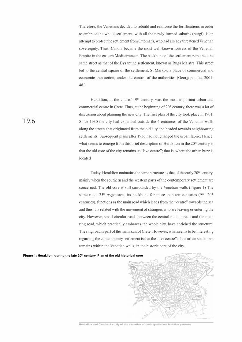
concerned. The old core is still surrounded by the Venetian walls (Figure 1) The
same road, 25th Avgoustou, its backbone for more than ten centuries (9th –20th
centuries), functions as the main road which leads from the “centre” towards the sea
and thus it is related with the movement of strangers who are leaving or entering the
city. However, small circular roads between the central radial streets and the main
ring road, which practically embraces the whole city, have enriched the structure.
The ring road is part of the main axis of Crete. However, what seems to be interesting
regarding the contemporary settlement is that the “live centre” of the urban settlement
remains within the Venetian walls, in the historic core of the city.
Figure 1: Heraklion, during the late 20th century. Plan of the old historical core
19.7
Proceedings . 4th International Space Syntax Symposium London 2003
As for the economic aspects of Heraklion , it emerges that trade activities
were the dominant economic resources of its population. Therefore, from the 15th to
the 17th century, there were a variety of people engaged with the trade. According to
the census of 1961, 59.2% of the active population in Heraklion is employed in this
sector of the economy, which includes both trade activities and administration.7
During 20th century its population has increased significantly compared to all the
other major cities of Crete.8 Today, retail shops and administrative buildings are
within the old core of the city, which appears to remain its “live centre”.
If we now turn to the second case study, Chania. Today, Chania is the main
economic and administrative centre in the larger area of western Crete. However
according to research conducted in 1977, the society of Chania and its larger area
was identified by its stability.9 The limited retail activities reinforced the image of
the city as the transitional point between the surrounding countryside and larger
settlements.
The historical evolution of Chania originates from the first Byzantine Period
(330-823a.C.). However, until 1211, despite the fact that Chania was an existing
settlement it was of minor importance, and thus there are not enough historical records
about the settlement. In 1252 the Venetians rebuilt and fortified the settlement by
reinforcing the existing fortress of Kasteli, the first core of the settlement. During
the 16th century new walls were built along the coast and the southern part of the
settlement, being identified as settlement’s main spatial components. They encircled
three identifiable areas; the central area of the ancient acropolis (Kasteli) embraced
by the old walls, the Venetian harbour and the dense residential areas to the south-
west and south-east. Therefore, the spatial pattern of the settlement emerges as a
bunch of main streets orientated towards the harbour and a small number of
disproportional squares (the squares that do not have a clear geometrical shape).
The main road (Ruga Maistra) originated from the harbour and led to the south
outside the walled city. A major square formed around a public fountain south of the
Venetian harbour. In Chania, the administrative buildings were clearly separated
from what were the main activities of the city, that is, the marketplace, the squares
and the public fountain (Georgopoulou, 2001).
In 1898, the authorities decided to destroy the northwestern part of the
Venetians walls. In 1901 the new plan of the city decided the expansion of the city
outside the walls, and thus the demolition of the southern walls. The new plan led to
the development of new streets which connected the “inside” settlement with the
developing “outside” one. The municipal food market was built on the south edge of
the old walled city, leading to the demolition of another part of the wall. Apparently,
when there was need for defending the sovereignty of Venetian rule, the settlement

Heraklion and Chania: A study of the evolution of their spatial and function patterns
19.8
followed the rules of growth and expanded outside the walls.
Today, Chania’s historical core retains only part of the original structure due
to the bombing of the city in 1941 and the partially applied plan of 1947, which
suggested the complete transformation of the existing urban structure. (Figure 2)
The historical core is not an identifiable walled city. Its function as tourist attraction
can be traced back to 1967, when another research suggested the maintenance of the
old urban structure and the restoration of all its monuments in an attempt to develop
it as a tourist attraction.10 Thus, at that time the answer to the socio-economic stability,
which the research conducted in 1977 pinpointed, was the development of the old
core of the settlement as a tourist attraction. Hence, Chania has followed the rules
under which other historical cities have grown, having its “live centre”, completely
separated from the old historical core. The latter has become a “live museum”
entailing all the functions and cultural events bound to this concept.
However, the study’s initial hypothesis suggests that Heraklion and Chania
differ in terms of their spatial structure, that is the morphology of the grid. This
difference is related to what is known about the distribution of land uses and appears
to be a more powerful reason for their different functional patterns today. For this
study the morphology of the grid is analysed configurationally through the axial
analysis. Hence, the latter will reveal each city’s spatial pattern.
5. Spatial Analysis
Comparing the axial maps of Heraklion and Chania throughout their evolution proc-
ess, it emerges immediately that these differ geometrically, especially regarding the
maps of 20th century, that is 1936 and 1947, or 1960 and 1963 and lastly 1990.
Heraklion’s axial models appear to be more “radial” than Chania’s models which
appear to be “ griddy”.11 (Figures 3 and 4)
Figure 2: Chania in 1990. The street pattern of the old historical city

19.9
Proceedings . 4th International Space Syntax Symposium London 2003
Figure 3: The growth of HERAKLION
Figure 4: The growth of CHANIA
Heraklion and Chania: A study of the evolution of their spatial and function patterns
19.10
All the axial maps of Heraklion comprise short lines, which end on other
lines, and this is found both locally and globally. The longest lines begin from the
historic core and head outwards. The contemporary settlement seems to have grown
under the same rules as those which formed the old city. Thus, the axial lines outside
the old core have similar geometrical features to those of the old core. However, the
latter has a weak connection with the surrounding grid. Thus, the “old” and the
“new” grid are mainly connected through three different lines. Comparing the axial
maps of Heraklion, one can notice that between 1960 and 1990 the grid is intensi-
fied in almost all areas.
The axial maps of Chania consist of a number of parallel long lines, passing
through each other. These lines form the grid mainly just outside the historical core.
This area of the grid has a strict right angle of intersection. The historical core of
Chania maintains some of its structural elements throughout the historical process
of evolution. It comprises shorter lines than the grid just outside of it, with less of a
right angle of intersection. However the grid of this old core appears to be well
connected with the grid of the new city, through two strong lines that practically
cross the structure of the old core, having a north-south orientation. The geometric
difference between the axial maps of Heraklion and Chania reflects the syntactic
differences as they emerge to the syntactic analysis of this study.
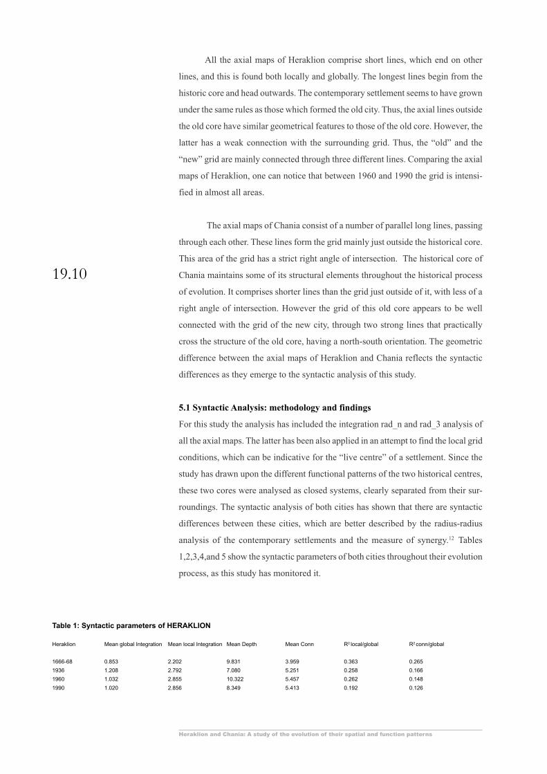
5.1 Syntactic Analysis: methodology and findings
For this study the analysis has included the integration rad_n and rad_3 analysis of
all the axial maps. The latter has been also applied in an attempt to find the local grid
conditions, which can be indicative for the “live centre” of a settlement. Since the
study has drawn upon the different functional patterns of the two historical centres,
these two cores were analysed as closed systems, clearly separated from their sur-
roundings. The syntactic analysis of both cities has shown that there are syntactic
differences between these cities, which are better described by the radius-radius
analysis of the contemporary settlements and the measure of synergy.12 Tables
1,2,3,4,and 5 show the syntactic parameters of both cities throughout their evolution
process, as this study has monitored it.
Heraklion Mean global Integration Mean local Integration Mean Depth Mean Conn R2 local/global R2 conn/global
1666-68 0.853 2.202 9.831 3.959 0.363 0.265
1936 1.208 2.792 7.080 5.251 0.258 0.166
1960 1.032 2.855 10.322 5.457 0.262 0.148
1990 1.020 2.856 8.349 5.413 0.192 0.126
Table 1: Syntactic parameters of HERAKLION
19.11
Proceedings . 4th International Space Syntax Symposium London 2003
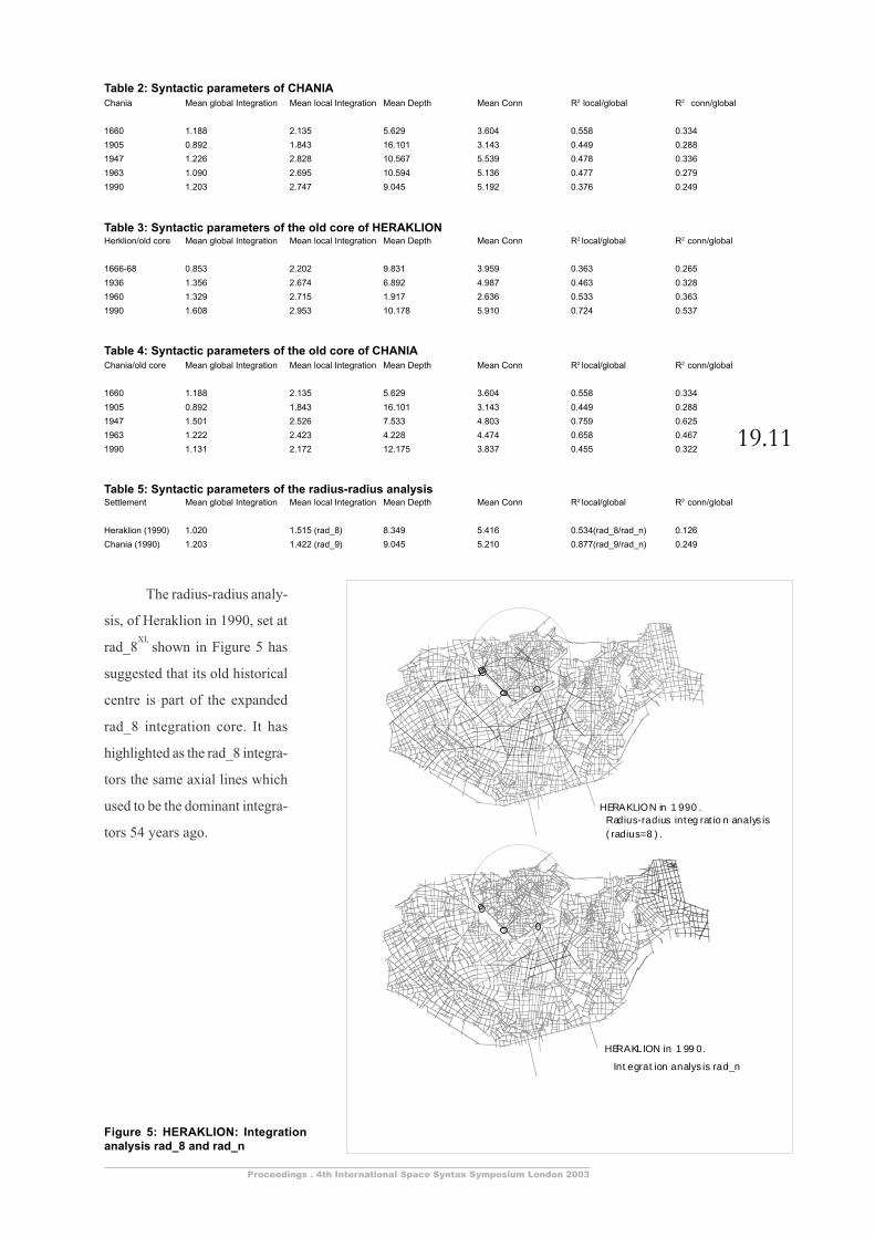
Chania Mean global Integration Mean local Integration Mean Depth Mean Conn R2 local/global R2 conn/global
1660 1.188 2.135 5.629 3.604 0.558 0.334
1905 0.892 1.843 16.101 3.143 0.449 0.288
1947 1.226 2.828 10.567 5.539 0.478 0.336
1963 1.090 2.695 10.594 5.136 0.477 0.279
1990 1.203 2.747 9.045 5.192 0.376 0.249
Table 2: Syntactic parameters of CHANIA
Herklion/old core Mean global Integration Mean local Integration Mean Depth Mean Conn R2 local/global R2 conn/global
1666-68 0.853 2.202 9.831 3.959 0.363 0.265
1936 1.356 2.674 6.892 4.987 0.463 0.328
1960 1.329 2.715 1.917 2.636 0.533 0.363
1990 1.608 2.953 10.178 5.910 0.724 0.537
Table 3: Syntactic parameters of the old core of HERAKLION
Chania/old core Mean global Integration Mean local Integration Mean Depth Mean Conn R2 local/global R2 conn/global
1660 1.188 2.135 5.629 3.604 0.558 0.334
1905 0.892 1.843 16.101 3.143 0.449 0.288
1947 1.501 2.526 7.533 4.803 0.759 0.625
1963 1.222 2.423 4.228 4.474 0.658 0.467
1990 1.131 2.172 12.175 3.837 0.455 0.322
Table 4: Syntactic parameters of the old core of CHANIA
Settlement Mean global Integration Mean local Integration Mean Depth Mean Conn R2 local/global R2 conn/global
Heraklion (1990) 1.020 1.515 (rad_8) 8.349 5.416 0.534(rad_8/rad_n) 0.126
Chania (1990) 1.203 1.422 (rad_9) 9.045 5.210 0.877(rad_9/rad_n) 0.249
Table 5: Syntactic parameters of the radius-radius analysis
HERAKLION in 1 990 . Radius-radius integ rat io n analys is ( radius=8 ) .
HERAKLION in 1 99 0.
Int egrat ion analys is rad_n
The radius-radius analy-
sis, of Heraklion in 1990, set at
rad_8XI,
shown in Figure 5 has
suggested that its old historical
centre is part of the expanded
rad_8 integration core. It has
highlighted as the rad_8 integra-
tors the same axial lines which
used to be the dominant integra-
tors 54 years ago.
Figure 5: HERAKLION: Integrationanalysis rad_8 and rad_n
Heraklion and Chania: A study of the evolution of their spatial and function patterns
19.12
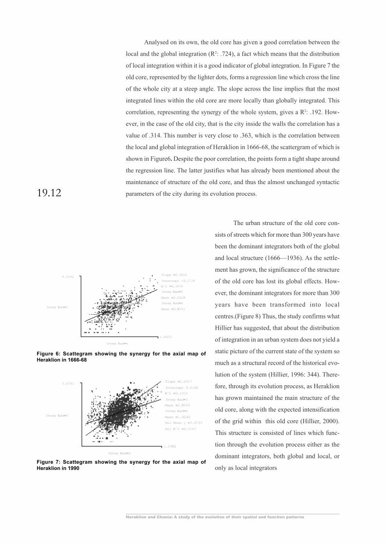
Analysed on its own, the old core has given a good correlation between the
local and the global integration (R2: .724), a fact which means that the distribution
of local integration within it is a good indicator of global integration. In Figure 7 the
old core, represented by the lighter dots, forms a regression line which cross the line
of the whole city at a steep angle. The slope across the line implies that the most
integrated lines within the old core are more locally than globally integrated. This
correlation, representing the synergy of the whole system, gives a R2: .192. How-
ever, in the case of the old city, that is the city inside the walls the correlation has a
value of .314. This number is very close to .363, which is the correlation between
the local and global integration of Heraklion in 1666-68, the scattergram of which is
shown in Figure6. Despite the poor correlation, the points form a tight shape around
the regression line. The latter justifies what has already been mentioned about the
maintenance of structure of the old core, and thus the almost unchanged syntactic
parameters of the city during its evolution process.
Figure 7: Scattegram showing the synergy for the axial map ofHeraklion in 1990
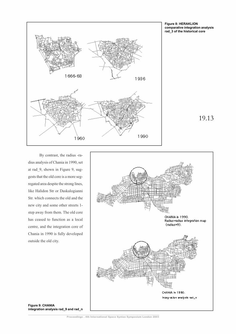
The urban structure of the old core con-
sists of streets which for more than 300 years have
been the dominant integrators both of the global
and local structure (1666—1936). As the settle-
ment has grown, the significance of the structure
of the old core has lost its global effects. How-
ever, the dominant integrators for more than 300
years have been transformed into local
centres.(Figure 8) Thus, the study confirms what
Hillier has suggested, that about the distribution
of integration in an urban system does not yield a
static picture of the current state of the system so
much as a structural record of the historical evo-
lution of the system (Hillier, 1996: 344). There-
fore, through its evolution process, as Heraklion
has grown maintained the main structure of the
old core, along with the expected intensification
of the grid within this old core (Hillier, 2000).
This structure is consisted of lines which func-
tion through the evolution process either as the
dominant integrators, both global and local, or
only as local integrators
Figure 6: Scattegram showing the synergy for the axial map ofHeraklion in 1666-68
19.13
Proceedings . 4th International Space Syntax Symposium London 2003
Figure 8: HERAKLIONcomparative integration analysisrad_3 of the historical core
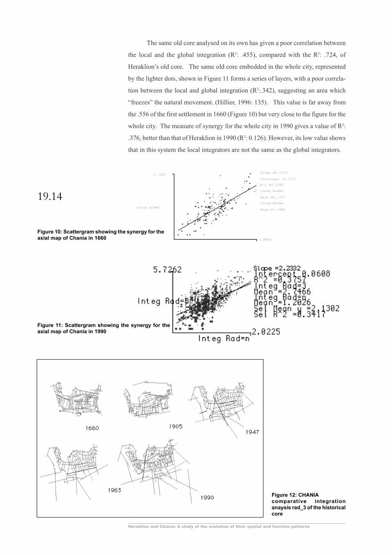
By contrast, the radius -ra-
dius analysis of Chania in 1990, set
at rad_9, shown in Figure 9, sug-
gests that the old core is a more seg-
regated area despite the strong lines,
like Halidon Str or Daskalogianni
Str. which connects the old and the
new city and some other streets 1-
step away from them. The old core
has ceased to function as a local
centre, and the integration core of
Chania in 1990 is fully developed
outside the old city.
Figure 9: CHANIAintegration analysis rad_9 and rad_n
Heraklion and Chania: A study of the evolution of their spatial and function patterns
19.14
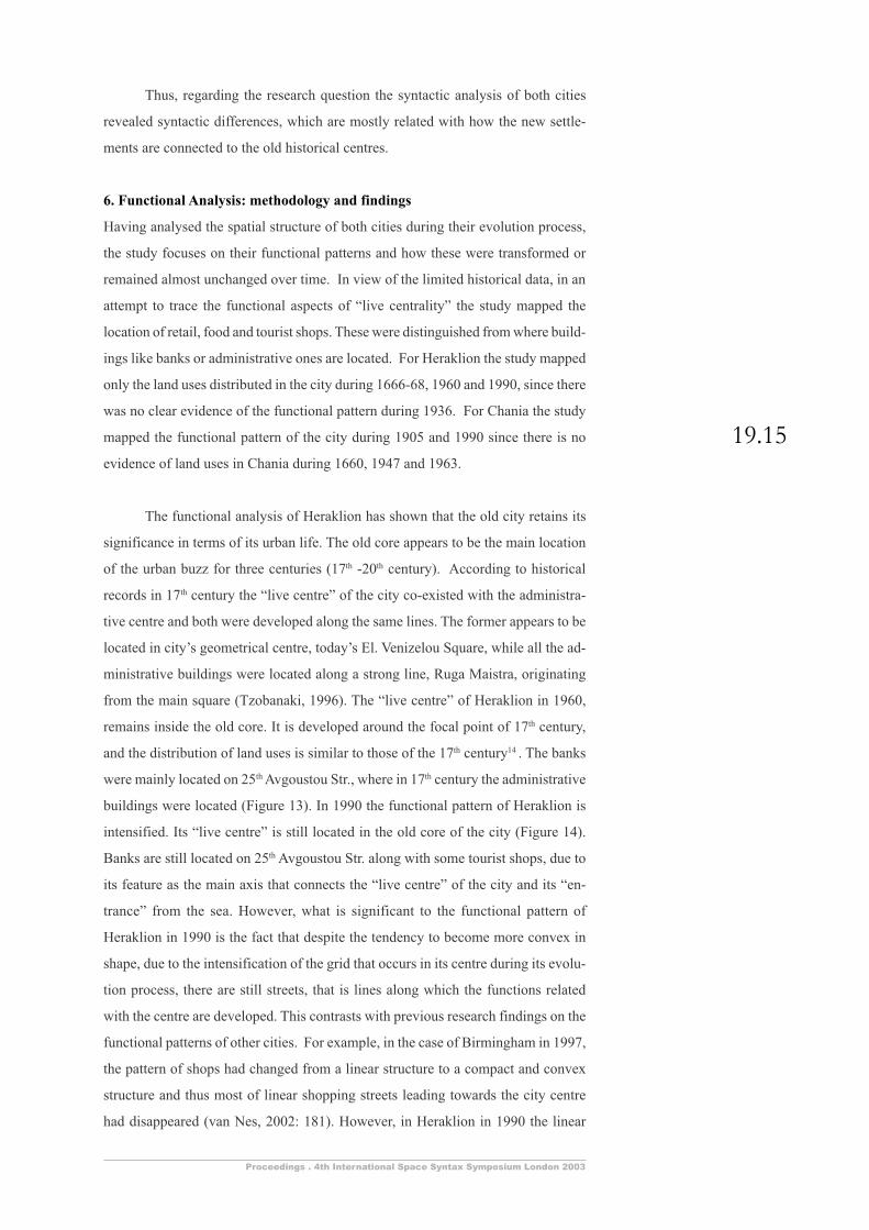
The same old core analysed on its own has given a poor correlation between
the local and the global integration (R2: .455), compared with the R2: .724, of
Heraklion’s old core. The same old core embedded in the whole city, represented
by the lighter dots, shown in Figure 11 forms a series of layers, with a poor correla-
tion between the local and global integration (R2:.342), suggesting an area which
“freezes” the natural movement. (Hillier, 1996: 135). This value is far away from
the .556 of the first settlement in 1660 (Figure 10) but very close to the figure for the
whole city. The measure of synergy for the whole city in 1990 gives a value of R2:
.376, better than that of Heraklion in 1990 (R2: 0.126). However, its low value shows
that in this system the local integrators are not the same as the global integrators.
Figure 10: Scattergram showing the synergy for theaxial map of Chania in 1660
Figure 11: Scattergram showing the synergy for theaxial map of Chania in 1990
Figure 12: CHANIAcomparative integrationanaysis rad_3 of the historicalcore
19.15
Proceedings . 4th International Space Syntax Symposium London 2003
Thus, regarding the research question the syntactic analysis of both cities
revealed syntactic differences, which are mostly related with how the new settle-
ments are connected to the old historical centres.
6. Functional Analysis: methodology and findings
Having analysed the spatial structure of both cities during their evolution process,
the study focuses on their functional patterns and how these were transformed or
remained almost unchanged over time. In view of the limited historical data, in an
attempt to trace the functional aspects of “live centrality” the study mapped the
location of retail, food and tourist shops. These were distinguished from where build-
ings like banks or administrative ones are located. For Heraklion the study mapped
only the land uses distributed in the city during 1666-68, 1960 and 1990, since there
was no clear evidence of the functional pattern during 1936. For Chania the study
mapped the functional pattern of the city during 1905 and 1990 since there is no
evidence of land uses in Chania during 1660, 1947 and 1963.
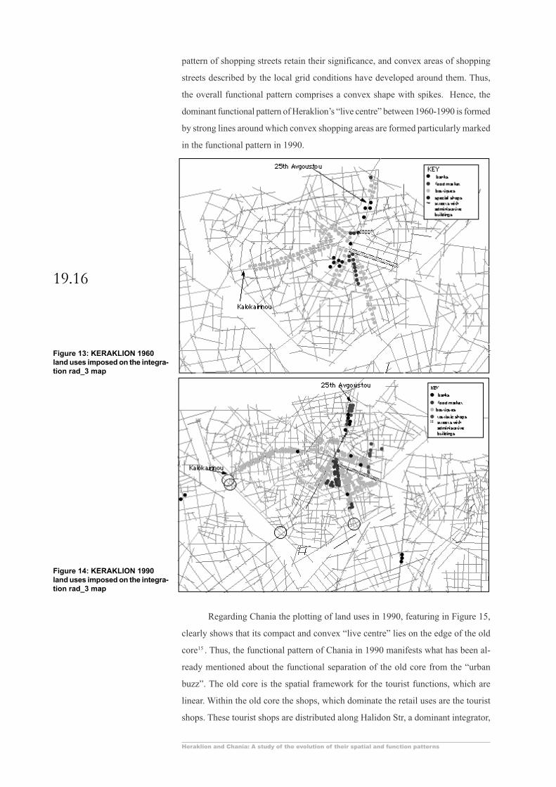
The functional analysis of Heraklion has shown that the old city retains its
significance in terms of its urban life. The old core appears to be the main location
of the urban buzz for three centuries (17th -20th century). According to historical
records in 17th century the “live centre” of the city co-existed with the administra-
tive centre and both were developed along the same lines. The former appears to be
located in city’s geometrical centre, today’s El. Venizelou Square, while all the ad-
ministrative buildings were located along a strong line, Ruga Maistra, originating
from the main square (Tzobanaki, 1996). The “live centre” of Heraklion in 1960,
remains inside the old core. It is developed around the focal point of 17th century,
and the distribution of land uses is similar to those of the 17th century14 . The banks
were mainly located on 25th Avgoustou Str., where in 17th century the administrative
buildings were located (Figure 13). In 1990 the functional pattern of Heraklion is
intensified. Its “live centre” is still located in the old core of the city (Figure 14).
Banks are still located on 25th Avgoustou Str. along with some tourist shops, due to
its feature as the main axis that connects the “live centre” of the city and its “en-
trance” from the sea. However, what is significant to the functional pattern of
Heraklion in 1990 is the fact that despite the tendency to become more convex in
shape, due to the intensification of the grid that occurs in its centre during its evolu-
tion process, there are still streets, that is lines along which the functions related
with the centre are developed. This contrasts with previous research findings on the
functional patterns of other cities. For example, in the case of Birmingham in 1997,
the pattern of shops had changed from a linear structure to a compact and convex
structure and thus most of linear shopping streets leading towards the city centre
had disappeared (van Nes, 2002: 181). However, in Heraklion in 1990 the linear
Heraklion and Chania: A study of the evolution of their spatial and function patterns
19.16
pattern of shopping streets retain their significance, and convex areas of shopping
streets described by the local grid conditions have developed around them. Thus,
the overall functional pattern comprises a convex shape with spikes. Hence, the
dominant functional pattern of Heraklion’s “live centre” between 1960-1990 is formed
by strong lines around which convex shopping areas are formed particularly marked
in the functional pattern in 1990.
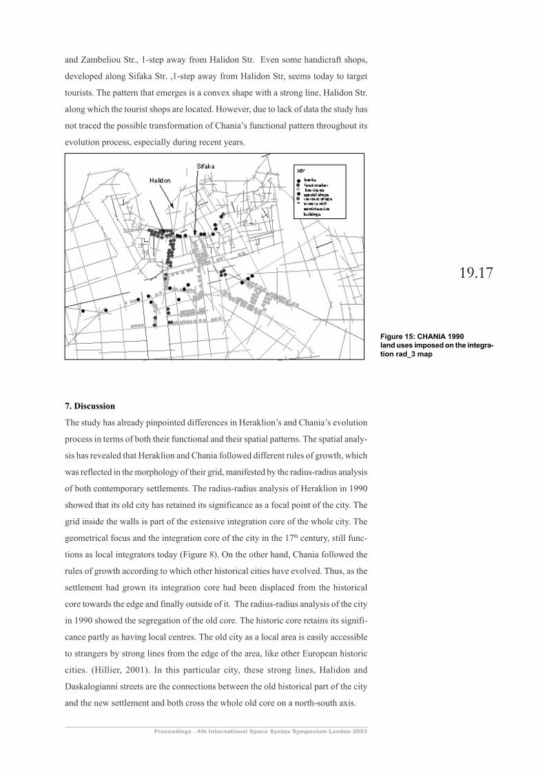
Regarding Chania the plotting of land uses in 1990, featuring in Figure 15,
clearly shows that its compact and convex “live centre” lies on the edge of the old
core15 . Thus, the functional pattern of Chania in 1990 manifests what has been al-
ready mentioned about the functional separation of the old core from the “urban
buzz”. The old core is the spatial framework for the tourist functions, which are
linear. Within the old core the shops, which dominate the retail uses are the tourist
shops. These tourist shops are distributed along Halidon Str, a dominant integrator,
Figure 13: KERAKLION 1960land uses imposed on the integra-tion rad_3 map
Figure 14: KERAKLION 1990land uses imposed on the integra-tion rad_3 map
19.17
Proceedings . 4th International Space Syntax Symposium London 2003
and Zambeliou Str., 1-step away from Halidon Str. Even some handicraft shops,
developed along Sifaka Str. ,1-step away from Halidon Str, seems today to target
tourists. The pattern that emerges is a convex shape with a strong line, Halidon Str.
along which the tourist shops are located. However, due to lack of data the study has
not traced the possible transformation of Chania’s functional pattern throughout its
evolution process, especially during recent years.
7. Discussion
The study has already pinpointed differences in Heraklion’s and Chania’s evolution
process in terms of both their functional and their spatial patterns. The spatial analy-
sis has revealed that Heraklion and Chania followed different rules of growth, which
was reflected in the morphology of their grid, manifested by the radius-radius analysis
of both contemporary settlements. The radius-radius analysis of Heraklion in 1990
showed that its old city has retained its significance as a focal point of the city. The
grid inside the walls is part of the extensive integration core of the whole city. The
geometrical focus and the integration core of the city in the 17th century, still func-
tions as local integrators today (Figure 8). On the other hand, Chania followed the
rules of growth according to which other historical cities have evolved. Thus, as the
settlement had grown its integration core had been displaced from the historical
core towards the edge and finally outside of it. The radius-radius analysis of the city
in 1990 showed the segregation of the old core. The historic core retains its signifi-
cance partly as having local centres. The old city as a local area is easily accessible
to strangers by strong lines from the edge of the area, like other European historic
cities. (Hillier, 2001). In this particular city, these strong lines, Halidon and
Daskalogianni streets are the connections between the old historical part of the city
and the new settlement and both cross the whole old core on a north-south axis.
Figure 15: CHANIA 1990land uses imposed on the integra-tion rad_3 map
Heraklion and Chania: A study of the evolution of their spatial and function patterns
19.18
Both spatial patterns have been suggestive for the different functional pat-
terns, mapped in Figure 13, 14 and 15. The functional pattern of Heraklion during
the decades from the 1960s to the 1990s describes the old core as the place where
the urban buzz is located. Hence, in 1990 the main shopping streets are found inside
the walled city, forming a convex shape attached to which other shopping areas are
developed along lines. Unlike other historical cities, Heraklion retains its historical
core as its main functional core, that is, its “live centre”. The functional core that is
strongly associated with natural movement was described by the rad_8 analysis of
Heraklion in 1990, which showed the main grid of the old city as comprising domi-
nant integrators. Unlike Heraklion, Chania’s functional pattern showed that its “live
centre” is located on the edge of the old core. The old core, having an historical
significance, functions as an attraction for visitors. The rad_9 analysis of the city
showed that the old core is clearly separated from the integration core. This true-to
life spatial pattern seems to have been very suggestive for the functional and current
movement patterns of the city.
8. Conclusions
Despite the similar historical process by which these two cities were formed, their
evolution appears to have led to different spatial and functional patterns. Heraklion
and Chania differ in terms of the size of their historic core. Heraklion’s old core
comprises a substantial part of the settlement as a whole. Its significance in terms of
the function of the whole city can be traced to the intensification and density of its
grid, which have taken place during the last decades. However, despite its size and
density, the historic core is not well connected with the settlement as a whole. The
latter reaches the old city through four lines, which are not very strong. By contrast
Chania’s historical city is a small part of the contemporary settlement, which has
been expanded significantly during the20th century. The morphology of the grid of
the old core is clearly different from that of the new part of the city. The historical
city is connected to the new city through two strong lines, which practically cross
the old core on the north-south axis. As a conclusion, this study suggests that it is its
size, its density, and its connections to the new city that have enabled Heraklion’s
historical core to function as a “city within a city”. For the same reasons, Chania’s
historical core is a local area of the city which, because of its significance in terms
of its historical evolution, functions as an attraction both for the inhabitants and the
strangers.
19.19
Proceedings . 4th International Space Syntax Symposium London 2003
Notes1 For this study the urban grid is the pattern of public space linking the buildings of the settlements.2 The axial map is the longest and fewest lines of direct movement that pass through all the open, public
space of one settlement and makes all the connections (Hillier, 2001).3 The source of this map is the original plan der Festung Candia gezeichner in den Jahren 1666-68 von
Generallieutenant Hans Rudolf Werdmuller, Library of Zurich. The information about the map are pro-
vided in Steriotou (1998)4 Fr Collignon: Fifteen plans of fortifications in Candia(Catalogue of the printed map) 1660, map sur-
veyed by W. Chapman, Chanea, or Khania; both found in Kalligas and Romanos (1977).5 For more details about the reports mentioned, see References.6 For more details about the research see References7 The details about the census of 1961 for the city of Heraklion are found in the research conducted by A.
Proveleggios in 1966 for Heraklion.8 See Perdikoiganni, 2002, Unpublished MSc Thesis9 Kalligas and Romanos (1977)10 The details of the findings of this research carried out by Argiropoulos and Tritsis, were found in
Kalligas and Romanos (1977)11 The terms “radial” and “griddy” describe the urban grid of each city comparing to an ideal orthogonal
grid.12 The measure of synergy describes the correlation between the local and the global integration of a
system and it is expressed by a scattegram showing the degree of this correlation.13 The radius-radius analysis was set at the mean depth of the whole system from the main integrator,
shown in Table 1.14 Proveleggios, (1966)15 Kalligas and Romanos, (1977)
References
Georgopoulou, M., 2001, Venice’s Mediterranean Colonies. Architecture and Urbanism, Cambridge,
Cambridge University Press
Hillier, B., 1996, Space is the Machine, Cambridge, Cambridge University Press,
Hillier, B. and Penn, A., 1992, “Dense Civilisations: the shape of cities in the 21st century”, Applied
Energy, 43, pp. 41-66
Hillier, B., Penn, A., Hanson, J., Grajewski, T. and Xu, J., 1993, “Natural movement: or configuration
and attraction in urban pedestrian movement”, Environment & Planning B: Planning & Design,
20, 29-66
Hillier, B., 1996, “Cities as movement economies”, Urban Design International, 1, 49-60
Hillier, B., 1999, “The hidden geometry of deformed grids: or, why space syntax works, when it looks as
though it shouldn’t”, Environment & Planning B: Planning & Design, 26, 169-191
Hillier, B., 2000, “Centrality as a process: accounting for attraction inequalities in deformed grids”,
Urban Design International, 3/4, 107-127
Hillier, B., 2001, “A theory of the city as object: or, how spatial laws mediate the social construction of
urban space”, Proceedings of the Third International Symposium on Space Syntax, Georgia
Institute of Technology, Atlanta, U. S. A., 2.01-2.28
Kalligas, A. S. and Romanos, A. G., 1977, (The Medieval City of Chania, Study of preservation of the city
of Chania)*, Athens
Karimi, K., 1998, “Continuity and Change in Old Cities: an analytical investigation of the spatial structure
in Iranian and English historic cities before and after modernisation”, PhD Thesis, University of
London
Ministry of Environment of Greece, 1998, (Study of Modification of the approved plan of the larger area
of Heraklion and the Boroughs of Gazi and of Alikarnassos)*, Athens
Perdikoiganni, I., 2002, “Heraklion-Chania: A study of the evolution of its spatial and functional pat
terns”, The Bartlett School of Graduate Studies, UCL, Unpublished MSc Thesis
Heraklion and Chania: A study of the evolution of their spatial and function patterns
19.20
Proveleggios, A., 1966, (Preliminary Study of regulative plan of Heraklion)*, Athens
Steriotou, I., 1998, (The Venetian Walls of Chandakas (the 16th and 17th centuries). An account of their
construction according to Venetian archival sources)*, Vikelaia Municipal Library, Borough of
Heraklion, Heraklion
Tzobanaki, C., 1996, (Chandakas. The city and the walls.)*, Etairia Kritikon Istorikon Meleton,
Heraklion
van Nes, A., 2002, “Road Building and Urban Change. The effect of ring roads on the dispersal of
shop and retail in Western European towns and cities”, PhD Thesis, University of London
* Title originally in Greek, translated by the author