header section description | - ddd.uab.cat · pdf file| | repeated for each satellite present...
TRANSCRIPT

+----------------------------------------------------------------------------+ | | | GPS NAVIGATION MESSAGE FILE - HEADER SECTION DESCRIPTION | +--------------------+------------------------------------------+------------+ | HEADER LABEL | DESCRIPTION | FORMAT | | (Columns 61-80) | | | +--------------------+------------------------------------------+------------+ |RINEX VERSION / TYPE| - Format version (2.10) | F9.2,11X, | | | - File type ('N' for Navigation data) | A1,19X | +--------------------+------------------------------------------+------------+ |PGM / RUN BY / DATE | - Name of program creating current file | A20, | | | - Name of agency creating current file | A20, | | | - Date of file creation | A20 | +--------------------+------------------------------------------+------------+*|COMMENT | Comment line(s) | A60 |* +--------------------+------------------------------------------+------------+*|ION ALPHA | Ionosphere parameters A0-A3 of almanac | 2X,4D12.4 |* | | (page 18 of subframe 4) | | +--------------------+------------------------------------------+------------+*|ION BETA | Ionosphere parameters B0-B3 of almanac | 2X,4D12.4 |* +--------------------+------------------------------------------+------------+*|DELTA-UTC: A0,A1,T,W| Almanac parameters to compute time in UTC| 3X,2D19.12,|* | | (page 18 of subframe 4) | 2I9 | | | A0,A1: terms of polynomial | | | | T : reference time for UTC data | *) | | | W : UTC reference week number. | | | | Continuous number, not mod(1024)! | | +--------------------+------------------------------------------+------------+*|LEAP SECONDS | Delta time due to leap seconds | I6 |* +--------------------+------------------------------------------+------------+ |END OF HEADER | Last record in the header section. | 60X | +--------------------+------------------------------------------+------------+
Records marked with * are optional
+----------------------------------------------------------------------------+ | | | GPS NAVIGATION MESSAGE FILE - DATA RECORD DESCRIPTION | +--------------------+------------------------------------------+------------+ | OBS. RECORD | DESCRIPTION | FORMAT | +--------------------+------------------------------------------+------------+ |PRN / EPOCH / SV CLK| - Satellite PRN number | I2, | | | - Epoch: Toc - Time of Clock | | | | year (2 digits, padded with 0 | | | | if necessary) | 1X,I2.2, | | | month | 1X,I2, | | | day | 1X,I2, | | | hour | 1X,I2, | | | minute | 1X,I2, | | | second | F5.1, | | | - SV clock bias (seconds) | 3D19.12 | | | - SV clock drift (sec/sec) | | | | - SV clock drift rate (sec/sec2) | *) | +--------------------+------------------------------------------+------------+ | BROADCAST ORBIT - 1| - IODE Issue of Data, Ephemeris | 3X,4D19.12 | | | - Crs (meters) | | | | - Delta n (radians/sec) | | | | - M0 (radians) | | +--------------------+------------------------------------------+------------+ | BROADCAST ORBIT - 2| - Cuc (radians) | 3X,4D19.12 | | | - e Eccentricity | | | | - Cus (radians) | | | | - sqrt(A) (sqrt(m)) | | +--------------------+------------------------------------------+------------+ | BROADCAST ORBIT - 3| - Toe Time of Ephemeris | 3X,4D19.12 | | | (sec of GPS week) | | | | - Cic (radians) | |
Página 1
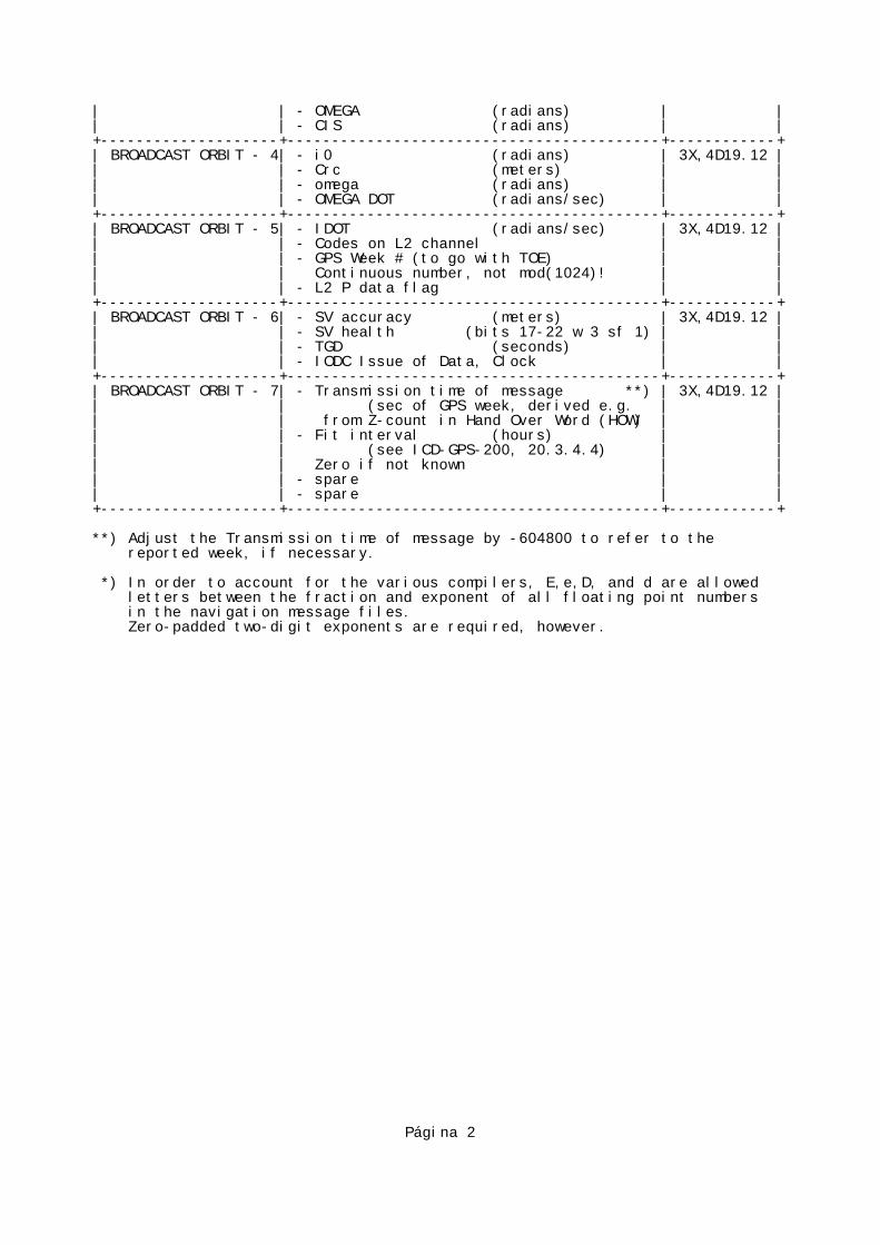
| | - OMEGA (radians) | | | | - CIS (radians) | | +--------------------+------------------------------------------+------------+ | BROADCAST ORBIT - 4| - i0 (radians) | 3X,4D19.12 | | | - Crc (meters) | | | | - omega (radians) | | | | - OMEGA DOT (radians/sec) | | +--------------------+------------------------------------------+------------+ | BROADCAST ORBIT - 5| - IDOT (radians/sec) | 3X,4D19.12 | | | - Codes on L2 channel | | | | - GPS Week # (to go with TOE) | | | | Continuous number, not mod(1024)! | | | | - L2 P data flag | | +--------------------+------------------------------------------+------------+ | BROADCAST ORBIT - 6| - SV accuracy (meters) | 3X,4D19.12 | | | - SV health (bits 17-22 w 3 sf 1) | | | | - TGD (seconds) | | | | - IODC Issue of Data, Clock | | +--------------------+------------------------------------------+------------+ | BROADCAST ORBIT - 7| - Transmission time of message **) | 3X,4D19.12 | | | (sec of GPS week, derived e.g. | | | | from Z-count in Hand Over Word (HOW) | | | | - Fit interval (hours) | | | | (see ICD-GPS-200, 20.3.4.4) | | | | Zero if not known | | | | - spare | | | | - spare | | +--------------------+------------------------------------------+------------+
**) Adjust the Transmission time of message by -604800 to refer to the reported week, if necessary.
*) In order to account for the various compilers, E,e,D, and d are allowed letters between the fraction and exponent of all floating point numbers in the navigation message files. Zero-padded two-digit exponents are required, however.
Página 2

+----------------------------------------------------------------------------+ | | | GPS OBSERVATION DATA FILE - HEADER SECTION DESCRIPTION | +--------------------+------------------------------------------+------------+ | HEADER LABEL | DESCRIPTION | FORMAT | | (Columns 61-80) | | | +--------------------+------------------------------------------+------------+ |RINEX VERSION / TYPE| - Format version (2.10) | F9.2,11X, | | | - File type ('O' for Observation Data) | A1,19X, | | | - Satellite System: blank or 'G': GPS | A1,19X | | | 'R': GLONASS | | | | 'S': Geostationary | | | | signal payload | | | | 'T': NNSS Transit | | | | 'M': Mixed | | +--------------------+------------------------------------------+------------+ |PGM / RUN BY / DATE | - Name of program creating current file | A20, | | | - Name of agency creating current file | A20, | | | - Date of file creation | A20 | +--------------------+------------------------------------------+------------+*|COMMENT | Comment line(s) | A60 |* +--------------------+------------------------------------------+------------+ |MARKER NAME | Name of antenna marker | A60 | +--------------------+------------------------------------------+------------+*|MARKER NUMBER | Number of antenna marker | A20 |* +--------------------+------------------------------------------+------------+ |OBSERVER / AGENCY | Name of observer / agency | A20,A40 | +--------------------+------------------------------------------+------------+ |REC # / TYPE / VERS | Receiver number, type, and version | 3A20 | | | (Version: e.g. Internal Software Version)| | +--------------------+------------------------------------------+------------+ |ANT # / TYPE | Antenna number and type | 2A20 | +--------------------+------------------------------------------+------------+ |APPROX POSITION XYZ | Approximate marker position (WGS84) | 3F14.4 | +--------------------+------------------------------------------+------------+ |ANTENNA: DELTA H/E/N| - Antenna height: Height of bottom | 3F14.4 | | | surface of antenna above marker | | | | - Eccentricities of antenna center | | | | relative to marker to the east | | | | and north (all units in meters) | | +--------------------+------------------------------------------+------------+ |WAVELENGTH FACT L1/2| - Default wavelength factors for | | | | L1 and L2 | 2I6, | | | 1: Full cycle ambiguities | | | | 2: Half cycle ambiguities (squaring) | | | | 0 (in L2): Single frequency instrument | | | | | | | | - zero or blank | I6 | | | | | | | The default wavelength factor line is | | | | required and must preceed satellite- | | | | specific lines. | | +--------------------+------------------------------------------+------------+*|WAVELENGTH FACT L1/2| - Wavelength factors for L1 and L2 | 2I6, |* | | 1: Full cycle ambiguities | | | | 2: Half cycle ambiguities (squaring) | | | | 0 (in L2): Single frequency instrument | | | | - Number of satellites to follow in list | I6, | | | for which these factors are valid. | | | | - List of PRNs (satellite numbers with | 7(3X,A1,I2)| | | system identifier) | | | | | | | | These opional satellite specific lines | | | | may follow, if they identify a state | | | | different from the default values. | | | | | | | | Repeat record if necessary. | | +--------------------+------------------------------------------+------------+ |# / TYPES OF OBSERV | - Number of different observation types | I6, |
Página 1
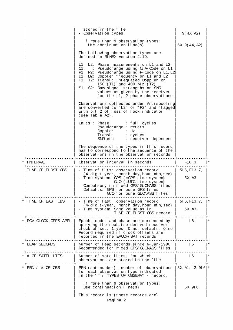
| | stored in the file | | | | - Observation types | 9(4X,A2) | | | | | | | If more than 9 observation types: | | | | Use continuation line(s) |6X,9(4X,A2) | | | | | | | The following observation types are | | | | defined in RINEX Version 2.10: | | | | | | | | L1, L2: Phase measurements on L1 and L2 | | | | C1 : Pseudorange using C/A-Code on L1 | | | | P1, P2: Pseudorange using P-Code on L1,L2| | | | D1, D2: Doppler frequency on L1 and L2 | | | | T1, T2: Transit Integrated Doppler on | | | | 150 (T1) and 400 MHz (T2) | | | | S1, S2: Raw signal strengths or SNR | | | | values as given by the receiver | | | | for the L1,L2 phase observations | | | | | | | | Observations collected under Antispoofing| | | | are converted to "L2" or "P2" and flagged| | | | with bit 2 of loss of lock indicator | | | | (see Table A2). | | | | | | | | Units : Phase : full cycles | | | | Pseudorange : meters | | | | Doppler : Hz | | | | Transit : cycles | | | | SNR etc : receiver-dependent | | | | | | | | The sequence of the types in this record | | | | has to correspond to the sequence of the | | | | observations in the observation records | | +--------------------+------------------------------------------+------------+*|INTERVAL | Observation interval in seconds | F10.3 |* +--------------------+------------------------------------------+------------+ |TIME OF FIRST OBS | - Time of first observation record | 5I6,F13.7, | | | (4-digit-year, month,day,hour,min,sec) | | | | - Time system: GPS (=GPS time system) | 5X,A3 | | | GLO (=UTC time system) | | | | Compulsory in mixed GPS/GLONASS files | | | | Defaults: GPS for pure GPS files | | | | GLO for pure GLONASS files | | +--------------------+------------------------------------------+------------+*|TIME OF LAST OBS | - Time of last observation record | 5I6,F13.7, |* | | (4-digit-year, month,day,hour,min,sec) | | | | - Time system: Same value as in | 5X,A3 | | | TIME OF FIRST OBS record | | +--------------------+------------------------------------------+------------+*|RCV CLOCK OFFS APPL | Epoch, code, and phase are corrected by | I6 |* | | applying the realtime-derived receiver | | | | clock offset: 1=yes, 0=no; default: 0=no | | | | Record required if clock offsets are | | | | reported in the EPOCH/SAT records | | +--------------------+------------------------------------------+------------+*|LEAP SECONDS | Number of leap seconds since 6-Jan-1980 | I6 |* | | Recommended for mixed GPS/GLONASS files | | +--------------------+------------------------------------------+------------+*|# OF SATELLITES | Number of satellites, for which | I6 |* | | observations are stored in the file | | +--------------------+------------------------------------------+------------+*|PRN / # OF OBS | PRN (sat.number), number of observations |3X,A1,I2,9I6|* | | for each observation type indicated | | | | in the "# / TYPES OF OBSERV" - record. | | | | | | | | If more than 9 observation types: | | | | Use continuation line(s) | 6X,9I6 | | | | | | | This record is (these records are) | |
Página 2

| | repeated for each satellite present in | | | | the data file | | +--------------------+------------------------------------------+------------+ |END OF HEADER | Last record in the header section. | 60X | +--------------------+------------------------------------------+------------+
Records marked with * are optional
+----------------------------------------------------------------------------+ | | | GPS OBSERVATION DATA FILE - DATA RECORD DESCRIPTION | +-------------+-------------------------------------------------+------------+ | OBS. RECORD | DESCRIPTION | FORMAT | +-------------+-------------------------------------------------+------------+ | EPOCH/SAT | - Epoch : | | | or | - year (2 digits, padded with 0 if necessary) | 1X,I2.2, | | EVENT FLAG | - month,day,hour,min, | 4(1X,I2), | | | - sec | F11.7, | | | | | | | - Epoch flag 0: OK | 2X,I1, | | | 1: power failure between | | | | previous and current epoch | | | | >1: Event flag | | | | - Number of satellites in current epoch | I3, | | | - List of PRNs (sat.numbers with system | 12(A1,I2), | | | identifier, see 5.1) in current epoch | | | | - receiver clock offset (seconds, optional) | F12.9 | | | | | | | If more than 12 satellites: Use continuation | 32X, | | | line(s) | 12(A1,I2) | | | | | | | If epoch flag 2-5: | | | | | | | | - Event flag: | [2X,I1,] | | | 2: start moving antenna | | | | 3: new site occupation (end of kinem. data) | | | | (at least MARKER NAME record follows) | | | | 4: header information follows | | | | 5: external event (epoch is significant, | | | | same time frame as observation time tags)| | | | | | | | - "Number of satellites" contains number of | [I3] | | | special records to follow. | | | | Maximum number of records: 999 | | | | | | | | - For events without significant epoch the | | | | epoch fields can be left blank | | | | | | | | If epoch flag = 6: | | | | 6: cycle slip records follow to optionally | | | | report detected and repaired cycle slips | | | | (same format as OBSERVATIONS records; | | | | slip instead of observation; LLI and | | | | signal strength blank or zero) | | +-------------+-------------------------------------------------+------------+ |OBSERVATIONS | - Observation | rep. within record for | m(F14.3, | | | - LLI | each obs.type (same seq | I1, | | | - Signal strength | as given in header) | I1) | | | | | | | If more than 5 observation types (=80 char): | | | | continue observations in next record. | | | | | | | | This record is (these records are) repeated for | | | | each satellite given in EPOCH/SAT - record. | | | | | | | | Observations: | | | | Phase : Units in whole cycles of carrier | | | | Code : Units in meters | |
Página 3

| | Missing observations are written as 0.0 | | | | or blanks. | | | | | | | | Phase values overflowing the fixed format F14.3 | | | | have to be clipped into the valid interval (e.g.| | | | add or subtract 10**9), set LLI indicator. | | | | | | | | Loss of lock indicator (LLI). Range: 0-7 | | | | 0 or blank: OK or not known | | | | Bit 0 set : Lost lock between previous and | | | | current observation: cycle slip | | | | possible | | | | Bit 1 set : Opposite wavelength factor to the | | | | one defined for the satellite by a | | | | previous WAVELENGTH FACT L1/2 line.| | | | Valid for the current epoch only. | | | | Bit 2 set : Observation under Antispoofing | | | | (may suffer from increased noise) | | | | | | | | Bits 0 and 1 for phase only. | | | | | | | | Signal strength projected into interval 1-9: | | | | 1: minimum possible signal strength | | | | 5: threshold for good S/N ratio | | | | 9: maximum possible signal strength | | | | 0 or blank: not known, don't care | | +-------------+-------------------------------------------------+------------
Página 4

C:\Users\ana\Desktop\proyecto_escritorio\matlabWEB\mainWEB.m 1 of 2
function mainWEB clear all; close all; datos= load ('/home/web/www/ana00/objetos/datos.m');lat= datos(1);lng= datos(2);alt= datos(3);tip=datos(4); sett.navFile ='/home/web/www/ana00/objetos/file.08n';sett.obsfile='/home/web/www/ana00/objetos/file.08o';flag.loadXMLionpar = 0; a_info.refLocation.llh(1) = lat/180*pi; a_info.refLocation.llh(2) = lng/180*pi; a_info.refLocation.llh(3) = alt; flag.plot = 0; a_info.refLocation.xyz = llh2xyz(a_info.refLocation.llh); null_position = [0 0 0];null_TOW = 0; if tip== 2 [acq, sett.numSnapShots]=read_uab_arc(sett.obsfile); else [acq, sett.numSnapShots]=read_rin_ob(sett.obsfile);end a_info.TOW = acq(1).SV(1).TOW; resllh = zeros(sett.numSnapShots,2); fid= fopen('/home/web/www/ana00/objetos/data.xml', 'w');fprintf (fid, '<markers>\n'); for nSnapShot=1:sett.numSnapShots, acq(nSnapShot).TOW = a_info.TOW; if( acq(nSnapShot).Nsv > 4 ) [acq(nSnapShot).xyzPos,acq(nSnapShot).PosError,acq(nSnapShot).estTOW, TruePosition,acq(nSnapShot).SVpos,a_info] = aPosPet(a_info,acq(nSnapShot), flag, acq(nSnapShot).TOW, a_info.refLocation.xyz, sett.navFile);

C:\Users\ana\Desktop\proyecto_escritorio\matlabWEB\mainWEB.m 2 of 2
PositionLLH = xyz2llh(acq(nSnapShot).xyzPos); TruePositionLLH = xyz2llh(TruePosition); resllh(nSnapShot,:) = [PositionLLH(1)/pi*180 PositionLLH(2)/pi*180]; else acq(nSnapShot).xyzPos = null_position; acq(nSnapShot).estTOW = null_TOW; end; fprintf(fid, '<marker lat="%f" lng="%f"/>\n', resllh(nSnapShot,1), resllh(nSnapShot,2));end;fprintf(fid, '</markers>');fclose(fid); exit;

C:\Users\ana\Desktop\proyecto_escritorio\matlabWEB\read_rin_ob.m 1 of 2
function [acq,numSnapShots] = read_rin_ob(obsfile) tmp=[]; fide=fopen(obsfile, 'r'); while 1 line = fgetl(fide); answer = findstr(line,'END OF HEADER'); if ~isempty(answer), break; end;end; fide2=fopen(obsfile);b=0;line2 = fgetl(fide2);while line2 ~= -1 answer = findstr(line2,'G'); if ~isempty(answer), b=b+1; end; line2 = fgetl(fide2);end sett.numSnapShots =b;sett.Nsats =15; SV(1:sett.Nsats) = struct('CN0',0,'Fe',0,'pseudoRange',0,'PRN',0);acq(1:sett.numSnapShots) = struct('SV',SV,'Nsv',0,'estTOW',0,'PosError',0,'TOW',0,'xyzPos',[0 0 0]); linein=0;linein=fgetl(fide);%empiezo a leer fichero%fijo tow inical anio=str2num(linein(1:3)); mes=str2num(linein(4:6)); dia=str2num(linein(7:9)); hora=str2num(linein(10:12)); min=str2num(linein(13:15)); seg=str2num(linein(16:26)); tmp = ymdhms2gps(anio+2000,mes,dia,hora,min,seg); TOWinic=tmp(2);k=0;while linein ~= -1 k=k+1; nsat=str2num(linein(30:32)); satelites=[]; satelites(1)=str2num(linein(34:35)); t=37; for(n=1:nsat-1)
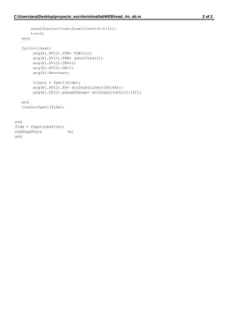
C:\Users\ana\Desktop\proyecto_escritorio\matlabWEB\read_rin_ob.m 2 of 2
satelites(n+1)=str2num(linein(t:t+1)); t=t+3; end; for(i=1:nsat) acq(k).SV(i).TOW= TOWinic; acq(k).SV(i).PRN= satelites(i); acq(k).SV(i).CN0=1; acq(k).SV(i).OK=1; acq(k).Nsv=nsat; linein = fgetl(fide); acq(k).SV(i).Fe= str2num(linein(36:46)); acq(k).SV(i).pseudoRange= str2num(linein(1:14)); end linein=fgetl(fide); end fide = fopen(obsfile);numSnapShots =b;end
C:\Users\ana\Desktop\proyecto_escritorio\matlabWEB\read_uab_arc.m 1 of 1
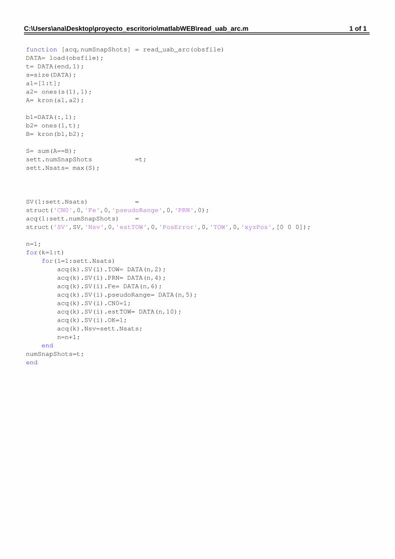
function [acq,numSnapShots] = read_uab_arc(obsfile)DATA= load(obsfile);t= DATA(end,1);s=size(DATA);a1=[1:t];a2= ones(s(1),1);A= kron(a1,a2); b1=DATA(:,1);b2= ones(1,t);B= kron(b1,b2); S= sum(A==B);sett.numSnapShots =t;sett.Nsats= max(S); SV(1:sett.Nsats) = struct('CN0',0,'Fe',0,'pseudoRange',0,'PRN',0);acq(1:sett.numSnapShots) = struct('SV',SV,'Nsv',0,'estTOW',0,'PosError',0,'TOW',0,'xyzPos',[0 0 0]); n=1;for(k=1:t) for(i=1:sett.Nsats) acq(k).SV(i).TOW= DATA(n,2); acq(k).SV(i).PRN= DATA(n,4); acq(k).SV(i).Fe= DATA(n,6); acq(k).SV(i).pseudoRange= DATA(n,5); acq(k).SV(i).CN0=1; acq(k).SV(i).estTOW= DATA(n,10); acq(k).SV(i).OK=1; acq(k).Nsv=sett.Nsats; n=n+1; endnumSnapShots=t; end

formulario.html 12/06/2009 - 18:19:35
- 1 -
1: <!DOCTYPE HTML PUBLIC "-//W3C//DTD HTML 4.01 Transitional//EN"> 2: 3: <html> 4: <head> 5: <title>Formulario</title> 6: </head> 7: 8: 9: <BODY background="objetos/brujula.png"> 10: <form method="POST" enctype="multipart/form-data" action="recoger.php"> 11: <table width="396" align="left"> 12: <tr> 13: 14: <td colspan="2"><div align="left"><span class="titulo"><font size="2" 15: face="Arial Black"> REFERENCE POSITION:</font></span></div></td> 16: </tr> 17: <tr></tr> 18: <tr></tr> 19: <tr></tr> 20: <tr></tr> 21: <tr></tr> 22: <tr> 23: <td width="121"> 24: <div align="left"><font size="2" face="Arial Black" color= "blue"> 25: Latitude:</font></div> 26: </div></td> 27: <td width="263"><div align="left"> 28: <input name="latitude" type="text" id="latitude" /> 29: </div></td> 30: </tr> 31: <tr> 32: <td> 33: <div align="left"><font size="2" face="Arial Black" color= "blue"> 34: Longitude:</font></div> 35: </div></td> 36: <td><div align="left"> 37: <input name="longitude" type="text" id="longitude" /> 38: </div></td> 39: </tr> 40: <tr> 41: <td> 42: <div align="left"><font size="2" face="Arial Black" color= "blue"> 43: Height:</font></div> 44: </div></td> 45: <td><div align="left"> 46: <input name="height" type="text" id="height" /> 47: </div></td> 48: </tr> 49: <tr></tr> 50: <tr></tr> 51: <tr></tr> 52: <tr></tr> 53: <tr></tr> 54: <tr></tr> 55: <tr></tr> 56: <tr></tr> 57: <tr></tr> 58: <tr></tr> 59: <tr></tr> 60: <tr> 61: 62: <td colspan="2"><div align="left"><font size="2" face="Arial Black"> 63: FILES:</font></span></div></td> 64: </tr> 65: <tr> 66: <td><div align="left"><font size="2" face="Arial Black" color= "blue">

formulario.html 12/06/2009 - 18:19:35
- 2 -
67: DATA FILE:</font></div></td> 68: </tr> 69: <tr> 70: 71: <td><div align="left"><font size="2" face="Arial Black" color= "blue"> 72: Seleccione el tipo de archivo a subir</font></div></td> 73: </tr> 74: <tr> 75: 76: <td> 77: <div align="left"> 78: <INPUT type="radio" name="tipo" value="2"> <font size="2" face="Arial Black" 79: color= "blue"> SwRx</font><BR> 80: <INPUT type="radio" name="tipo" value="1"><font size="2" face="Arial Black" 81: color= "blue"> RINEXobs</font><BR> 82: </td> 83: 84: </tr> 85: 86: <tr> 87: <td> 88: <div align="left"> <input type="file" name="archivo" size="30"></div> 89: 90: </td> 91: </tr> 92: <tr></tr> 93: <tr></tr> 94: <tr></tr> 95: <tr></tr> 96: <tr> 97: <td><div align="left"><font size="2" face="Arial Black" color= "blue"> 98: EPHEMERIDS FILE: </font></div></td> 99: </tr> 100: <tr> 101: <td> 102: <div align="left"> <input type="file" name="archivo1" size="30"></div> 103: 104: <div align="center"><input type="submit" value="Enviar" name="send"></div> 105: </td> 106: </tr> 107: <tr> 108: <td><div align="center"></div> 109: <div align="center"><input name="Borrar" type="reset" id="Borrar" 110: value="Borrar" /></div> 111: </td> 112: </tr> 113: 114: 115: </form> 116: </body> 117: </html> 118: 119: 120: 121: 122: 123:

formulario.php 12/06/2009 - 18:16:36
- 1 -
1: <?php 2: $archivo= "/home/web/www/ana00/objetos/data.xml"; 3: if(is_file($archivo)) 4: { 5: unlink($archivo); 6: include("formulario.html"); 7: 8: } 9: else 10: { 11: include("formulario.html"); 12: } 13: 14: 15: ?>

googlemaps.html 12/06/2009 - 18:21:29
- 1 -
1: <html> 2: <!DOCTYPE html PUBLIC "-//W3C//DTD XHTML 1.0 Strict//EN" 3: "http://www.w3.org/TR/xhtml1/DTD/xhtml1-strict.dtd"> 4: <html xmlns="http://www.w3.org/1999/xhtml" xmlns:v="urn:schemas-microsoft-com:vml"> 5: <head> 6: <META HTTP-EQUIV="Content-Type" CONTENT="text/html;charset=ISO-8859-1"> 7: <title>Mapa de Google</title> 8: <script src="http://maps.google.com/maps?file=api&v=2&key=ABQIAAAA1Mva 9: -SoetL-ErkTVRbO1zRSctkfHrS9mIs8KjEnA60IulV_HzRRCgAJROeow3Fsv2FVWimOHhWztsw" 10: type="text/javascript"></script> 11: <script type="text/javascript"> 12: //<![CDATA[ 13: 14: function load() { 15: if (GBrowserIsCompatible()) { 16: var map = new GMap2(document.getElementById("map")); 17: map.addControl(new GLargeMapControl()); 18: map.addControl(new GMapTypeControl()); 19: map.setMapType(G_NORMAL_MAP); 20: 21: var iconoMarca = new GIcon(G_DEFAULT_ICON); 22: iconoMarca.image = "http://maps.google.com/mapfiles/kml/pal4/icon49.png"; 23: var tamanoIcono = new GSize (20,20); 24: iconoMarca.iconSize = tamanoIcono; 25: iconoMarca.shadow = "http://maps.google.com/mapfiles/kml/pal4/icon49s.png"; 26: var tamanoSombra = new GSize(40,20); 27: iconoMarca.shadowSize = tamanoSombra; 28: iconoMarca.iconAnchor = new GPoint(10,20); 29: 30: 31: 32: 33: GDownloadUrl("objetos/data.xml", function(data) { 34: var xml = GXml.parse(data); 35: var markers = xml.documentElement.getElementsByTagName("marker"); 36: for (var i = 0; i < markers.length; i++) { 37: var point = new GLatLng(parseFloat(markers[i].getAttribute("lat")), 38: parseFloat(markers[i].getAttribute("lng"))); 39: var marker = new GMarker(point, iconoMarca); 40: map.addOverlay(marker); 41: } 42: var pcenter = new GLatLng(parseFloat(markers[0].getAttribute("lat")), 43: parseFloat(markers[0].getAttribute("lng"))); 44: map.setCenter(pcenter,15); 45: }); 46: 47: 48: 49: 50: 51: 52: 53: 54: 55: 56: } 57: } 58: 59: 60: window.onload=load 61: 62: //]]> 63: </script> 64: <body> 65: <div id= "global"> 66: <div id="map" style="width: 100%; height: 85%"></div>

googlemaps.html 12/06/2009 - 18:21:29
- 2 -
67: <BODY background="objetos/brujula.png"> 68: <a href="lineas.html">MOSTRAR RUTA</a> 69: <p> 70: <a href="formulario.php">Rellenar otro formulario</a> 71: <p> 72: 73: </ul></div> 74: 75: </div> 76: 77: <br /> 78: <br /> 79: </body> 80: </html>

index.html 12/06/2009 - 18:21:54
- 1 -
1: 2: 3: 4: <html> 5: <head> 6: <META HTTP-EQUIV="Content-Type" CONTENT="text/html;charset=ISO-8859-1"> 7: <title>GOOGLE-GPS</title> 8: </head> 9: <BODY background="objetos/brujula.png"> 10: 11: <div style="text-align: center"> 12: 13: <font size="10" face="Arial Black">Bienvenidos a google-GPS </font> 14: <p> 15: <a href="formulario.php"> 16: <img with=500 height=500 border=0 src="objetos/gps.png" alt="INICIAR APLICACION"></a> 17: 18: 19: 20: </div> 21: 22: </body> 23: </html>

lineas.html 12/06/2009 - 18:22:39
- 1 -
1: <!DOCTYPE html PUBLIC "-//W3C//DTD XHTML 1.0 Strict//EN" 2: "http://www.w3.org/TR/xhtml1/DTD/xhtml1-strict.dtd"> 3: <html xmlns="http://www.w3.org/1999/xhtml" xmlns:v="urn:schemas-microsoft-com:vml"> 4: <head> 5: <META HTTP-EQUIV="Content-Type" CONTENT="text/html;charset=ISO-8859-1"> 6: <title>Mapa de Google</title> 7: <script src="http://maps.google.com/maps?file=api&v=2&key=ABQIAAAA1Mva- 8: SoetL-ErkTVRbO1zRSctkfHrS9mIs8KjEnA60IulV_HzRRCgAJROeow3Fsv2FVWimOHhWztsw" 9: type="text/javascript"></script> 10: <script type="text/javascript"> 11: //<![CDATA[ 12: 13: function load() { 14: if (GBrowserIsCompatible()) { 15: var map = new GMap2(document.getElementById("map")); 16: var pcenter=new GLatLng(41.50035, 2.104697); 17: map.addControl(new GLargeMapControl()); 18: map.setCenter(pcenter,8); 19: map.addControl(new GMapTypeControl()); 20: map.setMapType(G_NORMAL_MAP); 21: 22: var iconoMarca = new GIcon(G_DEFAULT_ICON); 23: iconoMarca.image = "http://maps.google.com/mapfiles/kml/pal4/icon49.png"; 24: var tamanoIcono = new GSize (20,20); 25: iconoMarca.iconSize = tamanoIcono; 26: iconoMarca.shadow = "http://maps.google.com/mapfiles/kml/pal4/icon49s.png"; 27: var tamanoSombra = new GSize(40,20); 28: iconoMarca.shadowSize = tamanoSombra; 29: iconoMarca.iconAnchor = new GPoint(10,20); 30: 31: 32: 33: 34: GDownloadUrl("objetos/data.xml", function(data) { 35: var xml = GXml.parse(data); 36: var markers = xml.documentElement.getElementsByTagName("marker"); 37: for (var i = 0; i < markers.length-1; i++) { 38: var point = new GLatLng(parseFloat(markers[i].getAttribute("lat")), 39: parseFloat(markers[i].getAttribute("lng"))); 40: var point2 = new GLatLng(parseFloat(markers[i+1].getAttribute("lat")), 41: parseFloat(markers[i+1].getAttribute("lng"))); 42: var marker = new GMarker(point, iconoMarca); 43: var marker2 = new GMarker(point2, iconoMarca); 44: map.addOverlay(marker2); 45: map.addOverlay(marker); 46: var opciones_poligono = {geodesic:true}; 47: var poligono = new GPolyline([point, point2], "#cccc00", 6, 0.6,
opciones_poligono); 48: map.addOverlay(poligono); 49: 50: } 51: var pcenter = new GLatLng(parseFloat(markers[0].getAttribute("lat")), 52: parseFloat(markers[0].getAttribute("lng"))); 53: map.setCenter(pcenter,12); 54: }); 55: 56: 57: 58: 59: 60: 61: 62: 63: 64: 65: }
lineas.html 12/06/2009 - 18:22:39
- 2 -
66: } 67: 68: 69: window.onload=load 70: 71: //]]> 72: </script> 73: 74: <BODY background="objetos/brujula.png"> 75: 76: </head> 77: <body> 78: 79: <div id= "global"> 80: <div id="map" style="width: 100%; height: 580px"></div> 81: <div id= "cabecera"><font size="2" face="Arial Black"> bienvenidos a la ruta de
google-GPS <ul> 82: <a href="googlemaps.html">VOLVER A MAPA</a> 83: <p> 84: <a href="formulario.php">Rellenar otro formulario</a> 85: <p> 86: 87: </ul></div> 88: 89: </div> 90: 91: <br /> 92: <br /> 93: </body> 94: </html>

recoger.php 12/06/2009 - 18:23:12
- 1 -
1: <?php 2: 3: 4: 5: if(empty($_POST["latitude"])){ 6: echo "<b><center>Ingrese un valor de latitud inicial</b><BR><BR>"; 7: } 8: if(empty($_POST["longitude"])){ 9: echo "<b><center>-Ingrese un valor de longitud inicial.</b><BR><BR>"; 10: } 11: if(empty($_POST["height"])){ 12: echo "<b><center>- Ingrese un valor de altura.</b><BR><BR>"; 13: } 14: if(empty($_POST["tipo"])){ 15: echo "<b><center>- seleccione el tipo de archivo de observacion que
subirá</b><BR><BR>"; 16: } 17: else { 18: 19: $latitude=$_POST["latitude"]; 20: $longitude=$_POST["longitude"]; 21: $height=$_POST["height"]; 22: $tipo=$_POST["tipo"]; 23: 24: $string="$latitude\n$longitude\n$height\n$tipo"; 25: $archivod='/home/web/www/ana00/objetos/datos.m'; 26: $a1 = fopen($archivod, "w"); 27: fwrite($a1, $string); 28: fclose($a1); 29: $path="/home/web/www/ana00/objetos"; 30: $nombre1= "file.08n"; 31: $nombre="file.08o"; 32: 33: $ruta_archivo1= "$path/$nombre1"; 34: $ruta_archivo= "$path/$nombre"; 35: 36: if (is_uploaded_file($HTTP_POST_FILES['archivo']['tmp_name'])) 37: { 38: copy($HTTP_POST_FILES['archivo']['tmp_name'], $ruta_archivo); 39: if (is_uploaded_file($HTTP_POST_FILES['archivo1']['tmp_name'])) 40: { 41: copy($HTTP_POST_FILES['archivo1']['tmp_name'], $ruta_archivo1); 42: exec("/home/web/www/ana00/run_mainWEB.sh /usr/local/matlab/MCR/v76"); 43: 44: } 45: 46: 47: else { echo "error al subir el archivo de navegación";} 48: 49: 50: 51: 52: } 53: 54: 55: else { echo "error al subir el archivo de observación";} 56: } 57: 58: 59: 60: 61: 62: 63: 64: 65:

recoger.php 12/06/2009 - 18:23:12
- 2 -
66: if(is_file("/home/web/www/ana00/objetos/data.xml")) 67: { 68: chmod("/home/web/www/ana00/objetos/data.xml", 0777); 69: include ("googlemaps.html"); 70: } 71: else 72: { 73: sleep(5); 74: include ("googlemaps.html"); 75: } 76: 77: 78: 79: ?> 80: 81: 82: 83: 84: