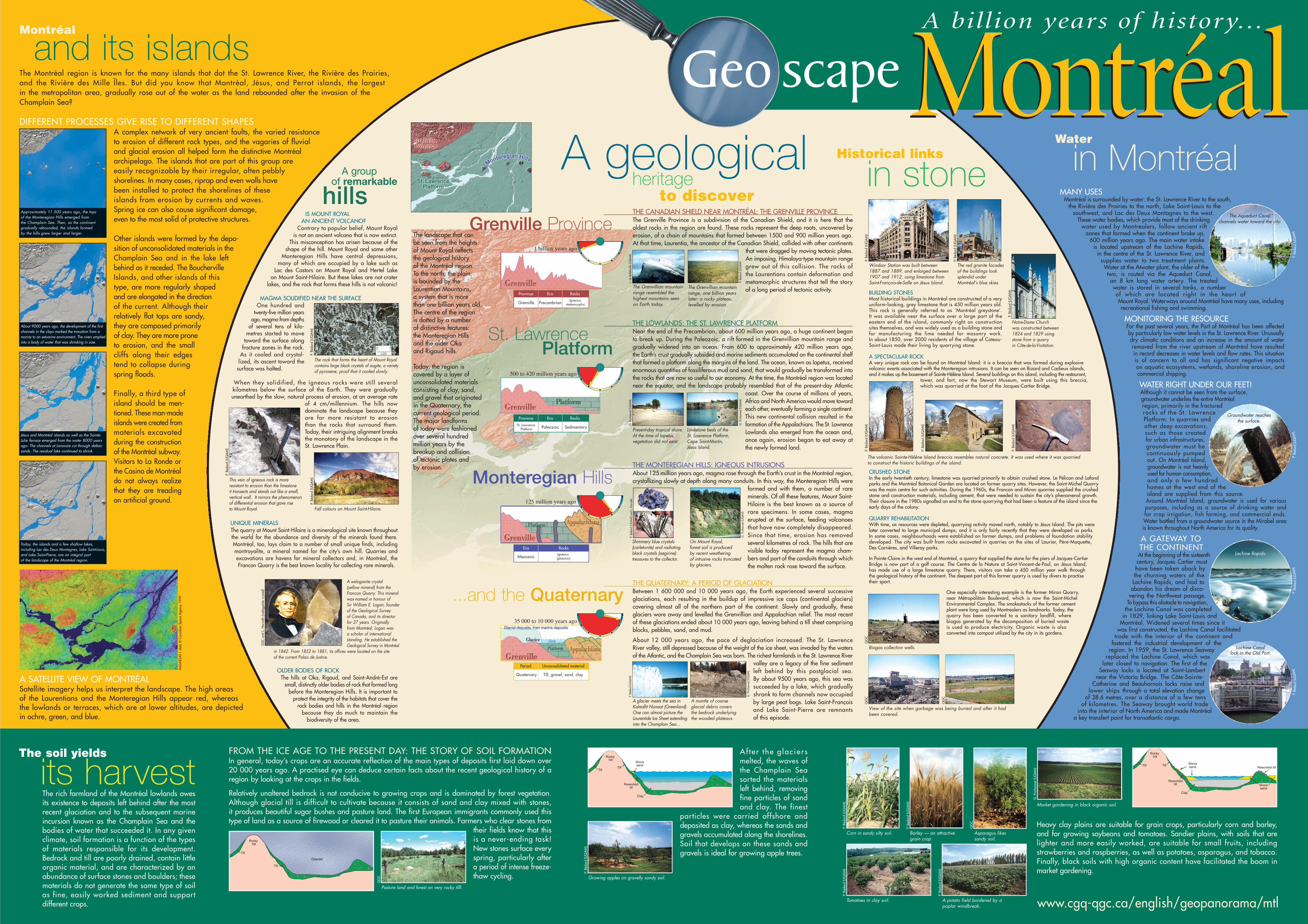
he st. lawrence river and mount royal t geoscape montréal · the geoscape montréal poster is...
TRANSCRIPT

he St. Lawrence River and Mount Royalform nature’s backdrop to the city of Montréal. Both played key roles
in its founding and growth. In the river, the Lachine Rapids, which once blocked the progress of explorers seeking a passage to the Northwest, churn over the underlyingresistant rock. And Mount Royal must haveafforded the first inhabitants a natural lookoutfrom which to observe the surrounding region.This hill, which gave its name to the city, is a remarkable geotourism attraction, offeringa full view of the surrounding geologicalpanorama: the broad St. Lawrence Plain, the Monteregian Hills to the east, the LaurentianPlateau to the north, the first hint of the Appalachiansto the southeast, and the Adirondack Mountains to the south. In just over 350 years,the Montréal region hasbecome the largest inlandport in the world, a major internationalmetropolis, and an important high-technology centre.
T
A broad clay plain that
is a remnant ofthe Champlain
Sea is the settingfor a number of large farms.
Ten thousand years ago, the Monteregian Hills emerged from the sea: like the pages of a book, the sedimentary layers on the slopes of Mount Saint-Hilaire tell the story of the past.
in stone Historical links
From the first stone buildings of the seventeenthcentury, to the skyscrapers of today, some ofwhich rival Mount Royal in height.
A geological
The St. Lawrence River, majestic gateway to a continent, is an integral part of the landscape of Montréal.
Is Mount Royal, that peaceful haven and treasured part of our heritage, really an ancient volcano?
Waterin Montréal
hills A group
of remarkable
The soil yields
its harvest
MontréalMontréalGeo scapeA billion years of history...
This document was made possible through the financial support of ‘ÉTALEZ VOTRE SCIENCE’, a scientific and technical literacy program of the Ministère de la Culture et des Communications du Québec, and the GeologicalSurvey of Canada.
The Geoscape Montréal poster is available from the Quebec Geoscience Centre's Distribution Centre,telephone: (418) 654-2677, e-mail: [email protected],or from any of the following Geological Survey of Canada offices:601 Booth Street, Ottawa, Ontario K1A 0E8; 3303-33rd Street N.W., Calgary, Alberta T2L 2A7; 101-605 Robson Street, Vancouver, British Columbia V6B 5J3
Catalogue no. M41-8/80E ISBN 0-660-18764-7
Aussi disponible en français.
© Her Majesty the Queen in Right of Canada, 2002
MontréalMontréalGeo scape Geological Survey of Canada, Miscellaneous Report 80, 2002Gilbert Prichonnet, Pascale Côté, Pierre Bédard, Marie Larocque, Aïcha Achab
www.cgq-qgc.ca/english/geopanorama/mtl
P.Bé
dard
(UQ
AM
)
P.Po
ulio
t(SÉ
PAQ
)
G.P
richo
nnet
(UQ
AM
)
P.Bé
dard
(UQ
AM
)
P.Bé
dard
(UQ
AM
)The Boucherville Islands, at the doorway to the city, are a pastoral park in the middle of the river.
islands Montréal and its
heritage to discover
P.Bé
dard
(UQ
AM
)
Gravel pit at Mount Saint-Hilaire:Champlain Sea sands and gravels
Scientific contribution: Gilbert Prichonnet, Pierre Bédard, Marie Larocque (Université du Québec à Montréal, département des Sciences de la Terre et de l’Atmosphère); Andrée Bolduc, Jean Bédard (Geological Survey of Canada), and Robert Ledoux (Université Laval)
Critical reading: Michel Parent (Geological Survey of Canada) and Pierre Pagé (Université du Québec à Montréal, département des Sciences de la Terre et de l’Atmosphère)
Illustrations: Pierre Bédard, Gilbert Prichonnet, Louis de Bellefeuille (Université du Québec à Montréal, département des Sciences de la Terre et de l’Atmosphère); Quebec Geoscience Centre; Pierre Pouliot (Société des établissements de plein air du Québec); László Horváth (Club de minéralogie de Montréal); Thierry Toutin (Canada Centre for Remote Sensing)
Special contribution: Michel Jébrak (Université du Québec à Montréal, département des Sciences de la Terre et de l’Atmosphère) and François Gaumond (Ministère des Ressources naturelles du Québec) Graphic design: Bleu Outremer
Members of the Québec Geoscience Centre
MANY USESMontréal is surrounded by water: the St. Lawrence River to the south,
the Rivière des Prairies to the north, Lake Saint-Louis to the southwest, and Lac des Deux Montagnes to the west.
These water bodies, which provide most of the drinkingwater used by Montrealers, follow ancient rift
zones that formed when the continent broke up, 600 million years ago. The main water intake
is located upstream of the Lachine Rapids, in the centre of the St. Lawrence River, and
supplies water to two treatment plants.Water at the Atwater plant, the older of thetwo, is routed via the Aqueduct Canal, an 8 km long water artery. The treatedwater is stored in several tanks, a number of which are located right in the heart of Mount Royal. Waterways around Montréal have many uses, includingrecreational fishing and swimming.
MONITORING THE RESOURCEFor the past several years, the Port of Montréal has been affected by particularly low water levels in the St. Lawrence River. Unusuallydry climatic conditions and an increase in the amount of waterremoved from the river upstream of Montréal have resulted in record decreases in water levels and flow rates. This situationis of concern to all and has significant negative impacts on aquatic ecosystems, wetlands, shoreline erosion, andcommercial shipping.
WATER RIGHT UNDER OUR FEET!Although it cannot be seen from the surface, groundwater underlies the entire Montréalregion, primarily in the fracturedrocks of the St. LawrencePlatform. In quarries andother deep excavations,such as those created for urban infrastructures,groundwater must becontinuously pumpedout. On Montréal Island,groundwater is not heavilyused for human consumption,and only a few hundredhomes at the west end of theisland are supplied from this source.Around Montréal Island, groundwater is used for various purposes, including as a source of drinking water and for crop irrigation, fish farming, and commercial ends. Water bottled from a groundwater source in the Mirabel areais known throughout North America for its quality.
A GATEWAY TO THE CONTINENT
At the beginning of the sixteenthcentury, Jacques Cartier musthave been taken aback bythe churning waters of theLachine Rapids, and had toabandon his dream of disco-
vering the Northwest passage.To bypass this obstacle to navigation,
the Lachine Canal was completedin 1829, linking Lake Saint-Louis and
Montréal. Widened several times since itwas first constructed, the Lachine Canal facilitated
trade with the interior of the continent and fostered the industrial development of the
region. In 1959, the St. Lawrence Seawayreplaced the Lachine Canal, which was
later closed to navigation. The first of theSeaway locks is located at Saint-Lambert
near the Victoria Bridge. The Côte-Sainte-Catherine and Beauharnois locks raise and
lower ships through a total elevation changeof 38.6 metres, over a distance of a few tens
of kilometres. The Seaway brought world tradeinto the interior of North America and made Montréal
a key transfert point for transatlantic cargo.
...and the Quaternary
The landscape that can be seen from the heights of Mount Royal reflects the geological history of the Montréal region. To the north, the plain is bounded by theLaurentian Mountains, a system that is more than one billion years old.The centre of the region is dotted by a number of distinctive features: the Monteregian Hills and the older Oka and Rigaud hills.
Today, the region is covered by a layer ofunconsolidated materialsconsisting of clay, sand,and gravel that originatedin the Quaternary, the current geological period.The major landforms of today were fashionedover several hundred million years by thebreakup and collision of tectonic plates and by erosion.
BUILDING STONESMost historical buildings in Montréal are constructed of a veryuniform-looking, grey limestone that is 450 million years old.This rock is generally referred to as ‘Montréal greystone’. It was available near the surface over a large part of the eastern end of the island, commonly right on constructionsites themselves, and was widely used as a building stone andfor manufacturing the lime needed for masonry work. In about 1850, over 2000 residents of the village of Coteau-Saint-Louis made their living by quarrying stone.
A SPECTACULAR ROCKA very unique rock can be found on Montréal Island: it is a breccia that was formed during explosive volcanic events associated with the Monteregian intrusions. It can be seen on Bizard and Cadieux islands,and it makes up the basement of Sainte-Hélène Island. Several buildings on this island, including the restaurant,
tower, and fort, now the Stewart Museum, were built using this breccia, which was quarried at the foot of the Jacques-Cartier Bridge.
CRUSHED STONEIn the early twentieth century, limestone was quarried primarily to obtain crushed stone. Le Pélican and Lafondparks and the Montréal Botanical Garden are located on former quarry sites. However, the Saint-Michel Quarrywas the main centre for such activities. During the 1960s, the Francon and Miron quarries supplied the crushedstone and construction materials, including cement, that were needed to sustain the city’s phenomenal growth.Their closure in the 1980s signalled an end to the stone quarrying that had been a feature of the island since theearly days of the colony.
QUARRY REHABILITATIONWith time, as resources were depleted, quarrying activity moved north, notably to Jésus Island. The pits werelater converted to large municipal dumps, and it is only fairly recently that they were developed as parks. In some cases, neighbourhoods were established on former dumps, and problems of foundation stabilitydeveloped. The city was built from rocks excavated in quarries on the sites of Laurier, Père-Maquette, Des Carrières, and Villeray parks.
In Pointe-Claire in the west end of Montréal, a quarry that supplied the stone for the piers of Jacques-CartierBridge is now part of a golf course. The Centre de la Nature at Saint-Vincent-de-Paul, on Jésus Island, has made use of a large limestone quarry. There, visitors can take a 450 million year walk through the geological history of the continent. The deepest part of this former quarry is used by divers to practisetheir sport.
One especially interesting example is the former Miron Quarry,near Métropolitain Boulevard, which is now the Saint-MichelEnvironmental Complex. The smokestacks of the former cementplant were long used by Montrealers as landmarks. Today, thequarry has been converted to a sanitary landfill, where biogas generated by the decomposition of buried waste is used to produce electricity. Organic waste is also converted into compost utilized by the city in its gardens.
THE CANADIAN SHIELD NEAR MONTRÉAL: THE GRENVILLE PROVINCEThe Grenville Province is a subdivision of the Canadian Shield, and it is here that the oldest rocks in the region are found. These rocks represent the deep roots, uncovered byerosion, of a chain of mountains that formed between 1500 and 900 million years ago.At that time, Laurentia, the ancestor of the Canadian Shield, collided with other continents
that were dragged by moving tectonic plates.An imposing, Himalaya-type mountain rangegrew out of this collision. The rocks of the Laurentians contain deformation and metamorphic structures that tell the story of a long period of tectonic activity.The Grenvillian mountain
range resembled the highest mountains seenon Earth today.
The Grenvillian mountainrange, one billion yearslater: a rocky plateau, levelled by erosion.
L. de
Bel
lefe
uille
(UQ
AM
)
P. Bé
dard
(UQ
AM
)
THE LOWLANDS: THE ST. LAWRENCE PLATFORMNear the end of the Precambrian, about 600 million years ago, a huge continent began to break up. During the Paleozoic, a rift formed in the Grenvillian mountain range and gradually widened into an ocean. From 600 to approximately 420 million years ago, the Earth’s crust gradually subsided and marine sediments accumulated on the continental shelfthat formed a platform along the margins of the land. The ocean, known as Iapetus, receivedenormous quantities of fossiliferous mud and sand, that would gradually be transformed intothe rocks that are now so useful to our economy. At the time, the Montréal region was locatednear the equator, and the landscape probably resembled that of the present-day Atlantic
coast. Over the course of millions of years,Africa and North America would move towardeach other, eventually forming a single continent.This new continental collision resulted in the formation of the Appalachians. The St. LawrenceLowlands also emerged from the ocean and,once again, erosion began to eat away atthe newly formed land.
Present-day tropical shore.At the time of Iapetus,vegetation did not exist.
Limestone beds of the St. Lawrence Platform,Cape Saint-Martin, Jésus Island.
G. P
richo
nnet
(UQ
AM
)
G. P
richo
nnet
(UQ
AM
)
THE QUATERNARY: A PERIOD OF GLACIATIONBetween 1 600 000 and 10 000 years ago, the Earth experienced several successive glaciations, each resulting in the buildup of impressive ice caps (continental glaciers) covering almost all of the northern part of the continent. Slowly and gradually, these glaciers wore away and levelled the Grenvillian and Appalachian relief. The most recentof these glaciations ended about 10 000 years ago, leaving behind a till sheet comprisingblocks, pebbles, sand, and mud.
About 12 000 years ago, the pace of deglaciation increased. The St. Lawrence River valley, still depressed because of the weight of the ice sheet, was invaded by the watersof the Atlantic, and the Champlain Sea was born. The richest farmlands in the St. Lawrence River
valley are a legacy of the fine sedimentleft behind by this postglacial sea. By about 9500 years ago, this sea wassucceeded by a lake, which graduallyshrank to form channels now occupiedby large peat bogs. Lake Saint-Françoisand Lake Saint-Pierre are remnants of this episode.
A mantle of coarse glacial debris covers the bedrock underlying the wooded plateaus.
P. Bé
dard
(UQ
AM
)
G. P
richo
nnet
(UQ
AM
)
THE MONTEREGIAN HILLS: IGNEOUS INTRUSIONSAbout 125 million years ago, magma rose through the Earth’s crust in the Montréal region,crystallizing slowly at depth along many conduits. In this way, the Monteregian Hills were
formed and with them, a number of rareminerals. Of all these features, Mount Saint-Hilaire is the best known as a source ofrare specimens. In some cases, magmaerupted at the surface, feeding volcanoesthat have now completely disappeared.Since that time, erosion has removed several kilometres of rock. The hills that arevisible today represent the magma cham-bers and part of the conduits through whichthe molten rock rose toward the surface.
Shimmery blue crystals (carletonite) and radiatingblack crystals (aegirine):treasures to the collector.
On Mount Royal, forest soil is produced by recent weathering of intrusive rocks truncatedby glaciers.
P. Bé
dard
(UQ
AM
) and
L. H
orvá
th
G. P
richo
nnet
(UQ
AM
)
Monteregian Hills
St. Lawrence Platform
Grenville Province
Af ter the g lac ier smelted, the waves ofthe Champlain Seasorted the materialsleft behind, removingfine particles of sandand clay. The finest
particles were carried offshore anddeposited as clay, whereas the sands andgravels accumulated along the shorelines.Soil that develops on these sands andgravels is ideal for growing apple trees.
Heavy clay plains are suitable for grain crops, particularly corn and barley,and for growing soybeans and tomatoes. Sandier plains, with soils that arelighter and more easily worked, are suitable for small fruits, including strawberries and raspberries, as well as potatoes, asparagus, and tobacco.Finally, black soils with high organic content have facilitated the boom in market gardening.
The rich farmland of the Montréal lowlands owesits existence to deposits left behind after the mostrecent glaciation and to the subsequent marineincursion known as the Champlain Sea and thebodies of water that succeeded it. In any given climate, soil formation is a function of the types of materials responsible for its development.Bedrock and till are poorly drained, contain littleorganic material, and are characterized by anabundance of surface stones and boulders; thesematerials do not generate the same type of soil as fine, easily worked sediment and support different crops.
its harvestThe soil yields
DIFFERENT PROCESSES GIVE RISE TO DIFFERENT SHAPESA complex network of very ancient faults, the varied resistance to erosion of different rock types, and the vagaries of fluvial and glacial erosion all helped form the distinctive Montréalarchipelago. The islands that are part of this group areeasily recognizable by their irregular, often pebblyshorelines. In many cases, riprap and even walls havebeen installed to protect the shorelines of theseislands from erosion by currents and waves.Spring ice can also cause significant damage,even to the most solid of protective structures.
Other islands were formed by the depo-sition of unconsolidated materials in theChamplain Sea and in the lake leftbehind as it receded. The BouchervilleIslands, and other islands of thistype, are more regularly shapedand are elongated in the directionof the current. Although theirrelatively flat tops are sandy,they are composed primarilyof clay. They are more proneto erosion, and the smallcliffs along their edgestend to collapse duringspring floods.
Finally, a third type ofisland should be men-tioned. These man-madeislands were created frommaterials excavatedduring the constructionof the Montréal subway.Visitors to La Ronde orthe Casino de Montréaldo not always realizethat they are treadingon artificial ground.
A SATELLITE VIEW OF MONTRÉALSatellite imagery helps us interpret the landscape. The high areas of the Laurentians and the Monteregian Hills appear red, whereas the lowlands or terraces, which are at lower altitudes, are depicted in ochre, green, and blue.
The Montréal region is known for the many islands that dot the St. Lawrence River, the Rivière des Prairies, and the Rivière des Mille Îles. But did you know that Montréal, Jésus, and Perrot islands, the largest in the metropolitan area, gradually rose out of the water as the land rebounded after the invasion of theChamplain Sea?
and its islandsMontréal
Geo scapeMontréalMontréalA billion years of history...
Growing apples on gravelly sandy soil.
Tomatoes in clay soil. A potato field bordered by a poplar windbreak.
Barley — an attractivegrain crop.
Corn in sandy silty soil. Asparagus likes sandy soil.
www.cgq-qgc.ca/english/geopanorama/mtl
Market gardening in black organic soil.
Approximately 11 500 years ago, the tops of the Monteregian Hills emerged from the Champlain Sea. Then, as the continent gradually rebounded, the islands formed by the hills grew larger and larger.
P. B
édar
d (U
QA
M)
P. B
édar
d (U
QA
M)
P. B
édar
d (U
QA
M)
P. B
édar
d (U
QA
M)
P. B
édar
d (U
QA
M)
QG
C
G. P
richo
nnet
(UQ
AM
)
in MontréalWater
The Aqueduct Canal channels water toward the city.
Groundwater reachesthe surface.
Lachine Rapids.
Lachine Canal lock in the Old Port.
P.Bé
dard
(UQ
AM
)P.
Béda
rd(U
QA
M)
P.Bé
dard
(UQ
AM
)P.
Béda
rd(U
QA
M)
P. B
édar
d (U
QA
M)
Windsor Station was built between 1887 and 1889, and enlarged between1907 and 1912, using limestone fromSaint-François-de-Salle on Jésus Island.
P. B
édar
d (U
QA
M)
P. B
édar
d (U
QA
M)
P. B
édar
d (U
QA
M)
The volcanic Sainte-Hélène Island breccia resembles natural concrete. It was used where it was quarried to construct the historic buildings of the island.
QG
C
QG
C
Biogas collection wells.
View of the site when garbage was being buried and after it had been covered.
Today, the islands and a few shallow lakes, including Lac des Deux Montagnes, Lake Saint-Louis,and Lake Saint-Pierre, are an integral part of the landscape of the Montréal region.
About 9000 years ago, the development of the firstchannels in the clays marked the transition from amarine to an estuarine environment. The rivers emptiedinto a body of water that was shrinking in size.
Jésus and Montréal islands as well as the Sainte-Julie Terrace emerged from the water 8000 yearsago. The channels at Lanoraie cut through deltaicsands. The residual lake continued to shrink.
P. B
édar
d (U
QA
M)
The red granite facadesof the buildings looksplendid under Montréal’s blue skies.
Notre-Dame Church was constructed between1824 and 1829 using stone from a quarry in Côte-de-la-Visitation.
P. B
édar
d (U
QA
M)
QG
C
RAD
ARS
AT-1
dat
a ©
Can
adia
n Sp
ace
Age
ncy
1999
A glacier meets the sea inKalaallit Nunaat (Greenland).One can almost picture theLaurentide Ice Sheet extendinginto the Champlain Sea...
IS MOUNT ROYAL AN ANCIENT VOLCANO?
Contrary to popular belief, Mount Royal is not an ancient volcano that is now extinct.
This misconception has arisen because of theshape of the hill. Mount Royal and some other
Monteregian Hills have central depressions,many of which are occupied by a lake such as
Lac des Castors on Mount Royal and Hertel Lake on Mount Saint-Hilaire. But these lakes are not crater
lakes, and the rock that forms these hills is not volcanic!
MAGMA SOLIDIFIED NEAR THE SURFACEOne hundred and
twenty-five million yearsago, magma from depths
of several tens of kilo-metres started to move
toward the surface alongfracture zones in the rock.
As it cooled and crystal-lized, its ascent toward the
surface was halted.
When they solidified, the igneous rocks were sti l l several kilometres below the surface of the Earth. They were graduallyunearthed by the slow, natural process of erosion, at an average rate
of 4 cm/millennium. The hills now dominate the landscape because theyare far more resistant to erosion than the rocks that surround them.Today, their intriguing alignment breaksthe monotony of the landscape in the St. Lawrence Plain.
UNIQUE MINERALSThe quarry at Mount Saint-Hilaire is a mineralogical site known throughout the world for the abundance and diversity of the minerals found there.Montréal, too, lays claim to a number of small unique finds, including montroyalite, a mineral named for the city’s own hill. Quarries and excavations are havens for mineral collectors and, in Montréal, theFrancon Quarry is the best known locality for collecting rare minerals.
OLDER BODIES OF ROCKThe hills at Oka, Rigaud, and Saint-André-Est are
small, distinctly older bodies of rock that formed longbefore the Monteregian Hills. It is important to
protect the integrity of the habitats that cover therock bodies and hills in the Montréal region
because they do much to maintain the biodiversity of the area.
hillsof remarkable
Fall colours on Mount Saint-Hilaire.
P. B
édar
d (U
QA
M)
The rock that forms the heart of Mount Royalcontains large black crystals of augite, a varietyof pyroxene, proof that it cooled slowly.
P. B
édar
d (U
QA
M)
FROM THE ICE AGE TO THE PRESENT DAY: THE STORY OF SOIL FORMATIONIn general, today’s crops are an accurate reflection of the main types of deposits first laid down over 20 000 years ago. A practised eye can deduce certain facts about the recent geological history of aregion by looking at the crops in the fields.
Relatively unaltered bedrock is not conducive to growing crops and is dominated by forest vegetation.Although glacial till is difficult to cultivate because it consists of sand and clay mixed with stones, it produces beautiful sugar bushes and pasture land. The first European immigrants commonly used thistype of land as a source of firewood or cleared it to pasture their animals. Farmers who clear stones from
their fields know that thisis a never-ending task!New stones surface everyspring, particularly aftera period of intense freeze-thaw cycling.
Pasture land and forest on very rocky tilll.
QG
C
A group
This vein of igneous rock is more resistant to erosion than the limestone it transects and stands out like a small,vertical wall. It mirrors the phenomenonof differential erosion that gave rise to Mount Royal.
P. B
édar
d (U
QA
M)
A weloganite crystal (yellow mineral) from theFrancon Quarry. This mineralwas named in honour of Sir William E. Logan, founder of the Geological Survey of Canada, and its director for 27 years. Originally from Montréal, Logan was a scholar of internationalstanding. He established theGeological Survey in Montréal
in 1842. From 1852 to 1881, its offices were located on the site of the current Palais de Justice.
GSC
and
L. H
orvá
th (w
elog
anite
cry
stal)
A geologicalheritage
to discover
Historical links
in stone