hds australia civil engineer s and project manage rs final report.pdf · in june 2013, hds...
TRANSCRIPT

Safe and Sustainable Road Transport Planning Solutions
HDS Australia Civil Engineers and Project Managers
Ad
ela
ide
Me
lbo
urn
e H
on
g K
on
g
The Murray and Mallee Local Government Association
REGIONAL ROAD ACTION PLANS AND 2015 SLRP ROADS DATABASE UPDATE
Final Report HDS Australia Pty Ltd
277 Magill Road Trinity Gardens SA 5068 telephone +61 8 8333 3760 facsimile +61 8 8333 3079 email [email protected]
www.hdsaustralia.com.au
April 2015

The Murray and Mallee Local Government Association HDS Australia Pty Ltd
LG802\006 April 2015
Regional Road Action Plans and 2015 SLRP Roads Database Update Final Report
CONTENTS
1.0 INTRODUCTION ............................................................................................................................1
1.1 Background ......................................................................................................................... 1 1.2 Project Brief ........................................................................................................................ 2
2.0 PROJECT ACTIVITIES AND OVERVIEW OF OUTCOMES ........................................................3
2.1 Phase 1 Tasks .................................................................................................................... 3 2.2 Phase 1 Outcomes ............................................................................................................. 3 2.3 Phase 2 Tasks .................................................................................................................... 3 2.4 Phase 2 Outcomes ............................................................................................................. 4
3.0 SUMMARY OF FINDINGS ............................................................................................................5
3.1 Phase 1 – Regional Road Action Plans .............................................................................. 5 3.2 Phase 2 – 2015 SLRP Roads Database Update ................................................................ 6 3.3 Phase 2A – SLRP 2015-16 Funding Applications Final Priority List .................................. 8
APPENDICES A. Regional Road Action Plans – Endorsed by RTS Committee 6 March 2015 B. Detailed Submissions – Berri Barmera Council C. Detailed Submissions – Coorong District Council D. Detailed Submissions – Mid Murray Council E. Detailed Submissions – Rural City of Murray Bridge F. Detailed Submissions – Renmark Paringa Council G. Detailed Submissions – Southern Mallee District Council H. 2015 SLRP Roads Database Update – Endorsed by RTS Committee 6 March 2015 REFERENCE (downloadable from the M&MLGA website “Reports” page) 1. M&MLGA 2030 Regional Transport Plan – Final Report, HDS Australia, March 2014 2. Murray and Mallee Regional Transport Review 2010, Parsons Brinckerhoff, March 2011

The Murray and Mallee Local Government Association HDS Australia Pty Ltd
LG802\006 April 2015
Regional Road Action Plans and 2015 SLRP Roads Database Update Final Report
1
1.0 INTRODUCTION
1.1 Background In June 2013, HDS Australia was engaged by the Murray and Mallee Local Government Association (M&MLGA) to prepare its 2030 Regional Transport Plan (Reference 1). The 2030 Regional Transport Plan is a strategic level assessment of transport needs and priorities within the Region for the period from 2013 to 2030. Upon its release in March 2014, it officially replaced an earlier Regional Transport Strategy (RTS) which had been operating since 2002. The final report for the 2030 Regional Transport Plan recognised that the 2030 Regional Transport Plan is a “living” document which will need regular review and updating as subsequent regional planning and development initiatives influence future transport priorities. In particular, Section 9 of the report outlined a methodology for review and update of the 2030 Regional Transport Plan, along with preparation and submission of annual Special Local Roads Program (SLRP) or other funding applications. A flow chart depicting the methodology was presented in Section 9.2 of the report, and is repeated below:

The Murray and Mallee Local Government Association HDS Australia Pty Ltd
LG802\006 April 2015
Regional Road Action Plans and 2015 SLRP Roads Database Update Final Report
2
1.2 Project Brief In August 2014, HDS Australia was engaged by the M&MLGA to assist member councils undertake Steps 2 and 3 of the above “Methodology for Review and Update of the 2030 Regional Transport Plan”. The project comprised two separate, but linked components, namely: 1. Phase 1 – Provision of assistance to the M&MLGA and individual member councils with
development of Regional Road Action Plans, in accordance with the methodology contained in Section 10 of the 2030 Regional Transport Plan. The purpose of these Action Plans was to develop an overall funding priority list, and associated strategy for seeking additional funds when available, to enable all regionally significant freight, tourism and community access routes, as defined by the maps in Appendix A of the 2030 Regional Transport Plan Final Report, to operate at their “fit for purpose” standard.
2. Phase 2 – Provision of assistance to the M&MLGA to undertake an independent review
and prioritisation of road upgrade proposals submitted by member councils for consideration under SLRP annual funding arrangements. This process, identified in Section 9 of the 2030 Regional Transport Plan Final Report, continued to utilise the two step assessment process first employed for the 2006 Regional Transport Strategy update, thereby ensuring continuity with earlier assessments. However, for 2015, all road proposals submitted for consideration were required to have been listed under Regional Road Action Plan 1. This provided an essential link to the 2030 Regional Transport Plan, by ensuring that all SLRP road upgrade proposals were for regionally significant roads with major deficiencies.
The project was undertaken by a specialist team of road transport planning and traffic engineers from HDS Australia led by John Olson, Managing Director and Principal Engineer, assisted by Tim Viner Smith for Phase 1 and Kyle Yang for Phase 2, both Senior Traffic Engineers. The M&MLGA RTS Committee acted as a Reference Group for the project, with Peter Campbell and subsequently Peter Bond, Chief Executive Officer of the M&MLGA, as the Client Representatives.

The Murray and Mallee Local Government Association HDS Australia Pty Ltd
LG802\006 April 2015
Regional Road Action Plans and 2015 SLRP Roads Database Update Final Report
3
2.0 PROJECT ACTIVITIES AND OVERVIEW OF OUTCOMES
2.1 Phase 1 Tasks Listed below are the activities undertaken in Phase 1, which included one task that was optional, based on individual council requirements. 1. An initial workshop was conducted in Karoonda on 12 September 2014, covering the
methodology for determining major and minor deficiencies on the regional road network. It was based upon comparing sample deficiencies with standards contained in the most recent version of the Local Government Association of SA (LGA) SLRP Fit for Purpose Standards Spreadsheet.
2. All RTS Committee representatives were followed up after the workshop to ascertain their
level of understanding and commitment to the development of Regional Road Action Plans, including the availability of resources and the timeframe needed to achieve an outcome if tackled in-house.
3. Where RTS Committee representatives indicated that they did not have available in-
house resources (which was seven of the eight members councils), HDS Australia assisted those councils to assess all regional routes in their area for major and minor deficiencies. One council, namely DC Loxton Waikerie, elected to undertake this task in-house. This task was carried out over the period October to December 2014.
4. Results from the road deficiency assessments were prioritised into Council Action Plans
1, 2 and 3 (with those roads showing no or insignificant deficiencies listed separately as Fit for Purpose).
5. Consolidated Regional Road Action Plans for the M&MLGA were then developed by HDS
Australia, listing all regionally significant roads and highlighting the level of deficiencies identified. Individual councils also provided an estimated upgrade cost for all road segments listed under Action Plan 1, based upon cost estimates included in their five year capital works program.
6. A Phase 1 completion meeting of the RTS Committee was held in Karoonda on 11
December 2014 to review draft Regional Road Action Plans, discuss the significance of the individual lists, seek endorsement from the RTS Committee of the draft plans as presented, and identify the next steps associated with Phase 2 of the project.
2.2 Phase 1 Outcomes
Training notes for all attendees under Task 1, plus an initial report to the client under Task 2, were the principal outcomes of the first two tasks. Individual road deficiency assessment sheets, including site specific observations by our field assessor, were supplied to the seven councils who used HDS Australia’s services for the road deficiency assessments (Task 3). All eight councils received Council Action Plans as part of Task 4. Under Task 5, draft Regional Road Action Plans were published for review and endorsement by the RTS Committee, before final versions of the Regional Road Action Plans were supplied to the client representative (for ultimate approval at a subsequent M&MLGA general meeting). Appendix A of this report contains a copy of the endorsed Regional Road Action Plans.
2.3 Phase 2 Tasks The independent assessment and prioritisation of road upgrade proposals submitted as part of the 2015 SLRP Roads Database Update involved the following steps:

The Murray and Mallee Local Government Association HDS Australia Pty Ltd
LG802\006 April 2015
Regional Road Action Plans and 2015 SLRP Roads Database Update Final Report
4
1. 27 road upgrade proposals were received from six of the eight councils within the
M&MLGA. Copies of these upgrade proposals are contained in Appendices B to G of this report. The proposals were independently reviewed by HDS Australia, which included the following activities:
a. A check that each road segment proposed for upgrading was regionally significant,
as shown on the Regional Transport Route maps forming part of the 2030 Regional Transport Plan;
b. A check that each road segment was identified as a deficient road segment within Regional Road Action Plan 1;
c. Provision of telephone and/or emailed comments on the overall quality of each
submission and evidence provided in support of benefits claimed for each road upgrade proposal;
d. Calculation of "Stage 1” and “Stage 2” assessment scores, in accordance with the
M&MLGA RTS methodology previously used in the 2006 and 2010 reviews; and
e. Ranking of all proposals by combined assessment, similar to the reported outcome under Section 5.3 of PB’s March 2011 report (Reference 2).
2. A Phase 2 completion meeting of the RTS Committee was held in Murray Bridge on
6 March 2015, at which: a. The final version of Regional Road Action Plans (released on 26 February 2015)
were endorsed; and
b. The prioritised list of 2015 SLRP Roads Database upgrade proposals was discussed and formal endorsement obtained from the RTS Committee for the overall list and for a set of identified 2015-16 priorities.
2.4 Phase 2 Outcomes
Individual verbal feedback by telephone was provided to each M&MLGA member council as their submissions were reviewed. Additional face-to-face feedback was provided to RTS Committee representatives at the Phase 2 completion meeting. A verbal report of HDS Australia’s findings, incorporating all assessment spreadsheets, was presented at the Phase 2 completion meeting. This final report of our findings, incorporating key outcomes from both Phase 1 and Phase 2 of the project, plus the final agreed M&MLGA priority lists, is the project’s final deliverable. Appendix H of this report contains a copy of the endorsed 2015 SLRP Roads Database Update.

The Murray and Mallee Local Government Association HDS Australia Pty Ltd
LG802\006 April 2015
Regional Road Action Plans and 2015 SLRP Roads Database Update Final Report
5
3.0 SUMMARY OF FINDINGS
3.1 Phase 1 – Regional Road Action Plans All member councils received detailed feedback by telephone and email in relation to their individual road deficiency assessments as part of Phase 1 of the project. It is not intended to replicate those detailed findings in this final report. However, in the lead up to the meeting held on 6 March 2015 at which the Regional Road Action Plans were formally endorsed by the RTS Committee, the following key facts and recommendations were emailed to committee members on 26 February 2015 for consideration prior to the meeting. Extracts from my email are included below: “ Some key facts (in relation to regional roads in the M&MLGA region) have now become
apparent from carrying out this project: 1. The total length of regionally significant roads of all functional types (freight,
tourism and community access) is 1,346km. A further 808km of locally important roads have also been assessed and included under the fifth (for information only) section of the Regional Action Plans document. The total length of locally important roads will further increase should the District Council of Loxton Waikerie and Southern Mallee District Council undertake deficiency assessments of their locally important roads (which was only an optional task in the current project). This places strategic oversight of at least 2,154km (it will be more) of the M&MLGA local road network under the collective responsibility of the RTS Committee, through implementation of the 2030 Regional Transport Plan.
2. 476km of regionally significant roads are listed under Regional Action Plan 1, with
identified major deficiencies expected to cost in the order of $32 million to bring these roads up to a fit-for-purpose standard. The eight M&MLGA councils have committed to this level of expenditure over the next five years, assuming that grant funding is available to assist. Therein lies a major hurdle. Forecast SLRP funding, if last year’s reduced level is maintained, will see about $1.5 million per year (i.e. $7.5 million over five years) allocated to the region. On a one part council to two parts SLRP grant basis, this will only enable a maximum of $12 million out of the forecast $32 million of capital works to be funded under the SLRP program over the next five years. Clearly this level of funding is grossly inadequate and other sources for grants, or a higher contribution from individual councils, will be required. Or a lot of projects will miss out!
3. 199km of regionally significant roads are listed under Regional Action Plan 2.
These roads have identified major deficiencies which should be rectified in order to achieve a fit-for-purpose standard, but no funds have been committed by councils in the next five years. This unfunded liability can be estimated at about $13 million if compared on a pro-rata basis to costs in Regional Action Plan 1. Hence, the total spend required to bring all regionally significant roads in the M&MLGA region up to a fit-for-purpose standard over the next five years is $45 million!
4. On a percentage basis, 50% of regionally significant roads in the M&MLGA region
have been assessed as having at least one major deficiency in their fit-for-purpose standard (i.e. they fall into Regional Action Plan 1 or 2). A further 38% display minor deficiencies which require on-going monitoring and potentially higher than normal routine maintenance to ensure the road operates safely and effectively (i.e. they fall into Regional Action Plan 3). Only 12% of regionally significant roads have been assessed as being fully compliant with their fit-for-purpose standard.
In due course, I’m sure the RTS Committee, and ultimately the M&MLGA as a whole, will be able to use the above information as part of a strategic level opportunity to pursue additional sources of funds for the M&MLGA region. However, on a more immediate basis, all RTS Committee members should appreciate that, as per Note 2, there is a

The Murray and Mallee Local Government Association HDS Australia Pty Ltd
LG802\006 April 2015
Regional Road Action Plans and 2015 SLRP Roads Database Update Final Report
6
significant shortfall in the ability of SLRP grant funds to support all road projects in Regional Action Plan 1. While not every one of the road projects from Regional Action Plan 1 have been submitted for prioritisation and inclusion in the 2015 SLRP Roads Database Update, those that have been submitted are seeking well in excess of the likely $7.5 million in SLRP grants available over the next five years. Total capital works cost for the projects which have been submitted is a little under $20 million. Thus, there will be as many losers as winners in the prioritisation process, especially if the M&MLGA policy of seeking two-thirds the project cost as a grant is maintained. I therefore recommend that: a. The RTS Committee give serious consideration to switching to a 50/50 grant
application model, allowing a few more projects to be funded over the next five years, but at a slightly higher cost to the councils who receive a grant; and
b. The M&MLGA join with other regional LGAs (particularly SELGA and S&HLGA who
are also well advanced with their updated regional transport planning and road deficiency assessments) to lobby the LGA, state and federal governments for a better share of the (getting smaller) road grant “pie” on the basis of the comprehensive master planning process now in use to ensure that funds spent on regionally significant roads achieve maximum economic and social benefit for the region. ”
3.2 Phase 2 – 2015 SLRP Roads Database Update
Once again, all member councils received detailed feedback by telephone and email in relation to their individual road upgrade proposals as part of Phase 2 of the project. It is not intended to replicate those detailed findings in this final report. However, in the lead up to the meeting held on 6 March 2015 at which the 2015 SLRP Roads Database Update was discussed and then formally endorsed by the RTS Committee, the following key conclusions were emailed to committee members for consideration prior to the meeting. Extracts from my email are included below: “ This assessment and associated prioritisation of the submissions is based upon Stage 1
of the agreed methodology set out in the 2030 Regional Transport Plan, which in turn is consistent with the previous Stage 1 assessment methodology used in the 2007 and 2011 updates. Note that the Stage 1 assessment, resulting in a score out of 100, is identical to the annual SLRP Application assessment scoring system used by the Local Government Transport Advisory Panel (LGTAP) on a state wide basis. While the Stage 1 assessment process provides a broad indication of likely final priorities, Stage 2 of the assessment process allows for some adjustment to the final agreed order. Since the basis of the Stage 2 assessment is nowhere near as well defined as the Stage 1 assessment, it requires further discussion and agreement by the RTS Committee. This will form an important part of my presentation at Friday’s meeting. In the meantime, though, some key conclusions can be drawn from the Stage 1 assessment, namely: 1. Over $5 million in SLRP grants are being sought in the 15 submissions which
councils have indicated they are ready to undertake (or at least commence) in 2015-16. Apart from the Rural City of Murray Bridge, which has sought funding on a 50/50 council contribution basis, all other submissions have been made on the M&MLGA traditional basis of 2/3 grant 1/3 council contribution. With a likely M&MLGA SLRP grant allocation of around $1.5 million for 2015-16, the majority of submissions received will not get SLRP grant funding in 2015-16. The quality of the proposals (see next note) might allow for a special argument to be put to LGTAP that the M&MLGA share of the state SLRP funds should be increased (e.g. to say $2 million), but this is highly unlikely as SLRP funds are very tight all round.

The Murray and Mallee Local Government Association HDS Australia Pty Ltd
LG802\006 April 2015
Regional Road Action Plans and 2015 SLRP Roads Database Update Final Report
7
2. Based upon my past experience, and assuming there are sufficient SLRP funds to
go around (which there aren’t), the following is my assessment of the likelihood of projects being funded –
a. For roads with “Freight” as the primary purpose, those scoring 60 and above
under the Stage 1 (i.e. LGTAP SLRP) assessment have a high to very high rating. 10 submissions (6 ready to undertake in 2015-16) fall into this category, with 2 others missing out by only 1 point.
b. For roads with “Tourism” or “Community Access” as the primary purpose,
those scoring 55 and above under the Stage 1 assessment have a high to very high rating. 10 submissions (4 ready to undertake in 2015-16) fall into this category.
3. If we were to base our final prioritisation of submissions for 2015-16 using only the
10 submissions ranked high to very high under the Stage 1 assessment, we will still currently have $4.3 million in SLRP grants required. However, 4 of the 10 submissions have been flagged as multiple year expenditure (1 from Southern Mallee District Council and 3 from Renmark Paringa Council). I will ask the representatives from these two councils to clarify their council’s committed expenditure for 2015-16, so that we can adjust the total grant being sought for 2015-16. However, we will still be well over any likely allocation. We should also discuss at the meeting on Friday whether, given the high quality of so many proposals, all councils (not just the Rural City of Murray Bridge) should commit to a 50/50 council contribution basis.
Please give some thought to the above comments in preparation for Friday’s meeting. ”
At the RTS Committee meeting held on 6 March 2015, several of the matters highlighted above were discussed and decisions made which are reflected in both the minutes of that meeting and in the final version of the 2015 SLRP Roads Database Update. In particular, the following items were noted at the meeting (as extracted from the meeting minutes): “ It was raised by Greg Hill, then confirmed by Matt James, that Cypress Terrace (ranked 2
on the 2015/16 draft priority list) has received federal government grant funding under the Heavy Vehicle Safety and Productivity Programme (HVSPP) which is an excellent outcome that means Cypress Terrace can be withdrawn from needing SLRP funding. This also applies to the remaining three sections of the Murray Bridge OD Route / Freight Bypass as they are scheduled to come up for funding in future years – now not required under SLRP. A note will be placed on the 2015 SLRP Database Update confirming funding from an alternative source. It was also identified that the junction of Battams Road and Sturt Highway, through to the Accolade Wines Entrance, received grant funding under HVSPP. This project can therefore also come off the draft priority list. The Rural City of Murray Bridge (Matt James) confirmed that they were happy to retain their SLRP application as 50/50 grant funds vs council funding for Schenscher Road (5 Ways Intersection), on the basis that they had been separately successful with funding from HVSPP for Cypress Terrace and had budgeted for 50/50 grant funding on all applications. Renmark Paringa Council (Geoff Meaney prior to meeting) confirmed they were happy with a 50/50 funding application for Murtho Road. Mid Murray Council (Greg Hill) offered to move from 2/3 grant 1/3 council funds to 50/50 for Murraylands Road, especially if it meant that the first segment of Purnong Road had a better chance of success, but this offer was subject to confirming with his council that the

The Murray and Mallee Local Government Association HDS Australia Pty Ltd
LG802\006 April 2015
Regional Road Action Plans and 2015 SLRP Roads Database Update Final Report
8
change was acceptable. The SLRP grant sought for Murraylands Road was therefore reduced from $ 487,200 to $ 365,400, but this will need to be confirmed – Action Greg Hill. Post Meeting Note – Greg subsequently advised that, in the absence of a M&MLGA wide decision to change to a 50/50 grant funding basis, Mid Murray Council did not wish to change. The grant application for Murraylands Road therefore reverted to $ 487,200. ”
Also advised at the meeting, but not separately noted in the minutes, was that Southern Mallee District Council (Matthew Sherman) wished to stage their Geranium South Road upgrade proposal over three years, while Coorong District Council (David Mosel) wished to stage their Tauragat Well Road final upgrade proposal over two years. The SLRP grant sought for 2015-16 was adjusted accordingly for both projects.
3.3 Phase 2A – SLRP 2015-16 Funding Applications Final Priority List While not specifically part of the original project brief, HDS Australia provided assistance to the M&MLGA CEO in early April by coordinating and consolidating final applications and overall regional priority recommendations for the 2015-16 round of SLRP funding applications. The final list of recommended priorities, as submitted by M&MLGA for 2015-16, was:
Priority Road Name Segment (Primary Purpose) SLRP Grant Sought R1 Murraylands Road 4km from Sturt Highway to 8.2km north
(Freight) $ 487,200 R2 Schenscher Road 5 Ways Intersection with Pallamana, Monarto,
Thiele and Patterson Roads (Freight) $ 400,000 R3 Geranium South Road Unsealed Section (Freight) – 3 stages $ 422,000 R4 Tauragat Well Road End of sealed section to Council boundary
(Freight) – 2 stages $ 433,500 R5 Murtho Road Sturt Highway to Beherendt Road
(Tourism) $ 200,000 R6 Purnong Road Long Gully Road to 100 km/h sign
(Community Access) $ 76,400 R7 Granites Road Webb Street to northern Viterra entrance
(Freight) $ 165,000 R8 Katapapko Crescent Plush Road to Grid (Tourism) $ 65,000

Appendix A Regional Road Action Plans Endorsed by RTS Committee 6 March 2015

Murray and Mallee LGA 2030 REGIONAL TRANSPORT PLAN
ROAD DEFICIENCY ACTION PLAN 1
(For RTS Committee Endorsement - as at 26 FEB 15)
HDS Australia Pty Ltd
Road Segment Description (from/to) Regional Routes
F/T/C or Combo -
( ) implies Locally
Important for this
category
Segment Length
(nearest 0.1 km)
Speed
Environment
Dimensions Geometry Strength /
Durability
Action Plan Cost for
Action Plan 1
Only (nearest
$0.1 million)
Berri Barmera Council
Battams Road Old Sturt Highway to Accolade Wines Entrance F 0.2 Compliant Major Compliant Major 1 0.3
Hughes Street Jellett Road to Higgs Street F 0.4 Compliant Compliant Compliant Major 1 0.1
Jellett Road Hughes Street to JC Smith Street F/C 0.3 Compliant Compliant Compliant Major 1 0.1
Katapapko Crescent Plush Road to Grid T 1.9 Compliant Minor Major Major 1 0.1
Loveday Road Sturt Highway to Morris Street C 3.7 Compliant Minor Major Major 1 0.1
Shueard Road Full length T/C 0.6 Compliant Compliant Compliant Major 1 0.1
Verrall Crescent (West) JC Smith Street to Higgs Street F 0.1 Compliant Compliant Compliant Major 1 0.1
Verran Terrace McIntosh Street to Crawford Terrace C 0.2 Compliant Compliant Compliant Major 1 0.1
Winkie Road / Bullpit Road Spendiff Road to Plush Road T 3.0 Compliant Minor Major Major 1 0.1
Sub-Total 10.4
Coorong District Council
Alexandrina Drive Full length C (T) 4.6 Compliant Minor Minor Major 1 0.2
Granites Road Trevena Road to Viterra Entrance F 0.5 Compliant Minor Minor Major 1 0.3
Homestead Road Woods Well Road to Sullivan Road C 6.4 Compliant Minor Compliant Major 1 0.6
Kulde Road Station Drive to Council Boundary F/C 17.4 Compliant Minor Major Compliant 1 0.4
Parkin Hall Road Full length C 8.9 Compliant Compliant Compliant Major 1 0.2
Seven Mile Road Princes Highway to Noonameena Settlement C (T) 4.9 Compliant Compliant Major Major 1 0.2
Tauragat Well Road End of sealed section to Council Boundary F/T 10.2 Compliant Compliant Minor Major 1 1.3
Yarindale Road Full length C 36.4 Compliant Compliant Minor Major 1 0.2
Yumali Road End of sealed section to Malinong Road C (F) 9.4 Compliant Compliant Minor Major 1 0.8
Sub-Total 98.7
District Council of Karoonda East Murray
Knights Well Road East Murray Area School Road to Mine Entrance - Seg 119 Cat 2 road - 2017/18 Plan F 1.0 Compliant Minor Major Compliant 1 0.1
Lowan Road Unsealed section - Seg 172/188 Cat1 road - 2014/15 Plan F 6.9 Compliant Compliant Major Major 1 1.2
Perponda Road Schiller Road to Goondooloo Road - Seg 192/193 Cat 1 road - 2014/15 Plan F 13.1 Compliant Compliant Minor Major 1 0.2
Perponda Road Goondooloo Road to Walker Flat Road - Seg 44 Cat 1 road - 2014/15 Plan F 12.9 Compliant Minor Minor Major 1 0.1
Perponda Road / Schiller Road Schiller Road Intersection - Roads to Recovery submission 2014/15 F/C 0.1 Compliant Compliant Major Compliant 1 0.1
West Terrace (Karoonda) Full length - Roads to Recovery submission 2014/15 F/C 0.3 Compliant Compliant Compliant Major 1 0.0
Sub-Total 34.3
District Council of Loxton Waikerie
Airfield Road Crase Road to Aerodrome Entrance C 1.0 Minor Compliant Minor Major 1 0.0
Armstrong Avenue Bookpurnong Terrace to Access Lane (School) C 0.1 Minor Minor Minor Major 1 0.0
Badcoe Road Robertson Avenue to Trenerry Avenue F/C 0.3 Minor Compliant Minor Major 1 0.0
Badcoe Road Trenerry Avenue to Mackey Road C (F) 1.8 Minor Compliant Minor Major 1 0.1
Civic Avenue Crush Terrace to McCutcheon Street F 0.6 Minor Compliant Minor Major 1 0.0
Crase Road Taplan Road to Airfield Road C 2.0 Minor Compliant Minor Major 1 0.1
East Terrace (East) Bookpurnong Terrace to Beverly Street C (T) 0.4 Minor Compliant Minor Major 1 0.0
East Terrace (West) Beverly Street to Bookpurnong Terrace C (T) 0.4 Minor Compliant Minor Major 1 0.0
Edward Street Martha Street to East Terrace C 0.1 Minor Compliant Minor Major 1 0.0
Gratwick Road Bookpurnong Terrace to School Entrance F/C 0.2 Minor Compliant Minor Major 1 0.0
Gratwick Road School Entrance to Trenerry Avenue F 0.1 Minor Compliant Minor Major 1 0.0
Holder Top Road Sturt Highway to Sir Donald Anderson Drive C 0.9 Minor Compliant Minor Major 1 0.0
Kokoda Terrace (East) Bookpurnong Tce to Robertson Avenue F/C 0.9 Major Compliant Minor Major 1 0.0
Kokoda Terrace (West) Robertson Avenue to Bookpurnong Tce F/C 0.9 Major Compliant Minor Major 1 0.0
Luther Road Bookpurnong Terrace to School Entrance C 0.6 Major Compliant Minor Major 1 0.0
Maggea Road Sturt Highway to Stott Highway F 46.5 Major Compliant Minor Major 1 1.6
Martha Street Bookpurnong Terrace to Edward Street C 0.2 Minor Compliant Minor Major 1 0.0
McCoy Street Strangman Road to White Street C 0.3 Minor Compliant Minor Major 1 0.0
McCutcheon St Ian Oliver Drive to Civic Avenue F 0.1 Minor Compliant Minor Major 1 0.0
McIntosh Street Bookpurnong Terrace to Hospital Entrance C 0.3 Minor Compliant Minor Major 1 0.0
Murbko Road Sturt Highway to Enduro Road F/T 16.0 Minor Compliant Minor Major 1 0.6
Murbko Road Enduro Road to Council Boundary T (F) 2.4 Minor Compliant Minor Major 1 0.1
Pyap Street Bookpurnong Terrace to Drabsch Street C 0.2 Major Compliant Minor Major 1 0.0
Robertson Avenue Kokoda Terrace to Siding Entrance F 0.8 Major Compliant Minor Major 1 0.0
Sir Donald Anderson Drive Holder Top Road to Aerodrome Entrance C 0.3 Minor Compliant Minor Major 1 0.0
Starcevich Road Gratwick Road to Kokoda Terrace F 1.0 Minor Compliant Minor Major 1 0.0
Strangman Road Sturt Highway to Lawrie Terrace C 1.3 Major Compliant Minor Major 1 0.0
Taplan Road Badcoe Road to Crase Road C (F) 5.1 Major Compliant Minor Minor 1 0.1
Ziegler Road Ramco Road to Sturt Highway F 6.0 Major Compliant Minor Minor 1 0.2
Sub-Total 90.8
Mid Murray Council
Bower Boundary Road Thiele Highway to new section F 23.1 Compliant Major Major Major 1 0.2
Carman Road Hunter Highway to Gierke Road F 4.9 Compliant Minor Minor Major 1 0.7
Milendella Road Randell Road to Wachtel Road F (T) 2.1 Compliant Minor Minor Major 1 0.4
Milendella Road Wachtel Road to Angus Valley Highway F (T) 10.1 Compliant Minor Minor Major 1 1.0
Murraylands Road Angas Valley Highway to Black Hill Road T (C/F) 5.0 Compliant Compliant Minor Major 1 0.8
Murraylands Road Black Hill Road to Sunnydale Road T (C/F) 7.5 Compliant Compliant Major Major 1 1.2
Murraylands Road Punyelroo Road to Stott Highway T (C/F) 5.5 Compliant Compliant Compliant Major 1 0.8
Murraylands Road Stott Highway to Swan Reach Pump Station T (C/F) 7.4 Compliant Compliant Minor Major 1 1.1
Murraylands Road Sturt Highway to Grid 8.2km North of Sturt Highway F/T (C) 8.2 Compliant Compliant Compliant Major 1 0.8
Purnong Road Long Gully Road to 100 km/h sign T/C (F) 2.9 Compliant Minor Minor Major 1 0.1
Purnong Road 100 km/h sign to Murraylands Road T/C (F) 6.6 Compliant Minor Minor Major 1 0.3
Purnong Road Murraylands Road to Mallee Road T/C (F) 4.5 Compliant Minor Minor Major 1 0.6
Sub-Total 87.8
Rural City of Murray Bridge
Boundary Road Orland Road to Bowhill Road F 15.5 Compliant Minor Minor Major 1 0.2
Bowhill Road Boundary Road to Council Boundary F 16.3 Compliant Compliant Minor Major 1 0.1
Brinkley Road Hindmarsh Road to the end of freight section F/C 0.5 Compliant Compliant Compliant Major 1 0.5
Cypress Terrace Full length F/C 1.3 Compliant Major Compliant Minor 1 0.8
Ferries MacDonald Road Old Princes Highway to Princes Highway F/T/C 2.4 Compliant Minor Minor Major 1 0.2
Hindmarsh Road Brinkley Road to Swanport Road F/C 2.1 Compliant Minor Minor Major 1 1.8
Jarvis Avenue Swanport Road to Lohmann Street C 0.2 Compliant Compliant Compliant Major 1 0.2
Koehler Road Full length T/C (F) 1.8 Major Major Major Major 1 0.1
Lohmann Street Jarvis Avenue to Long Island Road C 0.4 Compliant Minor Compliant Major 1 0.1
Mary Terrace Swanport Road to East Terrace F/T/C 0.5 Compliant Major Compliant Major 1 0.1
Maurice Road Brinkley Road to Adelaide Road F/C 2.1 Compliant Minor Minor Major 1 1.2
Maurice Road Adelaide Road to Cypress Terrace F/C 1.4 Compliant Compliant Major Major 1 1.0
Monarto Road Full length C 12.1 Compliant Compliant Minor Major 1 0.3
Mypolonga Road Dean Jaensch Road to Woolshed Road F/C (T) 2.8 Compliant Minor Compliant Major 1 0.2
Page 1 of 9
Murray and Mallee LGA 2030 REGIONAL TRANSPORT PLAN
ROAD DEFICIENCY ACTION PLAN 1
(For RTS Committee Endorsement - as at 26 FEB 15)
HDS Australia Pty Ltd
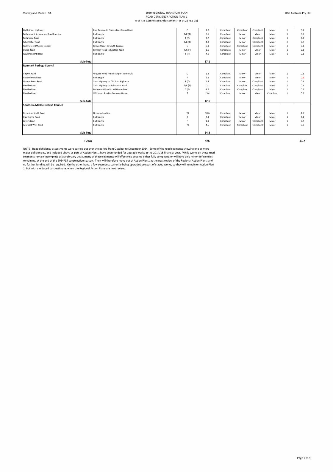
Old Princes Highway East Terrace to Ferries MacDonald Road C 7.7 Compliant Compliant Compliant Major 1 0.1
Pallamana / Schenscher Road I'section Full length F/C (T) 0.5 Compliant Minor Major Major 1 0.8
Pallamana Road Full length F (T) 7.7 Compliant Minor Compliant Major 1 0.3
Schenscher Road Full length F/C (T) 4.3 Compliant Minor Compliant Major 1 0.2
Sixth Street (Murray Bridge) Bridge Street to South Terrace C 0.1 Compliant Compliant Compliant Major 1 0.1
Usher Road Brinkley Road to Koehler Road T/C (F) 2.5 Compliant Minor Minor Major 1 0.1
Wagenknecht Road Full length F (T) 4.9 Compliant Minor Minor Major 1 0.1
Sub-Total 87.1
Renmark Paringa Council
Airport Road Gregory Road to End (Airport Terminal) C 1.6 Compliant Minor Minor Major 1 0.1
Government Road Full length F 9.1 Compliant Minor Major Minor 1 0.6
Lindsay Point Road Sturt Highway to Old Sturt Highway F (T) 1.2 Compliant Minor Compliant Major 1 0.1
Murtho Road Sturt Highway to Beherendt Road T/C (F) 11.1 Compliant Compliant Compliant Major 1 0.4
Murtho Road Beherendt Road to Wilkinson Road T (F) 4.2 Compliant Compliant Compliant Major 1 0.2
Murtho Road Wilkinson Road to Customs House T 15.4 Compliant Minor Major Compliant 1 0.6
Sub-Total 42.6
Southern Mallee District Council
Geranium South Road Unsealed section F/T 10.6 Compliant Minor Minor Major 1 1.9
Hawthorne Road Full length C 8.1 Compliant Minor Minor Major 1 0.1
Lovers Lane Full length F 1.1 Compliant Major Compliant Major 1 0.2
Tauragat Well Road Full length F/T 4.5 Compliant Compliant Compliant Major 1 0.9
Sub-Total 24.3
TOTAL 476 31.7
NOTE - Road deficiency assessments were carried out over the period from October to December 2014. Some of the road segments showing one or more
major deficiencies, and included above as part of Action Plan 1, have been funded for upgrade works in the 2014/15 financial year. While works on these road
segments remain incomplete as at February 2015, many of these segments will effectively become either fully compliant, or will have only minor deficiencies
remaining, at the end of the 2014/15 construction season. They will therefore move out of Action Plan 1 at the next review of the Regional Action Plans, and
no further funding will be required. On the other hand, a few segments currently being upgraded are part of staged works, so they will remain on Action Plan
1, but with a reduced cost estimate, when the Regional Action Plans are next revised.
Page 2 of 9

Murray and Mallee LGA 2030 REGIONAL TRANSPORT PLAN
ROAD DEFICIENCY ACTION PLAN 2
(For RTS Committee Endorsement - as at 26 FEB 15)
HDS Australia Pty Ltd
Road Segment Description (from/to) Regional Routes
F/T/C or Combo -
( ) implies Locally
Important for this
category
Segment Length
(nearest 0.1 km)
Speed
Environment
Dimensions Geometry Strength /
Durability
Action Plan Cost for
Action Plan 1
Only (nearest
$0.1 million)
Berri Barmera Council
Caddy Road Thiele Road to Council Boundary T 5.3 Compliant Minor Major Major 2
Distillery Road Old Sturt Highway to School C 1.3 Compliant Compliant Major Major 2
Fenwick Road Kay Avenue to Burgess Drive C 0.1 Compliant Compliant Compliant Major 2
Gilmour Road Sturt Highway to Thiele Road T 3.7 Compliant Minor Minor Major 2
Jury Road Old Sturt Highway to McKay Road F (T) 1.4 Compliant Major Major Major 2
McKay Road Full length F 3.9 Compliant Minor Major Minor 2
Old Coach Road Full length T 3.4 Compliant Minor Major Compliant 2
Sub-Total 19.1
Coorong District Council
Racecourse Road (Tailem Bend) Full length F 0.3 Compliant Major Compliant Minor 2
Tailem Bend Bypass (proposed) Full length F 2.0 Major Major Major Major 2
Sub-Total 2.3
District Council of Karoonda East Murray
East Murray Area School Road Knights Well Road to Walker Flat Road C (F) 12.7 Compliant Compliant Major Compliant 2
Galga Road Full length F 19.7 Compliant Compliant Major Minor 2
Kulde Road Karoonda Highway to Council Boundary F/C 6.4 Compliant Major Major Compliant 2
Kulkami Road Prentice Road to Council Boundary F 19.3 Compliant Major Compliant Compliant 2
Sub-Total 58.1
District Council of Loxton Waikerie
Drabsch Street Loxton Primary School to East Tce C 0.2 Major Compliant Minor Major 2
Geraldton Street Tobruk Terrace to Kokoda Terrace C 0.3 Major Compliant Minor Major 2
Sub-Total 0.5
Mid Murray Council
Bundilla Road Ridley Road to Sunnyview Road F (T) 2.0 Compliant Major Major Minor 2
Cliff View Drive Angas Valley Highway to 80 km/h sign T 1.5 Compliant Compliant Major Compliant 2
East Front Road Road closed section T 0.6 Major Major Major Major 2
East Front Road Recently upgraded section ending at Hunter Highway T 1.8 Compliant Compliant Major Compliant 2
Eudunda Road Full length F/C 9.2 Compliant Minor Minor Major 2
Long Gully Road Unsealed section F 1.8 Compliant Major Major Minor 2
Murraylands Road Sunnydale Road to Punyelroo Road T (C/F) 6.2 Compliant Compliant Compliant Minor 2
Murraylands Road Grid 8.2km North of Sturt Highway to Start of Seal 10km South of Morgan T (C/F) 18.2 Compliant Major Minor Minor 2
Pelican Point Full length T 1.9 Compliant Compliant Major Minor 2
Punyelroo Road Sealed section T 0.9 Compliant Compliant Major Compliant 2
Rob Loxton Road Full length T 2.0 Compliant Major Minor Compliant 2
Stony Steps Road Full length T 1.6 Compliant Minor Major Compliant 2
Teal Flat Road Full length T 4.5 Compliant Compliant Major Compliant 2
Tepko Road Full length F 5.5 Compliant Compliant Major Minor 2
Thamm Road Full length T 1.1 Compliant Compliant Major Compliant 2
Sub-Total 58.8
Rural City of Murray Bridge
Bremer Valley Road Unsealed section to Bondleigh Road C 10.3 Compliant Minor Major Minor 2
Brinkley Road End of freight section to Racecourse entrance C 1.9 Compliant Compliant Compliant Major 2
Brinkley Road Racecourse entrance to Usher Road T/C 1.5 Compliant Compliant Compliant Major 2
Brinkley Road Usher Road to Pfeiffer Road C (F) 1.7 Compliant Compliant Compliant Major 2
Coolibah Road Woolshed Road to North Bokara Road F 1.2 Minor Minor Major Compliant 2
Flagstaff Road Jervois Road to Big River Pork F 2.5 Compliant Minor Major Minor 2
Maurice Road Cypress Terrace to Netley Road C (F) 0.8 Compliant Minor Major Minor 2
Sub-Total 19.9
Renmark Paringa Council
Bookmark Avenue Twentyfifth Street to Angoves Winery Entrance F 0.7 Compliant Major Major Compliant 2
Gurra Road Nolan Road to Berri-Loxton Road C (T) 7.2 Compliant Minor Major Minor 2
James Avenue Ral Ral Avenue to Ninth Street T 0.6 Compliant Compliant Major Compliant 2
Lock 5 Road Sturt Highway To Bert Dix Park T 0.3 Compliant Minor Major Compliant 2
Lyrup Main Road Full length T/C 5.6 Compliant Minor Major Compliant 2
Moorna Street Twentythird Street to Townsend Street T 1.3 Compliant Major Minor Compliant 2
Nolan Road Downer Avenue to Gurra Road C (T) 1.4 Compliant Minor Major Compliant 2
Old Sturt Highway Sturt Highway to Lindsay Point Road F 0.7 Compliant Major Major Minor 2
Patey Drive Full length T 1.1 Compliant Minor Major Major 2
Plushs Bend Road Full length T 1.7 Compliant Major Major Compliant 2
Twentyfifth Street Sturt Highway to Bookmark Avenue F 0.7 Compliant Major Compliant Compliant 2
Sub-Total 21.3
Southern Mallee District Council
Airport Access Full length C 0.1 Compliant Major Compliant Major 2
Parilla Well Road End of Foster Road to Wurfel Road C 10.6 Compliant Major Minor Minor 2
Railway Terrace South (Lameroo) Chandos Terrace to Bews Road F 0.5 Compliant Minor Compliant Minor 2
Rosy Pine Road Full length T 8.1 Compliant Minor Major Minor 2
Sub-Total 19.3
TOTAL 199
Page 3 of 9

Murray and Mallee LGA 2030 REGIONAL TRANSPORT PLAN
ROAD DEFICIENCY ACTION PLAN 3
(For RTS Committee Endorsement - as at 26 FEB 15)
HDS Australia Pty Ltd
Road Segment Description (from/to) Regional Routes
F/T/C or Combo -
( ) implies Locally
Important for this
category
Segment Length
(nearest 0.1 km)
Speed
Environment
Dimensions Geometry Strength /
Durability
Action Plan Cost for
Action Plan 1
Only (nearest
$0.1 million)
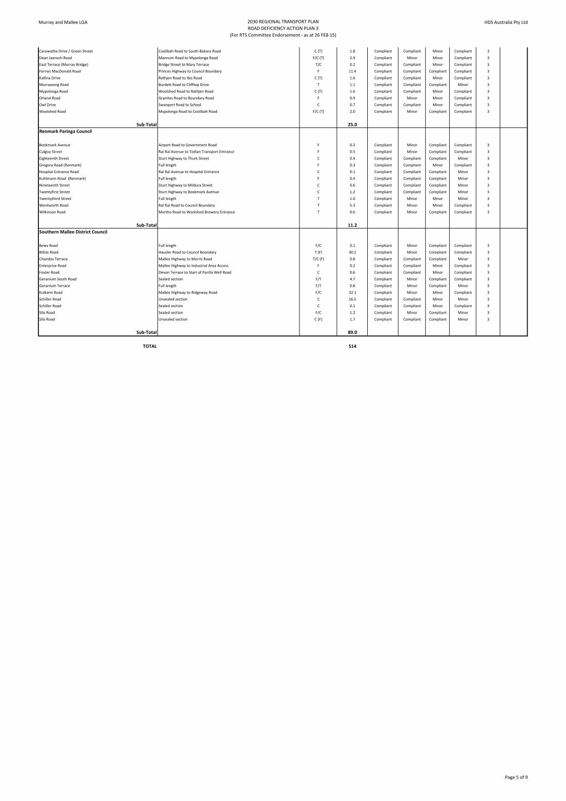
Berri Barmera Council
Anderson Street Sturt Highway to Hill Street F 0.4 Compliant Minor Compliant Compliant 3
Appleton Terrace Scott Avenue to Rumbold Drive C 0.4 Compliant Compliant Minor Compliant 3
Bigg Road Full length C 1.4 Compliant Compliant Minor Compliant 3
Burgess Drive Fenwick Drive to Berri Recreation Centre C 0.8 Compliant Minor Minor Compliant 3
Crawford Terrace Wilson Street to Riverview Drive T 0.3 Compliant Compliant Minor Compliant 3
Drogemuller Road Full length T/C 0.3 Compliant Compliant Compliant Minor 3
Hawdon Street Scott Avenue to Eyre Street C 0.1 Compliant Minor Compliant Minor 3
Jellett Road Old Sturt Highway to Hughes Street C 0.3 Compliant Compliant Compliant Minor 3
Jellett Road JC Smith Street to Woolston Road C 0.6 Compliant Compliant Compliant Minor 3
Joyce Street Sturt Highway to Farmer Street C 0.1 Compliant Minor Compliant Compliant 3
Lyrup Road Sturt Highway to Ferry T/C 1.8 Compliant Compliant Minor Compliant 3
Maddern Street Old Sturt Highway to Hepworth Street C 0.3 Compliant Compliant Compliant Minor 3
Minnis Road Full length C 1.1 Compliant Compliant Compliant Minor 3
Nixon Road Sturt Highway to Thachi Winery F 2.2 Compliant Minor Minor Compliant 3
Riverview Drive Crawford Terrace to Clarke Road T 0.9 Compliant Compliant Compliant Minor 3
Rumbold Drive Appleton Terrace to School C 0.3 Compliant Minor Compliant Minor 3
Scott Avenue Fowels Street to Appleton Terrace C 0.7 Compliant Compliant Compliant Minor 3
Shiell Road Full length F 0.8 Compliant Minor Minor Compliant 3
Sultana Street Full length C 0.3 Compliant Minor Compliant Compliant 3
Thiele Road Gilmour Road to Caddy Road T 2.3 Compliant Compliant Compliant Minor 3
Vaughn Terrace East Old Sturt Highway to Wilson Street C 0.4 Compliant Compliant Compliant Minor 3
Whitmore Avenue Nookamka Terrace to Dean Drive T 0.1 Compliant Minor Compliant Compliant 3
Winkie Road Old Sturt Highway to Spendiff Road T/C 1.6 Compliant Minor Minor Compliant 3
Sub-Total 17.5
Coorong District Council
Carcuma Road Dukes Highway to Heinrich Road C (F) 12.9 Compliant Compliant Minor Compliant 3
Granites Road Viterra Entrance to Council Boundary F 6.9 Compliant Minor Minor Compliant 3
Hannah Well Road Dukes Highway to Werrimbrook Road C 3.5 Compliant Compliant Minor Minor 3
Narrung Road Princes Highway to Loveday Bay Road C (F)(T) 21.9 Compliant Minor Minor Compliant 3
North Terrace (Tailem Bend) Dukes Highway to Station Drive F/C 0.3 Compliant Minor Compliant Compliant 3
Poltalloch Road Full length C (F)(T) 17.6 Compliant Compliant Minor Compliant 3
Princes Road (Tailem Bend) South Tce to Dukes Highway C 0.1 Compliant Compliant Minor Compliant 3
Tauragat Well Road Dukes Highway to end of sealed section F/T 24.6 Compliant Minor Minor Compliant 3
Woods Well Road Dukes Highway to Luhrs Road C (F) 8.4 Compliant Compliant Minor Compliant 3
Yumali Road Princes Highway through industrial section F/C 0.5 Compliant Compliant Minor Compliant 3
Yumali Road End of industrial section to end of sealed section C (F) 6.9 Compliant Compliant Minor Compliant 3
Sub-Total 103.6
District Council of Karoonda East Murray
East Murray Area School Road Karoonda Highway to Knights Well Road F/C 0.2 Compliant Minor Minor Compliant 3
Eustice Road Galga Road to Council Boundary F 2.1 Compliant Compliant Compliant Minor 3
Goondooloo Road Hunter Highway to Hundred Line Road F 9.3 Compliant Compliant Minor Compliant 3
Goondooloo Road Hundred Line Road to Perponda Road F 6.1 Compliant Minor Compliant Minor 3
KR Wilson Drive Full length F 0.9 Compliant Minor Compliant Compliant 3
Kulkami Road Kulkawarra Road to Prentice Road F/C 16.4 Compliant Minor Minor Compliant 3
Kulkawarra Road Kulkami Road to Peake Road C (F) 10.9 Compliant Compliant Minor Compliant 3
Lowan Road Rosenzweig Road to end of sealed section F 5.2 Compliant Compliant Minor Compliant 3
Morrell Road Full length F/C 7.9 Compliant Compliant Minor Compliant 3
Perponda Road North Terrace to 50m south of Schiller Road F/C 15.3 Compliant Minor Compliant Compliant 3
Walker Flat Road Galga Road to Perponda Road F 6.5 Compliant Minor Compliant Minor 3
Sub-Total 80.8
District Council of Loxton Waikerie
Billiat Road Karoonda Highway to Council Boundary T (F) 35.5 Minor Compliant Minor Minor 3
Eustice Road Stott Highway to Council Boundary F 9.5 Minor Compliant Minor Minor 3
Sub-Total 45.0
Mid Murray Council
Belvedere Road 100 km/h zone T 5.1 Compliant Compliant Minor Compliant 3
Black Hill Road 50 km/h zone to Ridley Road C (T) 0.5 Compliant Minor Compliant Compliant 3
Bower Boundary Road Burra-Morgan Road to Thiele Highway F 29.6 Compliant Minor Minor Minor 3
Bower Boundary Road New section to Sturt Highway F 6.6 Compliant Compliant Compliant Minor 3
Centenary Road Full length F 1.0 Compliant Compliant Minor Compliant 3
Cliff View Drive 80 km/h zone T 2.0 Minor Minor Minor Compliant 3
Cliff View Drive 110 km/h zone T 2.4 Compliant Minor Compliant Compliant 3
East Front Road Closed section to recently upgraded section T 20.1 Compliant Minor Minor Minor 3
Egerton Road Full length T 0.6 Compliant Minor Minor Compliant 3
Gierke Road Full length F 1.5 Compliant Minor Compliant Compliant 3
Goondooloo Road Full length F 9.3 Compliant Compliant Minor Compliant 3
High Street Full length T/C (F) 1.4 Compliant Minor Compliant Compliant 3
Long Gully Road Sealed section F 1.3 Compliant Minor Compliant Compliant 3
Morgan-Cadell Road Full length C (F) 9.7 Compliant Compliant Compliant Minor 3
Morrell Road Full length F 7.8 Compliant Compliant Minor Compliant 3
Murraylands Road Purnong Road to Angas Valley Highway T (C/F) 13.1 Compliant Compliant Minor Minor 3
Murraylands Road Swan Reach Pump Station to 50 km/h sign at Blanchetown T (C/F) 16.4 Compliant Compliant Minor Minor 3
Nildottie Road 50 km/h zone C 1.1 Compliant Compliant Minor Compliant 3
Nildottie Road 100 km/h zone T/C 1.1 Compliant Compliant Minor Compliant 3
North Terrace Full length T 0.7 Compliant Compliant Compliant Minor 3
Providence Drive Full length T 1.5 Compliant Minor Compliant Compliant 3
Punyelroo Road Unsealed section T 0.6 Compliant Compliant Compliant Minor 3
Purnong Road 50 km/h zone to 80 km/h sign north of Mannum F/T/C 0.4 Compliant Minor Compliant Compliant 3
Purnong Road 80 km/h sign north of Mannum to Long Gully Road F/T/C 0.7 Minor Minor Compliant Compliant 3
Purnong Road Eastern side of ferry to end of 50 km/h zone T/C (F) 0.9 Compliant Minor Compliant Compliant 3
River Lane Full length T 1.2 Compliant Minor Compliant Compliant 3
Riverview Road 30 km/h zone T 0.1 Minor Compliant Compliant Compliant 3
South Terrace Full length T 3.1 Compliant Minor Minor Compliant 3
Tennanbie Road Full length T 0.1 Compliant Compliant Minor Minor 3
Wongulla Ramp Road Full length T 0.3 Compliant Minor Compliant Compliant 3
Zadow Road Unsealed section to Martins Road T 1.4 Compliant Compliant Minor Compliant 3
Sub-Total 141.6
Rural City of Murray Bridge
Bremer Valley Road Sealed section C 0.8 Compliant Compliant Minor Compliant 3
Page 4 of 9
Murray and Mallee LGA 2030 REGIONAL TRANSPORT PLAN
ROAD DEFICIENCY ACTION PLAN 3
(For RTS Committee Endorsement - as at 26 FEB 15)
HDS Australia Pty Ltd
Carawatha Drive / Green Street Coolibah Road to South Bokara Road C (T) 1.8 Compliant Compliant Minor Compliant 3
Dean Jaensch Road Mannum Road to Mypolonga Road F/C (T) 2.9 Compliant Minor Minor Compliant 3
East Terrace (Murray Bridge) Bridge Street to Mary Terrace T/C 0.2 Compliant Compliant Minor Compliant 3
Ferries MacDonald Road Princes Highway to Council Boundary F 11.4 Compliant Compliant Compliant Compliant 3
Kallina Drive Rathjen Road to Ibis Road C (T) 1.6 Compliant Compliant Minor Compliant 3
Murrawong Road Burdett Road to Clifftop Drive T 1.1 Compliant Compliant Compliant Minor 3
Mypolonga Road Woolshed Road to Rathjen Road C (T) 1.6 Compliant Compliant Minor Compliant 3
Orland Road Granites Road to Boundary Road F 0.9 Compliant Minor Minor Compliant 3
Owl Drive Swanport Road to School C 0.7 Compliant Compliant Minor Compliant 3
Woolshed Road Mypolonga Road to Coolibah Road F/C (T) 2.0 Compliant Minor Compliant Compliant 3
Sub-Total 25.0
Renmark Paringa Council
Bookmark Avenue Airport Road to Government Road F 0.2 Compliant Minor Compliant Compliant 3
Culgoa Street Ral Ral Avenue to Todian Transport Entrance F 0.5 Compliant Minor Compliant Compliant 3
Eighteenth Street Sturt Highway to Thurk Street C 0.4 Compliant Compliant Compliant Minor 3
Gregory Road (Renmark) Full length F 0.3 Compliant Compliant Minor Compliant 3
Hospital Entrance Road Ral Ral Avenue to Hospital Entrance C 0.1 Compliant Compliant Compliant Minor 3
Kuhlmann Road (Renmark) Full length F 0.4 Compliant Compliant Compliant Minor 3
Nineteenth Street Sturt Highway to Mildura Street C 0.6 Compliant Compliant Compliant Minor 3
Twentyfirst Street Sturt Highway to Bookmark Avenue C 1.2 Compliant Compliant Compliant Minor 3
Twentythird Street Full length T 1.6 Compliant Minor Minor Minor 3
Wentworth Road Ral Ral Road to Council Boundary T 5.3 Compliant Minor Minor Compliant 3
Wilkinson Road Murtho Road to Woolshed Brewery Entrance T 0.6 Compliant Minor Compliant Compliant 3
Sub-Total 11.2
Southern Mallee District Council
Bews Road Full length F/C 0.1 Compliant Minor Compliant Compliant 3
Billiat Road Hausler Road to Council Boundary T (F) 30.2 Compliant Minor Compliant Compliant 3
Chandos Terrace Mallee Highway to Morris Road T/C (F) 0.8 Compliant Compliant Compliant Minor 3
Enterprise Road Mallee Highway to Industrial Area Access F 0.2 Compliant Compliant Minor Compliant 3
Foster Road Devon Terrace to Start of Parilla Well Road C 0.6 Compliant Compliant Minor Compliant 3
Geranium South Road Sealed section F/T 4.7 Compliant Minor Compliant Compliant 3
Geranium Terrace Full length F/T 0.8 Compliant Minor Compliant Minor 3
Kulkami Road Mallee Highway to Ridgeway Road F/C 32.1 Compliant Minor Minor Compliant 3
Schiller Road Unsealed section C 16.5 Compliant Compliant Minor Minor 3
Schiller Road Sealed section C 0.1 Compliant Compliant Minor Compliant 3
Silo Road Sealed section F/C 1.2 Compliant Minor Compliant Minor 3
Silo Road Unsealed section C (F) 1.7 Compliant Compliant Compliant Minor 3
Sub-Total 89.0
TOTAL 514
Page 5 of 9

Murray and Mallee LGA 2030 REGIONAL TRANSPORT PLAN
COMPLIANT ROADS
(For RTS Committee Endorsement - as at 26 FEB 15)
HDS Australia Pty Ltd
Road Segment Description (from/to) Regional Routes
F/T/C or Combo -
( ) implies Locally
Important for this
category
Segment Length
(nearest 0.1 km)
Speed
Environment
Dimensions Geometry Strength /
Durability
Action Plan Cost for
Action Plan 1
Only (nearest
$0.1 million)
Berri Barmera Council
Barwell Avenue East Scott Avenue to Nookamka Terrace T/C 0.3 Compliant Compliant Compliant Compliant N/A
Barwell Avenue West Nookamka Terrace to Scott Avenue T/C 0.3 Compliant Compliant Compliant Compliant N/A
Coneybeer Street Crawford Terrace to McIntosh Street C 0.1 Compliant Compliant Compliant Compliant N/A
Cornwall Street Old Sturt Highway to Hepworth Street C 0.3 Compliant Compliant Compliant Compliant N/A
Crawford Terrace Berri-Loxton Road to Wilson Street T/C 0.3 Compliant Compliant Compliant Compliant N/A
Dean Drive Foot Avenue to Lakeside Drive T 1.0 Compliant Compliant Compliant Compliant N/A
Fowels Street Sturt Highway to Scott Avenue T/C 0.6 Compliant Compliant Compliant Compliant N/A
Higgs Street Full length F 0.1 Compliant Compliant Compliant Compliant N/A
Hoskin Road Minnis Road to Bigg Road C (F) 0.3 Compliant Compliant Compliant Compliant N/A
James Terrace Lakeside Drive to Nookamka Terrace T 0.1 Compliant Compliant Compliant Compliant N/A
JC Smith Road Jellett Road to Verall Crescent West F 0.3 Compliant Compliant Compliant Compliant N/A
Kay Avenue Full length C 1.8 Compliant Compliant Compliant Compliant N/A
Lakeside Drive James Terrace to Dean Drive T 0.2 Compliant Compliant Compliant Compliant N/A
McIntosh Street Full length C 0.1 Compliant Compliant Compliant Compliant N/A
Muscat Avenue Sultana Street to Zante Road C 0.3 Compliant Compliant Compliant Compliant N/A
Nookamka Terrace Barwell Avenue to Whitmore Avenue T/C 0.1 Compliant Compliant Compliant Compliant N/A
Nookamka Terrace Whitmore Avenue to James Terrace C 0.7 Compliant Compliant Compliant Compliant N/A
Nookamka Terrace James Terrace to Sturt Highway T/C 0.4 Compliant Compliant Compliant Compliant N/A
Park Terrace East (Cobdogla) Full length T 0.3 Compliant Compliant Compliant Compliant N/A
Park Terrace West (Cobdogla) Full length T 0.3 Compliant Compliant Compliant Compliant N/A
Plush Road Full length T 0.9 Compliant Compliant Compliant Compliant N/A
Vaughn Terrace West Wilson Street to Old Sturt Highway C 0.4 Compliant Compliant Compliant Compliant N/A
Wilson Street Full length C 0.2 Compliant Compliant Compliant Compliant N/A
Zante Road Muscat Avenue to Old Sturt Highway C 0.1 Compliant Compliant Compliant Compliant N/A
Sub-Total 9.5
Coorong District Council
Coorong Wilderness Lodge Access Princes Highway to Gate T 0.1 Compliant Compliant Compliant Compliant N/A
Emu Springs Road Becker Tce to end of sealed section C (F) 4.6 Compliant Compliant Compliant Compliant N/A
Emu Springs Road Start of unsealed section to Coombe Road C (F) 7.9 Compliant Compliant Compliant Compliant N/A
North Tce / Trevena Road Station Drive to start of Granites Road F 0.8 Compliant Compliant Compliant Compliant N/A
Railway Terrace (Tailem Bend) North Tce to South Tce C 0.5 Compliant Compliant Compliant Compliant N/A
South Terrace (Tailem Bend) Full length C 0.1 Compliant Compliant Compliant Compliant N/A
Station Drive North Tce to Kulde Road F/C 0.3 Compliant Compliant Compliant Compliant N/A
Sub-Total 14.3
District Council of Karoonda East Murray
Kulkawarra Road Karoonda Highway to Kulkami Road F/C 0.6 Compliant Compliant Compliant Compliant N/A
Lewis Road Karoonda Highway to Industrial Area Access F 0.1 Compliant Compliant Compliant Compliant N/A
North Terrace (Karoonda) West Terrace to School Entrance C 0.3 Compliant Compliant Compliant Compliant N/A
Rosenzweig Road Hundred Line Road to Lowan Road F 3.8 Compliant Compliant Compliant Compliant N/A
Schiller Road 50m west of Perponda Road to Hundred Line Road F 5.4 Compliant Compliant Compliant Compliant N/A
Stokes Road West Terrace to Hospital Entrance C 0.3 Compliant Compliant Compliant Compliant N/A
Sub-Total 10.5
District Council of Loxton Waikerie
Sub-Total 0.0
Mid Murray Council
Belvedere Road 80 km/h and 50 km/h zones T 1.6 Compliant Compliant Compliant Compliant N/A
Berryman Avenue Full length T 0.5 Compliant Compliant Compliant Compliant N/A
Black Hill Road 100 km/h zone C (T) 7.0 Compliant Compliant Compliant Compliant N/A
Caloote Road Mannum Road to 50 km/h sign in Caloote T/C 2.9 Compliant Compliant Compliant Compliant N/A
Carman Road Gierke Road to Oakville Potatoes F 0.6 Compliant Compliant Compliant Compliant N/A
Cliff View Drive 50 km/h zone to Wongulla Ramp Road T 1.3 Compliant Compliant Compliant Compliant N/A
East Front Road Hunter Highway to road closed section T 1.9 Compliant Compliant Compliant Compliant N/A
Johnson Hill Road Full length T 0.2 Compliant Compliant Compliant Compliant N/A
Mallee Road Purnong Road to Angas Valley Highway T/C (F) 15.1 Compliant Compliant Compliant Compliant N/A
Murbko Road Full length T (F) 14.8 Compliant Compliant Compliant Compliant N/A
Murray Street 50 km/h zone in Caloote T/C 1.3 Compliant Compliant Compliant Compliant N/A
Murraylands Road Start of Seal 10km South of Morgan to Thiele Highway T (C/F) 9.9 Compliant Compliant Compliant Compliant N/A
Murraylands Road (Egerton St) 50 km/h zone to Sturt Highway T (C/F) 0.4 Compliant Compliant Compliant Compliant N/A
Murraylands Road (West Tce) 50 km/h zone at Blanchetown T (C/F) 0.5 Compliant Compliant Compliant Compliant N/A
Nildottie Road 80 km/h zone T/C 0.3 Compliant Compliant Compliant Compliant N/A
Parker Street Full length C 0.1 Compliant Compliant Compliant Compliant N/A
Purnong Road Mallee Road to Teal Flat Road T/C (F) 10.0 Compliant Compliant Compliant Compliant N/A
Purnong Road Teal Flat Road to western side of ferry T/C (F) 5.9 Compliant Compliant Compliant Compliant N/A
Purnong Road 80 km/h sign east of Purnong to Hunter Highway T/C (F) 1.0 Compliant Compliant Compliant Compliant N/A
Riverview Road Hunter Highway to 30 km/h sign T 0.9 Compliant Compliant Compliant Compliant N/A
Walker Avenue Full length C 0.4 Compliant Compliant Compliant Compliant N/A
Zadow Road End of 50 km/h zone in Caloote to unsealed section T 2.8 Compliant Compliant Compliant Compliant N/A
Sub-Total 79.4
Rural City of Murray Bridge
Brinkley Road Pfeiffer Road to Australian Salt C 12.8 Compliant Compliant Compliant Compliant N/A
Brinkley Road Australian Salt to Langhorne Creek Road F/C 1.6 Compliant Compliant Compliant Compliant N/A
Long Island Road Swanport Road to Lohmann Street T/C 0.3 Compliant Compliant Compliant Compliant N/A
Long Island Road Lohmann Street to Wildens Way T 0.8 Compliant Compliant Compliant Compliant N/A
Mulgundawah Road Full length C 1.5 Compliant Compliant Compliant Compliant N/A
Old Princes Highway Ferries MacDonald Road to Monarto Zoo T/C (F) 0.8 Compliant Compliant Compliant Compliant N/A
Old Princes Highway Monarto Zoo to Adelaide Road C (F/T) 8.8 Compliant Compliant Compliant Compliant N/A
Seventh Street (Murray Bridge) Bridge Street to South Terrace C 0.1 Compliant Compliant Compliant Compliant N/A
South Terrace (Murray Bridge) East Terrace to Swanport Road C 0.5 Compliant Compliant Compliant Compliant N/A
West Terrace (Murray Bridge) Bridge Road to South Terrace C 0.1 Compliant Compliant Compliant Compliant N/A
Sub-Total 27.3
Renmark Paringa Council
Airport Road Sturt Highway to Gregory Road F/C 0.6 Compliant Compliant Compliant Compliant N/A
Beames Road (Lyrup) Full length T 0.3 Compliant Compliant Compliant Compliant N/A
Downer Avenue Lyrup Main Road to Beames Road T/C 0.3 Compliant Compliant Compliant Compliant N/A
Downer Avenue Beames Road to Wilson Parade C 0.3 Compliant Compliant Compliant Compliant N/A
Ferry Access Road (Lyrup) Full length T/C 0.1 Compliant Compliant Compliant Compliant N/A
Fifteenth Street Renmark Avenue to Para Avenue C 0.2 Compliant Compliant Compliant Compliant N/A
Page 6 of 9
Murray and Mallee LGA 2030 REGIONAL TRANSPORT PLAN
COMPLIANT ROADS
(For RTS Committee Endorsement - as at 26 FEB 15)
HDS Australia Pty Ltd
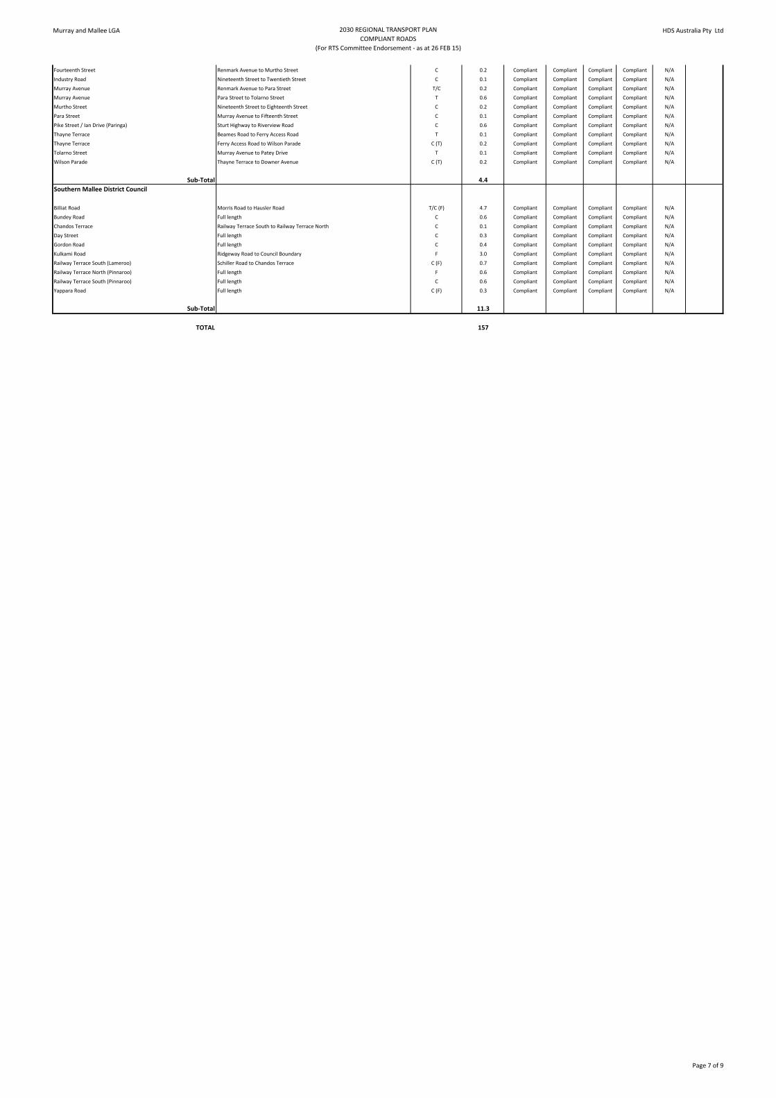
Fourteenth Street Renmark Avenue to Murtho Street C 0.2 Compliant Compliant Compliant Compliant N/A
Industry Road Nineteenth Street to Twentieth Street C 0.1 Compliant Compliant Compliant Compliant N/A
Murray Avenue Renmark Avenue to Para Street T/C 0.2 Compliant Compliant Compliant Compliant N/A
Murray Avenue Para Street to Tolarno Street T 0.6 Compliant Compliant Compliant Compliant N/A
Murtho Street Nineteenth Street to Eighteenth Street C 0.2 Compliant Compliant Compliant Compliant N/A
Para Street Murray Avenue to Fifteenth Street C 0.1 Compliant Compliant Compliant Compliant N/A
Pike Street / Ian Drive (Paringa) Sturt Highway to Riverview Road C 0.6 Compliant Compliant Compliant Compliant N/A
Thayne Terrace Beames Road to Ferry Access Road T 0.1 Compliant Compliant Compliant Compliant N/A
Thayne Terrace Ferry Access Road to Wilson Parade C (T) 0.2 Compliant Compliant Compliant Compliant N/A
Tolarno Street Murray Avenue to Patey Drive T 0.1 Compliant Compliant Compliant Compliant N/A
Wilson Parade Thayne Terrace to Downer Avenue C (T) 0.2 Compliant Compliant Compliant Compliant N/A
Sub-Total 4.4
Southern Mallee District Council
Billiat Road Morris Road to Hausler Road T/C (F) 4.7 Compliant Compliant Compliant Compliant N/A
Bundey Road Full length C 0.6 Compliant Compliant Compliant Compliant N/A
Chandos Terrace Railway Terrace South to Railway Terrace North C 0.1 Compliant Compliant Compliant Compliant N/A
Day Street Full length C 0.3 Compliant Compliant Compliant Compliant N/A
Gordon Road Full length C 0.4 Compliant Compliant Compliant Compliant N/A
Kulkami Road Ridgeway Road to Council Boundary F 3.0 Compliant Compliant Compliant Compliant N/A
Railway Terrace South (Lameroo) Schiller Road to Chandos Terrace C (F) 0.7 Compliant Compliant Compliant Compliant N/A
Railway Terrace North (Pinnaroo) Full length F 0.6 Compliant Compliant Compliant Compliant N/A
Railway Terrace South (Pinnaroo) Full length C 0.6 Compliant Compliant Compliant Compliant N/A
Yappara Road Full length C (F) 0.3 Compliant Compliant Compliant Compliant N/A
Sub-Total 11.3
TOTAL 157
Page 7 of 9

Murray and Mallee LGA 2030 REGIONAL TRANSPORT PLAN
LOCALLY IMPORTANT ROADS - NOT REGIONALLY SIGNIFICANT
(For RTS Committee Infomation Only - as at 26 FEB 15)
HDS Australia Pty Ltd
Road Segment Description (from/to) ( ) implies Locally
Important for this
category
Segment Length
(nearest 0.1 km)
Speed
Environment
Dimensions Geometry Strength /
Durability
Potential
Council
Priority
Cost for
Council Works
(nearest $0.1
million)
Berri Barmera Council
Jury Road Hoskin Road to Sturt Highway (T) 1.6 Compliant Compliant Major Major 1 0.2
Martins Bend Drive Full length (T) 0.9 Compliant Compliant Minor Major 1 0.1
Queen Elizabeth Drive Foot Avenue to Morgan Road (T) 9.1 Compliant Compliant Minor Major 1 0.3
Trenaman Road Jury Road to Berriman Road (F) 0.5 Compliant Minor Compliant Major 1 0.1
Battams Road Accolade Wines Entrance to McKay Road (F) 0.6 Compliant Major Compliant Major 2
Riverview Drive Clarke Road to Old Sturt Highway (T) 4.1 Minor Minor Major Major 2
Hoskin Road Old Sturt Highway to MInnis Road (F) 2.0 Compliant Minor Compliant Compliant 3
Hoskin Road Bigg Road to Jury Road (F) 1.9 Compliant Minor Compliant Compliant 3
Jury Road McKay Road to Hoskin Road (F)(T) 1.9 Compliant Minor Minor Minor 3
Field Day Drive Sturt Highway to Wine Store Entrance (F) 0.1 Compliant Compliant Compliant Compliant N/A
Hughes Road Higgs Road to Tipper Street (F) 0.5 Compliant Compliant Compliant Compliant N/A
Quarry Access (Barmera) Sturt Highway to Gate (F) 0.1 Compliant Compliant Compliant Compliant N/A
Verrall Crescent Higgs Street to JC Smith Street (F) 0.3 Compliant Compliant Compliant Compliant N/A
Sub-Total 23.6
Coorong District Council
Cooke Plains Road Full length (F) 18.0 Compliant Compliant Major Compliant 2
Coombe Road Dukes Highway to Emu Springs Road (F) 9.1 Compliant Minor Major Compliant 2
Gumwell Road Woods Well Road to end of sealed section (F) 7.8 Compliant Major Minor Compliant 2
Lime Kiln Road Full length (F) 5.5 Compliant Minor Major Compliant 2
Loop Road Full length (T) 13.2 Compliant Minor Major Minor 2
Loveday Bay Road Alexandrina Drive to Marks Point Road (F) 15.6 Compliant Major Major Minor 2
Marks Point Road Full length (T) 3.0 Compliant Major Major Minor 2
Parnka Point Road Full length (T) 3.9 Compliant Minor Major Minor 2
Seven Mile Road Noonameena Settlement to Narrung Road (T) 7.6 Compliant Compliant Major Minor 2
Taunta Hut Road Gumwell Road for 23km south (F) 22.7 Compliant Major Major Minor 2
Boothby Road Sealed Section (F) 4.1 Compliant Minor Compliant Compliant 3
Burns Road Full length (F) 3.9 Compliant Minor Compliant Minor 3
Carcuma Road Heinrich Road to Council Boundary (F) 15.5 Compliant Compliant Minor Minor 3
Cold and Wet Road Yarindale Road to Pink Road (Unsealed) (F) 3.0 Compliant Compliant Compliant Minor 3
Growden Road Stirling Well Road to Council Boundary (F) 9.0 Compliant Minor Compliant Minor 3
Gumwell Road End of sealed section to Taunta Hut Road (F) 6.3 Compliant Compliant Minor Minor 3
Heinrich Road Full length (F) 21.0 Compliant Minor Minor Minor 3
Loveday Bay Road Marks Point Road to Narrung Road (F)(T) 6.9 Compliant Compliant Minor Minor 3
Malinong Road Full length (F) 20.6 Compliant Compliant Minor Minor 3
Moorlands Road Dukes Highway to Council Boundary (F) 9.7 Compliant Compliant Minor Minor 3
Narrung Road Alexandrina Drive to Loveday Bay Road (T) 17.8 Compliant Minor Minor Compliant 3
Pascoe Road Tauragat Well Road to Burns Road (F) 1.3 Compliant Minor Compliant Minor 3
Railz Road Full length (F) 10.3 Compliant Minor Compliant Minor 3
Richardson Road Todd Road to Lutze Road (F) 10.6 Compliant Minor Minor Minor 3
Stirling Well Road Mallee Highway to High Street (F) 0.3 Compliant Minor Compliant Compliant 3
Todd Road Full length (F) 6.6 Compliant Minor Minor Compliant 3
Two Wells Road Woods Well Road to end of sealed section (F) 3.8 Compliant Minor Compliant Compliant 3
Two Wells Road End of sealed section to Council Boundary (F) 17.7 Compliant Minor Minor Minor 3
West Terrace (Jabuk) Full length (F) 0.7 Compliant Minor Minor Minor 3
Woods Well Road Princes Highway to Luhrs Road (F)(C) 42.3 Compliant Minor Compliant Compliant 3
Yumali Road Malinong Road to Dukes Highway (F) 29.5 Compliant Compliant Minor Minor 3
Beehive Road West Tce to Council Boundary (F) 1.2 Compliant Compliant Compliant Compliant N/A
Boothby Road Unsealed section (F) 30.8 Compliant Compliant Compliant Compliant N/A
Cold and Wet Road McIntosh Way to Yarindale Road (Sealed) (F) 20.3 Compliant Compliant Compliant Compliant N/A
Gypsum Road Dukes Highway to Irbrae Road (F) 4.1 Compliant Compliant Compliant Compliant N/A
Jabuk South Road Full length (F) 19.5 Compliant Compliant Compliant Compliant N/A
Kulkawurra Road Dukes Highway to Council Boundary (F) 14.4 Compliant Compliant Compliant Compliant N/A
Ladana Bore Road Dukes Highway to Netherton Road (F) 16.7 Compliant Compliant Compliant Compliant N/A
Netherton Road Mallee Highway to end of sealed section (F) 1.4 Compliant Compliant Compliant Compliant N/A
Netherton Road End of sealed section to Netherton (F) 16.8 Compliant Compliant Compliant Compliant N/A
Nine Mile Road Full length (F) 12.3 Compliant Compliant Compliant Compliant N/A
Stirling Well Road High Street to Council Boundary (F) 9.1 Compliant Compliant Compliant Compliant N/A
Trevana Road (Tailem Bend) Kulde Road to Lime Kiln Road (F) 0.5 Compliant Compliant Compliant Compliant N/A
Tynan Road Full length (F)(C) 23.3 Compliant Compliant Compliant Compliant N/A
Sub-Total 517.7
District Council of Karoonda East Murray
Dowling Road Full length - Seg 97 Cat 1 road - 2017/18 Plan (F) 8.4 Compliant Minor Major Major 1 0.1
Goondooloo Road Perponda Road to Dixon Road - Part of Seg 42/66 Cat 1 road - 2015/16 Plan (F) 31.4 Compliant Minor Minor Major 1 0.3
Walker Flat Road Galga Road to East Murray Area School Road - Seg 58 Cat 2 road - 2015/16 Plan (F) 19.6 Compliant Compliant Minor Major 1 0.2
Walker Flat Road East Murray Area School Road to Karoonda Highway - Seg 122 Cat 2 road - 2019/20 Plan (F) 18.1 Compliant Minor Major Minor 1 0.1
Evans Road Full length (F) 7.3 Compliant Compliant Major Major 2
Dixon Road Karoonda Highway to Goondooloo Road (F) 0.5 Compliant Minor Minor Compliant 3
Kulkawarra Road Peake Road to Council Boundary (F) 3.1 Compliant Minor Minor Compliant 3
Parrakie North Road Kulkami Road to Council Boundary (F) 17.1 Compliant Minor Minor Minor 3
Sub-Total 105.5
District Council of Loxton Waikerie
Sub-Total 0.0
Mid Murray Council
Black Hill Road Murraylands Road to 50 km/h zone (T) 6.1 Compliant Compliant Major Minor 2
Black Hill Road End 50 km/h zone to seal (T) 9.5 Compliant Minor Major Minor 2
Black Hill Road 25 km/h zone (T) 0.4 Major Major Minor Minor 2
Brinkworth Road Unsealed section (F) 10.8 Compliant Compliant Major Minor 2
Bundilla Road Sunnyview Road to Angas Valley Road (T) 10.4 Compliant Major Major Minor 2
Cascade Road Sealed section (T) 1.9 Minor Compliant Major Compliant 2
Martin Road Full length (T) 1.0 Compliant Compliant Major Minor 2
Peters Road Sealed section (T) 1.5 Minor Minor Major Compliant 2
Ayres Road Full length (F) 3.5 Compliant Compliant Minor Minor 3
Black Hill Road Sealed section to 25 km/h sign (T) 1.8 Compliant Minor Compliant Compliant 3
Blackheath Road Boundary Road to Brinkworth Road (F) 12.8 Compliant Compliant Minor Minor 3
Blackheath Road Brinkworth Road to Reidy Creek Road (F) 13.8 Compliant Compliant Minor Minor 3
Cascade Road Unsealed section (T) 5.7 Compliant Minor Minor Minor 3
Peters Road Unsealed section (T) 3.2 Compliant Minor Compliant Minor 3
Seven Sisters Road Full length (T) 1.1 Compliant Minor Compliant Minor 3
Black Hill Road 50 km/h zone (Black Hill) (T) 0.6 Compliant Compliant Compliant Compliant N/A
Brinkworth Road Sealed section (F) 0.6 Compliant Compliant Compliant Compliant N/A
Heindrich Road Full length (T) 0.6 Compliant Compliant Compliant Compliant N/A
Page 8 of 9

Murray and Mallee LGA 2030 REGIONAL TRANSPORT PLAN
LOCALLY IMPORTANT ROADS - NOT REGIONALLY SIGNIFICANT
(For RTS Committee Infomation Only - as at 26 FEB 15)
HDS Australia Pty Ltd
Kittely Road Full length (T) 0.6 Compliant Compliant Compliant Compliant N/A
Sub-Total 85.9
Rural City of Murray Bridge
Flagstaff Road Big River Pork to Langhorne Creek Road (F) 14.4 Compliant Minor Major Compliant 1 0.3
Kennett Road Full length (T) 0.4 Compliant Compliant Minor Major 1 0.1
Kepa Road Old Princes Highway to Schultz Road (F) 7.2 Compliant Minor Compliant Major 1 0.3
Pfeiffer Road Brinkley Road to Jervois Road (F) 5.1 Compliant Major Minor Minor 1 0.1
Swanport Village Road Jervois Road to Stay Crisp (F) 1.9 Compliant Minor Minor Major 1 0.1
Woodlane Drive White Hut Road to North Bokara Road (F) 2.4 Compliant Major Compliant Major 1 0.1
Maurice Road Netley Road to end of seal (F) 2.8 Compliant Minor Major Compliant 2
Maurice Road Unsealed section to Old Princes Highway (F) 3.1 Compliant Major Major Minor 2
Rathjen Road Mannum Road to White Hut Road (F) 6.3 Compliant Minor Major Minor 2
Kallina Drive / Kittlety Road Ibis Road to Council Boundary (T) 4.3 Compliant Compliant Minor Compliant 3
Ibis Road Full length (T) 0.9 Compliant Compliant Compliant Compliant N/A
Sub-Total 48.8
Renmark Paringa Council
Bookmark Avenue Angoves Winery Entrance to Tapalin Street (F) 1.5 Compliant Major Minor Compliant 2
Lock 5 Road Bert Dix Park to End of Road (T) 1.8 Compliant Minor Major Minor 2
Weaver Road / Pine Creek Road Lyrup Main Road to Stanitzki Road (T) 4.9 Minor Compliant Major Compliant 2
Industry Road Twentieth Street to Twentyfirst Street (F) 0.7 Compliant Minor Compliant Compliant 3
Lindsay Point Road Old Sturt Highway to Border Road (F)(T) 15.7 Compliant Minor Compliant Compliant 3
Tapalin Street Full length (F) 1.6 Compliant Minor Compliant Compliant 3
Sub-Total 26.2
Southern Mallee District Council
Sub-Total 0.0
TOTAL 808 2.4
Page 9 of 9

Appendix B Detailed Submissions Berri Barmera Council

ECM 584209 Page 1 of 15
Local Government Transport Advisory Panel
FUNDING APPLICATION
SPECIAL LOCAL ROADS PROGRAM 2015-16
(Please complete this form using the GUIDELINES available at
www.lga.sa.gov.au/goto/lgtap)
1. PROJECT SUMMARY (please complete all details in this box)
Regional LGA or MLGG Murray Mallee
Council Berri Barmera Council
Contact Name Greg Perry
Contact Email [email protected]
Road Name Battams Road, Glossop
Timeframe (Continuing Project or New Project)
New Project – 2015/16
2015-16 Application
Project Total
Estimated Cost ($) $154,000 $308,000
Length of Road (Km) 250m (intersections) 250m (intersections)
% Gap Closed (Refer to Section 4 of Guidelines)
90% 90%
Amount Sought ($) $154,000
Council Contribution ($) $154,000

ECM 584209 Page 1 of 10
Local Government Transport Advisory Panel
FUNDING APPLICATION
SPECIAL LOCAL ROADS PROGRAM 2015-16
(Please complete this form using the GUIDELINES available at
www.lga.sa.gov.au/goto/lgtap)
1. PROJECT SUMMARY (please complete all details in this box)
Regional LGA or MLGG
Council Berri Barmera Council
Contact Name Greg Perry
Contact Email [email protected]
Road Name Katarapko Crescent
Timeframe (Continuing Project or New Project)
Has this project received SLRP funding previously? If so, indicate the financial year it commenced and what year this is i.e. 2 of 3 or 1 of 1
2015-16 Application
Project Total
Estimated Cost ($) $65,000 $130,000
Length of Road (Km)
% Gap Closed (Refer to Section 4 of Guidelines)
90% N/A
Amount Sought ($) $65,000
Council Contribution ($) $65,000

Appendix C Detailed Submissions Coorong District Council

SLRP-03
ECM 584209 Page 1 of 10
LOCAL GOVERNMENT TRANSPORT ADVISORY PANEL
STANDARD FUNDING APPLICATION
SPECIAL LOCAL ROADS PROGRAM 2015-16
(Please complete this form using the GUIDELINES att ached and also available at www.lga.sa.gov.au/goto/lgtap )
1. PROJECT SUMMARY (please complete all details in this box)
Regional LGA The Murray and Mallee LGA
Council Name Coorong District Council
Road Name Coonalpyn-Geranium Road
(Tauragat Well Road) – Stage 6
Timeframe 2015-16
2015-16 Application
Project Total
Estimated Cost ($) $1,300,000 $2,640,000
Length of Road (Km) 7km 26km
% Gap Closed (Refer to Section 4 of Guidelines)
95% N/A
Amount Sought ($) $433,00 $1,760,000
Council Contribution ($) $867,000 $880,000
2(a). BRIEF DESCRIPTION OF WORKS TO BE UNDERTAKEN
Previous Works Stages 1 and 2 These stages of the project involved the construction of approximately 6 km of Tauragat Well Road between the 10 km and 16 km markers, all of which has now been completed. Stage 3 Funded in 2012/13, this stage involved construction of a further 3 km of roadway to the 19 km marker. This has been completed (refer Appendix B, Map 1).

SLRP-03
ECM 584209 Page 1 of 8
LOCAL GOVERNMENT TRANSPORT ADVISORY PANEL
STANDARD FUNDING APPLICATION
SPECIAL LOCAL ROADS PROGRAM 2015-16
(Please complete this form using the GUIDELINES att ached and also available at www.lga.sa.gov.au/goto/lgtap )
1. PROJECT SUMMARY (please complete all details in this box)
Regional LGA The Murray and Mallee LGA
Council Name Coorong District Council
Road Name Granites Road
Timeframe 2015-16
2015-16 Application
Project Total
Estimated Cost ($) $250,000 $ 250,000
Length of Road (Km) 0.5km 0.5km
% Gap Closed (Refer to Section 4 of Guidelines)
90% N/A
Amount Sought ($) $165,000 $165,000
Council Contribution ($) $85,000 $85,000
2(a). BRIEF DESCRIPTION OF WORKS TO BE UNDERTAKEN
The Coorong District Council intends to profile a 500m section of Granites Road. Along this section they will then lay deep lift asphalt to improve strength and durability for heavy vehicles to access the Viterra Grain depot.
2(b). PROJECT SUITABILITY CHECKLIST FOR LGTAP CONS IDERATION
1. If not covered in section 2(a) on the previous page, please outline justification and objectives of the project, includ ing a description of the functions of the road and any existing problems .

SLRP-03
ECM 584209 Page 1 of 8
LOCAL GOVERNMENT TRANSPORT ADVISORY PANEL
STANDARD FUNDING APPLICATION
SPECIAL LOCAL ROADS PROGRAM 2015-16
(Please complete this form using the GUIDELINES att ached and also available at www.lga.sa.gov.au/goto/lgtap )
1. PROJECT SUMMARY (please complete all details in this box)
Regional LGA The Murray and Mallee LGA
Council Name Coorong District Council
Road Name Seven Mile Road
Timeframe 2015-16
2015-16 Application
Project Total
Estimated Cost ($) $240,000 $240,000
Length of Road (Km) 2km 2km
% Gap Closed (Refer to Section 4 of Guidelines)
90% N/A
Amount Sought ($) $159,000 $159,000
Council Contribution ($) $81,000 $81,000
2(a). BRIEF DESCRIPTION OF WORKS TO BE UNDERTAKEN
The main aim of this project is to improve the strength and durability of the pavement on Seven Mile Road. Council intends to upgrade a 2km section of Seven Mile Road by improving the sub-base material and laying new base material. This section of road will then be sealed with a 7m wide spray seal on the 9m wide formation.
2(b). PROJECT SUITABILITY CHECKLIST FOR LGTAP CONS IDERATION
1. If not covered in section 2(a) on the previous page, please outline justification and objectives of the project, includ ing a description of the functions of the road and any existing problems .
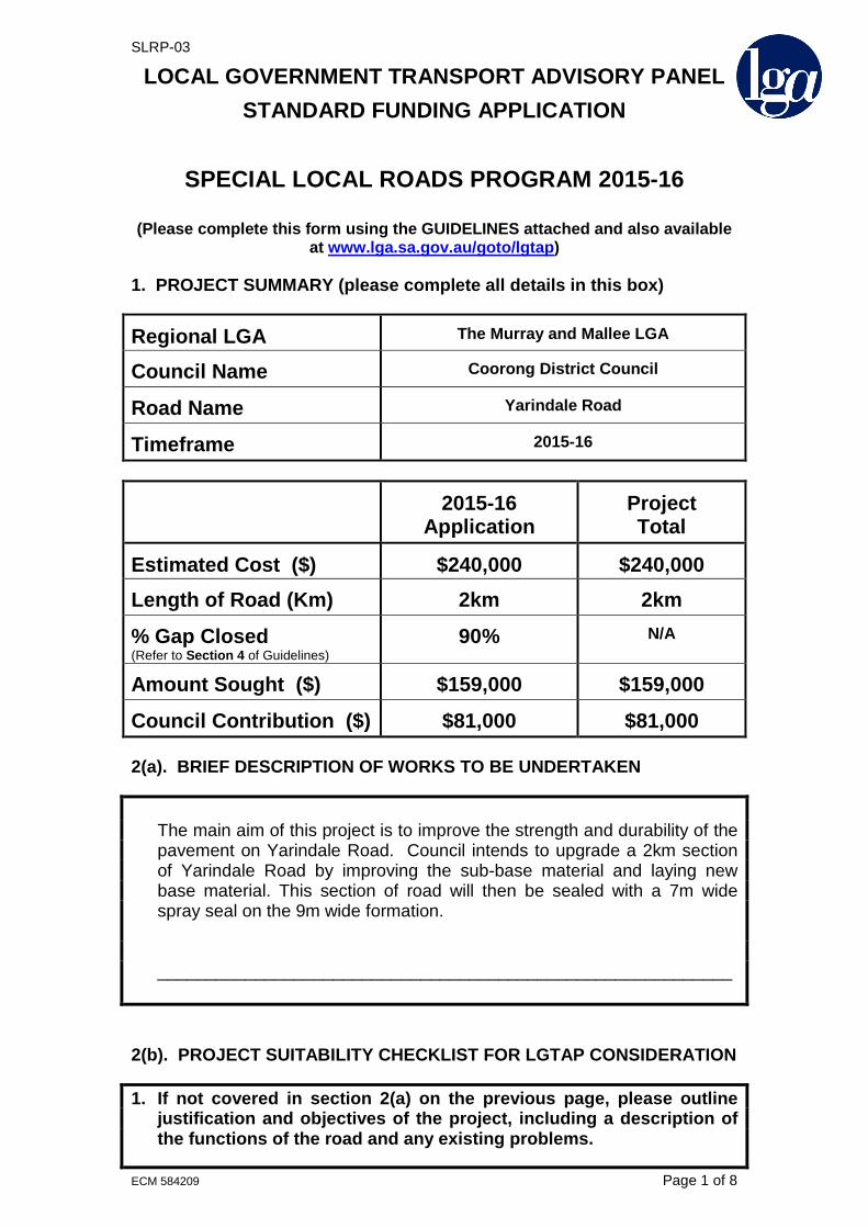
SLRP-03
ECM 584209 Page 1 of 8
LOCAL GOVERNMENT TRANSPORT ADVISORY PANEL
STANDARD FUNDING APPLICATION
SPECIAL LOCAL ROADS PROGRAM 2015-16
(Please complete this form using the GUIDELINES att ached and also available at www.lga.sa.gov.au/goto/lgtap )
1. PROJECT SUMMARY (please complete all details in this box)
Regional LGA The Murray and Mallee LGA
Council Name Coorong District Council
Road Name Yarindale Road
Timeframe 2015-16
2015-16 Application
Project Total
Estimated Cost ($) $240,000 $240,000
Length of Road (Km) 2km 2km
% Gap Closed (Refer to Section 4 of Guidelines)
90% N/A
Amount Sought ($) $159,000 $159,000
Council Contribution ($) $81,000 $81,000
2(a). BRIEF DESCRIPTION OF WORKS TO BE UNDERTAKEN
The main aim of this project is to improve the strength and durability of the pavement on Yarindale Road. Council intends to upgrade a 2km section of Yarindale Road by improving the sub-base material and laying new base material. This section of road will then be sealed with a 7m wide spray seal on the 9m wide formation.
___________________________________________________________
2(b). PROJECT SUITABILITY CHECKLIST FOR LGTAP CONS IDERATION
1. If not covered in section 2(a) on the previous page, please outline justification and objectives of the project, includ ing a description of the functions of the road and any existing problems .

Appendix D Detailed Submissions Mid Murray Council

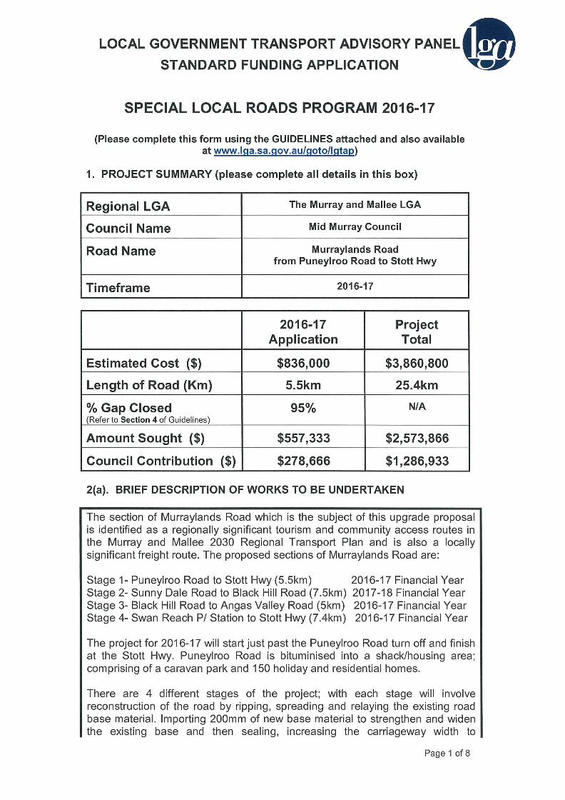


SLRP-03
LOCAL GOVERNMENT TRANSPORT ADVISORY PANEL STANDARD FUNDING APPLICATION
SPECIAL LOCAL ROADS PROGRAM 2015-16
(Please complete this form using the GUIDELINES attached and also available
at www.lga.sa.gov.au/goto/lgtap)
1. PROJECT SUMMARY (please complete all details in this box)
Regional LGA The Murray and Mallee LGA
Council Name Mid Murray Council
Road Name Purnong Road-Long Gully Road to 100 km/h sign
Timeframe 2015-16
2015-16
Application Project Total
Estimated Cost ($) $114,600 $114,600
Length of Road (Km) 0.8km 0.8km
% Gap Closed (Refer to Section 4 of Guidelines)
95% 95%
Amount Sought ($) $76,400 $76,400
Council Contribution ($) $38,200 $38,200
2(a). BRIEF DESCRIPTION OF WORKS TO BE UNDERTAKEN
Purnong Road is identified as a regionally significant community access route and tourist route in the Murray and Mallee 2030 Regional Transport Plan. It is also identified as a locally important freight route.
The road starts in Mannum and heads north and then east for approximately 30km to Purnong. The road acts as a collector road for the communities in the area such as Purnong and Walkers Flat who are heading to Mannum. Purnong Road is also heavily utilised by tourists wishing to access the river and the many shack communities along the Murray. Purnong Road is also a locally important freight route due to the volume of freight it carries. It is a B Double gazetted route. There is potential in the future for an initial section of Purnong Road to become part of a fright bypass around the Mannum town centre (as shown in the. 2030 Regional Transport Plan)
Stage 1 of this project is to upgrade 0.8kms of Purnong Road, 2 . 3 k m s n o r t h from the junction with Long Gully Road. It is intended to improve the pavement and widen the road by 1m. There will also be some minor
ECM 584209 Page 1 of 8

SLRP-03
LOCAL GOVERNMENT TRANSPORT ADVISORY PANEL STANDARD FUNDING APPLICATION
SPECIAL LOCAL ROADS PROGRAM 2016-17
(Please complete this form using the GUIDELINES attached and also available
at www.lga.sa.gov.au/goto/lgtap)
1. PROJECT SUMMARY (please complete all details in this box)
Regional LGA The Murray and Mallee LGA
Council Name Mid Murray Council
Road Name Purnong Road-100 km/h sign to Murraylands Road
Timeframe 2016-17
2016-17
Application Project Total
Estimated Cost ($) $315,040 $315,040
Length of Road (Km) 2.2km 2.2km
% Gap Closed (Refer to Section 4 of Guidelines)
95% 95%
Amount Sought ($) $210,026 $210,026
Council Contribution ($) $105,013 $105,013
2(a). BRIEF DESCRIPTION OF WORKS TO BE UNDERTAKEN
Purnong Road is identified as a regionally significant community access route and tourist route in the Murray and Mallee 2030 Regional Transport Plan. It is also identified as a locally important freight route.
The road starts in Mannum and heads north and then east for approximately 30km to Purnong. The road acts as a collector road for the communities in the area such as Purnong and Walkers Flat who are heading to Mannum. Purnong Road is also heavily utilised by tourists wishing to access the river and the many shack communities along the Murray. Purnong Road is also a locally important freight route due to the volume of freight it carries. It is a B Double gazetted route. There is potential in the future for an initial section of Purnong Road to become part of a fright bypass around the Mannum town centre (as shown in the. 2030 Regional Transport Plan)
Stage 2 of this project is to upgrade 2.2kms of Purnong Road, 5 k m s n o r t h from the junction with Long Gully Road. It is intended to improve the pavement and widen the road by 1m. There will also be some minor
ECM 584209 Page 1 of 8

SLRP-03
LOCAL GOVERNMENT TRANSPORT ADVISORY PANEL STANDARD FUNDING APPLICATION
SPECIAL LOCAL ROADS PROGRAM 2017-18
(Please complete this form using the GUIDELINES attached and also available
at www.lga.sa.gov.au/goto/lgtap)
1. PROJECT SUMMARY (please complete all details in this box)
Regional LGA The Murray and Mallee LGA
Council Name Mid Murray Council
Road Name Purnong Road-Murraylands Road to Mallee Road
Timeframe 2017-18
2017-18
Application Project Total
Estimated Cost ($) $554,880 $554,880
Length of Road (Km) 3.4km 3.4km
% Gap Closed (Refer to Section 4 of Guidelines)
95% 95%
Amount Sought ($) $369,920 $369,920
Council Contribution ($) $184,960 $184,960
2(a). BRIEF DESCRIPTION OF WORKS TO BE UNDERTAKEN
Purnong Road is identified as a regionally significant community access route and tourist route in the Murray and Mallee 2030 Regional Transport Plan. It is also identified as a locally important freight route.
The road starts in Mannum and heads north and then east for approximately 30km to Purnong. The road acts as a collector road for the communities in the area such as Purnong and Walkers Flat who are heading to Mannum. Purnong Road is also heavily utilised by tourists wishing to access the river and the many shack communities along the Murray. Purnong Road is also a locally important freight route due to the volume of freight it carries. It is a B Double gazetted route. There is potential in the future for an initial section of Purnong Road to become part of a fright bypass around the Mannum town centre (as shown in the. 2030 Regional Transport Plan)
Stage 3 of this project is to upgrade 3.4kms of Purnong Road, 1 . 2 k m s e a s t from the junction with Murray Lands Road. It is intended to improve the pavement and widen the road by 1m. There will also be some minor
ECM 584209 Page 1 of 8

SLRP-03
LOCAL GOVERNMENT TRANSPORT ADVISORY PANEL STANDARD FUNDING APPLICATION
SPECIAL LOCAL ROADS PROGRAM 2016-17
(Please complete this form using the GUIDELINES attached and also available
at www.lga.sa.gov.au/goto/lgtap)
1. PROJECT SUMMARY (please complete all details in this box)
Regional LGA The Murray and Mallee LGA
Council Name Mid Murray Council
Road Name Milendella Road-Randell Road to Wachtel Road
Timeframe 2016-17
2016-17 Application
Project Total
Estimated Cost ($) $405,720 $405,720 Length of Road (Km) 2.1km 2.1km
% Gap Closed (Refer to Section 4 of Guidelines)
N/A
Amount Sought ($) $270,480 $270,480
Council Contribution ($) $135,240 $135,240
2(a). BRIEF DESCRIPTION OF WORKS TO BE UNDERTAKEN
Stage 2, consists of 2.1 km’s reconstruction of existing pavement by remove the old bitumen seal and ripping and relaying the existing base; with the inclusion of 200mm of crush road base material to provide additional pavement strength. There is a small segment of road realignment to be considered so that new road is away from silo entrances and neighbouring houses. Entrance from Randell Road and the silo’s to be widened and asphalt sealed to increase performance in bitumen seal.
Stage 1 Wachtel Rd to near The Pines Rd (8km) Completed Stage 2 Randell Rd to Wachtel Rd (2.1km) 16/17 Financial Year Stage 3 near The Pines Rd Angas Valley Rd(2.1km)17/18 Financial Year See Map 1 for segment locations. The proposal overall is to widen the road pavement to 7.2m wide by
shoulder widening 8kms of road pavement and reconstruct 4.2km of road
ECM 584209 Page 1 of 36

SLRP-03
LOCAL GOVERNMENT TRANSPORT ADVISORY PANEL STANDARD FUNDING APPLICATION
SPECIAL LOCAL ROADS PROGRAM 2015-16
(Please complete this form using the GUIDELINES attached and also available
at www.lga.sa.gov.au/goto/lgtap)
1. PROJECT SUMMARY (please complete all details in this box)
Regional LGA The Murray and Mallee LGA
Council Name Mid Murray Council
Road Name Milendella Road-Wachtel Road to Angus Valley Highway
Timeframe 2016-17
2015-16 Application
Project Total
Estimated Cost ($) $665,600 $987,320 Length of Road (Km) 8km 10.1km
% Gap Closed (Refer to Section 4 of Guidelines)
N/A
Amount Sought ($) $443,734 $658213
Council Contribution ($) $221,867 $329,107
2(a). BRIEF DESCRIPTION OF WORKS TO BE UNDERTAKEN
Stage 1, consists of 8 km’s of shoulder widening and resurfacing. Currently the existing seal pavement varies from 6.2 to 6.4 in width where the sealed pavement would be widened to 7.2m to cater to suit B-double traffic. Works will also include the installation of new safety barrier on the Milendella Bridge, as the existing railing is inadequate. The proposal is to shoulder widen and reconstruct 12.2km of sealed carriageway along Milendella Road. The works will be programmed over a 3 year period; with completion of works in the 2018/19 financial year.
Stage 1 Wachtel Rd to near The Pines Rd (8km) 15/16 Financial Year Stage 2 Randell Rd to Wachtel Rd (2.1km) 16/17 Financial Year Stage 3 near The Pines Rd Angas Valley Rd(2.1km)17/18 Financial Year See Map 1 for segment locations.
ECM 584209 Page 1 of 36
Appendix E Detailed Submissions Rural City of Murray Bridge


SLRP-03
ECM 584209 Page 1 of 9
LOCAL GOVERNMENT TRANSPORT ADVISORY PANEL
STANDARD FUNDING APPLICATION
SPECIAL LOCAL ROADS PROGRAM 2014-15
(Please complete this form using the GUIDELINES attached and also available
at www.lga.sa.gov.au/goto/lgtap)
1. PROJECT SUMMARY (please complete all details in this box)
Regional LGA Murray and Mallee
Council Name Rural City of Murray Bridge
Road Name Hindmarsh Road
Stage 2 of the B-Double/OD Route Between Mannum Road and Maurice Road, Murray
Bridge.
Timeframe 2016-17
2014-15 Application
Project Total
Estimated Cost ($) 1,823,450 4,710,000
Length of Road (Km) 2.1
% Gap Closed (Refer to Section 4 of Guidelines)
100% N/A
Amount Sought ($) 911,725 2,355,000
Council Contribution ($) 600,000 2,355,000
2(a). BRIEF DESCRIPTION OF WORKS TO BE UNDERTAKEN
Anticipated “Stage One” works of this SLRP 2014-15. Application involves widening
and strengthening of Hindmarsh Road pavement and new seal as a “fit for purpose”
B-Double and OD freight route with the associated civil infrastructure upgrades
including stormwater drainage, installation of slip lanes, road line marking and street
lighting. Detailed designs have not been undertaken as yet.
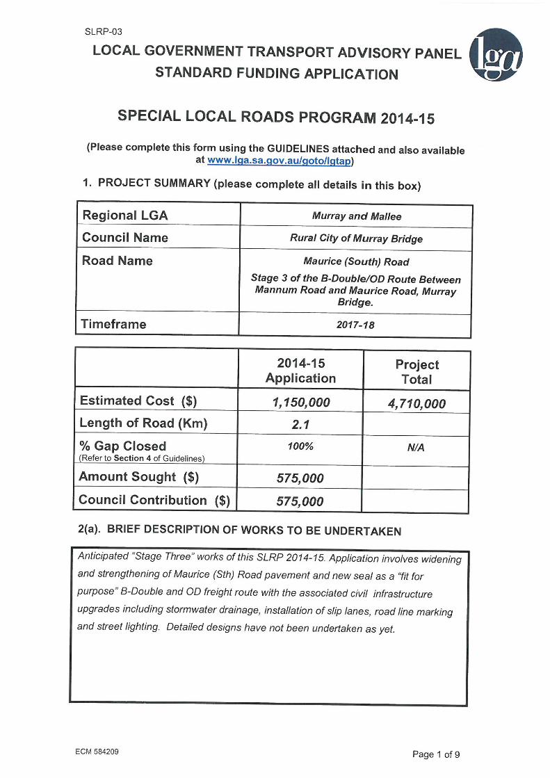

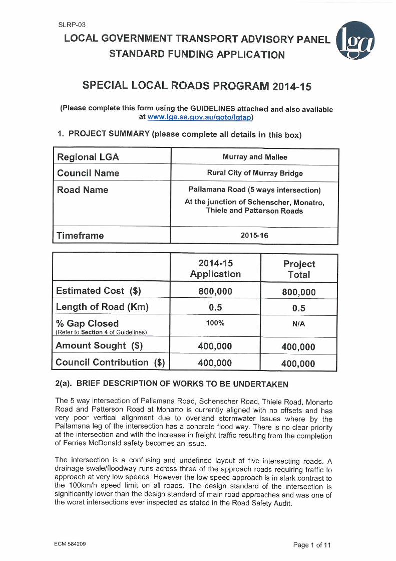

Appendix F Detailed Submissions Renmark Paringa Council

SLRP-03
ECM 584209 Page 1 of 9
LOCAL GOVERNMENT TRANSPORT ADVISORY PA NEL
STANDARD FUNDING APPLICATION
SPECIAL LOCAL ROADS PROGRAM 2014-15
(Please complete this form using the GUIDELINES attached and also available
at www.lga.sa.gov.au/goto/lgtap)
1. PROJECT SUMMARY (please complete all details in this box)
Regional LGA M&MLGA
Council Name Renmark Paringa
Road Name Government Road
Timeframe 2015-2018
2014-15 Application
Project Total
Estimated Cost ($) $600,000
Length of Road (Km) 9.1 klm
% Gap Closed (Refer to Section 4 of Guidelines)
77% N/A
Amount Sought ($) $400,000
Council Contribution ($) $200,000
2(a). BRIEF DESCRIPTION OF WORKS TO BE UNDERTAKEN
Resealing works as identified in Councils Sealed Road Asset Management Plan. Approximately 40,000 M2 is scheduled to be resealed within the next 5 years. Widening 2.6 klm of shoulders to 2.4 mts and sealing x 1 mts, is also being considered (dependent on funding) Existing shoulders vary in width but average around 1.5 metres
2(b). PROJECT SUITABILITY CHECKLIST FOR LGTAP CONSIDERATION

SLRP-03
ECM 584209 Page 1 of 8
LOCAL GOVERNMENT TRANSPORT ADVISORY PANEL
STANDARD FUNDING APPLICATION
SPECIAL LOCAL ROADS PROGRAM 2014-15
(Please complete this form using the GUIDELINES attached and also available
at www.lga.sa.gov.au/goto/lgtap)
1. PROJECT SUMMARY (please complete all details in this box)
Regional LGA M&MLGA
Council Name Renmark Paringa
Road Name Murtho Road Paringa
Sturt Highway to Beherendt Road
Timeframe 2015-2018
2014-15 Application
Project Total
Estimated Cost ($) 400,000
Length of Road (Km) 12klm 9 km to seal
% Gap Closed (Refer to Section 4 of Guidelines)
50%
Amount Sought ($) $200,000
Council Contribution ($) $200,000
2(a). BRIEF DESCRIPTION OF WORKS TO BE UNDERTAKEN
Resealing works as identified in Councils Sealed Road Asset Management Plan. Approximately 9.5km is scheduled to be resealed within the next 5 years. As identified in SRAMP. This section of Murtho Road is a locally important Freight Route, as identified in the M&MLGA 2030 RTP.
2(b). PROJECT SUITABILITY CHECKLIST FOR LGTAP CONSIDERATION
1. If not covered in section 2(a) on the previous page, please outline justification and objectives of the project, including a description of the functions of the road and any existing problems.

SLRP-03
ECM 584209 Page 1 of 8
LOCAL GOVERNMENT TRANSPORT ADVISORY PANEL
STANDARD FUNDING APPLICATION
SPECIAL LOCAL ROADS PROGRAM 2014-15
(Please complete this form using the GUIDELINES attached and also available
at www.lga.sa.gov.au/goto/lgtap)
1. PROJECT SUMMARY (please complete all details in this box)
Regional LGA M&MLGA
Council Name Renmark Paringa
Road Name Murtho Road Paringa
Beherendt Road to Wilkinson Road
Timeframe 2015-2018
2014-15 Application
Project Total
Estimated Cost ($) 120,000
Length of Road (Km) 3.5lkm 2 km to seal
% Gap Closed (Refer to Section 4 of Guidelines)
20%
Amount Sought ($) $100,000
Council Contribution ($) $20,000
2(a). BRIEF DESCRIPTION OF WORKS TO BE UNDERTAKEN
Resealing works as identified in Councils Sealed Road Asset Management Plan. Approximately 14000 M2 is scheduled to be resealed within the next 5 years. As identified in SRAMP.
2(b). PROJECT SUITABILITY CHECKLIST FOR LGTAP CONSIDERATION
1. If not covered in section 2(a) on the previous page, please outline justification and objectives of the project, including a description of the functions of the road and any existing problems.

SLRP-03
ECM 584209 Page 1 of 8
LOCAL GOVERNMENT TRANSPORT ADVISORY PANEL
STANDARD FUNDING APPLICATION
SPECIAL LOCAL ROADS PROGRAM 2014-15
(Please complete this form using the GUIDELINES attached and also available
at www.lga.sa.gov.au/goto/lgtap)
1. PROJECT SUMMARY (please complete all details in this box)
Regional LGA M&MLGA
Council Name Renmark Paringa
Road Name Murtho Road Paringa
Wilkinson Road to Customs House
Timeframe 2015-2018
2014-15 Application
Project Total
Estimated Cost ($) 400,000
Length of Road (Km) 15 klm 10.5 km to seal
% Gap Closed (Refer to Section 4 of Guidelines)
50%
Amount Sought ($) $200,000
Council Contribution ($) $200,000
2(a). BRIEF DESCRIPTION OF WORKS TO BE UNDERTAKEN
Resealing works as identified in Councils Sealed Road Asset Management Plan. Approximately 73,000 M2 is scheduled to be resealed within the next 5 years. As identified in SRAMP.
2(b). PROJECT SUITABILITY CHECKLIST FOR LGTAP CONSIDERATION
1. If not covered in section 2(a) on the previous page, please outline justification and objectives of the project, including a description of the functions of the road and any existing problems.
Appendix G Detailed Submissions Southern Mallee District Council
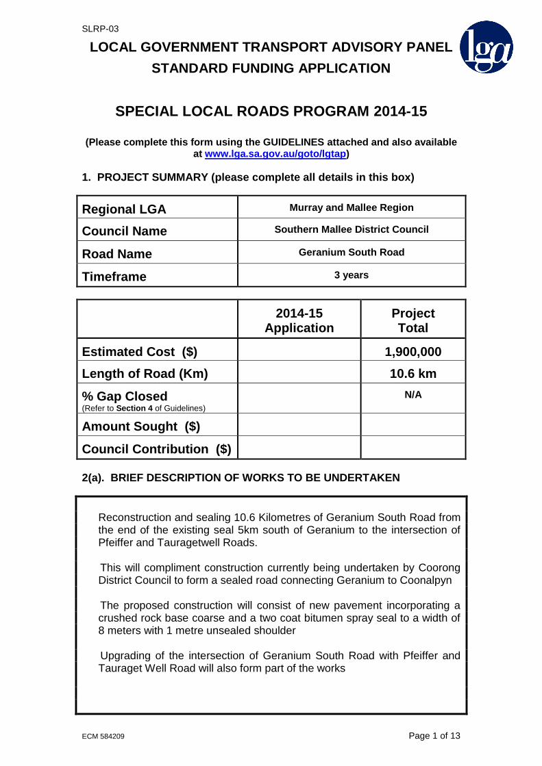
SLRP-03
ECM 584209 Page 1 of 13
LOCAL GOVERNMENT TRANSPORT ADVISORY PANEL
STANDARD FUNDING APPLICATION
SPECIAL LOCAL ROADS PROGRAM 2014-15
(Please complete this form using the GUIDELINES attached and also available
at www.lga.sa.gov.au/goto/lgtap)
1. PROJECT SUMMARY (please complete all details in this box)
Regional LGA Murray and Mallee Region
Council Name Southern Mallee District Council
Road Name Geranium South Road
Timeframe 3 years
2014-15 Application
Project Total
Estimated Cost ($) 1,900,000
Length of Road (Km) 10.6 km
% Gap Closed (Refer to Section 4 of Guidelines)
N/A
Amount Sought ($)
Council Contribution ($)
2(a). BRIEF DESCRIPTION OF WORKS TO BE UNDERTAKEN
Reconstruction and sealing 10.6 Kilometres of Geranium South Road from the end of the existing seal 5km south of Geranium to the intersection of Pfeiffer and Tauragetwell Roads.
This will compliment construction currently being undertaken by Coorong
District Council to form a sealed road connecting Geranium to Coonalpyn The proposed construction will consist of new pavement incorporating a
crushed rock base coarse and a two coat bitumen spray seal to a width of 8 meters with 1 metre unsealed shoulder
Upgrading of the intersection of Geranium South Road with Pfeiffer and
Tauraget Well Road will also form part of the works

SLRP-03
ECM 584209 Page 1 of 12
LOCAL GOVERNMENT TRANSPORT ADVISORY PANEL
STANDARD FUNDING APPLICATION
SPECIAL LOCAL ROADS PROGRAM 2014-15
(Please complete this form using the GUIDELINES attached and also available
at www.lga.sa.gov.au/goto/lgtap)
1. PROJECT SUMMARY (please complete all details in this box)
Regional LGA Murray and Mallee Region
Council Name Southern Mallee District Council
Road Name Tauraget Well Road
Timeframe 1 year
2014-15 Application
Project Total
Estimated Cost ($) 875,000
Length of Road (Km) 4.5 km
% Gap Closed (Refer to Section 4 of Guidelines)
N/A
Amount Sought ($)
Council Contribution ($)
2(a). BRIEF DESCRIPTION OF WORKS TO BE UNDERTAKEN
Reconstruction and sealing 4.5 Kilometres of Tauraget Well Road from the intersection of Pfeiffer and Geranium South Roads to the Council boundary. This will compliment construction currently being undertaken by Coorong District Council to form a sealed road connecting Geranium to Coonalpyn
The proposed construction will consist of new pavement incorporating a
crushed rock base coarse and a two coat bitumen spray seal to a width of 8 meters with 1 metre unsealed shoulder

Appendix H 2015 SLRP Roads Database Update Endorsed by RTS Committee 6 March 2015

Murray and Mallee Local Government Association 2030 Regional Transport Plan - 2015 SLRP Database
Council Road Name Segment Primary Purpose
Stage 1 Score
(100 max)
Stage 1
Ranking
Stage 2 Score
(30 max) Final Score
Final Funding
Priority
Council Year of
Proposed SLRP
Funding
RCMB Maurice Road Brinkley Road to Adelaide Road Freight 72 1 15 87 1 HVSPP
RCMB Hindmarsh Road Brinkley Road to Swanport Road Freight 72 2 13 85 2 HVSPP
MMC Murraylands Road 4km from Sturt Highway to 8.2km north Freight 67 6 17 84 3 2015-16
RCMB Cypress Terrace Mannum Road and Maurice Road Freight 72 3 11 83 4 HVSPP
RCMB Maurice Road Adelaide Road to Cypress Terrace Freight 72 4 10 82 5 HVSPP
RCMB Schenscher Road 5 ways Intersection with Pallamana, Monarto, Thiele and Patterson RdsFreight 71 5 11 82 6 2015-16
SMDC Geranium South Road Unsealed Section Freight 65 7 16 81 7 2015-18
CDC Tauragat Well Road End of sealed section to Council boundary Freight 63 9 16 79 8 2015-16
SMDC Tauraget Well Road Full Length Freight 63 10 16 79 9 2018-19
RPC Murtho Road Sturt Highway to Beherendt Road Tourism 63 8 14 77 10 2015-16
RPC Government Road Full length Freight 62 11 9 71 11 2016-18
MMC Purnong Road Long Gully Road to 100 km/h sign Community Access 58 14 11 69 12 2015-16
MMC Purnong Road 100km/h sign to Murraylands Road Community Access 58 15 11 69 13 2016-17
MMC Purnong Road Murraylands Road to Mallee Road Community Access 58 16 11 69 14 2017-18
MMC Murraylands Road Punyelroo Road to Stott Highway Tourism 57 18 12 69 15 2016-17
MMC Murraylands Road Sunny Dale Road to Black Hill Road Tourism 57 19 12 69 16 2017-18
MMC Murraylands Road Black Hill Road to Angas Valley Highway Tourism 57 20 12 69 17 2018-19
MMC Murraylands Road Stott Highway to Swan Reach Pump Station Tourism 57 21 12 69 18 2019-20
RPC Murtho Road Beherendt Road to Wilkinson Road Tourism 56 22 13 69 19 2017-18
MMC Milendella Road Wachtel Road to Angus Valley Highway Freight 59 12 8 67 20 2016-19
MMC Milendella Road Randell Road to Wachtel Road Freight 59 13 7 66 21 2016-17
CDC Yarindale Road ? Community Access 58 17 8 66 22 2016-17
BBC Battams Road Old Sturt Highway to Accolade Wines Entrance Freight 55 23 6 61 23 HVSPP
CDC Granites Road Webb Street to northern Viterra entrance Freight 54 24 6 60 24 2015-16
CDC Seven Mile Road Princes Highway to Noonameena Settlement Community Access 51 25 8 59 25 2016-17
BBC Katapapko Crescent Plush Road to Grid Tourism 44 26 9 53 26 2015-16
RPC Murtho Road Wilkinson Road to Customs House Tourism 39 27 10 49 27 2018-19
Council Road Name Segment Primary Purpose Final Score
Final Funding
Priority
2015 Priority
Overall
2015 Priority
by Purpose
SLRP Grant
Sought ($)
RTS Committee
Endorsement
MMC Murraylands Road 4km from Sturt Highway to 8.2km north Freight 84 3 R1 F1 $487,200
RCMB Cypress Terrace Mannum Road and Maurice Road Freight 83 4 HVSPP
RCMB Schenscher Road 5 ways Intersection with Pallamana, Monarto, Thiele and Patterson RdsFreight 82 6 R2 F2 $400,000
SMDC Geranium South Road Unsealed Section Freight 81 7 R3 F3 $422,000
CDC Tauragat Well Road End of sealed section to Council boundary Freight 79 8 R4 F4 $433,500
RPC Murtho Road Sturt Highway to Beherendt Road Tourism 77 10 R5 T1 $200,000
MMC Purnong Road Long Gully Road to 100 km/h sign Community Access 69 12 R6 C1 $76,400
BBC Battams Road Old Sturt Highway to Accolade Wines Entrance Freight 61 23 HVSPP
CDC Granites Road Webb Street to northern Viterra entrance Freight 60 24 R7 F5 $165,000
BBC Katapapko Crescent Plush Road to Grid Tourism 53 26 R8 T2 $65,000
$2,249,100
Sort in Descending Order using Data / Sort by Column "H", then by Column "F"
Note - The following recommended "2015 Regional Priorities", sorted both by "Primary Purpose" and "Overall", are based upon all road segments submitted for consideration with "2015-16+" council priority (being a subset of
road segments listed in the 2015 Roads Database), sub-grouped by the likelihood of funding within their individual purpose categories, then re-grouped for an overall ranking.
Summary of Road Proposals
10/6/15 Summary slrp database calculator revised.xlsm

M&MLGA SLRP DATABASE 2015 - STAGE 1 ASSESSMENT
ANALYSIS OF WEIGHTED BENEFIT (WB) AND WEIGHTED BENEFIT/COST SCORE (WBC) - INITIAL ASSESSMENT
Council Code BBC BBC CDC CDC CDC CDC MMC MMC MMC MMC MMC MMC MMC MMC MMC MMC
Timeframe 2015-16 2015-16 2015-16 2015-16 2015-16 2015-16 2015-16 2016-17 2017-18 2018-19 2019-20 2015-16 2016-17 2017-18 2016-17 2016-19
Council Name: Berri Barmera Council Berri Barmera Council Coorong District Council Coorong District Council Coorong District Council Coorong District Council Mid Murray Council Mid Murray Council Mid Murray Council Mid Murray Council Mid Murray Council Mid Murray Council Mid Murray Council Mid Murray Council Mid Murray Council Mid Murray Council
Road Name: Battams Road Katapapko Crescent Tauragat Well Road Granites Road Seven Mile Road Yarindale Road Murraylands Road Murraylands Road Murraylands Road Murraylands Road Murraylands Road Purnong Road Purnong Road Purnong Road Milendella Road Milendella Road
Segment: Old Sturt Highway to
Accolade Wines Entrance
Plush Road to Grid End of sealed section to
Council boundary
Trevena Road to Viterra
Entrance
Princes Highway to 2km
west of Princes Highway
? 4km from Sturt Highway to
8.2km north
Punyelroo Road to Stott
Highway
Sunny Dale Road to Black
Hill Road
Black Hill Road to Angas
Valley Highway
Swan Reach Pump Station
to Stott Highway
Long Gully Road to 100
km/h sign
100km/h sign to
Murraylands Road
Murraylands Road to Mallee
Road
Randell Road to Wachtel
Road
Wachtel Road to Angus
Valley Highway
Primary Purpose:Freight Tourism Freight Freight Community Access Community Access Freight Tourism Tourism Tourism Tourism Community Access Community Access Community Access Freight Freight
Length of Segment (km) - RL 0.25 1.9 7.0 0.5 2.0 2.0 4.2 5.5 7.5 5.0 7.4 0.8 2.2 3.4 2.1 10.1
Traffic Volume (AADT): - TV 1200 200 112 300 250 200 150 150 150 150 150 616 616 616 250 250
% Gap Closed: - GC 90 90 95 90 90 90 95 95 95 95 95 95 95 95 95 95
Cost to Close Gap ($): - UC 154000 130000 1300000 250000 240000 240000 730800 836000 1140000 760000 1124800 114600 315040 554880 405720 987320
Amount Sought ($) 154000 65000 867000 165000 159000 159000 243600 557333 760000 506666 749866 76400 210026 369920 270480 658213
Benefit Influencing
FactorWeighting (%) Specific Criteria Maximum Score
1. One Secondary Purpose 5.0 2.5 2.5 5.0 5.0 5.0 5.0 5.0 5.0 5.0 5.0 5.0 5.0 5.0 5.0 5.0
2. Two Secondary Purposes 5.0 2.5 2.5 5.0 5.0 5.0 5.0 5.0
1. Community Significance 8.3 8.3 8.3 8.3 8.3 8.3 8.3 8.3 8.3 8.3 8.3 8.3 8.3 8.3 8.3 8.3 8.3
2. Regional Significance 8.3 8.3 8.3 8.3 8.3 8.3 8.3 8.3 8.3 8.3 8.3 8.3 8.3 8.3 8.3 8.3 8.3
3. State Significance 8.3
Road User Benefit
1. Reduce delays and operating costs for heavy vehicles? 1.7 1.7 1.7 1.7 1.7 1.7 1.7 1.7 1.7 1.7 1.7 1.7 1.7 1.7 1.7
2. Provide direct access to major industrial developments 1.7 1.7 1.7 1.7 1.7 1.7 1.7 1.7 1.7 1.7
3. Facilitate a higher classification of freight movements 1.7 1.7 1.7 1.7 1.7 1.7 1.7 1.7 1.7 1.7
4A. Facilitate intermodal transport operations - rail 0.6
4B. Facilitate intermodal transport operations - sea 0.6
4C. Facilitate intermodal transport operations - air 0.6
5. Assist export of products by improving quality and reducing
impacts of dust etc 1.7 1.7 1.7 1.7 1.7 1.7 1.7 1.7 1.7
6. Provide direct access to new industrial precincts 1.7 1.7
Community Benefit
7. Benefit regional employment and sustain communities 2.5 2.5 2.5 2.5 2.5 2.5 2.5 2.5 2.5 2.5 2.5 2.5 2.5 2.5
8. Assist attraction of economic investment to region 2.5 2.5 2.5 2.5 2.5 2.5 2.5 2.5 2.5 2.5 2.5 2.5 2.5
Road Owner Benefit
9. Reduce the road maintenance effort 5.0 5.0 5.0 5.0 5.0 5.0 5.0 5.0 5.0 5.0 5.0 5.0 5.0 5.0 5.0 5.0 5.0
1. Reduce traffic congestion 1.7 1.7
2. Link areas of particular land uses to strategic routes 1.7 1.7 1.7 1.7 1.7 1.7 1.7 1.7 1.7 1.7 1.7
3. Provide a higher standard alternative route 1.7 1.7 1.7 1.7 1.7 1.7 1.7 1.7 1.7 1.7
4. Complement the existing arterial road network 1.7 1.7 1.7 1.7 1.7 1.7 1.7 1.7 1.7 1.7
5. Provide improved access to key population centres 1.7 1.7 1.7 1.7 1.7 1.7 1.7
6. Ensure communities are not dislocated by flooding 1.7 1.7 1.7
7. Act as a collector road for local or heavy traffic 1.7 1.7 1.7 1.7 1.7 1.7 1.7
8. Provide all weather access 1.7 1.7 1.7 1.7 1.7 1.7 1.7 1.7 1.7 1.7 1.7 1.7 1.7 1.7 1.7
9A. Provide access to other types of transport - bus 0.6
9B. Provide access to other types of transport - rail 0.6
9C. Provide access to other types of transport - air 0.6
1. Reduce conflicts between tourist, freight and commuter
traffic 2.2 2.2 2.2 2.2 2.2 2.2 2.2 2.2 2.2 2.2 2.2 2.2 2.2 2.2 2.2 2.2 2.2
2. Contribute to safer travel and reduce accidents 2.2 2.2 2.2 2.2 2.2 2.2 2.2 2.2 2.2 2.2 2.2 2.2 2.2 2.2 2.2 2.2 2.2
3. Provide safe overtaking opportunities and reduce frustration
and fatigue 2.2 2.2 2.2 2.2 2.2 2.2 2.2 2.2 2.2 2.2 2.2 2.2
4. Reduce exposure to travel risk 2.2 2.2 2.2 2.2 2.2 2.2 2.2 2.2 2.2 2.2 2.2 2.2 2.2 2.2 2.2
5. Provide access for school buses 2.2 2.2 2.2 2.2
6. Provide access for emergency services 2.2
7. Remove traffic from city/town areas 2.2 2.2 2.2 2.2
8. Reduce road roughness and potential dust hazards 2.2 2.2 2.2 2.2 2.2 2.2 2.2 2.2 2.2 2.2 2.2 2.2 2.2 2.2 2.2 2.2
9. Reduce the impact of roadside hazards 2.2 2.2 2.2 2.2 2.2 2.2
1A. Reduce environmental pollution - air 1.1 1.1 1.1 1.1 1.1 1.1 1.1 1.1 1.1 1.1 1.1 1.1
1B. Reduce environmental pollution - noise 1.1
1C. Reduce environmental pollution - water 1.1
2. Minimise impact of heavy vehicles on local community 3.3 3.3 3.3 3.3 3.3 3.3
3. Reduce reliance on road transport and encourage other
forms of transport 3.3
WEIGHTED BENEFIT SCORE (WB) 100 56 40 60 45 51 62 56 56 56 56 56 59 59 59 59 59
WEIGHTED BENEFIT/COST SCORE (WBC) 98 105 34 24 96 93 46 52 52 52 52 241 241 211 72 143
( = WB x TV x (RLx1000) x (GC/100) / UC )
PRIORITY RANKING BY WEIGHTED BENEFIT 17 27 11 26 25 9 22 18 19 20 21 12 13 14 16 15
5(f). Environmental 10
5(c). Economic 10
5
5
5(d). Access 15
5(e). Safety 20
(Based on Guidelines developed through the Roads Infrastructure Database Project, for application for Special Local Roads Funding)
5(a). Secondary
Purpose(s)
10
5(b). Regional
Significance
25
Modified: 10/6/15
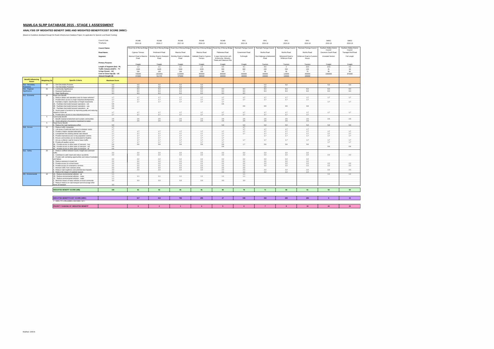
M&MLGA SLRP DATABASE 2015 - STAGE 1 ASSESSMENT
ANALYSIS OF WEIGHTED BENEFIT (WB) AND WEIGHTED BENEFIT/COST SCORE (WBC) - INITIAL ASSESSMENT
Council Code
Timeframe
Council Name:
Road Name:
Segment:
Primary Purpose:
Length of Segment (km) - RL
Traffic Volume (AADT): - TV
% Gap Closed: - GC
Cost to Close Gap ($): - UC
Amount Sought ($)
Benefit Influencing
FactorWeighting (%) Specific Criteria Maximum Score
1. One Secondary Purpose 5.0
2. Two Secondary Purposes 5.0
1. Community Significance 8.3
2. Regional Significance 8.3
3. State Significance 8.3
Road User Benefit
1. Reduce delays and operating costs for heavy vehicles? 1.7
2. Provide direct access to major industrial developments 1.7
3. Facilitate a higher classification of freight movements 1.7
4A. Facilitate intermodal transport operations - rail 0.6
4B. Facilitate intermodal transport operations - sea 0.6
4C. Facilitate intermodal transport operations - air 0.6
5. Assist export of products by improving quality and reducing
impacts of dust etc 1.7
6. Provide direct access to new industrial precincts 1.7
Community Benefit
7. Benefit regional employment and sustain communities 2.5
8. Assist attraction of economic investment to region 2.5
Road Owner Benefit
9. Reduce the road maintenance effort 5.0
1. Reduce traffic congestion 1.7
2. Link areas of particular land uses to strategic routes 1.7
3. Provide a higher standard alternative route 1.7
4. Complement the existing arterial road network 1.7
5. Provide improved access to key population centres 1.7
6. Ensure communities are not dislocated by flooding 1.7
7. Act as a collector road for local or heavy traffic 1.7
8. Provide all weather access 1.7
9A. Provide access to other types of transport - bus 0.6
9B. Provide access to other types of transport - rail 0.6
9C. Provide access to other types of transport - air 0.6
1. Reduce conflicts between tourist, freight and commuter
traffic 2.2
2. Contribute to safer travel and reduce accidents 2.2
3. Provide safe overtaking opportunities and reduce frustration
and fatigue 2.2
4. Reduce exposure to travel risk 2.2
5. Provide access for school buses 2.2
6. Provide access for emergency services 2.2
7. Remove traffic from city/town areas 2.2
8. Reduce road roughness and potential dust hazards 2.2
9. Reduce the impact of roadside hazards 2.2
1A. Reduce environmental pollution - air 1.1
1B. Reduce environmental pollution - noise 1.1
1C. Reduce environmental pollution - water 1.1
2. Minimise impact of heavy vehicles on local community 3.3
3. Reduce reliance on road transport and encourage other
forms of transport 3.3
WEIGHTED BENEFIT SCORE (WB) 100
WEIGHTED BENEFIT/COST SCORE (WBC)
( = WB x TV x (RLx1000) x (GC/100) / UC )
PRIORITY RANKING BY WEIGHTED BENEFIT
5(f). Environmental 10
5(c). Economic 10
5
5
5(d). Access 15
5(e). Safety 20
(Based on Guidelines developed through the Roads Infrastructure Database Project, for application for Special Local Roads Funding)
5(a). Secondary
Purpose(s)
10
5(b). Regional
Significance
25
RCMB RCMB RCMB RCMB RCMB RPC RPC RPC RPC SMDC SMDC
2015-16 2016-17 2017-18 2018-19 2015-16 2015-18 2015-18 2015-18 2015-18 2015-18 2018-19
Rural City of Murray Bridge Rural City of Murray Bridge Rural City of Murray Bridge Rural City of Murray Bridge Rural City of Murray Bridge Renmark Paringa Council Renmark Paringa Council Renmark Paringa Council Renmark Paringa Council Southern Mallee District
Council
Southern Mallee District
Council
Cypress Terrace Hindmarsh Road Maurice Road Maurice Road Pallamana Road Government Road Murtho Road Murtho Road Murtho Road Geranium South Road Tauraget Well Road
Mannum Road to Maurice
Road
Brinkley Road to Swanport
Road
Brinkley Road to Adelaide
Road
Adelaide Road to Cypress
Terrace
5 ways Intersection with
Schenscher, Monarto,
Thiele and Patterson Rds
Full length Sturt Highway to Beherendt
Road
Beherendt Road to
Wilkinson Road
Wilkinson Road to Customs
House
Unsealed Section Full Length
Freight Freight Freight Freight Freight Freight Tourism Tourism Tourism Freight Freight
1.3 2.1 2.1 1.4 0.5 9.1 9.0 2 10.5 10.6 4.5
2240 4429 5340 2228 550 600 220 250 220 31 58
100 100 100 100 100 77 95 95 75 95 95
746000 1823450 1150000 993000 800000 600000 400000 120000 400000 1900000 875000
373000 911725 575000 496500 400000 400000 200000 100000 200000
5.0 5.0 5.0 5.0 5.0 5.0 5.0 5.0
5.0 5.0 5.0 5.0 5.0
8.3 8.3 8.3 8.3 8.3 8.3 8.3 8.3 8.3 8.3 8.3
8.3 8.3 8.3 8.3 8.3 8.3 8.3 8.3 8.3 8.3 8.3
8.3 8.3 8.3 8.3 8.3 8.3
1.7 1.7 1.7 1.7 1.7 1.7 1.7 1.7 1.7 1.7 1.7
1.7 1.7 1.7 1.7 1.7 1.7 1.7 1.7 1.7
1.7 1.7 1.7 1.7 1.7 1.7 1.7
0.6
0.6 0.6 0.6 0.6
1.7 1.7 1.7 1.7 1.7 1.7 1.7 1.7 1.7 1.7 1.7
1.7 1.7 1.7 1.7 1.7 1.7 1.7 1.7 1.7
2.5 2.5 2.5 2.5 2.5 2.5 2.5 2.5 2.5 2.5 2.52.5 2.5 2.5 2.5 2.5 2.5 2.5 2.5 2.5
5.0 5.0 5.0 5.0 5.0 5.0 5.0
1.7
1.7 1.7 1.7 1.7
1.7 1.7 1.7 1.7 1.7 1.7 1.7 1.7 1.7 1.7 1.7
1.7 1.7 1.7 1.7 1.7 1.7 1.7 1.7 1.7 1.7 1.7
1.7 1.7 1.7 1.7 1.7 1.7 1.7 1.7 1.7 1.7
1.7 1.7 1.7 1.7 1.7
1.7 1.7 1.7 1.7 1.7 1.7 1.7 1.7 1.7 1.7 1.7
1.7 1.7 1.7 1.7 1.7 1.7 1.7
0.6 0.6 0.6 0.6 0.6 1.7 0.6 0.6 0.6
0.6 0.6 0.6
2.2 2.2 2.2 2.2 2.2 2.2 2.2 2.2 2.2
2.2 2.2 2.2 2.2 2.2 2.2 2.2 2.2 2.2 2.2 2.2
2.2 2.2 2.2 2.2 2.2 2.2 2.2 2.2 2.2
2.2 2.2 2.2 2.2 2.2 2.2 2.2 2.2 2.2
2.2 2.2 2.2 2.2 2.2 2.2 2.2 2.2 2.2 2.2 2.2
2.2 2.2 2.2 2.2 2.2 2.2 2.2 2.2 2.2 2.2 2.2
2.2 2.2 2.2 2.2 2.2 2.2
2.2 2.2 2.2 2.2 2.2 2.2 2.2 2.2 2.2 2.2 2.2
2.2 2.2 2.2 2.2 2.2
1.1 1.1 1.1
1.1 1.1 1.1 1.1 1.1 1.1
3.3 3.3 3.3 3.3 3.3 3.3
81 81 81 81 80 78 71 66 61 53 53
317 414 792 255 27 546 332 260 263 9 15
3 2 1 4 5 6 7 8 10 24 23
Modified: 10/6/15

M&MLGA SLRP DATABASE 2015 - STAGE 1 ASSESSMENT
ANALYSIS OF WEIGHTED BENEFIT (WB) AND WEIGHTED BENEFIT/COST SCORE (WBC) - REVISED ASSESSMENT
Council Code BBC BBC CDC CDC CDC CDC MMC MMC MMC MMC MMC MMC MMC MMC MMC MMC
Timeframe 2015-16 2015-16 2015-16 2015-16 2016-17 2016-17 2015-16 2016-17 2017-18 2018-19 2019-20 2015-16 2016-17 2017-18 2016-17 2016-19
Council Name: Berri Barmera Council Berri Barmera Council Coorong District Council Coorong District Council Coorong District Council Coorong District Council Mid Murray Council Mid Murray Council Mid Murray Council Mid Murray Council Mid Murray Council Mid Murray Council Mid Murray Council Mid Murray Council Mid Murray Council Mid Murray Council
Road Name: Battams Road Katapapko Crescent Tauragat Well Road Granites Road Seven Mile Road Yarindale Road Murraylands Road Murraylands Road Murraylands Road Murraylands Road Murraylands Road Purnong Road Purnong Road Purnong Road Milendella Road Milendella Road
Segment: Old Sturt Highway to
Accolade Wines Entrance
Plush Road to Grid End of sealed section to
Council boundary
Webb Street to northern
Viterra entrance
Princes Highway to
Noonameena Settlement
? 4km from Sturt Highway to
8.2km north
Punyelroo Road to Stott
Highway
Sunny Dale Road to Black
Hill Road
Black Hill Road to Angas
Valley Highway
Stott Highway to Swan
Reach Pump Station
Long Gully Road to 100
km/h sign
100km/h sign to
Murraylands Road
Murraylands Road to Mallee
Road
Randell Road to Wachtel
Road
Wachtel Road to Angus
Valley Highway
Primary Purpose:Freight Tourism Freight Freight Community Access Community Access Freight Tourism Tourism Tourism Tourism Community Access Community Access Community Access Freight Freight
Length of Segment (km) - RL 0.25 1.9 7.0 0.5 2.0 2.0 4.2 5.5 7.5 5.0 7.4 0.8 2.2 3.4 2.1 10.1
Traffic Volume (AADT): - TV 1200 200 112 300 250 200 150 150 150 150 150 616 616 616 250 250
% Gap Closed: - GC 90 90 95 90 90 90 95 95 95 95 95 95 95 95 95 95
Cost to Close Gap ($): - UC 308000 130000 1300000 250000 240000 240000 730800 836000 1140000 760000 1124800 114600 315040 554880 405720 987320
Amount Sought ($) 154000 65000 867000 165000 159000 159000 487200 557333 760000 506666 749866 76400 210026 369920 270480 658213
Benefit Influencing
FactorWeighting (%) Specific Criteria Maximum Score
1. One Secondary Purpose 5.0 5.0 2.5 2.5 5.0 2.5 2.5 2.5 2.5 5.0 5.0 5.0 5.0 5.0
2. Two Secondary Purposes 5.0 2.5 2.5 2.5 2.5 2.5 2.5 2.5 2.5
1. Community Significance 8.3 8.3 8.3 8.3 8.3 8.3 8.3 8.3 8.3 8.3 8.3 8.3 8.3 8.3 8.3 8.3 8.3
2. Regional Significance 8.3 8.3 8.3 8.3 8.3 8.3 8.3 8.3 8.3 8.3 8.3 8.3 8.3 8.3 8.3 8.3 8.3
3. State Significance 8.3
Road User Benefit
1. Reduce delays and operating costs for heavy vehicles? 1.7 1.7 1.7 1.7 1.7 1.7 1.7 1.7 1.7 1.7 1.7 1.7 1.7 1.7 1.7
2. Provide direct access to major industrial developments 1.7 1.7 1.7 1.7 1.7 1.7
3. Facilitate a higher classification of freight movements 1.7 1.7 1.7 1.7 1.7 1.7 1.7 1.7 1.7 1.7
4A. Facilitate intermodal transport operations - rail 0.6 0.6 0.6 0.6
4B. Facilitate intermodal transport operations - sea 0.6
4C. Facilitate intermodal transport operations - air 0.6
5. Assist export of products by improving quality and reducing
impacts of dust etc 1.7 1.7 1.7 1.7 1.7 1.7 1.7 1.7 1.7 1.7 1.7 1.7 1.7 1.7 1.7 1.7
6. Provide direct access to new industrial precincts 1.7 1.7 1.7 1.7
Community Benefit
7. Benefit regional employment and sustain communities 2.5 2.5 2.5 2.5 2.5 2.5 2.5 2.5 2.5 2.5 2.5 2.5 2.5 2.5
8. Assist attraction of economic investment to region 2.5 2.5 2.5 2.5 2.5 2.5 2.5 2.5 2.5 2.5 2.5 2.5 2.5
Road Owner Benefit
9. Reduce the road maintenance effort 5.0 5.0 5.0 5.0 5.0 5.0 5.0 5.0 5.0 5.0 5.0 5.0 5.0 5.0 5.0 5.0 5.0
1. Reduce traffic congestion 1.7 1.7
2. Link areas of particular land uses to strategic routes 1.7 1.7 1.7 1.7 1.7 1.7 1.7 1.7 1.7 1.7 1.7 1.7
3. Provide a higher standard alternative route 1.7 1.7 1.7 1.7 1.7 1.7 1.7 1.7 1.7 1.7 1.7 1.7 1.7
4. Complement the existing arterial road network 1.7 1.7 1.7 1.7 1.7 1.7 1.7 1.7 1.7 1.7 1.7 1.7 1.7 1.7
5. Provide improved access to key population centres 1.7 1.7 1.7 1.7 1.7 1.7 1.7
6. Ensure communities are not dislocated by flooding 1.7 1.7 1.7 1.7
7. Act as a collector road for local or heavy traffic 1.7 1.7 1.7 1.7 1.7 1.7 1.7 1.7 1.7
8. Provide all weather access 1.7 1.7 1.7 1.7 1.7 1.7 1.7 1.7 1.7 1.7 1.7 1.7 1.7 1.7 1.7 1.7 1.7
9A. Provide access to other types of transport - bus 0.6
9B. Provide access to other types of transport - rail 0.6
9C. Provide access to other types of transport - air 0.6
1. Reduce conflicts between tourist, freight and commuter
traffic 2.2 2.2 2.2 2.2 2.2 2.2 2.2 2.2 2.2 2.2 2.2 2.2 2.2 2.2 2.2 2.2 2.2
2. Contribute to safer travel and reduce accidents 2.2 2.2 2.2 2.2 2.2 2.2 2.2 2.2 2.2 2.2 2.2 2.2 2.2 2.2 2.2 2.2 2.2
3. Provide safe overtaking opportunities and reduce frustration
and fatigue 2.2 2.2 2.2 2.2 2.2 2.2 2.2 2.2 2.2 2.2 2.2 2.2 2.2 2.2 2.2
4. Reduce exposure to travel risk 2.2 2.2 2.2 2.2 2.2 2.2 2.2 2.2 2.2 2.2 2.2 2.2 2.2 2.2 2.2 2.2 2.2
5. Provide access for school buses 2.2 2.2 2.2 2.2
6. Provide access for emergency services 2.2
7. Remove traffic from city/town areas 2.2
8. Reduce road roughness and potential dust hazards 2.2 2.2 2.2 2.2 2.2 2.2 2.2 2.2 2.2 2.2 2.2 2.2 2.2 2.2 2.2 2.2 2.2
9. Reduce the impact of roadside hazards 2.2 2.2 2.2 2.2 2.2 2.2 2.2
1A. Reduce environmental pollution - air 1.1 1.1 1.1 1.1 1.1 1.1 1.1 1.1 1.1 1.1 1.1 1.1
1B. Reduce environmental pollution - noise 1.1
1C. Reduce environmental pollution - water 1.1
2. Minimise impact of heavy vehicles on local community 3.3 3.3 3.3 3.3 1.7 3.3 1.7 1.7 1.7 1.7 1.7 1.7 1.7 3.3 3.3
3. Reduce reliance on road transport and encourage other
forms of transport 3.3
WEIGHTED BENEFIT SCORE (WB) 100 55 44 63 54 51 58 67 57 57 57 57 58 58 58 59 59
WEIGHTED BENEFIT/COST SCORE (WBC) 48 115 36 29 95 87 55 54 54 54 54 237 237 208 73 145
( = WB x TV x (RLx1000) x (GC/100) / UC )
PRIORITY RANKING BY WEIGHTED BENEFIT 23 26 9 24 25 17 6 18 19 20 21 14 15 16 13 12
5(d). Access 15
5(e). Safety 20
5(f). Environmental 10
5(c). Economic 10
5
5
(Based on Guidelines developed through the Roads Infrastructure Database Project, for application for Special Local Roads Funding)
5(a). Secondary
Purpose(s)
10
5(b). Regional
Significance
25
Modified: 10/6/15

M&MLGA SLRP DATABASE 2015 - STAGE 1 ASSESSMENT
ANALYSIS OF WEIGHTED BENEFIT (WB) AND WEIGHTED BENEFIT/COST SCORE (WBC) - REVISED ASSESSMENT
Council Code
Timeframe
Council Name:
Road Name:
Segment:
Primary Purpose:
Length of Segment (km) - RL
Traffic Volume (AADT): - TV
% Gap Closed: - GC
Cost to Close Gap ($): - UC
Amount Sought ($)
Benefit Influencing
FactorWeighting (%) Specific Criteria Maximum Score
1. One Secondary Purpose 5.0
2. Two Secondary Purposes 5.0
1. Community Significance 8.3
2. Regional Significance 8.3
3. State Significance 8.3
Road User Benefit
1. Reduce delays and operating costs for heavy vehicles? 1.7
2. Provide direct access to major industrial developments 1.7
3. Facilitate a higher classification of freight movements 1.7
4A. Facilitate intermodal transport operations - rail 0.6
4B. Facilitate intermodal transport operations - sea 0.6
4C. Facilitate intermodal transport operations - air 0.6
5. Assist export of products by improving quality and reducing
impacts of dust etc 1.7
6. Provide direct access to new industrial precincts 1.7
Community Benefit
7. Benefit regional employment and sustain communities 2.5
8. Assist attraction of economic investment to region 2.5
Road Owner Benefit
9. Reduce the road maintenance effort 5.0
1. Reduce traffic congestion 1.7
2. Link areas of particular land uses to strategic routes 1.7
3. Provide a higher standard alternative route 1.7
4. Complement the existing arterial road network 1.7
5. Provide improved access to key population centres 1.7
6. Ensure communities are not dislocated by flooding 1.7
7. Act as a collector road for local or heavy traffic 1.7
8. Provide all weather access 1.7
9A. Provide access to other types of transport - bus 0.6
9B. Provide access to other types of transport - rail 0.6
9C. Provide access to other types of transport - air 0.6
1. Reduce conflicts between tourist, freight and commuter
traffic 2.2
2. Contribute to safer travel and reduce accidents 2.2
3. Provide safe overtaking opportunities and reduce frustration
and fatigue 2.2
4. Reduce exposure to travel risk 2.2
5. Provide access for school buses 2.2
6. Provide access for emergency services 2.2
7. Remove traffic from city/town areas 2.2
8. Reduce road roughness and potential dust hazards 2.2
9. Reduce the impact of roadside hazards 2.2
1A. Reduce environmental pollution - air 1.1
1B. Reduce environmental pollution - noise 1.1
1C. Reduce environmental pollution - water 1.1
2. Minimise impact of heavy vehicles on local community 3.3
3. Reduce reliance on road transport and encourage other
forms of transport 3.3
WEIGHTED BENEFIT SCORE (WB) 100
WEIGHTED BENEFIT/COST SCORE (WBC)
( = WB x TV x (RLx1000) x (GC/100) / UC )
PRIORITY RANKING BY WEIGHTED BENEFIT
5(d). Access 15
5(e). Safety 20
5(f). Environmental 10
5(c). Economic 10
5
5
(Based on Guidelines developed through the Roads Infrastructure Database Project, for application for Special Local Roads Funding)
5(a). Secondary
Purpose(s)
10
5(b). Regional
Significance
25
RCMB RCMB RCMB RCMB RCMB RPC RPC RPC RPC SMDC SMDC
2015-16 2016-17 2017-18 2018-19 2015-16 2016-18 2015-16 2017-18 2018-19 2015-18 2018-19
Rural City of Murray Bridge Rural City of Murray Bridge Rural City of Murray Bridge Rural City of Murray Bridge Rural City of Murray Bridge Renmark Paringa Council Renmark Paringa Council Renmark Paringa Council Renmark Paringa Council Southern Mallee District
Council
Southern Mallee District
Council
Cypress Terrace Hindmarsh Road Maurice Road Maurice Road Schenscher Road Government Road Murtho Road Murtho Road Murtho Road Geranium South Road Tauraget Well Road
Mannum Road and Maurice
Road
Brinkley Road to Swanport
Road
Brinkley Road to Adelaide
Road
Adelaide Road to Cypress
Terrace
5 ways Intersection with
Pallamana, Monarto, Thiele
and Patterson Rds
Full length Sturt Highway to Beherendt
Road
Beherendt Road to
Wilkinson Road
Wilkinson Road to Customs
House
Unsealed Section Full Length
Freight Freight Freight Freight Freight Freight Tourism Tourism Tourism Freight Freight
1.3 2.1 2.1 1.4 0.5 6.8 9.0 2 10.5 10.6 4.5
2240 4429 5340 2228 550 600 250 250 220 31 58
100 100 100 100 100 95 95 95 75 100 100
746000 1823450 1150000 993000 800000 600000 400000 120000 400000 1900000 875000
373000 911725 575000 496500 400000 300000 200000 60000 200000 1267000 583000
5.0 5.0 5.0 5.0 5.0 5.0 2.5 5.0 5.0
2.5 2.5
8.3 8.3 8.3 8.3 8.3 8.3 8.3 8.3 8.3 8.3 8.3
8.3 8.3 8.3 8.3 8.3 8.3 8.3 8.3 8.3 8.3 8.3
8.3 8.3 8.3 8.3
1.7 1.7 1.7 1.7 1.7 1.7 1.7 1.7 1.7 1.7
1.7 1.7 1.7 1.7 1.7 1.7
1.7 1.7 1.7 1.7 1.7 1.7 1.7 1.7 1.7 1.7
0.6
1.7 1.7 1.7 1.7 1.7 1.7 1.7 1.7 1.7 1.7
1.7 1.7 1.7 1.7 1.7 1.7
2.5 2.5 2.5 2.5 2.5 2.5 2.5 2.5 2.5 2.5 2.52.5 2.5 2.5 2.5 2.5 2.5 2.5 2.5 2.5 2.5 2.5
5.0 5.0 5.0 5.0 5.0 5.0 5.0 5.0 5.0 5.0 5.0
1.7
1.7 1.7 1.7 1.7 1.7 1.7
1.7 1.7 1.7 1.7 1.7 1.7 1.7 1.7 1.7 1.7
1.7 1.7 1.7 1.7 1.7 1.7 1.7 1.7 1.7 1.7 1.7
1.7 1.7 1.7 1.7 1.7 1.7
1.7 1.7 1.7 1.7 1.7 1.7
1.7 1.7 1.7 1.7 1.7 1.7 1.7 1.7 1.7 1.7 1.7
2.2 2.2 2.2 2.2 2.2 2.2 2.2 2.2
2.2 2.2 2.2 2.2 2.2 2.2 2.2 2.2 2.2 2.2 2.2
2.2 2.2 2.2 2.2 2.2
2.2 2.2 2.2 2.2 2.2 2.2 2.2 2.2 2.2 2.2 2.2
2.2 2.2 2.2 2.2
2.2 2.2 2.2 2.2 2.2
2.2 2.2 2.2 2.2 2.2 2.2 2.2 2.2 2.2 2.2 2.2
2.2 2.2 2.2
1.1 1.1 1.1 1.1 1.1 1.1 1.1
1.1 1.1 1.1 1.1 1.1 1.1 1.1 1.1
3.3 3.3 3.3 3.3 3.3 3.3 1.7 1.7 3.3 3.3
72 72 72 72 71 62 63 56 39 65 63
280 366 699 225 24 399 337 223 168 11 19
3 2 1 4 5 11 8 22 27 7 10
Modified: 10/6/15
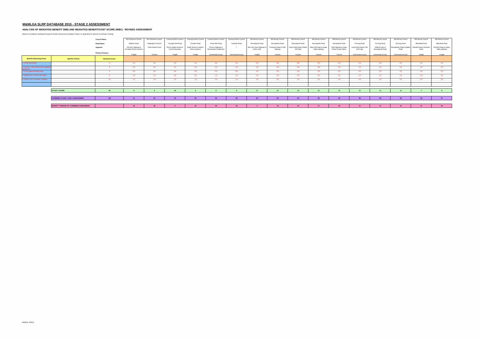
M&MLGA SLRP DATABASE 2015 - STAGE 2 ASSESSMENT
ANALYSIS OF WEIGHTED BENEFIT (WB) AND WEIGHTED BENEFIT/COST SCORE (WBC) - REVISED ASSESSMENT
Council Name: Berri Barmera Council Berri Barmera Council Coorong District Council Coorong District Council Coorong District Council Coorong District Council Mid Murray Council Mid Murray Council Mid Murray Council Mid Murray Council Mid Murray Council Mid Murray Council Mid Murray Council Mid Murray Council Mid Murray Council Mid Murray Council
Road Name: Battams Road Katapapko Crescent Tauragat Well Road Granites Road Seven Mile Road Yarindale Road Murraylands Road Murraylands Road Murraylands Road Murraylands Road Murraylands Road Purnong Road Purnong Road Purnong Road Milendella Road Milendella Road
Segment: Old Sturt Highway to
Accolade Wines Entrance
Plush Road to Grid End of sealed section to
Council boundary
Webb Street to northern
Viterra entrance
Princes Highway to
Noonameena Settlement
? 4km from Sturt Highway to
8.2km north
Punyelroo Road to Stott
Highway
Sunny Dale Road to Black
Hill Road
Black Hill Road to Angas
Valley Highway
Stott Highway to Swan
Reach Pump Station
Long Gully Road to 100
km/h sign
100km/h sign to
Murraylands Road
Murraylands Road to Mallee
Road
Randell Road to Wachtel
Road
Wachtel Road to Angus
Valley Highway
Primary Purpose:Freight Tourism Freight Freight Community Access Community Access Freight Tourism Tourism Tourism Tourism Community Access Community Access Community Access Freight Freight
Specific Criteria Maximum Score
5 0.0 0.0 5.0 0.0 0.0 0.0 5.0 0.0 0.0 0.0 0.0 0.0 0.0 0.0 0.0 0.0
5 0.0 5.0 2.5 0.0 5.0 5.0 2.5 5.0 5.0 5.0 5.0 5.0 5.0 5.0 0.0 0.0
5 0.0 0.0 5.0 0.0 0.0 0.0 2.5 2.5 2.5 2.5 2.5 0.0 0.0 0.0 0.0 0.0
5 5.0 1.0 2.5 5.0 1.0 1.0 5.0 2.5 2.5 2.5 2.5 1.0 1.0 1.0 5.0 5.0
10 1.0 3.0 1.0 1.0 2.0 2.0 2.0 2.0 2.0 2.0 2.0 5.0 5.0 5.0 2.0 3.0
STAGE 2 SCORE 30 6 9 16 6 8 8 17 12 12 12 12 11 11 11 7 8
COMBINED STAGE 1 AND 2 ASSESSMENT 130 61 53 79 60 59 66 84 69 69 69 69 69 69 69 66 67
PRIORITY RANKING BY COMBINED ASSESSMENT 23 26 8 24 25 22 3 15 16 17 18 12 13 14 21 20
5. Project cost & economic analysis.
(Based on Guidelines developed through the Roads Infrastructure Database Project, for application for Special Local Roads Funding)
Benefit Influencing Factor
1. Continuing project.
2. Tourism / community access weighting
adjustment.
3. Cross-regional linkage route.
4. Significance of road to the region.
Modified: 10/6/15

M&MLGA SLRP DATABASE 2015 - STAGE 2 ASSESSMENT
ANALYSIS OF WEIGHTED BENEFIT (WB) AND WEIGHTED BENEFIT/COST SCORE (WBC) - REVISED ASSESSMENT
Council Name:
Road Name:
Segment:
Primary Purpose:
Specific Criteria Maximum Score
5
5
5
5
10
STAGE 2 SCORE 30
COMBINED STAGE 1 AND 2 ASSESSMENT 130
PRIORITY RANKING BY COMBINED ASSESSMENT
5. Project cost & economic analysis.
(Based on Guidelines developed through the Roads Infrastructure Database Project, for application for Special Local Roads Funding)
Benefit Influencing Factor
1. Continuing project.
2. Tourism / community access weighting
adjustment.
3. Cross-regional linkage route.
4. Significance of road to the region.
Rural City of Murray Bridge Rural City of Murray Bridge Rural City of Murray Bridge Rural City of Murray Bridge Rural City of Murray Bridge Renmark Paringa Council Renmark Paringa Council Renmark Paringa Council Renmark Paringa Council Southern Mallee District
Council
Southern Mallee District
Council
Cypress Terrace Hindmarsh Road Maurice Road Maurice Road Schenscher Road Government Road Murtho Road Murtho Road Murtho Road Geranium South Road Tauraget Well Road
Mannum Road and Maurice
Road
Brinkley Road to Swanport
Road
Brinkley Road to Adelaide
Road
Adelaide Road to Cypress
Terrace
5 ways Intersection with
Pallamana, Monarto, Thiele
and Patterson Rds
Full length Sturt Highway to Beherendt
Road
Beherendt Road to
Wilkinson Road
Wilkinson Road to Customs
House
Unsealed Section Full Length
Freight Freight Freight Freight Freight Freight Tourism Tourism Tourism Freight Freight
0.0 0.0 0.0 0.0 2.5 0.0 0.0 0.0 0.0 5.0 5.0
0.0 0.0 0.0 0.0 0.0 0.0 5.0 5.0 5.0 2.5 2.5
2.5 2.5 2.5 2.5 2.5 0.0 0.0 0.0 0.0 5.0 5.0
2.5 2.5 2.5 2.5 5.0 1.0 2.0 1.0 1.0 2.5 2.5
6.0 8.0 10.0 5.0 1.0 8.0 7.0 7.0 4.0 1.0 1.0
11 13 15 10 11 9 14 13 10 16 16
83 85 87 82 82 71 77 69 49 81 79
4 2 1 5 6 11 10 19 27 7 9
Modified: 10/6/15