harvesting and effective utilization of rainwater in diked ... mishra.pdfharvesting and effective...
TRANSCRIPT
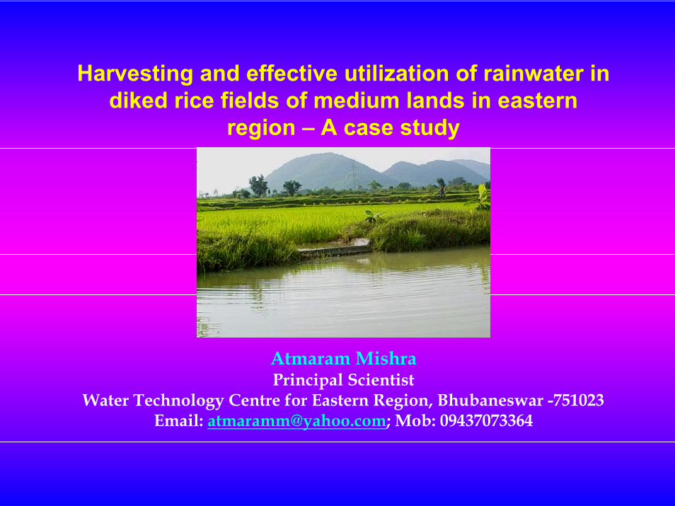
Harvesting and effective utilization of rainwater indiked rice fields of medium lands in eastern
region – A case study
Atmaram MishraPrincipal Scientist
Water Technology Centre for Eastern Region, Bhubaneswar -751023Email: [email protected]; Mob: 09437073364
Background:
Plenty of rainfall ranging from 1007 mm to 3126 mm80% of rainfall occurrence during monsoon50% of annual rainfall comes from few intense stormsErratic nature of onset, distribution and withdrawal of monsoonReduction in crop growth and yield due to moisture stress either due to deficit or excess water Fallow after kharif rice in about 12-16 M ha area due to irrigation water unavailability. Frequent occurrences of natural calamities
Solution approach
Conservation and multiple use of rainwater
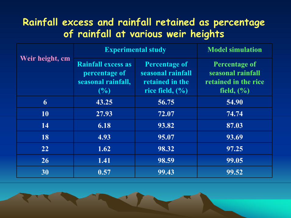
Rainfall excess and rainfall retained as percentage of rainfall at various weir heights
Weir height, cmExperimental study Model simulation
Rainfall excess as percentage of
seasonal rainfall, (%)
Percentage of seasonal rainfall retained in the rice field, (%)
Percentage of seasonal rainfall
retained in the rice field, (%)
6 43.25 56.75 54.9010 27.93 72.07 74.7414 6.18 93.82 87.0318 4.93 95.07 93.6922 1.62 98.32 97.2526 1.41 98.59 99.0530 0.57 99.43 99.52
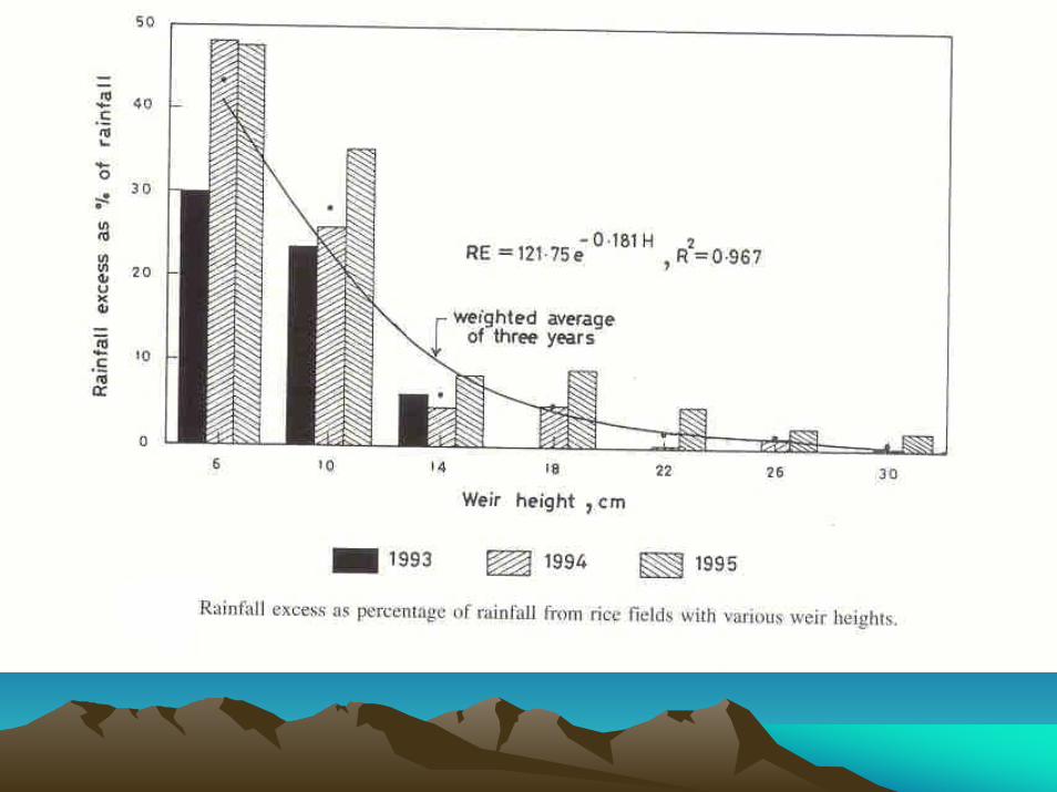
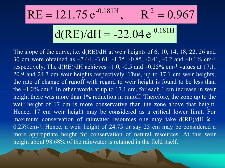
967.0R ,e 121.75RE 2-0.181H ==-0.181He -22.04d(RE)/dH =
The slope of the curve, i.e. d(RE)/dH at weir heights of 6, 10, 14, 18, 22, 26 and 30 cm were obtained as –7.44, -3.61, -1.75, -0.85, -0.41, -0.2 and –0.1% cm-1
respectively. The d(RE)/dH achieves –1.0, -0.5 and –0.25% cm-1 values at 17.1, 20.9 and 24.7 cm weir heights respectively. Thus, up to 17.1 cm weir heights, the rate of change of runoff with regard to weir height is found to be less than the –1.0% cm-1. In other words at up to 17.1 cm, for each 1 cm increase in weir height there was more than 1% reduction in runoff. Therefore, the zone up to the weir height of 17 cm is more conservative than the zone above that height. Hence, 17 cm weir height may be considered as a critical lower limit. For maximum conservation of rainwater resources one may take d(RE)/dH ≥ -0.25%cm-1. Hence, a weir height of 24.75 or say 25 cm may be considered amore appropriate height for conservation of natural resources. At this weir height about 98.68% of the rainwater is retained in the field itself.
Salient findings
Rice plots with weir heights of 6 and 30 cm could store 57% and 99% of the rainwater, respectively. An exponential relationship was observed between the rainfall excess values (as percentage of rainfall) and weir heights.
For kharif rice, on an average, four supplemental irrigations with an applications depth of 6 cm per irrigation were required for 6 cm weir height plots. Weir height ranging from 10-14 cm required three supplemental irrigations while 18-30 cm required only two supplemental irrigations.
Loss of sediments and nutrients such as Total Kjeldhal Nitrogen (TKN) & available potassium in runoff water were found to be exponentially related with weir heights. Six cm weir height plots recorded highest loss of sediments (347.78 kg/ha) and nutrients (4.227 kg/ha of TKN and 2.20 kg/ha of potassium). At the weir height of 22 cm these losses were minimised to a considerable extent.
The average depth of water stored in 6, 10, 14, 18, 22, 26 and 30 cm weir height plots were obtained as 4.47, 7.02, 7.10, 8.22, 8.68, 9.02 and 9.91 cm, respectively.
RecommendationRecommendation
Based on the results of the study, a dike height of 25 cm is considered as the optimum height for in-situ conservation of rainwater, sediments and nutrients etc. for rainfed medium flat lands with light to medium textured soils. Dike height is a function of soil type, land gradient, rainfall pattern, crop characteristics etc. Hence, slightly higher height may be considered if the soil is heavy and land is sloping.
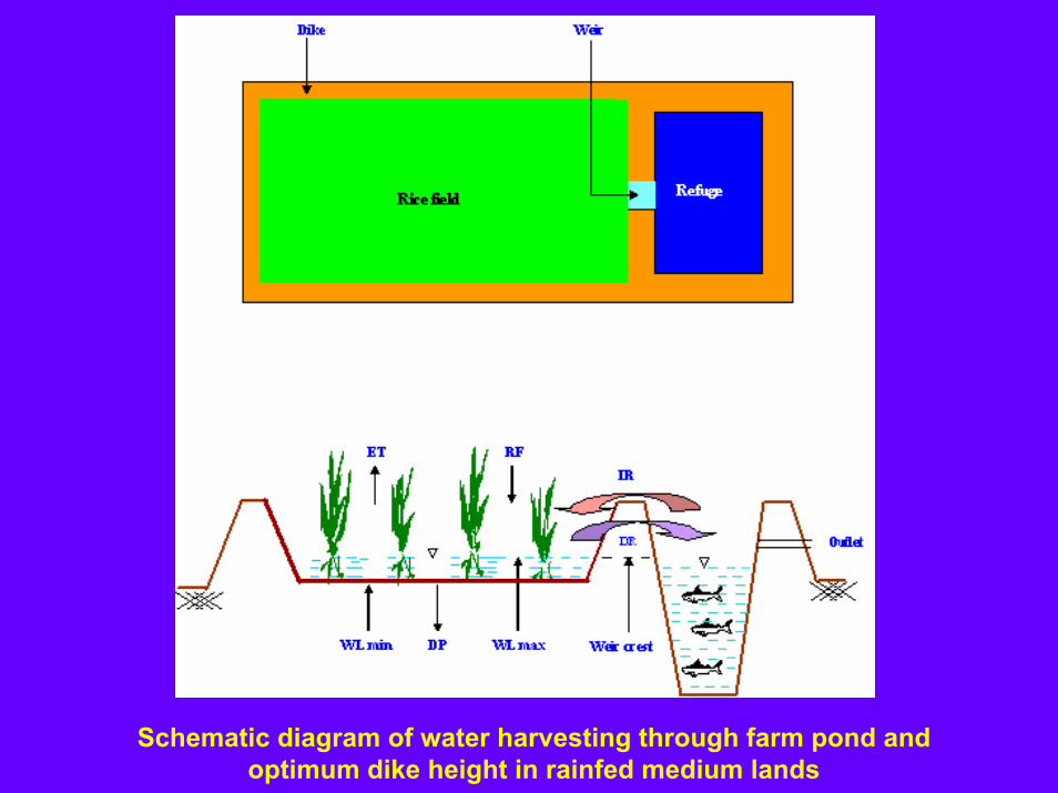
Schematic diagram of water harvesting through farm pond and optimum dike height in rainfed medium lands
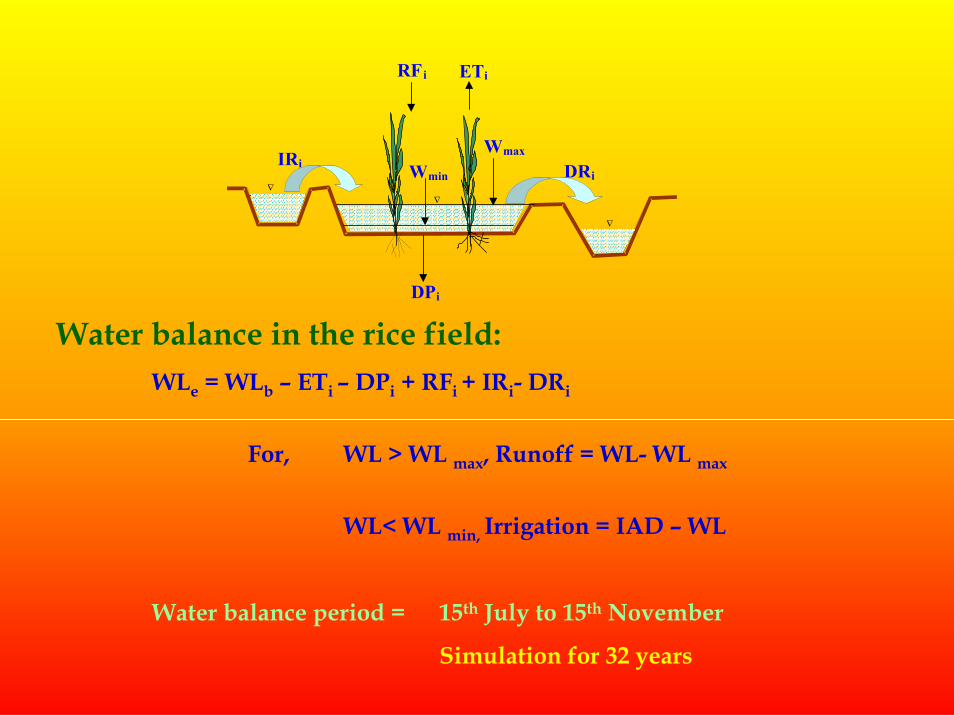
ETi
IRi
RFi
DPi
DRi
Wmax
∇
∇∇
Wmin
Water balance in the rice field:WLe = WLb – ETi – DPi + RFi + IRi- DRi
For, WL > WL max, Runoff = WL- WL max
WL< WL min, Irrigation = IAD – WL
Water balance period = 15th July to 15th November
Simulation for 32 years
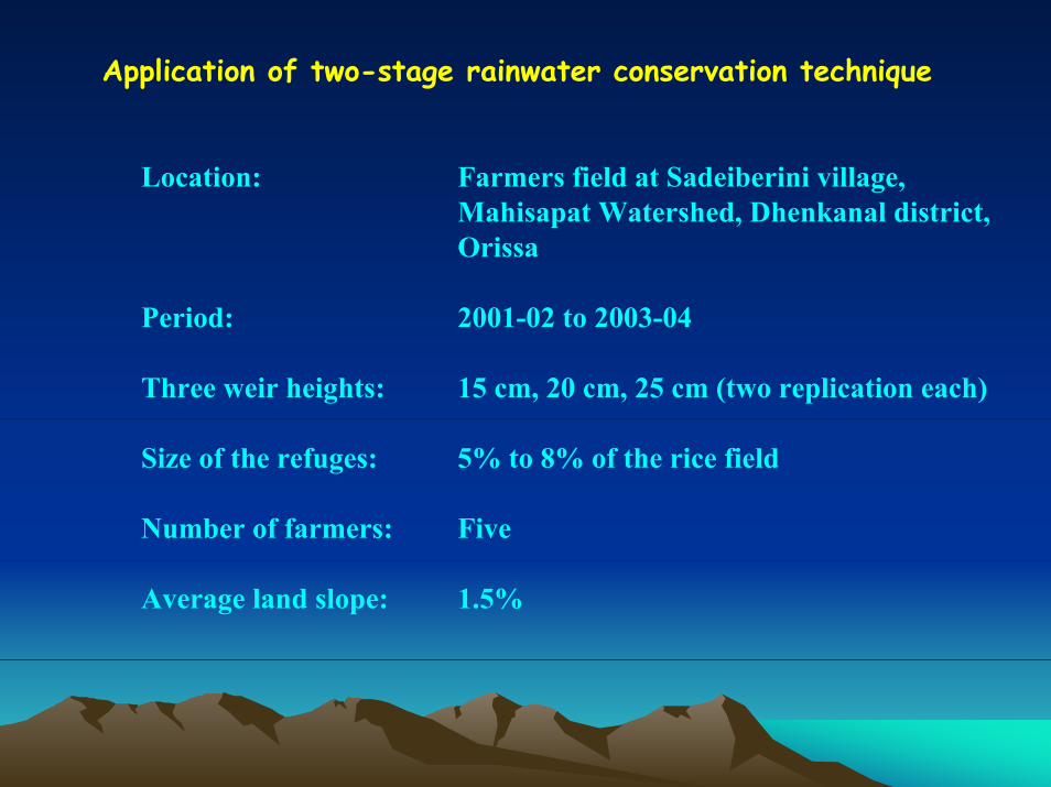
Application of two-stage rainwater conservation technique
Location: Farmers field at Sadeiberini village,Mahisapat Watershed, Dhenkanal district,Orissa
Period: 2001-02 to 2003-04
Three weir heights: 15 cm, 20 cm, 25 cm (two replication each)
Size of the refuges: 5% to 8% of the rice field
Number of farmers: Five
Average land slope: 1.5%
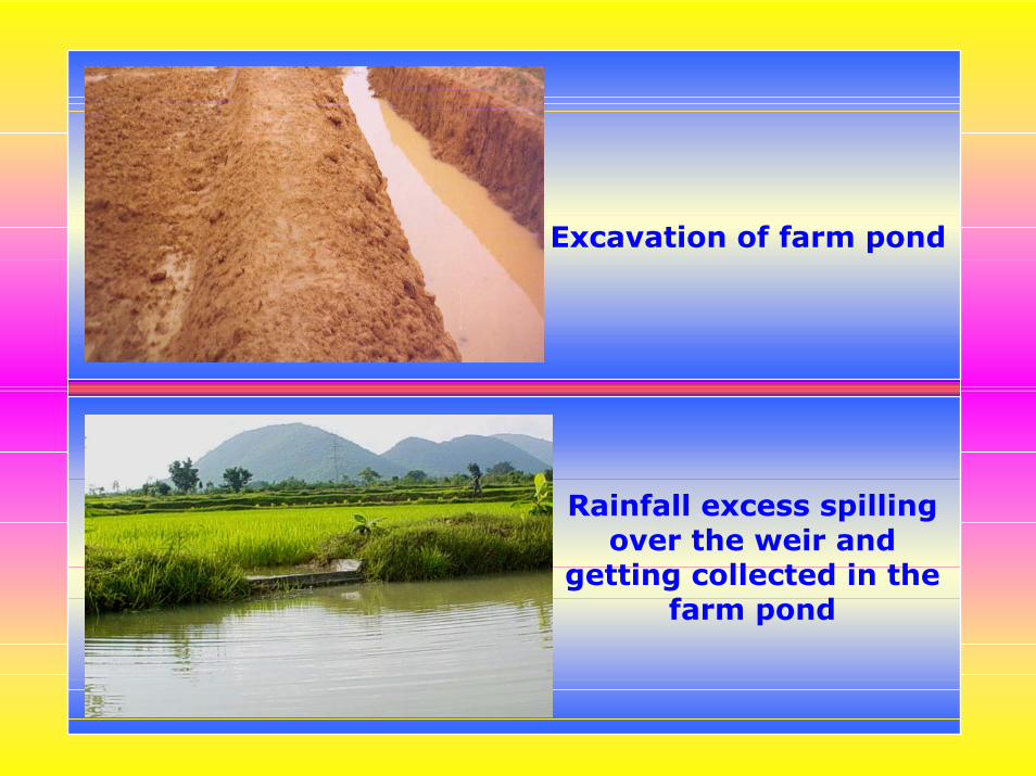
Excavation of farm pond
Rainfall excess spilling over the weir and
getting collected in the farm pond
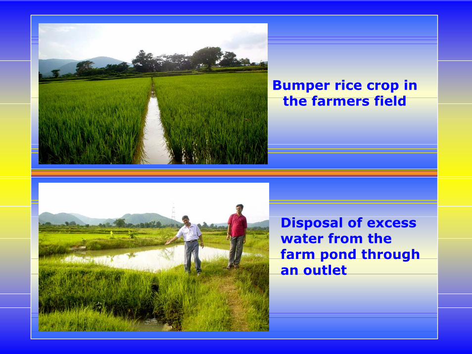
Bumper rice crop in the farmers field
Disposal of excess water from the farm pond through an outlet
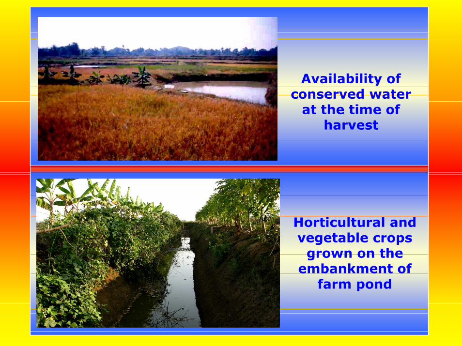
Availability of conserved water
at the time of harvest
Horticultural and vegetable crops
grown on the embankment of
farm pond
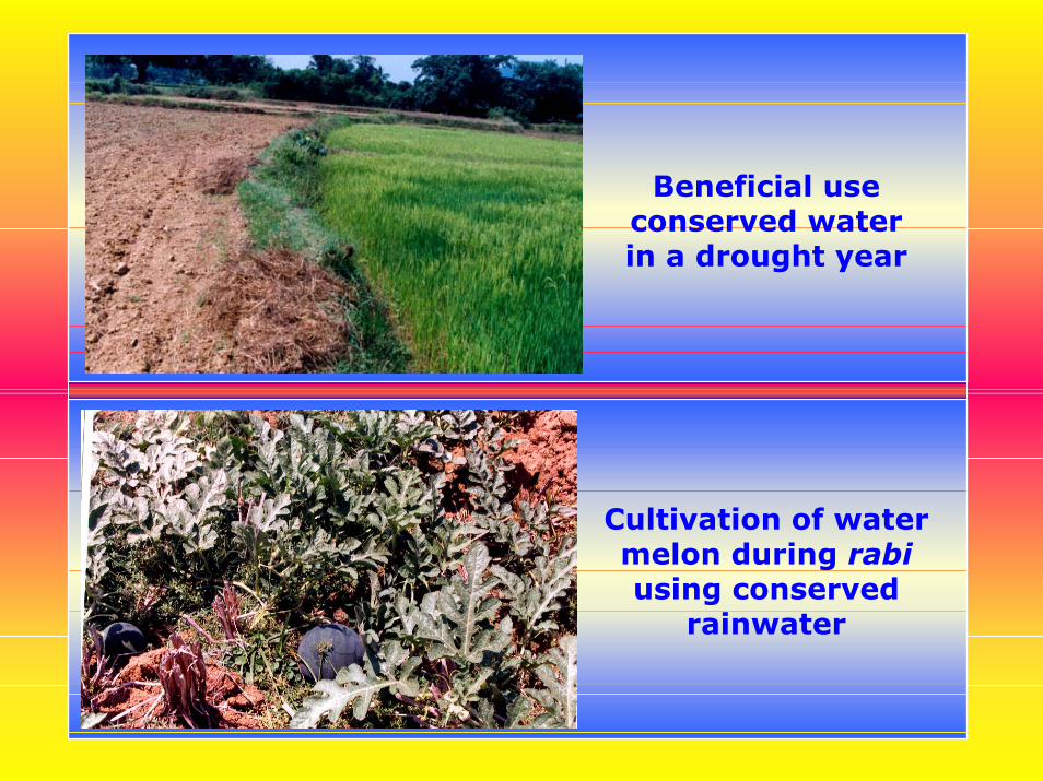
Beneficial use conserved water in a drought year
Cultivation of water melon during rabiusing conserved
rainwater
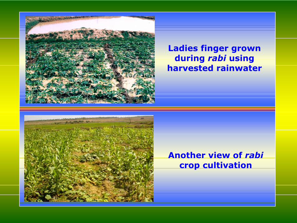
Ladies finger grown during rabi using
harvested rainwater
Another view of rabicrop cultivation
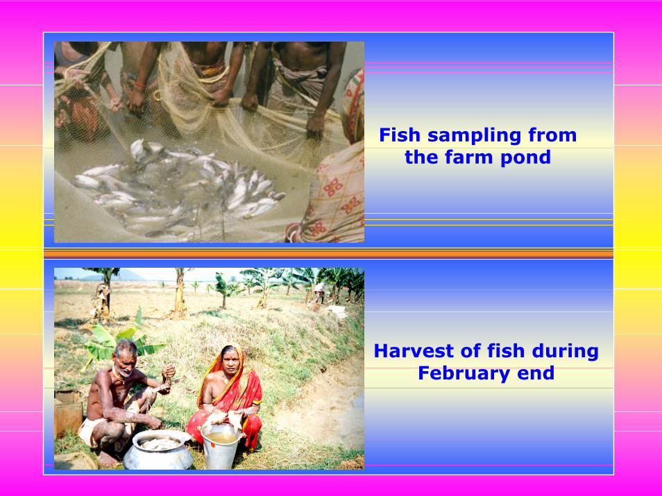
Fish sampling from the farm pond
Harvest of fish during February end
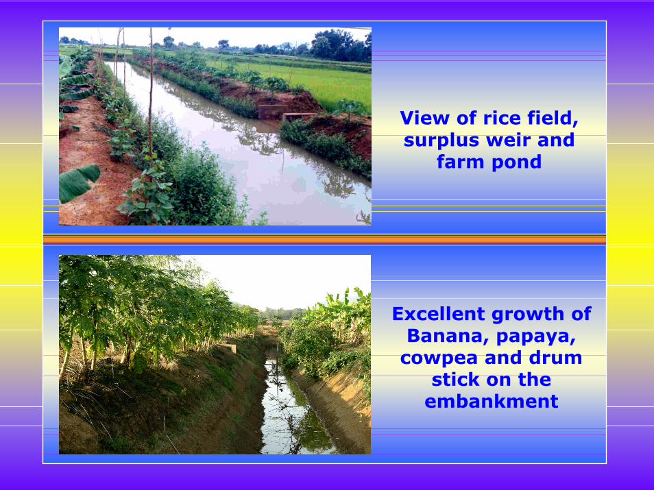
View of rice field, surplus weir and
farm pond
Excellent growth of Banana, papaya,
cowpea and drum stick on the
embankment
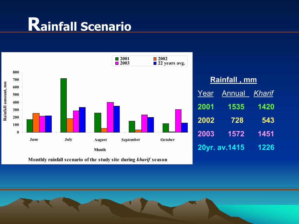
Rainfall Scenario
Rainfall , mm
Year Annual Kharif
2001 1535 1420
2002 728 543
2003 1572 1451
20yr. av.1415 1226Monthly rainfall scenario of the study site during kharif season
0
100
200
300
400
500
600
700
800
June July August September October
Month
Rai
nfal
l am
ount
, mm
2001 20022003 22 years avg.
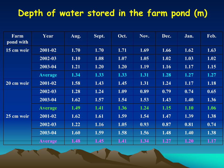
Depth of water stored in the farm pond (m)
Farm pond with
Year Aug. Sept. Oct. Nov. Dec. Jan. Feb.
15 cm weir 2001-02 1.70 1.70 1.71 1.69 1.66 1.62 1.63
2002-03 1.10 1.08 1.07 1.05 1.02 1.03 1.02
2003-04 1.21 1.20 1.20 1.19 1.16 1.17 1.15
Average 1.34 1.33 1.33 1.31 1.28 1.27 1.27
20 cm weir 2001-02 1.58 1.43 1.45 1.31 1.24 1.17 1.18
2002-03 1.28 1.24 1.09 0.89 0.79 0.74 0.65
2003-04 1.62 1.57 1.54 1.53 1.43 1.40 1.36
Average 1.49 1.41 1.36 1.24 1.15 1.10 1.06
25 cm weir 2001-02 1.62 1.61 1.59 1.54 1.47 1.39 1.38
2002-03 1.22 1.16 1.05 0.93 0.87 0.81 0.74
2003-04 1.60 1.59 1.58 1.56 1.48 1.40 1.38
Average 1.48 1.45 1.41 1.34 1.27 1.20 1.17
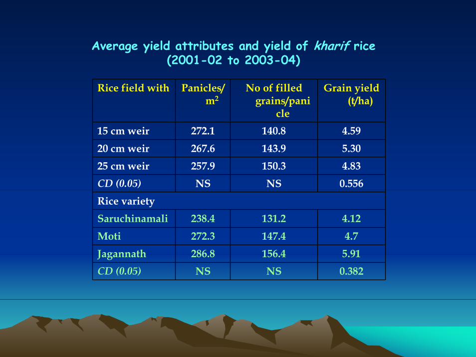
Average yield attributes and yield of kharif rice (2001-02 to 2003-04)
Rice field with Panicles/m2
No of filled grains/pani
cle
Grain yield (t/ha)
15 cm weir 272.1 140.8 4.5920 cm weir 267.6 143.9 5.3025 cm weir 257.9 150.3 4.83CD (0.05) NS NS 0.556Rice varietySaruchinamali 238.4 131.2 4.12Moti 272.3 147.4 4.7Jagannath 286.8 156.4 5.91CD (0.05) NS NS 0.382

Fish yield (kg/ha) from farm ponds
Farm pond with
1st year 2nd year 3rd year Pooled
15 cm weir 1232.40 1988.80 1859.60 1693.6020 cm weir 1004.8 1553.00 1238.10 1265.3025 cm weir 1109.90 1478.35 1250.00 1279.40
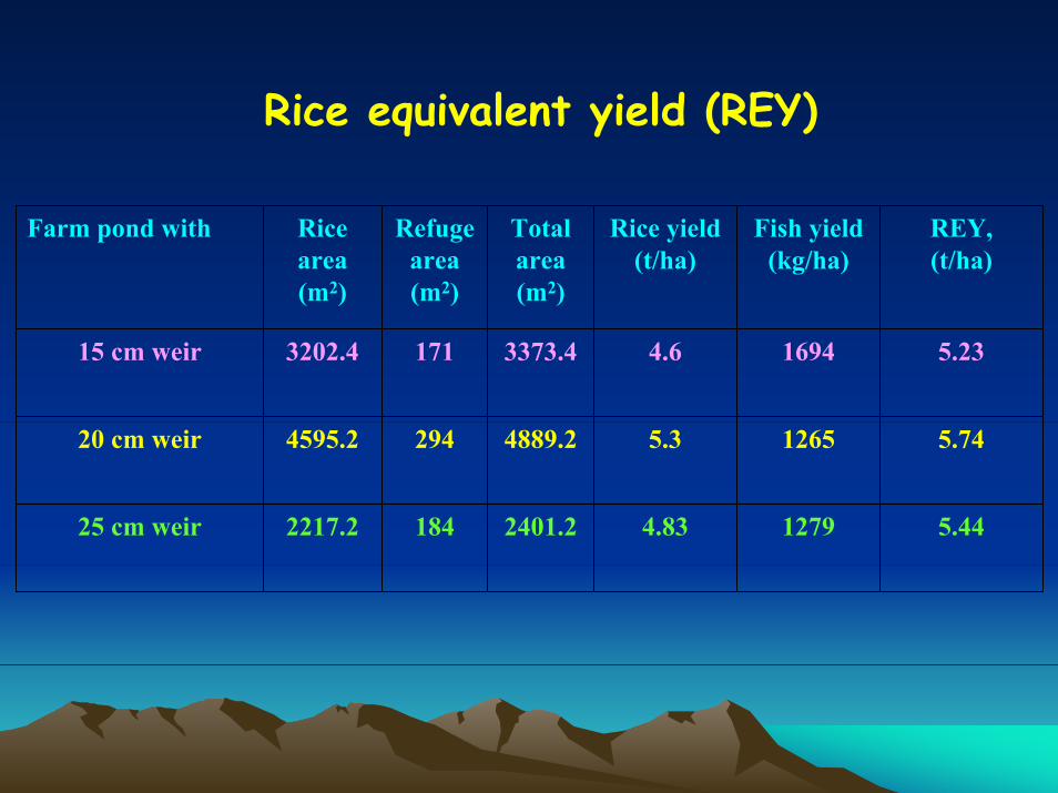
Rice equivalent yield (REY)
Farm pond with Rice area (m2)
Refuge area(m2)
Total area(m2)
Rice yield (t/ha)
Fish yield (kg/ha)
REY,(t/ha)
15 cm weir 3202.4 171 3373.4 4.6 1694 5.23
20 cm weir 4595.2 294 4889.2 5.3 1265 5.74
25 cm weir 2217.2 184 2401.2 4.83 1279 5.44
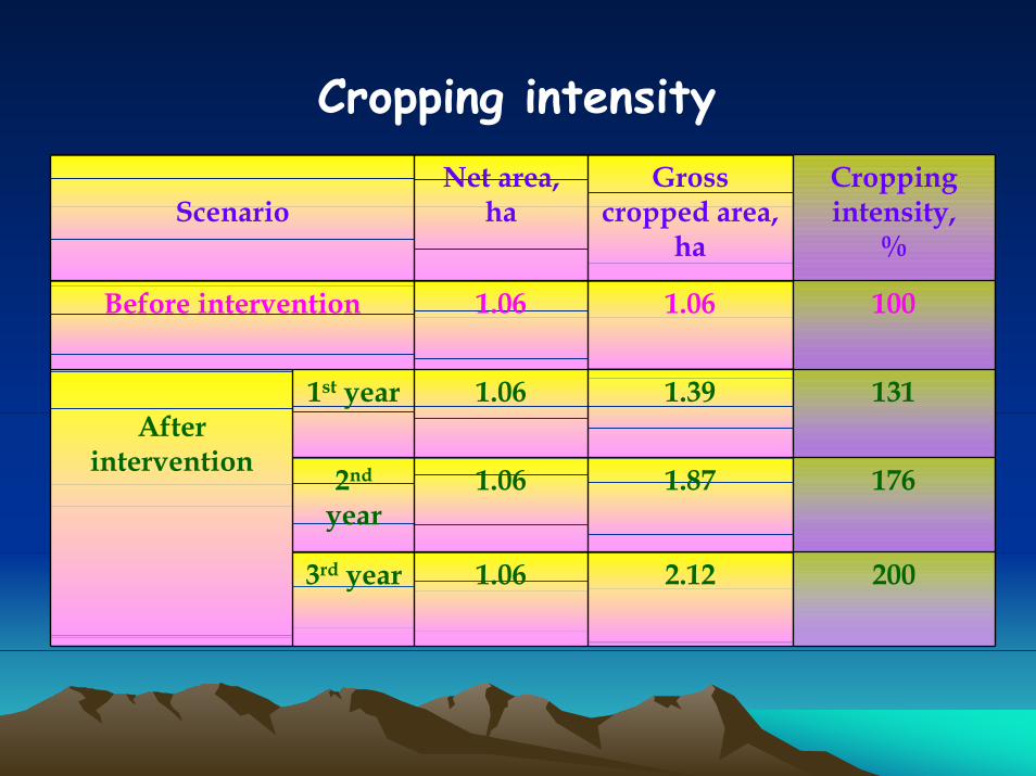
Cropping intensity
ScenarioNet area,
haGross
cropped area, ha
Cropping intensity,
%
Before intervention 1.06 1.06 100
After intervention
1st year 1.06 1.39 131
2nd
year1.06 1.87 176
3rd year 1.06 2.12 200
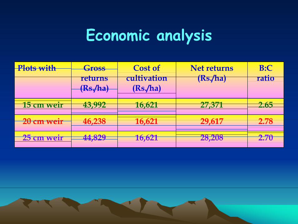
Economic analysis
Plots with Gross returns (Rs./ha)
Cost of cultivation
(Rs./ha)
Net returns (Rs./ha)
B:C ratio
15 cm weir 43,992 16,621 27,371 2.65
20 cm weir 46,238 16,621 29,617 2.78
25 cm weir 44,829 16,621 28,208 2.70
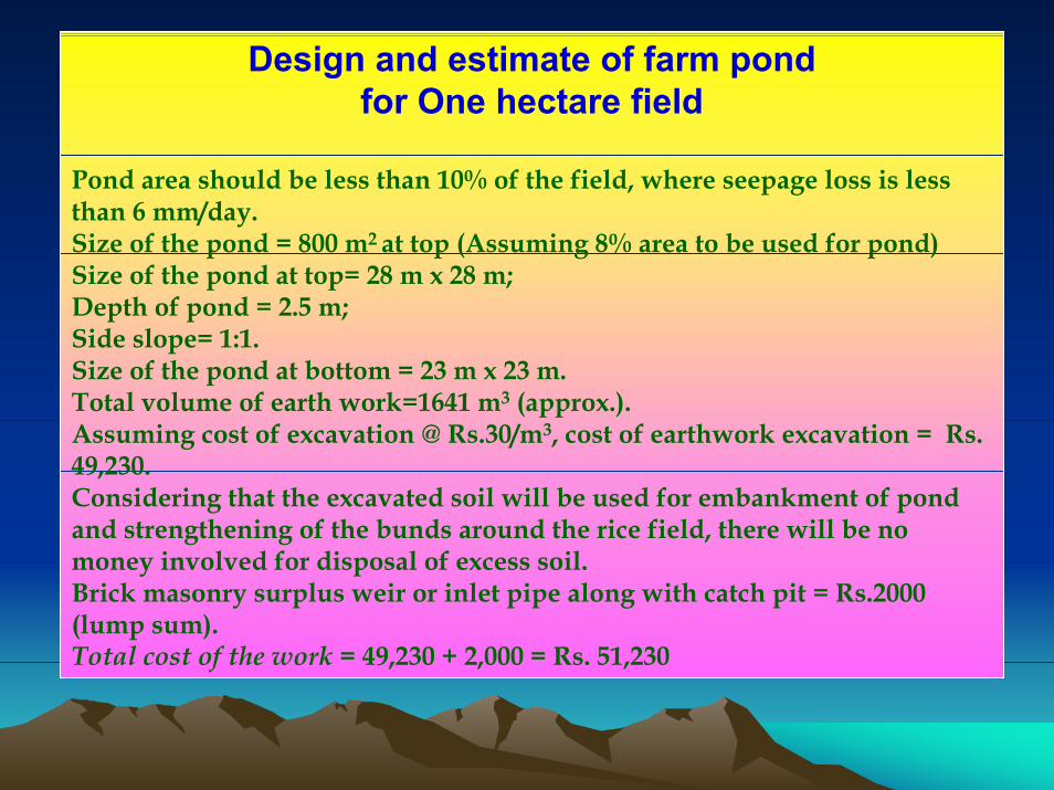
Design and estimate of farm pond for One hectare field
Pond area should be less than 10% of the field, where seepage loss is less than 6 mm/day.Size of the pond = 800 m2 at top (Assuming 8% area to be used for pond)Size of the pond at top= 28 m x 28 m; Depth of pond = 2.5 m; Side slope= 1:1.Size of the pond at bottom = 23 m x 23 m.Total volume of earth work=1641 m3 (approx.).Assuming cost of excavation @ Rs.30/m3, cost of earthwork excavation = Rs. 49,230.Considering that the excavated soil will be used for embankment of pond and strengthening of the bunds around the rice field, there will be no money involved for disposal of excess soil. Brick masonry surplus weir or inlet pipe along with catch pit = Rs.2000 (lump sum). Total cost of the work = 49,230 + 2,000 = Rs. 51,230

2.76 2.94
4.94
5.87
2.06 2.17
3.07
3.76
0
1
2
3
4
5
6
7
Rice Rice+fish Rice+fish+on-dykehorticulture
Rice+fish+on-dykehort.+rabi crop
Farming system
Wat
er p
rodu
ctiv
ity (R
s./m
3 )Gross water productivityNet water productivity
Economic index of gross and net water productivity
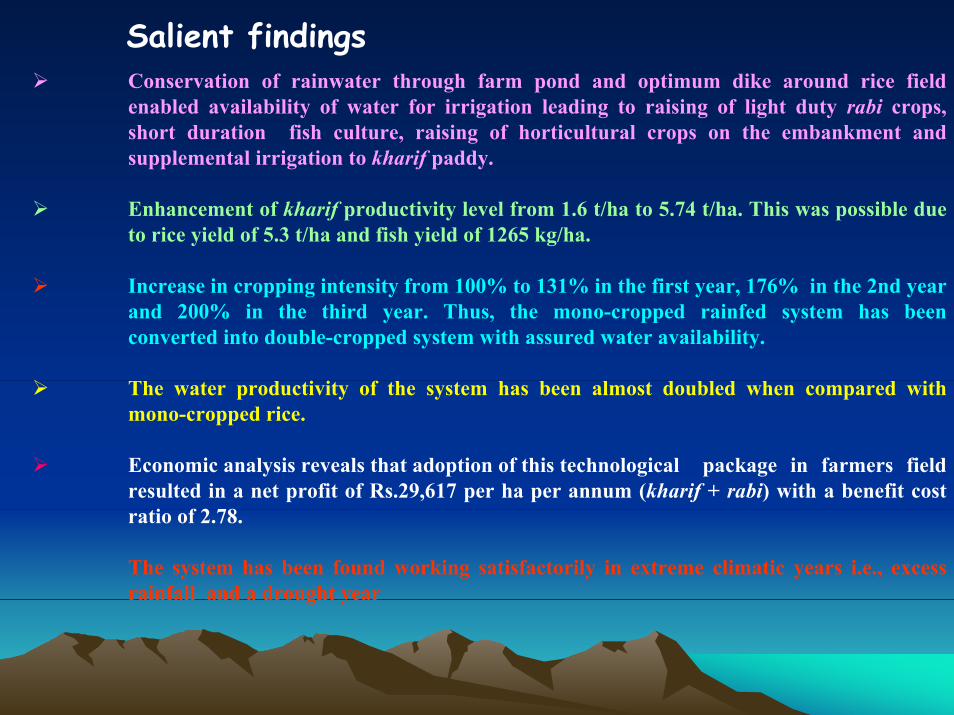
Salient findingsConservation of rainwater through farm pond and optimum dike around rice field enabled availability of water for irrigation leading to raising of light duty rabi crops, short duration fish culture, raising of horticultural crops on the embankment and supplemental irrigation to kharif paddy.
Enhancement of kharif productivity level from 1.6 t/ha to 5.74 t/ha. This was possible due to rice yield of 5.3 t/ha and fish yield of 1265 kg/ha.
Increase in cropping intensity from 100% to 131% in the first year, 176% in the 2nd year and 200% in the third year. Thus, the mono-cropped rainfed system has been converted into double-cropped system with assured water availability.
The water productivity of the system has been almost doubled when compared with mono-cropped rice.
Economic analysis reveals that adoption of this technological package in farmers field resulted in a net profit of Rs.29,617 per ha per annum (kharif + rabi) with a benefit cost ratio of 2.78.
The system has been found working satisfactorily in extreme climatic years i.e., excess rainfall and a drought year
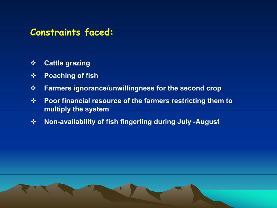
Constraints faced:
Cattle grazing
Poaching of fish
Farmers ignorance/unwillingness for the second crop
Poor financial resource of the farmers restricting them to multiply the system
Non-availability of fish fingerling during July -August
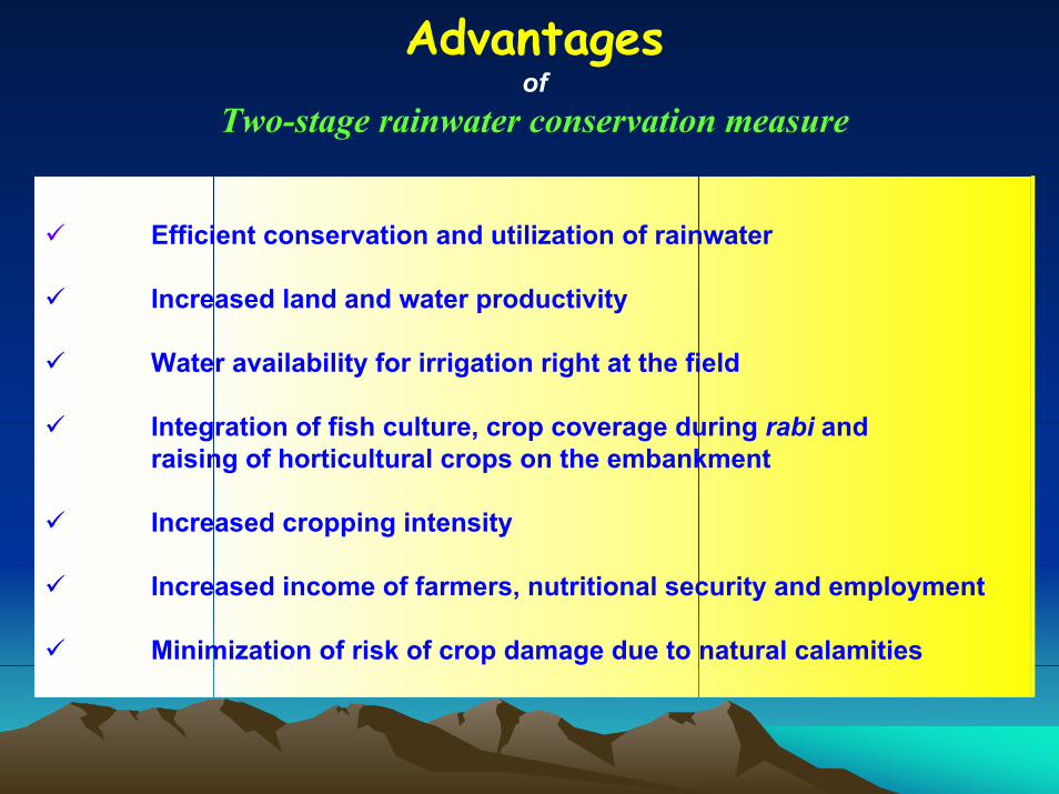
Advantagesof
Two-stage rainwater conservation measure
Efficient conservation and utilization of rainwater
Increased land and water productivity
Water availability for irrigation right at the field
Integration of fish culture, crop coverage during rabi and raising of horticultural crops on the embankment
Increased cropping intensity
Increased income of farmers, nutritional security and employment
Minimization of risk of crop damage due to natural calamities
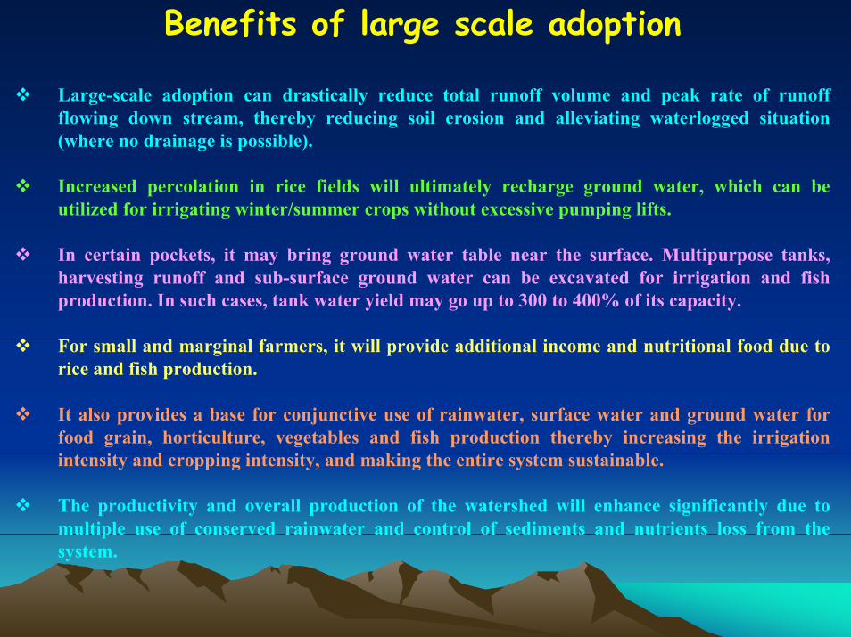
Benefits of large scale adoption
Large-scale adoption can drastically reduce total runoff volume and peak rate of runoff flowing down stream, thereby reducing soil erosion and alleviating waterlogged situation (where no drainage is possible).
Increased percolation in rice fields will ultimately recharge ground water, which can be utilized for irrigating winter/summer crops without excessive pumping lifts.
In certain pockets, it may bring ground water table near the surface. Multipurpose tanks, harvesting runoff and sub-surface ground water can be excavated for irrigation and fish production. In such cases, tank water yield may go up to 300 to 400% of its capacity.
For small and marginal farmers, it will provide additional income and nutritional food due to rice and fish production.
It also provides a base for conjunctive use of rainwater, surface water and ground water for food grain, horticulture, vegetables and fish production thereby increasing the irrigation intensity and cropping intensity, and making the entire system sustainable.
The productivity and overall production of the watershed will enhance significantly due to multiple use of conserved rainwater and control of sediments and nutrients loss from the system.