harrison river watershed habitat status report · ii executivesummary!...
TRANSCRIPT

Harrison River Watershed Habitat Status Report
Prepared For:
Suzanne Thorpe
Fisheries and Oceans Canada
May 10, 2010
Prepared By:
Monica Pearson, B.Sc., Dipl. Tech., Biologist
Lesley-‐Ann Chiavaroli, B.Sc., Research Assistant
BALANCE ECOLOGICAL
1940 Napier St. Vancouver BC
Canada V5L 2N5
Tel: (778) 868-‐8507
i
ACKNOWLEDGEMENTS
Many people were consulted in the development of this document, and gave freely of their knowledge and resources. Matt Foy (DFO) provided boxes of historic information and background knowledge of the watershed, as did Rick Stitt and Wayne Charlie (Weaver Creek Hatchery). Vince Busto, Jeremy Hume, Kimberly Sandve and Angeleen Olsen provided useful documents within DFO, as did Lance Lilley, David Bennett and Wendy Bales from the Fraser Valley Regional District. Thanks to Ken Peters for the lecture on sockeye salmon in the Harrison watershed that provided our first insight into the complexity of the salmonid CUs in the area. Liz Freyman, Jennie Aikman and Rob Knight helped to track down information within the B.C. Ministry of Environment. Many more pointed us towards these knowledgeable people, and helped us identify sources of information along the way. Final thanks to Suzanne Thorpe for guiding the work and providing careful edits to the drafts.

ii
EXECUTIVE SUMMARY Fisheries and Oceans Canada adopted the Wild Salmon Policy (WSP) for the conservation of wild Pacific Salmon in 2005, with the overall goal of restoring and maintaining healthy and diverse salmon populations and their habitats. Strategy 2 of WSP requires the assessment of habitats associated with salmon Conservation Units (CUs). The purpose of this document is to summarize the habitat conditions impacting salmon CUs in the Lower Harrison River Watershed (LHW), to select habitat indicators appropriate to the watershed and conservation units, and to identify existing reports to inform habitat status.
The Lower Harrison Watershed is the southernmost and downstream portion of the 8,324 km2 Harrison-‐Lillooet watershed. Nine salmon Conservation Units are known to occupy 32 named habitats in the watershed, 17 of which are addressed in this document. The geographic scope of this project and preliminary identification of high-‐value habitat were determined from the Province of British Columbia Integrated Land Management Bureau’s (ILMB) online mapping system iMap. Potential habitat indicators were selected based on the habitat type. Given the geographic scope of the work, and the presence of distinct conservation units in multiple sub-‐habitats, information was organized geographically. Interviews were conducted with DFO staff, as well as staff from the Regional District, Municipalities, and knowledgeable locals.
It was beyond the scope of this project to analyze raw data to inform habitat conditions, but we have identified available raw data that can be compiled into useful habitat status indicators. Land cover data is available for the watershed, albeit out-‐of-‐date. Water licenses in the watershed are mostly held by Fisheries and Oceans Canada, however new water licenses have been sought or obtained by independent power producers (IPPs) on several streams in the LHW, which will impact flow patterns in affected streams. LHW tributaries are naturally oligotrophic and although agricultural / urban pollutants are insignificant in much of the watershed, the southern portion is recipient to non-‐point and point-‐source pollution. Long-‐term temperature data is available from six habitats; where compiled, temperature data consistently indicated summer temperatures at levels stressful to fish. Tipella Creek was the only drainage in which known temperature data did not show stressful summer temperatures. Eleven high-‐value salmon streams in the LHW in the lower portion of the LHW are estimated to have critically low flows below the mean annual discharge benchmark for instantaneous flow for survival of most aquatic life. Those tributaries in the upper portion of the LHW all maintain adequate or good low flow summer habitat. Sakwi Creek is the most vulnerable to discharge instability, due to its denuded headwaters and high extraction allowances.
The most severe limiting factors in the Harrison Watershed result from excessive forest harvesting and the related channel instability, road density, riparian removal, and water temperatures increases. Impacts predicted due to climate change will further affect water temperatures and flows, reducing the availability and quality of habitat for alevin, fry and spawners. Nutrient availability in streams is low and may become a limiting factor if not replenished by returning adults. Water extraction from IPPs will impact flow patterns, and should be carefully monitored to ensure impacts to downstream spawners and eggs are minimized.
Forest harvest is the most significant land use in the LHW, and information regarding percent of watershed logged is out-‐date and sometimes conflicting. B.C. Ministry of Forests and Range maintains maps and archives of completed and planned forest harvest, and should be approached to access the data for analysis. By compiling statistics regarding road densities and forest harvest in the LHW, habitat managers would have the ability to infer a wide range of habitat status indicators, including riparian connectivity, water temperatures, and flow stability.

iii
TABLE OF CONTENTS
1 INTRODUCTION ...........................................................................................................................1
2 METHODS..................................................................................................................................1 2.1 IDENTIFICATION OF THE GEOGRAPHIC AND BIOLOGICAL SCOPE OF WORK .............................................. 3 2.2 IDENTIFICATION OF HABITAT INFORMATION – FART 1 ........................................................................ 4 2.3 EXTRACTION / ORGANIZATION OF INFORMATION .............................................................................. 4 2.4 IDENTIFICATION OF HABITAT INFORMATION – FART 2 ........................................................................ 4 2.5 INTERVIEWS ................................................................................................................................ 5 2.6 HABITAT STATUS REPORT DEVELOPMENT ........................................................................................ 5 2.7 METHODS RECOMMENDATIONS..................................................................................................... 6
3 LOWER HARRISON WATERSHED......................................................................................................6
4 SALMONID CONSERVATION UNITS...................................................................................................9 4.1 CHINOOK CONSERVATION UNITS .................................................................................................. 11
4.1.1 Lower Fraser Fall White (CH 3) ....................................................................................... 12 4.1.2 Lower Fraser Spring (CH 4) ............................................................................................. 13 4.1.3 Lower Fraser Summer Chinook (CH 6) ............................................................................ 13
4.2 LOWER FRASER RIVER CHUM CONSERVATION UNIT (CM 2) ............................................................. 14 4.3 LOWER FRASER COHO CONSERVATION UNIT (CO 2)........................................................................ 15
4.3.1 Coho Creek group ........................................................................................................... 17 4.4 LOWER FRASER PINK CONSERVATION UNIT (PK1)........................................................................... 17 4.5 SOCKEYE CONSERVATION UNITS ................................................................................................... 19
4.5.1 Lake-‐type Harrison Downstream Lower Fraser (SK L-‐3-‐3) .............................................. 20 4.5.2 Lake-‐type Upstream Lower Fraser (SK L-‐3-‐4) ................................................................. 20 4.5.3 River-‐type Lower Fraser (R03) ........................................................................................ 22
5 HIGH VALUE HABITATS ...............................................................................................................22 5.1 BIG SILVER CREEK ...................................................................................................................... 22 5.2 CHEHALIS RIVER ........................................................................................................................ 24
5.2.1 Chehalis Lake.................................................................................................................. 30 5.2.2 Coho Creek...................................................................................................................... 30
5.3 COGBURN CREEK ....................................................................................................................... 31 5.4 DOUGLAS CREEK........................................................................................................................ 32 5.5 HARRISON RIVER ....................................................................................................................... 33
5.5.1 Harrison Lake.................................................................................................................. 36 5.6 MORRIS CREEK / SLOUGH ........................................................................................................... 37
5.6.1 Morris Lake..................................................................................................................... 38 5.6.2 Weaver Creek ................................................................................................................. 38 5.6.3 Sakwi Creek .................................................................................................................... 40
5.7 MYSTERY CREEK ........................................................................................................................ 41 5.8 MIAMI CREEK ........................................................................................................................... 42 5.9 TIPELLA CREEK........................................................................................................................... 43 5.10 TROUT LAKE CREEK.................................................................................................................. 44

iv
5.11 TWENTY MILE......................................................................................................................... 45
6 HABITAT INDICATOR ANALYSIS .....................................................................................................46 6.1 PRESSURE INDICATORS................................................................................................................ 46
6.1.1 Total Land Cover Alterations .......................................................................................... 46 6.1.2 Riparian disturbance ...................................................................................................... 47 6.1.3 Watershed road development........................................................................................ 47 6.1.4 Water extraction ............................................................................................................ 47 6.1.5 Permitted Waste Discharges .......................................................................................... 47
6.2 STATE INDICATORS ..................................................................................................................... 48 6.2.1 Suspended sediment....................................................................................................... 48 6.2.2 Water Quality ................................................................................................................. 48 6.2.3 Water Temperature........................................................................................................ 48 6.2.4 Discharge........................................................................................................................ 48 6.2.5 Length of Spawning Habitat........................................................................................... 49
7 LIMITING FACTORS, THREATS AND RECOMMENDATIONS ....................................................................49 7.1 LIMITING FACTORS..................................................................................................................... 49 7.2 THREATS .................................................................................................................................. 49
7.2.1 Forestry .......................................................................................................................... 49 7.2.2 Development and Resource Extraction........................................................................... 50 7.2.3 Climate Change .............................................................................................................. 51
8 LITERATURE CITED .....................................................................................................................53
9 WEBSITES ................................................................................................................................56

v
LIST OF FIGURES
FIGURE 1. Location of the Lower Harrison Watershed within B.C. and the Fraser River Watershed..... 7
FIGURE 2. Chinook occurrences in the Lower Harrison Watershed, as described by Holtby and Ciruna (2007) and Provincial FISS databases. The three chinook Conservation Units are not differentiated in this image. ....................................................................................................... 12
FIGURE 3. Chum salmon occurrences in the Lower Harrison Watershed, as described by Holtby and Ciruna (2007) and provincial FISS databases. ............................................................................. 15
FIGURE 4. Coho salmon occurrences in the Lower Harrison Watershed, as described by Holtby and Ciruna (2009) and Provincial FISS databases. ............................................................................. 16
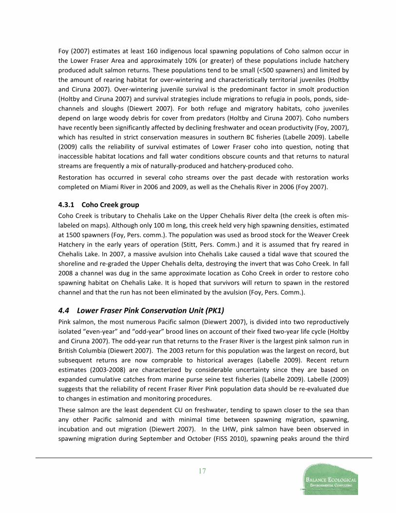
FIGURE 5. Pink salmon occurrences in the Lower Harrison Watershed, as described by Holtby and Ciruna (2007) and Provincial FISS databases. ............................................................................. 18
FIGURE 6. Sockeye occurrences in the Lower Harrison Watershed, as described by Holtby and Ciruna (2009) and Provincial FISS databases. The three sockeye Conservation Units are not differentiated in this image. ....................................................................................................... 21
LIST OF TABLES
TABLE 1. Steps and information sources in the development of the Harrison Habitat Status Report. .. 2
TABLE 2. Harrison Watershed Habitats for Oncorhynchus spp. Conservation Units. With Index Identification as per Holtby and Ciruna 2007. Sockeye (SK), Chinook (CH), Coho (CO), Chum (CH), Odd-‐Year Pink (PK)............................................................................................................... 9
TABLE 3. Water quality analysis in Chehalis River Watershed on July 24, 1998 (Foy, Pers. Correspondence). ....................................................................................................................... 26

1
1 Introduction Fisheries and Oceans Canada adopted the Wild Salmon Policy (WSP) for the conservation of wild Pacific Salmon in 2005, with the overall goal of restoring and maintaining healthy and diverse salmon populations and their habitats. Strategy 2 of WSP requires the assessment of habitats associated with salmon Conservation Units (CUs). A two-‐stage approach of habitat status indicators, metrics and benchmarks were identified in Stahlberg et al. (2009) to provide a standardized pool of indicators for long-‐term monitoring of the quantity and quality of key salmon habitats. “Pressure” indicators access information at a large-‐scale using primarily remote information such as road densities and riparian connectivity to inform regional decision-‐making. In CUs where pressure benchmarks have been exceeded, “state” indicators will provide detailed descriptions of the condition of specific salmon habitats.
The purpose of the Lower Harrison Watershed Habitat Status Report is to summarize the habitat conditions impacting salmon CUs in the Lower Harrison River Watershed (LHW), to select habitat indicators appropriate to the watershed and conservation units, and to identify existing reports to inform habitat status. For each CU, we identify important habitat in need of protection to maintain salmon productivity, identify risks and constraints that may adversely affect productivity, identify areas where habitat restoration or rehabilitation would be desirable to enhance productivity, select habitat indicators, identify and assemble existing data pertaining to those habitat indicators, and identify potential habitat restoration / enhancement projects. This information has been compiled into habitat status tables for discrete CUs within the LHW, which are appended to this document. These tables follow the WSP Strategy 2 Habitat Status Template.
The following document discusses the methods used to inform the habitat status document, provides an overview of the salmon habitat conditions in the Harrison Watershed, and identifies threats and data gaps: Chapter 2 describes the steps taken to identify and synthesize information; Chapter 3 provides an overview of the LHW; Chapter 4 identifies CUs present in the LHW, and identifies the high value habitats used by those species; Chapter 5 describes the high value habitats independently, and discusses the availability of habitat indicators for each. Chapter 6 provides a discussion of pressure and state indicators available or recommended to inform habitat status decisions regarding the LHW.
2 Methods This habitat status report for the Harrison River Watershed was conducted by way of the following steps, which are illustrated in Table 1. It should be noted that although the procedure is presented linearly, the actual process of assessing habitat status was more anachronistic, with steps 5-‐9 being revisited or occurring in parallel.

2
Table 1. Steps and information sources in the development of the Harrison Habitat Status Report.
Stage Purpose Sources of information/Description Identify geographic scope of LHW and main tributaries
• BC Integrated Land Management Bureau: GeoBC iMap (http://webmaps.gov.bc.ca/imfx/imf.jsp?site=imapbc)
• Fisheries Information Summary System (FISS 2010) Report Server for waterbody data (http://a100.gov.bc.ca/pub/fidq/main.do)
Identify Pacific salmon CUs in LHW and high value habitats
• Holtby and Ciruna 2007
Identify potential Habitat Indicators for habitat types
• Stalberg et al. 2009
Stage 1 Identify Geographic and Biological Scope of Work
Identify relevant CU life history strategies and respective habitat requirements
• Diewert 2007
Stage 2 Identify Habitat Information Sources – Part 1
Search federal and provincial online data and library catalogues
• Department of Fisheries and Oceans online library catalogue: WAVES (http://inter01.dfo-‐mpo.gc.ca/waves2/search.html?__LANG=en)
• BC Ministry of Environment: The Ecological Reports Catalogue (EcoCat) (http://a100.gov.bc.ca/pub/acat/public/welcome.do)
• DFO Pacific Regions Headquaters Library: 200-‐401 Burrard St., Vancouver, BC V6C 3S4
Stage 3 Information extraction and organization
Develop information management spreadsheet
• Create/populate spreadsheet to organize incoming information geographically.
• Chose and record bibliographic information of incoming information sources.
• Create/populate spreadsheet for limiting factors, productivity and restoration information.
Stage 4 Identify Habitat Information Sources – Part 2
Expanded data search Search for documents referenced by steps 1-‐5 sources and expand search to address specific indicators and habitats • Science/Academic-‐based search engines • Sector-‐based web searches • Community Mapping Network: Aquatic Information Partnership Atlas
(http://cmnbc.ca/atlas_gallery/aquatic-‐information-‐partnership-‐aip-‐under-‐construction)
Stage 5 Interviews (Concurrent with Stages 3/4/6)
Interviews • Identify regional and field staff in DFO / MOE / FVRD / FN. • Establish contacts / request interviews / request names of
knowledgeable staff / citizens. • Determine knowledge base / identify information transfer venue:
email, telephone, in-‐person. • Copy and return data / files. • Follow-‐up – pers. comm. confirmation / directed questions.

3
Stage Purpose Sources of information/Description Overview of sources and extraction of data
• Continue population of spreadsheets with data points addressing indicators, high value habitats, limiting factors, possible measures and recommendations.
• Transfer data to CU-‐specific habitat status report spreadsheets. • Firm list of high value habitats based on sources of information and
interviews Information transfer to report document
• Transfer CU-‐LHW-‐specific information to report. • Transfer habitat-‐specific information to report. • Construct maps.
Stage 6 Habitat Status Report Development
Habitat Indicator Confirmation
• Identify quantifiable data, conflicting data, uncompiled data and data gaps.
Finalize draft report • Complete background information, verify data/references. • Assemble appendices.
2.1 Identification of the Geographic and Biological Scope of Work The first step in identifying the geographic scope of the LHW was to reference the Province of British Columbia Integrated Land Management Bureau’s (ILMB) online mapping system iMap. We determined the extent of the LHW and identified its main tributaries, and produced a map of salmonid occurrences in the watershed.
Salmonid occurrences were sought from the Ministry of Environment’s Fisheries Information Summary System (FISS 2010) using the watershed code (110 -‐ Harrison) and a report was generated for each of the main tributaries containing Pacific salmon. These reports provided an initial understanding of salmonid distribution and high value habitats. Salmonid CUs present in the LHW geographic area were identified by Holtby and Ciruna’s 2007 document Conservation Units for Pacific Salmon under the Wild Salmon Policy. We created a summary habitat table identifying tributary habitat use by species, differentiating between WSP CU location lists (locations where the CUs are known to or are believed to have successfully reproduced; according to Holtby and Ciruna 2007) and FISS-‐reported occurrences.
The preliminary high value habitats were compared and combined to form a reference list for habitat indicator consideration. Potential habitat indicators were selected based on the habitat type (Stalberg et al. 2009); for example, estuary indicators were not included in this habitat assessment as the LHW does not include any estuarine features.
Pacific Salmon life histories and species-‐specific habitat requirements were identified using Diewert’s (2007) document Habitat Requirements for ten Pacific Salmon Life History Strategies. This document was referenced by Stalberg et al. (2009) as unpublished and was acquired from DFO. Population-‐specific life history data was extracted from FISS (2010) reports, Holtby and Ciruna (2007), and Foy (2007).

4
2.2 Identification of Habitat Information – Part 1 The first information sources sought were those referenced in LHW FISS reports. Searches for these and other salmon/LHW documents were conducted by way of the web-‐based government search engines listed in Table 1. Documents that had been identified by web-‐based searches but not available online were pursued at the DFO Pacific Region Headquarters Library in Vancouver and by contact with regional DFO and MOE staff. Recommended sources from Stahlberg et al.’s 2009 document entitled Stream Indicators – Provisional Metrics and Benchmarks were also accessed.
2.3 Extraction / Organization of Information Given the geographic scope of the work, and the presence of distinct conservation units in multiple sub-‐habitats, we organized information geographically. We developed an information-‐management spreadsheet with column headings for each potential habitat indicator and sub-‐columns for each useful information source. Each occupied tributary was assigned a row, and information bearing on the particular habitat indicator was transferred into the column under the information source. For example, information regarding water temperature in Big Silver Creek from Wilson 1999 was placed in the row “Big Silver”, under the column “Water Temperature”, sub-‐column Wilson 1999. Bibliographic information from documents, articles, reports and other sources of information (e.g. iMap) was recorded in reference management software. A similar spreadsheet regarding limiting factors, restoration measures and productivity measures was also created and annotated with reference information.
In this manner, each document was assessed for relevant information and the information placed into accessible, organized pockets. The process was repeated for each new source of information and, as such, occurred in parallel for the duration of the project until all accessed data was organized and synthesized. Often, useful sources of information were identified in the literature cited or bibliographies of accessed reports. These sources were sought out where possible; where the documents were not found they are referenced in this document as “Citation, YEAR in Citation, YEAR”.
2.4 Identification of Habitat Information – Part 2 Academic search engines were used to acquire journal articles regarding Pacific salmon runs and habitat studies in the Fraser and Harrison watersheds. Internet searches were also conducted to locate non-‐government or stakeholder information relating to Pacific salmon, Fraser River or the lower Harrison watershed. One notable source of information was the Community Mapping Network’s Aquatic Information Partnership Atlas, which at the time of writing was not fully functional. This atlas will contain the information synthesized by the BC Watershed Statistics Atlas, which was not available for this report. Sector-‐based and service provider/licensing searches, mineral development and water license queries for example, where also conducted as per the recommendations of Stalberg et al. (2009). Background information regarding ecological aspects of salmonids, salmon habitat, and of the LHW, and current population and climate trends, were also accessed and recorded.

5
2.5 Interviews Interviews were conducted with DFO staff, as well as staff from the Regional District, Municipalities, and knowledgeable locals. Interviews were requested through email, with an explanation of the purpose of the Habitat Status Report and a request for any applicable documentation that they may have in their possession. Many information managers were happy to provide electronic copies of reports and documents. Telephone conversations were used to discuss the availability of information and further direct questions regarding specific aspects of previous conversations or requests. In some cases, interviews were conducted in person where we were able to discuss the habitat with the aid of maps, and extract information from files. Some of these interviews resulted in boxes of uncompiled information in file-‐folders or data-‐binders, which were then reviewed and incorporated into the spreadsheets and final report. Personal communications are listed in detail in Appendix 1.
Unfortunately, although primary contact was made with several people, First Nations interviews were limited to one member of the Chehalis Indian Band. Knowledgeable members of the Chehalis, St’át’imc Xa’xtsa7 (Port Douglas), and Scowlitz bands should be consulted regarding their knowledge of historical changes in the watershed as well as current management concerns. In addition, local knowledge through conservation organizations, such as the Pacific Fisheries Resource Conservation Council, Nature Trust, the Heart of the Fraser, the B.C. Federation of Drift-‐Fishers, local Streamkeepers and Environmental Non-‐Government Organizations were not accessed due to time constraints.
2.6 Habitat Status Report Development CU Habitat Status Report spreadsheets (Appendix 2) were generated for each CU using information accumulated in the organizational spreadsheets. CU-‐specific high value habitat lists were compiled from Holtby and Ciruna (2007), FISS reports, and interviews. High value habitats and associated limiting factors for each CU were imputed into a discrete “High Value Habitats – Habitat Indicators” spreadsheet, which provides habitat indicator data referenced in the CU status spreadsheets. CU-‐specific life-‐stage habitat requirements were inserted into the spreadsheets as per information from Diewert (2007). Next, CU spreadsheets were populated with general and habitat-‐specific data pertaining to limiting factors, productivity and habitat restoration/protection.
Concurrently, a draft report was outlined and introductions and methods drafted. Conservation units were defined and summarized in the context of the LHW, and high value habitat information was transferred from the information spreadsheet to the report for assimilation. Through this process, habitat indicators with quantifiable data were parsed from habitat information that will inform choices for future data collection. Data that was sparse or conflicting is considered a data gap, but noted in the spreadsheet. Likewise, un-‐complied data or existing but inaccessible data that could not be timely synthesized (such as watershed road density) are also noted in the tables.

6
2.7 Methods Recommendations Accessing government reports and databases was time-‐intensive. Federal and Provincial databases are continuously evolving, improving and growing, and new data is being added continuously, even through the duration of this review. Although much information has been collected and compiled its presence is poorly known and data often inaccessible due to broken links and changing project administration. Several data sources identified in Stalberg et al. (2007) were inaccessible due to incomplete database development. Some data-‐collection and organization initiatives that were referenced in accessed reports had been re-‐named or the data re-‐routed into other organizations. Current web addresses to useful databases are listed in the Online References section of this document.
The B.C. Fisheries Information Summary System was well-‐organized, cross-‐referenced and very useful to the project. Federal and Provincial initiatives such as the British Columbia and Yukon Environmental Monitoring Networks Station Information Map Viewer (Environment Canada 2002), B.C. Integrated Land Management Bureau’s iMap (ILMB 2010a) and Land and Resource Data Warehouse (ILMB 2010b), GeoBase (2009a, 2009b) provided useful information. This data, however, is provided in GIS format, and future Statements of Work for Habitat Status Reports should specify that GIS components are required. GIS downloads were used in the development of this report, however detailed analysis was not possible within the allotted scope of work.
We chose to conduct interviews after having searched online engines and having completed external information source extraction. However, interviews, once begun, were a very efficient method for information-‐gathering. We recommend identifying and speaking with knowledgeable staff at the very beginning of the information-‐gathering process.
3 Lower Harrison Watershed Entering the Fraser River only 116 km from its mouth at the Georgia Strait, the Harrison River watershed is one of the largest, most accessible salmon spawning habitats on the South Coast. It contains all five salmonid species, counting 9 distinct CUs, and provides passage for anadromous fish to the productive Lillooet-‐Birkenhead drainages.
The Lower Harrison Watershed is the southernmost and downstream portion of the 8,324 km2 Harrison-‐Lillooet watershed. The drainage stretches 177 km from the Harrison-‐Fraser confluence to the head of the Lillooet River; it lies within the Coast Mountains, with a small portion on the Fraser Lowland near Harrison River’s confluence with the Fraser River. The Harrison Valley lies in a northwest-‐southeast orientation within the Coast Mountains. Harrison Lake, the centerpiece of the valley, is approximately 60 km long and 9 km across at its widest point.
Although this document reports only on habitat within the Lower Harrison Watershed, it is expected that Habitat Status Reports for the Lillooet-‐Birkenhead watershed will be completed during the implementation of WSP Strategy 2.

7
Figure 1. Location of the Lower Harrison Watershed within B.C. and the Fraser River Watershed.
Hydrologically, the LHW is split into two distinct regions: the Eastern Pacific Ranges and Southern Pacific Ranges Ecoregions (NHC 1994). The Pacific Ranges Ecoregion includes the Lillooet River drainage, which flows into the northern tip of Harrison Lake, and continues approximately halfway down Harrison Lake (NHC 1994). This region is characterized by low annual rainfall, compared to the downstream portion of the LHW, with most precipitation falling in the winter and held in storage over the winter. Melting snowpack and glaciers result in peak flows in May and June, and maintain reliable flows through the summer from Lillooet River into Harrison Lake. Monthly flows decline quickly after August, reaching a minimum in February under ice-‐cover; however, rainstorms in early fall and late winter also cause large flood events. Important salmon-‐bearing streams in the north portion of the LHW, including Douglas Creek, Tipella Creek, and Big Silver Creek, also follow this hydrograph (NHC 1994).
The lower portion of LHW exists in the Southern Fiord Ranges Ecoregion, which is characterized by high rainfall in the winter months with little precipitation stored in snow and ice. This results in large flows from October through February followed by low flows in the dry summer and fall months. Minimum discharge is typically in August. This hydrograph is followed by all of the important salmon-‐bearing streams in the southern portion of LHW, including Chehalis Creek, Weaver Creek, Trout Lake Creek and the Harrison River (NHC 1994). The southernmost portion of the Harrison River, near the mouth of the Fraser, is impacted in the early summer (June) by the Fraser River

8
freshet which backwaters up the Harrison River into Harrison Bay, the Chehalis estuary and Morris Lake.
Development and resource extraction interests continue to put pressure on the watershed, and the multiplicity of users and interest groups make the area vulnerable to conflict between stakeholders (Braacz 2006). The Fraser Valley Regional District is considering the development of a Harrison River Watershed Strategy, and Braacz (2006) prepared a preliminary review of stakeholders and key issues facing the watershed (Lilley, Pers. Comm.)
Heritage Values
The entire Harrison River watershed falls under traditional First Nations territory, some of it overlapping between nations. Stó:lõ Nation territory encompasses most of the Lower Harrison watershed, extending up beyond the north end of Harrison Lake (Braacz 2006). The Chehalis band, now independent of Stó:lõ Nation, is widely involved in fisheries and resource management on the Harrison River. St’át’imc territory encompasses much of the Lillooet-‐Birkenhead watershed, with the southern border overlapping some of the upper Stó:lõ Nation traditional territory (Braacz 2006). There are several FN heritage sites, including three below the high water line on the northeast side of Harrison Bay (Braacz 2006), a graveyard on the left bank of the Harrison River, and many spiritually significant outcrops on Harrison Lake (Charlie, Pers. Comm.).
Conservation
Conservation initiatives are increasing in the Harrison watershed: the Heart of the Fraser Initiative was launched to promote the protection of Fraser River floodplains from unchecked development and industry, and include the Harrison River in its scope (HOTF 2005). In Febuary 2010, the Harrsion River was designated Canada’s first “Salmon Stronghold”, which intends to strengthen efforts to drive focused collaborative conservation projects within the watershed (PFRCC 2010).
The Fraser River Bald Eagle Festival Committee spearheaded an initiative to designate a portion of the Harrison River and Chehalis fan designated as a Wildlife Management Area (WMA), to “conserve the ecological integrity of riverine habitats of the Harrison and Chehalis Rivers” (MOE 1997). The WMA would protect 1,400 ha of river and delta habitats along the Harrison and Chehalis rivers; the Nature Trust of B.C. owns two properties (purchased 1978 and 1999) located within the Chehalis River delta and totaling 200 ha, which will be included in the WMA. The Nature Trust also received a 22-‐ha portion of Harrison Knob in 2006. A trail along the east shore of the Chehalis River within the proposed WMA was established in 2009 as a result of a joint effort including the Chehalis Indian Band and the B.C. Federation of Drift Fishers.
Two B.C. provincial parks are within the LHA: Sasquatch Provincial Park on the east shore of Harrison Lake, extending up the Trout Lake Creek watershed, and Kilby Provincial Park, a small, 3-‐Ha riverside park adjacent to Harrison Bay. Braacz (2007) also references a report developed by the “Fraser Lowlands Working Group” that identified three areas for consideration for provincial parks in the Harrison-‐Chehalis watershed: the Harrison River Park Proposal, encompassing 364 ha in five separate areas fronting Harrison River and protecting a variety of river shorelines and upland forest habitat; the Harrison Knob proposal, encompassing 671 ha of mixed forest and upland habitat; and the Chehalis River Park Proposal, encompassing 329 ha including existing Ministry of Forests

9
recreation areas and an extension along the Chehalis River Canyon, protecting the canyon walls and rim and increasing management of existing campgrounds (FLPAS 1998 in Braacz 2006).
4 Salmonid Conservation Units Conservation units (CUs) were described by Hotby and Circuna (2007) using ecotypic, biological (life history) and genetic characterizations. The Harrison River Watershed provides spawning and/or rearing habitat for all five species of anadromous Pacific Salmon (Oncorhynchus spp.), forming nine CUs. These include three distinct Sockeye units, three Chinook units, and one unit each of Coho, Chum, and Pink. Table 2 lists the conservation units of Pacific salmon and their endemic locations within the Lower Harrison Watershed as defined by Holtby and Ciruna (2007). The table contains additional citations for locales not listed by Holtby and Ciruna but referenced in other sources of published data (FISS, Personal communications).
Species occurrence maps are included in each species section, and include data retrieved from the provincial FISS online database as well as locations referenced in Holtby and Ciruna (2009).
Table 2. Harrison Watershed Habitats for Oncorhynchus spp. Conservation Units. With Index Identification as per Holtby and Ciruna 2007. Sockeye (SK), Chinook (CH), Coho (CO), Chum (CH), Odd-Year Pink (PK). (•) denotes Holtby and Ciruna citation; (*) denotes FISS Report citation. Note that Conversation Units are not specified in FISS reports, therefore all SK and CH occurrences are shown in all CU columns. High value habitats addressed in this document are highlighted in bold.
Oncorhynchus spp. Conservation Unit SK CH CO CM PK
Habitat Name
Watershed Code
L-‐3-‐3 L-‐3-‐4 R03 3 4 6 2 2 1 Bateson Slough
110-‐068100 * * *
Big Silver Creek
110-‐599000 •* * * * * • * • * • * • *
Chehalis Lake 110-‐090200 * * * * Chehalis River
110-‐090200 * * • * * • * * • * • * • *
Cogburn Creek
110-‐535100 • * * * * * • * • * • *
Coho Creek 110-‐090200-‐66600 •* •
Connor Creek 110-‐149200-‐68600 * * * *
Davidson Creek
110-‐719300 * * *
Douglas Creek
110-‐987400 • * * * * * • * * •* •
Duncan Slough
110-‐071000 * * *
Elbow Creek 110-‐076200 *

10
Oncorhynchus spp. Conservation Unit SK CH CO CM PK
Habitat Name
Watershed Code
L-‐3-‐3 L-‐3-‐4 R03 3 4 6 2 2 1 Harrison Lake 110 * * * * * * * * *
Harrison River
110 * * •* •* * * •* •* •*
Hornet Creek 110-‐599000-‐08600
* * * *
Hotsprings Slough
110-‐232100-‐14200 *
Lake Errock 110-‐036900 * Little Harrison Lake
110 * * * * * * *
Maisal Creek 110-‐090200-‐42900 *
Miami Creek 110-‐232100 •* Morris Creek 110-‐149200 * * * * * * * * *
Morris Lake 110-‐149200 * Mystery Creek
110-‐581900 * * * * * * •* *
Pretty Creek 110-‐090200-‐05000 * *
Sakwi Creek 110-‐149200-‐85400-‐35600
* * * •* •*
Skwellepil Creek
110-‐090200-‐62400 *
Slollicum Creek
110-‐327700 * *
Squawkum Creek
110-‐036900 •* •* •
Tipella Creek 110-‐954600 •* * * * * * •* •* *
Tretheway Creek
110-‐881400 *
Trout Lake Creek
110-‐259000 •* * * •* •* •*
Twenty Mile Creek
110-‐588000 * * * •* •* *
Weaver Creek
110-‐149200-‐85400
* •* * * * •* •* •* •*

11
4.1 Chinook Conservation Units Chinook salmon populations have the most highly variable life histories, with the Fraser River chinook being the most ecologically and genetically diverse in Canada (Holtby and Ciruna 2007). Typically, chinook salmon spawn in large rivers or in their headwaters and most individual spawning populations in British Columbia are fewer than one thousand spawners (Diewert 2007). Three distinct CUs of chinook salmon use the Lower Harrison Watershed, differentiated in large part by timing of spawning migration and rearing duration in freshwater. The CUs present in the LHW are categorized as either immediate-‐type or stream-‐type chinook (Diewert 2007). Lower Fraser River Fall White Chinook are immediate-‐type Chinook, which do not rear in freshwater, migrating instead to the Fraser estuary upon emergence (Holtby and Ciruna 2007). Lower Fraser River (LFR) Spring (CH 4) and Lower Fraser River (LFR) Summer (CH6) are both stream-‐type chinook CUs, with an extended freshwater rearing phase that lasts from one to two years (Diewert 2007). Figure 2 maps known chinook occurrences for all CUs in the LHW.
Labelle (2009) indicates that some Fraser River chinook stocks have decreased to 1970s levels from 10-‐30 years of stable or improved escapements, but these trends reflect crude estimates due to a lack of long-‐term indicator stocks in the mid-‐upper Fraser River chinook populations. Fraser River chinook have been observed migrating early, along with other late summer/early fall Fraser salmon; it is not known what effect this has on the chinook populations (Labelle 2009).

12
Figure 2. Chinook occurrences in the Lower Harrison Watershed, as described by Holtby and Ciruna (2007) and Provincial FISS databases. The three chinook Conservation Units are not differentiated in this image.
4.1.1 Lower Fraser Fall White (CH 3) The Lower Fraser River (LFR) Fall White (CH3) is an immediate-‐type chinook (Holtby and Ciruna 2007) which spawns in Harrison River and migrates to the estuary soon after emergence (Diewert 2007). In the LHW, these chinook have short migrations to spawning grounds in Harrison River and delay their river entry until the first week of October (FISS 2010) when winter rains provide more favourable hydrologic conditions (NHC 1995). LFR Fall White chinook are native only to the Harrison

13
River below the lake, however hatchery and feral populations are distributed throughout the Lower Fraser River and tributaries (Holtby and Ciruna 2007). Foy also describes a small Harrison Lake – Lillooet run, estimated at less than 2000 spawners per year (Foy 2007). The Harrison River population is used as a source for chinook enhancement in Alouette, Capilano, Coquitlam, Chilliwack and Stave Rivers. Escapement trends of Fraser River summer run Chinook from 1975-‐2006 show substantial increases for the age 0.3 group compared to the age 1.2 group (which showed fluctuating escapement, with few large increases) indicating that the immediate-‐type life strategy may be more beneficial in the context of recent medium to long-‐term environmental changes (Labelle 2009).
These fall-‐run chinook with white flesh are unique, as the fry do not rear in the lake but in non-‐natal lower Fraser tributaries and Fraser estuary. Habitat conditions for this population within the Harrison River are considered relatively healthy (Foy 2007). Restoration of Harrison River side-‐channels is considered feasible and would recover a large amount of spawning habitat for this population, as the left and right banks of the Harrison River were damaged by navigation channel dredging in the mid-‐1960s (Foy 2007).
Habitat restoration projects along the lower Fraser River have improved rearing habitat available to Harrison River chinook fry, improving access to over 200 ha of freshwater tidal rearing habitat in Addington Marsh on the lower Pitt River and Colony Farm on the lower Coquitlam River (Foy 2007). Further restoration works at Colony Farm and Fraser River South Arm Marshes are planned (Foy 2007).
4.1.2 Lower Fraser Spring (CH 4) The Lower Fraser River Spring CU is determined by genetics, life history and timing. LFR Spring Chinook are stream-‐type chinook, rearing for one to two years in freshwater (Diewert 2007). Holtby and Ciruna (2009) describe 3 spanwing locations for this CU, of which 1 (33.3%) exists within the (Chehalis River). These chinook are distinguished from other LHW CUs by their distinct spring migration timing (Holtby and Ciruna 2007). Their spawning migrations are observed in early May (FISS 2010), likely coincident with high flows due to meltwaters in the upper Chehalis watershed (NHC 1994). Foy (2007) indicates that spawners from this population have not been recorded since the 1980s, however he further suggests that this may be due to the remoteness of the spawning habitat and that a small undetected population may exist, warranting further assessment. Labelle (2009) suggests that this CU is subject to relatively low exploitation rates and recent escapement decline is likely due to lower survival rates in fresh water and/or the marine environment.
4.1.3 Lower Fraser Summer Chinook (CH 6) The LFR Summer Chinook CU is the second stream-‐type chinook in the LHW, distinguished by its summer migration to the upper tributaries of the LHW (Holtby and Ciruna 2007). Holtby and Ciruna (2007) describe 10 locations for this CU, of which 4 (40%) exist within the LHW, as well as two populations that use LHW en route to the Lillooet Watershed. These chinook spawn and rear in the headwaters of the watershed, namely in Big Silver Creek, Cogburn Creek and Weaver Creek (Holtby

14
and Ciruna 2007). They are also known in Douglas Creek and Tipella Creek (Foy 2007) and are likely the CU observed at Mystery Creek (FISS 2010).
Marine and freshwater harvesting may impact this CU, but Labelle (2009) suggests that exploitation rates are low and recent stock declines may be related to decreased survival rates in fresh water and/or the marine environment. In the LHW, efforts have been undertaken in Big Silver Creek to improve chinook spawning and rearing habitat (Foy 2007).
4.2 Lower Fraser River Chum Conservation Unit (CM 2) Chum salmon are widely distributed and constitute the most abundant biomass of all the Pacific Salmon (Holtby and Ciruna 2007), and hence provide a wide-‐range of aquatic and terrestrial ecosystems in the Lower Fraser area with more marine-‐derived nutrients than any other Pacific salmon species (Foy 2007). Foy (2007) estimates at least 120 indigenous local popluations of Chum Salmon in the Lower Fraser area. They are said to be poor or reluctant jumpers, which is likely related to their occurrences in the lower reaches of rivers (Diewert 2007).
Holtby and Ciruna (2007) describe 81 locations for this CU, of which 12 (14.8%) exist within the LHW (Figure 3) and two populations use the LHW en route to the Lillooet watershed. FISS describes 17 locations for this species (Figure 3). Most of the Fraser chum production (>90%) comes from about 10 streams; the Harrison River produces a large portion of these due to an abundance of both natural spawning populations and hatchery-‐enhanced production (Labelle 2009). Chum are described in Coho Creek, above Chehalis Lake, by Holtby and Ciruna (2007) but are not shown to be present in either according to the FISS database -‐ it is unlikely that chum exist in Coho Creek as the canyon downstream of Chehalis Lake is a barrier to chum (Stitt, Pers. Comm.).
The life history of this chum CU involves 3 to 4-‐year old fish migrating from September-‐November and spawning as late as January (Diewert 2007). These late-‐spawn timing chum are found where groundwater affects spawning areas in larger river floodplains or where there are deep groundwater discharges. Chum smolts emerge in spring and migrate to estuary/nearshore zones of ocean immediately (Diewert 2007). Chum are known to spawn on the beach at Harrison Hot Springs as well as at Green Point on Harrison Lake in Sasquatch Provincial Park (Stitt, Pers. Comm.), a rare characteristic for this species (Foy 2007). Populations that spawn at Cogburn Creek, Big Silver Creek, Mystery Creek and Trout Lake Creek are populations of interest due to their rare behaviour of spawning above large lakes (Foy 2007). Foy notes that chum salmon are extirpated from a significant number of their endemic streams due to degraded or destroyed habitats and remnant populations in some streams are at risk of extirpation.
A 3-‐6 week early spawning migration has been observed for Fraser River chum coincident with that of late-‐run Fraser salmon; it is not known what effect this has on chum populations (Labelle 2009).

15
Figure 3. Chum salmon occurrences in the Lower Harrison Watershed, as described by Holtby and Ciruna (2007) and provincial FISS databases.
4.3 Lower Fraser Coho Conservation Unit (CO 2) Coho are the most widespread salmon in the Harrison watershed, using most (possibly all) of the spawning habitats used by other salmonid species. The Lower Fraser River Coho CU was determined by genetics and habitat. Holtby and Ciruna (2007) describe 77 locations for this CU, of which 13 (16.9%) exist within the LHW; FISS indicates 28 coho streams in the LHW (Figure 4). These coastal coho are thought to be more opportunistic, straying from their natal streams to spawn in other

16
(non-‐natal) locations more often than other Pacific Salmon species (Holtby and Ciruna 2007). As such, their spawning habitat is very diverse ranging from large river or lake systems to small headwater streams and drainage ditches (Diewert 2007). Coho in the LHW have been observed migrating in late fall and spawning from late fall to mid-‐winter (FISS 2010). These spawners are typically three years old, having spent two years in the ocean and a year rearing in freshwater (Diewert 2007).
Figure 4. Coho salmon occurrences in the Lower Harrison Watershed, as described by Holtby and Ciruna (2009) and Provincial FISS databases.
17
Foy (2007) estimates at least 160 indigenous local spawning populations of Coho salmon occur in the Lower Fraser Area and approximately 10% (or greater) of these populations include hatchery produced adult salmon returns. These populations tend to be small (<500 spawners) and limited by the amount of rearing habitat for over-‐wintering and characteristically territorial juveniles (Holtby and Ciruna 2007). Over-‐wintering juvenile survival is the predominant factor in smolt production (Holtby and Ciruna 2007) and survival strategies include migrations to refugia in pools, ponds, side-‐channels and sloughs (Diewert 2007). For both refuge and migratory habitats, coho juveniles depend on large woody debris for cover from predators (Holtby and Ciruna 2007). Coho numbers have recently been significantly affected by declining freshwater and ocean productivity (Foy, 2007), which has resulted in strict conservation measures in southern BC fisheries (Labelle 2009). Labelle (2009) calls the reliability of survival estimates of Lower Fraser coho into question, noting that inaccessible habitat locations and fall water conditions obscure counts and that returns to natural streams are frequently a mix of naturally-‐produced and hatchery-‐produced coho.
Restoration has occurred in several coho streams over the past decade with restoration works completed on Miami River in 2006 and 2009, as well as the Chehalis River in 2006 (Foy 2007).
4.3.1 Coho Creek group Coho Creek is tributary to Chehalis Lake on the Upper Chehalis River delta (the creek is often mis-‐labeled on maps). Although only 100 m long, this creek held very high spawning densities, estimated at 1500 spawners (Foy, Pers. comm.). The population was used as brood stock for the Weaver Creek Hatchery in the early years of operation (Stitt, Pers. Comm.) and it is assumed that fry reared in Chehalis Lake. In 2007, a massive avulsion into Chehalis Lake caused a tidal wave that scoured the shoreline and re-‐graded the Upper Chehalis delta, destroying the invert that was Coho Creek. In fall 2008 a channel was dug in the same approximate location as Coho Creek in order to restore coho spawning habitat on Chehalis Lake. It is hoped that survivors will return to spawn in the restored channel and that the run has not been eliminated by the avulsion (Foy, Pers. Comm.).
4.4 Lower Fraser Pink Conservation Unit (PK1) Pink salmon, the most numerous Pacific salmon (Diewert 2007), is divided into two reproductively isolated “even-‐year” and “odd-‐year” brood lines on account of their fixed two-‐year life cycle (Holtby and Ciruna 2007). The odd-‐year run that returns to the Fraser River is the largest pink salmon run in British Columbia (Diewert 2007). The 2003 return for this population was the largest on record, but subsequent returns are now comprable to historical averages (Labelle 2009). Recent return estimates (2003-‐2008) are characterized by considerable uncertainty since they are based on expanded cumulative catches from marine purse seine test fisheries (Labelle 2009). Labelle (2009) suggests that the reliability of recent Fraser River Pink population data should be re-‐evaluated due to changes in estimation and monitoring procedures.
These salmon are the least dependent CU on freshwater, tending to spawn closer to the sea than any other Pacific salmonid and with minimal time between spawning migration, spawning, incubation and out migration (Diewert 2007). In the LHW, pink salmon have been observed in spawning migration during September and October (FISS 2010), spawning peaks around the third
18
week of October (Holtby and Ciruna 2007). Water temperatures affect incubation duration, with lower the water temperature increasing the duration of incubation until emergence, upon which the fry migrate immediately to the ocean (Diwert, 2007).
Figure 5. Pink salmon occurrences in the Lower Harrison Watershed, as described by Holtby and Ciruna (2007) and Provincial FISS databases.
Although the Fraser River 1 CU is ecotypically disparate, this odd-‐year Pink CU is genetically homogenous with no significant spawning timing differences (Holtby and Ciruna 2007). Of 59 database locations identified by Holtby and Ciruna (2007), 5 (8.5%) locations exist in the Lower

19
Harrison watershed, and two more pass through this watershed into the Lillooet watershed (Figure 5). Foy (2007) estimates at least 57 indigenous local spawning populations of odd-‐year pink salmon occur in the Lower Fraser Area with many populations at low levels of abundance, particularly those populations in small streams affected by mixed stock commercial fisheries. Foy (2007) further notes that stock management efforts to re-‐establish pink populations in historic habitats through transplant and enhancement programs have been successful for nine pink salmon populations within the Lower Mainland (Foy 2007).
A 3-‐6 week early spawning migration has been observed for Fraser River pink coincident with that of late-‐run Fraser River sockeye; it is not known what effect this has on pink populations (Labelle 2009).
4.5 Sockeye Conservation Units Sockeye salmon have three distinct life history types: anadromous lake-‐type, anadramous river-‐type, and a freshwater obligate (Holtby and Ciruna 2007). Lake-‐type salmon require a nursery lake for freshwater rearing of juveniles, whereas the fry of river-‐type sockeye migrate immediately to estuaries (Diewert 2007). Most sockeye spawn as four year olds, after either several months rearing in nearshore/estuary zones or a full year in nursery lakes, followed by two or three years in the ocean (Diewert 2007). Run-‐timing and spawn-‐timing are key in differentiating sockeye populations, as Holtby and Ciruna (2007) noted that when compared within the same ecotype, river-‐type sockeye spawn later than their lake-‐type counterparts.
Foy (2007) estimates there are twenty-‐seven populations of lake-‐type salmon rearing in six nursery lakes (Lillooet, Harrison, Cultus, Kawakawa, Chilliwack and Pitt) in the Lower Fraser Area. The sockeye populations that spawn in the LHW are among 52 sockeye stocks characterized as “ late-‐run” Fraser River sockeye populations, owning to their late summer/early fall spawning migrations (Labelle 2009). The 99 other Fraser River sockeye spawning populations are described as either early Stuart runs or summer runs (Labelle 2009).
Three sockeye CUs are defined in the LHW for a portion of their life cycle: two lake-‐type and one a river-‐type (Holtby and Ciruna 2007). FISS reports sockeye occurrences in fourteen streams plus observations in Harrison Lake, Chehalis Lake and Little Harrison Lake. Holtby and Ciruna (2007) categorized outlet and inlet spawners into two separate lake-‐type sockeye CUs: one spawning in Weaver Creek (L-‐3-‐4) and the other CU using the upper tributaries as natal grounds (L-‐3-‐3). River-‐type sockeye (R03) spawn in Harrison River and migrate directly to the Fraser estuary upon emergence from the gravels. A historic sockeye population in Chehalis Lake was thought to have become extinct around 1912, since post-‐contact settlement (Foy, 2007). In 1985 however, FISS reports indicated sockeye were observed spawning and rearing in Chehalis Lake and a further, small group of sockeye where caught in a gill net in 1997 during a BC Fisheries survey (FISS 2010) and again in 2001 (FISS 2010).
The Fraser River lake-‐type sockeye runs is one of the largest lake-‐type runs in British Columbia (Diewert 2007). Historically, late-‐run sockeye held for 3-‐6 weeks near the mouth of the Fraser River before moving upstream; however, beginning in 1994, this holding period decreased by 2-‐6 weeks

20
in all years (Mathes et al. 2009); averaging ≤5 days in all years since 2000 except 2002 (22 days) (Labelle 2009). Late-‐run sockeye stocks of 2000 and 2001 migrated 4-‐6 weeks earlier than normal (Labelle 2009). Monitoring activities indicate that migration mortality has increased since the mid-‐1990s from under 20% to over 60%, with 90% mortality occurring in some years (Mathes et al. 2009). This early migration of late-‐run Fraser River Sockeye is occurring as the Fraser River is experiencing a >1.8°C increase in average peak summer water temperatures (over the past 40 years), with eight of the past 10 summers being the warmest on record (Mathes et al. 2009). These early-‐migrating, late-‐run sockeye are therefore now exposed to warmer water temperatures than historically encountered for considerably longer durations, as early migrations and environmental changes have not been met with changes in spawning times (Mathes et al. 2009). Investigations show the impact of this extended period of fresh water residency on early timing, late-‐run Fraser sockeye populations, such that these salmon suffer increases (since 1995) in both en-‐route mortality during spawning migrations and pre-‐spawning mortality, where females die on the spawning grounds with their eggs intact (Labelle 2009). Recent escapement estimates reflect these effects on Sockeye populations; for example the 2007 Fraser River Sockeye returns were the lowest on the cycle since 1947 and only 28% of the average return on the cycle since 1955 (Labelle 2009). Similarly, spawning success has also declined with the 2004 cycle return year showing the lowest spawning success in fifty years in 2008 (65%) for all stocks combined (Labelle 2009).
In 2009, the total return of Fraser River sockeye was the lowest in over 50 years. This was only a small fraction of the number expected. A “Think-‐Tank” of Scientists has been established to discuss the possible causes of the unexpectedly low numbers. This population collapse impacted the LHW’s lake-‐type sockeye. It should be noted that, despite the collapse, the Harrison River stream-‐type sockeye was the only population to not only remain stable but increase in size. In a 2009 statement, the Think-‐Tank suggests that the problem of reduced productivity occurred after the juvenile fish began their migration toward the sea (Reynolds and Wood 2009).
4.5.1 Lake-‐type Harrison Downstream Lower Fraser (SK L-‐3-‐3) This lake-‐type sockeye CU is so named due to the downstream migration of juveniles from the upper tributaries of the LHW into their nursery grounds in Harrison Lake (Holtby and Ciruna 2007). Natal streams in the LHW for this CU are listed as Big Silver Creek, Cogburn Creek, Douglas Creek, Tipella Creek and Trout Lake Creek (Holtby and Ciruna 2007). Spawning migration has typically been observed during August and September (FISS 2010). According to survey data from 1977-‐2007, this stock is relatively small with increasing production over the past 10 years (Labelle 2009).
4.5.2 Lake-‐type Upstream Lower Fraser (SK L-‐3-‐4) This CU is identified by its upstream migration. In the LHW, the juveniles of the L-‐3-‐4 CU swim downstream from their natal grounds in Weaver Creek / Weaver Creek spawning tributaries and channels to the Harrison River then to rearing grounds in Harrison Lake. Spawning migrations have historically been observed in late September (Mathes et al. 2009) with spawning beginning in early October (FISS, Mathes et al. 2009). Peak spawning in the Weaver Creek system occurs in the third

21
week of October but rarely before then due to low water levels in Weaver Creek, Morris Lake and Morris Slough (Mates et al. 2009).
Weaver Creek / Weaver Channel populations have experienced rapid declines in the last decade. It is suspected that this is due to effects of the Parvicapsula minibicornis parasite (Foy 2007) and increasing late-‐run mortality (Labelle 2009).
Figure 6. Sockeye occurrences in the Lower Harrison Watershed, as described by Holtby and Ciruna (2009) and Provincial FISS databases. The three sockeye Conservation Units are not differentiated in this image.

22
4.5.3 River-‐type Lower Fraser (R03) This CU is genetically distinguished from other Fraser River river-‐type sockeye (Holtby and Ciruna 2007). Holtby and Ciruna (2007) identify six locations for this CU with two, the Chehalis and Harrison Rivers, occurring in the LHW. The river-‐type sockeye of the LHW have been observed migrating to natal grounds in the Harrison River rapids area during early October (FISS 2010) and spawn around the third week of February (Holtby and Ciruna 2007). Recent studies show the Harrison-‐Chehalis Sockeye, unlike other late-‐run Fraser River Sockeye populations, have had unprecedented, large escapements in recent years (Labelle 2009). It is not known if this is related to the immediate downstream migration of the fry to rear in the Fraser River estuary (Labelle 2009). This population is the only Fraser sockeye stock that increased in number during the 2009 sockeye collapse.
Habitat conditions for this population are thought to be relatively healthy. Potential restoration of Harrison River left and right bank side channels damaged by navigation channel dredging are considered options for future restoration efforts (Foy 2007). Reduced winter flows prevent entry to important side-‐channel spawning habitats which could also be seriously impacted by low water levels caused by dredging of gravel at Harrison Rapids or by the use of Harrison Lake as a regional water supply (Foy 2007).
5 High Value Habitats High value habitats were identified as locations considered by Holtby and Ciruna (2007) and are shown in Figures 2-‐6. Each of these habitats is discussed below. Each section identifies the salmon species / CUs present in the habitat, provides a brief physical description of the drainage and salmon use within the drainage, as well as completed and proposed restoration projects. Data related to pressure and state indicators relevant to the watershed are provided where data has been compiled, or referred to where the data exists but is not compiled.
Tributaries are listed alphabetically, except where the habitat is within a previously-‐identified drainage; for example, Sakwi Creek is listed in Section 5.6 under Morris Creek.
5.1 Big Silver Creek CUs in Big Silver River, as described by Holtby and Ciruna (2007), are SK L-‐3-‐3, CH6, CO2, CM2 and PK1.
Big Silver Creek is located 35 km north of the Village of Harrison Hot Springs, on the east side of Harrison Lake. It drains an area of 495 km2 (NHC 1994), originating in the Lillooet Range of the Coast Mountains. Total length of the mainstem from headwaters to mouth is approximately 40 km. The lower 15 km of the mainstem is stable and contains a single major side-‐channel where the river splits approximately 2 km from its mouth on Harrison Lake (WRP 2000). The main tributaries of Big Silver Creek are Clear Creek and Hornet Creek; both have been heavily impacted by historic logging and Hornet Creek is still relatively unstable (WRP 2000).
The west (right) branch provides excellent spawning habitat whereas the east (left) branch contains mostly large rock (NHC 1995). A large boulder in the centre of the stream upstream of the fork forces high-‐flows around the rock, and acts a barrier to many fish (Stitt, Charlie, Foy, Pers. Comm.).

23
Spawning is limited to the lower 6 km of Big Silver due to a waterfall obstruction, although rainbow trout and possibly steelhead utilize canyon habitat from km 6 – 15. Chinook and coho are scattered throughout system downstream of the falls; chum spawning is concentrated in the upper 1.2 km of the west channel; coho spawning is concentrated in the top 2 km of the system before the falls and in the lower section of Hornet Creek (FISS 2010). There is limited sockeye rearing up to the falls. Habitat limitations in Big Silver are lack of off-‐channel habitats, nutrient limitations, and a lack of large woody debris (WRP 2000). Historic logging and road building has increased erosion, siltation and bedload movement, causing a chronic siltation and aggradation problem in the lower reaches (FISS 2010).
Restoration Works Completed
A Fisheries Research and Development fertilization experiment was conducted in Big Silver Creek watershed from 1991 – 1997, in which the mainstem was fertilized using liquid ammonium polyphosphate fertilizer during the summers of 1994-‐97. Physical, chemical and biological components were monitored throughout the project, and the fertilization was shown to stimulate growth at all trophic levels (Wilson et al. 1999). Fertilization continued in 1999, but was discontinued in 2000 (WRP 2000).
Major habitat restoration works took place at Big Silver Creek in 1991. Natural aggradation of the channel had caused flows to dewater the west branch, which had been a major spawning channel for all five salmonid species. The fork in Big Silver was re-‐graded and fortified to return flows to the west (right) branch of the stream to maximize spawning habitat potential and has been successful in maintaining flows since that time (Foy 2007).
Pressure Indicators:
Land cover alterations: The lower slopes of the watershed have been logged intensively over the last 40 years, but secondary growth is well-‐established (Nener and Warwick 1997): 24% of the total watershed has been logged, including 15% from recent or proposed harvesting. DFO has had concerns regarding continued logging in this area (FRAP 1999).
Watershed road development: Road density statistics are not available for this watershed.
Water extraction: Two water licenses for power generation have been granted to Cloudworks Energy Inc. totaling 3192.7 cfs (MOE Water Users’ Community Query – Licensees 2010).
Riparian disturbance: Significant disturbance due to historic logging. We were not able to identify data specific to riparian disturbance.
Permitted waste management discharge: None.
State Indicators:
Suspended sediment: Channel destabilization and sedimentation from historic logging is an identified limitation in Big Silver Creek (FRAP 1999). Field notes from the 1950s to 1970s indicate heavy silting over 10-‐ 90% of spawning grounds.
Water Quality: Baseline water quality data was collected in the summer of 1993 before the Big Silver Creek Fertilization experiment, and were reported in Wilson et al. 1999. Water transparency was measured in Big Silver Creek during 1993-‐1994 using a secchi disk. Transparency was usually

24
above 2 m in July and August, and often above 4 m (Wilson et al. 1999). Pre-‐fertilization nitrate + nitrite concentrations averaged 38 – 46 µg/L in all three reaches from June to August, and increased sharply in September when water levels dropped to 88 – 91 µg/L. This stream is considered oligotrophic. Soluble reactive phosphorous (SRP) and total dissolved phosphorous (TDP) were at or below the 1 µg/L and 3 µg/L (respectively) detection limits in Big Silver, Clear Creek and Hornet Creek. Elevated levels were measured throughout the nutrient enrichment experiment, but were attributed to chronic contamination issues (Wilson et al. 1999).
Water Temperature: Wilson et al. (1999) measured water temperatures at multiple locations in Big Silver River from June – September from 1993-‐1997, and this data should be available for comparison to future monitoring data. Temperatures ranged between 7-‐17°C, with peak temperatures in August. The average growing-‐season temperatures of Big Silver Creek and its tributaries were over the 10°C temperature required by rearing salmonids (Wilson et al. 1999).
Discharge: The estimated mean annual flow of Big Silver Creek is 15.0 m3/s (NHC 1994) and the naturalized summer 7-‐day mean low flow is 33% of the mean annual flow (FRAP 1999). There is no historic or current data from hydrometric stations in this watershed.
5.2 Chehalis River CUs in Chehalis River, as described by Holtby and Ciruna (2007), are SK R03, CH4, CO2, CM2, and PK1. Steelhead are also present in this river, and spawn in restored habitats below the outlet from Chehalis Lake (Stitt, Pers. Comm). A historic run of red-‐fleshed chinook were known in the lower reaches of Chehalis River as late as the 1980s (Foy 2007).
The Upper Chehalis River drains the Upper Chehalis Lake, which is inaccessible to anadromous fish due to cascades, log jams, and a 9 m waterfall 6 km above Chehalis Lake. The lower reaches of the Upper Chehalis do provide some spawning habitat for coho and steelhead, and Coho Creek provided high-‐density spawning habitat for coho on the alluvial floodplain into Chehalis Lake (see S. 5.2.2). Below Chehalis Lake is approximately 2 km of spawning habitat, heavily used by steelhead. Downstream of these spawning gravels, Chehalis Canyon is a barrier to chum, chinook and pink salmon and is prone to channel-‐spanning log jams. One such jam was removed in the 1980s and removed before Chehalis River coho populations were lost (Foy 2007). A log-‐boom on Chehalis Lake is used to reduce jamming in the canyon below; log jams are regularly removed approximately 0.5 km downstream from Chehalis Lake.
Chehalis River flows out of the canyon onto its alluvial fan, just upstream of the Morris Valley Road bridge-‐crossing. The fan is wide, gradients are low and the river is currently eroding towards the east bank. The Chehalis River has a history of lateral and vertical instability resulting in abrupt channel changes and avulsions on its fan (NHC 1994). The Chehalis First Nation Reserve is on the banks of the Chehalis, and a new berm has been built to protect the reserve from river avulsions and to replace a dike built in 1968 that was heavily damaged during a 1978 flood (Foy, Pers. Comm.). Aggradation will continue on the Chehalis fan, and will continue to need management to prevent flooding (Foy, Pers. Comm.). Restoration of the historic sloughs east of the Chehalis Reserve would improve spawning and rearing habitat in the absence of the natural processes caused by the
25
now restricted movement of the Chehalis River across its fan (Foy, Pers. Comm.). The right bank of the river near Chehalis hatchery is protected by a rock revetment (Foy, Pers. Comm.).
The Chehalis fan is the only significant aquifer within the LHW (Atwater et al. 1994 in NHC 1994), and is recharged from the Chehalis River. Shallow high-‐production wells provide water to the Chehalis River Hatchery and, as a result, reduce flows in the Chehalis River (Foy, Pers. Comm.).
Restoration and Enhancement Completed
The Chehalis River Salmon and Trout Enhancement Facility was built in 1982 and is operated by DFO to produce coho salmon, chinook salmon, chum salmon, pink salmon, steelhead trout, and sea-‐run cutthroat trout (Stitt, Pers. Comm.). Spawning gravel was placed at the outlet from Chehalis Lake to create spawning habitat for coho and steelhead in 1976. Rearing ponds were created and enhanced in the mid 1980’s to compensate for impacts resulting from the expansion of Morris Valley Road (FRAP 1999 – location unclear). A second spawning gravel placement was completed at the Chehalis Lake outlet in 1996, and was complemented by large woody debris placement in 1998 through the Watershed Restoration Program (WRP 1999). In 1997, 30,000 m2 of rearing habitat, including 500m2 of spawning area was created at Kahl Creek, downstream of the Chehalis Hatchery, for coho, steelhead and cutthroat trout (Foy et al. 1997). In addition, a 480 m-‐long off-‐channel spawning, rearing and refuge habitat was created alongside the Statlu tributary to the Chehalis, at 9.5 Mile on the Chehalis Forest Service Road, which increased available spawning habitat from just 20 m in the main channel (WRP 1999).
Restoration and Enhancement Proposed
In 1997, proposals submitted to the Watershed Restoration Project in the Chehalis Watershed included: Stream Classification and Ground water Assessment of Upper Chehalis River Tributaries, Statlu River Waterfall Obstruction Removal Assessment, Coho Creek off-‐channel pool assessment, Pretty Creek Diversion Assessment, and Chehalis River Watershed Stream Classification Assessment). In addition, a proposal to increase chum and coho productivity of Chehalis River fan sloughs was provided by J.O. Thomas and Associates Ltd. in 2000 to DFO; this proposal involved removing in-‐streamth silt accumulations and developing pool / cover habitat units in the Harrison River side-‐channels (originally formed by movement of the Chehalis River across the fan). These proposals were identified in Foy’s files, however it is not clear whether these proposals were accepted and funded; final reports regarding these projects were not found.
Pressure Indicators:
Land cover alterations: A detailed breakdown of land-‐use in the Chehalis watershed is provided in Table 4 (Environment Canada, 2002). The upper reaches of the Chehalis River have been heavily impacted by logging; the lower reaches of the Chehalis River are impacted by urban development, flood control, and forestry (FRAP 1999). Portions of the watershed are in transition from forest to rural residential lots and there is residential development on the Chehalis Reserve (FRAP 1999). A 1995 review of forest harvesting in the Harrison watershed found that the Chehalis watershed was heavily impacted by logging, assessed by determining the area of historic, recent and planned forest harvest as a percentage of the total basin area (McLennan and Recknell 1999). In 1994, 32% of the watershed had been logged and another 9% was proposed. Of particular concern was Statlu Creek,

26
with 40% of the watershed logged and another 12% proposed (NHC 1994). A 1997 review of the watershed found that only 30% remained in mature or old-‐growth forest (Scott 1996 in McLennan and Recknell 1999), and the watershed then became a priority for the Watershed Restoration Program.
Watershed road development: Road density statistics are not available for this watershed.
Water extraction: Fisheries and Oceans Canada extracts water from the Chehalis River, with an allowable limit of 65 cfs for the Chehalis Fish Hatchery. Surface water is also removed from the Chehalis River approximately 1 km upstream of the hatchery, designed to provide at least 100 litres per minute (LPM) to the facility. Normal operating supply is 30-‐40 LPM, but is reduced to 25 LPM during high turbidity events. Chehalis First Nation extract up to 10 000 gallons/day for residential use (MOE Water Users’ Community Query – Licensees 2010). The potential August and September water demand for industrial use is less than 1% of the naturalized summer 7-‐day mean low flow (NHC 1994).
Riparian disturbance: Logging and flood control are the main causes of riparian disturbance in this drainage. Total riparian disturbance has not been calculated for this watershed. McLennan and Recknell (1999) developed a riparian status summary for selected sub-‐drainages of the Chehalis watershed, as well as a riparian restoration plan. They found that 60% of the riparian vegetation in the selected sub-‐drainages had been harvested, of which 32% were significantly hydrologically impaired and another 28% were moderately impaired. McLennan and Recknell (1999) recommended that riparian restoration prescriptions be developed for three sites within the Chehalis watershed: one in the Upper Chehalis River, one on the Chehalis fan, and a third in the Statlu River Spotted Owl Special Management Zone. We were not able to find any reports regarding the completion of these proposed projects.
Permitted waste management discharge: Discharge Creek (a tributary to Maisal) receives sewage discharges from the Hemlock Valley Ski Area (FRAP 1999).
State Indicators:
Suspended sediment: Unknown. Sediment loads are high due to a combination of road-‐dirt from the Morris Valley Road bridge, which services logging traffic, as well as extensive logging in the watershed and land clearing for recreational trails and MOF campsites along the river. There is also significant sedimentation and pool infilling occur for the entire length Maisal Creek due to forest harvest and boulder slides on the left bank (FISS 2010).
Water Quality: Chehalis river water is very oligotrophic (Stitt, Pers. Comm). Water quality analysis conducted in July 1998 found water throughout the Chehalis watershed to be very low in nutrient values (Table 3), suggesting low potential ecological productivity.
Table 3. Water quality analysis in Chehalis River Watershed on July 24, 1998 (Foy, Pers. Correspondence).
Site Name NO2+NO3 (mg/L)
o-PO4 mg/L
SpCond (µS/cm)
pH
Upper Chehalis 0.064 < 0.001 8.0 6.79 Coho Creek 0.103 < 0.001 25.0 6.56

27
Site Name NO2+NO3 (mg/L)
o-PO4 mg/L
SpCond (µS/cm)
pH
Chehalis Lake outlet 0.076 < 0.001 11.0 7.38 Maisal Creek 0.048 < 0.001 43.0 7.57 Chehalis River – mid main 0.076 < 0.001 12.0 6.97 Statlu Creek 0.139 < 0.001 18.0 7.15 Chehalis River – above hatchery
0.090 < 0.001 18.0 7.52
Water Temperature: Daily temperature records are available in data binders at the Chehalis Fish Hatchery, but are not compiled. This is an easy source of state indicator data that should be accessed to inform the Chehalis watershed habitat status.
Discharge: Environment Canada Hydrometric Station #08MG001 measures flows at the Chehalis River near Harrison Mills, with daily flow readings from 1911 to present (Table 4). The mean annual flow of the Chehalis River is 37.7 m3/s (EC web), with maximum and minimum discharge at 660 m3/s and 3.02 m3/s respectively. The Chehalis fan has low flow issues, and DFO regularly removes gravel from Chehalis River to maintain a channel leading to their hatchery. During low flows, much of the discharge moves through the thick gravel on the channel bed and gravel removal is required to maintain flow (FRAP 1999). FRAP (1999) reports that high flows occur in December, however IEC (1980) determined that while low summer flows are more common than low winter flows, low winter flows are more extreme, therefore over the long-‐term, the lowest flows occur in the winter months (IEC 1980). The naturalized summer 7-‐day mean low flow is 14% of the mean annual flow (Nener and Warwick 1997).

28
Table 4. Summary statistics and land use data for Environment Canada Hydrometric Stations and related data, accessed through the British Columbia and Yukon Environmental Monitoring Networks (Environment Canada 2002). *Station 08MG022 measured water level, not m3/s.
Station 08MG001 08MG023 08MG009 08MG012 08MG013 08MG022 Description CHEHALIS
RIVER NEAR HARRISON MILLS)
CHEHALIS RIVER BELOW STATLU CREEK
WEAVER CREEK NEAR HARRISON HOT SPRINGS
HARRISON LAKE NEAR HARRISON HOT SPRINGS
HARRISON RIVER NEAR HARRISON HOT SPRINGS
HARRISON RIVER BELOW MORRIS CREEK *water level
Dates 1/1/1911-present
1/1/1981-12/31/1983
1/1/1945-12/31/1964
1/1/1933-present
1/1/1923-present
1973-present
Basin Area (Km2) 383 357 42.2 134 7870 7950 Max Discharge (m3/s) 660 469 134 1930 12 m* Min Discharge (m3/s) 3.02 5.49 0.063 67.1 8.16 m* Mean Discharge (m3/s) 37.7 41 2.73 445 9.33 m*
% Area % Area % Area % Area % Area % Area Agriculture Landuse based agriculture
activities undifferentiated as to crop (ie. land is used as the producing medium)
0.61 0.60 0.60
Alpine Areas virtually devoid of trees at high elevations
9.71 25.31 25.28 25.03
Barren Surfaces
Rock barrens, badlands, sand and gravel flats, dunes and beaches where unvegetated surfaces predominate.
0.10 1.01 1.01 1.00
Fresh Water Fresh water bodies (lakes, reservoirs and wide portions of major rivers).
1.72 3.87 3.88 3.90
Glaciers and Snow
Glaciers and permanent snow. Depending on the date of imagery, ephemeral snow may be included in this class.
0.20 8.25 8.25 8.16
Mining Land used now (or in the past and remains unreclaimed) for the surface extraction of minerals or quarry materials.
0.00 0.00
Old Forest Forest greater than or equal to 140 years old and greater than 6 meters in height. Areas defined as Recently Logged and Selectively Logged land uses are excluded from this class.
35.38 31.37 31.34 31.09
Rangelands Unimproved pasture and grasslands based on cover rather than use. Cover includes drought tolerant grasses, sedges, scattered shrubs to 6 meters in height and less than 35% forest cover. Sparse forest stands are included with their understorey of drought tolerant shrubs and herbs.
0.03 0.03 0.03
Recently Burned
Areas virtually devoid of trees due to fire within the past 20 years. Forest less than or equal to 15% cover.
0.29 0.29 0.29

29
Station 08MG001 08MG023 08MG009 08MG012 08MG013 08MG022 Description CHEHALIS
RIVER NEAR HARRISON MILLS)
CHEHALIS RIVER BELOW STATLU CREEK
WEAVER CREEK NEAR HARRISON HOT SPRINGS
HARRISON LAKE NEAR HARRISON HOT SPRINGS
HARRISON RIVER NEAR HARRISON HOT SPRINGS
HARRISON RIVER BELOW MORRIS CREEK *water level
Recently Logged
Timber harvesting within the past 20 years, or older if tree cover is less than 40% and under 6 meters in height.
16.47 6.14 6.13 6.10
Recreation Land used for private or public outdoor recreational purposes. Ski resorts and golf courses are included. This class does not include recreational areas within built-up portions of cities, towns and villages, which are mapped as urban areas. This class includes waterfront cottage areas if they are at least 200 meters wide.
0.02 0.12 0.12 0.16
Residential / Agricultural Mix
Areas where agriculture activities are intermixed with residential and other buildings with a building density of between 2 to 0.2 per hectare.
0.04 0.04 0.04
Selectively Logged
Areas where the practice of selective logging can be clearly interpreted on the Landsat TM image and TRIM aerial photography.
0.31 0.31 0.31
Sub-alpine Avalanche Chutes
Areas below the tree line that are devoid of forest growth due primarily to snow avalanches. Usually herb or shrub covered
5.47 7.26 7.25 7.18
Urban All compact settlements including built up areas of cities, towns and villages as well as isolated units away from settlements such as manufacturing plants, rail yards and military camps. In most cases residential use will predominate in these areas. Open space which forms an integral part of the urban agglomeration, e.g. parks, golf courses, etc. are included as urban.
0.15 0.15 0.15
Wetlands Wetlands including swamps, marshes, bogs or fens. This class excludes lands with evidence or knowledge of haying or grazing in drier years.
0.65 0.65 0.67
Young Forest
Forest less than 140 years old and greater than 6 meters in height. Areas defined as Recently Logged and Selectively Logged land uses are excluded from this class.
30.93 14.59 14.66 15.28

30
5.2.1 Chehalis Lake Chehalis Lake is 8.6 km long with a north-‐south orientation, surface area of 685 ha, mean depth of 79 m and maximum depth of 138 m. The lake provides rearing habitat for coho fry, and creates a hydrologic and thermal buffer for the lower Chehalis River from flash-‐floods and sediment pulses (Foy, 2007). In December 2007, a massive avulsion into Chehalis Lake caused a tidal wave that scoured the shoreline and re-‐graded the Upper Chehalis delta, removing riparian vegetation around the lake up to 10 m elevation from the high water mark. Impacts to fish were not measured, but the large amounts of silt, mud and debris in the lake would have caused stressful conditions for overwintering fry and resident fish. Sockeye salmon had been known to occur in Chehalis Lake until the late 1800s, and was believed to have gone extinct due to altered thermal regimes from local logging in 1912 or a logjam barrier in the Chehalis Canyon (Foy 2007). Since then, sockeye salmon have been caught in gill-‐net sampling in Chehalis Lake in 1997 and 2001 during sampling for dolly varden / bull trout research (FISS 2010). Beach-‐spawning sockeye or kokannee populations may still exist in this lake (Foy 2007).
Pressure Indicators:
Riparian disturbance: The riparian vegetation of Chehalis Lake is undisturbed by anthropogenic uses, however the 2007 landslide into the lake caused significant destruction to riparian vegetation surrounding the lake.
Permitted waste management discharges: None.
Land Cover Alterations: Forest harvesting exists in the Chehalis Lake watershed, however we were unable to find any compiled area data to quantify logging as a pressure indicator. Data from the Ministry of Forests and Range should be compiled to provide a measure of the equivalent clearcut area (ECA) in the watershed, a measure that includes a regeneration recovery factor to reflect hydrologic recovery of cutblocks as they regenerate. NHC (1994) suggests that allowable ECA may range from 20-‐40%. There is currently no residential or urban land use in the Chehalis Lake watershed.
Watershed road development: Road density statistics are not available for this watershed.
Water extraction: None.
State Indicators:
Productive Capacity: Unknown.
Coldwater refuge zone: Unknown.
5.2.2 Coho Creek CUs in Coho Creek, as described by Holtby and Ciruna (2007), are CO2 and CM2.
Coho Creek is tributary to Chehalis Lake on the Upper Chehalis River delta (the creek is often mis-‐labeled on maps). Although it drains an area of only 9 km2 and is only 100 m long, this creek has held very high spawning densities, estimated at 1500 spawners / 100 m length (Foy, Pers. Comm.). The population was used as brood stock for the Weaver Creek Hatchery in the early years of operation (Stitt, Pers. Comm.) and it is assumed that fry rear in Chehalis Lake.

31
The Salmonid Enhancement Program (SEP) had constructed a groundwater-‐fed spawning channel in the upper part of the creek (year unknown) ensuring stable summer flows (NHC 1994). Debris removal was also conducted on Coho Creek in 1970 to increase spawning area (FRAP 1999). FRAP (1999) reported that potential enhancement opportunities for Coho Creek included a spawning channel for pink salmon and an incubation box for coho. In 2007, a massive avulsion into Chehalis Lake caused a tidal wave that scoured the shoreline and re-‐graded the Upper Chehalis delta, destroying the invert that was Coho Creek. In fall 2009 a channel was dug by DFO in the same approximate location as Coho Creek in order to restore coho spawning habitat on Chehalis Lake.
Pressure Indicators:
Land cover alterations: Coho creek was reportedly logged before 1963, but there is no record of this in the Ministry of Forests Silvicultural Records (NHC 1994).
Watershed road development: Road density statistics are not available for this watershed.
Water extraction: None.
Riparian disturbance: Coho creek was reportedly logged before 1963, but there is no record of this in the Ministry of Forests Silvicultural Records (NHC 1994).
Permitted waste management discharge: none.
State Indicators:
Suspended sediment: No data.
Water Quality: No data.
Water Temperature: No data.
Discharge: No data.
Length of key spawning areas: Approximately 100 m (Foy, pers. Comm.).
5.3 Cogburn Creek CUs in Cogburn Creek, as described by Holtby and Ciruna (2007), are SK L-‐3-‐3, CH6, CO2, and CM2. Cogburn Creek drains an area of 203 km2 east of Harrison Lake, but has an impassable 3 m waterfall 1.5 km upstream of the mouth that limits spawning (FISS 2010). Potential rearing habitat is found in two side-‐channels within the lower reach, and the first four reaches are of highest value for salmonids in the watershed (FISS 2010). Chum spawn in the lower 1st km of Cogburn Creek (FISS 2010). Cogburn logging company operates on Harrison Lake directly south of the mouth of Cogburn Creek.
Pressure Indicators:
Land cover alterations: FRAP 1999 indicated that 8% of the total watershed had been logged, including 7% from recent activity with another 4% proposed. Ortho-‐imagery suggests that the watershed has been heavily logged, and should be re-‐assessed.
Watershed road development: Road density statistics are not available for this watershed.
Water extraction: None.
Riparian disturbance: We were not able to identify data specific to riparian disturbance.

32
Permitted waste management discharge: None.
State Indicators:
Suspended sediment: No data.
Water Quality: No data.
Water Temperature: No data.
Discharge: Average annual discharge is estimated at 6.15 m3/s (NHC 1994). The naturalized summer 7-‐day mean low flow is 33% of the mean annual flow (Nener and Warwick 1997).
Length of key spawning areas: Impassable falls 1.5 km upstream of mouth (FRAP 1999).
5.4 Douglas Creek CUs in Douglas Creek, as described by Holtby and Ciruna (2007), are SK L-‐3-‐3, CH6, CM2 and PK1. FISS also documents coho salmon in this river. Sockeye and coho are most abundant, with an excess of 1000 and 100 individuals (respectively) during peak years (CELP 2003).
Douglas Creek drains a 103.2 km2 watershed at the north end of Harrison Lake, directly east of the mouth of the Lillooet River. The lower reaches have high fisheries values, although they are channelized. Impassable falls exist at 0.9 km upstream of the mouth of Douglas Creek to Harrison Lake, and another steep gradient barrier exists 1.6 km upstream of the confluence (FISS 2010). Chinook, chum, coho and sockeye all spawn upstream to the first barrier, and mostly spawn in the lower 750 m (Nener and Warwick 1997). Douglas Creek is unstable and prone to flooding; skidder activity has caused severe slumping in the drainage and logging in the 1960s left the stream unstable for several years (Nener and Warwick, 1997).
Independent Power Production
Cloudworks Energy operates an independent power project (IPP) in Douglas Creek, where water is diverted from upper reaches for power generation and returned to the creek upstream of the first barrier falls and the upper limit for anadromous fish utilization (CELP 2003). The powerhouse is set back 100 m from the creek to minimize riparian disturbance. The design flow for the project is 10.0 m3/s, and will provide 32 MW of power. This IPP project provides a significant amount of data to inform quantitative habitat status (CELP 2003).
Enhancement works proposed by CELP (2003) involve the construction of a rearing pond and water supply channel adjacent to upper reach 1 of Douglas creek to provide an off-‐channel rearing habitat complex and constructed spawning channel.
Pressure Indicators:
Land cover alterations: 1% of the total watershed has been logged recently and 1% is proposed for harvest. Skidder activity caused severe slumping and logging in the 1960s which left the stream unstable for several years (Nener and Warwick 1997). Gravel mining (Matsqui Pits) caused severe sedimentation of the Douglas Creek headwaters in the early 1980s resulting in a Fisheries Act prosecution – the pit areas have now been developed for housing (FRAP 1999). The constructed IPP increases road density and clearing in the watershed.

33
Watershed road development: Road density statistics are not available for this watershed.
Water extraction: A water extraction license for power generation purposes was granted in 2006 to the Douglas Creek Project Partnership for 392 cfs, and an application has been submitted by Cloudworks Energy Inc. for another 12.36 cfs for conservation purposes.
Riparian disturbance: The lower channel has been channelized. This unstable system is prone to flash floods (Nener and Warwick 1997).
Permitted waste management discharge: None.
State Indicators:
Suspended sediment: Low (CELP 2003).
Water Quality: Baseline water quality data was collected on Douglas Creek in 2002 to add to the 2001 water quality database reported on in KPL (2002a in CELP 2003). Douglas Creek is oligotrophic, with total phosphate 0.002mg/L-‐0.003mg/L; ortho-‐phosphate concentrations were at or below lab detection levels; conductivity was below 25µs/cm over a 6 year period (Quilty 2001 in CELP 2003); ammonia and nitrite nitrogen values were at lab detection levels, and nitrogen values of 0.37 mg/L -‐ 0.46mg/L were lower than long-‐term mean of 0.79mg/L (Quilty 2001 in CELP 2003).
Water Temperature: Reported summer stream temperatures ranged between 10° C and 15°C with a max temp of 16.8°C (CELP 2003). Temperature data compared to MOE water quality guidelines did not often exceed the prescribed maxima (CELP 2003).
Discharge: Mean annual discharge at the mouth of Douglas Creek is 6.33 m3/s. Instream flows meet BC Fisheries broad-‐based guidelines for minimum flows (Hatfield et al. 2002, unpubl. draft in CELP 2003). Therefore, following the construction of the IPP, minimum instream flows are as follows:
0.45 m3/s overwintering flow release from Nov. 1 – May 31. 0.90 m3/s summer rearing release from July 1 – Oct. 31. 1.8 m3/s as rainbow trout spawning release from June 1 – June 30.
Length of key spawning areas: Anadramous spawning is limited to below impassable falls at km 0.9 on Douglas Creek (CELP 2003). A constructed spawning channel and rearing habitat is proposed for the lower reaches of Douglas Creek (CELP 2003).
5.5 Harrison River CUs in Harrison River, as described by Holtby and Ciruna (2007) are SK R03, CH3, CO2, CM2, and PK1. The Harrison River provides crucial spawning habitat for sockeye CU R03, which spawn almost exclusively in the Harrison Rapids, as well as for the LFR Fall White chinook CU (CH3) (Holtby and Ciruna 2007).
The Harrison River is a short, large tributary flowing southwest from Harrison Lake for 16.5 km, entering the Fraser River 116 km upstream from Georgia Strait (Ennis 2010). The Harrison River between Chehalis Village and Harrison Lake is well graveled, straight, and confined by bedrock through much of its course (FRAP 1999). The river flows through small rapids and difficult water at the Chehalis Fan; this rapid provides an important control on water levels in upstream habitat and Harrison Lake at low discharges (FRAP 1999). The river then widens into a complex system with

34
multiple side-‐channels and in-‐river islands below the confluence of the Chehalis River. Downstream, near the confluence with the Fraser, the Harrison River expands into a wide backwater called Harrison Bay. The Harrison drains an area of 8,324 km2, which includes the Lillooet drainage. A detailed breakdown of land use is shown in Table 4 (p. 28); 41% of the watershed is alpine, barren land, avalanche chutes or glacier; 31% of the watershed is old forest (greater than 140 years old); 15% is young forest, and 6% is recently logged (Environment Canada 2002). Much of the lower floodplain at Harrison Mills has been diked and riparian removed around 5 km of the area, now used for agriculture. Another 2 km of riparian has been removed by the development of a residential area and golf course on the right bank of the Harrison on the Elbow Creek fan (ILMB 2010a).
In the days of the Fraser Canyon Goldrush (1858 era), sandbars at the confluence with the Fraser River were dredged (Ennis 2010). The Harrison River was then dredged regularly until the early 1960s for navigation at the request of log boom operators (IPSFC 1967). In 1964, dredging near the upper end of Harrison Rapids in the vicinity of a control section of the river was halted by the Department of Public Works and Fisheries and Oceans in order to study the effects of the dredging on river levels and spawning grounds. The assessment concluded that spoils from the dredging covered approximately 15,900 square yards (1.3 ha) of sockeye spawning grounds in the river, as well as 100,400 square yards (8.4 ha) of spawning ground in the main channel formerly used by pink, chinook and chum salmon, much of it the most valuable spawning gravel in the area. In addition, dredging at the control section near the upper end of the rapids lowered the water level at the upper end of important spawning back-‐channels on the left bank of the river, significantly increasing the frequency of zero-‐flow in the channel in March when salmon fry begin to emerge from the gravel (IPSFC 1967). Channels on the right bank of the river also dry up at higher river discharges, and the entrances to these sloughs were confined by dredge spoil piles resulting in lower flows and sediment build-‐up. Diversion of the Chehalis River from its east branch also shut off sources of water for these right bank channels at low flow. Lowering of water levels upstream of the control point further reduced sockeye spawning area by 5,300 square yards along the left bank of the river (IPSFC 1967). As a result, dredging of the rapids near the control point was discontinued (Foy, Pers. Comm.). The document describing dredging in the Harrison River and its impacts on salmon spawning is included as Appendix 4.
Reduced winter flows are likely to further reduce entry to important side-‐channel spawning habitats, which could be seriously impacted by low water levels caused by dredging of gravel at Harrison Rapids or by the use of Harrison Lake as a regional water supply (Foy 2007).
Enhancement facilities on the Harrison River include: two groundwater spawning channels for chum (Billy Harris Channel and Ed Leon Channel), two other spawning channels for chum (Little Mountain Side channel and Pretty's SEP Channel), and the Smokehouse Hatchery for chinook (FRAP 1999). A Ministry of Environment proposal to designate a Harrison WMA is in process, and would protect 1,400 ha of river and delta habitats along the Harrison and Chehalis rivers; the Nature Trust of B.C. owns two properties, located within the Chehalis River delta and totaling 200 hectares, which will be included in the wildlife management area. The objective of the WMA would be to conserve the ecological integrity of riverine habitats of the Harrison and Chehalis Rivers (MOE 1997).

35
In 1981, Fisheries and Oceans Canada proposed enhancement works regarding the development of a large spawning channel in a side channel on the left bank of the Harrison River. The new channel would regrade the top end of the side-‐arm to ensure adequate flows for incubation at all water stages, primarily for the enhancement of pink salmon. A second proposal to regrade the same channel was submitted in 1992, however the work was not completed (Foy, Pers. Comm.)
Pressure Indicators:
Land cover alterations: 31% of the watershed is old forest (greater than 140 years old); 15% is young forest, and 6% is recently logged (Environment Canada 2002). Along the Harrison River, development occurs at Elbow Creek, Chehalis Village, and Harrison Hot Springs.
Watershed road development: Road density statistics are not available for this watershed.
Water extraction: Three domestic / business water licenses have an allowable extraction of 0.001 m3/s.
Riparian disturbance: The lower Harrison River and a number of tributaries are impacted by logging, riparian removal, channelization and an accumulation of development activities. Along the Harrison, 7 km of riparian have been removed as a result of agriculture at Harrison Mills and the development of a golf course and housing subdivision on the Elbow Creek fan (ILMB 2010). Lougheed Highway runs alongside the north portion of Harrison Bay, and a railroad runs along the south portion, however neither restricts the movement of the river.
Permitted waste management discharge: One sewage waste outfall is permitted on Harrison River, from the Harrison River Lodge (MOE Water Users’ Community Query – Licensees 2010).
State Indicators:
Suspended sediment: No data.
Water Quality: No data.
Water Temperature: Continuous water temperature monitoring near the mouth of the river (at the south end of Harrison Bay) from 1988 to 1993 show that maximum July and August stream water temperatures often exceed 20°C (Nener and Warwick, 1997). Thermal data loggers that were placed at a depth of 5 m in Harrison River from August – November 2004 indicated that late August river water temperatures were 16.5-‐18.0°C, above critical disease thresholds for holding salmon (Mathes et al. 2010). Early-‐run sockeye salmon holding in the watershed survived these high temperatures by moving to Harrison Lake for cooler temperatures; no early-‐run sockeye that remained in Harrison River to hold were found to survive until spawning (Mathes et al. 2010).
Discharge: Environment Canada hydrometric gauge #08MG022 (Table 4) measures the water level of Harrison River at Morris Creek. The mean annual water level at that location is 9.33 m (above sea level), with a maximum measured level of 12 m and a minimum level of 8.16 m. The mean annual discharge of the Harrison River at Harrison Hot Springs (at the upper end of the Harrison River, drainage area 7,870 km2 of 8,400 km2) is 445 m3/s (Hydrometric gauge #08MG013) (Table 4). Harrison rapids, at the Chehalis fan, provides an important control on water levels at low discharges. During the spring, the rapids are backwatered and inundated from the freshet flows on the Fraser River (NHC 1994). Both of the hydrometric stations are upstream of the Harrison Rapids.

36
Length of key spawning areas: Spawning maps and locations for the five salmonid species were well documented in the late 1960s following the dredging, however we were unable to find spawning maps using data from the last half-‐century. Changes in the river’s morphology, habitat succession, and flow changes are likely to have impacted spawning locations, and surveys should be repeated to compare historic with current use. A document entitled “Spawning distribution of salmon in the mainstem of the Harrison and Stave River during November and December 1967” is appended to this document (Appendix 5). Salmon Research on spawning sockeye salmon by the laboratory of Dr. Scott Hinch at U.B.C. in 2004 will provide detailed habitat use data for sockeye salmon in the area. Harrison River is a major chum salmon producing system: most spawning occurs throughout Chehalis flats in groundwater-‐fed channels which were originally part of the Chehalis River, with a spawning area approximately 176,000 sq. yds. (FRAP 1999). Appended to this document is an un-‐dated map of chum spawning in the Harrison River (Appendix 6).
5.5.1 Harrison Lake Harrison Lake is about 60 km long and 9 km across at its widest point, with a surface area of 220 km2 and a mean depth of 151 m (Mathes 2010). The Lake is oriented northwest-‐southeast. It is fed by the glacial Lillooet River from its northernmost point, and flows into Harrison River in the south. The resort community of Harrison Hot Springs is situated at the south end of the lake, about 95 km east of Vancouver. Chinook, chum, coho, pink and sockeye adults hold in Harrison Lake before moving into tributaries to spawn (FISS 2010). Coho and sockeye juveniles rear and overwinter in the lake. Chum are known to spawn on beaches at the south end of the lake, on the public beach at Harrison Hot Springs as well as on the shores at Sasquatch Park on the east shore (Stitt Pers. Comm.).
Pressure Indicators:
Riparian disturbance: Riparian connectivity along much of Harrison Lake is intact, however residential development at the south end is reducing riparian cover in urbanizing area. Further development of the shores is likely, as development from the Fraser Valley reaches up into the Harrison watershed. At the resort town of Harrison Hot Springs, riparian vegetation is absent along the 2.2 km shoreline; residential development along Rockwell Drive on the south-‐east shore of the lake has resulted in another 2 km of riparian removal.
Permitted waste management discharges: Two permitted waste discharges outlet into Harrison Lake, one from the Village of Harrison Hot Springs (PE-‐116, lat/long 49.3073/121.7969) of sewage waste following treatment, and one from Harrison Hot Springs Hotel (PE-‐6197, lat/long 49.3044/121.7842) of dechlorinated hot tub water (Freyman, Pers. Comm.)
Land Cover Alterations: A detailed breakdown of land use by Environment Canada (2002) hydrometric station #08MG012 (Harrison Lake near Harrison Hot Springs) at is shown in Table 4; 41% of the watershed is alpine, barren land, avalanche chutes or glacier; 31% of the watershed is old forest (greater than 140 years old); 15% is young forest, and 6% is recently logged. At its base, Harrison Lake drains an area of approximately 7,870 km2, which includes the Lillooet drainage.

37
Mining: Three placer mining operations on Harrison Lake extract gold, iron pyrite, zinc, copper, silver, lead and molybdenum at Doctor’s Point, Rockwell Drive, and Seneca (ILMB 2010a). None of these operations appear to have large land cover footprints.
Forestry: Forest harvesting is extensive throughout the Harrison Lake Watersheds, however we were unable to find any compiled area data to quantify logging as a pressure indicator. Data from the Ministry of Forests and Range should be compiled to provide a measure of the equivalent clearcut area (ECA) in the watershed, a measure that includes a regeneration recovery factor to reflect hydrologic recovery of cutblocks as they regenerate. NHC (1994) suggests that allowable ECA may range from 20-‐40%.
Residential/ Urban Use: The Village of Harrison Hot Springs and residential developments along the south-‐east shore of Harrison Lake cover approximately 7 km2 of the Harrison Lake Watershed.
Road Density: Road density statistics are not available for this watershed.
Water extraction: Seven water licenses total maximum removal of 112,000 gallons/day or 100,000,000 gallons/annum (MOE Water Users’ Community Query – Licensees 2010).
State Indicators:
Productive Capacity: Harrison Lake’s importance to sockeye production is described in Shortreed et al. (2001); sockeye fry are substantially larger than those found in most coastal lakes and some interior rearing lakes, and fry survival is within the normal range with higher than average growth-‐rates. Productive capacity of the combined Harrison-‐Lillooet drainage is calculated at 796 000 escapement, approximately double the annual average (Shortreed et al. 2001).
Coldwater refuge zone: A formal investigation of coldwater refuge zones in Harrison Lake has not been compiled, however given the lake’s depth and size it is clear that thermal refuges do exist. Mathes et al. (2010) and Patterson (2005) measured temperatures in the Harrison River and Harrison Lake during sockeye spawning in 2004 (from August – November). Within Harrison lake, water temperatures in the shallow regions of the lake (20-‐40 m) averaged 14.5 °C; the lake is stratified during the summer, and the thermocline was at ~45, weakening in late October. In the deep regions of Harrison Lake (>50 m), the temperatures throughout the study was 6.5°C.
5.6 Morris Creek / Slough Morris Creek is not identified by Holtby and Ciruna (2007), but FISS records show all five salmon species occurring within Morris Creek. Morris Creek is slough-‐like, draining Morris Lake into the Harrison River at a very low gradient. Morris Lake is fed by Weaver Creek, which originates at Weaver Lake and is joined by Sakwi Creek upstream of constructed spawning channels. Salmon spawn in a large wetland at the historic delta of Weaver Creek (Pearson, Pers. Obs.). The wetland is flooded most years from May – July during the Fraser freshet, as water backs up from the Fraser River up Harrison River and Morris Creek to the wetland, providing approximately 40 ha of rearing habitat (Pearson, pers. Obs.). Chum spawn from the mouth of Morris Creek to 800 m upstream; coho, pink and sockeye utilize the tributaries (FISS 2010).

38
Hydrology and morphology of Morris Creek have been impacted by past logging activity and residential / ski-‐resort development impacts upstream in the Weaver and Sakwi Creek watersheds. Morris Creek had previously been used as a log dump, and is now recovering (Nener and Warwick 1997).
Morris Creek, Weaver Creek and Sakwi Creek are threatened by summer water demand for residential use and IPP development, as well as natural summer low flows (NHC 1994). No water level monitoring stations exist on Morris Creek or Sakwi Creek, however.
Pressure Indicators:
Land cover alterations: Intensive forestry and the development of a ski resort in the Sakwi watershed have significantly impacted the hydrology and aggradation of the Morris watershed.
Watershed road development: Road density statistics are not available for this watershed.
Water extraction: None on Morris Creek. There is a large volume of water storage and no irrigation demand. However, see sections 5.6.2 and 5.6.1 regarding extractions on Weaver and Sakwi Creeks.
Riparian disturbance: The creek is more like a slough, and has been used as a log dump in the past (Nener and Warwick 1997). Permitted waste management discharge: Morris Creek has been used as a log dump in the past, and the watershed is now recovering; sewage has been discharged into the creek from development (FRAP 1999).
State Indicators
Suspended sediment: No data.
Water Quality: No data.
Water Temperature: No data.
Discharge: The mean annual flow is estimated at 2.51 m3/s (NHC 1994). The naturalized summer 7-‐day mean low flow is 8% of the mean annual flow (Nener and Warwick 1997). Data binders with daily water levels are available from the Weaver Creek Spawning Channel office (Stitt, Pers. Comm.)
Length of key spawning areas: Anadromous fish have access to all the tributary systems.
5.6.1 Morris Lake Morris Lake is drained by Morris Creek, and accepts flows from Weaver Creek. It has a surface area of 8 ha, mean depth of 4 m, maximum depth of 12 m (Mathes et al. 2010). Salmon use this lake to hold before entering Weaver Creek. We were unable to find any data on Morris Lake, however Patterson (2005) indicates that a temperature logger was placed in Morris Lake in the summer of 2004. FISS (2009) reports water discoloration in the lake due to silt inputs from Sakwi Creek that may impact fish production and angling. No escapement data is available.
5.6.2 Weaver Creek Weaver Creek CUs, as described by Holtby and Ciruna (2007), are SK R03, CH6, CO2, CM2 and PK1. Weaver Creek drains an area of 42.4 km2 from Weaver Lake, which is inaccessible to anadromous

39
fish due to several rock obstacles below the outlet (FISS 2010). Below these obstacles, approximately 1 km downstream of Weaver Lake is a 1.2 km reach of high-‐value spawning habitat in which chum, coho and sockeye have been documented (FISS 2010). At the lower end of this reach is the confluence with Sakwi Creek, a high-‐velocity flashy stream with large gravel loads that disrupt downstream spawning areas. For this reason, very little spawning occurs below the confluence of Sakwi and Weaver. Most Weaver sockeye fry rear in Harrison Lake.
The Weaver Creek spawning channel was constructed in 1969 to provide high quality spawning habitat to sockeye, chum, and pink salmon (Stitt, Pers. Comm.) below the confluence of Sakwi, in part because of damage to Weaver and Sakwi Creeks from sedimentation. Weaver Creek has been dredged annually to prevent gravel build-‐up and maintain access to the spawning channels; excess gravel was used to dyke Weaver Creek to prevent water and sediment for entering the spawning channel. Annual gravel extraction was approximately 20,000 m3. In recent years, dredging has been altered to the annual excavation of a trench in Weaver Creek to ‘catch’ excess gravels and sediment traveling downstream (Stitt, Pers. Comm.)
Weaver Creek has low flow issues, which are aggravated by sediment accumulation and loss of surface water to the channel bed. Water for the spawning channel is taken from storage on Weaver Lake and a diversion from Sakwi Creek, and is designed for a discharge of 0.56 m3/s (20 cfs) during spawning and 0.38 m3/s (10 cfs) during incubation (IPSFC 1964 in NHC 1994). This flow is used to supplement low flows in Weaver Creek during part of the year (NHC 1994).
A hydrometric gauge on Weaver Creek was in place from 1945 -‐ 1964, however land-‐use statistics were not compiled by Environment Canada.
Pressure Indicators:
Land cover alterations: Development of the Hemlock Valley Ski Resort at the head of the Sakwi creek tributary has resulted in heavy inputs of gravel and logging debris into the creek. Nener and Warwick (1997) indicated that 1% of the total watershed had been logged, and there is no further proposed harvesting (to 1998). However, it is known that logging has caused heavy inputs of gravel and logging debris into the creek, and has resulted in unstable flow. Formal land cover analysis would be very useful in this watershed.
Watershed road development: Road density statistics are not available for this watershed.
Water extraction: Fisheries and Oceans retains a water license to store 2160 acre-‐feet per annum (2.66 million m3) in Weaver Creek (since 1964), as well as an extraction license for 20 cfs (0.57 m3/s) for conservation purposes. Two domestic licenses total 1000 gallons per day. Nener and Warwick (1997) identify the potential August and September water demand for domestic, waterworks and industrial uses as 6% of the naturalized summer 7-‐day mean low flow.
Riparian disturbance: We were not able to identify data specific to riparian disturbance.
Permitted waste management discharge: None.
State Indicators:
40
Suspended sediment: Downstream of Hudson Bridge (Morris Valley road over Weaver Creek) has been dredged annually with the removal averaging 20,000 m3 in order to maintain access to spawning channel.
Water Quality: No data.
Water Temperature: Data uncompiled. Data binders with daily water temperature records are available from the Weaver Creek Spawning Channel office (Stitt, Pers. Comm.).
Discharge: The mean annual flow is estimated at 2.51 m3/s (NHC 1994). The naturalized summer 7-‐day mean low flow is 8% of the mean annual flow (Nener and Warwick 1997). Data binders with daily water levels are available from the Weaver Creek Spawning Channel office (Stitt, Pers. Comm.)
Discharge: Environment Canada’s hydrometric station #08MG009 has operated at Weaver Creek from 1945 – 1964. During that time the mean annual discharge was 2.73 m3/s; maximum discharge was 134 m3/s, and minimum discharge was 0.063 m3/s (Table 4). Length of key spawning areas: Spawning habitat in Weaver Creek is optimal below Weaver Lake and above the confluence with Sakwi Creek, as well as in the Weaver Creek spawning channels.
5.6.3 Sakwi Creek CUs in Sakwi Creek, as described by Holtby and Ciruna (2007), are CO2, and CM2. FISS databases also show sockeye occurrences. These three species have been found in the lower 1.6 km of Sakwi Creek, but spawning success is likely poor due to high sediment-‐loads from upstream reaches (Stitt, Pers. Comm.). The Sakwi watershed drains an area of 14 km2, but has a large impact on downstream Weaver Creek habitat. The north part of Sakwi Creek was logged before 1963, causing extensive erosion, particularly on the west slopes of the canyon below Hemlock Valley (NHC 1988 in NHC 1994). Roads, trails and clearing for the Hemlock Valley Ski Resort at the head of Salkwi Creek in the 1970s appears to have also caused significant erosion and sediment input to the creek, resulting in substantial gravel and logging debris into Sakwi and Weaver Creeks.
This watershed has been significantly damaged by land-‐clearing activities and road-‐building, and has not yet stabilized from activities that occurred over 40 years ago. Damage to headwaters will not be restored, as they have been developed into a recreational resort area.
Pressure Indicators:
Land cover alterations: The north part of the creek was logged prior to 1963 and caused heavy input of gravel and logging debris to Sakwi and Weaver Creeks, resulting in extensive erosion and scouring. Nener and Warwick (1997) indicate that only 3% of the total watershed has been logged, and there is no proposed harvesting (to 1998). This, however, contrasts with the clear orthophoto evidence of clearing for ski runs to the highest elevation points of the watershed at the north end, as well as large cutblocks in the western portion of the watershed.
Watershed road development: Road density statistics are not available for this watershed, however road density is high due to ski hill maintenance and historic logging.
Water extraction: Fisheries and Oceans Canada holds a water license, issued in 2002, to remove 20 cfs (0.57 m3/s) from Sakwi Creek for use in the Weaver Creek spawning channels. A license

41
application has been submitted by Sakwi Creek Power Corporation for another 24.72 cfs (0.70 m3/s) (MOE Water Users’ Community Query – Licensees 2010). No other water licenses exist on Sakwi Creek. The potential August water demand for irrigation and waterworks use is ten times (1000%) of the naturalized summer 7-‐day mean low flow (0.13 m3/s).
Riparian disturbance: Riparian disturbance is significant due to roads, residential development and the development of a ski hill in the Sakwi Creek headwaters (FRAP 1999).
Permitted waste management discharge: None.
State Indicators:
Suspended sediment: Development of the Hemlock Valley Ski Resort has caused heavy input of gravel and logging debris into this major tributary of Weaver Creek (Nener and Warwick 1997).
Water Quality: Development of the Hemlock Valley Ski Resort has caused heavy input of gravel and logging debris into this major tributary of Weaver Creek (Nener and Warwick 1997).
Water Temperature: No data.
Discharge: The estimated mean annual flow for Sakwi Creek is 0.66 m3/s (NHC 1994). The naturalized summer 7-‐day mean low flow is 8% of the mean annual flow. Each of the water extractions permitted from Sakwi Creek exceed the mean annual flow, and their combined use doubles the mean annual flow. In addition, summer low flows are estimated at approximately 0.13 m3/s, and the permitted extractions exceed this estimated flow by 1000%.
Length of key spawning areas: Chum and coho spawn from the Sakwi confluence with the Weaver to 1.2 km upstream (FISS 2010), however, spawner counts are low and survivorship is very poor due to yearly scouring events and subsequent bedload instability (Stitt, Pers. Comm.).
5.7 Mystery Creek CUs in Mystery Creek, as described by Holtby and Ciruna (2007), are CO2. FISS reports also document occurrences of sockeye, chinook and chum in Mystery Creek. The watershed drains 30 km2, but has an impassable waterfall only 0.5 km from the mouth of the river. Chum beach-‐spawn in the lower section of the system by Harrison Lake, and both coho and chum are known to spawn in the lower 0.5 km of the drainage (Stitt, Pers. Comm.; FISS 2010).
Pressure Indicators:
Land cover alterations: In 1994, Mystery Creek was identified as significantly threatened by logging, as 53% of the watershed had been logged and 75% of the watershed was proposed for further harvest (NHC 1994).
Watershed road development: Road density statistics are not available for this watershed.
Water extraction: None.
Riparian disturbance: Unknown.
Permitted waste management discharge: None.
State Indicators:
Suspended sediment: No data.

42
Water Quality: No data.
Water Temperature: No data.
Discharge: The estimated mean annual flow for Mystery Creek is 1.43 m3/s, with estimated summer low flows of 0.27 m3/s (NHC 1994). The naturalized summer 7-‐day mean low flow is 8% of the mean annual flow (FRAP 1999). The creek is prone to flash flooding and summer low flows are severe (Nener and Warwick 1997).
Length of key spawning areas: Chum spawn in the lower end of Mystery Creek below the impassable falls located 0.5 km upstream (FRAP 1999).
5.8 Miami Creek Miami Creek flows north from the town of Agassiz through the village of Harrison Hot Springs. The upper reaches are ditched and treated as a drainage system that drains dairy and hazelnut farms as well as rural residential housing (Nener and Warwick 1997). A sluice-‐gate and pump-‐station at the mouth of the river artificially maintained high water levels in the river for recreational purposes, restricting anadromous passage. In the early 1990s the Village of Harrison Hot Springs constructed a new flood-‐box, which lowered water levels by 1m and allowed spawning for the first time in many years. A new bridge over the Miami River at Highway 9 in 2009 re-‐graded the gravels below the bridge-‐deck and improved spawning habitat (Pearson, Pers. Obs.).
Much of the Miami watershed is impacted by residential and agricultural development, and the resultant lack of riparian vegetation along the lower reaches, combined with artificially high waters (for recreation) and nutrients form upstream, have caused eutrophication and chronic weed growth. Weeds are removed mechanically by a floating cutter (NHC 1994). Miami Creek has been severely constrained, diverted, infilled, and degraded by adjacent land use and non-‐point source pollution (FRAP 1999).
Pressure Indicators:
Land cover alterations: FRAP (1999) identified residential housing on 9% of the total watershed area, agriculture on 22%, and 10% in parks. Development over the last decade and large proposed housing developments will change the urban:wild ratio dramatically, and should be formally evaluated.
Watershed road development: Road density statistics are not available for this watershed, however the watershed contains an urban resort town, and therefore road densities are high.
Water extraction: No water licenses exist on the Miami River. NHC (1994) identified small irrigation and domestic licenses for which the potential August water demand was <1% of the naturalized summer 7-‐day mean low flow (Nener and Warwick, 1997).
Riparian disturbance: The Village of Harrison Hot Springs and part of the Town of Agassiz are located in the watershed. There is a lack of riparian vegetation along the majority of the creek, and upper reaches have been ditched and are treated as a field drainage system (Nener and Warwick 1997).
Permitted waste management discharge: None.
State Indicators:

43
Suspended sediment: No data.
Water Quality: No data.
Water Temperature: No data.
Discharge: The annual mean flow of Miami Creek is 0.92 m3/s. The naturalized summer 7-‐day mean low flow is 11% of the mean annual flow.
Length of key spawning areas: Unknown.
5.9 Tipella Creek CUs in Tipella Creek, as described by Holtby and Ciruna (2007), are SK L-‐3-‐3, CO2, and CM2. FISS reports also document chum and pink occurrences in Tipella Creek. Tipella is located at the northwest end of Harrison Lake, and drains a total area of 62.8 km2. Approximately 1700 m of low-‐gradient habitat with placid flow provides spawning habitat for chinook, chum, coho, and sockeye, up to a gradient barrier with falls (FISS 2010). Beaver damming is an annual problem between the mouth of the creek and the logging road, however it is unknown if this is an impassable obstruction (FISS 2010).
Independent Power Production
Cloudworks Energy Inc. operates the Tipella Creek Hydroelectric diversion and powerhouse, which is located 50 m below an impassable obstruction, therefore impacting spawning coho habitat. To offset habitat losses to spawning coho, the tailrace channel will be configured to provide a stable 40 m2 spawning bed in the lower section (Lewis et al. 2006). The project also impacted 7,294 m2 of permanently altered riparian habitat and 409 m2 of net aquatic habitat loss, with riparian restoration, aquatic restoration, or off-‐site silvicultural actions as compensation (Lewis et al. 2006). Pressure Indicators:
Land cover alterations: A logging camp is located at the mouth and its implications for water quality are unknown; 3% of the total watershed has been logged recently and there is no proposed harvesting (to 1998) (Nener and Warwick 1997).
Watershed road development: Road density statistics are not available for this watershed.
Water extraction: A water license was granted to the Tipella Creek Project Partnership in 2006 for 254 cfs for power generation purposes, and another application has been proposed for a further 21.2 cfs by Cloudworks Energy Inc. for conservation purposes (MOE Water Users’ Query -‐ Licensees 2010).
Riparian disturbance: Unknown. The Tipella Creek Hydroelectric project permanently impacted 7,294m2 of riparian habitat (Lewis et al. 2006).
Permitted waste management discharge: None.
State Indicators:
Suspended sediment: No data.
Water Quality: No data.
44
Water Temperature: Temperature loggers installed by OnStream and Ecofish were collected from February – December 2005 at the FSR bridge. Mean daily temperatures in the summer were 10.2°C and 8.7°C in August and September, respectively, with a maximum reading of 12.2°C in August 2005 (Lewis et al. 2006).
Discharge: The estimated mean annual discharge for Tipella Creek is 7.4m3/cm (NHC 1994), with the naturalized summer 7-‐day mean low flow at 25% of the mean annual flow (Nener and Warwick 1997). Lewis et al. (2006) provide a mean annual discharge at the lower diversion site as 4.75 m3/s. Under post-‐project operation, the mean annual discharge will be reduced by 71% and managed throughout the year to provide adequate flows for resident and anadromous fish in their various life stages (Lewis et al. 2006).
Length of key spawning areas: Anadramous spawning is limited to 1700m from the mouth of Tipella Creek with Harrison Lake, due to a gradient barrier and impassable falls (FISS 2010).
5.10 Trout Lake Creek CUs in Trout Lake Creek, as described by Holtby and Ciruna (2007), are SK L-‐3-‐3, CO2, CM2, and PK1. Trout Lake Creek drains an area of 24 km2, dropping sharply from Trout Lake approximately 1 km upstream of the mouth of the river. The lower reach of Trout Lake Creek is encroached upon by a subdivision with a limited setback from development (NHC 1994), and upper Trout Creek is constrained on the north side by Rockwell Drive. However, much of the watershed is now encompassed in Sasquatch Provincial Park.
Anadromous spawning is limited to the lowest 0.4 km of Trout Lake Creek, due to an impassable culvert at the main logging road. Chum spawning is concentrated at mouth of the creek, with the majority of spawning on the beach; sockeye spawning is concentrated at the mouth, while coho spawn up to the culvert (FISS 2010). A cascade above these culverts, approximately 0.8 km from the mouth is also impassable to anadromous fish (NHC 1994). Trout Lake Creek is threatened by both summer water demand, assessed by comparing potential water demand for irrigation, industry and waterworks to natural summer low flows, and summer low flows, assessed by comparing the summer low flow to the mean annual flow to indicate the ability of the stream to accept water extractions (NHC 1994). In high flows the creek moves a large bedload, and the channel is aggrading. Ministry of Transportation and Highways regularly removes gravel beneath their bridge on Rockwell Drive, and bank stabilization walls have been erected in the lower reaches to floodproof residential properties (NHC 1994).
Pressure Indicators:
Land cover alterations: Trout Lake Creek watershed was completely logged by 1956. Logging has altered the hydrology, deposited sediment, and led to erosion in many parts of the system (FRAP 1999). Residential development in the lower reach has reduced riparian vegetation and constrained the channel. Parking lots and campsites for recreational activities exist in Sasquatch Provincial Park.
Watershed road development: Road density statistics are not available for this watershed.

45
Water extraction: No water licenses currently exist for Trout Lake Creek. NHC (1994) identified industrial and residential water extraction that would potentially demand 44% of the naturalized 7-‐day mean low flow.
Riparian disturbance: Riparian disturbance around Trout Lake Creek has not been formally assessed.
Permitted waste management discharge: None.
State Indicators:
Suspended sediment: No data. The creek moves a large bedload and the channel is aggrading and building a large fan.
Water Quality: No data.
Water Temperature: No data.
Discharge: The mean annual flow of Trout Lake Creek is estimated at 1.14 m3/s (NHC 1994). The potential August and September water demand for domestic and industrial use is 44% of the naturalized summer 7-‐day mean low flow (Nener and Warwick 1997)
Length of key spawning areas: Anadromous spawning is limited to the lowest 0.4 km of Trout Lake Creek, due to an impassable culvert at the main logging road. Chum spawning is concentrated at mouth of the creek, with the majority of spawning is on the beach, sockeye spawning is concentrated at the mouth, while coho spawn up to culvert (FISS 2010).
5.11 Twenty Mile CUs in Twenty Mile Creek, as described by Holtby and Ciruna (2007), are CO2 and CM2. FISS reports also document occurrences of sockeye and pink salmon in Twenty Mile Creek. This creek drains a 20 km2 watershed, and transports large quantities of coarse sediment onto its fan; the Ministry of Transportation and Highways regularly cleans debris from under their bridge (FISS 2010). It is unknown whether a cascade 0.4 km upstream from the mouth is impassable to salmonids; falls located 4 km upstream of the mouth are impassable. Chum and coho are known to spawn in the lower 400 m of Twenty Mile Creek.
Pressure Indicators:
Land cover alterations: 10% of the total watershed has been logged recently, and 1% is proposed for harvest (Nener and Warwick 1997).
Watershed road development: Road density statistics are not available for this watershed.
Water extraction: None.
Riparian disturbance: No data.
Permitted waste management discharge: None.
State Indicators:
Suspended sediment: Aggradation is occurring in this stream: a large quantity of coarse sediment is transported to the creek fan (Nener and Warwick 1997).
Water Quality: No data.

46
Water Temperature: No data.
Discharge: The estimated mean annual flow for Twenty Mile Creek is 0.98 m3/s (NHC 1994). The naturalized summer 7-‐day mean low flow is 7% of the mean annual flow, and the stream often dries up in summer (Nener and Warwick 1997).
Length of key spawning areas: Spawning may be limited to 0.4 km of spawning habitat downstream of a cascade. If fish are able to overcome the cascade, impassable falls occur 4 km from the mouth of the stream.
6 Habitat Indicator Analysis It is beyond the scope of this project to analyze raw data to inform habitat conditions, but we have identified data gaps and available raw data that can be compiled into useful habitat status indicators.
6.1 Pressure Indicators Compiled pressure indicators for the larger Lower Harrison Watershed are few. The only indicator with complete information is the Land Cover Alterations category, due to Environment Canada’s detailed land-‐use analysis of 2002.
6.1.1 Total Land Cover Alterations Compiled land-‐use data is available for Harrison Lake / River and the Chehalis River due to a 2002 Environment Canada project to compile land-‐use data for watersheds monitored by hydrometric gauges (Environment Canada 2002). We were unable to obtain a methods document for the analysis, but can surmise that the project was performed by digital orthophoto analysis (Environment Canada 2002). Although it is beyond the scope of this project to analyze the shapefiles, detailed land cover data is available from GeoBase in ESRI shapefile format at no charge (GeoBase 2009a). Statistics for sub-‐watersheds of interest could be compiled with relative ease however the source data would be at least ten years old. GeoBase land cover data is based on circa-‐2000 vector data are the result of vectorization of raster thematic data originating from classified Landsat 5 and Landsat 7 ortho-‐images, with forest cover data from a collaboration between Canadian Forest Service (CFS) and the Canadian Space Agency (CSA) in partnership with the provincial and territorial governments, and agricultural coverage from the Agriculture and Agri-‐ Food Canada (AAFC) (GeoBase 2009a).
Stalberg et al. 2009 indicates that a thorough literature review is still required to determine a method for weighing different land use categories and to establish benchmarks based on the expected magnitude and duration of each land use impact, both in isolation and in concert with other land use activities.
The most recent compiled forest harvest data we were able to find was 1997 for most watersheds. Data from the Ministry of Forests and Range should be compiled to provide a new image of the harvesting impacts on LHW.

47
6.1.2 Riparian disturbance Stalberg et al. (2009) recommend the BC Watershed Statistics Atlas as a source of information regarding riparian disturbance; despite significant effort, we were not able to find any compiled statistics. Riparian disturbance data was only available for the Chehalis drainage, where riparian disturbance was identified at 60% (McLennan and Recknell 1999). Stalberg et al. (2009) propose a benchmark of 5% riparian disturbance as a point of concern.
6.1.3 Watershed road development We were unable to find compiled road density data for LHW or any of its sub-‐drainages. Although BC Watershed Statistics Atlas and GeoBC have compiled road shapefiles, these only apply to gazetted roads, and do not contain Forest Service Roads (ILMB 2010b). As most roads in the LHW are developed and maintained only for forest harvesting purposes, the Ministry of Forests and Range should be consulted to acquire the most recent maps; road densities will be highest in the same areas that have significant historic or planned forest harvest. A quick survey of publicly available ortho-‐imagery (Google, iMap) shows logging roads spidering across the watershed, particularly in the lower elevation areas of the west side of the valley around Mystery Creek, Twenty Mile Creek, Weaver Creek and the Chehalis River watersheds. Stalberg et al. 2009 recommend road density thresholds at 0.4 km/km2.
6.1.4 Water extraction Licensed water extraction information for specific creeks was obtained through B.C. Ministry of Environment’s Water License Web Query (MOE 2010). However, unlicensed water use is impossible to measure and is likely significant in developed areas.
The majority of identified water licenses (by volume) were held by Fisheries and Oceans Canada Ltd., whereas residential use was insignificant in most areas. New water licenses are sought or obtained by micro-‐hydro / independent power producers (IPPs) on several streams in the LHW; three IPPs are operational or under construction in the upper end of the LHW, in Tipella Creek, Douglas Creek, and Stokke Creek, and another 25 water licenses for power generation purposes are being sought in the watershed (IPP Watch 2008).
6.1.5 Permitted Waste Discharges Permitted waste discharges were provided by Liz Freyman at the Ministry of Environment, indicating only three permitted waste discharges into Harrison Lake and Harrison River. The Village of Harrison Hot Springs is currently evaluating the potential connection of their sewage waste to the District of Kent’s waste treatment facilities (Connolly, Pers. Comm.)

48
6.2 State Indicators
6.2.1 Suspended sediment We were unable to identify any suspended sediment data in the LHW. However, sediment is identified as a limiting factor in many of the LHW tributaries due to forest harvesting and roads leading to channel instability.
6.2.2 Water Quality Water quality data, where available, consistently indicate that LHW tributaries are oligotrophic, with NO2+NO3 levels measured in Harrison Lake and Harrison River tributaries were all below the 100µg/L threshold. Phosphorous levels are below or at detection limits in most systems as well. Agricultural and urban runoff are insignificant to most portions of the watershed, however there are likely non-‐point source and point-‐source pollutants entering Harrison Lake from the Village of Harrison Hot Springs and its associated developments, as well as along the Harrison River, Harrison Bay and Harrison Mills.
6.2.3 Water Temperature Long-‐term temperature data is available for Weaver Creek and Chehalis Creeks from the Weaver Creek Spawning Channel and Cheahlis Hatcheries, respectively, but has not been compiled. Big Silver Creek, Douglas Creek, Tipella Creek, and Harrison River have some seasonal water temperature associated with them, most of which indicated summer temperatures at levels potentially harmful to fish. Tipella Creek was the only drainage in which known temperature data did not show stressful summer temperatures. A review of species-‐specific maximum temperature limits for chinook, coho and chum salmon is available in Richter and Kolmes (2005). Available temperature data from LHW streams should be reviewed against these recommendations. See Section 7.2.3 for a discussion on climate change impacts.
6.2.4 Discharge NHC (1994) was consulted to express the sensitivity of salmon streams throughout the Harrison Habitat Management Area (which also included drainages to the south into the Fraser). They analyzed data for watersheds with hydrometric stations and water level gauges, and estimated flows in un-‐gauged watersheds by transferring data from nearby, similar streams (NHC 1994). This report provides Mean Annual Discharge (MAD) estimates for the salmon streams in the LHA, as well as estimates of summer and winter low-‐flows. It uses this data to rank the streams’ sensitivity to human impacts based on their geomorphic and hydrologic regime (NHC 1994).
All of the streams in the lower portion of the LHW (those in the Southern Fiord Ranges Ecoregion) are estimated to have 7-‐day summer low flows below the 20% benchmark indicated in the Stahlberg et al. document, and most of those fall below the critical 10% of MAD benchmark for instantaneous flow for survival of most aquatic life. Stalberg et al. (2009) recommend that where insufficient flows are found to meet the 20% MAD benchmark, more rigorous and localized examinations should be initiated. In the LHW, this applies to 11 high value habitat salmon streams.

49
It may be that salmon in streams with associated lake rearing habitat are less susceptible to low flows.
Those tributaries in the upper portion of the LHW (in the Pacific Ranges Ecoregion) all maintain 7-‐day summer low flows above the 20% benchmark for maintaining adequate habitat, and most of these maintain flows above the 30% benchmark to sustain good quality habitat (discussed in Appendix 14 of Stalberg et al. 2009). Winter low flows drop to 11 – 20 % MAD in the upper tributaries during the winter months (NHC 1994).
Stalberg et al. (2009) stress that these benchmarks are guidelines only, and that discharge impacts will vary significantly across different watersheds. NHC (1994) identified those streams most sensitive to summer low flows as Morris Creek, Weaver Creek, Sakwi Creek and Trout Lake Creek.
Sakwi Creek is the most vulnerable to discharge instability, due to its denuded headwaters and high extraction allowances; its estimated MAD is 0.66 m3/s (NHC 1994) with a naturalized summer 7-‐day low flow of 8% MAD. Each of the water extractions permitted from Sakwi Creek exceed the MAD, and their combined use doubles the mean annual flow. In addition, summer low flows are estimated at approximately 0.13 m3/s, and the permitted extractions exceed this estimated flow by 1000%.
6.2.5 Length of Spawning Habitat Information regarding length of spawning habitat is available in FISS reports and obstruction locations are available for public download through ILMB’s GIS data service (ILMB 2010b).
7 Limiting Factors, Threats and Recommendations
7.1 Limiting Factors The most severe limiting factors in the Harrison Watershed result from excessive forest harvesting and the related channel instability, road density, riparian removal and water temperatures increases. Road improvements and the associated development that would follow could significantly impact habitat connectivity in the watershed. Impacts predicted due to climate change will further affect water temperatures and flows, reducing the quantity and quality of habitat for alevin, fry and spawners. Nutrient availability in streams is low and may become a limiting factor if not replenished by spawners. Water extraction from IPPs will impact flow patterns, and should be carefully monitored to ensure impacts to downstream spawners are minimized.
7.2 Threats
7.2.1 Forestry Forest harvest is the most significant land use in the LHW, and information regarding percent of watershed logged is out-‐date and sometimes conflicting. B.C. Ministry of Forests maintains maps and archives of completed and planned forest harvest, and should be approached to access the data for analysis. Several of the sub-‐drainages in the LHW are unstable and at risk due to forest harvest,

50
according to information from the late 1990s. The associated road networks are not publicly available in digital format, and should also be accessed to derive statistics for watershed road densities. A thorough multi-‐scale analysis of harvest history, harvest planning, and road densities will be the most efficient manner of informing habitat status for the greater watershed and its tributaries. Stalberg et al. (2009) recommend Equivalent Clearcut Area analysis, a measure that includes a regeneration recovery factor to reflect hydrologic recovery of cutblocks as they regenerate, and provides an accurate and common measure of peak flow hazard in harvested watersheds. A 15 – 20% benchmark is proposed, with consideration to additional disturbance and inherent instability (Stalberg et al. 2009).
The majority of roads in the LHW are developed and maintained only for forest harvesting purposes, and GIS data is available by request from the Ministry of Forests and Range. Road densities will be highest in the same areas that have significant historic or planned forest harvest. Road density and road-‐crossing data will provide a strong indication of poor habitat quality both as a single metric and in concert with harvest statistics. Recent research on road networks associated with forest harvest studied land cover impacts on water temperature in northern BC. Nelitz et al. (2007) found high probabilities that increases in road density and stream crossings in watersheds are associated with increases in residual temperature, citing a 60% probability that the summer maximum weekly average temperature in their study area would increase by 1.25ºC for a road density of 2 km/km2
of watershed area and by 3.25ºC for a road density of 4 km/km2.
By compiling statistics regarding road densities and forest harvest in the LHW, habitat managers would have the ability to infer a wide range of habitat status indicators, including riparian connectivity, water temperatures, and flow stability.
7.2.2 Development and Resource Extraction Residential development is increasing in the LHW, especially in the southern portion around the Harrison River / Chehalis area. In addition, the In-‐SHUCK-‐ch First Nation has been lobbying the Provincial Government to improve the Harrison West Forest Service Road to link the Fraser Valley with the Lillooet River valley and Highway 99 in Pemberton (Braacz 2006). This proposed upgrade, termed the Sasquatch Highway, has been in the proposal stage since 2003. A highway up the west coast of the Harrison River would have significant impacts on all of the western drainages due to the inevitable development that would follow.
Mining pressures in the Harrison watershed are in the early stages; gold, silver, zinc, molybdenum and many other valuable ores have been identified in the Harrison valley, and three existing small-‐scale mines are identified in the watershed by FISS, at Doctor’s Point, Rockwell Drive, and Seneca. Mosquito Consolidated Gold Mines Ltd. is pursuing an aggregate mining project in the Statlu watershed, as well as placer mining for gold in the Chehealis watershed (Braacz 2006).
The Fraser Valley Aggregate Pilot Project was initiated by the Minister of State for Mines in response to continued conflict surrounding aggregate mining operations in the Fraser Valley Regional District (FVRDAPP 2009). The purpose was to develop recommendations to reduce conflicts and ensure a long-‐term, stable aggregate supply in the Fraser Valley. The final recommendations report

51
designates ‘green’, ‘yellow’ and ‘red’ zones for aggregate extraction throughout the Fraser Valley. Red zones prohibit aggregate extraction, yellow zones will permit aggregate extraction subject to provincial and government approval conditions, and green zones will be zoned for aggregate extraction such that no land use approvals are required (FVRDAPP 2009). Interestingly, this document does not reference fish or fish habitat, nor provincial / federal environmental regulations. Large areas of the LHW, encompassing Long Island, Echo Island, and the lower portions of tributaries to the Harrison River, particularly around Lake Errock and Harrison Bay, are designated as yellow and green zones (FVRDAPP 2009). Of particular concern is a proposed green zone in the Lake Errock watershed, which has recently been cleared and mining operations begun (Bales, Pers. Comm.)
7.2.3 Climate Change The LHC and the larger Harrison-‐Lillooet watershed will likely be impacted by climate change. Taylor and Langlois (2000) predict a 3-‐4°C increase in average monthly temperatures in the Fraser Valley by the end of the 21st century, with increased precipitation in winter, a drop in precipitation in the spring, little change in summer months, and increased precipitation in the fall. Warmer temperatures mean that a larger percentage of the precipitation will fall as rain, rather the snow, however increased winter precipitation at higher elevations could lead to larger snowpacks where mean temperatures remain below freezing.
Increased winter and early spring precipitation may mean increased flooding and high flows (Taylor and Langlois 2000) when alevin are emerging from the gravel, reducing survival at early stages. In addition, summer drought will reduce increase evapotranspiration and soil-‐water deficits, decrease summer and fall stream flows (Taylor and Langlois 2000) in already-‐sensitive streams, as well as increase demand for irrigation and waterworks infrastructure. Higher water temperatures (Taylor and Langlois 2000) will increase stresses to rearing juveniles as well as returning adults. Stream temperature and water flows will be the most significant state indicators that will inform managers’ knowledge of the impact of climate change on salmonids in temperature and flow-‐sensitive streams. Fraser River water temperatures have already increased by 1.8°C (Mathes et al. 2010), and are expected to continue rising as air temperatures rise and precipitation patterns change (Langlois 2000).
Lake temperatures, however, are stabilized in the short-‐term due to the large glacial inflows to Lillooet Lake, ensuring that excessively warm temperatures do not occur in either Lillooet Lake or Harrison Lake at any time (Shortreed et al. 2001). Due to this glacial inflow, Harrison-‐Lillooet sockeye are less susceptible to climate change than upper Fraser stocks (Shortreed et al. 2001). Cold-‐water refugia in Harrison Lake are therefore less susceptible to warming and may continue to provide thermal shelter for pooling spawners and rearing fry. Sockeye that remain in Harrison River to hold are more susceptible to temperature-‐related disease stressors (Mathes et al. 2010). Hague et al. (2010) modeled a 1°C increase in average summer water temperature over 100 years, and indicate that this modest increase would triple the number of days per year exceeding critical salmonid thermal thresholds. In 80% of future climate simulations, ≥ 90% Weaver Creek sockeye salmon were predicted to encounter temperatures exceeding their population-‐specific thermal

52
optimum for maximum aerobic scope. Once again, early-‐run sockeye were more likely to experience sub-‐optimal temperatures than later entrants (Hague et al. 2010).
Water temperature monitoring in streams is now inexpensive and easy, as waterproof thermal loggers are commercially available and require very little labour to install, monitor, and collect data. Thermal loggers should be installed in each high value habitat as an easy, valuable indicator of habitat quality.

53
8 Literature Cited
Braacx, J. 2006. Harrison-‐Chehalis Watershed: Review of Key Stakeholders -‐ Draft. Fraser Valley Regional District. 17 pp.
Diewert, R. 2007. Habitat requirements for ten Pacific salmon life history strategies. Fisheries and Oceans Canada. Unpublished data.
Cloudworks Energy Ltd. Partnership. 2003. Lower Lillooet Projects: Instream Flow Analysis Final Report (Ref. No. OEI-‐001/2-‐1). Addendum to the Fisheries and Instream Flow Analysis Report. 45pp. + appendices.
Ennis, G. 2010. North American Salmon Stronghold Partnership: Harrison Basin Certification Application. Pacifc Fisheries Resource Conservation Council. 18 pp. + appendices.
Foy, M. and Nielson, G.O. 1993. Big Silver Creek Improvement Project. Encl. Habitat Restoration Project Reports for the Upper Fraser Valley. Department of Fisheries and Oceans – Habitat and Enhancement Branch.
Foy, M., H. Beardmore, K. Wood, D. de Montreuil, J. Bulcock. 1997. Chehalis River – Kahl Creek. Resource Restoration Division, Habitat and Enhancement Branch, Fisheries and Oceans Canada. 2pp.
Foy, M. 2007. Lower Fraser Area Salmonid Enhancement Program – 2007 Salmon Conservation Strategy “Putting the Wild Salmon Policy into Practice”. Prepared for Fisheries and Oceans Canada for internal use only. 45 pp.
Fraser River Action Plan. 1999. Lower Fraser Valley Streams Strategic Review. Vancouver, B.C. 439 pp + appendices.
Fraser River Valley Regional District. 2009. Water Licences in FVRD. Unpublished Data. 4 pp.
Fraser Valley Regional District Aggregate Pilot Project. 2009. Recommendations Report.
Hague, M.J., M.R. Ferrari, J.R. Miller, D.A. Patterson, G.L. Russell, A.P. Farrell, and S.G. Hinch. 2010. Modelling the future hydroclimatology of the lower Fraser River Basin and its impacts on the spawning migration survival of sockeye salmon. Global Change Biology, in press.
Heart of the Fraser. 2005. A Shared Vision: The Conservation Significant of the Gravel Reach of the Fraser River, British Columbia. Available online at: http://commons.bcit.ca/heartofthefraser/
Holtby, L.B. and K. A. Ciruna. 2007. Conservation Units for Pacific Salmon under the Wild Salmon Policy. Fisheries and Oceans Canada Research Document 2007/070.

54
Ionson, B. 1995. Habitat Enforcement Report for the Fraser River. Fisheries and Oceans Canada – Fraser River Action Plan.
International Environmental Consultants Ltd. 1980. Chehalis River Low Flows Study. Prepared for Department of Fisheries and Oceans. 6 pp + appendices.
IPSFC Engineering. 1967. The Effects of Dredging in the Harrison River on River Levels and Salmon Spawning Grounds.
Labelle, M. 2009. Status of Pacific Salmon Resources in Southern British Columbia and Fraser River Basin. Vancouver, BC: Pacific Resource Conservation Council.
Lewis, A., M. Bahr, K. Ganshorn, R. Petch and C.B. Robert. 2006. Assessment of Fish Habitat Impacts and Mitigation/Compensation. Consultant’s report prepared for Cloudworks Energy Inc.
Mathes, M.T., S.G. Hinch, S.J. Cooke, G.T. Crossin, D.A. Patterson, A.G. Lotto, and A.P. Farrell. 2010. Effect of water temperature, timing, physiological condition, and lake thermal refugia on migrating adult Weaver Creek sockeye salmon (Oncorhynchus nerka). Canadian Journal of Fisheries and Aquatic Sciences. 67:20-‐84.
McLennan, D.S, and G. Recknell. 1999. Riparian Overview and Conceptual Restoration Prescriptions for Selected Sub-‐drainages of the Chehalis River, South-‐Western British Columbia. Prepared for Watershed Restoration Program, B.C. Ministry of Environment. 21pp + appendices.
Ministry of Environment. 1997. Harrison-‐Chehalis Wildlife Management Area Management Plan. 25 pp. + appendices.
Nelitz, M.A., E.A. MacIsaac, and R.M. Peterman. 2007. A Science-‐Based Approach for Identifyting Temperature-‐Sensitive Streams for Rainbow Trout. North American Journal of Fisheries Management. 27:405–424.
Nener, J.C. and Wernick, B.G. 1997. Fraser River Basin Strategic Water Quality Plan, Lower Fraser Basin: Fraser Delta, Pitt-‐Stave, Chilliwack and Harrison-‐Lillooet habitat management areas. Fisheries and Oceans Canada -‐ Fraser River Action Plan Water Quality Series: 01.
Northwest Hydraulic Consultants Ltd. 1994. Hydrology and Water Use for Salmon Streams in the Harrison Habitat Management Area, British Columbia. Prepared for Fraser River Action Plan and Department of Fisheries and Oceans.
Patterson, D. 2005. Prediction of Migratory and Reproductive Success in Fraser Sockeye -‐ Final Report of Research Activity for the Southern Endowment Fund: 2004-‐05.
Reynolds, J. and L. Wood. 2009. Adapting to Change: Managing Fraser sockeye in the face of declining productivity and increasing uncertainty -‐ Statement from Think Tank of Scientists Wednesday, December 9th, 1:00 pm, 515 West Hastings, SFU Vancouver. PDF document available online at: http://www.sfu.ca/cstudies/science/adaptingtochange.htm

55
Rood, K.M. and Hamilton, R.E. 1995. Hydrology and Water Use for Salmon Streams in the Harrison Habitat Management Area, British Columbia. Canadian Manuscript Report of Fisheries and Aquatic Sciences No. 2293.
Shortreed, K.S, K.F. Morton, K. Malange, and J.M.B. Hume. 2001. Factors Limiting Juvenile Production and Enhancement Potential for Selected B.C. Nursery Lakes. Canadian Science Advisory Secretariat Research Document 2001/098.
Stalberg, H.C., Lauzier, R.B., MacIsaac, E.A., Porter, M., and Murray, C. 2009. Canada’s Policy for Conservation of Wild Pacific Salmon: Stream, Lake, and Estuarine Habitat Indicators. Canadian Manuscript Report of Fisheries and Aquatic Sciences 2859.
Taylor, E. and D. Langlois. 2000. Climate Change and the Lower Fraser Valley. Environment Canada Pacific and Yukon Region, Vancouver, B.C.
Watershed Restoration Program. 1999. Annual Compendium Of Aquatic Rehabilitation Projects For The Watershed Restoration Program 1998 – 1999. WRP Report # 13.
Watershed Restoration Program. 2000. Annual Compendium of Aquatic Rehabilation Projects for the Watershed Restoration Program 1999-‐2000. WRP Report # 18.
Wilson, G., K. Ashley, S. Mouldey Ewing, P. Slaney, and R. Land. 1999. Development of a Premier River Fishery: The Big Silver Creek Fertilization Experiment, 1993-‐97 Final Project Report. Fisheries Report No. RD69, B.C. Ministry of Fisheries.
56
9 Websites Environment Canada. 2002. British Columbia and Yukon Environmental Monitoring Networks
Station Information Map Viewer. Available Online at: http://scitech.pyr.ec.gc.ca/climhydro/welcome_e.asp
GeoBase. 2009. Land Cover circa-‐2000. Available online at: http://www.geobase.ca/geobase/en/data/landcover/index.html
GeoBase. 2009a. National Road Network. Available Online at: http://www.geobase.ca/geobase/en/data/nrn/index.html
Google Earth. Google Earth Application v5.1.35.33.1731: primary database.
Integrated Bureau of Land Management. 2010a. iMap. Available Online at: http://webmaps.gov.bc.ca/imfx/imf.jsp?site=imapbc
Integrated Bureau of Land Management. 2010b. Land and Resource Data Warehouse. Available Online at: http://lrdw.ca
IPP Watch. 2008. Private Power License Browser. Available Online at: http://www.ippwatch.info/ppe/
Ministry of Environment. 2010. Water Users’ Community Query -‐ Licensees. Available Online at: http://a100.gov.bc.ca/pub/wtrwhse/water_licenses.input
Ministry of Environment, British Columbia. 2010. Fisheries Inventory Data Queries. Available online at: http://a100.gov.bc.ca/pub/fidq/main.do
Pacific Fisheries Resource Conservation Council. 2010. BC’s Harrison River Designated first Canadian “Salmon Stronghold” through North American Partnership. Available online at: http://www.fish.bc.ca/bc-‐s-‐harrison-‐river-‐designated-‐first-‐canadian-‐salmon-‐stronghold-‐through-‐north-‐american-‐partnership-‐0

Appendix
LIST OF APPENDICES
APPENDIX 1 Personal Communications
APPENDIX 2 Conservation Unit Habitat Status Report Tables (appended as .xls files to digital document)
APPENDIX 3 High Value Habitats and Indicators (appended as .xls files to digital document)
APPENDIX 4 Harrison River Dredging Impacts 1967
APPENDIX 5 Harrison River Salmonid Spawning Distribution 1967
APPENDIX 6 Undated map of Harrison River Chum Spawning Distribution


Balance Ecological1940 Napier St., Vancouver BC. V5L2N5
Harrison Habitat Status Report -‐ Communica4ons Summary
Agency Name Title Phone EmailFirst Contact Date
Response? Mee4ng?
In-‐person or via phone? Result
MaC FoySenior Biologist, Resource Restora4on Division 604-‐666-‐3678 ma?hew.foy@dfo-‐mpo.gc.ca Feb 15, '10 yes Mar 15, '10 DFO offices
Habitat restora4on history, proposals, constructed. CU defini4ons, maps.
Vince Busto Habitat Engineer, Water Use Sec4on 604-‐666-‐8281 vince.busto@dfo-‐mpo.gc.ca Feb 15, '10 yes Feb 17, '10 PhoneTom Cadieux Re4red [email protected] Feb 15, '10 yes Feb 16th -‐ pass on to Mark Johnson and
Ma? FoyMark Johnson Community Advisor 604-‐824-‐4715 mark.johnson@dfo-‐mpo.com Feb 17, '10 yes Feb 17th -‐ pass on to Ken Peters and
Don JohnsonAl Stobbart Director, FVRD Area G; DFO Hatchery
Manager Upper Pi?, Inch Creek, [email protected] Feb 15, '10 yes Feb 16th -‐ pass on to Ken Peters
Ken Peters Senior Technician, Sockeye & Pink Analy4cal Program
604-‐831-‐5328 (h) ken.peters@dfo-‐mpo.gc.ca Feb 16, '10 yes Feb 19th Phone Habitat / escapement history. Sockeye CU info, high value habitats, threats, limi4ng factors, research. Follow-‐up email fwd to Jeremy Hume
Jeremy Hume Research Biologist, Cultus Lake 604-‐824-‐4705 Jeremy.Hume@dfo-‐mpo.gc.ca Mar 22, '10 yes email followed up on ques4ons re: sockeye rearing in Harrison Lake
Don Johnson Opera4ons Manager, Chehalis Fish Hatchery
Rick S4C Opera4ons Manager, Weaver Creek Spawning Channels
604-‐796-‐9444 rick.s4?@dfo-‐mpo.gc.ca Mar 1 '10 yes Mar 5, '10 Weaver Creek Hatchery
High value habitats, habitat status data for Weaver Creek, history
Wayne Charlie Opera4ons staff, Weaver Creek Spawning Channels
604-‐796-‐9445 yes Mar 5, '10 Weaver Creek Hatchery
Habitat knowledge, historic knowledge.
Craig Sciankowy Habitat Biologist, Mission 604-‐814-‐1079 craig.sciankowy@dfo-‐mpo.gc.ca Mar 26, '10 re: development proposals in LHWKimberly Sandve Co-‐op student Mul4ple yes Mul4ple provided documents / supportAngeleen Olson Intern angeleen.olson@dfo-‐mpo.gc.ca Mar 16, '10 yes Provided construc4on reports on LHW
habitat enhancement projectsLance Lilley Watersheds Planner 604-‐702-‐5006 [email protected] Feb 2, '10 yes Feb 11 '10 in-‐person provided referrals to Wendy Bale, Dave
BennetWendy Bale Director, Area C 604-‐302-‐8740 [email protected] Feb 15, '10 Feb 15
'10Feb 25 '10 in-‐person Habitat threats, aggregate removal
Dave BenneC Planner 604-‐702-‐5052 [email protected] Feb 17, '10 yes email proivded referrals for IPPs in Harrison watershed
Greg Wilson Fisheries Biologist, Ecosystem Sec4on 604 582-‐5365 [email protected] Feb 15,'10 no not returning un4l May 2010
Duane Jesson Fisheries Biologist, Ecosystem Sec4on [email protected] Feb 15, '10 no
Krista PayeCe Environmental Impact Biologist, Environmental Quality Sec4on
604 582-‐5225 [email protected] Mar 4, '10 yes email Mar 5th -‐ Pass to Liz Freyman
Liz Freyman Environmental Impact Biologist, Environmental Quality Sec4on
604 582-‐5216 [email protected] Mar 4, '10 yes email March 5t -‐ Harrison waste discharges
Jennie Aikman Regional Planner, Lower Mainland Office
604 824-‐2316 [email protected] Mar 4, '10 yes email Provided planning documents re: Harrison Lake WMA proposal
Rob Knight Inventory Specialist, Fish and Wildlife Sec4on [email protected] Mar 1, '10 yes email re: MOE reports libraryMartha FredeCe STEP Coordinator 604-‐796-‐0627 [email protected] Feb 15, '10 yes email Feb 16th -‐ pass on to Murray NedMurray Ned Sto:lo TC Fish [email protected] Feb 16, '10 yes email Feb 18th -‐ pass on to Ernie Cray, Kim
Charlie, Andy PhilipsErnie Crey [email protected] Feb 19, '10 noAndy Phillips Chief, Scowlitz [email protected] Feb 19, '10 noKim Charlie Fisheries Coordinator Chehalis 604-‐796-‐2116 x248 [email protected] Feb 19, '10 Follow-‐up phone calls
Other Dave BarreC Salmon Table [email protected] Feb 17, '10 no
DFO
FVRD
MOE
First Na4ons


Appendix
APPENDIX 2 Conservation Unit Habitat Status Report Tables (appended as .xls files to digital document)
PAGE A2-‐1. Chinook Salmon – Lower Fraser Fall White CH3 Conservation Unit
PAGE A2-‐2. Chinook Salmon – Lower Fraser Spring CH4 Conservation Unit
PAGE A2-‐3. Chinook Salmon – Lower Fraser Summer Chinook CH 6 Conservation Unit
PAGE A2-‐4. Chum Salmon – Lower Fraser River Chum Conservation Unit
PAGE A2-‐5. Coho Salmon – Lower Fraser Coho Conservation Unit
PAGE A2-‐6. Pink Salmon – Lower Fraser Pink Conservation Unit
PAGE A2-‐7. Sockeye Salmon – Lake-‐type Harrison Downstream Lower Fraser SK L-‐3-‐3 Conservation Unit
PAGE A2-‐8. Sockeye Salmon – Lake-‐type Upstream Lower Fraser SK L-‐3-‐4 Conservation Unit
PAGE A2-‐9 Sockeye Salmon – River-‐type Lower Fraser Conservation Unit


Chinook, Lower Fraser River Fall White CH3 Conserva7on UnitLower Harrison Watershed Habitat Status Report A2-1
Conserva)on Unit: Chinook, Lower Fraser River Fall White -‐ Lower Harrison Watershed Habitat Status ReportSpecies: Oncorhynchus tshawytscha Watershed: Lower Harrison WatershedLife Stage Habitat Requirement for each life stage Known limi)ng factors & high value
habitatsPerformance Indicators for habitat limi)ng factors
Performance Indicators Status Performance Indicators Thresholds
Possible measures to address limi)ng factors Possible measures to maintain produc)vity Habitat Protec)on & Restora)on Measures Undertaken
Spawner/Egg/ Alevin
Diewart (2007): Quan9ty of prime spawning grounds and incuba9on area determine freshwater produc9on. Immediate-‐type chinook require about 24
m2 of gravel per spawning pair, with op9mal gravel size of 2.0 cm -‐ 10.6 cm diameter. Good subgravel flow is vital to egg survival since chinook eggs are the largest of all the Pacific salmon. Embryos/alevin survival is higher in stable flow regimes that are high enough to supply adequate oxygen but do not cause gravel movement. Survival/development op9mal with incuba9on temperatures between 4.5°C and 12.8°C.
Chinook have been observed in 15 tributaries to Harrison River and
Harrison Lake4. The high value habitat for the Lower Fraser River fall while Chinook, as reported by Holtby and Ciruna (2008) is the Harrison River. Documented spawning areas are throughout the mainstem, along bars and in side channels, par9cularly from 1.8-‐6.8 km above Harrison River bridge and in the rapids. Limita9ons: Harrison River: high level-‐development in Harrison Mills and
agricultural ac9vity in lower reaches5,
loss of vegeta9on, blocked culverts4,
high summer water temperautres20.
See Appendix 3. Harrison River: land cover altera9ons, riparian disturbance, water temperature.
See Appendix 3. Harrison River: summarized land use data from Env Can. (2002, 7 km riparian disturbance/golf course, summer high water temperatures20.
A proposal to remove silt accumula9ons and develop pool/cover habitats in the Harrison River side-‐channels was submi^ed (Foy Pers. Comm.).
Higher escapements should be allowed whenever possible, and monitoring programs that track changes in survival and exploita9on rates should be maintained to iden9fy the main factors responsible for improving
escapement monitoring rocedures14. Foy (2007) notes that returns data from CWT tagging of Harrison River chinook smolts should be available "beginning in a few years" to more consistently measure the Harrison River chinook popula9on. Monitoring of overall CU to determine status of spawning sites. Par9cipa9on in Land Use Planning processes to ensure that Salmon & salmon habitats are considered in any landscape level decisions. Con9nue to apply the habitat provisions of the Fisheries Act to downstream migra9on routes and non-‐natal tributarie to ensure access to and produc9vity of habitats.
The Harrison River chinook stock has been used to populate the Chilliwack River, Chehalis River, Stave River, Aloue^e River, Coquitlam River, Nicomekl River, and
Capilano River during the last 15 years13. This has created a more robust meta-‐pupula9on structure, making it more resilient to localized catastrophic events within any one
watershed13. Harrison River: the rapids and lower por9on of the river, which are part of the spawning area, have been dredged to
maintain a naviga9on channel6. A number of habitat restora9on projects along the lower Fraser River, in 9dal rearing areas, have been developed to increase amount of chinook fry
rearing habitat13.
Fry/Juvenile Summer (N/A for immediate ocean migrants, ie. pink, chum, some chinook & sockeye pop'ns)
N/A N/A N/A N/A N/A N/A N/A N/A
Fry/Juvenile Winter (N/A for immediate ocean migrants as above)
N/A N/A N/A N/A N/A N/A N/A N/A
Smolt Diewart (2007): Immediate-‐type chinook are highly dependent on estuary habitat and require an unimpeded migra9on path with cover from predators.
LFR fall white fry swim to the ocean
immediately2 or shortly aeer emergence.
See Appendix 3. As above. See Appendix 3. As above. N/A N/A Habitat provisions of the Fisheries Act have been applied for approximately 35 years.
Marine CoastalMarine OffshoreReturning Adult Migra)on
Diewart (2007): Adults require flows sufficient to provide access to spawning grounds. High water temperatures or extreme high or low flows can delay river entry and affect survival. Op9mum temperature for upstream migra9on is 9.4°C -‐ 14.2°C.
Low flows and high water temperatures may prevent returning chinook migrants from reaching spawning grounds and reduce
spawning habitat in Harison River7. Returning adult chinook have been oberseved holding in Harrison River and Lake prior to moving to spawning
grounds4.
See Appendix 3. As with Spawner/Egg/Alevin with emphasis on adequate summer/fall flows and water temperatures.
See Appendix 3. Temperature data is lacking throughout the LHW, and recent available data for Harrison River is sugges9ve of increasing temperatures with summer highs rising above
op9mum thresholds20. Hydrometric guage discharge data for Harrison River is available from sta9on 08MG013.
Pre-‐spawning monitoring of known and emerging high quality spawning sites for removal / breaching of beaver dams throughout the spawning period.
A formal inves9ga9on of coldwater refuge zones in Harrison Lake should be conducted and analysis of overall logged area in the watershed and its possible effects on holding spawners.
Habitat provisions of the Fisheries Act have been applied for approximately 35 years. Community monitoring of access to major lee-‐bank spawning areas has occurred from approximately 1999 to present. Beaver dams have been breached, and beaver removed.
Habitat Produc)vity Model
12. Stalberg, H.C., Lauzier, R.B., MacIsaac, E.A., Porter, M., and Murray, C. 2009. Canada's policy for conserva9on of wild pacific salmon: Stream, lake and estuarine habitat indicators. Can. Manuscr. Fish. Auat. Sci. 2859: xiii + 135p.
References (applicable to mul9ple data sheets, therefore some of these cita9ons may not be referenced in the above table)1. Google Earth: primary database. Accessed: 28 March 2010 v5.1.3533.17312. Holtby, B.L. and Ciruna, K.A. 2007. Conserva9on Units for Pacific Salmon under the Wild Salmon 3. Ionson, B. 1995. Habitat Enforcement Report for the Fraser River. Fisheries and Oceans Canada -‐ Fraser River 4. Ministry of Environment, Bri9sh Columbia. Fisheries Inventory Data Queries. 5. Nener, J.C. and Wernick, B.G. 1997. Fraser River Basin Strategic Water Quality Plan, Lower Fraser Basin: Fraser
10. Labelle, M. 2009. Status of Pacific Salmon Resources in Southern Bri9sh Columbia and Fraser River Basin. Vancouver, BC: Pacific Resource Conserva9on Council. 11. Diewart, R. 2007. Habitat requirements for ten Pacific salmon life history strategies. Fisheries and Oceans Canada. Unpublished data.
6. Rood, K.M. and Hamilton, R.E. 1995. Hydrology and Water Use for Salmon Streams in the Harrison Habitat
8. Shortreed, K.S., Morton, K.F., Malange, K., and Hume, J.M.B. 2001. Factors Limi9ng Juvenille Sockeye Produc9on 9. Integrated Land Management Bureau, Province of Bri9sh Columbia. iMapBC.
7. Foy, M. and Nielson, G.O. 1993. Big Silver Creek Improvement Project. Encl. Habitat Restora9on Project Reports

Chinook, Lower Fraser River Fall White CH3 Conserva7on UnitLower Harrison Watershed Habitat Status Report A2-1
13. Foy, M. 2007. Lower Fraser Area Salmonid Enhancement Program – 2007 Salmon Conserva9on Strategy “Purng the Wild Salmon Policy into Prac9ce”. Prepared for Fisheries and Oceans Canada for internal use only. 45 pp.14. Labelle 2009. Status of Pacific Salmon Resources in Southern Bri9sh Columbia and Fraser River Basin. Vancouver, BC: Pacific Resource Conserva9on Council.15. Cloudworks Energy Ltd. Partnership. 2003. Lower Lillooet Projects: Instream Flow Analysis Final Report (Ref. No. OEI-‐001/2-‐1). Addendum to the Fisheries and Instream Flow Analysis Report. 45pp. + appendices.16. Watershed Restora9on Program. 2000. Annual Compendium of Aqua9c Rehabila9on Projects for the Watershed Restora9on Program 1999-‐2000. WRP Report # 18.17. Fraser River Ac9on Plan. 1999. Lower Fraser Valley Streams Strategic Review. Vancouver, B.C. 439 pp + appendices18. Ministry of Environment. 1997. Harrison-‐Chehalis Wildlife Management Area Management Plan. 25 pp. + appendices.19. Wilson, G., K. Ashley, S. Mouldey Ewing, P. Slaney, and R. Land. 1999. Development of a Premier River Fishery: The Big Silver Creek Fer9liza9on Experiment, 1993-‐97 Final Project Report. Fisheries Report No. RD69, B.C. Ministry of Fisheries.20. Mathes, M.T., S.G. Hinch, S.J. Cooke, G.T. Crossin, D.A. Pa^erson, A.G. Lo^o, and A.P. Farrell. 2010. Effect of water temperature, 9ming, physiological condi9on, and lake thermal refugia on migra9ng adult Weaver Creek sockeye salmon (Oncorhynchus nerka). Canadian Journal of Fisheries and Aqua9c Sciences. 67:20-‐84.

Chinook, Lower Fraser River Spring CH4 Conserva7on UnitLower Harrison Watershed Habitat Status Report A2-‐2
Conserva)on Unit: Chinook, Lower Fraser River Spring -‐ Lower Harrison Watershed Habitat Status ReportSpecies:Oncorhynchus tshawytscha Watershed: Lower Harrison WatershedLife Stage Habitat Requirement for each life stage Known limi)ng factors & high value
habitatsPerformance Indicator(s) for habitat limi)ng factors
Performance Indicator(s) Status
Performance Indicators Thresholds
Possible measures to address limi)ng factors Possible measures to maintain produc)vity Habitat Protec)on & Restora)on Measures Undertaken
Spawner/Egg/ Alevin
Diewart (2007): Stream-‐type chinook
require about 16m2 of gravel per spawning pair, survival best in areas of coarser gravel and low rates of sedimentaFon, good subgravel flow is vital to egg survival since chinook eggs are the largest of all the Pacific salmon; embryos/alevin is higher in more stable flow regimes that are adequate to supply the required level of oxygen but not high enough to cause gravel movement; survival/development best if incubaFon temperatures between 5°C and 15°C with healthy riparian vegetaFon and high water quality.
Chinook have been observed in 15 tributaries to Harrison River and
Harrison Lake4. The high value habitat for Lower Fraser River Spring Chinook, as reported by Holtby and Ciruna (2008) is the Chehalis River (spawning below canyon barrier, SFX, Pers. Comm.). Limita)ons: Chehalis
River: unstable5, 32% logging in
watershed (esp. PreXy Creek)4,
campsites, bridges, inhabited areas4, suspended sediment, nutrient poor (Foy, Pers. Comm.).
See Appendix 3. Chehalis River: land cover alteraFons, suspended sediments, water quality.
See Appendix 3. Chehalis River: uncompiled land use/forest harvest data, no suspended sediments data, oligotrophic (Foy Pers. Comm.)
According to Foy (Pers. Comm.) proposals submiXed to the Watershed RestoraFon Project in the Chehalis watershed include: stream classificaFon and ground water assessment of upper Chehalis tributaries, Statlu River Waterfall ObstrucFon Removal Assessment, Coho Creek off-‐channel pool assessment, PreXy Creek Diversion Assessment and a Chehalis River watershed stream classificaFon assesment. A further proposal to remove silt accumulaFons and develop pool/cover habitats in the Harrison River side-‐channels was submiXed (Foy Pers. Comm.).
Foy (2007) suggests that research should be undertaken to determine if indigenous chinook populaFons exist in the upper Chehalis River. Monitoring of overall CU to determine status of spawning sites. ParFcipaFon in Land Use Planning processes to ensure that Salmon & salmon habitats are considered in any landscape level decisions. ConFnue to apply the habitat provisions of the Fisheries Act to downstream migraFon routes and non-‐natal tributarie to ensure access to and producFvity of habitats.
Chehalis River: gravel removals maintain flow, log-‐boom is used to reduce jamming in the canyon below, log jams reguarly removed, and hatchery built in 1982, berm surrounds hatchery (SFX, Pers. Comm.), two spawning gravel placements to creat spawning habitat, 480 m of off-‐channel spawning, rearing and refuge created16.
Fry/Juvenile Summer
Diewart (2007): Juvenile chinook are most oden found where substrate size is small, velocity and temperature are moderate and depth shallow; silt-‐free streams with 40-‐60% pool-‐raFo are opFmal. They prefer main river channels along margins and are not oden found in off-‐channel habitat. Preferred temperature range is between 12°C -‐ 14°C.
Chinook fry rear one year in freshwater and three years at sea; High value habitat for spring run Chinook offspring are Chehalis River
and Harrison River4 during outmigraFon.
See Appendix 3. As above with emphasis on riparian cover and adequate spring/summer flows; Chehalis River: low summer flows
See Appendix 3. As above with empshsis on riparian cover and adequate spring/summer flows to provide diverse, protected habitat for rearing fry. Chehalis River: flow data available from hydrometric gauge 08MG001
Harrison Lake: Increase escapement through
harvest reducFon8.
A formal invesFgaFon of overall logged area in the watershed and the possible effects of logging/water shed development on rearing juvenile salmon, especially with regard to nursery Lakes. Harrison Lake: increased fry recruitment -‐ spawning channel or spawning ground improvement (more data required to confirm the suggested recommendaFon), lake ferFlizaFon (more data required to confirm the suggested recommendaFon). raFonale for enhancement: enhancement larger stock with
probable short-‐term economic benefit8. AddiFonal invesFgaFon of the early life stages of fry is warranted.
Habitat provisions of the Fisheries Act have been applied for approximately 35 years. No juvenile salmon restoraFon acFviFes have taken place to date.
Fry/Juvenile Winter
Diewart (2007): During the winter, stream-‐chinook fry in larger systems typically move out of tributaries and into the river mainstem, where they seek out deep pools or spaces between boulders and rubble. In systems with lake access, juveniles may overwinter in the lake.
Unknown See Appendix 3. As above with emphasis on riparian cover and adequate winter flows. Chehalis River: low winter flows
See Appendix 3. Same as above and addiFonally Chehalis River: flow data available from hydrometric gauge 08MG001
Insufficient informaFon A formal invesFgaFon analysis of overall logged area in the watershed and its possible effects on over wintering juveniles. AddiFonal invesFgaFon of fry over-‐wintering grounds is warranted.
As above.
Smolt Diewart (2007): In larger rivers, juveniles migrate close to the river edges where velocity is reduced and cover is increased. Mortality is significant during downstream migraFon and loss to predators is considered to be the most significant cause of mortality. Temperatures should not exceed 10°C in late winter to prevent accelerated smolFficaFon.
Unknown N/A N/A Insufficient informaFon
Marine CoastalMarine Offshore

Chinook, Lower Fraser River Spring CH4 Conserva7on UnitLower Harrison Watershed Habitat Status Report A2-‐2
Conserva)on Unit: Chinook, Lower Fraser River Spring -‐ Lower Harrison Watershed Habitat Status ReportSpecies:Oncorhynchus tshawytscha Watershed: Lower Harrison WatershedLife Stage Habitat Requirement for each life stage Known limi)ng factors & high value
habitatsPerformance Indicator(s) for habitat limi)ng factors
Performance Indicator(s) Status
Performance Indicators Thresholds
Possible measures to address limi)ng factors Possible measures to maintain produc)vity Habitat Protec)on & Restora)on Measures Undertaken
Returning Adult Migra)on
Adults require access to spawning grounds, high water temps or extreme high or low flows can delay river entry and affect survival; migraFng chinook salmon prefer temperatures from 9.4°C to 14.2°C
Low flows and high water temperatures may prevent returning chinook from reaching their natal streams and reduce spawning habitat throughout the Harrison Watershed. Returning adult chinoook have been oberseved holding in Harrison River and Lake prior to moving to spawning
grounds4.
See Appendix 3. As with Spawner/Egg/Alevin with emphasis on adequate summer/fall flows and water temperatures.
See Appendix 3. Temperature data is lacking throughout the LHW, and available data is suggesFve of increasing temperatures with summer highs rising above opFmum thresholds. Likewise, discharge data is largely comprised of outdated esFmates with some indicaFon that water extracFons are contribuFng to low flows.
As for spawner/egg/alevine. Pre-‐spawning monitoring of known and emerging high quality spawning sites, and removal of beaver or breaching of beaver dams throughout the spawning period.
A formal invesFgaFon of coldwater refuge zones in Harrison Lake should be conducted and analysis of overall logged area in the watershed and its possible effects on holding spawner habitat.
Habitat provisions of the Fisheries Act have been applied for approximately 35 years. Community monitoring of access to major led-‐bank spawning areas has occurred from app 1999 to present. Beaver dams have been breached, and beaver removed.
Habitat Produc)vity Model
12. Stalberg, H.C., Lauzier, R.B., MacIsaac, E.A., Porter, M., and Murray, C. 2009. Canada's policy for conservaFon of wild pacific salmon: Stream, lake and estuarine habitat indicators. Can. Manuscr. Fish. Auat. Sci. 2859: xiii + 135p.13. Foy, M. 2007. Lower Fraser Area Salmonid Enhancement Program – 2007 Salmon ConservaFon Strategy “Pupng the Wild Salmon Policy into PracFce”. Prepared for Fisheries and Oceans Canada for internal use only. 45 pp.14. Labelle 2009. Status of Pacific Salmon Resources in Southern BriFsh Columbia and Fraser River Basin. Vancouver, BC: Pacific Resource ConservaFon Council.15. Cloudworks Energy Ltd. Partnership. 2003. Lower Lillooet Projects: Instream Flow Analysis Final Report (Ref. No. OEI-‐001/2-‐1). Addendum to the Fisheries and Instream Flow Analysis Report. 45pp. + appendices.16. Watershed RestoraFon Program. 2000. Annual Compendium of AquaFc RehabilaFon Projects for the Watershed RestoraFon Program 1999-‐2000. WRP Report # 18.17. Fraser River AcFon Plan. 1999. Lower Fraser Valley Streams Strategic Review. Vancouver, B.C. 439 pp + appendices18. Ministry of Environment. 1997. Harrison-‐Chehalis Wildlife Management Area Management Plan. 25 pp. + appendices.19. Wilson, G., K. Ashley, S. Mouldey Ewing, P. Slaney, and R. Land. 1999. Development of a Premier River Fishery: The Big Silver Creek FerFlizaFon Experiment, 1993-‐97 Final Project Report. Fisheries Report No. RD69, B.C. Ministry of Fisheries.20. Mathes, M.T., S.G. Hinch, S.J. Cooke, G.T. Crossin, D.A. PaXerson, A.G. LoXo, and A.P. Farrell. 2010. Effect of water temperature, Fming, physiological condiFon, and lake thermal refugia on migraFng adult Weaver Creek sockeye salmon (Oncorhynchus nerka). Canadian Journal of Fisheries and AquaFc Sciences. 67:20-‐84.
References (applicable to mul)ple data sheets, therefore some of these cita)ons may not be referenced in the above table)1. Google Earth: primary database. Accessed: 28 March 2010 v5.1.3533.17312. Holtby, B.L. and Ciruna, K.A. 2007. ConservaFon Units for Pacific Salmon under the Wild 3. Ionson, B. 1995. Habitat Enforcement Report for the Fraser River. Fisheries and Oceans Canada -‐ Fraser 4. Ministry of Environment, BriFsh Columbia. Fisheries Inventory Data Queries. 5. Nener, J.C. and Wernick, B.G. 1997. Fraser River Basin Strategic Water Quality Plan, Lower Fraser Basin:
10. Labelle, M. 2009. Status of Pacific Salmon Resources in Southern BriFsh Columbia and Fraser River Basin. Vancouver, BC: Pacific Resource ConservaFon Council. 11. Diewart, R. 2007. Habitat requirements for ten Pacific salmon life history strategies. Fisheries and Oceans Canada. Unpublished data.
6. Rood, K.M. and Hamilton, R.E. 1995. Hydrology and Water Use for Salmon Streams in the Harrison Habitat
8. Shortreed, K.S., Morton, K.F., Malange, K., and Hume, J.M.B. 2001. Factors LimiFng Juvenille Sockeye 9. Integrated Land Management Bureau, Province of BriFsh Columbia. iMapBC.
7. Foy, M. and Nielson, G.O. 1993. Big Silver Creek Improvement Project. Encl. Habitat RestoraFon Project

Chinook, Lower Fraser River Summer CH6 Conserva7on UnitLower Harrison Watershed Habitat Status Report A2-3
Watershed: Lower Harrison WatershedLife Stage Habitat Requirement for each
life stageKnown limi<ng factors & high value habitats Performance Indicator(s) for
habitat limi<ng factorsPerformance Indicator(s) Status
Performance Indicators Thresholds
Possible measures to address limi<ng factors Possible measures to maintain produc<vity
Habitat Protec<on & Restora<on Measures Undertaken
Spawner/Egg/ Alevin
Diewart (2007): Stream-‐type
chinook require about 16m2 of gravel per spawning pair, survival best in areas of coarser gravel and low rates of sedimentaEon, good subgravel flow is vital to egg survival since chinook eggs are the largest of all the Pacific salmon; embryos/alevin is higher in more stable flow regimes that are adequate to supply the required level of oxygen but not high enough to cause gravel movement; survival/development best if incubaEon temperatures between 5°C and 15°C with healthy riparian vegetaEon and high water quality.
Chinook have been observed in 15 tributaries to
Harrison River and Harrison Lake4. High value habitats for Lower Fraser River Summer Chinook, as reported by Holtby and Ciruna (2008), are Big Silver Creek (spawning
lower than impassable rock at 750 m4), Cogburn Creek
(spawning below rock falls4), Douglas Creek (spawn in
lower ~750 m 4), and Weaver Creek (chinook spawning between confluence with Sakwi Creek and barrier falls, SEW, Pers. Comm.). LimitaEons: Big Silver Creek: 24% of total watershed has been logged, increased siltaEon,
erosion5, summer high water temperatures19, lack of off-‐channel habitats, nutrient limitaEons, and lack of large
woody debris16; Cogburn Creek: watershed appears to
have extensive logging in lower reaches1,3, barrier:
culvert no flow in Emes of low water 4; Douglas Creek:
summer high water temperatures, low producEvity13; Weaver Creek: steep gradient d/s reach channel is dry in
many spots4, ski resort development resulted in heavy
sediment inputs5.
See Appendix 3. Big Silver Creek: Land cover alteraEons, suspended sediment, water quality, riparian disturbance; Cogburn Creek: land cover alteraEons, discharge; Douglas Creek: water temperature, water quality; Weaver Creek: suspended sediments, discharge.
See Appendix 3. Big Silver Creek: Uncompiled Forest harvest data, no data on suspended sediment,
oligotrophic19, no riparian disturbance data; Cogburn Creek: land cover alteraEons, discharge; Douglas Creek: summer 2003 water temperatures and nutruent data from CELP (2003); Weaver Creek: no suspended sediment data, uncompiled daily water data from spawning channel.
Enhancement works proposed for Douglas Creek include construcEon of rearing pond and water supply channel to increase off-‐channel
rearing/spawning habitat15.
Foy (2007) suggests that geneEc tesEng be undertaken to geneEcally confirm the existence of these indigenous chinook salmon and that it may be desirable to enhancethese populaEons to >500 individuals using fish cultures. Monitoring of overall CU to determine status of spawning sites. ParEcipaEon in Land Use Planning processes to ensure that Salmon & salmon habitats are considered in any landscape level decisions. ConEnue to apply the habitat provisions of the Fisheries Act to downstream migraEon routes and non-‐natal tributarie to ensure access to and producEvity of habitats.
Habitat enhancement / restoraEon has occurred at Big Silver Creek to retain important spawning
grounds for mulEple species7
including restoraEon of the west branch of the lower Big Silver Creek in 1994 and reconstrucEon
of large wood jam in 199913. FerElizaEon in mainstem from 1994-‐1997 and 1999 to increase
primary producEon4.
Fry/Juvenile Summer
Diewart (2007): Juvenile chinook are most ogen found where substrate size is small, velocity and temperature are moderate and depth shallow; silt-‐free streams with 40-‐60% pool-‐raEo are opEmal. They prefer main river channels along margins and are not ogen found in off-‐channel habitat. Preferred temperature range is between 12°C -‐ 14°C.
High value habitats for summer run fry are same as above with the addiEon of Harrison Lake (rearing).
See Appendix 3. As above with emphasis on riparian cover and adequate spring/summer flows. Harrison Lake: riparian cover, water temperatures.
See Appendix 3. As above with empshsis on riparian cover and adequate spring/summer flows to provide diverse, protected habitat for rearing fry. Harrison Lake: no formal riparian disturbance data for most of lake but developed areas effected by lack of riparian vegetaEon, water temperature data from Mathes et al. (2010) and PaWerson et al. (2005).
Harrison Lake: Increase escapement through
harvest reducEon8.
A formal invesEgaEon of overall logged area in the watershed and the possible effects of logging/water shed development on rearing juvenile salmon, especially with regard to nursery Lakes. Harrison Lake: increased fry recruitment -‐ spawning channel or spawning ground improvement.
Habitat provisions of the Fisheries Act have been applied for approximately 35 years.
Fry/Juvenile Winter
Diewart (2007): During the winter, stream-‐chinook fry in larger systems typically move out of tributaries and into the river mainstem, where they seek out deep pools or spaces between boulders and rubble. In systems with lake access, juveniles may overwinter in the lake.
High value habitats for summer run fry are same as above with the addiEon of Harrison Lake (rearing).
See Appendix 3. As above with emphasis on riparian cover and adequate spring/summer flows. Harrison Lake: riparian cover, water temperatures.
Conserva<on Unit: Chinook, Lower Fraser River Summer -‐ Lower Harrison Watershed Habitat Status ReportSpecies: Oncorhynchus tshawytscha

Chinook, Lower Fraser River Summer CH6 Conserva7on UnitLower Harrison Watershed Habitat Status Report A2-3
Watershed: Lower Harrison WatershedLife Stage Habitat Requirement for each
life stageKnown limi<ng factors & high value habitats Performance Indicator(s) for
habitat limi<ng factorsPerformance Indicator(s) Status
Performance Indicators Thresholds
Possible measures to address limi<ng factors Possible measures to maintain produc<vity
Habitat Protec<on & Restora<on Measures Undertaken
Conserva<on Unit: Chinook, Lower Fraser River Summer -‐ Lower Harrison Watershed Habitat Status ReportSpecies: Oncorhynchus tshawytscha
Smolt Diewart (2007): In larger rivers, juveniles migrate close to the river edges where velocity is reduced and cover is increased. Mortality is significant during downstream migraEon and loss to predators is considered to be the most significant cause of mortality. Temperatures should not exceed 10°C in late winter to prevent accelerated smolEficaEon.
High value habitats for summer run fry are same as above with the addiEon of Harrison Lake and River
(during outmigraEon)4.
See Appendix 3. As above with emphasis on riparian cover and adequate spring/summer flows. Harrison Lake: riparian cover, water temperatures.
N/A
Marine CoastalMarine OffshoreReturning Adult Migra<on
Adults require access to spawning grounds, high water temps or extreme high or low flows can delay river entry and affect survival; migraEng chinook salmon prefer temperatures from 9.4°C to 14.2°C
Low flows and high water temperatures may prevent returning chinook from reaching their natal streams and reduce spawning habitat throughout the Harrison Watershed. Returning adult chinoook have been observed holding in Harrison River and Lake prior to
moving to spawning grounds4.
See Appendix 3. As with Spawner/Egg/Alevin with emphasis on adequate summer/fall flows and water temperatures.
See Appendix 3. Temperature data is lacking throughout the LHW, and available data is suggesEve of increasing temperatures with summer highs rising above opEmum thresholds. Likewise, discharge data is largely comprised of outdated esEmates with some indicaEon that water extracEons are contribuEng to low flows.
Pre-‐spawning monitoring of known and emerging high quality spawning sites, and removal of beaver or breaching of beaver dams throughout the spawning period.
A formal invesEgaEon of coldwater refuge zones in Harrison Lake should be conducted and analysis of overall logged area in the watershed and its possible effects on holding spawners.
Habitat provisions of the Fisheries Act have been applied for approximately 35 years. Community monitoring of access to major leg-‐bank spawning areas has occurred from approximately 1999 to present. Beaver dams have been breached, and beaver removed.
Habitat Produc<vity Model
12. Stalberg, H.C., Lauzier, R.B., MacIsaac, E.A., Porter, M., and Murray, C. 2009. Canada's policy for conservaEon of wild pacific salmon: Stream, lake and estuarine habitat indicators. Can. Manuscr. Fish. Auat. Sci. 2859: xiii + 135p.13. Foy, M. 2007. Lower Fraser Area Salmonid Enhancement Program – 2007 Salmon ConservaEon Strategy “Puong the Wild Salmon Policy into PracEce”. Prepared for Fisheries and Oceans Canada for internal use only. 45 pp.14. Labelle 2009. Status of Pacific Salmon Resources in Southern BriEsh Columbia and Fraser River Basin. Vancouver, BC: Pacific Resource ConservaEon Council.15. Cloudworks Energy Ltd. Partnership. 2003. Lower Lillooet Projects: Instream Flow Analysis Final Report (Ref. No. OEI-‐001/2-‐1). Addendum to the Fisheries and Instream Flow Analysis Report. 45pp. + appendices.16. Watershed RestoraEon Program. 2000. Annual Compendium of AquaEc RehabilaEon Projects for the Watershed RestoraEon Program 1999-‐2000. WRP Report # 18.17. Fraser River AcEon Plan. 1999. Lower Fraser Valley Streams Strategic Review. Vancouver, B.C. 439 pp + appendices18. Ministry of Environment. 1997. Harrison-‐Chehalis Wildlife Management Area Management Plan. 25 pp. + appendices.19. Wilson, G., K. Ashley, S. Mouldey Ewing, P. Slaney, and R. Land. 1999. Development of a Premier River Fishery: The Big Silver Creek FerElizaEon Experiment, 1993-‐97 Final Project Report. Fisheries Report No. RD69, B.C. Ministry of Fisheries.
4. Ministry of Environment, BriEsh Columbia. Fisheries Inventory Data Queries.
2. Holtby, B.L. and Ciruna, K.A. 2007. ConservaEon Units for Pacific Salmon under the Wild Salmon Policy. CSAS
5. Nener, J.C. and Wernick, B.G. 1997. Fraser River Basin Strategic Water Quality Plan, Lower Fraser Basin: Fraser Delta, PiW-‐Stave,
3. Ionson, B. 1995. Habitat Enforcement Report for the Fraser River. Fisheries and Oceans Canada -‐ Fraser River AcEon Plan
6. Rood, K.M. and Hamilton, R.E. 1995. Hydrology and Water Use for Salmon Streams in the Harrison Habitat Management Area,
References (applicable to mul<ple data sheets, therefore some of these cita<ons may not be referenced in the above table)1. Google Earth: primary database. Accessed: 28 March 2010 v5.1.3533.1731
8. Shortreed, K.S., Morton, K.F., Malange, K., and Hume, J.M.B. 2001. Factors LimiEng Juvenille Sockeye ProducEon and
10. Labelle, M. 2009. Status of Pacific Salmon Resources in Southern BriEsh Columbia and Fraser River Basin. Vancouver, BC: Pacific Resource ConservaEon Council.
20. Mathes, M.T., S.G. Hinch, S.J. Cooke, G.T. Crossin, D.A. PaWerson, A.G. LoWo, and A.P. Farrell. 2010. Effect of water temperature, Eming, physiological condiEon, and lake thermal refugia on migraEng adult Weaver Creek sockeye salmon (Oncorhynchus nerka). Canadian Journal of Fisheries and AquaEc Sciences. 67:20-‐84.
11. Diewart, R. 2007. Habitat requirements for ten Pacific salmon life history strategies. Fisheries and Oceans Canada. Unpublished data.
9. Integrated Land Management Bureau, Province of BriEsh Columbia. iMapBC.
7. Foy, M. and Nielson, G.O. 1993. Big Silver Creek Improvement Project. Encl. Habitat RestoraEon Project Reports for the Upper

Chum, Lower Fraser Chum Conserva1on UnitLower Harrison Watershed Habitat Status Report A2-‐4
Conserva)on Unit: Chum, Lower Fraser -‐ Lower Harrison Watershed Habitat Status ReportSpecies: Oncorhynchus keta Watershed: Lower Harrison WatershedLife Stage Habitat Requirement for
each life stageKnown limi)ng factors & high value habitats Performance Indicators for habitat
limi)ng factorsPerformance Indicators Status Performance
Indicators Thresholds
Possible measures to address limi)ng factors
Possible measures to maintain produc)vity
Habitat Protec)on & Restora)on Measures Undertaken
Spawner/Egg/ Alevin
Diewart (2007): Chum salmon construct redds in the mainstem of the river or in side-‐channels and are generally immediately upstream of turbulent flows with a source of upwelling water. Gravel is moderately sized with minimal fine sediments; chum embryos and alevins survival is higher in more stable flow regimes. Eggs and alevins show decreased survival at temp below 4.5°C and above 14°C.
Chum have been observed in 18 tributaries to Harrison River and Harrison Lake4. High value habitats as reported by Holtby and Ciruna
(2008) are Big Silver Creek (spawning lower than impassable rock at 7.5 km4), Chehalis River (spawning throughout mainstem4), Cogburn
Creek (spawning below rock falls4), Coho Creek (unlikely due to canyon barrier, SST, Pers. Comm.), Douglas Creek (spawn in lower ~750
m)4, Harrison River (rapids area and between confluences of Chehalis River and Morris Creek, Foy, Pers. Comm.), Sakwi Creek (spawning
from mouth to 1.2 km upstream4), Squawkum Creek (chum spawing in upper secSons4), Tipella Creek (spawing from mouth to gradient
barrier at 1700m4), Trout Lake Creek (chum spawning concentrated at mouth majority of spawning is on beach4), Twenty Mile Creek
(spawning in lower 400 m of system4) and Weaver Creek (chum scaTered uSlizaSon throughout to rock falls4). Chum are also known to beach spawn in Harrison Lake (Foy, Pers. Comm.). Limita)ons: Big Silver Creek: 24% of total watershed has been logged, increased
siltaSon, erosion4, summer high water temperatures19, lack of off-‐channel habitats, nutrient limitaSons, and lack of large woody debris16;
Chehalis River: unstable5, 32% logging in watershed (esp. preTy creek)4, campsites, bridges, inhabited areas4, suspended sediment,
nutrient poor (Foy, Pers. Comm.); Cogburn creek: lower reaches extensively logged1, barrier: culvert no flow in Smes of low water4; Coho Creek, a tributary to upper Chehalis Creek draining to Chehalis Lake, that historically contained extremely high spawning densiSes (Pers Comm Foy, SST, Charlie) was eliminated by an avulsion of Skwellepil Creek into Chehalis Lake in December 2007; Douglas Creek: summer
high water temperatures, low producSvity13; Harrison River: high level-‐development b/c Harrison Mills and agricultural acSvity in lower
reaches5, loss of vegetaSon, blocked culverts4, high summer water temperautres20; Sakwi Creek: watershed appears to be degraded due
to logging1, unstable stream4, heavy input of gravel and logging debris5 (affecSng spawning success, SST, Pers. Comm.), high water
demand5, riparian disturbance due to development (Pearson, Pers. Obs.); Squawkum Creek: low flow occur during spawning, water
quality issues b/c discharges5; Trout Lake Creek: lower reach encroached by subdivision, riparian disturbance4, high water demand5,
channel is aggrading5; Twenty Mile Creek: aggradaSon, high sediment load5, watershed appears to be extensively logged1; Weaver Creek:
steep gradient d/s reach channel is dry in many spots4, ski resort development resulted in heavy sediment inputs5.
See Appendix 3. Big Silver Creek: Land cover alteraSons, suspended sediment, water quality, riparian disturbance. Chehalis River: land cover alteraSons, suspended sediment, water quality. Cogburn Creek: land cover alteraSons, discharge. Coho Creek: discharge. Douglas Creek: water temperature, water quality. Harrison River: land cover alteraSons, riparian disturbance, water temperature. Sakwi Creek: land cover alteraSons, riparian disturbance, suspended sediment, water extraSon. Squawkum Creek: discharge, permiTed waste discharge. Trout Lake Creek: land cover alteraSons, riparian disturbance, water extracSon, suspended sediments. Twenty Mile Creek: suspended sediments, land cover alteraSons. Weaver Creek: suspended sediments, discharge.
See Appendix 3. Big Silver Creek: Uncompiled land-‐use/Forest harvest data, no data on suspended sediment, oligotrophic19, no riparian disturbance data; Chehalis River: uncompiled land use/forest harvest data, no suspended sediments data, oligotrophic (Foy Pers. Comm.); Cogburn creek: uncompiled land use/forest harvest data, no direct discharge measurements; Coho Creek: no discharge data; Douglas Creek: summer 2003 water temperatures and nutruent data from CELP (2003); Harrison River: summarized land use data from Env Can. (2002, 7 km riparian disturbance/golf course, summer high water temperatures20; Sakwi Creek: uncompiled forest harvest data, no riparian disturbance, no suspended sediments data, MOE water licences; Squawkum Creek: esSmated discharge data, conflicSng permiTed waste discharge informaSon; Trout Lake Creek: uncompiled land use/forest harvest data, no riparian disturbance data, no water extracSon dat, no suspended sediment data; Twenty Mile Creek: uncompiled land-‐use/forest harvest data, no suspended sediment data; Weaver Creek: no suspended sediment data, uncompiled daily water data from spawning channel.
According to Foy (Pers. Comm.) proposals submiTed to the Watershed RestoraSon Project in the Chehalis watershed include: stream classificaSon and ground water assessment of upper Chehalis tributaries, Statlu River Waterfall ObstrucSon Removal Assessment, Coho Creek off-‐channel pool assessment, PreTy Creek Diversion Assessment and a Chehalis River watershed stream classificaSon assesment. A further proposal to remove silt accumulaSons and develop pool/cover habitats in the Harrison River side-‐channels was submiTed (Foy Pers. Comm.). Enhancement works proposed for Douglas Creek include construcSon of rearing pond and water supply channel to increase off-‐channel rearing/spawning habitat15. The following recommendaSons are from Ionson (1995): fund an aerial surveillance program to monitor large areas (impacts of agriculture, logging, and linear developments should be invesSgated). Land-‐use and its effects on salmon habitat in the Miami Creek watershed should be formally evaluated.
Foy (2007) recommends designaSng Harrison River, Weaver Creek and Squawkum Creek as wild chum populaSons and those of Cogburn Creek, Big Silver Creek, Mystery Creek, Trout Lake Creek should be designated at populaSons of interest that represent rare behaviour of spawning above large lakes. Foy (2007) also suggests geneSc tesSng should be done on indigenous chum populaSons to confirm relaSonship between chum populaSons in the lower Fraser area. Formal land cover analysis would be useful in Weaver Creek watershed and monitoring of overall CU to determine status of spawning sites (Pearson, Pers. Obs.) Monitoring of overall CU to determine status of spawning sites. ParScipaSon in Land Use Planning processes to ensure that Salmon & salmon habitats are considered in any landscape level decisions. ConSnue to apply the habitat provisions of the Fisheries Act to downstream migraSon routes and non-‐natal tributarie to ensure access to and producSvity of habitats.
DFO Stock Assessment Division monitors chum salmon in the Harrison River; OHEB monitors chum salmon in the Chehalis River and Weaver Creek and the Chehalis FN monitors chum salmon returning to the sloughs of the Harrison
River and other spawning streams in this area13. Habitat enhancement /
restoraSon has occurred at Big Silver Creek7 to retain important spawning grounds for mulSple species and ferSlizaSon in mainstem from 1994-‐1997 and 1999 to increase primary producSon. Coho Creek restoraSon was undertaken in Fall of 2009 by the digging of a channel in the Upper Chehalis Estuary in the stream's approximate historic locaSon (Foy, Pers. Comm.). Harrison River: four
groundwater spawning channels (for chum) and a hatchery for chinook17,
Harrison Willife Management Area proposal in process18. Squawkum Creek: lower porSons of ck channelized to prevent flooding. Chehalis River: gravel removals maintain flow, log-‐boom is used to reduce jamming in the canyon below; log jams reguarly removed; hatchery built in 1982, berm surrounds hatchery (SST, Pers. Comm.); two spawning gravel placements to create
spawning habitat, 480 m of off-‐channel spawning, rearing and refuge created16. Weaver Creek: Constructed spawning channel developed in part because of damage to Weaver and Sakwi Creeks from sedimentaSon; downstream of Hudson bridge Weaver is dredged annually to maintain access to spawning channel; dredged material used to dyke Weaver Creek spawning channel. Miami Creek: a flood-‐box was built in 1990s to lower water levels and allow spawning, gravel re-‐graded below bridge-‐deck in 2009 improving spawning habitat (Pearson, Pers. Obs.). Trout Lake Creek: MTH removes gravel from beneath
bridge. Twenty Mile Creek: MTH cleans debris under bridge (coarse sediment)6.
Fry/Juvenile Summer (N/A for immediate ocean migrants, ie. pink, chum, some chinook & sockeye pop'ns)
N/A N/A N/A N/A N/A N/A N/A N/A
Fry/Juvenile Winter (N/A for immediate ocean migrants as above)
N/A N/A N/A N/A N/A N/A N/A N/A
Smolt Diewart (2007): an unimpeded migraSon path with cover from predators is important; water temp range: 6.7°C-‐13.3°C
Chum juveniles emerge in spring and migrate to estuary/nearshore zone of ocean immediately2. High value habitats for Chum smolts are
Harrison Lake and Harrison River, during outmigraSon4.
See Appendix 3. As above with emphasis on riparian disturbance and water temperatures, plus Harrison Lake: riparian disturbance, water temperature.
See Appendix 3. As above plus Harrison Lake: no formal riparian disturbance data for most of lake but developed areas affected by lack of riparian vegetaSon; water temperature data from Mathes et al. (2010) and PaTerson et al. (2005).
AddiSonal invesSgaSon of the early life stages of fry is warranted.
A formal habitat assessment should be conducted in Chehalis Lake to determine habitat status and which species are presently uSlizing this habitat.
Habitat provisions of the Fisheries Act have been applied for approximately 35 years. No juvenile salmon restoraSon acSviSes have taken place to date.
Marine CoastalMarine OffshoreReturning Adult Migra)on
Diewart (2007): adults require access to spawning grounds. High water temperatures or extreme high or low flows can delay river entry and affect survival. OpSmum temperature range for successful upstream migraSon is 8.3°C to 15.6°C.
Low flows and high water temperatures may prevent returning chum from reaching their natal streams and reduce spawning habitat throughout the Harrison Watershed. Returning adult chum have been oberseved holding in Harrison River and Lake prior to moving to
spawning grounds4.
See Appendix 3. As with Spawner/Egg/Alevin with emphasis on adequate summer/fall flows and water temperatures.
See Appendix 3. Temperature data is lacking throughout the LHW, and available data is suggesSve of increasing temperatures with summer highs rising above opSmum thresholds. Likewise, discharge data is largely comprised of outdated esSmates with some indicaSon that water extracSons are contribuSng to low flows.
As for spawner/egg/alevin. Pre-‐spawning monitoring of known and emerging high quality spawning sites, and removal of beaver or breaching of beaver dams throughout the spawning period.
A formal invesSgaSon of coldwater refuge zones in Harrison Lake should be conducted and analysis of overall logged area in the watershed and its possible effects on holding spawner habitat.
Habitat provisions of the Fisheries Act have been applied for approximately 35 years. Community monitoring of access to major lek-‐bank spawning areas has occurred from approximately 1999 to present. Beaver dams have been breached, and beaver removed.
Habitat Produc)vity Model
12. Stalberg, H.C., Lauzier, R.B., MacIsaac, E.A., Porter, M., and Murray, C. 2009. Canada's policy for conservaSon of wild pacific salmon: Stream, lake and estuarine habitat indicators. Can. Manuscr. Fish. Auat. Sci. 2859: xiii + 135p.13. Foy, M. 2007. Lower Fraser Area Salmonid Enhancement Program – 2007 Salmon ConservaSon Strategy “Puong the Wild Salmon Policy into PracSce”. Prepared for Fisheries and Oceans Canada for internal use only. 45 pp.14. Labelle 2009. Status of Pacific Salmon Resources in Southern BriSsh Columbia and Fraser River Basin. Vancouver, BC: Pacific Resource ConservaSon Council.15. Cloudworks Energy Ltd. Partnership. 2003. Lower Lillooet Projects: Instream Flow Analysis Final Report (Ref. No. OEI-‐001/2-‐1). Addendum to the Fisheries and Instream Flow Analysis Report. 45pp. + appendices.16. Watershed RestoraSon Program. 2000. Annual Compendium of AquaSc RehabilaSon Projects for the Watershed RestoraSon Program 1999-‐2000. WRP Report # 18.17. Fraser River AcSon Plan. 1999. Lower Fraser Valley Streams Strategic Review. Vancouver, B.C. 439 pp + appendices18. Ministry of Environment. 1997. Harrison-‐Chehalis Wildlife Management Area Management Plan. 25 pp. + appendices.19. Wilson, G., K. Ashley, S. Mouldey Ewing, P. Slaney, and R. Land. 1999. Development of a Premier River Fishery: The Big Silver Creek FerSlizaSon Experiment, 1993-‐97 Final Project Report. Fisheries Report No. RD69, B.C. Ministry of Fisheries.20. Mathes, M.T., S.G. Hinch, S.J. Cooke, G.T. Crossin, D.A. PaTerson, A.G. LoTo, and A.P. Farrell. 2010. Effect of water temperature, Sming, physiological condiSon, and lake thermal refugia on migraSng adult Weaver Creek sockeye salmon (Oncorhynchus nerka). Canadian Journal of Fisheries and AquaSc Sciences. 67:20-‐84.
7. Foy, M. and Nielson, G.O. 1993. Big Silver Creek Improvement Project. Encl. Habitat RestoraSon Project Reports for the Upper Fraser Valley. Department of Fisheries and Oceans -‐ Habitat and Enhancement Branch.
10. Labelle, M. 2009. Status of Pacific Salmon Resources in Southern BriSsh Columbia and Fraser River Basin. Vancouver, BC: Pacific Resource ConservaSon Council. 11. Diewart, R. 2007. Habitat requirements for ten Pacific salmon life history strategies. Fisheries and Oceans Canada. Unpublished data.
6. Rood, K.M. and Hamilton, R.E. 1995. Hydrology and Water Use for Salmon Streams in the Harrison Habitat Management Area, BriSsh Columbia. Canadian Manuscript Report of Fisheries and AquaSc Sciences No. 2293.
8. Shortreed, K.S., Morton, K.F., Malange, K., and Hume, J.M.B. 2001. Factors LimiSng Juvenille Sockeye ProducSon and Enhancement PotenSal for Selected B.C. Nursery Lakes. Canadian Science Advisory Secretariat Research Document 9. Integrated Land Management Bureau, Province of BriSsh Columbia. iMapBC. hTp://webmaps.gov.bc.ca/imfx/imf.jsp?site=imapbc. Accessed January 28, 2010 -‐ March 29, 2010
References (applicable to mul)ple data sheets, therefore some of these cita)ons may not be referenced in the above table)1. Google Earth: primary database. Accessed: 28 March 2010 v5.1.3533.17312. Holtby, B.L. and Ciruna, K.A. 2007. ConservaSon Units for Pacific Salmon under the Wild Salmon Policy. CSAS Research Document 2007/070.3. Ionson, B. 1995. Habitat Enforcement Report for the Fraser River. Fisheries and Oceans Canada -‐ Fraser River AcSon Plan4. Ministry of Environment, BriSsh Columbia. Fisheries Inventory Data Queries. hTp://a100.gov.bc.ca/pub/fidq/main.do Accessed: 11 February, 2010.5. Nener, J.C. and Wernick, B.G. 1997. Fraser River Basin Strategic Water Quality Plan, Lower Fraser Basin: Fraser Delta, PiT-‐Stave, Chilliwack and Harrison-‐Lillooet habitat management areas. Fisheries and Oceans Canada -‐ Fraser River AcSon


Coho, Lower Fraser Coho Conserva/on UnitLower Harrison Watershed Habitat Status Report A2-‐5
Conserva)on Unit: Coho, Lower Fraser-‐A -‐ Lower Harrison Watershed Habitat Status ReportSpecies: Oncorhynchus kisutch Watershed: Lower Harrison WatershedLife Stage Habitat Requirement for each life
stageKnown limi)ng factors & high value habitats Performance Indicators for habitat
limi)ng factorsPerformance Indicators Status Performance
Indicators Thresholds
Possible measures to address limi)ng factors
Possible measures to maintain produc)vity Habitat Protec)on & Restora)on Measures Undertaken
Spawner/Egg/ Alevin
Diewart (2007) 2007: Coho spawning grounds are very diverse, ranging from large river systems to small headwater streams and drainage ditches. They require unimpeded access to their home spawning grounds, and require gravels small enough to be moved by fish and large enough to allow good intragravel flow (1.3 cm -‐ 15 cm diameter). OpKmum spawning temperatures are between 5.6°C-‐13°C. IncubaKng eggs require a stable supply of clean, oxygen-‐rich water, with opKmum temperatures between 4.4°C-‐13.3°C. Winter flooding may cause eggs/alevins to be exposed and/or swept downstream; associated silt-‐loads hinder water circulaKon and reduce oxygen availability in teh redds.
Coho have been observed in 28 tributaries to Harrison River and Harrison Lake4. High value habitats as reported by Holtby and Ciruna (2008) are Big Silver Creek (spawning lower than impassable rock at 7.5 km 4), Chehalis River (spawning below highway overpass, Foy, Pers. Comm.), Cogburn Creek (spawning below rock falls 4), Coho Creek, Harrison River (rapids area and between confluences of Chehalis River and Morris Creek Foy, Pers. Comm.), beach spawning in Harrison Lake 4, Miami Creek (spawning in upper tributaries 4), Mystery Creek (spawning in lower secKon of system 4), Sakwi Creek (spawning from mouth to 1.2 km upstream4), Squawkum Creek (spawing in upper secKons below lake4), Tipella Creek (spawing from mouth to gradient barrier at 1700m 4), Trout Lake Creek (spawning from mouth to culvert at 0.4km4), 20 Mile Creek (spawning in lower 400m of system 4) and Weaver Creek (major spawning in upper secKon to rock falls4). Limita)ons: Big Silver Creek: 24% of total watershed has been logged, increased siltaKon, erosion 4, summer high water temperatures 19 , lack of off-‐channel habitats, nutrient limitaKons, and lack of large woody debris16 ; Chehalis River: unstable5, 32% logging in watershed (esp. preby creek)4, campsites, bridges, inhabited areas4, suspended sediment, nutrient poor (Foy, Pers. Comm.); Cogburn creek: lower reaches extensively logged1, barrier: culvert no flow in Kmes of low water 4; Coho Creek , a tributary to upper Chehalis Creek draining to Chehalis Lake, that historically contained extremely high spawning densiKes (Pers Comm Foy, SKb, Charlie) was eliminated by an avulsion of Skwellepil Creek into Chehalis Lake in December 2007; Harrison River: high level-‐development b/c harrison mills, and agricultural acKvity in lower reaches5, loss of vegetaKon, blocked culverts4, high summer water temperautres 20 ; Miami Creek: development-‐residenKal 9%, agriculture 22%, parks 19% of total watershed 4, lack of riparian vegetaKon along lower creek 4 , upper reaches ditched 5; Mystery Creek: 46% of watershed logged and 29% proposed4, appears to have extensive logging1; summer low flow severe4; Sakwi Creek: watershed appears to be degraded due to logging1, unstable stream4, heavy input of gravel and logging debris5 (affecKng spawning success, SKb, Pers. Comm.), high water demand 5, riparian disturbance due to development; Squawkum Creek: low flow occur during spawning, water quality issues b/c discharges5; Trout Lake Creek: lower reach encroached by subdivision, riparian disturbance4, high water demand5, channel is aggrading5; Twenty Mile Creek: aggradaKon, high sediment load5, watershed appears to be extensively logged 1; Weaver Creek: steep gradient d/s reach channel is dry in many spots 4, ski resort development resulted in heavy sediment inputs5.
See Appendix 3. Big Silver Creek: Land cover alteraKons, suspended sediment, water quality, riparian disturbance; Chehalis River: land cover alteraKons, suspended sediment, water quality; Cogburn Creek: land cover alteraKons, discharge, Coho Creek: discharge; Harrison River: land cover alteraKons, riparian disturbance, water temperature; Miami Creek: land cover alteraKons, riparian disturbance, Mystery Creek: land cover alteraKons, discharge; Sakwi Creek: land cover alteraKons, riparian disturbance, suspended sediment, water extraKon; Squawkum Creek: discharge, permibed waste discharge; Trout Lake Creek: land cover alteraKons, riparian disturbance, water extracKon, suspended sediments; Twenty Mile Creek: uncompiled land-‐use/forest harvest data, no suspended sediment data; Weaver Creek: suspended sediments, discharge.
See Appendix 3. Big Silver Creek: Uncompiled Land use/Forest harvest data, no data on suspended sediment, oligotrophic19, no riparian disturbance data; Chehalis River: uncompiled land use/forest harvest data, no suspended sediments data, oligotrophic (Foy Pers. Comm.); Cogburn creek: uncompiled land use/forest harvest data, no direct discharge measurements; Coho Creek: no discharge data; Harrison River: summarized land use data from 2002 Env Can., 7 km riparian disturbance/golf course, summer high water temperatures20; Miami Creek: uncompiled land cover alteraKons; no data riparian disturbance; Mystery Creek: uncompiled forest harvest data, no directly measured discharge data; Sakwi Creek: uncompiled forest harvest data, no riparian disturbance, no suspended sediments data, MOE water licences; Squawkum Creek: esKmated discharge data, conflicKng permibed waste discharge informaKon; Trout Lake Creek: uncompiled land use/forest harvest data, no riparian disturbance data, no water extracKon dat, no suspended sediment data; Weaver Creek: no suspended sediment data, uncompiled daily water data from spawning channel.
According to Foy (Pers. Comm.) proposals submibed to the Watershed RestoraKon Project in the Chehalis watershed include: stream classificaKon and ground water assessment of upper Chehalis tributaries, Statlu River Waterfall ObstrucKon Removal Assessment, Coho Creek off-‐channel pool assessment, Preby Creek Diversion Assessment and a Chehalis River watershed stream classificaKon assesment. A further proposal to remove silt accumulaKons and develop pool/cover habitats in the Harrison River side-‐channels was submibed (Foy Pers. Comm.). Enhancement works proposed for Douglas Creek include construcKon of rearing pond and water supply channel to increase off-‐channel rearing/spawning habitat 15 .
Foy (2007) suggests that Harrison River, Weaver Creek, Big Silver Creek, Miami River, Sakwi Creek, Mystery Creek, Twenty-‐Mile Creek, Trout Lake Creek, upper Chehalis River, Coho Creek, Statlu Creek, and Squawkum Creek be designated as wild coho populaKons and be monitored. Foy (2007) further suggests using local populaKons broodstock to provide fry and smolts for supplemenKng hatchery designate streams. Formal land cover analysis would be useful in Weaver Creek watershed and monitoring of overall CU to determine status of spawning sites (Pearson, Pers. Obs.). ParKcipaKon in Land Use Planning processes to ensure that Salmon & salmon habitats are considered in any landscape level decisions. ConKnue to apply the habitat provisions of the Fisheries Act to downstream migraKon routes and non-‐natal tributarie to ensure access to and producKvity of habitats.
DFO OHEB monitors wild coho salmon populaKons in Weaver Creek. OHEB and public watershed groups monitor streams supporKng hatchery coho salmon including Cogburn Creek and Chehalis River13 . Enhancement / restoraKon has occurred at Big Silver Creek 7 to retain important spawning grounds for mulKple species and ferKlizaKon in mainstem from 1994-‐1997 and 1999 to increase primary producKon. Coho Creek restoraKon was undertaken in Fall of 2009 by the digging of a channel in the Upper Chehalis Estuary in the streams' approximate historic locaKon (Foy, Pers. Comm.). Harrison River: four groundwater spawning channels (for chum) and a hatchery for chinook17 , Harrison Wildife Management Area proposal in process18 ; Squawkum Creek: lower porKons of creek channelized to prevent flooding; Chehalis River: gravel removals maintain flow, log-‐boom is used to reduce jamming in the canyon below, log jams reguarly removed, and hatchery built in 1982, berm surrounds hatchery (SKb, Pers. Comm.), two spawning gravel placements to creat spawning habitat, 480 m of off-‐channel spawning, rearing and refuge created16 ; Weaver Creek: (downstream of hudson bridge) dredged annually for a number of years to maintain access to spawning channel, dredged material used to dyke Weaver Creek spawning channel, channel developed in part because of damage to Weaver and Sakwi Creeks from sedimentaKon; Miami Creek: floodbox lowered water levels, weeds removed mechanically; Miami Creek: a flood-‐box was built in 1990s to lower water levels and allow spawning, gravel re-‐graded below bridge-‐deck in 2009 improving spawning habitat (Pearson, Pers. Obs.); Trout Lake Creek: MTH removes gravel from beneath bridge; Twenty Mile Creek: MTH cleans debris under bridge (coarse sediment) 6.
Fry/Juvenile Summer
Diewart (2007):Coho fry take cover under boulders, under overhanging branches and tend to seek out quiet backwaters, side channels and small creeks; in stream environments fry are found in both pool and riffles areas, where they set up and defend territories. During summer, carrying capacity of streams maybe constrained due to low flows which limit the quanKty of pool habitat; high water temperatures can also affect coho distribuKon, abundance and survival
Coho fry rear in nursery lakes/ponds/tributaries for 1 year 10 . Fry from Coho Creek are known to rear in Chehalis Lake (Foy, Pers. Comm.) which was heavily impacted by an avulsion of Skwellepil Creek in December 2010 and throughout tributaries in canyon4. Coho have also been observed rearing and overwinter in above-‐noted tributaries, notably Miami Creek, and Harrison Lake4. LimiKng factors for nursery lakes: Chehalis Lake: significant riparian disturbance from 2007 landslide.
See Appendix 3. As above with emphasis on riparian cover and adequate spring/summer flows. Nursery lake indicators: Chehalis Lake: riparian disturbance.
See Appendix 3. As above with empshsis on riparian cover and adequate spring/summer flows to provide diverse, protected habitat for rearing fry. No formal data regarding Chehalis Lake riparian condiKons.
A formal habitat assessment should be conducted in Chehalis Lake to determine habitat status and which species are presently uKlizing this habitat. Harrison Lake: type of enhancement/restoraKon indicated:increased escapement through harvest reducKon8. AddiKonal invesKgaKon of fry rearing ground habitat and behaviour is warranted.
A formal invesKgaKon of overall logged area in the watershed and the possible effects of logging/water shed development on rearing juvenile salmon, especially with regard to nursery Lakes. Harrison Lake: increase fry recruitment through spawning channel or spawning ground improvement AddiKonal invesKgaKon of fry rearing ground habitat and behaviour is warranted.
Habitat provisions of the Fisheries Act have been applied for approximately 35 years. No juvenile salmon restoraKon acKviKes have taken place to date.
Fry/Juvenile Winter
Diewart (2007): QuanKty of suitable winter habitat limits coho producKon; juveniles seek deep pools and/or a variety of off-‐channel habitats that provide protecKon from high winter flows. Winter cover such as log jams, exposed roots and flooded brush areas (ie riparian vegetaKon) become crucial as they provide protecKon from predaKon, freezing, high flows and stabilize stream banks.
As above with emphasis on protecKve riparian habitat. See Appendix 3. As above with emphasis on riparian cover and adequate spring/summer flows. Nursery lake indicators: Chehalis Lake: riparian disturbance.
See Appendix 3. Same as above and addiKonally Chehalis River: flow data available from hydrometric gauge 08MG001
A formal habitat assessment should be conducted in Chehalis Lake to determine habitat status and which species are using this habitat.
A formal invesKgaKon analysis of overall logged area in the watershed and its possible effects on over wintering juveniles.
As above
Smolt Diewart (2007): Coho smolts require adequate migraKon corridors between rearing areas and the ocean with appropriate cover and food for migraKng smolts. Temperature should not exceed 10 0C in late winter to prevent accelerated smolKficaKon.
As above with emphasis on protecKve riparian habitat.
Marine CoastalMarine OffshoreReturning Adult Migra)on
Diewart (2007): Adults require access to spawning grounds. High water temps or extreme high or low flows can delay river entry and affect survival; migraKon occurs in temperatures between 7.2°C and 15.6°C
Low flows and high water temperatures may prevent returning coho from reaching their natal streams and reduce spawning habitat throughout the Harrison Watershed. Returning adult coho have been observed holding in Harrison River and Lake prior to moving to spawning grounds 4.
See Appendix 3. As with Spawner/Egg/Alevin with emphasis on adequate summer/fall flows and water temperatures.
See Appendix 3. Temperature data is lacking throughout the LHW, and available data is suggesKve of increasing temperatures with summer highs rising above opKmum thresholds. Likewise, discharge data is largely comprised of outdated esKmates with some indicaKon that water extracKons are contribuKng to low flows.
As for spawner/egg/alevin. Pre-‐spawning monitoring of known and emerging high quality spawning sites, and removal of beaver or breaching of beaver dams throughout the spawning period.
A formal invesKgaKon of coldwater refuge zones in Harrison Lake should be conducted and analysis of overall logged area in the watershed and its possible effects on holding spawner habitat.
Habitat provisions of the Fisheries Act have been applied for approximately 35 years. Community monitoring of access to major lel-‐bank spawning areas has occurred from approx. 1999 to present. Beaver dams have been breached, and beaver removed.
Habitat Produc)vity Model
References (applicable to mul)ple data sheets, therefore some of these cita)ons may not be referenced in the above table)1. Google Earth: primary database. Accessed: 28 March 2010 v5.1.3533.17312. Holtby, B.L. and Ciruna, K.A. 2007. ConservaKon Units for Pacific Salmon under the Wild Salmon Policy. CSAS Research Document 2007/070.

Coho, Lower Fraser Coho Conserva/on UnitLower Harrison Watershed Habitat Status Report A2-‐5
12. Stalberg, H.C., Lauzier, R.B., MacIsaac, E.A., Porter, M., and Murray, C. 2009. Canada's policy for conservaKon of wild pacific salmon: Stream, lake and estuarine habitat indicators. Can. Manuscr. Fish. Auat. Sci. 2859: xiii + 135p.13. Foy, M. 2007. Lower Fraser Area Salmonid Enhancement Program – 2007 Salmon ConservaKon Strategy “Puqng the Wild Salmon Policy into PracKce”. Prepared for Fisheries and Oceans Canada for internal use only. 45 pp.14. Labelle 2009. Status of Pacific Salmon Resources in Southern BriKsh Columbia and Fraser River Basin. Vancouver, BC: Pacific Resource ConservaKon Council.15. Cloudworks Energy Ltd. Partnership. 2003. Lower Lillooet Projects: Instream Flow Analysis Final Report (Ref. No. OEI-‐001/2-‐1). Addendum to the Fisheries and Instream Flow Analysis Report. 45pp. + appendices.16. Watershed RestoraKon Program. 2000. Annual Compendium of AquaKc RehabilaKon Projects for the Watershed RestoraKon Program 1999-‐2000. WRP Report # 18.17. Fraser River AcKon Plan. 1999. Lower Fraser Valley Streams Strategic Review. Vancouver, B.C. 439 pp + appendices18. Ministry of Environment. 1997. Harrison-‐Chehalis Wildlife Management Area Management Plan. 25 pp. + appendices.19. Wilson, G., K. Ashley, S. Mouldey Ewing, P. Slaney, and R. Land. 1999. Development of a Premier River Fishery: The Big Silver Creek FerKlizaKon Experiment, 1993-‐97 Final Project Report. Fisheries Report No. RD69, B.C. Ministry of Fisheries.20. Mathes, M.T., S.G. Hinch, S.J. Cooke, G.T. Crossin, D.A. Paberson, A.G. Lobo, and A.P. Farrell. 2010. Effect of water temperature, Kming, physiological condiKon, and lake thermal refugia on migraKng adult Weaver Creek sockeye salmon (Oncorhynchus nerka). Canadian Journal of Fisheries and AquaKc Sciences. 67:20-‐84.
8. Shortreed, K.S., Morton, K.F., Malange, K., and Hume, J.M.B. 2001. Factors LimiKng Juvenille Sockeye ProducKon and Enhancement PotenKal for Selected B.C. Nursery Lakes. Canadian Science Advisory Secretariat Research 9. Integrated Land Management Bureau, Province of BriKsh Columbia. iMapBC. hbp://webmaps.gov.bc.ca/imfx/imf.jsp?site=imapbc. Accessed January 28, 2010 -‐ March 29, 2010
3. Ionson, B. 1995. Habitat Enforcement Report for the Fraser River. Fisheries and Oceans Canada -‐ Fraser River AcKon Plan
10. Labelle, M. 2009. Status of Pacific Salmon Resources in Southern BriKsh Columbia and Fraser River Basin. Vancouver, BC: Pacific Resource ConservaKon Council. 11. Diewart, R. 2007. Habitat requirements for ten Pacific salmon life history strategies. Fisheries and Oceans Canada. Unpublished data.
4. Ministry of Environment, BriKsh Columbia. Fisheries Inventory Data Queries. hbp://a100.gov.bc.ca/pub/fidq/main.do Accessed: 11 February, 2010.5. Nener, J.C. and Wernick, B.G. 1997. Fraser River Basin Strategic Water Quality Plan, Lower Fraser Basin: Fraser Delta, Pib-‐Stave, Chilliwack and Harrison-‐Lillooet habitat management areas. Fisheries and Oceans Canada -‐ Fraser 6. Rood, K.M. and Hamilton, R.E. 1995. Hydrology and Water Use for Salmon Streams in the Harrison Habitat Management Area, BriKsh Columbia. Canadian Manuscript Report of Fisheries and AquaKc Sciences No. 2293.7. Foy, M. and Nielson, G.O. 1993. Big Silver Creek Improvement Project. Encl. Habitat RestoraKon Project Reports for the Upper Fraser Valley. Department of Fisheries and Oceans -‐ Habitat and Enhancement Branch.

Pink, Lower Fraser Pink Conserva1on UnitLower Harrison Watershed Habitat Status Report A2-6
Conserva)on Unit: Odd-‐Year Pink, Fraser River -‐ Lower Harrison Watershed Habitat Status ReportSpecies: Oncorhynchus gorbuscha Watershed: Lower Harrison WatershedLife Stage Habitat Requirement for
each life stageKnown limi)ng factors & high value habitats Performance Indicator(s) for
habitat limi)ng factorsPerformance Indicator(s) Status Performance
Indicators Thresholds
Possible measures to address limi)ng factors
Possible measures to maintain produc)vity
Habitat Protec)on & Restora)on Measures Undertaken
Spawner/Egg/ Alevin
Diewart (2007): Pink salmon prefer coarse gravel with a few large cobbles, along with a mixture of sand a small amount of silt; water depth must be sufficient to cover the redd at all Cmes. High gravel permeability and low rates of sedimentaCon generate higher survival. OpCmum temp range for incubaCon is 5°C-‐16°C, flow range preferred by pink salmon is from 40 to 70 cm/s.
Odd-‐year Pink have been observed in 11 tributaries to Harrison River and Harrison Lake4. High value habitats as reported by Holtby and Ciruna (2008) are Big Silver Creek
(spawning lower than impassable rock at 7.5 km 4), Chehalis River (spawning throughout
mainstem4), Douglas Creek (spawn in lower ~750 m 4), Harrison River (rapids area and between confluences of Chehalis River and Morris Creek, Foy, Pers. Comm.), Squawkum
Creek (chum spawing in upper secCons4), Trout Lake Creek (chum spawning concentrated at mouth majority of spawning is on beach4), and Weaver Creek (chum scaXered uClizaCon throughout to rock falls4). Limita)ons: Big Silver Creek: 24% of total
watershed has been logged, increased siltaCon, erosion4, summer high water
temperatures19, lack of off-‐channel habitats, nutrient limitaCons, and lack of large woody
debris16; Chehalis River: unstable5, 32% logging in watershed (esp. PreXy Creek)4,
campsites, bridges, inhabited areas4, suspended sediment, nutrient poor (Foy, Pers. Comm.); Harrison River: high level-‐development b/c Harrison Mills, agricultural acCvity in
lower reaches5, loss of vegetaCon, blocked culverts4; Douglas Creek: summer high water
temperatures, low producCvity13; Harrison River: high level-‐development b/c harrison
mills, and agricultural acCvity in lower reaches5, loss of vegetaCon, blocked culverts4,
high summer water temperautres20; Squawkum Creek: low flow occur during spawning,
water quality issues b/c discharges5; Trout Lake Creek: lower reach encroached by
subdivision, riparian disturbance4, high water demand5, channel is aggrading5; Weaver
Creek steep gradient d/s reach channel is dry in many spots4, ski resort development
resulted in heavy sediment inputs5.
See Appendix 3. Big Silver Creek: Land cover alteraCons, suspended sediment, water quality, riparian disturbance. Chehalis River: land cover alteraCons, suspended sediment, water quality. Douglas Creek: water temperature, water quality. Harrison River: land cover alteraCons, riparian disturbance, water temperature. Squawkum Creek: discharge, permiXed waste discharge. Trout Lake Creek: land cover alteraCons, riparian disturbance, water extracCon, suspended sediments. Weaver Creek: suspended sediments, discharge.
See Appendix 3. Big Silver Creek: Uncompiled land-‐use/Forest harvest data, no data on
suspended sediment, oligotrophic19, no riparian disturbance data; Chehalis River: uncompiled land use/forest harvest data, no suspended sediments data, oligotrophic (Foy Pers. Comm.); Douglas Creek: summer 2003 water temperatures and nutruent data from CELP (2003); Harrison River: summarized land use data from Env Can. (2002), 7 km riparian disturbance/golf course, summer high water
temperatures20; Squawkum Creek: esCmated discharge data, conflicCng permiXed waste discharge informaCon; Trout Lake Creek: uncompiled land use/forest harvest data, no riparian disturbance data, no water extracCon data, no suspended sediment data; Weaver Creek: no suspended sediment data, uncompiled daily water data from spawning channel.
According to Foy (Pers. Comm.) proposals submiXed to the Watershed RestoraCon Project in the Chehalis watershed include: stream classificaCon and ground water assessment of upper Chehalis tributaries, Statlu River Waterfall ObstrucCon Removal Assessment, Coho Creek off-‐channel pool assessment, PreXy Creek Diversion Assessment and a Chehalis River watershed stream classificaCon assesment. A further proposal to remove silt accumulaCons and develop pool/cover habitats in the Harrison River side-‐channels was submiXed (Foy Pers. Comm.). Enhancement works proposed for Douglas Creek include construcCon of rearing pond and water supply channel to increase off-‐channel
rearing/spawning habitat15.
As there is no formal monitoring of pink populaCons, Foy (2007) recommends monitoring wild pink populaCons and further suggests designaCng Harrison River, Weaver Creek, Chehalis River, Cogburn Creek, and Big Silver Creek as indigenous pink salmon populaCons. Monitoring of overall CU to determine status of spawning sites and formal land cover analysis would be useful in Weaver Creek watershed.
The Chehalis Hatchery cultures pink salmon for release into lower Fraser stream and the Weaver Creek Spawning Channel produces significant numbers of
pink fry each spring13. Habitat enhancement /
restoraCon has occurred at Big Silver Creek8 to retain important spawning grounds for mulCple species as well as ferClizaCon in mainstem from 1994-‐1997 and 1999 to increase primary producCon. Chehalis River: gravel removals maintain flow, log-‐boom is used to reduce jamming in the canyon below, log jams reguarly removed, and hatchery built in 1982, berm surrounds hatchery (SCX, Pers. Comm.), two spawning gravel placements to creat spawning habitat, 480 m of off-‐
channel spawning, rearing and refuge created16. Squawkum Creek: lower porCons of creek channelized to prevent flooding. Chehalis River: gravel removals maintain flow and channel leading to hatchery, berm surrounds hatchery. Weaver Creek: (downstream of Hudson bridge) dredged annually for a number of years to maintain access to spawning channel, dredged material used to dyke Weaver Creek spawning channel, channel developed in part because of damage to Weaver and Sakwi Creeks from sedimentaCon.
Fry/Juvenile Summer (N/A for immediate ocean migrants, ie. pink, chum, some chinook & sockeye pop'ns)
N/A N/A N/A N/A N/A N/A N/A N/A
Fry/Juvenile Winter (N/A for immediate ocean migrants as above)
N/A N/A N/A N/A N/A N/A N/A N/A
Smolt Diewart (2007): OpCmum migraCon temperatures between 2°C and 16°C; migraCon occurs during the night, and presence of cover (rocky substrate) is required during daylight hours.
Pink juveniles emerge in spring and migrate to estuary/nearshore zone of ocean immediately. High value habitats for outmigrants are the above-‐noted tributaries and
addiCoally Harrison Lake4.
See Appendix 3. As above with emphasis on riparian disturbance and water temperatures, plus Harrison Lake: riparian disturbance, water temperature.
See Appendix 3. As above plus Harrison Lake: no formal riparian disturbance data for most of lake but developed areas effected by lack of riparian vegetaCon, water temperature data from Mathes et al. (2010) and PaXerson et al. (2005).
Habitat provisions of the Fisheries Act have been applied for approximately 35 years.
Marine CoastalMarine OffshoreReturning Adult Migra)on
Diewart (2007): adults require access to spawning grounds, high water temps (migraCng pink salmon prefer temperatures from 7.2°C to 15.6°C) or extreme high or low flows can delay river entry and affect survival.
Low flows and high water temperatures may prevent returning pink migrants from reaching their natal streams and reduce spawning habitat throughout the Harrison Watershed. Returning adult pink have been oberseved holding in Harrison River and Lake
prior to moving to spawning grounds4.
See Appendix 3. As with Spawner/Egg/Alevin with emphasis on adequate summer/fall flows and water temperatures.
See Appendix 3. Temperature data is lacking throughout the LHW, and available data is suggesCve of increasing temperatures with summer highs rising above opCmum thresholds. Likewise, discharge data is largely comprised of outdated esCmates with some indicaCon that water extracCons are contribuCng to low flows.
As for spawner/egg/alevin. Pre-‐spawning monitoring of known and emerging high quality spawning sites, and removal of beaver or breaching of beaver dams throughout the spawning period.
A formal invesCgaCon of coldwater refuge zones in Harrison Lake should be conducted and analysis of overall logged area in the watershed and its possible effects on holding spawner habitat.
Habitat provisions of the Fisheries Act have been applied for approximately 35 years. Community monitoring of access to major leh-‐bank spawning areas has occurred from approximately 1999 to present. Beaver dams have been breached, and beaver removed.
Habitat Produc)vity Model
References (applicable to mul)ple data sheets, therefore some of these cita)ons may not be referenced in the above table)1. Google Earth: primary database. Accessed: 28 March 2010 v5.1.3533.1731

Pink, Lower Fraser Pink Conserva1on UnitLower Harrison Watershed Habitat Status Report A2-6
12. Stalberg, H.C., Lauzier, R.B., MacIsaac, E.A., Porter, M., and Murray, C. 2009. Canada's policy for conservaCon of wild pacific salmon: Stream, lake and estuarine habitat indicators. Can. Manuscr. Fish. Auat. Sci. 2859: xiii + 135p.13. Foy, M. 2007. Lower Fraser Area Salmonid Enhancement Program – 2007 Salmon ConservaCon Strategy “Puong the Wild Salmon Policy into PracCce”. Prepared for Fisheries and Oceans Canada for internal use only. 45 pp.14. Labelle 2009. Status of Pacific Salmon Resources in Southern BriCsh Columbia and Fraser River Basin. Vancouver, BC: Pacific Resource ConservaCon Council.15. Cloudworks Energy Ltd. Partnership. 2003. Lower Lillooet Projects: Instream Flow Analysis Final Report (Ref. No. OEI-‐001/2-‐1). Addendum to the Fisheries and Instream Flow Analysis Report. 45pp. + appendices.16. Watershed RestoraCon Program. 2000. Annual Compendium of AquaCc RehabilaCon Projects for the Watershed RestoraCon Program 1999-‐2000. WRP Report # 18.17. Fraser River AcCon Plan. 1999. Lower Fraser Valley Streams Strategic Review. Vancouver, B.C. 439 pp + appendices18. Ministry of Environment. 1997. Harrison-‐Chehalis Wildlife Management Area Management Plan. 25 pp. + appendices.19. Wilson, G., K. Ashley, S. Mouldey Ewing, P. Slaney, and R. Land. 1999. Development of a Premier River Fishery: The Big Silver Creek FerClizaCon Experiment, 1993-‐97 Final Project Report. Fisheries Report No. RD69, B.C. Ministry of Fisheries.
7. Foy, M. and Nielson, G.O. 1993. Big Silver Creek Improvement Project. Encl. Habitat RestoraCon Project Reports for the Upper Fraser Valley. Department of Fisheries and Oceans -‐
10. Labelle, M. 2009. Status of Pacific Salmon Resources in Southern BriCsh Columbia and Fraser River Basin. Vancouver, BC: Pacific Resource ConservaCon Council. 11. Diewart, R. 2007. Habitat requirements for ten Pacific salmon life history strategies. Fisheries and Oceans Canada. Unpublished data.
6. Rood, K.M. and Hamilton, R.E. 1995. Hydrology and Water Use for Salmon Streams in the Harrison Habitat Management Area, BriCsh Columbia. Canadian Manuscript Report of
8. Shortreed, K.S., Morton, K.F., Malange, K., and Hume, J.M.B. 2001. Factors LimiCng Juvenille Sockeye ProducCon and Enhancement PotenCal for Selected B.C. Nursery Lakes. 9. Integrated Land Management Bureau, Province of BriCsh Columbia. iMapBC. hXp://webmaps.gov.bc.ca/imfx/imf.jsp?site=imapbc. Accessed January 28, 2010 -‐ March 29, 2010
20. Mathes, M.T., S.G. Hinch, S.J. Cooke, G.T. Crossin, D.A. PaXerson, A.G. LoXo, and A.P. Farrell. 2010. Effect of water temperature, Cming, physiological condiCon, and lake thermal refugia on migraCng adult Weaver Creek sockeye salmon (Oncorhynchus nerka). Canadian Journal of Fisheries and AquaCc Sciences. 67:20-‐84.
2. Holtby, B.L. and Ciruna, K.A. 2007. ConservaCon Units for Pacific Salmon under the Wild Salmon Policy. CSAS Research Document 2007/070.3. Ionson, B. 1995. Habitat Enforcement Report for the Fraser River. Fisheries and Oceans Canada -‐ Fraser River AcCon Plan4. Ministry of Environment, BriCsh Columbia. Fisheries Inventory Data Queries. hXp://a100.gov.bc.ca/pub/fidq/main.do Accessed: 11 February, 2010.5. Nener, J.C. and Wernick, B.G. 1997. Fraser River Basin Strategic Water Quality Plan, Lower Fraser Basin: Fraser Delta, PiX-‐Stave, Chilliwack and Harrison-‐Lillooet habitat

Sockeye, Lake-‐type Harrison Downstream Lower Fraser SK L-‐3-‐3 Conserva;on UnitLower Harrison Watershed Habitat Status Report A2-‐7
Conserva)on Unit: Lake-‐type Sockeye, Harrison (D/S)-‐L -‐ Lower Harrison Watershed Habitat Status ReportSpecies: Oncorhynchus nerka Watershed: Lower Harrison WatershedLife Stage Habitat Requirement for each
life stageKnown limi)ng factors & high value habitats Performance
Indicators for habitat limi)ng factors
Performance Indicators Status Performance Indicators Thresholds
Possible measures to address limi)ng factors Possible measures to maintain produc)vity
Habitat Protec)on & Restora)on Measures Undertaken
Spawner/Egg/ Alevin
Diewart (2007): Sockeye salmon require high quality, extensive gravels. Those sockeye that spawn on lake shores require access to undisturbed shorelines with quality gravel and clean, upwelling groundwater to ensure high survivals. During incubaFon, eggs and alevins require a stable environment with an uniterrupted supply of clean, oxygen rich water. Winter flooding and high proporFons of fine sediment reduce survival, OpFmum water temperature range for sockeye incubaFon is 4.4°C -‐13.3°C.
Sockeye have been observed in 16 tributaries to Harrison River and
Harrison Lake4. High value habitats for Harrison Downstream Sockeye, as reported by Holtby and Ciruna(2008) are Big Silver
Creek (spawning lower than impassable rock at 7.5km 4), Douglas
Creek (spawn in lower ~750 m 4), Tipella Creek (spawing from
mouth to gradient barrier at 1.7 km 4), Trout Lake Creek (spawning
from mouth to culvert at 0.4km 4). Limita)ons: Big Silver Creek: 24% of total watershed has been logged, increased siltaFon,
erosion4, summer high water temperatures19, lack of off-‐channel
habitats, nutrient limitaFons, and lack of large woody debris16; Douglas Creek: summer high water temperatures, low
producFvity13; Trout Lake Creek: lower reach encroached by
subdivision, riparian disturbance4, high water demand, channel is
aggrading5.
See Appendix 3. Big Silver Creek: Land cover alteraFons, suspended sediment. Douglas Creek: water temperature, water quality. Trout Lake Creek: land cover alteraFons, riparian disturbance, water extracFon, suspended sediments.
See Appendix 3. Big Silver Creek: Uncompiled Forest harvest data, no data on suspended sediment; Douglas Creek: summer 2003 water temperatures and nutruent data from CELP (2003); Trout Lake Creek: uncompiled land use/forest harvest data, no riparian disturbance data, no water extracFon data, no suspended sediment data.
Enhancement works proposed for Douglas Creek include construcFon of rearing pond and water supply channel to increase off-‐
channel rearing/spawning habitat15.
Monitoring of overall CU to determine status of spawning sites. ParFcipaFon in Land Use Planning processes to ensure that Salmon & salmon habitats are considered in any landscape level decisions. ConFnue to apply the habitat provisions of the Fisheries Act to downstream migraFon routes and non-‐natal tributaries to ensure access to and producFvity of habitats.
StAD monitors the dominant Big Silver Creek and Cogburn Creek populaFons strough a stream
survey program13. Habitat enhancement / restoraFon has
occurred at Big Silver Creek7 to retain important spawning grounds for mulFple species and ferFlizaFon in mainstem from 1994-‐1997 and 1999 to increase primary producFon. Trout Lake Creek: MTH removes gravel from
beneath bridge6.
Fry/Juvenile Summer
Diewart (2007): Aeer emerging, fry migrate directly to nursery lake and require appropriate cover to limit exposure to predators during migraFon. Upon reaching the lake juveniles spend first few weeks in near shore, therefore shoreline habitats must remain favourable to the producFon of insect populaFons. Subsequently, fry spend most of their Fme in offshore waters of nursery lake., Water quality must support abundant food sources with opFmum water temperatures from 12°C -‐ 14°C.
Rear in freshwater for one year. Sockey fry have been observed
rearing in Big Silver Creek4 and Harrison Lake2.
See Appendix 3. Harrison Lake
See Appendix 3. Harrison Lake: discharge data available from hydrometric staFon 08MG012, water temperature
reference data available20.
Harrison Lake: Increase escapement through
harvest reducFon8.
A formal invesFgaFon of overall logged area in the watershed and the possible effects of logging/water shed development on rearing juvenile salmon, especially with regard to nursery Lakes. Harrison Lake: increase fry recruitment -‐ spawning channel or spawning ground improvement.
Habitat provisions of the Fisheries Act have been applied for approximately 35 years. No juvenile salmon restoraFon acFviFes have taken place to date. A pilot fry salvage is scheduled for spring 06 to invesFgate uFlity of this technique in the area.
Fry/Juvenile Winter
See Appendix 3. Harrison Lake
See Appendix 3. Harrison Lake: discharge data available from hydrometric staFon 08MG012, water temperature
reference data available20.
AddiFonal invesFgaFon of fry over-‐wintering habitat and behaviour is warranted.
A formal invesFgaFon analysis of overall logged area in the watershed and its possible effects on over wintering juveniles. AddiFonal invesFgaFon of fry over-‐wintering grounds is warranted.
As above.
Smolt Diewart (2007): Smolts require open migraFon corridors that are free from obstacles and provide sufficient cover such as healthy, abundant streamside vegetaFon as well as woody debris and large substrate material.
Harrison River See Appendix 3. Harrison River.
See Appendix 3. Harrison River.
Marine CoastalMarine Offshore

Sockeye, Lake-‐type Harrison Downstream Lower Fraser SK L-‐3-‐3 Conserva;on UnitLower Harrison Watershed Habitat Status Report A2-‐7
Conserva)on Unit: Lake-‐type Sockeye, Harrison (D/S)-‐L -‐ Lower Harrison Watershed Habitat Status ReportSpecies: Oncorhynchus nerka Watershed: Lower Harrison WatershedLife Stage Habitat Requirement for each
life stageKnown limi)ng factors & high value habitats Performance
Indicators for habitat limi)ng factors
Performance Indicators Status Performance Indicators Thresholds
Possible measures to address limi)ng factors Possible measures to maintain produc)vity
Habitat Protec)on & Restora)on Measures Undertaken
Returning Adult Migra)on
Diewart (2007): Highly dependent on estuary habitat. Sockeye require an unimpeded migraFon path with cover from predators; opFmum migraFon temperatures are between 7.2°C and 15.6°C.
Low flows and high water temperatures may prevent returning sockeye from reaching their natal streams and reduce spawning habitat throughout the Harrison Watershed. Returning adult sockeye have been oberseved holding in Harrison River and Lake
prior to moving to spawning grounds4.
See Appendix 3. As with Spawner/ Egg /Alevin with emphasis on adequate summer/ fall flows and water temperatures.
See Appendix 3. Temperature data is lacking throughout the LHW, and available data is suggesFve of increasing temperatures with summer highs rising above opFmum thresholds. Likewise, discharge data is largely comprised of outdated esFmates with some indicaFon that water extracFons are contribuFng to low flows.
As for spawner/egg/alevine. Pre-‐spawning monitoring of known and emerging high quality spawning sites, and removal of beaver or breaching of beaver dams throughout the spawning period.
A formal invesFgaFon of coldwater refuge zones in Harrison Lake should be conducted and analysis of overall logged area in the watershed and its possible effects on holding spawners.
Habitat provisions of the Fisheries Act have been applied for approximately 35 years. Community monitoring of access to major lee-‐bank spawning areas has occurred from app 1999 to present. Beaver dams have been breached, and beaver removed.
Habitat Produc)vity Model
12. Stalberg, H.C., Lauzier, R.B., MacIsaac, E.A., Porter, M., and Murray, C. 2009. Canada's policy for conservaFon of wild pacific salmon: Stream, lake and estuarine habitat indicators. Can. Manuscr. Fish. Auat. Sci. 2859: xiii + 135p.13. Foy, M. 2007. Lower Fraser Area Salmonid Enhancement Program – 2007 Salmon ConservaFon Strategy “Puong the Wild Salmon Policy into PracFce”. Prepared for Fisheries and Oceans Canada for internal use only. 45 pp.14. Labelle 2009. Status of Pacific Salmon Resources in Southern BriFsh Columbia and Fraser River Basin. Vancouver, BC: Pacific Resource ConservaFon Council.15. Cloudworks Energy Ltd. Partnership. 2003. Lower Lillooet Projects: Instream Flow Analysis Final Report (Ref. No. OEI-‐001/2-‐1). Addendum to the Fisheries and Instream Flow Analysis Report. 45pp. + appendices.16. Watershed RestoraFon Program. 2000. Annual Compendium of AquaFc RehabilaFon Projects for the Watershed RestoraFon Program 1999-‐2000. WRP Report # 18.17. Fraser River AcFon Plan. 1999. Lower Fraser Valley Streams Strategic Review. Vancouver, B.C. 439 pp + appendices18. Ministry of Environment. 1997. Harrison-‐Chehalis Wildlife Management Area Management Plan. 25 pp. + appendices.19. Wilson, G., K. Ashley, S. Mouldey Ewing, P. Slaney, and R. Land. 1999. Development of a Premier River Fishery: The Big Silver Creek FerFlizaFon Experiment, 1993-‐97 Final Project Report. Fisheries Report No. RD69, B.C. Ministry of Fisheries.
References (applicable to mul)ple data sheets, therefore some of these cita)ons may not be referenced in the above table)1. Google Earth: primary database. Accessed: 28 March 2010 v5.1.3533.17312. Holtby, B.L. and Ciruna, K.A. 2007. ConservaFon Units for Pacific Salmon under the Wild Salmon Policy. CSAS Research 3. Ionson, B. 1995. Habitat Enforcement Report for the Fraser River. Fisheries and Oceans Canada -‐ Fraser River AcFon Plan4. Ministry of Environment, BriFsh Columbia. Fisheries Inventory Data Queries. hup://a100.gov.bc.ca/pub/fidq/main.do 5. Nener, J.C. and Wernick, B.G. 1997. Fraser River Basin Strategic Water Quality Plan, Lower Fraser Basin: Fraser Delta, Piu-‐Stave, Chilliwack and
20. Mathes, M.T., S.G. Hinch, S.J. Cooke, G.T. Crossin, D.A. Pauerson, A.G. Louo, and A.P. Farrell. 2010. Effect of water temperature, Fming, physiological condiFon, and lake thermal refugia on migraFng adult Weaver Creek sockeye salmon (Oncorhynchus nerka). Canadian Journal of Fisheries and AquaFc Sciences. 67:20-‐84.
7. Foy, M. and Nielson, G.O. 1993. Big Silver Creek Improvement Project. Encl. Habitat RestoraFon Project Reports for the Upper Fraser Valley.
10. Labelle, M. 2009. Status of Pacific Salmon Resources in Southern BriFsh Columbia and Fraser River Basin. Vancouver, BC: Pacific Resource ConservaFon Council. 11. Diewart, R. 2007. Habitat requirements for ten Pacific salmon life history strategies. Fisheries and Oceans Canada. Unpublished data.
6. Rood, K.M. and Hamilton, R.E. 1995. Hydrology and Water Use for Salmon Streams in the Harrison Habitat Management Area, BriFsh Columbia.
8. Shortreed, K.S., Morton, K.F., Malange, K., and Hume, J.M.B. 2001. Factors LimiFng Juvenille Sockeye ProducFon and Enhancement PotenFal for 9. Integrated Land Management Bureau, Province of BriFsh Columbia. iMapBC. hup://webmaps.gov.bc.ca/imfx/imf.jsp?site=imapbc. Accessed
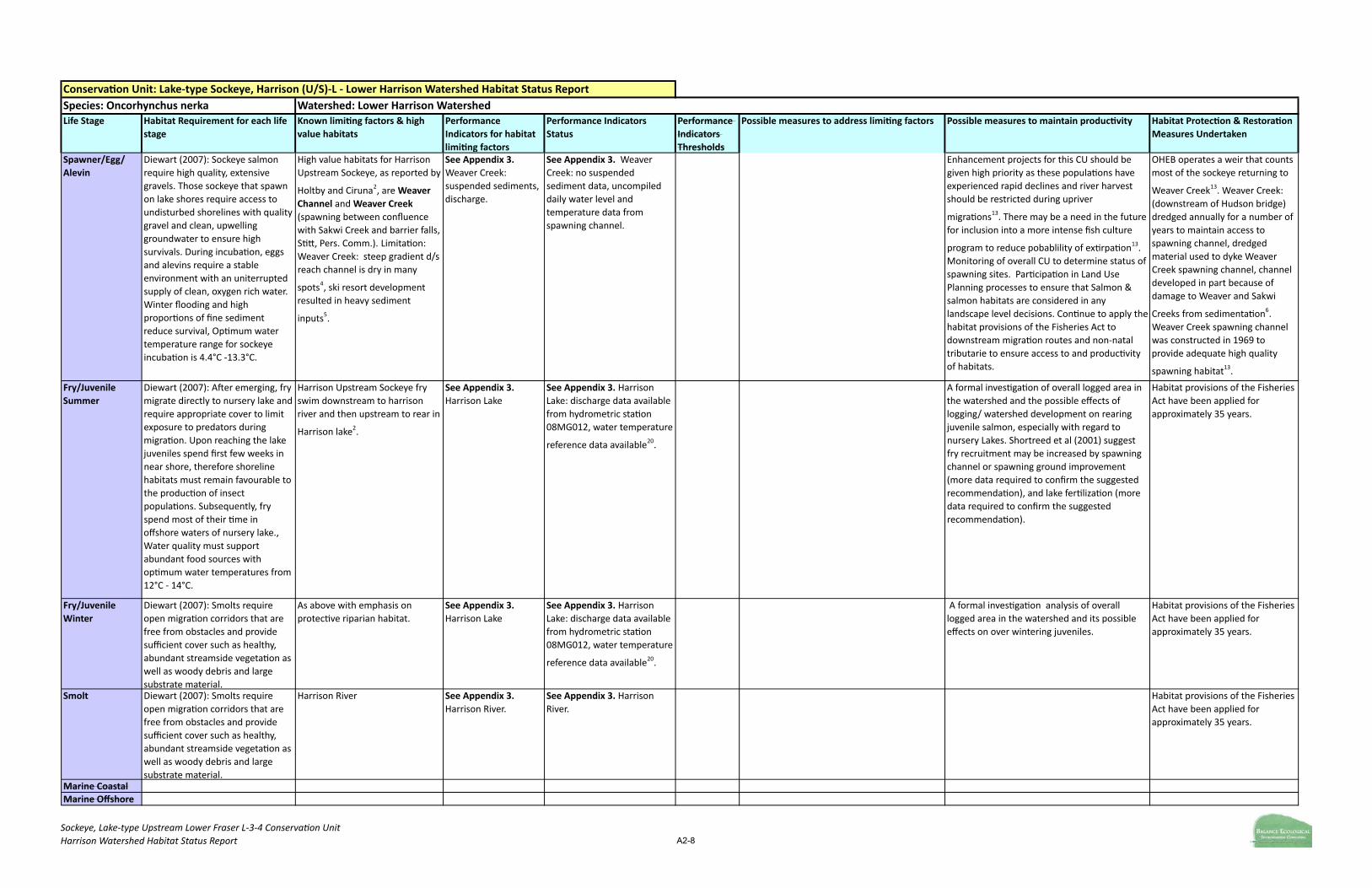
Sockeye, Lake-‐type Upstream Lower Fraser L-‐3-‐4 Conserva9on UnitHarrison Watershed Habitat Status Report A2-8
Conserva)on Unit: Lake-‐type Sockeye, Harrison (U/S)-‐L -‐ Lower Harrison Watershed Habitat Status ReportSpecies: Oncorhynchus nerka Watershed: Lower Harrison WatershedLife Stage Habitat Requirement for each life
stageKnown limi)ng factors & high value habitats
Performance Indicators for habitat limi)ng factors
Performance Indicators Status
Performance Indicators Thresholds
Possible measures to address limi)ng factors Possible measures to maintain produc)vity Habitat Protec)on & Restora)on Measures Undertaken
Spawner/Egg/ Alevin
Diewart (2007): Sockeye salmon require high quality, extensive gravels. Those sockeye that spawn on lake shores require access to undisturbed shorelines with quality gravel and clean, upwelling groundwater to ensure high survivals. During incubaDon, eggs and alevins require a stable environment with an uniterrupted supply of clean, oxygen rich water. Winter flooding and high proporDons of fine sediment reduce survival, OpDmum water temperature range for sockeye incubaDon is 4.4°C -‐13.3°C.
High value habitats for Harrison Upstream Sockeye, as reported by
Holtby and Ciruna2, are Weaver Channel and Weaver Creek (spawning between confluence with Sakwi Creek and barrier falls, SDR, Pers. Comm.). LimitaDon: Weaver Creek: steep gradient d/s reach channel is dry in many
spots4, ski resort development resulted in heavy sediment
inputs5.
See Appendix 3. Weaver Creek: suspended sediments, discharge.
See Appendix 3. Weaver Creek: no suspended sediment data, uncompiled daily water level and temperature data from spawning channel.
Enhancement projects for this CU should be given high priority as these populaDons have experienced rapid declines and river harvest should be restricted during upriver
migraDons13. There may be a need in the future for inclusion into a more intense fish culture
program to reduce pobablility of exDrpaDon13. Monitoring of overall CU to determine status of spawning sites. ParDcipaDon in Land Use Planning processes to ensure that Salmon & salmon habitats are considered in any landscape level decisions. ConDnue to apply the habitat provisions of the Fisheries Act to downstream migraDon routes and non-‐natal tributarie to ensure access to and producDvity of habitats.
OHEB operates a weir that counts most of the sockeye returning to
Weaver Creek13. Weaver Creek: (downstream of Hudson bridge) dredged annually for a number of years to maintain access to spawning channel, dredged material used to dyke Weaver Creek spawning channel, channel developed in part because of damage to Weaver and Sakwi
Creeks from sedimentaDon6. Weaver Creek spawning channel was constructed in 1969 to provide adequate high quality
spawning habitat13.
Fry/Juvenile Summer
Diewart (2007): A`er emerging, fry migrate directly to nursery lake and require appropriate cover to limit exposure to predators during migraDon. Upon reaching the lake juveniles spend first few weeks in near shore, therefore shoreline habitats must remain favourable to the producDon of insect populaDons. Subsequently, fry spend most of their Dme in offshore waters of nursery lake., Water quality must support abundant food sources with opDmum water temperatures from 12°C -‐ 14°C.
Harrison Upstream Sockeye fry swim downstream to harrison river and then upstream to rear in
Harrison lake2.
See Appendix 3. Harrison Lake
See Appendix 3. Harrison Lake: discharge data available from hydrometric staDon 08MG012, water temperature
reference data available20.
A formal invesDgaDon of overall logged area in the watershed and the possible effects of logging/ watershed development on rearing juvenile salmon, especially with regard to nursery Lakes. Shortreed et al (2001) suggest fry recruitment may be increased by spawning channel or spawning ground improvement (more data required to confirm the suggested recommendaDon), and lake ferDlizaDon (more data required to confirm the suggested recommendaDon).
Habitat provisions of the Fisheries Act have been applied for approximately 35 years.
Fry/Juvenile Winter
Diewart (2007): Smolts require open migraDon corridors that are free from obstacles and provide sufficient cover such as healthy, abundant streamside vegetaDon as well as woody debris and large substrate material.
As above with emphasis on protecDve riparian habitat.
See Appendix 3. Harrison Lake
See Appendix 3. Harrison Lake: discharge data available from hydrometric staDon 08MG012, water temperature
reference data available20.
A formal invesDgaDon analysis of overall logged area in the watershed and its possible effects on over wintering juveniles.
Habitat provisions of the Fisheries Act have been applied for approximately 35 years.
Smolt Diewart (2007): Smolts require open migraDon corridors that are free from obstacles and provide sufficient cover such as healthy, abundant streamside vegetaDon as well as woody debris and large substrate material.
Harrison River See Appendix 3. Harrison River.
See Appendix 3. Harrison River.
Habitat provisions of the Fisheries Act have been applied for approximately 35 years.
Marine CoastalMarine Offshore

Sockeye, Lake-‐type Upstream Lower Fraser L-‐3-‐4 Conserva9on UnitHarrison Watershed Habitat Status Report A2-8
Conserva)on Unit: Lake-‐type Sockeye, Harrison (U/S)-‐L -‐ Lower Harrison Watershed Habitat Status ReportSpecies: Oncorhynchus nerka Watershed: Lower Harrison WatershedLife Stage Habitat Requirement for each life
stageKnown limi)ng factors & high value habitats
Performance Indicators for habitat limi)ng factors
Performance Indicators Status
Performance Indicators Thresholds
Possible measures to address limi)ng factors Possible measures to maintain produc)vity Habitat Protec)on & Restora)on Measures Undertaken
Returning Adult Migra)on
Diewart (2007): Highly dependent on estuary habitat. Sockeye require an unimpeded migraDon path with cover from predators; opDmum migraDon temperatures are between 7.2°C and 15.6°C.
Low flows and high water temperatures may prevent returning sockeye from reaching their natal streams and reduce spawning habitat throughout the Harrison Watershed. Returning adult sockeyek have been oberseved holding in Harrison River and Lake prior to moving to
spawning grounds4.
See Appendix 3. As with Spawner/Egg/Alevin with emphasis on adequate summer/fall flows and water temperatures.
See Appendix 3. Temperature data is lacking throughout the LHW, and available data is suggesDve of increasing temperatures with summer highs rising above opDmum thresholds. Likewise, discharge data is largely comprised of outdated esDmates with some indicaDon that water extracDons are contribuDng to low flows.
Shortreed et al (2001) suggest escapements from Harrison Lake may be increased through
harvest reducDon8. Pre-‐spawning monitoring of known and emerging high quality spawning sites, and removal of beaver or breaching of beaver dams throughout the spawning period.
A formal invesDgaDon of coldwater refuge zones in Harrison Lake should be conducted and analysis of overall logged area in the watershed and its possible effects on holding spawners.
Habitat provisions of the Fisheries Act have been applied for approximately 35 years. Community monitoring of access to major le`-‐bank spawning areas has occurred from approximately 1999 to present. Beaver dams have been breached, and beaver removed.
Habitat Produc)vity Model
12. Stalberg, H.C., Lauzier, R.B., MacIsaac, E.A., Porter, M., and Murray, C. 2009. Canada's policy for conservaDon of wild pacific salmon: Stream, lake and estuarine habitat indicators. Can. Manuscr. Fish. Auat. Sci. 2859: xiii + 135p.13. Foy, M. 2007. Lower Fraser Area Salmonid Enhancement Program – 2007 Salmon ConservaDon Strategy “Pumng the Wild Salmon Policy into PracDce”. Prepared for Fisheries and Oceans Canada for internal use only. 45 pp.14. Labelle 2009. Status of Pacific Salmon Resources in Southern BriDsh Columbia and Fraser River Basin. Vancouver, BC: Pacific Resource ConservaDon Council.15. Cloudworks Energy Ltd. Partnership. 2003. Lower Lillooet Projects: Instream Flow Analysis Final Report (Ref. No. OEI-‐001/2-‐1). Addendum to the Fisheries and Instream Flow Analysis Report. 45pp. + appendices.16. Watershed RestoraDon Program. 2000. Annual Compendium of AquaDc RehabilaDon Projects for the Watershed RestoraDon Program 1999-‐2000. WRP Report # 18.17. Fraser River AcDon Plan. 1999. Lower Fraser Valley Streams Strategic Review. Vancouver, B.C. 439 pp + appendices18. Ministry of Environment. 1997. Harrison-‐Chehalis Wildlife Management Area Management Plan. 25 pp. + appendices.19. Wilson, G., K. Ashley, S. Mouldey Ewing, P. Slaney, and R. Land. 1999. Development of a Premier River Fishery: The Big Silver Creek FerDlizaDon Experiment, 1993-‐97 Final Project Report. Fisheries Report No. RD69, B.C. Ministry of Fisheries.
7. Foy, M. and Nielson, G.O. 1993. Big Silver Creek Improvement Project. Encl. Habitat RestoraDon
10. Labelle, M. 2009. Status of Pacific Salmon Resources in Southern BriDsh Columbia and Fraser River Basin. Vancouver, BC: Pacific Resource ConservaDon Council. 11. Diewart, R. 2007. Habitat requirements for ten Pacific salmon life history strategies. Fisheries and Oceans Canada. Unpublished data.
6. Rood, K.M. and Hamilton, R.E. 1995. Hydrology and Water Use for Salmon Streams in the Harrison
8. Shortreed, K.S., Morton, K.F., Malange, K., and Hume, J.M.B. 2001. Factors LimiDng Juvenille Sockeye 9. Integrated Land Management Bureau, Province of BriDsh Columbia. iMapBC.
20. Mathes, M.T., S.G. Hinch, S.J. Cooke, G.T. Crossin, D.A. PaRerson, A.G. LoRo, and A.P. Farrell. 2010. Effect of water temperature, Dming, physiological condiDon, and lake thermal refugia on migraDng adult Weaver Creek sockeye salmon (Oncorhynchus nerka). Canadian Journal of Fisheries and AquaDc Sciences. 67:20-‐84.
References (applicable to mul)ple data sheets, therefore some of these cita)ons may not be referenced in the above table)1. Google Earth: primary database. Accessed: 28 March 2010 v5.1.3533.17312. Holtby, B.L. and Ciruna, K.A. 2007. ConservaDon Units for Pacific Salmon under the 3. Ionson, B. 1995. Habitat Enforcement Report for the Fraser River. Fisheries and Oceans Canada -‐ 4. Ministry of Environment, BriDsh Columbia. Fisheries Inventory Data Queries. 5. Nener, J.C. and Wernick, B.G. 1997. Fraser River Basin Strategic Water Quality Plan, Lower Fraser

Sockeye, River-‐type Lower Fraser Conserva7on UnitHarrison Watershed Habitat Status Report A2-‐9
Conserva)on Unit: River-‐type Sockeye, Lower Fraser -‐ Lower Harrison Watershed Habitat Status ReportSpecies: Oncorhynchus nerka Watershed: Lower Harrison WatershedLife Stage Habitat Requirement for each
life stageKnown limi)ng factors & high value habitats Performance
Indicator(s) for habitat limi)ng factors
Performance Indicator(s) Status
Performance Indicators Thresholds
Possible measures to address limi)ng factors Possible measures to maintain produc)vity Habitat Protec)on & Restora)on Measures Undertaken
Spawner/Egg/ Alevin
Diewart (2007): Sockeye salmon require high quality, extensive gravels. Those sockeye that spawn on lake shores require access to undisturbed shorelines with quality gravel and clean, upwelling groundwater to ensure high survivals. During incubaGon, eggs and alevins require a stable environment with an uniterrupted supply of clean, oxygen rich water. Winter flooding and high proporGons of fine sediment reduce survival, OpGmum water temperature range for sockeye incubaGon is 4.4°C -‐13.3°C.
High value habitats for Lower Fraser Sockeye, as reported by Holtby and Ciruna (2007), are Chehalis River (spawning throughout
mainstem4) and (in the rapids of) Harrison
River . Limita)ons: Chehalis River: unstable5, 32% logging in watershed (esp. preXy creek)4, land cover alteraGons: campsites, bridges,
inhabited areas4, suspended sediment, nutrient poor (Foy, Pers. Comm.); Harrison River: high level-‐development b/c Harrison Mills, and agricultural acGvity in lower
reaches5, loss of vegetaGon, blocked culverts4,
high summer water temperautres20.
See Appendix 3. Chehalis River: land cover alteraGons, suspended sediment, water qualit; Harrison River: land cover alteraGons, riparian disturbance, water temperature.
See Appendix 3. Chehalis River: uncompiled land use/forest harvest data, no suspended sediments data, oligotrophic (Foy Pers. Comm.); Harrison River: summarized land use data from Env Can. (2002, 7 km riparian disturbance/golf course, summer high water
temperatures20.
According to Foy (Pers. Comm.) proposals submiXed to the Watershed RestoraGon Project in the Chehalis watershed include: stream classificaGon and ground water assessment of upper Chehalis tributaries, Statlu River Waterfall ObstrucGon Removal Assessment, Coho Creek off-‐channel pool assessment, PreXy Creek Diversion Assessment and a Chehalis River watershed stream classificaGon assesment. A further proposal to remove silt accumulaGons and develop pool/cover habitats in the Harrison River side-‐channels was submiXed (Foy Pers. Comm.).
StAD monitors this CU but populaGon esGmates are approximaGons only, more accurate methods
should be employed13. PotenGal restoraGon of Harrison River leb and right bank side channels damaged by navigaGon channel dredging are
considered opGons for future restoraGon efforts13. Monitoring of overall CU to determine status of spawning sites. ParGcipaGon in Land Use Planning processes to ensure that Salmon & salmon habitats are considered in any landscape level decisions. ConGnue to apply the habitat provisions of the Fisheries Act to downstream migraGon routes and non-‐natal tributarie to ensure access to and producGvity of habitats.
Harrison Willife Management
Area proposal in process18; Harrison River: the rapids and lower porGon of the river, which are part of the spawning area, have been dredged to maintain a navigaGon channel; chehalis river: gravel removals maintain flow and channel leading to hatchery, berm
surrounds hatchery6.
Fry/Juvenile Summer (N/A for immediate ocean migrants, ie. pink, chum, some chinook & sockeye pop'ns)
N/A N/A N/A N/A N/A N/A N/A N/A
Fry/Juvenile Winter (N/A for immediate ocean migrants as above)
N/A N/A N/A N/A N/A N/A N/A N/A
Smolt Diewart (2007): River sockeye migrate directly to estuaries upon emergence. Smolts require open migraGon corridors that are free from obstacles and provide sufficient cover such as healthy, abundant streamside vegetaGon as well as woody debris and large substrate material.
Lower Fraser Sockeye fry swim downstream to Fraser River estuary immediately upon
emergence2.
See Appendix 3. As above.
See Appendix 3. As above. Habitat provisions of the Fisheries Act have been applied for approximately 35 years.
Marine CoastalMarine OffshoreReturning Adult Migra)on
Diewart (2007): Adults require access to spawning grounds, high water temps or extreme high or low flows can delay river entry and affect survival, migraGon temperatures between 7.2°C and 15.6°C preferred.
Sockeye adults have been observed holding in
harrison lake and harrison river4. Low flows and high water temperatures may prevent returning coho from reaching their natal streams and reduce spawning habitat throughout the Harrison Watershed
See Appendix 3. As with Spawner/Egg/Alevin with emphasis on adequate summer/fall flows and water temperatures.
See Appendix 3. Temperature data is lacking throughout the LHW, and recent available data for Harrison River is suggesGve of increasing temperatures with summer highs rising above opGmum thresholds20. Hydrometric gauge discharge data for Harrison River is available from staGon 08MG013.
Pre-‐spawning monitoring of known and emerging high quality spawning sites, and removal of beaver or breaching of beaver dams throughout the spawning period.
A formal invesGgaGon of coldwater refuge zones in Harrison Lake should be conducted and analysis of overall logged area in the watershed and its possible effects on holding spawners.
Habitat provisions of the Fisheries Act have been applied for approximately 35 years. Community monitoring of access to major leb-‐bank spawning areas has occurred from approximately 1999 to present. Beaver dams have been breached, and beaver removed.

Sockeye, River-‐type Lower Fraser Conserva7on UnitHarrison Watershed Habitat Status Report A2-‐9
Conserva)on Unit: River-‐type Sockeye, Lower Fraser -‐ Lower Harrison Watershed Habitat Status ReportSpecies: Oncorhynchus nerka Watershed: Lower Harrison WatershedLife Stage Habitat Requirement for each
life stageKnown limi)ng factors & high value habitats Performance
Indicator(s) for habitat limi)ng factors
Performance Indicator(s) Status
Performance Indicators Thresholds
Possible measures to address limi)ng factors Possible measures to maintain produc)vity Habitat Protec)on & Restora)on Measures Undertaken
Habitat Produc)vity Model
12. Stalberg, H.C., Lauzier, R.B., MacIsaac, E.A., Porter, M., and Murray, C. 2009. Canada's policy for conservaGon of wild pacific salmon: Stream, lake and estuarine habitat indicators. Can. Manuscr. Fish. Auat. Sci. 2859: xiii + 135p.13. Foy, M. 2007. Lower Fraser Area Salmonid Enhancement Program – 2007 Salmon ConservaGon Strategy “Puong the Wild Salmon Policy into PracGce”. Prepared for Fisheries and Oceans Canada for internal use only. 45 pp.14. Labelle 2009. Status of Pacific Salmon Resources in Southern BriGsh Columbia and Fraser River Basin. Vancouver, BC: Pacific Resource ConservaGon Council.15. Cloudworks Energy Ltd. Partnership. 2003. Lower Lillooet Projects: Instream Flow Analysis Final Report (Ref. No. OEI-‐001/2-‐1). Addendum to the Fisheries and Instream Flow Analysis Report. 45pp. + appendices.16. Watershed RestoraGon Program. 2000. Annual Compendium of AquaGc RehabilaGon Projects for the Watershed RestoraGon Program 1999-‐2000. WRP Report # 18.17. Fraser River AcGon Plan. 1999. Lower Fraser Valley Streams Strategic Review. Vancouver, B.C. 439 pp + appendices18. Ministry of Environment. 1997. Harrison-‐Chehalis Wildlife Management Area Management Plan. 25 pp. + appendices.19. Wilson, G., K. Ashley, S. Mouldey Ewing, P. Slaney, and R. Land. 1999. Development of a Premier River Fishery: The Big Silver Creek FerGlizaGon Experiment, 1993-‐97 Final Project Report. Fisheries Report No. RD69, B.C. Ministry of Fisheries.
7. Foy, M. and Nielson, G.O. 1993. Big Silver Creek Improvement Project. Encl. Habitat RestoraGon Project Reports
10. Labelle, M. 2009. Status of Pacific Salmon Resources in Southern BriGsh Columbia and Fraser River Basin. Vancouver, BC: Pacific Resource ConservaGon Council. 11. Diewart, R. 2007. Habitat requirements for ten Pacific salmon life history strategies. Fisheries and Oceans Canada. Unpublished data.
6. Rood, K.M. and Hamilton, R.E. 1995. Hydrology and Water Use for Salmon Streams in the Harrison Habitat
8. Shortreed, K.S., Morton, K.F., Malange, K., and Hume, J.M.B. 2001. Factors LimiGng Juvenille Sockeye ProducGon 9. Integrated Land Management Bureau, Province of BriGsh Columbia. iMapBC.
20. Mathes, M.T., S.G. Hinch, S.J. Cooke, G.T. Crossin, D.A. PaXerson, A.G. LoXo, and A.P. Farrell. 2010. Effect of water temperature, Gming, physiological condiGon, and lake thermal refugia on migraGng adult Weaver Creek sockeye salmon (Oncorhynchus nerka). Canadian Journal of Fisheries and AquaGc Sciences. 67:20-‐84.
References (applicable to mul)ple data sheets, therefore some of these cita)ons may not be referenced in the above table)1. Google Earth: primary database. Accessed: 28 March 2010 v5.1.3533.17312. Holtby, B.L. and Ciruna, K.A. 2007. ConservaGon Units for Pacific Salmon under the Wild Salmon 3. Ionson, B. 1995. Habitat Enforcement Report for the Fraser River. Fisheries and Oceans Canada -‐ Fraser River 4. Ministry of Environment, BriGsh Columbia. Fisheries Inventory Data Queries. 5. Nener, J.C. and Wernick, B.G. 1997. Fraser River Basin Strategic Water Quality Plan, Lower Fraser Basin: Fraser

Appendix
APPENDIX 3 High Value Habitats and Indicators (appended as .xls files to digital document)


!"#$%&'()*%!'+",',-%'./%0./"1',23-425*3%!'33"-2.%6',*3-$*/%!'+",',%7,',)-%8*923, A3
!"#$%"% &"%'()*'+,-.+'
!"#$%&'()$"*" +,-('*)."-/('* 0,"$)1(#'2*3 024"-2"#)$2'*&-5"#6( 7"*(-'8($)-,"$)$(/(9,4:(#*
7"*(-)(;*-"6<,# =(-:2>($)7"'*()$2'68"-?(
7"*(-)@(:4(-"*&-( A&'4(#$($)'($2:(#* 7"*(-)B&"92*3 12'68"-?(/
0$1,2$34'(,-(''5 66789::777 !"#$%&'()*+,+
-)$./0)+1223/
!"#$%&'()*+,+4$56+7+89:*/:)*+
*/:/+;<$%+=)")<+/"*+>/<?'#@+
A33BC+1DE+($FF)*G++AHE+;<$%+
<)#)":+$<+&<$&$0)*+
!"#$%&'()*+,+
4856+7+
-)$./0)+
1223I
=$+*/:/ !"#$%&'()*+,+.J+
>/:)<0K)*+L:(/0+7+
=/M$"/(+6$/*+
=):?$<@+7+4$56
N?$+('#)"0)0+K/O)+I))"+/&&(')*+;$<+IP+
J($9*?$<@0+Q")<FP+R"#S+;$<+&$?)<+F)")</M$"+
:$:/('"F+TA31SB+#;0S
=$") U'%'M"F+;/#:$<+,+
09%%)<+K'FK0+*/:/C+
>'(0$"+):+/(S+A333S
U'%'M"F+;/#:$<+,+"$+
*/:/
U'%'M"F+;/#:$<+,+
"9:<')":+&$$<+V*/:/C+
>'(0$"+):+/(S+A333WC+
"':</:)+X+"':<':)+TY+Z+
D[+9F7U+\+
&K$0&K$<$90+
9"*):)#:/I()
Q0M%/:)*C+=]J+
A33DS+
-*'*"3$),;"5' 66787:7<77 !"#$%&'()*+,+
-)$./0)+1223/
!"#$%&'()*+,+4$56++ !"#$%&'()*+,+
4856+7+
-)$./0)+
1223I
^'F"'_#/":+*'0:9<I/"#)+;<$%+
122B+(/"*0('*)
!"#$%&'()*+,+.J+
>/:)<0K)*+L:(/0+7+
=/M$"/(+6$/*+
=):?$<@+7+4$56
=$") =$") =$+*/:/ =$+*/:/ =$+*/:/ =$+*/:/
-*'*"3$),=$4'( 66787:7<77 Q"O'<$"%)":+J/"/*/+
V1221W
!"#$%&'()*+,+4$56+7+89:*/:)*+
*/:/+;<$%+56L`+A333C+1DE+
($FF)*G+AHE+<)#)":+7+
4#U)""/"*+/"*+6)#@")((+
VA333WC+T2E+<)%/'"'"F+'"+$(*+$<+
%/:9<)+;$<)0:+'"+A33BS
!"#$%&'()*+,+
4856+7+
-)$./0)+
1223I
[2E+$;+:K)+<'&/<'/"+
O)F):/M$"+'"+:K)+0)()#:)*+
09I,*</'"/F)0+K/*+I))"+
K/<O)0:)*G+$;+?K'#K+T1E+
?)<)+0'F"'_#/":(P+
KP*<$($F'#/((P+'%&/'<)*+/"*+
/"$:K)<+1YE+?)<)+
%$*)</:)(P+'%&/'<)*+
V4#U)""/"+/"*+6)#@")((+
A333W
!"#$%&'()*+,+.J+
>/:)<0K)*+L:(/0+7+
=/M$"/(+6$/*+
=):?$<@+7+4$56
5'0K)<')0+/"*+8#)/"0+J/"/*/C+[H+#;0+;$<+:K)+
JK)K/('0+5'0K+]/:#K)<PS+
a'0#K/<F)+J<))@+V/+
:<'I9:/<P+:$+4/'0/(W+
<)#)'O)0+0)?/F)+
*'0#K/<F)0+;<$%+:K)+
])%($#@+b/(()P+^@'+
L<)/+V56L`+A333WS+
=$:+#$%%9"'#/:)*+
IP+US+5<)P%/"+c+
48QS
!"#$%&'()*+,+*/:/+
/O/'(/I()+;<$%+
JK)K/('0+5'0K+
]/:#K)<P
U'%'M"F+;/#:$<+,+"$+
*/:/\+:K$9FK:+:$+I)+
K'FK:+*9)+:$+<$/*+
:</d#+/"*+($FF'"F+'"+
:K)+?/:)<0K)*
U'%'M"F+;/#:$<+,+
"9:<')":+&$$<+V*/:/C+
5$PG+`)<0S+
J$<<)0&$"*)"#)WC+
=81X=8TC+
2S32%F7U\+$`8D+e+
2S22A+%F7U
]P*<$%):<'#+F/9F)+
2Y4-22AC+
09%%)<7?'":)<+($?+
f$?0+('%'M"F+;/#:$<
-.1#>(?,-(''5 66789@9677 !"#$%&'()*+,+
-)$./0)+1223/
!"#$%&'()*+,+4$56+7+89:*/:)*+
*/:/+;<$%+56L`+A333C+YE+$;+:K)+
:$:/(+?/:)<0K)*+K/*+I))"+
($FF)*G+'"#(9*'"F+BE+;<$%+
<)#)":+/#MO':P+?':K+/"$:K)<+DE+
&<$&$0)*
!"#$%&'()*+,+
4856+7+
-)$./0)+
1223I
=$+*/:/ !"#$%&'()*+,+.J+
>/:)<0K)*+L:(/0+7+
=/M$"/(+6$/*+
=):?$<@+7+4$56
=$") =$") =$+*/:/ =$+*/:/ =$+*/:/ Q0M%/:)*C+=]J+A33D
-.*.,-(''5 66787:7<778AAA77
!"#$%&'()*+,+
-)$./0)+1223/
!"#$%&'()*+,+4$56+7+89:*/:)*+
*/:/+;<$%+=)")<+/"*+>/<?'#@+
A33B
!"#$%&'()*+,+
4856+7+
-)$./0)+
1223I
^'F"'_#/":+*'0:9<I/"#)+;<$%+
122B+(/"*0('*)
!"#$%&'()*+,+.J+
>/:)<0K)*+L:(/0+7+
=/M$"/(+6$/*+
=):?$<@+7+4$56
=$") =$+*/:/ =$+*/:/ =$+*/:/ =$+*/:/
B.>13"),-(''5 6678:CDE77 !"#$%&'()*+,+
-)$./0)+1223/
!"#$%&'()*+,+4$56+7+89:*/:)*+
*/:/+;<$%+=)")<+/"*+>/<?'#@+
A33BC+AE+$;+:K)+:$:/(+?/:)<0K)*+
K/0+I))"+($FF)*+<)#)":(P+/"*+
AE+'0+&<$&$0)*+;$<+K/<O)0:
!"#$%&'()*+,+
4856+7+
-)$./0)+
1223I
=$+*/:/\+($?)<+#K/"")(+K/0+
I))"+#K/"")('g)*
!"#$%&'()*+,+.J+
>/:)<0K)*+L:(/0+7+
=/M$"/(+6$/*+
=):?$<@+7+4$56
J($9*?$<@0+R``+,+D2DST[+#;0 =$") U'%'M"F+;/#:$<+,+
09%%)<+K'FK0G+*/:/C+
JQU`+122TS
($?+VJQU`+122TW U'%'M"F+;/#:$<+,+
"9:<')":+&$$<+V*/:/C+
JQU`+122TW
a/:/C+JQU`+122T\++
%$*'_)*+IP+R` S̀
!"(($).?,;"5' 667 Q"O'<$"%)":+J/"/*/+
V1221W\+:K<))+&(/#)<+
%'"'"F+$&)</M$"0+
VRU4.+12A2/W\+
<)0'*)"M/(+
*)O)($&%)":+#$O)<0+
/&&<$h'%/:)(P+B+@%1+
!"#$%&'()*+,+4$56+7TAE+$;+:K)+
?/:)<0K)*+'0+$(*+;$<)0:+VF<)/:)<+
:K/"+AD2+P)/<0+$(*W\+AHE+'0+
P$9"F+;$<)0:G+/"*+[E+'0+<)#)":(P+
($FF)*+VQ"O'<$"%)":+J/"/*/+
1221W
!"#$%&'()*+,+
4856+7+
-)$./0)+
1223I
<'&/<'/"+O)F):/M$"+/I0)":+
/($"F+1S1+@%+0K$<)('")+/:+
]/<<'$0$"+]$:+^&<'"F0G+
<)0'*)"M/(+*)O)($&%)":+
/($"F+6$#@?)((+a<'O)+$"+:K)+
0$9:K,)/0:+0K$<)+$;+:K)+(/@)+
K/0+<)09(:)*+'"+/"$:K)<+1+@%+
$;+<'&/<'/"+<)%$O/(
!"#$%&'()*+,+.J+
>/:)<0K)*+L:(/0+7+
=/M$"/(+6$/*+
=):?$<@+7+4$56
^)O)"+?/:)<+('#)"#)0+:$:/(+%/h'%9%+<)%$O/(+
$;+AA1G222+F/(($"07*/P+$<+A22G222G222+
F/(($"07/""9%+
N?$+&)<%'i)*+?/0:)+
*'0#K/<F)0
a/:/C+V4/:K)0+):+/(S+
12A2WG+`/i)<0$"+):+
/(S+122H
=$+*/:/ =$+*/:/ ]P*<$%):<'#+-/9F)+
2Y4-2A1+,+]/<<'0$"+
U/@)+")/<+]/<<'0$"+
]$:+^&<'"F0CG+*/'(P+
()O)(+A3TT,122Y+/"*+
<)/(,M%)
!"(($).?,=$4'( 667 Q"O'<$"%)":+J/"/*/+
V1221W
!"#$%&'()*+,+4$56+7+TAE+$;+
:K)+?/:)<0K)*+'0+$(*+;$<)0:+
VF<)/:)<+:K/"+AD2+P)/<0+$(*W\+
AHE+'0+P$9"F+;$<)0:G+/"*+[E+'0+
<)#)":(P+($FF)*+VQ"O'<$"%)":+
J/"/*/+1221W
!"#$%&'()*+,+
4856+7+
-)$./0)+
1223I
B@%+<'&/<'/"+*'0:9<I/"#)+
;<$%+*)O)($&%)":+7+F$(;+
#$9<0)S
!"#$%&'()*+,+.J+
>/:)<0K)*+L:(/0+7+
=/M$"/(+6$/*+
=):?$<@+7+4$56
NK<)) *$%)0M# 7 I90'")00 ?/:)< ('#)"0)0
K/O)+/"+/(($?/I()+)h:</#M$"+$;+2S22A+%T70S+
8")+I90'")00+
0)?/F)+$9j/((+
V_0K'"F+($*F)W
U'%'M"F+;/#:$<+,+
09%%)<+K'FK0G+*/:/C+
4/:K)0+):+/(S+12A2S
=$+*/:/ =$+*/:/ ]P*<$%):<'#+F/9F)+
2Y4-2AT+,+>LNQ6+
UQbQU+N]6Q^]8Uakk
F$"G$,-(''5 6678<@<677 56L`+VA333W+
'*)"M_)*+<)0'*)"M/(+
K$90'"F+$"+3E+$;+:K)+
:$:/(+?/:)<0K)*+
/<)/G+/F<'#9(:9<)+$"+
11EG+/"*+A2E+'"+
&/<@0\+!"#$%&'()*+,+
-)$./0)+1223
!"#$%&'()*+,+4$56+7+89:*/:)*+
*/:/+;<$%+=)")<+/"*+>/<?'#@+
A33B
!"#$%&'()*+,+
4856+7+
-)$./0)+
1223I
(/#@+$;+O)F):/M$"+/($"F+
%/l$<':P+$;+#<))@+*9)+:$+
*)O)($&%)":+V=)")<+/"*+
>/<?'#@+A33BW
!"#$%&'()*+,+.J+
>/:)<0K)*+L:(/0+7+
=/M$"/(+6$/*+
=):?$<@+7+4$56
=$") =$") =$+*/:/ =$+*/:/ =$+*/:/ Q0M%/:)*C+=]J+A33D
=-(''&-()C#$26"*,-' A*"*()C#$26"*,-'
;.H'(,!"(($).?,&"%'()*'+,!$1*,I"3>',!"#$%"%)

!"#$%&'()*%!'+",',-%'./%0./"1',23-425*3%!'33"-2.%6',*3-$*/%!'+",',%7,',)-%8*923, A3
!"#$%"% &"%'()*'+,-.+'
!"#$%&'()$"*" +,-('*)."-/('* 0,"$)1(#'2*3 024"-2"#)$2'*&-5"#6( 7"*(-'8($)-,"$)$(/(9,4:(#*
7"*(-)(;*-"6<,# =(-:2>($)7"'*()$2'68"-?(
7"*(-)@(:4(-"*&-( A&'4(#$($)'($2:(#* 7"*(-)B&"92*3 12'68"-?(/
=-(''&-()C#$26"*,-' A*"*()C#$26"*,-'
F.(($),-(''5 66786E:<77 !"#$%&'()*+,+
-)$./0)+1223/
!"#$%&'()*+,+4$56+7+89:*/:)*+
*/:/+;<$%+=)")<+/"*+>/<?'#@+
A33B
!"#$%&'()*+,+
4856+7+
-)$./0)+
1223I
=$+*/:/ !"#$%&'()*+,+.J+
>/:)<0K)*+L:(/0+7+
=/M$"/(+6$/*+
=):?$<@+7+4$56
=$") =$") =$+*/:/ =$+*/:/ =$+*/:/ Q0M%/:)*C+=]J+A33D
F.(($),;"5' 66786E:<77 !"#$%&'()*+,+
-)$./0)+1223/
!"#$%&'()*+,+4$56+7+89:*/:)*+
*/:/+;<$%+=)")<+/"*+>/<?'#@+
A33B
!"#$%&'()*+,+
4856+7+
-)$./0)+
1223I
=$+*/:/ !"#$%&'()*+,+.J+
>/:)<0K)*+L:(/0+7+
=/M$"/(+6$/*+
=):?$<@+7+4$56
=$") =$") =$+*/:/ =$+*/:/ =$+*/:/ Q0M%/:)*C+=]J+A33D
FJ)%'(J,-(''5 66789C6:77 !"#$%&'()*+,+
-)$./0)+1223/
U'%'M"F+5/#:$<C+!"#$%&'()*+,+
4$56+7+89:*/:)*+*/:/+;<$%+
=)")<+/"*+>/<?'#@+A33BC+HTE+
$;+:K)+?/:)<0K)*+K/*+I))"+
($FF)*+/"*+BHE+$;+:K)+
?/:)<0K)*+?/0+&<$&$0)*+;$<+
;9<:K)<+K/<O)0:
!"#$%&'()*+,+
4856+7+
-)$./0)+
1223I
=$+*/:/ !"#$%&'()*+,+.J+
>/:)<0K)*+L:(/0+7+
=/M$"/(+6$/*+
=):?$<@+7+4$56
=$") =$") =$+*/:/ =$+*/:/ =$+*/:/ Q0M%/:)*C+=]J+A33D
2"5H$,-(''5 66786E:<778C9E778@9A77
!"#$%&'()*+,+
-)$./0)+1223/
!"#$%&'()*+,+4$56+7+
J$"f'#M"F+<)&$<:0\+$9:*/:)*+
*/:/+;<$%+=)")<+/"*+>/<?'#@+
A33B
!"#$%&'()*+,+
4856+7+
-)$./0)+
1223I
U'%'M"F+;/#:$<+,+"$+*/:/G+I9:+
:K$9FK:+:$+I)+0'F"'_#/":+*9)+
:$+<$/*0+/"*+*)O)($&%)":
!"#$%&'()*+,+.J+
>/:)<0K)*+L:(/0+7+
=/M$"/(+6$/*+
=):?$<@+7+4$56
5'0K)<')0+/"*+8#)/"0+J/"/*/+('#)"0)G+12+#;0+
V2SHB+%T70W\+^/@?'+J<))@+`$?)<+J$<&$</M$"+
;$<+/"$:K)<+1DSB1+#;0+V2SB2+%T70W+S+NK)+
&$:)"M/(+L9F90:+?/:)<+*)%/"*+;$<+'<<'F/M$"+
/"*+?/:)<?$<@0+90)+'0+:)"+M%)0+VA222EW+$;+
:K)+"/:9</('g)*+09%%)<+B,*/P+%)/"+($?+f$?+
V2SAT+%T70WS
=$") =$+*/:/ =$+*/:/\+:K$9FK:+:$+
I)+0'F"'_#/":+*9)+:$+
*)O)($&%)":+/"*+
($FF'"F
=$+*/:/ U'%'M"F+5/#:$<+7+
Q0M%/:)*C+=]J+A33D
2K>"H5>G,-(''5
66787@A:77 !"#$%&'()*+,+
-)$./0)+1223/
!"#$%&'()*+,+4$56+ !"#$%&'()*+,+
4856+7+
-)$./0)+
1223I
:K$9FK:+:$+I)+0$%)+
*'0:9<I/"#)+*9)+:$+
*)O)($&%)":
!"#$%&'()*+,+.J+
>/:)<0K)*+L:(/0+7+
=/M$"/(+6$/*+
=):?$<@+7+4$56
=$") #$"f'#M"F+*/:/C+"$+
48Q+<)#$<*+I9:+
56L`+VA333W+0:/:)0+
*'0#K/<F)0+/"*+
0)&M#+_)(*0+;<$%+
0)i()%)":+/<$9"*+
Q<<$#@+U/@)
=$+*/:/ =$+*/:/ =$+*/:/ Q0M%/:)*C+=]J+
A33D+/"*+=)")<+/"*+
>)<"'#@+A33B
L$M'33",-(''5 6678:9EA77 !"#$%&'()*+,+
-)$./0)+1223/
!"#$%&'()*+,+4$56+7+89:*/:)*+
*/:/+;<$%+=)")<+/"*+>/<?'#@+
A33BC+TE+$;+:K)+:$:/(+?/:)<0K)*+
K/0+I))"+($FF)*+<)#)":(P+
!"#$%&'()*+,+
4856+7+
-)$./0)+
1223I
R``+&)<%)":)":(P+'%&/:#:)*+
BG13D+%1+$;+<'&/<'/"+K/I':/:+
VU)?'0+):+/(S+122[W
!"#$%&'()*+,+.J+
>/:)<0K)*+L:(/0+7+
=/M$"/(+6$/*+
=):?$<@+7+4$56
N'&)((/+J<))@+`<$l)#:+`/<:")<0K'&C<+1HD+#;0+;$<+
&$?)<+F)")</M$"+&9<&$0)0\1AS1+#;0+IP+
J($9*?$<@0+Q")<FP+;$<+#$"0)<O/M$"+&9<&$0)0+
=$") 8@+,+*/:/+;<$%+U)?'0+
):+/(+122[S
=$+*/:/ =$+*/:/ a/:/C+U)?'0+):+/(S+
122[\++%$*'_)*+IP+
R` S̀
L(.>%,;"5',-(''5
6678<9:777 !"#$%&'()*+,+
-)$./0)+1223/
!"#$%&'()*+,+4$56+7+89:*/:)*+
*/:/+;<$%+=)")<+/"*+>/<?'#@+C+
A33BC+N<$9:+U/@)+J<))@+
?/:)<0K)*+?/0+#$%&():)(P+
($FF)*+IP+A3H[
!"#$%&'()*+,+
4856+7+
-)$./0)+
1223I
=$+*/:/\+:K$9FK:+:$+I)+K'FK+
'"+($?)<+<)/#K+*9)+:$+
<)0'*)"M/(+*)O)($&%)":
!"#$%&'()*+,+.J+
>/:)<0K)*+L:(/0+7+
=/M$"/(+6$/*+
=):?$<@+7+4$56\+
:K$9FK:+:$+I)+K'FK+
*9)+:$+<)0'*)"M/(+
*)O)($&%)":G+
#/%&F<$9"*0+/"*+
K'0:$<'#/(+($FF'"F
#$"f'#M"F+*/:/C+"$+?/:)<+('#)"0)0+('0:)*+IP+
48Q+I9:G+=]J+A33D+'*)"M_)*+'"*90:<'/(+/"*+
<)0'*)"M/(+?/:)<+)h:</#M$"
=$") =$+*/:/ =$+*/:/\+:K$9FK:+:$+
I)+K'FK+I7#+#K/"")(+
'0+I9'(*'"F+9&+*)I<'0
=$+*/:/ U'%'M"F+5/#:$<+
V=)")<+/"*+>/<?'#@G+
A33BW+Q0M%/:)*C+
=]J+A33D
LH'?%J,F$3',-(''5
66789CC777 !"#$%&'()*+,+
-)$./0)+1223/
!"#$%&'()*+,+4$56+7+89:*/:)*+
*/:/+;<$%+=)")<+/"*+>/<?'#@+
A33BC+A2E+$;+:K)+:$:/(+
?/:)<0K)*+K/0+I))"+($FF)*+
<)#)":(PG+/"*+AE+'0+&<$&$0)*+;$<+
K/<O)0:
!"#$%&'()*+,+
4856+7+
-)$./0)+
1223I
=$+*/:/ !"#$%&'()*+,+.J+
>/:)<0K)*+L:(/0+7+
=/M$"/(+6$/*+
=):?$<@+7+4$56
=$") =$") =$+*/:/ =$+*/:/\+:K$9FK:+:$+
I)+K'FK+I7#+
/FF</*/M$"+'0+
$##9<'"F
=$+*/:/ Q0M%/:)*C+=]J+A33D
&'"4'(,-(''5 66786E:<778C9E77
!"#$%&'()*+,+
-)$./0)+1223/
!"#$%&'()*+,+4$56+7+
J$"f'#M"F+<)&$<:0\+89:*/:)*+
*/:/+;<$%+=)")<+/"*+>/<?'#@+
A33B
!"#$%&'()*+,+
4856+7+
-)$./0)+
1223I
=$+*/:/ !"#$%&'()*+,+.J+
>/:)<0K)*+L:(/0+7+
=/M$"/(+6$/*+
=):?$<@+7+4$56
5'0K)<')0+/"*+8#)/"0C+1A[2+/#<),;)):+&)<+
/""9%+'"+>)/O)<+J<))@+V0'"#)+A3[DWG12#;0+;$<+
#$"0)<O/M$"+&9<&$0)0S+N?$+*$%)0M#+
('#)"0)0+:$:/(+A222+F/(($"0+&)<+*/P
=$") !"#$%&'()*+,+*/:/+
/O/'(/I()+;<$%+
>)/O)<+J<))@+
^&/?"'"F+JK/"")(0
=$+*/:/+V/""9/(+
*<)*F'"F+$;+12G222+
%TW
=$+*/:/ Q0M%/:)*C+=]J+
A33D++7+!"#$%&'()*+
*/'(P+?/:)<+()O)(+
*/:/+/O/'(/I()+;<$%+
>)/O)<+J<))@+
^&/?"'"F+JK/"")(0
Appendix
APPENDIX 4 Harrison River Dredging Impacts 1967


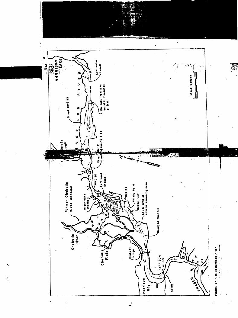


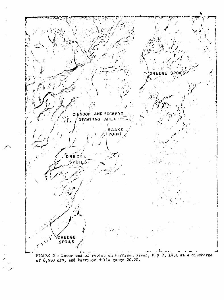


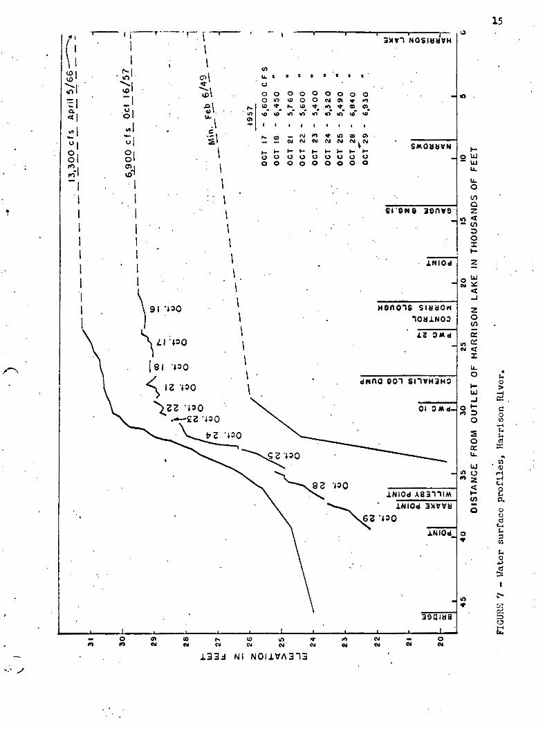


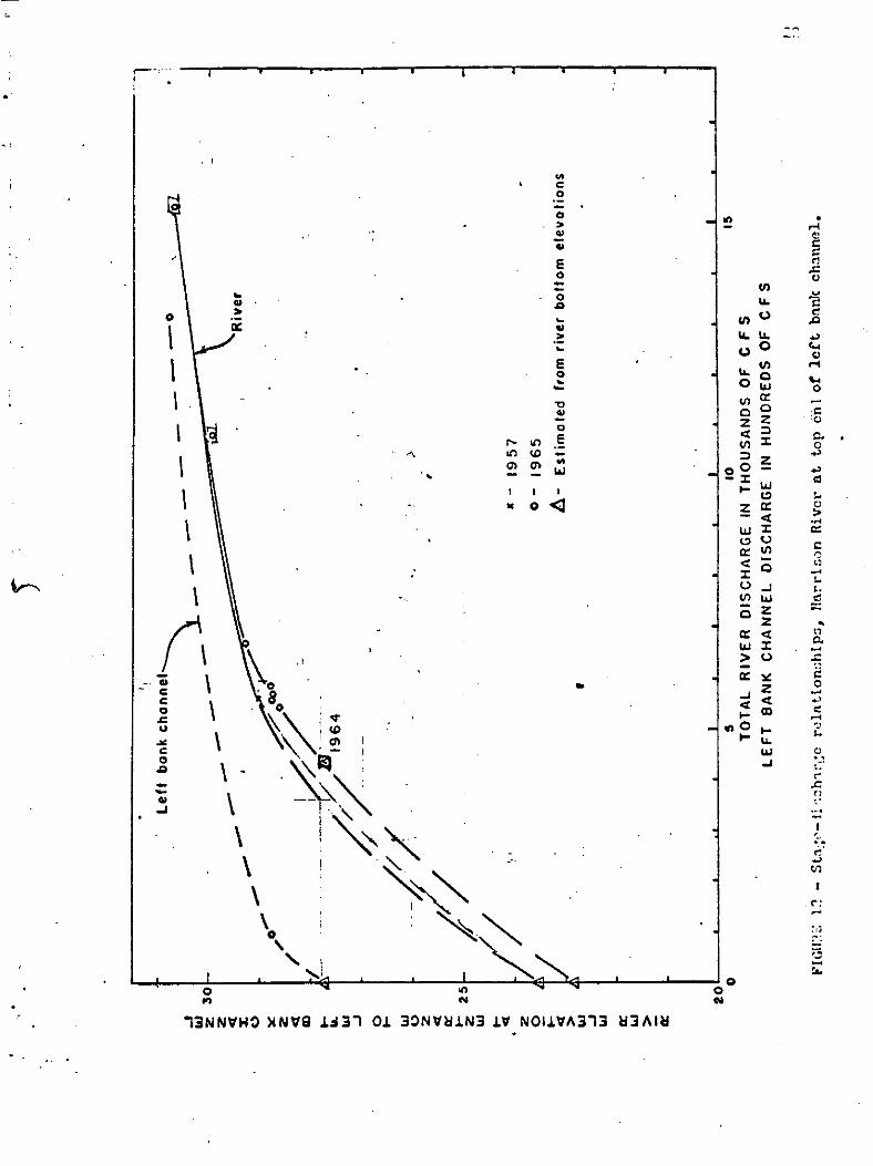


Appendix
APPENDIX 5 Harrison River Salmonid Spawning Distribution 1967


Appendix
APPENDIX 6 Undated map of Harrison River Chum Spawning Distribution

