happy, healthy, smart cities symposium in knoxville, t ... · pdf filehappy, healthy, smart...
TRANSCRIPT
Happy, Healthy, Smart Cities Symposium in Knoxville, Tennessee A TPCB Peer Exchange
Location: Knoxville, Tennessee
Date: March 29-30, 2017
Host Agencies: Knoxville Regional Transportation Planning Organization East Tennessee Community Design Center
National Peers: Philip Erickson, AIA David Vega-Barachowitz
Federal Agencies: Federal Highway Administration Federal Transit Administration Volpe National Transportation Systems Center
U.S. Department of Transportation Federal Highway Administration • Federal Transit Administration
Transportation Planning Capacity Building (TPCB) Peer Program
Happy, Healthy, Smart Cities Symposium in Knoxville, TN 2
Notice
This document is disseminated under the sponsorship of the Department of Transportation in the interest of information exchange. The United States Government assumes no liability for the contents or use thereof.
The United States Government does not endorse products or manufacturers. Trade or manufacturers’ names appear herein solely because they are considered essential to the objective of this report.
Happy, Healthy, Smart Cities Symposium in Knoxville, TN 3
REPORT DOCUMENTATION PAGE Form Approved OMB No. 0704-0188
Public reporting burden for this collection of information is estimated to average 1 hour per response, including the time for reviewing instructions, searching existing data sources, gathering and maintaining the data needed, and completing and reviewing the collection of information. Send comments regarding this burden estimate or any other aspect of this collection of information, including suggestions for reducing this burden, to Washington Headquarters Services, Directorate for Information Operations and Reports, 1215 Jefferson Davis Highway, Suite 1204, Arlington, VA 22202-4302, and to the Office of Management and Budget, Paperwork Reduction Project (0704-0188), Washington, DC 20503.
1. AGENCY USE ONLY (Leave blank) 2. REPORT DATESeptember 2017
3. REPORT TYPE AND DATES COVERED Final
4. TITLE AND SUBTITLE Happy, Healthy, Smart Cities Symposium in Knoxville, Tennessee: A TPCB Peer Exchange
5a. FUNDING NUMBERS HW2LA4 / QC338
6. AUTHOR(S) Jonah Chiarenza, AICP
5b. CONTRACT NUMBER
7. PERFORMING ORGANIZATION NAME(S) AND ADDRESS(ES) U.S. Department of Transportation John A Volpe National Transportation Systems Center55 BroadwayCambridge, MA 02142-1093
8. PERFORMING ORGANIZATION REPORT NUMBER
DOT-VNTSC-FHWA-17-24
9. SPONSORING/MONITORING AGENCY NAME(S) AND ADDRESS(ES) U.S. Department of Transportation Federal Transit Administration/Federal Highway Administration Office of Planning & Environment/Office of Planning1200 New Jersey Avenue, SEWashington, DC 20590
10. SPONSORING/MONITORING AGENCY REPORT NUMBER
FHWA-HEP-18-010
11. SUPPLEMENTARY NOTES
12a. DISTRIBUTION/AVAILABILITY STATEMENT This document is available to the public through the National Technical Information Service, Springfield, VA 22161.
12b. DISTRIBUTION CODE
13. ABSTRACT (Maximum 200 words)
This report highlights key recommendations and noteworthy practices identified at the “Happy, Healthy, Smart Cities Symposium” Peer Exchange held on March 29-30, 2016 in Knoxville, Tennessee. This event was sponsored by the Transportation Planning Capacity Building (TPCB) Peer Program, which is jointly funded by the Federal Highway Administration (FHWA) and Federal Transit Administration (FTA).
14. SUBJECT TERMS Keywords: transportation/land use connection, active transportation, multimodal, transit, bicycle/pedestrian, livable communities, Knoxville TN, smart cities, parking, zoning, public space, pilot projects, public health, public involvement
15. NUMBER OF PAGES57
16. PRICE CODE
17. SECURITY CLASSIFICATION OF REPORT
Unclassified
18. SECURITY CLASSIFICATION OF THIS PAGE
Unclassified
19. SECURITY CLASSIFICATION OF ABSTRACT
Unclassified
20. LIMITATION OF ABSTRACTUnlimited
NSN 7540-01-280-5500 Standard Form 298 (Rev. 2-89) Prescribed by ANSI Std. 239-18
298-102
Happy, Healthy, Smart Cities Symposium in Knoxville, TN 4
Contents Introduction .......................................................................................................................... 5
Event Overview ..................................................................................................................................... 5
Key Recommendations ......................................................................................................................... 6
Background ........................................................................................................................... 8
What is a Happy, Healthy, Smart City? ................................................................................................. 8
Overview of Peer Exchange ................................................................................................... 9
Why is East Tennessee Interested in Happy, Healthy, Smart Cities Topics? ........................................ 9
Why a TPCB Peer Exchange? ................................................................................................................ 9
Who were the Hosts? ........................................................................................................................... 9
Who were the Peers? ......................................................................................................................... 10
Peer Exchange Format ........................................................................................................................ 12
Event Themes ...................................................................................................................... 15
Documentary Films ............................................................................................................................. 15
Key Themes and Lessons Learned ........................................................................................ 19
Education and Involvement ................................................................................................................ 19
Data and Community Design .............................................................................................................. 25
Strategies to Support Walking, Bicycling, and Transit Use ................................................................. 28
Future Trends ...................................................................................................................................... 41
Conclusion ........................................................................................................................... 43
About the Transportation Planning Capacity Building Program ............................................ 45
Appendices ......................................................................................................................... 46
Appendix A: Key Contacts ................................................................................................................... 46
Appendix B: Peer Exchange Agenda ................................................................................................... 47
Appendix C: Key Resources ................................................................................................................. 52
Appendix D: Acronyms........................................................................................................................ 54
Appendix E: Endnotes ......................................................................................................................... 55
Happy, Healthy, Smart Cities Symposium in Knoxville, TN 5
Introduction
Event Overview
The Happy, Healthy, Smart Cities Symposium was a two-day event focused on exploring the impacts that transportation and land use decisions have on health, safety, and quality of life. The event was hosted by the Knoxville Regional Transportation Planning Organization and the East Tennessee Community Design Center. The Federal Highway Administration and Federal Transit Administration’s Transportation Planning Capacity Building Peer Program funded assistance with planning and documentation of the event, and funded the participation of the following national experts as peer panelists for the symposium:
Philip Erickson, AIA, President of Community Design + Architecture, a city planning and urbandesign firm based in Oakland, California.
David Vega-Barachowitz, Senior Urban Designer with the New York City Department of CityPlanning.
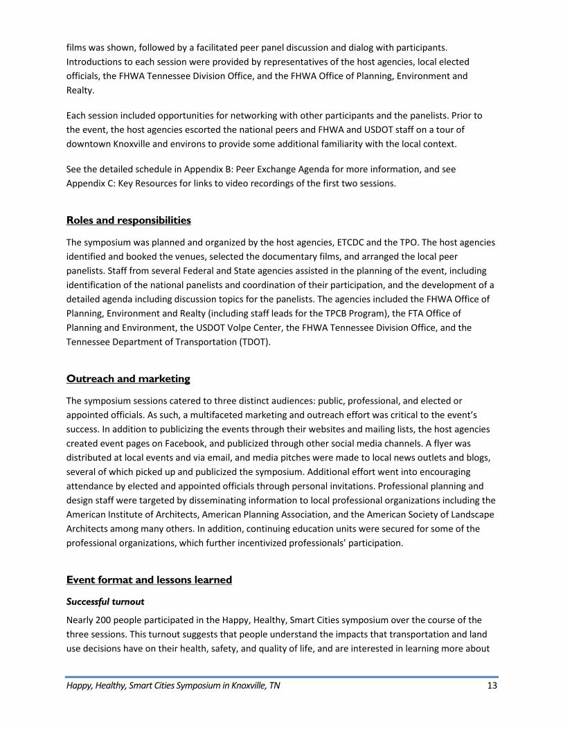
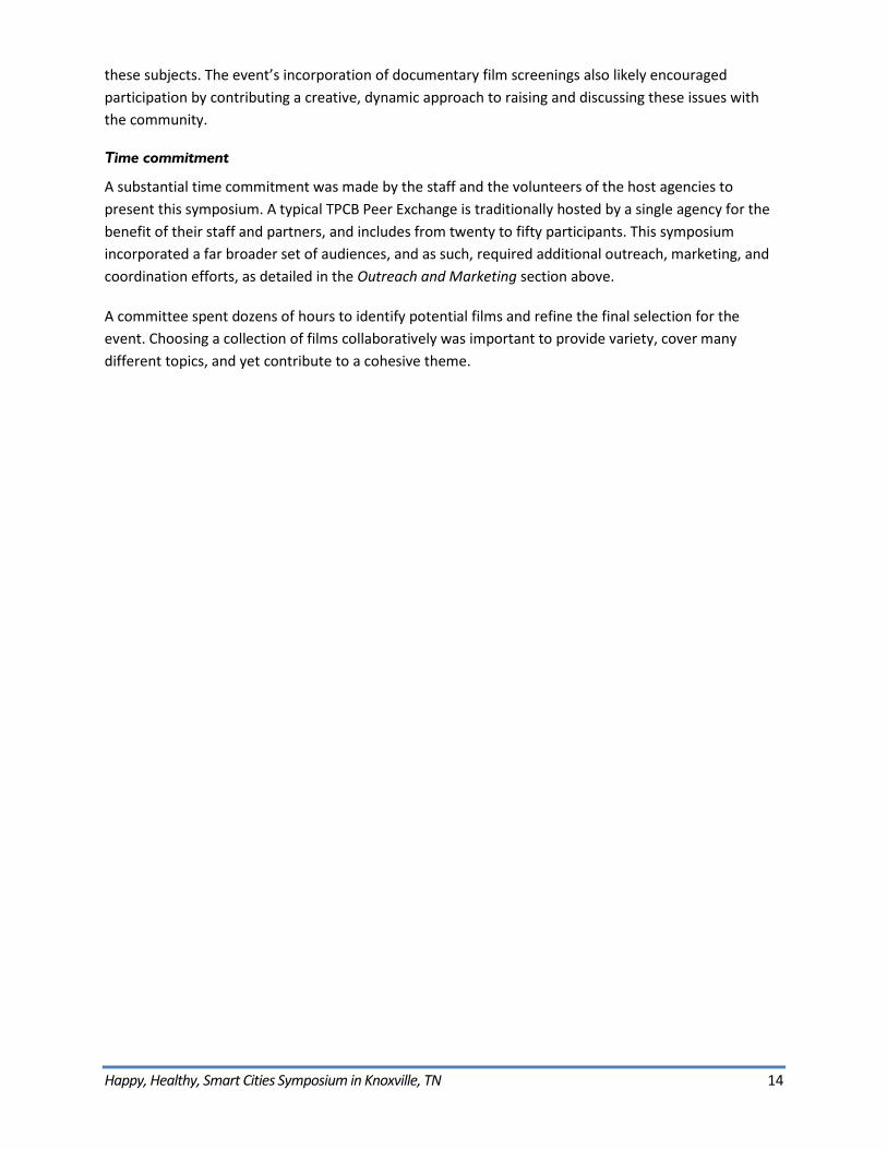
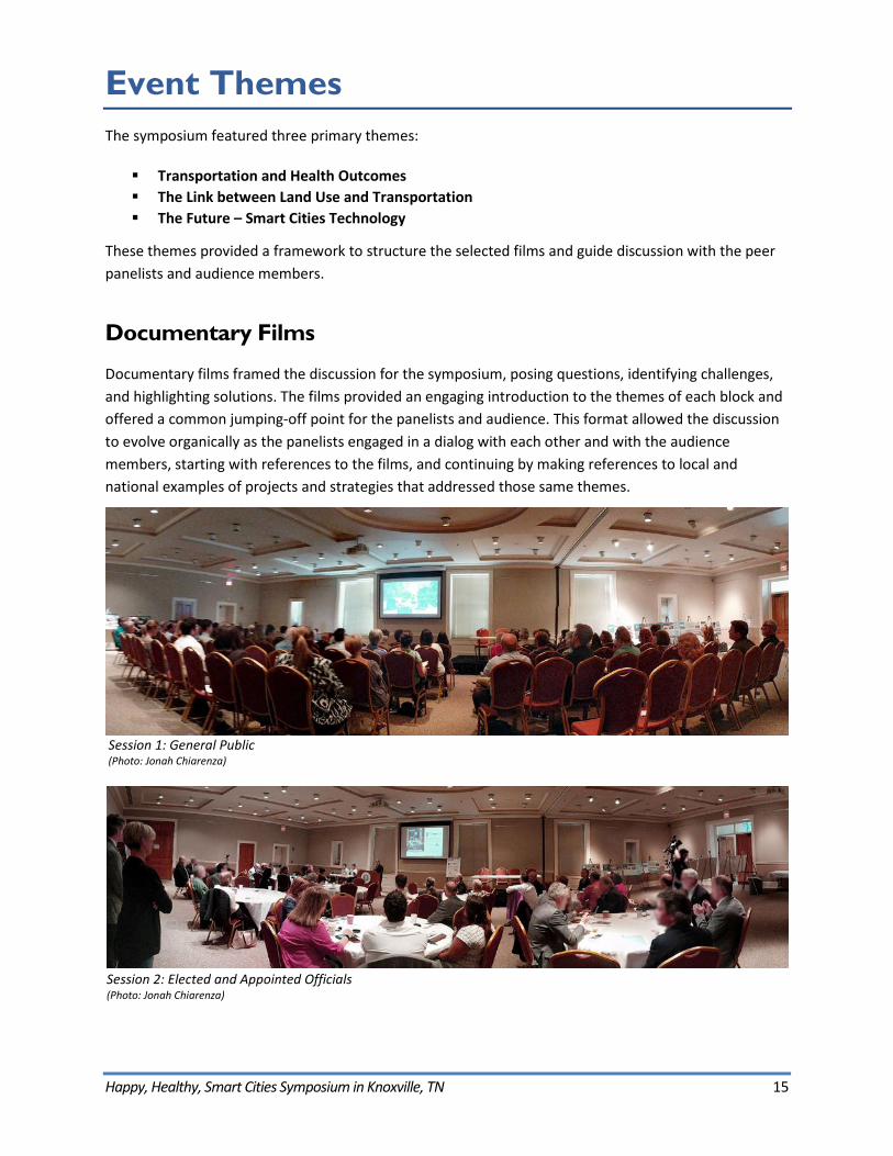
In total, nearly 200 people participated in the symposium. The event featured three separate sessions with a different audience invited to attend each:
Session 1: General Public Session 2: Elected and Appointed Officials Session 3: Planning and Design Professionals
Each session was oriented around blocks of short documentary films about transportation, land use, health, and technology. A facilitated discussion among the national and local peer panelists followed each block of films, providing a forum for dialog on these topics. The panel also responded to questions from the audience, encouraging attendees to engage in the discussion about challenges and solutions, as well as applicability of specific strategies to the Knoxville and East Tennessee region. The symposium featured three primary themes, which provided a framework for the films and served as a guide for discussion with the peer panelists and audience members:
Transportation and Health Outcomes The Link between Land Use and Transportation The Future: Smart Cities Technology
Happy, Healthy, Smart Cities Symposium in Knoxville, TN 6
Key Recommendations
Over the course of three sessions, and in response to the films shown, the symposium’s peer panelists and audience members raised complex challenges and identified innovative solutions to better connect people and places. Key recommendations from each of the symposium’s themes include the following:
Education and Involvement
Modernize outreach methods to include the participation and views of all community membersand stakeholders – from hosting events in project neighborhoods or attending standingstakeholder meetings, to harnessing new digital tools and using short-format films to stimulatediscussion and interaction.
Use pilot projects and phasing to test ideas in the real world and implement changes withgreater speed, more flexibility, and less risk.
Use outreach as a tool for educating decisionmakers and community members. Build inter-agency, inter-disciplinary, and community-wide partnerships that last from project
concept, through construction, and into the operations and maintenance stage. Institutionalizethese partnerships to support ongoing coordination.
Data and Community Design
Understand your community’s demographic and cultural trends through data-driven analysis. Model health and economic outcomes to communicate the broader benefits of active
transportation projects. Collect and use quantitative data and qualitative feedback to make informed decisions and
arguments in favor of certain projects. Set measurable goals to spur action and assess performance. Understand the trade-offs people make when making housing and transportation choices and
work to expand the range of choices available.
Strategies to Support Walking, Bicycling, and Transit
Consider the ability to walk to places as a fundamental necessity for any land use ortransportation project.
Understand the characteristics of land use patterns and transportation infrastructure thatsupport walking, bicycling, and transit use; understand the linkages required between land useand transportation to encourage travel via these modes.
Use engineering strategies to retrofit suburban arterial roads to make walking, bicycling, andtransit use safer, more efficient, and more comfortable options.
Prioritize safety improvements, especially those that reduce vehicle speeding. Develop “complete network” street polices to prioritize different modes on different streets. Implement small-scale changes to quickly test ideas and demonstrate visual evidence of
progress to community members and stakeholders. Match transit service to the population’s needs, and consider ways to improve connections to
and from transit stops, such as bikeshare programs or improved walking routes.
Happy, Healthy, Smart Cities Symposium in Knoxville, TN 7
Use a range of strategies to overcome place-based obstacles to active transportation use, suchas challenging topographic and climatic conditions.
Future Trends
Collaborate with public, private, and community members to understand the potential impactsof “smart cities” autonomous and connected vehicles and infrastructure technology (AV/CV andV2I).
Establish policies to maximize the benefits and minimize the impacts of AV/CV and V2I. Apply the lessons of the prior transportation revolution to present dialog and decisionmaking.
Conclusion
As transportation, housing and other options expand, transportation networks and their userswill need to accept greater variability in how they get around and use new tools to help themmake travel plans.
Consider streets as malleable places that can change quickly, slightly, or significantly, dependingon needs, context, funding, and other variables.
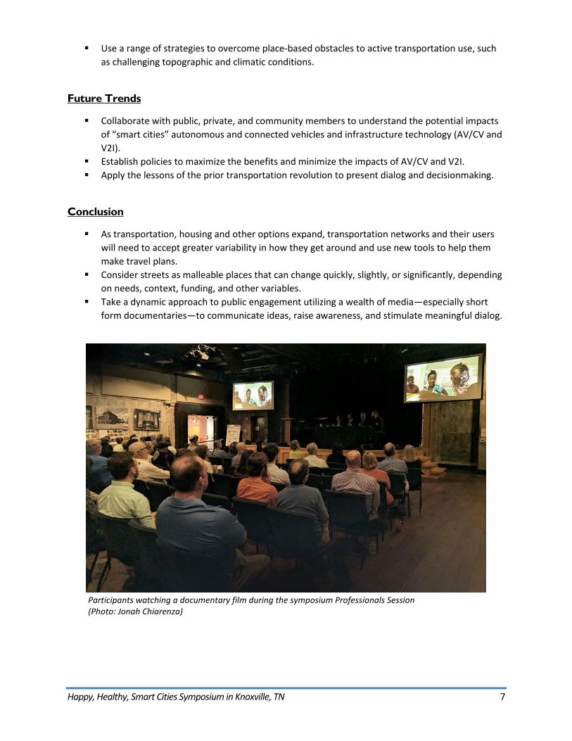
Take a dynamic approach to public engagement utilizing a wealth of media—especially shortform documentaries—to communicate ideas, raise awareness, and stimulate meaningful dialog.
Participants watching a documentary film during the symposium Professionals Session (Photo: Jonah Chiarenza)
Happy, Healthy, Smart Cities Symposium in Knoxville, TN 8
Background
What is a Happy, Healthy, Smart City?
As urban and suburban populations grow and change, our communities experience a myriad of impacts – housing costs, transportation options, job opportunities, health outcomes, education access,recreational opportunities, economic activity, environmental impacts, and social interactions, amongmany others. Cities and regions throughout the country are finding new and better ways to connectpeople and places, to steer all of us away from the negative impacts of change, and toward positiveoutcomes.
“Happy, healthy, smart” describes an environment in which people of all abilities are able to live full lives, with access to choices about where they live and how they
travel.
In the context of this symposium, “happy, healthy, smart” describes an environment in which people of all abilities are able to live full lives, with access to choices about where they live and how they travel. Traditional development patterns and transportation systems in the U.S. typically result in few choices: people are usually limited to housing options in predominantly residential neighborhoods that are separated from places of business, shopping, education, and recreation, with the only safe and convenient method of travel between them by personal vehicle. “Happy, healthy, smart” is meant to evoke the freedom and enjoyment that comes with being able to choose to live closer to places where one works, shops, learns, plays and exercises—or to have those places closer to where one wants to live. It also means being able to safely and conveniently travel to those places not just by car, but also by walking, riding a bike, or taking transit. As policy, planning, and technology evolve, places that seek to be “happy, healthy, and smart” should aim to increase access and opportunity by expanding these kinds of choices.
Happy, Healthy, Smart Cities Symposium in Knoxville, TN 9
Overview of Peer Exchange
Why is East Tennessee Interested in Happy, Healthy, Smart Cities Topics?
The City of Knoxville is preparing to update its zoning ordinance. The Knoxville Regional Transportation Planning Organization (TPO)—the Knoxville Urban Area’s Metropolitan Planning Organization (MPO)— recently completed a draft of the Mobility 2040 Long Range Transportation Plan. These updates to land use policy and transportation planning represent important opportunities to guide quality of life improvements in Eastern Tennessee.
To facilitate this, the TPO and the East Tennessee Community Design Center (ETCDC) collaborated to host a symposium that engages stakeholders—residents, business owners, community groups, public and private sector planning and design professionals, elected officials, and others—to think about ways to make the region happier, healthier, and smarter. It is important for the region to involve a broad coalition of community members to think about these issues. Connecting them with the zoning and transportation plan update processes will help to ensure that those guiding documents truly reflect the community’s desired direction for future investments; investments that will support health, improve quality of life, and leverage new strategies and technology to expand choice, access, and economic competitiveness.
Why a TPCB Peer Exchange?
The ETCDC and TPO host several annual and one-time events for the Knoxville area community. For this Happy, Healthy, Smart Symposium, these agencies sought the support of the U.S. Department of Transportation (USDOT) through the Federal Highway Administration (FHWA) and Federal Transit Administration’s (FTA) Transportation Planning Capacity Building (TPCB) Peer Program. As a recipient of TPCB Peer Program support, the TPO, in partnership with the ETCDC, benefited from coordination and funding that allowed the symposium to host two national peer panelists with expertise in land use policy, transportation planning, urban and roadway design, and community outreach. The TPCB program also funded the development of this report, which documents the event and will provide a resource to the host agencies, participants, and others who may have an interest in the themes, challenges, and solutions discussed during the symposium.
Who were the Hosts?
East Tennessee Community Design Center (ETCDC)
ETCDC is a nonprofit organization whose mission is to make East Tennessee a better place to live and work by bringing professional design and planning assistance to community groups and nonprofit
Happy, Healthy, Smart Cities Symposium in Knoxville, TN 10
organizations. ETCDC receives pro bono design assistance from area architects, landscape architects, planners and other professionals. The organization has been working in East Tennessee for nearly 50 years and has assisted with over 1000 projects in that time.
Knoxville Regional Transportation Planning Organization (TPO)
The TPO coordinates a comprehensive, multimodal transportation planning process for the Knoxville Urban Area. Member jurisdictions include Knox County and the urbanized areas of Anderson, Blount, Loudon, and Sevier Counties; and includes the following cities: Alcoa, Clinton, Knoxville, Lenoir City, Loudon, Maryville and Oak Ridge, and the Town of Farragut. As the Urban Area’s MPO, the TPO is a planning agency established by Federal law to assure that a continuing, cooperative, and comprehensive transportation planning process takes place, that it results in the development of plans, programs, and projects that consider all transportation modes, and that it will support the goals of the community.
Welcoming Remarks
Opening remarks at the three sessions were offered by representatives of the host agencies, local elected officials, and FHWA:
Jeff Welch, Executive Director of TPO Wayne Blasius, Executive Director of ETCDC Rick Blackburn, President of ETCDC Diane Davidson, Board Member of ETCDC and Program Chair Mayor Terry Frank, Anderson County and Vice Chair TPO Mayor Tim Burchett, Knox County Mayor Madeline Rogero, City of Knoxville Councilmember Marshall Stair, City of Knoxville Pamela Kordenbrock, FHWA Tennessee Division Administrator Victoria Martinez, FHWA Office of Natural Environment
Who were the Peers?
National Peers
The FHWA/FTA TPCB Peer Program coordinated and funded the participation of the following national experts as peer panelists for the symposium:
Philip Erickson, AIA, President of Community Design + Architecture, a city planning and urban design firm based in Oakland, California. Mr. Erickson is a planner, urban designer, and architect with extensive experience in community and urban design, land use and transportation planning, site planning, street design, and architecture. Mr. Erickson has worked with urban, suburban, and rural communities to help them transform their streets and places through planning, design, and
Happy, Healthy, Smart Cities Symposium in Knoxville, TN 11
policy to support walking, biking, and transit use. He has authored national standards for the integration of street design, land use planning, and urban stormwater management.
David Vega-Barachowitz, Senior Urban Designer with the New York City Department of City Planning. Mr. Vega-Barachowitz has worked on projects from transportation planning, street design, and placemaking, to local government innovation, master planning, open space development, and urban design. Mr. Vega-Barachowitz led the development of innovative street design guidelines to promote walking and bicycling as the Director of the Designing Cities Initiative at the National Association of City Transportation Officials (NACTO) in New York, NY. He co-authored Start-up City: Inspiring Private and Public Entrepreneurship, Getting Projects Done, and Having Fun (Island Press, 2015), which showcases how innovative ideas that start as simple pilot projects can grow from experiments into major improvements that support healthier, more active lifestyles.
Local Peers
Local experts in planning, architecture, landscape architecture, and transportation also participated in certain blocks of the peer panels, augmenting the dialog with their knowledge of local Knoxville area issues and projects.
Belinda Woodiel-Brill, Director of Communications and Service Development for Knoxville Area Transit (KAT). As Director of Communications and Service Development, she handles route and service planning, as well as marketing and media relations, and oversees communications, customer service and outreach.
William “Bill” Bruce, Jr. MLA, Principal-in-Charge of the Knoxville office of CRJA-IBI Group. Mr. Bruce has over 30 years of experience in community planning and design, and has contributed to the development of over 200 projects throughout the country. Designing4Health, a firm he co-founded, has teamed with CRJA-IBI to develop a Health Design Assessment™, an innovative process that aims to improve the wellbeing of communities and project sites through evidence-based design.
Gerald Green, AICP, the Executive Director of the Knoxville-Knox County Metropolitan Planning Commission. Mr. Green has served as Principal Planner for the East Tennessee Development District, Senior Planner and Chief Planner for the City of Asheville, N.C., and in private practice as owner of NFocus Planning and Design in Asheville. Prior to coming to Knoxville in 2015, he was the Planning Director of Jackson County, NC.
Marshall Stair is a member of the Knoxville City Council. He has worked in a number of different cities including New Orleans, LA; Houston, TX; Austin, TX, Chicago, IL, and Mexico City, Mexico. Councilmember Stair attended the University of Tennessee College of Law, during which time he worked for the United States Department of Labor enforcing Federal employment laws throughout East Tennessee. He is an attorney with a general civil litigation practice focused on employment law at the law firm of Lewis, King, Krieg & Waldrop, P.C.
Happy, Healthy, Smart Cities Symposium in Knoxville, TN 12
Jeff Welch, AICP, Director of the Knoxville Regional Transportation Planning Organization (TPO). Jeff has served as TPO Director since 1985. He has over 35 years of experience in the field of transportation planning, and has worked in Dubuque, IA and Sioux Falls, SD in addition to Knoxville.
Mike Thompson, Research Fellow with the Nashville Civic Design Center (NCDC). Mr. Thompson has worked in over 20 different cities across the country, including large urban communities and Native American reservations. Mr. Thompson joined NCDC in January 2016 and created the Active Building Guidelines in collaboration with the TN Department of Health, and the Neighborhood Assessment Toolkit. He assists with an array of NCDC projects, including management of a statewide taskforce on Health and the Built Environment.
Andy Powers, AIA, Director of Design Services for the University of Tennessee (UT) Facilities Services. Mr. Powers has worked for a number of local Knoxville design firms for much of his career serving as an architect for UT projects. He has worked on nearly thirty projects at UT, leading the office’s professional design advice on campus aesthetics, technical details, and master plans.
Wayne Blasius is the Executive Director of the East Tennessee Community Design Center (ETCDC). Mr. Blasius’s career has been balanced in both the public and private sectors, spanning planning, community development, construction, real estate development and management, plus consulting in real estate, strategic planning and energy management. His firm, InSite Development, spearheaded notable downtown redevelopments like The Phoenix and Mast General Store/Gallery Lofts.
Peer Exchange Format
Symposium sessions
The event featured three separate sessions, with each catering to a different audience:
Session 1: General Public Session 2: Elected and Appointed Officials Session 3: Planning and Design Professionals
Each session was oriented around blocks of short documentary films about transportation, land use, health, and technology. A facilitated discussion among the peer panelists followed each block of films, providing a forum for dialog on these topics. The panel also responded to questions from the audience, encouraging attendees to engage in the discussion about challenges and solutions, as well as applicability of specific strategies to the Knoxville and East Tennessee region.
For the public and professional sessions, three blocks of films were shown, representing the following themes: transportation and health outcomes, the link between transportation and land use, and smart cities. A facilitated peer panel discussion and dialog with participants was held after each of the first two blocks, and brief comments from the panelists and TPO Executive Director Jeff Welch followed the final block on smart cities. For the session directed toward elected and appointed officials, a single block of
Happy, Healthy, Smart Cities Symposium in Knoxville, TN 13
films was shown, followed by a facilitated peer panel discussion and dialog with participants. Introductions to each session were provided by representatives of the host agencies, local elected officials, the FHWA Tennessee Division Office, and the FHWA Office of Planning, Environment and Realty.
Each session included opportunities for networking with other participants and the panelists. Prior to the event, the host agencies escorted the national peers and FHWA and USDOT staff on a tour of downtown Knoxville and environs to provide some additional familiarity with the local context.
See the detailed schedule in Appendix B: Peer Exchange Agenda for more information, and see Appendix C: Key Resources for links to video recordings of the first two sessions.
Roles and responsibilities
The symposium was planned and organized by the host agencies, ETCDC and the TPO. The host agencies identified and booked the venues, selected the documentary films, and arranged the local peer panelists. Staff from several Federal and State agencies assisted in the planning of the event, including identification of the national panelists and coordination of their participation, and the development of a detailed agenda including discussion topics for the panelists. The agencies included the FHWA Office of Planning, Environment and Realty (including staff leads for the TPCB Program), the FTA Office of Planning and Environment, the USDOT Volpe Center, the FHWA Tennessee Division Office, and the Tennessee Department of Transportation (TDOT).
Outreach and marketing
The symposium sessions catered to three distinct audiences: public, professional, and elected or appointed officials. As such, a multifaceted marketing and outreach effort was critical to the event’s success. In addition to publicizing the events through their websites and mailing lists, the host agencies created event pages on Facebook, and publicized through other social media channels. A flyer was distributed at local events and via email, and media pitches were made to local news outlets and blogs, several of which picked up and publicized the symposium. Additional effort went into encouraging attendance by elected and appointed officials through personal invitations. Professional planning and design staff were targeted by disseminating information to local professional organizations including the American Institute of Architects, American Planning Association, and the American Society of Landscape Architects among many others. In addition, continuing education units were secured for some of the professional organizations, which further incentivized professionals’ participation.
Event format and lessons learned
Successful turnout
Nearly 200 people participated in the Happy, Healthy, Smart Cities symposium over the course of the three sessions. This turnout suggests that people understand the impacts that transportation and land use decisions have on their health, safety, and quality of life, and are interested in learning more about
Happy, Healthy, Smart Cities Symposium in Knoxville, TN 14
these subjects. The event’s incorporation of documentary film screenings also likely encouraged participation by contributing a creative, dynamic approach to raising and discussing these issues with the community.
Time commitment
A substantial time commitment was made by the staff and the volunteers of the host agencies to present this symposium. A typical TPCB Peer Exchange is traditionally hosted by a single agency for the benefit of their staff and partners, and includes from twenty to fifty participants. This symposium incorporated a far broader set of audiences, and as such, required additional outreach, marketing, and coordination efforts, as detailed in the Outreach and Marketing section above.
A committee spent dozens of hours to identify potential films and refine the final selection for the event. Choosing a collection of films collaboratively was important to provide variety, cover many different topics, and yet contribute to a cohesive theme.
Happy, Healthy, Smart Cities Symposium in Knoxville, TN 15
Event Themes The symposium featured three primary themes:
Transportation and Health Outcomes The Link between Land Use and Transportation The Future – Smart Cities Technology
These themes provided a framework to structure the selected films and guide discussion with the peer panelists and audience members.
Documentary Films
Documentary films framed the discussion for the symposium, posing questions, identifying challenges, and highlighting solutions. The films provided an engaging introduction to the themes of each block and offered a common jumping-off point for the panelists and audience. This format allowed the discussion to evolve organically as the panelists engaged in a dialog with each other and with the audience members, starting with references to the films, and continuing by making references to local and national examples of projects and strategies that addressed those same themes.
Session 1: General Public (Photo: Jonah Chiarenza)
Session 2: Elected and Appointed Officials (Photo: Jonah Chiarenza)
Happy, Healthy, Smart Cities Symposium in Knoxville, TN 16
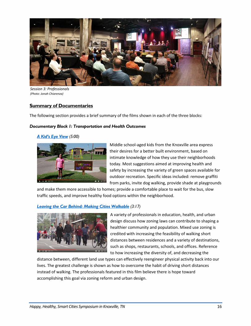
Session 3: Professionals (Photo: Jonah Chiarenza)
Summary of Documentaries
The following section provides a brief summary of the films shown in each of the three blocks:
Documentary Block 1: Transportation and Health Outcomes
A Kid’s Eye View (5:00)
Middle school-aged kids from the Knoxville area express their desires for a better built environment, based on intimate knowledge of how they use their neighborhoods today. Most suggestions aimed at improving health and safety by increasing the variety of green spaces available for outdoor recreation. Specific ideas included: remove graffiti from parks, invite dog walking, provide shade at playgrounds
and make them more accessible to homes; provide a comfortable place to wait for the bus, slow traffic speeds, and improve healthy food options within the neighborhood.
Leaving the Car Behind: Making Cities Walkable (3:17)
A variety of professionals in education, health, and urban design discuss how zoning laws can contribute to shaping a healthier community and population. Mixed use zoning is credited with increasing the feasibility of walking short distances between residences and a variety of destinations, such as shops, restaurants, schools, and offices. Reference to how increasing the diversity of, and decreasing the
distance between, different land use types can effectively reengineer physical activity back into our lives. The greatest challenge is shown as how to overcome the habit of driving short distances instead of walking. The professionals featured in this film believe there is hope toward accomplishing this goal via zoning reform and urban design.
Happy, Healthy, Smart Cities Symposium in Knoxville, TN 17
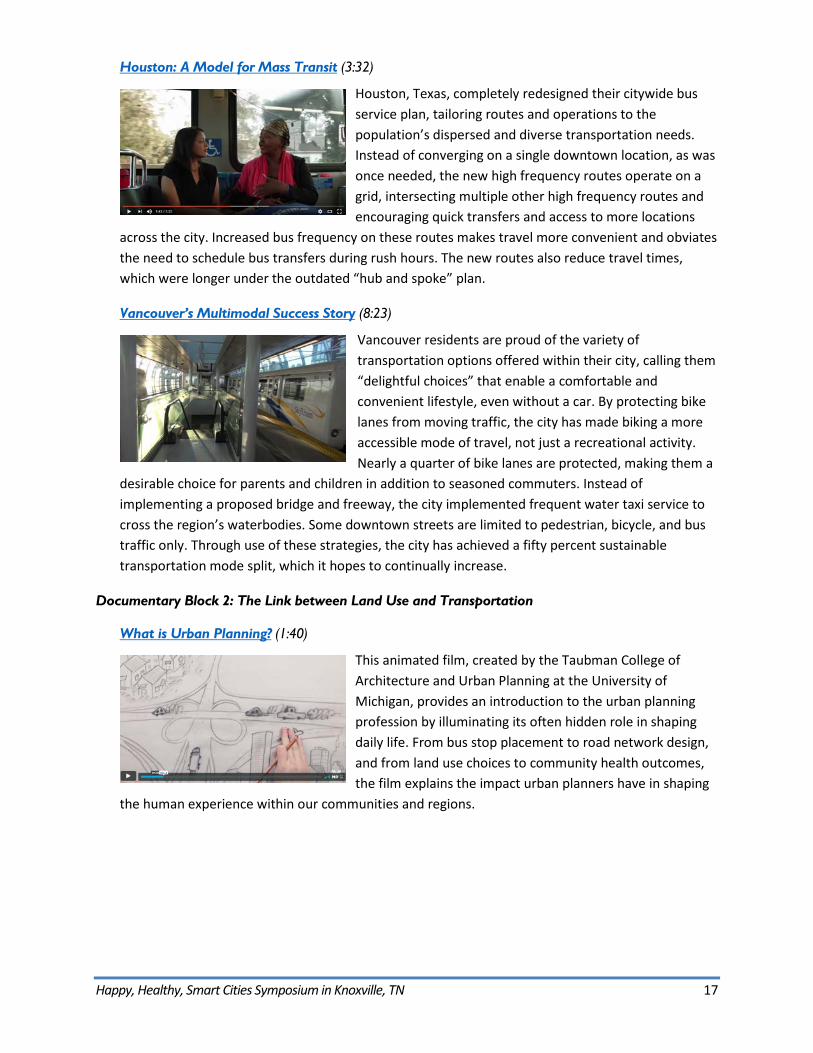
Houston: A Model for Mass Transit (3:32)
Houston, Texas, completely redesigned their citywide bus service plan, tailoring routes and operations to the population’s dispersed and diverse transportation needs. Instead of converging on a single downtown location, as was once needed, the new high frequency routes operate on a grid, intersecting multiple other high frequency routes and encouraging quick transfers and access to more locations
across the city. Increased bus frequency on these routes makes travel more convenient and obviates the need to schedule bus transfers during rush hours. The new routes also reduce travel times, which were longer under the outdated “hub and spoke” plan.
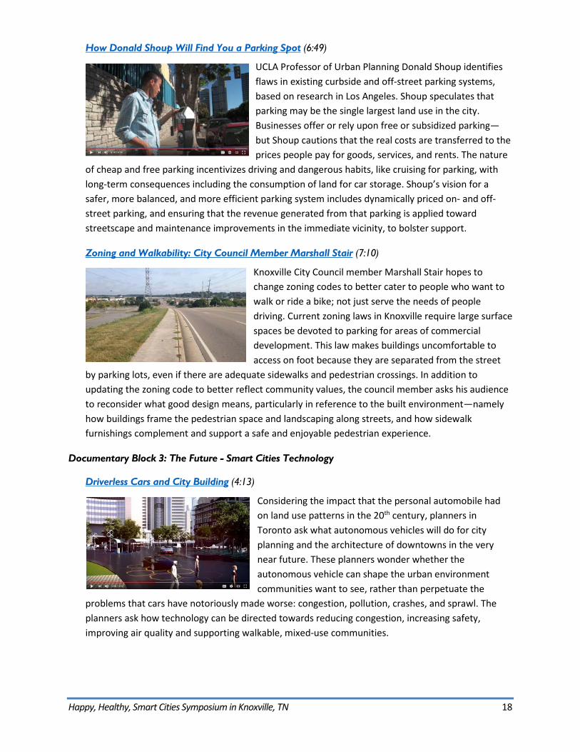
Vancouver’s Multimodal Success Story (8:23)
Vancouver residents are proud of the variety of transportation options offered within their city, calling them “delightful choices” that enable a comfortable and convenient lifestyle, even without a car. By protecting bike lanes from moving traffic, the city has made biking a more accessible mode of travel, not just a recreational activity. Nearly a quarter of bike lanes are protected, making them a
desirable choice for parents and children in addition to seasoned commuters. Instead of implementing a proposed bridge and freeway, the city implemented frequent water taxi service to cross the region’s waterbodies. Some downtown streets are limited to pedestrian, bicycle, and bus traffic only. Through use of these strategies, the city has achieved a fifty percent sustainable transportation mode split, which it hopes to continually increase.
Documentary Block 2: The Link between Land Use and Transportation
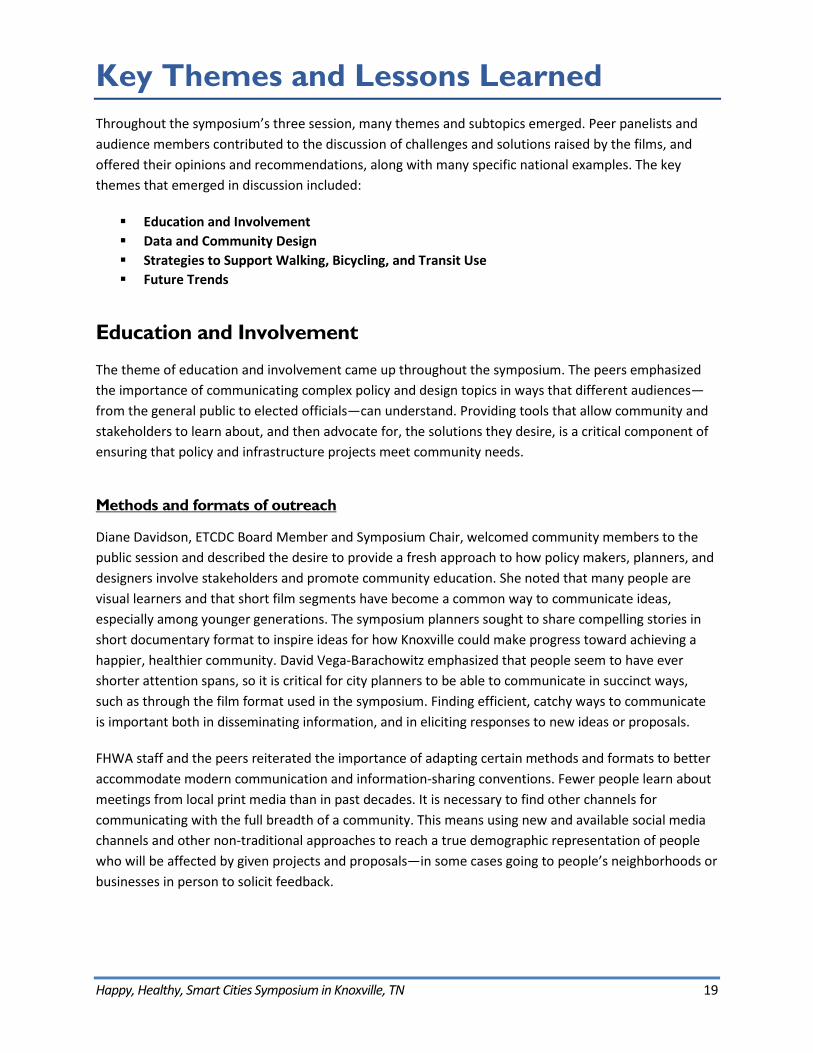
What is Urban Planning? (1:40)
This animated film, created by the Taubman College of Architecture and Urban Planning at the University of Michigan, provides an introduction to the urban planning profession by illuminating its often hidden role in shaping daily life. From bus stop placement to road network design, and from land use choices to community health outcomes, the film explains the impact urban planners have in shaping
the human experience within our communities and regions.
Happy, Healthy, Smart Cities Symposium in Knoxville, TN 18
How Donald Shoup Will Find You a Parking Spot (6:49)
UCLA Professor of Urban Planning Donald Shoup identifies flaws in existing curbside and off-street parking systems, based on research in Los Angeles. Shoup speculates that parking may be the single largest land use in the city. Businesses offer or rely upon free or subsidized parking—but Shoup cautions that the real costs are transferred to the prices people pay for goods, services, and rents. The nature
of cheap and free parking incentivizes driving and dangerous habits, like cruising for parking, with long-term consequences including the consumption of land for car storage. Shoup’s vision for a safer, more balanced, and more efficient parking system includes dynamically priced on- and off-street parking, and ensuring that the revenue generated from that parking is applied toward streetscape and maintenance improvements in the immediate vicinity, to bolster support.
Zoning and Walkability: City Council Member Marshall Stair (7:10)
Knoxville City Council member Marshall Stair hopes to change zoning codes to better cater to people who want to walk or ride a bike; not just serve the needs of people driving. Current zoning laws in Knoxville require large surface spaces be devoted to parking for areas of commercial development. This law makes buildings uncomfortable to access on foot because they are separated from the street
by parking lots, even if there are adequate sidewalks and pedestrian crossings. In addition to updating the zoning code to better reflect community values, the council member asks his audience to reconsider what good design means, particularly in reference to the built environment—namely how buildings frame the pedestrian space and landscaping along streets, and how sidewalk furnishings complement and support a safe and enjoyable pedestrian experience.
Documentary Block 3: The Future - Smart Cities Technology
Driverless Cars and City Building (4:13)
Considering the impact that the personal automobile had on land use patterns in the 20th century, planners in Toronto ask what autonomous vehicles will do for city planning and the architecture of downtowns in the very near future. These planners wonder whether the autonomous vehicle can shape the urban environment communities want to see, rather than perpetuate the
problems that cars have notoriously made worse: congestion, pollution, crashes, and sprawl. The planners ask how technology can be directed towards reducing congestion, increasing safety, improving air quality and supporting walkable, mixed-use communities.
Happy, Healthy, Smart Cities Symposium in Knoxville, TN 19
Key Themes and Lessons Learned Throughout the symposium’s three session, many themes and subtopics emerged. Peer panelists and audience members contributed to the discussion of challenges and solutions raised by the films, and offered their opinions and recommendations, along with many specific national examples. The key themes that emerged in discussion included:
Education and Involvement Data and Community Design Strategies to Support Walking, Bicycling, and Transit Use Future Trends
Education and Involvement
The theme of education and involvement came up throughout the symposium. The peers emphasized the importance of communicating complex policy and design topics in ways that different audiences—from the general public to elected officials—can understand. Providing tools that allow community and stakeholders to learn about, and then advocate for, the solutions they desire, is a critical component of ensuring that policy and infrastructure projects meet community needs.
Methods and formats of outreach
Diane Davidson, ETCDC Board Member and Symposium Chair, welcomed community members to the public session and described the desire to provide a fresh approach to how policy makers, planners, and designers involve stakeholders and promote community education. She noted that many people are visual learners and that short film segments have become a common way to communicate ideas, especially among younger generations. The symposium planners sought to share compelling stories in short documentary format to inspire ideas for how Knoxville could make progress toward achieving a happier, healthier community. David Vega-Barachowitz emphasized that people seem to have ever shorter attention spans, so it is critical for city planners to be able to communicate in succinct ways, such as through the film format used in the symposium. Finding efficient, catchy ways to communicate is important both in disseminating information, and in eliciting responses to new ideas or proposals.
FHWA staff and the peers reiterated the importance of adapting certain methods and formats to better accommodate modern communication and information-sharing conventions. Fewer people learn about meetings from local print media than in past decades. It is necessary to find other channels for communicating with the full breadth of a community. This means using new and available social media channels and other non-traditional approaches to reach a true demographic representation of people who will be affected by given projects and proposals—in some cases going to people’s neighborhoods or businesses in person to solicit feedback.
Happy, Healthy, Smart Cities Symposium in Knoxville, TN 20
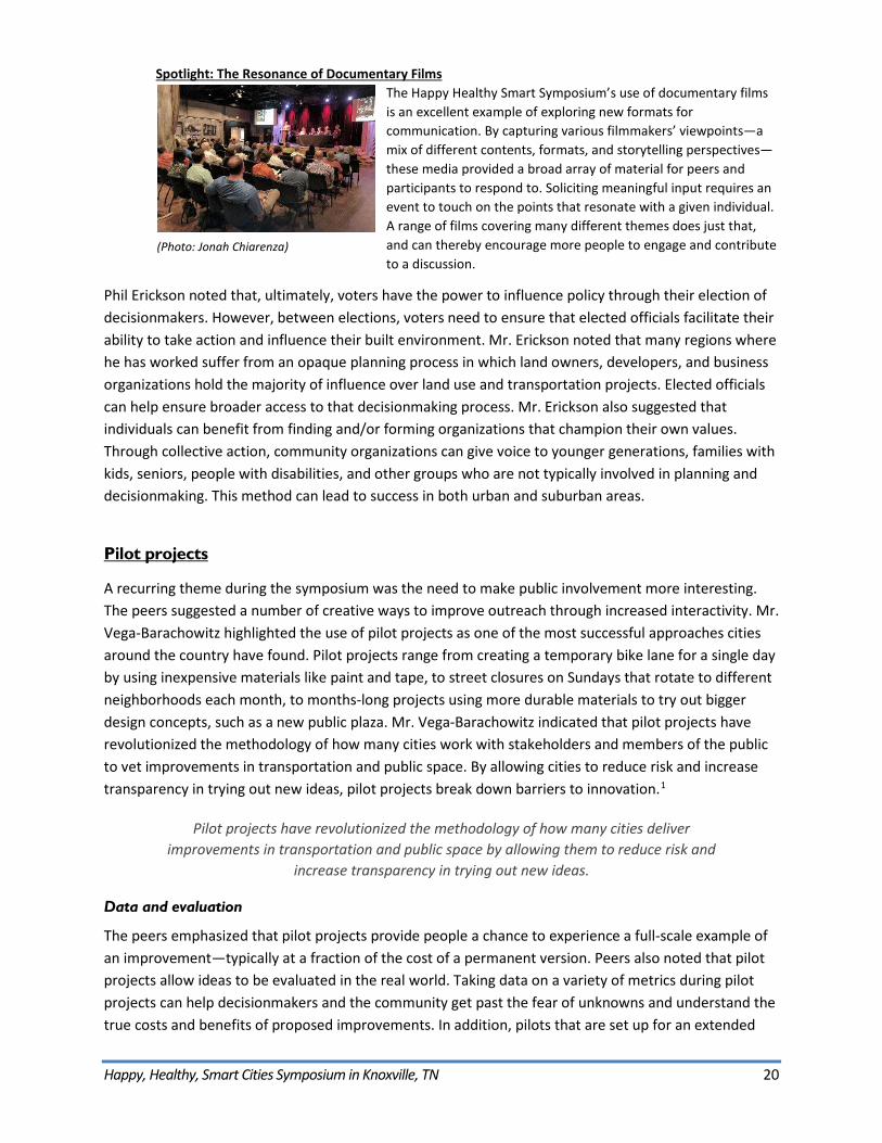
Spotlight: The Resonance of Documentary Films The Happy Healthy Smart Symposium’s use of documentary films is an excellent example of exploring new formats for communication. By capturing various filmmakers’ viewpoints—a mix of different contents, formats, and storytelling perspectives—these media provided a broad array of material for peers and participants to respond to. Soliciting meaningful input requires an event to touch on the points that resonate with a given individual. A range of films covering many different themes does just that, and can thereby encourage more people to engage and contribute to a discussion.
Phil Erickson noted that, ultimately, voters have the power to influence policy through their election of decisionmakers. However, between elections, voters need to ensure that elected officials facilitate their ability to take action and influence their built environment. Mr. Erickson noted that many regions where he has worked suffer from an opaque planning process in which land owners, developers, and business organizations hold the majority of influence over land use and transportation projects. Elected officials can help ensure broader access to that decisionmaking process. Mr. Erickson also suggested that individuals can benefit from finding and/or forming organizations that champion their own values. Through collective action, community organizations can give voice to younger generations, families with kids, seniors, people with disabilities, and other groups who are not typically involved in planning and decisionmaking. This method can lead to success in both urban and suburban areas.
Pilot projects
A recurring theme during the symposium was the need to make public involvement more interesting. The peers suggested a number of creative ways to improve outreach through increased interactivity. Mr. Vega-Barachowitz highlighted the use of pilot projects as one of the most successful approaches cities around the country have found. Pilot projects range from creating a temporary bike lane for a single day by using inexpensive materials like paint and tape, to street closures on Sundays that rotate to different neighborhoods each month, to months-long projects using more durable materials to try out bigger design concepts, such as a new public plaza. Mr. Vega-Barachowitz indicated that pilot projects have revolutionized the methodology of how many cities work with stakeholders and members of the public to vet improvements in transportation and public space. By allowing cities to reduce risk and increase transparency in trying out new ideas, pilot projects break down barriers to innovation.1
Pilot projects have revolutionized the methodology of how many cities deliver improvements in transportation and public space by allowing them to reduce risk and
increase transparency in trying out new ideas.
Data and evaluation
The peers emphasized that pilot projects provide people a chance to experience a full-scale example of an improvement—typically at a fraction of the cost of a permanent version. Peers also noted that pilot projects allow ideas to be evaluated in the real world. Taking data on a variety of metrics during pilot projects can help decisionmakers and the community get past the fear of unknowns and understand the true costs and benefits of proposed improvements. In addition, pilots that are set up for an extended
(Photo: Jonah Chiarenza)
Happy, Healthy, Smart Cities Symposium in Knoxville, TN 21
timeframe can be modified to test different arrangements and compare the costs and benefits between various options. The data collected should include quantitative values such as traffic volumes and speeds, pedestrian volumes and dwell times, and business revenues, as well as qualitative feedback from user surveys. It is important to ensure pilot projects are planned with enough time to provide useful data collection and user feedback.
Agency and influence
Mr. Erickson stated that planning agencies should be responsible for pursuing pilots and other, more engaging approaches to public outreach. However, he reiterated that community members can participate as well through neighborhood and advocacy organizations, and even by developing and implementing their own pilot concepts. Members of the symposium’s public audience described examples of engaging in “tactical urbanism” to make their own improvements in landscaping and pedestrian access in their neighborhoods, which called city officials’ attention to their needs.
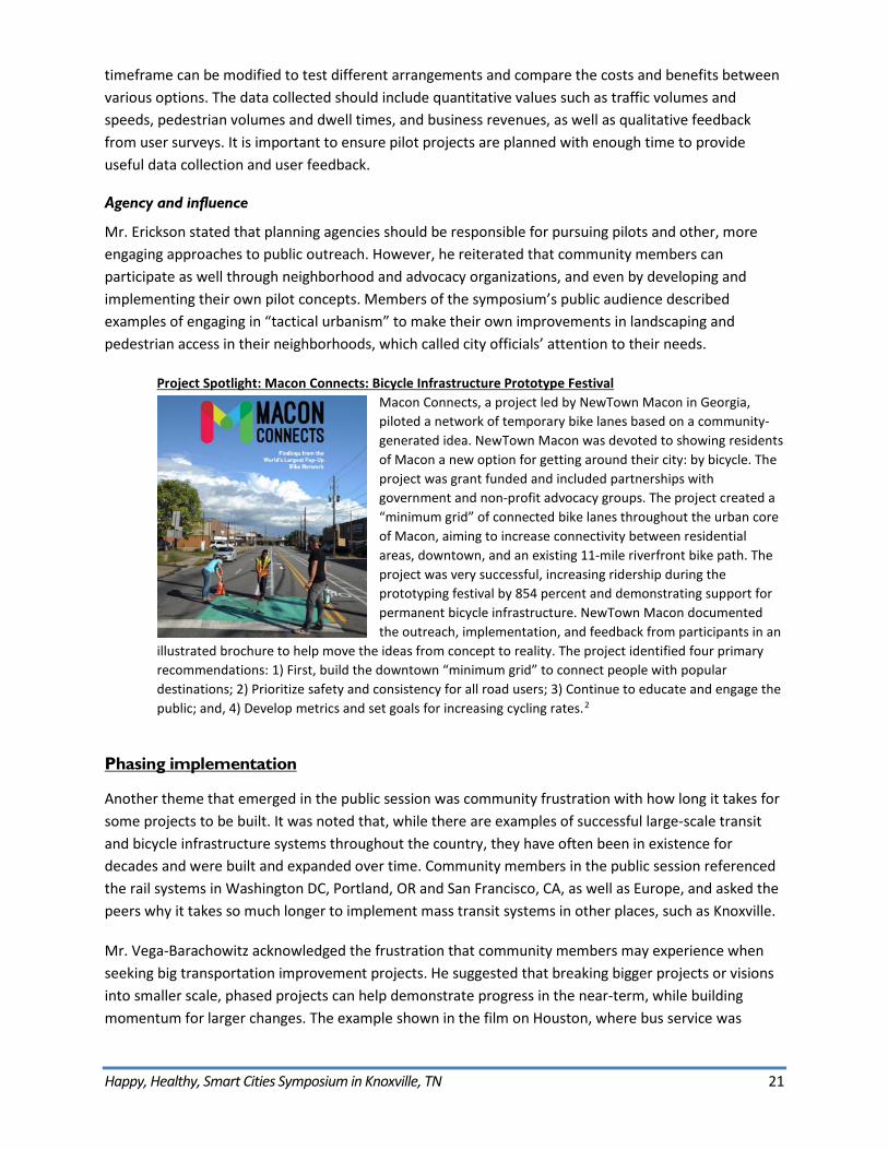
Project Spotlight: Macon Connects: Bicycle Infrastructure Prototype Festival Macon Connects, a project led by NewTown Macon in Georgia, piloted a network of temporary bike lanes based on a community-generated idea. NewTown Macon was devoted to showing residents of Macon a new option for getting around their city: by bicycle. The project was grant funded and included partnerships with government and non-profit advocacy groups. The project created a “minimum grid” of connected bike lanes throughout the urban core of Macon, aiming to increase connectivity between residential areas, downtown, and an existing 11-mile riverfront bike path. The project was very successful, increasing ridership during the prototyping festival by 854 percent and demonstrating support for permanent bicycle infrastructure. NewTown Macon documented the outreach, implementation, and feedback from participants in an
illustrated brochure to help move the ideas from concept to reality. The project identified four primary recommendations: 1) First, build the downtown “minimum grid” to connect people with popular destinations; 2) Prioritize safety and consistency for all road users; 3) Continue to educate and engage the public; and, 4) Develop metrics and set goals for increasing cycling rates.2
Phasing implementation
Another theme that emerged in the public session was community frustration with how long it takes for some projects to be built. It was noted that, while there are examples of successful large-scale transit and bicycle infrastructure systems throughout the country, they have often been in existence for decades and were built and expanded over time. Community members in the public session referenced the rail systems in Washington DC, Portland, OR and San Francisco, CA, as well as Europe, and asked the peers why it takes so much longer to implement mass transit systems in other places, such as Knoxville.
Mr. Vega-Barachowitz acknowledged the frustration that community members may experience when seeking big transportation improvement projects. He suggested that breaking bigger projects or visions into smaller scale, phased projects can help demonstrate progress in the near-term, while building momentum for larger changes. The example shown in the film on Houston, where bus service was
Happy, Healthy, Smart Cities Symposium in Knoxville, TN 22
redesigned to better suit customer needs, demonstrated that such a project could be the first step toward eventually upgrading popular service lines to Bus Rapid Transit (BRT) or even Light Rail Transit (LRT). By taking smaller, achievable steps with available time and resources while maintaining a vision for the future, Houston is achieving progress that will help encourage transit system use, and ridership and revenue growth, which can in turn incentivize further investment. Subsequent phases can continue building on these successes. In addition, providing small improvements that encourage new users broadens the base of people who can advocate for further improvements as part of a virtuous cycle.
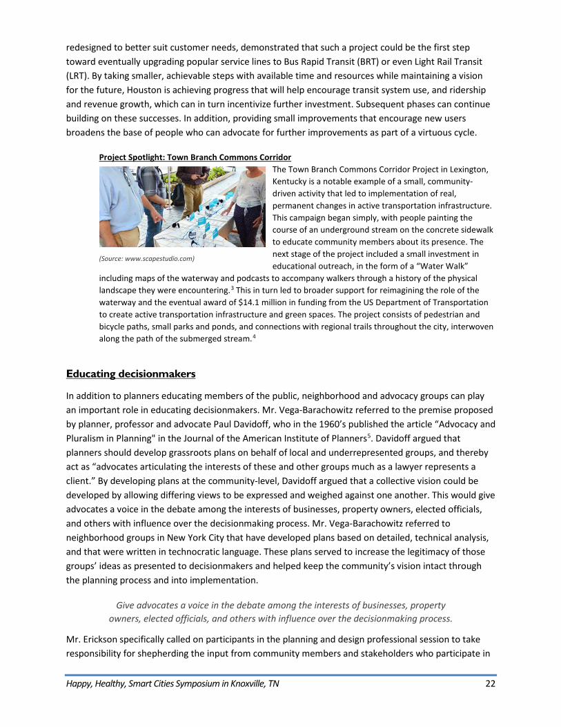
Project Spotlight: Town Branch Commons Corridor The Town Branch Commons Corridor Project in Lexington, Kentucky is a notable example of a small, community-driven activity that led to implementation of real, permanent changes in active transportation infrastructure. This campaign began simply, with people painting the course of an underground stream on the concrete sidewalk to educate community members about its presence. The next stage of the project included a small investment ineducational outreach, in the form of a “Water Walk”
including maps of the waterway and podcasts to accompany walkers through a history of the physical landscape they were encountering.3 This in turn led to broader support for reimagining the role of the waterway and the eventual award of $14.1 million in funding from the US Department of Transportation to create active transportation infrastructure and green spaces. The project consists of pedestrian and bicycle paths, small parks and ponds, and connections with regional trails throughout the city, interwoven along the path of the submerged stream.4
Educating decisionmakers
In addition to planners educating members of the public, neighborhood and advocacy groups can play an important role in educating decisionmakers. Mr. Vega-Barachowitz referred to the premise proposed by planner, professor and advocate Paul Davidoff, who in the 1960’s published the article “Advocacy and Pluralism in Planning" in the Journal of the American Institute of Planners5. Davidoff argued that planners should develop grassroots plans on behalf of local and underrepresented groups, and thereby act as “advocates articulating the interests of these and other groups much as a lawyer represents a client.” By developing plans at the community-level, Davidoff argued that a collective vision could be developed by allowing differing views to be expressed and weighed against one another. This would give advocates a voice in the debate among the interests of businesses, property owners, elected officials, and others with influence over the decisionmaking process. Mr. Vega-Barachowitz referred to neighborhood groups in New York City that have developed plans based on detailed, technical analysis, and that were written in technocratic language. These plans served to increase the legitimacy of those groups’ ideas as presented to decisionmakers and helped keep the community’s vision intact through the planning process and into implementation.
Give advocates a voice in the debate among the interests of businesses, property owners, elected officials, and others with influence over the decisionmaking process.
Mr. Erickson specifically called on participants in the planning and design professional session to take responsibility for shepherding the input from community members and stakeholders who participate in
(Source: www.scapestudio.com)
Happy, Healthy, Smart Cities Symposium in Knoxville, TN 23
a planning process. He remarked that professionals in these fields have a duty not only to create a planning process that involves and challenges participants, but also to ensure that the input from that process remains part of the conversation throughout the subsequent stages of planning, engineering, funding, and implementation.
Educating ourselves
In the face of potential frustration with existing transportation options, the peers recommended participants try out new travel modes, even if they were not necessarily convenient for daily needs. Mr. Vega-Barachowitz referenced the value of bikeshare programs in getting people who might not otherwise ride to experience what bicycling in an urban environment is like. Belinda Woodiel-Brill suggested people experiment by taking a trip by bus, or by using a different bus route than they typically take. She asked participants to consider “changing our common national narrative of ‘how fast can I get there’ to ‘how am I spending my precious time?’” The difference is slight, but suggests people consider the other benefits they can incorporate into their trips beyond just speed. If people can relax and read a book on the bus, incorporate a walk to and from the bus stop, or get exercise by riding a bike, they can get more value out of their travel time, even if that time is a little longer.
Pamela Kordenbrock and Ms. Woodiel-Brill elaborated that these experiences with different travel modes allow people to develop personal opinions about them, and become advocates for transportation improvements. Ms. Kordenbrock noted that organized opposition to transportation and land use planning is common, but that organized support would be incredibly helpful as people become more familiar with possible improvements and lend support to their implementation.
Partnerships
Partnerships between disciplines and agencies
Ms. Kordenbrock welcomed participants to each session by underscoring that FHWA understands transportation as a system that incorporates more than just vehicles and highways, including facilities and connections for people taking transit, riding bikes and walking. For the planning professionals’ session, Ms. Kordenbrock specifically highlighted the need for those working in the public sector to help community members and other partners to understand the relationships between these modes. Developing strong partnerships between the various agencies responsible for the discrete segments of the transportation system is a key to ensuring those agencies have the capacity and the desire to build the best, most responsive, and most integrated transportation system.
One or two disciplines alone cannot effectively build places where the needs of everyone from kids to seniors are effectively met; design and planning professionals
along with elected officials, public health professionals, economists, lawyers, advocates, and others must collaborate to realize the best plans.
Mr. Erickson surveyed the room of professionals in the third session to ask how many participants were architects, landscape architects, city planners, urban designers, civil engineers, transportation planners, or developers. He then revealed that this was a “trick question,” maintaining that people in all of these
Happy, Healthy, Smart Cities Symposium in Knoxville, TN 24
professions are urban designers in that they each play a role in shaping the built environment. Mr. Erickson described the projects he most enjoys as partnerships with people from other disciplines who understand that their core mission is to build an urban environment to serve people. He further emphasized the collaborative nature of creating such places. One or two disciplines alone cannot effectively build places where the needs of everyone from kids to seniors are effectively met; design and planning professions along with elected officials, public health professionals, economists, lawyers, advocates, and others must collaborate to realize the best plans.
Inter-agency and inter-disciplinary partnerships should ideally last from the early stages of project conceptualization, through construction, and into operations and maintenance stages. This longevity can help ensure the community’s vision and the performance of the project is maintained throughout design and implementation stages, and endures once the project is completed and in operation.
Partnerships with communities
Mike Thompson described the importance of partnering with the community to build people’s interest in and capacity for participating in decisionmaking. But, especially in the context of planning and design, Mr. Thompson cautioned professionals against the use of jargon that can alienate people. Referencing the first film showing children’s perspective on the built environment, Mr. Thompson recommended using plain language as much as possible to build the broad partnerships necessary to create the communities that people want.
Mr. Erickson noted that neighborhood groups and advocacy organizations are also important stewards of community sentiment, and should be involved early and throughout planning processes to ensure local voices are heard. Reaching out to such groups is an important part of creating meaningful partnerships with communities, who in addition to advocating for improvements, can become stewards of the investments made in their neighborhoods—helping to clean, maintain, and monitor conditions.
Happy, Healthy, Smart Cities Symposium in Knoxville, TN 25
Data and Community Design
Demographic and cultural trends
A central theme throughout the symposium was the connection between health and community design. Peers referenced national trends such as an aging population, increasing obesity rates, and reductions in physical activity, including among children.6 The peers also referenced national trends from the past half century toward increasing personal vehicle use, sprawling and disconnected land use patterns, longer travel distances, and the reduced viability of walking, riding a bike, or taking transit. A recent study documented “…increasing sedentary activity [and] an overall trend of declining total physical activity.... A strong linear increase existed in vehicle miles traveled per person over the past half century, coupled with a strong and consistent trend toward Americans living in suburbs.”7 The peers maintained that these trends must be addressed through land use planning and transportation decisionmaking to increase community health and happiness.
Communicating health and economic benefits
Bill Bruce responded to the films that discussed the relationship between transportation, land use, and health. He noted that a very small proportion of healthcare spending goes toward prevention, estimated as between three and eight percent of total healthcare spending.8 That percentage needs to grow, according to Mr. Bruce, who advocated strongly for a different communication strategy for building healthier communities. He described moving the conversation on transportation and land use projects away from quality of life or mode shift, and towards quantitative health and economic outcomes. The same projects and policies that support improved quality of life and access to transportation choices have been shown to yield health and economic benefits.9,10
Performing analyses, such as modeling, that document the potential savings in healthcare costs and the potential rise in local business revenues can increase the appeal of these projects to varied audiences. These audiences may include members of chambers of commerce, business improvement districts, health departments, as well as elected officials. As Mr. Bruce cited, this is part of the reason some funding for the East Tennessee Community Design Center comes from the Department of Public Health. The ETCDC and other organizations like it from around the country stand to expand their base of advocates by connecting regional economic and health outcome goals to investments in smart transportation and land use projects.
Using data to make informed decisions and arguments
Throughout the symposium, the peers returned to the theme of collecting and analyzing data to guide projects and policies. Mr. Vega-Barachowitz implored participants to fully understand the problems they wish to solve. Collecting data on both successes and challenges is critical to making effective arguments for specific projects and investments. Mr. Vega-Barachowitz referenced the film about Donald Shoup’s analytical parking studies, which have spurred parking pricing reforms and helped people understand paid parking differently. By providing data about how adequately priced parking incentivizes turnover
Happy, Healthy, Smart Cities Symposium in Knoxville, TN 26
and increases the likelihood of a customer finding a space, planners can more effectively influence community and stakeholder sentiment. Increasing parking charges on some streets, instead of discouraging customers from parking as some fear, not only increases parking convenience but also increases revenues for a business district to spend on other priorities, such as façade improvements, litter abatement, or landscaping. Such investments tend to result in a more pleasant environment for walking, which means more people may choose to park once and walk to shops, or forego their car altogether and walk or ride a bike and bus. Without piloting experiments and then collecting the data to document the positive outcomes, it is much hard to innovate around entrenched opinions.
Fear of the unknown is powerful and can dissuade people from committing to projects. Piloting temporary implementations and documenting the outcomes is an
important strategy to counter this barrier to change.
Mr. Vega-Barachowitz also referenced the example of temporary street closures that several cities have implemented on Sundays. These events prompt community members to walk, run, skate or ride bikes on what would typically be auto-dominated roadways. Programming with art, music, and food encourages people to dwell and explore local business. Cities are able to try out different activities and street configurations and get people to actually experience them, rather than just see images or hear descriptions of what they might look like. By hosting events on different streets over time, cities can iterate and try out various arrangements. By recording general feedback, business revenues, and other data, cities can back up project recommendations for more permanent changes on certain streets. In addition, the people who participated in temporary events may be more likely to advocate for changes to make the benefits they experienced permanent. Fear of the unknown is powerful and can dissuade people from committing to projects. Piloting temporary implementations and documenting the outcomes is an important strategy to counter this barrier to change.
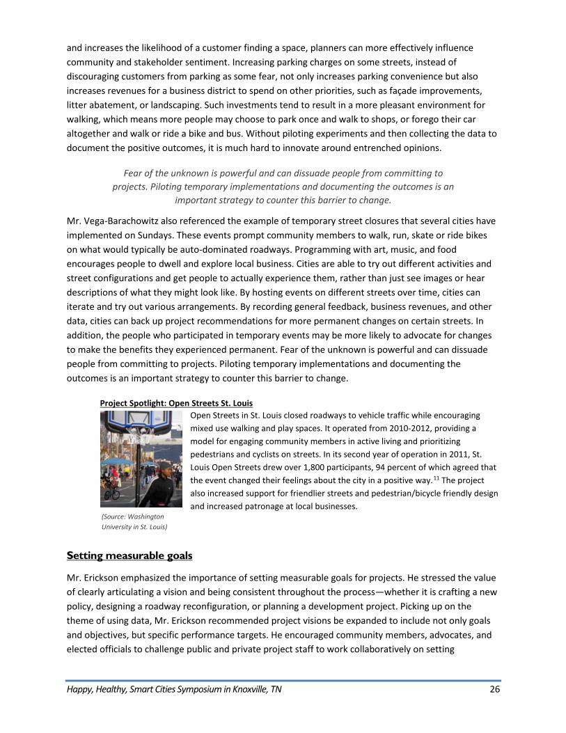
Project Spotlight: Open Streets St. Louis Open Streets in St. Louis closed roadways to vehicle traffic while encouraging mixed use walking and play spaces. It operated from 2010-2012, providing a model for engaging community members in active living and prioritizing pedestrians and cyclists on streets. In its second year of operation in 2011, St. Louis Open Streets drew over 1,800 participants, 94 percent of which agreed that the event changed their feelings about the city in a positive way.11 The project also increased support for friendlier streets and pedestrian/bicycle friendly design and increased patronage at local businesses.
Setting measurable goals
Mr. Erickson emphasized the importance of setting measurable goals for projects. He stressed the value of clearly articulating a vision and being consistent throughout the process—whether it is crafting a new policy, designing a roadway reconfiguration, or planning a development project. Picking up on the theme of using data, Mr. Erickson recommended project visions be expanded to include not only goals and objectives, but specific performance targets. He encouraged community members, advocates, and elected officials to challenge public and private project staff to work collaboratively on setting
(Source: Washington University in St. Louis)
Happy, Healthy, Smart Cities Symposium in Knoxville, TN 27
quantitative targets, and then actually measuring progress towards achieving them. Mr. Erickson noted the value of setting cross-disciplinary goals and targets. For example, a roadway reconfiguration project could be designed to create new public space. That space could in turn be designed to serve a stormwater management function. In that way, the goals of the project expand and the benefits are reaped by multiple city departments and other segments of the community. Project proponents can strengthen their arguments in favor of such projects by demonstrating that these benefits help the city and community meet specific performance targets. Targets can be aspirational, like Vision Zero,12 or more conservative, like hosting five Sunday Streets events over five months.
Mr. Vega-Barachowitz echoed these recommendations. He noted how the film about Vancouver’s transformation clearly articulated a goal of achieving a fifty percent mode shift by a specific date. Clear performance targets like this serve as both stick and carrot – they give public officials something to latch onto and something for advocates to hold those official accountable for. Once achieved, targets then become something for officials to tout as an accomplishment. The ability to demonstrate measurable progress to public officials and a community is a critical element to incentivizing good projects, and encouraging additional works to follow.
Economics of transportation and housing
Mr. Erickson noted that data can be used to clarify the tradeoffs between housing and transportation costs—an oft cited metric. He noted that the typical land use and transportation patterns of the past half century force people into situations where they have to choose one or the other. People typically select to maximize the value of their housing at the expense of transportation expenses (bigger residence, farther away). Mr. Erickson explained that this choice restricts mobility, reducing access to jobs, and may have other measurable costs. The reduction of such costs may be referenced, but are not often quantified when planners advocate for mixed-use, higher density, or more urban development near jobs and multimodal transportation networks. Providing these kinds of data and tying them to other community goals in a measurable way can help encourage more urban, walkable developments.
Happy, Healthy, Smart Cities Symposium in Knoxville, TN 28
Strategies to Support Walking, Bicycling, and Transit Use
Walking as a fundamental unit
Creating places where people can enjoy walking, in safety, was at the core of the symposium. Mr. Erickson lamented how often people—professionals, community members, public officials—forget how fundamental it is to be able to walk somewhere. He noted that land use and transportation projects often get buried in complex details and may lose sight of this fundamental concept. The kids featured in the symposium’s first film expressed the same sentiment—they too lamented “adults” not understanding that they want to have the freedom to move about their neighborhoods, access parks, school, and friends’ houses, and get to these places safely via the mode that is most readily available to them: walking. Many of the neighborhoods built over the last half century were designed without regard for this need. Mr. Erickson maintains that planners, developers and officials do not think enough about making it safe and convenient for people to walk, from children through senior citizens. He correlated this trend to the language that’s used by professionals when we talk about “pedestrian amenities” – they area already an afterthought.
Mr. Vega-Barachowitz noted that designing cities around children’s needs creates an environment that inherently supports walking. He referenced the concept of “play streets” which are designed to minimize traffic volumes and speeds, where children and adults alike are literally expected to play in the street. Temporary street closures to support children’s play was documented as early as 1914 in New York City and most recently appeared again through a partnership between the City of New York Departments of Transportation, Health & Mental Hygiene, Parks and Recreation, and Education.13,14 Mr. Vega-Barachowitz noted that in plans for cities that predate the interstate highway system, the role of children in the environment was celebrated, with parks carefully distributed within a neighborhood so as to maintain minimum distances from residences. Contemporary planning processes present barriers to getting input from children, with the rare exception of films like that presented at the symposium. David noted how critical it is for planners to understand the normal, daily activities of the people for whom our cities and towns are designed. In addition, the ability of children to play actively has been linked to important health outcomes, as described in the Communicating health and economic benefits section of this report.
Transportation and land use
Creating destinations
Knoxville Mayor Madeline Rogero used the recent “Big Ears” music festival as proof of the city’s walkable, bicycle-friendly infrastructure. Thousands of people, many from surrounding counties or farther away, parked their vehicles in town then left them for the day, choosing to walk, ride bikes, or take the free trolley between ten different venues to see performances. The presence of ten venues in close proximity to one another and the downtown core—and the many shops, cafes, restaurants, bars, and public open spaces between them—both allowed people to walk and rewarded them with interesting experiences and convenient access to goods and services along the way. The Mayor’s example points to the importance of having destinations for people to walk to. Even with the best
Happy, Healthy, Smart Cities Symposium in Knoxville, TN 29
infrastructure for walking, attractive places and dynamic programming are needed to encourage people to be out and about.
Even with the best infrastructure for walking, attractive places and dynamic programming are needed to encourage people to be out and about.
Knoxville is capitalizing on the popularity of its walkable downtown by undertaking multimodal roadway redesign projects on several streets that connect downtown to nearby neighborhoods. In some cases these streets already lead to destinations like the University. In other cases, the redesign projects may encourage auto-oriented commercial establishments to be redeveloped with stores and other establishments that cater to people on foot or riding bikes and transit. How such establishments are oriented on their site is another important component of creating a walkable environment; zoning is a critical tool to influence this.
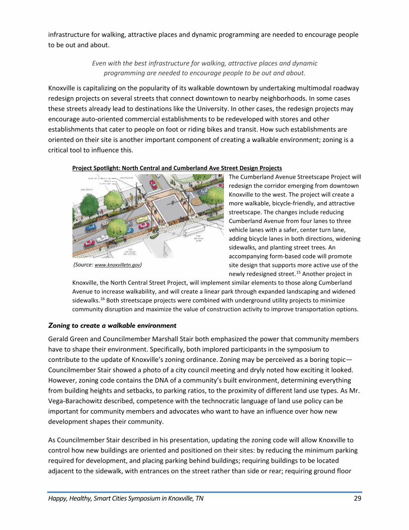
Project Spotlight: North Central and Cumberland Ave Street Design Projects The Cumberland Avenue Streetscape Project will redesign the corridor emerging from downtown Knoxville to the west. The project will create a more walkable, bicycle-friendly, and attractive streetscape. The changes include reducing Cumberland Avenue from four lanes to three vehicle lanes with a safer, center turn lane, adding bicycle lanes in both directions, widening sidewalks, and planting street trees. An accompanying form-based code will promote site design that supports more active use of the newly redesigned street.15 Another project in
Knoxville, the North Central Street Project, will implement similar elements to those along Cumberland Avenue to increase walkability, and will create a linear park through expanded landscaping and widened sidewalks.16 Both streetscape projects were combined with underground utility projects to minimize community disruption and maximize the value of construction activity to improve transportation options.
Zoning to create a walkable environment
Gerald Green and Councilmember Marshall Stair both emphasized the power that community members have to shape their environment. Specifically, both implored participants in the symposium to contribute to the update of Knoxville’s zoning ordinance. Zoning may be perceived as a boring topic—Councilmember Stair showed a photo of a city council meeting and dryly noted how exciting it looked. However, zoning code contains the DNA of a community’s built environment, determining everything from building heights and setbacks, to parking ratios, to the proximity of different land use types. As Mr. Vega-Barachowitz described, competence with the technocratic language of land use policy can be important for community members and advocates who want to have an influence over how new development shapes their community.
As Councilmember Stair described in his presentation, updating the zoning code will allow Knoxville to control how new buildings are oriented and positioned on their sites: by reducing the minimum parking required for development, and placing parking behind buildings; requiring buildings to be located adjacent to the sidewalk, with entrances on the street rather than side or rear; requiring ground floor
(Source: www.knoxvilletn.gov)
Happy, Healthy, Smart Cities Symposium in Knoxville, TN 30
uses like retail and commercial office space, with windows looking out onto the street. Zoning can shape development that defines a more interesting, pleasant pedestrian realm on the sidewalk. Mr. Erickson described how much he enjoyed the peers’ tour of downtown Knoxville and the surrounding neighborhoods. These parts of the city, such as along Gay Street, benefit from an older format of development—a continuous building wall along the street, well-articulated facades and entrances, connections with the street through ground floor windows. The downtown and surrounding neighborhoods also feature an older development pattern that includes smaller blocks, a mix of different land uses close to one another, broad sidewalks and mature street trees that make the street a pleasant place to walk.
By redeveloping aging shopping centers and other low-density developments so that the buildings line the street rather than sit behind acres of parking, and by connecting
a robust pedestrian network of sidewalks with landscaping and other pedestrian furnishings to the residential streets, suburban communities can begin to create the
same walkable environment that is so prized in downtowns.
Mr. Erickson emphasized that this combination—a walkable street and places to walk to—is central to encouraging people to choose to walk. However, he indicated that expanding on these qualities in other parts of town through the zoning update, and beyond Knoxville in other counties and cities, may present challenges. For example, how do you retrofit more suburban and rural communities? Homeowners are invested in their single family neighborhoods, and the cost of adding sidewalks to every subdivision that lacks them is prohibitive. Nevertheless, Mr. Erickson proposed some ideas for reshaping suburban environments. In many communities, there are pedestrian cut-throughs between culs de sac, or from a subdivision into a neighboring shopping center. If they don’t already exist, the potential is there for them to be created by willing neighbors. These shortcuts allow people walking or bicycling to take more direct routes with less vehicle traffic, rather than travel from a local street to a busier collector road onto an auto-dominated arterial corridor. The next piece of the puzzle is where zoning comes in. By redeveloping aging shopping centers and other low-density developments so that the buildings line the street rather than sit behind acres of parking, and by connecting a robust pedestrian network of sidewalks with landscaping and other pedestrian furnishings to the residential streets, suburban communities can begin to create the same walkable environment that is so prized in downtowns. Zoning can also influence how new development is platted, or laid out, to include streets that “stub out” at the property lines, so that when new development comes in on adjacent property, the streets can continue. This strategy helps prevent the compartmentalization of neighborhoods and provides multiple routes through a community, rather than forcing everyone to travel on the same collector and arterial roads for every trip.
Mr. Welch highlighted the example of the city of Oak Ridge’s economically struggling mall where a redevelopment project is underway. The plan replaces part of the mall parking lot and building with a new, gridded street layout. This pattern is intended to recall a more urban environment, with sidewalks surrounding each block and land uses including a mix of use types rather than just a single commercial use. He noted that redevelopment is only possible because a walkable, mixed-use property format is now a more profitable alternative to the mid-century, auto-oriented mall format. He did note that some developers question the requirement for sidewalks in new or redevelopment projects when there are no sidewalks in adjacent subdivisions or on connector and arterial roads.
Happy, Healthy, Smart Cities Symposium in Knoxville, TN 31
Mr. Vega-Barachowitz responded to this point, connecting it to a concern raised by Councilmember Stair about developers building only the minimum required five-foot wide sidewalks. Mr. Vega-Barachowitz lamented the installation of sidewalks without any regard for the environment around them. He encouraged developers, planners, and community members to envision streets as a place where a sequence of spaces and moments creates an engaging, comfortable, and safe pedestrian experience on a sidewalk. Wide sidewalks, street trees, furnishings, and landscaping are critical components of a truly walkable environment.
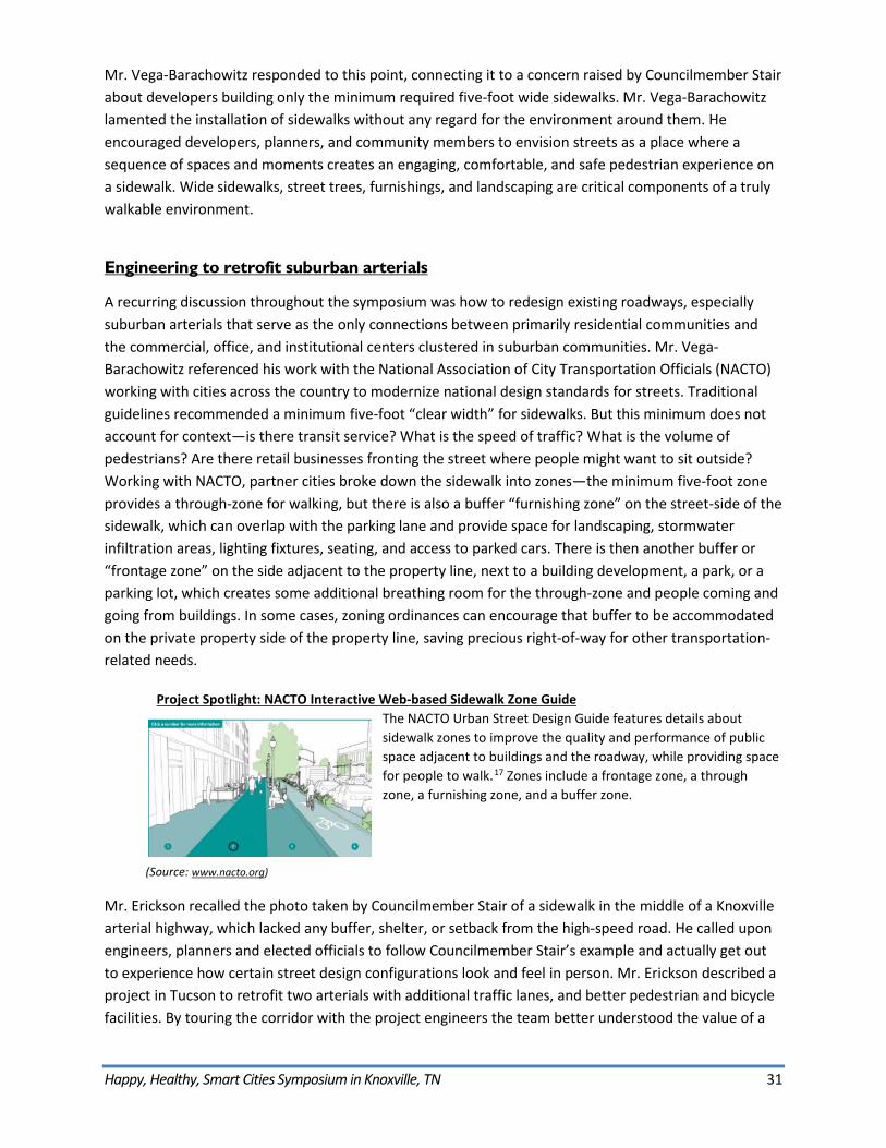
Engineering to retrofit suburban arterials
A recurring discussion throughout the symposium was how to redesign existing roadways, especially suburban arterials that serve as the only connections between primarily residential communities and the commercial, office, and institutional centers clustered in suburban communities. Mr. Vega-Barachowitz referenced his work with the National Association of City Transportation Officials (NACTO) working with cities across the country to modernize national design standards for streets. Traditional guidelines recommended a minimum five-foot “clear width” for sidewalks. But this minimum does not account for context—is there transit service? What is the speed of traffic? What is the volume of pedestrians? Are there retail businesses fronting the street where people might want to sit outside? Working with NACTO, partner cities broke down the sidewalk into zones—the minimum five-foot zone provides a through-zone for walking, but there is also a buffer “furnishing zone” on the street-side of the sidewalk, which can overlap with the parking lane and provide space for landscaping, stormwater infiltration areas, lighting fixtures, seating, and access to parked cars. There is then another buffer or “frontage zone” on the side adjacent to the property line, next to a building development, a park, or a parking lot, which creates some additional breathing room for the through-zone and people coming and going from buildings. In some cases, zoning ordinances can encourage that buffer to be accommodated on the private property side of the property line, saving precious right-of-way for other transportation-related needs.
Project Spotlight: NACTO Interactive Web-based Sidewalk Zone Guide The NACTO Urban Street Design Guide features details about sidewalk zones to improve the quality and performance of public space adjacent to buildings and the roadway, while providing space for people to walk.17 Zones include a frontage zone, a through zone, a furnishing zone, and a buffer zone.
Mr. Erickson recalled the photo taken by Councilmember Stair of a sidewalk in the middle of a Knoxville arterial highway, which lacked any buffer, shelter, or setback from the high-speed road. He called upon engineers, planners and elected officials to follow Councilmember Stair’s example and actually get out to experience how certain street design configurations look and feel in person. Mr. Erickson described a project in Tucson to retrofit two arterials with additional traffic lanes, and better pedestrian and bicycle facilities. By touring the corridor with the project engineers the team better understood the value of a
(Source: www.nacto.org)
Happy, Healthy, Smart Cities Symposium in Knoxville, TN 32
well-proportioned pedestrian realm in influencing whether someone decides to walk. The preferred design alternative included a twelve-foot wide landscape and stormwater infiltration zone for the summer “monsoon season” and wider Palo Verde shade trees native to the southwest, and an eight-foot wide sidewalk. Once a mock-up section of the street was built with this design, the project team was able to compare the experience of this design to the minimum requirement, as Mr. Erickson described it: “a five-foot wide sidewalk with utility poles in the middle of it,” and fully appreciate the value of the more generous pedestrian realm.
Mr. Erickson described Americans with Disabilities Act (ADA) requirements that include establishing more time for people to cross the street at intersections with traffic signals. He mentioned a recent project where that requirement was going to result in additional delay for vehicles—the time devoted to the longer pedestrian crossing meant vehicles would have to wait longer for a green light. The solution his team came up with was to reduce the street width from six to four lanes in many sections where traffic volumes would allow it. This “road diet” saved nearly ten seconds of time for vehicles during every signal cycle, which makes a big difference over the course of the peak morning and evening commute hours. However, an arguably greater benefit was the ability to convert the space previously devoted to two extra vehicle lanes into more space for bicycling and walking. Narrower streets with fewer vehicle travel lanes also reduce the likelihood of “multiple threat” collisions. These occur when one vehicle yields to a pedestrian crossing the street, but in doing so obscures the line of sight between that pedestrian and a vehicle traveling the in the same direction in an adjacent lane. Reducing streets to one lane in each direction greatly reduce this risk. Additionally, studies have shown that narrower travel lanes contribute to safer streets and reduced vehicle speeds, and in urban areas “result in less aggressive driving and more ability to slow or stop a vehicle over a short distance to avoid collision.”18
Complete streets and complete networks
“Complete streets” refers to street design that supports people’s ability to use multiple modes for travel, whether they chose to drive, walk, cycle and/or take transit. However, with limited right-of-way on existing streets, it is impossible for every street to be truly “complete.” Peers referred to the concept of “complete networks” as a more appropriate way to conceive of a street system that supports all modes. By prioritizing certain streets for certain modes, a city can distribute transportation improvements throughout their network, giving people more transportation choices. In many cities, there are street groupings that demonstrate this approach. For example, three parallel streets in San Francisco’s Mission District each support a different modal priority: Mission Street is the main transit route with transit-only lanes and frequent buses and connections to the Bay Area Rapid Transit (BART) rail system. Valencia Street is the primary bicycle route with bicycle lanes and traffic signals coordinated to support a continuous “green wave” that allows people to cycle at 15 mph without hitting red lights. As a result, Guerrero Street features smoother vehicle travel because drivers do not encounter buses or bicycles as frequently. These three streets are each a block apart and comprise a robust transportation spine through the city for miles. As much of the neighborhood includes bustling shops, restaurants and bars with office and residential uses on upper floors, the pedestrian realm on all three streets is fairly high quality.
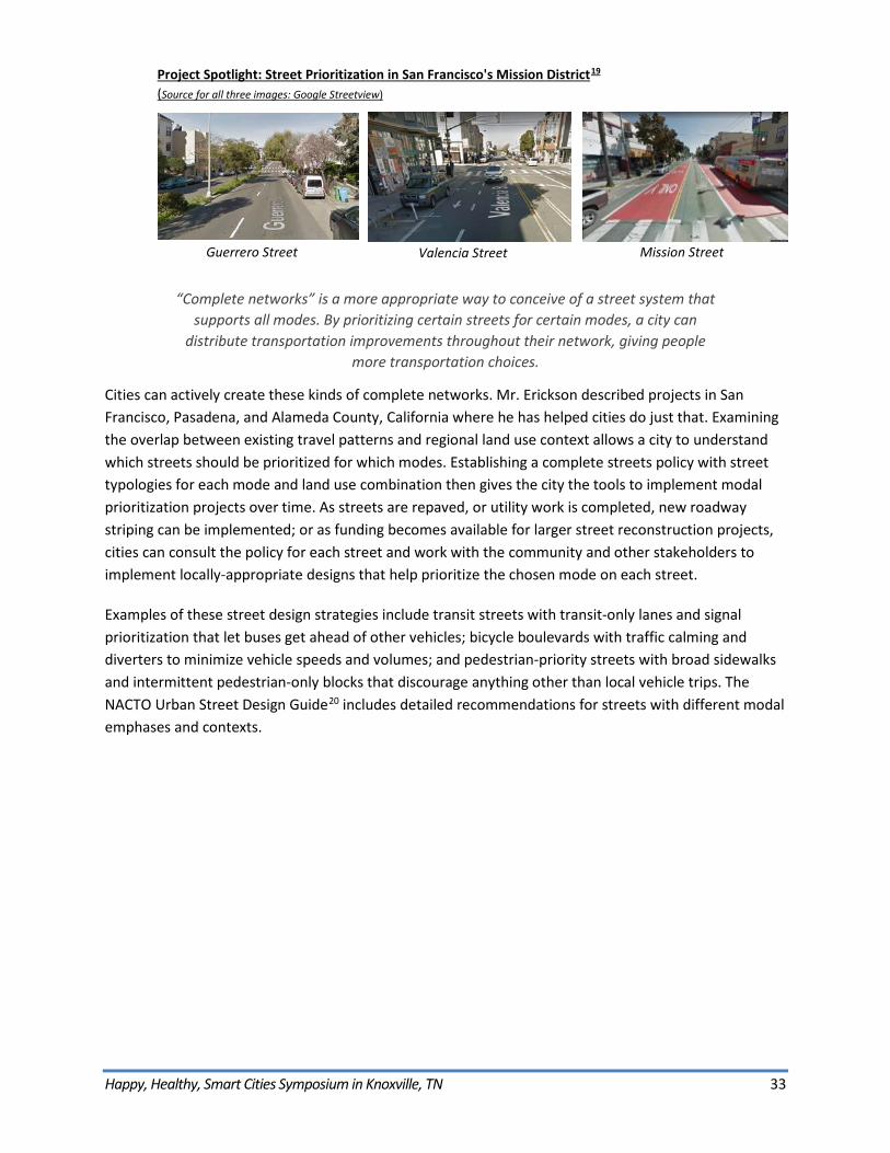
Happy, Healthy, Smart Cities Symposium in Knoxville, TN 33
Project Spotlight: Street Prioritization in San Francisco's Mission District19 (Source for all three images: Google Streetview)
“Complete networks” is a more appropriate way to conceive of a street system that supports all modes. By prioritizing certain streets for certain modes, a city can
distribute transportation improvements throughout their network, giving people more transportation choices.
Cities can actively create these kinds of complete networks. Mr. Erickson described projects in San Francisco, Pasadena, and Alameda County, California where he has helped cities do just that. Examining the overlap between existing travel patterns and regional land use context allows a city to understand which streets should be prioritized for which modes. Establishing a complete streets policy with street typologies for each mode and land use combination then gives the city the tools to implement modal prioritization projects over time. As streets are repaved, or utility work is completed, new roadway striping can be implemented; or as funding becomes available for larger street reconstruction projects, cities can consult the policy for each street and work with the community and other stakeholders to implement locally-appropriate designs that help prioritize the chosen mode on each street.
Examples of these street design strategies include transit streets with transit-only lanes and signal prioritization that let buses get ahead of other vehicles; bicycle boulevards with traffic calming and diverters to minimize vehicle speeds and volumes; and pedestrian-priority streets with broad sidewalks and intermittent pedestrian-only blocks that discourage anything other than local vehicle trips. The NACTO Urban Street Design Guide20 includes detailed recommendations for streets with different modal emphases and contexts.
Guerrero Street Valencia Street Mission Street
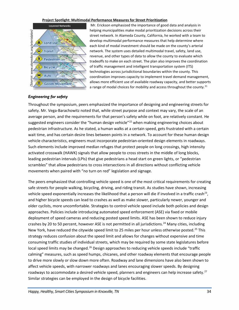
Happy, Healthy, Smart Cities Symposium in Knoxville, TN 34
Project Spotlight: Multimodal Performance Measures for Street Prioritization Mr. Erickson emphasized the importance of good data and analysis in helping municipalities make modal prioritization decisions across their street network. In Alameda County, California, he worked with a team to develop multimodal performance measures that help determine where each kind of modal investment should be made on the county’s arterial network. The system uses detailed multimodal travel, safety, land use, revenue, and other types of data to allow the county to evaluate which tradeoffs to make on each street. The plan also improves the coordination of traffic management and intelligent transportation system (ITS) technologies across jurisdictional boundaries within the county. This coordination improves capacity to implement travel demand management, allows more efficient use of available roadway capacity, and better supports a range of modal choices for mobility and access throughout the county.21
Engineering for safety
Throughout the symposium, peers emphasized the importance of designing and engineering streets for safety. Mr. Vega-Barachowitz noted that, while street purpose and context may vary, the scale of an average person, and the requirements for that person’s safety while on foot, are relatively constant. He suggested engineers consider the “human design vehicle”22 when making engineering choices about pedestrian infrastructure. As he stated, a human walks at a certain speed, gets frustrated with a certain wait time, and has certain desire lines between points in a network. To account for these human design vehicle characteristics, engineers must incorporate pedestrian-oriented design elements in roadways. Such elements include improved median refuges that protect people on long crossings, high intensity activated crosswalk (HAWK) signals that allow people to cross streets in the middle of long blocks, leading pedestrian intervals (LPIs) that give pedestrians a head start on green lights, or “pedestrian scrambles” that allow pedestrians to cross intersections in all directions without conflicting vehicle movements when paired with “no turn on red” legislation and signage.
The peers emphasized that controlling vehicle speed is one of the most critical requirements for creating safe streets for people walking, bicycling, driving, and riding transit. As studies have shown, increasing vehicle speed exponentially increases the likelihood that a person will die if involved in a traffic crash23, and higher bicycle speeds can lead to crashes as well as make slower, particularly newer, younger and older cyclists, more uncomfortable. Strategies to control vehicle speed include both policies and design approaches. Policies include introducing automated speed enforcement (ASE) via fixed or mobile deployment of speed cameras and reducing posted speed limits. ASE has been shown to reduce injury crashes by 20 to 50 percent, however ASE is not permitted in all jurisdictions.24 Many cities, including New York, have reduced the citywide speed limit to 25 miles per hour unless otherwise posted.25 This strategy reduces confusion about the speed limit and allows for changes without expensive and time consuming traffic studies of individual streets, which may be required by some state legislatures before local speed limits may be changed.26 Design approaches to reducing vehicle speeds include “traffic calming” measures, such as speed humps, chicanes, and other roadway elements that encourage people to drive more slowly or slow down more often. Roadway and lane dimensions have also been shown to affect vehicle speeds, with narrower roadways and lanes encouraging slower speeds. By designing roadways to accommodate a desired vehicle speed, planners and engineers can help increase safety.27 Similar strategies can be employed in the design of bicycle facilities.
(Sou
rce:
ww
w.a
lam
edac
tc.o
rg/a
rter
ialp
lan)
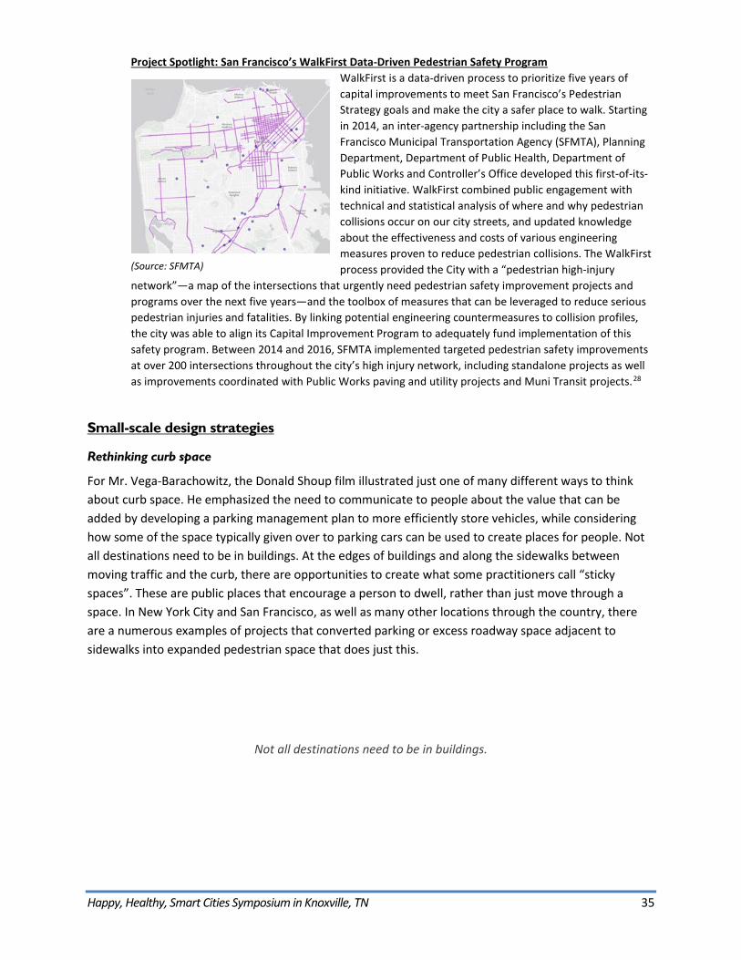
Happy, Healthy, Smart Cities Symposium in Knoxville, TN 35
Project Spotlight: San Francisco’s WalkFirst Data-Driven Pedestrian Safety Program WalkFirst is a data-driven process to prioritize five years of capital improvements to meet San Francisco’s Pedestrian Strategy goals and make the city a safer place to walk. Starting in 2014, an inter-agency partnership including the San Francisco Municipal Transportation Agency (SFMTA), Planning Department, Department of Public Health, Department of Public Works and Controller’s Office developed this first-of-its-kind initiative. WalkFirst combined public engagement with technical and statistical analysis of where and why pedestrian collisions occur on our city streets, and updated knowledge about the effectiveness and costs of various engineering measures proven to reduce pedestrian collisions. The WalkFirst process provided the City with a “pedestrian high-injury
network”—a map of the intersections that urgently need pedestrian safety improvement projects and programs over the next five years—and the toolbox of measures that can be leveraged to reduce serious pedestrian injuries and fatalities. By linking potential engineering countermeasures to collision profiles, the city was able to align its Capital Improvement Program to adequately fund implementation of this safety program. Between 2014 and 2016, SFMTA implemented targeted pedestrian safety improvements at over 200 intersections throughout the city’s high injury network, including standalone projects as well as improvements coordinated with Public Works paving and utility projects and Muni Transit projects.28
Small-scale design strategies
Rethinking curb space
For Mr. Vega-Barachowitz, the Donald Shoup film illustrated just one of many different ways to think about curb space. He emphasized the need to communicate to people about the value that can be added by developing a parking management plan to more efficiently store vehicles, while considering how some of the space typically given over to parking cars can be used to create places for people. Not all destinations need to be in buildings. At the edges of buildings and along the sidewalks between moving traffic and the curb, there are opportunities to create what some practitioners call “sticky spaces”. These are public places that encourage a person to dwell, rather than just move through a space. In New York City and San Francisco, as well as many other locations through the country, there are a numerous examples of projects that converted parking or excess roadway space adjacent to sidewalks into expanded pedestrian space that does just this.
Not all destinations need to be in buildings.
(Source: SFMTA)
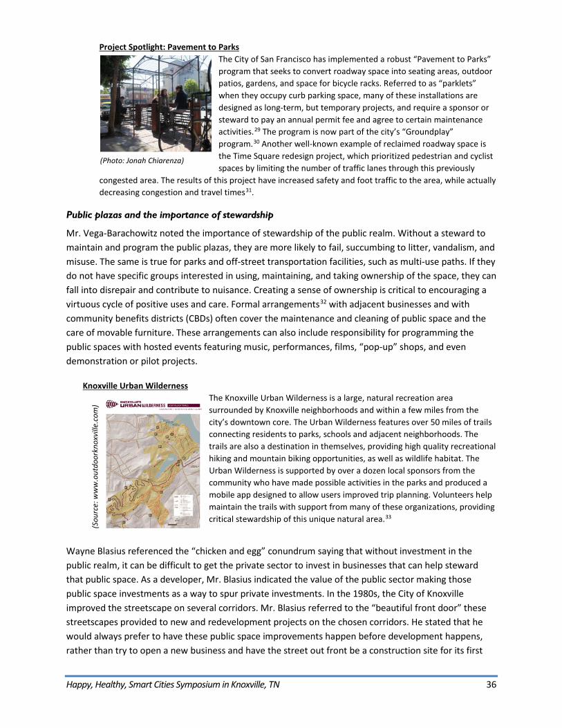
Happy, Healthy, Smart Cities Symposium in Knoxville, TN 36
Project Spotlight: Pavement to Parks The City of San Francisco has implemented a robust “Pavement to Parks” program that seeks to convert roadway space into seating areas, outdoor patios, gardens, and space for bicycle racks. Referred to as “parklets” when they occupy curb parking space, many of these installations are designed as long-term, but temporary projects, and require a sponsor or steward to pay an annual permit fee and agree to certain maintenance activities.29 The program is now part of the city’s “Groundplay” program.30 Another well-known example of reclaimed roadway space is the Time Square redesign project, which prioritized pedestrian and cyclistspaces by limiting the number of traffic lanes through this previously
congested area. The results of this project have increased safety and foot traffic to the area, while actually decreasing congestion and travel times31.
Public plazas and the importance of stewardship
Mr. Vega-Barachowitz noted the importance of stewardship of the public realm. Without a steward to maintain and program the public plazas, they are more likely to fail, succumbing to litter, vandalism, and misuse. The same is true for parks and off-street transportation facilities, such as multi-use paths. If they do not have specific groups interested in using, maintaining, and taking ownership of the space, they can fall into disrepair and contribute to nuisance. Creating a sense of ownership is critical to encouraging a virtuous cycle of positive uses and care. Formal arrangements32 with adjacent businesses and with community benefits districts (CBDs) often cover the maintenance and cleaning of public space and the care of movable furniture. These arrangements can also include responsibility for programming the public spaces with hosted events featuring music, performances, films, “pop-up” shops, and even demonstration or pilot projects.
Knoxville Urban Wilderness The Knoxville Urban Wilderness is a large, natural recreation area surrounded by Knoxville neighborhoods and within a few miles from the city’s downtown core. The Urban Wilderness features over 50 miles of trails connecting residents to parks, schools and adjacent neighborhoods. The trails are also a destination in themselves, providing high quality recreational hiking and mountain biking opportunities, as well as wildlife habitat. The Urban Wilderness is supported by over a dozen local sponsors from the community who have made possible activities in the parks and produced a mobile app designed to allow users improved trip planning. Volunteers help maintain the trails with support from many of these organizations, providing critical stewardship of this unique natural area.33
Wayne Blasius referenced the “chicken and egg” conundrum saying that without investment in the public realm, it can be difficult to get the private sector to invest in businesses that can help steward that public space. As a developer, Mr. Blasius indicated the value of the public sector making those public space investments as a way to spur private investments. In the 1980s, the City of Knoxville improved the streetscape on several corridors. Mr. Blasius referred to the “beautiful front door” these streetscapes provided to new and redevelopment projects on the chosen corridors. He stated that he would always prefer to have these public space improvements happen before development happens, rather than try to open a new business and have the street out front be a construction site for its first
(Photo: Jonah Chiarenza)
(Sou
rce:
ww
w.o
utdo
orkn
oxvi
lle.c
om)
Happy, Healthy, Smart Cities Symposium in Knoxville, TN 37
year of operation. Mr. Blasius urged elected and appointed officials to have the courage to make those investments that support development to follow.
Transit as an alternative to vehicle ownership
Ms. Woodiel-Brill noted the general public often forgets not everyone owns or has access to a car. As a transit planner, she is confronted with that fact every day. She noted that the regional average share of household income that goes to transportation—predominantly single-occupancy vehicle ownership, fuel, and maintenance—is 20 to 25 percent. In that context, a transit is pass could translate to thousands of dollars in annual savings. However, for transit to be a viable alternative to driving, the buses have to be frequent and take people where they need to go. Ms. Woodiel-Brill noted that one in five people is 60 years or older, and of these, many may do not leave their home because of the difficulty or cost associated with it. For some people, this means they have difficulty getting to see family or make medical appointments. In rural areas, these issues are even more acute.
Improving the Equity of Transit Access to Achieve Better Health Outcomes Austin, Texas’ growth over the past decade has led to the suburbanization of poverty, and Austin is among the most economically segregated urban areas in the nation. A significant impact of this is that many lower-income residents are located more than ½-mile from transit, but may not have access to other reliable transportation to meet critical needs, such as access to health care. As part of the city’s submission34 for the US Department of Transportation’s (USDOT) Smart Cities Challenge, for which Austin was a finalist, their plan included a unique strategy to manage the equity of new transportation options: Pilot new “Connected Traveler/Packaged Mobility” tools that help patients travel more conveniently to health clinic locations – without needing to drive alone. The pilot would include a focus on first-mile/last-mile shuttle connections between transit stations and clinics. Austin proposed to use the data collected through the Mobility Marketplace to prioritize the rollout of services, including engaging and supporting travelers through a new “Smart Ambassador” program. Austin also proposed to pilot autonomous vehicles (AV) for first-mile/last-mile connections – first at the airport, then for other connections, such as between patient residents, transit stops, and health care locations. The proposal included a plan to measure the performance of the program by tracking changes in alternative mode share and reduction in the number of missed clinic appointments.
Mr. Vega-Barachowitz cautioned that improving transit reliability often requires the alteration of bus routes as well as stop consolidation. This translates to the elimination of stops and routes that—while not necessarily the most popular routes—some people likely depend on. The film about Houston redesigning their bus service is a great success story. But people like the self-proclaimed “bus lady” in the Houston video show how important it is to be involved in these kinds of processes to ensure they take into account and mitigate the potential negative impacts of route changes. Major transit system updates require extensive public involvement with dynamic approaches to ensure disadvantaged populations—many of whom may rely exclusively on transit for access to jobs and healthcare and who may be unlikely to come to public meetings—can participate in planning. Holding events at transit stops or hubs, taking transit rider intercept surveys, and providing information in multiple languages are examples of such dynamic approaches.
Happy, Healthy, Smart Cities Symposium in Knoxville, TN 38
Ms. Woodiel-Brill further emphasized the importance of connections to and from transit stops. Even with the most convenient bus and train route, if people cannot easily get from their home or final destination to the transit stop, the value of the transit service plummets. This is often referred to as the “first mile/last mile” challenge, making the local connections to and from the transit route safe and convenient. To do this, Ms. Woodiel-Brill described the need for streets that allow people to safely walk, and once at their stop, wait for the bus or train in a comfortable facility, whether it’s a bus stop or a train platform. Providing real time transit arrival information is a non-physical strategy to improve the quality of the experience, by allowing passengers to see when the next bus or train is coming.
Bikeshare programs
Mr. Vega-Barachowitz lauded bikeshare programs for their ability to expand the conversation on bicycling in urban environments. Bikeshare programs around the county have been an important part of many cities’ strategy to increase the number of people riding bikes for shorter trips. These programs allow individuals who are interested in riding a bike around a city to try it out, opening cycling as an option for those who may not have access to a bike at all, or those who may not be able to bring one with them as part of a commute or for errands. By allowing a broader segment of the population to experience bicycling in an urban environment, these programs help build support for better bicycling infrastructure—creating advocates who can appreciate the value of making certain trade-offs to improve safety and access. Bikeshare systems have a very good safety record in North America, with far fewer fatalities per 100,000 trips than non-bikeshare bicycling.35
Bikeshare can also expand the usefulness of transit systems, aiding the “first-mile, last-mile” component of a traveler’s trip from home to their origin transit station, and/or from a transit station to their final destination. There is an added benefit in allowing people to experience a city “at the speed of a bike.” Riders can cover more ground than they could on foot, and yet they are able to take in their surroundings more easily than if they were driving, even stopping to explore places of interest. Mr. Vega-Barachowitz referenced the success of bikeshare programs in Nashville, Chattanooga, and Memphis, Tennessee.
Other solutions to active transportation obstacles
The peers and symposium participants identified a number of other factors that influence whether people can safely and comfortably use active transportation, including: specific mobility obstacles; topography and climate; facilities to accommodate active transportation needs; and, cultural shifts.
Mobility obstacles
Major mobility obstacles are one such factor and include: highway interchanges and routes that travel along arterial streets. For these issues, the peers indicated that infrastructure projects—such as overpasses and protected or off-street multi-use paths—may be one of the only strategies that can surmount the challenges these obstacles present. The planning, design, and implementation of these facilities benefit from the strategies outlined in this report: from public involvement and interagency
Happy, Healthy, Smart Cities Symposium in Knoxville, TN 39
coordination, data collection and performance-based planning, to pilot projects and phased implementation
Topography and climate
Other factors specifically influencing bicycling include challenging topography, the need to carry things while traveling (commonly shopping items and/or children), and climates with very hot or cold seasons. For topography, the peers cited examples from other hilly places that have devised routes with improved wayfinding signage and roadway striping that circumnavigate the biggest hills.36 Mr. Erickson also recommended using bicycles with lower, mountain bike specific gearing to make it easier to climb hills. In addition, he noted the availability of electric-assist “e-bikes” that use a battery and motor to supplement human-powered cycling. These bicycles allow people to expend less energy when climbing hilly terrain, traveling over longer distances, and carrying heavier loads. “Fat bikes” are also a more recently available model of bicycle that feature wider tires and work well in rougher conditions with sand or snow. Low gearing, E-bikes, and fat bikes also present possible solutions for riders who encounter very hot or cold seasons. By using these technologies to reduce the effort needed to cycle, more people may be able to continue to travel by bicycle in hot summer months, or in cold and even snow-covered conditions.
Facilities
Another key to enabling active transportation by bicycle in all conditions are secure bicycle storage facilities at origins and destinations. Residential developments, offices, shopping areas, and transit hubs benefit from accommodating people who want to cycle, by reducing demand for vehicle parking spaces. Secure facilities can incentivize more people to choose to bicycle by ensuring their bikes are safe while parked. Facilities can include everything from providing secure bike racks enclosures, to individual bike lockers37, to supervised “bike stations38” and even smart bike racks39. Finally, destinations, especially offices and other places of employment, can incentivize active transportation in good and poor weather conditions and climates by providing shower and changing facilities for riders. By doing so, employers can encourage people to walk, run, or bicycle as part of their commute to work, which has been shown to provide measurable health benefits40 that could help employers achieve heath care savings and achieve other environmental and health-related goals for their organizations.
Culture shift
Mr. Erickson noted that many locations have been grappling with culture shift as new facilities are planned and new technologies emerge to support active transportation. He noted that people often reference European examples of bicycle and pedestrian infrastructure, but that those examples are often much older than their American counterparts. He emphasized that bicycling in many European cities has accommodated children and seniors as core users for decades, and has typically featured more protected and off-street paths, with higher volumes of people moving at slower speeds. In North America, by contrast, many large cities are still transitioning from minimal bicycle infrastructure and a bicycle user group that has been historically limited to younger, predominantly male riders.41 As newer facilities are implemented, especially separated or protected bicycle lanes and shared streets, newer riders are mixing with more experienced riders, and there can be a clash when goals for safety, comfort, and speed are not shared by all users. User education and setting measurable goals, as described in this

Happy, Healthy, Smart Cities Symposium in Knoxville, TN 40
report, are important elements to bridge these divides and facilitate a cultural shift. Vision Zero is one unifying goal that many cities have used to guide investments in newer bicycle and pedestrian facilities that provide increased protection, but may also require users to limit speeds and/or obey new regulations and traffic control devices. Policies such as Vision Zero can also influence the enforcement of these regulations, new or existing, to make cycling safer and more comfortable for a larger range of riders.
Happy, Healthy, Smart Cities Symposium in Knoxville, TN 41
Future Trends
Smart cities technologies: learning from the past and envisioning the future
The final film about smart cities spurred a dialog about how the advent of autonomous and connected vehicles (AV/CV) and vehicle to infrastructure (V2I) (core elements of “smart cities technology”) could both compound the challenges and contribute to the solutions outlined by the other films and discussions that took place throughout the symposium. Mr. Welch offered brief remarks about the need to proactively engage in discussions about specific technologies and consider policies to influence how they could serve to advance regional goals, while minimizing negative impacts. 42 He noted that the TPO would be hosting future events on this topic.
Smart cities technology presents the opportunity for a novel reversal of our historic approach to designing cities for vehicles, toward a future in which we instead design
vehicles for the cities we want.
Challenges ahead
Mr. Erickson expressed some concern about the speed of new technology coming to market and the lack of rules and regulations for guiding its implementation. He cautioned that AV/CV and V2I could contribute to continuing sprawl development, further isolating people in disconnected communities, and confining them to vehicles for longer distances and durations. This trend could lead to increasing public health issues as inactivity increases while people spend more and more time in their vehicles. There is also the potential for the cost of these technologies to exacerbate existing inequalities as well, as the demand for upgraded infrastructure takes on a geographic dimension; wealthier areas could benefit from an accelerated expansion of smart infrastructure that could take longer to reach poorer communities.
Mr. Erickson noted the importance of ensuring a community’s vision is well-documented and used to guide policies and practices related to implementing AV/CV and V2I technology. In the earlier auto revolution of the 20th century, the impact of vehicles on cities was not discussed as part of a public, community-oriented dialog. He stressed that it is critical to keep the dialog about technology implementation part of a public forum to help communities avoid negative impacts analogous to those of the country’s prior auto revolution.
Opportunities ahead
Mr. Vega-Barachowitz referred to discussions he has had with other planners, designers, and engineers about how to respond to AV/CV and V2I. He remarked that the street design strategies and policies they came up in their informal conversations strongly resembled those that have already been discussed during the symposium, but taken to the next level of sophistication and execution: Pedestrian and transit priority in traffic control design, enhanced spaces for public life activities, reduced congestion and environmental impacts through shared mobility, higher performance landscaping for stormwater management and aesthetics. He noted the opportunity for a novel reversal of our historic approach to designing cities for vehicles, toward a future in which we instead design vehicles for the cities we want.
Happy, Healthy, Smart Cities Symposium in Knoxville, TN 42
In the context of past choices that deferred a great deal of accommodation to the automobile—communities with a strong vision will be better equipped to engage
with AV/CV and V2I technology and shape its implementation.
Cities that have a concrete vision of what they want to become have the ability to make that vision a reality using the tools and strategies discussed in during the symposium: updating zoning, changing design guidelines, and piloting and testing small-scale projects to spur change while avoiding large-scale missteps. Mr. Vega-Barachowitz emphasized that—in the context of past choices that deferred a great deal of accommodation to the automobile—communities with a strong vision will be better equipped to engage with AV/CV and V2I technology and shape its implementation.
Happy, Healthy, Smart Cities Symposium in Knoxville, TN 43
Conclusion The Happy, Healthy, Smart symposium covered a wide variety of interrelated topics: transportation, land use, health, equity, community involvement, data, and technology. While many themes emerged throughout the event, one pair of observations helps to synthesize the far-ranging discussion into forward-looking recommendations for practitioners, politicians, and members of the public: Accept more variability, and see streets as malleable.
Accept greater variability
Hand in hand with increasing the number of options people have to choose from—from travel mode, to housing location, to involvement opportunities—is the need to accept more variability. If living in a suburban neighborhood and driving for all trips is no longer the only option afforded to a person, he or she will need to weigh the costs and benefits—the variables—of the other available options. Based on her needs for a given trip, for example, a person may value getting exercise over maintaining comfort, or she may choose greater affordability over speed, or she may choose not to travel at all, connecting with people and work remotely.
The key is to have the freedom to make those choices without sacrificing safety, and accepting that with expanded choices comes increasing variability in the system. Technology can help make these variables more knowable – it allows a person to check route options, transit schedules and real time arrivals, weather forecasts, bikeshare availability, traffic volumes, and variable prices for travel and parking. Emerging technologies also help forecast health outcomes in the form of calories burned, or environmental benefits in the form of energy saved; these and other innovations will expand the availability of information about the impacts and outcomes of various choices. The same travel options may not always be available or produce the same outcomes as circumstances change with time of day, weather patterns, infrastructure maintenance, and myriad other conditions; this is another aspect of a variable system, but one that many people may learn to prefer to a narrow range or complete lack of other options.
Streets as malleable
At the core of the conversation about increasing transportation options—through changes to format, safety, and modal priorities on streets—is the concept of the street as a place that is not permanently fixed in time and space. Variability can take on a physical form, as streets are changed over the course of years through major redesign projects, or on a daily basis as a parking lane becomes a travel lane or a lane on a bridge is reversed to accommodate higher volumes of morning and evening commuter traffic.43 Other examples include pilot projects that allow a city to test a modified street design for a pre-set interval or monthly closures of different streets to traffic (“Open Streets”). Cities can also implement programs of small design changes, such as changing signal timing at high-injury locations, shortening crossing distances by building sidewalk extensions (bulb-outs) on wide corridors, or implementing projects to convert parking spaces to seasonal plazas.
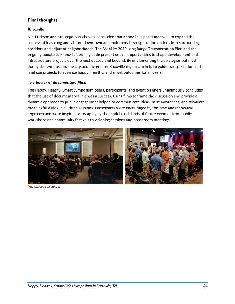
Happy, Healthy, Smart Cities Symposium in Knoxville, TN 44
Final thoughts
Knoxville
Mr. Erickson and Mr. Vega-Barachowitz concluded that Knoxville is positioned well to expand the success of its strong and vibrant downtown and multimodal transportation options into surrounding corridors and adjacent neighborhoods. The Mobility 2040 Long Range Transportation Plan and the ongoing update to Knoxville’s zoning code present critical opportunities to shape development and infrastructure projects over the next decade and beyond. By implementing the strategies outlined during the symposium, the city and the greater Knoxville region can help to guide transportation and land use projects to advance happy, healthy, and smart outcomes for all users.
The power of documentary films
The Happy, Heathy, Smart Symposium peers, participants, and event planners unanimously concluded that the use of documentary-films was a success. Using films to frame the discussion and provide a dynamic approach to public engagement helped to communicate ideas, raise awareness, and stimulate meaningful dialog in all three sessions. Participants were encouraged by this new and innovative approach and were inspired to try applying the model to all kinds of future events—from public workshops and community festivals to visioning sessions and boardroom meetings.
(Photos: Jonah Chiarenza)
Happy, Healthy, Smart Cities Symposium in Knoxville, TN 45
About the Transportation Planning Capacity Building Program The TPCB Program is a joint venture of FHWA and FTA that delivers products and services to provide information, training, and technical assistance to the transportation professionals responsible for planning for the capital, operating, and maintenance needs of our nation's surface transportation system. The TPCB Program website (www.planning.dot.gov) serves as a one-stop clearinghouse for state-of-the-practice transportation planning information and resources. This includes more than 70 peer exchange reports covering a wide range of transportation planning topics.
The TPCB Peer Program advances the state of the practice in multimodal transportation planning nationwide by organizing, facilitating, and documenting peer events to share noteworthy practices among State DOTs, MPOs, transit agencies, and local and Tribal transportation planning agencies. During peer events, transportation planning staff interact with one another to share information, accomplishments, and lessons learned from the field and help one another overcome shared transportation planning challenges.
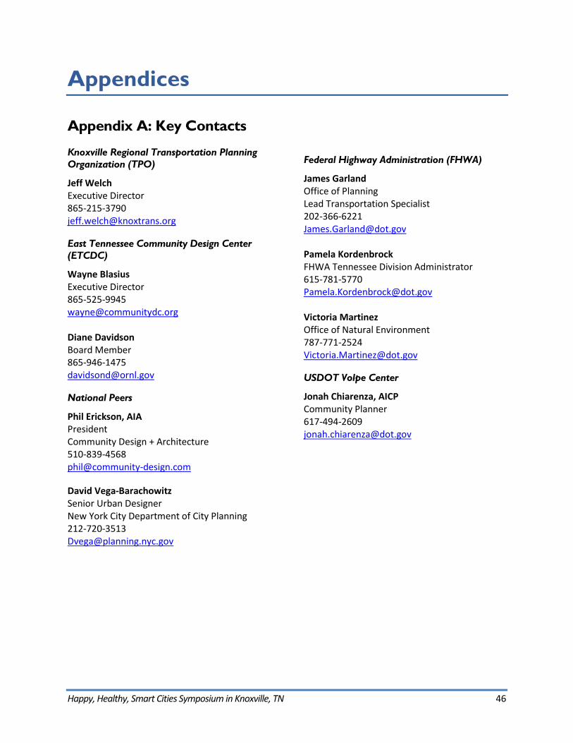
Happy, Healthy, Smart Cities Symposium in Knoxville, TN 46
Appendices
Appendix A: Key Contacts
Knoxville Regional Transportation Planning Organization (TPO)
Jeff Welch Executive Director [email protected]
East Tennessee Community Design Center (ETCDC)
Wayne Blasius Executive Director [email protected]
Diane Davidson Board Member [email protected]
National Peers
Phil Erickson, AIA President Community Design + Architecture [email protected]
David Vega-Barachowitz Senior Urban Designer New York City Department of City Planning [email protected]
Federal Highway Administration (FHWA)
James Garland Office of Planning Lead Transportation Specialist [email protected]
Pamela Kordenbrock FHWA Tennessee Division Administrator [email protected]
Victoria Martinez Office of Natural Environment [email protected]
USDOT Volpe Center
Jonah Chiarenza, AICP Community Planner [email protected]
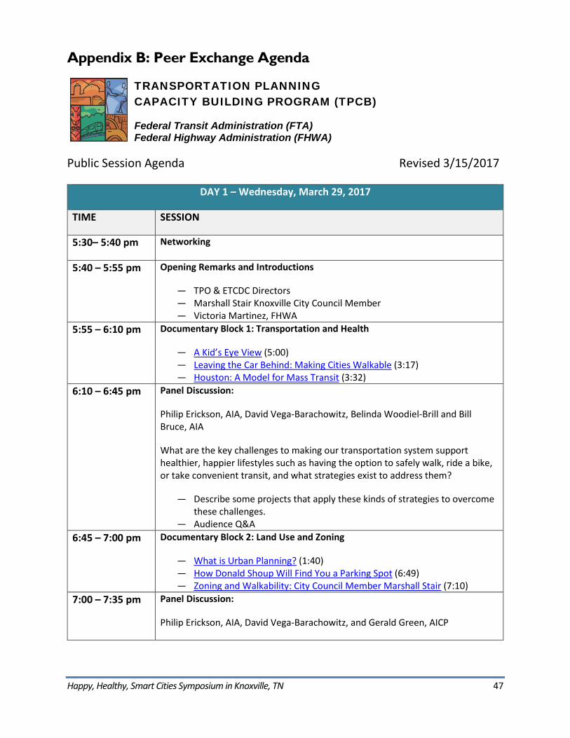
Happy, Healthy, Smart Cities Symposium in Knoxville, TN 47
Appendix B: Peer Exchange Agenda
TRANSPORTATION PLANNING CAPACITY BUILDING PROGRAM (TPCB)
Federal Transit Administration (FTA) Federal Highway Administration (FHWA)
Public Session Agenda Revised 3/15/2017
DAY 1 – Wednesday, March 29, 2017
TIME SESSION
5:30– 5:40 pm Networking
5:40 – 5:55 pm Opening Remarks and Introductions
― TPO & ETCDC Directors ― Marshall Stair Knoxville City Council Member ― Victoria Martinez, FHWA
5:55 – 6:10 pm Documentary Block 1: Transportation and Health
― A Kid’s Eye View (5:00) ― Leaving the Car Behind: Making Cities Walkable (3:17) ― Houston: A Model for Mass Transit (3:32)
6:10 – 6:45 pm Panel Discussion:
Philip Erickson, AIA, David Vega-Barachowitz, Belinda Woodiel-Brill and Bill Bruce, AIA
What are the key challenges to making our transportation system support healthier, happier lifestyles such as having the option to safely walk, ride a bike, or take convenient transit, and what strategies exist to address them?
― Describe some projects that apply these kinds of strategies to overcome these challenges.
― Audience Q&A 6:45 – 7:00 pm Documentary Block 2: Land Use and Zoning
― What is Urban Planning? (1:40) ― How Donald Shoup Will Find You a Parking Spot (6:49) ― Zoning and Walkability: City Council Member Marshall Stair (7:10)
7:00 – 7:35 pm Panel Discussion:
Philip Erickson, AIA, David Vega-Barachowitz, and Gerald Green, AICP
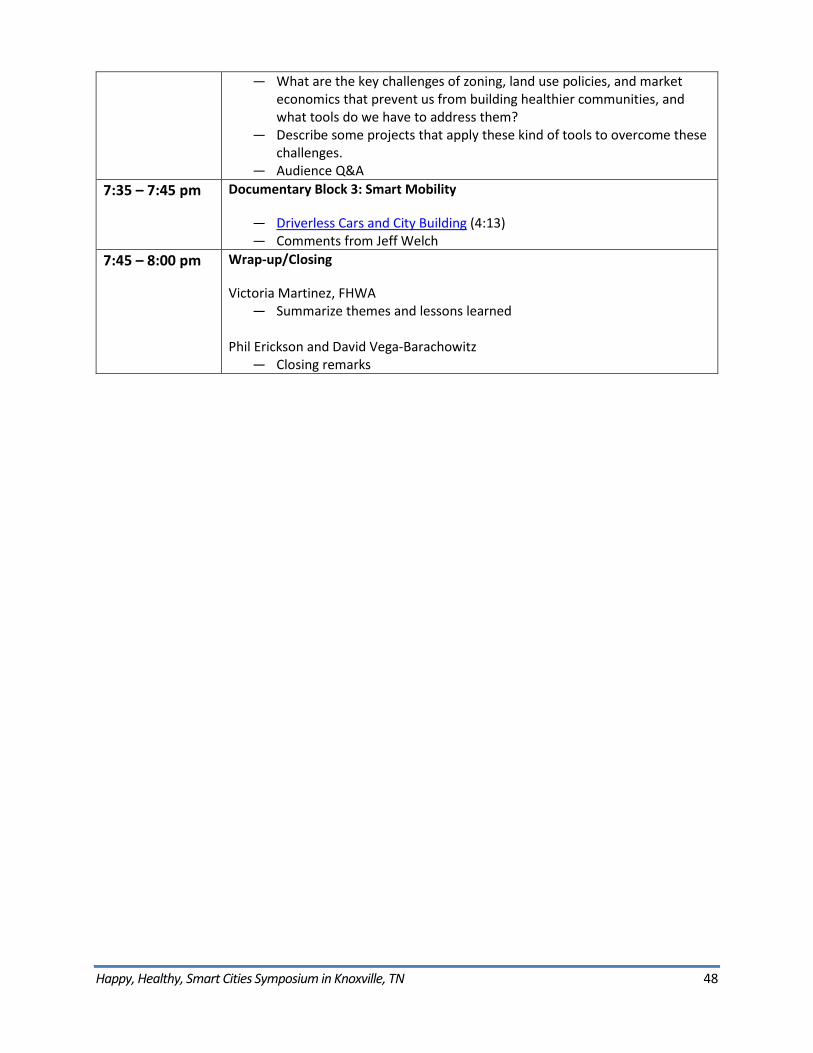
Happy, Healthy, Smart Cities Symposium in Knoxville, TN 48
― What are the key challenges of zoning, land use policies, and market economics that prevent us from building healthier communities, and what tools do we have to address them?
― Describe some projects that apply these kind of tools to overcome these challenges.
― Audience Q&A 7:35 – 7:45 pm Documentary Block 3: Smart Mobility
― Driverless Cars and City Building (4:13) ― Comments from Jeff Welch
7:45 – 8:00 pm Wrap-up/Closing
Victoria Martinez, FHWA ― Summarize themes and lessons learned
Phil Erickson and David Vega-Barachowitz ― Closing remarks
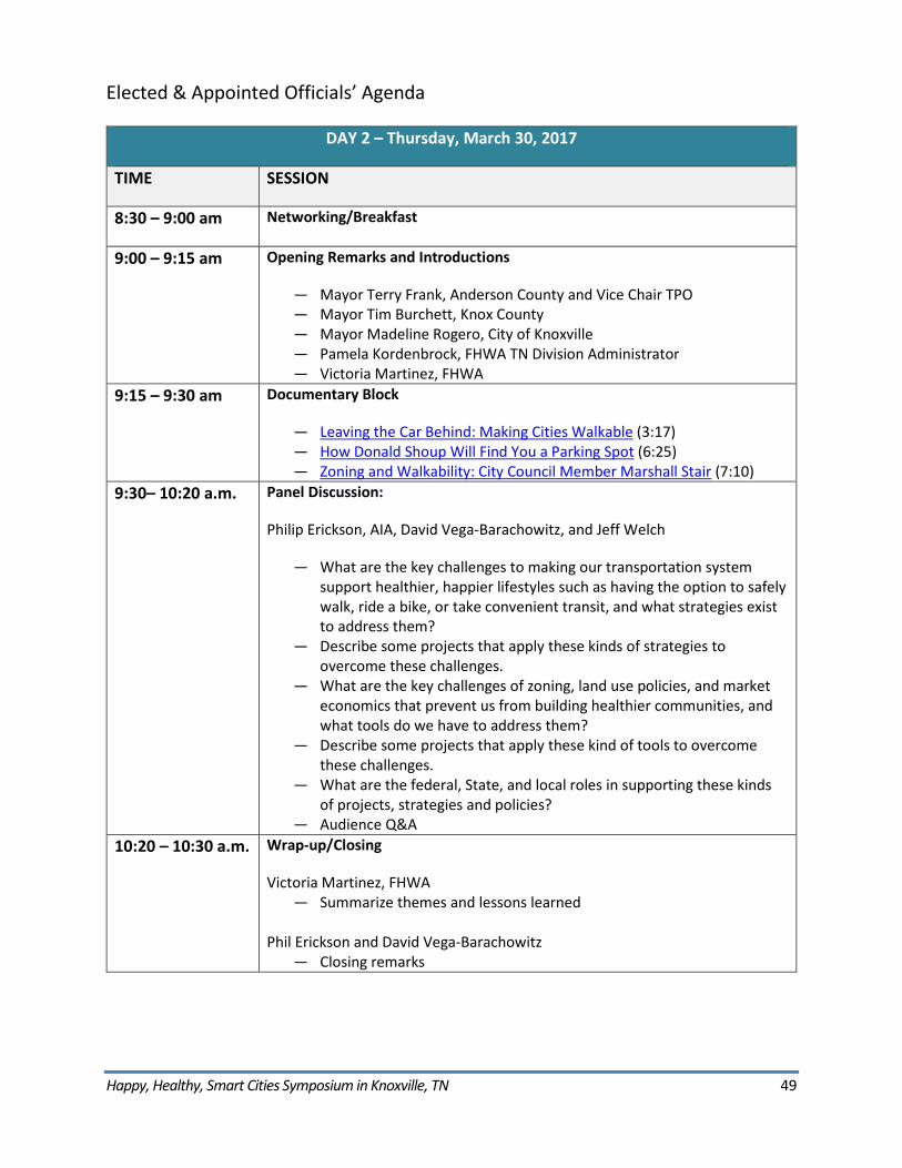
Happy, Healthy, Smart Cities Symposium in Knoxville, TN 49
Elected & Appointed Officials’ Agenda
DAY 2 – Thursday, March 30, 2017
TIME SESSION
8:30 – 9:00 am Networking/Breakfast
9:00 – 9:15 am Opening Remarks and Introductions
― Mayor Terry Frank, Anderson County and Vice Chair TPO ― Mayor Tim Burchett, Knox County ― Mayor Madeline Rogero, City of Knoxville ― Pamela Kordenbrock, FHWA TN Division Administrator ― Victoria Martinez, FHWA
9:15 – 9:30 am Documentary Block
― Leaving the Car Behind: Making Cities Walkable (3:17) ― How Donald Shoup Will Find You a Parking Spot (6:25) ― Zoning and Walkability: City Council Member Marshall Stair (7:10)
9:30– 10:20 a.m. Panel Discussion:
Philip Erickson, AIA, David Vega-Barachowitz, and Jeff Welch
― What are the key challenges to making our transportation system support healthier, happier lifestyles such as having the option to safely walk, ride a bike, or take convenient transit, and what strategies exist to address them?
― Describe some projects that apply these kinds of strategies to overcome these challenges.
― What are the key challenges of zoning, land use policies, and market economics that prevent us from building healthier communities, and what tools do we have to address them?
― Describe some projects that apply these kind of tools to overcome these challenges.
― What are the federal, State, and local roles in supporting these kinds of projects, strategies and policies?
― Audience Q&A 10:20 – 10:30 a.m. Wrap-up/Closing
Victoria Martinez, FHWA ― Summarize themes and lessons learned
Phil Erickson and David Vega-Barachowitz ― Closing remarks
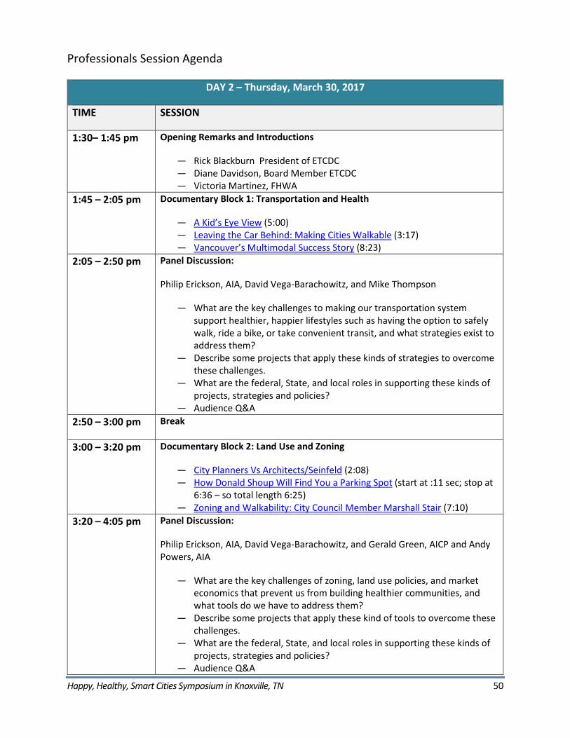
Happy, Healthy, Smart Cities Symposium in Knoxville, TN 50
Professionals Session Agenda
DAY 2 – Thursday, March 30, 2017
TIME SESSION
1:30– 1:45 pm Opening Remarks and Introductions
― Rick Blackburn President of ETCDC ― Diane Davidson, Board Member ETCDC ― Victoria Martinez, FHWA
1:45 – 2:05 pm Documentary Block 1: Transportation and Health
― A Kid’s Eye View (5:00) ― Leaving the Car Behind: Making Cities Walkable (3:17) ― Vancouver’s Multimodal Success Story (8:23)
2:05 – 2:50 pm Panel Discussion:
Philip Erickson, AIA, David Vega-Barachowitz, and Mike Thompson
― What are the key challenges to making our transportation system support healthier, happier lifestyles such as having the option to safely walk, ride a bike, or take convenient transit, and what strategies exist to address them?
― Describe some projects that apply these kinds of strategies to overcome these challenges.
― What are the federal, State, and local roles in supporting these kinds of projects, strategies and policies?
― Audience Q&A 2:50 – 3:00 pm Break
3:00 – 3:20 pm Documentary Block 2: Land Use and Zoning
― City Planners Vs Architects/Seinfeld (2:08) ― How Donald Shoup Will Find You a Parking Spot (start at :11 sec; stop at
6:36 – so total length 6:25) ― Zoning and Walkability: City Council Member Marshall Stair (7:10)
3:20 – 4:05 pm Panel Discussion:
Philip Erickson, AIA, David Vega-Barachowitz, and Gerald Green, AICP and Andy Powers, AIA
― What are the key challenges of zoning, land use policies, and market economics that prevent us from building healthier communities, and what tools do we have to address them?
― Describe some projects that apply these kind of tools to overcome these challenges.
― What are the federal, State, and local roles in supporting these kinds of projects, strategies and policies?
― Audience Q&A
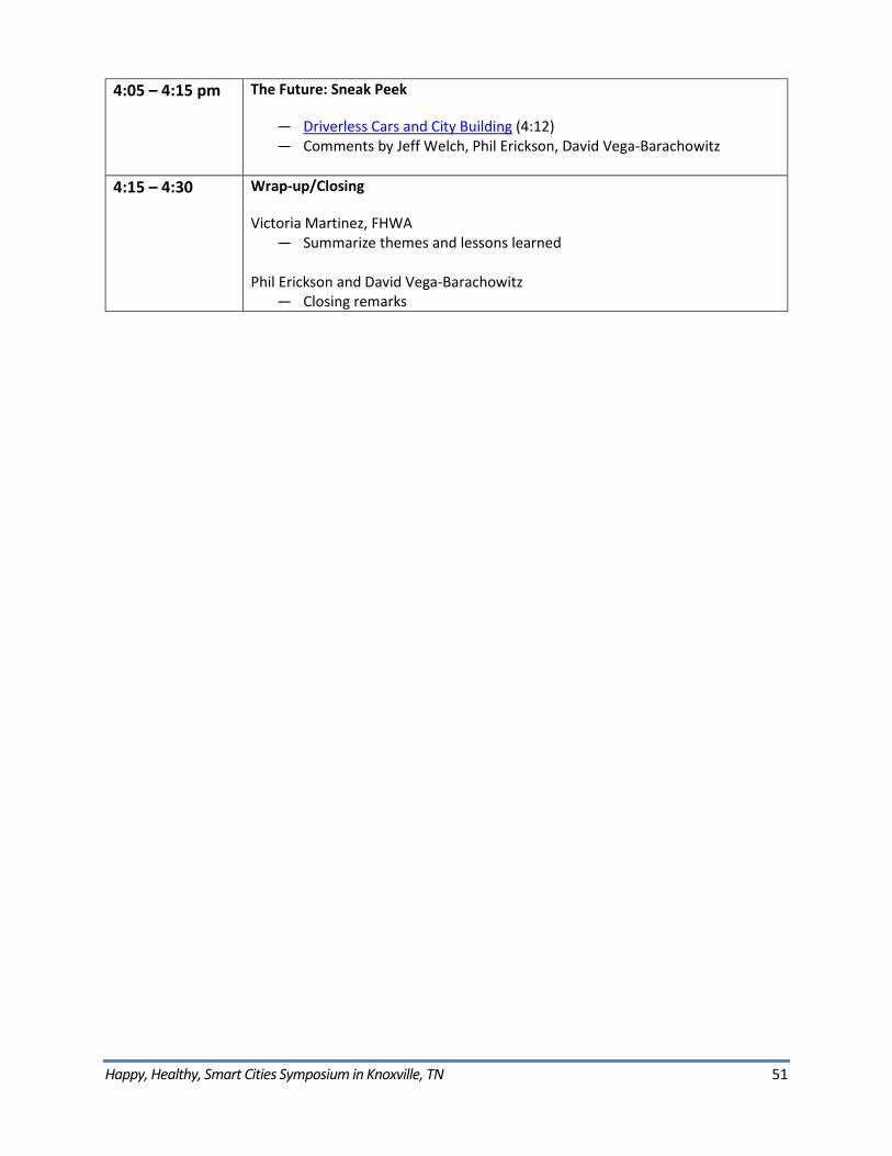
Happy, Healthy, Smart Cities Symposium in Knoxville, TN 51
4:05 – 4:15 pm The Future: Sneak Peek
― Driverless Cars and City Building (4:12) ― Comments by Jeff Welch, Phil Erickson, David Vega-Barachowitz
4:15 – 4:30 Wrap-up/Closing
Victoria Martinez, FHWA ― Summarize themes and lessons learned
Phil Erickson and David Vega-Barachowitz ― Closing remarks
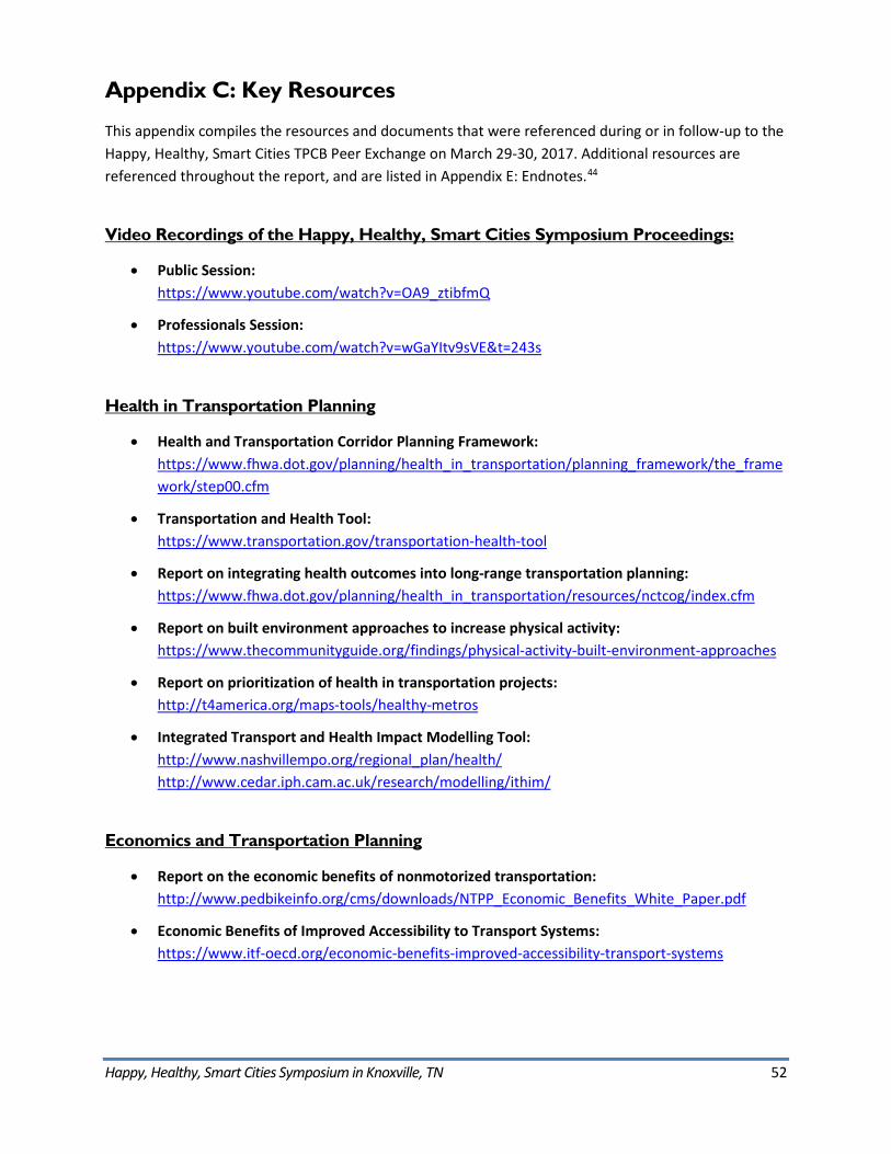
Happy, Healthy, Smart Cities Symposium in Knoxville, TN 52
Appendix C: Key Resources
This appendix compiles the resources and documents that were referenced during or in follow-up to the Happy, Healthy, Smart Cities TPCB Peer Exchange on March 29-30, 2017. Additional resources are referenced throughout the report, and are listed in Appendix E: Endnotes.44
Video Recordings of the Happy, Healthy, Smart Cities Symposium Proceedings:
• Public Session:https://www.youtube.com/watch?v=OA9_ztibfmQ
• Professionals Session:https://www.youtube.com/watch?v=wGaYItv9sVE&t=243s
Health in Transportation Planning
• Health and Transportation Corridor Planning Framework:https://www.fhwa.dot.gov/planning/health_in_transportation/planning_framework/the_framework/step00.cfm
• Transportation and Health Tool:https://www.transportation.gov/transportation-health-tool
• Report on integrating health outcomes into long-range transportation planning:https://www.fhwa.dot.gov/planning/health_in_transportation/resources/nctcog/index.cfm
• Report on built environment approaches to increase physical activity:https://www.thecommunityguide.org/findings/physical-activity-built-environment-approaches
• Report on prioritization of health in transportation projects:http://t4america.org/maps-tools/healthy-metros
• Integrated Transport and Health Impact Modelling Tool:http://www.nashvillempo.org/regional_plan/health/http://www.cedar.iph.cam.ac.uk/research/modelling/ithim/
Economics and Transportation Planning
• Report on the economic benefits of nonmotorized transportation:http://www.pedbikeinfo.org/cms/downloads/NTPP_Economic_Benefits_White_Paper.pdf
• Economic Benefits of Improved Accessibility to Transport Systems:https://www.itf-oecd.org/economic-benefits-improved-accessibility-transport-systems
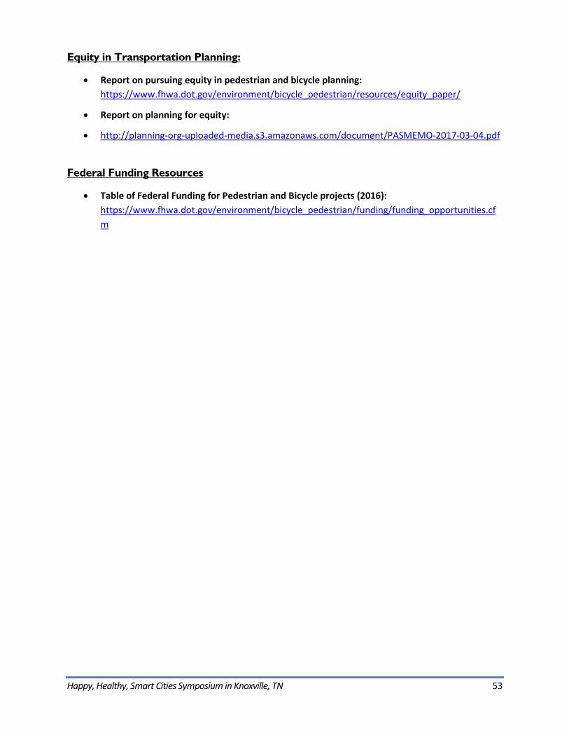
Happy, Healthy, Smart Cities Symposium in Knoxville, TN 53
Equity in Transportation Planning:
• Report on pursuing equity in pedestrian and bicycle planning:https://www.fhwa.dot.gov/environment/bicycle_pedestrian/resources/equity_paper/
• Report on planning for equity:
• http://planning-org-uploaded-media.s3.amazonaws.com/document/PASMEMO-2017-03-04.pdf
Federal Funding Resources
• Table of Federal Funding for Pedestrian and Bicycle projects (2016):https://www.fhwa.dot.gov/environment/bicycle_pedestrian/funding/funding_opportunities.cfm
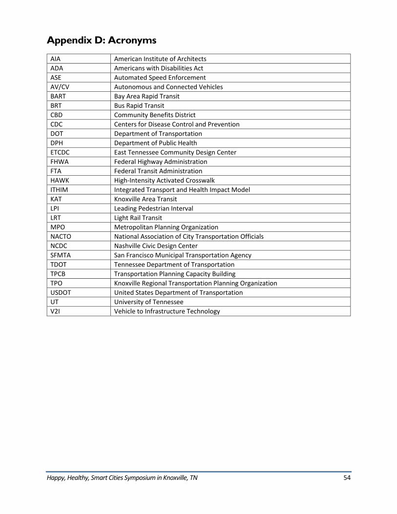
Happy, Healthy, Smart Cities Symposium in Knoxville, TN 54
Appendix D: Acronyms
AIA American Institute of Architects ADA Americans with Disabilities Act ASE Automated Speed Enforcement AV/CV Autonomous and Connected Vehicles BART Bay Area Rapid Transit BRT Bus Rapid Transit CBD Community Benefits District CDC Centers for Disease Control and Prevention DOT Department of Transportation DPH Department of Public Health ETCDC East Tennessee Community Design Center FHWA Federal Highway Administration FTA Federal Transit Administration HAWK High-Intensity Activated Crosswalk ITHIM Integrated Transport and Health Impact Model KAT Knoxville Area Transit LPI Leading Pedestrian Interval LRT Light Rail Transit MPO Metropolitan Planning Organization NACTO National Association of City Transportation Officials NCDC Nashville Civic Design Center SFMTA San Francisco Municipal Transportation Agency TDOT Tennessee Department of Transportation TPCB Transportation Planning Capacity Building TPO Knoxville Regional Transportation Planning Organization USDOT United States Department of Transportation UT University of Tennessee V2I Vehicle to Infrastructure Technology
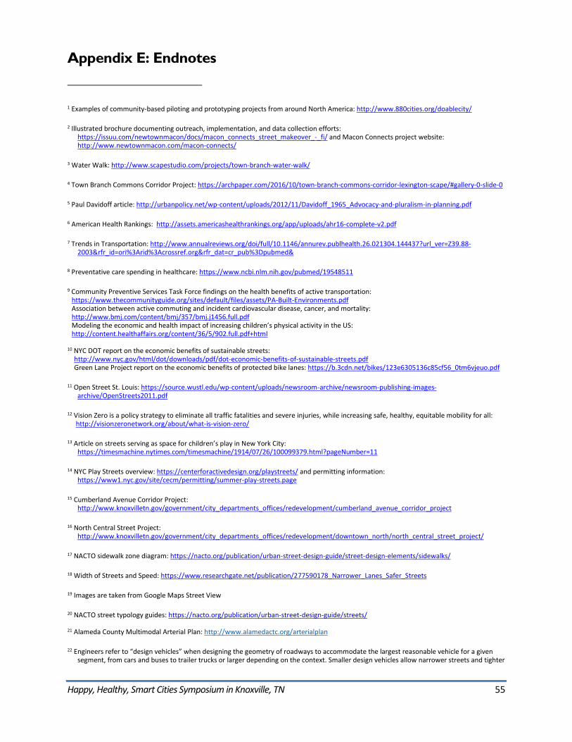
Happy, Healthy, Smart Cities Symposium in Knoxville, TN 55
Appendix E: Endnotes
1 Examples of community-based piloting and prototyping projects from around North America: http://www.880cities.org/doablecity/
2 Illustrated brochure documenting outreach, implementation, and data collection efforts: https://issuu.com/newtownmacon/docs/macon_connects_street_makeover_-_fi/ and Macon Connects project website: http://www.newtownmacon.com/macon-connects/
3 Water Walk: http://www.scapestudio.com/projects/town-branch-water-walk/
4 Town Branch Commons Corridor Project: https://archpaper.com/2016/10/town-branch-commons-corridor-lexington-scape/#gallery-0-slide-0
5 Paul Davidoff article: http://urbanpolicy.net/wp-content/uploads/2012/11/Davidoff_1965_Advocacy-and-pluralism-in-planning.pdf
6 American Health Rankings: http://assets.americashealthrankings.org/app/uploads/ahr16-complete-v2.pdf
7 Trends in Transportation: http://www.annualreviews.org/doi/full/10.1146/annurev.publhealth.26.021304.144437?url_ver=Z39.88-2003&rfr_id=ori%3Arid%3Acrossref.org&rfr_dat=cr_pub%3Dpubmed&
8 Preventative care spending in healthcare: https://www.ncbi.nlm.nih.gov/pubmed/19548511
9 Community Preventive Services Task Force findings on the health benefits of active transportation: https://www.thecommunityguide.org/sites/default/files/assets/PA-Built-Environments.pdf Association between active commuting and incident cardiovascular disease, cancer, and mortality: http://www.bmj.com/content/bmj/357/bmj.j1456.full.pdf Modeling the economic and health impact of increasing children’s physical activity in the US: http://content.healthaffairs.org/content/36/5/902.full.pdf+html
10 NYC DOT report on the economic benefits of sustainable streets: http://www.nyc.gov/html/dot/downloads/pdf/dot-economic-benefits-of-sustainable-streets.pdf Green Lane Project report on the economic benefits of protected bike lanes: https://b.3cdn.net/bikes/123e6305136c85cf56_0tm6vjeuo.pdf
11 Open Street St. Louis: https://source.wustl.edu/wp-content/uploads/newsroom-archive/newsroom-publishing-images-archive/OpenStreets2011.pdf
12 Vision Zero is a policy strategy to eliminate all traffic fatalities and severe injuries, while increasing safe, healthy, equitable mobility for all: http://visionzeronetwork.org/about/what-is-vision-zero/
13 Article on streets serving as space for children’s play in New York City: https://timesmachine.nytimes.com/timesmachine/1914/07/26/100099379.html?pageNumber=11
14 NYC Play Streets overview: https://centerforactivedesign.org/playstreets/ and permitting information: https://www1.nyc.gov/site/cecm/permitting/summer-play-streets.page
15 Cumberland Avenue Corridor Project: http://www.knoxvilletn.gov/government/city_departments_offices/redevelopment/cumberland_avenue_corridor_project
16 North Central Street Project: http://www.knoxvilletn.gov/government/city_departments_offices/redevelopment/downtown_north/north_central_street_project/
17 NACTO sidewalk zone diagram: https://nacto.org/publication/urban-street-design-guide/street-design-elements/sidewalks/
18 Width of Streets and Speed: https://www.researchgate.net/publication/277590178_Narrower_Lanes_Safer_Streets
19 Images are taken from Google Maps Street View
20 NACTO street typology guides: https://nacto.org/publication/urban-street-design-guide/streets/
21 Alameda County Multimodal Arterial Plan: http://www.alamedactc.org/arterialplan
22 Engineers refer to “design vehicles” when designing the geometry of roadways to accommodate the largest reasonable vehicle for a given segment, from cars and buses to trailer trucks or larger depending on the context. Smaller design vehicles allow narrower streets and tighter
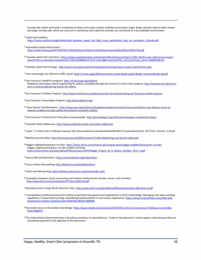
Happy, Healthy, Smart Cities Symposium in Knoxville, TN 56
turning radii, which work well in residential contexts and create a better walking environment; larger design vehicles require wider streets and larger turning radii, which are common in warehouse and industrial contexts, but contribute to a less walkable environment.
23 Speed and Fatalities: https://nacto.org/docs/usdg/relationship_between_speed_risk_fatal_injury_pedestrians_and_car_occupants_richards.pdf
24 Automated speed enforcement: https://www.nhtsa.gov/DOT/NHTSA/Traffic%20Injury%20Control/Articles/Associated%20Files/HS810763.pdf
25 Citywide speed limit reductions: https://www.washingtonpost.com/local/trafficandcommuting/as-traffic-deaths-soar-cities-pursue-lower-speed-limits-to-eliminate-fatalities/2017/02/25/6f86e614-f216-11e6-a9b0-ecee7ce475fc_story.html?utm_term=.5bbf953b619c
26 Citywide speed limit strategy: http://www.ncsl.org/research/transportation/transportation-review-speed-limits.aspx
27 How road design can influence traffic speed: https://nacto.org/publication/urban-street-design-guide/design-controls/design-speed/
28 San Francisco’s WalkFirst program: http://sf-planning.org/walkfirst Additional information about engineering for safety is available through San Francisco’s Vision Zero program: http://visionzerosf.org/vision-zero-in-action/engineering-streets-for-safety/
29 San Francisco’s Parklets Program: http://www.transformca.org/best-practices-item/placemaking-san-francisco-parklet-program
30 San Francisco’s Groundplay Program: http://groundplaysf.org/
31 Times Square Transformation: https://www.pps.org/reference/broadway-boulevard-transforming-manhattans-most-famous-street-to-improve-mobility-increase-safety-and-enhance-economic-vitality/
32 San Francisco’s Pavement to Parks plaza proposal guide: http://groundplaysf.org/publication/propose-a-pedestrian-plaza/
33 Knoxville Urban Wilderness: http://www.outdoorknoxville.com/urban-wilderness
34 Austin, TX Smart Cities Challenge proposal: http://www.austintexas.gov/sites/default/files/files/Transportation/Austin_SCCFinal_Volume1_5.25.pdf
35 Bikesharing and safety: http://transweb.sjsu.edu/PDFs/research/1204-bikesharing-and-bicycle-safety.pdf
36 Wiggle neighborhood green corridor: https://www.sfmta.com/projects-planning/projects/wiggle-neighborhood-green-corridor Wiggle neighborhood green corridor project overview: https://www.sfmta.com/sites/default/files/projects/2015/Wiggle_Project_At_A_Glance_October_2015_0.pdf
37 Secure bike parking lockers: https://www.bikelink.org/help/videos
38 Secure indoor bike parking: http://bikehub.com/bartbikestation/
39 Smart lock bike parking: https://bikeep.com/smart-commercial-bike-rack/
40 Association between active commuting and incident cardiovascular disease, cancer, and mortality: http://www.bmj.com/content/bmj/357/bmj.j1456.full.pdf
41 Bicycling trends in large North American cities: http://www.utrc2.org/sites/default/files/pubs/analysis-bike-final_0.pdf
42 Transportation professional presents outline of potential local government approaches to AV/CV technology: Managing curb space, parking regulations, transportation pricing, and piloting implementation to test various approaches: https://www.smartresilient.com/cities-and-autonomous-vehicle-revolution?eid=240416437&bid=1808486
43 Reversible lanes on the Golden Gate Bridge: https://www.citylab.com/solutions/2015/03/its-time-to-reverse-our-thinking-on-reversible-lanes/388207/
44 The United States Government does not endorse products or manufacturers. Trade or manufacturers’ names appear solely because they are considered essential to the objective of this document.
Happy, Healthy, Smart Cities Symposium in Knoxville, TN 57
U.S. Department of Transportation John A. Volpe National Transportation Systems Center
55 Broadway Cambridge, MA 02142-1093
617-494-2000www.volpe.dot.gov
DOT-VNTSC-FHWA-17-24 FHWA-HEP-18-010