handbook of reclamation techniques in … this handbook is intended to assist an operator in the...
TRANSCRIPT

--------------------------------------------------------------------------------------------------------Mineral Resources Directorate, Yukon---------------------------------------------------------------------------------------------------------------------------
HANDBOOK OF RECLAMATIONTECHNIQUES IN THE YUKON
Yukon Placer Mining Land Use Regulations

Published under the authority of theMinister of Indian Affairs andNorthern DevelopmentOttawa, 1999
QS-Y128-001-EE-A1Catalogue No. R32-199/1999EISBN 0-662-27649-3
© Minister of Public Works and GovernmentServices Canada
Cette publication peut aussi être obtenueCette publication peut aussi être obtenueen français sous le titre :en français sous le titre :
Guide des Techniques de Remise en État des Terres Minières au YukonRèglement sur l'utilisation des terres pour l'exploitationdes placers au Yukon

Preface
This guide was primarily prepared by Laberge Environmental Services, Whitehorse, Yukon.
Disclaimer
This handbook is intended to assist an operator in the reclamation and/or restoration of their mining landuse site. Adopting the suggestions, approaches and options outlined herein are considered to be basicmanagement practices and will not, in any way, constitute a defence in a court of law if an operator wereto be investigated and subsequently prosecuted for a violation of the Yukon Placer Mining Act andRegulations or any other legislation.

TABLE OF CONTENTS
1. INTRODUCTIONClassification of Placer Land Use Operations What is Notification What is an Operating Plan
2. How to Control Erosion and Encourage RevegetationRegulations Preparing Sites for Revegetation Options for Slope Contouring Options for Stripping Operations Regulations Options for Trenching and Pit Excavation Operations Preparation for Re-vegetation Guidelines for Preventing Stream Sedimentation Guidelines for Mining Cuts Guidelines for Tailings and Overburden Piles
3. Archaeological and Burial SitesRegulations
4. Keeping It Clean - Campsite and Waste DisposalRegulations Camp Location and Layout Camp Operation and Maintenance For Seasonal Shutdown For Final Camp Abandonment
5. Handling Fuel and ChemicalsRegulations Fuel and Chemical Storage Fuel Storage Guidelines Fuel Spill Plans
6. Clearing Trees and BrushRegulations Options For Clearing Salvaging Timber
7. Getting There - Access Roads and TrailsRegulations Options for Off-Road Vehicles Stream Crossings Regulations Construction of Roads and Trails Guidelines for Access Roads and Trails
Appendix 1. Glossary of Terms Appendix 2. List of Contacts

1. Introduction
CLASSIFICATION OF PLACERLAND USE OPERATIONS
The objective of this handbook is to offer a range of options and approachesto minimizing environmental impact to the land caused by placer explorationor mining, and to provide the rationale behind them. Basic environmentalstandards for land use activities on claims and leases are outlined in theOperating Conditions, which form Schedule I of the Yukon Placer MiningLand Use Regulations.
The focus of this booklet are suggestions on how to best achieve the basicmanagement practises that govern the Operating Conditions on all classesof exploration and mining land use on placer claims and leases. TheOperating Conditions are divided into 12 headings under the regulations,ranging from conditions for revegetation and erosion control to clearing treesand brush. The Operating Conditions are meant to stand alone for Class I,and to act as benchmarks or environmental standards for Classes II, III andIV.
This booklet can be used to become familiar with the basic OperatingConditions and the environmental standards suggested by them. Theoperator may use the reclamation alternatives and guidelines containedwithin to assist in preparing an exploration and mining land use Notificationor Operating Plan. The operator’s own experience and knowledge ofsuccessful reclamation techniques, and consultation with the Chief ofMining Land Use and other specialists will decide the final form of aNotification or Operating Plan - not a set of prescribed solutions. In otherwords, do not rely exclusively on this booklet for the only methods ofmeeting the requirements of the Regulations. The following sections in this handbook are organized along the line of theSchedule I Operating Conditions. Under each chapter, the appropriateoperating conditions are repeated from Schedule I of the Regulations, alongwith supporting rationale, objectives, reclamation alternatives and guidelines.For a quick reference of the Operating Conditions, see Schedule I of theRegulations.
Classifications of placer exploration or mining operations are based onspecified thresholds of activities, as defined by Section 4 of the YukonPlacer Mining Land Use Regulations. The level of environmental screeningfor placer exploration or mining operations increases as the potential tocause significant effects to the environment broadens from Class I to ClassIV respectively. All classes of placer exploration or mining operations mustcomply with the Operating Conditions of Schedule I of the Regulations.

Class I Operation
Class II Operation
Class III Operation
Class IV Operation
Class I grass roots exploration
The characteristics which define one class from another are as summarizedin the following:
This class is characterized by grass roots exploration activity on claims orleases such as hand shafting, line cutting, drilling, mobilization ofequipment, and moving minimal amounts of overbuden. Carried out incompliance with the Operating Conditions, the activities in Class I shouldhave very little potential for effects on the environment. No prior governmentapproval is required for Class I, but the activity will still be subject toinspection for compliance with the Operating Conditions.
This class includes most other activities on claims or leases associatedwith placer exploration such as extension of roads and trails, moving heavyequipment, preparing ground, bulk sampling, etc. Before commencing aClass II activity, the Chief of Mining Land Use must be informed through“Notification”, which explains the proposed operations and what measureswill be taken by the operator to minimize environmental effects.
This class includes extensive road building or upgrades, permanentstructures, and long off-road mobilization of heavy equipment. All Class IIIoperations require submission of a detailed exploration and mining land useOperating Plan, which must be reviewed and approved by government beforeproceeding. The reclamation and mitigation options and guidelines in thisbooklet may be useful when preparing the plan.
This classification is reserved for production mining, which is in turn definedas the stage when a water licence is required under the Yukon Waters Act.When preparing the required land use Operating Plan for production mining,operators would be well advised to consider the entire placer operation.That is, plan for handling water and soil at the same time, keeping in mindthat much of the exploration and mining land use considerations will gotogether with stream channel restoration and other components of theYukon Placer Authorization and Water Licence Application.

What is Notification?
What is an Operating Plan?
Notification is the method that allows for fast, responsible permitting ofClass II placer exploration with a minimum of red tape. Each year, at least25 days before start-up, the operator must contact government. This isdone by filling out the “Notification Form”, found in Schedule I of theRegulations, and submitting it to the Chief of Mining Land Use.
This is the detailed plan that must be submitted to the Chief for Class III orClass IV activities. The plan has to be reviewed within specified time limitsand approved before commencing the activity. The Regulations specify inpoint form the particular information that an Operating Plan must include.Operating Plan details are further outlined in the Guide to Mining Land UseRegulations: Policies and Procedures booklet, available from the MiningLand Use Office.
For the purposes of this handbook, the Operating Plan must contain all ofthe planned activities of the placer exploration or mining operation along witha description of how the exploration and mining land use disturbance will bereclaimed and how any adverse affects to the environment will be mitigated

2. How to control erosion and encourage revegetation
REGULATIONS
Operating Conditionsfor Re- establishmentof the vegetative mat
Operating Conditionsfor Erosion Control
Erosion control and revegetation often go hand in hand: if the soil surface isconstantly unstable due to erosive forces, then revegetation can’t take hold.Likewise, where plant cover is not re-established, the surface will be moresubject to erosion. Most land disturbed by placer operations will successfullyrevegetate as long as the area is left within a reasonable range of conditions.
For Class I operations, no notification is required: simply comply with theOperating Conditions for erosion control and re-establishment of the vegetativemat.
Here are the basic Operating Conditions concerning revegetation and erosioncontrol for placer exploration or mining land use operations, from theRegulations.
All areas disturbed during an exploration or mining operation must be left by theoperator in a condition conducive to successful revegetation by native plantspecies or other species adaptable to that environment.
All areas disturbed during an exploration or mining operation must be re-sloped,contoured, or otherwise stabilized by the operator to prevent long term soilerosion, slumping and subsidence and to comply with the conditions for re-establishment of the vegetative mat.
The first condition sets the environmental standard for all placer exploration ormining land use in regard to revegetation. The objective for revegetation of grounddisturbed by placer exploration or mining, no matter what classification, is toleave the ground in such a way as to provide a good chance for successfulrevegetation by plant species native to the area (natural revegetation).Application of seed and fertilizer, or "assisted" revegetation, would only berequired in areas unsuited to natural revegetation but having had significantvegetative cover before the land was disturbed. When seed is applied to placerexploration or mining disturbances, it should consist of native species to theextent possible in order to avoid the introduction of undesirable new species tothe area.
The environmental standard for erosion control in placer exploration or miningland use is to leave slopes, excavations, and other disturbed lands in a rangeof conditions that will limit the incidence of gullying, sheet erosion, slumping andother instabilities. One of the objectives of controlling erosion is to prevent soilerosion and excessive sediment load to nearby streams. In general, re-slopingor re-contouring of the disturbed land will be done as a means of preparing thesite for successful revegetation, which in turn prevents erosion and sedimentdischarge.

PREPARING SITESFOR REVEGETATION
Slope ContouringOptions
Natural revegetation oneyear after disturbance.
The measures you will take to stabilize the disturbed land and/or prepare it forrevegetation will vary depending on the scale and type of activity, the soil type,and the amount of permafrost present.
The following are some options for controlling erosion and preparing sites forsuccessful revegetation. Notifications and Operating Plans must include anexplanation of how soil erosion will be prevented and revegetation will beaccomplished. The operator may choose to adopt one or more of the examplessited in these guidelines, or else propose other site specific measures in theirNotification or Operating Plan.
Any significant amount of earth movement during placer exploration or miningwill require some grade restoration or side-slope contouring. The reclamationalternatives for contouring offered below are intended for piles and side slopesresulting from any placer exploration or mining activity.
The first two alternatives are practical, easy to perform and the most commonlyused applications. The last five alternatives, although they may be generallyapplied, should be reserved for situations where there is likely to be significantsediment load to adjacent watercourses (see guidelines for preventing streamsedimentation on page 10).

RECLAMATIONOPTIONS
High Ice Content Slopes
Contour to Blend withNatural Topography
Unfrozen Slopes -Coarse Soil
Unfrozen Slopes - Fine Soil
Coarse Piles
Fine Soil Piles
Low Ice Content Slopes
An example of a coarsepile bladed to an optimum
grade of less than 2:1.Fine soils bladed into
surface.
Options for Slope Contouring:
Side slopes with ice-rich soils, as in "black muck", may be left vertical ornear-vertical to thaw and stabilize naturally. Ideally these may be undercut sothat the top vegetated mat falls over and covers the exposed ice rich slope.
Side slopes and/or push piles may be contoured so as to blend with the naturaltopography and the top of piles and slopes may be rounded off.
Side slopes with no permafrost made up of coarse, well drained soils should begraded to a slope less than 2 horizontal: 1 vertical, and if over 15m high shouldbe benched to prevent excessive erosion.
Side slopes with no permafrost made up of poorly drained, fine-grained soilshould be graded to a slope less than 3 horizontal: 1 vertical.
Piles of coarse soils should be graded to a slope less than 2 horizontal: 1vertical, and the top of the pile rounded off.
Piles of fine-grained soils, topsoil or organics should be graded to a slope lessthan 3 horizontal:1 vertical and the top of the pile rounded off.
Side slopes with less than 5 percent frost by volume should be graded to a slopeless than 2 horizontal:1 vertical and the top of the slope rounded off.

RECLAMATIONOPTIONS
Clear Trees First
Conserve OrganicMaterial
Overburden Piles
Contour Overburden toMatch Natural
Topography
REGULATIONSOperating Conditions
for Trenching
Careful planning before beginning a large scale stripping operation will ensurethat the Operating Conditions for revegetation and erosion control can easily bemet at the end of the placer exploration or mining operation.
Options for Stripping Operations:
• Clearing of trees and brush should take place first, in accordance withthe Operating Conditions and acceptable options for removal of treesand brush.
• Topsoil and organics may be windrowed separately from overburden andleft in stabilized piles, which are ”guarded” if necessary to preventerosion, for use in preparing the site for revegetation.
• Stripped overburden may be left in stable piles, sloped and contoured,at least 5 m from the edge of standing trees.
• Overburden may be stacked along the valley wall, contoured to blendwith the natural topography and the top may be rounded off.
These are the operating conditions for Trenching, from the Regulations:
Trenching carried out by hand or with hand-held tools must be methodical, andthe trenches must be stabilized and marked in such a way as to minimize riskto the public.
When trenching with mechanized equipment, an operator shall segregatematerial into two piles:
1. Vegetative mat; and2. Overburden and bedrock,
to be conserved and used for backfilling the trenches.
Trenches excavated during an exploration or mining operation with mechanizedequipment must be backfilled by the operator. Overburden and bedrock shallbe replaced first, followed by vegetative mat. The backfilled trench must complywith the operating conditions for re-establishment of the vegetative mat anderosion control.
The environmental standards in trenching and pit excavation are to minimizeterrain hazards and promote revegetation of the site through orderly backfillingof all trenches dug by machine. Most of the instability problems in trenchingarise from excavating in frozen ground or from orienting trenches parallel to steepslopes. Special care should be taken during placer exploration or mining not tohave trenches or open pits turn into retrogressively failing gullies.

RECLAMATIONOPTIONS
Backfill Trenches
Conserve Materials
Natural Revegetation
Spread Organic Material
PREPARATION FOR RE-VEGETATION
Reclamation standards for exploration trenching are clearly outlined within theOperating Condition itself. Suggestions for the re-establishment of the vegetativemat and erosion control are described in the following sections.
Options for Trenching and Pit Excavation Operations:
For Class I & II activities, the trench or pit must be backfilled after sampling andbefore the end of the season.
Where there is no organic cover, the excavated material will be conserved forbackfill.
Backfilled trenches and pits will be contoured so as to blend in with thesurrounding topography, and the surface prepared for successful naturalrevegetation.
Trees and brush that were cleared for trenching or pits may be bucked up intosuitable lengths and spread over the recontoured trench site.
All trenches or pits excavated bymachine must now be backfilled.
Once a disturbed site has been re-contoured, the next step is to give natural re-vegetation the best possible chance of success by leaving the soil surface in acondition that will promote plant growth. The question is whether or not a givensurface will be likely to re-vegetate. Compacted surfaces, smoothly gradedsurfaces on slopes, and dry coarse-grained surfaces are the least likely tosustain growth. Use your experience with the site and observations of nearbyoperations to judge when to apply a given technique. Almost all placer depositsare covered with good material for seed stock and growth

RECLAMATIONOPTIONS
Rip
Roughen SmoothSurfaces
Spread Topsoil andOrganics
Mix Fine Soil intoCourse
Apply Seed andFertilizer
Spreading topsoil ontocoarse soils
medium - make the best use of organic materials by spreading conserevedtopsoil piles onto surfaces not likely to revegetate on their own.
The following are some suggested methods for the re-establishment of thevegetative mat:
Where surface soils appear adequate to sustain growth, these areas could beprepared as follows:
! Compacted surfaces may be ripped to loosen the subsoil.
! Smooth surfaces may roughed up by walking tracked equipment up anddown the slope , or by any other acceptable means, to provide seedand moisture traps.
Where surface soils appear unlikely to sustain growth, these areas could beprepared as follows:
! Topsoil and organic matter set aside may be bladed out onto thesurface.
! The soil matrix may be improved by blading fine-grained soils ontocoarse-grained surfaces.
! A native selection seed mix and fertilizer appropriate for the sitecharacteristics and region may be applied.

GUIDELINES FORPREVENTING STREAM
SEDIMENTATION
GUIDELINES FORMINING CUTS
Many of the above alternatives may be applicable to Operating Plans, but thelarger scale of Class III and IV operations may also require consideration of thefollowing guidelines.
Large-scale stripping or stockpiling operations may cause discharge ofunacceptable amounts of sediment to nearby water courses. To controldownslope and downstream sedimentation, an Operating Plan should includemeasures to keep sediment-laden water caused by exploration and mining landuse operations from reaching streams.
Here are some sediment control measures to consider:
• Construct a sump either by pushing up berms or by excavatingdepressions, or else by using existing topographic low areas to trapsilt-laden run-off from unstable slopes or cut banks.
• Maintain a vegetated buffer strip or setback between the naturalboundaries of streams and the operation. These setbacks can performwell as sediment traps and also serve to maintain stream bank stabilityand limit the destabilisation of the watercourse itself.
• Arrange windrows of slash perpendicular to the slope to trap sedimentfrom stripped areas.
• Construct drainage ditches along the bottom of highly erosive piles orslopes to carry silt-laden run-off to either sedimentation ponds oralternative sediment traps.
• Construct benches on slopes to control erosion.
It is the responsibility of the operator to prevent exploration and mining land useoperations from causing excessive downstream sedimentation.
Placer mining pit wall stability involves the issues of safety, stability, aesthetics,and the post-mining return to a productive habitat. These are a function of soiltype and amount of permafrost.
• When excavating unfrozen soils (on bench operations for example),consider removing standing timber to a location where it will bedisposed of outside the ultimate cut perimeter after the cut has beenabandoned and slopes have been stabilized at the natural angle ofrepose. When trees fall into the cut, the root wad rips up and exposesmore soil to erosion. Removing trees from the cut perimeter improvesaesthetics, lessens the terrain hazard, and promotes more orderlystabilization. At no time should trees and overburden material bepushed over the edge of hillsides.
• When excavating in frozen soils, consider removing the standing timber,leaving as much of the undergrowth and vegetative mat as possible, fora distance of 1 ½ times the projected depth of the cut. This will promotebetter thaw stabilization.
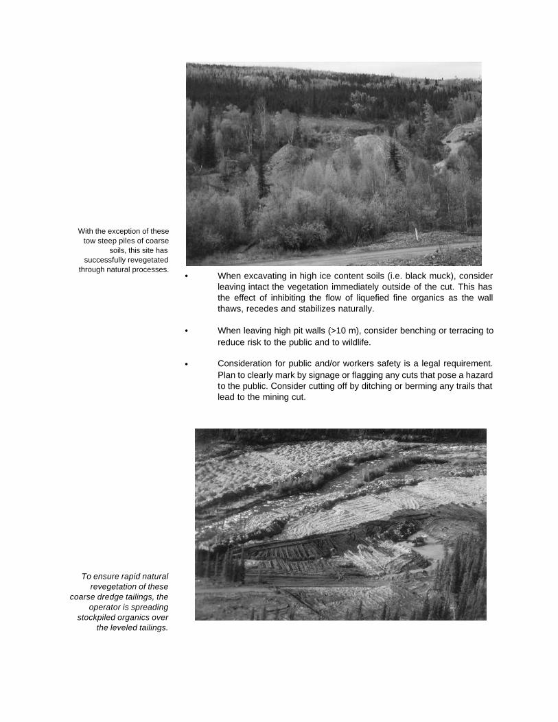
With the exception of thesetow steep piles of coarse
soils, this site hassuccessfully revegetated
through natural processes.
To ensure rapid naturalrevegetation of these
coarse dredge tailings, theoperator is spreading
stockpiled organics overthe leveled tailings.
• When excavating in high ice content soils (i.e. black muck), considerleaving intact the vegetation immediately outside of the cut. This hasthe effect of inhibiting the flow of liquefied fine organics as the wallthaws, recedes and stabilizes naturally.
• When leaving high pit walls (>10 m), consider benching or terracing toreduce risk to the public and to wildlife.
• Consideration for public and/or workers safety is a legal requirement.Plan to clearly mark by signage or flagging any cuts that pose a hazardto the public. Consider cutting off by ditching or berming any trails thatlead to the mining cut.

Good grade restoration oftailings and overburden. Finesoil matrix and microsites for
seed trap created by dozertracks.
GUIDELINES FOR TAILINGSAND OVERBURDEN PILES
The management of these piles of materials greatly affects the degree to whichthe site will return to a self-supporting ecosystem. If left within a reasonablerange of conditions, these new landforms will become very suitable habitat. Inbroad valleys, excellent riparian habitat can be maintained with a minimum ofcost and effort. I n gulches and narrow valleys containing ice-rich soils, thepost-mining conditions often support more productive and diverse habitat thanwhat existed prior to mining.
The key to promoting successful reclamation of tailings piles and overburdenpiles is in grading to an appropriate slope, contouring, providing a fine soil matrixcover when needed, and providing an environment that traps seed and water.Use your experience and observations of successful reclamation in the area tocreate the landforms best suited to the site with a minimum of extra materialshandling.
Plans will be site specific but likely fall into four main categories: gulches,narrow valleys, wide valleys, and terraces or benches. In gulches, the strategywould likely be to recontour piles to blend with the valley topography within agenerous range of slope angles, and provide competent velocity barriers madeup of very coarse tailings or rock, to reduce short-term sedimentation. In widervalleys, a range of options is possible, including encouraging wetland habitat,contouring ramps and dumps to create landforms more suitable for wildlife, andsimple grading and spreading of stockpiled topsoil and organics to hasten plantgrowth.
On terraces or benches not normally considered as riparian habitats, thestrategy is likely to be simply a case of keeping slope angles within somereasonable range and applying topsoil or finer textured soil covers wherenecessary to encourage plant growth.

Blading tailings with goodsoil matrix - likely torevegetate naturally.
Coarse dredge tailings require some special treatment to encourage re-vegetation. Due to the mining method, fines are deposited at the bottom of thepile and coarsest material on top. This soil matrix is not suitable for re-vegetationbecause of poor moisture retention and lack of nutrients. Blading, contouring,and compaction will improve the soil matrix.
Tailings piles and waste overburden piles should be constructed with the lowestslope angle that is practical. Round off the top and toe.
Consider pumping a portion of the sluice undersize onto the top of the coarsesection as dredging progresses.
Re-blading stripped overburden or stockpiled topsoil onto coarse tailings ordredge tailings such that a maximum surface area is covered is a good methodof encouraging revegetation.
Consider contouring and blading dredge tailings relatively flat.

3. Archaeological and burial sites
Operating Conditionsfor Archaeological and
Burial Sites
Archaeological Objectmeans an object that is the
product of human art,workmanship, or use, and
it includes plant andanimal remains that have
been modified ordeposited in consequenceof human activities, and is
of value for its historic orarchaeological
significance.
The Operating Condition for archaeological and burial sites is as follows:
All archaeological sites and burial grounds must be avoided. If such a site isencountered in the course of an exploration or mining operation, it is to bemarked, reported to the Chief and protected from further disturbance untilauthorization is given by the Chief.
The environmental standard in regard to archaeological sites and burial groundsto be observed at any level of exploration and mining land use activity is toavoid these sites if possible, and to stop work at the site if you encounter one.
Of note, under Section 17.2.b. of the Yukon Placer Mining Act, cemeteries areexcepted from lands on which claims can be staked.
In order to avoid any surprises the operator should take steps to try and identifyany known sites in their claim areas. Here are some ways this can be done:
• The First Nation in whose traditional territory the placer exploration ormining operation is located, and the Heritage Branch of theGovernment of the Yukon may be able to provide advice as to knownsites (see Appendix II).
• Most burial sites have been selected as part of the Land Claims siteselections for the First Nation in who’s traditional territory the area issituated. All land claims selections, both final and tentative, appear onthe claim maps available at the Mining Recorders office. The locationof site selections through land claims is also available at the Territorialand Federal land claims offices.

4. Keeping it Clean: Cleanliness and Waste Disposal
REGULATIONS
Operating Conditions forCleanliness
Poor practice -Abandonment of waste
materials after a programis no longer allowed.
The Operating Conditions for Cleanliness are relevant to waste disposal in andaround placer exploration or mining camps.
Debris, equipment, fuel barrels, scrap metal or other waste at the work siteshall be disposed of safely, so as not to attract wildlife, by removal, burial, orincineration, as often as is practical throughout the mining season andcompletely at the cessation of the exploration or mining operation.
Campsites must be kept clean and tidy.
Structures must be removed and the site restored at the end of the explorationor mining operation to a level of utility comparable to its previous level of utility.
The above conditions indicate the environmental standards for all placerexploration or mining operations where there is a campsite or waste isgenerated anywhere on the property. These are:
• Avoidance of land or water pollution and risk to wildlife through properwaste disposal and handling.
• Attention to aesthetics and public relations by reducing litter andwaste material dumps.
• Clean-up and restoration of work areas or campsites seasonally andat the end of mining.
It would be impractical to list all of the acceptable ways and means toaccomplish these goals because they will vary with the scale of operations andbecause many of the measures relate to public health and safety concerns: notonly exploration and mining land use. What is offered in the following areguidelines which represent good environmental practice for waste disposal,cleanliness, and restoration in and around placer exploration or mining camps.

CAMP LOCATION ANDLAYOUT
Good layout, competentsoil, room for future needs.
If a large-scale camp is planned with permanent structures or more than 250person-days per season, or the camp is situated in an environmentally sensitivearea, more sophisticated measures and more consultation with the Chief ofMining Land Use will be required when developing the Operating Plan.
For a detailed guideline on camps see A User’s Guide to Camp Development,published by Land Resources, DIAND.
When establishing a new camp, locate the campsite in existing clearings orabandoned camp sites where practical.
• Locate residential and office buildings no less than 30 meters from thehigh water mark of streams.
• Locate mechanical shops or buildings used for storage oftoxic/deleterious materials no less than 30 meters from the high watermark of streams.
• Lay out buildings and other facilities on well drained soils with enoughroom for present and future needs;
• Locate subsurface grey water pits and/or pit privies at least 30 metersfrom the high water mark of streams and at least 1.2 meters abovebedrock or water table. If very permeable soils are encountered, the pitprivy or grey water pit should be lined with 0.6 meters of sand or silt.These measures may help to prevent downstream pollution bypathogenic (disease causing) organisms.
• A properly designed and installed sewage disposal system may berequired for large camps and certainly for permanent dwellings.Complete information on private sewage disposal systems is availablefrom Health Canada or the nearest Environmental Health office.
CAMP OPERATION ANDMAINTENANCE
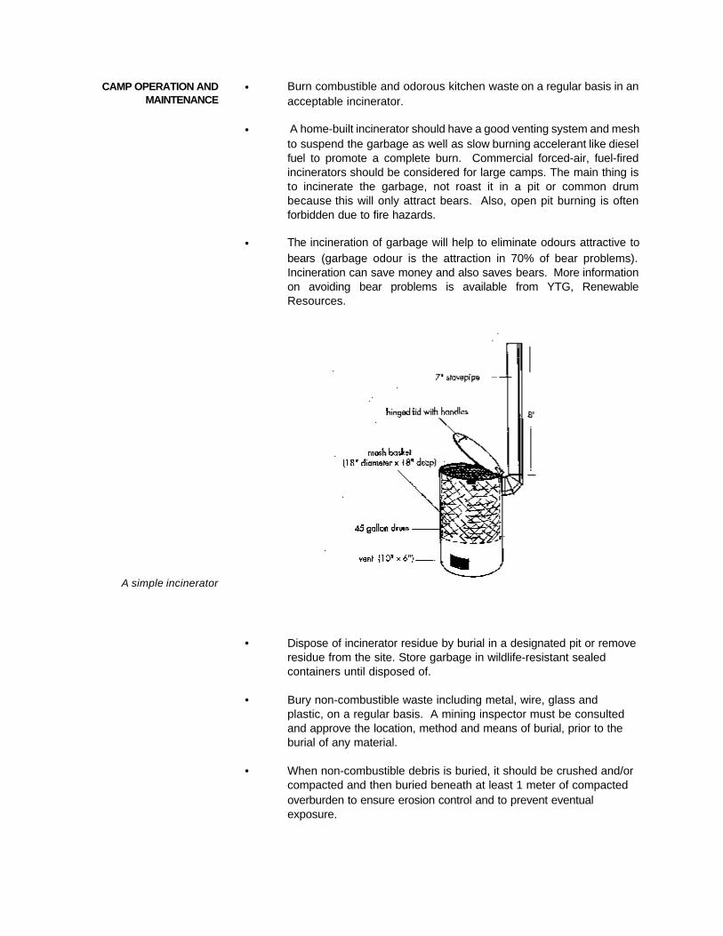
A simple incinerator
• Burn combustible and odorous kitchen waste on a regular basis in anacceptable incinerator.
• A home-built incinerator should have a good venting system and meshto suspend the garbage as well as slow burning accelerant like dieselfuel to promote a complete burn. Commercial forced-air, fuel-firedincinerators should be considered for large camps. The main thing isto incinerate the garbage, not roast it in a pit or common drumbecause this will only attract bears. Also, open pit burning is oftenforbidden due to fire hazards.
• The incineration of garbage will help to eliminate odours attractive tobears (garbage odour is the attraction in 70% of bear problems).Incineration can save money and also saves bears. More informationon avoiding bear problems is available from YTG, RenewableResources.
• Dispose of incinerator residue by burial in a designated pit or removeresidue from the site. Store garbage in wildlife-resistant sealedcontainers until disposed of.
• Bury non-combustible waste including metal, wire, glass andplastic, on a regular basis. A mining inspector must be consultedand approve the location, method and means of burial, prior to theburial of any material.
• When non-combustible debris is buried, it should be crushed and/orcompacted and then buried beneath at least 1 meter of compactedoverburden to ensure erosion control and to prevent eventualexposure.

FOR SEASONALSHUT-DOWN
At final abandonment,remove all waste and all
temporary structures
FOR FINAL CAMPABANDONMENT
• Remove all garbage in permafrost areas. Buried material in permafrostis likely to be forced to the surface by frost action.
• If practical, back haul solid waste to the nearest maintained dump.
• Avoid scattering wood debris, empty drums, junked equipment andmetal waste over the claims. Remove these items from work areasregularly and keep in a secure area for final disposal.
• Remove from the camp or safely store on site any materials that mayresult in injury to wildlife such as wire, steel, glass and plastic.
• Either back haul all non-combustible garbage or bury on site with 1metre of overburden. Compact overburden after burial to prevent soilerosion.
• Look around. Has solid waste been cleaned up? Have wildlifeattractions been removed?
• Remove everything from the site, including all buildings, machinery,materials, fuel drums, used hydro carbons, unburied solid waste, andmetal waste including junked vehicles.
• Rip or loosen compacted soil that is likely to revegetate naturally, orspread topsoil onto areas that have soils not likely to revegetate.
• Certain structures and materials may be left on site for future re-use in
accordance with an approved Operating Plan.

5. Handling chemicals and fuel
REGULATIONSOperating Conditions for
Fuel and ChemicalStorage and Handling
FUEL AND CHEMICALSTORAGE
Fuel and other petroleum products and chemicals shall be stored andtransferred in such a manner as to prevent spillage into a body of water or ontothe surrounding land.
A fuel spill emergency plan must be in place and a copy of it posted on-site.
When the quantity of fuel in storage exceeds 4 000 L, a secondary containmentfacility must be constructed that is of material impervious to petroleumproducts and that is of sufficient size to accommodate at least 110% of thefuel, in the case of a single storage tank. If there is more than one storagetank, the secondary containment facility must be of sufficient size toaccommodate 110% of the capacity of the largest tank or 10% of the totalcapacity of all the tanks, whichever size is greater.
Vehicles must be maintained and operated in a manner designed to preventspills of fuel or oil.
All waste petroleum products must be safely stored on-site or be removed toa waste disposal facility approved under the Special Waste Regulations of theEnvironment Act of the Yukon
All fuel spills must be immediately contained, cleaned up and reported to aninspector.
In addition to the above conditions, you must also comply with the OperatingConditions for Cleanliness, which would apply to empty fuel drums and othersolid waste.
The environmental standards in handling chemicals and fuel apply to all levelsof activity. These are:
• Spill prevention through proper handling, storage and contingencyplanning.
• Secondary containment for large volumes of stationary storage.
• Prevention of land and water pollution through proper vehicle operationand maintenance, and safe handling and disposal of waste petroleumproducts.
Large volume, above-ground storage facilities should be provided with thecapacity to contain spills. These containment facilities should be capable ofhandling large volume spills in order to protect adjacent lands and water. Fuelstorage areas should be stable and set back greater than the minimum set ackfrom watercourses in order to avoid spillage into the water shed.

Secondary containment offuel storage facilities
exceeding 4 000 L may beaccomplished simply by
constructing earthenberms and lining the
containment withpetroleum impermeable
material.
FUEL STORAGEGUIDELINES
Marking of containers will identify potential liabilities and also act as anincentive to remove empty containers from sites. Labelling of containers forall “controlled substances” under the Hazardous Products Act (Canada) isrequired under the Workplace Hazardous Materials Information SystemRegulations (WHMIS) under the Occupational Health and Safety Act (Yukon).
The following are suggested ways to ensure that petroleum products andchemicals are stored and handled in as safe a manner as possible:
• Ensure that all fuel containers, regardless of size, are situated onstable ground located well above the ordinary high water mark of anywatercourse.
• Leave a safe distance between fuel caches and water bodies anddrainages.
• Ensure that containers with a capacity greater than 4,000 litres arelocated at least 30 metres from any watercourse.
• Store fuel drums in an upright position to prevent the possibility ofspills and leaks.
• Ensure all containers are sealed when not in use.
• Ensure that every precaution is taken to avoid spillage during fueltransfers.
RECLAMATIONOPTIONS
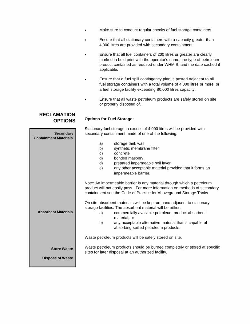
SecondaryContainment Materials
Absorbent Materials
Store Waste
Dispose of Waste
• Make sure to conduct regular checks of fuel storage containers.
• Ensure that all stationary containers with a capacity greater than4,000 litres are provided with secondary containment.
• Ensure that all fuel containers of 200 litres or greater are clearlymarked in bold print with the operator’s name, the type of petroleumproduct contained as required under WHMIS, and the date cached ifapplicable.
• Ensure that a fuel spill contingency plan is posted adjacent to allfuel storage containers with a total volume of 4,000 litres or more, ora fuel storage facility exceeding 80,000 litres capacity.
• Ensure that all waste petroleum products are safely stored on siteor properly disposed of.
Options for Fuel Storage:
Stationary fuel storage in excess of 4,000 litres will be provided withsecondary containment made of one of the following:
a) storage tank wallb) synthetic membrane filterc) concreted) bonded masonryd) prepared impermeable soil layere) any other acceptable material provided that it forms an
impermeable barrier.
Note: An impermeable barrier is any material through which a petroleum product will not easily pass. For more information on methods of secondarycontainment see the Code of Practice for Aboveground Storage Tanks
On site absorbent materials will be kept on hand adjacent to stationarystorage facilities. The absorbent material will be either:
a) commercially available petroleum product absorbentmaterial; or
b) any acceptable alternative material that is capable ofabsorbing spilled petroleum products.
Waste petroleum products will be safely stored on site.
Waste petroleum products should be burned completely or stored at specificsites for later disposal at an authorized facility.

Portable secondarycontainment structures are
an economical option forhighly mobile operations.
FUEL SPILL PLANS A fuel spill emergency plan should be simple and practical. It would include acontingency plan for the prevention, reporting, control and cleanup of accidentalspills.
A posted spill contingency plan will help make everyone on site mindful of thesteps to be taken to ensure safety and minimize environmental impacts. Thekey to responding to fuel spills is to ensure that they are isolated and notallowed to spread to adjacent land or into water bodies.
• Contain the spill into empty barrels.
• Use absorbents (manufactured or sawdust) to absorb small fuel spills.
• If conditions are appropriate, burning of spilled petroleum product maybe permitted
• Spill clean-up in open water bodies may be achieved with absorbentmaterial
• On land, earthen dikes can be used to hold fuel until removal ispossible.
• Dikes should be lined with plastic to prevent seepage into the ground.
Fuel spills are reported to Environment Canada spill reportnumber (867) 667-7244
• Have this number posted at the site.
• For all petroleum products, any quantity greater than 100 L must bereported, or, any quantity which exceeds conditions of a WaterLicence.

6. Clearing Trees and Brush
REGULATIONS
Operating Conditions forGrid Line Cutting
Operating Conditions forRemoval of Trees and
Brush from Corridors andClearings
Most disturbances caused by typical placer exploration or mining activitiesbegin with clearing of trees and brush.
Cut brush must not be piled so that it blocks movement of wildlife or people.
Leaning trees created by the cutting of lines must be knocked down.
Lines must be cut by hand or with hand-held tools.
Lines must not exceed 1.5 m in width.
In making a clearing the vegetative mat must not be removed unless thepurpose of the clearing is to remove the overburden.
All risk of fire hazard must be avoided.
Removed brush shall not be piled so that it blocks movement of wildlife orpeople.
Leaning trees created by the removal of trees and brush from corridors andclearings must be felled. When it is economically viable to do so, timbersuitable for sale must be salvaged and stockpiled.
The environmental standards for cut lines are self-explanatory. If a operationrequires a line wider than 1.5 m, notify the Chief, Mining Land Use and providethe justification for the wider line width.
Larger scale removal of trees and brush from corridors or clearings requiresattention to these environmental objectives:
• avoiding fire hazards• encouraging decomposition• allowing for salvage of economically viable timber resources, or
"merchantable timber"
It is not the responsibility of the operator to determine whether or not the timberwhich they plan to clear is “merchantable”. It is up to the District ResourceManagement Officer to identify economically viable timber stands at the timethat they review a Notification or an Operating Plan (see Salvaging Timber onpage 19).
RECLAMATIONOPTIONS
Brush Piles
Compaction
Burning
Burial
Salvage Timber
SALVAGING TIMBER
The following apply to clearings up to 400 m² per claim per year. Clearingsbeyond this threshold require an Operating Plan.
Brush piles should be located away from the edge of standing trees. Thesepiles will not be situated so as to block existing trails used by wildlife, trappers,or other land users.
Brush piles and/or windrows may be compacted tightly to the ground surfaceby walking tracked equipment up onto the pile or windrow after dropping eachblade load.
Brush piles and windrows may be burned in accordance with a valid BurningPermit.
Brush piles or windrows may be buried so that nothing protrudes from theground, and covered with 1 m of placer soil and a layer of topsoil in that order.
Merchantable timber may be set aside for salvage.
For placer exploration or mining land use in general, an "economically viabletimber resource" is defined as timber of a size, quality, and quantity that canbe harvested economically. Since all mining land use activities requiringmechanical clearing of significant areas of timber requires either Notification oran Operating Plan, the Chief of Mining Land Use will have ample time torespond to the placer exploration or mining operation plan and advise theoperator as to the presence of viable timber. If Renewable Resources (DIAND)deems the timber economically viable they may put out a Tender for bids toharvest the salvageable timber. The claim holder gives up their right to thetimber at the time they record the claim, but the operator may submit a bidunder a separate land use permit if he or she wishes.
Sections 47.1.b. of the Yukon Placer Mining Act still apply to the salvage oftimber on mining claims. If there is timber surplus to needs for miningpurposes, you may apply for a commercial timber permit to allow you or athird party to harvest and sell this wood. You may also deck the timber forlater disposal by the Crown. Keep in mind that the removal of trees andsubsequent possible salvage of timber only applies to land that must becleared for placer exploration or mining purposes. You must demonstrate tothe Chief of Mining Land Use, that the clearing is essential to the operation.

7. Getting There - Access Roads and Trails
REGULATIONSOperating Conditions for
Use of Vehicles onExisting Roads and Trails
Operating Conditions forUse of Vehicles Off the
Road or Trail
Access roads and trails is another exploration and mining land use activity thatis too broad to allow for a list of ready-made methods and solutions that couldbe applied to all situations. The purpose of this chapter is geared more towardsunderstanding the impacts of building and using roads and trails, and to offerguidelines that can be useful in preparing Operating Plans.
The Regulations contain Operating Conditions that are related to roads andtrails, along with the environmental standards suggested by them. Rememberthat operating conditions must be met at all times for all classes of operations.
It is important to keep in mind that the Operating Conditions and theirobjectives, including re-vegetation, erosion control, archaeological sites,cleanliness, and fuel storage are applicable to access road and trail work.
If you are simply using vehicles up to 20 t GVW on existing roads or trails, youmust comply with the following conditions from the Regulations.
All vehicles must be operated within the design limits or tolerances of the roador trail. If design limits or tolerances are unknown, the operation of vehiclesmust not cause significant rutting or gouging to the road or trail.
Routes for off the road or trail use by vehicles must be be reconnoitred andused in way which that minimizes ground disturbance.
If rutting and gouging that could lead to ongoing erosion, ponding or permafrostdegradation occurs, vehicle use must be suspended or relocated to ground thatis capable of bearing the vehicle, and the former routes must be restored incompliance with the operating conditions for re-establishment of the vegetativemat and erosion control.
The environmental standards suggested by these conditions is to avoid seriousterrain damage that might result when sections of the road are destroyed bymoving heavy equipment when the surface is too soft. If the operator doescause “significant rutting and gouging” then they must restore the surface bygrading the road.
If there is no road, the operator must comply with the following operatingconditions when mobilizing heavy equipment to a site not connected by anyroad or trail:
If your operation requires the mobilization of some equipment (such as a dozer,excavator or drill) to a location on the property not connected by road, you musttake care to minimize impact. If you don’t scout the route first to choose thebest approach, you could potentially cause considerable unnecessarydisturbance to soils, vegetation and trees, and it would be your responsibilityto reclaim.
RECLAMATIONOPTIONS
Review Maps andPhotos, Flag Route
Scout Route, Flag
If Rutting and Gouging,Suspend or Relocate
Provide Mushroom Pads
Raise Blade
Critical Habitat
Critical Periods, Wildlife
Travel on Ice-RichGround
As in road and trail building, planning in off-road mobilization is the first andmost important step. Your reconnaissance could include a review of maps andair photos, and/or aircraft fly-over. Whatever you do, scout the entire route onfoot or by ATV and flag at regular intervals.
The environmental standards in off-road vehicle use are to cause as little landdisturbance as possible and to avoid environmentally sensitive areas, criticalwildlife habitat, and critical wildlife time periods as much as possible while youare getting the piece of equipment to and from the job site. In some cases itmay be prudent to consult with a mining inspector. In order to assess whetheryour claims or the access to your claims occurs in an environmentally sensitivearea, contact the Department of Renewable Resources, Government of theYukon.
Options for Off-Road Vehicles:
The route may be selected by reviewing large-scale topographic maps and airphotographs to select the most competent surface. The entire route may beground truthed and flagged at regular intervals.
The entire route may be scouted on foot to select the most competent surface,and flagged at regular intervals.
If rutting and gouging that may lead to gullying, ponding, or permafrostdegradation occurs, then the mobilization of the vehicle(s) may be suspendedor relocated to ground capable of bearing the vehicle.
Tracked vehicles may be provided with mushroom pads to minimize terraindamage.
Dozers may travel with the blade raised so as not to rip up the vegetative mat.
Where critical wildlife habitat has been identified, the route may be changed soas to avoid the habitat.
Vehicle travel may be temporarily suspended so as to avoid disturbance towildlife during critical periods.
When traversing ice-rich permafrost areas, the vehicle(s) may only be mobilizedeither when the active layer is frozen, or whenever the surface is strong enoughto support the vehicle without excessive permafrost degradation.
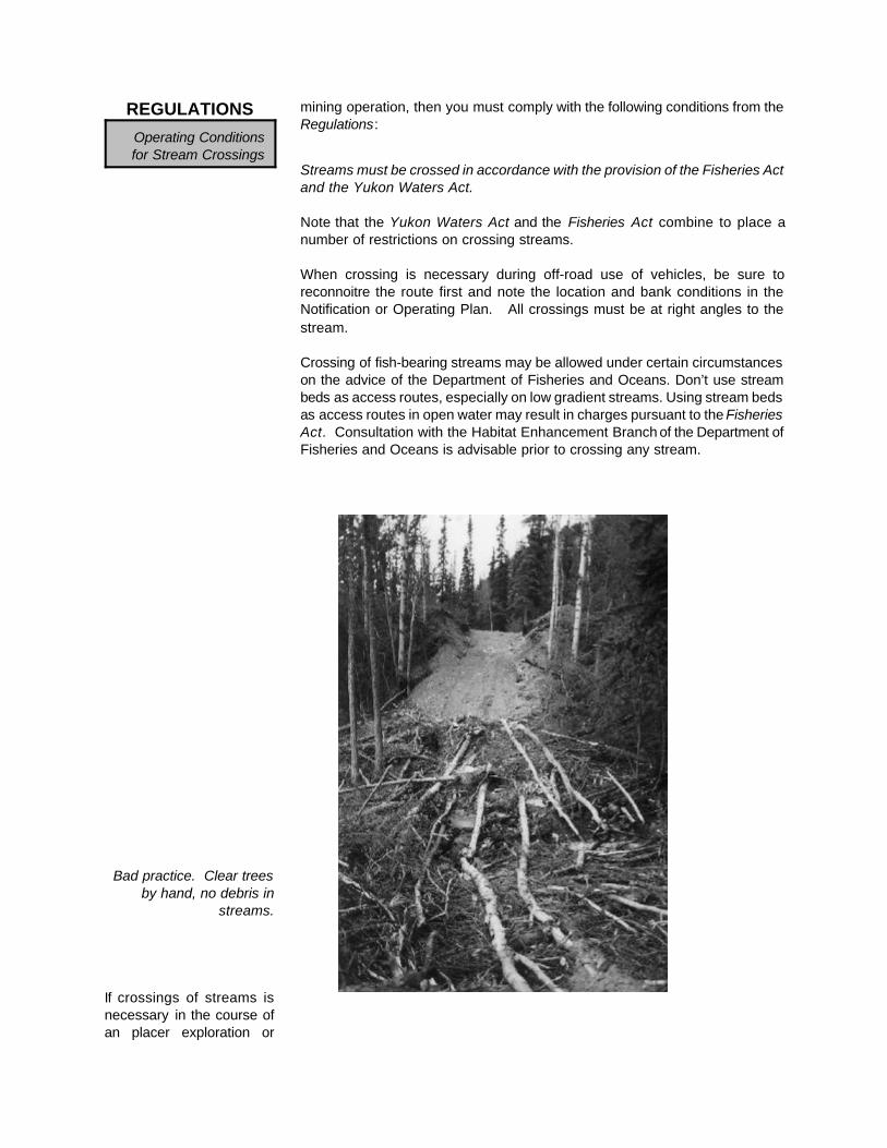
REGULATIONSOperating Conditionsfor Stream Crossings
Bad practice. Clear treesby hand, no debris in
streams.
If crossings of streams isnecessary in the course ofan placer exploration or
mining operation, then you must comply with the following conditions from theRegulations:
Streams must be crossed in accordance with the provision of the Fisheries Actand the Yukon Waters Act.
Note that the Yukon Waters Act and the Fisheries Act combine to place anumber of restrictions on crossing streams.
When crossing is necessary during off-road use of vehicles, be sure toreconnoitre the route first and note the location and bank conditions in theNotification or Operating Plan. All crossings must be at right angles to thestream.
Crossing of fish-bearing streams may be allowed under certain circumstanceson the advice of the Department of Fisheries and Oceans. Don’t use streambeds as access routes, especially on low gradient streams. Using stream bedsas access routes in open water may result in charges pursuant to the FisheriesAct. Consultation with the Habitat Enhancement Branch of the Department ofFisheries and Oceans is advisable prior to crossing any stream.

CONSTRUCTION OFROADS AND TRAILS
A second attempt to find aroute with a dozer. Scout
the route first to avoid falsestarts.
The following are some additional general guidelines that can be useful inpreparing a Notification or Operating Plan for approval to construct a road ortrail.
Plan Ahead! Planning is the most important step in road construction of anykind, regardless of its location, length or utility. Proper planning saves time andmoney and will lessen the risk of environmental impacts. A well planned routeminimizes the chance of false starts and abandoned stretches off road.Planning the route means a road less prone to erosion, one that lasts longer,costs less to maintain, and requires the least amount of effort, time andexpense to reclaim.
The following information should be provided on a Notification or OperatingPlan:
• The route on a topographic map.• The location and plotting of existing roads and trails in the
immediate area.• The location of stream crossings and bank conditions.• The location of culverts and cross ditches.• The standard of the road (i.e. 2-wheel drive, 4x4, trail, etc.).• Reclamation and mitigation measures and possible alternatives.• Start-up date.• Maintenance Planning.

Review Maps, Photos, Flag
Walk and Flag Route
Ensure Cross Drainage
Start-up dates
Shut-down dates
Remove Snow Fills
High Blades
Blade Shoes
Observe Load Limits
Suspend Use if Ruttingand Gouging
Review largest scale topographic maps available, review air photographs, selectroute with most competent ground; reconnoitre the entire route on foot and flagthe route at regular intervals.
Walk the entire route and select the most competent ground. Flag the route atregular intervals.
You must ensure that natural drainage is maintained along the entire route byinstalling drainage structures as the situation warrants. You must maintainproper drainage across the road. Ensure cross drainage by selecting the mostappropriate technique(s) below:
• Construct outsloping grades.
• Construct cross ditches.
• Install cross drains in fills.
• Construct parallel ditches on steep slopes and uphill patches.
• Install corduroy.
The following alternatives apply only to winter access:
Planned overland movement of equipment may not take place until there isadequate frost penetration and snow cover.
Overland movement of equipment will cease when the surface can no longersupport the weight of vehicles without cutting.
Snow fills shall be removed from stream crossings before spring break-up.
Dozer blades will be raised so as not to cut the organic layer.
Dozer blade shoes may be used so as not to cut the organic layer.
Using Existing Roads and Trails:
Vehicles greater than 20 t GVW may only be used within notified loadrestrictions.
Vehicles greater than 20 t GVW may not be used when severe rutting andgouging of the route may result.

Remove Culverts
Install Earth Breakers
Scarify
Block Access
GUIDELINES FOR ACCESSROADS AND TRAILS
Abandonment of a Road or Trail:
Where culverts have been installed, they may be removed and replaced bynon-erosive cross ditches.
Earth breakers may be built up on steep slopes to divert surface run-off.
Compacted surfaces may be scarified to promote revegetation.
Public access may be blocked by constructing barriers of logs, slash, bermsor other acceptable means.
The following guidelines and references are offered to assist in completing amitigation/reclamation plan for an access road or trail.
Each area within a corridor will have its own unique terrain and site specificengineering problems. Prior to ground truthing, topographic map and air photoreconnaissance should be done. Through air photo interpretation, it will bepossible to predict permafrost areas (through vegetation interpretation), severityof slopes, timber size, surface material type and availability, wet areas, etc.
Active and abandoned stream channels will be obvious. Prior to construction,all photo interpretation should be verified on the ground as even an experiencedphotogrammetrist can make interpretation errors. Here are some guidelines toconsider when selecting a route:
• Avoid areas of permafrost where practicable. In areas of discontinuouspermafrost, select frost-free, south-facing slopes. Where it isimpossible to avoid permafrost, select the route significantly up-slopeor on ridges where bedrock is closer to the surface.
• Avoid seepage zones by routing to drier, elevated ground wherepracticable.
• Avoid areas of erratic slope changes necessitating extensive cut andfill requirements.
• Avoid steep slopes. Select routes to keep slopes as low as possible.Maximum grades of 8 to 10 percent are desirable, although shortpitches (less than 5m) of up to 15 percent are acceptable if necessary.
• Avoid unnecessary stream crossings. Select crossings that approachthe stream at right angles and cross where the channel is straight,unobstructed, well defined, and has minimum bank height.
• Avoid known archaeological and burial sites. Consult with the FirstNation nearest the proposed route and the Heritage Branch. In somecases, an Government of the Yukon to find out about known sitesalong the route. In some cases, an archeological survey may be

called for.
• Avoid duplication of roads and trails. sites along the archaeologicalsurvey may be called for.
• Consideration should be given to all existing trails and roads in theimmediate area. If at all practical, these roads and trails should beutilized rather than constructing additional ones, but make sure the oldroute is in an acceptable location first. Many old roads and tote trailswere pushed in with little regard for the environment. Use of theseroutes may not be acceptable today.
• Do not use stream beds as access routes.
• Avoid construction of over-width roads. Build the narrowest roadpossible consistent with safety and traffic needs.
• Avoid environmentally sensitive areas, critical wildlife habitat, andcritical time periods for wildlife.
Wildlife habitat in the Yukon is protected under the Yukon Wildlife Act.Sections 35 and 36 of the Act prevent "Damage to or Destruction of Habitat".In addition, under Section 138.3, Habitat Protection Areas may be designatedby the Commissioner in Executive Council. The habitat of migratory birds isprotected by the federal Migratory Birds Convention Act. Under Section 12i, theGovernor in Council may make regulations necessary for "prescribing protectionareas for migratory birds and nests, and for the control and management ofthose areas". The Yukon Wildlife Act and the Migratory Birds Convention Actare enforced by the Yukon Government conservation officers and by the RCMP.
Critical wildlife habitat is currently being identified by the Yukon Department ofRenewable Resources. Mapping of this habitat has been carried out in someareas. Inventory of wildlife habitat is an ongoing process and maps arecontinually being updated.
Key habitat includes such areas as staging and nesting sites for waterfowl,nesting sites for raptors, beaver and muskrat lodges, winter range for thin hornsheep and goats, late winter range for caribou, moose, mule deer, elk and woodbison, calving and rearing areas, denning areas, mineral licks and travelcorridors.
Many key habitats are only utilized for certain seasons of the year. For theduration of the year, their importance as habitat may not be obvious. Wildlifehabitat may be disrupted despite the best efforts to minimize impacts to theland and vegetation. In some areas, mining land use activities may have to becurtailed in order to accommodate concerns about wildlife.
To find out more about environmentally sensitive areas, and habitat andtime periods critical to wildlife, contact the Fish and Wildlife Branch ofRenewable Resources.
APPENDIX I
GLOSSARY OF TERMS
Access Road means a road which provides access to a public highway or any private road.
Archaeological Object means an object that is the product of human art, workmanship, or use, and it includesplant and animal remains that have been modified by or deposited in consequence of human activities, and isof value for its historic or archaeological significance.
Archaeological Site means a place where archaeological objects are found.
Buffer Strip means a strip of vegetated land left undisturbed adjacent to a watercourse.
Clearing means an area in the forest cleared for mining or exploration.
Corridor means a path cut to accommodate a trail, water line, fuel line or power line.
Critical Habitat means habitat areas which are critical to a significant number of individuals of a species duringat least part of the year.
Cross Ditch means a shallow trench excavated by hand or by dozer blade across the surface of the road in thedownslope direction. Its purpose is to allow water to travel to the lower side of the road without eroding orponding, and it also provides a barrier to vehicles.
Cross Drain means culverts or pipes placed in the road grade, set below the level of side ditches and inclinedabout 2% more than the road grade above.
Environmental Effect means, in respect of a project:(a) any change that the project may cause in the environment, including any effect of any such changeon health and socio-economic conditions, on physical and cultural heritage, on the current use of landsand resources for traditional purposes by aboriginal persons, or on any structure, site or thing that isof historical, archaeological, paleontological or architectural significance, and(b) any change to the project that may be caused by the environment, whether any such change occurswithin or outside Canada.
Environmentally Sensitive Areas means areas which are rated as high value for archaeological or historic sites,timber, recreation, watershed, wildlife and unique land forms.
Foundation means: a. the solid ground or base, natural or artificial, on which a building rests; b. The lowest loadbearing part of a building, usually below ground level.
Line means a linear clearing for the purpose of carrying out a geophysical, geological or engineering survey.
Merchantable Timber means timber located on mining claims that has been determined to be of a size, qualityand overall quantity that it can likely be harvested economically, all cost factors considered.
Ordinary High Water Mark means the visible high water mark of any lake, river, stream or other body of waterwhere the presence and action of water is active such that the water level is indicated on the sil of the bed orbank of the lake, river stream or other body of water.
Overburden means barren rock material, either loose or consolidated, overlying a mineral deposit, which must

be removed prior to mining .
Parallel Ditches means long narrow excavations made in the ground by digging and which run in the samedirection on opposite sides of the road.
Permafrost means ground that remains frozen through at least two consecutive winters and the interveningsummer.
Permanent Structure means a surface structure suitable for indefinite use, including any buildings with afoundation.
Reclamation means the return of a site disturbed by mining and or exploration activities to a condition where itwill make a suitable environment for the re-establishment of the site. Reclamation is also successful ifreplacement of native species which fill a similar ecological niche find the site to be suitable.
Revegetation means the re-establishment of self-sustaining vegetation of land which previously had vegetativecover.
Road means a pathway for vehicular traffic, the construction of which requires the movement of rock or earth.
Seasonal Structure means a surface structure that is dismantled and moved at the end of each mining season.
Stripping means the removal of the vegetation and overburden from a geographic area.
Sump means a manmade or natural pit, trench, hollow or cavity in the earth’s surface used for the purpose ofdepositing waste material.
Temporary Structure means a surface structure used for more than one season which is not of permanentconstruction and does not include seasonal structures.
Terrain Hazard means naturally occurring geologic and geomorphic processes and unstable conditions thatpresent a risk to life and property within a specific area.
Topsoil means the dark-coloured upper portion of a soil at the land surface, varying in depth according to soiltype, and corresponding to the A Horizon.
Trail means a facility allowing entry to sites within claims which does not provide access to a public highwayor any private road connecting a public highway or any private road .
Trenching means any excavation carried out on a mineral claim for the purpose of obtaining geologicalinformation.
Vegetative Mat means the organic horizon of soil which is characterized by the accumulation of organic matteror partly decomposed organic matter, derived mainly from leaves, twigs and woody materials including the rootmass of living vegetation.
Watercourse means any stream, lake, pond, river, creek, spring, ravine, or swamp whether ordinarily containingwater or not.
Windrow means a low bank, heap, or other accumulation of material, formed naturally by the wind or the tide,or artificially.

APPENDIX II
CONTACTS AND CORRESPONDENCE
1. Mining Land Use and Reclamation Office
LOCATION: 300 Main Street, Whitehorse, Yukon Room 320
MAILING ADDRESS: Mining Land Use Office345-300 Main StreetWhitehorse, YukonY1A 2B5
TELEPHONE NUMBERS:
Office Manager 667-3265Chief of Mining Land Use 667-3172Senior Mining Land Use Officer 667-3807Mining Land Use Officer 667-3371Mining Land Use OfficerEnvironmental Geologist 667-3808Engineer of Mines 667-3208First Nation Liaison Officer 667-3804Fax 667-3899E-mail [email protected]
2. HERITAGE RESOURCES, YUKON GOVERNMENT 667-5683
3. RENEWABLE RESOURCES, YUKON GOVERNMENT 667-5295
NOTE: all numbers are Area Code 867